WV Association of Geospatial Professionals · WV Association of Geospatial Professionals ......
12
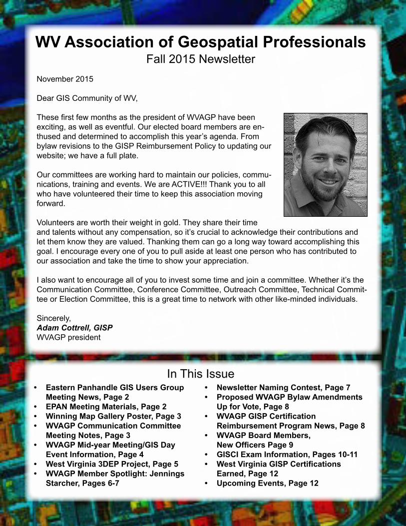
WV Association of Geospatial Professionals Fall 2015 Newsletter In This Issue November 2015 Dear GIS Community of WV, These first few months as the president of WVAGP have been exciting, as well as eventful. Our elected board members are en- thused and determined to accomplish this year’s agenda. From bylaw revisions to the GISP Reimbursement Policy to updating our website; we have a full plate. Our committees are working hard to maintain our policies, commu- nications, training and events. We are ACTIVE!!! Thank you to all who have volunteered their time to keep this association moving forward. Volunteers are worth their weight in gold. They share their time and talents without any compensation, so it’s crucial to acknowledge their contributions and let them know they are valued. Thanking them can go a long way toward accomplishing this goal. I encourage every one of you to pull aside at least one person who has contributed to our association and take the time to show your appreciation. I also want to encourage all of you to invest some time and join a committee. Whether it’s the Communication Committee, Conference Committee, Outreach Committee, Technical Commit- tee or Election Committee, this is a great time to network with other like-minded individuals. Sincerely, Adam Cottrell, GISP WVAGP president • Eastern Panhandle GIS Users Group Meeting News, Page 2 • EPAN Meeting Materials, Page 2 • Winning Map Gallery Poster, Page 3 • WVAGP Communication Committee Meeting Notes, Page 3 • WVAGP Mid-year Meeting/GIS Day Event Information, Page 4 • West Virginia 3DEP Project, Page 5 • WVAGP Member Spotlight: Jennings Starcher, Pages 6-7 • Newsletter Naming Contest, Page 7 • Proposed WVAGP Bylaw Amendments Up for Vote, Page 8 • WVAGP GISP Certification Reimbursement Program News, Page 8 • WVAGP Board Members, New Officers Page 9 • GISCI Exam Information, Pages 10-11 • West Virginia GISP Certifications Earned, Page 12 • Upcoming Events, Page 12
Transcript of WV Association of Geospatial Professionals · WV Association of Geospatial Professionals ......
WV Association of Geospatial ProfessionalsFall 2015 Newsletter
In This Issue
November 2015
Dear GIS Community of WV,
These first few months as the president of WVAGP have been exciting, as well as eventful. Our elected board members are en-thused and determined to accomplish this year’s agenda. From bylaw revisions to the GISP Reimbursement Policy to updating our website; we have a full plate.
Our committees are working hard to maintain our policies, commu-nications, training and events. We are ACTIVE!!! Thank you to all who have volunteered their time to keep this association moving forward.
Volunteers are worth their weight in gold. They share their time and talents without any compensation, so it’s crucial to acknowledge their contributions and let them know they are valued. Thanking them can go a long way toward accomplishing this goal. I encourage every one of you to pull aside at least one person who has contributed to our association and take the time to show your appreciation.
I also want to encourage all of you to invest some time and join a committee. Whether it’s the Communication Committee, Conference Committee, Outreach Committee, Technical Commit-tee or Election Committee, this is a great time to network with other like-minded individuals.
Sincerely, Adam Cottrell, GISPWVAGP president
• Eastern Panhandle GIS Users Group Meeting News, Page 2
• EPAN Meeting Materials, Page 2• Winning Map Gallery Poster, Page 3• WVAGP Communication Committee
Meeting Notes, Page 3• WVAGP Mid-year Meeting/GIS Day
Event Information, Page 4• West Virginia 3DEP Project, Page 5• WVAGP Member Spotlight: Jennings
Starcher, Pages 6-7
• Newsletter Naming Contest, Page 7• Proposed WVAGP Bylaw Amendments
Up for Vote, Page 8• WVAGP GISP Certification
Reimbursement Program News, Page 8• WVAGP Board Members,
New Officers Page 9• GISCI Exam Information, Pages 10-11• West Virginia GISP Certifications
Earned, Page 12• Upcoming Events, Page 12

WVAGP fall 2015 Page 2
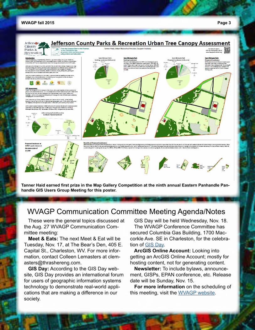
Annual Eastern Panhandle GIS Users Group Meeting News The ninth annual Eastern Panhandle GIS Users Group Meeting took place on Sept. 2 at the South Branch Inn in Romney, W.Va. Attended by more than 40 GIS users, the meeting was a great success. Presentations this year in-cluded topics such as detecting change using aerial photogra-phy, device locational accuracy, stormwater management and interactive mapping. Also discussed were updates from the state and WV GIS Tech-nical Center. Thank you to all the speakers for their wonderful presentations. We also had a first this year in the Map Gallery Competition: our digital maps outnumbered our paper maps! Thank you to everyone who participated and congratulations to our three winners: Tanner Haid, Jeff Frye and Bonn Po-land. First prize in the Map Gallery Competition this year went to Haid, with his poster “Jefferson County Parks & Recreation Ur-ban Tree Canopy Assessment.” (See Page 3) We would like to thank all of our sponsors for this event; we couldn’t have done it without you. The EPAN GIS Users Group would like to invite everyone to join us next year for our 10th Anniversary Gala, which will take place in Berkeley County, W.Va. Hope to see you there!
Tanner Haid, Jeff Frye and Bonn Poland were winners at the ninth annual Eastern Panhandle Panhandle GIS Users Group Meeting.
EPAN GIS Users Group Meeting Materials
The following presentations from the ninth annual Eastern Panhandle GIS Users Group Meeting are now on Slideshare.
• WV SAMS Update• Detecting Change Using Connect Assessment.
It is listed as Pictometry Imagery for WV.• Device Locational Accuracy• GIS in Stormwater Management and Reporting.
It is listed as Stormwater and GIS.• The Geo-Precision Solutions presentation. It is
listed as Transitioning Web Applications to the Web AppBuilder.
Also, Annie Cahill has turned her presentation—Interactive Mapping – Winchester, Va.—into an in-depth video on YouTube.
WVAGP fall 2015 Page 3
Tanner Haid earned first prize in the Map Gallery Competition at the ninth annual Eastern Panhandle Pan-handle GIS Users Group Meeting for this poster.
WVAGP Communication Committee Meeting Agenda/Notes These were the general topics discussed at the Aug. 27 WVAGP Communication Com-mittee meeting: Meet & Eats: The next Meet & Eat will be Tuesday, Nov. 17, at The Bear’s Den, 405 E. Capital St., Charleston, WV. For more infor-mation, contact Colleen Lemasters at [email protected]. GIS Day: According to the GIS Day web-site, GIS Day provides an international forum for users of geographic information systems technology to demonstrate real-world appli-cations that are making a difference in our society.
GIS Day will be held Wednesday, Nov. 18. The WVAGP Conference Committee has secured Columbia Gas Building, 1700 Mac-corkle Ave. SE in Charleston, for the celebra-tion of GIS Day. ArcGIS Online Account: Looking into getting an ArcGIS Online Account; mostly for hosting content, not for generating content. Newsletter: To include bylaws, announce-ment, GISPs, EPAN conference, etc. Release date will be Sunday, Nov. 15. For more information on the scheduling of this meeting, visit the WVAGP website.

WVAGP fall 2015 Page 4
Mid-year Meeting The WVAGP is hosting its Mid-year Meeting on GIS Day, Wednesday, Nov. 18, at Columbia Gas Auditorium, 1700 Maccorkle Ave. SE, Charleston, WV 25314. It is free for members. The morning sessions are intended for GIS professionals and WVAGP members. The meeting will begin at 9 a.m. A workshop will be presented by Hexagon Geo-spatial beginning at 10 a.m. The topic will be “Prop-erty Change Detection and Appraisal Plus CAMA.” After an 11 a.m. break, at 11:10 a.m. proposed amendments to the WVAGP Bylaws will be offered for consideration. (See Page 8) Immediately after the consideration of bylaws amendments, there will be the consideration of the repeal of the existing GISP reimbursement policy and the proposal of a new GISP reim-bursement policy. (See Page 8) Lunch at 12:10 p.m. is included for those who RSVP’d before Nov. 4. At 1 p.m. there will be Map Gallery presentations, and map authors will be available to ex-plain and answer questions regarding their maps. There will be Ignite Presentations starting at around 1:30 p.m., sharing new GIS mobile or web apps, natural resources or forestry projects using lidar data, etc. The event will conclude around 4 p.m. To register, visit this site.
GIS Day Event The afternoon sessions of the Mid-year Meeting are intended to be informative to both GIS professionals and the general public as an outreach effort participation in GIS Day! Call for Posters For those who would like to present their recent work to the members and public, the WVAGP will be hosting a Map Gallery Competition during the GIS Day portion of our Mid-year Meeting. This competition will have two categories: Paper Maps and Digital Maps. There will be four winners of the competition, one professional and one student for each cat-egory. Winners will receive a certificate and small prize. All participants are required to bring his or her map to the meeting or find someone who will bring it for him or her. Early submissions are not allowed. Paper Maps should be no larger than 36 inches by 48 inches. Those bringing digital maps are encouraged to bring power cords/adapters. For information about the Map Gallery Competition, email Jessica Gormont at [email protected]. Accommodations A block of hotel rooms have been reserved for out-of-town attendees at the Holiday Inn, 400 2nd Ave, South Charleston, WV 25303. To make reservations, call 304-744-4641. The rate for a room is $107, plus taxes and fees. Please note: This is the hotel in South Charleston, not in downtown Charleston. Additional details about the Mid-year Meeting can be found on the WVAGP website.
WVAGP Mid-year Meeting/GIS Day Event

WVAGP fall 2015 Page 5
WV 3DEP Project Planned Many of you in the GIS profession are aware of the importance of statewide lidar. Uses of a high-resolution lidar data set in the Mountain State are almost endless. These uses include dimen-sional modeling of structures, urban planning and model-ling, oil and gas exploration surveys, transportation stud-ies and surveys (including road, rail and air), climate studies, flood-risk mapping, forestry, power line transmis-sion and pipe line corridor planning, engineering and construction surveys, real estate development, canopy studies, studies on airport and UAV exclusion zones, high-resolution mapping, rec-tification of satellite and aerial imagery, etc. In July, the U.S. Geological Survey (USGS) issued the FY15/FY16 Broad Agency Announcement (BAA) for 3D Elevation Program (3DEP). Due to time and budgetary constraints, we were not able to submit an application for West Virginia. 3DEP rules require a 25 percent contri-bution. Unfortunately, due to the nature of this project, in-kind contributions other than monetary, are not possible like they are in other projects. The challenge is to work with federal, state and local entities to bring the project to fruition. In January, my office
plans to bring the Imagery and Lidar Workgroup back to-gether to work on this project. WV can and should benefit from this program in the next cycle of funding.I know many of you would like to be involved in this proj-
ect and will be getting emails from the coordinator’s office encouraging you to partici-pate and help secure contri-butions from state and local agencies. — Tony Simental, West Virginia Office of GIS Coordinator
Here are some potential state and federal areas of interest for 3DEP. For more detail, view the interactive map.

WVAGP fall 2015 Page 6
Jennings Starcher, GISP, is the GIS man-ager at the West Virginia Division of Home-land Security and Emergency Management. Starcher is our Member Spotlight for fall 2015.
Q: How long have you been working in state government?A: I’ve been with the state since June 2005, when I went to work for the West Virginia Health Care Authority in Charleston.
Q: How long have you been in your current role?A: I’ve been with WVDHSEM since November 2008.
Q: Are you married? Any children?A: No, still single. And no children, but I do have two nieces—one in college and the youngest in high school.
Q: How do you spend your free time?A: I spend my free time listening to different genres of music I’ve grown up with, reading as many books as I have time, attending sporting events with friends and playing team trivia with my baseball family, The Rowdys, each week.
Q: Do you have a favorite hobby?A: Learning about the U.S. presidents. I start-ed when I was 8 years old and I continue to learn new facts about them every year.
Q: Who other than your staff and boss do you interact with most as part of your job?A: I do my best to check in with the county, addressing coordinators to see how things are going with the addressing and mapping proj-ect. They know if they ever need anything that they can contact me and I’ll do my best to get them the right answer.
Q: Who do you report to?
A: Jimmy Gianato, DHSEM director, and Paul Howard, DHSEM director of operations.
Q: What is the most unusual job you’ve had?A: The two weeks I worked at Cedar Point be-fore I got ill with tonsillitis and I had to go back home for surgery. Q: What do you enjoy most about your job?A: Being able to come in every day and have a great working relationship with the other member of our section. David Phillips is one great person and I’m lucky to have him in our section. Q: Briefly, what is one or two of the “Hot Top-ics/issues” for you and the GIS community in West Virginia right now?
Continued on Page 7
WVAGP Member Spotlight: Jennings Starcher, GISP
When not working as GIS manager at the West Virginia Division of Homeland Security and Emer-gency Management or in his role as treasurer of the WVAGP, Jennings Starcher often can be found “doing something I love at the ballpark—reminding the opposing batter not to argue with the umpire on balls and strikes.”

WVAGP fall 2015 Page 7
WVAGP Member Spotlight: Jennings Starcher, GISP (cont.)
Name the WVAGP Newsletter! The WVAGP Communication Committee would like to invite the mem-bers to participate in a contest to give our newsletter an official name. The winner of the contest will be announced at the 2016 WVAGP GIS Conference on May 3-5 in Morgantown and will receive a small prize package. Here’s how the contest will work: • Fill out the official entry form and submit by the Dec. 31, 2015, deadline. • There are a maximum of two entries per person. If more than two entries are made, only the first two submitted will be used. • The list of entries will be complied and made into a poll, and the mem-bership will vote. The poll will be announced and released in the WVAGP Spring Newsletter. • Members get one vote each. Any additional votes cast by the same person will be discard-ed. Names will be checked against membership list before tallying up votes. • The winner will be announced at the 2016 conference and receive a prize package.
A: The one hot topic right now is the fact that we need to get new statewide aerial map-ping/lidar in place so it will help out those from the statehouse all the way down to local governments with their mapping needs.
Q: How long have you been involved in AGP?A: Since its inception back when the first Bylaws Committee met back in 2006.
Q: How did you get into GIS? A: I was introduced to GIS by my Geography 100 professor, Dr. Allen Arbogast, at Marshall University in early 2000. He mentioned GIS in class and I met with him afterward to learn more about it. Before the end of that semes-ter I switched majors to geography. Since then, I have bachelor’s and master’s degrees in geography with the emphasis on GIS.
Q: Why are you in public service?A: Because I want to give something back to the state that has been good to me my entire
life. I truly enjoy helping out citizens, even those who are still not happy with me after I explain the state’s role with the addressing and mapping project and have to refer them back to their respective county.
Q: What is the best book you’ve read lately?A: “Live from New York: The Complete, Uncensored History of Saturday Night Live,” updated for the show’s 40th anniversary.
Q: Do you have a favorite quote?A: “You’re never a loser until you quit trying.” — Chinese proverb Q: Anything else you’d like to add? A: As WVAGP enters its ninth year as an as-sociation, I am in awe of the geospatial pro-fessionals who are members and especially to those who have volunteered their time to serve on the Board of Directors. It may not be easy at times, but I’m impressed with the diversity of talent and how we continue to learn from each other.
WVAGP GISP Certification Reimbursement Information The GISP Certification Reimbursement Program is for regular members of the WVAGP who are and have remained current in their membership dues for the duration of the GISP certifi-cation process, have paid for the certification out of their own personal funds and have successfully received certifi-cation. This policy does not reim-burse employers nor orga-nizations for any expenses incurred by them. The purpose of the WVAGP’s GISP Certification Reimbursement Program is to provide monetary assis-tance to eligible members in their pursuit of GISCI’s GISP certification. The WVAGP assists mem-bers in their professional development and the state of West Virginia’s geospatial strength through the promo-tion of the GISP Certification.
The following eligibility requirements will apply to cer-tification reimbursement: • Regular members who are and have been current in their membership dues for the du-ration of the GISP certification process. • The costs must have been paid by the member personal-ly and not otherwise covered or reimbursed by any employ-er, agency or program. • In the case where some expenses were paid or reim-bursed by another party, any remaining portion paid by the member individually is still eligible for reimbursement. • GISP Certification must be successfully awarded prior to application for reimburse-ment. • Applicant shall fill out an application form for GISP Certification Reimbursement. Reimbursement will cover 50 percent of the total cost paid by the member up to a
maximum of $225 per mem-ber. Any member requesting reimbursement must provide documentation of success-ful certification, receipts of all claimed expenses and a signed statement attesting that all of the claimed expens-es were borne entirely by the member and not paid or reim-bursed through any employer, agency or program. All documents shall be sub-mitted to the WVAGP secre-tary via email, and that officer shall acknowledge receipt thereof with a return email. Disclaimer: There is an Ethics Form that is part of the GISCI’s GISP Certification Application. Unethical actions will be reported to GISCI if false claims are made for reimbursements. For more information on this program or for an appli-cation form, visit the WVAGP website.
WVAGP fall 2015 Page 8
On Wednesday, Nov. 18, the WVAGP mem-bership will hold a special meeting to vote on 12 proposed WVAGP bylaw amendments. The proposed bylaw amendments address issues including automatic dues adjustments, provisions for the board elect to meet before the term begins to elect officers and establish a regular meeting schedule, annual and spe-cial meeting notice requirements, delivery of
meeting notices, committee names and roles, and whether parlaimentary authority applies not only to the board but to the association as well. For complete language on these proposed bylaw amendments, including the rationale behind each of these issues, visit the WVAGP website and click on the “Amendments” section under News.
Proposed WVAGP Bylaw Amendments

WVAGP fall 2015 Page 9
JD Adkins [email protected] Cabell County Assessors Office
County
Chris Chrzanowski chrischrzanowski@ kanawha.us
Kanawha County Assessors Office
County
Adam Cottrell (president)
adam.cottrell@cityof charleston.org
City of Charleston City
Michael Duminiak (secretary)
[email protected] WV Water Development Authority
State
Connie Ervin [email protected] Preston County Assessors Office
County
Jessica Gormont (vice president)
Jefferson County GIS/ Addressing Office
Regional
Kevin Kuhn [email protected] WV GIS Technical Center, WVU
Education/Research
Frank LaFone [email protected]
WV GIS Technical Center, WVU
Education/Research
Colleen Lemasters [email protected] The Thrasher Group Inc. Private Sector
Tony Simental (ex-officio)
[email protected] Office of GIS Coordinator State
Jennings Starcher (treasurer)
[email protected] WV Division of Homeland Security and Emergency Management
State
Paul Wray [email protected] Putnam County Assessors Officer
County
WVAGP Board Members, New Officers for 2015-16WVAGP Board Members include (from left) Connie Ervin, Chris Chr-zanowski, Trea-surer Jennings Starcher, Kevin Kuhn, President Adam Cottrell, Vice President Jessica Gormont, Secretary Mike Duminiak, Colleen Lemasters, Ex-officio Tony Simental and Frank LaFone. Not pic-tured are JD Adkins and Paul Wray.
GISCI Exam Information The GISCI Geospatial Core Technical Knowledge Exam® is now a requirement for GISCIGISP Certification. Here is some general information about the GISP Certification Program.For more information, including a link to an exam application, visit the GISCI website.
WVAGP fall 2015 Page 10
Inaugural exam date: Nov. 12-17, 2015. Applications were due Oct. 9. 2015 exam procedure: Complete and submit exam application form, which can be found at gisci.org. Send the form, along with your resume, to GISCI. Once your application is received, you’ll be given pay-ment instructions. Application fee: The certification application fee is $100. If you have already paid the application fee for a portfolio review, you will not be charged a second time. Exam fee: The exam fee is $250. Schedule your exam date: Once you re-ceive authorization to take the exam, contact the test provider to schedule your exam date, time and location. The exam will be offered at specific times at test facilities across the U.S. Exam times and seat capacity will vary, so schedule your exam as soon as possible after you receive authorization. Take the exam: You must take the exam at the place and time arranged between you and the test provider (PSI). Receive exam results: GISCI will provide your results about one month after the exam. Rescheduling: You may contact PSI to reschedule your exam date at least two days prior to the exam date, without financial pen-alty, if there is space available. Inability to schedule your specific exam date: If you are authorized to take the exam, but do not schedule your specific exam date, you may receive a refund or transference of the exam fee upon request.
Postponement to a later exam event: If you wish to take the exam at a later date, you must obtain au-thorization. Your exam fee may be transferred to that event. Failure to take your exam as scheduled: If
you schedule your exam and don’t take it, the exam fee
will not be refunded. To take the exam at a later event, you must get
authorization and pay the exam fee for that date. Exam failure and retake: • If you fail the exam, you may take it again at the next exam event. You must obtainauthorization for that future event. • If you fail the exam, you must pay the exam fee to take it again, and must obtainauthorization for that exam event. • If you fail the exam twice, you must wait a year before taking the exam again. • You may not retake the exam in the same exam event. Next exam: The next GISCI Geospatial Core Technical Knowledge Exam® has not been scheduled, but the tentative exam inter-val is approximately six months. Exam description: The exam is about 200 questions, and four hours are allowed for the exam. The questions are selected-response format, and the exam is taken via comput-er-based testing. Calculators will be provided, as necessary, on the computers. The exam is in English and will be proctored.
Continued on Page 11
GISCI Exam Information (cont.)
WVAGP fall 2015 Page 11
Exam content: The exam is based on a job analysis of GIS professionals across all GIS job categories and sectors, with at least four years of GIS experience. It also is guided by the Geospatial Technology Competency Model, Tier 4, Core Geospatial Industry-wide Technical Competencies, and informed by the Geographic Information Science and Technol-ogy Body of Knowledge. Core GIS technical knowledge: The exam tests core geospatial technical knowledge. It does not address software, specific environ-ments, specialized knowledge or manage-ment knowledge. Exam knowledge areas/sample ques-tions: For GIS knowledge areas and sample questions, visit gisci.org. Study resources: Here are examples of the types of resources that would contain information regarding exam topics: • GIS textbooks, compendiums and man-uals (not software manuals), courses and periodicals • Cartography textbooks and courses • Geography textbooks and courses • Mathematics and statistics textbooks and courses • GIS software supplier general GIS discus-sion (not software specific) • General computer and programming texts and courses On the day of the exam: • Arrive at the testing center 30 minutes in advance. • Present a valid, government-recognized, unexpired, photo ID with your name as it appears on your exam authorization and scheduling. Contact GISCI at least two weeks in advance if you need to make arrangements for another type of ID to be used, and bring that preapproved ID to the test center. • No personal items are to be brought into the testing area.
• No electronic devices of any kind are al-lowed in the testing area. • Exam participants are not permitted to leave the building or use cell phones or other electronic devices during the exam. • There is to be no conversing or other form of communication among candidates once you enter the testing area. • Persons not scheduled to take the exam are not permitted to wait in the testing center or surrounding common area. • Test-takers must conduct themselves in a professional and courteous manner at all times. • You are prohibited from reproducing, com-municating or transmitting any test content in any form for any purpose. Any such actions are violations of PSI and GISCI security pol-icy, and may result in the disqualification of exam results and/or lead to legal action. Special accommodations: All exam cen-ters are equipped to provide access in ac-cordance with the Americans with Disabilities Act (ADA) of 1990, and every reasonable accommodation will be made in meeting a candidate’s needs. If you have special re-quirements, please contact GISCI at least 10 business days before the exam date. Non-discrimination: GISCI does not dis-criminate on the basis of race, religion, sex, age, sexual orientation or national origin, or any other category that is protected by federal law or applicable laws and regulations. Appeal of results: Any appeals regarding exam results should be submitted to the GIS-CI executive director. The GIS Certification Institute (GISCI) is a nonprofit organization that provides the GIS community with a complete certification pro-gram, leading to Certified GIS Professional recognition. GISCI offers a positive method of developing value for professionals and em-ployers in the GIS profession.
WVAGP fall 2015 Page 12
Upcoming Events
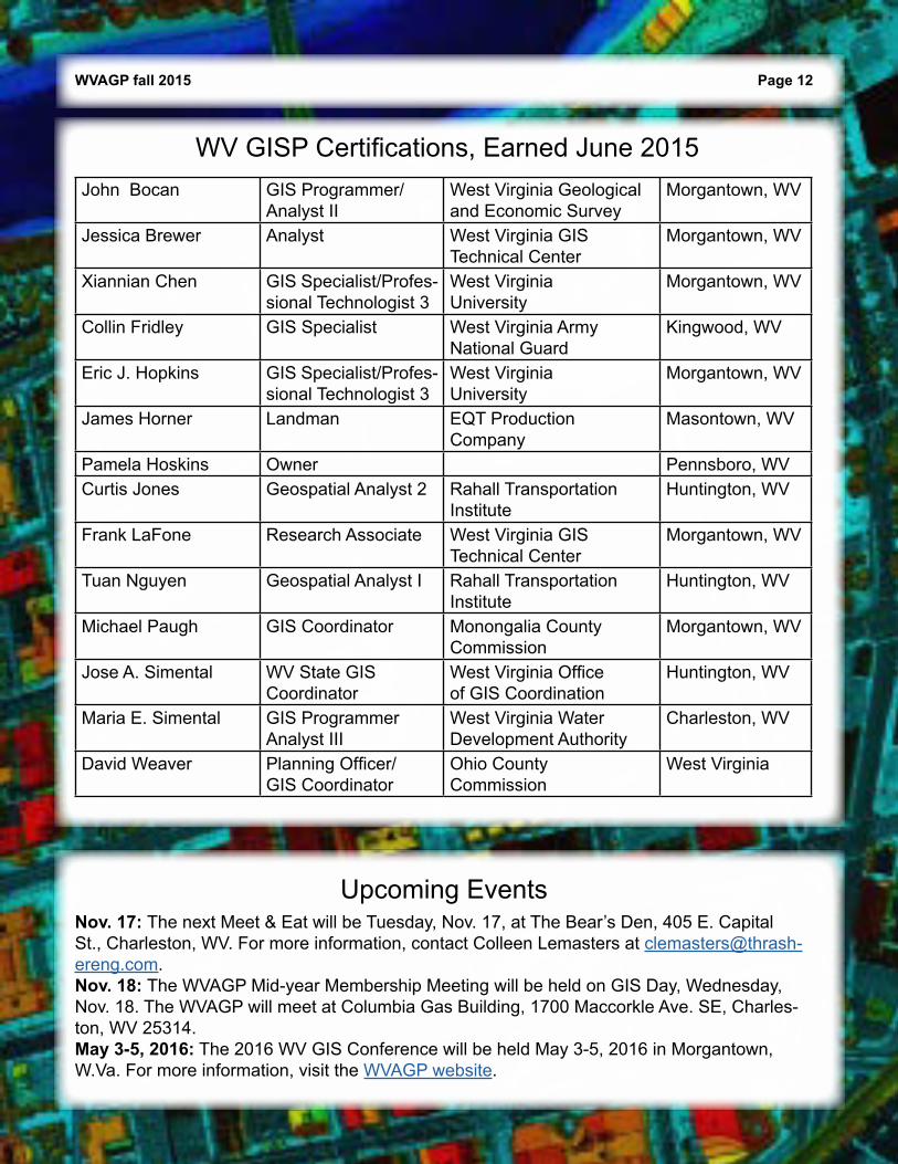
WV GISP Certifications, Earned June 2015
Nov. 17: The next Meet & Eat will be Tuesday, Nov. 17, at The Bear’s Den, 405 E. Capital St., Charleston, WV. For more information, contact Colleen Lemasters at [email protected]. 18: The WVAGP Mid-year Membership Meeting will be held on GIS Day, Wednesday, Nov. 18. The WVAGP will meet at Columbia Gas Building, 1700 Maccorkle Ave. SE, Charles-ton, WV 25314.May 3-5, 2016: The 2016 WV GIS Conference will be held May 3-5, 2016 in Morgantown, W.Va. For more information, visit the WVAGP website.
John Bocan GIS Programmer/ Analyst II
West Virginia Geological and Economic Survey
Morgantown, WV
Jessica Brewer Analyst West Virginia GIS Technical Center
Morgantown, WV
Xiannian Chen GIS Specialist/Profes-sional Technologist 3
West Virginia University
Morgantown, WV
Collin Fridley GIS Specialist West Virginia Army National Guard
Kingwood, WV
Eric J. Hopkins GIS Specialist/Profes-sional Technologist 3
West Virginia University
Morgantown, WV
James Horner Landman EQT Production Company
Masontown, WV
Pamela Hoskins Owner Pennsboro, WVCurtis Jones Geospatial Analyst 2 Rahall Transportation
InstituteHuntington, WV
Frank LaFone Research Associate West Virginia GIS Technical Center
Morgantown, WV
Tuan Nguyen Geospatial Analyst I Rahall Transportation Institute
Huntington, WV
Michael Paugh GIS Coordinator Monongalia County Commission
Morgantown, WV
Jose A. Simental WV State GIS Coordinator
West Virginia Office of GIS Coordination
Huntington, WV
Maria E. Simental GIS Programmer Analyst III
West Virginia Water Development Authority
Charleston, WV
David Weaver Planning Officer/ GIS Coordinator
Ohio County Commission
West Virginia