WUCochabamba,Bolivia-02-TheCochabambaValley
106
WATER URBANISM STUDIO COCHABAMBA, BOLIVIA BOOKLET O1 THE COCHABAMBA VALLEY
-
Upload
kristoff-biscop -
Category
Documents
-
view
213 -
download
0
description
Water Urbanism Studio Cochabamba, Bolivia Booklet 02 The Cochabamba Valley Thesis presented to obtain the degree of Master of Applied Sciences and Engineering: Architecture 2011-2012
Transcript of WUCochabamba,Bolivia-02-TheCochabambaValley

WATER URBANISM STUDIO COCHABAMBA, BOLIVIA BOOKLET O1 THE COCHABAMBA VALLEY


WATER URBANISM STUDIO COCHABAMBA, BOLIVIA BOOKLET O2 THE COCHABAMBA VALLEY
© Copyright K.U.Leuven
Without written permission of the promotors and the authors it is for-bidden to reproduce or adapt in any form or by any means any part of this publication. Requests for obtaining the right to reproduce or utilize parts of this publication should be addressed to dept. ASRO, Kasteelpark Arenberg 1/2431, B-3001 Heverlee, +32-16-321361 or by e-mail [email protected] written permission of the promotor is also required to use the me-thods, products, schematics and programs described in this work for industrial or commercial use, and for submitting this publication in scienti!c contests.
Zonder voorafgaande schriftelijke toestemming van zowel de promotor(en) als de auteur(s) is overnemen, kopiëren, gebruiken of realiseren van deze uitgave of gedeelten ervan verboden. Voor aan-vragen tot of informatie i.v.m. het overnemen en/of gebruik en/of realisatie van gedeelten uit deze publicatie, wend u tot dept. ASRO, Kasteelpark Arenberg 1/2431, B-3001 Heverlee, +32-16-321361 of via e-mail [email protected] schriftelijke toestemming van de promotor(en) is even-eens vereist voor het aanwenden van de in deze masterproef beschre-ven (originele) methoden, producten, schakelingen en programma’s voor industrieel of commercieel nut en voor de inzending van deze publicatie ter deelname aan wetenschappelijke prijzen of wedstrijden.

WATER URBANISM STUDIO COCHABAMBA, BOLIVIA BOOKLET O2
THE COCHABAMBA VALLEY The quest for an equilibrium in an intertwining water system.Thesis presented to obtain the degree of Master of Applied Sciences and Engineering: Architecture 2011-2012
AUTHORS Kristo" Biscop, Benjamin Brans, Elien Broeckx, Samuel Van de Vijver, Liesbeth Van Ginderdeuren
PROMOTOR Prof. Dr. Kelly Shannon
CO-PROMOTOR Prof. Dr. Bruno De Meulder
READERS Sergio Vega Arnez, Laura Vescina, Joris Scheers
4
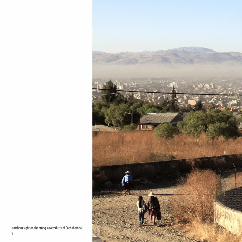
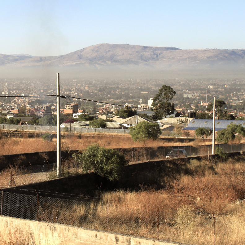
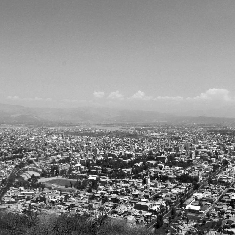
Northern sight on the smog-covered city of Cochabamba.
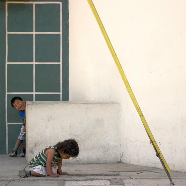
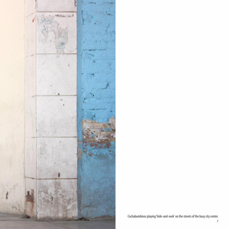
7Cochabambinos playing ‘hide-and-seek‘ on the streets of the busy city center.

8
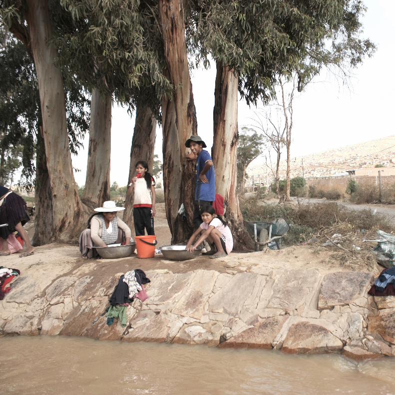
Common use of irrigation canal for washing clothes.

10
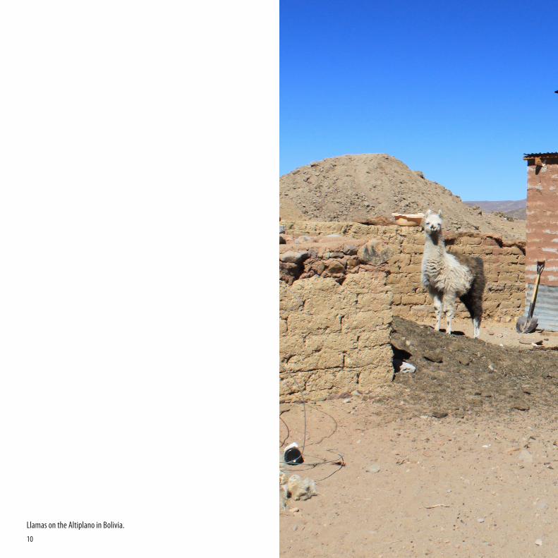
Llamas on the Altiplano in Bolivia.


13
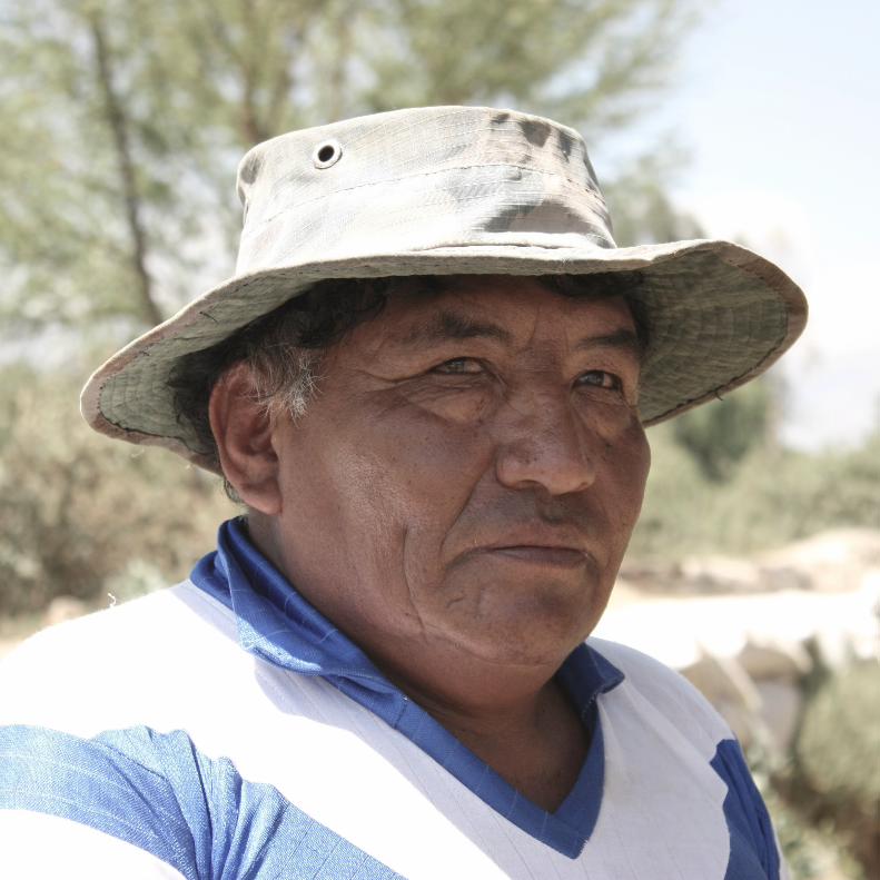
Typical peasant’s dwelling in the southern area of the Cochabamba Valley.

14
A pleasant interval after a hard day of labour on Cochabamba’s agrarian !elds.


17
PREFACE
This booklet is the second of a series of booklets about water urbanism in Cochabamba. Subsequent to the !rst booklet that emphasized the con#icts of water around the world, this part of the set contains the main analysis of the water system of Cochabamba.
The analysis starts by clarifying the historical water context of Bolivia, based on natural transformations and thus introducing the background of the Cochabamba Valley. The second chapter explains the rich water system in Cochabamba adapted by agricultural state workers from the Incas, in#uenced by Spanish colonialists and exposed to the booming city today. In a third chapter, a zoom on the ambiguous water systems investigates the presented guidelines for the inhabitants of the valley. The analysis concludes with a research on di"erent tissues, that maps the unplanned and interprets the potential of the interaction between man and nature, within a controver-sial water context.

0 PREFACE 17
1 BOLIVIAN LAKE REMNANTS 21 1.1 Bolivian water sources 1.2 Internal basins
2 WATER AS A GUIDE THROUGH HISTORY 29 2.1 Kocha Pampa, plain of lakes 2.2 Food basket of the Inca Empire 2.3 Spanish interventions on the expanding city 2.4 Crossing the river’s bend 2.5 Diminishing fertility of land
3 AMBIGUOUS WATER SYSTEM 43 3.1 Natural stormwater runo" Latent water provision The torrent claiming space Urbanization choking the torrent Rocha River as a collector Urbanization and canalization causing #oods
3.2 Southern irrigation system Permanent water supply for agriculture A guide for irrigation Irrigating agricultural land
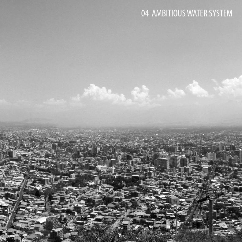
4 AMBITIOUS WATER SYSTEM 75 4.1 A shifting attitude towards the Rocha River 4.2 Usage of the river banks 4.3 Value of public organized activities 4.4 An organized rapprochement to the Tamborada River 4.5 A recreational focus of the waterfront
REFERENCES 99
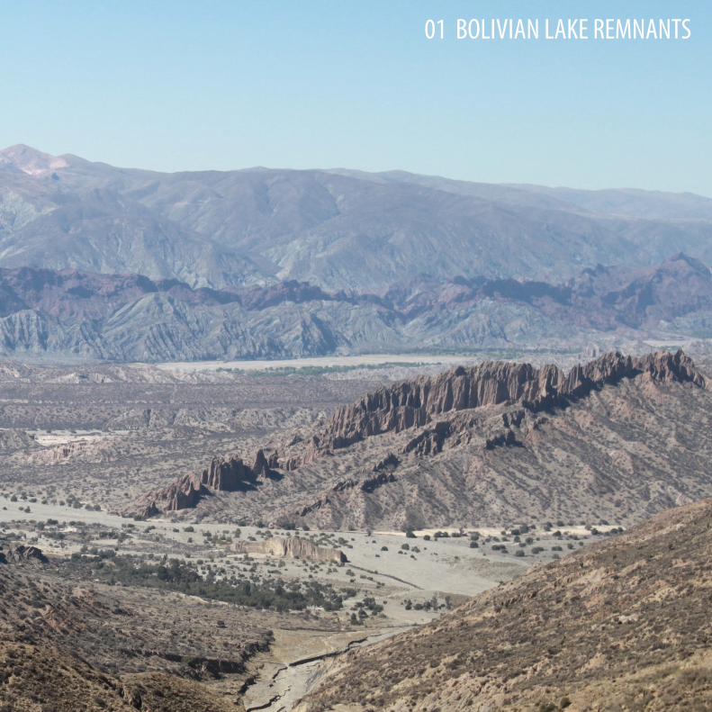
01 BOLIVIAN LAKE REMNANTS

22
1.1. BOLlVIAN WATER SOURCESFreshwater is one of the most important water sources all over the world, but even less than one percent of it is readily accessible for human use. Almost 70% of our fresh water is locked in deep underground aquifers as groundwater. Today, one-third of the world population lives in areas confronted with lack of water. [Kuylenstierna et al, 1998]The main reason for the unsustainability of groundwater is the long-term groundwater recharge. Bolivia, situated in South America, su"ers with mode-rate groundwater recharge. [Döll & Fiedler, 2007]
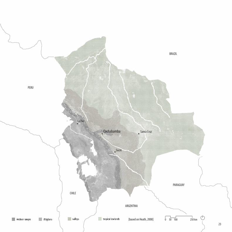
It is, together with Paraguay, the only Latin-American country that is nowhere bordered by water. Topographically, the country can be divided in three regions identi!ed by altitude and climate. The Altiplano or highlands, consists of high plateaus, found at an altitude beyond 3500 meters above sea level. Secondly, the valley has an altitude between 1500 to 3500 meters. And eventually the plains, with their very tropical climate, consist of forests and savannahs at an altitude of less than 1500 meters. [Musalem-Perez, 2009]
[based on United Nations Environment Programme, 2005]World map of groundwater recharge. 0 2000 5000 km
(cm$ water/cm$ land area)
23
PERU
CHILE
ARGENTINA
PARAGUAY
BRAZIL
La Paz
Cochabamba Santa Cruz
Sucre
[based on Heath, 2008] 0 50 100 250 km
24
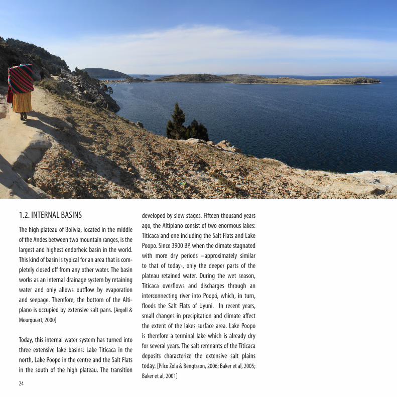
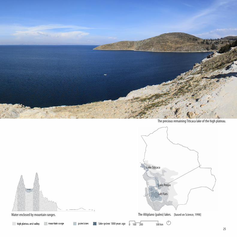
1.2. INTERNAL BASINSThe high plateau of Bolivia, located in the middle of the Andes between two mountain ranges, is the largest and highest endorheic basin in the world. This kind of basin is typical for an area that is com-pletely closed o" from any other water. The basin works as an internal drainage system by retaining water and only allows out#ow by evaporation and seepage. Therefore, the bottom of the Alti-plano is occupied by extensive salt pans. [Argoll & Mourguiart, 2000]
Today, this internal water system has turned into three extensive lake basins: Lake Titicaca in the north, Lake Poopo in the centre and the Salt Flats in the south of the high plateau. The transition
developed by slow stages. Fifteen thousand years ago, the Altiplano consist of two enormous lakes: Titicaca and one including the Salt Flats and Lake Poopo. Since 3900 BP, when the climate stagnated with more dry periods –approximately similar to that of today-, only the deeper parts of the plateau retained water. During the wet season, Titicaca over#ows and discharges through an interconnecting river into Poopó, which, in turn, #oods the Salt Flats of Uyuni. In recent years, small changes in precipitation and climate a"ect the extent of the lakes surface area. Lake Poopo is therefore a terminal lake which is already dry for several years. The salt remnants of the Titicaca deposits characterize the extensive salt plains today. [Pilco Zola & Bengtsson, 2006; Baker et al, 2005; Baker et al, 2001]
25
Lake Poopo
The precious remaining Titicaca lake of the high plateau.
Water enclosed by mountain ranges. The Altiplano (paleo) lakes. [based on Science, 1998]
0 100 200 500 km
Lake Titicaca
Salt Flats
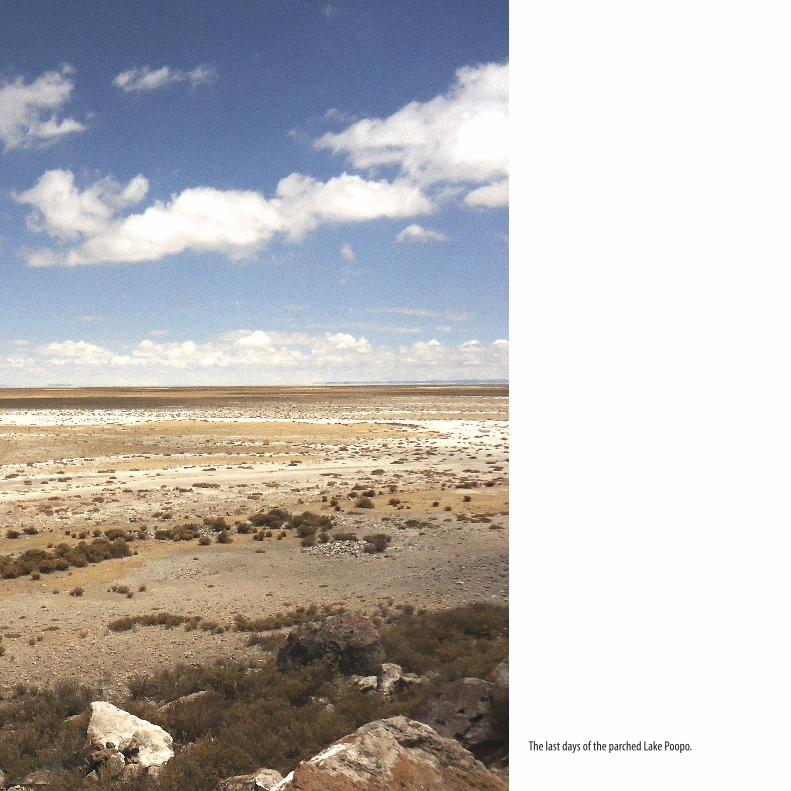
26The last days of the parched Lake Poopo.
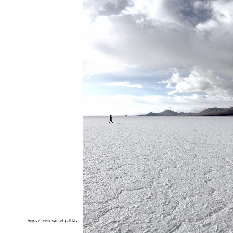
27From paleo lake to breathtaking salt #ats.

28
29
02 WATER AS A GUIDE THROUGH HISTORY
30
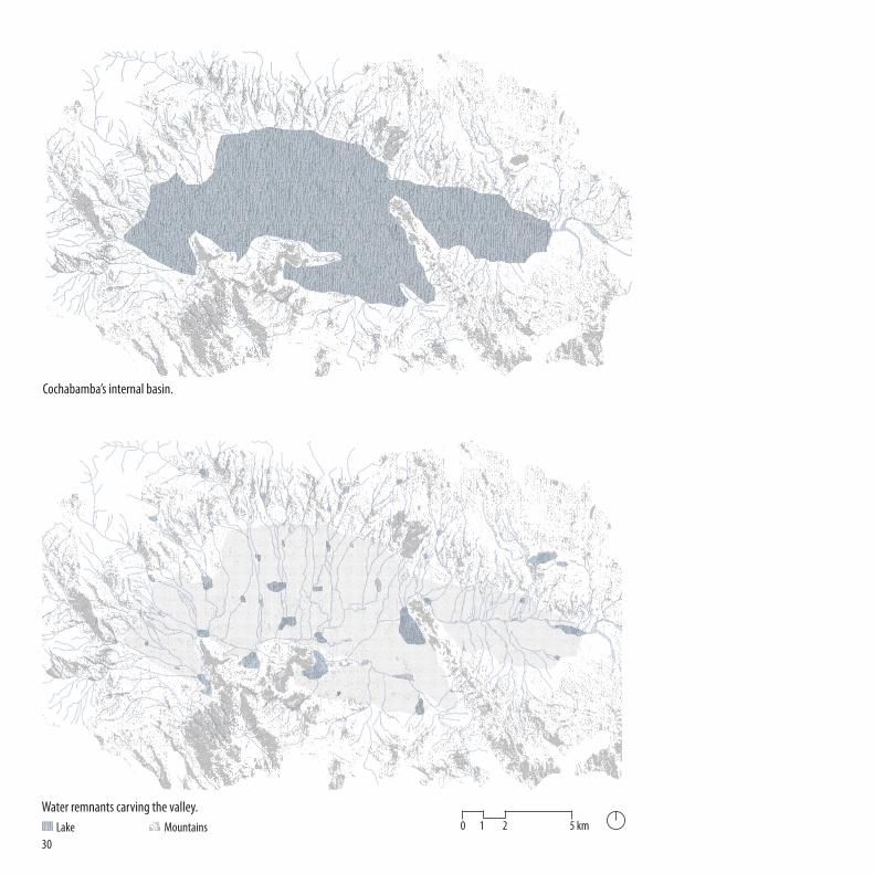
Cochabamba’s internal basin.
Water remnants carving the valley.0 1 2 5 kmLake Mountains
31
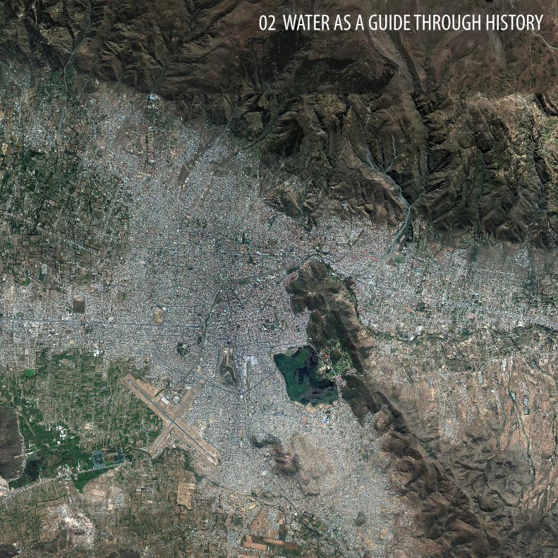
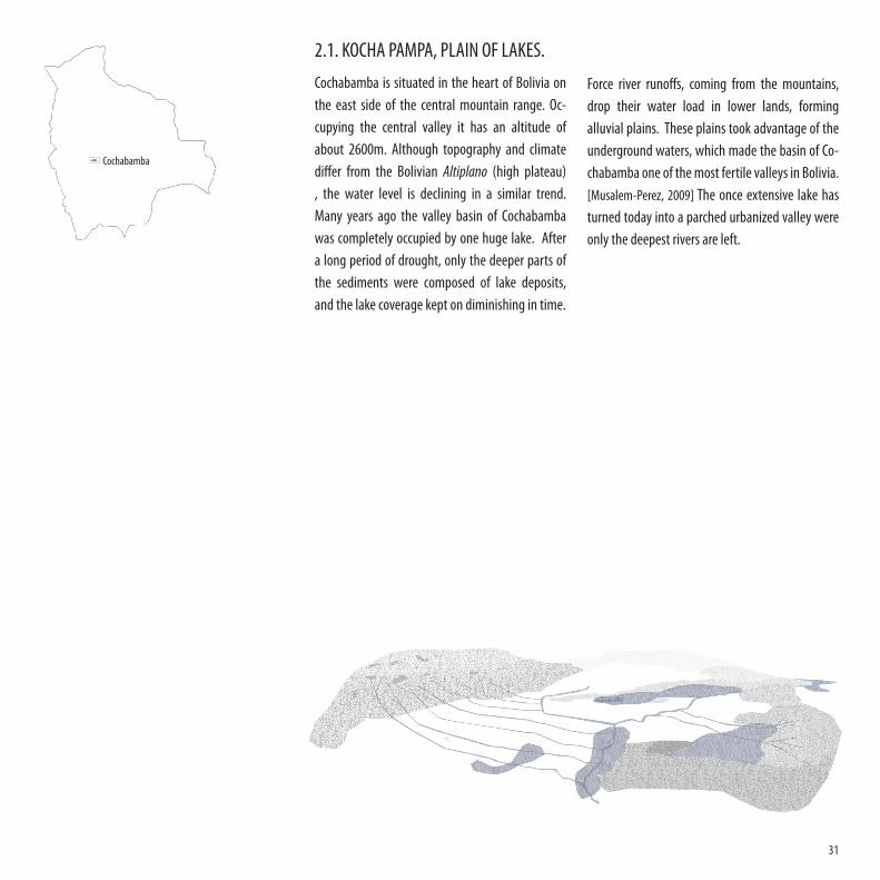
Force river runo"s, coming from the mountains, drop their water load in lower lands, forming alluvial plains. These plains took advantage of the underground waters, which made the basin of Co-chabamba one of the most fertile valleys in Bolivia. [Musalem-Perez, 2009] The once extensive lake has turned today into a parched urbanized valley were only the deepest rivers are left.
Cochabamba
2.1. KOCHA PAMPA, PLAIN OF LAKES. Cochabamba is situated in the heart of Bolivia on the east side of the central mountain range. Oc-cupying the central valley it has an altitude of about 2600m. Although topography and climate di"er from the Bolivian Altiplano (high plateau) , the water level is declining in a similar trend. Many years ago the valley basin of Cochabamba was completely occupied by one huge lake. After a long period of drought, only the deeper parts of the sediments were composed of lake deposits, and the lake coverage kept on diminishing in time.

0 1 2 5 km
Extensive agricultural suyu system with primary and secondary canals. [based on map in paper of Zimmerer K.S., 2000]
32
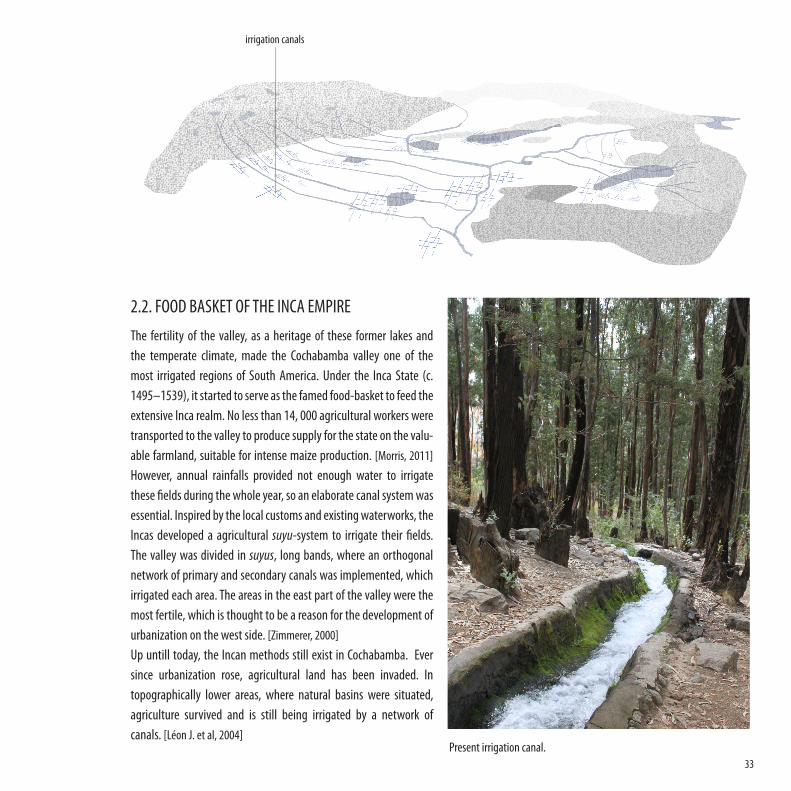
2.2. FOOD BASKET OF THE INCA EMPIREThe fertility of the valley, as a heritage of these former lakes and the tem perate climate, made the Cochabamba valley one of the most irrigated regions of South America. Under the Inca State (c. 1495–1539), it started to serve as the famed food-basket to feed the extensive Inca realm. No less than 14, 000 agricultural workers were transported to the valley to produce supply for the state on the valu-able farmland, suitable for intense maize production. [Morris, 2011] However, annual rainfalls provided not enough water to irrigate these !elds during the whole year, so an elaborate canal system was essential. Inspired by the local customs and existing waterworks, the Incas developed a agricultural suyu-system to irrigate their !elds. The valley was divided in suyus, long bands, where an orthogonal network of primary and secondary canals was implemented, which irrigated each area. The areas in the east part of the valley were the most fertile, which is thought to be a reason for the development of urbanization on the west side. [Zimmerer, 2000]Up untill today, the Incan methods still exist in Cochabamba. Ever since urbanization rose, agricultural land has been invaded. In topographically lower areas, where natural basins were situated, agriculture survived and is still being irrigated by a network of canals. [Léon J. et al, 2004]
Present irrigation canal.
irrigation canals
33
The Rocha River as attractive edge of the city. [Municipal de Cochabamba, 1900]
2.3. SPANISH INTERVENTIONS ON THE EXPANING CITY
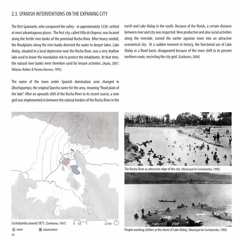
The !rst Spaniards, who conquered the valley - in approximately 1538- settled at most advantageous places. The !rst city, called Villa de Oropesa, was located along the fertile river banks of the perennial Rocha River. After heavy rainfall, the #oodplains along the river banks diverted the water to deeper lakes. Lake Alalay, situated in a local depression near the Rocha River, was a very shallow lake used to lower the inundation risk to protect the inhabitants. At that time, the natural river banks were therefore used for leisure activities. [Ayala, 2007; Villarias-Robles & Pereira Herrera, 1995]
The name of the town under Spanish domination soon changed in Qhochapampa, the original Quecha name for the area, meaning “#ood plain of the lake”. After an upwards shift of the Rocha River to its recent course, a new grid was implemented in between the natural borders of the Rocha River in the
Cochabamba around 1873. [Zambrana, 1967] 0 0,5 1 2,5 km
People washing clothes at the shore of Lake Alalay. [Municipal de Cochabamba, 1900]water urbanization
north and Lake Alalay in the south. Because of the #oods, a certain distance between river and city was respected. New productive and also social activities along the riverside, turned the earlier agrarian town into an attractive economical city. At a sudden moment in history, the functional use of Lake Alalay as a #ood basin, disappeared because of the rivers shift to its present northern route, encircling the city grid. [Goldstein, 2004]
34
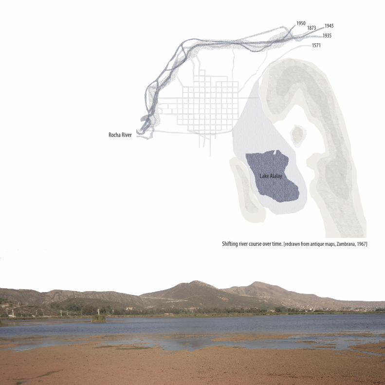
Shifting river course over time. [redrawn from antique maps, Zambrana, 1967]
Rocha River
Lake Alalay
1571
1935
19501873 1945
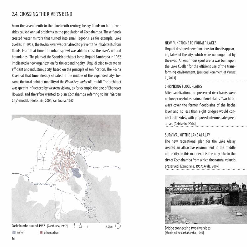
2.4. CROSSING THE RIVER’S BEND
From the seventeenth to the nineteenth century, heavy #oods on both river-sides caused annual problems to the population of Cochabamba. These #oods created water mirrors that turned into small lagoons, as for example, Lake Cuellar. In 1952, the Rocha River was canalized to prevent the inhabitants from #oods. From that time, the urban sprawl was able to cross the river’s natural boundaries. The plans of the Spanish architect Jorge Urquidi Zambrana in 1962 implicated a new organization for the expanding city. Urquidi tried to create an e%cient and industrious city, based on the principle of zoni!cation. The Rocha River -at that time already situated in the middle of the expanded city- be-came the focal point of mobility of the Plano Regulador of Urquidi. The architect was greatly in#uenced by western visions, as for example the one of Ebenezer Howard, and therefore wanted to plan Cochabamba referring to his ‘Garden City’-model. [Goldstein, 2004; Zambrana, 1967]
Cochabamba around 1962. [Zambrana, 1967] 0 0,5 1 2,5 km
SHRINKING FLOODPLAINSAfter canalization, the preserved river banks were no longer useful as natural #ood plains. Two high-ways cover the former #oodplains of the Rocha River and no less than eight bridges would con-nect both sides, with proposed intermediate green areas. [Goldstein, 2004]
NEW FUNCTIONS TO FORMER LAKESUrquidi designed new functions for the disappear-ing lakes of the city, which were no longer fed by the river. An enormous sport arena was built upon the Lake Cuellar for the e%cient use of the trans-forming environment. [personal comment of Vargaz C., 2011]
SURVIVAL OF THE LAKE ALALAYThe new recreational plan for the Lake Alalay created an attractive environment in the middle of the city. In this manner, it is the only lake in the city of Cochabamba from which the natural value is preserved. [Zambrana, 1967; Ayala, 2007]
Bridge connecting two riversides. [Municipal de Cochabamba, 1940]water urbanization
36
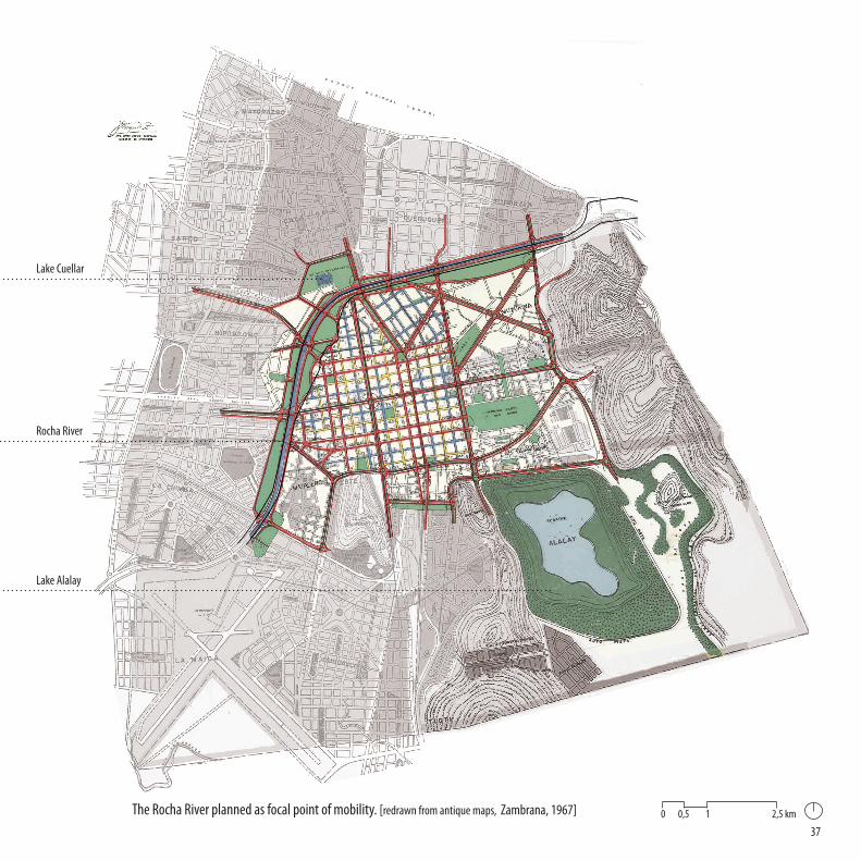
The Rocha River planned as focal point of mobility. [redrawn from antique maps, Zambrana, 1967] 0 0,5 1 2,5 km
Lake Cuellar
Lake Alalay
Rocha River
37

2.5. DIMINISHING FERTILITY OF LAND
After the migration boom of 1950, the city grew outside its borders and the so called ‘un-urbanizable’ land became occupied by new settlers. The green city from before, turned into a dense and contaminated city, expanding north-wards and towards the -from then on- canalized torrents. From then on, the once inexhaustible aquifer is being less recharged due to the increase of imper-meable surface (for example the current trend of building tra%c roads) of the expanding urbanization. The very few permeable areas are not able to provide enough in!ltration water to recharge. As a result, the once agricultural valley is drying out and therefore losing its fertility. [Léon J. et al, 2004]
Cochabamba around 2011 [Zambrana, 1967] 0 0,5 1 2,5 km
water urbanization
The expanding city. 1873-2012
38
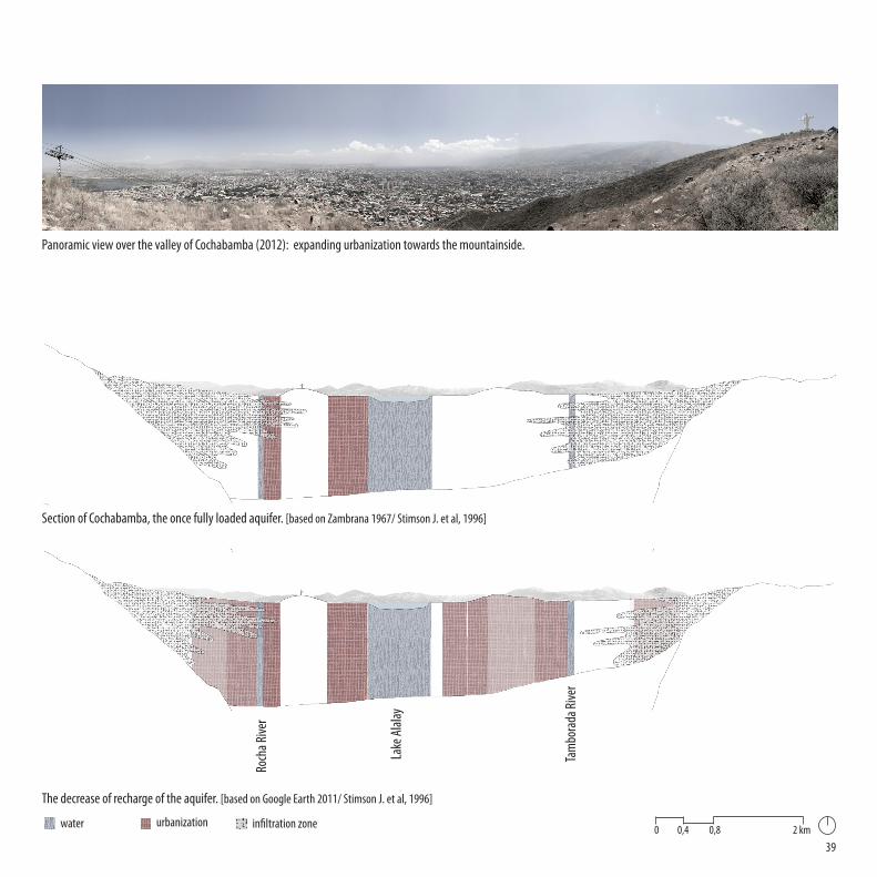
The decrease of recharge of the aquifer. [based on Google Earth 2011/ Stimson J. et al, 1996]
0 0,4 0,8 2 km
Roch
a Rive
r
Lake
Alala
y
Tamb
orad
a Rive
r
Section of Cochabamba, the once fully loaded aquifer. [based on Zambrana 1967/ Stimson J. et al, 1996]
water urbanization in!ltration zone
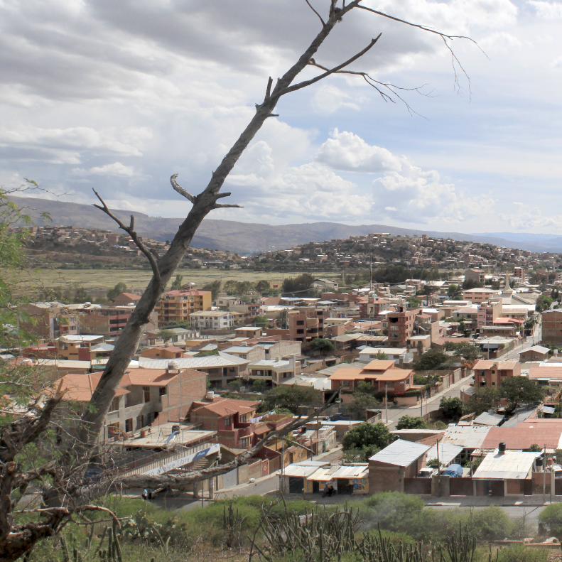
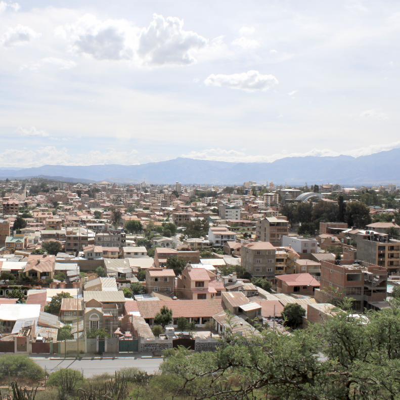
Panoramic view over the valley of Cochabamba (2012): expanding urbanization towards the mountainside.
39
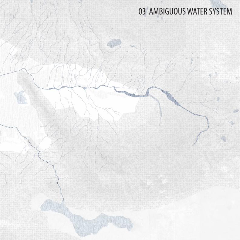
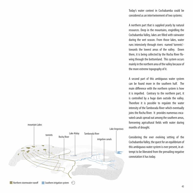
03 AMBIGUOUS WATER SYSTEM

44Impression of the versatile water system in Cochabamba.
45
Today’s water context in Cochabamba could be considered as an intertwinement of two systems:
A northern part that is supplied yearly by natural resources. Deep in the mountains, engirdling the Cochabamba Valley, lakes are !lled with rainwater during the wet season. From those lakes, water runs intensively through rivers -named ‘torrents’- towards the lowest areas of the valley. Down there, it is being collected by the Rocha River #o-wing through the bottomland. This system occurs mainly in the northern area of the valley because of the more extreme topography of it.
A second part of this ambiguous water system can be found more in the southern half. The main di"erence with the northern system is how it is impelled. Contrary to the northern part, it is controlled by a huge dam outside the valley. Therefore it is possible to regulate the water intensity of the Tamborada River which eventually joins the Rocha River. It provides numerous exca-vated canals spread out among the southern areas, foreseeing agricultural !elds with water during months of drought.
Considering the ever evolving setting of the Cochabamba Valley, the quest for an equilibrium of this ambiguous water system is ever present, in at-tempt to be liberated from the prevailing negative connotation it has today.
Northern stormwater runo" Southern irrigation systemImpression of the versatile water system in Cochabamba.
Rocha RiverTamborada River
irrigation canals
Lake AngosturaLake Alalay
mountain Lakes
torrents

47
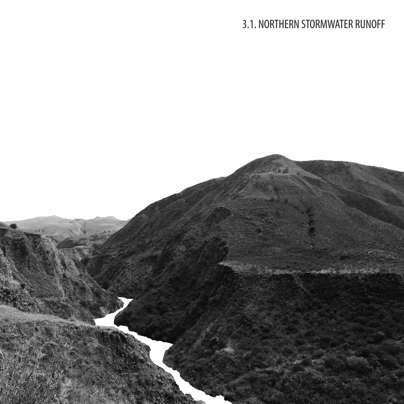
3.1. NORTHERN STORMWATER RUNOFF

48Mountain range Urbanization Lakes Water system 0 1 2.5 km
LATENT WATER PROVISIONCochabamba is de!ned by its surrounding mountainous landscape. This continuously undulating scenery allows water to be stored in local depressions of the topography. Numerous lakes are scattered among the mountaintops, !l-led each year during rainy season. They provide Cochabamba with clean water, a rarity and a gift for the city and its dwellers.
Monthly waterfall in mm. [JICA, 2009]
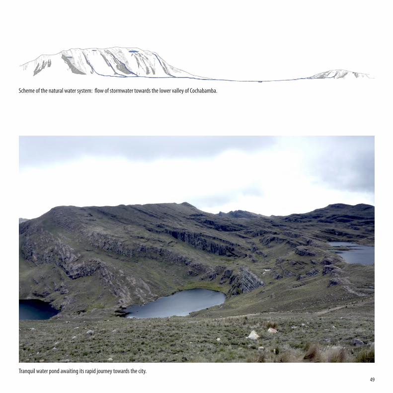
49Tranquil water pond awaiting its rapid journey towards the city.
Scheme of the natural water system: #ow of stormwater towards the lower valley of Cochabamba.Monthly waterfall in mm. [JICA, 2009]
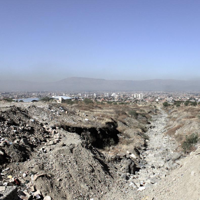

51Carved landscape caused by seasonal torrential water runo".
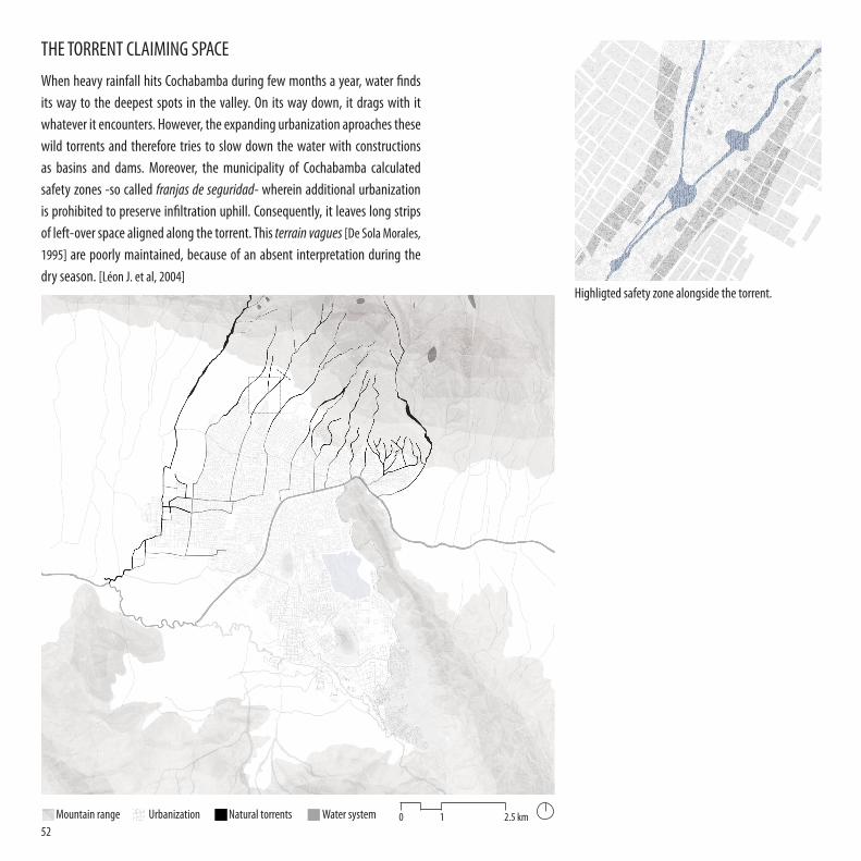
52Mountain range Urbanization Natural torrents Water system 0 1 2.5 km
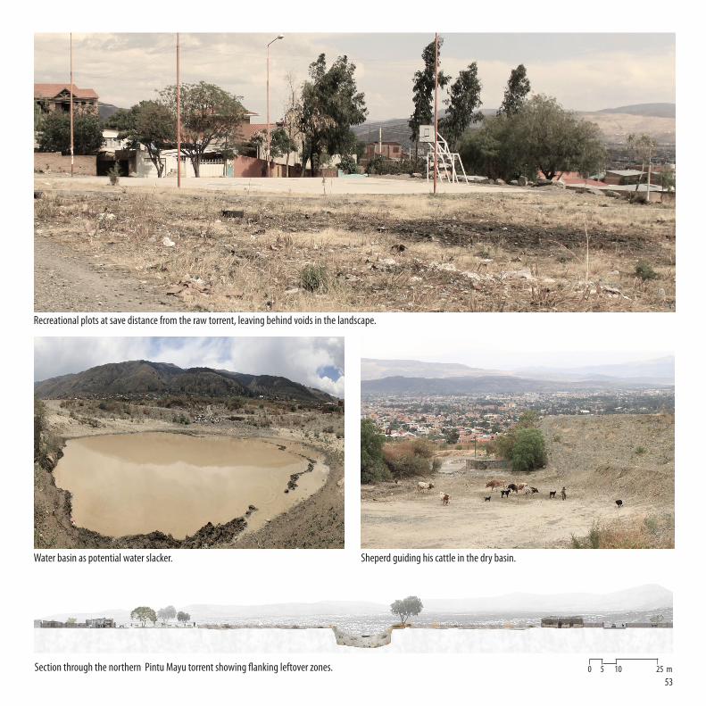
THE TORRENT CLAIMING SPACEWhen heavy rainfall hits Cochabamba during few months a year, water !nds its way to the deepest spots in the valley. On its way down, it drags with it whatever it encounters. However, the expanding urbanization aproaches these wild torrents and therefore tries to slow down the water with constructions as basins and dams. Moreover, the municipality of Cochabamba calculated safety zones -so called franjas de seguridad- wherein additional urbanization is prohibited to preserve in!ltration uphill. Consequently, it leaves long strips of left-over space aligned along the torrent. This terrain vagues [De Sola Morales, 1995] are poorly maintained, because of an absent interpretation during the dry season. [Léon J. et al, 2004]
Highligted safety zone alongside the torrent.
53
Recreational plots at save distance from the raw torrent, leaving behind voids in the landscape.
Section through the northern Pintu Mayu torrent showing #anking leftover zones.
Water basin as potential water slacker. Sheperd guiding his cattle in the dry basin.
0 5 10 25 m

55
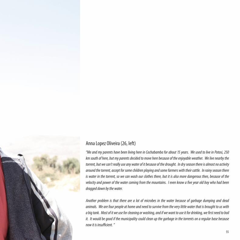
Anna Lopez Oliveira (26, left) “Me and my parents have been living here in Cochabamba for about 15 years. We used to live in Potosi, 250 km south of here, but my parents decided to move here because of the enjoyable weather. We live nearby the torrent, but we can’t really use any water of it because of the drought. In dry season there is almost no activity around the torrent, accept for some children playing and some farmers with their cattle. In rainy season there is water in the torrent, so we can wash our clothes there, but it is also more dangerous then, because of the velocity and power of the water coming from the mountains. I even know a !ve year old boy who had been dragged down by the water.
Another problem is that there are a lot of microbes in the water because of garbage dumping and dead animals. We are four people at home and need to survive from the very little water that is brought to us with a big tank. Most of it we use for cleaning or washing, and if we want to use it for drinking, we !rst need to boil it. It would be good if the municipality could clean up the garbage in the torrents on a regular base because now it is insu"cient. ”
56Mountain range Urbanization Canalized torrents Water system 0 1 2.5 km
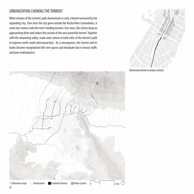
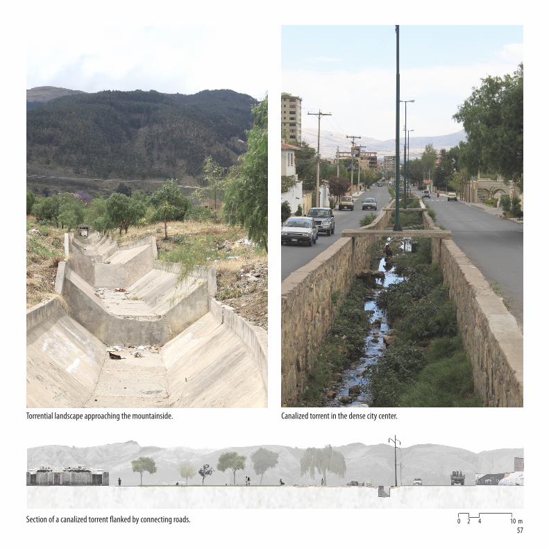
URBANIZATION CHOKING THE TORRENTWhat remains of the torrent’s path downstream is only a funnel narrowed by the expanding city. Ever since the city grew outside the Rocha River’s boundaries, it came into contact with the river’s feeding torrents. Ever since, the citizins keep on approaching them and reduce the section of the once powerful torrent. Together with the urbanizing valley, roads were strewn at both sides of the torrent’s path to improve north-south interconnection. As a consequence, the torrent and its banks become marginalized left-over spaces and devaluate due to heavy tra%c and poor maintainance.
Narrowed torrent in urban context.
57
Torrential landscape approaching the mountainside. Canalized torrent in the dense city center.
Section of a canalized torrent #anked by connecting roads. 0 2 4 10 m
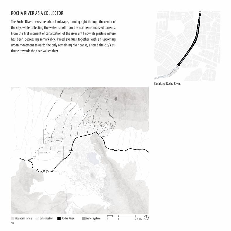
58Mountain range Urbanization Rocha River Water system 0 1 2.5 km
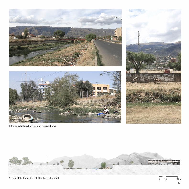
ROCHA RIVER AS A COLLECTORThe Rocha River carves the urban landscape, running right through the center of the city, while collecting the water runo" from the northern canalized torrents. From the !rst moment of canalization of the river until now, its pristine nature has been decreasing remarkably. Paved avenues together with an upcoming urban movement towards the only remaining river banks, altered the city’s at-titude towards the once valued river.
Canalized Rocha River.
59
Informal activities characterizing the river banks
Section of the Rocha River at it least accesible point. 0 5 15 m

60
Impermeable canalized torrent increases the speed of water.
Mountain range Urbanization Canalization Water system Flooded area 0 2 5 km

61
CANALIZATION AND URBANIZATION CAUSING FLOODSConsidering the torrents’ transformation from north to south, from a large natural gully to a narrow canal, there is a remarkable change in in!ltration. Because of canalization, water is not able to in!ltrate in the concreted canal bottom and more water is #owing towards the south. Moreover, due to the urban sprawl towards the waterfront, former #oodplains became im-permeable and the seasonal water streams have accelerated. [Léon J. et al, 2004] As a consequence, the Rocha River can not divert this huge amount of water and the lowest points in the southern part of the Cochabamba Valley struggle with serious #oods in times of heavy rainfall. Every year, the population of Cochabamba -especially the farmers in the south- is threa-tened by the damage to crops, houses and infrastructure. [personal com-ment of Tindea B., 2011]
Reducing section of the torrent banks.
Powerful mudstreams during rainy season in the Rocha River.
Flooded agricultural !elds in the south. 0 2 5 km

62

63
The canalized torrent: During dry season a rather curious contraption is revealed in the landscape.

65
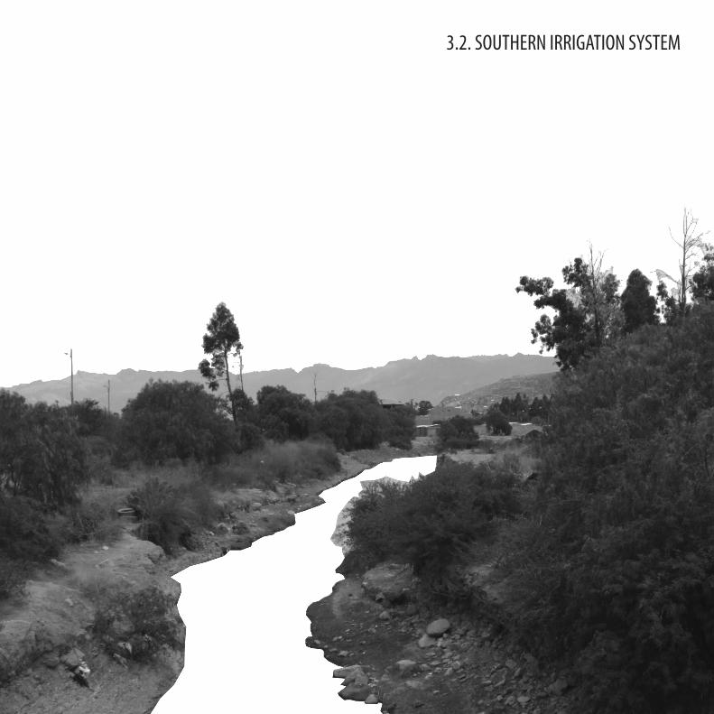
3.2. SOUTHERN IRRIGATION SYSTEM

67
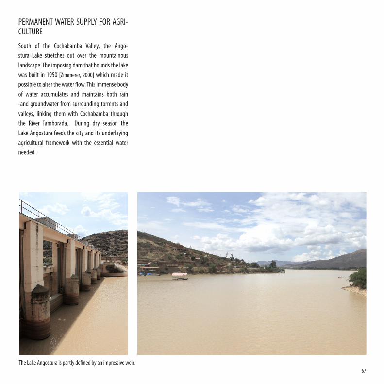
PERMANENT WATER SUPPLY FOR AGRI-CULTURESouth of the Cochabamba Valley, the Ango-stura Lake stretches out over the mountainous l andscape. The imposing dam that bounds the lake was built in 1950 [Zimmerer, 2000] which made it possible to alter the water #ow. This immense body of water accumulates and maintains both rain -and groundwater from surrounding torrents and valleys, linking them with Cochabamba through the River Tamborada. During dry season the Lake Angostura feeds the city and its underlaying agricultural framework with the essential water needed.
The Lake Angostura is partly de!ned by an impressive weir.
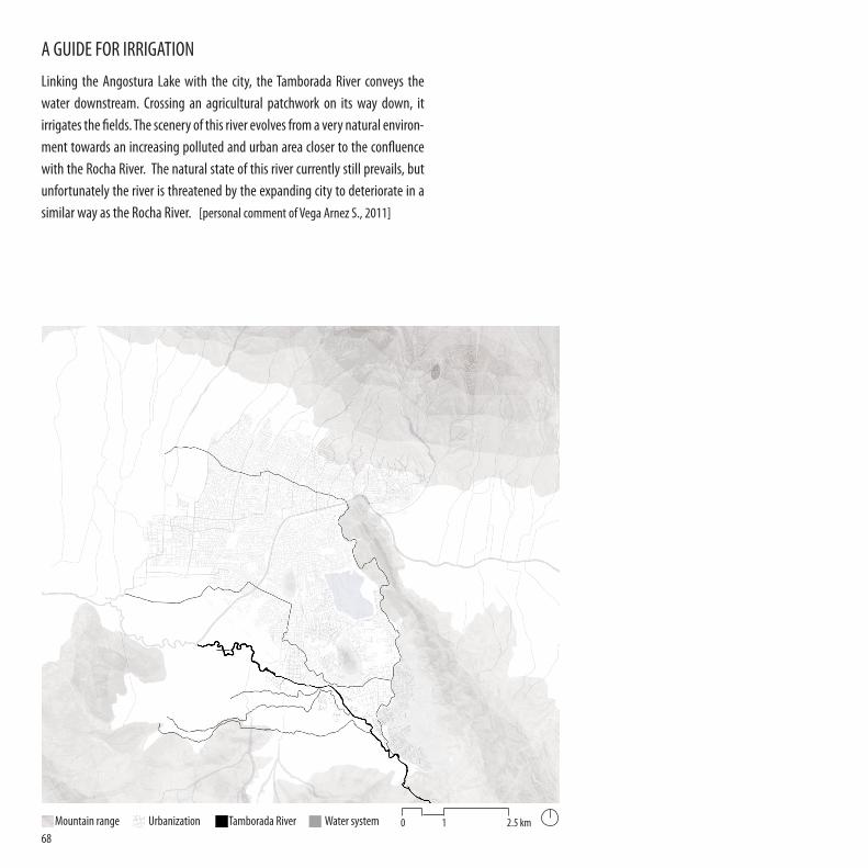
68Mountain range Urbanization Tamborada River Water system 0 1 2.5 km
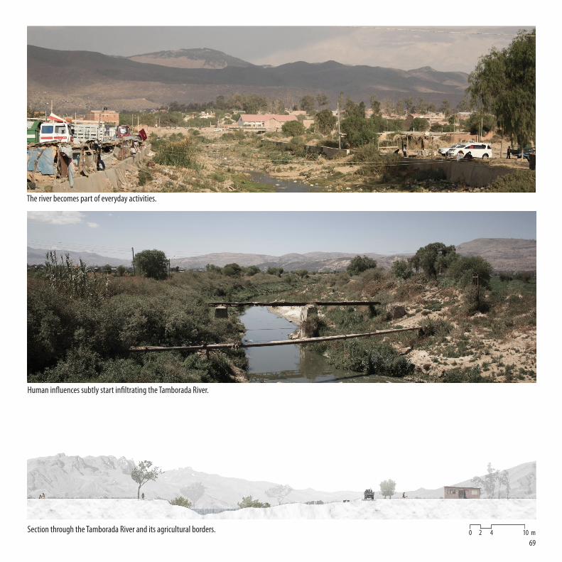
A GUIDE FOR IRRIGATIONLinking the Angostura Lake with the city, the Tamborada River conveys the water downstream. Crossing an agricultural patchwork on its way down, it irrigates the !elds. The scenery of this river evolves from a very natural environ-ment towards an increasing polluted and urban area closer to the con#uence with the Rocha River. The natural state of this river currently still prevails, but unfortunately the river is threatened by the expanding city to deteriorate in a similar way as the Rocha River. [personal comment of Vega Arnez S., 2011]
69
Section through the Tamborada River and its agricultural borders.
The river becomes part of everyday activities.
Human in#uences subtly start in!ltrating the Tamborada River.
0 2 4 10 m
70Mountain range Urbanization Irrigation canals Water system 0 1 2.5 km
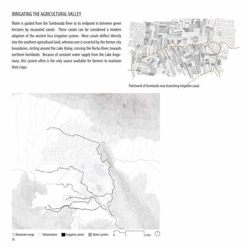
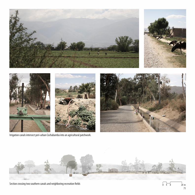
IRRIGATING THE AGRICULTURAL VALLEYWater is guided from the Tamborada River to its endpoint in between green hectares by excavated canals. These canals can be considered a modern adaption of the ancient Inca irrigation system. Most canals de#ect directly into the southern agricultural land, whereas one is escorted by the former city boundaries, circling around the Lake Alalay, crossing the Rocha River, towards northern farmlands. Because of constant water supply from the Lake Ango-stura, this system often is the only source available for farmers to maintain their crops.
Patchwork of farmlands near branching irrigation canal.
71Section crossing two southern canals and neighboring recreation !elds
Irrigation canals intersect peri-urban Cochabamba into an agricultural patchwork.
0 4 8 20 m
72

73
Bossa Tindea (55) - “Here in the south, it’s a di#erent way of living. You almost don’t see any cars, there are no stressed people going to work and most important of all, we’re only surrounded by nature. It’s a peaceful way of living.
But I’m already an old man and things aren’t getting much easier on the farm. Last years the $oods got worse and damaged the canals in this region severely. It has been almost impossible to cultivate my crops since. During the dry season there’s very little or no water at all, so every drop counts. Even at this very moment, all my !elds have dried up. I’ve got seven children who are all working on the farm which makes it easier to cover all the work, but without water, we can’t do much. I don’t want to sound too pessimistic, but it is what it is. If the municipality would provide us with tanks for drinking water, things would be a lot more bearable but now it’s really a struggle to survive.
When I remember the older days we didn’t have those kinds of problems. Of course there were a few, but those were only futile compared to the ones now. It’s a shame because I love Cochabamba with all my heart. Let’s just hope Pacha Mama will be good for us and things will change soon. “
74
75
04 AMBITIOUS WATER SYSTEM

76

77
From the twentieth century until the beginning of the twenty !rst, the city of Cochabamba evolved in an uncontrollable way, eating up every piece of land on its way. As urban sprawl continued, the city lost its waterways to concrete roads and buil-ding infrastructures. Stripped from their natural breathing spaces, waters soon began to alter their functional role. Neglect, misuse and deterioration have become the new standard, setting a path to a downwards spiral.
Nevertheless, they are still being used by the indigenous people today, marking them as informal territory. Although rejected by the formal city, these last activities show that the potential of Cochabamba's waterways is not entirely forgotten. To understand more closely the inter-contextuality between the city and its waterways, it is essential to zoom into a smaller scale. When taking a closer look on the borderline between these two main actors, new insights might arise about their con-#ictual relation, potential and daily use.
Spread over Cochabamba, !ve di"erent tissues are examined, all 400 by 400 meters, displaying more carefully the current water situation.

78
0 20 40 100 mgreen park river bank water urbanization
Section through a fenced green space on the Rocha Riverbank.
790 5 10 25 m
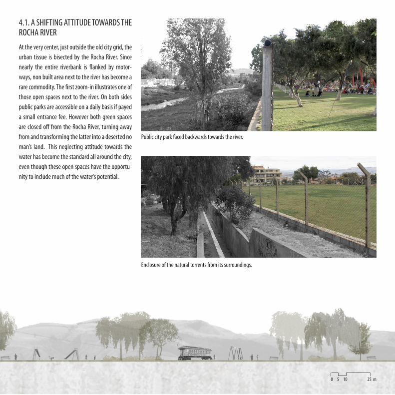
4.1. A SHIFTING ATTITUDE TOWARDS THE ROCHA RIVER At the very center, just outside the old city grid, the urban tissue is bisected by the Rocha River. Since nearly the entire riverbank is #anked by motor-ways, non built area next to the river has become a rare commodity. The !rst zoom-in illustrates one of those open spaces next to the river. On both sides public parks are accessible on a daily basis if payed a small entrance fee. However both green spaces are closed o" from the Rocha River, turning away from and transforming the latter into a deserted no man’s land. This neglecting attitude towards the water has become the standard all around the city, even though these open spaces have the opportu-nity to include much of the water’s potential.
Public city park faced backwards towards the river.
Enclosure of the natural torrents from its surroundings.

80
0 5 10 25 m
Rocha River
bank
water urbanization The need to encourage new audiences.
Section through the inaccessible Rocha River.
0 20 40 100 m
81
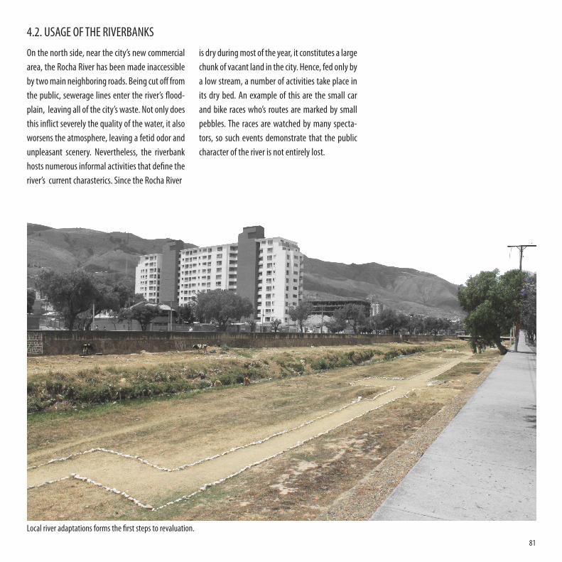
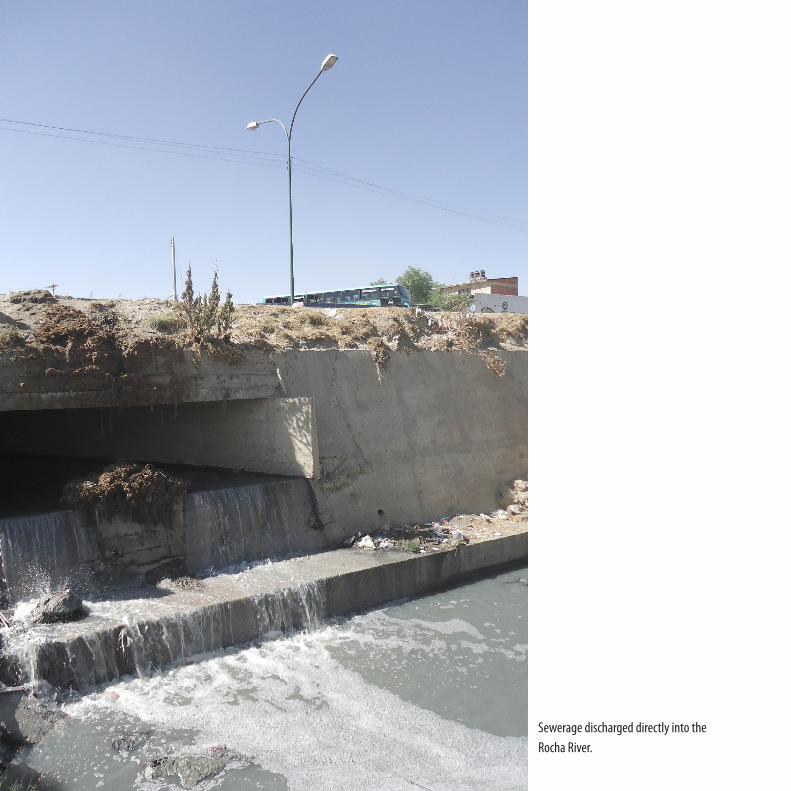
4.2. USAGE OF THE RIVERBANKSOn the north side, near the city’s new commercial area, the Rocha River has been made inaccessible by two main neighboring roads. Being cut o" from the public, sewerage lines enter the river’s #ood-plain, leaving all of the city’s waste. Not only does this in#ict severely the quality of the water, it also worsens the atmosphere, leaving a fetid odor and unpleasant scenery. Nevertheless, the riverbank hosts numerous informal activities that de!ne the river’s current charasterics. Since the Rocha River
The need to encourage new audiences.
Local river adaptations forms the !rst steps to revaluation.
is dry during most of the year, it constitutes a large chunk of vacant land in the city. Hence, fed only by a low stream, a number of activities take place in its dry bed. An example of this are the small car and bike races who’s routes are marked by small pebbles. The races are watched by many specta-tors, so such events demonstrate that the public character of the river is not entirely lost.
82
Sewerage discharged directly into the Rocha River.

83
Lack of social control encourages misuse of the Taquiña Torrent

84
85
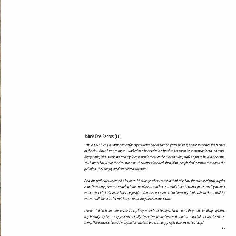
Jaime Dos Santos (66) “I have been living in Cochabamba for my entire life and as I am 66 years old now, I have witnessed the change of the city. When I was younger, I worked as a bartender in a hotel so I knew quite some people around town. Many times, after work, me and my friends would meet at the river to swim, walk or just to have a nice time. You have to know that the river was a much cleaner place back then. Now, people don’t seem to care about the pollution, they simply aren’t interested anymore.
Also, the tra"c has increased a lot since. It’s strange when I come to think of it how the river used to be a quiet zone. Nowadays, cars are zooming from one place to another. You really have to watch your steps if you don’t want to get hit. I still sometimes see people using the river’s water, but I have my doubts about the unhealthy water condition. It’s a bit sad, but probably they have no other way.
Like most of Cochabamba’s residents, I get my water from Semapa. Each month they come to !ll up my tank. It gets really dry here every year so I’m really dependent on that water. It is not so much but at least it is some-thing. Nevertheless, I consider myself fortunate, there are many people who are not so lucky.”
86
0 2 4 10 m
water urbanizationgreen park
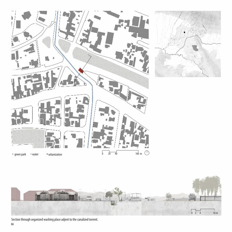
Section through organized washing place adjent to the canalized torrent.
0 20 40 100 m

87
4.3. VALUE OF PUBLIC, ORGANIZED ACTI-VITIESIn the urban center, near one of the canalized northern torrents, one sole organized lavatory can be found. This construction gives the inhabitants the possibility to wash their clothes with free water supply. However, the washing place is only open a few hours a week and not all of the twenty taps always function. As a consequence the lavatory is often overcrowded. The location was not chosen at random, but implemented so that used water #ows down into the canalized torrent. Due to this discharge, the torrent results in an even more c ontaminated water canal.
This trend also characterizes the river banks of Cochabamba every day. In most environments these activities take place in an unorganized way. The design of public lavatories to stop random washing and to provide cleaner water, is already a good intention to organize these informal acti-vities. If some treatment actions would be under-taken for the contaminated discharge, the value of this potential places would increase.
Self organised washing place near the natural origin of the Tamborada River.
The only organized washing place in Cochabamba, o"ering free facilities .
88
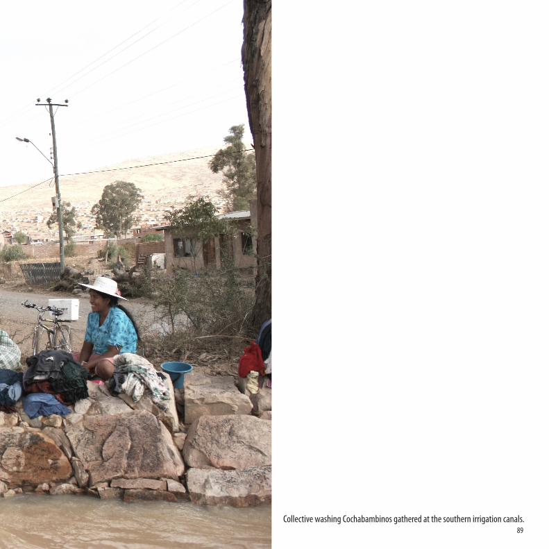
89Collective washing Cochabambinos gathered at the southern irrigation canals.
90
river bank water urbanization
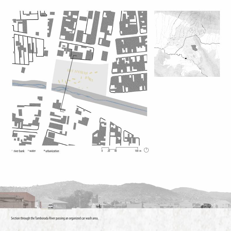
Section through the Tamborada River passing an organized car wash area.
0 20 40 100 m

910 2 4 10 m
The Tamborada River, #owing through the less dense southern part of the city, marks one of the most frequently utilized hot spots of the region. Right before the river regains its natural course and leaves the city towards Cochabamba’s air-port, it passes the bustling Santa Ines square. Here numerous cars arriving from the Panameri-cana Avenue make their stop to take advantage of the locally invented carwash. The used washing system, representative for the common informal carwashes in Cochabamba, consist of a dug hole in the riverbank, !ltering the river’s water through its
natural soil. Subsequently, the collected water is brought up by a personal water pump and ready for use. However this process involves the usage of many cleaning agents which aggravates the already highly contaminated state of the Tambo-rada River. Either way, such local interventions af-!rm the possibility of an organized rapprochement towards the river, favoring not only a selective po-pulation group but the urban dwellers all together.
4.4. AN ORGANIZED RAPPROCHEMENT TO THE TAMBORADA RIVER
Local organised carwash attracting people to the riverside.

92
93
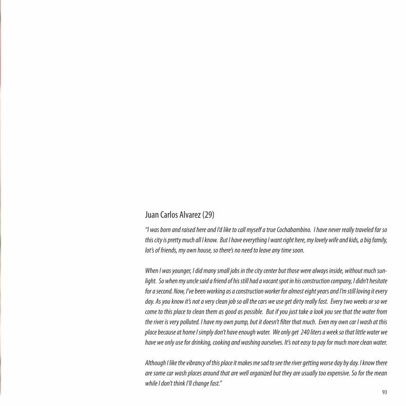
Juan Carlos Alvarez (29) “I was born and raised here and I’d like to call myself a true Cochabambino. I have never really traveled far so this city is pretty much all I know. But I have everything I want right here, my lovely wife and kids, a big family, lot’s of friends, my own house, so there’s no need to leave any time soon.
When I was younger, I did many small jobs in the city center but those were always inside, without much sun-light. So when my uncle said a friend of his still had a vacant spot in his construction company, I didn’t hesitate for a second. Now, I’ve been working as a construction worker for almost eight years and I’m still loving it every day. As you know it’s not a very clean job so all the cars we use get dirty really fast. Every two weeks or so we come to this place to clean them as good as possible. But if you just take a look you see that the water from the river is very polluted. I have my own pump, but it doesn’t !lter that much. Even my own car I wash at this place because at home I simply don’t have enough water. We only get 240 liters a week so that little water we have we only use for drinking, cooking and washing ourselves. It’s not easy to pay for much more clean water.
Although I like the vibrancy of this place it makes me sad to see the river getting worse day by day. I know there are some car wash places around that are well organized but they are usually too expensive. So for the mean while I don’t think I’ll change fast.”
94
river bank water urbanization
0 2 4 10 m
0 20 40 100 m
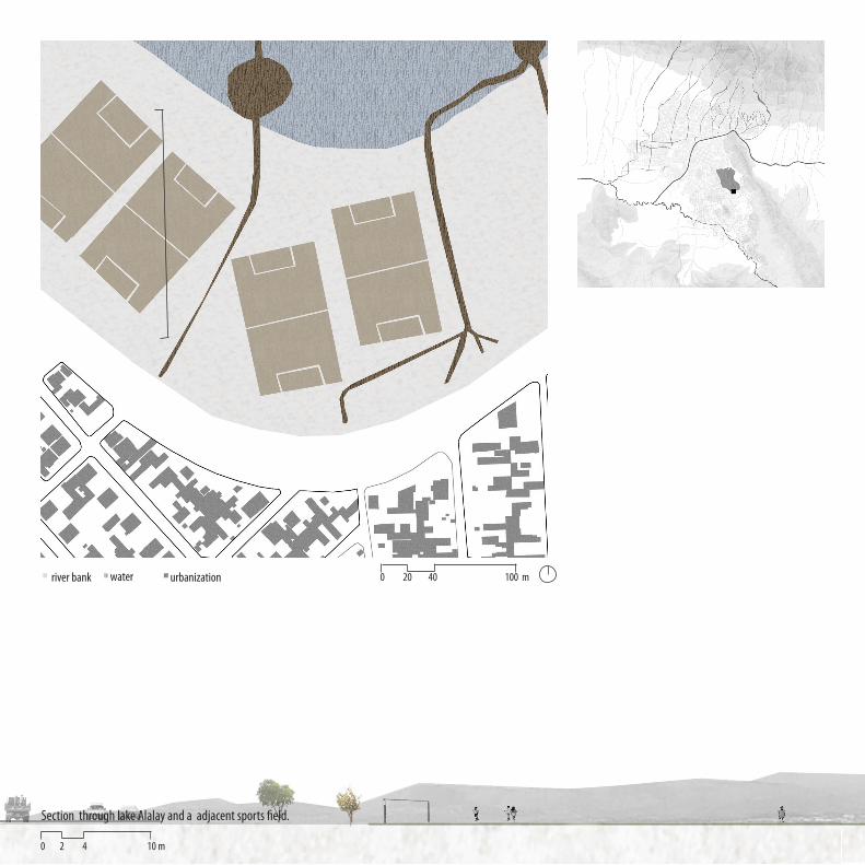
Section through lake Alalay and a adjacent sports !eld.
95
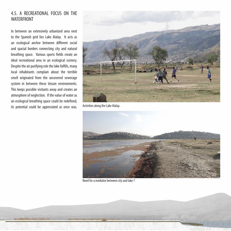
4.5. A RECREATIONAL FOCUS ON THE WATERFRONT
In between an extensively urbanized area next to the Spanish grid lies Lake Alalay. It acts as an ecological anchor between di"erent social and spacial borders connecting city and natural breathing space. Various sports !elds create an ideal recreational area in an ecological scenery. Despite the air purifying role the lake ful!lls, many local inhabitants complain about the terrible smell originated from the uncovered sewerage system in between these leisure environments. This keeps possible visitants away and creates an atmosphere of neglection. If the value of water as an ecological breathing space could be rede!ned, its potential could be appreciated as once was. Activities along the Lake Alalay.
Need for a mediator between city and lake ?

96
97
Starting from the Inca reign, through the enormous urban expansion of today, water of the city has been di"erently interpreted. Water was of daily importance for the Incan farmers, meant leading opportunities for the Spanish founders and was a guideline for the (re)organisation plans of urban architects. As a consequence, the natural #oodplain was swallowed by the expanding city. The once attractive river where people used to gather and meet with their neighbours was paved over and the water in the city lost its glory.
There is clear ambiguity of the water system in the valley, starting from the di"erence between the dry and rainy s eason, which gives rise to a range of con#icting issues between agriculture and urbanization, between #oods and drought. The approach of the water by the built context hampers the natural in!ltrati-on and recharge of the fertile valley. The balance of the water system is disturbed by mankind, which drives these two powers further apart. The city literally turns his back to its water courses by high walls, fencing and garbage dumping. The water system takes its revenge on the city by re-#ooding in rainy months and vanishing in dry months, leaving the inhabitants in despair.
When further considering the ongoing activities along the water courses in the valley -mostly happening in an informal way- a certain interaction between water and man can be (re)discovered. It clearly illustrates the necessity of water for a city as Cochabamba. Although urbanization expels water, a deeper approach shows that the inhabitants are still a"ected by water. Shifting the focus from a con#ict towards a dialogue, reveals a huge potential in the existing water system of Cochabamba. By rethinking the torrents, the rivers and the lakes, the relations between man and nature can be reshaped and the balance pursued.
IMPETUS FOR A STRATEGIC DESIGN APPROACH.

98
REFERENCES
AYALA R., ACOSTA F., MOOIJ W. M., REJAS D., VAN DAMME P. A. 2007. Laguna Alalay: a case study of lake restoration in Andean valleys in Bolivia.
ARGOLLO J., MOURGUIART P., “Late Quaterny climate history of the Bolivian Altiplano”, in Quaterny palaeohydrology of South America, 2000, vol. 72, issue 1, pp. 37-51.
BAKER P.A., FRITZ S. C., GARLAND J., EKDAHL E., “Holocene hydrologic variation at Lake Titicaca, Bolvia/Peru, and its relationship to North Atlantic climate variation”, in Journal of Quaternary Science, 2005, vol. 20, issue 7-8, pp. 655-662.
BAKER P.A., RIGSBY C.A., SELTZER G.O., FRITZ S.C., LOWENSTEIN T.K., BACHER N.P., VELIZ C., “Tropical climate changes at millennial and orbital timescales on the Bolivian Altiplano”, in Letters to Nature, 2001 (409).
BROOKE L., “Along the Inca Frontier” in Cochabamba 1550-1900, Colonialism and agrarian Transformation in Bolivia, p. 13-50
DÖLL P., FIEDLER K., “Global-scale modeling of groundwater recharge”, in Hydrology and Earth System Sciences, 2007
GOLDSTEIN, Daniel, “Urbanism, Modernity and Migration in Cochabamba” in The Spectacular City, Violence and Performance in Urban Bolivia, p. 53-89, Duke University Press, 2004
KUYLENSTIERNA J., NAJLIS P., BJÖRKLUND G., “The Comprehensive Assessment of the Freshwater Resources of the World-Policy Options for an Integrated Sustainable Water Future”., 1998, vol. 23, issue 1., pp. 17-20.
LEDO GARCIA M., Urbanisation and Poverty in the Cities of the National Economic Corridor in Bolivia. Case Study: Cochabamba, Delft University Press 2002
LEON J. Q. , Revollo I. V., Manejo integral de cuencas y franjas de seguridad en asentamientos humanos en zonas de riesgo, PROMIC, Cochabamba, Bolivia, 2004.
MORRIS C., VON HAGEN A. The Incas. London: Thames & Hudson, 2011
MUSALEM-PEREZ N., Looking for the past in the present: Ethnoarchaeology of plant utilization in rural Bolivia, BS thesis, University of Wisconsin-La Crosse, 2009
PILCO ZOLA R., BENGTSSON L., “Long-term and extreme water level variations of the shallow Lake Poopo, Bolivia”, in Hydrological Sciences Journal, 2006, vol. 51, Issue 1, pp. 98-114.
ZIMMERER K. S., Rescaling irrigation in Latin America: The cultural images and political ecology of water resources, 2000
99

ENCOUNTERS
ALVAREZ J.C.,inhabitant of Cochabamba, 14/09/2011.
ALVARO F., Geologist, 12/09/2011.
ANDRES L., Civil engineer/ Director of Programa Manejo Integral de cuenca. PROMIC, 05/102011
BUSTILLOS J., Civil enigineer, contact on regular base
CARLOS J., inhabitant of Cochabamba,15/09/2011.
DOS SANTOS J., inhabitant of Cochabamba, 11/09/2011.
FELIZA A., inhabitant of Cochabamba, 06/09/2011.
OLIVEIRA A. L., inhabitant of Cochabamba, 11/09/2011.
ROCHA TAREZ F., Civil engineer, 18/09/2011
ROJAS ALBORNOZ K., Civil engineer, contact on regular base
SANTA CRUZ, V., Civil engineer, contact on regular base
TINDEA B., inhabitant of Cochabamba, 06/09/2011.
VARGAS C., Architect (local co-promotor), contact on regular base.
VASQUEZ V., Water engineer, contact on regular base
VEGA ARNEZ S., Architect/Director of Planning Department city of Cochabamba (local promoter), contact on regular base.
VERONICA GARCIA GARECA P., Civil engineer, contact on regular base
100
PICTOGRAPHY
All images in this booklet are, unless listed below, made or drawn by the authors.
0 PREFACE
p. 24: World map of groundwater recharge: redrawn from a map of the Nations Enviroment programme, 2005,p. 25: Map of Bolivia: redrawn from maps published in THOMPSON L.G., DAVIS M.E., MOSLEY-THOMPSON E., SOWERS T.A., HENDERSON K.A., ZAGORODNOV, LIN P.N., MIKHALENKO V.N, CAMPEN R.K, BOLZAN J.F., COLE-DAI J., FRANCOU B.,”A 25,000-year tropical climate history from Bolivian ice cores”, in: Science, 1998, volume 282, issue 5395, pp. 1585-1864
01 BOLIVIAN LAKE REMNANTS
1.2 INTERNAL BASINS p. 27: Section of Bolivia: redrawn from section published in HEATH D. B., “The evolution of a Multi-Ethnic Society”, in: The Latin American Anthropology Review, 1994, vol. 6, issue 1, pp. 54-55 Map of lakes: redrawn from maps published in ARGOLLO J., MOURGUIART P., “Late Quaterny climate history of the Bolivian Altiplano”, in: Quaterny palaeohydrology of South America, 2000, vol. 72, issue 1, pp. 37-51.
02 WATER AS A GUIDE THROUGH HISTORY
p. 30-31: Aereal picture of the Cochabamba Valley: based on Google Earth 2011 2.1 KOCHA PAMPA , PLAIN OF LAKES p. 32: Maps of the valley: redrawn from Google Earth 2011 p. 33: Three-dimensional diagram of the valley: redrawn from Google Earth 2011 2.2 FOOD BASKET OF THE INCA EMPIRE p. 34: Map of the valley: redrawn from Google Earth 2011 and diagram published in Zimmerer K. S., Rescaling irrigation in Latin America: The cultural images and political ecology of water resources, 2000 2.3 SPANISH INTERVENTIONS ON THE EXPANDING CITY p. 36: Map of Cochabama in 1873: redrawn from historical map, published in ZAMBRANA J. U., La Urbanizacion de la ciudad de Cochabamba y el desarrollo regional y urbano, Cochabamba, Bolivia, 1967. 101

Historical pictures: obtained from the municipality of Cochabamba p. 37: Diagram of shifting river course: redrawn from di"erent historical maps, published in ZAMBRANA J. U., La Urbanizacion de la ciudad de Cocha bamba y el desarrollo regional y urbano, Cochabamba, Bolivia, 1967.
2.4 CROSSING THE RIVER’S BEND p. 38: Map of Cochabamba in 1962: historical map published in ZAMBRANA J. U., La Urbanizacion de la ciudad de Cochabamba y el desarrollo regional y urbano, Cochabamba, Bolivia, 1967. historical picture: obtained from the municipality of Cochabamba p. 39: Patchwork of historical maps: redrawn from historical maps, published in ZAMBRANA J. U., La Urbanizacion de la ciudad de Cochabamba y el desarrollo regional y urbano, Cochabamba, Bolivia, 1967. 2.5 DIMINISHING FERTILITY OF LAND p. 40: Map of Cochabamba in 2011: redrawn from Google Earth 2011 Map of expanding city: based on former historical maps p. 41: Sections of the Cochabamba Valley: redrawn from maps published in STIMSON J. ET AL, RUDOLPH D., FRAPE S., DRIMMIE R., “Interpreta- tion of groundwater #ow patterns through a reconstruction of the tritium precipitation record in the Cochabamba Valley, Bolivia”, in: Journal of Hydrology, 1996, issue 180, pp. 155-172., historical maps through time, published in ZAMBRANA J. U., La Urbanizacion de la ciudad de Cochabamba y el desarrollo regional y urbano, Cochabamba, Bolivia, 1967., Google Earth 2011.
3 AMBIGUOUS WATER SYSTEMp. 44-45: Map of the Cochabamba Valley: based on Google Earth 2011, mapa de canales obtained by the municipality of Cochabamba, Plano Municipal de Ordenamiento Territorial (PMOT), Cochabamba, Bolivia, 2009. obtained from the municipality of Cochabamba.p. 47: Diagram of the Cochabamba Valley, redrawn from Google Earth 2011 3.1 NATURAL STORMWATER RUNOFF LATENT WATER PROVISION p. 50: Diagram of monthly waterfall: redrawn from diagram published in Jica, 2008. Informe sobre el studio para la implementacion para el projecto de mejoramiento del sistema de agua potable en la zona sudeste de la ciudad de Cochabamba en la republica de Bolivia. Tokyo Engineering Consultants Co.l Map of watersystem of Cochabamba: based on Google Earth 2011, mapa de canales de agua obtained from the municipality of Cochabamba, Plano Municipal de Ordenamiento Territorial (PMOT), Cochabamba, Bolivia, 2009. obtained from the municipality of Cochabamba and Plano General de la ciudad de Cochabamba, 1999. obtained from the municipality of Cochabamba. p. 51: Scheme of the natural water system: redrawn from Google Earth 2011
102
THE TORRENT CLAIMING SPACE p. 54: Map of highlighted safety zone: redrawn from Google Earth 2011 and map published in Léon J. Q. , Revollo I. V., Manejo integral de cuencas y franjas de seguridad en asentamientos humanos en zonas de riesgo, PROMIC, Cochabamba, Bolivia, 2004. URBANIZATION CHOKING THE TORRENT p. 58: Map of canalized torrent: redrawn from Google Earth 2011, mapa de canales de agua obtained from the municipality of Cocha bamba, map published in Léon J. Q. , Revollo I. V., Manejo integral de cuencas y franjas de seguridad en asentamientos huma nos en zonas de riesgo, PROMIC, Cochabamba, Bolivia, 2004. and Plano General de la ciudad de Cochabamba, 1999. obtained from the municipality of Cochabamba. ROCHA RIVER AS A COLLECTOR p. 60: Map of canalized Rocha River: redrawn from Google Earth 2011, mapa de canales de agua obtained from the municipality of Cochabamba and Plano General de la ciudad de Cochabamba, 1999. obtained from the municipality of Cochabamba.
URBANIZATION AND CANALIZATION CAUSING FLOODS p. 62: Map of $ooded area in the valley of Cochabamba: based on Google Earth 2011, mapa de curvas obtained by the municipality of Cochabamba, mapa de canales de agua obtained from the municipality of Cochabamba and Plano General de la ciudad de Cochabamba, 1999. obtained from the municipality of Cochabamba. 3.2 SOUTHERN IRRIGATION SYSTEM PERMANENT WATER SUPPLY FOR AGRICULTURE p. 68: Map of the Lake Angostura: redrawn from Google Earth 2011 A GUIDE FOR IRRIGIATION p. 70-72: Maps of Cochabamba: based on Google Earth 2011, mapa de curvas obtained by the municipality of Cochabamba, mapa de canales de agua obtained from the municipality of Cochabamba and Plano General de la ciudad de Cochabamba, 1999. ob tained from the municipality of Cochabamba. IRRIGATING AGRICULTURAL LAND p. 72: Patchwork of farmlands: based on Google Earth 2011
4 AMBITIOUS WATER SYSTEM p. 78: Map wit highlighted tissues: based on Google Earth 2011, mapa de curvas obtained by the municipality of Cochabamba, mapa de canales de agua obtained from the municipality of Cochabamba and Plano General de la ciudad de Cochabamba, 1999. obtained from the munici pality of Cochabamba. p. 80-97: Maps of tissues: based on Google Earth 2011 and Plano General de la ciudad de Cochabamba, 1999. obtained from the municipality of Cochabam ba.
103