WS0-0000-HES-PLN-CVX-000-00066-000 3 - PUBLIC · Wheatstone Project Mangrove, Algal Mat and Tidal...
65
Wheatstone Project Mangrove, Algal Mat and Tidal Creek Protection Management Plan Document ID: WS0-0000-HES-PLN-CVX-000-00066-000 Revision ID: 3 Revision Date: 15 February 2017 Information Sensitivity: Public
Transcript of WS0-0000-HES-PLN-CVX-000-00066-000 3 - PUBLIC · Wheatstone Project Mangrove, Algal Mat and Tidal...
Wheatstone Project Mangrove, Algal Mat and Tidal Creek Protection Management Plan
Document ID: WS0-0000-HES-PLN-CVX-000-00066-000 Revision ID: 3
Revision Date: 15 February 2017
Information Sensitivity:
Public

Wheatstone Project Mangrove, Algal Mat and Tidal Creek Protection Management Plan
Document ID: WS0-0000-HES-PLN-CVX-000-00066-000 Revision ID:3 Revision Date: 15 Feb 2017 Page ii Information Sensitivity:Public Uncontrolled when Printed
Contents
Terms, Definitions and Abbreviations ............................................................................ v 1.0 Introduction ................................................................................................... 8
1.1 Objectives of this Plan ................................................................................... 8 1.2 Approvals .................................................................................................... 8 1.3 Scope ....................................................................................................... 10 1.4 Proponent and Operator .............................................................................. 10 1.5 Hierarchy of Documentation ......................................................................... 11
2.0 Existing Environment .................................................................................... 13 3.0 Risk Assessment ........................................................................................... 15
3.1 Key Receptors ........................................................................................... 15 3.2 Proposal-related Stressors ........................................................................... 17 3.3 Potential Stressors Addressed in Other Statutory Plans .................................... 18 3.4 Risk Assessment Methodology ...................................................................... 19 3.5 Outcomes ................................................................................................. 20
4.0 Management Measures .................................................................................. 23 4.1 Human Impacts ......................................................................................... 23 4.2 Contaminated Surface Water and Groundwater ............................................... 24 4.3 Turbidity and Sediment Deposition ................................................................ 24 4.4 Changes in Hydrological Regime ................................................................... 25 4.5 Potential Acid Sulphate Soils ........................................................................ 25 4.6 Chemical or Hydrocarbon Spills and Leaks ..................................................... 26
5.0 Monitoring Program ...................................................................................... 27 5.1 Monitoring Program Design .......................................................................... 27 5.2 Potential Monitoring Locations ...................................................................... 31
6.0 Management Triggers .................................................................................... 34 6.1 Direct Habitat Loss ..................................................................................... 34 6.2 Mangrove Health ........................................................................................ 35 6.3 Mangrove Groundwater Condition (Water Tables) ............................................ 36
6.3.1 Salinity .............................................................................................. 36 6.3.2 Groundwater Levels ............................................................................ 36
6.4 Surface Water Quality and Groundwater Quality ............................................. 37 6.5 Turbidity and Sediment Deposition / Erosion .................................................. 37 6.6 Potential Acid Sulphate Soils ........................................................................ 38 6.7 Chemical and Hydrocarbon Spills and Leaks ................................................... 38
7.0 Management of Trigger Exceedances ............................................................... 40 7.1 Response to Trigger Exceedances ................................................................. 40 7.2 Potential Contingency Measures ................................................................... 40
8.0 Reporting .................................................................................................... 42 8.1 Annual Compliance Reporting ....................................................................... 42 8.2 Non-compliance Reporting ........................................................................... 42
9.0 Review, Approval and Revision of this Plan ....................................................... 43 10.0 Stakeholder Consultation and Public Availability ................................................ 44 11.0 References .................................................................................................. 45

Wheatstone Project Mangrove, Algal Mat and Tidal Creek Protection Management Plan
Document ID: WS0-0000-HES-PLN-CVX-000-00066-000 Revision ID:3 Revision Date: 15 Feb 2017 Page iii Information Sensitivity:Public Uncontrolled when Printed
Tables
Table 1-1: MS 873 Condition Requirements Addressed in this Plan .................................... 9 Table 1-2: Project Facilities ........................................................................................ 10 Table 3-1: Potential Key Receptor Sensitivities from Project Activities .............................. 15 Table 3-2: Potential Stressors to Key Receptors Associated with the Project Relevant to this Plan .................................................................................................................. 17 Table 3-3: Potential Key Receptor Sensitivities to Project Activities Addressed in Other Statutory Plans ........................................................................................................ 18 Table 3-4: Residual Risk Categories ............................................................................ 19 Table 3-5: Summary of Risk Assessment for Construction Activities for the Project ............ 21 Table 3-6: Summary of Risk Assessment for Operation Activities for the Project ................ 22 Table 4-1: Management Measures for Human Impacts (Direct Habitat Loss) ..................... 23 Table 4-2: Management Measures for Human Impacts (Dust Generation) ......................... 23 Table 4-3: Management Measures of Surface Water and Groundwater ............................. 24 Table 4-4: Management Measures for Turbidity and sedimentation/Erosion ...................... 24 Table 4-5: Management Measures for Changes in Hydrological Regime ............................ 25 Table 4-6: Management Measures for PASS ................................................................. 25 Table 4-7: Management Measures for Hydrocarbon Spills and Leaks ................................ 26 Table 5-1: Construction Phase Monitoring Programs ...................................................... 28 Table 5-2: Operational Phase Monitoring Programs ....................................................... 29 Table 6-1: Trigger Values and Outcomes for Mangrove and Algal Mat Habitat Loss ............. 35 Table 6-2: Trigger Value for Mangrove Health and Habitat Condition ................................ 36 Table 6-3: Trigger Values for Hydraulic Loading ............................................................ 37 Table 6-4: Turbidity and Sediment Deposition/Erosion Trigger Value ............................... 38 Table 7-1: Potential Contingency Measures to Mitigate Impacts ...................................... 40
Figures
Figure 1-1: Location of the Project .............................................................................. 12 Figure 2-1: Intertidal Habitats within Project Survey Area .............................................. 14 Figure 5-1: Location of Potential Mangrove Monitoring Sites ........................................... 32 Figure 5-2: Schematic diagram showing key monitoring parameters at a single site ........... 33
Appendices
Appendix A - Summary of Baseline Habitat Information ................................................. 48 Appendix B - Chevron Integrated Risk Prioritisation Matrix ............................................. 60 Appendix C Compliance Reporting Table ...................................................................... 61
Appendix Tables
Table C-1: Compliance Reporting Table ..................................................................... 63

Wheatstone Project Mangrove, Algal Mat and Tidal Creek Protection Management Plan
Document ID: WS0-0000-HES-PLN-CVX-000-00066-000 Revision ID:3 Revision Date: 15 Feb 2017 Page iv Information Sensitivity:Public Uncontrolled when Printed
Appendix Figures
Figure A-1: Habitats of Hooley and Four Mile Creeks ..................................................... 49 Figure A-2: Mangrove Habitats of the Ashburton River Delta ........................................... 50 Appendix Figure B-1: Chevron Integrate Risk Prioritisation Matrix ................................. 60 Appendix Table C-1: Compliance Reporting Table ........................................................ 61
Appendix Photographs
Photograph A.1: Closed Canopy Avicennia marina Mangroves (Am2) ............................... 51 Photograph A.2: Open Shrub Land Mangroves Dominated By Avicennia Marina (Am3)........ 51 Photograph A.3: Bioturbated Mud Flats with Patches of Samphire .................................... 52 Photograph A.4: Algal Mat Peeling Back from the Underlying Mud Flat ............................. 55 Photograph A.5: Highly Turbid Water at the Mouth of the Ashburton River ........................ 58

Wheatstone Project Mangrove, Algal Mat and Tidal Creek Protection Management Plan
Document ID: WS0-0000-HES-PLN-CVX-000-00066-000 Revision ID:3 Revision Date: 15 Feb 2017 Page v Information Sensitivity:Public Uncontrolled when Printed
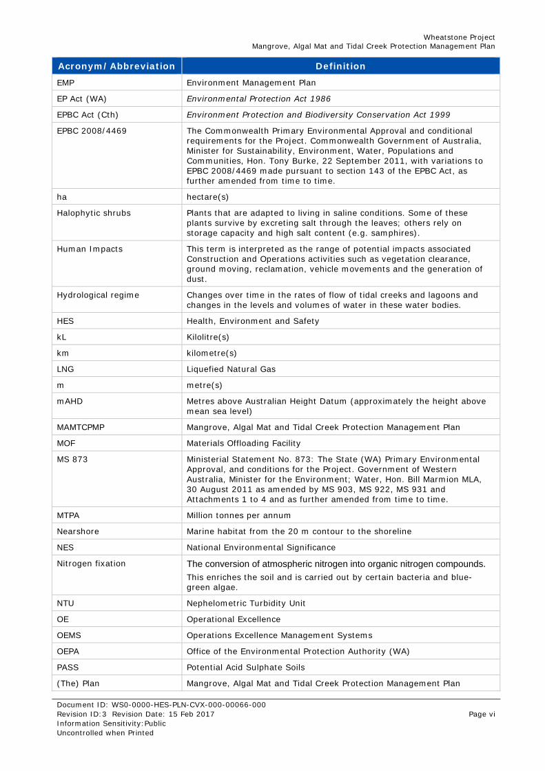
Terms, Definitions and Abbreviations Terms, definitions and abbreviations used in this document are listed below. These align with the terms, definitions and abbreviations defined in:
Schedule 4 of the Western Australian Project Ministerial Statement 873
Commonwealth Project Ministerial Approvals (EPBC Reference: 2008/4469).
Acronym/Abbreviation Definition
ABU Australasia Business Unit
ANSIA Ashburton North Strategic Industrial Area
AASS Actual Acid Sulphate Soils
BGL Below Ground Level
Benthic Primary Producer communities
Biological communities, including the plants and animals, within which benthic primary producers are the more prominent components
BPPH Benthic Primary Producer Habitat
CAR Compliance Assessment Report
Chevron Australia Chevron Australia Pty Ltd
Chenier Detached shoestring or sinuous sand deposit built to high tidal or supratidal levels surrounded by muddy tidal-lands.
CEO Chief Executive Office of the Office of the Environmental Protection Authority
Construction Means construction and commissioning of a Facility and includes any excavation and/or dredging but excludes temporary, minor, preliminary and investigatory works, geotechnical, geophysical, biological and cultural heritage surveys, staging works, baseline surveys, monitoring, technology trials, and works consented to by OEPA.
cm centimetre/s
CPMMP Coastal Processes Monitoring and Management Plan
CSMFIMP Conservation Significant Marine Fauna Interaction Management Plan
Commonwealth Marine Area Commonwealth Marine Area means the area in section 24 of the EPBC Act
Cth Commonwealth
CV Construction Village
DBNGP Dampier-to-Bunbury Natural Gas Pipeline
DDG DBP Development Group Pty Ltd
DEC Former Department of Environment and Conservation (WA) (as of July 2013 separated into Department of Parks & Wildlife and Department of Environment Regulation)
DER Department of Environment Regulation (WA) - formerly Department of Environment and Conservation (WA)
DMSI Digital Multi-Spectral Imagery
Domgas Domestic gas
DPaW Department of Wildlife and Parks (WA) - formerly Department of Environment and Conservation (WA)
Draft EIS/ERMP The Environmental Impact Statement/Environmental Review and Management Programme
Wheatstone Project Mangrove, Algal Mat and Tidal Creek Protection Management Plan
Document ID: WS0-0000-HES-PLN-CVX-000-00066-000 Revision ID:3 Revision Date: 15 Feb 2017 Page vi Information Sensitivity:Public Uncontrolled when Printed
Acronym/Abbreviation Definition
EMP Environment Management Plan
EP Act (WA) Environmental Protection Act 1986
EPBC Act (Cth) Environment Protection and Biodiversity Conservation Act 1999
EPBC 2008/4469 The Commonwealth Primary Environmental Approval and conditional requirements for the Project. Commonwealth Government of Australia, Minister for Sustainability, Environment, Water, Populations and Communities, Hon. Tony Burke, 22 September 2011, with variations to EPBC 2008/4469 made pursuant to section 143 of the EPBC Act, as further amended from time to time.
ha hectare(s)
Halophytic shrubs Plants that are adapted to living in saline conditions. Some of these plants survive by excreting salt through the leaves; others rely on storage capacity and high salt content (e.g. samphires).
Human Impacts This term is interpreted as the range of potential impacts associated Construction and Operations activities such as vegetation clearance, ground moving, reclamation, vehicle movements and the generation of dust.
Hydrological regime Changes over time in the rates of flow of tidal creeks and lagoons and changes in the levels and volumes of water in these water bodies.
HES Health, Environment and Safety
kL Kilolitre(s)
km kilometre(s)
LNG Liquefied Natural Gas
m metre(s)
mAHD Metres above Australian Height Datum (approximately the height above mean sea level)
MAMTCPMP Mangrove, Algal Mat and Tidal Creek Protection Management Plan
MOF Materials Offloading Facility
MS 873 Ministerial Statement No. 873: The State (WA) Primary Environmental Approval, and conditions for the Project. Government of Western Australia, Minister for the Environment; Water, Hon. Bill Marmion MLA, 30 August 2011 as amended by MS 903, MS 922, MS 931 and Attachments 1 to 4 and as further amended from time to time.
MTPA Million tonnes per annum
Nearshore Marine habitat from the 20 m contour to the shoreline
NES National Environmental Significance
Nitrogen fixation The conversion of atmospheric nitrogen into organic nitrogen compounds.
This enriches the soil and is carried out by certain bacteria and blue-green algae.
NTU Nephelometric Turbidity Unit
OE Operational Excellence
OEMS Operations Excellence Management Systems
OEPA Office of the Environmental Protection Authority (WA)
PASS Potential Acid Sulphate Soils
(The) Plan Mangrove, Algal Mat and Tidal Creek Protection Management Plan

Wheatstone Project Mangrove, Algal Mat and Tidal Creek Protection Management Plan
Document ID: WS0-0000-HES-PLN-CVX-000-00066-000 Revision ID:3 Revision Date: 15 Feb 2017 Page vii Information Sensitivity:Public Uncontrolled when Printed
Acronym/Abbreviation Definition
PLF Product Loading Facility
Pneumatophore Aerial Root
PPA Pilbara Port Authority
ppt Parts Per Thousand
Practicable Means reasonably practicable having regard to, among other things, local conditions and circumstances (including costs) and to the current state of technical knowledge (taken from the EP Act).
Project Nearshore and offshore marine facilities, trunkline, and Onshore Facility as per schedule 1
Project footprint Total disturbance onshore – approximately 3300 ha covering: LNG Plant approximately 1010 ha Shared Infrastructure Corridor (including construction village
area) approximately 1000 ha Roads and fill sources approximately 980 ha
Project Stressor Project activities that have been identified in the Wheatstone EIS/ERMP to have the potential to cause negative impacts to mangroves, juvenile turtle habitat and saw fish nursery habitat.
Proponent Chevron Australia Pty Ltd (Chevron Australia)
RTK Real Time Kinematic
SME Subject Matter Experts
TAA Terrestrial Assessment Area
TDS Total Dissolved Solids

Wheatstone Project Mangrove, Algal Mat and Tidal Creek Protection Management Plan
Document ID: WS0-0000-HES-PLN-CVX-000-00066-000 Revision ID:3 Revision Date: 15 Feb 2017 Page 8 Information Sensitivity:Public Uncontrolled when Printed
1.0 Introduction Chevron Australia Pty Ltd (Chevron Australia) will operate a multi-train Liquefied Natural Gas (LNG) and domestic gas (Domgas) plant near Onslow on the Pilbara Coast, Western Australia. The Wheatstone Development (the Project) processes gas from various offshore fields in the West Carnarvon Basin. Ashburton North Strategic Industrial Area (ANSIA) is the approved site for the LNG and Domgas plants.
The initial Project produces gas from Production Licences WA-46-L, WA-47-L and WA-48-L, 145 km offshore from the mainland, approximately 100 km north of Barrow Island and 225 km north of Onslow. Figure 1-1 shows the location of the Project.
The ANSIA site is approximately 12 km south-west of Onslow along the Pilbara coast within the Shire of Ashburton. The Foundation Project consists of two LNG processing trains, each with a capacity of approximately 5 million tonnes per annum (MTPA). Environmental approval was granted for a 25 MTPA plant to allow for the expected further expansions. The Domgas plant is a separate but co-located facility and forms part of the Project. The Domgas plant ties-in to the existing Dampier-to-Bunbury Natural Gas Pipeline infrastructure via third party DBP Development Group Pty Ltd Domgas pipeline.
1.1 Objectives of this Plan The objective of the Mangrove, Algal Mat and Tidal Creek Protection Management Plan (the Plan) is to minimise the impacts of Construction and Operation of the Proposal on mangroves, algal mats, juvenile turtle habitat and saw fish nursery habitat (tidal creeks and lagoon) between and including the Ashburton River Delta and Four Mile Creek.
1.2 Approvals The Project was approved by the WA Minister for Environment; Water on 30 August 2011 by way of Ministerial Statement No.873 (MS 873) and as amended by Ministerial Statement No.903, Ministerial Statement No.922, Ministerial Statement No.931 and Attachments 1 to 4.
The WA Minister for Environment by way of letter dated 30/01/2013 approved revised Environmental Protection Outcomes under Condition 8-7 in respect for trunkline installation. State condition requirements of this plan and the sections that fulfil them are detailed in Table 1-1.

Wheatstone Project Mangrove, Algal Mat and Tidal Creek Protection Management Plan
Document ID: WS0-0000-HES-PLN-CVX-000-00066-000 Revision ID:3 Revision Date: 15 Feb 2017 Page 9 Information Sensitivity:Public Uncontrolled when Printed
Table 1-1: MS 873 Condition Requirements Addressed in this Plan
Condition No.
Condition Requirement Section in this Plan
14-1 The Proponent shall manage Construction and Operation activities to achieve the following outcomes as measured under the Mangrove, Algal Mat and Tidal Creek Protection Management Plan: i. Not more than 5% long-term (greater than 5 years) loss of mangrove habitat in the Hooley Creek – Four Mile Creek mangrove system;
3,4,5,6,7
14-1 ii. No long-term (greater than 5 years) net detectable loss of mangrove habitat in the Ashburton Delta mangrove system; and
3,4,5,6,7
14-1 iii. No long-term (greater than 5 years) net detectable loss of algal mat habitat outside the proposed footprint.
3,4,5,6,7
14-2 Prior to the Construction of the MOF or ground disturbing activities, that could potentially impact upon mangroves and algal mat habitats, unless otherwise approved by the CEO, the proponent shall prepare a Mangrove, Algal Mat and Tidal Creek Management Plan to be approved by the CEO.
This plan
14-2 The objective of the Mangrove, Algal Mat and Tidal Creek Management Plan is to minimise the impacts of the Construction and Operation of the Proposal on mangroves, algal mats, juvenile turtle habitat and sawfish nursery habitat (tidal creeks and lagoon) between and including Ashburton River Delta and Four Mile Creek. The Plan shall include the results of the additional saw fish survey referred to in the Wheatstone Environmental Review and Management Program (July 2010), and details of the management, monitoring, triggers and contingencies and reporting in relations to: i. Human impacts;
3,4,5,6,7
14-2 ii. Contaminated surface water runoff; 3,4,5,6,7
14-2 iii. Contaminated groundwater impacts; 3,4,5,6,7
14-2 iv. Changes in turbidity; 3,4,5,6,7
14-2 v. Changes in hydrological regime; 3,4,5,6,7
14-2 vi. Generation of acidity from potential acid sulphate soil disturbance; and
3,4,5,6,7
14-2 vii Chemical and hydrocarbon spills and leaks. 3,4,5,6,7
14-3A The Proponent shall provide relevant stakeholders with a draft copy of the Mangrove, Algal Mat and Tidal Creek Protection Management Plan required under condition 14-2, and provide those stakeholders a reasonable opportunity to comment on the plan before it is submitted to the CEO for approval under condition 14-2.
10
14-3 The Proponent shall implement the approved Mangrove, Algal Mat and Tidal Creek Protection Management Plan required under condition 14-2.
8 and Appendix C
14-4 The Proponent shall make the Mangrove, Algal Mat and Tidal Creek Protection Management Plan required under condition 14-2 publicly available in a manner approved by the CEO
8
Project characteristics may be amended from time to time, for example under Section 45C of the Environmental Protection Act 1986 (WA) (EP Act). The key Project characteristics, which are detailed in this Plan, should therefore be read as subject to any project amendments, which are made from time to time. Activities are generally undertaken as part of Construction or Operations:

Wheatstone Project Mangrove, Algal Mat and Tidal Creek Protection Management Plan
Document ID: WS0-0000-HES-PLN-CVX-000-00066-000 Revision ID:3 Revision Date: 15 Feb 2017 Page 10 Information Sensitivity:Public Uncontrolled when Printed
1.3 Scope This plan is applicable to the following facilities listed in Table 1-2. This Plan does not apply to:
The operation of any port facilities under the operational control of the Pilbara Port Authority.
Activities and impacts related to decommissioning stages; these will be addressed in other plans.
Emergency response activities.
Table 1-2: Project Facilities
Project Facilities
Nearshore Marine Facilities:
Shipping Channel
Product Loading Facility (PLF)
Materials Offloading Facility (MOF)
Dredge Spoil Disposal Site A
[Wastewater] Discharge Lines
Offshore Marine Facilities:
Shipping Channel
Dredge Spoil Disposal Sites, B, C, D & E
Produced Water Outfall
Other Marine Facilities:
Dredging
Trunkline
Trunkline shore crossing
Offshore Accommodation Vessel
Offshore Sand Borrow Area
Onshore Facilities:
Project Footprint
LNG Plant
Domgas Plant
Accommodation Village
1.4 Proponent and Operator Chevron Australia is the proponent and the person taking the action for the Project on behalf of its current joint venture participants. The Wheatstone Project is a joint venture between:
Australian subsidiaries of Chevron,
Kuwait Foreign Petroleum Exploration Company,
Woodside Petroleum Limited,
Kyushu Electric Power Company, and
PE Wheatstone PTY LTD, part owned by JERA.

Wheatstone Project Mangrove, Algal Mat and Tidal Creek Protection Management Plan
Document ID: WS0-0000-HES-PLN-CVX-000-00066-000 Revision ID:3 Revision Date: 15 Feb 2017 Page 11 Information Sensitivity:Public Uncontrolled when Printed
1.5 Hierarchy of Documentation This Plan will be implemented for the Wheatstone Development via the Chevron Australasia Business Unit (ABU) Operational Excellence Management System (OEMS). The OEMS is the standardised approach that applies across the ABU to continuously improve the management of safety, health, environment, reliability, and efficiency to achieve world-class performance.
Implementation of the OEMS enables the Chevron ABU to integrate its Operational Excellence (OE) objectives, processes, procedures, values, and behaviours into the daily Operations of Chevron Australia personnel and contractors working under Chevron Australia’s supervision. The OEMS is designed to be consistent with and, in some respects, go beyond ISO 14001:2004 (Environmental Management Systems – Requirements with Guidance for Use) (Standards Australia/Standards New Zealand 2004).

Wheatstone Project Mangrove, Algal Mat and Tidal Creek Protection Management Plan
Document ID: WS0-0000-HES-PLN-CVX-000-00066-000 Revision ID:3 Revision Date: 15 Feb 2017 Page 12 Information Sensitivity:Public Uncontrolled when Printed
Figure 1-1: Location of the Project

Wheatstone Project Mangrove, Algal Mat and Tidal Creek Protection Management Plan
Document ID: WS0-0000-HES-PLN-CVX-000-00066-000 Revision ID:3 Revision Date: 15 Feb 2017 Page 13 Information Sensitivity:Public Uncontrolled when Printed
2.0 Existing Environment The coastal tract along Onslow is an extensive system of sandy beaches backed by coastal dune systems, limestone barriers and tidal flats. Tidal creek systems have breached gaps between the dunes and beach barriers and formed a network of narrow mangrove-lined drainage channels that then broaden into expansive tidal flat systems.
The existing environment can be separated into mangrove habitats, coastal lagoon systems (tidal creeks) - suitable for sawfish and juvenile turtles, bioturbated mud flats and algal mat assemblages. There are two key areas of mangrove, algal mat and tidal creek habitat immediately adjacent to the Project. These include the east Ashburton Delta and associated mangroves and lagoons, and the Hooley Creek and Four Mile Creek systems that extend past mangrove lined tidal drainage channels into bioturbated mud flats and algal mats (URS 2010b).
The Ashburton River Delta is an accretionary sedimentary structure occupying about 9 km of the coastline from the mouth of the Ashburton River to an area east of Entrance Point. The delta has formed a complex system of spits, cheniers, tidal flats, channels and coastal dune barriers. A net eastward littoral transport system has orientated the main depositional activity towards the eastern side of the delta, immediately adjacent to the Project. In this area, a series of parallel sand deposits are separated by elongate lagoons that are infilling with subtidal, intertidal mangrove and tidal mud flat deposits. The delta supports an extensive area of mangroves (526 ha) and diversity of mangrove assemblages. The Ashburton Delta and the Coolgra Point area (located approximately 20 km east of the ANSIA) are recognised as particularly important mangroves areas by the relevant EPA Guidance Statement (EPA 2001) and as being of “regionally significant” conservation value.
The Hooley Creek – Four Mile Creek tidal embayment is a broad tidal flat area on the eastern side of the ANSIA that includes narrow tidal creeks with fringing mangroves and extensive mud flats. It is drained to the sea by the west and east arms of Hooley Creek and Middle Creek, which have a common entrance, and Four Mile Creek, which enters the sea separately further to the east. The distribution of habitat types within the tidal embayment is a progression from tidal creek – mangroves – samphire and bioturbated high tidal mud flat-algal-mat covered high tidal flat – salt flat – hinterland margin (i.e. the beginning of the surrounding dunes). A similar geomorphology and pattern or sequence of intertidal habitats also occurs within the extensive tidal flat embayment at Tubridgi Point (Urala Creek) and east of Onslow between Beadon Creek to Coolgra Point. A map of intertidal habitats is provided in Figure 2-1.
Appendix A provides a summary of baseline information for the following habitats, which are included as part of this plan:
Mangroves
Algal mats
Tidal creeks and lagoons
Information regarding the Sawfish Biodiversity Offset Strategy is included in this summary.

Wheatstone Project Mangrove, Algal Mat and Tidal Creek Protection Management Plan
Document ID: WS0-0000-HES-PLN-CVX-000-00066-000 Revision ID: 2C Revision Date: 1 Nov 2016 Page 14 Information Sensitivity: Public Uncontrolled when Printed
Figure 2-1: Intertidal Habitats within Project Survey Area
Wheatstone Project Mangrove, Algal Mat and Tidal Creek Protection Management Plan
Document ID: WS0-0000-HES-PLN-CVX-000-00066-000 Revision ID: 3 Revision Date: 15 Feb 2017 Page 15 Information Sensitivity: Public Uncontrolled when Printed
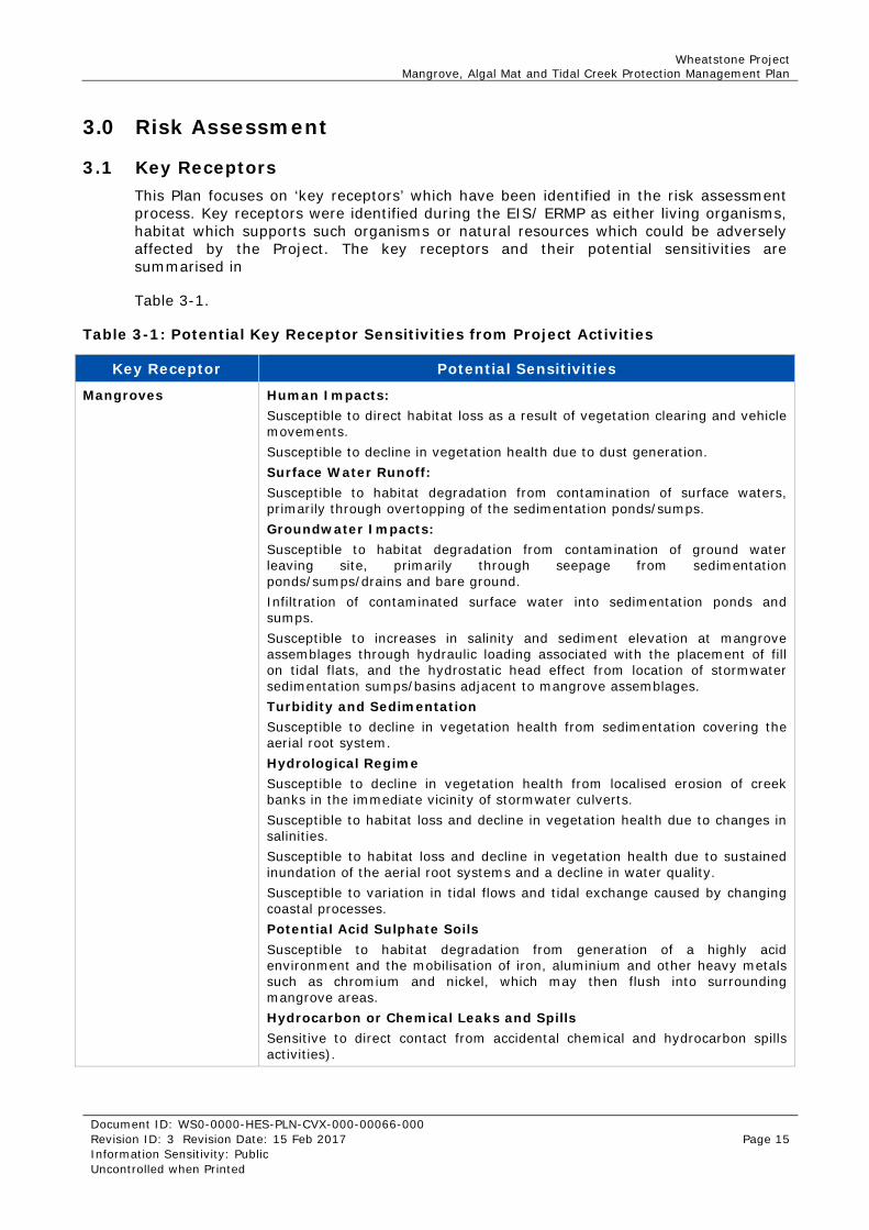
3.0 Risk Assessment
3.1 Key Receptors This Plan focuses on ‘key receptors’ which have been identified in the risk assessment process. Key receptors were identified during the EIS/ ERMP as either living organisms, habitat which supports such organisms or natural resources which could be adversely affected by the Project. The key receptors and their potential sensitivities are summarised in
Table 3-1.
Table 3-1: Potential Key Receptor Sensitivities from Project Activities
Key Receptor Potential Sensitivities
Mangroves Human Impacts: Susceptible to direct habitat loss as a result of vegetation clearing and vehicle movements. Susceptible to decline in vegetation health due to dust generation. Surface Water Runoff: Susceptible to habitat degradation from contamination of surface waters, primarily through overtopping of the sedimentation ponds/sumps. Groundwater Impacts: Susceptible to habitat degradation from contamination of ground water leaving site, primarily through seepage from sedimentation ponds/sumps/drains and bare ground. Infiltration of contaminated surface water into sedimentation ponds and sumps. Susceptible to increases in salinity and sediment elevation at mangrove assemblages through hydraulic loading associated with the placement of fill on tidal flats, and the hydrostatic head effect from location of stormwater sedimentation sumps/basins adjacent to mangrove assemblages. Turbidity and Sedimentation Susceptible to decline in vegetation health from sedimentation covering the aerial root system. Hydrological Regime Susceptible to decline in vegetation health from localised erosion of creek banks in the immediate vicinity of stormwater culverts. Susceptible to habitat loss and decline in vegetation health due to changes in salinities. Susceptible to habitat loss and decline in vegetation health due to sustained inundation of the aerial root systems and a decline in water quality. Susceptible to variation in tidal flows and tidal exchange caused by changing coastal processes. Potential Acid Sulphate Soils Susceptible to habitat degradation from generation of a highly acid environment and the mobilisation of iron, aluminium and other heavy metals such as chromium and nickel, which may then flush into surrounding mangrove areas. Hydrocarbon or Chemical Leaks and Spills Sensitive to direct contact from accidental chemical and hydrocarbon spills activities).

Wheatstone Project Mangrove, Algal Mat and Tidal Creek Protection Management Plan
Document ID: WS0-0000-HES-PLN-CVX-000-00066-000 Revision ID: 3 Revision Date: 15 Feb 2017 Page 16 Information Sensitivity: Public Uncontrolled when Printed
Algal Mats Human Impacts: Susceptible to direct habitat loss as a result of vegetation clearing and vehicle movements. Susceptible to decline in vegetation health from dust generation. Surface Water Runoff: Susceptible to habitat degradation from contamination of surface waters, primarily through overtopping of the sedimentation ponds/sumps. Groundwater Impacts: Susceptible to habitat degradation from contamination of ground water leaving site, primarily through seepage from sedimentation ponds/sumps/drains and bare ground. Infiltration of contaminated surface water flow into sedimentation ponds and sumps. Hydrological Regime Susceptible to habitat loss through reduction in tidal flushing from upstream restriction points (roads, causeways etc.). Susceptible to habitat loss and decline in vegetation health due to changes in salinities. Susceptible to increased sedimentation through reduced tidal flushing, smothering algal mats. Potential Acid Sulphate Soils Susceptible to habitat degradation from generation of a highly acid environment and the mobilisation of iron, aluminium and other heavy metals such as chromium and nickel, which may then flush into surrounding algal mat areas. Hydrocarbon or Chemical Leaks and Spills Sensitive to direct contact from accidental chemical and hydrocarbon spills.
Tidal Creeks and Lagoons
Human Impacts Susceptible to indirect habitat loss as a result of geomorphic change. Subsequent habitat degradation due to reduction/increase in tidal flushing. Susceptible to habitat modification as a result of increased sedimentation. Hydrological Regime Localised erosion of creek banks in the immediate vicinity of culverts through surface water run-off.
Marine turtles (Green, Flatback, Hawksbill, Loggerhead)
Human Impacts Susceptible to foraging habitat loss/change through modification of tidal creeks and lagoons from Project infrastructure. Hydrocarbon or Chemical Leaks and Spills Sensitive to direct contact from accidental chemical and hydrocarbon spills.
Sawfish (green and freshwater species identified)
Human Impacts Susceptible to nursery and foraging habitat loss/change through modification of tidal creeks and lagoons from Project infrastructure. Hydrocarbon or Chemical Leaks and Spills Sensitive to direct contact from accidental chemical and hydrocarbon spills.
Wheatstone Project Mangrove, Algal Mat and Tidal Creek Protection Management Plan
Document ID: WS0-0000-HES-PLN-CVX-000-00066-000 Revision ID: 3 Revision Date: 15 Feb 2017 Page 17 Information Sensitivity: Public Uncontrolled when Printed
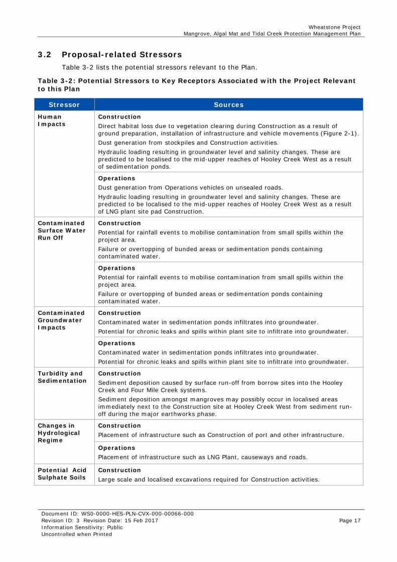
3.2 Proposal-related Stressors Table 3-2 lists the potential stressors relevant to the Plan.
Table 3-2: Potential Stressors to Key Receptors Associated with the Project Relevant to this Plan
Stressor Sources
Human Impacts
Construction Direct habitat loss due to vegetation clearing during Construction as a result of ground preparation, installation of infrastructure and vehicle movements (Figure 2-1). Dust generation from stockpiles and Construction activities. Hydraulic loading resulting in groundwater level and salinity changes. These are predicted to be localised to the mid-upper reaches of Hooley Creek West as a result of sedimentation ponds.
Operations Dust generation from Operations vehicles on unsealed roads. Hydraulic loading resulting in groundwater level and salinity changes. These are predicted to be localised to the mid-upper reaches of Hooley Creek West as a result of LNG plant site pad Construction.
Contaminated Surface Water Run Off
Construction Potential for rainfall events to mobilise contamination from small spills within the project area. Failure or overtopping of bunded areas or sedimentation ponds containing contaminated water.
Operations Potential for rainfall events to mobilise contamination from small spills within the project area. Failure or overtopping of bunded areas or sedimentation ponds containing contaminated water.
Contaminated Groundwater Impacts
Construction Contaminated water in sedimentation ponds infiltrates into groundwater. Potential for chronic leaks and spills within plant site to infiltrate into groundwater.
Operations Contaminated water in sedimentation ponds infiltrates into groundwater. Potential for chronic leaks and spills within plant site to infiltrate into groundwater.
Turbidity and Sedimentation
Construction Sediment deposition caused by surface run-off from borrow sites into the Hooley Creek and Four Mile Creek systems. Sediment deposition amongst mangroves may possibly occur in localised areas immediately next to the Construction site at Hooley Creek West from sediment run-off during the major earthworks phase.
Changes in Hydrological Regime
Construction Placement of infrastructure such as Construction of port and other infrastructure.
Operations Placement of infrastructure such as LNG Plant, causeways and roads.
Potential Acid Sulphate Soils
Construction Large scale and localised excavations required for Construction activities.

Wheatstone Project Mangrove, Algal Mat and Tidal Creek Protection Management Plan
Document ID: WS0-0000-HES-PLN-CVX-000-00066-000 Revision ID: 3 Revision Date: 15 Feb 2017 Page 18 Information Sensitivity: Public Uncontrolled when Printed
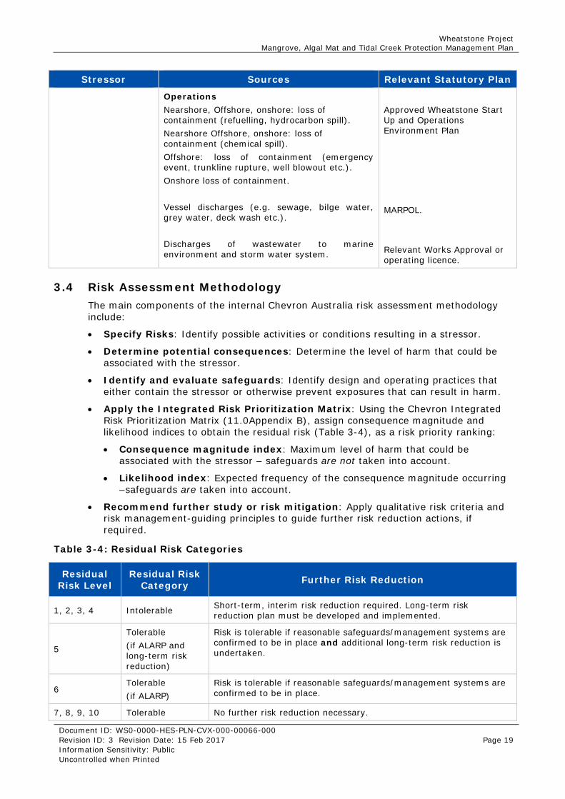
Stressor Sources
Operations Excavations required for maintenance activities or other activities requiring earth movement.
Chemical and Hydrocarbon Leaks and Spills
Construction May occur from both onshore and marine Construction works (e.g. Construction vehicles/plant, vessels and dredging spread).
Operations Accidental spill from road haulage / roll overs of chemicals or hydrocarbons.
3.3 Potential Stressors Addressed in Other Statutory Plans Potential stressors, management and mitigation measures for Key Receptors identified in Table 3-1 that are not addressed in this Plan are outlined in Table 3-3.
Table 3-3: Potential Key Receptor Sensitivities to Project Activities Addressed in Other Statutory Plans
Stressor Sources Relevant Statutory Plan
Hydrological Regime Construction Changes in coastal processes as a result of Construction of the MOF inhibiting littoral transport.
Coastal Processes Monitoring and Management Plan (CPMMP)
Operations Changes in coastal processes as a result of the MOF inhibiting littoral transport.
CPMMP
Contaminated Surface Water Run Off
Discharges of wastewater to marine environment and storm water system.
Relevant Works Approval or licence
Chemical and Hydrocarbon Leaks and Spills
Construction Nearshore: loss of containment (vessel refuelling). Offshore, onshore: loss of containment (refuelling). Onshore loss of containment (chemical spill). Vessel discharges (e.g. sewage, bilge water, grey water, deck wash etc.)
Relevant approved Environment Plan for activity Relevant Works Approval or licence MARPOL
Wheatstone Project Mangrove, Algal Mat and Tidal Creek Protection Management Plan
Document ID: WS0-0000-HES-PLN-CVX-000-00066-000 Revision ID: 3 Revision Date: 15 Feb 2017 Page 19 Information Sensitivity: Public Uncontrolled when Printed
Stressor Sources Relevant Statutory Plan
Operations Nearshore, Offshore, onshore: loss of containment (refuelling, hydrocarbon spill). Nearshore Offshore, onshore: loss of containment (chemical spill). Offshore: loss of containment (emergency event, trunkline rupture, well blowout etc.). Onshore loss of containment. Vessel discharges (e.g. sewage, bilge water, grey water, deck wash etc.). Discharges of wastewater to marine environment and storm water system.
Approved Wheatstone Start Up and Operations Environment Plan MARPOL. Relevant Works Approval or operating licence.
3.4 Risk Assessment Methodology The main components of the internal Chevron Australia risk assessment methodology include:
Specify Risks: Identify possible activities or conditions resulting in a stressor.
Determine potential consequences: Determine the level of harm that could be associated with the stressor.
Identify and evaluate safeguards: Identify design and operating practices that either contain the stressor or otherwise prevent exposures that can result in harm.
Apply the Integrated Risk Prioritization Matrix: Using the Chevron Integrated Risk Prioritization Matrix (11.0Appendix B), assign consequence magnitude and likelihood indices to obtain the residual risk (Table 3-4), as a risk priority ranking:
Consequence magnitude index: Maximum level of harm that could be associated with the stressor – safeguards are not taken into account.
Likelihood index: Expected frequency of the consequence magnitude occurring –safeguards are taken into account.
Recommend further study or risk mitigation: Apply qualitative risk criteria and risk management-guiding principles to guide further risk reduction actions, if required.
Table 3-4: Residual Risk Categories
Residual Risk Level
Residual Risk Category Further Risk Reduction
1, 2, 3, 4 Intolerable Short-term, interim risk reduction required. Long-term risk reduction plan must be developed and implemented.
5
Tolerable (if ALARP and long-term risk reduction)
Risk is tolerable if reasonable safeguards/management systems are confirmed to be in place and additional long-term risk reduction is undertaken.
6 Tolerable (if ALARP)
Risk is tolerable if reasonable safeguards/management systems are confirmed to be in place.
7, 8, 9, 10 Tolerable No further risk reduction necessary.

Wheatstone Project Mangrove, Algal Mat and Tidal Creek Protection Management Plan
Document ID: WS0-0000-HES-PLN-CVX-000-00066-000 Revision ID: 3 Revision Date: 15 Feb 2017 Page 20 Information Sensitivity: Public Uncontrolled when Printed
Risk-ranking categories were used in the development of this Plan to determine whether the stressors are considered ALARP, or whether further mitigation and safeguards are required. Where it is demonstrated that the cost of implementing further control measures is disproportionate to the benefit gained, the risk is considered ALARP.
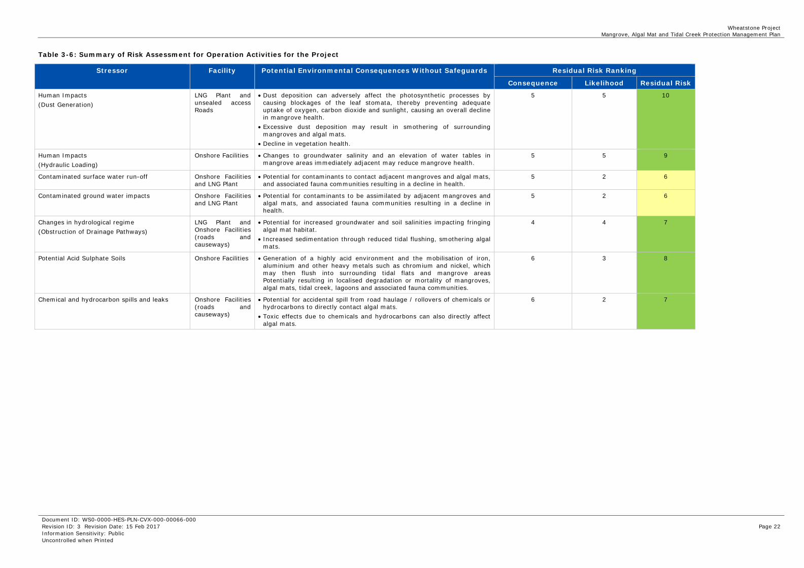
3.5 Outcomes A detailed assessment of the potential proposal-related stressors to mangroves, algal mat and tidal creek/lagoon related to the Project was undertaken prior to Construction and presented in previous revisions of this Plan as well as the Draft EIS/ERMP (Chevron, 2010). A review of the assessment was undertaken in a one-day workshop on the 7th of April 2016 for the Operations phase (including any remaining simultaneous Construction related activities) of the Project. A summary of the risk assessment is provided in Table 3-5 (Construction) and Table 3-6 (Operations).
The April 2016 risk assessment assigned updated residual risk levels after incorporating the additional environmental information gained during the Construction period as well as new information relevant to commissioning activities. Overall, the risk assessment showed a reduced risk profile from that identified previously. This change reflects greater certainty regarding Project design features, commissioning and Operations activities, and improved understanding of impacts provided by four years of monitoring the effects of key stressors during Construction. Specific factors influencing the changes to identified risks include:
Dust generation, sedimentation and potential for generation of potential acid sulphate soil will be reduced due to completion of major dredging, earthworks and clearing activities. No impacts to mangroves or algal mats were observed during monitoring.
Direct mangrove habitat loss was lower than anticipated 3.9 Ha compared to the predicted 4.3 Ha.
Impacts due to hydraulic loading, surface water or groundwater contamination were not observed during monitoring.
Project waste water and surface water run-off management measures are in place, reducing the risk of chemical and hydrocarbon spills and leaks from Project site reaching mangrove, algal mat and tidal creek habitats.
Three stressors were identified for Operations (Table 3-6) as having a Residual Risk Category of Tolerable (if ALARP and long-term risk reduction) (i.e. below a Risk Ranking Level of 7). For all other sources of risk to mangroves, algal mats, juvenile turtle habitat and sawfish nursery habitat (tidal creeks and lagoon) during Operations, the risk assessment found that the residual risk category was Tolerable (i.e. the residual risk level was seven or above) (Table 3-6). Safeguards, including; design features, management measures and monitoring, were considered when determining the risk ranking.

Wheatstone Project Mangrove, Algal Mat and Tidal Creek Protection Management Plan
Document ID: WS0-0000-HES-PLN-CVX-000-00066-000 Revision ID: 3 Revision Date: 15 Feb 2017 Page 21 Information Sensitivity: Public Uncontrolled when Printed
Table 3-5: Summary of Risk Assessment for Construction Activities for the Project
Stressor Facility Potential Environmental Consequences Without Safeguards Residual Risk Ranking
Consequence Likelihood Residual Risk
Human Impacts (Direct Habitat Loss)
Onshore Facilities Loss and degradation of mangrove and algal mat habitat outside of the Terrestrial Assessment Area due to installation of temporary structures (i.e. roads) and vehicle movements.
5 2 6
Human Impacts (Dust Generation)
LNG Plant and associated facilities
Dust deposition can adversely affect the photosynthetic processes by causing blockages of the leaf stomata, thereby preventing adequate uptake of oxygen, carbon dioxide and sunlight, causing an overall decline in mangrove health.
Excessive dust deposition may result in smothering of surrounding mangroves and algal mats. Decline in vegetation health.
6 4 9
Human Impacts (Hydraulic Loading)
Onshore Facilities Changes to groundwater salinity and an elevation of water tables in mangrove areas immediately adjacent may reduce mangrove health.
5 2 6
Contaminated Surface Water Run-Off
Onshore Facilities and LNG Plant
Potential for contaminants to contact adjacent mangroves and algal mats, and associated fauna communities resulting in a decline in health.
5 2 6
Contaminated Groundwater Impacts
Onshore Facilities and LNG Plant
Potential for contaminants to be assimilated by adjacent mangroves and algal mats, and associated fauna communities resulting in a decline in health.
5 2 6
Turbidity and Sediment Deposition/Erosion
Roads and fill sources
Smothering of mangrove roots causing tree stress. 5 3 6
Changes to Hydrological Regime (Obstruction of Natural Water Flow)
Temporary Roads and fill sources
Potential for increased groundwater and soil salinities impacting fringing algal mat habitat. Increased sedimentation through reduced tidal flushing, smothering algal mats. Increased water retention may reduce water quality and cause decline in algal mats.
5 2 6
Potential Acid Sulphate Soils (PASS)
Onshore Facilities and LNG Plant
Generation of a highly acid environment and the mobilisation of iron, aluminium and other heavy metals such as chromium and nickel, which may then flush into surrounding tidal flats and mangrove areas Potentially resulting in localised degradation or mortality of mangroves, algal mats, tidal creek, lagoons and associated fauna communities.
5 3 7
Chemical and Hydrocarbon Spills and Leaks (Transportation Inventory of HAZMAT Brought to LNG Site by Road or Vessels)
LNG Plant, Onshore and Nearshore Facilities
Pneumatophores may be smothered by hydrocarbons causing oxygen deprivation, general plant decline and possibly mortality.
Toxic effects due to chemicals and hydrocarbons can also indirectly affect mangroves through depletion or loss of the associated benthic fauna community.
5 5 9
Wheatstone Project Mangrove, Algal Mat and Tidal Creek Protection Management Plan
Document ID: WS0-0000-HES-PLN-CVX-000-00066-000 Revision ID: 3 Revision Date: 15 Feb 2017 Page 22 Information Sensitivity: Public Uncontrolled when Printed
Table 3-6: Summary of Risk Assessment for Operation Activities for the Project
Stressor Facility Potential Environmental Consequences Without Safeguards Residual Risk Ranking
Consequence Likelihood Residual Risk
Human Impacts (Dust Generation)
LNG Plant and unsealed access Roads
Dust deposition can adversely affect the photosynthetic processes by causing blockages of the leaf stomata, thereby preventing adequate uptake of oxygen, carbon dioxide and sunlight, causing an overall decline in mangrove health.
Excessive dust deposition may result in smothering of surrounding mangroves and algal mats.
Decline in vegetation health.
5 5 10
Human Impacts (Hydraulic Loading)
Onshore Facilities Changes to groundwater salinity and an elevation of water tables in mangrove areas immediately adjacent may reduce mangrove health.
5 5 9
Contaminated surface water run-off Onshore Facilities and LNG Plant
Potential for contaminants to contact adjacent mangroves and algal mats, and associated fauna communities resulting in a decline in health.
5 2 6
Contaminated ground water impacts Onshore Facilities and LNG Plant
Potential for contaminants to be assimilated by adjacent mangroves and algal mats, and associated fauna communities resulting in a decline in health.
5 2 6
Changes in hydrological regime (Obstruction of Drainage Pathways)
LNG Plant and Onshore Facilities (roads and causeways)
Potential for increased groundwater and soil salinities impacting fringing algal mat habitat.
Increased sedimentation through reduced tidal flushing, smothering algal mats.
4 4 7
Potential Acid Sulphate Soils Onshore Facilities Generation of a highly acid environment and the mobilisation of iron, aluminium and other heavy metals such as chromium and nickel, which may then flush into surrounding tidal flats and mangrove areas Potentially resulting in localised degradation or mortality of mangroves, algal mats, tidal creek, lagoons and associated fauna communities.
6 3 8
Chemical and hydrocarbon spills and leaks
Onshore Facilities (roads and causeways)
Potential for accidental spill from road haulage / rollovers of chemicals or hydrocarbons to directly contact algal mats.
Toxic effects due to chemicals and hydrocarbons can also directly affect algal mats.
6 2 7

Wheatstone Project Mangrove, Algal Mat and Tidal Creek Protection Management Plan
Document ID: WS0-0000-HES-PLN-CVX-000-00066-000 Revision ID: 3 Revision Date: 15 Feb 2017 Page 23 Information Sensitivity: Public Uncontrolled when Printed
4.0 Management Measures Chevron Australia has committed to a number of design features and management measures to detect and avoid, or where this is not practicable, mitigate, impacts upon mangroves, algal mats, juvenile turtle habitat and saw fish nursery habitat (tidal creeks and lagoon). This section of the Plan presents the environmental design features and management measures that will be implemented for the applicable work scopes during Construction and Operations of the Project. The management measures have been developed for the Project to fulfil the environmental protection outcomes required under MS 873. The management measures are divided into categories of potential Project stressors (impacts).
4.1 Human Impacts Table 4-1 and Table 4-2 details the management measures for mitigating the identified environmental stressors previously identified in Table 3-2 – Human Impacts.
Table 4-1: Management Measures for Human Impacts (Direct Habitat Loss)
Management measures Timing
Relevant Construction site maps will include the outer disturbance boundary in the Hooley Creek West area and where reasonable practicable, will include a buffer area (minimum distance of approximately 30 m) between the outer disturbance boundary and the outer Construction footprint (e.g. toe of the perimeter bund). Construction footprints adjacent or within tidal flat areas, algal mat areas and mangroves will be delineated through use of survey and flagging (or equivalent) to avoid disturbance, where practicable.
Construction
To provide the maximum opportunity for vegetative recovery along the boundary of cleared areas during clearing and reclamation works, where practicable, the rootstock (i.e. below ground portion) of mangroves will be retained with only the above ground portion of the vegetation removed.
Construction
Project vehicles and earthworks machinery will be restricted from operating / moving outside the project footprint as far as practicable.
Construction and Operations
Table 4-2: Management Measures for Human Impacts (Dust Generation)
Management measures Timing
Dust management controls will be implemented, where practicable, during Construction and Operation activities to reduce dust coatings on mangrove canopies and algal mats.
Construction and Operations
Table 3-2 identified hydraulic loading as a project related stressor during both Construction and Operation phases of the Project. The designed placement and orientation of the Project footprint considered reducing the effects of hydraulic loading on the surrounding environment. There are no active management measures for the effects of hydraulic loading once the Project pad is constructed. The potential for impacts is monitored at mangrove survey plots as detailed in Table 5-1 and Table 5-2.

Wheatstone Project Mangrove, Algal Mat and Tidal Creek Protection Management Plan
Document ID: WS0-0000-HES-PLN-CVX-000-00066-000 Revision ID: 3 Revision Date: 15 Feb 2017 Page 24 Information Sensitivity: Public Uncontrolled when Printed
4.2 Contaminated Surface Water and Groundwater Table 4-3 details the key management measures for mitigating the identified environmental stressors previously identified in Table 3-2 – contaminated surface water and groundwater.
Table 4-3: Management Measures of Surface Water and Groundwater
Management measures Timing
Chemical and fuel storage will include secondary containment measures such as double skin tanks or bunding. Liquids shall be kept at least 1 m away from any drain system, body of water, watercourse or environmentally sensitive area.
Construction and Operations
Chemical and hydrocarbon wastes will be disposed at appropriately licensed waste disposal facilities.
Construction and Operations
Chemical selection process - ABU Hazardous Material Approval Procedure, will be used to ensure the least hazardous chemical that meets technical requirements is used.
Construction and Operations
Storm-water runoff during Construction and Operations will be directed through open ditches via sedimentation sumps/basins before discharging into the natural drainage system.
Construction and Operations
Sedimentation sumps and basins will be inspected and maintained to ensure they are operating as per design.
Construction and Operations
Project waste water management systems will be inspected and maintained to ensure they are operating as per design.
Construction and Operations
Project waste water management procedures will be routinely reviewed to identify they meet project requirements.
Construction and Operations
4.3 Turbidity and Sediment Deposition Table 4-4 details the key management measures for mitigating the identified environmental stressors previously identified in Table 3-2 – turbidity and sedimentation deposition and erosion
Table 4-4: Management Measures for Turbidity and sedimentation/Erosion
Management measures Timing
The extraction of fill from borrow sites will be managed so that sediment run-off is contained within the borrow areas as far as practicable.
Construction
Temporary sedimentation control measures including silt fences, rock dike, and sediment traps, may be implemented during earthwork activities.
Construction
Where practicable, vegetation clearing will be undertaken progressively and only as required, to reduce the area of ground surface exposed to erosive forces. Graded areas will be mechanically compacted and stabilised to reduce the potential for erosion.
Construction
Storm-water runoff during Construction and Operations will be directed through open ditches via sedimentation sumps/basins before discharging into the natural drainage system.
Construction and Operations

Wheatstone Project Mangrove, Algal Mat and Tidal Creek Protection Management Plan
Document ID: WS0-0000-HES-PLN-CVX-000-00066-000 Revision ID: 3 Revision Date: 15 Feb 2017 Page 25 Information Sensitivity: Public Uncontrolled when Printed
4.4 Changes in Hydrological Regime Table 4-5 details the key management measures for mitigating the identified environmental stressors previously identified in Table 3-2 – changes in hydrological regime.
Table 4-5: Management Measures for Changes in Hydrological Regime
Management measures Timing
Temporary access roads constructed across the Hooley Creek tidal flat area (for fill removal from borrow sites) to contain culverts, focused the natural surface contours, to allow for surface water flows and maintenance of tidal inundation and drainage as far as practicable.
Construction
Natural drainage flow will be maintained to the extent practical through engineering design. This may include temporary culverts with flow velocity reduction systems at exit points.
Construction and Operations
After completion of borrow site/fill extraction works the temporary access roads will be removed where practicable and natural drainage will be restored as far as practicable.
Construction
4.5 Potential Acid Sulphate Soils Table 4-6 details the key management measures for mitigating the identified environmental stressors previously identified in
Table 3-1 – PASS.
Table 4-6: Management Measures for PASS
Management measures Timing
A bunded treatment pad will be constructed based on anticipated throughput requirements and verification testing turnaround times. The treatment pad will comprise well-compacted alkaline material such as limestone. The level of compaction used will produce an appropriately low permeability to prevent infiltration of leachate.
Construction
Excavation permitting to identify and assess the potential for PASS. Construction and Operations
PASS will be identified and handled to manage the generation of Actual Acid Sulphate Soils (AASS) as a result of soil disturbance within and adjacent to mangroves, algal mat areas, and to prevent the potential acidification of tidal creeks and lagoons.
Construction and Operations
Proposed disturbance areas will be assessed for the presence of PASS prior to disturbance. If PASS is intersected, actions taken may include:
- Exposed PASS horizons will be coated with granular neutralising agent or sprayed with a neutralising solution (such as lime putty in iron-free water) as appropriate.
- Excavated PASS will be removed from the area where practicable and transferred to a treatment pad.
Construction and Operations

Wheatstone Project Mangrove, Algal Mat and Tidal Creek Protection Management Plan
Document ID: WS0-0000-HES-PLN-CVX-000-00066-000 Revision ID: 3 Revision Date: 15 Feb 2017 Page 26 Information Sensitivity: Public Uncontrolled when Printed
4.6 Chemical or Hydrocarbon Spills and Leaks Table 4-7 details the key management measures for mitigating the identified environmental stressors previously identified in
Table 3-1 – Chemical or Hydrocarbon spills and leaks.
Table 4-7: Management Measures for Hydrocarbon Spills and Leaks
Management measures Timing
All chemicals and hydrocarbons will be stored within secondary containment and leaks and spills will be captured, as far as practicable.
Construction and Operations
Chemicals will be transported and stored in compliance with Dangerous Goods Licences.
Construction and Operations

Wheatstone Project Mangrove, Algal Mat and Tidal Creek Protection Management Plan
Document ID: WS0-0000-HES-PLN-CVX-000-00066-000 Revision ID: 3 Revision Date: 15 Feb 2017 Page 27 Information Sensitivity: Public Uncontrolled when Printed
5.0 Monitoring Program The monitoring program defined in this section is designed to measure and detect changes to the processes and conditions required for mangrove, algal mat and tidal creek protection, at those assemblages in the vicinity of the Project.
5.1 Monitoring Program Design To monitor for the detection of localised impacts a series of monitoring sites (transects/plots) were established to collect data on the following parameters where practicable:
Mangrove community structure (species composition and density)
Mangrove tree health (canopy cover and tree condition)
Shallow groundwater conditions (salinity and water table depth)
Sedimentation/erosion (ground levels/sediment heights, veneer profiles)
Sediment quality (metals and hydrocarbons concentrations, particle size).
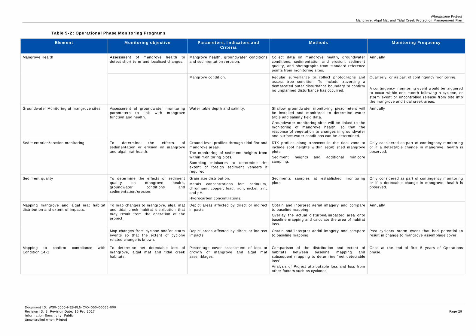
Monitoring objectives methods and frequency of surveys were developed and implemented for the Construction phase of the Project, presented in Table 5-1. The monitoring requirements have been revised for Operations this includes consideration of:
Construction phase monitoring results
Completion of certain Construction activities and the updated risk profile
Any additional monitoring items that may need to be included that are specific to the Operations phase
The monitoring program will be implemented to meet the objectives defined in Table 5-1 and Table 5-2 while retaining operational flexibility such that abnormal events (e.g. extreme weather events), that are beyond Chevron Australia’s control, can be accommodated.

Wheatstone Project Mangrove, Algal Mat and Tidal Creek Protection Management Plan
Document ID: WS0-0000-HES-PLN-CVX-000-00066-000 Revision ID: 3 Revision Date: 15 Feb 2017 Page 28 Information Sensitivity: Public Uncontrolled when Printed
Table 5-1: Construction Phase Monitoring Programs
Element Monitoring objective Parameters, Indicators and Criteria
Methods Monitoring Frequency
Mangrove Community Structure Determine long-term change to mangrove community structure.
Tree species composition and density.
Describe the mangrove tree species composition and determine mangrove canopy density within monitoring plots to detect long-term change to mangrove community structure.
Once during baseline phase then at the end of Construction phase.
Mangrove Health Assessment of mangrove health to detect short term and localised changes.
Mangrove health, groundwater conditions and sedimentation /erosion.
Collect data on mangrove health, groundwater conditions, sedimentation and erosion, sediment quality, and photographs from standard reference points from monitoring sites.
Once during baseline phase, then biannually during Construction phase.
Mangrove condition. Regular surveillance to collect photographs and assess tree condition. To include traversing a demarcated outer disturbance boundary to confirm no unplanned disturbance has occurred.
Monthly
Groundwater Monitoring Assessment of groundwater monitoring parameters to link with mangrove function and health.
Water table depth and salinity. Shallow groundwater monitoring piezometers will be installed and monitored to determine water table and salinity field data. Groundwater monitoring sites will be linked to the monitoring of mangrove health, so that the response of vegetation to changes in groundwater and surface water conditions can be determined.
Biannually
Sedimentation/erosion monitoring To determine the effects of sedimentation or erosion on mangrove and algal mat health.
Ground level profiles through tidal flat and mangrove areas. The monitoring of sediment heights from within monitoring plots. Sampling minicores to determine the extent of foreign sediment veneers if required.
RTK profiles along transects in the tidal zone to include spot heights within established mangrove plots. Sediment heights and additional minicore sampling.
Annual for surveying ground level profiles (RTK). Biannual monitoring of sediment heights and mini-cores.
Sediment quality To determine the effects of sediment quality on mangrove health, groundwater conditions and sedimentation/erosion.
Grain size distribution. Metals concentrations for: cadmium, chromium, copper, lead, iron, nickel, zinc and pH. Hydrocarbon concentrations.
Sediments samples at established monitoring plots Annually
Mapping mangrove and algal mat habitat distribution and extent of impacts.
To map changes to mangrove, algal mat and tidal creek habitat distribution that may result from the Construction of the project.
Depict areas affected by direct or indirect impacts.
Obtain and interpret aerial imagery and compare to baseline mapping. Overlay the actual disturbed/impacted area onto baseline mapping and calculate the area of habitat loss.
Annually
Map changes from cyclone and/or storm events so that the extent of cyclone related change is known.
Depict areas affected by direct or indirect impacts.
Obtain and interpret aerial imagery and compare to baseline mapping.
Post cyclone/ storm event that had potential to result in change to mangrove assemblage cover.
Remote sensing of mangrove and algal mat status.
To obtain information of the status of mangrove vegetation from a regional perspective (i.e. Turbridgi Point to Coolgra Point).
Depict areas of change in both mangrove and algal mat habitats through interpreting light emittance data associated with the photosynthetic function of the organism.
Obtain and interpret high resolution Digital Multi-Spectral Imagery (DMSI) from satellite or airplane.
Once during baseline phase, then midway through and again at the end of Construction phase.
Mapping to confirm compliance with Condition 14-1
To determine net detectable loss of mangrove, algal mat and tidal creek habitats.
Percentage cover assessment of loss or growth of mangrove and algal mat assemblages.
Comparison of the distribution and extent of habitats between baseline mapping and subsequent mapping to determine “net detectable loss”. Analysis of Project attributable loss and loss from other factors such as cyclones.
Once at end of Construction phase.
Wheatstone Project Mangrove, Algal Mat and Tidal Creek Protection Management Plan
Document ID: WS0-0000-HES-PLN-CVX-000-00066-000 Revision ID: 3 Revision Date: 15 Feb 2017 Page 29 Information Sensitivity: Public Uncontrolled when Printed
Table 5-2: Operational Phase Monitoring Programs
Element Monitoring objective Parameters, Indicators and Criteria
Methods Monitoring Frequency
Mangrove Health Assessment of mangrove health to detect short term and localised changes.
Mangrove health, groundwater conditions and sedimentation /erosion.
Collect data on mangrove health, groundwater conditions, sedimentation and erosion, sediment quality, and photographs from standard reference points from monitoring sites.
Annually
Mangrove condition. Regular surveillance to collect photographs and assess tree condition. To include traversing a demarcated outer disturbance boundary to confirm no unplanned disturbance has occurred.
Quarterly, or as part of contingency monitoring. A contingency monitoring event would be triggered to occur within one month following a cyclone, or storm event or uncontrolled release from site into the mangrove and tidal creek areas.
Groundwater Monitoring at mangrove sites Assessment of groundwater monitoring parameters to link with mangrove function and health.
Water table depth and salinity. Shallow groundwater monitoring piezometers will be installed and monitored to determine water table and salinity field data. Groundwater monitoring sites will be linked to the monitoring of mangrove health, so that the response of vegetation to changes in groundwater and surface water conditions can be determined.
Annually
Sedimentation/erosion monitoring To determine the effects of sedimentation or erosion on mangrove and algal mat health.
Ground level profiles through tidal flat and mangrove areas. The monitoring of sediment heights from within monitoring plots. Sampling minicores to determine the extent of foreign sediment veneers if required.
RTK profiles along transects in the tidal zone to include spot heights within established mangrove plots. Sediment heights and additional minicore sampling.
Only considered as part of contingency monitoring or if a detectable change in mangrove, health is observed.
Sediment quality To determine the effects of sediment quality on mangrove health, groundwater conditions and sedimentation/erosion.
Grain size distribution. Metals concentrations for: cadmium, chromium, copper, lead, iron, nickel, zinc and pH. Hydrocarbon concentrations.
Sediments samples at established monitoring plots.
Only considered as part of contingency monitoring or if a detectable change in mangrove, health is observed.
Mapping mangrove and algal mat habitat distribution and extent of impacts.
To map changes to mangrove, algal mat and tidal creek habitat distribution that may result from the operation of the project.
Depict areas affected by direct or indirect impacts.
Obtain and interpret aerial imagery and compare to baseline mapping. Overlay the actual disturbed/impacted area onto baseline mapping and calculate the area of habitat loss.
Annually
Map changes from cyclone and/or storm events so that the extent of cyclone related change is known.
Depict areas affected by direct or indirect impacts.
Obtain and interpret aerial imagery and compare to baseline mapping.
Post cyclone/ storm event that had potential to result in change to mangrove assemblage cover.
Mapping to confirm compliance with Condition 14-1.
To determine net detectable loss of mangrove, algal mat and tidal creek habitats.
Percentage cover assessment of loss or growth of mangrove and algal mat assemblages.
Comparison of the distribution and extent of habitats between baseline mapping and subsequent mapping to determine “net detectable loss”. Analysis of Project attributable loss and loss from other factors such as cyclones.
Once at the end of first 5 years of Operations phase.
Wheatstone Project Mangrove, Algal Mat and Tidal Creek Protection Management Plan
Document ID: WS0-0000-HES-PLN-CVX-000-00066-000 Revision ID: 3 Revision Date: 15 Feb 2017 Page 30 Information Sensitivity: Public Uncontrolled when Printed
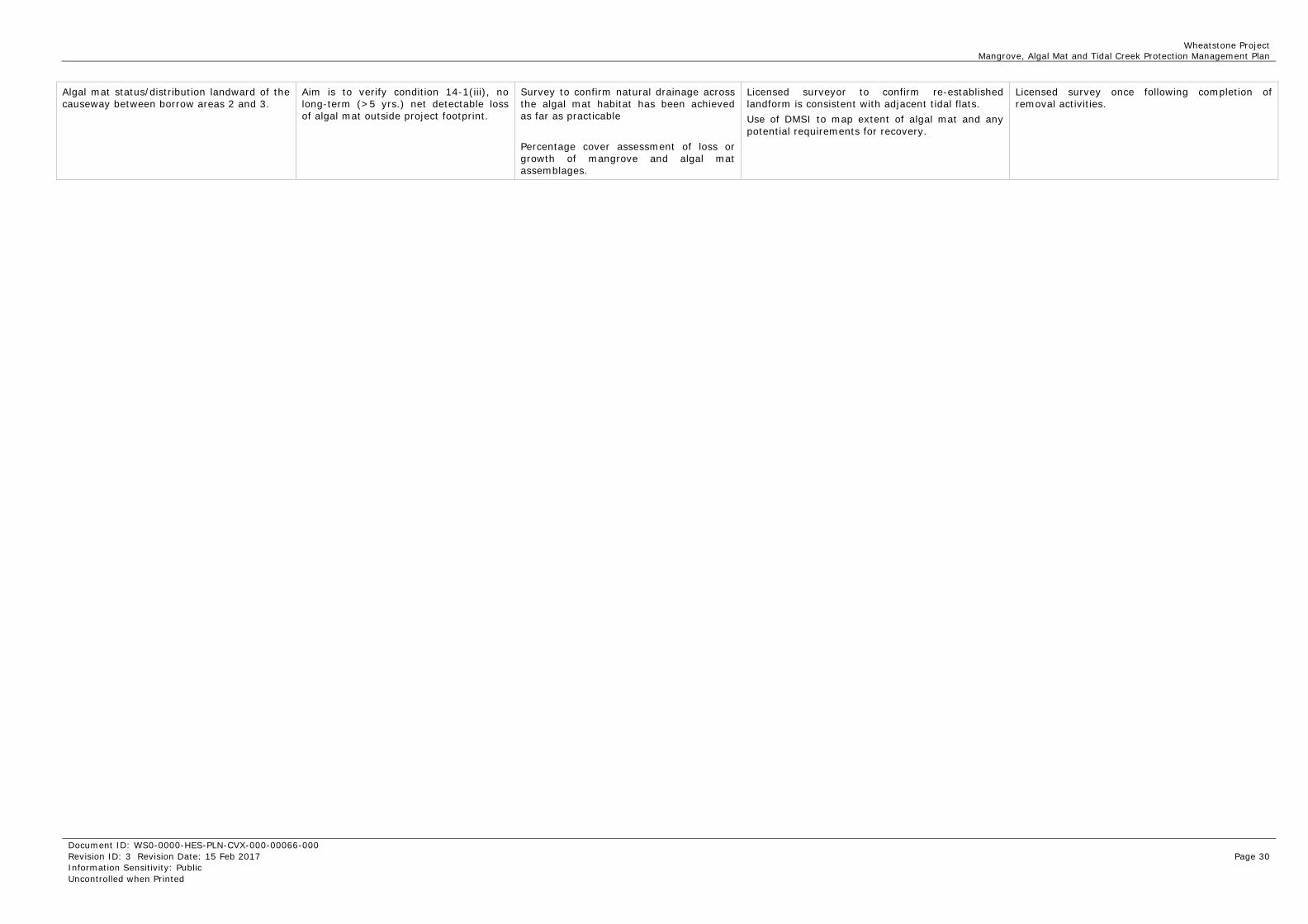
Algal mat status/distribution landward of the causeway between borrow areas 2 and 3.
Aim is to verify condition 14-1(iii), no long-term (>5 yrs.) net detectable loss of algal mat outside project footprint.
Survey to confirm natural drainage across the algal mat habitat has been achieved as far as practicable Percentage cover assessment of loss or growth of mangrove and algal mat assemblages.
Licensed surveyor to confirm re-established landform is consistent with adjacent tidal flats. Use of DMSI to map extent of algal mat and any potential requirements for recovery.
Licensed survey once following completion of removal activities.

Wheatstone Project Mangrove, Algal Mat and Tidal Creek Protection Management Plan
Document ID: WS0-0000-HES-PLN-CVX-000-00066-000 Revision ID: 3 Revision Date: 15 Feb 2017 Page 31 Information Sensitivity: Public Uncontrolled when Printed
5.2 Potential Monitoring Locations Potential mangrove monitoring locations include sites close to the ANSIA, and control sites further away considered outside the area of potential Project related changes. Potential mangrove monitoring locations are presented in Figure 5-1.
Various mangrove lined tidal creek systems in the Onslow area were considered for their applicability as control sites. The mid-landward section of the Ashburton Delta and Secret Creek were considered the most appropriate for the following reasons:
The risk assessment of potential impacts to the Ashburton Delta undertaken for the EIS/ERMP (Appendix N4) concluded that these areas would not be impacted by Construction and Operation of the Project.
These areas are currently undisturbed and can be considered to be in suitable condition to provide reference or control data.
The other mangrove lined tidal creek systems in the Onslow area all have some level of existing disturbance due to the extensive Onslow Solar Salt project.
The schematic diagram shown in Figure 5-2 illustrates the relationship between the survey transects and monitoring plots (10m x 10m in size) at a typical monitoring site and lists the parameters to monitor for the detection of localised impacts.

Wheatstone Project Mangrove, Algal Mat and Tidal Creek Protection Management Plan
Document ID: WS0-0000-HES-PLN-CVX-000-00066-000 Revision ID: 3 Revision Date: 15 Feb 2017 Page 32 Information Sensitivity: Public Uncontrolled when Printed
Figure 5-1: Location of Potential Mangrove Monitoring Sites

Wheatstone Project Mangrove, Algal Mat and Tidal Creek Protection Management Plan
Document ID: WS0-0000-HES-PLN-CVX-000-00066-000 Revision ID: 3 Revision Date: 15 Feb 2017 Page 33 Information Sensitivity: Public Uncontrolled when Printed
Figure 5-2: Schematic diagram showing key monitoring parameters at a single site

Wheatstone Project Mangrove, Algal Mat and Tidal Creek Protection Management Plan
Document ID: WS0-0000-HES-PLN-CVX-000-00066-000 Revision ID: 3 Revision Date: 15 Feb 2017 Page 34 Information Sensitivity: Public Uncontrolled when Printed
6.0 Management Triggers Trigger values will be periodically assessed to determine relevance and applicability, based on data obtained from the monitoring program. This would include reviewing data collected from control sites to provide reference to background conditions.
To determine if an exceedance of trigger value has occurred, the monitoring data for each parameter will be assessed against the trigger value after each monitoring survey (the monitoring frequency for each parameter is described in Tables 5-1 and 5-2). This assessment will include, where appropriate, a comparison between data from both sites located close to the ANSIA and the control sites.
It should also be noted that a particular trigger value exceedance may or may not actually result in any measurable effect on key receptors and therefore would not be considered non-compliance. It would however, highlight the need for further evaluation.
The approach taken here is to include:
Triggers related to the extent of habitat loss associated with meeting the outcomes stated in Condition 14-1 (items i to iii).
Triggers that are designed to provide for early warning of potential indirect impacts from the range of Project related stressors assessed in section 3.0.
6.1 Direct Habitat Loss MS 873 Condition 14-1 stipulates the maximum permitted loss of mangrove and algal mat habitat as a result of the Project. The maximum permitted habitat losses shown in Table 6-1 have been calculated based on the following:
Mangrove loss in the Hooley Creek system – Benthic Primary Producer Habitat (BPPH) assessments undertaken for the EIS/ERMP predicted a maximum direct mangrove loss within the Hooley Creek (attributed to the Project) of approximately 4.3 ha. This represents approximately 5% loss of the existing mangrove habitat as shown in Figure 2-1. Based on the design of the Project footprint and location of the perimeter bund, it is expected that a minimum of approximately 4 ha of mangroves will be lost and this value has subsequently set as a trigger value for permanent mangrove habitat loss.
To date 3.95 ha of mangroves have been lost through the physical placement of the Project pad on the western tip of west Hooley Creek. This is less than the predicted 4.3 ha.
Mangrove Disturbance in the Ashburton Delta - BPPH assessments undertaken for the Draft EIS/ERMP indicated that there should be no direct (or indirect) loss of mangroves (attributed to the Project) and hence the compliance level used in MS 873 Condition 14-1 is “no long-term (greater than five years) net detectable loss of mangrove habitat in the Ashburton Delta”. To date, there has been no detected loss of mangroves in the Ashburton Delta. The use of a micro-tunnelling technique for the pipeline shore crossing has been successful in avoiding any direct mangrove habitat loss.
Algal Mat loss within the Project Footprint – BPPH assessments undertaken for the Draft EIS/ERMP predicted a maximum direct algal mat loss as a result of the placement of permanent infrastructure of approximately 52 ha. This represents approximately 6% loss of the existing algal mat habitat as shown in Figure 2-1. Based on the design of the Project footprint and location of the shared infrastructure corridor, a value of 50 ha has subsequently been allocated for permanent algal mat habitat loss.

Wheatstone Project Mangrove, Algal Mat and Tidal Creek Protection Management Plan
Document ID: WS0-0000-HES-PLN-CVX-000-00066-000 Revision ID: 3 Revision Date: 15 Feb 2017 Page 35 Information Sensitivity: Public Uncontrolled when Printed
To date, 31.5 ha of direct permanent algal mat loss has been recorded. This is through the physical placement of the Project Pad and infrastructure corridors.
Algal Mat Disturbance within the TAA - BPPH assessments undertaken for the Draft EIS/ERMP indicated that there should be no additional direct loss of algal mat habitat within the TAA, outside of the Project footprint. However, temporary disturbance to approximately 44 ha of algal mat habitats is predicted as a result of Construction activities including the installation of temporary access roads, excavation along the edges of borrow pit areas and the use of temporary lay down areas along the shared infrastructure corridor. A trigger value of 40 ha of algal mat habitat disturbance has been set in relation to any temporary disturbance to the algal mat habitats outside of the Project footprint.
Table 6-1: Trigger Values and Outcomes for Mangrove and Algal Mat Habitat Loss
Monitoring Parameter Trigger Value Outcomes Comment
Determining Mangrove habitat distribution and extent of impacts
Area of mangrove loss in the Ashburton Delta mangrove system
> 0.1 ha
No long-term (greater than five years) net detectable loss of mangrove habitat
Determined by annual mapping during Construction showing the extent of Project related habitat loss.
Area of mangrove loss in the Hooley Creek-Four Mile Creek mangrove system
>4 ha within the area designated for reclamation
Not more than 5% long-term (greater than five years) loss of mangrove habitat
Determined by annual mapping during Construction showing the extent of Project related habitat loss.
Area of algal mat permanently lost
>50 ha within the Project footprint
No long-term (greater than five years) net detectable loss of algal mat habitat outside the Project footprint
Determined by annual mapping during Construction showing the extent of Project related habitat loss.
Area of algal mat temporarily disturbed
>40 ha outside of the Project footprint
6.2 Mangrove Health A trigger value of 20% was nominated for mangrove health / tree condition. Should monitoring at mangrove plots show a net reduction in canopy density of 20%, or the assessment of tree condition indicates an increase in the number of ‘un-healthy’ mangroves by 20%, relative to control sites, the trigger value has been met (Table 6-2).
For this trigger, a 20% reduction is defined as a 20% decrease relative to the baseline canopy density levels, not a reduction to a canopy density of 20%. The 20% reduction trigger level was chosen as a practical and realistic level that was used initially as a preliminary measure during Construction and now selected as a realistic trigger value for longer-term evaluation.
Due to the structure of Avicennia communities, it is expected that there will be considerable natural spatial variation (~10–20%) in canopy densities within each monitoring plot (and the broader Avicennia zone). Avicennia mangroves display a noticeable annual cycle of leaf turnover and new growth that will produce natural variation in canopy densities (~5-10% changes in canopy density from this cycle would be anticipated). The patterns observed from monitoring of mangroves on the Burrup Peninsula is for leaf deterioration to occur in the mid-year months and then new leaf
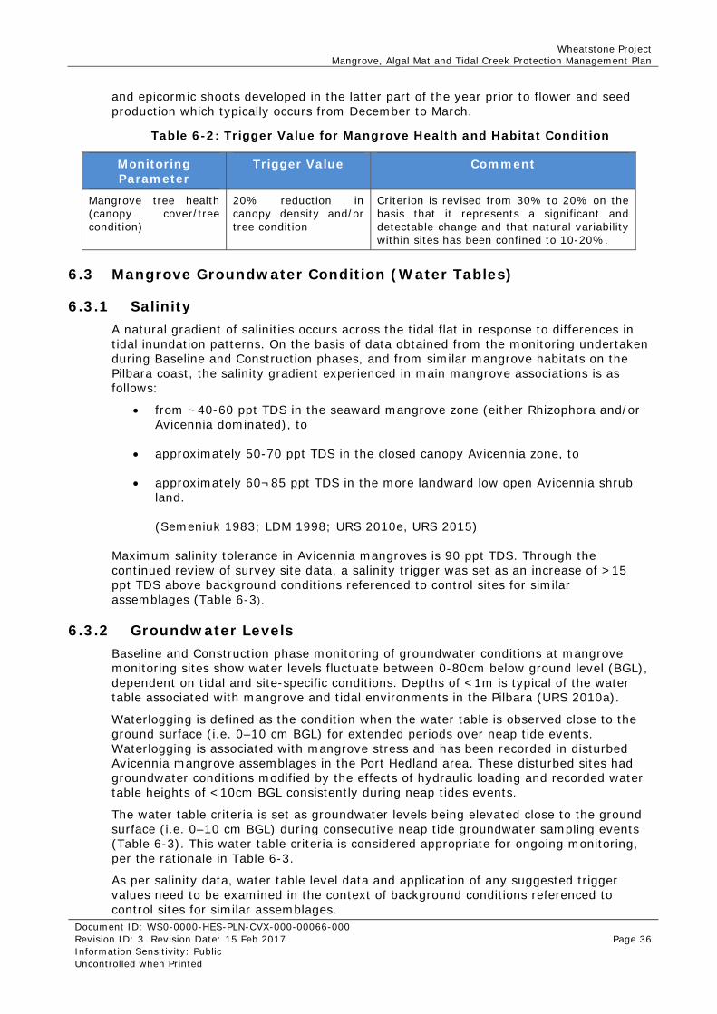
Wheatstone Project Mangrove, Algal Mat and Tidal Creek Protection Management Plan
Document ID: WS0-0000-HES-PLN-CVX-000-00066-000 Revision ID: 3 Revision Date: 15 Feb 2017 Page 36 Information Sensitivity: Public Uncontrolled when Printed
and epicormic shoots developed in the latter part of the year prior to flower and seed production which typically occurs from December to March.
Table 6-2: Trigger Value for Mangrove Health and Habitat Condition
Monitoring Parameter
Trigger Value Comment
Mangrove tree health (canopy cover/tree condition)
20% reduction in canopy density and/or tree condition
Criterion is revised from 30% to 20% on the basis that it represents a significant and detectable change and that natural variability within sites has been confined to 10-20%.
6.3 Mangrove Groundwater Condition (Water Tables)
6.3.1 Salinity A natural gradient of salinities occurs across the tidal flat in response to differences in tidal inundation patterns. On the basis of data obtained from the monitoring undertaken during Baseline and Construction phases, and from similar mangrove habitats on the Pilbara coast, the salinity gradient experienced in main mangrove associations is as follows:
from ~40-60 ppt TDS in the seaward mangrove zone (either Rhizophora and/or Avicennia dominated), to
approximately 50-70 ppt TDS in the closed canopy Avicennia zone, to
approximately 60¬85 ppt TDS in the more landward low open Avicennia shrub land.
(Semeniuk 1983; LDM 1998; URS 2010e, URS 2015)
Maximum salinity tolerance in Avicennia mangroves is 90 ppt TDS. Through the continued review of survey site data, a salinity trigger was set as an increase of >15 ppt TDS above background conditions referenced to control sites for similar assemblages (Table 6-3).
6.3.2 Groundwater Levels Baseline and Construction phase monitoring of groundwater conditions at mangrove monitoring sites show water levels fluctuate between 0-80cm below ground level (BGL), dependent on tidal and site-specific conditions. Depths of <1m is typical of the water table associated with mangrove and tidal environments in the Pilbara (URS 2010a).
Waterlogging is defined as the condition when the water table is observed close to the ground surface (i.e. 0–10 cm BGL) for extended periods over neap tide events. Waterlogging is associated with mangrove stress and has been recorded in disturbed Avicennia mangrove assemblages in the Port Hedland area. These disturbed sites had groundwater conditions modified by the effects of hydraulic loading and recorded water table heights of <10cm BGL consistently during neap tides events.
The water table criteria is set as groundwater levels being elevated close to the ground surface (i.e. 0–10 cm BGL) during consecutive neap tide groundwater sampling events (Table 6-3). This water table criteria is considered appropriate for ongoing monitoring, per the rationale in Table 6-3.
As per salinity data, water table level data and application of any suggested trigger values need to be examined in the context of background conditions referenced to control sites for similar assemblages.

Wheatstone Project Mangrove, Algal Mat and Tidal Creek Protection Management Plan
Document ID: WS0-0000-HES-PLN-CVX-000-00066-000 Revision ID: 3 Revision Date: 15 Feb 2017 Page 37 Information Sensitivity: Public Uncontrolled when Printed
Table 6-3: Trigger Values for Hydraulic Loading
Monitoring Parameter
Trigger Level Comment
Mangrove groundwater condition (salinity)
Increase of >15ppt TDS
Criterion is appropriate – based on the monitoring data showing that the only sites where a trend of increased salinities occurred to reach levels of 15 ppt TDS above baseline values were subject to a change in habitat condition (i.e. the deposition of red-brown silt/clays from dredge spoil management activities), reflecting a real change.
Mangrove groundwater condition (water tables)
Elevation of water tables close to surface for a sustained period (approximately 6* months)
Criterion is appropriate – however, consideration needs to be given to the elevated water tables (typically 0–0.2 m BGL) that naturally occur in the seaward fringing mangroves zones due to regular (daily or twice daily) tidal inundation. * = estimate of a sustained waterlogging period is based on data provided in Gordon et al., 1995.
6.4 Surface Water Quality and Groundwater Quality Mangrove and tidal creek habitats receive regular tidal flushing, making it difficult to detect change from sampling surface water. Sediment quality analysis has been used as a surrogate for sampling surface water during baseline and Construction phases. A similar approach to monitoring sediments is proposed during the Operation phase of the Project. The requirement and frequency to sample would be determined/triggered by a change in the health assessment of mangroves or as part of a contingency monitoring event.
Sediment quality guidelines are based against the ANZECC and ARMCANZ (2000) guidelines. These guidelines provide values that can be used to assess whether contaminant concentrations at monitoring sites are likely to have an adverse impacts on the biotic communities at those sites. In the event of an exceedance, site conditions and the reference to Project surface water and groundwater data will be used to guide further action.
6.5 Turbidity and Sediment Deposition / Erosion Typical turbidity values for the Ashburton River range between 10 NTU at 30 m³/s flow up to 3300 NTU at flows of 250 m³/s. Flow weighted turbidity for the Ashburton River has been estimated at 1750 NTU, which is higher than all other large drainage systems in the Pilbara. Weighted turbidity values generally range between 10 to 587 NTU (Ruprect and Ivanescu, 2000). These values show that the ANZECC guideline values for turbidity (1 to 20 NTU) are not applicable given the significantly higher values recorded locally and recorded Ashburton River values (URS 2012).
Given the ephemeral nature of the Ashburton River system, this would suggest that the near shore environment is likely to experience high turbidity and sediment loading for short durations during flood events. The contribution to turbidity from the ANSIA, into the Hooley Creek tidal system, adjacent tidal creeks and lagoons, would be minor in the context of high turbidity over the much broader area. For this reason, no NTU trigger value is presented for sediment deposition.

Wheatstone Project Mangrove, Algal Mat and Tidal Creek Protection Management Plan
Document ID: WS0-0000-HES-PLN-CVX-000-00066-000 Revision ID: 3 Revision Date: 15 Feb 2017 Page 38 Information Sensitivity: Public Uncontrolled when Printed
A review of case studies of impacts from sediment burial of mangroves in Australia (Ellison 1998) provides examples of mangrove degradation and/or death from depths between 5 and 200 cm. The response of different mangrove species to root burial does not appear to be standardised and is likely to be a function of root architecture, tidal range, and sediment composition and grain size. Pneumatophore (aerial root) burial of around 10 cm appears to have caused the death of Avicennia, however most case studies reviewed in Ellison (1998) documented burial of Avicennia by sediment depths ranging between 10 and 100 cm. There are occurrences of sand deposition sufficiently high to cover Avicennia marina pneumatophores completely but which does not result in any ill effects. This usually occurs in extremely well drained sands where mangroves have colonised road or natural rock margins (Pedretti & Paling 2010).
On the basis of these sediment burial studies, and results from surveys completed during Baseline and Construction phases, a sedimentation increase around mangrove pneumatophores is set as 10 cm (i.e. 10 cm increase in ground level within mangroves). Criterion for erosion effects is suggested as being a 10 cm decrease in ground levels within mangroves (
A similar approach to monitoring sedimentation and erosion is proposed during the Operation phase of the Project. The requirement and frequency to sample would be triggered by a change in the health assessment of mangroves or as part of a contingency monitoring event.
Table 6-4).
A similar approach to monitoring sedimentation and erosion is proposed during the Operation phase of the Project. The requirement and frequency to sample would be triggered by a change in the health assessment of mangroves or as part of a contingency monitoring event.
Table 6-4: Turbidity and Sediment Deposition/Erosion Trigger Value
Monitoring Parameter
Trigger Level Comment
Sediment deposition ±10 cm change in ground level indicating sediment deposition /erosion within a 12 month period.
Criterion is appropriate – in terms of potential sediment smothering impacts, an increase of 10 cm in ground level (indicating 10 cm of sediment deposition) is likely to be conservative. It is not possible to accurately account for factors such as the rate of sediment deposition and the type of sediment deposited (e.g. sand versus finer material such as clays/silts).
6.6 Potential Acid Sulphate Soils The potential for ASS generated by Project activities outside the LNG plant footprint and TAA is considered less likely to occur once Construction activities conclude. Trigger values for the management of PASS from Project related activities is included in Construction and operation management plans and is in accordance with Department of Environment Regulation guidelines.
6.7 Chemical and Hydrocarbon Spills and Leaks This plan assesses chemical and hydrocarbon spills and leaks caused in the event of an incident from road haulage such as a rollover. In this event, the sensitive environmental receptor is the algal mat communities adjacent to Project road network.

Wheatstone Project Mangrove, Algal Mat and Tidal Creek Protection Management Plan
Document ID: WS0-0000-HES-PLN-CVX-000-00066-000 Revision ID: 3 Revision Date: 15 Feb 2017 Page 39 Information Sensitivity: Public Uncontrolled when Printed
There are no specific chemical or hydrocarbon trigger levels addressed for this scenario. A presence or absence of chemicals or hydrocarbons would be determined following such an event, the presence of which would be managed through the appropriate regulatory framework.

Wheatstone Project Mangrove, Algal Mat and Tidal Creek Protection Management Plan
Document ID: WS0-0000-HES-PLN-CVX-000-00066-000 Revision ID: 3 Revision Date: 15 Feb 2017 Page 40 Information Sensitivity: Public Uncontrolled when Printed
7.0 Management of Trigger Exceedances
7.1 Response to Trigger Exceedances The following procedure will be undertaken to allow a case-by-case assessment to be made should an exceedance occur.
If a trigger level is exceeded an assessment will be made of the significance of the exceedance matter. Issues to be addressed are:
Nature of the criteria and extent of exceedance Potential causes (both Project-related and natural) Scale of impacts to mangroves and algal mats (if this has occurred) and/or
potential for impacts to occur Adequacy of the management measures Adequacy of the monitoring program and the existing criteria Need for further investigation or additional monitoring.
Due to the linkages between the MAMTCPMP and CPMMP there is the requirement to assess if there is evidence that an MAMTCPMP exceedance may be related to the management of coastal processes. For example, an increase in groundwater salinity in mangroves or erosion of the mangrove shoreline along the seaward edge of Hooley Creek could potentially (but not exclusively) be related to changes in coastal features that are the subject of the monitoring and management requirements of the CPMMP.
7.2 Potential Contingency Measures Where a trigger level has been exceeded, and there is a resultant impact to the subsequent monitoring parameter, the following contingency measures may be employed (Table 7-1).
Table 7-1: Potential Contingency Measures to Mitigate Impacts
Scenario Potential Contingency Measures
Mangrove or algal mat habitat loss in excess of the trigger levels shown in Table 6-1
1. Confirm losses by survey and re-define clearing or reclamation boundary.
2. Investigate cause of excessive clearing/reclamation and ensure no further clearing/reclamation occurs.
3. Confirm management measures are functioning appropriately and investigate the need to modify as appropriate.
4. Refer to CPMMP and determine if trigger levels and contingency levels are appropriate.
5. Investigate options for habitat rehabilitation. 6. Consider rehabilitation/reinstatement of disturbed areas.
Site-specific rehabilitation completion criteria will be developed prior to the commencement of rehabilitation activities.
Excess sediment deposition within mangroves from Project-related terrestrial sources
1. Take immediate short-term measures to reduce or cease sediment input/deposition.
2. Investigate measures to ameliorate impact on affected habitat.

Wheatstone Project Mangrove, Algal Mat and Tidal Creek Protection Management Plan
Document ID: WS0-0000-HES-PLN-CVX-000-00066-000 Revision ID: 3 Revision Date: 15 Feb 2017 Page 41 Information Sensitivity: Public Uncontrolled when Printed
Scenario Potential Contingency Measures
3. Confirm management measures are functioning appropriately and investigate the need to modify as appropriate.
Erosion of mangroves and algal mats 1. Modify water flow path causing erosion or reduce flow velocity.
2. Provide physical protection along eroding surface (e.g. matting, rubble or rock armour).
Alteration to mangrove groundwater conditions
1. Take immediate short-term measures to reduce impacts (e.g. interceptor trench or groundwater recovery bores).
2. Investigate measures to ameliorate impact on affected mangroves.
3. Refer to groundwater monitoring data on/near site. 4. Investigate condition of drainage system and consider
changes as necessary. 5. Confirm management measures are functioning
appropriately and investigate the need to modify as appropriate.
Chemical or hydrocarbon spillage 1. Take immediate short-term measures to reduce impact (contain spill to affected area and recover free hydrocarbons as per appropriate emergency response management plans).
2. Investigate options for remediation by either in situ means or by removal of impacted sediments.
3. Confirm management measures are functioning appropriately and investigate the need to modify as appropriate.
Excessive dust deposition on foliage 1. Take immediate short-term measures to reduce impact (e.g. increase dust suppression).
2. Investigate measures to ameliorate impact on affected mangroves.
3. Confirm management measures are functioning appropriately and investigate the need to modify as appropriate.
Acid Sulphate Soils treatment ineffective
1. Take immediate short-term measures to reduce impact Investigate options for remediation by either in situ means or by removal of impacted sediments.
2. Evaluate area for source of contamination. 3. Confirm management measures are functioning
appropriately and investigate the need to modify as appropriate.

Wheatstone Project Mangrove, Algal Mat and Tidal Creek Protection Management Plan
Document ID: WS0-0000-HES-PLN-CVX-000-00066-000 Revision ID: 3 Revision Date: 15 Feb 2017 Page 42 Information Sensitivity: Public Uncontrolled when Printed
8.0 Reporting
8.1 Annual Compliance Reporting Both a State and Commonwealth annual Compliance Assessment Report (CAR) are required by MS 873 Condition 4 and EPBC 2008/4469 Condition 3 respectively. Both reports assess compliance against Ministerial conditions within the compliance-reporting period being 31 August to 30 August of each year, with each CAR due by the 30 November. As part of the preparation of the annual CARs, Chevron will assess its compliance status against this Plan.
The Compliance Assessment Plan requires that the Project CARs shall be made publicly available within one month of being submitted to the OEPA. A copy of the most recent annual CAR will be placed on the Chevron Australia website until the subsequent annual CAR is placed on the website. Annual CAR’s from previous years will be made publicly available on request for the life of the project.
8.2 Non-compliance Reporting MS 873 condition 4-5 requires that any potential non-compliance, relevant to this Plan, will be reported to the Chief Executive Officer (CEO) of the OEPA within seven days of that potential non-compliance being known.

Wheatstone Project Mangrove, Algal Mat and Tidal Creek Protection Management Plan
Document ID: WS0-0000-HES-PLN-CVX-000-00066-000 Revision ID: 3 Revision Date: 15 Feb 2017 Page 43 Information Sensitivity: Public Uncontrolled when Printed
9.0 Review, Approval and Revision of this Plan Chevron is committed to conducting activities in an environmentally responsible manner and aims to implement reviews of its environmental management measures as part of a programme of continuous improvement. This commitment to continuous improvement means that the Proponent will review the Plan to address matters such as the overall effectiveness, environmental performance, changes in environmental risks and changes in business conditions on an as needed basis (e.g. in response to new information).
MS 873 condition 24-1 requires that Chevron may only implement an amendment to this Plan from the date of the amendment. Significant amendments may only be implemented from the date of approval of the amendment by the CEO.
Significant amendments are those amendments, which alter the obligations of the Proponent, that is, are not minor or administrative.
Chevron will submit a proposed revision of this Plan as a result of the following:
when a new activity, or significant modification, change, or new stage of the existing activity, not provided for in the Plan is proposed;
before, or as soon as practicable after, the occurrence of any significant new environmental risks or impacts, or significant increases in an existing environmental risk or impact not provided for in the Plan.
Minor administrative changes to this Plan, may be required from time to time. Such changes are defined as
Where an assessment of the environmental risks and impacts is not required (e.g. document references, contact details, etc.), will be considered a ‘minor change’.
Where a review of the activity and the environmental risks and impacts of the activity does not alter the environmental risk, will also be considered a ‘minor change’.
Minor changes as defined above will be made to this Plan using Chevron’s document control process and will not be submitted for formal assessment.

Wheatstone Project Mangrove, Algal Mat and Tidal Creek Protection Management Plan
Document ID: WS0-0000-HES-PLN-CVX-000-00066-000 Revision ID: 3 Revision Date: 15 Feb 2017 Page 44 Information Sensitivity: Public Uncontrolled when Printed
10.0 Stakeholder Consultation and Public Availability In accordance with MS 873 Condition 14-3A CAPL provided an opportunity for the following relevant stakeholders to comment on the initial draft version of the Plan, as agreed with OEPA:
Department of Parks and Wildlife (DPaW) - formerly WA Department of Environment and Conservation (DEC) – currently Department of Parks and Wildlife (DPaW)
WA OEPA, Marine Branch The Wilderness Society Cape Conservation Group.
The comments received from these stakeholders were taken into consideration in the preparation of the initial Plan. The Plan will be made publicly available within one month of approval on Chevron Australia’s website in a manner approved by the CEO of the OEPA.

Wheatstone Project Mangrove, Algal Mat and Tidal Creek Protection Management Plan
Document ID: WS0-0000-HES-PLN-CVX-000-00066-000 Revision ID: 3 Revision Date: 15 Feb 2017 Page 45 Information Sensitivity: Public Uncontrolled when Printed
11.0 References The following documentation is either directly referenced in this document or is a recommended source of background information.
Table 11-1: References
Ref. No.
Description
1. Government of Western Australia, Minister for the Environment, Youth, Donna Faragher JP MLC. 2009. Statement that a Proposal may be Implemented – Gorgon Gas Development Revised and Expanded Proposal: Barrow Island Nature Reserve (Ministerial Statement No. 800), 10 August 2009. Perth, Western Australia.
2. Commonwealth Government of Australia, Minister for the Environment and Water Resources, Malcolm Turnbull. 2007. Approval – Gorgon Gas Development (EPBC Reference: 2003/1294), 3 October 2007. Canberra, Australian Capital Territory.
3. Commonwealth Government of Australia, Minister for the Environment, Water, Heritage and the Arts, Peter Garrett. 2009. Approval – Gorgon Gas Development (EPBC Reference: 2008/4178), 26 August 2009. Canberra, Australian Capital Territory.
4. International Standard ISO 14001
5. URS 2010b, Intertidal Habitats of Onslow coastline, Western Australia. Prepared for Chevron Australia Pty Ltd, Report No. R1426, February 2010 (Appendix N11 of the Wheatstone EIS/ERMP)
6. Semeniuk, V 1983, Mangrove distribution in north western Australia in relationship to regional and local freshwater seepage. Vegetation 53: pp. 11–31.
7. Semeniuk, V 1993, The mangrove systems of Western Australia 1993: Presidential Address. Journal of the Royal Society of Western Australia 76: pp. 99–122.
8. URS 2010c, Ashburton River Delta Mangrove System: Impact Assessment Report. Prepared for Chevron Australia Pty Ltd, Report No. R1521, May 2010 (Appendix N4 of the Wheatstone EIS/ERMP).
9. URS 2010d, Biomass attributes of intertidal habitats in the Hooley Creek area. Prepared for Chevron Australia Pty Ltd, Report No. R1521, October 2010.
10. Paling, E, Kobryn, H, Humphreys, G, 2008, Assessing the extent of mangrove change caused by Cyclone Vance in the eastern Exmouth Gulf, north-western Australia. Estuarine Coastal and Shelf Science 77, pp. 603-613.
11. Paling, E 1990, Report on the Biological Environments near Onslow, Western Australia. Onslow Solar Salt field ERMP, Volume II: Technical Appendices, Gulf Holdings, Perth, Western Australia.
12. Biota 2005, Yannarie Salt Project – Mangrove and Coastal Ecosystem Study. Baseline Ecological Assessment. Report prepared for Straits Salt Pty Ltd by Biota Environmental Sciences Pty Ltd, September 2005.
13. Paling, EI, McComb, AJ & Pate, JS 1989, Nitrogen Fixation (Acetylene Reduction) in Nonheterocystous Cyanobacterial Mats from the Dampier Archipelago, Western Australia. Australian Journal Marine & Freshwater Research. 40: 147-153.
14. Chevron 2012, Wheatstone Sawfish Monitoring Project – Progress Report. Compiled by Morgan, D; Allen, M; and Ebner, B., Murdoch University, Western Australia. January 2012.
15. Morgan, D.L., Whitty, J.M., Phillips, N.M., Thorburn, D.C., Chaplin, J.A. & McAuley, R. (2011). North western Australia as a hotspot for endangered elasmobranchs with particular reference to sawfishes and the Northern River Shark. Journal of the Royal Society of Western Australia 94: 345‐358.
16. Thorburn, D.C., Morgan, D.L., Rowland, A.J. & Gill, H.S. (2007). Freshwater Sawfish Pristis microdon Latham, 1794 (Chondrichthyes: Pristidae) in the Kimberley region of Western

Wheatstone Project Mangrove, Algal Mat and Tidal Creek Protection Management Plan
Document ID: WS0-0000-HES-PLN-CVX-000-00066-000 Revision ID: 3 Revision Date: 15 Feb 2017 Page 46 Information Sensitivity: Public Uncontrolled when Printed
Ref. No.
Description
Australia. Zootaxa 1471: 27–41.
17. Whitty, JM, Morgan, DL, Peverell, SC, Thorburn, DC & Beatty, SJ (2009a), Ontogenetic depth partitioning by juvenile freshwater sawfish (Pristis microdon: Pristidae) in a riverine environment. Marine and Freshwater Research 60: pp. 306-316.
18. Chidlow, J.A. (2007). First record of the freshwater sawfish, Pristis microdon, from southwestern Australian waters. Records of the Western Australian Museum 23: 307 - 308.
19. WAMSI, 2014, Impacts of Barriers and Fishways on Sawfish – Wheatstone Sawfish Offset 2014 Annual Report, compiled Morgan, D; Whitty, J; Allen, M; Beatty, S; Keleher, J., Murdoch University, Western Australia. June 2014.
20. WAMSI, 2015, Impacts of Barriers and Fish ways on Sawfish – Wheatstone Sawfish Offset 2015 Annual Report, compiled Morgan, D; Whitty, J; Allen, M; Beatty, S., Murdoch University, Western Australia. May 2015.
21. Chevron 2010, Draft Environmental Impact Statement/Environmental Review and Management Program for the Proposed Wheatstone Project. Chevron Australia, Perth, Western Australia.
22. Environmental Protection Authority 2001, Guidance Statement for protection of tropical arid zone mangroves along the Pilbara coastline. Guidance for the Assessment of Environmental Factors Western Australia (in accordance with the Environmental Protection Act 1986) No. 1. Perth WA.
23. URS 2005, Darwin LNG Project Mudwave Monitoring Survey – Final Survey, August 2005. Report prepared for Bechtel Australia by URS Australia Pty Ltd, Perth, Western Australia, Report No. R1136, September 2005.
24. Gordon, D, Bougher, A, LeProvost, I, & Bradley, S 1995, Use of Models for Detecting and Monitoring Change in a Mangrove Ecosystem in North-western Australia. Environment International, 21, No. 5, pp. 605-618.
25. LDM 1998, Cargill Salt. Environmental Management Program Annual Report 1997. Report to Cargill Salt by LeProvost Dames & Moore, Perth, Western Australia, This included the following component reports: Progress and Compliance Report (Report No. R694); Mangrove Monitoring Program and Rehabilitation Plan 1992-1997 Report (Report No. R678); Bitterns Discharge Monitoring Program 1992-1997 Report (Report No. R691); Monitoring of Rehabilitation Sites (Report No. R695) and Shorebird Monitoring 1993-1997, Final Report.
26. URS Dames & Moore 2000. An Investigation of the Macassar Creek Mangrove Area, Gove, Northern Territory. Report to Nabalco Pty Ltd by URS Dames & Moore, Perth, Western Australia.
27. Pedretti, Y & Paling, E 2010, Biodiversity associated with mangroves in the Port Hedland harbour: Stage 1. Report to Fortescue Metals Group Ltd. Marine and Freshwater Research Laboratory Environmental Science, Murdoch University (Report No. MAFRA 10/2).
28. URS 2004, Darwin LNG Plant Mangrove Monitoring Program 2003-04 Annual Report - Results of Mangrove Mapping; Surveillance and Groundwater Monitoring: and Sedimentation/Erosion Monitoring. Report prepared for ConocoPhillips Australia Pty Ltd by URS Australia Pty Ltd, Perth, Western Australia, Report No. R1044, October 2004.
29. URS 2010e. Mangrove Monitoring Program, Construction Phase Monitoring Report (2006-2009). Report to Fortescue Metals Group by URS Australia, Perth, Western Australia. Report No. R1497.
30. Gordon, D 1998, ‘Disturbance to mangroves in tropical-arid Western Australia: hypersalinity and restricted tidal exchange as factors leading to mortality. Journal of Arid Environments 15, pp. 117-145.
31. URS 2010f, Wheatstone Project Surface Water Studies. Prepared for Chevron Australia Pty

Wheatstone Project Mangrove, Algal Mat and Tidal Creek Protection Management Plan
Document ID: WS0-0000-HES-PLN-CVX-000-00066-000 Revision ID: 3 Revision Date: 15 Feb 2017 Page 47 Information Sensitivity: Public Uncontrolled when Printed
Ref. No.
Description
Ltd, May 2010 (Appendix G1 of the Wheatstone EIS/ERMP).
32. URS 2015, Wheatstone Project Mangrove Monitoring Program 2015 Report. Prepared for Chevron Australia PTY LTD, April 2016.
33. ANZECC & ARMCANZ 2000, Australian and New Zealand Guidelines for Fresh and Marine Water Quality, Australian and New Zealand Environment & Conservation Council and Agriculture & Resource Management Council of Australia & New Zealand, October 2000.
34. Whitty, J.M., Morgan, D.L. & Thorburn, D.C. (2009b) Movements and interannual variation in the morphology and demographics of Freshwater Sawfish (Pristis microdon) in the Fitzroy River. In: Phillips NM, Whitty JM, Morgan DL, Chaplin JA, Thorburn DC & Peverell SC (eds). Freshwater Sawfish (Pristis microdon) movements and population demographics in the Fitzroy River, Western Australia and genetic analysis of P. microdon and Pristis zijsron. Centre for Fish & Fisheries Research (Murdoch University) report to the Department of the Environment, Water, Heritage and the Arts, Australian Government.

Wheatstone Project Mangrove, Algal Mat and Tidal Creek Protection Management Plan
Document ID: WS0-0000-HES-PLN-CVX-000-00066-000 Revision ID: 3 Revision Date: 15 Feb 2017 Page 48 Information Sensitivity: Public Uncontrolled when Printed
Appendix A - Summary of Baseline Habitat Information
Mangroves
Mangrove Communities Present in the Area
In the Hooley Creek area, mangroves are largely confined to fringing the tidal creek channels where they typically occur as a narrow band only 10–20 m wide. More expansive mangrove areas are found at the Ashburton River Delta where a greater area and diversity of habitats exist. Avicennia marina is widespread and is the dominant mangrove species at both these locations and other tidal creek systems in the Onslow area. At both Hooley Creek and the Ashburton River Delta it is commonly found growing monospecifically and in a range of structural forms (e.g. from dense to open shrub land), but also occurs in association with the other mangrove species. The local dominance of A. marina reflects the broader regional pattern with this species being the most widespread and abundant mangrove species in the Pilbara coastal region (Semeniuk 1993).
Groundwater and sediment salinity gradients are established across the tidal flats in response to decreasing frequencies of seawater (tidal) recharge with increasing tidal flat elevation. These gradients have produced recognisable structural and physiognomic zones or associations within the mangroves (URS 2010b). The distribution of mangrove associations in the Hooley Creek area and Ashburton Delta are shown in Figure A-1 and Figure A-2. Codes used in the mapping denoted for the various associations reflect the dominant mangrove species. The two main associations are described below.
Low to moderate height, dense Avicennia marina shrub land (Am2)
Together with the more open shrub land unit (Am3), this association is the most widespread in the Hooley Creek – Four Mile Creek tidal embayment (Am2 occupies 35 ha and Am3 occupies 47 ha). It occurs as a fringe along the lower mid reaches of the tidal creek systems. This association is predominantly monospecific A. marina, approximately to 2–3 m in height and with a variable moderate to dense canopy cover (see Photograph A.1). It is often backed by, and intergrades with, the open scrub unit (Am3) described below.
Low, open to very open Avicennia marina scrub on the landward margins (Am3)
Extensive areas of this unit occur along the uppermost reaches of the tidal creeks and at the landward extent of the mangrove zone on tidal mudflat areas. As tidal elevation increases and the frequency of inundation decreases, the density of trees within these areas becomes generally low to scattered and they grow in a stunted, recumbent form due to high soil salinities that are approaching (or at) the threshold level tolerated by mangroves (see Photograph A.2). Areas of low open A. marina scrub mangroves are often interspersed with the high tidal mudflat habitat (samphire and bioturbated mud flat zone) described below.

Wheatstone Project Mangrove, Algal Mat and Tidal Creek Protection Management Plan
Document ID: WS0-0000-HES-PLN-CVX-000-00066-000 Revision ID: 3 Revision Date: 15 Feb 2017 Page 49 Information Sensitivity: Public Uncontrolled when Printed
Figure A-1: Habitats of Hooley and Four Mile Creeks

Wheatstone Project Mangrove, Algal Mat and Tidal Creek Protection Management Plan
Document ID: WS0-0000-HES-PLN-CVX-000-00066-000 Revision ID: 3 Revision Date: 15 Feb 2017 Page 50 Information Sensitivity: Public Uncontrolled when Printed
Figure A-2: Mangrove Habitats of the Ashburton River Delta

Wheatstone Project Mangrove, Algal Mat and Tidal Creek Protection Management Plan
Document ID: WS0-0000-HES-PLN-CVX-000-00066-000 Revision ID: 3 Revision Date: 15 Feb 2017 Page 51 Information Sensitivity: Public Uncontrolled when Printed
Photograph A.1: Closed Canopy Avicennia marina Mangroves (Am2)
Photograph A.2: Open Shrub Land Mangroves Dominated By Avicennia Marina (Am3)
High Tidal Mud Flats
Landward of the mangrove zone, areas of bioturbated mud flats with samphire communities typically extend across the tidal flats either to the hinterland margin or to

Wheatstone Project Mangrove, Algal Mat and Tidal Creek Protection Management Plan
Document ID: WS0-0000-HES-PLN-CVX-000-00066-000 Revision ID: 3 Revision Date: 15 Feb 2017 Page 52 Information Sensitivity: Public Uncontrolled when Printed
algal mat areas (Photograph A.3). These tidal mud flat areas occur in the upper or higher sections of the intertidal zone and are not regularly inundated by tides.
Photograph A.3: Bioturbated Mud Flats with Patches of Samphire
This habitat type has been considered part of the broader mangrove habitat complex for the purposes of the Project environmental assessment (URS 2010b). The mangrove trees are primary producers in the strict sense, while the bioturbated mud flats are areas of high secondary production essential to the uptake of nutrients by the plants in the ecosystem. The bioturbated/samphire zone are a mappable habitat, however, the boundaries between samphire communities and bioturbated areas are often indistinct (or often interspersed within the same area) and hence they have been mapped together (URS 2010b).
At locations where the extent of mud flat development is limited or truncated by the hinterland or low islands, the bioturbated/samphire mud flat habitat occupies the full extent of the mud flat zone between the landward edge of the mangroves and the hinterland margin. During both ground and helicopter-based surveys it was noted that high tides above 2.2 m Chart Datum (CD) (0.7 metres above Australian Height Datum [mAHD]) were required to inundate these areas (note: Mean High Water Springs tidal level is 2.5 m CD or 1.0 mAHD). In many locations this habitat is hundreds of metres wide, while in others the bioturbated/samphire mud flat habitat zone is only a few metres wide and abuts the base of supratidal sandy cheniers or dunes with a well-defined high tide mark.
Within the bioturbated/samphire mud flat habitat a patchy and often complex zonation or mosaic is evident in the following sub-habitats:
Bioturbated mud flats - devoid of macro-vegetation but heavily worked over by burrowing crabs, typically ocypodid (fiddler crabs - genus Uca) and sesarmids (marsh crabs – genera Neosarmatium, Perisesarma, Parasesarma).

Wheatstone Project Mangrove, Algal Mat and Tidal Creek Protection Management Plan
Document ID: WS0-0000-HES-PLN-CVX-000-00066-000 Revision ID: 3 Revision Date: 15 Feb 2017 Page 53 Information Sensitivity: Public Uncontrolled when Printed
Samphire flats and/or discrete patches of samphires - dominated by halophytic shrubs but with some crab burrows.
Vegetation communities within samphire areas are dominated by two species, Halosarcia halocnemoides and H. pruinosa. Other species that are commonly found in areas where the samphire flats abut the hinterland or low islands located amongst the tidal mud flats are Muellerolimon salicorniaceum, Frankenia ambita, Noebassia astrocarpa, Hemichroa diandra and the perennial grass Sporobolus virginicus (marine couch).
Natural Factors Influencing Mangroves
A complex series of factors influence the proliferation of mangroves. Tidal characteristics, climate, geomorphology and biotic conditions are considered the main factors that combine to affect the nature of a mangrove community. This is reflected in mangrove characteristics that include zonation, life form, species structure and productivity. One example of this complexity is the interactions between tidal frequency and temperature that ultimately dictate groundwater table height and salinity. Water table height, combined with habitat slope and erosional/depositional processes, in turn influences the oxygen content of the soil. These factors and their interactions are quite complex and the various summation/interactions of these factors then dictate the habitat type and diversity of mangrove species in a particular environment (URS 2010c).
In modelling terms, most mangrove systems are very much ‘self-contained’. In other words, the bulk of the nutrient and energy (i.e. carbon) flow is cycled within the system (including the mangrove trees and any secondary producers). In the Pilbara, this system includes the adjacent nearshore marine region, rather than upland sources. Dissolved inorganic carbon, derived largely from the bacterial breakdown of particulate material within the mangroves, returns on incoming tides, along with any nutrients. Within a region such as the Pilbara, the productivity and nutrient cycles within any mangrove habitat are essentially similar. The primary question remains is what factors affect mangrove distribution in specific locations.
In the right climatic conditions, regardless of the geomorphological setting and taking into account the factors mentioned above, the key requirement for mangrove presence is having a suitable substrate on which to grow. ‘Suitable’ is defined here as substrate that is relatively stable and of the appropriate groundwater and soil salinity. Under normal conditions, the rates of erosion and deposition are likely to be ‘slow’ and influenced by the mangroves themselves. Human factors also influence the hydrological conditions, which may lead to enhanced deposition or erosion (e.g. dredging). In contrast, under ‘catastrophic’ conditions (such as storms, floods and cyclones), these rates are likely to be rapid and it has been shown that tens of metres of shoreline substrate can recede in several hours. Deposition is also more intense under these conditions (e.g. Paling et al. 2008).
Once a suitably stable substrate is present, the next important attribute is groundwater and soil salinity. Mangroves in the Pilbara typically only grow between 35 parts per thousand (ppt) and 90 ppt. Any interaction of topography and elevation, along with tidal inundation and climate that produces a suitable range of salinity will have mangroves present. Predominantly these factors are the salinity of tidal water; time interval between inundations; rainfall; evaporation rate; soil retention properties and run-on minus run-off. Unlike many other mangrove habitats worldwide, mangrove communities in the Pilbara do not have (under normal conditions) appreciable upland sources of either nutrients or freshwater. Hence, unlike mangroves in tropical northern Australia, there are no mangrove zones occurring at the landward margin of the mangrove belt that are reliant on regular seasonal freshwater input from hinterland

Wheatstone Project Mangrove, Algal Mat and Tidal Creek Protection Management Plan
Document ID: WS0-0000-HES-PLN-CVX-000-00066-000 Revision ID: 3 Revision Date: 15 Feb 2017 Page 54 Information Sensitivity: Public Uncontrolled when Printed
sources to maintain the appropriate groundwater and soil salinities required for their survival.
Algal Mats
In the Hooley Creek – Four Mile Creek tidal embayment expansive cyanobacterial mats, also referred to as algal mats, occur on mud flats further landward of the bioturbated/samphire habitat. Algal mat areas are only rarely inundated by the largest of the spring tides and, during helicopter flights over the area, it was observed that high tides (2.6 m CD) partly inundate the algal mat areas (URS 2010b). Such expansive areas of mud flats do not occur in the Ashburton River Delta and there were no large spatial areas of algal mat detected from the habitat mapping (URS 2010c).
The algal mats vary from a sheet form to a pustular or crinkled form. In the most commonly observed sheet form, the mat was typically 5–10 mm thick and can be easily rolled and peeled back from the underlying mud flat surface (see Photograph A.4) (URS 2010d). Where algal mats retain moisture, they take on a dark colouring and texture that make them readily identifiable from a distance.
The algal mats of the coastline near Onslow have been examined and described previously as part of the Onslow Solar Salt Project environmental assessment (Paling 1990) and, more recently, a detailed investigation of algal mats within a similar coastal setting was undertaken along the east side of Exmouth Gulf for the Yannarie Salt Project ERMP (Biota 2005). Analysis of algal mat samples collected in May 2009 in the Hooley Creek – Four Mile Creek tidal flat area and observations on algal mat distribution made during surveys in the Tubridgi Point to Coolgra Point area were consistent with the findings of the previous studies, as summarised below:
Algal mats consisted of dehydrated algal material on the surface with a moister layer below consisting of tangled filaments, mostly Oscillatoria sp.
The upper limits or elevations of algal mat distribution were likely to be controlled by dehydration and high salinity due to low frequency of tidal inundation. Biota (2005) estimated that algal mats are only submerged by tides for between 1–3% of the year.
The lower limits or elevation may be related to a greater frequency of tidal inundation (and hence exposure to greater tidal currents) and grazing by invertebrates such as the extensive crustacean populations that occur in the high tidal mud flat habitat (i.e. this being the next habitat located at lower elevation adjoining algal mat areas).
Cyanobacterial mats have been demonstrated to fill an important ecological function in coastal arid zone systems, fixing atmospheric nitrogen into biologically available forms (Paling et al. 1989). Crabs are absent or rare in these areas, but insects and insect larvae are sometimes seen under the algal mats.

Wheatstone Project Mangrove, Algal Mat and Tidal Creek Protection Management Plan
Document ID: WS0-0000-HES-PLN-CVX-000-00066-000 Revision ID: 3 Revision Date: 15 Feb 2017 Page 55 Information Sensitivity: Public Uncontrolled when Printed
Photograph A.4: Algal Mat Peeling Back from the Underlying Mud Flat

Wheatstone Project Mangrove, Algal Mat and Tidal Creek Protection Management Plan
Document ID: WS0-0000-HES-PLN-CVX-000-00066-000 Revision ID: 3 Revision Date: 15 Feb 2017 Page 56 Information Sensitivity: Public Uncontrolled when Printed
Tidal Creeks and Lagoons
A series of tidal creeks occur in the Onslow area. Typically, the creeks drain expansive tidal flat areas through narrow creek mouths that breach the coastal dune system. Shallow lagoons also occur near the mouth of some tidal creeks where sand barriers (cheniers and sand spits) provide a shore-parallel structure that partly contain the lagoons. Tidal flows and coastal processes are the dominant mechanisms maintaining the creek mouth openings, lagoons and the extensive tidal creek and lagoon habitats. Both sawfish and juvenile turtles may potentially use the tidal creek and lagoon habitat. The assessment and management of project related factors in Sections 3.0 and 4.0 are based on the recognition that the one habitat type (referred to as tidal creeks/lagoons) is common to both animals and hence the management measures are common to both.
Sawfish Habitat
Tidal creek and estuarine lagoon habitats occurring in the Onslow have previously been identified as potentially supporting three species of sawfish that had been recorded elsewhere within the southern Pilbara. These include the freshwater sawfish (Pristis microdon), the green sawfish (P. zijsron), and the narrow sawfish (Anoxypristis cuspidata). The first two species are listed as threatened species under the EPBC Act. All species are protected within Western Australian State Waters under the Fish Resources Management Act. The green sawfish (P. zijsron) is listed as ‘Fauna that is rare or likely to become extinct’ in Schedule 1 of the Western Australian Wildlife Conservation Act 1950.
Sawfish are known to inhabit a range of environments ranging from freshwater (non-turbid) areas to tidal (turbid) environments such as King Sound. Turbidity is highly variable in the tidal creeks in the Onslow area and the mouth of the Ashburton River experiences regular periods of high turbidity due to tidal movements (see Photograph A.5). During flood events, highly turbid floodwaters exit the Ashburton River mouth and extend 10–15 km out to sea.
An initial sawfish survey undertaken in April 2011 resulted in 14 captures of sawfish from two species. The captures were two freshwater sawfish (Pristis microdon) in the Ashburton River mouth and twelve green sawfish (P. zijsron) across all sites visited (Ashburton River mouth, Hooley Creek mouth and Four Mile Creek mouth). The sawfish were tagged with acoustic tags and a series of acoustic receivers were placed within the study area to track sawfish movements.
A subsequent survey in October 2011 (Chevron 2012) was carried out with the aim to establish distributional data for the different sawfish species in the Onslow region, while also examining population demographics and movement patterns of the resident species (MS 873 Condition 14-2). Sampling resulted in a total catch of 29 new individuals and 14 recaptures (including two individuals first captured in April). All individuals captured in October were Green Sawfish (P. zijsron). None of the males captured were sexually mature.
The survey data indicates that the coastal rivers and creeks near the Wheatstone site footprint provide nursery habitat for at least one sawfish species, P. zijsron. Additionally, the Ashburton River now appears to be a pupping ground for this species with over 50% of newly captured individuals in October being recent recruits into the population (i.e. <1000 mm Total Length). Some of these small sawfish had fresh umbilical scarring indicating an age at capture of a matter of a few days to weeks.
The presence of a second sawfish species, i.e. P. microdon, in the Ashburton indicates that this system is also potential habitat for sub-adults of this species. Although nursery habitats appear to be widespread along the WA coast for P. zijsron (Morgan et al. 2011), known nursery habitats for P. microdon are largely restricted to the major rivers

Wheatstone Project Mangrove, Algal Mat and Tidal Creek Protection Management Plan
Document ID: WS0-0000-HES-PLN-CVX-000-00066-000 Revision ID: 3 Revision Date: 15 Feb 2017 Page 57 Information Sensitivity: Public Uncontrolled when Printed
of King Sound in the west Kimberley (Thorburn et al. 2007, Whitty et al. 2009a, Morgan et al. 2011).
With regard to adults of these species, records are widespread for P. zijsron, but very few adult records of P. microdon exist, and those that are available include King Sound, and 80 Mile Beach. The records at the Ashburton River mouth are therefore considerable range extensions, with the exception of one large male recorded off Cape Naturaliste in the State’s south-west (Chidlow 2007). It is plausible that the two large P. microdon, captured April 2011, were attracted to the increased flow from the Ashburton River during its flood event for feeding.
In the eight months to December 11, 130,909 detections were recorded at an average of 534.3 per day (Chevron 2012). An initial analysis suggests that for Green Sawfish there is a correlation between site fidelity and total length. Small individuals were detected at fewer receiver locations compared with larger individuals that were found to range more widely throughout the array.
Subsequent research has focussed on assessing the impacts of barriers on sawfish in Pilbara and Kimberley regions. Greater focus has been placed on research into the Large Tooth sawfish Pristis pristis, as this species is most likely to be impacted by anthropogenic ‘instream barriers’ in the Ord and Fitzroy River systems of the Kimberley. A level of effort was applied to the Ashburton River in 2013 to assess the concrete weir and roadway across the river. Unfortunately, no saw-fish were captured during this sampling event (WAMSI 2014).
The 2015 WAMSI report concluded that the relatively low abundance of P. pristis previously recorded in the Ashburton River might be due to the decreased water temperature, decreased discharge and the obstruction of movement by barriers. While it is understood that installation of fish ways would provide access to additional habitat, and would prove to be highly beneficial to those species inhabiting the Fitzroy River, it is uncertain as to how beneficial a fish way would be sawfish, on a population scale, in the Ashburton River. It would likely provide better access to resources in the lower pools of the Ashburton River for a couple of months of the year, until natural barriers begin to form from a decrease in river depth (WAMSI 2015).
The focus of the MAMTCPMP is to ensure that project related stressors do not inhibit the natural function of the mangrove and tidal creek habitat, of which sawfish populations are present.

Wheatstone Project Mangrove, Algal Mat and Tidal Creek Protection Management Plan
Document ID: WS0-0000-HES-PLN-CVX-000-00066-000 Revision ID: 3 Revision Date: 15 Feb 2017 Page 58 Information Sensitivity: Public Uncontrolled when Printed
Photograph A.5: Highly Turbid Water at the Mouth of the Ashburton River
Juvenile Turtle Habitat
Four species of turtles (Green, Flatback, Hawksbill and Loggerhead) are known to occur in the Onslow area and adjacent offshore islands and waters. Of these, the green, flatback and hawksbill turtles are listed as ‘Fauna that is rare or likely to become extinct’ in Schedule 1 of the Western Australian Wildlife Conservation Act 1950 and listed as ‘threatened’ under the Environment Protection and Biodiversity Conservation Act 1999 (EPBC Act).
Surveys of turtle nesting activity undertaken for the Wheatstone Draft EIS/ERMP found a very low nesting density on the mainland beaches with large sections of beach apparently having no nesting activity at all (Chevron 2010). High-tide water over-topped the sand bar on sections of beach along the Ashburton North site, reducing the likelihood that marine turtles utilise the area for nesting purposes. Low density Flatback Turtle nesting was observed on the western beaches of the Ashburton delta approximately 4 km to the west of Ashburton North (Chevron 2010). Turtle nesting activity was higher on the offshore islands than on the mainland.
While the turtle surveys focused on beach nesting activity, opportunistic sightings of over 60 turtles swimming in nearshore waters were also recorded. Most of these were juvenile Green Turtles observed around the islands. These animals are likely to be residents around the islands. Foraging Green Turtles are likely to be found in seagrass and algal habitats near the Project footprint, and may utilise coastal mangrove habitats (Chevron 2010). Given the prevailing conditions (muddy substrates and high turbidity) and lack of seagrass that occur within the narrow tidal creeks immediately adjacent to the ANSIA it is unlikely that these areas would represent important foraging habitat for turtles. A boat-based survey (Chevron 2010) found highest densities of turtles at shallow offshore reefs.
Wheatstone Project Mangrove, Algal Mat and Tidal Creek Protection Management Plan
Document ID: WS0-0000-HES-PLN-CVX-000-00066-000 Revision ID: 3 Revision Date: 15 Feb 2017 Page 59 Information Sensitivity: Public Uncontrolled when Printed
The focus of the MAMTCPMP is ensure that project related stressors do not inhibit the natural function of the mangrove and tidal creek habitat, of which juvenile turtle populations may be present. Specific monitoring and management measures of marine turtles are included in the Conservation Significant Marine Fauna Interaction Monitoring and Management Plan (CSMFIMMP).

Wheatstone Project Mangrove, Algal Mat and Tidal Creek Protection Management Plan
Document ID: WS0-0000-HES-PLN-CVX-000-00066-000 Revision ID: 3 Revision Date: 15 Feb 2017 Page 60 Information Sensitivity: Public Uncontrolled when Printed
Appendix B - Chevron Integrated Risk Prioritisation Matrix Appendix Figure B-1: Chevron Integrate Risk Prioritisation Matrix

Wheatstone Project Mangrove, Algal Mat and Tidal Creek Protection Management Plan
Document ID: WS0-0000-HES-PLN-CVX-000-00066-000 Revision ID: 3 Revision Date: 15 Feb 2017 Page 61 Information Sensitivity: Public Uncontrolled when Printed
Appendix C Compliance Reporting Table Appendix Table C-1: Compliance Reporting Table
Section No. Action Timing
4.1 Relevant Construction site maps will include the outer disturbance boundary in the Hooley Creek West area and where reasonable practicable, will include a buffer area (minimum distance of approximately 30 m) between the outer disturbance boundary and the outer Construction footprint (e.g. toe of the perimeter bund). Construction footprints adjacent or within tidal flat areas, algal mat areas and mangroves will be delineated through use of survey and flagging (or equivalent) to avoid disturbance, where practicable.
Construction
4.1 To provide the maximum opportunity for vegetative recovery along the boundary of cleared areas during clearing and reclamation works, where practicable, the rootstock (i.e. below ground portion) of mangroves will be retained with only the above ground portion of the vegetation removed.
Construction
4.1 Project vehicles and earthworks machinery will be restricted from operating / moving outside the project footprint as far as practicable.
Construction and Operations
4.1 Dust management controls will be implemented, where practicable, during Construction and Operation activities to reduce dust coatings on mangrove canopies and algal mats.
Construction and Operations
4.2 Chemical and fuel storage will include secondary containment measures such as double skin tanks or bunding. Liquids shall be kept at least 1 m away from any drain system, body of water, watercourse or environmentally sensitive area.
Construction and Operations
4.2 Chemical and hydrocarbon wastes will be disposed at appropriately licensed waste disposal facilities.
Construction and Operations
4.2 Chemical selection process - ABU Hazardous Material Approval Procedure, will be used to ensure the least hazardous chemical that meets technical requirements is used.
Construction and Operations
4.2 Storm-water runoff during Construction and Operations will be directed through open ditches via sedimentation sumps/basins before discharging into the natural drainage system.
Construction and Operations
4.2 Sedimentation sumps and basins will be inspected and maintained to ensure they are operating as per design.
Construction and Operations
4.2 Project waste water management systems will be inspected and maintained to ensure they are operating as per design.
Construction and Operations
4.2 Project waste water management procedures will be routinely reviewed to identify they meet project requirements.
Construction and Operations
4.3 The extraction of fill from borrow sites will be managed so that sediment run-off is contained within
Construction

Wheatstone Project Mangrove, Algal Mat and Tidal Creek Protection Management Plan
Document ID: WS0-0000-HES-PLN-CVX-000-00066-000 Revision ID: 3 Revision Date: 15 Feb 2017 Page 62 Information Sensitivity: Public Uncontrolled when Printed
Section No. Action Timing the borrow areas as far as practicable.
4.3 Temporary sedimentation control measures including silt fences, rock dike, and sediment traps, may be implemented during earthwork activities.
Construction
4.3 Where practicable, vegetation clearing will be undertaken progressively and only as required, to reduce the area of ground surface exposed to erosive forces. Graded areas will be mechanically compacted and stabilised to reduce the potential for erosion.
Construction
4.3 Storm-water runoff during Construction and Operations will be directed through open ditches via sedimentation sumps/basins before discharging into the natural drainage system.
Construction and Operations
4.4 [The following management measures will be used to maintain the hydrological regime associated with terrestrial surface water flows:] - Temporary access roads constructed across the
Hooley Creek tidal flat area (for fill removal from borrow sites) to contain culverts, focused the natural surface contours, to allow for surface water flows and maintenance of tidal inundation and drainage as far as practicable.
Construction
4.4 [The following management measures will be used to maintain the hydrological regime associated with terrestrial surface water flows:] - Natural drainage flow will be maintained to the
extent practical through engineering design. This may include temporary culverts with flow velocity reduction systems at exit points.
Construction and Operations
4.4 After completion of borrow site/fill extraction works the temporary access roads will be removed where practicable and natural drainage will be restored as far as practicable.
Construction
4.5 A bunded treatment pad will be constructed based on anticipated throughput requirements and verification testing turnaround times. The treatment pad will comprise well-compacted alkaline material such as limestone. The level of compaction used will produce an appropriately low permeability to prevent infiltration of leachate.
Construction
4.5 Excavation permitting to identify and assess the potential for PASS.
Construction and Operations
4.5 PASS will be identified and handled to manage the generation of Actual Acid Sulphate Soils (AASS) as a result of soil disturbance within and adjacent to mangroves, algal mat areas, and to prevent the potential acidification of tidal creeks and lagoons.
Construction and Operations
4.5 Proposed disturbance areas will be assessed for the presence of PASS prior to disturbance. If PASS is intersected, actions taken may include:
- Exposed PASS horizons will be coated with granular neutralising agent or sprayed with a neutralising solution (such as lime putty in
Construction and Operations

Wheatstone Project Mangrove, Algal Mat and Tidal Creek Protection Management Plan
Document ID: WS0-0000-HES-PLN-CVX-000-00066-000 Revision ID: 3 Revision Date: 15 Feb 2017 Page 63 Information Sensitivity: Public Uncontrolled when Printed
Section No. Action Timing iron-free water) as appropriate.
- Excavated PASS will be removed from the area where practicable and transferred to a treatment pad.
4.6 All chemicals and hydrocarbons will be stored within secondary containment and leaks and spills will be captured, as far as practicable.
Construction and Operations
4.6 Chemicals will be transported and stored in compliance with Dangerous Goods Licences.
Construction and Operations
5.1 Mapping of intertidal habitat distribution, undertaken as part of the EIS/ERMP process will provide the basis against which Project attributable changes to mangrove and algal mat intertidal habitats will be measured in order to determine if the outcomes listed in Condition 14-1 have been achieved.
Construction
5.1 During the Construction phase the core monitoring components of mangrove tree health, groundwater conditions and sediment heights (for sediment deposition/erosion effects) will be undertaken at biannual frequency. This will be augmented by more regular inspections of mangrove condition by site environmental personnel.
Construction
5.1 Monitoring for other components related to more gradual or long-term changes will be undertaken on a less frequent basis (i.e. annual frequency or less).
Construction and Operations
5.1 To monitor for the detection of localised impacts a series of monitoring sites (transects/plots) will be established to collect data on: Mangrove community structure (species
composition and density) Mangrove tree health (canopy cover and tree
condition) Groundwater conditions (salinity and water table
depth) Sedimentation/erosion (ground levels/sediment
heights, veneer profiles) Sediment quality (metals and hydrocarbons concentrations, particle size).
Construction and Operations
5.1 [Mangrove community structure] Collect data on tree species composition and density from monitoring plots for long term change to mangrove community structure.
Once during the baseline phase and then at end of Construction phase
5.1 [Mangrove health] Assessment of mangrove health to detect short term and localised changes in tree condition and extent of canopy cover within monitoring plots established to collect data on mangrove health, groundwater conditions, and sedimentation/erosion and sediment quality. Photographs of mangrove condition taken from standard reference points at monitoring sites.
Biannually during Construction phase Annually during operation phase
5.1 [Mangrove health] To provide for a more regular surveillance capability, onsite environmental personnel will undertake regular
Monthly during the Construction phase

Wheatstone Project Mangrove, Algal Mat and Tidal Creek Protection Management Plan
Document ID: WS0-0000-HES-PLN-CVX-000-00066-000 Revision ID: 3 Revision Date: 15 Feb 2017 Page 64 Information Sensitivity: Public Uncontrolled when Printed
Section No. Action Timing inspections of mangroves immediately adjacent to the ANSIA to collect observations and photographs (where appropriate) of mangrove condition. This will include a traverse along a demarcated outer disturbance boundary to confirm that no unplanned disturbance has occurred in mangrove areas outside of the outer disturbance boundary.
Quarterly during operation phase or as part of contingency monitoring
5.1 [Groundwater monitoring] Mangroves are sensitive to changing groundwater conditions and are dependent on tidal inundation patterns to maintain suitable groundwater/soil water salinities for mangrove growth and survival. Shallow groundwater monitoring piezometers will be installed manually and monitored by collecting field data (water table depth and salinity). Groundwater sites will be linked to the monitoring of mangrove health so that the response of vegetation to changes in groundwater and surface water conditions can be determined.
Biannually during Construction phase Annually during operation phase
5.1 [Sedimentation/ Erosion Monitoring] Monitor for potential sedimentation and erosion effects by two techniques - surveying of ground levels profiles (transects) through tidal flat and mangroves areas and the monitoring of sediment heights from within the monitoring plots (plus additional mini-cores to determine the extent of foreign sediment veneers if required). Sedimentation/erosion monitoring sites will be linked to the monitoring of mangrove health so that the response of vegetation to changes in ground levels/sediment heights and the presence of foreign sediment veneers/can be determined.
Annual frequency (for surveying of ground level profiles) or biannual for monitoring of sediment heights and mini-cores during Construction phase Only considered as part of contingency monitoring during Operations
5.1 [Sediment Quality] Sediment sampling and analyses to determine: grain size distribution metals concentrations for: cadmium, chromium,
copper, lead, iron, nickel, zinc and pH. hydrocarbon concentrations.
Sampling of sediments to be undertaken at the same monitoring plots established to collect data on mangrove health, groundwater conditions and sedimentation/erosion.
Annually during the Construction phase Only considered as part of contingency monitoring during Operations
5.1 [Habitat Mapping] Map changes to mangrove, algal mat and tidal creek habitat distribution that result from the Construction of the Project by updating baseline mapping to depict areas affected by direct or indirect impacts. Overlay the actual disturbed/impacted on to baseline mapping and calculate the area of habitat loss. Baseline habitat mapping has already been undertaken as part of the EIS/ERMP process.
Annually during the Construction phase Annually during operation phase
5.1 [Habitat Mapping] Map changes from cyclone events so that the extent of cyclone related change can be differentiated from
Contingency mapping following cyclone events

Wheatstone Project Mangrove, Algal Mat and Tidal Creek Protection Management Plan
Document ID: WS0-0000-HES-PLN-CVX-000-00066-000 Revision ID: 3 Revision Date: 15 Feb 2017 Page 65 Information Sensitivity: Public Uncontrolled when Printed
Section No. Action Timing Project attributable changes.
6.0 Trigger values will be periodically assessed to determine relevance and applicability, based on data obtained from the monitoring program. This would include reviewing data collected from control sites to provide reference to background conditions.
Construction and Operations
6.0 To determine if an exceedance of trigger value has occurred, the monitoring data for each parameter will be assessed against the trigger value after each monitoring survey (the monitoring frequency for each parameter is described in Tables 5-1 and 5-2). This assessment will include, where appropriate, a comparison between data from both sites located close to the ANSIA and the control sites.
Construction and Operations
8.1 Both a State and Commonwealth annual Compliance Assessment Report (CAR) are required by MS 873 condition 4 and EPBC 2008/4469 condition 3 respectively. Both reports assess compliance against Ministerial conditions within the compliance reporting period being 31 August to 30 August of each compliance year, with each CAR due by the 30 November of each year. As part of the preparation of the annual CARs, CAPL will assess its compliance status against this Plan, which will be guided by the action table provided in Appendix A.
Construction and Operations
8.2 MS 873 condition 4-5 requires that any potential non-compliance, relevant to this Plan, will be reported to the CEO of the OEPA within seven days of that potential non-compliance being known.
Construction and Operations