WP 3000 Macroscopic Parameter Retrieval Jane Hurley, Anu Dudhia, Don Grainger University of Oxford.
22
WP 3000 Macroscopic Parameter Retrieval Jane Hurley, Anu Dudhia, Don Grainger University of Oxford
-
date post
21-Dec-2015 -
Category
Documents
-
view
216 -
download
0
Transcript of WP 3000 Macroscopic Parameter Retrieval Jane Hurley, Anu Dudhia, Don Grainger University of Oxford.
WP 3000 Macroscopic Parameter Retrieval
Jane Hurley, Anu Dudhia, Don Grainger
University of Oxford
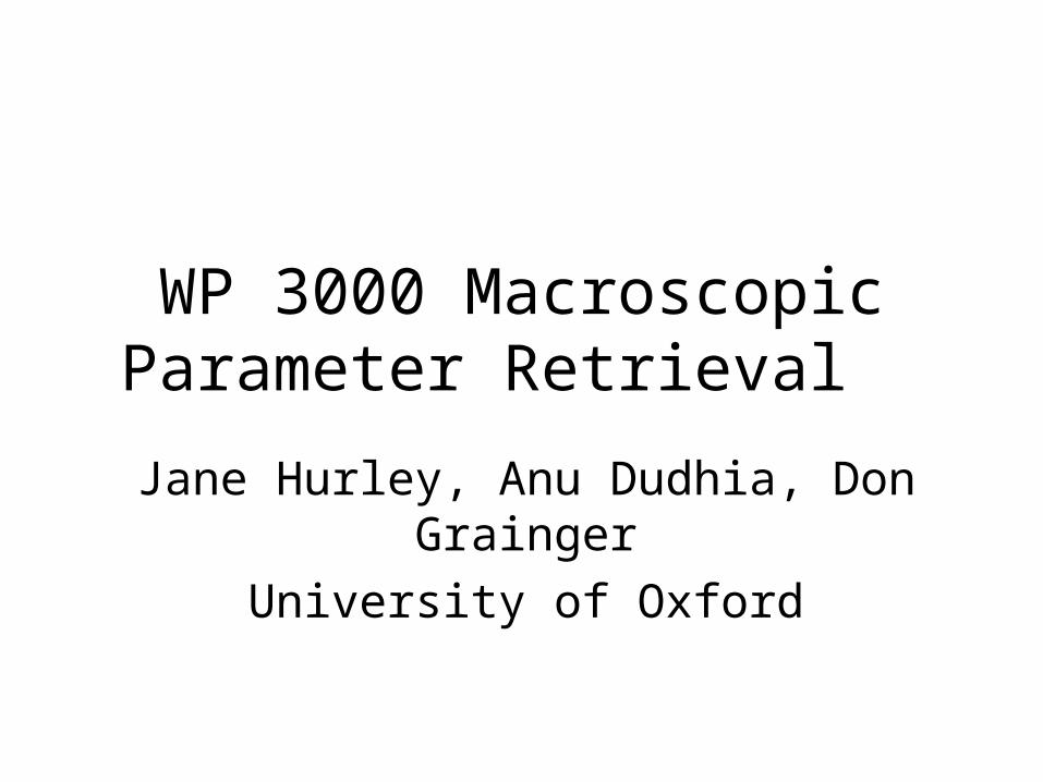
Aim to retrieve most obvious macrophysical cloud properties:
• Cloud Top Height CTH (relative to instrument pointing)
• Cloud Top Temperature CTT
• Cloud Extinction Coefficient kext

Cloud Forward Model (CFM): Radiance in MIPAS FOV
Assume that:
1. a cloud in the MIPAS FOV is horizontally homogeneous – that is, has a constant cloud top height across the FOV and can be characterized by a single extinction coefficient.
2. the temperature structure within the cloud can be determined by the wet adiabatic lapse rate estimated downwards from the cloud top temperature.

The radiance is considered in the clearest microwindow of the MIPAS A band: 960 cm-1 – 961 cm-1
O3 & CO2 O3
O3 O3 O3 & NH3
O3 & CO2
O3

Total radiance measured within two MIPAS FOVs (the FOV containing the cloud top and the FOV immediately below) calculated by the CFM for varying cloud top heights and extinction coefficients.

Gas Correction and Validation with Simulations
Real MIPAS measurements Rm will include significant gaseous radiation contributions Rg, while the CFM calculates only the radiation contribution by the cloud itself Rc. It is thus necessary to deduce what portion of the measured signal is due to the cloud.
Assume that the cloud has a continuum signal and that the gaseous contribution has emission/absorption lines.

Comparing the CFM output with RFM simulations of cloud corrected for gaseous emission in the manner described above, it is clear that the CFM does a good job at estimating the radiance measured by the MIPAS FOV.
Want blue to overlay red

Retrieval and A Priori DependenceCloud modelling is a highly non-linear process, even when considered on the vastly simplified scale.
Given a pair of radiances from two adjacent sweeps in a scan pattern, there can be two possible clouds present: a high thin cloud, or a low thick cloud.Depending upon which a priori is supplied to an OER, equally valid different solutions will result. NEED TO ADD MORE INFORMATION, to better characterize the a priori extinction.
Easiest way to get information is to use quantity we already have:THE COLOUR INDEX CIwhich should already be highly correlated with Cloud Effective Fraction EF, which is the ‘effective blocking power’ of the cloud in the FOV.
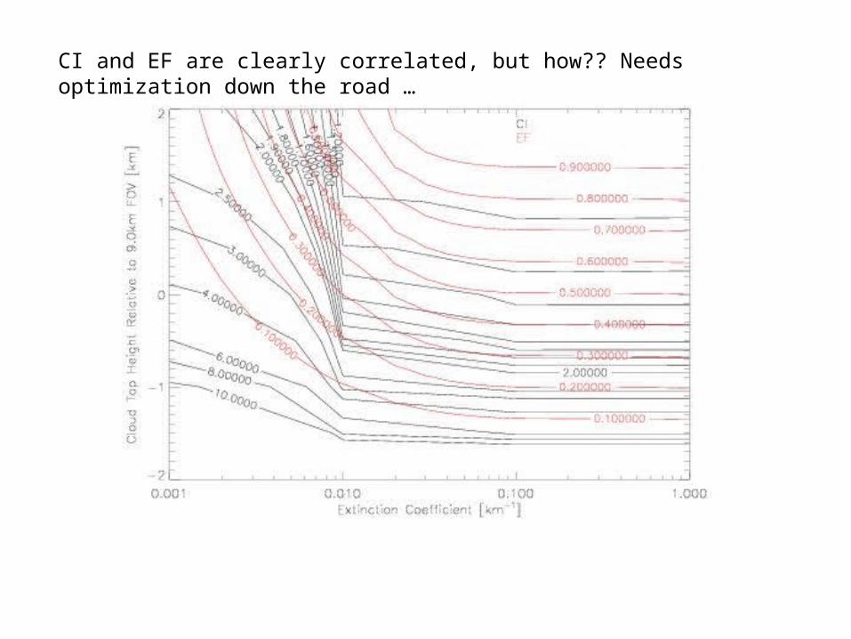
CI and EF are clearly correlated, but how?? Needs optimization down the road …

Using three different extinction coefficients (0.001, 0.01,and 0.1 km-1), four standard RFM atmospheres (day, polar summer, polar winter and tropical) and nine different cloud top heights at a tangent height of 9 km, for a total of 108 different cloudy atmospheric conditions …

Optimal Estimations retrieval of form
with state vector and using:
Real Measurements:
2 radiance measurements from MIPAS spectrum – the first sweep flagged as cloudy and the one immediately below
DIRECT
Pseudo-Measurements:
Tret = temperature corresponding to first flagged cloudy sweep
EF = Cloud effective fraction, as estimated from CI
RELATE

The retrieval has been applied to and validated with RFM simulations for cloudy FOVs with known CTH, CTT and kext.
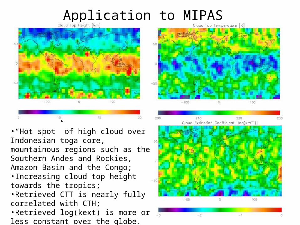
Application to MIPAS Spectra
•“Hot spot” of high cloud over Indonesian toga core, mountainous regions such as the Southern Andes and Rockies, Amazon Basin and the Congo;•Increasing cloud top height towards the tropics;•Retrieved CTT is nearly fully correlated with CTH;•Retrieved log(kext) is more or less constant over the globe.
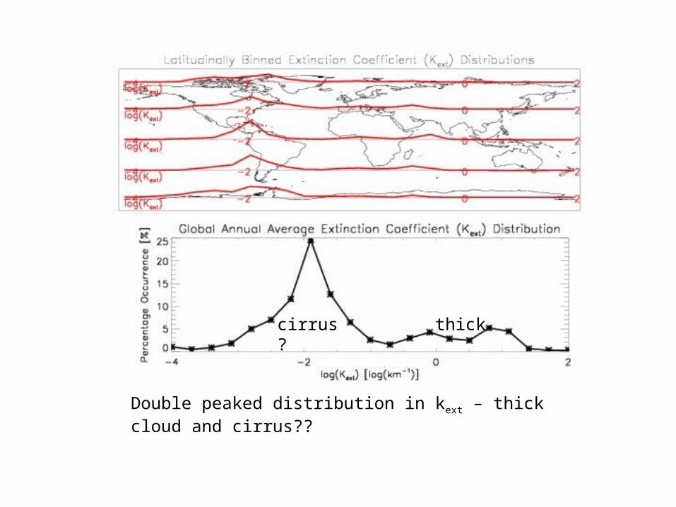
Double peaked distribution in kext – thick cloud and cirrus??
cirrus? thick

If there IS a cloud in the FOV at a certain latitude, this shows the probability that it will occur at a given altitude …

If there IS a cloud in the FOV at a certain latitude, this shows the probability that it will occur at a given temperature …
Basically anti-correlated with cloud top height/altitude

If there IS a cloud in the FOV at a certain latitude, this shows the probability that it will have a given extinction …
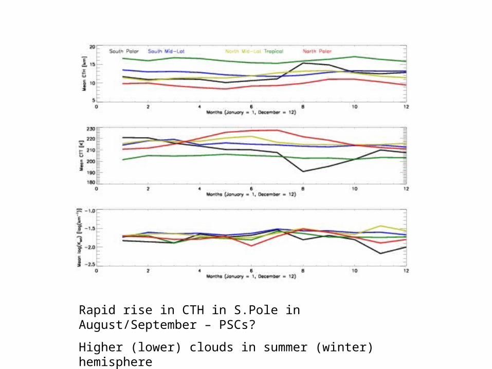
Rapid rise in CTH in S.Pole in August/September – PSCs?
Higher (lower) clouds in summer (winter) hemisphere
Future Work
• Check retrieval’s sensitivity to reference temperature.
• Check retrieval against other retrievals of macroscopic properties: McClouds etc
• Run over larger MIPAS dataset to get a high cloud climatology
• Compare high cloud climatology with others: ISCCP etc


The forward model of the radiance encountered in the MIPAS FOV can be expressed as: , where
is the pencil beam radiance for temperature ,
pathlength ,
whereby Re = Earth’s radius, thc = tangent height where cloud is first detected, thFOV = tangent height of FOV modelled, T = temperature, z = relative position within the FOV, Φ = FOV convolution and Γwet = wet adiabatic lapse rate.

Basically, the sequential retrieval consists of two separate retrievals (“preliminary” and “main”) which independently use difference pieces of information in an attempt to retrieve the state vector
using the one-step formulation
and then feed their results back and forth until a converged set of values is reached.
Preliminary Retrieval
uses Tret and EF as pseudo-measurements to retrieve x
Main Retrieval
uses the two radiance measurements to retrieve x