BETWEEN CHIEFTAINCY AND KNIGHTHOOD: A COMPARATIVE STUDY OF THE OTTOMAN AND THE SAFAVID EMPIRES

World Rural Observations 2016;8(1) http://www.sciencepub.net/rural
27
Spatial Patterns Of Community Conflicts (1990-2015) And Its Implication To Rural Development In Rivers State
Samuel Bankole Arokoyu and *Evangeline Nkiruka Ochulor
Department of Geography and Environmental Science
Faculty of Social Science, University of Port Harcourt, Rivers State [email protected]
Abstract: Community conflict patterns and frequency vary in space and thus the use of Geographic Information Systems (GIS) in conflict management is highly required in contemporary time. This study therefore investigated the spatial pattern and variations in the frequency of community conflict in Rivers State, Nigeria between 1990 and 2015. The locations of all communities that have experienced conflict were mapped with global positioning system. Imageries of rural development indices (infrastructural poverty index and accessibility) and land sat images of 2014 for land use patterns were acquired for the study from United States Geological Survey. The spatial pattern of communal conflicts was analysed using nearest neighbour statistic while the relationship between frequency of community conflicts and rural development was analysed using Spearman rank correlation. Findings reveal that the pattern of distribution of communities that have experienced communal conflicts is random (Nearest Neighbour Ratio = 1.0). More communal conflicts occurred in the upland areas (65.5%) while the swamp areas experienced comparatively lower communal conflicts (34.5%). Inter community conflict was highest in Khana and Gokana LGAs while intra community conflict was highest in Obio Akpor LGA. The community conflict hotspots were in Ogbogoro, Okrika Town, Egbema and Ogbakiri. The correlation coefficient between frequency of conflict and infrastructural poverty was negative and low. The study recommended that awareness programmes on peace-building to educate and sensitize individuals in the LGAs affected by community conflict should be encouraged. [Arokoyu SB, Ochulor EN. Spatial Patterns of Community Conflicts (1990-2015) and Its Implication To Rural Development In Rivers State. World Rural Observ 2016;8(1):27-37]. ISSN: 1944-6543 (Print); ISSN: 1944-6551 (Online). http://www.sciencepub.net/rural. 6. doi:10.7537/marswro08011606.
Keywords: Spatial patterns, Communal conflict, Rural development, Rivers State, Nigeria 1. Introduction
Violent communal conflicts have been in existence in the trouble spots in Africa, especially in such countries as Chad, Cote d’Ivoire, Democratic Republic of Congo, Kenya, Liberia, Nigeria, Rwanda, Sierra Leone, Somalia, Sudan and Zimbabwe (Taylor, 2008). Asiyanbola (2007) stated that various parts of Africa have experienced continual dysfunctional conflicts, which occurred between communities, ethnic groups and religious groups. Today, many nations have witnessed and are still witnessing severe cases of communal conflict. However, Nigeria has been be-deviled by various forms of violent conflicts that have claimed the lives of many people and maimed or displaced people from their communities as a result of these problems (Alimba, 2014). Some conflicts had their roots in the past historical circumstances while others were manufactured by the elites, seeking to stretch the liberty inherent in the new democratic process in Nigeria (Alimba, 2014). This has resulted in electoral, ethnic, religious, herder-farmer, communal and indigene/settler conflicts.
Within the first three years of the country’s return to democratic rule, Nigeria had witnessed the outbreak of several violent communal or ethnic conflicts, while some old ones had gained additional potency
(Asiyanbola, 2007). Examples of conflicts in Nigeria include Yoruba-Hausa community in Shagamu, Ogun State; Eleme-Okrika in Rivers State; the intermittent clashes in Kano, Kano State; Zango-Kataf in Kaduna State; Tiv-Jukun in Wukari, Taraba State; Ogoni-Adoni in Rivers State; Chamba-Kuteb in Taraba State; Itsekiri-Ijaw/Urhobo in Delta State; Aguleri-Umuleri in Anambra State; Ijaw-Ilaje conflict in Ondo State to mention a few (Ubi, 2001; Imobighe, 2003; Omotayo, 2005). Furthermore, World Report (2015) disclose that inter-communal violence, which has plagued the Middle Belt states of Plateau and Kaduna for years, extended to other states in northern Nigeria, including Benue, Nasarawa, Taraba, Katsina, and Zamfara, resulting in the death of more than 4,000 people and the displacement of more than 120,000 residents. Also, the case of boundary disputes between Ebonyi and Benue States (Nehi, 2012). Rivers State is not exempted from this menace as community conflicts have affected communities like Rumuekpe and Ogbakiri, B-Dere and K-Dere, Okirika and Eleme, Soku, Elem-Sangama and Oluasiri, Buguma, Ataba, and Kula communities.
Ongori (2009) citing Loomis and Loomis (1965) explain that conflict is an ever-present process in human relations and it is a phenomenon that is faced at

World Rural Observations 2016;8(1) http://www.sciencepub.net/rural
28
all levels (Barker et al., 1987). Conflict however, is a known and expected outcome of human interaction (Ilvento, et al., 1995); and is a spice of life in every community and is in most cases, seen to be healthy spring-board for developmental process (Iheriohamma, 2003).
The application of Geographic Information Systems (GIS) to conflict management is highly needed in recent time. GIS approach provides a structured methodology with which to help resolve locational disputes by facilitating the precise geo-referencing of violence, along with providing rapid access to a consistent database from which public policies may be formulated (Imrie et al, 1996 in Mesev et al, 2012). Mapping the patterns and variations in the intra and inter community conflicts in Nigeria has been a very important aspect of investigating conflict. According to the USAID (2011), the study on socio-economic mapping of tensions and disputes in Southern Kyrgyzstan was designed to help determine the root causes of tension and disputes between communities in Osh, Jalalabad and Batken Provinces. Similarly, USAID (2013) noted that mapping of community conflict would establish the presence and effectiveness of conflict early warning and early response to help support the program in designing strategies for improving interventions aimed at building peace and provide information that will lead to development of strategies to garner citizen awareness and participation in conflict reporting and community collaboration in conflict transformation. Aspect of mapping community conflict patterns and variation in the frequency of occurrence is limited in the literature. Thus, the present study focused on mapping the patterns and variations in community conflict in Rivers State with a view to identifying inter and intra community conflicts and the hotspots of community conflict in Rivers State.
2.Material and Methods
The study was carried out in Rivers State, Nigeria. Rivers State falls on latitudes between 4o 30’N and 5o 40’N and longitudes between 6o 25’E and 7o 33’E.This study involves reconnaissance survey which provided the list of inter and intra community conflict in Rivers State. The locations of all the listed communities that have experienced community conflict were mapped with Global Positioning System (GPS) and their coordinates (longitudes and latitudes) were used to map them. Data used for the study included the communities that have experienced conflicts in Rivers State and rural development indices. Data on communities that have witnessed conflicts were obtained from the Nigerian Police Force (NPF) in Rivers State and Rivers State Ministry of Chieftaincy Affairs. The data on rural development indices were
obtained from the accessibility data of Rivers State which has the estimates of travel cost (metres) to the nearest community (Nelson, 2008). The accessibility is defined as the travel time to a location of interest using land (road/off road) or water (navigable river, lake and ocean) based travel. This accessibility is computed using a cost-distance algorithm which computes the cost of travelling between two locations on a regular raster grid and this cost is measured in units of time (Nelson, 2008). The higher the travel cost to the conflict-ridden community, the lower the rural development. Also, the rural development was measured using the infrastructural poverty index (IPI). The IPI was measured as the ratio of the availability of electricity and population size in an area. The higher the infrastructural poverty index (IPI), the higher the rural development and vice versa. The analysis on both accessibility data and infrastructural poverty index were both point and polygon based. Landsat imagery of 2014 of 30m x 30m resolution of Rivers State was obtained from the United States of Geological Survey (USGS) for major land use/land cover classification using Erdas Imagine 9.2 and ArGIS 10.1 software. The landsat imageries covering the entire Rivers State were of different path and rows and thus, the imageries were mosaicked. Thereafter, the bands of mosaicked imagery were combined to generate a composite image which was used for the land use/land cover classification. Supervised classification using Maximum Likelihood Algorithm was used. The study employed the use of both descriptive and inferential statistics for analysis. Descriptive statistics involved the use of percentages and frequency to amplify the findings. Inferential statistics used was Spearman’s rank correlation statistics. The spatial pattern of communities that have experienced communal conflicts was tested with the use of nearest neighbour analysis in ArcGIS 10.1. The relationship between frequency of community conflicts and rural development index was tested with Spearman rank correlation statistics. All statistical analyses were computed using Statistical Package for Social Scientists (SPSS) 20.0 Version. 3. Results Spatial Pattern of Distribution of communities that have experienced community conflict
Forty-two communities had experienced communal conflicts in River State (Figure 1). The average distance between and among these communities was 9.1km, while the expected mean distance was 8.9km. The Nearest Neighbour Ratio of 1.0 indicated that the pattern of distribution of communities that have experienced communal conflicts is random (Figure 2). The implication is that all communities have equal chance of being involved in community conflict in Rivers State. This is in line with

World Rural Observations 2016;8(1) http://www.sciencepub.net/rural
29
the findings of Bailey and Gatrell (1995) whereby community conflicts in Sub-Saharan Africa possessed
random distribution.
Figure 1: Communities that have experienced communal conflicts

World Rural Observations 2016;8(1) http://www.sciencepub.net/rural
30
Figure 2: Nearest neighbour graph of the distributional pattern of community conflict
Community conflicts in relation to Land use/ Land cover in Rivers State
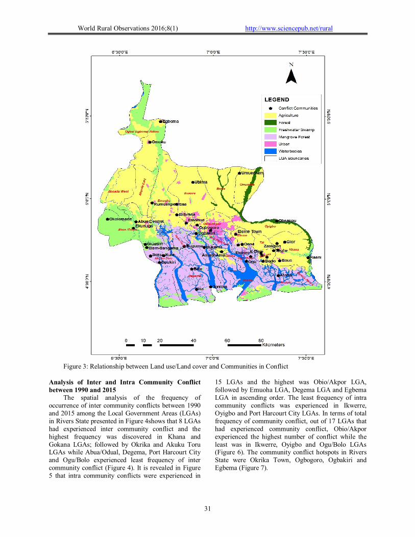
There were more occurrences of communal conflicts in the southern compared to the northern part of the State (Figure 3). The southern part of the state is dominated by wetlands ecosystem, while the northern part is comparatively drier. About 35% of the communities that have experienced conflicts were located in the mangrove ecosystem, while the remaining 65% are located in the upland areas. Therefore, more communal conflicts occurred in the upland areas, while the swamp areas experienced comparatively lower communal conflicts. There are many conflicts that can arise as a result of land as a
resource. Ichite (2015) reported that land means an important economic asset and a source of livelihoods, and it is also closely linked to the identity, history, and culture of communities. Land ownership qualifies a ‘host’ community to enjoy the benefits accrued from the land (Ochulor, 2006). Ichite (2015) further reported that land and natural resource are almost never the sole cause of confrontation while Bob (2010) cited in Ichite (2015) noted that land conflicts commonly become violent when linked to wider processes of political exclusion, social discrimination, economic marginalization, and a perception that peaceful action is no longer a viable strategy for change.
World Rural Observations 2016;8(1) http://www.sciencepub.net/rural
31
Figure 3: Relationship between Land use/Land cover and Communities in Conflict
Analysis of Inter and Intra Community Conflict between 1990 and 2015
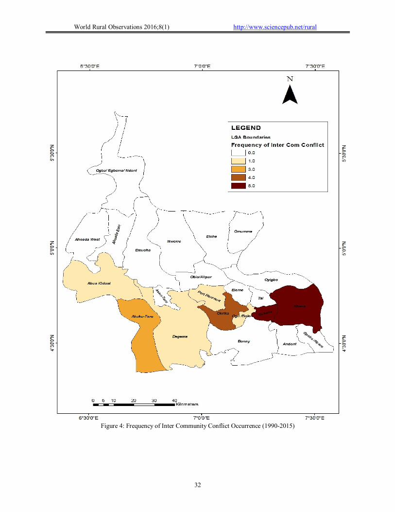
The spatial analysis of the frequency of occurrence of inter community conflicts between 1990 and 2015 among the Local Government Areas (LGAs) in Rivers State presented in Figure 4shows that 8 LGAs had experienced inter community conflict and the highest frequency was discovered in Khana and Gokana LGAs; followed by Okrika and Akuku Toru LGAs while Abua/Odual, Degema, Port Harcourt City and Ogu/Bolo experienced least frequency of inter community conflict (Figure 4). It is revealed in Figure 5 that intra community conflicts were experienced in
15 LGAs and the highest was Obio/Akpor LGA, followed by Emuoha LGA, Degema LGA and Egbema LGA in ascending order. The least frequency of intra community conflicts was experienced in Ikwerre, Oyigbo and Port Harcourt City LGAs. In terms of total frequency of community conflict, out of 17 LGAs that had experienced community conflict, Obio/Akpor experienced the highest number of conflict while the least was in Ikwerre, Oyigbo and Ogu/Bolo LGAs (Figure 6). The community conflict hotspots in Rivers State were Okrika Town, Ogbogoro, Ogbakiri and Egbema (Figure 7).
World Rural Observations 2016;8(1) http://www.sciencepub.net/rural
32
Figure 4: Frequency of Inter Community Conflict Occurrence (1990-2015)

World Rural Observations 2016;8(1) http://www.sciencepub.net/rural
33
Figure 5: Frequency of Intra Community Conflict Occurrence (1990-2015)

World Rural Observations 2016;8(1) http://www.sciencepub.net/rural
34
Figure 6: Total Frequency of Community Conflict Occurrence (1990-2015)

World Rural Observations 2016;8(1) http://www.sciencepub.net/rural
35
Figure 7: Community conflict hotspots in Rivers State (1990-2015)
World Rural Observations 2016;8(1) http://www.sciencepub.net/rural
36
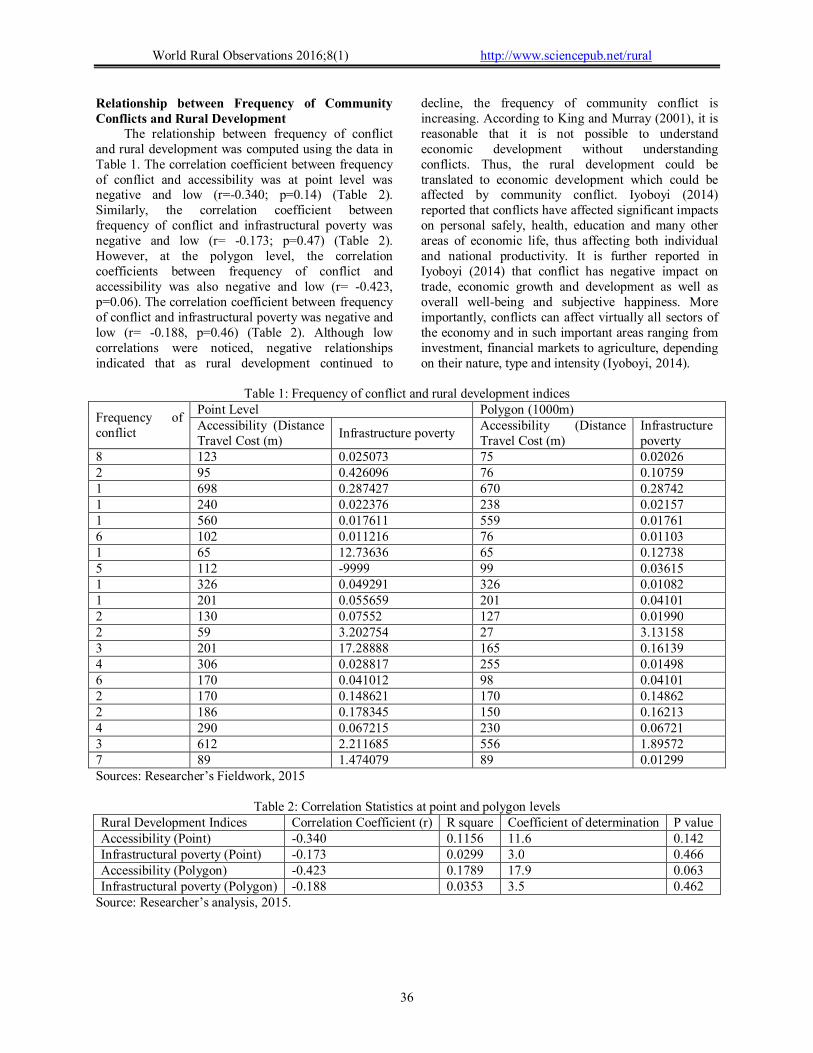
Relationship between Frequency of Community Conflicts and Rural Development
The relationship between frequency of conflict and rural development was computed using the data in Table 1. The correlation coefficient between frequency of conflict and accessibility was at point level was negative and low (r=-0.340; p=0.14) (Table 2). Similarly, the correlation coefficient between frequency of conflict and infrastructural poverty was negative and low (r= -0.173; p=0.47) (Table 2). However, at the polygon level, the correlation coefficients between frequency of conflict and accessibility was also negative and low (r= -0.423, p=0.06). The correlation coefficient between frequency of conflict and infrastructural poverty was negative and low (r= -0.188, p=0.46) (Table 2). Although low correlations were noticed, negative relationships indicated that as rural development continued to
decline, the frequency of community conflict is increasing. According to King and Murray (2001), it is reasonable that it is not possible to understand economic development without understanding conflicts. Thus, the rural development could be translated to economic development which could be affected by community conflict. Iyoboyi (2014) reported that conflicts have affected significant impacts on personal safely, health, education and many other areas of economic life, thus affecting both individual and national productivity. It is further reported in Iyoboyi (2014) that conflict has negative impact on trade, economic growth and development as well as overall well-being and subjective happiness. More importantly, conflicts can affect virtually all sectors of the economy and in such important areas ranging from investment, financial markets to agriculture, depending on their nature, type and intensity (Iyoboyi, 2014).
Table 1: Frequency of conflict and rural development indices
Frequency of conflict
Point Level Polygon (1000m) Accessibility (Distance Travel Cost (m)
Infrastructure poverty Accessibility (Distance Travel Cost (m)
Infrastructure poverty
8 123 0.025073 75 0.02026 2 95 0.426096 76 0.10759 1 698 0.287427 670 0.28742 1 240 0.022376 238 0.02157 1 560 0.017611 559 0.01761 6 102 0.011216 76 0.01103 1 65 12.73636 65 0.12738 5 112 -9999 99 0.03615 1 326 0.049291 326 0.01082 1 201 0.055659 201 0.04101 2 130 0.07552 127 0.01990 2 59 3.202754 27 3.13158 3 201 17.28888 165 0.16139 4 306 0.028817 255 0.01498 6 170 0.041012 98 0.04101 2 170 0.148621 170 0.14862 2 186 0.178345 150 0.16213 4 290 0.067215 230 0.06721 3 612 2.211685 556 1.89572 7 89 1.474079 89 0.01299 Sources: Researcher’s Fieldwork, 2015
Table 2: Correlation Statistics at point and polygon levels
Rural Development Indices Correlation Coefficient (r) R square Coefficient of determination P value Accessibility (Point) -0.340 0.1156 11.6 0.142 Infrastructural poverty (Point) -0.173 0.0299 3.0 0.466 Accessibility (Polygon) -0.423 0.1789 17.9 0.063 Infrastructural poverty (Polygon) -0.188 0.0353 3.5 0.462
Source: Researcher’s analysis, 2015.

World Rural Observations 2016;8(1) http://www.sciencepub.net/rural
37
4. Conclusion and Recommendations The study revealed that the spatial pattern of
communities that have experienced communal conflict is random. Inter community conflict was higher in Gokana and Khana LGAs while intra community conflict was highest in Obio/Akpor LGA. There was spatial variation in the number of communities involved in community conflict in Rivers State in relation to landuse/ land cover. The hotspots of community conflict were found in Okrika Town, Ogbakiri, Ogbogoro and Egbema. The study recommended that more attention should be placed on the hotspots area of community conflict within the State to reduce the frequency of occurrence and safe innocent lives and properties. There should be awareness programmes on peace-building to educate and sensitize individuals in the LGAs affected by community conflict. This will bring tranquillity among the different groups within and outside a town or LGA and more importantly, rural development will be improved. Corresponding Author: Miss Evangeline Nkiruka Ochulor Department of Geography and Environmental Management, University of Port Harcourt, Nigeria Telephone:+234-703-883-3200 Email: [email protected] References 1. Alimba N.C. (2014): Probing the Dynamics of
Communal Conflicts in Northern Nigeria, African Journal Online (AJOL) Volume 8, No 1.
2. Asiyanbola, A.R. (2007): Urban-ethno communal conflict in Africa: Nigeria A paper submitted for presentation at the Union for African Population Studies (UAPS) Fifth African Population Conference, Arusha, Tanzania: December 10 – 14, 2007 pp 1-28.
3. Bailey T. C. and Gatrell, A. C. (1995) Interactive Spatial Data Analysis. Harlow, UK: Addison Wesley Longman.
4. Barker L. L., Kathy J. W, Kittie W. W, Robert J. K, (1987): Group in process: An Introduction to Small Group Communication, Third Edition. Prentice Hall, Englewood Cliffs, NJ.
5. Bob, U. (2010): Land-Related Conflicts in Sub-Saharan Africa”, African Journal of Conflict Resolution 10 (2): 49-64.
6. Ichite, C. (2015): Land conflicts, population pressure and lethal violence in the Niger Delta (Akwa Ibom, Rivers, Bayelsa, Delta) 2006-2014. IFRA-Nigeria working papers series, No. 48. pp 1-36.
7. Iheriohamma E.B.J (2003): Polity and Economy of Nigeria and the European Intervention; An
Introduction In: E.B.J. Iheriohamma (Ed): Path to Nigeria Political and Economic Development, Kosoko Press.
8. Ilvento, T, Hustedde, R., Garkovich, L., and Greider, T. (1995): Mediation, Facilitation, and Negotiation: Understanding the Differences. SEED Occasional Paper, Rural and Economics Development Programs, University of Kentuky.
9. Imobighe A. T. (2003): “Ethnicity and ethnic conflicts in Nigeria: an Overview” in Thomas A. Imobighe (ed.) Civil society and ethnic conflict management in Nigeria. Ibadan: Spectrum.
10. Loomis, C.P and Loomis Z.K (1965): Modern Social Theories. Princeton: D. Van Nostran Company, Inc.
11. Iyoboyi, M. (2014): Economic Growth and Conflicts: Evidence from Nigeria. Journal of Sustainable Development Studies, Volume 5, Number 2,:116-144 Taylor, P. (2008). Places, spaces and Macy’s: place-space tensions in the political geography of modernities. Progress in Human Geography 23(1):7-26.
12. King, G and Murray, C. (2001). ‘Rethinking Human Security’. Political Science Quarterly 116(4), 585–610.
13. Mesev V., Shirlow P. and Downs J. (2012): Geography of Conflict and Death in Belfast, Northern Ireland. In Koyabashi A. (Ed) Geographies of Peace and Conflict. Published by Routledge, New York. pp 76-85.
14. Nehi, I. (2012): Discover Nigeria: 5 Causes of Conflict in Nigeria connectnigeria.com/.../discover-nigeria-5-causes-of-conflict-in-nigeria/.
15. Nelson, A. (2008): Estimated travel time to the nearest city of 50,000 or more people in year 2000. Global Environment Monitoring Unit - Joint Research Centre of the European Commission, Ispra Italy. Available at http://bioval.jrc.ec.europa.eu/products/gam/ (Accessed on 14/3/2015).
16. Ochulor, E. (2006): The Effect of Land Disputes on Community Development- Study of Eleme and Okirika in Rivers State, Unpublished M.Sc. Thesis, Department of Urban and Regional Planning, University of Ibadan, Oyo State. Nigeria.
17. Omotayo B. (2005): “Women and conflict in the new information age: Virtual Libraries to the rescue” A paper presented at the World Library and Information Congress: 71th IFLA General Conference and Council “Library - a voyage of discovery” August 15th – 18th 2005, Oslo, Norway.
18. Ongori H, (2009): Organisational Conflict and its Effects on Organisational Performance. Research Journal of Business Management, 3: 16-24.
19. Ubi, O. A. (2001): Communal conflict and traditional conflict resolution: theUgeb/Idomi 1992 conflict experience. Ife Psychologia 9 (3), pp. 71 – 82.
20. World Report (2015): Nigeria Human Rights Watch https://www.hrw.org/world-report/2015/country-chapters/nigeria. Accessed on 20th February, 2016.
2/24/2016