World Heritage Volcanoes - International Union for ... · volcano, it is estimated that the World...
70
World Heritage Volcanoes A thematic study: A Global Review of Volcanic World Heritage Properties: Present Situation, Future Prospects and Management Requirements IUCN Protected Areas Programme - World Heritage Studies
Transcript of World Heritage Volcanoes - International Union for ... · volcano, it is estimated that the World...
World Heritage VolcanoesA thematic study: A Global Review of Volcanic World Heritage Properties: Present Situation, Future Prospects and Management Requirements
IUCN Protected Areas Programme - World Heritage Studies

About IUCN
IUCN, International Union for Conservation of Nature, helps the world fi nd pragmatic solutions to our most pressing environment and development challenges.
IUCN works on biodiversity, climate change, energy, human livelihoods and greening the world economy by supporting scientifi c research, managing fi eld projects all over the world, and bringing governments, NGOs, the UN and companies together to develop policy, laws and best practice.
IUCN is the world’s oldest and largest global environmental organization, with more than 1,000 government and NGO members and almost 11,000 volunteer experts in some 160 countries. IUCN’s work is supported by over 1,000 staff in 60 offi ces and hundreds of partners in public, NGO and private sectors around the world.
www.iucn.org
This study is produced as part of IUCN’s role as advisory body to the UNESCO World Heritage Convention on natural heritage.
AcknowledgementsThis report has benefi ted from research of databases undertaken with the assistance of Jessica Roberts. Inaddition, thanks are extended to a number of external reviewers of this document. Nevertheless, any errorsor inaccuracies remain the sole responsibility of the author.
IUCNProgramme on Protected AreasRue Mauverney 28CH-1196 GlandSwitzerlandwww.iucn.org/wcpa

The designation of geographical entities in this book, and the presentation of the material, do not imply the expression of any opinion whatsoever on the part of IUCN concerning the legal status of any country, territory, or area, or of its authorities, or concerning the delimitation of its frontiers or boundaries.
The views expressed in this publication do not necessarily refl ect those of IUCN.
Published by: IUCN, Gland, Switzerland
Copyright: © 2009 International Union for Conservation of Nature and Natural Resources
Reproduction of this publication for educational or other non-commercial purposes is authorized without prior written permission from the copyright holder provided the source is fully acknowledged.
Reproduction of this publication for resale or other commercial purposes is prohibited without prior written permission of the copyright holder.
Citation: Chris Wood. World Heritage Volcanoes, Gland, Switzerland: IUCN. 70pp.
Cover photo: June 1996 eruption of Mt Ruapehu, which is one of four andesitic volcanoes in New Zealand’s Tongariro National Park, a World Heritage Cultural Landscape. © Harry Keys
Layout by: Delwyn Dupuis
Produced by: IUCN Protected Areas Programme
Printed by: IUCN
Available from: IUCN (International Union for Conservation of Nature) Publications Services Rue Mauverney 28 1196 Gland Switzerland Tel +41 22 999 0000 Fax +41 22 999 0020 [email protected] www.iucn.org/publications A catalogue of IUCN publications is also available.
The text of this book is printed on paper made from wood fi bre from well-managed forests certifi ed in accordance with the rules of the Forest Stewardship Council (FSC).

World Heritage VolcanoesA thematic study: A Global Review of Volcanic World Heritage Properties: Present Situation, Future Prospects and Management Requirements

Table of Contents
Summary ...........................................................................................................................................................1
Introduction ........................................................................................................................................................3
The purpose of the study ...................................................................................................................................5
Defi ning the scope of the study .........................................................................................................................7 What is a volcanic World Heritage property? ......................................................................................7 What is an active volcano? .................................................................................................................8 Volcanoes are complex constructions ...............................................................................................11 Chemical change in the magma chamber.........................................................................................11 Degraded volcanic cones and domes ...............................................................................................11 Exposed intrusive forms ....................................................................................................................11 Hydrothermal phenomena and solfataric fi elds .................................................................................13 Volcanoes on the ocean fl oors ..........................................................................................................13 Summary of scope of study...............................................................................................................14
Volcanoes and volcanic features on the World Heritage List ..........................................................................15 Types of volcanic World Heritage properties .....................................................................................16 Number of Holocene volcanoes in World Heritage properties ..........................................................17 Archaeological sites and settlements periodically buried by volcanic deposits ................................18 Atolls and reef-fringed islands ...........................................................................................................18
Technical framework for gap analysis..............................................................................................................19 Genetic classifi cation ........................................................................................................................19 Styles of eruption ..............................................................................................................................20 Plate tectonic setting .........................................................................................................................21 Classifi cations of volcanic landforms ................................................................................................25 Conclusion: a framework for gap analysis ........................................................................................26
Identifying the gaps .........................................................................................................................................27 Gaps in the range of volcanic World Heritage properties ..................................................................27 Missing iconic volcanoes...................................................................................................................31
Filling the gaps ................................................................................................................................................32
Requirements for integrity and management that should apply to sites with volcanic geology .......................33 Meeting the condition of Integrity ......................................................................................................33 Example 1 - Jeju Volcanic Island, Republic of Korea ........................................................................34 Example 2 - Teide National Park, Tenerife, Spain .............................................................................35 Site management .............................................................................................................................36 Education and interpretation .............................................................................................................37 Monitoring .........................................................................................................................................37 Risk management and contingency planning ...................................................................................39
Conclusions and Recommendations ...............................................................................................................41

Annexes Annex 1: List of Figures ....................................................................................................................43 Annex 2: List of Tables .....................................................................................................................44 Annex 3: Data Sources ...................................................................................................................45 Annex 4: References ........................................................................................................................46 Annex 5: Glossary ............................................................................................................................47 Annex 6: Table 1 Properties with volcanic geology on the World Heritage List ................................52 Annex 7: Table 2 Properties with volcanic geology on the Tentative Lists........................................58

1 IUCN World Heritage Studies
Summary
This Global Theme Study examines the position of volcanoes and volcanic features in relation to the World Heritage List. It was commissioned by the IUCN, following a request of the World Heritage Committee which observed that volcanic features are now well represented on the List and any future nominations of volcanic World Heritage properties1 should be limited only to those that fi ll the most signifi cant gaps in the present coverage. The study therefore has set out to defi ne what constitutes a volcanic World Heritage property and establish a technical framework under which such properties might be evaluated in the future and possible priorities for further recognition. It has also considered the particular challenges that might be faced by a State Party in the management of a volcanic World Heritage property.
The study examined the records of the 878 properties on the current World Heritage List (including all properties listed up to and including the Committee meeting in 2008 (32nd Session of the World Heritage Committee, Québec City), as well as 1468 sites proposed for nomination in the Tentative Lists of State Parties. It was found that while there are 57 properties that have some volcanic geology, 27 of these contain active volcanoes2. Furthermore, because many of the properties with active volcanism contain more than one volcano, it is estimated that the World Heritage List may contain over 100 active volcanoes, which is over 6% of all the world’s Holocene subaerial volcanoes. Examination of the Tentative Lists revealed a further 40 volcanic properties, 25 with one or more active volcanoes, these latter properties containing over 70 Holocene volcanoes.
The World Heritage List therefore represents a most important mechanism for protecting the global volcanic estate. The volcanic properties on the List display a wide variety of volcanic forms and features, including single active, dormant or extinct volcanic edifi ces; complex, large scale, active volcanic groups and landscapes representative of particular plate tectonic settings; individual volcanic landforms or features, or combinations of these; eroded remains of former volcanoes; and signifi cant hydrothermal and fumarolic systems. The study found that the volcanic properties on the World Heritage List exhibit virtually all types of major and subsidiary constructional and erosional (destructional) volcanic landforms.
While the World Heritage List appears to possess good overall representation of volcanic features, deeper analysis in the context of plate tectonic setting, landform and geopolitical boundaries has revealed some gaps that might be fi lled by future nominations. For example, some important features of basaltic volcanism not so far included are fi ssure volcanoes, sub-glacial volcanic edifi ces and continental fl ood basalts, while features of more silicic volcanism that might be better represented are calderas and large ash or pumice fl ows (ignimbrites). Also worthy of consideration for nomination to the World Heritage List are some of the world’s most iconic volcanoes.
In its consideration of the management of volcanic World Heritage properties, the study has discussed the concept of ‘integrity’ in relation to existing and proposed future volcanic World Heritage properties. This concept is important in defi ning and containing the volcanic ‘system’, and the protection of geological values,
1. The World Heritage Convention and its Operational Guidelines consistently refer to World Heritage Sites as ‘Properties’ (i.e., the area of land inscribed on the World Heritage List is a “property”). The term World Heritage property is therefore used throughout this report in preference to the term World Heritage site. However, the use of the word “property’ in this context should not be confused with the use of the word “property” to mean a quality or characteristic (i.e., as in the properties or characteristics of a volcano, or its scientifi c properties). 2. volcanoes listed in the database of the Smithsonian Institution’s Global Volcanism Program as having been active during the Holocene period, or the last 10,000 years.
IUCN World Heritage Studies 2
both in themselves and as a part of integrated ecosystem management. One other important aspect of management not usually so dominant in other natural World Heritage properties is the hazardous behaviour of many volcanoes, necessitating the scientifi c monitoring of volcanic activity, as well as the preparation up of Hazard Assessments, Hazard Zone Maps and Risk Contingency Plans.

3 IUCN World Heritage Studies
Introduction
Volcanoes are perhaps the best known and most spectacular of the Earth’s geological features, and the importance of some as outstanding earth-science features is recognised in their status as natural World Heritage properties. From the beautiful, soaring cone of Mt Kilimanjaro in Kenya, to the infamous Krakatau, a part of the Ujung Kulon National Park in Indonesia, or the giant slumbering caldera of Yellowstone in the United States of America, World Heritage volcanoes provide a diverse range of volcano types, geographical locations and eruptive activities.
Volcanoes capture the public’s imagination not only as beautiful and fascinating landforms, but also features whose enormous power may threaten society. Not so widely appreciated is that the formation of the planet and the existence of life on it have been dependent upon the activity of volcanoes throughout geological time. If the ocean fl oors are included, over 80% of the Earth’s surface is of volcanic origin, while the gases emitted from volcanoes
Plate 1: 1977 eruption of Krafl a, NE Iceland, a fi ssure volcano on Iceland’s Tentative List (photo: S. A. Thorarinsson)
over hundreds of millions of years were instrumental in forming the Earth’s earliest oceans and atmosphere. These gases provided the ingredients vital to evolve and sustain life. Volcanoes are therefore true wonders of the planet and it is appropriate that notable ones have been recognised to be worthy of special protection through their inclusion on the World Heritage List.
Volcanoes are not randomly distributed over the Earth, but are found over areas where hot liquid rock (magma) has been able to rise and escape onto the Earth’s surface. As seen in Figure 1, volcanoes occur mainly along the boundaries of the Earth’s lithospheric (tectonic) plates, or at places in the interior of plates where rising magma has punctured the crust (a place known as a ‘hot spot’). However, it should be remembered that the present-day distribution of volcanoes is a refl ection of the current arrangement of lithospheric plates, and that in the geological past the pattern of plates and therefore the distribution of volcanoes changed constantly throughout time. This means that in addition to present day volcanoes, we also fi nd evidence of ancient volcanism in the historical, or stratigraphical, record, at locations typically remote from any current plate boundary or hot spot.
What are volcanoes? To the scientist, they provide vital clues on the internal workings of the Earth. They represent the places where hot, buoyant magma ascends from the upper mantle or lower crust and migrates toward the Earth’s surface. The magma’s ascent may be arrested in the crust, where it may crystallize to form an intrusive body of igneous rock, or it may travel to the surface and break out (erupt) to build a suite of diverse volcanic landforms. However, the landforms that the erupting material constructs are varied in scale and form, determined both by the chemical and physical properties of the magma, and the style and environment of the eruption.
Crucial to the behaviour of any volcano is the rheological, or fl ow, properties of the magma, the most important being its viscosity. Viscosity in turn is determined by the magma’s chemical composition, gas content and degree of crystallisation. The more viscous the magma, the more explosive the eruption, producing a higher proportion of ejected fragmentary material. Thus, if the magma is relatively fl uid (low viscosity), its effusion will

IUCN World Heritage Studies 4
Figure 1: Map showing the Earth’s tectonic plates and distribution of active volcanoes (courtesy of USGS).
normally take place without signifi cant explosive activity (unless water enters the system), which is a style of eruption that will form lava plains, lava fi elds and low-angled shield volcanoes. If the viscosity of the magma is high, escaping gases are released explosively, blasting magma and fragments of the pre-existing volcano into the air, to fall back to Earth as bombs, lapilli, or ash, collectively known as pyroclastic material. Such activity, combining lava fl ows and pyroclastic deposits, builds steep conical mountains, known as stratovolcanoes, surmounted by one or more craters of different types. As a further variant, magma with particularly high viscosity can be slowly extruded from vents, like toothpaste from a tube, to form mounds of varying sizes, known as lava domes. However, this is a very simple interpretation, and in reality there is a great diversity of eruption styles and volcanic constructions.
Given their large scale, and their powerful and unpredictable behaviour, the protection of the heritage values of volcanoes and volcanic landscapes is a challenging task. To date, their conservation has been rather haphazard, partly because of the remoteness and apparent barrenness of volcanic terrains, and also because many conservation agencies have considered that such geological resources are little threatened. However, this approach is far from the truth and the integrity of many of the world’s volcanic landscapes and features are under threat from such things as recreational overuse, mineral extraction and encroaching development. In addition, it should not be forgotten that volcanoes are hazardous environments, and while management intervention is often necessary to achieve conservation goals, it is also an essential means by which the risks to communities living on and around volcanoes may be reduced.

5 IUCN World Heritage Studies
The purpose of the study
This report provides a review of the volcanic landforms and landscapes inscribed on the World Heritage List. It also reviews those included on the Tentative Lists of States Parties to the World Heritage Convention that may be proposed for nomination in future, and other signifi cant volcanic features that might have the potential to be added to the List. The report arises following a decision adopted by the World Heritage Committee (Decision 31 COM 8B.17, paragraph 6):
“The World Heritage Committee requests IUCN to evaluate the volcanic systems inscribed on the World Heritage List and on the Tentative Lists of States Parties and to present a thematic study for consideration of the Committee.”
This decision was made in response to the advice of IUCN that volcanic features are relatively well represented on the List, and thus suggesting a decreasing potential for further nominations of volcanic properties related to the remaining gaps in the present world coverage. Reporting to the World Heritage Committee in July, 2007, IUCN drew the Committee’s attention to this issue and recommended undertaking a thorough global analysis, as follows:
“IUCN notes that volcanic systems are relatively well represented on the World Heritage List, including several properties whose inscription was justifi ed on the basis of arguments that are considered by a number of experts to be rather narrow. There are a large number of volcanoes worldwide and at a detailed level every one of these can assert that it is in some way unique. In 1996 IUCN noted that the World Heritage Committee had already asked “how many volcanoes should there be on the World Heritage List?”
In the interests of maintaining the credibility of the World Heritage List, IUCN considers that there is increasingly limited scope to recommend further nominations for inclusion on the World Heritage List. In particular, IUCN recommends that the World Heritage Committee should consider indicating clearly to State Parties that further volcanic nominations should only be promoted where:
There is a very clear basis for identifying major and distinctive features of outstanding universal value that has been verifi ed by a thorough global comparative analysis;
The basis for claiming outstanding universal value is a signifi cant and distinctive feature of demonstrable and widespread signifi cance, and not one of many narrow and specialized features that are exhibited within volcanic terrains. IUCN recommends that State Parties considering volcanic nominations carry out an initial global comparative analysis prior to proceeding with the development of a full nomination, in order to minimize the possibilities of promoting a nomination that will not meet the requirements of the World Heritage Convention, including those concerning the conditions of integrity.”
The brief for this study therefore calls for a review of sites included, or with the potential to be included, on the World Heritage List. Sites to be reviewed have been defi ned by IUCN as:
a) Landscapes that are formed by the primary action of volcanic and igneous processes and are of potential Outstanding Universal Value (OUV), but will not include landscapes formed in igneous terrains by secondary processes.
•
•

IUCN World Heritage Studies 6
b) Volcanic and igneous features of outstanding and universal importance in relation to geoscience, including its accessibility and comprehension by civil society (i.e., does not include sites with values that are only of a specialised scientifi c importance), and an overview of the requirements necessary to meet the conditions of integrity and management at such sites.
The purpose of this study is therefore to advise State Parties on:
a) the scope of volcanic values already represented on the World Heritage List;b) the potential and priorities for future recognition of volcanic landscapes and features on the World Heritage List;c) the requirements for integrity and management that should apply to such sites.

7 IUCN World Heritage Studies
Defi ning the scope of the study
What is a volcanic World Heritage property?
This report defi nes a volcanic World Heritage property as one that contains geological structures and landforms constructed from volcanic, or igneous, rocks (see Text Box 1 for defi nition). These are rocks derived from a liquid magma that was intruded into, and often extruded onto, the Earth’s crust. Such activity has been prevalent throughout geological time, and while eruptions that have taken place in the recent past still exhibit, or are still building, constructional landforms on the Earth’s surface, the results of older eruptions have been partly or wholly destroyed by surface erosive processes. Yet, even when deeply eroded, volcanic terrains may include important landforms, either as features formed by the dissection of the volcanic cone, or by the complete removal of the weaker material of the cone to leave the hard skeleton of the intrusive features upstanding in the landscape (sometimes known as inverted topography).
Volcanic features therefore may be divided into:
1. Primarily constructional features - those principally formed by explosive and/or effusive volcanic activity (i.e., formed by endogenetic processes, or those geological processes originating from within the body of Earth)2. Primarily destructional features - those formed by the weathering and erosion of the Earth’s land surface (i.e., formed by exogenetic processes, or those originating outside of the Earth’s crust, at the interface of the lithosphere with the atmosphere, hydrosphere and biosphere).
There is inevitably overlap between these two types of features, because even during their construction new volcanoes suffer some exogenetic degradation, such as landslides, fl uvial and even glacial erosion, and one should consider the forms of many volcanoes to have evolved from a mixture of both types of processes.
This study of volcanic World Heritage properties has been approached from the standpoint of geomorphology, or physical landscape. It embraces volcanic landforms and landscapes that have been formed by varying combinations of endogenetic or exogenetic processes. Furthermore, it recognises that volcanoes may vary greatly in shape and size, ranging from small cinder cones and tuff rings to enormous edifi ces, such as the towering stratocone of Sangay, Ecuador, or the gigantic volcanic shields of Mauna Loa and Mauna Kea, on Hawaii Island, USA, which are the largest individual mountain structures on the planet. It is also important to note that these larger structures will contain on their fl anks a range of subsidiary features, including such phenomena as calderas and craters, rift zones and fi ssures, lava domes, collapse scars, scoria cones, tuff cones and tuff rings, maars, pit craters, lava fl ows with lava channels and lava tube caves, and debris lobes produced by collapse or lahars (see Figure 2). A further consideration is that scientists now recognise that several apparently individual volcanoes may be parts of the same volcanic system, each volcano tapping a common magma source, as explained in Text Box 1.
The conceptual approach taken here has been to consider volcanic World Heritage properties within the general term volcanic landscape, and that each landscape is composed of an assemblage of volcanic landforms. However, it should also be recognised that there are some ‘volcanic’ landscapes that do not have distinctive landforms, but contain abundant evidence in their rocks and underground structures of former volcanic activity. Adding further complexity to the defi nition is the fact that a volcanic landform may be a composite feature (e.g., a polygenetic stratovolcano), representing a single landform in its own right, but also containing a range of subsidiary features.
IUCN World Heritage Studies 8
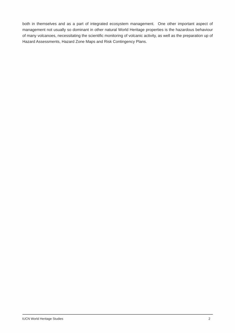
TEXT BOX 1: Nomenclature and diversity of igneous rocks
Igneous rocks are those that are formed by the cooling and crystallization of a liquid magma. As will be explained below, magmas have a wide range of chemical compositions, and each may crystallize to produce a variety of min-erals. Igneous rocks are aggregates of these interlocking mineral crystals, the relative proportions of the various minerals being dependent upon the unique chemistry of the original magma.
Nearly all magmas are silicate melts, or ‘liquid’ glass (there are a few rare and unusual classes of igneous rocks, such as carbonatites, that are derived from magmas composed primarily of non-silicate minerals, such as carbon-ates). On crystallization of a silicate melt, different minerals form when the silicate molecule combines with other elements. The common families of minerals forming igneous rocks are quartz, feldspars (and feldspathoids), micas, amphiboles, pyroxenes, and olivines. Silica accounts for 40-75% of most igneous rocks by weight and modern classifi cations categorize igneous rocks according to their relative proportions of the silicate minerals.
Thus:Rocks whose minerals have a high silica content, such as rhyolites or granites, are termed felsic or silicic (the word felsic is derived from feldspar and silica),Rocks whose minerals have a low silica content, such as basalts or gabbros, are termed mafi c or basic (the word mafi c is derived from magnesium and ferric, or iron).
A further important point is that mafi c minerals crystallize at higher temperatures than do the felsic minerals. In other words they appear earlier in a cooling magma.
Classifi cation of igneous rocks
Igneous rocks may be classifi ed on the basis of their silica content and texture. Texture relates to the size of the mineral crystals that make up the rock, larger crystals signifying slower cooling, providing a longer time for crystals to grow, while smaller crystal signify more rapid cooling. Sometimes magma may be cooled so fast that there is no time for discrete crystals to grow, and the resulting rock has the appearance of a glass.
A simple classifi ction of igneous rocks is as follows:
Texture Mode of Occurence 75%--------------------Composition (silica content)---------------40%Acid(Felsic or silicic) Intermediate Basic (mafi c) Ultra-basic
(Ultra-mafi c)Coarse Large intrusion Granite Diorite Gabbro PeridotiteIntermediate Small intrusion Diorite DoleriteFine Extrusive (lava) Rhyolite Andesite Basalt KomatiteGlassy Obsidian
Black or grey-coloured basalt is the archytypal basic, fi ne-grained rock (coarse-grained equivalent is known as gabbro). It has low silica content and is composed primarily of the minerals plagioclase feldspar, pyroxene and olivine. In contrast, the most felsic fi ne-grained rock is rhyolite (coarse-grained equivalent is granite). This rock is light in colour, has high silica content, and consists largely of quartz, feldspar and mica. Intermediate between these are rocks known as andesites.
For further understanding of the diversity of igneous rocks and their classifi cation, the reader is directed to one of the standard physical geology texts, such as Press et al. (2004), or Murck and Skinner (1999).
What is an active volcano?
Any volcano, if it is not currently erupting, may be in a period of repose between eruptions, when it is said to be dormant, or in fact is not likely to erupt again, when it is said to be extinct. The usual assumption is that an active volcano is one that is currently erupting or has erupted during recorded history. However, the Smithsonian Institution’s Global Volcanism Program (GVP), the most authoritative source on the activities of the world’s volcanoes, takes a longer term view:

9 IUCN World Heritage Studies
“Because dormant intervals between major eruptions at a single volcano may last hundreds to thousands of years, dwarfi ng the relatively short historical record in many regions, it is misleading to restrict usage of the term “active volcano” to recorded human memories: we prefer to add another identifying word (e.g. “historically active” or “Holocene volcano”).”
On the basis of its database of volcanic activity around the world, the GVP notes (see Text Box 2) that at any one time there may be 20 volcanoes in eruption, while the historical record has shown that roughly 60 volcanoes erupted each year in the 1990s, 154 in the decade 1990-1999, about 550 in the historic period, and as many as 1573 in the last 10,000 years - a period of geological time known as the Holocene. This review will adopt the defi nition of ‘active volcano’ provided by the GVP as one that has been in activity in the last 10,000 years and will use the term ‘holocene volcano’ as one synonymous with ‘active volcano’.
TEXT BOX 2: How many active volcanoes are there in the world?
Abstracted from Smithsonian Institution’s Global Volcanism Program, Frequently Asked Questions, see: http://www.volcano.si.edu/faq/index.cfm?faq=03
Usage [of the term “volcano”] has varied widely, [and has been] applied to individual vents, measured in meters, through volcanic edifi ces measured in tens of kilometers, to volcanic fi elds measured in hundreds of kilometers. We have tended toward the broader defi nition in our compilations, allowing the record of a single large plumbing system to be viewed as a whole, but this approach often requires careful work in fi eld and laboratory to establish the integrity of a group’s common magmatic link. The problem is particularly diffi cult in Iceland, where eruptions separated by many tens of kilometers along a single rift may share the same magmatic system. A “volcanic fi eld”, such as Mexico’s Michoacán-Guanajuato fi eld (comprising nearly 1,400 cinder cones, maars, and shield volcanoes derived from a single magmatic system, dotting a 200 x 250 km area) may be counted the same as a single vol-canic edifi ce. Perhaps the most honest answer to the number question is that we do not really have an accurate count of the world’s volcanoes, but that there are at least a thousand identifi ed magma systems - on land alone - likely to erupt in the future. How many active volcanoes known?
Erupting now: perhaps 20Each year: 50-70Each decade about 160Historical eruptions about 550Known Holocene eruptions (last 10,000 years): about 1300Known (and possible) Holocene eruptions: about 1500
Note: This does not include the large number of eruptions (and undescribed volcanoes) on the deep sea fl oor. Es-timates of global magma budgets suggest that roughly 3/4 of the lava reaching Earth’s surface does so unnoticed at submarine mid-ocean ridges.
Figure 2: Diagram showing eruptive processes and products (courtesy of USGS).

IUCN World Heritage Studies 10
Volcanoes are complex constructions
An important consideration is that volcanoes are formed from repeated episodes of volcanic activity, many forming over a time span of hundreds of thousands of years, and some remaining active for millions of years (e.g., the activity which built Jeju Island (Mount Halla), Korea, began about 0.8 million years ago, while the Las Cañadas edifi ce, Tenerife, Spain, may have an age of over 3.5 million years). This means that older edifi ces may be the complex constructions of a relatively long history of eruption, this activity usually being punctuated by large sector collapse (landslip), or violent caldera collapse, and suffering from continuous degradation by weathering and erosion.
Chemical changes in the magma chamber
A further consequence of the longevity of some volcanic systems is that the magma chamber beneath the volcano may cease to be refreshed from its deep magma source and, as the magma cools, it may undergo a process of fractional crystallization (see Text Box 3) to produce progressively more silicic and/or alkalic melts. This means that over time the eruption style and therefore the form (shape) of the volcano may also change, the volcanic edifi ce having started as a basalt plateau, shield or scattered mafi c cones, but eventually being surmounted by a steeper stratocone built from the more explosive products as the magma evolves.
Degraded volcanic cones and domes
As noted above, volcanic cones are relatively unstable features and easily collapse or are prone to dissection, particularly by fl uvial and glacial erosion. Because these processes are exogenetic in origin, they are often overlooked by volcanologists, but erosional features may be of signifi cant form and scale, transforming the shape of the original edifi ce. They may include immense collapse scars and debris lobes, as on the fl anks of the islands of Tenerife and La Palma in the Canary Islands (Spain), or extensive canyons and gorges cutting deep into the structure of volcanoes. Volcanic islands in the moist tropics are particularly prone (but not exclusively so) to such dissection, with ash cones patterned by radiating stream-cut gullies and ravines, and larger edifi ces spectacularly dissected by immense amphitheatre valleys, and ‘erosion calderas’. Such exogenetic volcanic landforms have not previously been the subject of a World Heritage property nomination, although the impressive valleys and amphitheatres dissecting the giant shield volcanoes of Reunion Island in the Indian Ocean is a proposed future nomination on the Tentative List of France (Pitons, cirques et remparts de l’Ile de la Réunion).
Exposed intrusive forms
In addition to contemporary volcanic processes and landforms, geologists are interested in the remains of ancient volcanoes that have been buried within the stratigraphical succession of rocks laid down over time. Evidence of former volcanic activity may be found in vertical geological sections exposed in cliff faces and valley sides, or in the patterns made by rock structures on the ground surface. Exposures, or sections, of volcanic rock sequences from the geological past have not, to date, been considered strong candidates as the subject of a World Heritage nomination. The exception is when beds of volcanic rock coincidentally form parts of a larger stratigraphical series that illustrate a particular tectonic event, or when they have become exposed because of collapse or the explosive disruption of the fl anks of a volcano. Such rock sequences are diffi cult to identify from the documentation of World Heritage properties and while attempts will be made here to identify all sites with volcanic bedrock, its signifi cance cannot be effectively evaluated unless the volcanic beds form recognisable landforms.

11 IUCN World Heritage Studies
TEXT BOX 3: Reasons for magmas of different compositions
Magma originates in the Earth’s mantle and lower crust as a result of melting of the mantle rock. Such melting is controlled by three things: composition of the material being melted, temperature and pressure, However, the generation of magma is complex, requiring understanding of a number of separate processes. The overall term for the various processes by which magmas are generated and undergo further chemical change during cooling and emplacement is known as magmatic differentiation. As the term implies, the end products are magmas and igneous rocks which are chemically distinct one from another.
Partial meltingMagma is thought to be produced by partial melting of the mantle rock. Laboratory experiments have shown that an igneous rock does not melt completely at any given temperature. This is because the minerals composing the rock melt at different temperatures. As temperatures rise, at any particular temperature some minerals have melted, while others remain solid. The fraction of rock that has melted at a given temperature is called the partial melt, and clearly the magma that is generated by this process will have a very different chemical composition than the rock from which it originated, or a magma that was generated at a higher or lower temperature.
Processes leading to melting of the mantle rockThe two most important reasons for melting of mantle rock are:1) lowering of the confi ning pressure as hot mantle material rises toward the crust in convection currents and plumes2) the role of water in lowering the melting temperature.
1) Pressure and temperature in the Mantle increases with depth. Clearly, pressure deep in the Mantle is many thousands of times higher than pressure at the surface, and this pressure at depth keeps mantle rock solid, even at very high temperatures. It therefore follows that the lower the pressure, the lower the temperature required to melt a rock.
It is thought that radiactive decay of some minerals and the great heat generated at the core/mantle boundary raises the temperature of mantle rock suffi cient to make it expand. This expansion lowers the density of the rock, causing it to rise bouyantly, and convect. As the rock rises through the mantle, the surrounding pressure decreases below a critical point, enabling the convecting rock to melt. Geologists call this process decompression melting, and it is responsible for the production of the greatest volume of molten rock.
2) Experiments have also shown that volatiles (especially water) play an important role in lowering the melting temperature of mantle rocks. This is particularly important at convergent plate boundaries where water contained in ocean fl oor sediments and rocks may be carried deep into the subduction zone, then released into the mantle wedge above the subduction zone, inducing rocks there to partially melt. This mechanism is known as fl uid-induced melting.
Magmas generated by decompression melting tend to be of basaltic composition because in the main they originate from the partial melting of mantle rock, , known as peridotite, which is rich in iron and magnesium. This basaltic magma erupts in great volumes at mid-ocean ridge and hot spot volcanoes.
In contrast, magmas generated by fl uid-induced melting are more varied depending on how much and what kind of materials make-up the subducting ocean fl oor. These materials include water, mixtures of seafl oor sediments, and a mixture of basaltic and felsic crust. As they subduct into deeper regions these rocks are exposed to higher pressures and temperatures, in the process losing water and other materials to the wedge of mantle that lies between it and the base of the Earth’s crust. This generates magma that rises bouyantly to form magma chambers in the overlying crust. As this magma rises, its chemistry may be changed as a result of cooling and fractional crystallization (see below), contamination by the assimilation of wall rocks, the mixing of two or more magmas, or even mixing with later injected magma. The result is the production of a great diversity of igneous melts, whose rock equivalents are more felsic (i.e., silicic) than those rocks erupted at mid-ocean ridges and hot spots.
Fractional crystallizationFractional crystallization is one of the most important mechanisms that contribute to magmatic differentiation. It is the term given to the segregation and removal from the melt of mineral precipitates. The process operates in a cooling magma chamber and takes place because different minerals crystallize at different temperatures (we have already seen that different minerals melt at different temperatures). Thus, as temperature falls in a magma chamber, early formed higher temperature crystals sediment out, leaving a liquid depleted of the chemical elements used to build those crystals. The process is very complex, particularly in nature, and some of the early formed mineral crystal may react with and continue to infl uence the chemistry of the melt, while other will be lost altogether from the melt. Nevertheless, because minerals of basic composition tend to be the earliest formed, the process generally means that melts become progressively enriched in silica and in some cases alkalis. Gradual evolution of the magma in a magma chamber is the reason for even long-lived basaltic ocean-ridge or hot spot volcanoes to erupt felsic lavas toward the end of their life.

IUCN World Heritage Studies 12
Figure 3: Diagram showing igneous intrusive forms (abstracted from Press et al., 2004, copyright W. H. Freeman and
Company)
Plate 2: Devil’s Tower, Wyoming, USA, showing spectacular columnar jointing - the origin of this intrusive volcanic feature is controversial and it may represent a part of a former laccolith or a volcanic neck. Photo: T. Kusky.
One area of debate is whether or not landscapes and landforms representing ancient, degraded volcanic features should be included in this review. Figure 3 illustrates the range of intrusive forms that may be present in the Earth’s crust, while Plate 2 Devil’s Tower demonstrates the sometimes spectacular and scientifi cally signifi cant nature of such landforms. Volcanic necks, dyke swarms, sills, ring dykes, cone sheets and diatremes, all represent parts of the underground “plumbing systems” of former active volcanoes, and may signifi cantly contribute to the geomorphological distinctiveness of ancient volcanic terrains. The same may be claimed for the larger intrusions of rock, such as those technically termed batholiths, laccoliths and lopoliths. These represent enormous reservoirs of magma that once accumulated in the Earth’s crust, and which, now cooled and crystallized, have become exposed at the land surface after millions of years of erosion removed the overlying rock strata. Batholiths and laccoliths are typically felsic (acidic or granitic) in composition and mostly associated with present and former lithospheric plate subduction zones and large scale mountain building.
In contrast, most lopoliths are mafi c (basic or gabbroic) and while some are claimed to be associated with large impact events, others form parts of basaltic Large Igneous Provinces (LIPs). Only some of these large scale intrusions now exposed at the Earth’s surface may have fed surface volcanic activity (i.e., as magma chambers feeding either silicic volcanoes, such as the Yellowstone caldera, or basaltic volcanism such as that associated with the opening of the North Atlantic basin). Nevertheless, these structures are exposed over vast areas of Earth’s surface, and granites in particular not

13 IUCN World Heritage Studies
only form the cores of the world’s greatest mountain ranges, but give rise to a distinctive geomorphology in their own right (e.g., as recognised in such World Heritage properties as Yosemite National Park, USA, and Huangshan and Sanqingshan National Parks, China). The decision on whether or not to include intrusive volcanic landforms in this review is therefore a diffi cult one. The view that is taken is to exclude the exposed large scale intrusions (batholiths, laccoliths and lopoliths), which provide no evidence of having supplied active volcanoes on the Earth’s surface, but to include the smaller features, which are more obviously the remnants of former volcanoes and their subterranean feeder systems.
Hydrothermal phenomena and solfataric fi elds
Another group of features that require some discussion are hydrothermal phenomena and solfatara fi elds, such as hot springs, geysers, mud pools and fumaroles. Hot springs occur where geothermally-heated groundwater emerges from the Earth’s crust. They are found all over the planet, including on the ocean fl oors. They are formed when water percolates deeply enough into the crust to come into contact with hot rocks, although it should be noted that because temperature rises with depth underground, the origin of hot springs is not always volcanic. Nevertheless, the most abundant and spectacular hot springs are associated with volcanic areas, and if water comes close to the magma reservoir at depth it may boil, become superheated, and build up steam pressure until it erupts as a geyser. At less dramatically explosive hot springs, the acidic water may dissolve the surrounding rock, thickening the water with muddy clay, which bubbles when steam and other gases escape through the layers of mud. In contrast, narrow vents that noisily expel gases such as steam, hydrogen sulfi de and sulfur dioxide are known as fumaroles, and areas displaying fumarolic activity are known as solfataric fi elds (named after the Solfatara crater, near Naples, Italy). All of these phenomena in sub-aerial volcanic terrains build distinctive, and sometimes large, shallow, cone-shaped mounds and craters, made of deposited material and minerals such as sinter and travertine, and coloured by minerals dissolved from the bedrock, and/or by heat loving (thermophilic) bacteria. In the marine environment, water rich in dissolved minerals may escape from vents on the ocean fl oor, building tall chimney-like structures, with predominantly black mineralisation if the water is very hot and rich in iron and sulfi de (known as ‘black smokers’), or white if the water is cooler and contains compounds of barium, calcium and silicon (known as ‘white smokers’). All sub-aerial and sub-marine hydrothermal phenomena build important, rare and fragile landforms, and may also harbour unusual and rare forms of life. They are therefore included in this review.
Volcanoes on the ocean fl oors
Most volcanoes that come to public attention lie in the terrestrial environment (i.e., on the continents, at continental edges and on ocean islands). Yet it has been estimated that the greatest number of volcanic structures and the most active occur in the ocean basins. Recent research has revealed that the ocean fl oor is dotted with volcanoes, which one study (Hillier & Watts, 2007) estimates could number over 3 million: 39,000 of which rise to more than 1000m above the ocean fl oor. The same study found over 200,000 submarine volcanic cones (seamounts) over 100m high. These facts are important reminders that there are very special and vulnerable volcanic features beneath the oceans, although the majority of these are not included in this review, because the World Heritage Convention and other international conservation conventions do not extend beyond the legal jurisdiction of national territories. Nevertheless, ocean fl oor volcanoes that do project above the ocean surface are included in this review. It is also noted that efforts are being made by the relevant States to consider a trans-national serial World Heritage nomination with the purpose of protecting important and accessible heritage, including volcanic features, of the Mid-Atlantic Ridge.

IUCN World Heritage Studies 14
Summary of scope of the study
In conclusion this review is constrained by the following:
It defi nes volcanic World Heritage properties (current or proposed), not solely as properties with active volcanoes, but as all those containing volcanic, or igneous, rocks.
2. The term ‘active’ volcano is used to refer only to those volcanoes listed in the database of the Smithsonian Institution’s Global Volcanism Program as having produced some activity in the Holocene period, or last 10,000 years.
3. The distinction is made between younger constructional (endogenetic) landforms and older eroded (exogenetic) landforms, the latter being dissected and degraded cones and domes, or at a more mature stage of degradation, the harder rock skeletons (inverted topography) of former volcanoes or volcanic fi elds. It is also recognised that the distinction between constructional and destructional volcanic landscapes and landforms is not clear-cut, and even active volcanoes may suffer signifi cant degradation by exogenetic processes.
4. While recognising that batholiths and other large scale igneous intrusions may give rise to surface volcanic activity, this study does not include such features, which more appropriately might be considered as a separate subject for review, although smaller scale intrusions that result in distinctive landforms are included.
5. Included here, but with the weakest argument for inclusion in the study, are sites which contain evidence in their rocks of ancient volcanism, but which possess no distinctive volcanic landforms. These are included for the completeness of the record and in recognition of the contribution they make to the record of the Earth’s history.
6. Due to the limitations of the World Heritage Convention in relation to protecting marine heritage beyond the 200 nautical mile limit of a nation’s Exclusive Economic Zone, only the sub-aerial parts of ocean fl oor volcanoes and sub-aerial hydrothermal vents will be included in the review.
1.

15 IUCN World Heritage Studies
Volcanoes and volcanic features on the World Heritage List
This study has examined the complete World Heritage List, the Tentative Lists of States Parties to the World Heritage Convention, and a list of nominations submitted for consideration since 1972 that were not inscribed or were withdrawn. The source of the data has been the lists maintained by UNESCO’s World Heritage Centre and retrievable from their website (http://whc.unesco.org - World Heritage List and Tentative Lists), and from unpublished material provided by the IUCN Programme on Protected Areas. More detailed information on any particular site was also retrieved from the data sheet provided by the World Conservation Monitoring Centre (although WCMC data sheets were not available for all sites), from published literature and web search. It was necessary to consider all properties on all of the lists because many important volcanic properites are inscribed or are proposed to be nominated under criteria other than the geological criterion (Criterion (viii)). For example, some important volcanic sites inscribed on the World Heritage List under biological, landscape or cultural criteria include: Ujung Kulon National Park, Indonesia (which contains the famous volcano Krakatau), Kilimanjaro National Park, Kenya, and the Pico Island Vineyard Culture, Azores, Portugal (on the fl anks of Pico volcano), while on the tentative lists are Mt Fuji, Japan, and the Grenadines Island Group, Grenada (which contains Mt St Catherine stratovolcano and the active seamount Kick em’ Jenny).
In total, the details of 2349 sites inscribed or proposed to be nominated by State Parties in 2008 were examined, comprising 878 sites on the World Heritage List, and 1488 sites on the Tentative Lists. The third list, which was not a public document, contained approximately 750 sites. This last list was only cursorily examined to
Description List of World Heritage properties (Table 1)
List of sites included on Tentative Lists (Table 2)
Notes
Number of actual or potential WH properties with signifi cant volcanic geology
57 40
Number of actual or potential WH properties containing an active (Holocene) volcano (i.e., embraces the whole volcano or includes at least one active vent - as listed in the database of the Smithsonian Institute’s Global Volcanism Program)
27 25
Number of actual and potential WH properties located on Holocene volcanic bedrock, but not embracing the whole volcano or including an active vent
7 3
Number of actual and potential WH properties located on older volcanoes or volcanic bedrock
23 12
Estimated number of active (Holocene) volcanoes located within actual and potential WH properties
101 73 There is large uncertainty in these numbers, which must be considered to be an under-estimate
Number of settlements permanently or periodically buried beneath volcanic deposits
5 0
Number of actual or potential WH properties noted for their important intrusive landforms, excluding large scale gabbroic - granitic intrusions
4 0
Number of actual or potential WH properties inscribed or proposed to be nominated under:- Category (vii) - all sites - sites with Holocene volcanoes- Category (viii) - all sites - sites with Holocene volcanoes
2714 (52%)
1914 (74%)
1815 (83%)
1714 (82%)
View data from Tentative Lists with caution - nomination criteria often not given, so data is incomplete
Table 3: Analysis of Tables 1 and 2

IUCN World Heritage Studies 16
establish if any important Holocene volcanoes had been nominated but not inscribed in the past. Examination of this list showed that all of the relevant nominations were eventually re-submitted (sometimes with a new name) and inscribed on the World Heritage List.
Tables 1 and 2 (see Annex 5 and 6) show details of the important sites revealed by this study, while Table 3 provides an analysis of the fi rst two tables. Table 2, which provides details of volcanic sites on the Tentative Lists, should be treated with caution because the site descriptions provided by some states or entered onto the UNESCO website are limited or incomplete (for example, many lack the criteria under which they are proposed to be nominated). Figure 4 shows the current world distribution of volcanic World Heritage properties.
There are several issues arising from this analysis, as follows:
Types of volcanic World Heritage properties
This research for this review began by separating from the World Heritage List and the Tentative Lists all the sites that were considered to contain signifi cant volcanic, or igneous, bedrock. Such properties may have been nominated, or may be proposed to be nominated, as natural, cultural or mixed category sites. Further refi nement then sought to establish which of the fi ltered sites had been nominated, or were proposed to be nominated, under Criterion (vii) (natural beauty), Criterion (viii) (geology), or other criteria, as defi ned in the World Heritage Committee’s Operational Guidelines (2008). The World Heritage properties identifi ed as volcanic were then grouped into a number of types, as follows:
Type 1. Extensive volcanic landscapes with multiple eruptive edifi ces and associated features, e.g., Air and Ténéré Natural Reserves, Niger; Tongariro National Park, New Zealand; Galapagos Islands, Ecuador.
Type 2. Individual active, dormant or extinct volcanic edifi ces, e.g., Hawaii Volcanoes National Park; Kilimanjaro National Park, Tanzania; Yellowstone National Park, USA
Type 3. Particular features of larger volcanic edifi ces, e.g. Teide National Park, Spain (as the summit vents and caldera of the Las Cañadas edifi ce, Tenerife); Jeju Volcanic Island (lava tube caves and tuff cone of Mt Halla volcano), Korea
Type 4. Identifi able landforms or landscapes which represent the erosional remnants of former volcanoes, e.g. Giant’s Causeway, UK; Pitons Management Area, St Lucia; Old and New Towns of Edinburgh, UK.
Type 5. Properties with signifi cant volcanic deposits, but without particularly distinctive volcanic landforms, e.g., St Kilda, UK; Vallée de Mai Nature Reserve, Seychelles.
Type 6. Signifi cant hydrothermal systems and solfataric fi elds, e.g., Yellowstone National Park, USA; Volcanoes of Kamchatka, Russian Federation.
Types 5 and 6 sites require some further explanation.
Type 5 sites are properties on the World Heritage List identifi ed because they possess volcanic or igneous bedrock, although they may not contain notable landforms. There are 23 sites in this category. The identifi cation of such sites is problematic - and potentially inconsistent or incomplete - because there is a lack of relevant information in the data sheets and the geographical area of search is so immense (i.e., because volcanic rocks cover extensive tracts of the Earth’s surface). Finding such sites therefore has involved considerable

17 IUCN World Heritage Studies
Figure 4: World map showing the distribution of volcanic World Heritage properties
detective work and inevitably some within this category may have been missed. Sites in this group contain notable volcanic deposits, and their importance lies in the stratigraphical evidence they provide of volcanism in the geological past.
Type 6 sites are signifi cant hydrothermal and solfataric systems. Once again the numbers that are present in World Heritage properties is extremely diffi cult to estimate, because there is minimal information in the data sheets. The term ‘signifi cant’ has been used here because, by defi nition, all Holocene volcanoes and many older ones have hydrothermal and solfataric systems and it is only the scientifi cally important or public noteworthy that may be identifi ed from the literature. The World Heritage properties that contain the best developed hydrothermal systems are Yellowstone National Park, USA; The Volcanoes of Kamchatka (Valley of Geysers), Russian Federation; and Tongariro National Park (representing a part of the Taupo Volcanic Field), New Zealand.
Number of active (Holocene) volcanoes in World Heritage properties
The analysis has shown that 27 properties on the World Heritage List and 25 properties on the Tentative Lists contain volcanoes that have been active in the Holocene and are listed in the GVP database. In addition there are another seven properties on the World Heritage List and three on the Tentative Lists that are located on the fl anks of, or deposits from, Holocene volcanoes (in total 34 inscribed sites and 28 tentative sites lie on Holocene volcanic deposits). However, because many World Heritage properties contain more than one volcano, the actual number of Holocene volcanoes is a minimum of 101 located in properties on the World Heritage List and 73 located in properties on the Tentative Lists (amounting to a minimum of 174 separate Holocene volcanoes). Identifying an exact number of Holocene volcanoes on the World Heritage List and Tentative Lists has not been possible because maps of the boundaries of World Heritage properties were not available during this review. For example, the UNEP/WCMC (World Conservation Monitoring Centre) datasheet claims that the Kamchatka

IUCN World Heritage Studies 18
Peninsula has over 300 volcanoes, although only 114 Holocene volcanoes are listed in the GVP database. This discrepancy may have arisen because the UNEP/WCMC data may include pre-Holocene volcanoes, and/or counting all vents and cones as individual volcanoes (when in fact many will represent subsidiary vents of larger volcanic systems). Furthermore, many of the 300 ‘volcanoes’ mentioned on the WCMC datasheet possibly lie outside of the boundary of the Kamchatka Volcanoes World Heritage property - as indeed do some of the Holocene volcanoes listed by the GVP.
Other examples of sites with multiple Holocene volcanoes are:
World Heritage ListVirunga National Park, Democratic Republic of Congo 5Galapagos Islands, Ecuador 12Isole Eolie, Italy 4Tongariro National Park, New Zealand 3Sangay National Park, Ecuador 2Tentative listsLas Parinas, Argentina 2-15Ogasawara Islands, Japan more than 12Great Rift Valley Ecosystem, Kenya over 20The Sublime Karsts of Papua New Guinea 3
Archaeological sites and settlements periodically buried beneath volcanic products
There are a small number of cultural sites on Tables 1 and 2 (see Annex) that are either important archaeological sites or are exposed to repeated burial beneath fall deposits, pyroclastic fl ows, landslides or lahars. The most notable examples in the World Heritage List are The Archaeological Areas of Pompeii, Herculaneum and Torre Annunziata, Italy; the Joya de Ceren Archaeological Site, El Salvador; and Antigua Guatemala, Guatemala. These sites have been included in the 33 Holocene volcanic World Heritage properties, but not in the list of 27 sites containing Holocene volcanoes.
Atolls and reef-fringed volcanic islands
One type of landform that has not been included here, but is usually built on a volcanic basement ( a seamount) and therefore should at least be acknowledged, is an atoll. This category might also include other ocean islands which have a volcanic basement, but are capped with carbonate deposits and with some fringing reefs. Thus, while atolls are not volcanic landforms, they are very often formed around volcanic peaks that may once have protruded above the surface of the ocean, but whose sub-aerial part has since been eroded back to sea-level. There are many atolls or reef fringed islands on the World Heritage List. Most of the world’s atolls are in the Pacifi c Ocean and Indian Ocean, with just one group in the Atlantic Ocean and one in the Red Sea. They have not been included in this study because: 1) the sub-aerial exposure of volcanic rock is frequently limited, and 2) atolls were identifi ed as a separate group of geological phenomena in the IUCN’s theme study Geological World Heritage: A Global Framework (Dingwall et al., 2005).

19 IUCN World Heritage Studies
Technical framework for gap analysis
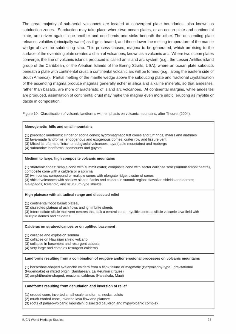
Before undertaking evaluation of the volcanic sites on the World Heritage List and Tentative Lists, a reasoned framework must be established that will enable sites to be grouped and compared. There are a number of different ways that volcanoes and volcanic landforms have been classifi ed, and it will be impossible here to identify or devise a single scheme that will provide adequate grouping of the World Heritage volcanoes, so an evaluation framework will be devised from one or more of the established classifi cation systems. For example, volcanoes may be classifi ed on the basis of their monogenetic or polygenetic origin, the scale of their explosive activity, the chemistry of their magma, their plate tectonic (or geotectonic) setting, or their landform. Below is a brief description of the principal classifi cation systems.
Genetic classifi cation
The varying chemistry and volatile content of magma is the driving force in the diversity of volcanic activity and form. Francis (1993) identifi ed the chain of cause and effect as follows:
‘1. the chemical composition dictates the melting temperature2. temperature, volatile content and degree of polymerization dictate viscosity3. viscosity and volatile content dictate ease of vesiculation and degassing4. ease of degassing dictates the explosive potential of an eruption5. explosiveness of an eruption dictates whether lavas or pyroclasts are produced’
Thus, at one end of the range volcanoes that effuse basaltic, usually fl uid, magma from which the volatiles escape relatively easily have low explosive activity and therefore produce abundant lavas and only limited amounts of pyroclastic material. These volcanic eruptions may emanate from fi ssures or central vents, and form extensive lava plains or low-angled ‘shield’ volcanoes. In contrast, at the other end of the range are
Figure 5: Classifi cation of volcanic landforms after Bloom (1998), modifi ed from Rittman (1962).

IUCN World Heritage Studies 20
Figure 6: Volcanic Explosivity Index (Source: www.volcano.si.edu)
volcanoes that erupt more silicic and therefore viscous magma (such as andesites and rhyolites), meaning that their volatiles may only escape explosively. In so doing the magma and older rocks around the vent are fragmented into abundant pyroclastic material, and the effusion of lavas is more limited. Such activity builds cones with steeper slopes. There are of course gradations between these extremes, while it should be also noted that the larger central volcanoes tend to be polygenetic (involving a number of different phases and modes of construction), frequently having evolved over hundreds of thousands of years. It is also notable that the presence of water interacting with rising magma may cause an eruption to be violently explosive (phreato- or hydro-magmatic). A well known scheme showing these variations and resulting volcanic forms was constructed by Rittman (1962), and modifi ed by Bloom (1998) (Figure 5).
Styles of eruption
As explained above, volcanic eruptions may be differentiated by the power or explosiveness of their activity. This was quantifi ed by Newhall and Self (1982) and their Volcanic Explosivity Index (VEI) is shown with modifi cations in Figure 6, as it appears in the GVP website (www.volcano.si.edu).
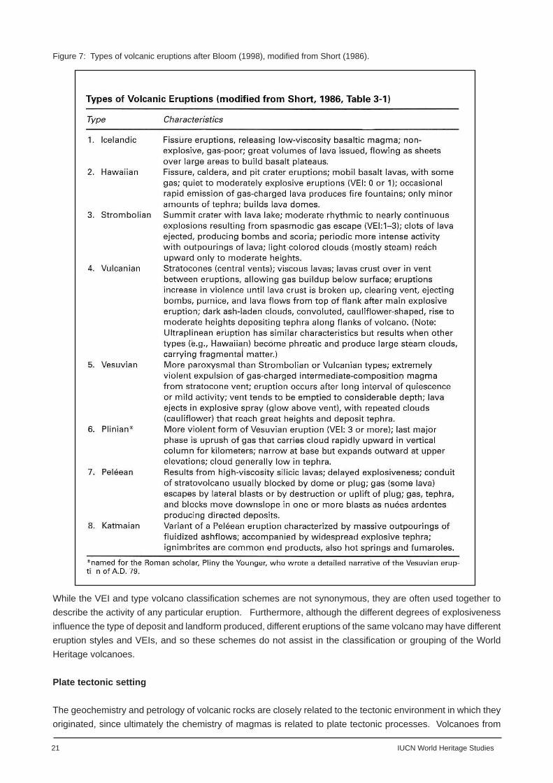
Related to the VEI is an older scheme of grouping volcanoes according to their style of activity fi rst introduced by Lacroix in 1908, but developed subsequently by other volcanologists. This is an observational scheme that identifi es the different eruption styles of historic ‘type’ volcanoes. This scheme has been summarised in Figure 7, also abstracted from Bloom (1998).
A further type in addition to those noted in Figure 7 is the group of explosive phreatomagmatic, or hydromagmatic, eruptions (i.e., those that occur when external water is in contact with magma). At the less intense end of this range is the “wet” variety of Strombolian activity, known as Surtseyan (named after the eruption that formed a new island in 1963-67 off the south coast of Iceland), and more recently it has been recognised that Vulcanian and Plinian eruption styles may also have phreatomagmatic varieties (for example, phreatoplinian).
21 IUCN World Heritage Studies
Figure 7: Types of volcanic eruptions after Bloom (1998), modifi ed from Short (1986).
While the VEI and type volcano classifi cation schemes are not synonymous, they are often used together to describe the activity of any particular eruption. Furthermore, although the different degrees of explosiveness infl uence the type of deposit and landform produced, different eruptions of the same volcano may have different eruption styles and VEIs, and so these schemes do not assist in the classifi cation or grouping of the World Heritage volcanoes.
Plate tectonic setting
The geochemistry and petrology of volcanic rocks are closely related to the tectonic environment in which they originated, since ultimately the chemistry of magmas is related to plate tectonic processes. Volcanoes from

IUCN World Heritage Studies 22
different plate tectonic environments are therefore distinct in terms of the composition of their source magmas, their eruptive behaviour, the characteristics of their volcanic deposits and the morphology of their volcanic landforms.
Figure 1 shows the boundaries of the world’s tectonic plates and the distribution of the world’s major active volcanoes (not necessarily World Heritage volcanoes). It is clear from the map that the highest densities of volcanoes coincide with plate boundaries. Such boundaries are defi ned by geologists as either constructive, where two plates separate (such as along the Mid-Atlantic Ridge or Juan de Fuca Ridge), or destructive, where plates converge in regions known as subduction zones (such as those within the Pacifi c ‘Ring of Fire’, or the islands of the Caribbean). There are also volcanoes that occur within plates (i.e., beyond plate boundaries). These are associated with ‘hotspots’ over plumes of rising magma in the Earth’s mantle, and are called intraplate volcanoes. Volcanoes also occur in areas of plate collision and in rare instances are associated with transform boundaries (where plates slip past one another in a horizontal movement along faults). As explained in Text Box 3, the relationship between plate tectonics and volcanism is fundamental: the mechanisms of plate tectonics infl uence the formation of magma in the mantle, either through decompression of hot, solid mantle material at constructive margins and mantle plumes, or the lowering of melting temperature of mantle material by the addition of volatiles (mainly water), as at destructive plate margins. These different processes give rise to variations in the composition of magmatic melts.
Thus, in simplifi ed terms, magma erupted at mid-ocean ridges (constructive margins) are typically basic in composition, producing fi ssure volcanoes, extensive lava fi elds and lava shields. Most of these volcanoes are underwater, so they are not visible, but where the ocean ridges coincide with rising mantle plumes, large volcanic islands, such as Iceland, may be formed. It should also be noted that even in this setting, the magma beneath a longer-lived volcano may fractionate to become silica enriched, resulting in more explosive activity and the building of a composite cone. A similar form of volcanism exists where intraplate (as opposed to ridge) volcanoes are built on the ocean fl oor over hot, rising mantle plumes. Intraplate mantle hotspots may also penetrate the crust of a continent, but here the crustal rocks are partially melted and assimilated by the rising mantle plume. This produces a wider range of magmas, with higher silica and alkali content, in turn infl uencing the eruption styles and products. In the past, mantle plumes have caused eruptions on both continental and oceanic crust at a much greater scale than anything experienced in the historic period, resulting in enormous outpourings of basaltic magma. These gigantic eruptions are known as Flood Basalts and are to be found
Figure 8: Diagram showing the plate tectonic settings of volcanoes, after Perfi t and Davidson (2000, modifi ed from Pearce 1996

23 IUCN World Heritage Studies
today in areas of the world known as Large Igneous Provinces (LIP). For example, in India the Deccan Traps are the remains of a late Cretaceous (60-65Ma) fl ood basalt event, and comprise piles of lavas nearly 2km thick, the remains of which still cover an area of 500,000 km² .
Volcanism is also associated with active rifting of continental crust, such as at the African Rift Valley. Such volcanism is produced because of extension (stretching) of the crust, and it may also be associated with mantle plume activity. One product may be outpourings of basalts, but on a lesser scale and with lava more chemically diverse than that of fl ood basalts. Assimilation of continental crust by the rising magma gives rift volcanoes some of the characteristics more generally associated with subduction volcanoes, such as having a wider range of rock types and explosive habits, including rare types of magmas such as carbonatites and highly alkaline melts.
Domes and cones of basaltic lava Basalt cones Central and fi ssure vents Flank outfl ows of lava Basaltic lava shield (small) Basaltic dome (shield) structure Icelandic spatter cones Scoria cones
Craters and calderas Craters Pit craters Caldera Glencoe Krakatau Multiple Erosion caldera
Lava plateaus and plains Ignimbrite plateaus Basalt plateaus Fissure eruptions Phonolite plains Basalt plains
Viscid lavas, Coulées and Tholoids Convex lava fl ows Cumulo domes Obsidian domes Plug domes Spines
Lava fi elds Lava tongues Ponded lavas Pahoehoe: tumulus, squeeze-ups, pressure ridges Block pahoehoe Block aa Block and ashfl ows Fire fountains Scoria mounds (cinder cones) Adventive cones
Tephra showers and nuées ardente Vulcanian ash phase Nuées ardente (First order) Plateau building (Ignimbrite sheet) Nuées ardente (Second order)
Exposed intrusive features Laccoliths Dikes, Sills
Tephra-built stratifi ed (with lava) cones Ash cones Young cones Composite (stratifi ed) cones Multiple cones Parasol ribbing Lahars (mudfl ows)
Maars and tuff rings Maars Ubehebes Basaltic tuff rings Diatremes
Erosion features Ravine cuts (Barrancos) Planeze stage of dissection Necks and plugs Erosion calderas Eroded dome Lava ridges (inverted topography) Lava palisades
Rifts Rift valley Rift lines
Figure 9: Surface volcanic forms and features, after Short (1986)
IUCN World Heritage Studies 24
The great majority of sub-aerial volcanoes are located at convergent plate boundaries, also known as subduction zones. Subduction may take place where two ocean plates, or an ocean plate and continental plate, are driven against one another and one bends and sinks beneath the other. The descending plate releases volatiles (principally water) as it gets heated, and these lower the melting temperature of the mantle wedge above the subducting slab. This process causes, magma to be generated, which on rising to the surface of the overriding plate creates a chain of volcanoes, known as a volcanic arc. Where two ocean plates converge, the line of volcanic islands produced is called an island arc system (e.g., the Lesser Antilles island group of the Caribbean, or the Aleutian Islands of the Bering Straits, USA); where an ocean plate subducts beneath a plate with continental crust, a continental volcanic arc will be formed (e.g., along the eastern side of South America). Partial melting of the mantle wedge above the subducting plate and fractional crystallisation of the ascending magma produce magmas generally richer in silica and alkaline minerals, so that andesites, rather than basalts, are more characteristic of island arc volcanoes. At continental margins, while andesites are produced, assimilation of continental crust may make the magma even more silicic, erupting as rhyolite or dacite in composition.
Monogenetic hills and small mountains
(1) pyroclatic landforms: cinder or scoria cones; hydromagmatic tuff cones and tuff rings, maars and diatrmes(2) lava-made landforms: endogenous and exogenous domes, crater row and fi ssure vent(3) Mixed landforms of intra- or subglacial volcanoes: tuya (table mountains) and mobergs(4) submarine landforms: seamounts and guyots
Medium to large, high composite volcanic mountains
(1) stratovolcanoes: simple cone with summit crater; composite cone with sector collapse scar (summit amphitheatre), composite cone with a caldera or a somma(2) twin cones; compopund or multiple cones with elongate ridge; cluster of cones(3) shield volcanoes with shallow-sloped fl anks and caldera in summit region: Hawaiian shields and domes; Galapagos, Icelandic, and scutulum-type shields
High plateaux with altitudinal range and dissected relief
(1) continental fl ood basalt plateau(2) dissected plateau of ash fl ows and ignimbrite sheets(3) Intermediate-silicic multivent centres that lack a central cone; rhyolitic centres; silicic volcanic lava fi eld with multiple domes and calderas
Calderas on stratovolcanoes or on uplifted basement
(1) collapse and explosion somma(2) collapse on Hawaiian shield volcano(3) collapse in basement and resurgent caldera(4) very large and complex resurgent calderas
Landforms resulting from a combination of eruptive and/or ersoional processes on volcanic mountains
(1) horseshoe-shaped avalanche caldera from a fl ank failure or magmatic (Bezymianny-type), gravitational (Fugendake) or mixed origin (Bandai-san, La Reunion cirques)(2) amphitheatre-shaped, erosional calderas (Haleakala, Maui)
Landforms resulting from denudation and inversion of relief
(1) eroded cone; inverted small-scale landforms: necks, culots(2) much eroded cone, inverted lava fl ow and planeze(3) roots of palaeo-volcanic mountain: dissected cauldron and hypovolcanic complex
Figure 10: Classifi cation of volcanic landforms with emphasis on volcanic mountains, after Thouret (2004).
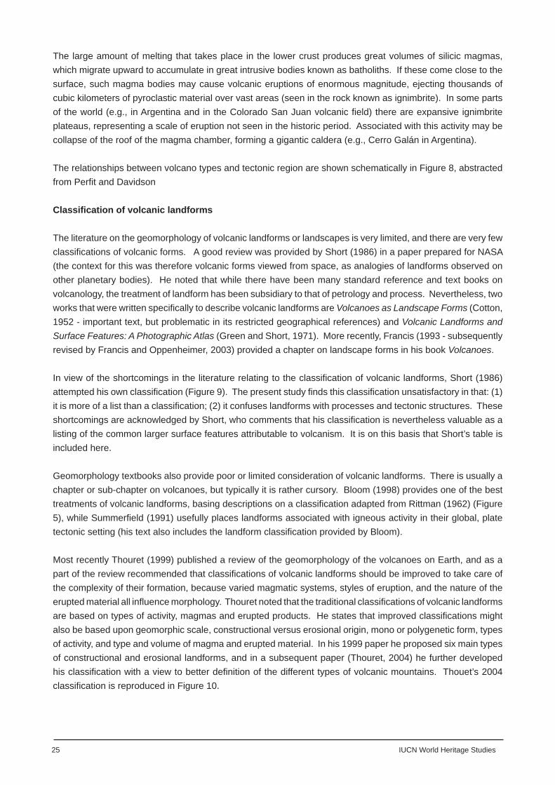
25 IUCN World Heritage Studies
The large amount of melting that takes place in the lower crust produces great volumes of silicic magmas, which migrate upward to accumulate in great intrusive bodies known as batholiths. If these come close to the surface, such magma bodies may cause volcanic eruptions of enormous magnitude, ejecting thousands of cubic kilometers of pyroclastic material over vast areas (seen in the rock known as ignimbrite). In some parts of the world (e.g., in Argentina and in the Colorado San Juan volcanic fi eld) there are expansive ignimbrite plateaus, representing a scale of eruption not seen in the historic period. Associated with this activity may be collapse of the roof of the magma chamber, forming a gigantic caldera (e.g., Cerro Galán in Argentina).
The relationships between volcano types and tectonic region are shown schematically in Figure 8, abstracted from Perfi t and Davidson
Classifi cation of volcanic landforms
The literature on the geomorphology of volcanic landforms or landscapes is very limited, and there are very few classifi cations of volcanic forms. A good review was provided by Short (1986) in a paper prepared for NASA (the context for this was therefore volcanic forms viewed from space, as analogies of landforms observed on other planetary bodies). He noted that while there have been many standard reference and text books on volcanology, the treatment of landform has been subsidiary to that of petrology and process. Nevertheless, two works that were written specifi cally to describe volcanic landforms are Volcanoes as Landscape Forms (Cotton, 1952 - important text, but problematic in its restricted geographical references) and Volcanic Landforms and Surface Features: A Photographic Atlas (Green and Short, 1971). More recently, Francis (1993 - subsequently revised by Francis and Oppenheimer, 2003) provided a chapter on landscape forms in his book Volcanoes.
In view of the shortcomings in the literature relating to the classifi cation of volcanic landforms, Short (1986) attempted his own classifi cation (Figure 9). The present study fi nds this classifi cation unsatisfactory in that: (1) it is more of a list than a classifi cation; (2) it confuses landforms with processes and tectonic structures. These shortcomings are acknowledged by Short, who comments that his classifi cation is nevertheless valuable as a listing of the common larger surface features attributable to volcanism. It is on this basis that Short’s table is included here.
Geomorphology textbooks also provide poor or limited consideration of volcanic landforms. There is usually a chapter or sub-chapter on volcanoes, but typically it is rather cursory. Bloom (1998) provides one of the best treatments of volcanic landforms, basing descriptions on a classifi cation adapted from Rittman (1962) (Figure 5), while Summerfi eld (1991) usefully places landforms associated with igneous activity in their global, plate tectonic setting (his text also includes the landform classifi cation provided by Bloom).
Most recently Thouret (1999) published a review of the geomorphology of the volcanoes on Earth, and as a part of the review recommended that classifi cations of volcanic landforms should be improved to take care of the complexity of their formation, because varied magmatic systems, styles of eruption, and the nature of the erupted material all infl uence morphology. Thouret noted that the traditional classifi cations of volcanic landforms are based on types of activity, magmas and erupted products. He states that improved classifi cations might also be based upon geomorphic scale, constructional versus erosional origin, mono or polygenetic form, types of activity, and type and volume of magma and erupted material. In his 1999 paper he proposed six main types of constructional and erosional landforms, and in a subsequent paper (Thouret, 2004) he further developed his classifi cation with a view to better defi nition of the different types of volcanic mountains. Thouet’s 2004 classifi cation is reproduced in Figure 10.
IUCN World Heritage Studies 26
Conclusion: A framework for gap analysis
The brief for this report calls for a general framework within which to place the World Heritage volcanoes and as a basis for undertaking gap analysis. It also demands that any such framework must not be an over-complicated taxonomy of volcano types and forms. This study fi nds both Short’s and Thouret’s classifi cations too detailed for the purpose of this review and instead groups World Heritage volcanoes on the basis of their plate tectonic, or geotectonic, setting, while providing a simplifi ed combination of Short’s and Thouret’s classifi cation as a checklist for assessing the variety of landforms in the World Heritage volcanic estate.

27 IUCN World Heritage Studies
Identifying the gaps
Gaps in the range of volcanic World Heritage properties
With 57 inscribed volcanic properties, containing a minimum of 101 Holocene volcanoes, it can be claimed that there already is adequate representation of the world’s volcanoes on the World Heritage List. However, Tables 4 (Plate tectonic setting of World Heritage Volcanoes), and 5 (Volcanic World Heritage properties by Geographical Region), do reveal some gaps in the plate tectonic and geopolitical settings of these volcanoes. Furthermore, while it has not been possible because of shortfalls in the basic data to establish the complete range of landforms in each of the 57 properties; it is known that some important landforms types are not represented. This section will examine if it is necessary to fi ll all the gaps and if so how this might be done from sites proposed in the Tentative Lists, or ultimately by suggesting suitable new sites that might be added to the tentative lists of relevant State Parties.
Figure 7 provides the basis for classifying volcanic sites on grounds of their plate tectonic setting and Table 4 indicates the number of sites in each setting. The table shows that the 57 volcanic properties on the World Heritage List are relatively well distributed through the various plate tectonic settings, with 14 sites representative of divergent plate boundaries, 17 of convergent boundaries, 6 of collision zones, and 14 of intraplate volcanism (6 sites are pre-Tertiary - too old to sit in this scheme). Volcanoes of continental and island arc systems, plate collision zones and mid-ocean ridges are well represented, while least represented are fl ood basalts and back-arc basin volcanoes. Nomination of examples from these latter groups might be encouraged from sites already listed on Tentative Lists, whilst new entries to the Tentative Lists might include examples of continental intraplate and fl ood basalt volcanoes (e.g., Columbia River Basalts, USA; Deccan Traps, India).
Scaling-up the view to regional plate tectonic environments and volcano groups, the Volcanoes of Kamchatka World Heritage property is a good representative of an ocean subduction environment, although the addition of the Ogasawara Islands from Japan’s Tentative List as a trans-national serial extension would enhance the range of volcanic forms represented within this tectonic group. In contrast, Holocene continental arc volcanism is not well represented on the World Heritage List by any single large group (although some smaller sites do lie in this environment), and Las Parinas on Argentina’s Tentative List is one possibility that could enhance this category. Larger representation of continental and oceanic rifting (divergent margins) may eventually be realised through the current proposals for serial trans-national nominations covering the Mid-Atlantic Ridge and the Great Rift Valley of Africa.
When the geopolitical distribution of volcanic World Heritage properties (Table 5) is examined, it is clear that because of the haphazard process of site selection and nomination of World Heritage properties by State Parties, the distribution of volcanic properties on the World Heritage List does not necessarily conform to priority global conservation sites that might be determined purely on scientifi c grounds. The Table also illustrates the fact that volcanoes are not distributed evenly across the Earth’s surface. Thus, Table 5 shows poor representation of sites in Africa beyond East and Central Africa, South-Central and Northern Asia, Australia, and Eastern Europe, principally because these are relatively stable areas of the Earth’s crust. While there are some Holocene volcanoes on the mainland of Europe (Germany, France, Spain) the high number of volcanic World Heritage properties in this region relate only to those in the Mediterranean and overseas (mainly ocean) territories. Most surprising is the lack of any sites in Melanesia and Polynesia (although these will have some sites which are overseas territories of European countries), and the relatively few sites in North America, which has many excellent, well studied and accessible examples. On regional grounds, there does appear to be some need to consider representation from Oceania and North America.
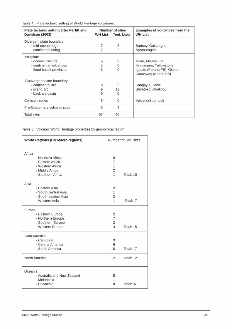
IUCN World Heritage Studies 28
Plate tectonic setting after Perfi tt and Davidson (2003)
Number of sitesWH List Tent. Lists
Examples of volcanoes from theWH List
Divergent plate boundary - mid-ocean ridge - continental rifting
7 8 7 2
Surtsey, GalapagosNyamuragira
Intraplate - oceanic islands - continental volcanoes - fl ood basalt provinces
6 9 5 0 3 0
Teide, Mauna LoaKilimanjaro, YellowstoneIguazu (Parana FB), Giants Causeway (Antrim FB)
Convergent plate boundary - continental arc - island arc - back arc basin
8 5 9 12 0 0
Sangay, El MistiShiretoko, Qualibou
Collision zones 6 0 Vulcano/Stromboli
Pre-Quaternary volcanic sites 6 4
Total sites 57 40
Table 4: Plate tectonic setting of World Heritage volcanoes
World Regions (UN Macro regions) Number of WH sites
Africa - Northern Africa - Eastern Africa - Western Africa - Middle Africa - Southern Africa
0 7 1 2 1 Total: 10
Asia - Eastern Asia - South-central Asia - South-eastern Asia - Western Asia
2 1 3 1 Total: 7
Europe - Eastern Europe - Northern Europe - Southern Europe - Western Europe
2 7 3 3 Total: 15
Latin America - Caribbean - Central America - South America
3 6 8 Total: 17
North America 2 Total: 2
Oceania - Australia and New Zealand - Melanesia - Polynesia
5 1 0 Total: 6
Table 5: Volcanic World Heritage properties by geopolitical region

29 IUCN World Heritage Studies
The most diffi cult gaps to identify are in the range of landforms contained within the 57 volcanic World Heritage properties. On the one hand, with a minimum of 101 Holocene volcanoes covered by these sites across the range of plate tectonic settings, it is likely that most of the features identifi ed in Bloom’s and Thouret’s classifi cations will be covered. On the other hand, while it is possible to classify the larger volcanic structures at any volcanic site, identifi cation of the full suite of subsidiary landforms on these structures is not possible because of negligible or at best limited local information.
Table 6 lists the main types of volcanic landforms and examples of inscribed properties in which these features may be found. The table is a much simplifi ed adaptation of Short’s and Thouret’s classifi cations and the examples are based on the author’s and reviewers’ knowledge of particular World Heritage properties (which is far from comprehensive). It is clear from the table that the two main forms of large volcanoes - shield volcanoes and stratovolcanoes - are well represented on the World Heritage List, although Icelandic type shield volcanoes are missing. With so many island arc and continental arc stratovolcanoes (Kamchatka, Philippines, Indonesia, South and Central America), it can confi dently be claimed that simple and composite structures, with craters and calderas of different types are adequately represented. Interestingly there are no fi ssure volcanoes, although the proposed Mývatn-Laxa site on Iceland’s Tentative List contains the active volcano Krafl a (Plate 1). Furthermore, while the newly-inscribed World Heritage property of Surtsey represents a style of shallow water phreatomagmatic eruption that constructed a tuya-like edifi ce (table mountain), fi ssure and central volcanoes erupted beneath water or ice forming hyaloclastite ridges and tuyas respectively are poorly represented. These could be covered in a proposed extension to Iceland’s Þingvellir World Heritage Site, which incidentally might also include the classical Iceland shield Skjaldbreiður, and the Herðubreiðarlindir and Askja site from Iceland’s Tentative List, as a potential serial property with Surtsey.
There are many examples of smaller scale monogenetic vents (scoria and tuff cones, tuff rings, maars - e.g., Aïr and Ténéré Natural Reserves, Niger; Jeju Volcanic Island, Korea), and all of the different types of lava fl ows (pahoehoe, aa and block, couleés, etc) are present. The current volcanic World Heritage properties also contain the full range of subsidiary lava landforms, including lava tube cave systems (Hawaii Volcanoes NP, USA, and Jeju Volcanic Island, Korea). There are fi ne examples of lava domes, including emergent domes on active stratovolcanoes (e.g., Sheveluch Volcano, Kamchatka) and eroded remnants of historic features (e.g., the Pitons Management Area, St Lucia). While two fl ood basalt provinces are represented (Paraná at Iguaçu, Brazil/Argentina and North Atlantic at Þingvellir, Iceland) there may be scope to consider a more classical example of this phenomenon, such as the Columbia River Flood Basalts, USA, or the Deccan Traps, India (neither of these are on the USA or Indian respective Tentative Lists). Not so well represented are large scale ash fl ows and ignimbrite sheets, although the site, Las Parinas, on Argentina’s Tentative Site might eventually provide some good examples.
There are a range of different types of calderas on the World Heritage List. This could be enhanced by the inclusion of the Taal Volcano Protected Landscape from the Philippines Tentative List, which is a complex, historically active, Holocene resurgent caldera, designated a Decade Volcano by the International Association of Volcanology and Chemistry of the Earth (IAVCEI) because of its large, destructive eruptions.
Poorly represented are intrusive landforms, and in fact none appear to have been ever specifi cally put forward for nomination (for example, the Aïr and Ténéré Natural Reserves, Niger, which contain the largest ring dike structure in the world, were not inscribed under the geological category (viii)). There is scope also to consider proposals that refl ect some of the world’s outstanding intrusive landscapes (options to consider might include the Shiprock volcanic neck (a diatreme) and dike complex, New Mexico, USA; the Great Dyke of Zimbabwe, or the classical Scottish Tertiary Igneous Province, U.K., etc).

IUCN World Heritage Studies 30
Type of volcanic landform Represented (Yes or No)
Example from the World Heritage List
Monogenetic landforms and fi elds - cinder or scoria cones - tuff cones and tuff rings - maars and diatremes - monogenetic volcanic fi eld - tuya - moberg ridge - lava domes - lava fl ows and lava fi elds
- lava tube cave systems - continental fl ood basalts - ash fl ows and ignimbrite sheets, plains and plateaus
YYNYNNY
YYY
Galapagos Islands, Hawaii Volcanoes NPJeju volcanic IslandJeju volcanic Island
Surtsey Volcanic Island (but not classical sub-glacial table mountain)
Pitons of St Lucia, Kamchatka Þingvellir NP, Hawaii Volcanoes NP, Giant’s Causeway and the Causeway CoastRapa Nui, Jeju Volcanic Island, Hawaii Volc. NPGiant’s Causeway, Iguazu/Iguacu NPsSome in Yellowstone NP
Polygenetic volcanoes and calderasstratovolcanoes: - simple with summit crater - composite with sector collape scar and/or caldera - compound or multiple volcanoes - rhyolitic centres - silicic volcanic lava fi eld with multiple domes and calderascaldera: - explosion (somma) - collapse-explosion (Krakatao) - collapse-shield - resurgent caldera (Valles) - large and complex (Toba)
YY
YNN
YYYYN
Sangay NP, KamchatkaTeide National Park, Kamchatka
Volcanoes of Kamchatka
Volcanoes of KamchatkaKrakatauHawaii Volcanoes NP, Galapagos IslandsYellowstone NP
Shield volcanoesshields and domes- types - Hawaiian - Galapagos - Icelandic
YYN
Hawaii Volcanoes NPGalapagos Islands
Volcanic landforms resulting from eruptive and/or erosional processes - avalanche caldera from a fl ank failure of magmatic, gravitational, or mixed origin - erosion caldera and amphitheatre valley
Y
N
Teide NP
Volcanic landforms resulting from denudation and inversion of relief - eroded cone, eroded pyroclastic- fl ow deposit and sheet - inverted small scale forms: necks, culots, dykes and sills - eroded lava fl ow, inverted relief and planeze - roots of palaeo-volcano, cauldron, and hypovolcanic complex
N
Y
N
Y
Old & New Towns Edinburgh, Frontier Roman Empire
Aïr and Ténéré Natural Reserves
Table 6: Landform types in volcanic World Heritage properties
31 IUCN World Heritage Studies
Missing iconic volcanoes
Interestingly, the World Heritage List does not contain many of the volcanoes that might be commonly recognised by the general public. The best known inscribed sites are probably Kilauea and Mauna Loa, on Hawaii Island, USA; Krakatau, Indonesia; and Mounts Kenya and Kilamanjaro, Kenya. Although not inscribed specifi cally, Vesuvius is represented by the Pompeii, Herculaneum and Torre Annunziata archaeological World Heritage property, which lies on the slope of the volcano. Not on the List are such iconic or world-renowned volcanoes as, for example: Mt Etna, Italy; Thera (Santorini), Greece; Mt Fuji, Japan; Paracutin, Mexico; Mt Mayon, Philippines; Mt St Helens and Crater Lake, USA; Laki, Iceland; Mt Pelée, Martinique, and Tambora, Indonesia. Mount Fuji is particularly signifi cant because the volcano and its surroundings receive more public visits in a year than any other on the planet.
Just because these volcanoes are well-known and used as examples in classroom teaching it does not mean that they are necessarily scientifi cally important. However, those that have come to the notice of the general public, and have been instructive to science because of their recent historic eruptions, have been Mt Pelée, Martinique; Mt St Helens, USA; and Paracutin, Mexico. Mt Fuji is the only volcano mentioned above that is on a Tentative List (of Japan).
IUCN World Heritage Studies 32
Name of volcanic feature Comment and suggested action
Volcanic features
Fissure volcanoes
Hyaloclastic mountains (tuyas) and ridges
Icelandic type shield volcano
Continental Flood Basalts
Resurgent calderas
Large ash fl ows and ignimbrite sheets/plateaus
Intrusive landforms
Not represented - potential properties: 1) extension of Þingvellir NP WHS, Iceland, 2) future inscription of Mývatn-Laxa area, Iceland, tentative site (this will include the volcano Krafl a - cover picture).
Not well represented, just Surtsey Volcanic Island - potential properties: 1) consider a future nomination tuya from type-area in Canada; 2) extension of Þingvellir NP WHS, Iceland
Not represented - potential properties: 1) extension of Þingvellir NP WHS, Iceland, to include Skjaldbreiður, 2) future inscription of extended Herðubreiðarlindir-Askja site on Iceland’s tentative list (boundary to include appropriate shield(s)).
Not well represented - potential properties: consider new nomination of Columbia Flood Basalt Province, USA and/or Deccan Traps, India
Yellowstone NP, USA, is one example - other potential site: 1) Taal is a good example on the Philippines tentative list; 2) other posiblilities not on existing tentative lists are the Valles Caldera, New Mexico, USA; Toba Caldera, Indonesia; and Cerro Galán Caldera, Argentina.
Related to the above. Not well represented, but requires more detailed investigation of existing sites - potential properties: Las Parinas tentative site, Argentina; consider alternative new nominations from, say, USA or S America.
Not well represented - potential properties: will require new nominations, e.g., Shiprock, New Mexico, USA; Scottish Tertiary Igneous Province, UK.
Whole landscapes
Basaltic plains
Silicic volcanic fi eld
Mid-ocean ridges(may also incorporate someaspects of ocean fl oor)
Continental rifts
Not well represented - potential properties: new nomination, for example, Snake River Plain, Idaho, USA, or extension of Herðubreiðarlindir-Askja tentative site, Iceland, to include the expansive lava plain known as the Odaðahraun.
As for resurgent calderas and ignimbrite plateaus, above
Existing proposal for a Mid-Atlantic Ridge transnational serial nomination
There is an existing proposal for an African Great Rift trans-national serial nomination
Iconic sitesNot well represented - to be considered on indivudual merits on basis of notoriety, scientifi c importance, and cultural and educational value - some possible properties: 1) Mt Fuji is on tentative list of Japan; 2) others such as Mt St Helens and Crater Lake, USA; Mt Pelee, Martinique; Laki, Iceland; Mt Mayon, Philippines; Thera, Greece; Mt Etna, Italy.
Filling the gaps
This analysis has shown that there is already good representation of the world’s volcanoes and volcanic landforms on the World Heritage List, but that there are some gaps that might be fi lled in the future to make the list of World Heritage Volcanoes more complete, balanced and comprehensive. These volcanic sites are shown in Table 7, with the reasons for their choice, and whether or not they are already listed in the Tentative Lists. In compiling this list of sites consideration was given to plate tectonic setting, world geopolitical regions and landforms.
Table 7: Possible future candidate volcanic features or areas for inclusion on the World Heritage List

33 IUCN World Heritage Studies
Requirements for integrity and management that should apply to sites with volcanic geology
This discussion will focus on the concept of integrity as it applies to the geological values of a volcanic World Heritage property, even if the property was not inscribed under the geological criterion (Criterion (viii)).
In the context of this study, integrity is an important idea that provides an intellectual framework for considering the scientifi c values and management of properties containing whole or major parts of volcanic systems, or specifi c volcanic landscapes or landforms. However, the concept is much less relevant in those sites that contain only limited volcanic deposits, are isolated from source vents, or have volcanic deposits from the deep geological past. These latter sites will be predominantly managed to protect the biological and cultural values for which they were inscribed, and therefore lie outside of the subject of this discussion.
Meeting the condition of Integrity
In order for it to be inscribed, the World Heritage Committee must be satisfi ed that a nominated property is of Outstanding Universal Value (OUV), meets the Condition of Integrity as set out in the Committee’s Operational Guidelines for the Implementation of the World Heritage Convention (UNESCO, 2008), and is effectively protected and managed.
Integrity is a most important concept developed in the Operational Guidelines (2008, Section IIe, paras 87 - 95), where it is defi ned as:
‘Integrity is a measure of the wholeness and intactness of the natural and/or cultural heritage and its attributes.
Examining the conditions of integrity, therefore requires assessing the extent to which the property:
a) includes all elements necessary to express its outstanding universal value;b) is of adequate size to ensure the complete representation of the features and processes which convey the property’s signifi cance;c) suffers from adverse effects of development and/or neglect.’
Further defi nition of integrity has been provided in the Operational Guidelines for each of the four criteria relating to natural sites. For example, properties nominated under Criterion (vii) (natural beauty) are required to ‘include areas that are essential for maintaining the natural beauty of the property’, which include all of the factors which may infl uence change to the visual or aesthetic quality of a site. Similarly properties proposed under Criterion (viii) (geology) should ‘contain all or most of the key interrelated and interdependent elements in their natural relationships.’ Ensuring that a site has integrity is therefore of fundamental importance, and relates to the completeness of the scientifi c case for inscription, as well as for its management. The need to ensure integrity also explains why the area of a World Heritage property should be of a scale adequate to contain and protect the essential parts of the system for which it was inscribed, and why accurate determination of the boundary of the site is so important.
For a volcanic World Heritage property to have scientifi c integrity means that the scientifi c justifi cation and protection of all of the essential features that distinguish that particular volcanic system are complete. Thus,
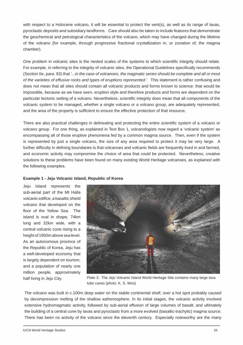
IUCN World Heritage Studies 34
with respect to a Holocene volcano, it will be essential to protect the vent(s), as well as its range of lavas, pyroclastic deposits and subsidiary landforms. Care should also be taken to include features that demonstrate the geochemical and petrological characteristics of the volcano, which may have changed during the lifetime of the volcano (for example, through progressive fractional crystallization in, or zonation of, the magma chamber).
One problem in volcanic sites is the nested scales of the systems to which scientifi c integrity should relate. For example, in referring to the integrity of volcanic sites, the Operational Guidelines specifi cally recommends (Section IIe, para. 93) that ‘...in the case of volcanoes, the magmatic series should be complete and all or most of the varieties of effusive rocks and types of eruptions represented.’ This statement is rather confusing and does not mean that all sites should contain all volcanic products and forms known to science: that would be impossible, because as we have seen, eruption style and therefore products and forms are dependent on the particular tectonic setting of a volcano. Nevertheless, scientifi c integrity does mean that all components of the volcanic system to be managed, whether a single volcano or a volcano group, are adequately represented, and the area of the property is suffi cient to ensure the effective protection of that resource.
There are also practical challenges in delineating and protecting the entire scientifi c system of a volcano or volcano group. For one thing, as explained in Text Box 1, volcanologists now regard a ‘volcanic system’ as encompassing all of those eruptive phenomena fed by a common magma source. Then, even if the system is represented by just a single volcano, the size of any area required to protect it may be very large. A further diffi culty in defi ning boundaries is that volcanoes and volcanic fi elds are frequently lived in and farmed, and economic activity may compromise the choice of area that could be protected. Nevertheless, creative solutions to these problems have been found on many existing World Heritage volcanoes, as explained with the following examples.
Example 1 - Jeju Volcanic Island, Republic of Korea
Plate 3: The Jeju Volcanic Island World Heritage Site contains many large lava tube caves (photo: K. S. Woo)
Jeju Island represents the sub-aerial part of the Mt Halla volcanic edifi ce, a basaltic shield volcano that developed on the fl oor of the Yellow Sea. The island is oval in shape, 74km long and 32km wide, with a central volcanic cone rising to a height of 1950m above sea level. As an autonomous province of the Republic of Korea, Jeju has a well-developed economy that is largely dependent on tourism, and a population of nearly one million people, approximately half living in Jeju City.
The volcano was built in c.100m deep water on the stable continental shelf, over a hot spot probably caused by decompression melting of the shallow asthenosphere. In its initial stages, the volcanic activity involved extensive hydromagmatic activity, followed by sub-aerial effusion of large volumes of basalt, and ultimately the building of a central cone by lavas and pyroclasts from a more evolved (basaltic-trachytic) magma source. There has been no activity of the volcano since the eleventh century. Especially noteworthy are the many

35 IUCN World Heritage Studies
well-developed features illustrative of the volcanic history of the island. These include a variety of rocks demonstrating chemical evolution in the magma chamber beneath the island, and a large number of well-developed subsidiary landforms and other features. These latter include 360 cinder cones, tuff cones and tuff rings, excellent coastal cliff exposures of pyroclastic deposits and columnar jointing, trachytic domes, basaltic lava fl ows and many long lava tube caves. Unable to nominate the whole island because of diffi cult land ownership and management problems, Korean scientists came up with two solutions to demonstrate the outstanding universal value, complexity and variety of the Halla volcanic system: either protection by means of several discrete sites scattered over the island (a serial approach), or the protection of one or more radiating wedge-shaped (more correctly keyhole-shaped) slices, each originating at and encircling the summit area of Mt Halla and widening toward the coast to contain important scoria cones, lava fl ows and cave systems. Eventually it was decided to develop a serial approach with three key elements of the volcano included: a tuff cone demonstrating the hydromagmatic mechanism of formation of the early island; a subsidiary vent, with its associated scoria cone, lava fl ows and lava tube caves, to indicate the scale and method of emplacement of the main body of the lava shield; and the summit area of Mt Halla showing the volcanic products and forms developed from a more evolved magma towards the end of volcanic activity.
Example 2 - Teide National Park, Tenerife, Spain
Teide National Park is located at the summit of the Las Cañadas volcano, which forms the main part of the island of Tenerife, Canary Islands, Spain. Like the Jeju example, Tenerife is a holiday island, with large settlements, but because the Las Cañadas volcano rises to 3718m, settlement and economic development does not seriously encroach onto the higher slopes of the edifi ce. The boundary of the
Plate 4: Pico Teide viewed from the Roques de Garcia in the Las Cañadas caldera, Tenerife, Spain (photo: B. Bomhard)
park encloses an 18km long, oval-shaped caldera at about 2100m, and from the fl oor of this rise the imposing subsidiary stratocones of Teide and Pico Viejo. The Las Cañadas edifi ce is broken by three radiating rift zones in the shape of a Mercedes star centred on Teide, and while evolved magma of phonolitic composition has erupted in the caldera to build the stratocones, basaltic lava has erupted along the rift zones outside of the caldera to form signifi cant groups of scoria cones. This phenomenon is thought to demonstrate some stratifi cation of different magmas within the magma chamber. The last recorded eruption was from Teide in 1909.
The minor landforms within the caldera include an interesting range of silicic and basic lava fl ows, while pyroclastic deposits and structural features are exposed in the inward-facing cliffs of the caldera wall. Scarring the north slope of the Las Cañadas edifi ce is a large sector collapse (landslip), a feature that was possibly associated with the formation of the summit caldera.
It was found in this case that the integrity of the volcanic system could be demonstrated and protected within the boundary of the national park. Here there was evidence in the volcanic deposits and landforms of the varying chemistry of the magma, representatives of all the important landforms to be found on the larger

IUCN World Heritage Studies 36
edifi ce, the upper part of the sector collapse, and of course the caldera with its important pyroclastic and structural features that provide evidence of the caldera-forming processes.
Site management
Although this discussion is concerned primarily with the protection of volcanic geology and landscape, it is important to remember that volcanic sites have other natural values that are frequently dependent upon the special factors of volcanic terrain. Thus, the ecology of a volcano will be infl uenced by, or in some cases be dependent upon, the rock type, soil, geomorphology, and such features as micro-terrain, aspect, altitude, aridity and sometimes even volcanic disturbance. Indeed, as exemplifi ed by the Surtsey World Heritage inscription, active volcanoes are about the only places on Earth where new land is created - a clean slate, or tabula rasa - and their protection and monitoring over time enables insights into the processes of biological colonisation.
In general, because of their large size, long eruptive lifetimes (usually spanning many hundreds of thousands of years), and inherent dangers, the most active volcanic systems are relatively undisturbed and little infl uenced by human behaviour. Indeed, on many occasions the interaction between humans and volcanoes is the reverse of that infl uencing other natural systems, because volcanoes can and do pose substantial hazards to life and property, and indeed to the conservation of important geological, biological and cultural features. Nevertheless, human activity does pose threats to many volcanic World Heritage properties, and include illegal dumping, pollution of ground water, inappropriate highway development, erosion of wilderness quality, commercial tourism (including ski development), recreational overuse, off-road driving, mineral extraction (removal of scoria and ash cones for construction aggregate and road ballast, and quarrying of lava fl ows for building stone) and the choking, pollution, and trampling of hydrothermal systems and their tapping for geothermal energy. Older volcanic structures and rock exposures also suffer damage from many of the above.
Geological conservation is an area of nature conservation that has received little attention until very recently, and the discipline remains relatively lightly developed at the world scale. There persists a view among many fi eld managers that conservation of geological systems does not require management intervention. This is demonstrably not so when one considers the type of threats now seen to the World’s volcanic estate, including those listed above. It is therefore of great importance that volcanoes and volcanic areas that have been inscribed, or are seeking inscription, as World Heritage properties, have management plans that consider the protection of their geological values, and those other values dependent upon the geology as key priorities. It is also important that site management plans are linked to regional plans, such as Minerals Plans and Development Plans, to ensure they fi t within an effective regional and national planning and conservation framework.
A discussion was provided above on how sites might fulfi l the Condition of Integrity in defi ning and embracing the complete scientifi c system. The maintenance of integrity should also be a goal of site management, and its pursuit will ensure that all important conservation values are protected. Prior research and a spatially-based resource database are important in determining what should and should not be included in a World Heritage property and particularly will help determine where the boundary should lie. The use of a buffer zone is less important in protecting a property inscribed solely for its volcanic geology, than for say a karstic or ecologically-important site. This is because, unlike the last examples, the energy and matter feeding the volcanic system are input from central or peripheral vents within the property, as opposed to inward and outward fl ows across the site boundary. However, a buffer zone will be appropriate if it is important to protect the associated biological, hydrological and hydrothermal values of a site, to provide some degree of control of

37 IUCN World Heritage Studies
encroaching urban development, or economic activity (such as farming, mineral extraction or tourism), and in hazard management.
Education and interpretation
Management objectives can also be achieved through education and interpretation programmes. Volcanoes are some of the world’s most visited tourist destinations. For example, the Fuji-Hakone-Izu National Park, Japan, (i.e., the area around Mt Fuji) may annually receive as many as 100 million visits, while an estimated 300,000 people climb to the volcano’s summit each year (source: Japan Ministry of Environment, National Park Service). The most visited volcanic World Heritage property is Teide National Park, Tenerife, Spain, with 3.2 million visits a year. All volcanic World Heritage properties provide some access for tourists, and on Kilauea, Hawaii Island, USA, and Stromboli, Aeolian Islands, Italy, casual visitors are able to safely view active volcanism as it is taking
place. The educational value of the experience of viewing either a dormant or active volcano is immense, because like no-where else on Earth they demonstrate the power and importance of geology and the magmatic processes by which the planet was made.
Excellent interpretive facilities are now being developed in many volcanic World Heritage properties (and in many other of the World’s volcanic protected
Plate 5: Visitors experience views of active lava fl ows on Kilauea volcano, Hawaii (photo: USGS)
areas), notable examples being at Thingvellir National Park and the Vestmann Islands (for Surtsey Island), Iceland; Hawaii Volcanoes National Park and Yellowstone National Park, USA; Teide National Park, Tenerife, Spain; and Tongariro National Park, New Zealand. At the very innovative Stone Park on Jeju Island, Korea, superb graphical, 3D and interactive exhibits explaining the volcanic geology of the island are also linked with artistic interpretation of the basaltic rock and the island’s folklore. Such exhibits, and associated interpretive publications and guiding services, fulfi l an essential role in raising awareness, understanding and appreciation of the beauty and interest of volcanoes, and the importance of protecting this geological resource.
Monitoring
It is important that any protected site is monitored to assess whether or not the values for which it was established are threatened and undergoing change. Monitoring is a fundamental part of conservation management, but in volcanic World Heritage properties it is also important in assessing change in the behaviour of a volcano, as an indicator of a potentially hazardous event.
The methods available to monitor the behaviour of a volcano may be quite sophisticated and involve both remote sensing, and measurements on and around the volcano to detect movement of magma at depth. Instrumentation will measure underground seismic activity, geophysical and thermal profi les, ground deformation, the geochemistry of emitted gases, hydrological data, and the chemistry, heat and viscosity of lava. While volcano monitoring will not be undertaken at every Holocene World Heritage Volcano, most volcanic regions of the world have several volcano observatories that can at least provide some warning of impending eruptive

IUCN World Heritage Studies 38
TEXT BOX 4: Preparation of updated volcanic hazards map for El Misti volcano, PeruAbstract of paper by Mariño J, Rivera M, Thouret J-C, Salas G, Cacya L, Siebe C, Tilling R.(http://www.cosis.net/abstracts/)
Digital elevation model showing El Misti volcano towering 5822 meters high above the city of Arequipa, Peru. Arequipa is a World Heritage property. (Image by Mike Abrams, NASA/GSFC/MITI/ERSDAC/JAROS, and U.S./Japan ASTER Science Team).
The city centre of Arequipa – second largest city in Peru (about one million people) – is located 17 km away from Misti Volcano (5822 a.s.l.) and about 3.5 km vertically below it. During the last 50,000 years, vulcanian and sub-plinian eruptions at Misti have produced about ten sizeable pyroclastic fl ows and twenty tephra falls (Thouret et al., 2001). However, numerous ash falls, pyroclastic fl ows, and lahars from prehistoric sub-plinian eruptions, as recent as 2,000 years ago, have affected the region of Arequipa around the volcano. Misti’s only well-recorded historical activity consisted of small eruptions during the mid-15th century (Chávez, 1992). The Chili River and the main ravines (Pastores, San Lázaro, Huarangal, Huarangueros, Agua Salada) drain the W, S, and SE fl anks of the volcanic edifi ce and cut through Arequipa city. Channelled through them, numerous pyroclastic fl ows and lahars have reached 12 to 25 km distance from source. Should El Misti Volcano awake in the future the volcanic and hydrological hazards associated with renewed eruptive activity and rainstorms would pose a serious threat to the people, infrastructures, and economy of Arequipa and its environs. Even though a number of volcano hazards maps and assessments have been made in recent years, these have not been entirely satisfactory due to the required detail or appropriate scale for use by decision makers in the preparation of contingency plans and risk reduction measures. In recognition of El Misti’s enormous potential volcanic threat, the national geological agency of Peru – Instituto Geológico Minero y Metalúrgico del Perú (INGEMMET) – recently initiated a project to make a detailed geological map and updated volcanic hazard map of El Misti Volcano.
This new map was published in 2007 (Mariño et al., 2007).
activity (a full list of volcano observatories is published by the World Organisation of Volcano Observatories (WOVO, 2005)). In addition, many Holocene volcanoes now have undergone a Volcano Hazard Assessment (see Text Box 2), which is a descriptive summary of potential hazards, complete with a map showing areas that might be affected by future volcanic activity. The latter is useful to site managers, scientists, civil authorities and people living on or near the volcano to judge for themselves the relation between potentially dangerous areas and their daily lives. The Assessments are also critical for planning long-term land-use and effective emergency-response measures.
The city centre of Arequipa – second largest city in Peru (about one million people) – is located 17 km away from Misti Volcano (5822 a.s.l.) and about 3.5 km vertically below it. During the last 50,000 years, vulcanian

39 IUCN World Heritage Studies
and sub-plinian eruptions at Misti have produced about ten sizeable pyroclastic fl ows and twenty tephra falls (Thouret et al., 2001). However, numerous ash falls, pyroclastic fl ows, and lahars from prehistoric sub-plinian eruptions, as recent as 2,000 years ago, have affected the region of Arequipa around the volcano. Misti’s only well-recorded historical activity consisted of small eruptions during the mid-15th century (Chávez, 1992). The Chili River and the main ravines Assessment of environmental change in any volcanic World Heritage property is also important, and calls for monitoring of such environmental factors as air and water quality, hydrology, ecology, soils, and visitor impact. As a management tool, monitoring should comprise intermittent structured measurements set against indicators or targets in the management plan. Results should therefore feed back into the management strategy so that policies and programmes may be developed to halt, reduce, divert or repair detrimental change.
Risk management and contingency planning
Perhaps the feature that most attracts public interest in volcanoes is their great power, as exemplifi ed in the well-publicised 1980 eruption of Mount St Helens, Washington State, USA, and the 1991 eruption of Pinatubo in the Philippines. Such events remind us also that volcanoes are hazardous, and in the past have taken many lives and extensively destroyed property. There are some particularly dangerous and threatening volcanoes on the World Heritage List (e.g., the eruptions of Krakatau 1883, Taal 1911, Pinatubo 1991, Stromboli 2002, Nyiragongo 1977 and 2002 - see Text Box 3), and as a part of the management planning process in World Heritage properties it should be obligatory to map hazards and potential impact zones, and to prepare hazard reduction schemes, including community preparedness programmes.
A good example of a successful hazard reduction scheme in a volcanic World Heritage property has been in New Zealand’s Tongariro National Park. Threat of lahars (mud fl ows) caused by water spillage from Mt Ruapehu’s summit lake has been of particular concern for the safety of skiers and ski infrastructure on its slopes, and for surrounding roads, farmland and settlements. A sophisticated crater-lake monitoring system and lahar warning system have been installed, and these proved to be of vital importance in reducing loss of life and property damage during a recent lahar event.
Volcano hazard maps are the most common methods by which scientists communicate risk to local authorities and citizens. In recent years new techniques and tools have been developed in order to improve the quality of such maps and especially to improve the way they are received and understood by land-use planners and decision-makers. Both static and dynamic maps are usually produced to aid prevention and crisis management respectively. Maps are based on fi eld mapping and mathematical modelling, and different graphical techniques may be used depending upon the target audience of the local volcano hazard communication. Recent international initiatives have attempted to standardize some of the key issues that should be addressed by hazard maps.
In addition to working with scientists to document the possible threats from a volcano, managers must also work with the civil and emergency authorities and the local communities to prepare a contingency plan in the event of a serious incident happening (see Text Box 4). Risk contingency planning is now recognised to be very important in safeguarding the public in a wide range of risk situations, although in addition to public risk, managers of volcanic protected areas will also wish to understand and mediate against the risks to natural assets of high conservation value. Currently risk contingency planning in volcanic World Heritage properties is limited and further work in this area remains a major challenge for site managers in the future.

IUCN World Heritage Studies 40
TEXT BOX 5: Volcanic hazards from Nyiragongo volcano, Virunga National Park, Democratic Republic of CongoAbstracted and adapted from fl yer: World Conference on Disaster Reduction, Kobe, Japan, 2005.
The volcano Nyiragongo is an important stratovolcano towering at 3,470m. It is well known for the permanent activity of a lava lake in the main crater. This lava lake emptied during a lateral eruption in 1977 and then later refi lled in 1982 and 1994. The latest eruption occurred in January 2002, once again emptying the crater. Activity re-appeared some months later, and at the current time the lava lake is refi lling.
The January 2002 eruption of volcano Nyiragongo deeply impacted the city of Goma: 18 % of its surface was destroyed, forcing the evacuation of some 300,000 persons and leaving 120,000 people homeless. About 110 people died as an immediate consequence of the eruption and approx. 80 % of the local economy was destroyed. Renewal of activity in the Nyiragongo crater occurred In November 2002, with the re-appearance of the active lava lake. Since then the level of activity has been growing, putting at risk an estimated population of some 460,000 people.
The permanency of the volcanic activity has also had a very deep impact on the environment. A huge volcanic gas plume is constantly emitted by the crater with sulfur dioxide quantities ranging from 12,000 to 50,000 metric tons per day. This represents approx. 50% of the total volcanic SO2 emitted by all volcanoes around the world. As a consequence, acid rains are burning forests and crops and very high concentrations of fl uoride are polluting drinking water.This constant volcanic activity could last for years or decades, exposing the population to direct volcanic risks. There is the constant possibility of a new eruption that would impact on the same population, with additional indirect risks, such as damage to crops, and pollution of air and water.

41 IUCN World Heritage Studies
Conclusions and Recommendations
This study has reviewed all 2349 sites on the World Heritage List and the Tentative Lists to establish the extent to which volcanic values are represented, including all records available to December 2008. It has identifi ed that 57 sites on the World Heritage List and 40 on the Tentative Lists are notable for their volcanic geology, while 27 sites on the World Heritage List and 25 on the Tentative Lists currently contain active (Holocene) volcanoes. Comparison with the Smithsonian Institution’s Global Volcanism Program database revealed that World Heritage properties may contain over 101 Holocene volcanoes (6.4% of all the active volcanoes in the world); while a further 73 Holocene volcanoes may be present in sites on the Tentative Lists. However, an accurate estimate of the number of Holocene volcanoes in inscribed or tentative sites has been diffi cult to make because maps of sites showing the location of named Holocene volcanoes were not available to this study.
The study identifi ed six types of volcanic World Heritage properties as follows:
volcanic landscapes with multiple ventsindividual active, dormant or extinct volcanoesparticular features of larger volcanic edifi cesidentifi able landforms or landscapes which represent the erosional remnants of former volcanoessites with volcanic bedrock but without any particularly distinctive volcanic landforms or landscapessignifi cant hydrothermal and solfataric systems
The volcanic World Heritage properties were also analysed on the basis of their plate tectonic setting, landforms represented, and geopolitical location, in order to fi nd gaps in their representation. This analysis showed that most volcanic phenomena are represented on the World Heritage List, although some gaps were identifi ed, as follows: Poorly represented are: - intrusive landforms - certain popularly-known or iconic volcanoes - fl ood basalts - basaltic plains - back-arc volcanoes Missing are: - fi ssure volcanoes - Icelandic type shield volcanoes - hyaloctastic mountains (tuyas) and ridges - Silicic volcanic fi elds - large ash fl ows and ignimbrite sheets and plateaus, - resurgent caldera Strategies for enhancing the List are identifi ed and it is considered that there is potential for a number of these gaps to be met by possible inscription of some properties currently included on Tentative Lists, or from extending established sites. A limited number of new sites (i.e., not on the existing Tentative Lists) might also be considered.
1.2.3.4.5.6.
IUCN World Heritage Studies 42
In regard to the management of volcanic World Heritage properties, attention is drawn to the importance of protection of the complete volcanic system, including evidence of its eruption styles, products and landforms. While there is recognition that volcanic geology is generally quite robust, there are human-made threats to geological values that may require management intervention. In most cases, these threat also impact on the site’s ecology and possible cultural values, and where these values are strong such sites should be managed as integrated systems. An important aspect of management of sites containing active (Holocene) volcanoes is risk reduction from hazardous eruptions. The World Heritage List includes some notably dangerous volcanoes, and the monitoring of volcanic activity and risk contingency planning should be essential parts of the management process in all potentially active volcanic World Heritage properties.
Specifi c recommendations arising from this study are:
1. Reinforce to State Parties the message originally communicated to the World Heritage Committee in July 2007 that there is increasingly limited scope to recommend further nominations of volcanic sites for inclusion on the World Heritage List, and that any future nominations should seek to fi ll the gaps in the List as identifi ed in this Theme Study;
2. In association with site managers, undertake further research to establish:
a) A defi nitive list of named active (Holocene) volcanoes currently included on the World Heritage List; b) A list of the most hazardous volcanoes and an assessment of the risks they pose to their respective communities.
43 IUCN World Heritage Studies
Annex 1: List of Figures
Figure 1 Map showing the Earth’s tectonic plates and distribution of active volcanoes
Figure 2 Diagram showing eruptive processes and products
Figure 3 Diagram showing igneous intrusive forms
Figure 4 World map showing the distribution of volcanic World Heritage properties
Figure 5 Classifi cation of volcanic landforms, after Bloom (1998), modifi ed from Rittman (1962)
Figure 6 Volcanic Explosivity Index
Figure 7 Types of volcanic eruptions, after Bloom (1998), modifi ed from Short (1986) Figure 8 Diagram showing the plate tectonic settings of volcanoes, after Perfi t and Davidson (2000),
modifi ed from Pearce (1996)
Figure 9 Surface volcanic forms and features, after Short (1986)
Figure 10 Classifi cation of volcanic landforms with emphasis on volcanic mountains, after Thouret (2004)

IUCN World Heritage Studies 44
Annex 2 : List of Tables
Table 1 Sites with volcanic geology on the World Heritage List (see Annex)
Table 2 Sites with volcanic geology on the Tentative Lists (see Annex)
Table 3 Analysis of Tables 1 and 2
Table 4 Plate tectonic setting of World Heritage volcanoes
Table 5 Volcanic World Heritage properties by geopolitical region
Table 6 Landform types in volcanic World Heritage properties
Table 7 Possible future candidate volcanic features or areas for inclusion on the World Heritage List

45 IUCN World Heritage Studies
Annex 3 : Data sources
Data sources drawn on for this study were:
UNESCO World Heritage List, accessed March/April 2008, available from: http://whc.unesco.org/en/list
UNESCO World Heritage Tentative Lists, accessed March/April 2008, available from: http://whc.unesco.org/en/tentativelists/
Database of World Heritage property nominations withdrawn or not recommended for inscription, provided March, 2008, by the Protected Areas Programme, IUCN
Database of Holocene volcanoes, Global Volcanism Program, Smithsonian Institute, available from:http://www.volcano.si.edu/
World Conservation Monitoring Centre, Natural Site Data Sheets, accessed March/April 2008, available from: http://www.unep-wcmc.org/sites/wh/
IUCN World Heritage Studies 46
Annex 4 : References
Bloom A L, 1998, Volcanoes. Chapter 6 in Geomorphology: A Systematic Analysis of Late Cenozoic Landforms (3rd Ed). pp.92-115. Prentice Hall.
Cotton C A, 1944, Volcanoes as Landscape Forms. Whitcombe and Tombs Ltd, Christchurch, New Zealand. 416p (republished 1952)
Dingwall P, Weighell T & Badman T, 2005, Geological World Heritage: A Global Framework., IUCN Protected Areas Programme, 51p
Francis P , 1993, Volcanoes: A Planetary Perspective Oxford University Press. 443p. (Second Edition: Francis P and Oppenheimer C, 2004)
Green J and Short N M, 1971, Volcanic Landforms and Surface Features. Springer-Verlag, New York. 519p.Hillier J K and Watts A B, 2007, Global distribution of seamounts from ship-track bathymetry data. Geophys.
Res. Lett., 34, L13304, doi:10.1029/2007GL029874.IUCN, 2007, Management Planning for World Heritage Properties: A Resource Manual for Practitioners.
Draft Report, 30p. IUCN, Gland.Macdonald G A., 1972, Volcanoes. Prentice-Hall, Inc. Eaglewood Cliffs, New Jersey.Mariño Rivera J,Thouret J-C, Salas G, Cacya L, Siebe C, Tilling R., 2007, Preparation of updated volcanic
hazards map for El Misti volcano, Peru, Abstract of paper, (http://www.cosis.net/abstracts/)Murck B W & Skinner B J, 1999, Geology Today: Understand our Planet. John Wiley & Sons, Inc.
New York.Ollier C D, 1988, Volcanoes. Basil Blackwell Ltd, Oxford, UK. 228p.Perfi t M R and Davidson J P, 2000, Plate Tectonics and Volcanism. In Sigurdsson, H (Ed-in-Chief),
Encyclopedia of Volcanoes, 89-113. Academic PressPress F, Siever R, Grotzinger J, Jordan T H, 2004, Understanding Earth (4th Ed.). W H Freeman and
Company, New York. Rittmann A, 1962, Volcanoes and their activity. (Translated by E A Vincent), Wiley-Interscience, New York.
305p. Schmincke H U, 2004, Volcanism. Springer. 324pShort N M, 1986, Volcanic Landforms. In Short N M and Blair R W Jnr. (Eds),Geomorphology from Space.
NASA Spec. Pub. 486, pp.185-253Simken T and Siebert L, 1994, Volcanoes of the World (2nd Ed) Smithsonian Institute Global, Volcanism
Program. Geoscience Press Inc., Tucson, ArizonaSummerfi eld M A, 1991, Landforms Associated with Igneous Activity. Chapter 5 in Global Geomorphology:
An introduction to the study of landforms, pp 107-126. Addison Wesley Longman Ltd.Thouret J-C, 1999, Volcanic geomorphology - an overview. Earth Science Reviews, 47, pp.95-131Thouret J-C, 2004, Hazards and processes on volcanic mountains. Chapter 11 in Owens, P O and
Slaymaker O (Eds.), Mountain Geomorphology. Arnold, England, pp.242-273.UNESCO, 2008, Operational Guidelines for the Implementation of the World Heritage Convention. UNESCO
World Heritage Centre, Paris. WHC. 08/01, 151p.WOVO, 2008, World list of volcano observatories. Available from website of the World Organisation of
Volcano Observatories: http://www.wovo.org/Observatories.html

47 IUCN World Heritage Studies
Annex 5: Glossary
Aa lava: a lava fl ow with a rubbly or clinkery surface
Batholith: a composite, intrusive, igneous rock body up to several hundred km lin extent, formed by the intrusion of numerous large packages (plutons) of magma in the same region
Block lava: a lava fl ow with a surface broken into angular, smooth-faced blocks
Caldera: a large circular depression with steep walls and a fairly fl at fl oor, formed after a violent eruption when the centre of the volcano collapsed into the partially drained magma chamber.
Cinder cone: a cone made of fragments of glassy rock, known as tephra, that were ejected from the volcano
Composite volcano: a stratovolcano with a complex history, built-up of layers of lava alternating with beds of ash and other pyroclastics, with collpse scars, some whooly or partially covered by newer erupted material and material eroded from the higher slopes of the cone
Collapse scar: a hollow left in the side of a volcano after a sector of it had collapsed
Collision zone: a type of convergent plate margin in which two continents or island arcs have collided
Cone sheet: an igneous intrusion, represented by a dyke shaped in cross-section like a cone dipping inwards to a central pluton.
Continental volcanic arc: a long chain of sub-aerial volcanoes on the margin of a continent adjacent to a convergent plate boundary
Coulee fl ow: a very thick, and relatively short, blocky lava fl ow, usually highly silicic in composition which has been extruded from a volcanic cone or fi ssure
Country rock: any older rock into which magma is intruded
Crust: the rock that makes up the outermost layer of the Earth
Diatreme: a narrow, conical-shaped volcanic vent typically cut through non-volcanic basement rocks, that has formed by explosive action, often fi lled with angular fragments injected by gas fl uidization
Dyke: a sheet like intrusion that cuts across the stratifi cation of the country rock, formed when molten magma is injected into a fault
Dyke swarm: a collection of many radial dykes around a central intrusion, or many parallel to sub-parallel dykes occurring over a large region
Erosion caldera: an erosion induced or transformed large depression on a volcano
Fissure: a linear fracture in the Earth surface
Flood basalt: expansive effusion of basaltic rock erupted from fi ssures, extending many tens of kilometres and covering a vast area of land in fl at, layered lava fl ows, forming a lava plateau

IUCN World Heritage Studies 48
Fumarole: a vent that releases volcanic gases
Fumarolic fi eld: an area rich in fumaroles, sometimes also known as a solfataric fi eld
Geotectonic setting: setting in relation to plate tectonics and structure of the Earth
Geysir: a vent that periodically erupts a fountain of steam and hot water
Hydromagmatic: a violent eruption style caused by water entering the volcanic vent and reacting with the hot magma
Hydrothermal fi eld: an area underlain by rocks through which circulates hot water
Hot spot: name given to the place where an ascending plume of hot mantle material penetrates the Earth’s crust
Igneous melt: magma, a liquid igneous rock
Igneous rock: a rock formed by the solidifi cation of a magma, before or after it reaches the Earth’s surface
Intrusion: a body of igneous rock that has been emplaced within, or intruded into, pre-existing rocks of the Earth crust
Ignimbrite: a rock formed when when deposits of pyroclastic fl ows settle and solidify
Ignimbrite plateau: extensive plateau made up of a succession of ignimbrite sheets
Intraplate volcano: a volcano that has formed in the interior of a lithospheric plate, remote from any plate boundary, thought to be a product of an underlying mantle plume.
Island arc: an arcuate chain of islands rising from the deep ocean fl oor and located where two ocean plates converge
Laccolith: a type of magmatic intrusion in which a sill-like magma body domes up its roof to form a circular or oval lentitular body.
Lahar: a torrential mudfl ow of wet volcanic debris produced when pyroclastic deposits mix with rain or the water of a lake, river or melting glacier
Lapilli: fi ne-grade pyroclastic material
Large Igneous Province (LIP): a voluminous emplacement of predominantly mafi c extrusive and intrusive igneous rocks
Lava: magma that has been extruded onto the Earth’s surface
Lava Channel: an open channel usually contained between two parallel levees (retaining walls) that conveys an active lava river down the axis of a lava fl ow
Lava dome: rounded or bulbous secondary volcanic dome that develops within a caldera or blown-out crater from slow extrusion of very viscous lava
Lava fl ow: elongated, active or solidifi ed outpouring of lava, with distinctive form depending on how viscous the fl uid material is
Lava tube: a conduit formed within an active fl ow lobe that transports fl uid lava
Lava tube system: an integrated system of connected lava tubes that conveys fl uid lava between the vent and the advancing fl ow front

49 IUCN World Heritage Studies
Lava tube cave: a lava tube or lava tube system from which the active fl ow has partially or wholly drained after the close of vent activity
Lava shield: a low-angled cone composed predominantly of thick accumulations of mafi c lava fl ows
Lithospheric plates: alternative name for tectonic plates - the lithosphere is the rigid crust surrounding the Earth
Lopolith: a large-scale, commonly mafi c, bowl-shaped shallow intrusion
Maar: a broad, low-relief explosion crater - may be surrounded by a tuff ring and underlain by a diatreme
Magma chamber: a magma-fi lled cavity below ground thought to form as bouyant packages of melted rock rise to accumulate in higher regions of the Earth’s crust
Mantle: the thick layer of rock below the Earth’s crust and above the core
Mantle plume: a column of very hot rock rising up through the mantle that may originate near the core/mantle boundary
Mid-Ocean Ridge (MOR): a sub-marine mountain range that may be more than 2km high that forms along a divergent plate boundary
Mineral : a naturally occurring, solid, crystalline substance, generally inorganic, with a specifi c chemical composition - all igneous rocks are composed of an assemblage of different, interlocking minerals
Hyaloclastic ridge: a volcanic ridge formed from a fi ssure eruption that took place beneath an ice sheet or on the ocean fl oor - composed of pillow lavas and hyaloclastite - an aggregate of fi ne, glassy debris formed when hot magma is rapidly chilled with water, ice or water saturated sediment
Monogenetic: built from a single eruptive event
Pahoehoe lava: a type of low viscosity lava fl ow characterised by a surface texture of smooth, glassy rope-like ridges - composed of accummulations of thin sheets, tongues and lobes that are fed by internally-formed distributary lava tubes.
Phreatomagmatic: as for hydromagmatic, a type of violent eruption caused when water interacts with magma in the volcanic vent
Petrology: the study of rocks, their nature and origin
Pit crater: a depression formed by the collapse of the ground surface of the fl anks of a volcano lying above a void or empty chamber
Plate tectonic setting: the setting of a volcano or volcanic system relative to the Earth’s tectonic plates and their structural features
Polygenetic: built of many discrete eruptive events
Pyroclastic deposit: any deposit of fragmental material violently ejected from a volcano
Pyroclastic fl ow: a fast-moving avalanche that occurs when hot volcanic ash and debris mix with air and fl ow down the side of a volcano

IUCN World Heritage Studies 50
Resurgent caldera: a caldera on a much bigger scale than one associated with collapse of the summit of a central volcano, but similarly overlies a shallow magma chamber into which the crust has collapsed - characterised by a broad topographical depression with a central elevated area formed from post-collapse upheaval (resurgence)
Rift zone: a series of fi ssures cutting a volcano and caused by infl ation - a volcano may have several rift zones that may radiate from the summit, any one of which may at some time allow lava to be erupted from the volcano’s fl ank rather than from its summit
Rift valley: a long narrow trough bounded by parallel normal faults and inward-facing fault scarps
Ring dyke: subvertical cylindrical sheet intrusion where magma has been intruded along a ring fault - the surface expression of the dyke is circular
Seamount: a submerged volcano, usually extinct, built on the deep abyssal plain of the ocean
Scoria: highly vesicular mafi c glass - solidifi ed lumps of frothy magma thrown out of fountains of lava in the vent
Scoria cone: cone built of scoria and lapilli over the vent during a Strombolian or Hawaiian style eruption
Sector collapse: collapse or landslide of a segment of a volcano
Shield volcano : a sub-aerial volcano with a broad, gentle dome, formed either from accumulations of low-viscosity basaltic lava fl ows or from large pyroclastic sheets
Silicic: magma which is rich in silica
Sill: a sheet intrusion formed when magma penetrates between the strata of the country rock
Solfataric fi eld: an area rich in fumaroles
Stratovolcano: a large cone-shaped sub-aerial volcano consisting of accumulations of lava and pyroclastic material
Subduction: the descent into the mantle of a lithospheric plate at a convergent plate margin
Transform boundary: a boundary at which one lithospheric plate slips laterally past another
Tuff: compacted volcanic ash or tephra
Tuff cone: a cone made up of very fi ne volcanic ash or tephra, formed after a hydromagmatic eruption
Tuff ring: a ring of volcanic ash or tephra
Tuya: a term given to fl at topped mountains produced by sub-glacial eruption of a central vent volcano
Vesiculation: cavities by formed by gas bubbles trapped and ‘frozen’ in a lava
Viscous: a term for the ‘stiffness’ or resistance to fl ow of a material.

51 IUCN World Heritage Studies
Volcanic landform: a physical feature with an identifi able form (shape) formed by a volcanic process
Volcanic landscape: an expansive area made up of different landforms of volcanic origin
Volcanic neck: the rock that solidifi ed in the throat of an ancient volcano, now exposed as an upstanding column because the softer fl anks of the volcano have been removed by erosion
Volcaniclastic: synonymous with pyroclastic
Volcanic system: all the volcanic phenomena originating from a single magma source

IUCN World Heritage Studies 52
Site
Ref
.N
ame
C
ount
rySm
ithso
nian
H
oloc
ene
(act
ive)
vo
lcan
o
Dat
e of
in
scrip
tion
Insc
ribed
un
der
Cat
egor
y (v
ii)
scen
ic b
eaut
y
Insc
ribed
un
der
Cat
egor
y (v
iii)
geol
ogy
Insc
ribed
und
er o
ther
ca
tego
ries
Obs
erva
tions
Nat
ural
Cul
tura
lM
ixed
1Lo
rd H
owe
Isla
nd G
roup
Aus
tralia
N19
82Y
Nx
Arc
hipe
lago
of v
olca
nic
isla
nds
2G
ondw
ana
Rai
nfor
ests
of
Aus
tralia
Aus
tralia
N19
86N
Yix
, xM
ainl
y Te
rtiar
y vo
lcan
ics.
Ser
ial
nom
inat
ion
alon
g G
reat
Esc
arpm
ent
- inc
lude
s M
t Bar
ney
intru
sive
com
plex
, Fo
al P
eak
shie
ld v
olca
no, M
t War
ning
vo
lcan
ic n
eck
and
eros
ion
cald
era,
B
arrin
gton
Vol
cano
dis
sect
ed p
late
au
basa
lts.
3H
eard
and
McD
onal
d Is
land
sA
ustra
liaY
1997
NY
ixM
t Maw
son
is A
ustra
lia’s
onl
y ac
tive
volc
ano
4Ig
uazu
Nat
iona
l Par
kA
rgen
tina
N19
84Y
Nx
Par
t of P
aran
á M
esoz
oic
fl ood
bas
alt
plat
eau,
cov
erin
g a
broa
d po
rtion
of t
he
Bot
ucat
a Tr
iass
ic d
eser
t. In
terle
aved
la
yers
of s
ands
tone
and
bas
alt r
emai
n.
5Ig
uacu
Nat
iona
l Par
kB
razi
lN
1986
YN
xC
ontin
uous
with
abo
ve.
Roc
ks a
re m
ainl
y ba
salt
lava
s in
terb
edde
d w
ith s
ands
tone
s
6M
alpe
lo F
auna
& F
lora
S
anct
uary
Col
umbi
aN
2006
YN
ixA
rchi
pela
go o
f vol
cani
c is
land
sin
Pac
ifi c
Oce
an
7R
apu
Nui
Nat
iona
l Par
kC
hile
Y19
95N
Ni,
iii, i
vC
ompo
sed
of 3
prin
cipa
l vol
cano
es a
nd
mor
e th
an 7
0 su
bsid
iary
ven
ts.
Ran
o K
au c
onta
ins
a fl a
t bot
tom
ed 1
km c
rate
r. Te
reva
ku is
a b
road
shi
eld
volc
ano
capp
ed b
y py
rocl
astic
con
es, l
ess
than
20
00 y
ears
old
.
8C
ocos
Isla
nd N
atio
nal P
ark
Cos
ta R
ica
N19
97N
Nix
, xP
acifi
c oc
eani
c is
land
of v
olca
nic
orig
in.
9Th
e A
rea
de C
onse
rvac
ión
Gua
naca
ste
Cos
ta R
ica
Y19
99N
Nix
, xS
ite c
onta
ins
a se
ries
of v
olca
noes
in
clud
ing
Rin
cón
de la
Vie
ja, w
hich
co
mpr
ises
at l
east
9 e
rupt
ive
cent
res.
A
lso
cont
ains
Oro
si, a
clu
ster
of f
our
erod
ed a
nd v
eget
ated
con
es.
10V
irung
a N
atio
nal P
ark
Dem
ocra
tic
Rep
ublic
of
Con
go
Y19
79Y
Yx
Site
con
tain
s 5
larg
e vo
lcan
oes,
4
of w
jhic
h ha
ve b
een
activ
e in
the
Hol
ocen
e. N
yam
urag
ira, a
larg
e ba
salti
c sh
ield
vol
cano
, is
Afri
ca’s
mos
t act
ive
volc
ano,
whi
le N
yrag
ongo
is a
n ac
tive
stra
tovo
lcan
o.
11K
ahuz
i-Bie
ga N
atio
nal P
ark
Dem
ocra
tic
Rep
ublic
of
Con
go
N19
80N
Nx
Two
spec
tacu
lar e
xtin
ct v
olca
noes
Kah
uzi
and
Bie
ga
Annex 6: Table 1: Properties with volcanic geology on the World Heritage List

53 IUCN World Heritage Studies
Site
Ref
.N
ame
C
ount
rySm
ithso
nian
H
oloc
ene
(act
ive)
vo
lcan
o
Dat
e of
in
scrip
tion
Insc
ribed
un
der
Cat
egor
y (v
ii)
scen
ic b
eaut
y
Insc
ribed
un
der
Cat
egor
y (v
iii)
geol
ogy
Insc
ribed
und
er o
ther
ca
tego
ries
Obs
erva
tions
Nat
ural
Cul
tura
lM
ixed
12M
orne
Tro
is P
itons
Nat
iona
l P
ark
Dom
inic
aY
1997
NY
xA
basa
ltic
spik
e re
mai
ns o
f a fo
rmer
vol
cano
. Con
tain
s tw
o la
rge
lava
dom
e co
mpl
exes
of M
orne
Tro
is
Pito
ns a
nd M
icot
rin. L
ands
cape
cha
ract
eris
ed b
y vo
lcan
ic p
iles
and
deep
ly in
cise
d va
lleys
. The
Val
ley
of d
esol
atio
n is
a la
rge
fum
erol
e of
whi
ch c
onta
ins
the
wor
lds
seco
nd la
rges
t boi
ling
lake
.
13S
angh
ay N
atio
nal P
ark
Ecu
ador
Y19
83Y
Yix
, xS
ite c
onta
ins
3 st
rato
volc
anoe
s, T
ungu
arua
, Alte
r and
S
anga
y, th
e la
tter h
avin
g on
e of
the
wor
ld’s
long
est
reco
rds
of c
ontin
uous
act
ivity
. San
gay
is a
n is
olat
ed
stra
tovo
lcan
o, w
ith a
sum
mit
glac
ier a
nd to
pped
with
tw
o ho
rses
hoe
cald
eras
.
14G
alap
agos
Isla
nds
Ecu
ador
Y19
78Y
Yix
,xA
volc
anic
arc
hipe
lago
con
sist
ing
of 1
3 is
land
s, th
e la
rges
t of w
hich
are
the
sum
mits
of s
hiel
d vo
lcan
oes.
Th
ere
have
bee
n at
leas
t 50
erup
tions
in th
e la
st 2
00
year
s, a
nd 1
4 vo
lcan
oes
have
bee
n ac
tive
in th
e H
oloc
ene.
15Jo
ya d
e ce
ren
Arc
haeo
logi
-ca
l Site
E
l Sal
vado
rN
1993
NN
iii,iv
Situ
ated
on
the
Ran
a py
rocl
astic
fl ow
s. T
he to
wn
was
bu
ried
unde
r an
erup
tion
from
the
Lagu
na C
alde
ra
volc
ano.
16S
imie
n N
atio
nal P
ark
Eth
iopi
aN
1978
YN
xD
isse
cted
bas
alt p
late
au
17G
ulf o
f Por
to: C
alan
che
of P
iana
, Gul
f of G
irola
ta,
Sca
ndol
a R
eser
ve
Fran
ceN
1983
YY
xS
ome
volc
anic
rock
s of
Per
mia
n ag
e - p
orph
yrys
, rh
yolit
es a
nd b
asal
ts.
18A
ntig
ua G
uate
mal
aG
uate
mal
aY
1979
NN
ii,iii
,ivTh
e ci
ty is
situ
ated
in a
val
ley
betw
een
thre
e la
rge,
ac-
tive
stra
tovo
lcan
oes
- Fue
go, A
gua
and
Aca
tena
go. T
he
city
has
bee
n tw
ice
dest
roye
d by
Mt.
Agu
a la
hars
.
19Th
ingv
ellir
Nat
iona
l Par
kIc
elan
dY
2004
NN
ii, v
iTh
e Þ
ingv
ellir
site
dem
onst
rate
rifti
ng d
ue to
the
dive
r-ge
nce
of c
rust
al p
late
s al
ong
the
Mid
-Atla
ntic
Rid
ge.
It is
situ
ated
on
the
Rey
kjan
eshr
yggu
r-La
ngjö
kull
rift
syst
em a
nd it
s ge
olog
y is
exc
lusi
vely
pos
t-gla
cial
ba
salti
c la
vas.
20S
urts
eyIc
elan
dY
2008
NN
ixVo
lcan
ic is
land
bor
n fro
m p
hrea
tom
agm
atic
eru
ptio
ns
1963
-67.
Cla
ssic
ally
form
ed T
uya
and
give
nam
e to
S
urts
eyan
sty
le o
f eru
ptio
n.
21K
omod
o N
atio
nal P
ark
Indo
nesi
aN
1991
YN
xLo
cate
d in
the
cent
re o
f the
Indo
nesi
an a
rchi
pela
go. N
o ac
tive
volc
anis
m.
22U
jung
Kul
on N
atio
nal P
ark
Indo
nesi
aY
1991
YN
xD
esig
natio
n in
clud
es th
e na
tura
l res
erve
of K
raka
tau.
C
olla
pse
of th
e or
igin
al s
truct
ure
in a
ppro
xim
atel
y 41
6AD
form
ed a
7km
wid
e ca
lder
a. C
ontin
uous
rebu
ild
and
colla
pse
resu
lted
in th
e fo
rmat
ion
of K
raka
tau
Isla
nd. T
he in
fam
ous
1883
eru
ptio
n w
as In
done
sia’
s se
cond
larg
est e
rupt
ion
in h
isto
rical
tim
e.

IUCN World Heritage Studies 54
Site
Ref
.N
ame
C
ount
rySm
ithso
nian
H
oloc
ene
(act
ive)
vo
lcan
o
Dat
e of
in
scrip
tion
Insc
ribed
un
der
Cat
egor
y (v
ii)
scen
ic b
eaut
y
Insc
ribed
un
der
Cat
egor
y (v
iii)
geol
ogy
Insc
ribed
und
er o
ther
ca
tego
ries
Obs
erva
tions
Nat
ural
Cul
tura
lM
ixed
23Tr
opic
al R
ainf
ores
t Her
itage
of
Sum
atra
Indo
nesi
aY
2004
YN
ix,x
Site
con
tain
s M
ount
Ker
inci
situ
ated
in th
e Ke
rinci
Na-
tiona
l Par
k. It
is In
done
sia’
s hi
ghes
t vol
cano
and
one
of
the
mos
t act
ive
in S
umat
ra. I
t con
tain
s a
larg
e su
mm
it cr
ater
par
tly fi
lled
by a
sm
all c
rate
r lak
e.
24Ta
kht-e
Sol
eym
anIra
nN
2003
NN
i, ii,
iii,
iv, v
iLo
cate
d on
the
crat
er ri
m o
f the
dor
man
t Zen
dan-
e Su
leim
an v
olca
no.
25Is
ole
Eolie
(Aeo
lian
isla
nds)
Italy
Y20
00N
YTh
e Ae
olia
n Is
land
s co
ntai
n th
e H
oloc
ene
volc
anoe
s St
rom
boli,
Pan
area
, Lip
ari a
nd V
ulca
no.
The
site
pr
ovid
es a
n ou
tsta
ndin
g re
cord
of v
olca
nic
isla
nd b
uild
-in
g an
d de
stru
ctio
n an
d on
goin
g vo
lcan
ism
. Th
ere
is a
hi
stor
y of
bot
h Vu
lcan
ian
and
Stro
mbo
lian
activ
ity.
26Ar
chae
olog
ical
Are
as o
f Po
mpe
ii, H
ercu
lane
um a
nd
Torre
Ann
unzi
ata
Italy
Y19
97N
Niii,
iv, v
Area
s bu
ried
by th
e AD
79 e
rupt
ion
of M
ount
Ves
uviu
s.
Both
site
s ha
ve b
een
exca
vate
d an
d m
ade
acce
ssib
le
to th
e pu
blic
.
27Sh
ireto
koJa
pan
Y20
05N
Nix
,xFo
rmed
of a
rang
e of
vol
cani
c pe
aks
incl
udin
g M
t. R
ausu
and
Mt.
Lou.
28M
ount
Ken
ya N
atio
nal P
ark
Keny
aN
1997
YN
ixM
ount
Ken
ya is
an
extin
ct s
trato
volc
ano
and
the
sec-
ond
high
est p
eak
in A
frica
.
29La
ke T
urka
na N
atio
nal P
ark
Keny
aY
1997
NY
xPo
sitio
ned
at th
e no
rther
n en
d of
the
Keny
an G
reat
Rift
Va
lley.
The
lake
has
thre
e vo
lcan
ic is
land
s, C
entra
l, N
orth
and
Sou
th Is
land
. Nor
ther
n Tu
rkan
a ha
s fl o
od
basa
lts, w
hile
in th
e so
uth
are
7 Pl
ioce
ne v
olca
noes
.
30Le
Mor
ne C
ultu
ral L
and-
scap
eM
aurit
ius
N20
08N
Niii,
viIs
olat
ed b
asal
t mou
ntai
n on
Le
Mor
ne p
enin
sula
31Is
land
s an
d Pr
otec
ted
Area
s of
the
Gul
f of M
exic
oM
exic
oN
2005
YN
ix,x
Volc
anic
ridg
es, i
nclu
ding
the
Tortu
ga V
olca
nic
Rid
ge,
are
situ
ated
bet
wee
n Is
la T
orug
a an
d La
Ref
orm
a C
alde
ra-S
anta
Ros
alia
regi
on.
32Ea
rlies
t 16t
h C
entu
ry
Mon
aste
ries
on th
e sl
opes
of
Popo
cate
petl
Mex
ico
Y19
94N
Nii,
ivAl
l fou
rteen
mon
aste
ries
com
pris
ing
the
site
lie
on th
e sl
opes
of P
opoc
atep
etl.
33To
ngar
iro N
atio
nal P
ark
New
Zea
land
Y19
90Y
Yvi
ituat
ed o
n th
e ce
ntra
l Nor
th Is
land
vol
cani
c pl
atea
u,
the
volc
anoe
s ar
e m
ainl
y an
desi
tic in
com
posi
tion.
Th
ree
mai
n vo
lcan
oes
are
Tong
ariro
, Nga
uruh
oe a
nd
Rua
pehu
.
34N
ew Z
eala
nd
Sub-
Anta
rctic
Isla
nds
New
Zea
land
Y19
98N
Nix
,xTh
ree
of th
e fi v
e N
Z Su
b-An
tarc
tic Is
land
s ar
e vo
lcan
ic
- Ant
ipod
es Is
land
, Auc
klan
d Is
land
and
Cam
pbel
l Is
land
. Th
e h
ighe
st p
oint
and
mos
t act
ive
volc
ano
is
Mt.
Gal
low
ay, o
n An
tipod
es Is
land
.
35R
uins
of L
eon
Viej
oN
icar
agua
Y20
00N
Niii,
ivTh
e or
igin
al c
ity w
as d
estro
yed
by th
e 16
10 e
rupt
ion
of
Mt.
Mom
otom
bo c
ausi
ng in
habi
tant
s to
rese
ttle.
The
ci
ty w
as e
xcav
ated
in 1
960.

55 IUCN World Heritage Studies
Site
Ref
.N
ame
C
ount
rySm
ithso
nian
H
oloc
ene
(act
ive)
vo
lcan
o
Dat
e of
in
scrip
tion
Insc
ribed
un
der
Cat
egor
y (v
ii)
scen
ic b
eaut
y
Insc
ribed
un
der
Cat
egor
y (v
iii)
geol
ogy
Insc
ribed
und
er o
ther
ca
tego
ries
Obs
erva
tions
Nat
ural
Cul
tura
lM
ixed
23Tr
opic
al R
ainf
ores
t Her
itage
of
Sum
atra
Indo
nesi
aY
2004
YN
ix,x
Site
con
tain
s M
ount
Ker
inci
situ
ated
in th
e K
erin
ci N
a-tio
nal P
ark.
It is
Indo
nesi
a’s
high
est v
olca
no a
nd o
ne o
f th
e m
ost a
ctiv
e in
Sum
atra
. It c
onta
ins
a la
rge
sum
mit
crat
er p
artly
fi lle
d by
a s
mal
l cra
ter l
ake.
24Ta
kht-e
Sol
eym
anIra
nN
2003
NN
i, ii,
iii,
iv, v
iLo
cate
d on
the
crat
er ri
m o
f the
dor
man
t Zen
dan-
e S
ulei
man
vol
cano
.
25Is
ole
Eol
ie (A
eolia
n is
land
s)Ita
lyY
2000
NY
The
Aeo
lian
Isla
nds
cont
ain
the
Hol
ocen
e vo
lcan
oes
Stro
mbo
li, P
anar
ea, L
ipar
i and
Vul
cano
. Th
e si
te
prov
ides
an
outs
tand
ing
reco
rd o
f vol
cani
c is
land
bui
ld-
ing
and
dest
ruct
ion
and
ongo
ing
volc
anis
m.
Ther
e is
a
hist
ory
of b
oth
Vulc
ania
n an
d S
trom
bolia
n ac
tivity
.
36A
ir an
d Te
nere
Nat
ural
R
eser
ves
Nig
erY
1991
YN
ix,x
The
Air
Mou
ntai
ns c
onsi
st o
f 9 c
ircul
ar m
assi
fs. T
he
site
con
sist
s of
Ter
tiary
and
Qua
tern
ary
volc
anic
fea-
ture
s, b
ut is
mos
t fam
ous
for h
avin
g on
e of
the
larg
est
ring
dyke
stru
ctur
es in
the
wor
ld. P
hrea
tom
agm
atic
tuff
rings
and
ove
r 100
bas
altic
stro
mbo
lian
cone
s ar
e al
so
pres
ent
37H
isto
rical
City
of t
he C
ity o
f A
requ
ipa
Per
uY
2000
NN
i,iv
Bui
lt at
the
foot
of E
l Mis
ti, a
n an
desi
tic s
trato
volc
ano.
A
ppro
xim
atel
y tw
enty
or m
ore
teph
ra fa
ll de
posi
ts a
nd
num
erou
s py
rocl
astic
fall
depo
sits
hav
e be
en d
ocu-
men
ted.
Its
mos
t rec
ent a
ctiv
ity h
as b
een
pyro
clas
tic.
The
hist
oric
cen
tre is
bui
lt in
to v
olca
nic
silla
r roc
k.
38La
ndsc
ape
of P
ico
Isla
nd
Vin
eyar
d C
ultu
re, A
zore
sP
ortu
gal
Y20
04N
Niii
,ivO
n sl
opes
of a
ctiv
e P
ico
volc
ano,
Pic
o Is
land
, Azo
res.
Th
e si
te is
loca
ted
on b
asal
tic la
va fl
ows.
39C
entra
l zon
e of
the
tow
n of
A
ngra
do
Her
oism
o in
the
Azo
res
Por
tuga
lY
1983
NN
iv,v
iLo
cate
d on
Ter
ceira
Isla
nd, w
hich
con
sist
s of
four
ov
erla
ppin
g st
rato
volc
anoe
s bu
ilt a
bove
a fi
ssur
e zo
ne :
San
ta B
arba
ra, P
ico
Alto
, Gui
lher
me
Mon
iz a
nd
Cin
quio
Pic
os.
40Je
ju v
olca
nic
isla
nd a
nd la
va
tube
sR
epub
lic o
f K
orea
Y20
07Y
YM
t Hal
la is
one
of t
he w
orld
s la
rges
t shi
eld
volc
anoe
s.
The
Geo
mun
oreu
m la
va tu
be s
yste
m is
rega
rded
as
one
of th
e fi n
est e
xam
ples
in th
e w
orld
. Th
e S
eong
san
Ilchu
lbon
g tu
ff co
ne e
xhib
its e
xcep
tiona
l evi
denc
e fo
r th
e st
udy
of S
urts
eyan
type
eru
ptio
ns.
41Vo
lcan
oes
of K
amch
atka
Rus
sian
Fe
dera
tion
Y19
96Y
Yix
,xhe
sou
ther
n ha
lf of
the
Kam
chat
ka P
enin
sula
con
-si
sts
of tw
o pa
ralle
l mou
ntai
n ra
nges
. The
wes
tern
S
redi
nniy
rang
e is
com
pose
d of
dor
man
t shi
eld
and
stra
tovo
lcan
oes
whi
lst t
he e
aste
rn V
osto
chin
iy ra
nge
has
near
ly 3
0 yo
ung
volc
anoe
s m
akin
g it
the
high
est
conc
entra
ted
area
of a
ctiv
e vo
lcan
ism
in E
uras
ia. T
he
site
als
o ex
hibi
ts s
coria
e an
d la
va c
ones
, cal
dera
s, la
va
stre
ams,
cin
der fi
eld
s, s
olfa
tara
s an
d m
any
othe
r vol
-ca
nic
feat
ures
. In
addi
tion
the
Kly
uche
vska
ya ra
nge
of
volc
anoe
s is
als
o th
e ar
ea o
f the
larg
est c
entre
of g
la-
ciat
ion
in K
amch
atka
, pro
vidi
ng m
ater
ial f
or th
e st
udy
of
inte
ract
ion
betw
een
activ
e vo
lcan
ism
and
gla
cier
s.

IUCN World Heritage Studies 56
Site
Ref
.N
ame
C
ount
ryS
mith
soni
an
Hol
ocen
e (a
ctiv
e)
volc
ano
Dat
e of
in
scri
ptio
nIn
scri
bed
unde
r C
ateg
ory
(vii)
sc
enic
bea
uty
Insc
ribe
d un
der
Cat
egor
y (v
iii)
geol
ogy
Insc
ribe
d un
der
othe
r ca
tego
ries
Obs
erva
tions
Nat
ural
Cul
tura
lM
ixed
42W
este
rn C
auca
sus
Rus
sian
Fe
dera
tion
Y19
99N
Nix
,xM
ount
Elb
rus,
a d
orm
ant s
trato
volc
ano
is th
e hi
ghes
t m
ount
ain
in th
e ra
nge.
43B
rimst
one
Hill
For
tress
N
atio
nal P
ark
Sai
nt K
itts
and
Nev
isY
1999
NN
iii,iv
Situ
ated
upo
n th
e sl
opes
of M
ount
Lia
mui
ga, a
stra
to-
volc
ano
whi
ch c
onta
ins
a 1
km w
ide
crat
er. T
he m
ost
rece
nt e
rupt
ion
2000
yea
rs a
go p
rodu
ced
pyro
clas
tic
fl ow
s an
d m
udfl o
ws.
Act
ive
fum
arol
es a
re p
rese
nt in
th
e cr
ater
.
44Va
llée
de M
ai N
atur
e R
e-se
rve
Sey
chel
les
N19
83Y
Yix
,xVa
lley
erod
ed in
to b
asal
tic d
epos
its -
impo
rtant
for f
or-
est b
iolo
gy
45P
itons
Man
agem
ent A
rea
Sai
nt L
ucia
Y20
04Y
YTh
e P
itons
are
two
dorm
ant s
teep
sid
ed d
aciti
c la
va
dom
e vo
lcan
oes.
In
the
cent
ral d
epre
ssio
n lie
s th
e su
lphu
r spr
ings
, whi
ch a
re s
urro
unde
d by
exp
losi
on
crat
ers,
lava
fl ow
s an
d pu
mic
e an
d as
h de
posi
ts o
f the
co
llaps
ed Q
ualib
ou v
olca
no.
46Te
ide
Nat
iona
l Par
kTe
nerif
eY
2007
YY
This
stra
tovo
lcan
o is
the
wor
ld’s
third
hig
hest
vol
cani
c st
ruct
ure.
The
par
k of
fers
a ri
ch a
nd d
iver
se c
olle
c-tio
n of
vol
cani
c fe
atur
es th
at s
how
diff
eren
t pha
ses
of
cons
truct
ion
and
rem
odel
ling.
Mou
nt T
eide
offe
rs a
n ex
cept
iona
l exa
mpl
e of
a re
lativ
ely
old
slow
mov
ing,
ge
olog
ical
ly c
ompl
ex a
nd m
atur
e vo
lcan
ic s
yste
m.
47G
iant
s C
ause
way
and
the
caus
eway
Coa
stU
nite
d K
ing-
dom
of G
reat
B
ritai
n an
d N
Ire
land
N19
86Y
YM
assi
ve b
lack
bas
altic
col
umns
whi
ch re
pres
ent v
ol-
cani
c ac
tivity
dur
ing
the
early
Ter
tiary
per
iod.
The
An-
trim
Ter
tiary
lava
s re
pres
ent t
he la
rges
t rem
aini
ng la
va
plat
eau
in E
urop
e. T
he c
oast
line
is a
lso
cut t
hrou
gh b
y th
olei
ite d
ykes
.
48S
t. K
ilda
Uni
ted
Kin
g-do
m o
f Gre
at
Brit
ain
and
N
Irela
nd
N19
86Y
Nix
,xii,
vTh
e ar
chip
elag
o re
pres
ents
the
rem
nant
s of
a lo
ng
extin
ct s
trato
volc
ano
volc
ano
risin
g fro
m a
sea
bed
plat
eau.
49G
ough
and
Inac
cess
ible
Is
land
sU
nite
d K
ing-
dom
of G
reat
B
ritai
n an
d N
Ire
land
N19
95Y
Nx
The
Gou
gh Is
land
s fo
rms
part
of th
e ch
ain
of S
outh
A
tlant
ic v
olca
nic
sea-
mou
nts
on th
e ea
st s
lope
of t
he
mid
-Atla
ntic
ridg
e. I
nacc
essi
ble
Isla
nd is
the
rem
nant
of
a la
rger
, mor
e er
oded
shi
eld
volc
ano.
50H
isto
ric T
own
of S
t. G
eorg
e an
d R
elat
ed F
ortifi
cat
ions
, B
erm
uda
N20
00N
Niv
Ber
mud
a is
a v
olca
nic
sea
mou
nt c
appe
d w
ith c
arbo
n-at
e (li
mes
tone
) dep
osits
.
51O
ld a
nd N
ew T
owns
of E
din-
burg
h, S
cotla
ndU
nite
d K
ing-
dom
of G
reat
B
ritai
n an
d N
Ire
land
N19
95N
Nii,
ivB
uilt
on th
e re
mna
nts
of a
Car
boni
fero
us v
olca
no
52Fr
ontie
rs o
f the
Rom
an
Em
pire
Uni
ted
Kin
g-do
m o
f Gre
at
Brit
ain
and
N
Irela
nd
N20
05N
Nii,
iii,iv
Had
rian’
s W
all i
s bu
ilt o
n th
e 30
m th
ick
Gt W
hin
sill

57 IUCN World Heritage Studies
Site
Ref
.N
ame
C
ount
rySm
ithso
nian
H
oloc
ene
(act
ive)
vo
lcan
o
Dat
e of
in
scrip
tion
Insc
ribed
un
der
Cat
egor
y (v
ii)
scen
ic b
eaut
y
Insc
ribed
un
der
Cat
egor
y (v
iii)
geol
ogy
Insc
ribed
und
er o
ther
ca
tego
ries
Obs
erva
tions
Nat
ural
Cul
tura
lM
ixed
53N
goro
ngor
o C
onse
rvat
ion
Area
Uni
ted
Rep
ublic
of
Tanz
ania
N19
79Y
Yix
,xTh
e N
goro
ngor
o cr
ater
is th
e la
rges
t unb
roke
n cr
ater
in
the
wor
ld w
hich
is n
eith
er a
ctiv
e no
r fl o
oded
. It f
orm
ed
whe
n a
gian
t vol
cano
exp
lode
d ap
prox
imat
ely
2-3
mil-
lion
year
s ag
o.
54Ki
liman
jaro
Nat
iona
l Par
kU
nite
d R
epub
lic o
f Ta
nzan
ia
Y19
87Y
NKi
liman
jaro
is A
frica
’s h
ighe
st m
ount
ain,
con
sist
ing
of
thre
e st
rato
volc
anoe
s.
55Ye
llow
ston
e N
atio
nal P
ark
Uni
ted
Stat
es o
f Am
eric
a
Y19
78Y
Yix
,xTh
e Ye
llow
ston
e Pl
atea
u vo
lcan
ic fi
eld
deve
lope
d th
roug
h th
ree
volc
anic
cyc
les
over
two
milli
on y
ears
. It
prov
ides
evi
denc
e of
som
e of
the
wor
ld’s
larg
est k
now
n er
uptio
ns. T
he p
ark
is p
artic
ular
ly n
otab
le fo
r its
larg
e,
shal
low
cal
dera
and
exc
eptio
nal g
eoth
erm
al a
ctiv
ity.
56H
awai
i Nat
iona
l Par
kU
nite
d St
ates
of
Amer
ica
Y19
87N
YC
onta
ins
two
of th
e w
orld
’s m
ost a
ctiv
e vo
lcan
oes,
M
auna
Loa
and
Kila
uea.
The
land
scap
e of
the
park
is
cons
tant
ly b
eing
cha
nged
by
erup
tive
activ
ity w
hich
has
fo
rmed
uni
que
lava
fl ow
form
atio
ns.
The
late
st e
rupt
ion
of K
ilaue
a ha
s la
st fo
r 24
year
s.
57C
hief
Roi
Mat
a’s
Dom
ain
Vanu
atu
N20
08N
Niii,
v, v
iAn
arc
hipe
lago
of v
olca
nic
isla
nds
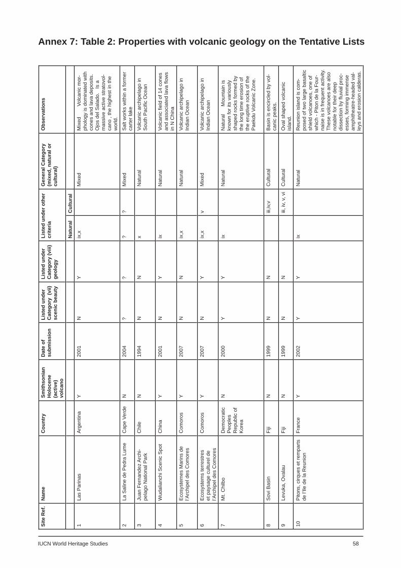
IUCN World Heritage Studies 58
Annex 7: Table 2: Properties with volcanic geology on the Tentative ListsSi
te R
ef.
Nam
e
Cou
ntry
Smith
soni
an
Hol
ocen
e (a
ctiv
e)
volc
ano
Dat
e of
su
bmis
sion
List
ed u
nder
C
ateg
ory
(vii)
sc
enic
bea
uty
List
ed u
nder
C
ateg
ory
(viii
) ge
olog
y
List
ed u
nder
oth
er
crite
riaG
ener
al C
ateg
ory
(mix
ed, n
atur
al o
r cu
ltura
l)
Obs
erva
tions
Nat
ural
Cul
tura
l1
Las
Par
inas
Arg
entin
aY
2001
NY
ix,x
Mix
edM
ixed
Vo
lcan
ic m
or-
phol
ogy
is d
omin
ated
with
co
nes
and
lava
dep
osits
. O
jos
del S
alad
o.
Is a
m
assi
ve a
ctiv
e st
rato
vol-
cano
, th
e hi
ghes
t in
the
wor
ld.
2La
Sal
ine
de P
edra
Lum
eC
ape
Verd
eN
2004
??
??
Mix
edS
alt w
orks
with
in a
form
er
carte
r lak
e
3Ju
an F
erna
ndez
Arc
hi-
pela
go N
atio
nal P
ark
Chi
leN
1994
NN
xN
atur
alVo
lcan
ic a
rchi
pela
go in
S
outh
Pac
ifi c
Oce
an
4W
udal
ianc
hi S
ceni
c S
pot
Chi
naY
2001
NY
ixN
atur
alVo
lcan
ic fi
eld
of 1
4 co
nes
and
asso
ciat
ed la
va fl
ows
in N
Chi
na
5E
cosy
stem
es M
arin
s de
l’A
rchi
pel d
es C
omor
es
Com
oros
Y20
07N
Nix
,xN
atur
alVo
lcan
ic a
rchi
pela
go in
In
dian
Oce
an
6E
cosy
stem
s te
rres
tres
et p
aysa
ge c
ultu
rel d
e l’A
rchi
pel d
es C
omor
es
Com
oros
Y20
07N
Yix
,xv
Mix
edVo
lcan
ic a
rchi
pela
go in
In
dian
Oce
an
7M
t. C
hilb
oD
emoc
ratic
P
eopl
es
Rep
ublic
of
Kor
ea
N20
00Y
Yix
Nat
ural
Nat
ural
M
ount
ain
is
know
n fo
r its
var
ious
ly
shap
ed ro
cks
form
ed b
y th
e lo
ng ti
me
eros
ion
of
the
erup
tive
rock
s of
the
Pae
kdu
Volc
anic
Zon
e.
8S
ovi B
asin
Fiji
N19
99N
Niii
,iv,v
Cul
tura
lB
asin
is e
ncirc
led
by v
ol-
cani
c pe
aks.
9Le
vuka
, Ova
lau
Fiji
N19
99N
Niii
, iv,
v, v
iC
ultu
ral
Ova
l sha
ped
volc
anic
is
land
.
10P
itons
, cirq
ues
et re
mpa
rts
de l’
Ile d
e la
Reu
nion
Fran
ceY
2002
YY
ixN
atur
alR
euni
on is
land
is c
om-
pose
d of
two
larg
e ba
salti
c sh
ield
vol
cano
es, o
ne o
f w
hich
- P
iton
de la
Fou
r-na
ise
is in
freq
uent
act
ivity
. Th
ese
volc
anoe
s ar
e al
so
nota
ble
for t
heir
deep
di
ssec
tion
by fl
uvia
l pro
c-es
ses,
form
ing
imm
ense
am
phith
eatre
-hea
ded
val-
leys
and
ero
sion
cal
dera
s.

59 IUCN World Heritage Studies
Site
Ref
.N
ame
C
ount
rySm
ithso
nian
H
oloc
ene
(act
ive)
vo
lcan
o
Dat
e of
su
bmis
sion
List
ed u
nder
C
ateg
ory
(vii)
sc
enic
bea
uty
List
ed u
nder
C
ateg
ory
(viii
) ge
olog
y
List
ed u
nder
oth
er
crite
riaG
ener
al C
ateg
ory
(mix
ed, n
atur
al o
r cu
ltura
l)
Obs
erva
tions
Nat
ural
Cul
tura
l11
Les
Iles
Mar
quis
esFr
ance
N19
96N
Ni,
iii, v
Cul
tura
lVo
lcan
ic a
rchi
pela
go in
the
Sout
h Pa
cifi c
O
cean
12G
rena
dine
s Is
land
G
roup
Gre
nada
Y20
04Y
Nx
Nat
ural
The
site
incl
udes
sev
eral
act
ive
unde
rsea
m
ount
s in
clud
ing
Kick
em
’ Jen
ny w
hich
atte
st
to th
e on
goin
g m
ovem
ent o
f the
Car
ibbe
an
and
Sout
h Am
eric
an p
late
s. T
he is
land
of
Gre
nada
is c
ompo
sed
of fi
ve v
olca
nic
cent
res
incl
udin
g M
ount
Sai
nt C
athe
rine
a st
rato
vol-
cano
with
a h
orse
shoe
sha
ped
crat
er w
ith
seve
ral l
ava
dom
es.
13Pr
otec
ted
area
of L
ake
Atitl
anG
uate
mal
aY
2002
YY
ixN
atur
alA
crat
er la
ke fo
rmed
as
a re
sult
of fo
ur s
epa-
rate
cyc
les
of b
uild
and
col
laps
e. T
he la
ke
is s
urro
unde
d by
the
stra
tovo
lcan
oes
Atitl
an,
Tolim
a an
d Su
chita
n.
14Br
eiða
fjörð
urIc
elan
dN
2001
??
??
Mix
edAr
ea c
onsi
sts
of T
ertia
ry b
asal
tic la
va th
at h
as
been
ero
ded
durin
g gl
acia
tions
. So
me
mor
e re
cent
vol
cani
cs a
nd s
ever
al g
eoth
erm
al s
ites
are
pres
ent.
15H
erðu
brei
ðarli
ndir
and
Askj
aIc
elan
dY
2001
YY
ix,x
Nat
ural
Askj
a is
a la
rge
basa
ltic
cent
ral v
olca
no th
at
form
s th
e D
yngi
ufjo
ll m
assi
f. It
is tr
unca
ted
by
thre
e ov
erla
ppin
g ca
lder
as. I
ts fo
rmat
ion
may
be
due
to s
ubgl
acia
l eru
ptio
n. H
urðu
brei
ðar i
s a
wel
l-for
med
tabl
e m
ount
ain
or tu
ya.
16M
ývat
n - L
axa
Icel
and
Y20
01Y
Yix
,xN
atur
alTh
e ar
ea is
a z
one
of a
ctiv
e vo
lcan
ism
, with
m
any
dive
rse
volc
anic
form
s, lo
cate
d in
nor
th-
ern
part
of th
e N
eovo
lcan
ic R
ift.
17N
úpss
taðu
rIc
elan
dN
2001
??
??
Mix
edVa
rious
type
s of
lava
, geo
ther
mal
are
as, t
ec-
toni
c fi s
sure
s an
d a
cent
ral v
olca
no.
18R
eykh
olt
Icel
and
N20
01N
Ni,
iii, v
iC
ultu
ral
Hyd
roth
erm
al a
rea
with
hot
spr
ings
19Sk
afta
fell
Icel
and
Y20
01?
??
?M
ixed
This
gla
cier
nat
iona
l par
k in
clud
es O
ræfa
jóku
ll,
the
larg
est a
ctiv
e ce
ntra
l vol
cano
in Ic
elan
d.
Also
cov
ers
part
of th
e ic
e-co
vere
d G
rimsv
ötn
volc
anic
sys
tem
, eru
ptio
ns o
f whi
ch c
an c
ause
la
rge
scal
e fl o
odin
g.
20Bu
nake
n N
atio
nal P
ark
Indo
nesi
aN
2005
YY
ix,x
Nat
ural
Geo
logi
cal h
isto
ry o
f exp
losi
ve v
olca
nism
evi
-de
nced
by
ext
ensi
ve d
epos
its o
f vol
cani
c tu
ff.
The
Park
con
tain
s M
anad
o Tu
a, a
dor
man
t vo
lcan
o.

IUCN World Heritage Studies 60
Site
Ref
.N
ame
C
ount
rySm
ithso
nian
H
oloc
ene
(act
ive)
vo
lcan
o
Dat
e of
su
bmis
sion
List
ed u
nder
C
ateg
ory
(vii)
sc
enic
bea
uty
List
ed u
nder
C
ateg
ory
(viii
) ge
olog
y
List
ed u
nder
oth
er
crite
riaG
ener
al C
ateg
ory
(mix
ed, n
atur
al o
r cu
ltura
l)
Obs
erva
tions
Nat
ural
Cul
tura
l21
Ban
da Is
land
sIn
done
sia
Y20
05Y
Nx
Nat
ural
ituat
ed in
the
Indo
-Mal
ayan
arc
hipe
lago
the
site
con
tain
s G
unun
g A
pi,th
e su
mm
it of
a
mas
sive
act
ive
stra
tovo
lcan
o. A
lso
pres
ent i
s th
e is
land
of M
anuk
, a h
igh
trunc
ated
and
esiti
c co
ne.
22O
gasa
war
a Is
land
sJa
pan
Y20
07N
Yix
,xN
atur
alA
serie
s of
vol
cani
c oc
eani
c is
land
s w
hich
co
nsis
t of t
he O
gasa
war
a A
rchi
pela
go, a
s w
ell
as s
ever
al is
olat
ed is
land
s. I
t is
the
only
pla
ce
in th
e w
orld
whe
re b
onite
and
tran
sitio
nal v
ol-
cani
c pr
oduc
ts c
an b
e se
en s
how
ing
the
entir
e gr
owth
cyc
le o
f an
ocea
n is
land
arc
.
23Fu
jisan
Ja
pan
Y20
07N
Niii
, iv,
v, v
iC
ultu
ral
The
fam
ous
stra
tovo
lcan
o is
Jap
an’s
hig
hest
pe
ak. F
ujis
an is
con
stru
cted
abo
ve a
gro
up o
f ov
erla
ppin
g vo
lcan
oes.
24G
reat
Rift
Val
ley
Eco
-sy
stem
K
enya
Y20
01?
??
?M
ixed
his
spre
adin
g co
ntin
enta
l rift
con
tain
s a
serie
s of
vol
cano
es in
clud
ing
Long
onot
, Mou
nt K
enya
an
d M
ount
Elg
on.
25Vo
lcan
Mas
aya
Na-
tiona
l Par
kN
icar
agua
Y19
95?
??
?N
atur
alM
asay
a is
a la
rge
activ
e ba
salti
c ca
lder
a, ly
ing
with
in th
e m
assi
ve L
as S
ierr
as p
yroc
last
ic
shie
ld v
olca
no a
nd a
djac
ent t
o vo
lcan
o N
indi
rí.
26A
uckl
and
Volc
anic
Fi
elds
New
Zea
land
Y20
07N
Yii,
iii,
iv, v
Mix
edS
ite c
ompo
sed
of 5
0 ba
salti
c er
uptio
n ce
ntre
s.
Incl
udes
the
shie
ld v
olca
no R
angi
toto
and
the
extin
ct P
ukak
i. S
ite e
xhib
its a
ser
ies
of m
aars
, tu
ff rin
gs, s
mal
l lav
a sh
ield
s an
d sc
oria
con
es.
27K
erm
adec
Isla
nds
and
Mar
ine
Res
erve
s N
ew Z
eala
ndY
2007
YY
ix, x
Nat
ural
An
arch
ipel
ago
of w
hich
the
four
mai
n is
land
s ar
e th
e pe
aks
of v
olca
noes
that
rise
hig
h ab
ove
sea
leve
l. T
here
are
sev
eral
oth
er v
ol-
cano
es in
the
chai
n th
e do
not
reac
h se
a le
vel.
The
site
incl
udes
the
stra
tovo
lcan
o R
aoul
and
th
e su
bmar
ine
volc
ano
Cur
tis Is
land
.
28C
ity o
f Gra
nada
and
its
Nat
ural
Env
ironm
ent
Nic
arag
uaY
2003
??
??
Mix
edC
onta
ins
the
Apo
yoeq
ue v
olca
nic
com
plex
, w
hich
occ
upie
s th
e C
hilte
pe P
enin
sula
, whi
ch
is p
art o
f the
Chi
ltepe
pyr
ocla
stic
shi
eld
volc
a-no
. A
lso
cont
ains
Mom
bach
o a
stra
tovo
lcan
o w
hich
has
und
ergo
ne e
difi c
e co
llaps
e.
29Th
e S
ublim
e K
arst
s of
P
apua
New
Gui
nea
Pap
ua N
ew
Gui
nea
Y20
06Y
Yix
,xv
Mix
edS
ite in
clud
es th
e N
akan
i Mou
ntai
ns o
n th
e is
land
of N
ew B
ritai
n. A
ctiv
e vo
lcan
oes
in th
e ra
nge
incl
ude
the
stra
tovo
lcan
o U
law
un, t
he
com
plex
vol
cano
Lan
gila
and
the
pyro
clas
tic
shie
ld v
olca
no R
abau
l.
30M
t. M
alin
dang
Ran
ge
Nat
ural
Par
k P
hilip
pine
s
Y20
06Y
Nix
,xN
atur
alM
t. M
alin
dang
is a
stra
tovo
lcan
o w
hich
con
-ta
ins
a sm
all s
umm
it ca
lder
a.
31M
t. M
atut
um P
rote
cted
La
ndsc
ape
Phi
lippi
nes
Y20
06N
Nix
,xN
atur
alA
sym
met
rical
stra
tovo
lcan
o.

61 IUCN World Heritage Studies
Site
Ref
.Na
me
Co
untry
Smith
soni
an
Holo
cene
(a
ctiv
e)
volc
ano
Date
of
subm
issi
onLi
sted
und
er
Cate
gory
(vi
i) sc
enic
bea
uty
List
ed u
nder
Ca
tego
ry (v
iii)
geol
ogy
List
ed u
nder
oth
er
crite
riaG
ener
al C
ateg
ory
(mix
ed, n
atur
al o
r cu
ltura
l)
Obs
erva
tions
Natu
ral
Cultu
ral
32M
t. Ap
o N
atur
al P
ark
Philip
pine
sY
2006
YN
ix,x
Nat
ural
Mou
nt A
po is
a la
rge
stra
tovo
lcan
o. I
t has
a
fl at t
oppe
d su
mm
it w
ith 3
pea
ks c
onta
inin
g a
500m
wid
e cr
ater
,
33Ta
al V
olca
no P
rote
cted
La
ndsc
ape,
Bat
anga
sPh
ilippi
nes
Y20
06Y
Yx
Nat
ural
A ca
lder
a vo
lcan
o, T
aal i
s on
e of
the
mos
t ac
tive
volc
anoe
s in
the
Philip
pine
s. I
t has
pr
oduc
ed s
ome
of th
e m
ost p
ower
ful h
isto
ric
erup
tions
in th
e w
orld
.
34Ilh
as S
elva
gens
Portu
gal
N20
02N
Nx
Nat
ural
A se
ries
of o
cean
ic is
land
s. T
he is
lets
repr
e-se
nt th
e re
mai
ns o
f vol
cani
c pe
aks.
35Al
gar d
o C
arva
oPo
rtuga
lY
1996
??
??
Nat
ural
A 10
0m lo
ng v
olca
nic
cave
, rem
nant
of a
n er
uptio
n of
Ter
ra B
rava
, the
cen
tre o
f Ter
ceira
, a
stom
bolia
n vo
lcan
o w
ith tw
o co
nes.
36Th
e C
omm
ande
r Is
land
s (C
oman
dors
ky
Stat
e N
atio
nal P
ark)
Rus
sian
Fe
dera
tion
Y20
05Y
Yix
,xN
atur
alVo
lcan
ic a
rchi
pela
go, b
eing
the
wes
tern
mos
t ex
tens
ion
of th
e Al
eutia
n Is
land
s ar
c. M
ainl
y st
rato
volc
anoe
s.
37Fa
galo
a Ba
y - U
afat
o Ti
avea
Con
serv
atio
n Zo
ne
Sam
oaY
2006
YN
xv
Mix
edU
polu
Isla
nd, o
n sl
opes
Upo
lu s
hiel
d vo
lcan
o
38Th
e Pr
ince
Edw
ard
Isla
nds
Sout
h Af
rica
Y20
04Y
Yix
,xN
atur
alM
ario
n is
land
is S
outh
Afri
ca’s
only
his
toric
ally
ac
tive
volc
ano.
It w
as fo
rmed
by
two
youn
g sh
ield
vol
cano
es th
at ri
se a
bove
a fl
at to
pped
su
bmar
ine
plat
form
. Th
e is
land
feat
ures
cin
der
cone
s, s
coria
con
es a
nd c
oast
al tu
ff co
nes.
39M
gahi
nga
Gor
illa
Nat
iona
l Par
kU
gand
aY
2007
YY
ix,x
Nat
ural
Mou
nt M
uhav
ura
is a
stra
tovo
lcan
o w
ith a
sm
all 4
0m w
ide
lake
in it
s su
mm
it cr
ater
. A
smal
l par
asiti
c cr
ater
has
bee
n re
cent
ly a
ctiv
e.
40La
ke L
etas
Vanu
atu
N20
04Y
Nix
,xN
atur
alVo
lcan
ic c
rate
r lak
e on
sum
mit
Hol
ocen
e vo
l. M
t Gha
rat.
Rec
ent e
rupt
ion.


World Heritage Studies
1. Outstanding Universal Value: Standards for Natural Heritage: A Compendium on Standards for Inscriptions of Natural Properties on the World Heritage List, IUCN World Heritage Studies Nº 1, Tim Badman, Bastian Bomhard, Annelie Fincke, Josephine Langley, Pedro Rosabal and David Sheppard, 2008.
2. World Heritage Caves and Karst, A Thematic Study: Global Review of Karst World Heritage Properties: present situation, future prospects and management, requirements, IUCN World Heritage Studies Nº2, Paul Williams, June 2008.
3. World Heritage and Protected Areas: an initial analysis of the contribution of the World Heritage Convention to the global network of protected areas presented to the 32nd session of the World Heritage Committee, Québec City, Canada, in July 2008, IUCN World Heritage Studies Nº 3, Tim Badman and Bastian Bomhard, 2008.
4. Natural World Heritage Nominations: A resource manual for practioners, IUCN World Heritage Studies Nº 4, Tim Badman, Paul Dingwall and Bastian Bomhard, 2008.
5. Management Planning for Natural World Heritage Properties: A resource manual for practioners, Interim version, IUCN World Heritage Studies Nº 5, IUCN Programme on Protected Areas, 2008.
6. Serial Natural World Heritage Properties: an initial analysis of the serial natural World Heritage Properties on the World Heritage List, IUCN World Heritage Studies Nº 6, Barbara Engels, Phillip Koch and Tim Badman, 2009.
7. World Heritage in Danger: A compendium of key decisions on the conservation of natural World Heritage Properties via the list of World Heritage in Danger, IUCN World Heritage Studies Nº 7, Tim Badman, Bastian Bomhard, Annelie Fincke, Josephine Langley, Pedro Rosabal and David Sheppard, 2009.
8. World Heritage Volcanoes: a thematic study: a global review of volcanic World Heritage properties: present situation, future prospects and management requirements, IUCN World Heritage Studies Nº 8, Chris Wood, 2009.