World 1 - VDOE :: Virginia Department of Education Home refined? Uses of mental maps • Carry out...
59
1 World Teacher Resource Guide World Geography Commonwealth of Virginia Board of Education Richmond, Virginia 2001 Curriculum Framework
Transcript of World 1 - VDOE :: Virginia Department of Education Home refined? Uses of mental maps • Carry out...

1
World
Teacher Resource Guide
World Geography
Commonwealth of VirginiaBoard of EducationRichmond, Virginia
2001
Curriculum Framework
Virginia Board of Education, 2001 1
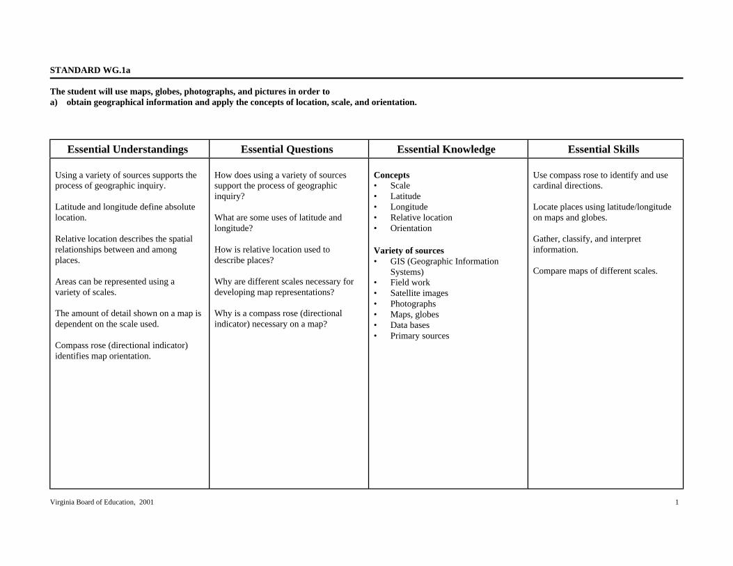
STANDARD WG.1a
The student will use maps, globes, photographs, and pictures in order toa) obtain geographical information and apply the concepts of location, scale, and orientation.
Essential Understandings Essential Questions Essential Knowledge Essential Skills
Using a variety of sources supports theprocess of geographic inquiry.
Latitude and longitude define absolutelocation.
Relative location describes the spatialrelationships between and amongplaces.
Areas can be represented using avariety of scales.
The amount of detail shown on a map isdependent on the scale used.
Compass rose (directional indicator)identifies map orientation.
How does using a variety of sourcessupport the process of geographicinquiry?
What are some uses of latitude andlongitude?
How is relative location used todescribe places?
Why are different scales necessary fordeveloping map representations?
Why is a compass rose (directionalindicator) necessary on a map?
Concepts• Scale• Latitude• Longitude• Relative location• Orientation
Variety of sources• GIS (Geographic Information
Systems)• Field work• Satellite images• Photographs• Maps, globes• Data bases• Primary sources
Use compass rose to identify and usecardinal directions.
Locate places using latitude/longitudeon maps and globes.
Gather, classify, and interpretinformation.
Compare maps of different scales.

Virginia Board of Education, 2001 2
STANDARD WG.1b
The student will use maps, globes, photographs, and pictures in order tob) develop and refine his or her mental maps of world regions.
Essential Understandings Essential Questions Essential Knowledge Essential Skills
Mental maps are based on objectiveknowledge and subjective perceptions.
People develop and refine their mentalmaps through both personal experienceand learning.
Mental maps serve as indicators of howwell people know the spatialcharacteristics of certain places.
How do people use mental maps toorganize information?
How are perceptions reflected in mentalmaps?
How can mental maps be developedand refined?
Uses of mental maps• Carry out daily activities (e.g.,
route to school, shopping)• Give directions to others• Understand world events
Ways mental maps can be developedand refined• Comparing sketch maps to maps in
atlases or other resources• Describing the location of places in
terms of reference points (e.g., theequator, prime meridian)
• Describing the location of places interms of geographic features andland forms (e.g., west of theMississippi River, north of the Gulfof Mexico)
• Describing the location of places interms of the human characteristicsof a place (e.g., languages, types ofhousing, dress, recreation, customsand traditions)
Locate places on maps and globes.
Interpret maps and globes.
Draw maps from memory.
Evaluate information.

Virginia Board of Education, 2001 3
STANDARD WG.1c
The student will use maps, globes, photographs, and pictures in order toc) create and compare political, physical, and thematic maps.
Essential Understandings Essential Questions Essential Knowledge Essential Skills
A map is a visual representation ofgeographic information.
What are ways that maps showinformation?
What are the major types of thematicmaps?
Standard ways that maps showinformation• Symbols• Color• Lines• Boundaries• Contours
Types of thematic maps• Population (e.g., distribution and
density)• Economic activity• Resource• Language• Ethnicity• Climate• Precipitation• Vegetation• Physical• Political
Select the appropriate geographicresource to draw conclusions.
Compare and contrast informationfound on different types of maps.
Compare maps and make inferences.
Draw conclusions and make inferencesabout data.
Identify and interpret regional patternson maps.
Virginia Board of Education, 2001 4
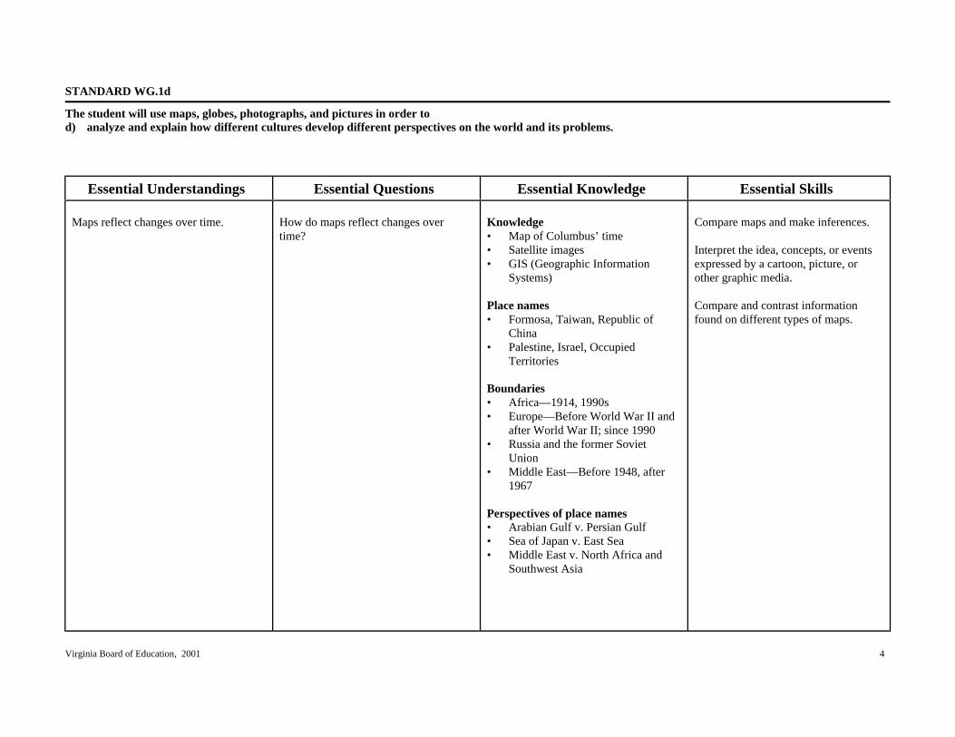
STANDARD WG.1d
The student will use maps, globes, photographs, and pictures in order tod) analyze and explain how different cultures develop different perspectives on the world and its problems.
Essential Understandings Essential Questions Essential Knowledge Essential Skills
Maps reflect changes over time. How do maps reflect changes overtime?
Knowledge• Map of Columbus’ time• Satellite images• GIS (Geographic Information
Systems)
Place names• Formosa, Taiwan, Republic of
China• Palestine, Israel, Occupied
Territories
Boundaries• Africa—1914, 1990s• Europe—Before World War II and
after World War II; since 1990• Russia and the former Soviet
Union• Middle East—Before 1948, after
1967
Perspectives of place names• Arabian Gulf v. Persian Gulf• Sea of Japan v. East Sea• Middle East v. North Africa and
Southwest Asia
Compare maps and make inferences.
Interpret the idea, concepts, or eventsexpressed by a cartoon, picture, orother graphic media.
Compare and contrast informationfound on different types of maps.

Virginia Board of Education, 2001 5
STANDARD WG.1d (continued)
The student will use maps, globes, photographs, and pictures in order tod) analyze and explain how different cultures develop different perspectives on the world and its problems.
Essential Understandings Essential Questions Essential Knowledge Essential Skills
Disputed areas• Korea• Western Sahara• Former Yugoslavia• Kashmir
Virginia Board of Education, 2001 6
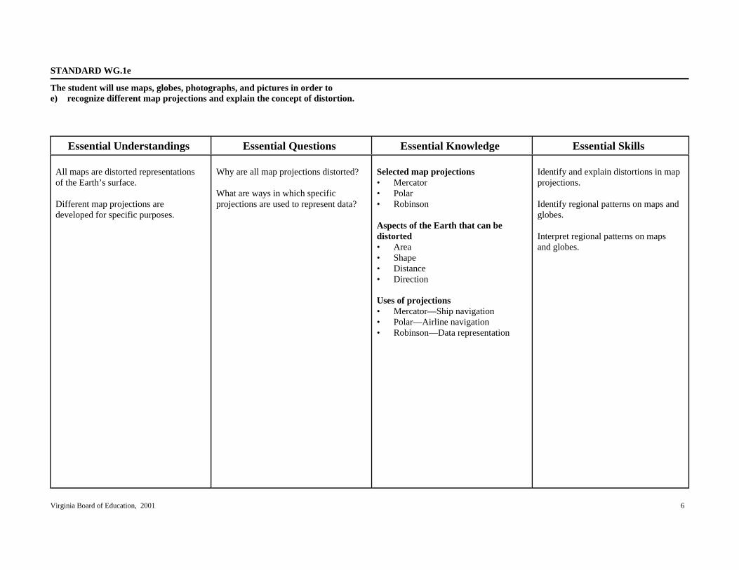
STANDARD WG.1e
The student will use maps, globes, photographs, and pictures in order toe) recognize different map projections and explain the concept of distortion.
Essential Understandings Essential Questions Essential Knowledge Essential Skills
All maps are distorted representationsof the Earth’s surface.
Different map projections aredeveloped for specific purposes.
Why are all map projections distorted?
What are ways in which specificprojections are used to represent data?
Selected map projections• Mercator• Polar• Robinson
Aspects of the Earth that can bedistorted• Area• Shape• Distance• Direction
Uses of projections• Mercator—Ship navigation• Polar—Airline navigation• Robinson—Data representation
Identify and explain distortions in mapprojections.
Identify regional patterns on maps andglobes.
Interpret regional patterns on mapsand globes.

Virginia Board of Education, 2001 7
STANDARD WG.2a
The student will analyze how selected physical and ecological processes shape the Earth’s surface bya) identifying regional climatic patterns and weather phenomena and their effects on people and places.
Essential Understandings Essential Questions Essential Knowledge Essential Skills
Climate is defined by certaincharacteristics.
Climate patterns result from theinterplay of common elements.
Climate regions have distinctivevegetation.
Certain weather phenomena are uniqueto specific regions.
Climate and weather phenomena affecthow people live in different regions.
What are the common characteristicsthat define climate?
What are the elements that influenceregional climate patterns?
What vegetation is characteristic of keyclimate zones?
Where do specific types of weatherphenomena occur?
What effects do climate and weatherphenomena have on people living indifferent regions?
Climate characteristics• Temperature• Precipitation• Seasons (hot/cold; wet/dry)
Climate elements• Influence of latitude• Influence of winds• Influence of elevation• Proximity to water
World climate regions• Low latitudes—e.g., tropical wet,
tropical wet and dry, arid, semiarid,highland
• Middle latitudes—e.g., semiarid,arid, Mediterranean (dry summersubtropical) humid continental,marine west coast, highland
• High latitudes—e.g., subarctic,tundra (subpolar), icecap
Vegetation regions• Rain forest• Savanna• Desert• Steppe• Middle latitude forests• Taiga• Tundra
Compare maps and make inferences.
Interpret the idea, concepts, or eventsexpressed by pictures, or other graphicmedia.
Apply latitude to identify climatezones.
Interpret charts, diagrams, andclimographs.
Select the appropriate geographicresource to draw conclusions.

Virginia Board of Education, 2001 8
STANDARD WG.2a (continued)
The student will analyze how selected physical and ecological processes shape the Earth’s surface bya) identifying regional climatic patterns and weather phenomena and their effects on people and places.
Essential Understandings Essential Questions Essential Knowledge Essential Skills
Weather phenomena• Monsoons—South and Southeast
Asia• Typhoons—Pacific Oceans• Hurricanes—Atlantic Ocean• Tornadoes—United States
Effects of climate• Crops• Clothing• Housing• Natural hazards

Virginia Board of Education, 2001 9
STANDARD WG.2b
The student will analyze how selected physical and ecological processes shape the Earth’s surface byb) describing how humans influence the environment and are influenced by it.
Essential Understandings Essential Questions Essential Knowledge Essential Skills
Physical and ecological processes shapethe Earth’s surface.
Humans both influence and areinfluenced by their environment.
How have physical and ecologicalprocesses shaped the Earth’s surface?
What are some ways humans influencetheir environment?
How are humans influenced by theirenvironment?
Physical and ecological processes• Earthquakes• Floods• Volcanoes• Erosion
Human impact on environmentWater diversion/management• Aral Sea• Colorado River• Aswan High Dam• Canals• Reservoirs• Irrigation
Changing landscapes• Agricultural terracing (e.g., China,
Southeast Asia)• Polders (e.g., Netherlands)• Deforestation (e.g., Nepal, Brazil,
Malaysia)• Desertification (e.g., Africa, Asia)
Environmental changes• Acid rain (e.g., forests in Germany,
Scandinavia, China and EasternNorth America)
• Pollution (e.g., Mexico City,Chernobyl, oil spills)
Gather, classify, and interpretinformation.
Draw conclusions and makegeneralizations about data.
Explain cause and effect relationships.
Identify and interpret regional patternson maps.

Virginia Board of Education, 2001 10
STANDARD WG.2c
The student will analyze how selected physical and ecological process shape the Earth’s surface byc) explaining how technology affects one’s ability to modify the environment and adapt to it.
Essential Understandings Essential Questions Essential Knowledge Essential Skills
Technology has expanded people’scapability to modify and adapt to theirphysical environment.
How has the use of technologyexpanded the capacity of people tomodify and adapt to their environment?
Influence of technology• Agriculture (e.g., fertilizers,
mechanization)• Energy usage (e.g., fossil fuels,
nuclear)• Transportation (e.g., road building,
railways)• Automobiles (e.g., parking lots,
suburbs)• Airplanes (e.g., airport expansion,
noise)
Environmental impact on humans• Settlement patterns• Housing materials• Agricultural activity• Types of recreation• Transportation patterns
Draw conclusions and make inferencesabout data.
Gather, classify, and interpretinformation.
Explain cause and effect relationships.
Identify and interpret regional patternson maps.

Virginia Board of Education, 2001 11
STANDARD WG.3a
The student will apply the concept of a region by a) explaining how characteristics of regions have led to regional labels.
Essential Understandings Essential Questions Essential Knowledge Essential Skills Regions are areas of Earth’s surface which share unifying characteristics. Regions may be defined by physical or cultural characteristics. Regional labels may reflect changes in people’s perceptions.
Why do geographers create and use regions as organizing concepts? What are some examples of physical and cultural regions? What are some examples of regional labels that reflect changes in perceptions?
Regions are used to simplify the world for study and understanding. Physical regions • Sahara • Taiga • Rainforest • Great Plains • Low Countries Cultural regions • Language
– Latin America – Francophone world
• Ethnic – Chinatowns – Kurdistan
• Religion – Islam – Buddhism
• Economic – Wheat Belts – European Union (EU)
• Political – North Atlantic Treaty
Organization (NATO) – African Union (AU)
Locate areas (regions) on maps and globes. Interpret regional patterns on maps and globes. Draw conclusions and make generalizations about data. Explain cause and effect relationships.

Virginia Board of Education, 2001 12
STANDARD WG.3a (continued)
The student will apply the concept of a region bya) explaining how characteristics of regions have led to regional labels.
Essential Understandings Essential Questions Essential Knowledge Essential Skills
• Changes in perceptions– Middle East– Sun Belt– Rust Belt

Virginia Board of Education, 2001 13
STANDARD WG.3b
The student will apply the concept of a region byb) explaining how regional landscapes reflect characteristics of their inhabitants.
Essential Understandings Essential Questions Essential Knowledge Essential Skills
Regional landscapes reflect culturalcharacteristics of their inhabitants.
How do regional landscapes reflectcultural characteristics of theirinhabitants?
Cultural characteristics• Architectural structures
– Religious buildings (e.g.,mosques, churches,synagogues, temples, pagodas)
– Dwellings (e.g., tiled roofs inMediterranean, chalets inSwitzerland, thatched roofs inPacific Islands, tents and yurtsin Central and Southwest Asia,castles in Europe)
• Statues and monuments of local,national, or global significance– Taj Mahal (India)– Kaaba (Mecca)– Western Wall (Jerusalem)– Dome of the Rock (Jerusalem)– Church of the Holy Sepulcher
(Jerusalem)– Pyramids (Egypt)– Kremlin (Moscow)– Eiffel Tower (Paris)– Virginia State Capitol Building– Washington Monument– White House– Lincoln Memorial– Statue of Liberty
Gather, classify, and interpretinformation.
Draw conclusions and makegeneralizations about data.
Analyze photographs and pictures andmake inferences.

Virginia Board of Education, 2001 14
STANDARD WG.3c
The student will apply the concept of a region byc) analyzing how cultural characteristics, including the world’s major languages and religions, link or divide regions.
Essential Understandings Essential Questions Essential Knowledge Essential Skills
Cultural differences can link or divideregions.
How can cultural characteristics link ordivide regions?
Language• Arab world—Arabic• Hispanic America—Spanish• Brazil—Portuguese• Canada—French/English• Switzerland—Multiple languages• English—World language
Ethnic heritage• Yugoslavia—Serbs, Croats,
Bosnians, Albanians• Burundi and Rwanda—Hutus and
Tutsis• United States, Switzerland—Unity
in multiple ethnic countries• Korea and Japan—Predominantly
single ethnicity• Cyprus—Greeks and Turks
Religion as a unifying force• Hinduism• Buddhism• Judaism• Christianity• Islam
Identify and interpret regional patternson maps.
Draw conclusions and makegeneralizations about information.
Explain cause and effect relationships.
Compare and contrast differing sets ofideas, beliefs, and behaviors.

Virginia Board of Education, 2001 15
STANDARD WG.3c (continued)
The student will apply the concept of a region byc) analyzing how cultural characteristics, including the world’s major languages and religions, link or divide regions.
Essential Understandings Essential Questions Essential Knowledge Essential Skills
Religion as a divisive force• Conflicts between Hindus and
Muslims in Pakistan and India• Conflicts between Catholics and
Protestants in Northern Ireland• Jews, Christians, and Muslims all
claiming Jerusalem as theirreligious heritage site

Virginia Board of Education, 2001 16
STANDARD WG.4
The student will locate and analyze physical, economic, and cultural characteristics of world regions: Latin America and the Caribbean, Europe, United Statesand Canada, North Africa and Southwest Asia, Sub-Saharan Africa, Russia and Central Asia, South Asia, Southeast Asia, East Asia, Australia and the PacificIslands, and Antarctica.
Essential Understandings Essential Questions Essential Knowledge Essential Skills
The development of a region isinfluenced by many factors, includingphysical, economic and culturalcharacteristics.
The interaction of humans with theirenvironment affects the development ofa region.
Different criteria may be used todetermine a country’s relativeimportance.
Elements of the physical environment,such as major bodies of water andmountains, influence the economic andcultural characteristics of regions.
In what ways do physical, economic,and cultural characteristics influenceregional development?
What are some ways that humaninteraction with the environment affectsthe development of a region?
What are some criteria that may be usedto determine a country’s relativeimportance?
What impact do elements of thephysical environment, such as majorbodies of water and mountains, have oncountries?
See attached charts for specificinformation concerning physical,economic, and cultural characteristics.
Human interaction with environment• Deforestation—Amazon Basin,
Nepal, Malaysia• Acid rain—Black Forest• Decreased soil fertility—Aswan
High Dam
Criteria for determining relativeimportance• GDP (Gross Domestic Product)• Land size• Population size• Resources
Impact of physical elementsExample: Water• Rio Grande—Boundary• Ob River—Flows northward into
Arctic Ocean• Zambezi River—Water power• Ganges and Brahmaputra rivers—
Flood hazard
Explain charts comparing two or moreconcepts.
Identify primary ideas expressed ingraphic data.
Gather, classify, and interpretinformation.
Draw conclusions and makegeneralizations about data.
Explain cause and effect relationships.
Identify and locate regions, continents,oceans, and major features on mapsand globes.

Virginia Board of Education, 2001 17
STANDARD WG.4 (continued)
The student will locate and analyze physical, economic, and cultural characteristics of world regions: Latin America and the Caribbean, Europe, United Statesand Canada, North Africa and Southwest Asia, Sub-Saharan Africa, Russia and Central Asia, South Asia, Southeast Asia, East Asia, Australia and the PacificIslands, and Antarctica.
Essential Understandings Essential Questions Essential Knowledge Essential Skills
Example: Mountains• Rocky Mountains—Create rain
shadows on leeward slopes• Himalayas—Block moisture to
create steppes and deserts inCentral Asia

Virginia Board of Education, 2001 18
STANDARD WG.4 (continued)
The student will locate and analyze physical, economic, and cultural characteristics of world regions: Latin America and the Caribbean, Europe, United Statesand Canada, North Africa and Southwest Asia, Sub-Saharan Africa, Russia and Central Asia, South Asia, Southeast Asia, East Asia, Australia and the PacificIslands, and Antarctica.
Countries Physical Characteristics Economic Characteristics Cultural Characteristics
Latin America and the CaribbeanMexico and Central America:Mexico, Belize, Guatemala, ElSalvador, Honduras, Nicaragua, CostaRica, Panama
South America: Colombia, Venezuela,Guyana, Suriname, French Guiana,Ecuador, Peru, Bolivia, Brazil,Paraguay, Argentina, Uruguay, Chile
Caribbean: Cuba, Haiti, Jamaica,Dominican Republic, Puerto Rico (U.S.)
Latin America and the Caribbean• Major mountain ranges—Andes,
Sierra Madres• Rainforests• Coastal desert—Atacama• Reversed seasons south of the
equator• Amazon River Basin• Grasslands: pampas, llanos• Tropical climates predominant• Volcanoes and earthquakes• Archipelagoes• Vertical zonation (tierra caliente,
tierra templada, tierra fria)
Latin America and the Caribbean• Diverse economies• Subsistence farming• Plantation agriculture• Slash and burn agriculture• Cash crops and food crops• Haciendas• Cattle ranges, gauchos• Deforestation• Destruction of rainforests• Oil resources, Ecuador, Venezuela,
and Mexico• Heavy smog, pollution—Mexico
City• Disparity of income distribution• North American Free Trade
Agreement (NAFTA)—Mexico,Canada, United States.
• Diverse mineral resources (e.g.,copper in Chile, iron ore inVenezuela and Brazil)
Latin America and the Caribbean• Indian civilizations• African traditions• Influence of European colonization• Predominance of Roman Catholic
religion• Rigid social structure• Mestizos• Location of settlements: coastal in
South America• Megacities, squatter settlements• Rapid population growth• Out-migration
Cultural heritage• Music—African influences,
calypso, steel drum bands, reggae• Traditional dances• Spanish, Portuguese languages
Cultural landscapes• Pyramids, cathedrals• Haciendas, ejidos (communal land)• Machu Picchu• Tikal

Virginia Board of Education, 2001 19
STANDARD WG.4 (continued)
The student will locate and analyze physical, economic, and cultural characteristics of world regions: Latin America and the Caribbean, Europe, United Statesand Canada, North Africa and Southwest Asia, Sub-Saharan Africa, Russia and Central Asia, South Asia, Southeast Asia, East Asia, Australia and the PacificIslands, and Antarctica.
Countries Physical Characteristics Economic Characteristics Cultural Characteristics
Cities as centers of culture and trade• Mexico City• Rio de Janeiro• Buenos Aires• Santiago

Virginia Board of Education, 2001 20
STANDARD WG.4 (continued)
The student will locate and analyze physical, economic, and cultural characteristics of world regions: Latin America and the Caribbean, Europe, United Statesand Canada, North Africa and Southwest Asia, Sub-Saharan Africa, Russia and Central Asia, South Asia, Southeast Asia, East Asia, Australia and the PacificIslands, and Antarctica.
Countries Physical Characteristics Economic Characteristics Cultural Characteristics
EuropeLocation of countries with particularemphasis on countries listed(determined by their per capita GDP,land size, and population)
GDP• Switzerland• Luxembourg• Sweden
Land size• Ukraine• France• Spain
Population• Germany• United Kingdom• Italy• France
Europe• Part of large landmass called
Eurasia• Peninsulas
– Iberian– Italian– Scandinavian– Jutland
• Islands– Great Britain– Ireland– Sicily
• Fjords• Mountains
– Alps– Pyrenees
• North European plain• Rivers
– Danube– Rhine– Seine– Volga
• Seas– Adriatic– Aegean– Mediterranean– Baltic– Black– North
Europe• Mountain regions—Tourism,
recreation, and mineral resources• Areas threatened by air and water
pollution– Forests (Black Forest)– Cities (Venice)– Rivers (Rhine, Danube, Seine)
• Development of industrial andtransportation centers near mineraldeposits, coal and iron ore– Ruhr valley– Po valley
• Rivers and canals serving as majortransportation links
• Oil reserves in the North Sea• Well-educated workforce—
Industrial and technologicalsocieties, banking in Switzerland
• Advanced farming techniques, highcrop yields, fertile soils, black earth(chernozem)
• Well-developed infrastructure• The Chunnel• Differences in Western and Eastern
European industrial developmentdue to differing economic systemsin prior years
• European Union
Europe• Birthplace of Industrial Revolution• Many ethnic groups—Languages,
religions, customs• Sporadic conflict among groups
(wars, revolutions)• Birthplace of western democracy—
Greece and Rome• Spread of European culture to many
other parts of the world(exploration, colonization,imperialism)
• Highly urbanized• One of the world’s most densely
populated areas• North Atlantic Treaty Organization
(NATO)
Cities as centers of culture and trade• Berlin• London• Paris• Madrid• Rome• Athens• Warsaw

Virginia Board of Education, 2001 21
STANDARD WG.4 (continued)
The student will locate and analyze physical, economic, and cultural characteristics of world regions: Latin America and the Caribbean, Europe, United Statesand Canada, North Africa and Southwest Asia, Sub-Saharan Africa, Russia and Central Asia, South Asia, Southeast Asia, East Asia, Australia and the PacificIslands, and Antarctica.
Countries Physical Characteristics Economic Characteristics Cultural Characteristics
• Oceans– Atlantic– Arctic
• Strait of Gibraltar• Varied climate regions—Tundra to
Mediterranean• Effects of the North Atlantic Drift
and prevailing westerlies onEurope’s climates
• Trade important, especially toisland nations; interdependence
• Large role of government in someeconomies (Sweden and Denmark).
• Replacement of communism withcapitalism in Eastern Europe.
• Reclaimed land—Polders inNetherlands
• Demographics typical of developedeconomies– High per capita GDP– High life expectancy– Low population growth rate– Low infant mortality– Low percentage of population
under age 15– High literacy rate
Cultural landscape• Notre Dame, Arc de Triomphe,
Louvre, Eiffel Tower• Colosseum, Leaning Tower of Pisa,
St. Peter’s Basilica• Parthenon• Westminster Abbey, Big Ben• Windmills• Castles

Virginia Board of Education, 2001 22
STANDARD WG.4 (continued)
The student will locate and analyze physical, economic, and cultural characteristics of world regions: Latin America and the Caribbean, Europe, United Statesand Canada, North Africa and Southwest Asia, Sub-Saharan Africa, Russia and Central Asia, South Asia, Southeast Asia, East Asia, Australia and the PacificIslands, and Antarctica.
Countries Physical Characteristics Economic Characteristics Cultural Characteristics
United States and CanadaUnited StatesCanada
United States and Canada• Abundant natural resources• Continental Divide• Rivers
– Mississippi– St. Lawrence– Colorado– Columbia– Rio Grande
• Other water features– Gulf of Mexico– Great Lakes– Arctic Ocean– Pacific Ocean– Atlantic Ocean– Hudson Bay
• Land forms– Aleutian Islands– Hawaiian archipelago– Appalachian Mountains– Pacific Coastal Ranges– Basin and Range– Rocky Mountains– Great Plains– Interior lowlands– Atlantic and Gulf coastal plains– Canadian Shield– Grand Canyon
United States and Canada• Major exporters of technology,
consumer goods, informationsystems, and foodstuffs
• Highly developed infrastructures• Highly diversified economies• Rich supply of mineral, energy, and
forest resources• North American Free Trade
Agreement (NAFTA)• Multinational corporations• Center of world financial markets
(New York Stock Exchange)• Sustained economic growth• Widening gap between rich and
poor• Export of U.S. culture via the
global marketplace (e.g.,McDonald’s, Coca Cola, music,blue jeans)
United States and Canada• Colonized by the Europeans• Multicultural societies• Increasingly diverse populations• High literacy rates• High standard of living• Highly urbanized• Canada’s struggle to maintain a
national identity• Highly mobile populations• World’s longest unfortified border
between the United States andCanada
• Democratic forms of government• Arts that reflect the cultural
heritage of multicultural societies• North Atlantic Treaty Organization
(NATO)
Cities as centers of culture and trade• Toronto• Montreal• Ottawa• Quebec• Vancouver, British Columbia• Washington, D.C.• Chicago• New York City• Los Angeles• Houston

Virginia Board of Education, 2001 23
STANDARD WG.4 (continued)
The student will locate and analyze physical, economic, and cultural characteristics of world regions: Latin America and the Caribbean, Europe, United Statesand Canada, North Africa and Southwest Asia, Sub-Saharan Africa, Russia and Central Asia, South Asia, Southeast Asia, East Asia, Australia and the PacificIslands, and Antarctica.
Countries Physical Characteristics Economic Characteristics Cultural Characteristics
• Varied climate regions—Rangingfrom tundra in Alaska to tropicalwet in Hawaii
Cultural landscape• U.S. Capitol building• Golden Gate Bridge• Independence Hall• St. Louis Gateway Arch• Wheat fields• Skyscrapers, shopping malls• Bilingual signs• Influence of the automobile (e.g.,
gas stations, motels, interstatehighways, drive-up services)
Virginia Board of Education, 2001 24
STANDARD WG.4 (continued)
The student will locate and analyze physical, economic, and cultural characteristics of world regions: Latin America and the Caribbean, Europe, United Statesand Canada, North Africa and Southwest Asia, Sub-Saharan Africa, Russia and Central Asia, South Asia, Southeast Asia, East Asia, Australia and the PacificIslands, and Antarctica.
Countries Physical Characteristics Economic Characteristics Cultural Characteristics
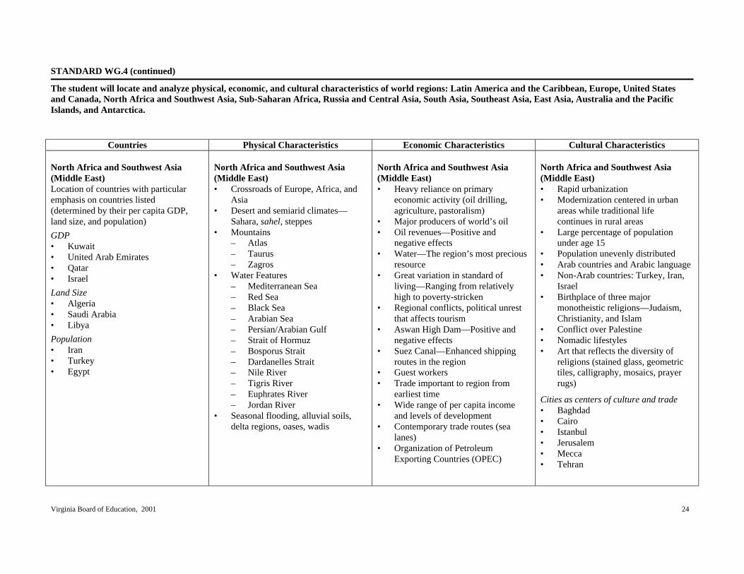
North Africa and Southwest Asia(Middle East)Location of countries with particularemphasis on countries listed(determined by their per capita GDP,land size, and population)
GDP• Kuwait• United Arab Emirates• Qatar• Israel
Land Size• Algeria• Saudi Arabia• Libya
Population• Iran• Turkey• Egypt
North Africa and Southwest Asia(Middle East)• Crossroads of Europe, Africa, and
Asia• Desert and semiarid climates—
Sahara, sahel, steppes• Mountains
– Atlas– Taurus– Zagros
• Water Features– Mediterranean Sea– Red Sea– Black Sea– Arabian Sea– Persian/Arabian Gulf– Strait of Hormuz– Bosporus Strait– Dardanelles Strait– Nile River– Tigris River– Euphrates River– Jordan River
• Seasonal flooding, alluvial soils,delta regions, oases, wadis
North Africa and Southwest Asia(Middle East)• Heavy reliance on primary
economic activity (oil drilling,agriculture, pastoralism)
• Major producers of world’s oil• Oil revenues—Positive and
negative effects• Water—The region’s most precious
resource• Great variation in standard of
living—Ranging from relativelyhigh to poverty-stricken
• Regional conflicts, political unrestthat affects tourism
• Aswan High Dam—Positive andnegative effects
• Suez Canal—Enhanced shippingroutes in the region
• Guest workers• Trade important to region from
earliest time• Wide range of per capita income
and levels of development• Contemporary trade routes (sea
lanes)• Organization of Petroleum
Exporting Countries (OPEC)
North Africa and Southwest Asia(Middle East)• Rapid urbanization• Modernization centered in urban
areas while traditional lifecontinues in rural areas
• Large percentage of populationunder age 15
• Population unevenly distributed• Arab countries and Arabic language• Non-Arab countries: Turkey, Iran,
Israel• Birthplace of three major
monotheistic religions—Judaism,Christianity, and Islam
• Conflict over Palestine• Nomadic lifestyles• Art that reflects the diversity of
religions (stained glass, geometrictiles, calligraphy, mosaics, prayerrugs)
Cities as centers of culture and trade• Baghdad• Cairo• Istanbul• Jerusalem• Mecca• Tehran

Virginia Board of Education, 2001 25
STANDARD WG.4 (continued)
The student will locate and analyze physical, economic, and cultural characteristics of world regions: Latin America and the Caribbean, Europe, United Statesand Canada, North Africa and Southwest Asia, Sub-Saharan Africa, Russia and Central Asia, South Asia, Southeast Asia, East Asia, Australia and the PacificIslands, and Antarctica.
Countries Physical Characteristics Economic Characteristics Cultural Characteristics
Cultural landscape• Mosques, minarets• Church of the Holy Sepulcher• Hagia Sophia• Bazaars, suqs• Western Wall• Dome of the Rock• Kaaba• Pyramids• Oil rigs• Walled cities

Virginia Board of Education, 2001 26
STANDARD WG.4 (continued)
The student will locate and analyze physical, economic, and cultural characteristics of world regions: Latin America and the Caribbean, Europe, United Statesand Canada, North Africa and Southwest Asia, Sub-Saharan Africa, Russia and Central Asia, South Asia, Southeast Asia, East Asia, Australia and the PacificIslands, and Antarctica.
Countries Physical Characteristics Economic Characteristics Cultural Characteristics
Sub-Saharan AfricaLocation of countries with particularemphasis on countries listed(determined by their per capita GDP,land size, and population)
GDP• South Africa• Gabon• Botswana
Land Size• Democratic Republic of Congo• Sudan• Chad• Mozambique• Madagascar
Population• Nigeria• Ethiopia• Democratic Republic of Congo• Tanzania• Kenya
Sub-Saharan Africa• Continent composed of a huge
plateau, escarpments• River transportation impeded by
waterfalls and rapids• Location of equator through middle
of region; similar climate patternsnorth and south of the equator
• Smooth coastline; few harbors• Large number of landlocked states• Storehouse of mineral wealth• Limited fertility of rainforest soils• Kalahari and Namib Deserts• Bodies of water
– Nile River– Zambezi River– Niger River– Congo River– Atlantic Ocean– Indian Ocean– Red Sea– Lake Victoria– Lake Tanganyika
• Nature preserves and national parks
Sub-Saharan Africa• Large percentage of population
engaged in agriculture (primaryactivity)
• Subsistence agriculture• Nomadic herding• Slash and burn agriculture• Plantation agriculture• Cash crops and food crops• Poorly developed infrastructure• Large number of landlocked states• Substantial mineral wealth
(diamonds, gold, alloys)• Major exporters of raw materials• Wide range of per capita income• Productivity that lags behind
population growth• Desertification• Demographics typical of
developing economies– Low per capita GDP– Low life expectancy– High population growth rate– High infant mortality– Large percentage of population
under age 15– Low literacy rates
Sub-Saharan Africa• Uneven population distribution• Many ethnic groups—Languages,
customs• Large numbers of refugees• Few cities with population over one
million• Knowledge of history through oral
tradition• Country names related to historical
empires—Mali, Ghana, Zimbabwe
Diversity of Africans reflected incultural heritage• Masks• Sculpture• Dance• Music• Colorful dress• Jewelry
Cities as centers of culture and trade• Lagos• Dakar• Johannesburg

Virginia Board of Education, 2001 27
STANDARD WG.4 (continued)
The student will locate and analyze physical, economic, and cultural characteristics of world regions: Latin America and the Caribbean, Europe, United Statesand Canada, North Africa and Southwest Asia, Sub-Saharan Africa, Russia and Central Asia, South Asia, Southeast Asia, East Asia, Australia and the PacificIslands, and Antarctica.
Countries Physical Characteristics Economic Characteristics Cultural Characteristics
Cultural landscape• Markets• Churches• Mosques, minarets• Villages• Modern city cores
Virginia Board of Education, 2001 28
STANDARD WG.4 (continued)
The student will locate and analyze physical, economic, and cultural characteristics of world regions: Latin America and the Caribbean, Europe, United Statesand Canada, North Africa and Southwest Asia, Sub-Saharan Africa, Russia and Central Asia, South Asia, Southeast Asia, East Asia, Australia and the PacificIslands, and Antarctica.
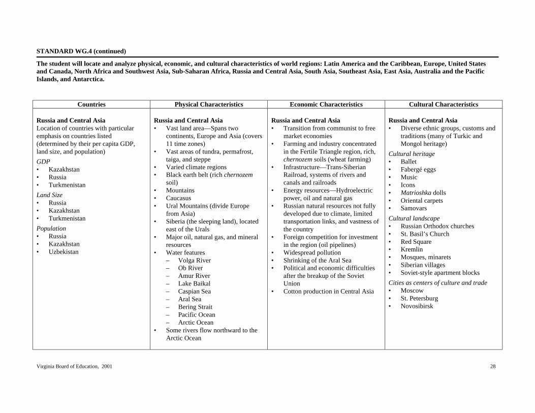
Countries Physical Characteristics Economic Characteristics Cultural Characteristics
Russia and Central AsiaLocation of countries with particularemphasis on countries listed(determined by their per capita GDP,land size, and population)
GDP• Kazakhstan• Russia• Turkmenistan
Land Size• Russia• Kazakhstan• Turkmenistan
Population• Russia• Kazakhstan• Uzbekistan
Russia and Central Asia• Vast land area—Spans two
continents, Europe and Asia (covers11 time zones)
• Vast areas of tundra, permafrost,taiga, and steppe
• Varied climate regions• Black earth belt (rich chernozem
soil)• Mountains• Caucasus• Ural Mountains (divide Europe
from Asia)• Siberia (the sleeping land), located
east of the Urals• Major oil, natural gas, and mineral
resources• Water features
– Volga River– Ob River– Amur River– Lake Baikal– Caspian Sea– Aral Sea– Bering Strait– Pacific Ocean– Arctic Ocean
• Some rivers flow northward to theArctic Ocean
Russia and Central Asia• Transition from communist to free
market economies• Farming and industry concentrated
in the Fertile Triangle region, rich,chernozem soils (wheat farming)
• Infrastructure—Trans-SiberianRailroad, systems of rivers andcanals and railroads
• Energy resources—Hydroelectricpower, oil and natural gas
• Russian natural resources not fullydeveloped due to climate, limitedtransportation links, and vastness ofthe country
• Foreign competition for investmentin the region (oil pipelines)
• Widespread pollution• Shrinking of the Aral Sea• Political and economic difficulties
after the breakup of the SovietUnion
• Cotton production in Central Asia
Russia and Central Asia• Diverse ethnic groups, customs and
traditions (many of Turkic andMongol heritage)
Cultural heritage• Ballet• Fabergé eggs• Music• Icons• Matrioshka dolls• Oriental carpets• Samovars
Cultural landscape• Russian Orthodox churches• St. Basil’s Church• Red Square• Kremlin• Mosques, minarets• Siberian villages• Soviet-style apartment blocks
Cities as centers of culture and trade• Moscow• St. Petersburg• Novosibirsk

Virginia Board of Education, 2001 29
STANDARD WG.4 (continued)
The student will locate and analyze physical, economic, and cultural characteristics of world regions: Latin America and the Caribbean, Europe, United Statesand Canada, North Africa and Southwest Asia, Sub-Saharan Africa, Russia and Central Asia, South Asia, Southeast Asia, East Asia, Australia and the PacificIslands, and Antarctica.
Countries Physical Characteristics Economic Characteristics Cultural Characteristics
South, Southeast, and East AsiaSouth Asia• Afghanistan• Pakistan• Nepal• Bhutan• Bangladesh• India• Sri Lanka
Southeast Asia• Philippines• Indonesia• Malaysia• Thailand• Cambodia• Burma (Myanmar)• Laos• Vietnam• Singapore• Brunei
East Asia• Mongolia• China (People’s Republic of China)• Japan• Taiwan (Republic of China)• North Korea• South Korea
South, Southeast, and East Asia• Influence of mountains—
Population, settlements, movement,climate
• Mountains– Himalayas– Western and Eastern Ghats– Mount Fuji
• Varied climate regions rangingfrom tropical wet to humidcontinental
• Natural hazards—Monsoons,typhoons, volcanoes, andearthquakes
• Influence of water (rivers, seas, andocean currents) on agriculture,trade, and transportation
• Bodies of water– Arabian Sea– Indian Ocean– Bay of Bengal– Ganges River– Indus River– Brahmaputra River– Pacific Ocean– Yangtze River (Chaing Jiang)– Mekong River– Yellow River (Huang He)
South, Southeast, and East Asia• Varied economies in the region
ranging from subsistence/commercial agriculture to high-techindustrial manufacturing
• Participation in global markets• Newly industrialized
countries—South Korea, Taiwan,Singapore
• Japan—Economic leader• China in transition from a centrally
planned economy• Agricultural advancements and
technology, enabling greater foodproduction—“Green Revolution”
• Environmental degradation• Deforestation• Fishing• ASEAN (Association of Southeast
Asian Nations)• Rice, tropical crops
South, Southeast, and East Asia• Areas of extremely dense and
sparse population• Contrast between rural and urban
areas• Religious diversity—Hinduism,
Islam, Buddhism, Christianity,Taoism, Shinto, Confucianism
• Caste system in India• Respect for ancestors• Religious conflicts (Hindu/Muslim)
Cultural heritage• Silks• Batik• Wood and ivory carving• Ideograms, unique alphabets• Jewels
Cities as centers of culture and trade• Tokyo• Beijing• New Delhi

Virginia Board of Education, 2001 30
STANDARD WG.4 (continued)
The student will locate and analyze physical, economic, and cultural characteristics of world regions: Latin America and the Caribbean, Europe, United Statesand Canada, North Africa and Southwest Asia, Sub-Saharan Africa, Russia and Central Asia, South Asia, Southeast Asia, East Asia, Australia and the PacificIslands, and Antarctica.
Countries Physical Characteristics Economic Characteristics Cultural Characteristics
• Abundant arable land• Loess• Plateau of Tibet• Gobi Desert
Cultural landscape• Taj Mahal• Angkor Wat• Great Wall of China• Floating markets• Mosques, minarets• Pagodas• Temples and shrines• Terraced rice fields

Virginia Board of Education, 2001 31
STANDARD WG.4 (continued)
The student will locate and analyze physical, economic, and cultural characteristics of world regions: Latin America and the Caribbean, Europe, United Statesand Canada, North Africa and Southwest Asia, Sub-Saharan Africa, Russia and Central Asia, South Asia, Southeast Asia, East Asia, Australia and the PacificIslands, and Antarctica.
Countries Physical Characteristics Economic Characteristics Cultural Characteristics
Australia, Pacific Islands, andAntarctica• Australia• New Zealand• Papua New Guinea
Australia, Pacific Islands, andAntarctica• Wide range of vegetation, from
tropical rain forests to desert scrub• Australia mostly desert• The Great Dividing Range• The Great Barrier Reef• Australia’s isolation, resulting in
unique animal life• Antarctica, the world’s coldest,
driest, windiest continent; icecap• Pacific islands—Volcanic, coral, or
continental
Australia, Pacific Islands, andAntarctica• Air and water travel that bring
goods and services to remote areas• Dry areas of Australia well suited
to cattle and sheep ranching• Upset of environmental balance,
caused by the introduction of non-native plants and animals
• Ranching, mining (primaryactivities)
Australia, Pacific Islands, andAntarctica• Pacific islands are sparsely
populated.• Most of Australia’s population lives
near the coast.• Traditional culture continues to
shape life in the Pacific islands.• Lifestyles range from subsistence
farming to modern city living.• Cultures reflect the mix of
European and indigenous cultures(e.g., Maori and aborigines).
• Antarctica has no permanentresidents.
Cities as centers of culture and trade• Canberra, A.C.T. (Australian
Capital Territory)• Sydney• Melbourne
Cultural landscape• Sydney Opera House• Cattle and sheep stations
(Australia)• Research stations (Antarctica)• Thatched roof dwelling (Pacific
islands)

Virginia Board of Education, 2001 32
STANDARD WG.5
The student will compare and contrast the distribution, growth rates, and characteristics of human population in terms of settlement patterns and the locationof natural and capital resources.
Essential Understandings Essential Questions Essential Knowledge Essential Skills
Population distribution is describedaccording to location and density.
Characteristics of human populationsdiffer over time and from region toregion.
Population growth rates are influencedby human, environmental, economic,and political factors.
What human, environmental, economic,and political factors influencepopulation distribution?
What are some characteristics of humanpopulations?
How do human, environmental,economic, and political factorsinfluence population growth rates?
Factors that influence populationdistribution• Natural resources (oil, arable land,
water)• Climate (hot/cold; wet/dry)• Economic development• Government policy• Rural/urban settlement• Capital resources (transportation,
technology)• Conflicts (refugees)
Characteristics of human populations• Birth and death rates• Age distribution• Male/female distribution• Life expectancy• Infant mortality• Urban/rural• GDP• Ethnicity• Language• Religion• Education
Compare maps and make inferences.
Identify and interpret regional patternson maps.
Draw conclusions and makegeneralizations about data.
Explain cause and effect relationships.
Interpret charts and graphs.
Interpret population pyramids.
Analyze data to determine patterns.

Virginia Board of Education, 2001 33
STANDARD WG.5 (continued)
The student will compare and contrast the distribution, growth rates, and characteristics of human population in terms of settlement patterns and the locationof natural and capital resources.
Essential Understandings Essential Questions Essential Knowledge Essential Skills
Factors that influence growth rates• Modern medicine and hygiene• Education• Industrialization and urbanization• Economic development• Government policy• Role of women in society

Virginia Board of Education, 2001 34
STANDARD WG.6
The student will analyze past and present trends in human migration and cultural interaction as they are influenced by social, economic, political, andenvironmental factors.
Essential Understandings Essential Questions Essential Knowledge Essential Skills
Migrations occur because of social,political, and environmental factors.
Migrations have influenced culturallandscapes.
Modern transportation andcommunication are encouraging higherlevels of cultural interaction worldwide.
How have social, economic, political,and environmental factors influencedmigration?
How has migration influenced culturallandscapes?
How and why do improvements intransportation and communicationtechnology lead to cultural interaction?
Push factors• Overpopulation• Religious persecution• Lack of job opportunities• Agricultural decline• Conflict• Political persecution• Natural hazards—Droughts, floods,
famines, volcanic eruptions• Limits on personal freedom• Environmental degradation
Pull factors• Religion• Economic opportunity• Land availability• Political freedom• Ethnic and family ties• Arable land
Impact of migrations on regions• Language• Religion and religious freedom• Customs/traditions• Cultural landscape
Identify and interpret regional patternson maps.
Identify primary ideas expressed ingraphic data.
Draw conclusions and makegeneralizations about data.
Explain cause and effect relationships.

Virginia Board of Education, 2001 35
STANDARD WG.6 (continued)
The student will analyze past and present trends in human migration and cultural interaction as they are influenced by social, economic, political, andenvironmental factors.
Essential Understandings Essential Questions Essential Knowledge Essential Skills
Evidence of cultural interaction• Diffusion of U.S. culture to other
regions• Popularization of other cultures’
traditions in the United States

Virginia Board of Education, 2001 36
STANDARD WG.7a
The student will identify natural, human, and capital resources and explain their significance bya) showing patterns of economic activity and land use.
Essential Understandings Essential Questions Essential Knowledge Essential Skills
Natural substances become resources ifand when they become useful tohumans.
The value of resources has changedover time.
Natural, human, and capital resourcesinfluence human activity in regions.
Economic activity can be classified asprimary, secondary, or tertiary.
How do human needs and availabilityof technology affect the value of naturalresources?
How has the value of resources changedover time?
How do natural, human, and capitalresources determine economic activityin regions?
Use of energy resources andtechnology (as it has changed overtime)• Wood (deforestation)• Coal (pollution, mining problems,
competition with oil and gas)• Petroleum (transportation,
environmental considerations)• Nuclear (contamination/waste)• Solar, wind (cost, aesthetics)
Natural resources• Renewable—Soil, water, forests• Nonrenewable—Fossil fuels (oil,
coal, natural gas) and metals (gold,iron, copper, bauxite)
Human resources• Level of education• Skilled and unskilled laborers• Entrepreneurial and managerial
abilities
Capital resources• Availability of money for
investment• Level of infrastructure• Availability and use of tools,
machines, and technologies
Compare maps and globes and makeinferences.
Interpret regional patterns on mapsand globes.
Identify primary ideas expressed ingraphic data.
Gather, classify, and interpretinformation.
Draw conclusions and makegeneralizations about information.

Virginia Board of Education, 2001 37
STANDARD WG.7a (continued)
The student will identify natural, human, and capital resources and explain their significance bya) showing patterns of economic activity and land use.
Essential Understandings Essential Questions Essential Knowledge Essential Skills
Resources are not distributed equally.
The location of resources influenceseconomic activity and patterns of landuse.
What are some examples of primary,secondary, and tertiary economicactivities?
Levels of economic activity• Primary—Dealing directly with
resources (fishing, farming,forestry, mining)
• Secondary—Manufacturing andprocessing (steel mills, automobileassembly, sawmills)
• Tertiary—Services (transportation,retail trade, informationaltechnology services)
Effects of unequal distribution ofresources• Interdependence of nations/trade in
goods, services, and capitalresources
• Uneven economic development• Energy producers and consumers• Imperialism• Conflict over control of resources
Patterns of land use• Proximity of economic activity and
natural resources: coal, steel; grain,cattle; fishing, ocean; hydro-electric power, aluminum smelting
Gather, classify and interpretinformation.
Analyze and evaluate information.
Draw conclusions and makegeneralizations from data.
Explain cause and effect relationships.
Sequence information.

Virginia Board of Education, 2001 38
STANDARD WG.7a (continued)
The student will identify natural, human, and capital resources and explain their significance bya) showing patterns of economic activity and land use.
Essential Understandings Essential Questions Essential Knowledge Essential Skills
• Non-proximity of resources toeconomic activity: Japan—Limitednatural resources, majormanufacturing region; United ArabEmirates (UAE)—Oil, lack ofindustry

Virginia Board of Education, 2001 39
STANDARD WG.7b
The student will identify natural, human, and capital resources and explain their significance byb) evaluating perspectives and consequences regarding the use of resources.
Essential Understandings Essential Questions Essential Knowledge Essential Skills
The use of a resource depends on anation’s culture, values, access totechnology, and governmental prioritiesas they change over time.
How and why do different culturesdevelop different perspectives on theuse of resources?
What are some costs and benefits in theuse of resources?
Social and economic priorities thatinfluence a culture’s perspective onresources• Economic development priorities• Environmental conservation
priorities• Priorities of indigenous minorities
Examples of technologies that havecreated demand for particularresources• Steam engine—Demand for coal• Internal combustion engine (cars
and trucks)—Demand for gasoline(petroleum)
• Computer chips—Demand forskilled labor
Costs• Resource depletion• Environmental degradation• Health problems
Benefits• Production of goods and services• Employment opportunities• Development of technologies
Gather, classify, and interpretinformation.
Draw conclusions and makegeneralizations from data.

Virginia Board of Education, 2001 40
STANDARD WG.8
The student will distinguish between developed and developing countries and relate the level of economic development to the standard of living and quality oflife.
Essential Understandings Essential Questions Essential Knowledge Essential Skills
Levels of economic development varyfrom country to country and from placeto place within countries.
Many criteria are used to assess thestandard of living and quality of life.
Resources and technology influenceeconomic development and quality oflife.
How and why does economicdevelopment vary from one part of theworld to another?
What factors influence the standards ofliving and quality of life?
How do resources and technologyinfluence economic development andquality of life?
Differences between developing anddeveloped nations• Access to natural resources• Access to capital resources
(investment in technology andinfrastructure)
• Numbers and skills of humanresources
• Levels of economic development• Standards of living and quality of
life• Relationships between economic
development and quality of life
Indicators of economic development• Urban/rural ratio• Labor force characteristics
(primary, secondary, tertiarysectors)
• GDP per capita• Educational achievement
Explain charts comparing two or moreconcepts.
Identify primary ideas expressed ingraphic data.
Gather, classify, and interpretinformation.
Draw conclusions and makegeneralizations about data.
Explain cause and effect relationships.
Interpret population pyramids.

Virginia Board of Education, 2001 41
STANDARD WG.8 (continued)
The student will distinguish between developed and developing countries and relate the level of economic development to the standard of living and quality oflife.
Essential Understandings Essential Questions Essential Knowledge Essential Skills
Indicators of standards of living andquality of life• Population growth rate (natural
increase)• Population age distribution• Literacy rate• Life expectancy• Infant mortality• Percentage of urban population

Virginia Board of Education, 2001 42
STANDARD WG.9a
The student will analyze the global patterns and networks of economic interdependence bya) identifying criteria that influence economic activities.
Essential Understandings Essential Questions Essential Knowledge Essential Skills
Resources are not equally distributed.
Economic activities are influenced byavailabiltiy of resources, culturalvalues, economic philosophies, andlevels of supply and demand for goodsand services.
No country has all the resources itneeds to survive and grow.
What are some criteria that influenceeconomic activities?
Criteria that influence economicactivity• Access to human, natural, and
capital resources– Skills of the work force– Natural resources– Access to new technologies– Transportaion and
communication networks– Availability of investment
capital• Location and ability to exchange
goods– Landlocked countries– Coastal and island countries– Proximity to shipping lanes– Access to communication
networks• Membership in political and
economic alliances that provideaccess to markets—e.g., EuropeanUnion (EU), North American FreeTrade Agreement (NAFTA)
Compare maps and globes and makeinferences.
Identify regional patterns on maps andglobes.
Identify primary ideas expressed ingraphic data.
Gather, classify, and interpretinformation.
Explain cause and effect relationships.
Draw conclusions and makegeneralizations about data.

Virginia Board of Education, 2001 43
STANDARD WG.9b
The student will analyze the global patterns and networks of economic interdependence byb) explaining comparative advantage and its relationship to international trade.
Essential Understandings Essential Questions Essential Knowledge Essential Skills
Resources are not distributed equally.
No country has all the resources itneeds to survive and grow.
Nations participate in those economicactivities compatible with their human,natural, and capital resources.
International trade fosters inter-dependence.
What is comparative advantage?
What are the effects of unequaldistribution of resources?
How do nations use their resources toengage in economic activities?
Why do countries engage in trade?
What is the relationship betweencomparative advantage andinternational trade?
Terms to know• Comparative advantage: Countries
will export goods and services thatthey can produce at lower relativecosts than other countries.
Effects of unequal distribution ofresources• Specialization in goods and
services that a country can marketfor profit
• Exchange of goods and services(exporting what a country canmarket for profit; importing what acountry cannot produce profitably)
Some countries’ use of resources• Japan—Highly industrial nation
despite limited natural resources• Russia—Numerous resources,
many of which are noteconomically profitable to develop
• United States—Diversifiedeconomy, abundant naturalresources, specialized industries
• Côte d’Ivoire—Limited naturalresources, cash crops in exchangefor manufactured goods
• Switzerland—Limited naturalresources, production of serviceson a global scale
Compare maps and globes and makeinferences.
Identify regional patterns on maps andglobes.
Identify primary ideas expressed ingraphic data.
Gather, classify, and interpretinformation.
Explain cause and effect relationships.
Draw conclusions and makegeneralizations about data.

Virginia Board of Education, 2001 44
STANDARD WG.9b (continued)
The student will analyze the global patterns and networks of economic interdependence byb) explaining comparative advantage and its relationship to international trade.
Essential Understandings Essential Questions Essential Knowledge Essential Skills
Reasons why countries engage intrade• To import goods and services that
they need• To export goods and services that
they can market for profit
Effects of comparative advantage oninternational trade• Enables nations to produce goods
and services that they can marketfor profit
• Influences development ofindustries (e.g., steel, aircraft,automobile, clothing)
• Supports specialization andefficient use of human resources

Virginia Board of Education, 2001 45
STANDARD WG.9c
The student will analyze the global patterns and networks of economic interdependence byc) describing ways that economic and social interactions have changed over time.
Essential Understandings Essential Questions Essential Knowledge Essential Skills
Economic, social, and therefore spatialrelationships change over time.
Improvements in transportation andcommunication have promotedglobalization.
How have economic and socialinteractions changed over time?
How do spatial patterns reflecteconomic and social change over time?
How have improvements intransportation and communicationpromoted globalization?
Changes over time• Industrial labor systems (e.g.,
cottage industry, factory, office,telecommunications)
• Migration from rural to urban areas• Industrialized countries export
labor-intensive work to developingnations
• Growth of trade alliances• Growth of service (tertiary)
industries• Growth of financial services
networks and international banks• Internationalization of product
assembly (e.g., vehicles, electronicequipment)
• Technology that allows instantcommunication among people indifferent countries
• Modern transportation networksthat allow rapid and efficientexchange of goods and materials(e.g., Federal Express, UnitedParcel Service, U. S. PostalService)
• Widespread marketing of products(e.g., Fuji film, Nike, UnitedColors of Benetton)
Compare maps and globes and makeinferences.
Identify regional patterns on maps andglobes.
Identify primary ideas expressed ingraphic data.
Gather, classify, and interpretinformation.
Explain cause and effect relationships.
Draw conclusions and makegeneralizations about data.

Virginia Board of Education, 2001 46
STANDARD WG.9d
The student will analyze the global patterns and networks of economic interdependence byd) describing and evaluating the formation of economic unions.
Essential Understandings Essential Questions Essential Knowledge Essential Skills
As a global society, the world isincreasingly interdependent.
Economic interdependence fosters theformation of economic unions.
What are some examples of economicunions?
What are the advantages anddisadvantages of economic unions?
Examples of economic unions• EU—European Union• NAFTA—North American Free
Trade Agreement• ASEAN—Association of Southeast
Asian Nations• OPEC—Organization of Petroleum
Exporting Countries
Advantages of economic unions• More efficient industries• Access to larger markets• Access to natural, human, and
capital resources withoutrestrictions
• Greater influence on world market
Disadvantages of economic unions• Closing of some industries• Concentration of some industries in
certain countries, leavingperipheral areas behind
• Agribusiness replacing familyfarms
• Difficulty in agreeing on commoneconomic policies
Compare maps and globes and makeinferences.
Identify regional patterns on maps andglobes.
Identify primary ideas expressed ingraphic data.
Gather, classify, and interpretinformation.
Explain cause and effect relationships.
Draw conclusions and makegeneralizations about data.

Virginia Board of Education, 2001 47
STANDARD WG.10a
The student will analyze how the forces of conflict and cooperation affect the division and control of the Earth’s surface bya) explaining and analyzing reasons for the different spatial divisions at the local and regional levels.
Essential Understandings Essential Questions Essential Knowledge Essential Skills
Divisions are regions of the Earth’ssurface over which groups of peopleestablish social, economic, and politicalcontrol.
Spatial divisions may generate conflict.
Spatial divisions may generatecooperation.
What are some examples of spatialdivisions at the local and regionallevels?
What are some reasons for spatialdivisions at the local and regionallevels?
How do spatial divisions generateconflict?
Why do spatial divisions cooperate?
Examples of spatial divisions• Neighborhoods• Election districts• School districts• Regional districts (e.g., bus lines,
waste disposal, conservationdistricts, planning districts, areacode zones)
• Cities• Counties• States
Reasons for spatial divisions• Desire for government closer to
home• Need to solve local problems• Need to administer resources more
efficiently
Reasons for conflict• Boundary disputes• Cultural differences• Economic differences• Competition for scarce resources• Political advantages (e.g.,
gerrymandering)
Compare maps and make inferences.
Identify regional patterns.
Gather, classify, and interpretinformation.
Explain cause and effect relationships.
Draw conclusions and makegeneralizations about data.
Participate in problem solving.

Virginia Board of Education, 2001 48
STANDARD WG.10a (continued)
The student will analyze how the forces of conflict and cooperation affect the division and control of the Earth’s surface bya) explaining and analyzing reasons for the different spatial divisions at the local and regional levels.
Essential Understandings Essential Questions Essential Knowledge Essential Skills
Reasons for cooperation• Natural disasters• Economic advantages (attract new
businesses)• Cultural similarities, ethnic
neighborhoods• Addressing regional issues (e.g.,
waste management, magnetschools, transportation)

Virginia Board of Education, 2001 49
STANDARD WG.10b, c
The student will analyze how the forces of conflict and cooperation affect the division and control of the Earth’s surface by b) explaining and analyzing reasons for the different spatial divisions at the national and international levels; c) analyzing ways cooperation occurs to solve problems and settle disputes.
Essential Understandings Essential Questions Essential Knowledge Essential Skills Divisions are regions of the Earth’s surface over which groups of people establish social, economic, and political control. Spatial divisions may generate conflict. Cooperation may eliminate the need for the division and control of the Earth’s surface.
What are some examples of spatial divisions at the national and international levels? What are some reasons for spatial divisions at the local and regional levels? How do spatial divisions generate conflict? How do spatial divisions cooperate to solve problems and settle disputes?
Examples of spatial divisions • Countries • Alliances: economic and political
– North Atlantic Treaty Organization (NATO)
– European Union (EU) – Organization of Petroleum
Exporting Countries (OPEC) – North American Free Trade
Agreement (NAFTA) – Commonwealth of Nations – United Nations – Red Cross/Red Crescent – Organization of American
States (OAS) – League of Arab States – Association of Southeast
Asian Nations (ASEAN) – African Union (AU)
Reasons for spatial divisions • Differences in culture, language,
religion • Retention of historical boundaries • Imperial conquest and control • Economic similarities and
differences
Compare maps and make inferences. Identify regional patterns. Gather, classify, and interpret information. Explain cause and effect relationships. Draw conclusions and make generalizations about data. Participate in problem solving.

Virginia Board of Education, 2001 50
STANDARD WG.10b, c (continued)
The student will analyze how the forces of conflict and cooperation affect the division and control of the Earth’s surface byb) explaining and analyzing reasons for the different spatial divisions at the national and international levels;c) analyzing ways cooperation occurs to solve problems and settle disputes.
Essential Understandings Essential Questions Essential Knowledge Essential Skills
Reasons for conflict• Boundary and territorial disputes
(Syria/Israel, WesternSahara/Morocco, China/Taiwan,India/Pakistan, Iraq/Kuwait)
• Cultural differences (language,religion)– Indonesia– Canada (Quebec)– Ireland– Sudan
• Economic differences (fertile land,access to fresh water, access tocoast, fishing rights, naturalresources, different economicphilosophies)
• Ethnic differences– Balkans– Cyprus– Rwanda and Burundi– Kashmir
• Nationalism

Virginia Board of Education, 2001 51
STANDARD WG.10b, c (continued)
The student will analyze how the forces of conflict and cooperation affect the division and control of the Earth’s surface byb) explaining and analyzing the different spatial divisions at the national and international levels.c) analyzing ways cooperation occurs to solve problems and settle disputes.
Essential Understandings Essential Questions Essential Knowledge Essential Skills
Examples of cooperation• Humanitarian initiatives—e.g., Red
Cross/Red Crescent• Economic alliances—e.g., Law of
Sea, China and United States,multinational corporations, NorthAmerican Free Trade Agreement(NAFTA), Organization ofPetroleum Exporting Countries(OPEC)
• Cultural alliances—e.g.,Francophone world,Commonwealth of Nations
• Military alliances—e.g., NorthAtlantic Treaty Organization(NATO)
• Problem-solving alliances—e.g.,Antarctica Treaty, United Nations(UN) peacekeepers
• Programs to promote internationalunderstanding—e.g., Peace Corps
• Alliances for environmentalpreservation
• Foreign aid

Virginia Board of Education, 2001 52
STANDARD WG.11a
The student will analyze the patterns of urban development bya) applying the concepts of site and situation to major cities in each region.
Essential Understandings Essential Questions Essential Knowledge Essential Skills
Site and situation are importantgeographic concepts when studying thegrowth of cities.
Patterns of urban development occuraccording to site and situation.
What is meant by site?
What is meant by situation?
In what ways may site and/or situationaffect urban development?
Site is the actual location of a city.
Examples of site (localcharacteristics)• Harbor sites: New York City;
Alexandria, Egypt; Istanbul,Turkey
• Island sites: Paris (originallylocated on an island in the SeineRiver), Hong Kong, Singapore
• Fall line sites: Richmond, Virginia• Confluence sites: Khartoum,
Sudan; Pittsburgh, Pennsylvania• Hilltop sites: Rome, Athens,
Jerusalem• Oasis sites: Damascus, Syria• Sites where rivers narrow: London,
Quebec City
Situation is another name for relativelocation—the location of a city withrespect to other geographic features,regions, resources, and transport routes.
Examples of situation (regional/global connections)• Baghdad—Command of land
between the Tigris and Euphratesrivers
Gather, classify, and interpretinformation.
Draw conclusions and makegeneralizations about information.
Explain cause and effect relationships.
Identify and interpret regional patternson maps.
Locate area on maps and globes.
Sequence events.

Virginia Board of Education, 2001 53
STANDARD WG.11a (continued)
The student will analyze the patterns of urban development bya) applying the concepts of site and situation to major cities in each region.
Essential Understandings Essential Questions Essential Knowledge Essential Skills
• Istanbul—Command of straits andland bridge to Europe
• Mecca, Saudi Arabia; Varanasi(Benares), India—Focal point ofpilgrimage
• Samarkand, Uzbekistan; Xi’an,China; Timbuktu, Mali;Singapore—Cities that grew uparound trade routes (the Silk Road;Trans-Sahara trade; maritime trade)
• Capetown, South Africa—Supplystation for ships
• Omaha, Nebraska; Sacramento,California—Cities that grew upalong the U.S. TranscontinentalRailroad
• Novosibirsk, Vladivostok—Citiesthat grew up along the Trans-Siberian Railroad

Virginia Board of Education, 2001 54
STANDARD WG.11b
The student will analyze the patterns of urban development byb) explaining how the functions of towns and cities have changed over time.
Essential Understandings Essential Questions Essential Knowledge Essential Skills
The functions of towns and citieschange over time.
What are the functions of towns andcities?
How have functions of towns and citieschanged over time?
Functions of towns and cities• Security, defense• Religious centers• Trade centers (local and long
distance)• Government administration• Manufacturing centers• Service centers
Examples of changes in cities’functions over time• Rio de Janeiro—Move of Brazil’s
capital city from Rio de Janeiro toBrasilia
• Pittsburgh, Pennsylvania—Earlyfunction connected to defense, thenbecame steel manufacturing center,later shifted to diverse services(financial, light manufacturing)
• New York City—Changes in tradepatterns, coastal and transatlantictrade, trade from Great Lakes viaErie Canal, worldwide trade andfinances
• Mining towns, “ghost”towns—Resource depletion,changes in the environment
Gather, classify, and interpretinformation.
Draw conclusions and makegeneralizations about information.
Explain cause and effect relationships.
Identify and interpret regional patternson maps.
Locate places on maps and globes.

Virginia Board of Education, 2001 55
STANDARD WG.11c
The student will analyze the patterns of urban development byc) describing the unique influence of urban areas and some challenges they face.
Essential Understandings Essential Questions Essential Knowledge Essential Skills
Urban populations exercise a powerfulinfluence in shaping the world’scultural, political, and economic ideasand systems.
Urban development may lead toproblems related to human mobility,social structure, and the environment.
How do urban areas influence theworld’s cultural, political, andeconomic ideas and systems?
What are some urban problems thatmay occur as a result of development?
Influences of urban areas on theirregions and countries• Nation-building (monuments,
symbols)• Transportation/communication
hubs• Magnets for migration• Seed beds of new ideas and
technologies• Diversity, leading to creativity in
the arts• Universities, educational
opportunities• Corporate headquarters/regional
offices• Media centers (news,
entertainment)
Problems associated with growth ofurban areas• Transportation problems emerge,
especially as automobile travelincreases.
• Rich and poor neighborhoods existin different areas isolated from oneanother.
Gather, classify, and interpretinformation.
Draw conclusions and makegeneralizations about data.
Explain cause and effect relationships.
Identify and interpret regional patternson maps.
Locate places on maps and globes.

Virginia Board of Education, 2001 56
STANDARD WG.11c (continued)
The student will analyze the patterns of urban development byc) describing the unique influence of urban areas and some challenges they face.
Essential Understandings Essential Questions Essential Knowledge Essential Skills
• Providing essential services (freshwater, sewage, disposal, electricity,schools, clinics) becomes aproblem.
• Air, water, and noise pollutionincrease.
• Sprawl results in conversion ofagricultural land to urban uses,especially in North America.
• Rapid immigration results in“shantytowns” on the edges ofcities in Latin America, Africa, andAsia.
• In developing countries, majorcities are more connected toregions outside the country than toregions within the country.

Virginia Board of Education, 2001 57
STANDARD WG.l2a
The student will apply geography to interpret the past, understand the present, and plan for the future bya) using geographic knowledge, skills, and perspectives to analyze problems and make decisions.
Essential Understandings Essential Questions Essential Knowledge Essential Skills
An understanding of the practicalapplications of geography enablesstudents to be informed, active citizensin their communities.
What are some practical applications ofgeography?
Geographic applications at local andregional levels• Recycling programs• Conversion of land from
agricultural use• Water sources (e.g., dams,
reservoirs, wells, pipelines, ocean)• Airport expansion• Air quality• Boundaries (e.g., school zones)• Bicycle paths• Mass transit• City planning and zoning laws• Energy use• Location and size of public
buildings (e.g., schools, recreationcenters, hospitals, and libraries)
• Selection of locations for newstores and businesses
Organize and interpret information.
Use maps and other geographicresources to obtain information anddraw conclusions.
Participate in problem solving anddecision making.

Virginia Board of Education, 2001 58
STANDARD WG.12b
The student will apply geography to interpret the past, understand the present, and plan for the future byb) relating current events to the physical and human characteristics of places and regions.
Essential Understandings Essential Questions Essential Knowledge Essential Skills
Current events are shaped by thephysical and human characteristics ofthe places and regions where theyoccur.
How are current events connected to thegeographical characteristics of placesand regions?
Geographic relationships• How physical characteristics
influence current events– Natural hazards (e.g, flooding,
earthquakes, volcanoes,drought)
– Climate, vegetation• How human characteristics
influence current events– Population distribution– Geographic patterns of ethnic
diversity– A sense of place (emotional
attachment to specificlocations)
– Geographic patterns of tradeand interdependence (e.g., oil)
– Geographic patterns of wealthand poverty (developed anddeveloping nations)
Compare maps and make inferences.
Identify and interpret regional patternson maps.
Identify primary ideas expressed ingraphic data.
Gather, classify, and interpretinformation.
Draw conclusions and makegeneralizations about data.
Examine cause and effectrelationships.