Works Plans - rampion2.com
22
Works Plans
Transcript of Works Plans - rampion2.com

Works Plans

1 © Wood Group UK Limited
Rampion 2 PEIR. Works Plans
Contents
Offshore Works Plan Onshore Works Plan

Cab le rou te
670000 680000 690000 700000
5600
000
5610
000
5620
000
5630
000
Key
Rampion 2 Offshore Wind Farm
Rampion Extension Development Limited
Company: Drawn By: Chk/Aprvd: Drawn Date: Status:06-Jul-21 REVIEWNAGLESMILLIIWOOD
42285-WOOD-PE-OF-PN-MD-0001
Offshore Works Plan
System Identifier:
Document uncontrolled when printed ISO A3 Landscape
Version:3.0
PEIR AssessmentArray areaExport cable area
0 1.5 3 4.5 6Kilometres
1:146,798WGS 1984 UTM Zone 30N Transverse Mercator
Service Layer Credits: Contains OS data © Crown Copyright anddatabase right 2020© British Crown and OceanWise, 2021. All rights reserved. LicenseNo. EMS-EK001-643956. Not to be used for Navigation.
NOTE:Due to scaling, some narrow areas (i.e. existingtracks) within the red line boundary mayappear as a single/solid red line on the map.

2
3
4
5
6
7
8
910
11
12
13
14
15
16 17
18
1
500000 505000 510000 515000 520000 525000
1000
0010
5000
1100
0011
5000
1200
00
Key
Rampion 2 Offshore Wind Farm
Rampion Extension Development Limited
Company: Drawn By: Chk/Aprvd: Drawn Date: Status:07-Jul-21 REVIEWNAGLESMILLIIWOOD
42285-WOOD-PE-ON-PN-MD-0004
Onshore Works PlanIndex Map
System Identifier:
Document uncontrolled when printed ISO A3 Landscape
Version:4.0
PEIR Assessment Boundary
Map Sheet Number
0 1 2 3 4
Kilometres
1:90,103British National Grid Transverse Mercator
Service Layer Credits: Contains OS data © Crown Copyright anddatabase right 2020© Crown copyright and database rights 2020 Ordnance Survey0100031673
NOTE:Due to scaling, some narrow areas (i.e. existingtracks) within the red line boundary may appear as asingle/solid red line on the map.Multiple corridor options are shown in the vicinity ofCrossbush and the existing National Grid BolneySubstation. Further information regarding these isprovided in the Rampion 2 PEIR, Volume 2, Chapter 4:The Proposed Development.

of Posts
E
Church Farm
Old Forge
6.0m
CHURCH LANE
Church Barn
Waggoners
Flettons
Field Place
Silver Birch
The
East
The
Laurels
Cottages
E
Church Farm
HORSEMERE GRE
EN LANE
4.8mG1
Church Farm House
LB
Elms Paddock
Barn
Church Farm House
Climping
G5
Lych
West
2 1
Church Farm
Hobbitts
The Barn
Padang
Gate
4.5m
108
12
WATERFORD GARDENS
27
14
9
5
10
CROPTHORNE DR
12
22
29
1
26
23
15
17
18 20
1
2
The Hamlet
21
19
1715
14
18
Church House
Cottage
LBs
Line
Church Farm
Play Area
Sewage Ppg Sta
Allotm entGarde ns
EstateIndustria l
El Sub Sta
El SubSta
Drain
Drain
Drain
1843
104
14
64
48
50
23
6
31
41
34
13
39
2
1b
1a1
105
Track
10
59
TCB
LB24
Recreation Ground
Groyne
Mean Low Water
Sand and S
hingle
Groyne
Groyne
Sand
Groyne
2.9m
Groyne
Groyne
Mean High W
ater
Shingle
FB
The Bo at Ho use
Slu ic e
St a t ion Slo ping Ma so nry
Dr a in
Slo ping ma so nry
Ca r P ar k
A 2 5
9
Slo ping ma so nry
Slo ping ma so nry
FE R RY R O
A D
Fil lin g
Fl o at in g La n d ing S t a ge
Rye ba nk Rif e
Dr a in
Po n d
Slipw ay
Slu ic e
Bol lar ds
A 259
Dra in
Dra in
2b
1
3
2a
Marina O ffice
MLW
Mud
Def
CS
Und
ED & War d B dy
CS
Def
Def
Pat h (um)
Mea n High Wa ter
Lan ding S tag es
Wha rf
Bo a t En c lo s u r e
SM
6
1
18
FB
19
FB
FB
25
24
Ma r in a V ie w
FB
12
MLW
River Arun
Me a n Hig h Wa t e r
SMDra in
Drain
Drain
Dr a in
Out fa ll
Out fa ll
Mu d
Tan k
Dra in
Dra in
73
103
29
85
84
95
30
97
28
76
79
81
83
90
88
58
65
82
51
96
86
74
91
78
56Clim
ping Pa
rk
C1
D1
FB
SL
B1
B2A1C3
A2
C2
El
B3
D2
D3
Sub D4Sta
E
H
Dra in
N7
N8
N9
N10N1
1
J
15
SM
Dra inDra i
n
Industrial Estate
Slu ic e
El Sub S ta
M1
Riverside
N5
10
R1
M2
L4
Hop pe rs
A3
P6
N2 U1 U2
N1
R6
M3
L1
N6
K
14
18
W
U3 to
6
S
V
19
El Sub S ta
P1to
SM
Slo ping ma so nry
M4
Dra in
BRID
G E R
O AD
El Sub S ta
El Sub S ta
Con ve yor
Filte r Bed s
Slo ping ma so nry
QU A Y S ID E
M5
Fo r s t er s Y ar d
SM
FB
Mud
Mud
Mud
CR
CR
ED &
War
d B d
y
Tra ck
Mea n High Wa ter
Wo r k s
Tan ks
Con ve yor s
Tra ve lling Cr an es
WB
WB
TCB
LB
LC
Slo ping ma so nry
Hop pe rs
Tan k
Shelter
J3
G11
FB
19
15
8
N
8
20
L
M
G
26
U1
T1
El Sub Sta
6
E6
El Sub Sta
2
G
4 M1
9
11
30
1
MAY CLOSE
17
1
1412
18
4
22
21
The Hamlet10
9
12
The Beaches
4
8
23
Telecottage
D1D6
17b17
17a
DEF
Def
E1
G
14
Travelling
Pond
WB
7
5.5m
Pond
j1 j2
K
Crane
Play Area
Shelter
Pond
CLIMPING STREETPond
Old Pound
4.6m
The Cottage
Drain
Beech Wood Lodge
FB
Moat
21
Cottages
Track
Drain Ryebank Rife
Drain
Cottages2
The Wel l House
Track
Drain
4.8m
Mead Cottage
Drain
4.4m
LB
1
TCB
3
Rose Cottages
CLIMPING STREET
Cottages
New Thatched
Ryebank
Black Horse
Dove Cottage
The Bung
alow
1
Pond
Path (um)
2
1
Spring Cottage
Path (um)
FB
Sewage Works
(PH)
Pump House
The Black Horse
Drain
White Cottage
BREAD LANE (TRACK)
ClimpingCamp Site
GableCottage
CROOKTHORN L
ANE
A 259
5.5m
2 CottsHobbs
1
LANGME
AD CL
6
1
C of ESt Mary's
Primary School
Hobb's FarmPiggeryThe Old
Redcot
ManorBarn End
Brookpits
East Barn
Shelter
Kents Barn
Drain
Pond 4.0m
4.3m
4.0m
Kent's Farm
3
CROOKTHORN LANE
Sadlers Cottage
21to
Lower Dairy Barn
Kent'sYardAmber ley Cour t
Cottages
The Dairy
Kents
The H ayloft
Play Area
BROOKPIT LANE
CottageBrookpits
Crookthorn Byre
Track
Kents Cottage
Clymping Vi llage Hal l
Ryeb
ank
Rife
1.8m
Drain
Drain
Drain
1.5mDrain
FERRY ROAD
Path (um
)
Def
CD
CD
ED & Ward Bdy
Drain
Drain
FB
FB
Track
A 259
2.4m
Drain
Drain
Shelter
Drain
Drain
Pond
Path (um)
4.2m
Drain
Path
Sand and Shingle
The Mill
Sand
Stone
Groyne
Mill Cottage
FB
Def
Def
Def
FW
FW
CD
FW
FF
Und
Path (um)
Drain
Mean High Water
Shingle
Moat
Moat
Drain
Groyne
Drain
3.6m
Pond
Groyne
Pond
Groyne
Sluice
Moat
Chapel
2.9m
Sand and S
hingle
4.7m
Pond
Drain
CLIMPING STREET
Tennis Court
Mean L
ow Wa
ter
2.6m
Ponds
Groyne
Atherington Farm
Pond
Groyne
Groyne
Sand
Groyne
Water
Sand
Drain
Groyne
Sand
Drain
2
GroyneSand and S
hingle
Sand and
Shingle
Sand and S
hingle
Groyne
Sand
3.3m
Bailiffscourt
Sand
Atherington
Sand and
Shingle
Sand and
Shingle
Sand and
Shingle
and Shing
le
Sand
Groyne
Cottages
Groyne
Path (um)
Atherington
Hotel
5.5m
Drain
Lodge1
Shingle
El Sub Sta
Sand and
Shingle
Track
Reservoir
Car Park
3.3m
PCs
FourteenAcre Barn
Atherington
4.9m
4.7m
1 to 8
Fo r s t er s Y ar d
20
22
St a t ion
a1 to
a3
Foo tb ridg e
War d Bdy
Mo de r n
M ou ld
s
Bu sin es
s Ce nt
r e
Silo
Tan k
Ga s H ol d er
LC
Bol lar ds
MLW
Boat Enclosur e
WharfMoo ring P ost s
Littleham pton Marin a
El Sub S ta
B1 to B
3 D1
Ha r w o od C e nt r e
C1 to C 7
Wor ks
Dr a in
Mud
MP 6 1 .75
Wor ks
78
Sl o pin g M as o n r y
Dr a in
MP s
BR ID G E R O A D
Wor ks
MP s
El Su b
S ta
MP
Dr a in
DW
71
Wick h a
m Bu sin
e s s C e
n t re
7 to 13
El Sub S ta
1 to 5
Wharf
Def
MHWS
MLWS
Works No. 9
Works No. 5
Works No. 8a
Works No. 9
WorksNo. 9
WorksNo. 8b
WorksNo. 9
Works No. 9
Works No. 6
WorksNo. 7Works No. 9
Works No. 8b
Works No.9 & 10
Works No. 9
Works No. 9
Works No. 5 Works No. 4
WorksNo. 7
WorksNo. 6
WorksNo. 7
500000 500500 501000 501500 502000
1010
0010
1500
1020
0010
2500 Key
Rampion 2 Offshore Wind Farm
Rampion Extension Development Limited
Company: Drawn By: Chk/Aprvd: Drawn Date: Status:07-Jul-21 REVIEWNAGLESMILLIIWOOD
42285-WOOD-PE-ON-PN-MD-0004
Onshore Works PlanPage 1 of 18
System Identifier:
Document uncontrolled when printed ISO A3 Landscape
Version:4.0
0 0.1 0.2 0.3 0.4
Kilometres
1:7,500British National Grid Transverse Mercator
Contains OS data © Crown Copyright and database right 20200100031673
NOTES:Due to scaling, some narrow areas (i.e. existingtracks) within the red line boundary may appear as asingle/solid red line on the map.Final plans will be scaled no smaller than 1:2500
Temporary Cable Construction Corridor
Limits of Deviation of Works Nos. 6, 7 &12
Temporary Construction Access Limitsof Deviation of Works No. 9
Temporary Construction andOperational Access Limits of Deviationof Works No. 9
Temporary Light Construction andOperational Access Limits of Deviation
of Works No. 9
Temporary Light Construction AccessLimits of Deviation of Works No. 9
Temporary Landfall ConstructionCompound Limits of Deviation of WorksNo. 9
Temporary Cable ConstructionCompound Options Limits of Deviationof Works Nos. 8a, 11a, 11b & 11c
Temporary Soil Storage Limits ofDeviation of Works No. 8b

3
Drain
Drain
SP
Path (um)
Drain
Pond
Mean High
Water
Drain
Sloping masonry
Drain
SP
Sluice
Slop
ing
maso
nry
MoP2.0m
MP 60.5
Drain
Pond
Drain
Sl ipwayPo
ntoo
ns
MoP
Drain
Sluice
Drain
Drain
Mud
Marina
Pond
MLW
MLW
SM
Mud
DefED & Ward Bdy
Track
FB
FB
Boat Park
Ship & Anchor(PH)
Drain
Drain
River Arun
Mean
High Wat
er
Sluice
Mean
High Wat
er
Bou lders
Boulders
FORD ROAD
of Posts
E
Church Farm
Old Forge
6.0m
HM Prison
CHURCH LANE
Church Barn
Waggoners
Flettons
Silver Birch
The
East
The
Laurels
3.4m
Cottages
E
Church Farm
HORSEMERE GRE
EN LANE
4.8mG1
Church Farm House
LB
Elms Paddock
Barn
Hal l
Church Farm House
G5
5.2m
Lych
West
2 1
Church Farm
Hobbitts
St Mary's Church
The Barn
Padang
Gate
4.5m
108
27
29
1
H21
CR
CF
Ponds
Church House
Cottage
LBs
Line
Church Farm
FSs
Sewage Ppg Sta
ESS
Track
Allotm entGarde ns
Und
Rudford
EstateIndustria l
Vincent Cottage
ESS
El Sub Sta
Track
Pond
Drain
Drain
Track
Drain
Outfall
Sluice
Drain
Drain
Drain
Track
Track
Mud
CR
ED & Ward Bdy
Und
Track
Und
ArunRiver
Mean H
igh Wa
ter
Mean High WaterSloping mas
onry
Slo ping ma so nry
A 2 5
9
Slo ping ma so nry
Bol lar ds
Dra in
MLW
Def
Pat h (um)
Mea n High Wa ter
Wha rfSM
FB
River Arun
Mu d
Tan k20
Dra in
Dra in
Dra in
Slo ping ma so nry
C1
D1
FB
Pa t h (u m )
LI N E SID E W
AY
Winch
El Sub S ta
13 4
AR N D A LE R O AD
199
13 2
193
2.1 m
El Sub S t
a
MP 61 .5
SL
B1
EL DO N
WA Y
2
3
AR ND A L
E RO AD
5.2 m
4
1
El Sub S ta
B2
El Sub S ta
A1C3A2
C2
El
B3
D2
D3
Sub D4Sta
E
H
Dra in
Slo ping ma so nry
5a
N7
N8
4
N9
N10
50
N11
5
J
A 2 5 9
5c
910
15
17
5d
51
6a
23
24
19
14
15 to 16
12
12a
Dra in
11d
Sup er sto re
11a
32
Sloping
ma sonry
6f
BRO A
D P IE C
E
BR ID G E R O A D
Su p e r st o r e
Filling S tat ion
26
Su p e r st o r e
SM
Dra inDra i
n
Tra ck
Industrial Estate
Slu ic e
El Sub S ta
M1
Riverside
N5
10
R1
M2
L4
Hop pe rs
A3
P6
N2 U1 U2
N1
R6
M3
L1
N6
K
14
18
W
U3 to
6
S
V
19
El Sub S ta
P1to
SM
Slo ping ma so nry
M4
Dra in
BRID
G E R
O AD
El Sub S ta
El Sub S ta
Con ve yor
Filte r Bed s
Slo ping ma so nry
QU A Y S ID E
M5
Fo r s t er s Y ar d
SM
FB
LA TH A
M CL O
SE
1
2
10
9
15
19
10
AR N D A LE R O AD
P
I
A
H
Mud
Mud
Mud
Mud
Mud
14
CR
CR
ED &
War
d B d
y
Q
L
D
Tra ck
Mea n High Wa ter
War d B dy
ED Bd y
CR
FB
Wo r k s
Tan ks
Con ve yor s
Tra ve lling Cr an es
SL
Pum ping S tat ion
Retail Pa rk
River A
run
WB
WB
MHW
Mea n High Wa ter
MHW
Mean
High W
ater
MHW
Mea n High Wa ter
Cycle Ra cing F acil ity
2.7 m
TCB
Dr a in
Slipw ay
LB
LC
Slo ping ma so nry
Hop pe rs
Tan k
Carriage Shed
Shelter
8
6
E6
G
Mooring
Posts
Mud
Sloping masonry
SP
Mud
Drain
MP 60.25
Sluice
MP 19.25
Path (um
)
Sloping masonry
1.7m
SP
DrainMP 19.5
Watermeadows
1.4m
Mud
SP
Drain
SM
SM
Drain
MLW
MLW
13 14
5
4
26
8
24
25
10
21
1
2322
3537
18
15
16
1112
Def
CCLW
ED & War
d Bdy
9
Pond
Sluice
River Arun
Waterbury House
Mean High
Water
Mean Hig
h Water
Depot
Glenvilla
ESS
62
70
The Bungalow
Old Mead House
41
63
33
65
41
55
67
55
63A
64
75
3
35
51
Marina House
27
15
4
30
55A
59
1
5
10
37
71
57
11
12
1
51
2
61
14
26
20
57A
24
86
20
12a
19
TorriNursery
Torri House
KINGSMEAD
WALTERS GREEN
1 205
201
MP 61 .25
31
SL
30
29
Pla y A re a
Ba l an c in gPo n d
Spo rt s C ou rt
SubEl
Sta
Dra in
Drain
Jun ct io n
SP
Litt leh amp to n
SP
Sloping masonry
Dra in
Dra in
Drain
MP 60.75
3.4m
MP 19.2 5
Out fa llMea n High Wa ter
Po n d
100
25
59
62
Dra in
Dra in
1.8m
2.4m
Tra ck
Dra in
Drain
23
2
39
Def
19
CO L E RID G E
Spry C ourt
1
CRE S
C EN T
HE NR Y
L OC K
WA Y
Ba l an c in gPo n d
1 to 12
2
2
4850
38
1
3
WIL C O X W A Y
OCK E N DE N R OA D
2
1511
16
1
17
4
1
11
15
5
19
29
4
2
16
3
31
18
51
30
1
61
41
9
14
5
21
Level Cross in g
ESS
2
ST A N F OR D A CR E
RA N D A LL W A Y
Pepper Pot Court
25
2
Isem onger Cour t1 to 12
BLACKBO
URNE
CHASE
THOMPSO
N GRO
VE
12
43
11
31
22
30
Ba l an c in gPo n d
15
33
1 to 12
1119
20
10
1
BEN J A MIN G RA Y D R IVE
BA T T IN L A N E
ETH E
R IN G
T ON P L
A CE
21
7
1511
23
5
1
5
28
2
10
1
1
32
Pla y A re a
22
10
53
2
2
31
3
1
15
11
39
2
1218
12
5
21
15
20
14
21
2412
2
BO N IF AC E
AV E N UE
PE N G E LL Y G AR D E N S
16
20
1
MU R R A Y R IS E
SILV E ST
E R ME A
D
15
8
22
15
1
19
28
11
24
41
28
32
12
10
1
27
3
26
26
2
2
51
1
25
11
UP P E R TO N G RO
V E
40
1 9
22
Sewage Ppg Sta
Pla y A re a
Ba l an c in g P o n d
AreaPla y
MP 61 .0
84
20
86
Outdo or Ac tivity Cent re
80
1 to 4
9
18
24
12
8
1
15
1
2
70
26
23
11
5CH
A LL E
N VA L
E
59
1
11
15
6
PEA C
H EY
WA Y
432
10
2
1
SL IND ON
W A LK
123
2 Pon d
ESS
1 to 5
MILLA RD G R OVE
88
Al lo t m en t G ar d e n s
Pla y A re a
CO U R T W IC K L A N E
Bal anc ing
16
GR O V E
Pla y
WIL L IAM D Y ER
Area
FIT C H ESER N E S T WA Y
CCL W
ED & War d B dy
Slo ping ma so nry
Slu ic es
ELD O
N WA Y
Mud
2.4m
Dra in
SL
Dra in
Pat h (u m)
Slo ping ma so nry
Tra ck
MLW
Slu ic e
ED Bdy
Slu ic e
Pla y A re a Pla y A re a
Ba l an c in gPo n d
Rive r A ru n
99b99a
Mea n High Wa ter
Mea n High Wa ter
Facil itySport s
FB
6
1
61
81
15 8
Estate
215
7
21
El s pr in g Me a d
Chilg r o v e H o u s e
76
14 4
16
104
71
A 2 59
72
1 to 12
15
92
1 to 24
Lineside
Wh it e A c r e
10
227
Industrial
6
Sta
95
211
11
El
91
1 to 14
67
9
19
68
13 6
Hig h f iel d C o t t ag e s
80
1
85
27
Sub S ta
1 to 12
1 to 12
8
14 8
9
3
Al d in g b o u rn e H ou s e
Ma r d e n H o u se
Pos ts
14
5
11
1 to 12
1 to 6
96
Bo xg r o
v e H ou
s e
99
1
Sin g le t o n H o u s e
15 4
18
TH O R G AT E R OA D
28
312 to 17
Fu n t ing t o n Ho u s e
Sub
Heo Green
ROAD
Pa g h a m H o u se
1
El
Hou gh ton
H ous e
CLUN
235
Clu b
1 to 12
13
EL DO N
W A Y
86
12
217
GR EE N F
IE LD S
16 2
1
5 to
8
PH O EN IX
C L OSE
Wick
Cou
rt
8
9 to
12
5 to 12
1 to 4 14 to 22
1 to 4
1 to 4
Fl o ra C
o ur t5 t o
8
Bo u rn e C
o u rt
1A
HIG HFI ELD
10
11
12
44
Bowerm an Co urt
CO N S T AB L E GA R D E NS
SUTER G
ARDEN
S
17
TA T L O W C H A SE
JOHN ED
E ROA
D
2
56
1 to 6
11
24
4
10
21
37 39
2
22
11 3
24
28
17
27
19
40
31
15
42
23
22
11
11
10
12
12
53
23
15
Oyster Cour t 25
41
38
1 to 6
29
42
19
10
17
15
Harvey Cour t
18
1
1
6
2
23
2
1
15
5
12
1 to 12
8
17
28
1
27
11
68
15
11 15
16
House
9.1 m
4
Tra ck
Cottag es
Coach House
Brook Barn
2.7m
FarmBrook Barn
Brook Barn
Court W
ic k
1
The
Court Wick Park
Park C o
ttages
2
St r a w be r r y F ie ld
5
Level Crossing
Solar Farm
SP
MP 18.75
Drain
Pond
Black Ditch
SP
El Sub Sta
Drain
MP 59.75
Arundel Junction
4.8m
Drain
1.6m
Co Const
CS
& Ward Bdy
Track
MP 19.0
LC
SP
Track
SP
Sluice
Slopin
g maso
nry
DrainSM
SP
SM
Mud
MP 60.0
HighWater
Sub
4
Wic kbo ur ne Ho use
Sta
49 to 56
6
100
5
77
73
Ga r d e ns
2
99
El Sub S ta
1
44
20
128
El
MA N N ING R O
AD
Gre en side
3858
14
66
Hal l
72 to 83
27
Al lo t m en t
4.9 m
21
75
HEL YE R'S GR EE N
6
90
48
102
CL U N RO A D
17
107
57 to 71
5.2 m9
11
11 0
1 to 20
89
1
5.2 m
10
12
1
5
OSB O
R N C
L OSE
11
2
75a
79
15
83
24
71
46
34
81
17
22
48
31
19
10
35
29
13
56
85
69
87
33
36
12
54
21
45 47
19
73a
12a
Es t a t e
12 2
Ar u n s id e In du s t r ial 1
1a
LB
112
Wor ks
12
6
118
1b
3.0 m
11
2
1 to 8
Fo r s t er s Y ar d
20
22
10
2
1
11
EG AN
WAY
R
6
1
6
1
Ham ble
T er ra ce
Swa n
w ick
W al k
St a t ion
a1 to
a3
Foo tb ridg e
109
TCB
War d Bdy
Mo de r n
M ou ld
s
Bu sin es
s Ce nt
r e
Silo
She lte r
Tan k
Ga s H ol d er
1
12 412 6
4
3
2
LC
41
74
48
HEL YE R'S GR EE N
5511
Bol lar ds
MLWWharfMoo ring P ost s
El Sub S ta
B1 to B
3
Works
D1
Wor ks
War eh ous e
Sta
Ha r w o od C e nt r e
Works
FO R T RO A D
C1 to C 7
Wor ks
El Sub
MP 6 1 .75
Wor ks
78
BR ID G E R O A D
Wor ks
El Su b
S ta
DW
71
Wick h a
m Bu sin
e s s C e
n t re
7 to 13
Pe p p e rv il le Ho u s e
El Sub S ta
TheStudio
14 to 1
7
12
1 to 5
FO R T RO A DEA S T
St a b le H ou s e
Def
3 to 6
18a18b
18 c
24
1416
71
Pla y A re a
4
BIG N O R WA L K
1
BU R Y WA L K
25
58
3736
3534
She lte rs
1610
53
35
Old Mead Nurs ery
30
Pos t
5
1823
7
28
BEL LO C ROA D
1718
Elspr ing M ead
6
52
33
6
13
23
34
12
1713
5
25
White Acre
12
7
5
22
5960
29
33
6
6.4 m
7
58
28
22
Northe ndLodge
El Sub S ta
37
28
40
25
1319
6
69
7378 72
65
122
68
6.1 m
18
57
132
77
33
11
45
14
65
28
3025
77
74
MANN ING R O AD
52
18
16
49
116
49
47
Sub S ta
106102
120
102
13
90
11 6
7
88
3.7 m
9
TCB
14
4.9 m
JO Y C E C L O S E
59
43
33
27
12
Pos ts
76
43
33
79
76
19
31
30
1
34
46
65
63
61
66
24
69
62
64
68
37
Potters Mead23
5.5 m
58
41
100
El
77
38
38
25
El
CO U R T WIC K RO A D
BE L L O C RO A D
3.0 m
33
18
37Sta
39
6715
75
62
44
26
Sub
114
20
67
32
118
112
64
12
13
110
7835
10
89
CL U N RO A D
26
15
18
39
36
49
29
99
59
13
50
83
45
7
12
2
1
48
24
Pos ts
1720
126
42
1
4
55
WH E ATC R O F
T
6
1
53
52
40
45
59
88
64
75
39
31 44
4049
3534
70
46
5
GR E E N FIE L D S
27
6
51
38
73
5460
10
52
72
NO R T O N W A L K
14
21
595352
56
57
26
54
4840
60
23
42
58
51
44
20
46
14
25
39
47
54
43
47
2423
49
22
51
44
41
19
45
13
38
24
5642
5049
53
Pum ping S tat ion
26
41
1
48
7
El Sub Sta
25
GO L D C RE S T10
5
27
6
58
10
3
ROB IN C L
O SE
7
1415
17
FINC HES CL OS E
1
9
24
El
51
55
2
NEW CO U R T WIC K L AN E
SW IF T W A Y
54
1
14
Facto ry
2329
24
19
37
ED WA RD
S WAY
KIN GF IS H
E R DR IV
E
2
5.5 m
4.3 m
12
21
1
2
20
1614
10
1
26
16
10
19
9
Sub S ta
14
3
Dr a in
34
14
46
18
11
4
12
23
4
12
5
28
65
1
LI NN E
T C L
O SE
45
7
1527
33
37
23
59
40
42
70
21
49El Sub S ta
A 2 5 9
3638
9
12
14
Pon d
Mil lf ie ld Co u r t
ED Bd yCR
CO U R T WIC K LA N E
SL
Pla y A re a
1 to 6
Works No. 9
Works No. 9
Works No. 9
Works No. 9
Works No. 9
WorksNo. 10
Works No. 6
WorksNo. 6
Works No. 7
WorksNo. 6
Works No. 7
500000 500500 501000 501500 502000
1025
0010
3000
1035
0010
4000
Key
Rampion 2 Offshore Wind Farm
Rampion Extension Development Limited
Company: Drawn By: Chk/Aprvd: Drawn Date: Status:07-Jul-21 REVIEWNAGLESMILLIIWOOD
42285-WOOD-PE-ON-PN-MD-0004
Onshore Works PlanPage 2 of 18
System Identifier:
Document uncontrolled when printed ISO A3 Landscape
Version:4.0
0 0.1 0.2 0.3 0.4
Kilometres
1:7,500British National Grid Transverse Mercator
Contains OS data © Crown Copyright and database right 20200100031673
NOTES:Due to scaling, some narrow areas (i.e. existingtracks) within the red line boundary may appear as asingle/solid red line on the map.Final plans will be scaled no smaller than 1:2500
Temporary Cable Construction Corridor
Limits of Deviation of Works Nos. 6, 7 &12
Temporary Construction andOperational Access Limits of Deviationof Works No. 9
Operational Access Limits of Deviationof Works No. 10
Temporary Light Construction AccessLimits of Deviation of Works No. 9

Drain
Drain
Drain
Drain
Weir
Drain
Sluice
Mud
SM
Drain
Mud
Mud
MLW
ED & Ward Bdy
Co Const,
Und
CCLW
River ArunMean High Water
Mean High Water
Mud
Sloping masonry
Drain
Drain
Watermeadows
Mud
CCLW
Drain
Glenvilla
ESS
37
HouseBay Tree
Lyminster Court
Paddock's
The Grange
Fairlands
Lyminster
Pindars
5.1m
Path (um)
4.8m
End
Nursery
WOODCOTE LANE
Cott
age
The OldVicarage
Wolstanton
Cour
tyar
d
Drain
Coach House Cott
Grooms Cottage
Play
Track
Area
Caravan Park
Fairfields
OldVicarage Cott
Bridleway
ChurchSt Mary Magdalene's
Lyminster
Track
Old Granary
256
Paigles
Fish Pond
Track
1
Blakedene
Lul lyng Cottage
5
Cottage
Drain
Sloping Wall
Wayfarers
CHURCH LANE
TCB
THE PADDOCK
4.5m
House
Lyminster House
CedarCottageTrack
Corn
erCott
age
Drain
Flint C
otta
ge
Drain
Fish Pond
Fish Pond
Dragon
Lyminster
Silo
Keymers
Church Farm
Gate
House
5.4m
3.0m
LYMINSTER ROAD
Drain
257
LB
Pauls
251
312
Churchfield
253
313
LychThe Coach House
Old Lyminster House
Silo
250
HouseChurchFarm
Arundel Vineyards
Tennis Cour t
Parkgate
Court Cottage
FoxglovesTreme adowCotta ge
The O ld Grain Stor e
Lyminster
Barn
Perrys
Black Ditch
19
ARUNDEL DRIVE 15
3
62
7060
52
1
173
El Sub Sta
4622
3
38
44
28
169
1.8m
Drain
193
211
5.6m1
The Bungalow
GARDENS
203
20 12
171
OLD MEAD ROAD
179
187
6
183
50
41
33
17
63
1
33
83
15
93
65
41
55
67
55
40 42
63A
64 82
75
3
35
51
36 9
Marina House
27
15
24
391
25
85
30
55A
59
27
1
5
6
10
37
11
71
57
5
52
65
35
11
12
71
29
67
1
1
51
2
61
46
14
26
20
54
13
4 3941
1a
1416
57A
31
24
86
20
87
57
12a
3a
3c
3b
4
19
42
Pumping Station
3f
9
TorriNursery
61
8
Torri House
181b
ARUNDEL DRIVE
PENA
RTH
181a
Thornlea Park
KINGSMEAD
(Park Homes)
Drain
3e
ForgeCottage
The
LodgeHunters
(PH)Six Bells
Hunters
Retreat
WALTERS GREEN
CS
Shelter
Caravan ParkFBCo Cons
t & Ward BdyBrookside
Drain
Mud
Mud
Drain
Sloping m
asonry
Drain
Grid
Drain
Sluice
Sluice
TrackDrain
Cattle
Posts
Sluice
Mud
Drain
SP
Mud
MLW
CCLW
Def
CD
Drain
Drain
FB
FB
Pond
MP 59.0
River Arun
Mean High Water
Drain
Drain
Drain
Drain
Drain
Filling Stat ion
Pond
Drain
LB
A 284
El Sub StaHotel
Drain
Cottages
LYMINSTER ROAD
Broomhurst
Brooklawns
1
245
2
Track
246
11.2mTank
Tank
BroomhurstBarn
Crossbush Farm Shop
Broomhurst Lodge
Pond
FB
Path (um)
Pond
Track
Path
(um
)
Drain
Pond
Pond
Drain
Path
(um
)
Pond
FB
Knucker Hole
Drain
Drain
Drain
FB
3.3m
Drain
A 284
Oak Cottage
2.2m
Cobweb Cottage
Cherwell
9.2m
Drain
Brookfield
Drain
The Boathouse
CoachHouse
Drain
Drain
Trac
k
Broomhurst Farm
Drain
Track
MP 58.75
Track
LC
Drain
ProvidenceCottage
High Croft
Pond
A27
A27
Trac
k
Drain
LevelCrossing
Track
Solar Farm
Track
SP
Drain
SP
Drain
MP 59.25
Drain
Drain
Drain
MP 18.75
Drain
Drain
Drain
Drain
Drain
SP
Pond
Black Ditch
Drain
Drain
SP
MP 59.5
Pond
Drain
Watermeadows
MP 59.75
Drain
Drain
Drain
Co Const
CS
& Ward Bdy
Track
Drain
Sluice
SP
Drain
Sluice
Drain
Slopin
g maso
nry
Mud
DrainSM
SM
Mud
ED & Ward Bdy
Co Const,
CCLWArun
River
HighWater
MeanMHW
Pond
Track
MP 58.5
Cross bushVilla
Maynards
A 27
LodgeMaynards Cottage
2
Trac
k
LB
Drain
Crossbush
28.6m
Sail Cott
121
HouseTheNew
(Hotel)
BushCottage
OldWell House
SM
Sloping
masonr
y
Def
River A
run
Mean H
igh Wat
er
Mean High
Water
Mud
Works No. 9
WorksNo. 10
Works No. 8b
Works No. 10
Works No. 8b
WorksNo. 9
Works No. 6
Works No. 8a
WorksNo. 9
Works No. 10Works No. 10
Works No. 6
Works No. 7
Works No. 7
501000 501500 502000 502500 503000
1045
0010
5000
1055
0010
6000
Key
Rampion 2 Offshore Wind Farm
Rampion Extension Development Limited
Company: Drawn By: Chk/Aprvd: Drawn Date: Status:07-Jul-21 REVIEWNAGLESMILLIIWOOD
42285-WOOD-PE-ON-PN-MD-0004
Onshore Works PlanPage 3 of 18
System Identifier:
Document uncontrolled when printed ISO A3 Landscape
Version:4.0
0 0.1 0.2 0.3 0.4
Kilometres
1:7,500British National Grid Transverse Mercator
Contains OS data © Crown Copyright and database right 20200100031673
NOTES:Due to scaling, some narrow areas (i.e. existingtracks) within the red line boundary may appear as asingle/solid red line on the map.Final plans will be scaled no smaller than 1:2500
Temporary Cable Construction Corridor
Limits of Deviation of Works Nos. 6, 7 &12
Temporary Construction Access Limitsof Deviation of Works No. 9
Temporary Construction and
Operational Access Limits of Deviationof Works No. 9
Operational Access Limits of Deviationof Works No. 10
Temporary Cable Construction
Compound Options Limits of Deviationof Works Nos. 8a, 11a, 11b & 11c
Temporary Soil Storage Limits ofDeviation of Works No. 8b
Path (um)
Path (um)
Path (um)
Trac
k
23.6m
Path (um)
Pol ing Copse
South Fields
BLAKEH
URST L
ANE
Track
Path
(um)
The Isles
Path (um)
Path (um)
Path (um)The Brocks
Path (um)
CS Ford
Footbridge
Path (um)
Pond
Reed's Copse
Path (um)
Path (um)
Path (um)
17 .7m
Path (um)
Cottage
BLAKEHURST LANE
Path (um)
Orchard
15.8m
ED Bdy
Ford
Drain
Track
HouseBlakehurst
Blakehurst Farm
Track
23.0m
Pond
Drain
River Coppice
The Barn
Bluebell Cott
Norfolk Flint Barn
Granary House
Track
Drain
2.1m 221
Drain
Drain
Shelter
TCBEl Sub Sta
The
GPWarningcamp
223
LB
Lodge
4.8m
Cottage
Christmas
QuakersOrchard
Treetops
Box Lodge
CS
Def
CROSSBUSH LANE
1
4
Pottery Cottages
Drain
Drain
Drain
Drain
Mud
Slop
ing
maso
nry
Drain
MLW
MP 57.75
Drain
Drain
BLAKEHURST LANE
El Sub Sta
32.7m
Track
Filling Stat ion
Pond
Drain
LB
A 284
El Sub StaHotel
Drain
Cottages
LYMINSTER ROAD
Broomhurst
Brooklawns
1
245
2
Track
246
11.2mTank
Tank
BroomhurstBarn
Crossbush Farm Shop
Broomhurst Lodge
Track
Drain
Drain
Oak Cottage
Cobweb Cottage
Cherwell
9.2m
Brookfield
The Boathouse
CoachHouse
Drain
Trac
k
Broomhurst Farm
Drain
Yaffle
s
12
Furzetor
1
5.8m
Cottages
Tree
7.8m
El Sub Sta
BLAKEHURST LANE
1
214
Track
The Brocks
2
Southfields
Pond
The Piano House
Track
2
CottageTCB
Norfolk
Council Cottages
Yew
9
The Old Byre
8
Clay Lane
213
House
Cottages
LB
Old Sch Ho
5
Tk B
0.91m R
H
0.91m RH
0.91m R
H
CS
0.91m RH
0.91m RH
0.91m R
H
0.91m RH
0.91m RH
0.91m R
H
Def
ED B
dy
ED Bdy
21
16.9m
1
2
Clayhill Cottages
Cemetery
Track
Drain
1 to 4
El Sub S ta
Pond
Pond
Cott
age
1
South View
219
LANE
Packwo
od
Ringwork
2
Cottage
Wood
bridg
e Hous
e
18 to
21
Pond
Cottage
Path (um)
Park Rough
Old
296
10.1 m
Lodge
CLAY L
ANE
Providence
1
Thelton House
Crossbush
LB
Batworthpark Plantat ion
Hillside
Forest Lodge
Cottage
OakfieldCla
remo
nt
Pond
Highfield House
House
Council Cottages
5
18.9m
Stable Cottage
Dairy
Tanks
Fox
High Croft
Crossbush
Watermeadow Cottages
Horseshoe Cott
St Fr ancis Cott ag
e
1 to 9
Stables
Pumping Station
Carlow
Cott
Path (u
m)
CROSSBUSH
1
Calcetto Cottage
4
Pond
Crossbush
Stub
bs
Jubilee
Cott
age
Hillview
0.91m
0.91m RH
CS
FF
0.91m R
H
0.91m RH
Track
Path
2
Warningcamp Farmhouse
1
Cottag
eNur
se's
The Terrac
e
Cottag
eWhite
Windermere
Sentry C
ottag
e
Trac
k
Pond
Pond
Reservoir(covered)
Cotta ge
Highfield Cottage
Def
April
10 to 13
The G len
14 to
17
BatworthparkHouse
Invers naidManto ny
Coach Hous eThe O lde
Brookfield Lodge
Track
Westlands CopsePond
CROSSBUSH LANE
Lay-by
Drain
Drain
Timber Yard
Quarterl ings
2
1
Calceto Farm
9.4mThe Granary
Connies Byre
The Stables
CALCETO LANE
The Old Dairy
El Sub Sta
Path
(um
)
Path
(um
)
Sub Sta
Stubbs Copse
El
10.5m
The Hay Barn
Calceto Barn
A27
A27
Stables
Pumping Station
Issues
Drain
Drain
Drain
Drain
Drain
Drain
Path (
um)
Def
Sloping
masonr
y
River Ar
unMean
High W
ater
Calcetto Priory
THE CAUSEWAY
LB
MP 58.25
21
Pond
TCB
(remains of)
STATION ROAD
SP
FarmhouseThe Priory
Farm
Cottages
Priory
Station
SL
Sluice
MLW
Cross bushVilla
Maynards
Drain
1.9m
A 27
Pond
SP
FB
Crossbush
El Sub Sta
Drain
Drain
3.2m
Sluice
Lodge
Drain
Drain
Poor Clares
Maynards
Drain
Cottage
2
Convent of
Farm
Trac
k
LB
Drain
27.7m
9.6m
Crossbush
Upper Broomhurst
2.3m
28.6m
Path (um)
Sail Cott
12
Tau Cottage
1
Pond
House
Forge House Plough Co
tt
TheNew
Sloping masonry
Mast (telecommunication)
Mast (telecommunication)
(Hotel)
Bush
Railway Crossing
Cottage
OldWell House
Works No. 10
WorksNo. 9
Works No. 9Works No. 9
Works No. 6
Works No. 8a
WorksNo. 9
Works No. 10
Works No. 10
Works No. 9
Works No. 9
Works No. 6
Works No. 6
Works No. 7
502500 503000 503500 504000 504500
1055
0010
6000
1065
0010
7000
Key
Rampion 2 Offshore Wind Farm
Rampion Extension Development Limited
Company: Drawn By: Chk/Aprvd: Drawn Date: Status:07-Jul-21 REVIEWNAGLESMILLIIWOOD
42285-WOOD-PE-ON-PN-MD-0004
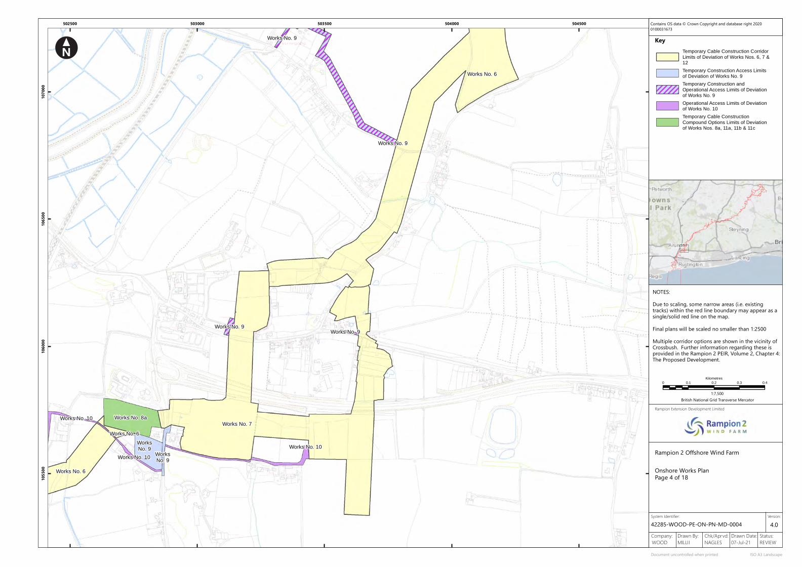
Onshore Works PlanPage 4 of 18
System Identifier:
Document uncontrolled when printed ISO A3 Landscape
Version:4.0
0 0.1 0.2 0.3 0.4
Kilometres
1:7,500British National Grid Transverse Mercator
Contains OS data © Crown Copyright and database right 20200100031673
NOTES:Due to scaling, some narrow areas (i.e. existingtracks) within the red line boundary may appear as asingle/solid red line on the map.Final plans will be scaled no smaller than 1:2500Multiple corridor options are shown in the vicinity ofCrossbush. Further information regarding these isprovided in the Rampion 2 PEIR, Volume 2, Chapter 4:The Proposed Development.
Temporary Cable Construction Corridor
Limits of Deviation of Works Nos. 6, 7 &12
Temporary Construction Access Limitsof Deviation of Works No. 9
Temporary Construction and
Operational Access Limits of Deviationof Works No. 9
Operational Access Limits of Deviationof Works No. 10
Temporary Cable Construction
Compound Options Limits of Deviationof Works Nos. 8a, 11a, 11b & 11c

Track
Gibbet Piece
68.0m
60.0mTrack
55.6m
Jack Upperton's Gibbet
Track
0.91m RH
Def
Track
Track
35.2m
New Down
Track
0.91m Tk HDef
Und
Path (um)
Track
91 .3m
Trac
k
Track
77.2m
Path (um
)
Pond
Pond
Trac
k
Path (um)
Wepha mfarm
2
98
Council
Perlis
105
Drain
22.4m
Perry Vale
The
Sta
Burpham
Brow Wepham
Sub
LB
El
4
24.9m
The Leat
27.7m
Cottage
Cottages
103
Farm
House
Path (um)
Downland
97
Burgh
Path (um)
Backw oods
Woodside
Ilex House
1
Lample House
104
94
Wepham
29.6m
Granary
Pond
Cottages
West
Wepham Farm
96Stopples Barn
The Conyers
Brook Lea
Conyers
Reed Thatch
Pond
Greenfields
5.1m
1
Drain
6
2.9m
Path
(um
)
3.3m
Path (u
m)
Stables
1
Court
Wepham
3.6m
House
Barn
Cottage
21 .6m
The
TCB
102
FB
Barn
30.7m
Leet
Perry Cottage
Place
BeeBumble
Burpham
Cottage
95
PondFBs
SplashFarm Green
Wepham
Pump House
84
House
Wepham
Cottage
Post
Ilex
The
Wepham LodgeThoma s Cot tage
Flints
OrchardHouse
Perry Hill Reservoir(covered)
Mangers
Track
Path (um)
FarmHome
BungalowHome Farm
Tank
Tank
Gallop
Path
(um)
New Down
MP 57.25
2.1m
LaneEnd
Walnuts
Sefton Cottage
CottLodge
Path (um
)
Drain
Drain
FB
The Conyers
Drain
6.6m
House
Drain
The Woodle ighs
Woodleigh
Roundell2.9m
Lodge
FB
Track
TrackWoodleighs Hanger
Path (um)
Sefton Place Gardens
Def
BB
0.91m
RH
0.91m F
F
BB
0.91m RH
Drain
Def
Path (um)
Sussex HouseSussexHeritageCentre
River Coppice
The Barn
Bluebell Cott
Norfolk Flint Barn
Granary House
Track
South Woodleighs
Path (um)
13.5m
WarningcampHouse
9.6m
The
221
Shelter
TCBEl Sub Sta
The
GPWarningcamp
223
LB
Lodge
4.8m
Cottage
Christmas
QuakersOrchard
Treetops
Box Lodge
CS
Yeomans
Sefton Paddock
Gardeners Cott
Bethany
The AmicusCommunity(Sch)
Path
(um)
The Knell
Track
Path (um)
Path (um)
(um)Track
Pond
Path
0.91m BB
Und
0.91m RH
Und
0.91m RH
Path (u
m)
41 .4m
BLAKEHURST LANE
Path (um)
El Sub Sta
54.0m
0.91m Tk HDef
Def
Def
BBSR
Und
Ppg Sta
32.7m
Track
MLW
Path (um)
Drain
Jacob's Ladder
2.2m
Path
(um)
Mud
Trac
k
2.3m
Drain
Sluice
Drain
Fort
River Arun
Mean H
igh W
aterMea
n High
Wate
r
Works No. 9
Works No. 9
Works No. 9
Works No. 6
Works No. 9
Works No. 6
Works No. 9
Works No. 6
Works No. 9
503500 504000 504500 505000
1070
0010
7500
1080
0010
8500
1090
00Key
Rampion 2 Offshore Wind Farm
Rampion Extension Development Limited
Company: Drawn By: Chk/Aprvd: Drawn Date: Status:07-Jul-21 REVIEWNAGLESMILLIIWOOD
42285-WOOD-PE-ON-PN-MD-0004
Onshore Works PlanPage 5 of 18
System Identifier:
Document uncontrolled when printed ISO A3 Landscape
Version:4.0
0 0.1 0.2 0.3 0.4
Kilometres
1:7,500British National Grid Transverse Mercator
Contains OS data © Crown Copyright and database right 20200100031673
NOTES:Due to scaling, some narrow areas (i.e. existingtracks) within the red line boundary may appear as asingle/solid red line on the map.Final plans will be scaled no smaller than 1:2500
Temporary Cable Construction Corridor
Limits of Deviation of Works Nos. 6, 7 &12
Temporary Construction andOperational Access Limits of Deviationof Works No. 9

Trac
k
Tumulus
Norfolk Clump
Track
Burpham High Barn
Perry Hill Reservoir(covered)
COOMBE
LANE
49.8m
Silos
Path (um)
Track
FarmHome
BungalowHome Farm
Tank
Tank
Gallop
Path (
um)
Trac
k
58.1m
CG
0.91m T
k H
ED &
War
d Bd
y
Tumulus
95.2m
EARTHWORK
(site of)Tumulus
Gallo
p
Trac
k 107.2m
CROSS DYKE
Track
Def
Und
RH
CD
ED & Wa
rd Bdy
CD
Und
TB
0.91m T
k H
Und
Track
Catt
le G
rid
Wepham Down
Track
Gallop
Dr illsfield Copse
Path (um)
Track
Tenantry Copse
Path (u
m)
Path (um)
Track
(site of)
Church
117.0m
ED & Ward
Bdy
Def
Def
Tk B
0.91m
RH
76.9m
85.2m
Pond
ED &
War
d Bd
y
Works No. 9
Works No. 9
WorksNo. 9
Works No. 9
WorksNo. 6
Works No. 9
Works No. 6
Works No. 9
Works No. 6
Works No. 9
Works No. 9
Works No. 9
505500 506000 506500 507000
1085
0010
9000
1095
0011
0000
Key
Rampion 2 Offshore Wind Farm
Rampion Extension Development Limited
Company: Drawn By: Chk/Aprvd: Drawn Date: Status:07-Jul-21 REVIEWNAGLESMILLIIWOOD
42285-WOOD-PE-ON-PN-MD-0004
Onshore Works PlanPage 6 of 18
System Identifier:
Document uncontrolled when printed ISO A3 Landscape
Version:4.0
0 0.1 0.2 0.3 0.4
Kilometres
1:7,500British National Grid Transverse Mercator
Contains OS data © Crown Copyright and database right 20200100031673
NOTES:Due to scaling, some narrow areas (i.e. existingtracks) within the red line boundary may appear as asingle/solid red line on the map.Final plans will be scaled no smaller than 1:2500
Temporary Cable Construction Corridor
Limits of Deviation of Works Nos. 6, 7 &12
Temporary Construction andOperational Access Limits of Deviationof Works No. 9

Path (um)
106.6m
Track
Track
Def
0.91m RH
Wepham Down
Track
Track
CP & ED Bdy
Und
Def
Def
Und
TB
CP &
ED
Bdy
Track
Track
Gray'sOld
Settlement
Wood
(site of)
Def
Def
Trac
k
Tank
Trac
k
159.2m
128.4m
137.3m
Def
CP &
ED
Bdy
Trac
k
Track
Earthworks
Track
Und
Track
Workings (d is)
Trac
kCP
& E
D Bd
y
Lee
1
Hopper
Farm
2
95.8m
76.9m
3
Lee Farm Copse
99.3m
85.2m
4
Cottages
86.1m
5 Lee Farm Cott ages
CP & ED Bdy
Def
Und
ED &
War
d Bd
y
Lee Farm
Works No. 9
Works No. 6
WorksNo. 9
Works No. 6
Works No. 9
Works No. 6
Works No. 9
Works No. 6
Works No. 6
Works No. 9
Works No. 9
Works No. 9
506500 507000 507500 508000
1105
0011
1000
1115
0011
2000
Key
Rampion 2 Offshore Wind Farm
Rampion Extension Development Limited
Company: Drawn By: Chk/Aprvd: Drawn Date: Status:07-Jul-21 REVIEWNAGLESMILLIIWOOD
42285-WOOD-PE-ON-PN-MD-0004
Onshore Works PlanPage 7 of 18
System Identifier:
Document uncontrolled when printed ISO A3 Landscape
Version:4.0
0 0.1 0.2 0.3 0.4
Kilometres
1:7,500British National Grid Transverse Mercator
Contains OS data © Crown Copyright and database right 20200100031673
NOTES:Due to scaling, some narrow areas (i.e. existingtracks) within the red line boundary may appear as asingle/solid red line on the map.Final plans will be scaled no smaller than 1:2500
Temporary Cable Construction Corridor
Limits of Deviation of Works Nos. 6, 7 &12
Temporary Construction andOperational Access Limits of Deviationof Works No. 9

Trac
k
Trac
k
Gallop
Workings(dis)
GridCattle
Track
Hill Barn
Path (um
)
Path (u
m)
143.6m
126.5m
121.0m
112.6m
Cross Dyke
105.8m
Track
Reservoir(covered)
Workings(dis)
Path (um)
CHANTRY LANE
157.1m
Track
173.0m
Track
Track
Track
(site of)Tumulus
(sites of)
Tumuli
Track
Cattle Grid
DefCP & ED Bdy
Track
Track
UndFB
Track
205.3m
Track
Trac
k
199.1m
171.2m
137.3m
Trac
k
Track
Track
Track
Track
Track
Track
Track
Path (um)
Cattle Grid
143.9m
191.2m
188.9mPost
181.2m
196.3m
Earthworks
Chantry Post
Track
Und
Def
Und
Def
CP &
ED
Bdy
CP & ED Bdy
Path (um)
Track
Path (um)
Cobden Farm
Works No. 10
Works No. 9
Works No. 9
Works No. 6
Works No. 10
Works No. 6
Works No. 7
508500 509000 509500 510000 510500
1110
0011
1500
1120
0011
2500
Key
Rampion 2 Offshore Wind Farm
Rampion Extension Development Limited
Company: Drawn By: Chk/Aprvd: Drawn Date: Status:07-Jul-21 REVIEWNAGLESMILLIIWOOD
42285-WOOD-PE-ON-PN-MD-0004
Onshore Works PlanPage 8 of 18
System Identifier:
Document uncontrolled when printed ISO A3 Landscape
Version:4.0
0 0.1 0.2 0.3 0.4
Kilometres
1:7,500British National Grid Transverse Mercator
Contains OS data © Crown Copyright and database right 20200100031673
NOTES:Due to scaling, some narrow areas (i.e. existingtracks) within the red line boundary may appear as asingle/solid red line on the map.Final plans will be scaled no smaller than 1:2500
Temporary Cable Construction Corridor
Limits of Deviation of Works Nos. 6, 7 &12
Temporary Construction Access Limitsof Deviation of Works No. 9
Temporary Construction and
Operational Access Limits of Deviationof Works No. 9
Operational Access Limits of Deviationof Works No. 10

Field System
68.7m
Trac
k
Track
Trac
k
0.91m Tk HDef
Und
0.91m RH
0.91m Tk H
Und
0.91m RH
Trac
k
Gallop
GridCattle
Track
Hill Barn
Path (um
)
Path (u
m)
Track
Reservoir(covered)
Pond
Drain
A 283
6
A 24
Pond
Path
(um
)
Brockhurst Barn
St Mary's
71 .4m
Rowdell Holt East
Graveyard
Track
Home Farm 76.4m
Bostal Nursery
Track The Old Vicarage
79.0m
Gate
Taints Orchard
War Meml
Path
(um
)
Cottages
Church Farm Cottage
THE STREETOrcha rd Ho use
Path (um)
St Mary's Church
Church House
FarmHome
SchoolC of E FirstSt Mary's
Trac
k
Fern Cottage
Lillyholt
Lime
Cottage
77.5m
(dis)
WASHINGTON BOSTAL
Track
House
Cottage
Elbourne
Kilns
Barn
72.8m
Rowdell Holt West
Works No. 9
Works No. 9
Works No. 9
Works No. 10 Works No. 9
Works No. 10
Works No. 6
WorksNo. 9
Works No. 6
Works No. 7
Works No. 7
510000 510500 511000 511500
1125
0011
3000
1135
0011
4000
Key
Rampion 2 Offshore Wind Farm
Rampion Extension Development Limited
Company: Drawn By: Chk/Aprvd: Drawn Date: Status:07-Jul-21 REVIEWNAGLESMILLIIWOOD
42285-WOOD-PE-ON-PN-MD-0004
Onshore Works PlanPage 9 of 18
System Identifier:
Document uncontrolled when printed ISO A3 Landscape
Version:4.0
0 0.1 0.2 0.3 0.4
Kilometres
1:7,500British National Grid Transverse Mercator
Contains OS data © Crown Copyright and database right 20200100031673
NOTES:Due to scaling, some narrow areas (i.e. existingtracks) within the red line boundary may appear as asingle/solid red line on the map.Final plans will be scaled no smaller than 1:2500
Temporary Cable Construction Corridor
Limits of Deviation of Works Nos. 6, 7 &12
Temporary Construction andOperational Access Limits of Deviationof Works No. 9
Operational Access Limits of Deviationof Works No. 10

Issues
41 .4m
A 283
Path (um)
0.91m FB0.91m Tk B
0.91m FB
Ward Bdy
Track
54.6m
B1
A 24
43.5m
LB
B5
DCastle Farm Estate
A
Rock Bus iness ParkESS
C1C4
E1
F5
F1
Spring
Pond
Pond
Lidbetter's Copse
Drain
0.91m Tk H
Nursery (hort icu lture)
Drain
Issues
Path (um)
Path (um)
62.2mA 283
Newcommon Copse
Path (um)
Drain
Pond
50.5m
Copyhold Wood
55.1m
58.0m
Path
(um
)
60.9m
Def
Und0.91m Tk H
Def
Ward Bdy
Drain
Lower ChanctonFarm
Track
Pond
Drain
Farm
Drain
1
Well
CottagesPoplars
2
Path (um)
Pond
Rokers Cottage
Lock's
Pond
Tank
Ruin
Tanks
Track
Silo
Path (um)
Pond
Drain
A 283
6
A 24
Pond
Path
(um
)
THE PIKE
54.5m
HOLLOW
Track
THE
Pond
Green Farm Barn
Track
Conv
eyor
Hoppers
GP
Rock Common
Trac
k
Green Farm House
WB
58.4m
59.9m
Drain
Pond
Pond
Pond
Sand Workings
Pond
Tank
Rock Common Quarry
El Sub StaWB
Conveyor
Tunnel
Hopper
Conveyor
Hoppers
Conveyor
Conveyors
Cottage
FB
Pump House
FB
Rock House
Rock Lodge
The Coach House
Workings
Ppg Sta
Rock House Nursery
Rock House Cott age
Rock Mil l
Sandhill Lodge
Nook
FB
TheA 283
Issues
Sandhill
Path (um)
Farmhouse
Cottage
49.0m
Harraton
A 24
TCB
The
Pond
1
Dingley Dell
The House at Home
House
LB
OLD
LOND
ON ROA
D
48.8m
Pond
The Old Forge
Old Smithy
SAND
HILL L
ANE
Pond
SunnySandhill Barn
Montpelier Cottages
1
6
4
2
Willam Barton Co ttage
s
135
76
Workings(dis)
Works
Pond
Pond
Path (um)Washington Towers
Caravan and Camping Park
Subway
16
2
5
PAY GATE
Pond
Ponds
LONDON ROAD
Fairview
4
DrainRecreation Ground
56.0m
55.0m
Tennis Courts
1
Al lotment Gardens
Downsfold
Homeland
FB
Memorial HallPlay Area
Pond
Shelter
Brockhurst Barn
St Mary's
Graveyard
76.4m
The Old Vicarage
Gate
Taints Orchard
War Meml
Path
(um
)
Church Farm Cottage
THE STREETOrcha rd Ho use
St Mary's Church
Church House
SchoolC of E FirstSt Mary's
Trac
k
Fern Cottage
Walnut Tree
Tilley's Farm
Cottage
Track
Pond
GreencommonHouse
Trac
k
9
1
Long
14
12
1
Pegasus
WASHINGTON
Newt
own
Brook House
1
Ivy Cottage
19
Sprin
g Cott
Washington
Cott
How-Man
68.4m
LANE
52.5m
Bank
THE
HOLT
LB
Tilleys House
5
The Old
1
CHAN
CTON
BURY C
LOSE
FRANK LAND MEAD
Frankland
Pond
FB
Arms (PH)
1
Cottage
Rose
5
LANE
Wayside
Til leys
SCHOOL
The Loft
6
5
FB
55.9m
School
Bank Cottage
BOSTAL
New
Cott
ages
TCB
1
7
Old
THE PIKE
3
Orch
ard
Little
62.4m
Cottage
Path (um)
61 .5m
2
Forge
SCHOOL
West
South
4
Cott
ages
Croft
The Street Cott
Cottage
Cottage
Cottage
7
4
8
4
Corner Cottage
STOCKS MEAD
5
Steepdown
6
Brook
Cott
age
Weavers
April
Old Barn
Cott
age
RiseLittleCroft
Hill View Co t
tage
Pinecroft
Downlands
Meadowlea
Long Island
12
Peppers
Schoo l H ouse
Hunny Hous e
2
Arche rs Co rner
The White House
Downsview
Cissbury House
Chanctonbury House
SeagullsHolt House
Old
Swallow's
Cottage
Mead
Gard
e nCotta g
e
East View
Hope
Laundry
Bowleys
The Post
Cottage
Corner
Offic
e
Path
(um
)
51 .2m
Track
Trac
k
50.2m
Pond
Und
Ward
Bdy
FarmUpper Chancton
60.4m
64.1m
Path (um)
57.7m
Oatash Row Copse2
63.4m
1
0.91m R
H
Works No. 8a
Works No. 9
Works No. 9Works No. 9
Works No. 9
Works No. 9
Works No. 8a
Works No. 6
Works No. 8a
Works No. 9
Works No. 10
WorksNo. 6
Works No. 7
Works No. 7
Works No. 9
WorksNo. 9
Works No. 6
Works No. 6
WorksNo. 7
512000 512500 513000 513500 514000
1125
0011
3000
1135
0011
4000
1145
00Key
Rampion 2 Offshore Wind Farm
Rampion Extension Development Limited
Company: Drawn By: Chk/Aprvd: Drawn Date: Status:07-Jul-21 REVIEWNAGLESMILLIIWOOD
42285-WOOD-PE-ON-PN-MD-0004
Onshore Works PlanPage 10 of 18
System Identifier:
Document uncontrolled when printed ISO A3 Landscape
Version:4.0
0 0.1 0.2 0.3 0.4
Kilometres
1:7,500British National Grid Transverse Mercator
Contains OS data © Crown Copyright and database right 20200100031673
NOTES:Due to scaling, some narrow areas (i.e. existingtracks) within the red line boundary may appear as asingle/solid red line on the map.Final plans will be scaled no smaller than 1:2500
Temporary Cable Construction Corridor
Limits of Deviation of Works Nos. 6, 7 &12
Temporary Construction Access Limitsof Deviation of Works No. 9
Temporary Construction andOperational Access Limits of Deviationof Works No. 9
Operational Access Limits of Deviationof Works No. 10
Temporary Cable ConstructionCompound Options Limits of Deviation
of Works Nos. 8a, 11a, 11b & 11c

Pond
Path
(um)
Drain
Spithandle Copse
38.1m
Path (um)
0.91m RH
Def
ED & Ward Bdy
Ruin
Issues
Path (um)
Path (um)
0.91m RH
CSWard Bdy
ED &
Horsebrook
Pond
Pond
40.7m
Cottage
ED & Ward Bdy0.91m RH
0.91m FF
0.91m F
F
Def
Drain
Footbridge
A283
A283
Killing Ground
Cottage
2
Model Cottages
45.1m
Ponds
Silos
Farm
1
Bush Hovel
Track
47.3m
Bushovel
Old School House
Track
Wiston Village Hall
Issues
FB
Pond
FB
38.8m
ROMAN BUILDING
Fastings
Buncton
54.0m
CHAN
CTON
BURY R
ING
ROAD
WASHINGTON ROAD
Timber Yard
42.2m
Sawyers Copse
Drain
41 .4m
Shelter
Pond
1
42.8m
42.7m
(site of)
34.3m
Path (um)
WATE
R LA
NE
2
Farm
Starvells
Pond
A 283
47.3m
MoatCottage
Path (um)
Yew Tree
Butcher's
34.3m
Copyhold Wood
Polecats Cottage
54.9m
OfficeWinston Estate
0.91m FB0.91m Tk B
Def
0.91m FB
Ward Bdy
Track
Track
Track
BUNCTON CROSSWAYS
ShirleyHouse
LongbacksCottages
SpringCopse
Path
(um
)
Workhouse
FB
36.1m
3
Issues
All Saints
1
Chapel
Track
Al lotmentGardens
Buncton ManorFarm
38.5m
Pond
Drain
Stable Cottage
The Round House
52.1m
42.6m
Drain
Tank
37.9m
Pond
Pond
Drain
The Falconers
Def
ED & Ward Bdy
0.91m FF
0.91m FB
FB
Ford
FB
Lower Barn
BarnSevier's
Drain
Pond
Drain
The Forstal
Track
43.6m
Track
Pond
WASHINGTON ROAD
LB
The Grove
Ponds
44.5m
46.9m
Paygate Copse
Pond
50.5m
LodgePaygate
50.0m
CG
Cricket Ground
Pavilion
CG
A 283
Path (um)
63.8m
Copse
0.91m T
k B
0.91m FF
Sawyers
Path (um)
Pond
LANE
37.6m
42.4m
Track
Track
Guesses Wood
34.0m
Track
SPITHAND
LE
Pond
Guessgate Wood
39.6m
Guessgate
34.6m
Farm
38.0m
Path
(um
)
41 .7m
Ponds Pen
Trac
k
Issues
41 .3m
Blackbush
Pond
Common
Cottage
Barn
Middle Barn
Bramley
Hole Street
1
NORT
H LA
NE
2
6a
Well
Farm
Cottages25.5mMiddle Barn
Sideways
Wheelers
2
1
Pond
Street
26.8m
HOLE STREET
Pond
Bennetts
1
6
Hole
CommonWheelersCottages
Barn Cottage
Palm Wood
SewageWorks
Cottage
1
41 .7m
1
Pond
29.4m
Lidbetters Cottages
Well
32.2m
2
Fair Oak
Lidbetter's Copse
33.2m
Abbott's
30.3m Farm
Farm
Abbotts
2
Pond
Ruin
Track
Track
Crackers
Stock's Hill
29.4mGP
3
Fn
Cottages
28.5m
Wiston
WATE
R LA
NE
5
4
29.1m
6
6
1
Stock's Field
2
35.0m
1
34.9m
Track
Pond
FBPostOffice
OldThe
TCB
Pond
House
SPITHANDLE LANE
34.9m
37.7m
Upper BunctonFarm
Buncton
Pond
Upper
Drain
0.91m Tk H
Nursery (hort icu lture)
50.5m
Path
(um
)
Def
Und0.91m Tk H
Def
Ward Bdy
50.2m
Und
Ward
Bdy
Cottages 1
Trickles
Lower Holestreet Barn
2
24.9m
25.2m
0.91m RH
0.91m RH
0.91m R
H
Works No. 9
Works No. 9
Works No. 9
Works No. 10
Works No. 10Works No. 9
Works No. 10
Works No. 6
WorksNo. 9
Works No. 6
WorksNo. 7
514000 514500 515000 515500 516000
1130
0011
3500
1140
0011
4500
Key
Rampion 2 Offshore Wind Farm
Rampion Extension Development Limited
Company: Drawn By: Chk/Aprvd: Drawn Date: Status:07-Jul-21 REVIEWNAGLESMILLIIWOOD
42285-WOOD-PE-ON-PN-MD-0004
Onshore Works PlanPage 11 of 18
System Identifier:
Document uncontrolled when printed ISO A3 Landscape
Version:4.0
0 0.1 0.2 0.3 0.4
Kilometres
1:7,500British National Grid Transverse Mercator
Contains OS data © Crown Copyright and database right 20200100031673
NOTES:Due to scaling, some narrow areas (i.e. existingtracks) within the red line boundary may appear as asingle/solid red line on the map.Final plans will be scaled no smaller than 1:2500
Temporary Cable Construction Corridor
Limits of Deviation of Works Nos. 6, 7 &12
Temporary Construction and
Operational Access Limits of Deviationof Works No. 9
Operational Access Limits of Deviation
of Works No. 10

B 2135
11.2mLB
12.2m
5.9m
Sussex
11.8mGP
Northover
B 2135
Manor
HORSHAM ROAD
Place
Driftway
FW
0.91m RH
0.91m RH
Def
Pond
Drain
Pond
Granary
Weir and SluicePond
14.8m
Farm
Cedar
Pond
Pond
Pepper's Pond
Pond
Pond
Pond
Pepper's
Sweethill
5.4m
Batts
Pond
FB
Pond
Cottage
Pond
Pond
Cottage
Pond
Pavilion
Pond
Pond
Wellens
2
Farm
1
Cottages
Path (u
m)
Play Area
Recreation Ground
FB
Pond
Pond
Pond
Pond
PondLowerbarn Wood
Square Copse
Baven's Wood
SPITHANDLE LANE
Pond
FB
10.1 m
Path
(um)
7.1m
Drain
Pond
12.2m
9.3m
Path (um)
Pond
Pond
Pond
Beggars Bush
Kennels
Pond
9.0m
B 2135
HORSHAM ROAD
Six Acre Copse
Path (um)
Issues
Pond
Felbridge Rough
SPITHANDLE LANE
Path (um)
3
Path
(um
)
Pond
Pond
Dairy
1
Common
16.1m
Horsebridge
Horsebridge House
Pond
Path
(um
)
Path
(um)
Horsebridge Cottages
2
Track
CS
Calcot Wood
Pond
Calcot Farm Bungalow
Trac
k
Path (um)
Path (um
)
Pond
12.6m
House
Path (um)
14.0m
Nutwood
Calcot Farm
Weir
Def
CS
Footbridge
Pond
Path
(um)
Drain
SPITHAN
DLE LA
NE
Pond
30.6m
22.5m
Dove's
Spithandle Copse
Pond
29.9m
Spithandle Rough
Farm
Pond
38.1m
Drain
Track
Spithandle
Path (um)
24.6m
Track
Spithandle BarnGranary Barn
ThePackhouse
Old
Def
0.91m RH
Def
0.91m RH
0.91m
RH
ED & Ward Bdy
0.91m R
H
0.91m RH
Sp ithandle Nursery
Track
Ruin
Track
PondFarmCollege Wood
24.4m
Path (um)
Issues
Pond
Footbridge
15.5m
Path (um)
Path (um)
Path
(um
)
Pond
Path (um)
Path (um)
Sandp it RoughPath
(um
)
Loves Rough
Path (um)
Drain
Loves CottagePath (um)
18.7m
Path (um)
Path (um)
0.91m RH
CS
Def
South Copse
Path (um)
Peppersgreen Lane
Path (um)
FB
Pond
Pond
Issues
15.8m
Three Cornered Wood
25.9m
Pond
Path (um)
17.1m
Cottage
Wood
Spithandle Lane
Litt le Pepper's Wood
Furzefield
Pond
Path (um)
Track
Gatehouse
Great Pepper's Wood
PondPath
(um)
Pond
SPITHANDLE LANE
Pond
Cottage
Path (um)
Path (um)
Pepper
Path
(um)
Furzefie ld
20.3m
17.6m
0.91m RH
Def
ED & Ward Bdy
B 2135
Drain
Wel len 's
Pond
FarmSouthview
Bergen-op-
Hors
ebridg
e Co
mmon
Zoom
9.8m
7.1m
B 2135
Pond
Blakes Farm
Silo
Tennis Court
CSWard Bdy 12.3m
Track
Common Copse
0.91m RH
RH
Drain
Track
Pond
37.6m
42.4m
Track
Pit
Pond
Pond
Slurry
Farm
39.6m
Guessgate
34.6m
Farm
Guesses
41 .7m
Ponds Pen
Trac
k
41 .3m
Works No. 10
Works No. 10
Works No. 10
Works No. 9
Works No. 9
Works No. 9
Works No. 10
Works No. 6
516000 516500 517000 517500 518000
1140
0011
4500
1150
0011
5500
1160
00Key
Rampion 2 Offshore Wind Farm
Rampion Extension Development Limited
Company: Drawn By: Chk/Aprvd: Drawn Date: Status:07-Jul-21 REVIEWNAGLESMILLIIWOOD
42285-WOOD-PE-ON-PN-MD-0004
Onshore Works PlanPage 12 of 18
System Identifier:
Document uncontrolled when printed ISO A3 Landscape
Version:4.0
0 0.1 0.2 0.3 0.4
Kilometres
1:7,500British National Grid Transverse Mercator
Contains OS data © Crown Copyright and database right 20200100031673
NOTES:Due to scaling, some narrow areas (i.e. existingtracks) within the red line boundary may appear as asingle/solid red line on the map.Final plans will be scaled no smaller than 1:2500
Temporary Cable Construction Corridor
Limits of Deviation of Works Nos. 6, 7 &12
Temporary Construction andOperational Access Limits of Deviationof Works No. 9
Operational Access Limits of Deviationof Works No. 10
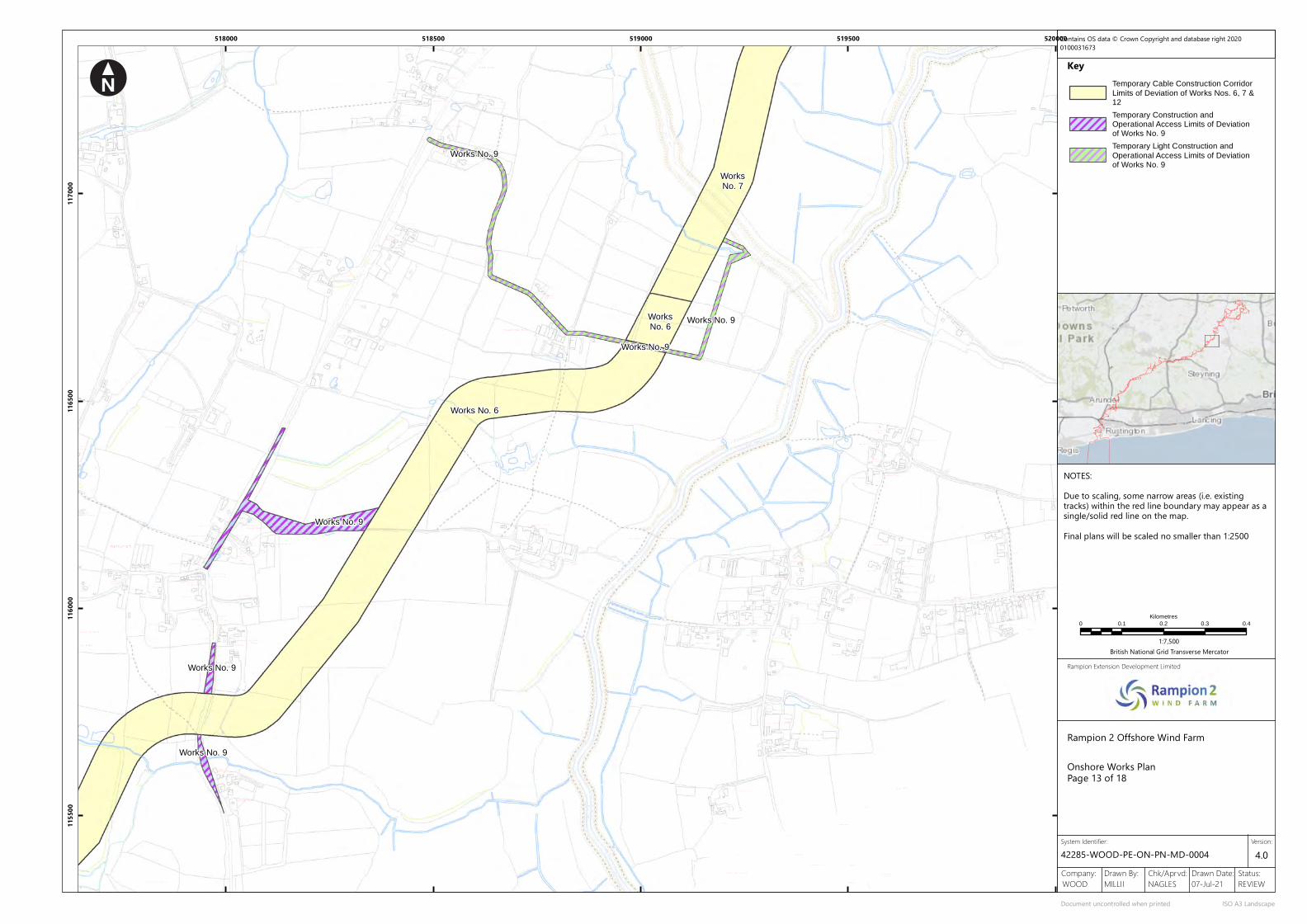
FB
1
SCHOOL LANE
Hol ly
Downsview
Ashurst 18.6m
4
Pond
Lodge
1
Pond
Molecombe
Bungalow
Mil l View
2
Sweetmans
B 2135
21 .1m GP
Batts
Little Gratwicks
23.6m
Tipnoak
Trees
Sweetmans Farm
19.2m
Barn Cottage
Forge Cottage
Ivy Cottage
Rose Cottage
Solar Panels
Pond
Townhouse
Hol ly
Weir
2
FORD LANE
13.3m
GOLDEN LANE
FB
18.6m
16.1m
Fox Cottage
New Cottages
1
Cottage
St James's
18.5m
Church
Benfield Farm
Timbers
Track
Benfield
Trac
k
Sluice
WEST
Squirrels Farm
Lashmars
Sluice
Neaves Cottage
Burnleigh House
River Adu
r
Sluice
Drain
11.7m
Brookside
Sluice
Drain
Drain
Drain
Chy
Lancaster
Lancasters
West EndHouse
Fresh ford
FB
Willows
Weir
END LANE
Hillview
Drain
Drain
Pond
13.5m
Path (um)
Chates
Wheeler's
Drain
Drain
Lancasters
Little
2
Cottage
FB
Tanglewood
Drain
Shearlings
Lidd Nurseries
Well
Tatlers
Spring
Downland Farm
Tanks
Drain
Drain
14.9m
Cottages
Ranmore
Blundens Farm
Gleann B eagLB
Little Blundens
10.5m
Drain
Drain
Pond
Pond
2
Fursdon
STONEPIT LANE
Path (um)
1
Hall
1
Ameys
Drain
Partwick
Cottages
Saddlers Meadow
CCLW
Def
Ward
Bdy
Trac
k
MLW&
MHW
Mean High Water
Mean
High
Wat
er
Footbridge
Ruin
Willow Barn
FB
Wheelers Well
Drain
Mean
High
Wat
er
CoombeCottage
Hathe rdene
Old Barn House
Junipe r
Barn
Lauriston
Fernlea
Lancaster
Birchwood House
River Adur
Sluice
Pond
Drain
Drain
Drain
Sluice
Mud
ED &
War
d Bd
y
ED & Ward Bdy
(FB)Eatons Bridge
Sluice
River Adur
Havana
Riverside
Drain
Trac
k
Granary
Pond
14.8m
Cedar
5.4m
Batts
Pond
Cottage
CottageWellens
2
Farm
1
Cottages
Play Area
Recreation Ground
Lowerbarn Wood
7.1m
Pond
11.2m
Eatons Cottages14.0m
Drain
Eatons Farm
MerrionCottages
2
1
Drain
Pond
Pond
Drain
14.8m
Drain
1 2
4.9m
PondDrain
Yokenclose Barn
Wind Pump
New Barn
Sluice
Drain
CCLW
ED & Ward Bdy
Track
Drain
Track
The Old Mill
TheFountain
Pond
B 2135
10.7m
18.8m
Pond
Sinclaire House
13.0m
Inn(PH)
13.9m
Garth
Blocques
Robins
Village HallAshurst
GOLDEN LANE
1
Godsmarks Farm
Long Cottage
2
11.0m
13.9m
Issues
Well Pond
15.2m
12.1m
Godsmarks Cottage9.9m
Pond
Godsmarks Barn
The Byre
FarmRobertsfield
Trac
k
Sixberries
Dove'sCottages
Track
Drain
Bungalow
Track
Catsfold Farm
The
Tank
Leeches
WEST END LANE
Godsons Farm
Topfield
FB
Harwoods Farm
Stable Cottage
Pond
13.4m
Track
5.9m
New Inn Farm
Pond
Pondcroft
Rose Cottage
Flints
Pond
Moundsmere
Track
LodgeYeoman
Drain
Sunnybank
14.0m
Little Westlands
16.7m
Path (um)
Pond
The Piggery
Bramb les ide
Marde n
Catsfold Farm House
Solar Panels
Lancasters Nursery
Westlands
Adur Riverm ead
WaySideThe S tudio
FrogsholeCottage
Track
Drain
3.7m
11.2m
Path (um) OakleaTrack
Eden
Drain
Causeway House
Drain
Wel len 's
Pond
FarmSouthview
7.1m
B 2135
Blakes Farm
FB
Sluice
Path (um)
Drain
SluiceMud
ED &
War
d Bd
y
3.3m
Drain
Drain
River Adur
Drain
Drain
Trac
k
CCLW
FB
Pond
Mean High Water
Mean High Water
Drain
Drain
Westering
Drain
10.8m
LB
Path
(um
)
Pond
Furlong Shaw
Southblows
Binesfield
Merrion Farm
FB
Hol ly Tree Cottage
Northblows
Pond
Drain 8.6m
Bines GreenDrain
Stanford Barn
Withyfield Cottage
Merrion Lodge Drain
Drain
Pond
Drain
West View
Campions
FB
Pond B 2135
Drain
Drain
Sluice
DrainDrain
Path (um
)
Sluice
Pond
PondSluice
Drain
Mud
Drain
Mean High
WaterMean
High Water
Sluice
River Adur
Sluice
Drain
Def
ED & Ward Bdy
Mean High Water & Mean Low Water
MHW & MLW
Springfield
Works No. 9
Works No. 9
Works No. 9
Works No. 9
Works No. 9
Works No. 6
Works No. 9
WorksNo. 6
WorksNo. 7
518000 518500 519000 519500 520000
1155
0011
6000
1165
0011
7000
Key
Rampion 2 Offshore Wind Farm
Rampion Extension Development Limited
Company: Drawn By: Chk/Aprvd: Drawn Date: Status:07-Jul-21 REVIEWNAGLESMILLIIWOOD
42285-WOOD-PE-ON-PN-MD-0004
Onshore Works PlanPage 13 of 18
System Identifier:
Document uncontrolled when printed ISO A3 Landscape
Version:4.0
0 0.1 0.2 0.3 0.4
Kilometres
1:7,500British National Grid Transverse Mercator
Contains OS data © Crown Copyright and database right 20200100031673
NOTES:Due to scaling, some narrow areas (i.e. existingtracks) within the red line boundary may appear as asingle/solid red line on the map.Final plans will be scaled no smaller than 1:2500
Temporary Cable Construction Corridor
Limits of Deviation of Works Nos. 6, 7 &12
Temporary Construction andOperational Access Limits of Deviationof Works No. 9
Temporary Light Construction and
Operational Access Limits of Deviationof Works No. 9

Pond
Pond
Cibses Cottage
Maltings BarnDra
in
FB
6.2m
5.0m
FB
Weir
Trac
k
Drain
KIDDERS LANE (TRACK)
Trac
k
Mean High &
Mean L
ow Wate
r
Great Betley Farm
Drain
Mean High
Water
5.7m
River A
dur
3.6m
Path (um)
3.5m
BetleyLittle
Drain
MLW
CCLW
Ward
Bdy
Def
Track
The Granary
Sluice
Partridge
2
1FINCHES CLOSE
1Excha
nge
9
2214
6 GreenTeleph
one
19
1
LITTLE FINCH
ES
ROADHAZELWOOD
5
1
26
23
18
6
Works
45
Cottage
11.5m WILTON
Beech
12
5
25 6
22
1
2
Works
Tideys
7
CLOSE
23
27
12
3
14
14
13
16
The Stable
s9
426
8 Depot
Alma Villa
17
STAR ROAD
15
9
Mil l
1
1
SOUTH STREET
7
4a
El Sub Sta
18
9
29
2
Depot
21
Works
Depot
26
37
33
7
29
Bowme r
25
6
2 1
New Cott
ages
38
48
32
39
3
House
1314
EstateHuff
wood Tra
ding
ESS
THE GREEN
7
1
8
2
Websters
Cottage
ESS
ESS
6
B2116
1317
Rose Cottage
Corner
BadgersEnd
TCB
Woodbarn Cottage
A 281
Queensga
te
Greenacre
Oakview
House
Phoenix Plac
eLulwor
th
11.6m
LisieuxAnningtonHouse
House
Morley
Wyndham
8 to
11
House
4 to
7
1 to
3
The GrangeBrightfordHouse
ShermanburyGrange
The Gate House
(PH)PartridgeThe
The
11.1m
GablesThe
Hol lies
Little Ha tch
Garage
House
Glenlea
Virgin ia
Cliv eBritto n
MEYERS WOOD
Ho
Ct
Ho
4
B 2135
3
LB
Kahala
Teal Cottage
Little
FirsCottages
Dormers
Lloytscroft12
MessinaSprin
gfield
9.9m
29
8.8m
18
24
11.5m
19
14.6m
17
FB
Pond
Priors Byne Farm
North Barn
LOCK LANE
Lloyts Croft
Moat
Moat Cottage
Copyhold
Copyhold Cottage
Pond
The Pines
7.1m
5.8m
6.0mPond
Pond
East Lloyts
Moat Farm
Ponds
Pond
Path (um)
PINLAND ROAD
21
Cottage
Smithy
4BINE
S ROAD
House
1
Pond
Pinlands Cottage
HouseHomelands
The Old
Weald
Crouchers
3
Allotment Gardens
9.7m
Maythorne Cottages
Seaford Villas
10.6m
The
Savernake
Sheiling
2
Elm
Cottages
Yew
CottageTree
Homelands
3
Homelands Farm
Farmgate
Bungalow
Centre
10.0m
House
1
B 2135
TristarThe Forge
Cattle Grid
Business
4b
Homelands Farm
Pond
The Elms
Homelands Farm
LodgeElm
Track
2011 Warehouses
19
El Sub Sta
HouseBrush
F1
El17
24C
20
18
Works
21
House
STAR ROAD
16
Amorim
Sub
Warehouse
Ash Wood
Avalon Court
Issues
Works
Sta
20 t
o 25
23
23
7
6
1
F4
24A
19a
PumpingStation
Star Road Trading
Estate16
ESS
ViscountHouse
T&M House
Drain
7
Drain
Lake
21
Pond
Pond
Sewage Works
Pond
Track
Pond
MLW
MLW
Pond
10.8m
LB
Path
(um
)
Pond
Southblows
Binesfield
FB
Hol ly Tree Cottage
Northblows
Pond
Drain 8.6m
Bines GreenDrain
7.5m
Sluice
MartinslandFarm
Sluice
Drain
Sluice
Drain
River Adu
r
Drain
Sluice
Binesbrook Cottage
Stanford Barn
ED & Ward BdyDef
MHW & M
LWMHW & M
LW
Pond
Withyfield Cottage
Drain
Drain
Merrion Lodge Drain
Drain
Pond
4.7m
Drain
Drain
Sluice
MHW & MLW
Bines Br idge
Tide Ga
uge
MHW&MLW
Fn
Well
Foxway
s
BRIGHTON ROAD
Drain
Marzde
n
Wychwood Farm House
Woodsi
de
Mean Hig
h & Mean
Low Wa
ter
Rivermede
Pond
12
8.8m
Trac
k
Track
CCLW Ward Bdy
Wychwood FarmCottages
Pond
Fairacre RivermedeCottage
Drain
Morning
Ville
Gleniffer
Greenl
ands
Dunelm
Westwar
d
HouseWychwood
River Adur
LB
Challco
te
Beechc
ote
Chalfield
ParkView
Ivelchester
Clovers
A 281
8.3m
Glenmo
re
Shingwe
dzi
Drain
Pond
CCD
Def
Fords
Cintra
Lanter
n Cott
age
The Oaks
Downs Vie
w
Woodlan
ds
Wymerin
g
Oaklea
Brighth
elmsto
ne
Diamond Hill
Hazeld
ene
Southl
ands
Cornerhouse
Madeira
Drain
0.91m RH
0.91m RH
0.91m R
H
FF
0.91m F
F
Drain
Track
Pond
Pond
Pond
Pond
Path (um)
Drain
0.91m RH
CD
Def
Drain
CD
FB Pond
Drain
Drain
Betley Bridge
Sluice
Brightham's Farm
Sluice
Drain
Drain
Path (um
)
Sluice
PondSluice
Drain
Mud
Ward Bdy
Def
Drain
Slurry Bed
Drain
Track
Pond
Mean High
WaterMean
High Water
FB
Trac
k
Track
River Adu
r
Drain
11.7m
Track
Pond
Sluice
1
Bines
River Adur
2
Brightham's Farm Cottage
Farm
5.1m
B 2135 Bines Farm Barn
Hylands Farm
Cottage
Drain
Sluice
9.0m
DefED & Ward Bdy
MHW &
MLW
Mean High Water & Mean Low Water
Lay-by
Pond
MHW & MLW
Solar Panels
Bines Farmhouse
Works No. 9
WorksNo. 9
Works No. 8b
Works No. 10
Works No. 9
Works No. 8bWorks No. 8b
Works No. 9
Works No. 10
Works No. 9
WorksNo. 7
Works No. 6
518500 519000 519500 520000 520500
1175
0011
8000
1185
0011
9000
Key
Rampion 2 Offshore Wind Farm
Rampion Extension Development Limited
Company: Drawn By: Chk/Aprvd: Drawn Date: Status:07-Jul-21 REVIEWNAGLESMILLIIWOOD
42285-WOOD-PE-ON-PN-MD-0004
Onshore Works PlanPage 14 of 18
System Identifier:
Document uncontrolled when printed ISO A3 Landscape
Version:4.0
0 0.1 0.2 0.3 0.4
Kilometres
1:7,500British National Grid Transverse Mercator
Contains OS data © Crown Copyright and database right 20200100031673
NOTES:Due to scaling, some narrow areas (i.e. existingtracks) within the red line boundary may appear as asingle/solid red line on the map.Final plans will be scaled no smaller than 1:2500
Temporary Cable Construction Corridor
Limits of Deviation of Works Nos. 6, 7 &12
Temporary Construction Access Limitsof Deviation of Works No. 9
Temporary Construction and
Operational Access Limits of Deviationof Works No. 9
Operational Access Limits of Deviationof Works No. 10
Temporary Light Construction and
Operational Access Limits of Deviationof Works No. 9
Temporary Soil Storage Limits ofDeviation of Works No. 8b

FBSt Giles's
FB
Weirs
9.4m
FB
Sl
Moat
Ewhurst Manor
Church
Cowfold Stream
5.8m
Track
Courts
Pond
59
WALK
20
1
Partridge
2
22
24
3
1
Issues
Pond
THE RISE
10.7m
MIDDLE ROAD
FINCHES CLOSE
Pond
1
April C
ott
37
Exchange
47
ROAD
9
El
Robin Shaw
22
Gate
83
22
13
Camom ile Cotta ge
1
Ivy
32
18
Tennis
40
Ivy
Cott
Pond
Sub Sta
Holly Cott
9.8m
1
Dunstans
14
Keepers Mead
Fortune
14
6
9.8m
Green
Greensleeves
2
Telephone
2
Birch Grove
11
SHERMANBUR
Y ROAD
21
11.6m
Playground
71
Old Priors
22
12
19
Deans Cottage
2
7
1
Pond
BLANCHES
16
25
6
28
Villas
LITTLE FINCH
ES
ROAD
1
12
HAZELWOOD
Cotta geThe
0.91m RH
Dunstan's Farm
Pond
Pavilion
GREENTREE
LANE (TRAC
K)
Melrose
Skatepark
(Recreat ion Ground)
Newlands
King George's Fie ld
Track
16.7m
FairwayLITTLEWORTH LANE
4
Blanche's Farm
BLANCHES
2
1
10
1
18
Nonsuch
1
Blanches House
The Corner Ho
Corams
2
Pond
2
REEDS LANE (TRACK)
GreenThe
ESS
5
6
Cottages
45
12
White
2
Eastern
Villa
Spring Cott
2
1
23Chanter House
1
Denville
2
The
Ruwen
The Andes
House
3
14
SOUTH STREET
1
2a4
South gate
House
GP
2
4
26
37
33
Rose
Maple Cottages
North lan ds
29
38
48
11
39
17
4
15
Endells
Bays
ESS
The
Peelers Croft
6
12.9m
Short Row
4
Treeways
1
12.9m
18
Cottage
Grovemount7
Rose Cottage
8
Corner
Badgers
LB
Barn
8a
Pond
Trac
k
1
End
12
1
FB
Drain
Drain
TCB
Briar Patch
Woodbarn Cottage
Monkswood
Cotta ge
14
Woods ide
A 281
1
Lindens
Buren
Silver Birches
2
BRIGHTON ROAD
1
Queensga
te
Greenacre
2
Wood
Oakview
Tol l
WOODSIDE CLOSE
House
Morley
Flatfield Shaws
Track
GP
3
4
Trac
k
Wymarks Oak
MorleyCottages
Phoenix Plac
e
20.1m
WateringburyTanglewood
13.0m
Brooklands
9Robin Wood
Wymarks
Pond
14.2m
Mal lards
Well
Shelter Cattle Grid
12.1m
Pond
A 28
1
Cotta geCorne r
Richmond House
Corner House
Pond
Reservoir
Cottages
Lulworth
House
Shepherds
11.6m
Spindlewood
Farm
Boeingfield
Lisieux
Parsimony Towers
The Firs
Cottage
Fircroft
Barrack
Woodpeckers
Wymarks
Wymarks
Path
Pumping Station
B2116
Pond
Track
Track
1
Drain
Pond
Drain
Mealhogs Wood
4
Wymarks Wood
Trac
k
Pond
Oak
PARTRIDGE GREEN ROAD
Path (um)
Tank
Fish Pond
Track
Track
OakWagstaff Cottages
Track
Woodmancote
AnningtonHouse
House
Morley
Wyndham
8 to
11
Track
House
House
4 to
7
1 to
3
8.1m
LodgeNorth
Track
12 .5m
9.3m
Pond
Home Farm
The
13
The Grange
CoachHouse
Track
Mast (telecommunication)
Def
0.91m RH
BrightfordHouse
ShermanburyGrange
GREENTREE LANE (TRACK)
The Lake House
The Gate House
B2116
DrainDrain
Furzefield ShawTrack
Tanks
Drain
Lower Barn
17.1m
Drain
13.4m
Pond
Pond
The Hangers
22.5m
16.7m
Und
FB
Drain
Buckbridge Wood
The Hangers
Pond
Ewhurst
Tennis
Sluice
Drain
Farm
Court
Ewhurst Cottages
Horsepark Shaws
Manor
Well
Weir
UndPond
Ewhurst Farmhouse
Lodge
Manor Cottage
Manor Barn
Manor Stables
Manor
Warren Cottage
Gatehouse
CottageLake
Drain
Track
Pond
Pond
Drain
Pond
Drain
Sluice
0.91m RH
Def
0.91m RH
0.91m RH
Pond
Drain
0.91m RH
El
24C
Sub
Ash Wood
Issues
Sta
PumpingStation
Drain
7
21
LB Challen's Wood
Chalfield
ParkView
Ivelchester
Clovers
A 281
8.3m
Glenmo
re
Shingwe
dzi
Def
Cintra
Lanter
n Cott
age
Downs Vie
w
Woodlan
ds
Wymerin
g
Oaklea
Brighth
elmsto
ne
Diamond Hill
Cornerhouse
Madeira
Slurry
Trac
kPond
Track
Pond
Wymarks Wood
Trac
k
Pit
George's Gorse
Farm
Felix Plantation
Trac
k
Parkminster
Wind Pump
Path (um)
30.6m
32.1m
26.6m
0.91m RH
0.91m R
H
0.91m R
H
0.91m R
H
0.91m R
H
Pond
Track
Track
Pond
Drain
25.4m
Pond
24.7m
Pond
Fn
Drain
A 28
1
25.6m
23.9m
Track
Maryland
Fn
18.7m
Trac
k
Issues
Pond
26.5m
Track
Millar's Wood
GREENTREE LANE
28.3m
28.9m
21 .2m
24.3m
Parkminster Wood
22.0m
Cattle Grid
Fn
(Carthusian)
Pond
St Hugh's Monastery
Trac
k
Chapel
Sewage Tank
Pond
Fn
Pond
MonastreyLodge
The
Def
0.91m RH
0.91m RH
0.91m R
H
0.91m RH0.91m RH
0.91m RH
0.91m RH
Def
Track
Graveyard
0.91m RH
Green Tree Farm
Works No. 8bWorks No. 8b
Works No. 9
Works No. 10
WorksNo. 9
Works No. 10
Works No. 9
Works No. 9
Works No. 9
Works No. 9
Works No. 6
Works No. 6
Works No. 7
Works No. 9Works No. 6
519500 520000 520500 521000 521500
1190
0011
9500
1200
0012
0500
Key
Rampion 2 Offshore Wind Farm
Rampion Extension Development Limited
Company: Drawn By: Chk/Aprvd: Drawn Date: Status:07-Jul-21 REVIEWNAGLESMILLIIWOOD
42285-WOOD-PE-ON-PN-MD-0004
Onshore Works PlanPage 15 of 18
System Identifier:
Document uncontrolled when printed ISO A3 Landscape
Version:4.0
0 0.1 0.2 0.3 0.4
Kilometres
1:7,500British National Grid Transverse Mercator
Contains OS data © Crown Copyright and database right 20200100031673
NOTES:Due to scaling, some narrow areas (i.e. existingtracks) within the red line boundary may appear as asingle/solid red line on the map.Final plans will be scaled no smaller than 1:2500Multiple corridor options are shown in the vicinity ofthe existing National Grid Bolney Substation. Furtherinformation regarding these is provided in theRampion 2 PEIR, Volume 2, Chapter 4: The ProposedDevelopment.
Temporary Cable Construction Corridor
Limits of Deviation of Works Nos. 6, 7 &12
Temporary Construction andOperational Access Limits of Deviationof Works No. 9
Operational Access Limits of Deviationof Works No. 10
Temporary Soil Storage Limits ofDeviation of Works No. 8b

23.9m
Pond
Pond
19.1m
Pond
18.7m
Sheepfie ld Shaw
Pooks
FarmPooks
Harbour
Pond
Pond
Pond
Trac
k
Drain
Pond
Pond
Birchfield Wood
Track
Pond
Track
Track
Track
15.8m
Woodf ield Wood
Pond
Pond
Snake'sFurzefie ld Wood
Fryland WoodPath
(um
)
Path (u
m)
The FodgesFord
Trac
k
BUCKHATCH LANE (TRACK)
Ponds8.3m
17.7m
19.5m
Path (um)
Drain
Cowfol
d Stre
am
Pond
Well
Pond
Little Park Farm
CS
Park Farm
Track
Track
Path (um)
Trac
k
20.7m
15.8m
Ponds
Drain
Pond20.7m
Pond
14.9m
Pond
Pond
Oaklands Farm Barn
Trac
k
Pond
OaklandsFarm
10.8m
12.9m
78 8a
1
12
Briar Patch
Monkswood
Cotta ge
14
Woods ide
1
Lindens
Silver Birches
2
WOODSIDE CLOSE
Morley
Flatfield Shaws
4
MorleyCottages
20.1m
9
Well
Pond
A 28
1
The Firs
Fircroft
Woodpeckers
Pumping Station
31 .4m
Buffords
29.6m
Path
(um)
8.3m
Stream
FB
Drain
Drain
Cowfold
7.2m
Pond
0.91m R
H
CS
Drain
Pond
Drain
Path (um)
Gratw icke
Furzefield Shaw
DrainPond
Pond
Ponds
0.91m RH
0.91m RH
CS
Track
Tanks
Drain
Drain
Lower Barn
17.1m
Pond Drain
Drain
13.4m
8.9m
Pond
Pond
The Hangers
22.5m
16.7m
Und
FB
Drain
The Hangers
Weir
Whitefield Shaw
Drain
Sheepfield Shaw
Firtree Mount Wood
Drain
Ewhurst Cottages
Horsepark Shaws
Well
0.91m Tk H
0.91m
RH
0.91m Tk HCS
0.91m RH
Und
Pond
Pond
Drain
Pond
Pond
Pond
Pond
Pond
Rivlyn
Pond
Pond
Pond
Pond
DRAGONS LANE
Pond
Pond
Path (um)
Hil lingdon
Pond
Crateman's Farm
Dragons Farm
Path (u
m)
Dragons Barn
The Old Dairy
Pond
Pond
Trac
k
Kings Barn Cottage
Pond0.91m RH
Pond
Sheepfield Shaw
FurzefieldFarm Pond
Pond
Old School
10.0m
Springlands
19.4m
Well
Drain
Beaumonts
Chapel
Pond
Lodge
17.1m
Pond
East
Springlands Gate
10.5m
House
10.7m
Pond
Cattle Grid
Waterperry
Cemetery
6.9m
Tal l Oaks
Well
FRYLAN
D LANE
Pond
Oaklands Farm Stud
LB
The Coach House
Pond
Pond
Drain
Pond
24.7m
Pond
Drain
A 28
1
25.6m
26.0m
23.9m
Track
Maryland
18.7m
Little Parkminster
26.5m
Track
Lodge
28.3m
21 .2m
Cattle Grid
Gratwicke
MonastreyLodge
The
Def
0.91m RH
0.91m R
H
Track
Little Parkminster
Oak
Cowfold Stream
9.9m
Cottage
11.4m
14.1m
Drain
Drain
Pond
Pond
CS
Def
Moatf ield Farm
FB
FB
13.3m
LB
FB
Potts
KENT
STRE
ET LAN
E
Drain
Pond
Kent Street
Issues
Cottage
Pond
3
Well
Pond
Keepers Cottage
Drain
Woodcock Shaw
Barrack Cottages21 .1m
Pond
19.0m
Vadgers
KENT STREET
1
Pond
Pond
15.5m
0.91m RH
0.91m RH
Def
CS
Und
Def
BUCKHATCH LANE (TRACK)
FarmPotts
Hol ly Croft
Wilcock's Farm
Cottages Litt le Parkminster
1Rossmore
A 28
1
1
3
Kenmore
2
Gratwicke
27.9m
Parkminster 2
22.5m
19.7m
4
Works No. 9
Works No. 9
Works No. 9
Works No. 10
Works No. 10
Works No. 10Works No. 10
Works No. 6
Works No. 6
Works No. 6
Works No. 7
Works No. 9
Works No. 6
Works No. 7
Works No. 6
Works No. 7
521000 521500 522000 522500 523000
1195
0012
0000
1205
0012
1000
Key
Rampion 2 Offshore Wind Farm
Rampion Extension Development Limited
Company: Drawn By: Chk/Aprvd: Drawn Date: Status:07-Jul-21 REVIEWNAGLESMILLIIWOOD
42285-WOOD-PE-ON-PN-MD-0004
Onshore Works PlanPage 16 of 18
System Identifier:
Document uncontrolled when printed ISO A3 Landscape
Version:4.0
0 0.1 0.2 0.3 0.4
Kilometres
1:7,500British National Grid Transverse Mercator
Contains OS data © Crown Copyright and database right 20200100031673
NOTES:Due to scaling, some narrow areas (i.e. existingtracks) within the red line boundary may appear as asingle/solid red line on the map.Final plans will be scaled no smaller than 1:2500Multiple corridor options are shown in the vicinity ofthe existing National Grid Bolney Substation. Furtherinformation regarding these is provided in theRampion 2 PEIR, Volume 2, Chapter 4: The ProposedDevelopment.
Temporary Cable Construction Corridor
Limits of Deviation of Works Nos. 6, 7 &12
Temporary Construction andOperational Access Limits of Deviationof Works No. 9
Operational Access Limits of Deviationof Works No. 10
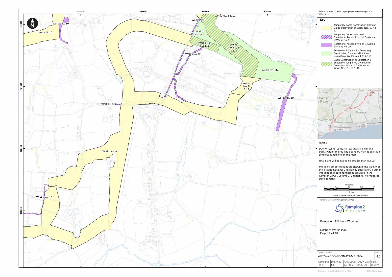
Priorsbush
Issues
Def
CS
0.91m RH
Drain
Twineham 400 Kv
Pond
House
Pond
Little Farm
Pond
Ponds
The Bungalow
House
Little Combe
Coombe
Pond
Def
CS
Pond
Harbour
Pond
Pond
Pond
Trac
k
Drain
Pond
Pond
Birchfield Wood
Track
Pond
Track
Track
Track
15.8m
Woodf ield Wood
Pond
Pond
Snake'sFurzefie ld Wood
Fryland WoodPath
(um
)
Path (u
m)
The FodgesFord
Trac
k
BUCKHATCH LANE (TRACK)
Drain
Pond
Pond
Pond
Pond
Oaklands Farm Barn
Trac
k
Pond
OaklandsFarm
Tank
Wineham
Sewage
Sluice
9.7m
Sluice
Station
10.9m
Fixcroft
Pool
19.3m
Track
The Bridge House
8.3m
DrainFrylands
12.4m
Pond
Grovelands
Mynton
Wyndham
TCB
Drain
7.9m
FRYLAND LANE
Drain
Cottages
110.8m
LB
2
107
Pumping
GranaryCottage
CR
Drain
Wineham
Grovelands
Frylands
Drain
Little
Lodge
River Adur
PoolCottage
Drain
The Bothy
The G ill
Fish Pond
31 .4m
Pond
Pond
27.7m
BOB LANE
FB
GP
Buffords
WINE
HAM
LANE
Wyndham
KENT STREET
Pond
GP
Cottage
Pond
20.7m
Orchard
30.2m
Tk
The Royal Oak
29.6m36.6m
(PH)
The Hatch Cottage
Issues
House
Pond
Trac
k
33.5m
Pond
Def
Co C
onst
,CR
PondTank
Snakes HarbourFarm
Russets
Pond
The Lodge
Trac
k
CP &
ED
Bdy
LashmarLodge
The Royal OakCountry Park
Medmerry
Symonds Hall
Holt
Drain
Caeburn
Gatefield Cottage
96
Sheiling
Fairoakland
Cottage
ForgeCottage
The SmithyTrack
95
19.5mPond
Well Cottage
The Forge
Holt
LB
Meadow
Cottage
Pond
Grovelands Farm House
Track
StableCottage
Issues
Pond
Drain
Grange
Nightingales
Swallow
Pond
Cottage
Pond
26.1m
PondPond
FarmPond
Pond
Pond
BOB LANE
Pond
6
Tw ineham
Drain
Court
Twineham
Cottages
3
Downsview
Tw ineham Grange
Track
Twineham
Drain
Grange
Farm
20.1m
Pond
Woodpeckers
TrackBungalow
FB
Drain
Pond
26.2m
Pond
Twineham Grange
29.0m
Bolney Substation
North Lodge
Substation
34.1m
Pond
Westridge Place
Old
Path (um)
Pond
El
28.3m
Pond
Pond
Sta
Kings Barn Cottage
Path (um)
The Hatch
WINEHAM LANE
Pond
Drain
Sub
Doctors
Pond
0.91m R
H
0.91m RH
Co Const,
0.91m RH
0.91m RH
Und
Und
0.91m RH
Def
Post
Boundary
CP & ED Bdy
Drain
Tennis CourtSparrows Drain
King 's Barn Farm
Pond
Pond
WTwineham Place Farm
Track
Drain
Drain
FB
Pond
Pond
Springlands
Well
Drain
Pond
Pond
Springlands Gate
10.5m
10.7m
6.9m
FRYLAN
D LANE
Pond
LB
FB
Potts
KENT
STRE
ET LAN
E
Drain
Pond
Kent Street
Issues
Cottage
14.2m
Pond
3
Well
Pond
Keepers Cottage
Pond
Woodcock Shaw
Barrack Cottages21 .1m
Pond
19.0m
Vadgers
KENT STREET
1
Pond
Pond
15.5m
0.91m RH
0.91m RH
Def
CS
Und
Def
BUCKHATCH LANE (TRACK)
Drain
FarmPotts
Hol ly Croft
Wilcock's Farm
Works No. 10
Works No. 9
Works No. 9
Works No. 10
WorksNo. 6, 12
& 11a
Works No. 6
WorksNo. 6
& 12
Works No. 6 & 12
Works No. 9
Works No. 6
Works No.6 & 11a
WorksNo. 11a
Works No. 11a
Works No. 10
523000 523500 524000 524500
1200
0012
0500
1210
0012
1500
Key
Rampion 2 Offshore Wind Farm
Rampion Extension Development Limited
Company: Drawn By: Chk/Aprvd: Drawn Date: Status:07-Jul-21 REVIEWNAGLESMILLIIWOOD
42285-WOOD-PE-ON-PN-MD-0004
Onshore Works PlanPage 17 of 18
System Identifier:
Document uncontrolled when printed ISO A3 Landscape
Version:4.0
0 0.1 0.2 0.3 0.4
Kilometres
1:7,500British National Grid Transverse Mercator
Contains OS data © Crown Copyright and database right 20200100031673
NOTES:Due to scaling, some narrow areas (i.e. existingtracks) within the red line boundary may appear as asingle/solid red line on the map.Final plans will be scaled no smaller than 1:2500Multiple corridor options are shown in the vicinity ofthe existing National Grid Bolney Substation. Furtherinformation regarding these is provided in theRampion 2 PEIR, Volume 2, Chapter 4: The ProposedDevelopment.
Temporary Cable Construction Corridor
Limits of Deviation of Works Nos. 6, 7 &12
Temporary Construction andOperational Access Limits of Deviation
of Works No. 9
Operational Access Limits of Deviationof Works No. 10
Substation & Substation TemporaryConstruction Compound Limits ofDeviation of Works Nos. 6,11a, 11b
Cable Construction or Substation &Substation Temporary ConstructionCompound Limits of Deviation ofWorks Nos. 6, 11a & 12

WINEHAM LANE
Pond
Track
29.6m
Eastridge Lodge
FarmNew
Nyeshill Farm
Wineham
Priorsbush
Cottage
House
Pond
Issues
Dawe's Farm
39.9m
Pond
Pond
Wilow Cottage
The Barn
Def
CS
Co C
onst
, CP
& ED
Bdy
0.91m RH
Def
Drain
Twineham 400 Kv
Drain
15.8m
Pond
The FodgesFord
31 .4m
GP
The Hatch Cottage
33.5m
Def
PondTank
The Lodge
Trac
k
Bolney Substation
Substation
Pond
Path
(um
)
Path (um)
Path
(um)
Pond
Path (um)
Ta intfield Wood
Pond
Track
Drain
Pond
Cowfold Stream
Pond
Pond
Lake
Pond
Pond
Pond
FB
FB
FB
Lodge
18.9m
20.1m
South
Manor
Pond
OakendenePond
Pond
Drain
New Barn
Chauf feurs Cott
Garde ners Cott
HouseThe White
FBs
Track
Industria lOakendene
Estate
Pond
Pond
Oakendene ManorFarm Cottages21
17.4m
Coopers Cottage
Pond
FB
FB
15.8m
Track
Drain
KENTSTREET LANE
Pond
Pond
15.5m
14.3m
Drain
0.91m Tk
H0.91
m Tk H
0.91m RH
0.91m RH
Pond
0.91m R
H
Pond
19.8m
LB
Pond
Track
GP
29.9m
16.8m
Pond23.2m
Pond
Pond
Drain
Pond
Pond
Southlands Farm
Southlands
Pond
Track
0.91m RH
0.91m RH0.91m RH
0.91m R
H
0.91m RH
Def
0.91m RH
Co Const, CP & ED BdyDrain
Electricity Distribution Site
A272
Pond
Oakfield Farm
KENTSTREET LANE
34.1m
Pond
Westridge Place
Old
Tank
Pond
Path (um)
Pond
Pond
El
PondPond
28.3m
Pond
Pond
Pond
Pond
Pond
Sta
Farm
Kings Barn Cottage
Pond
Path (um)
21 .3m
The Hatch
WINEHAM LANE
18.1m
Pond
Drain
Sub
Delspride
Pond
Doctors
Pond
Pond
Westridge
Park StudFarm
Eastridge
Ridgelands
Oak Tree Farm
0.91m R
H
0.91m RH
Co Const,
0.91m RH
0.91m RH
Und
Und
0.91m RH
Def
Post
Boundary
CP & ED Bdy
Drain
Tennis Court
Tennis Court
Pond
Track
Sparrows
PondWest Barn
Pond
Drain
King 's Barn Farm
ManorEastridge
Track
Muttons
1
Nye's Copse
26.8m
2
30.2m
NYE'S HILL
Pond
Def
Co Const, C
P & ED Bdy
Bugs HoleBarn
BungalowEastridge
Pond
Farm
Nye's HillCottages
Woodlands
Tennis Court
Track
29.0m
Drain
Cottage
30.8m
Old Barn
Farm
SPRONKETT'S LANE
Bugshole Copse
Farm
Pond
Lyelands
GP
Greenacres
Greenacres
34.1m
28.0m
Drain
0.91m
RH
Def
Track
A272
WINEHAM LANE
IssuesPond
CR
26.8m
Oak
9.9m
Cottage
11.4m
14.1m
MOATFIELD LANE
The Granary
Pond
PondDef
Moatf ield Farm
Lower Barn Farm
FB
13.3m
LB
FB
Potts
KENT
STRE
ET LAN
E
Drain
Pond
Kent Street
Issues
Cottage
Farm
15.5m
Cottage
Taintfield Farmhouse
Wilcocks
14.2m
Pond
3
Well
Pond
Keepers Cottage
Pond
Drain
Pond
Woodcock Shaw
Barrack Cottages
Path (um)
Ta intfield Farm
21 .1m
Pond
Path (um)
15.1m
Pond
19.0m
Vadgers
KENT STREET
Lidford
1
Bankfield Grange
Pond
KING'S LANE
Track
14 .5m
Pond
Pond
15.5m
Smiths Meadow
House
0.91m RH
0.91m RH
Def
CS
Und
Def
DrainFord
BUCKHATCH LANE (TRACK)
Kings
Drain
FarmPotts
Hol ly Croft
Wilcock's Farm
14.7m
10.9mFB
Cause way
17.1m
Works No. 10
Works No.8a & 11c
Works No. 9
Works No. 9
Works No. 9
Works No. 9
Works No. 9
Works No. 9
WorksNo. 6,11a
& 11b
Works No. 9
Works No. 12
WorksNo. 6, 12
& 11a
Works No. 6
WorksNo. 6
& 12
WorksNo. 6
& 12
Works No.11a & 11b
WorksNo. 10
Works No. 6
Works No. 6
Works No.6 & 11a
WorksNo. 11a
WorksNo. 11a
Works No. 7
Works No.9 & 11d
522500 523000 523500 524000 524500
1210
0012
1500
1220
0012
2500
Key
Rampion 2 Offshore Wind Farm
Rampion Extension Development Limited
Company: Drawn By: Chk/Aprvd: Drawn Date: Status:07-Jul-21 REVIEWNAGLESMILLIIWOOD
42285-WOOD-PE-ON-PN-MD-0004
Onshore Works PlanPage 18 of 18
System Identifier:
Document uncontrolled when printed ISO A3 Landscape
Version:4.0
0 0.1 0.2 0.3 0.4
Kilometres
1:7,500British National Grid Transverse Mercator
Contains OS data © Crown Copyright and database right 20200100031673
NOTES:Due to scaling, some narrow areas (i.e. existingtracks) within the red line boundary may appear as asingle/solid red line on the map.Final plans will be scaled no smaller than 1:2500Multiple corridor options are shown in the vicinity ofthe existing National Grid Bolney Substation. Furtherinformation regarding these is provided in theRampion 2 PEIR, Volume 2, Chapter 4: The ProposedDevelopment.
Temporary Cable Construction Corridor
Limits of Deviation of Works Nos. 6, 7 &12
Temporary Construction Access Limitsof Deviation of Works No. 9
Temporary Construction andOperational Access Limits of Deviationof Works No. 9
Operational Access Limits of Deviationof Works No. 10
Temporary Cable ConstructionCompound Options Limits of Deviationof Works Nos. 8a, 11a, 11b & 11c
Substation & Substation TemporaryConstruction Compound Limits ofDeviation of Works Nos. 6,11a, 11b
Cable Construction or Substation &Substation Temporary ConstructionCompound Limits of Deviation of
Works Nos. 6, 11a & 12