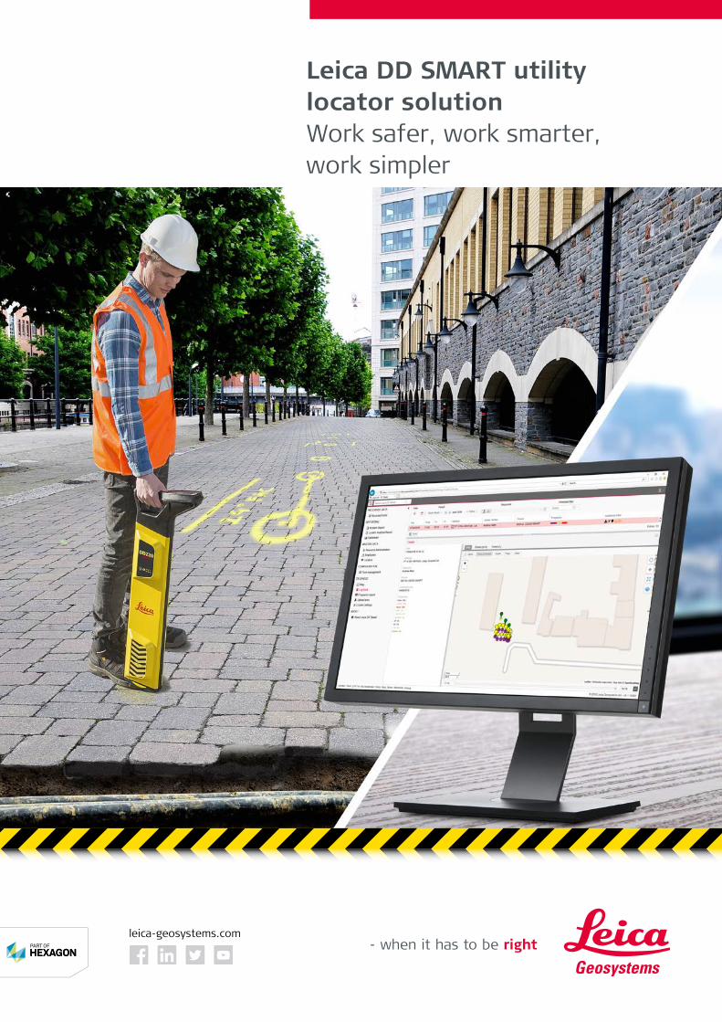
Work safer, work smarter, work simpler
8
Leica DD SMART utility locator solution Work safer, work smarter, work simpler leica-geosystems.com
Transcript of Work safer, work smarter, work simpler
Leica DD SMART utility locator solutionWork safer, work smarter, work simpler
leica-geosystems.com
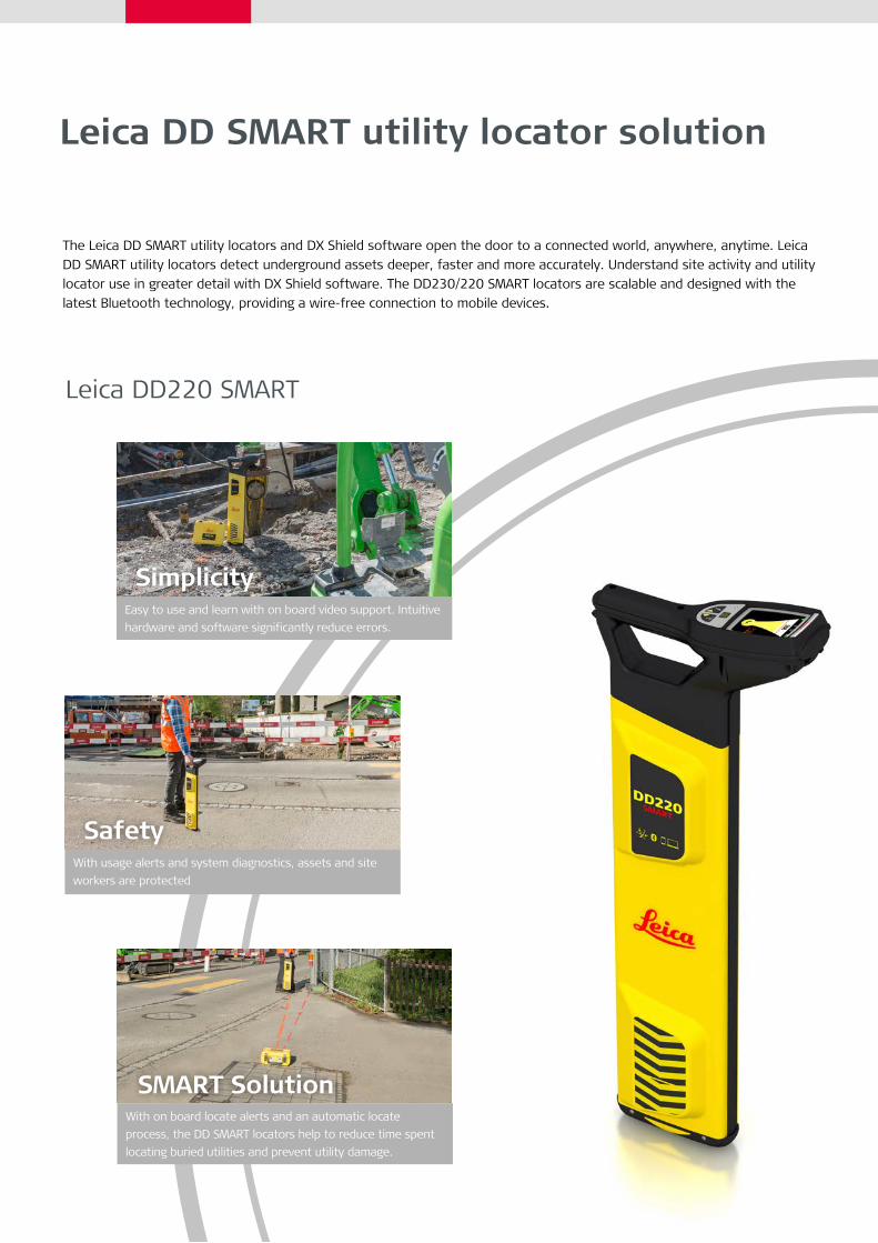
Leica DD SMART utility locator solution
The Leica DD SMART utility locators and DX Shield software open the door to a connected world, anywhere, anytime. Leica DD SMART utility locators detect underground assets deeper, faster and more accurately. Understand site activity and utility locator use in greater detail with DX Shield software. The DD230/220 SMART locators are scalable and designed with the latest Bluetooth technology, providing a wire-free connection to mobile devices.
Leica DD220 SMART
Simplicity
Safety
SMART Solution
Easy to use and learn with on board video support. Intuitive hardware and software significantly reduce errors.
With usage alerts and system diagnostics, assets and site workers are protected
With on board locate alerts and an automatic locate process, the DD SMART locators help to reduce time spent locating buried utilities and prevent utility damage.
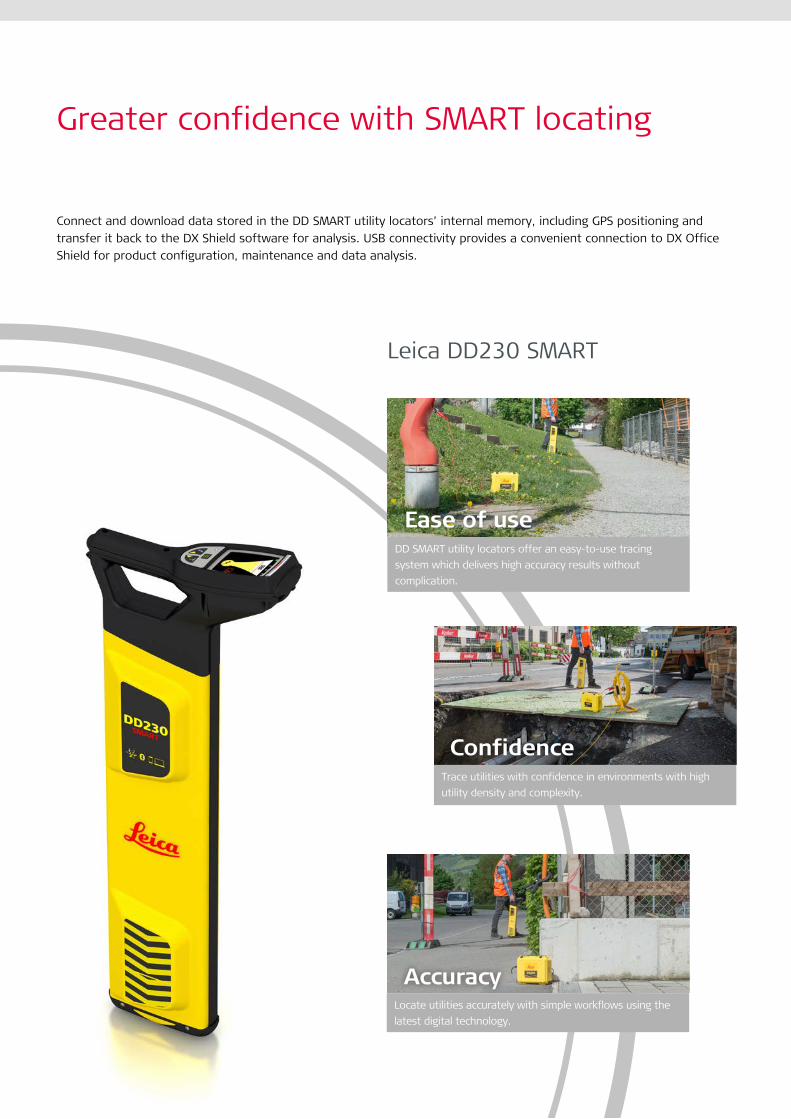
Greater confidence with SMART locating
Connect and download data stored in the DD SMART utility locators’ internal memory, including GPS positioning and transfer it back to the DX Shield software for analysis. USB connectivity provides a convenient connection to DX Office Shield for product configuration, maintenance and data analysis.
DD SMART utility locators offer an easy-to-use tracing system which delivers high accuracy results without complication.
Ease of use
ConfidenceTrace utilities with confidence in environments with high utility density and complexity.
AccuracyLocate utilities accurately with simple workflows using the latest digital technology.
Leica DD230 SMART
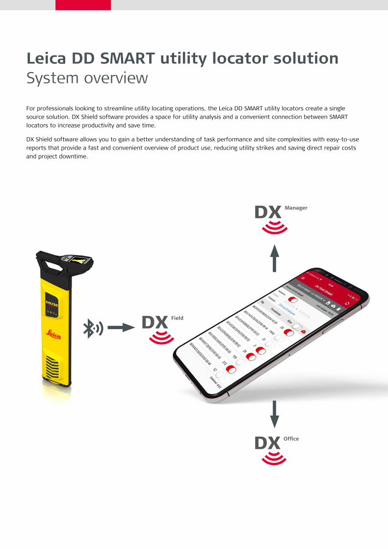
Leica DD SMART utility locator solution System overview
For professionals looking to streamline utility locating operations, the Leica DD SMART utility locators create a single source solution. DX Shield software provides a space for utility analysis and a convenient connection between SMART locators to increase productivity and save time.
DX Shield software allows you to gain a better understanding of task performance and site complexities with easy-to-use reports that provide a fast and convenient overview of product use, reducing utility strikes and saving direct repair costs and project downtime.
DX Shield software
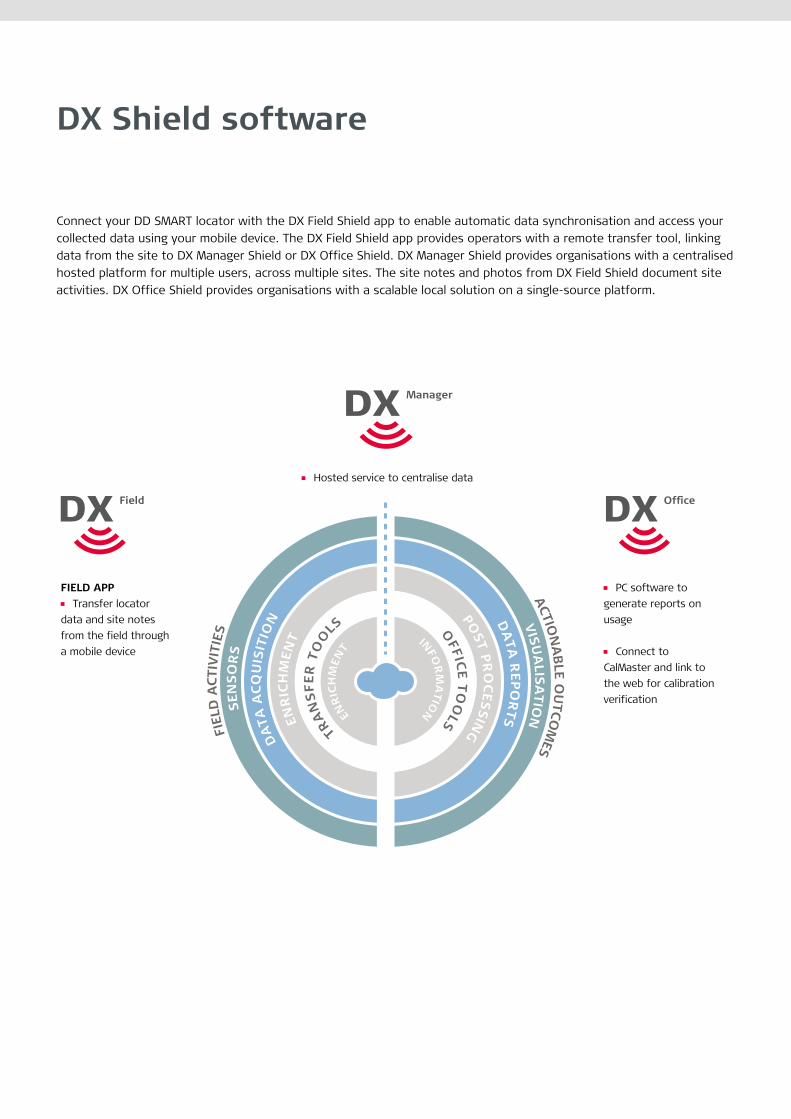
Connect your DD SMART locator with the DX Field Shield app to enable automatic data synchronisation and access your collected data using your mobile device. The DX Field Shield app provides operators with a remote transfer tool, linking data from the site to DX Manager Shield or DX Office Shield. DX Manager Shield provides organisations with a centralised hosted platform for multiple users, across multiple sites. The site notes and photos from DX Field Shield document site activities. DX Office Shield provides organisations with a scalable local solution on a single-source platform.
ACTION
ABLE O
UTCO
MES
FIEL
D A
CTIV
ITIE
S
VISUA
LISATIO
NSEN
SOR
S
DA
TA R
EPOR
TSD
ATA
AC
QU
ISIT
ION PO
ST PRO
CESSIN
GENR
ICH
MEN
T INFOR
MA
TIONEN
RIC
HM
ENT
TRA
NS
FER
TO
OLS O
FFICE TO
OLS
OFF
ICE TOOLS
FIELD APP Transfer locator
data and site notes from the field through a mobile device
PC software to generate reports on usage Connect to
CalMaster and link to the web for calibration verification
Hosted service to centralise data
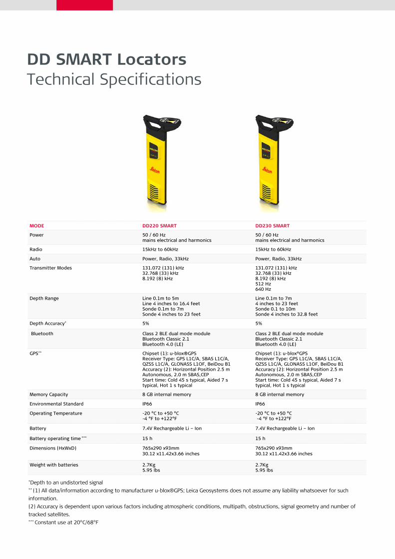
DD SMART Locators Technical Specifications
MODE DD220 SMART DD230 SMART
Power 50 / 60 Hz mains electrical and harmonics
50 / 60 Hz mains electrical and harmonics
Radio 15kHz to 60kHz 15kHz to 60kHz
Auto Power, Radio, 33kHz Power, Radio, 33kHz
Transmitter Modes 131.072 (131) kHz32.768 (33) kHz8.192 (8) kHz
131.072 (131) kHz32.768 (33) kHz8.192 (8) kHz512 Hz640 Hz
Depth Range Line 0.1m to 5m Line 4 inches to 16.4 feetSonde 0.1m to 7mSonde 4 inches to 23 feet
Line 0.1m to 7m 4 inches to 23 feetSonde 0.1 to 10mSonde 4 inches to 32.8 feet
Depth Accuracy* 5% 5%
Bluetooth Class 2 BLE dual mode moduleBluetooth Classic 2.1Bluetooth 4.0 (LE)
Class 2 BLE dual mode moduleBluetooth Classic 2.1Bluetooth 4.0 (LE)
GPS** Chipset (1): u-blox®GPSReceiver Type: GPS L1C/A, SBAS L1C/A,QZSS L1C/A, GLONASS L1OF, BeiDou B1Accuracy (2): Horizontal Position 2.5 mAutonomous, 2.0 m SBAS,CEPStart time: Cold 45 s typical, Aided 7 stypical, Hot 1 s typical
Chipset (1): u-blox®GPSReceiver Type: GPS L1C/A, SBAS L1C/A,QZSS L1C/A, GLONASS L1OF, BeiDou B1Accuracy (2): Horizontal Position 2.5 mAutonomous, 2.0 m SBAS,CEPStart time: Cold 45 s typical, Aided 7 stypical, Hot 1 s typical
Memory Capacity 8 GB internal memory 8 GB internal memory
Environmental Standard IP66 IP66
Operating Temperature -20 °C to +50 °C -4 °F to +122°F
-20 °C to +50 °C -4 °F to +122°F
Battery 7.4V Rechargeable Li – Ion 7.4V Rechargeable Li – Ion
Battery operating time *** 15 h 15 h
Dimensions (HxWxD) 765x290 x93mm30.12 x11.42x3.66 inches
765x290 x93mm30.12 x11.42x3.66 inches
Weight with batteries 2.7Kg5.95 lbs
2.7Kg5.95 lbs
*Depth to an undistorted signal** (1) All data/information according to manufacturer u-blox®GPS; Leica Geosystems does not assume any liability whatsoever for such information.(2) Accuracy is dependent upon various factors including atmospheric conditions, multipath, obstructions, signal geometry and number of tracked satellites.*** Constant use at 20°C/68°F
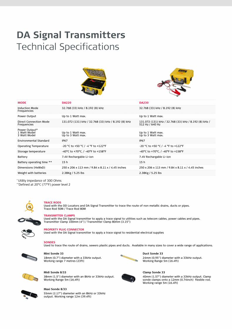
DA Signal Transmitters Technical Specifications
MODE DA220 DA230
Induction ModeFrequencies
32.768 (33) kHz / 8.192 (8) kHz 32.768 (33) kHz / 8.192 (8) kHz
Power Output Up to 1 Watt max. Up to 1 Watt max.
Direct Connection Mode Frequencies
131.072 (131) kHz / 32.768 (33) kHz / 8.192 (8) kHz 131.072 (131) kHz / 32.768 (33) kHz / 8.192 (8) kHz / 512 Hz / 640 Hz
Power Output*1 Watt Model3 Watt Model
Up to 1 Watt max.Up to 3 Watt max.
Up to 1 Watt max.Up to 3 Watt max.
Environmental Standard IP67 IP67
Operating Temperature -20 °C to +50 °C / -4 °F to +122°F -20 °C to +50 °C / -4 °F to +122°F
Storage temperature -40°C to +70°C, / -40°F to +158°F -40°C to +70°C, / -40°F to +158°F
Battery 7.4V Rechargable Li–ion 7.4V Rechargable Li–ion
Battery operating time ** 15 h 15 h
Dimensions (HxWxD) 250 x 206 x 113 mm / 9.84 x 8.11 x / 4.45 inches 250 x 206 x 113 mm / 9.84 x 8.11 x / 4.45 inches
Weight with batteries 2.38Kg / 5.25 lbs 2.38Kg / 5.25 lbs
* Utility impedance of 300 Ohms**Defined at 20°C (77°F) power level 2
TRACE RODS Used with the DD Locators and DA Signal Transmitter to trace the route of non metallic drains, ducts or pipes.Trace Rod 50M / Trace Rod 80M
TRANSMITTER CLAMPS Used with the DA Signal transmitter to apply a trace signal to utilities such as telecom cables, power cables and pipes.Transmitter Clamp 100mm (4”) / Transmitter Clamp 80mm (3.15”)
PROPERTY PLUG CONNECTOR Used with the DA Signal transmitter to apply a trace signal to residential electrical supplies
SONDESUsed to trace the route of drains, sewers plastic pipes and ducts. Available in many sizes to cover a wide range of applications.
Mini Sonde 3318mm (0.7”) diameter with a 33kHz output. Working range 7 metres (23ft)
Duct Sonde 33 24mm (0.95”) diameter with a 33kHz output.Working Range 5m (16.4ft)
Midi Sonde 8/3338mm (1.5”) diameter with an 8kHz or 33kHz output. Working Range 5m (16.4ft)
Clamp Sonde 33 40mm (1.57”) diameter with a 33kHz output. Clamp sonde clamps onto a 12mm (0.74inch) flexible rod. Working range 5m (16.4ft)
Maxi Sonde 8/3355mm (2.17”) diameter with an 8kHz or 33kHz output. Working range 12m (39.4ft)
Copyright Leica Geosystems AG, 9435 Heerbrugg, Switzerland. All rights reserved. Printed in Switzerland – 2018. Leica Geosystems AG is part of Hexagon AB. 874472en – 05.18
Leica Geosystems – when it has to be right
Revolutionising the world of measurement and survey for nearly 200 years, Leica Geosystems is the industry leader in measurement and information technologies. We create complete solutions for professionals across the planet. Known for innovative product and solution development, professionals in a diverse mix of industries, such as surveying and engineering, building and heavy construction, safety and security, and power and plant trust Leica Geosystems for all their geospatial needs. With precise and accurate instruments, sophisticated software, and trusted services, Leica Geosystems delivers value every day to those shaping the future of our world.
Leica Geosystems is part of Hexagon (Nasdaq Stockholm: HEXA B; hexagon.com), a leading global provider of information technology solutions that drive productivity and quality across geospatial and industrial landscapes.
Leica Geosystems AGHeinrich-Wild-Strasse9435 Heerbrugg, Switzerland+41 71 727 31 31