WORK PLAN Lower Carmel River Floodplain … · dynamics of the lagoon drive the functioning of the...
17
WORK PLAN Lower Carmel River Floodplain Protection and Enhancement Project INTRODUCTION Project Goals and Objectives Goal : The Lower Carmel River Floodplain Protection and Enhancement Project (Project) is a multi-objective project that combines flood protection, habitat enhancement and wildlife corridors, agricultural land protection, storm water retention, and public recreation on a 131-acre site in the lower Carmel River. Objectives : A. Reduce flood flows in urban areas : County Services Area 50 (CSA-50) is a developed area located along the north side of the lower Carmel River and includes the highest number of repetitive loss properties in Monterey County. Of the 147 acres of developed land in CSA-50, approximately 105 acres flood during the 50-year flood event and all 147 acres flood during the 100-year event. The Project will provide lower elevations on the south side of the River and remove levees that will reconnect the historic floodplain to the river channel and allow for a flood regime that moves water away from the developed areas of the floodplain thus reducing flood elevations by an estimated 0.5- 1.0 feet in the 100-year storm from current flood elevations. See Flood Elevation Projections Attachment. B. Increase riparian and wetland habitat : The Project will restore approximately 90 acres of riparian and wetland habitat on the historic floodplain, providing important habitat for sensitive species including steelhead trout, California red-legged frog, and western pond turtle, as well as six additional state species of concern. The project will provide inundation of the floodplain at the 10-year interval. The project will provide increased quantity and quality of breeding and/or foraging habitat for 27 avian species that have been identified by one or more bird conservation plans as species of concern. C. Recharge groundwater and base flows to the Carmel River : The Project will address one of the watershed’s most critical environmental problems - very low or no flow in the Lower Carmel River and Lagoon in the dry season - by enabling recharge of groundwater on the restored floodplain. Groundwater monitoring wells established on the project site in 2009 documented that groundwater recharge from the Carmel River establishes a base level in the aquifer underlying the parcel at the Projects site and sedimentary interbedding on the floodplain provide additional storage for infiltration and recharge to the aquifer above this base level. Due to these conditions, opportunities exist on the parcel to enhance groundwater recharge. D. Provide habitat connection across the floodplain: The Project includes a flood conveyance causeway under Highway One which will reconnect the east side of the floodplain to the west side of the floodplain and providing a corridor for wildlife species utilizing these habitat areas. E. Protect Agricultural Land from Flooding : The Project will establish a permanent 36-acre organic farm out of the 100-year floodplain. F. Improve water quality : The Project will provide additional filtration for sediment and nutrients through the creation of a functioning floodplain and associated riparian habitat and wetlands, resulting in increased water quality in the surface and groundwater flows entering the Carmel River Lagoon, the Carmel Bay (state-designated Area of Special Biological Significance, Marine Protected Area, and Critical Coastal Area) and the Monterey Bay National Marine Sanctuary. The hydrologic SWFM Prop 1E Grant Proposal County of MOnterey Causeway Design and Construction Att3_SWF_1CrFrEeP2_WorkPLan_1ofTotal1
Transcript of WORK PLAN Lower Carmel River Floodplain … · dynamics of the lagoon drive the functioning of the...

WORK PLAN
Lower Carmel River Floodplain Protection and Enhancement Project INTRODUCTION Project Goals and Objectives Goal: The Lower Carmel River Floodplain Protection and Enhancement Project (Project) is a multi-objective project that combines flood protection, habitat enhancement and wildlife corridors, agricultural land protection, storm water retention, and public recreation on a 131-acre site in the lower Carmel River. Objectives:
A. Reduce flood flows in urban areas: County Services Area 50 (CSA-50) is a developed area located along the north side of the lower Carmel River and includes the highest number of repetitive loss properties in Monterey County. Of the 147 acres of developed land in CSA-50, approximately 105 acres flood during the 50-year flood event and all 147 acres flood during the 100-year event. The Project will provide lower elevations on the south side of the River and remove levees that will reconnect the historic floodplain to the river channel and allow for a flood regime that moves water away from the developed areas of the floodplain thus reducing flood elevations by an estimated 0.5-1.0 feet in the 100-year storm from current flood elevations. See Flood Elevation Projections Attachment.
B. Increase riparian and wetland habitat: The Project will restore approximately 90 acres of riparian and wetland habitat on the historic floodplain, providing important habitat for sensitive species including steelhead trout, California red-legged frog, and western pond turtle, as well as six additional state species of concern. The project will provide inundation of the floodplain at the 10-year interval. The project will provide increased quantity and quality of breeding and/or foraging habitat for 27 avian species that have been identified by one or more bird conservation plans as species of concern.
C. Recharge groundwater and base flows to the Carmel River: The Project will address one of the watershed’s most critical environmental problems - very low or no flow in the Lower Carmel River and Lagoon in the dry season - by enabling recharge of groundwater on the restored floodplain. Groundwater monitoring wells established on the project site in 2009 documented that groundwater recharge from the Carmel River establishes a base level in the aquifer underlying the parcel at the Projects site and sedimentary interbedding on the floodplain provide additional storage for infiltration and recharge to the aquifer above this base level. Due to these conditions, opportunities exist on the parcel to enhance groundwater recharge.
D. Provide habitat connection across the floodplain: The Project includes a flood conveyance causeway under Highway One which will reconnect the east side of the floodplain to the west side of the floodplain and providing a corridor for wildlife species utilizing these habitat areas.
E. Protect Agricultural Land from Flooding: The Project will establish a permanent 36-acre organic farm out of the 100-year floodplain.
F. Improve water quality: The Project will provide additional filtration for sediment and nutrients through the creation of a functioning floodplain and associated riparian habitat and wetlands, resulting in increased water quality in the surface and groundwater flows entering the Carmel River Lagoon, the Carmel Bay (state-designated Area of Special Biological Significance, Marine Protected Area, and Critical Coastal Area) and the Monterey Bay National Marine Sanctuary. The hydrologic
SWFM Prop 1E Grant Proposal County of MOnterey Causeway Design and Construction Att3_SWF_1CrFrEeP2_WorkPLan_1ofTotal1

dynamics of the lagoon drive the functioning of the ecosystem. The amount and quality of water in the lagoon determine the available habitat for significant species.1
G. Public Trails and Recreation: The Project will include a public trail along the southern edge of the farm field and will link to over 4000 acres of pubic land (Palo Corona Regional Park) immediately adjacent to the project site. The Project will link the new restored riparian and wetland habitats via the flood conveyance causeway.
Purpose and Need The Lower Carmel River Floodplain Restoration and Enhancement Project will be completed on the 131-acre historic floodplain located just upstream of the Carmel River Lagoon and east of Highway One on land known as the Odello fields. See Figures 1-5 and Photos 1-5 at the end of this narrative. The land is part of the historic floodplain along the Carmel River but has not been available for a typical flooding regime for over 75-years due to agricultural production on the land. Prior to the 1930s, earthen levees were built on the south side of the river by the farmer-landowner to constrain the river and the entire expanse of wetlands and riparian forest surrounding the Carmel River Lagoon and Odello East was put into agricultural production for artichokes. Downstream of the present day Highway One, the levee and agricultural production narrowed the riparian forest and wetlands on the south side of the river for nearly ½-mile at their widest to a narrow strip along the river. Upstream of Highway One, the riparian forest on the south side of the main stem was reduced from a maximum of about 1400 feet wide to a narrow strip. The levees kept flood events out of the fields except during larger flows (10-year storms and larger), which spread into the floodplain and caused damages to residential and commercial properties. The existing levees are not adequate to hold the 1% annual chance flood.2 The construction of Highway One in the early 1930s further diminished the ecological condition of the entire coastal ecosystem by placing a physical barrier between the Carmel River Lagoon and the larger floodplain thereby preventing hydrologic connectivity across the floodplain. Highway One created a north-south barrier to flood flows as well, resulting in flood waters flowing to the north side of the river, which affects areas such as Mission Fields, the Crossroads Shopping Center and Rio Road/Val Verde Road. Today the lower Carmel River is confined by levees on both sides, beginning near the river’s mouth and running 1.2 miles upstream.3 Recent major floods include January and March 1995 events and the February 1998 event. These events resulted in approximately $10,520,000 in damages in 2009 dollars. The project focuses on restoring a more frequent flooding regimen to 90-acres of the Odello East property and provides a flood conveyance causeway to both reconnect the west and east sides of the floodplain hydrologically and for habitat connectivity and wildlife movement. The remaining 36 acres of the property will remain as an agricultural preserve to allow for public access, as well as an organic farming operation and native plant nursery. A public trail will be located along the southern edge of the agricultural preserve and will be maintained by the Big Sur Land Trust as part of the Carmel River Parkway. The overall environmental goal is to restore connectivity and natural ecological function to a critical section of the Carmel River watershed—the lower floodplain/estuary system. The project is a second phase in a series of habitat conservation and restoration activities occurring in the lower floodplain and lagoon since the 1990s including the Carmel River Lagoon Riparian Restoration Project completed in 2000 and the Carmel River Lagoon South Arm Restoration Project completed in 2004. Both of these projects were completed by California State Parks in partnership with the State Department of Transportation and the Big Sur
1 Carmel River Lagoon Enhancement Project: Water Quality and Aquatic Wildlife Monitoring, 2005-6 Joy Larson, Fred Watson, PhD, Joel Casagrande, Brian Pierce. Publication No.: WI-2006-06, 24 July 2006, The Watershed Institute, Division of Science and Environmental Policy, California State University Monterey Bay. 2 Monterey County Water Resources Agency. Monterey County Flood Management Plan, pp. 20. Update 2008. Prepared for Monterey County. 3 Balance Hydrologics, Inc., 2007. Design Alternatives Analysis for Floodplain Restoration at the Odello Property.
SWFM Prop 1E Grant Proposal County of MOnterey Causeway Design and Construction Att3_SWF_1CrFrEeP2_WorkPLan_1ofTotal1

Land Trust. Partners in this phase of restoring the floodplain and associated riparian and wetland habitats include California State Parks, Coastal Conservancy, Monterey County Water Resources Agency, Monterey County Public Works, Monterey Peninsula Water Management District and the Big Sur Land Trust. The following studies and plans have been completed for the Lower Carmel River to articulate the vision for restoring the area for fish and wildlife habitat as well as address flood issues.
• Philip Williams and Associates and California Coastal Conservancy, Carmel River Lagoon Enhancement Plan, 1992. Prepared for Carmel River Steelhead Association.
• Philip Williams and Associates and California Coastal Conservancy, Carmel River Lagoon: Enhancement
and and Management Plan: Conceptual Design Report,1999. Prepared for Monterey Peninsula Regional Park District, Coastal Conservancy, and California State Parks.
• Philip Williams and Associates and California Coastal Conservancy, Carmel River Reach 2: (Eastwood/Big
Sur Land trust Property): Conceptual Enhancement Plan, 2000. Prepared for Big Sur Land Trust and California Coastal Conservancy.
• Big Sur Land Trust, Carmel River Parkway Vision Plan, 2005.
• Balance Hydrologics, Inc., Design Alternatives Analysis for Floodplain Restoration at the Odello Property,
2007. Prepared for Big Sur Land Trust.
• Balance Hydrologics Inc., Supplemental Analysis for Floodplain Restoration at the Odello Property, 2008. Prepared for Big Sur Land Trust.
• Monterey County Water Resources Agency. Monterey County Flood Management Plan, Update 2008.
Prepared for Monterey County.
• Whitson Engineers, Project Study Report to request Conceptual Approval, 2009. Prepared for Big Sur Land Trust, County of Monterey and Cal Trans.
• Balance Hydrologics, Inc., Groundwater Investigation and Initial Results of Monitoring at the Odello East Property, Carmel River Valley, June 2, 2010.
• Nikki Nedeff, Wetland Delineation for Odello East Property, 2010. Prepared for the Big Sur Land Trust.
The Lower Carmel River Floodplain Restoration and Enhancement Project at Odello East property has been planned through a series of technical studies initiated in 1992 and continuing to the current project description included in this proposal. The initial studies conducted by Philip Williams & Associates4 developed preliminary restoration plans for the west and east sides of the Odello property.5 These projects were designed to provide improved habitat and flood conveyance along two miles of the lower Carmel River. The 2000 work identified a much larger flood conveyance causeway that was cost prohibitive at the time of the technical studies. Work on the east side restoration was delayed due to these costs.
4 Philip Williams and Associates and California Coastal Conservancy, Carmel River Lagoon Enhancement Plan, 1992. Prepared for Carmel River Steelhead Association. 5 Philip Williams & Associates, Carmel River Lagoon: Enhancement and Management Plan: Conceptual Design Report; and Philip Williams & Associates, 2000. Carmel River: Reach 2 (Eastwood/Big Sur Land Trust Property) Conceptual Enhancement Plan.
SWFM Prop 1E Grant Proposal County of MOnterey Causeway Design and Construction Att3_SWF_1CrFrEeP2_WorkPLan_1ofTotal1

California State Parks completed the restoration of the west side of the Odello property in 2004, restoring a 100-acre agricultural parcel adjacent to the existing lagoon back to riparian and wetlands species and expanding the lagoon to provide a summer rearing habitat and winter refuge for steelhead. The companion restoration plan for Odello East (or Carmel River Reach 2 in the report title) is the focus of the current project, involving levee removal and site grading to reconnect the active river channel with the floodplain, as well as the enhancement of riparian and wetland habitat over the entirety of the floodplain. Work Completed to Date and Proposed Phase for Prop 84 IRWM Funding Since 2005 the Big Sur Land Trust and its partners have updated technical studies for the project including updated design plans, HEC-RAS modeling to identify the size and location for the flood conveyance structure, groundwater monitoring, and a wetland delineation.6 This work was completed with the current update of the FEMA Carmel River Flood Insurance Study (2008) and incorporates design based on new flood levels from that study. Big Sur Land Trust and its partners have also completed a Project Study Report with Cal Trans on the flood conveyance causeway to be built at Highway One. The Project has received conceptual approval by Cal Trans as of November 1, 2010.7 The project is currently supported by $7,500,000 in confirmed funding with $500,000 in design and feasibility work completed through 35% plans since September 30, 2008. Due to funding timelines for existing grants secured for the project and for practicality to gain access back to farming the land, the project will be built in two phases. Phase One: Agricultural Preserve Creation and Fill Pad Creation Phase One will include the grading and creation of the 36-acre agricultural preserve out of the 100-year floodplain and the public trail. This phase will provide the “fill” site for the grading “cut” portions resulting in Phase Two, thus saving significant funds in not hauling off material from the levee removal. CEQA will be completed for the Agricultural Preserve phase of the project by February 2011. Phase One will be completed from May 2011 – October 2011 and is not proposed to be funded through IRWM funds. Preliminary planting for restoration and invasive species control will occur in some sites of the Phase One final grades. Phase Two: Flood Conveyance Structure, Levee Removal, and Continued Habitat Restoration Phase Two of the project will include the construction of the flood conveyance causeway, removal of the south bank levees, regrading of the east edge of the Odello property, and continued restoration plantings. This Phase will occur in from July 2011 – December 2013 and involves completing 100% design and engineering for the causeway and levee removal, completing CEQA/NEPA for the flood conveyance causeway, and constructing the causeway and removing the levees to the fill areas created during Phase One. IRWM funds are being sought for a portion of the environmental review and a portion of the construction of Phase Two. The Work Plan tasks proposed for IRWM funding include the following:
Task 1: Project management including administering grant funds, managing subconsultants, administering a project review committee and technical advisory committee, and reporting to the public at meetings.
Task 2: Earthwork and Grading including:
6 Balance Hydrologics, Inc., Design Alternatives Analysis for Floodplain Restoration at the Odello Property, 2007. Prepared for Big Sur Land Trust. 7 Whitson Engineers, Project Study Report to request Conceptual Approval, Signed November 1, 2010. Prepared for Big Sur Land Trust, County of Monterey and Cal Trans.
SWFM Prop 1E Grant Proposal County of MOnterey Causeway Design and Construction Att3_SWF_1CrFrEeP2_WorkPLan_1ofTotal1

• Remove approximately one half to 1400 feet of levee along the south side of the Carmel River to allow flood flows to access the floodplain and restoration area.
• Regrading a levee on the east edge of the property to allow flood flows to access the floodplain on the south side of the River.
• Create a new south overbank channel for the Carmel River to utilize during flood events and creation of shallow wetlands areas for restoration of approximately 90 acres of historic floodplain to riparian and wetland habitat.
Task 3: Construction of the approximate 500-foot flood conveyance causeway in Highway One linking lands on the east side of the Highway with land on the west side of the Highway.
Task 4: Restoration activities will involve grading to restore the land to a more naturally functioning floodplain, along with some native seeding and planting. As noted, approximately 36 acres of land will be graded and retained as active agricultural land restricted to organic farming under a lease by the Big Sur Land Trust. This 36-acre agricultural preserve will be raised approximately 3 feet above the restored floodplain/riparian area immediately to the north in Phase One. Several off channel seasonal wetlands will be constructed at the east edge of the project site to accommodate sediment deposition during large flood events. The remaining portion of the floodplain will be graded to historic elevations with the assumption that off channel wetlands will re-establish with annual flood events. Riparian and wetland plantings will be used to encourage scour and floodplain depressions so that small wetlands can re-establish with hydrologic function.
Task Schedule
1. Project Management (part of IRWM Grant) At Grant Award Date
2. CEQA for Ag Field Grading (not in IRWM grant) Complete by February 2011
3. Grade for Ag Field, Farm Road (not in IRWM grant) May 2011 – Dec 2011
4. 100% designs for Causeway (not in IRWM grant) July 2011 – March 2012
5. CEQA/NEPA for Causeway (part of IRWMP grant) July 2001 – March 2012
6. Permitting (part of IRWM grant) February 2011 – July 2011
7. Pre-project monitoring (not in IRWM grant) January 2011 – March 2011
8. Causeway Construction and Habitat Restoration (part of IRWM Grant)
May 2012 – January 2013
9. Plantings and Invasives Control (part of IRWM Grant) February 2013 – October 2013
10. Post-Project Monitoring (part of IRWM Grant) February 2013 – December 2013
Required Permits The proposed project will be subject to numerous federal, state, and local permits. BSLT will consult with the involved regulatory agencies and prepare permit applications and supporting documentation for review and approval. The following permits are anticipated to be needed for the project:
• U.S. Army Corps of Engineers, Clean Water Act Section 404 Permit • National Marine Fisheries Service, Endangered Species Act (ESA) Section 7 Consultation • USFWS ESA Section 7 Consultation • California Department of Fish and Game, Streambed Alteration Agreement (1600 permit), and California
Endangered Species Act Section 2081 Approval
SWFM Prop 1E Grant Proposal County of MOnterey Causeway Design and Construction Att3_SWF_1CrFrEeP2_WorkPLan_1ofTotal1

• Central Coast Regional Water Quality Control Board, Clean Water Act Section 401 water quality permit • California Coastal Commission, Coastal Development Permit • County of Monterey
o Land Use Approval (grading permit and possibly tree removal permit) o Federal Emergency Management Agency (FEMA) Floodplain Conditional Letter of Map Revision
(CLOMR) • Monterey Peninsula Water Management District, Carmel River Permit
Related Plans and Actions
There are several ongoing efforts to protect and preserve coastal habitats along the Carmel coast and lower Carmel River. These are summarized in the table below. The second table summarizes the natural resource plans that address the project area or affected coastal resources. Current Coastal Acquisition, Restoration, Enhancement, and Management Actions
Related Action Primary agency(ies) Involved
Relationship to Project
Carmel River Parkway Acquisitions
BSLT, Monterey Peninsula Regional Park District (MPRPD)
BSLT is pursuing a comprehensive program to acquire fee title or easements to property along the Carmel River in order to implement the vision for a Carmel River Parkway. These efforts will provide additional habitat for species using the project area. These efforts will also enhance public access to the area and create enhanced opportunities for interpretation of the Odello East project.
Regional water supply efforts
California American Water, State Water Resouces Control Board
California American Water (CalAm), the water provider to the Monterey Peninsula, is under order from the State Water Resources Control Board (SWRCB) to stop withdrawing water from the Carmel River in excess of their water right. CalAm is developing an alternative source of water supply which will allow it to reduce its water withdrawals from the Carmel River by approximately 75%.
Reducing CalAm’s water withdrawals from the river will significantly improve aquatic and riparian habitat conditions, particularly for the anadromous steelhead.
Carmel River Lagoon management
California State Parks
In 2004, CSP completed a restoration project for the Carmel River Lagoon. CSP is undertaking ongoing management of the property in order to sustain and enhance the conservation value of the coastal wetland. The proposed project will provide additional connectivity to the CSP site. In addition, the Floodplain Restoration Project is a necessary precursor to the Highway 1 Conveyance project which would significantly improve scour of the south arm of the lagoon, and thus promote its sustainability.
MPWMD River Management
Monterey Peninsula Water Management District (MPWMD)
MPWMD has on ongoing program to assess and reduce the impacts of water withdrawals on the river. Their efforts include protection and restoration of the riparian corridor, protection of steelhead trout, and periodic bird use monitoring. The proposed project is consistent with MPWMD’s river management program, and MPWMD staff will provide technical review and oversight for the Floodplain Restoration Project.
SWFM Prop 1E Grant Proposal County of MOnterey Causeway Design and Construction Att3_SWF_1CrFrEeP2_WorkPLan_1ofTotal1
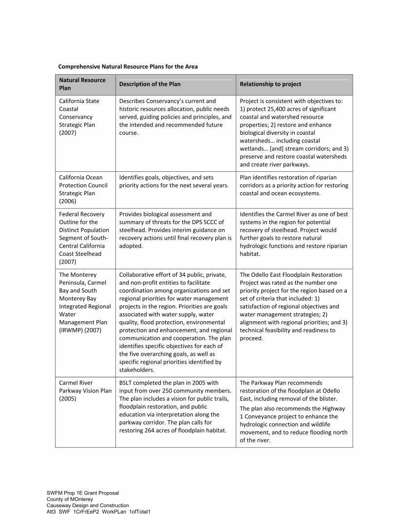
Comprehensive Natural Resource Plans for the Area
Natural Resource Plan
Description of the Plan Relationship to project
California State Coastal Conservancy Strategic Plan (2007)
Describes Conservancy’s current and historic resources allocation, public needs served, guiding policies and principles, and the intended and recommended future course.
Project is consistent with objectives to: 1) protect 25,400 acres of significant coastal and watershed resource properties; 2) restore and enhance biological diversity in coastal watersheds… including coastal wetlands… [and] stream corridors; and 3) preserve and restore coastal watersheds and create river parkways.
California Ocean Protection Council Strategic Plan (2006)
Identifies goals, objectives, and sets priority actions for the next several years.
Plan identifies restoration of riparian corridors as a priority action for restoring coastal and ocean ecosystems.
Federal Recovery Outline for the Distinct Population Segment of South-Central California Coast Steelhead (2007)
Provides biological assessment and summary of threats for the DPS SCCC of steelhead. Provides interim guidance on recovery actions until final recovery plan is adopted.
Identifies the Carmel River as one of best systems in the region for potential recovery of steelhead. Project would further goals to restore natural hydrologic functions and restore riparian habitat.
The Monterey Peninsula, Carmel Bay and South Monterey Bay Integrated Regional Water Management Plan (IRWMP) (2007)
Collaborative effort of 34 public, private, and non-profit entities to facilitate coordination among organizations and set regional priorities for water management projects in the region. Priorities are goals associated with water supply, water quality, flood protection, environmental protection and enhancement, and regional communication and cooperation. The plan identifies specific objectives for each of the five overarching goals, as well as specific regional priorities identified by stakeholders.
The Odello East Floodplain Restoration Project was rated as the number one priority project for the region based on a set of criteria that included: 1) satisfaction of regional objectives and water management strategies; 2) alignment with regional priorities; and 3) technical feasibility and readiness to proceed.
Carmel River Parkway Vision Plan (2005)
BSLT completed the plan in 2005 with input from over 250 community members. The plan includes a vision for public trails, floodplain restoration, and public education via interpretation along the parkway corridor. The plan calls for restoring 264 acres of floodplain habitat.
The Parkway Plan recommends restoration of the floodplain at Odello East, including removal of the blister.
The plan also recommends the Highway 1 Conveyance project to enhance the hydrologic connection and wildlife movement, and to reduce flooding north of the river.
SWFM Prop 1E Grant Proposal County of MOnterey Causeway Design and Construction Att3_SWF_1CrFrEeP2_WorkPLan_1ofTotal1

Natural Resource Plan
Description of the Plan Relationship to project
Carmel River Watershed Assessment and Action Plan (2004)
In 2004, the Carmel River Watershed Conservancy prepared an assessment of the river based on available historic and current data, and limited field work. The action plan recommends key management measures and critical areas needing restoration work. In 2006, the CRWC revised and prioritized the recommended actions.
The Floodplain Restoration Project addresses several of the high priority actions identified in the CRWC plan including acquiring land to improve natural habitat and functions; reducing flood risk through multi-objectives projects including floodplain restoration; expand riparian restoration efforts; and implement the Carmel River Parkway.
The Water Quality Control Plan for the Central Coastal Basin (Basin Plan) (2005)
Adopted by the Central Coast Regional Water Quality Control Board, the Basin Plan designates beneficial use objectives for the Carmel River.
The proposed project will enhance several of the beneficial uses designated for the project area, in particular those related to support of aquatic and riparian habitat.
Carmel Area Land Use Plan (1999)
Monterey County’s adopted Local Coastal Program (LCP) for the portion of the county in which the proposed project would be located.
Project will further LCP goals to 1) protect, enhance and restore wetland and riparian habitat; and 2) manage the floodplain in the lower Carmel River valley to preserve the river’s natural values while providing flood protection.
California’s Wildlife Action Plan (2007)
A comprehensive wildlife conservation strategy for California that includes regional specific conservation actions necessary to restore and conserve ecosystems and wildlife populations. This proposal is in the Central Coast Region.
Project would further the plan’s goal to protect and restore regionally significant river systems, including the Carmel River, and would specifically meet objectives to maintain a functional connection between river and floodplain, preserve riparian habitat, maintain sediment transfer capacity, and improve water quality. It is also consistent with the identified priority to protect and restore CRLF habitat.
California Water Plan Update (2009)
Provides a framework for water managers, legislators, and the public to consider options and make decisions regarding California’s water future.
The plan calls for re-establishing contiguous natural riparian and floodplain habitat and its hydrologic connectivity between rivers/streams and their historical floodplains. The proposed project is also consistent with the goal to promote integrated flood management, in part through enhancement of floodplain ecosystems.
SWFM Prop 1E Grant Proposal County of MOnterey Causeway Design and Construction Att3_SWF_1CrFrEeP2_WorkPLan_1ofTotal1

Maps and Photographs
• Figure 1: Project Location along Central Coast of California • Figure 2: Project Vicinity Map • Figure 3: Project Site – Property Boundaries and Agricultural Preserve • Figure 4: Conceptual Project Plan • Figure 5: Parcel Map of Project Site
• Photo 1: Aerial Photo of Project Vicinity
• Photo 2: Odello East Field Below Palo Corona Regional Park
• Photo 3: Odello East, looking west towards ocean
• Photo 4: Lower Carmel River in 1949
• Photo 5: South Arm of Carmel River Lagoon, immediately after restoration.
SWFM Prop 1E Grant Proposal County of MOnterey Causeway Design and Construction Att3_SWF_1CrFrEeP2_WorkPLan_1ofTotal1

Project Location
Figure 1: Project Location along Central Coast of California
Project Location
SWFM Prop 1E Grant Proposal County of MOnterey Causeway Design and Construction Att3_SWF_1CrFrEeP2_WorkPLan_1ofTotal1

Figure 2: Project Vicinity Map
Project Site
SWFM Prop 1E Grant Proposal County of MOnterey Causeway Design and Construction Att3_SWF_1CrFrEeP2_WorkPLan_1ofTotal1

Figure 3: Project Site
Property boundary Agricultural Preserve area Note: Everything within the project boundary (outer blue line) that is not highlighted orange, is part of the 90-acre restoration area.
SWFM Prop 1E Grant Proposal County of MOnterey Causeway Design and Construction Att3_SWF_1CrFrEeP2_WorkPLan_1ofTotal1

Figure 4: Conceptual Project Plan
SWFM Prop 1E Grant Proposal County of MOnterey Causeway Design and Construction Att3_SWF_1CrFrEeP2_WorkPLan_1ofTotal1

Figure 5: Parcel Map of Project Site
SWFM Prop 1E Grant Proposal County of MOnterey Causeway Design and Construction Att3_SWF_1CrFrEeP2_WorkPLan_1ofTotal1

Photo 1: Aerial Photo of Project Vicinity
Project Location
Carmel Lagoon and South arm restoration area
Palo Corona Regional Park
SWFM Prop 1E Grant Proposal County of MOnterey Causeway Design and Construction Att3_SWF_1CrFrEeP2_WorkPLan_1ofTotal1

Photo 2: Odello East Field Below Palo Corona Regional Park
Photo 3: Odello East, looking west towards ocean
Photo 4: Lower Carmel River in 1949, note lack of floodplain habitat.
SWFM Prop 1E Grant Proposal County of MOnterey Causeway Design and Construction Att3_SWF_1CrFrEeP2_WorkPLan_1ofTotal1
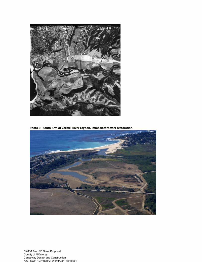
Photo 5: South Arm of Carmel River Lagoon, immediately after restoration.
SWFM Prop 1E Grant Proposal County of MOnterey Causeway Design and Construction Att3_SWF_1CrFrEeP2_WorkPLan_1ofTotal1