WOODFORDIA AND ABBEY MUSEUM - Moreton Bay … · WOODFORDIA AND ABBEY MUSEUM Detailed Planning...
48
WOODFORDIA AND ABBEY MUSEUM Detailed Planning Assessments of Identified Study Areas for Moreton Bay Regional Council AUGUST 2012
Transcript of WOODFORDIA AND ABBEY MUSEUM - Moreton Bay … · WOODFORDIA AND ABBEY MUSEUM Detailed Planning...

WOODFORDIA ANDABBEY MUSEUMDetailed Planning Assessments of Identified Study Areas
for Moreton Bay Regional Council
AUGUST 2012

Prepared by:
Buckley Vann Town Planning ConsultantsGround Floor, 140 Brunswick Street, Fortitude Valley QLD 4006PO Box 205, Fortitude Valley QLD 4006
T: (07) 3852 1822 F: (07) 3852 1750E: [email protected]
© Buckley Vann Town Planning Consultants 2012
This document remains the property of Buckley Vann Town Planning Consultants and has been prepared for the sole use of its intended recipient. Unauthorised use of this document in any form whatsoever is prohibited.
Document Management
Authors: Mary Mealey and Michael Cattoni
Reviewer: Jennifer Roughan
Date: 3 September, 2012 (Final)
Job Number: 12-3794
Job Name: PO - MBRC Woodfordia and Abbey Museum
File Location: J:\12\12-3794 PO - MBRC Woodfordia and Abbey Museum - MM\\Final Report
Revision History
Revision Revision Date Approved By Details of Revision
A 16.07.12 Mary MealeyComments from Council on draft 9.07.12
B 08.08.12 Mary MealeyFinalisation of use tables following further discussion with Council officers
C 03.09.12 Jennifer RoughanComments from Council on draft 30.08.12
D

Buckley Vann Town Planning Consultants
Woodfordia and Abbey MuseumDetailed Planning Assessments of
Identified Study Areas (August 2012)i
TABLE OF CONTENTS
EXECUTIVE SUMMARY .............................................................................................................. ii Woodfordia Study Area.............................................................................................................. iii Abbey......................................................................................................................................... iii
1.0 INTRODUCTION AND BACKGROUND ............................................................................... 1 1.1 Project Inception ............................................................................................................... 1 1.2 Study Brief ........................................................................................................................ 1 1.3 Methodology ..................................................................................................................... 2 1.4 The Project Timeframes ................................................................................................... 3
2.0 REVIEW OF DEVELOPMENT CONTEXT ............................................................................ 4 2.1 Woodfordia Core Site ....................................................................................................... 4
2.1.1 Site Details ................................................................................................................ 4 2.1.2 Draft Woodfordia Rural Precinct Plan ....................................................................... 5 2.1.3 Temporary Local Planning Instrument 03/11 – Woodfordia...................................... 6 2.1.4 Existing Development Approvals............................................................................... 6 2.1.5 Activity Elsewhere in the Study Area......................................................................... 6
2.2 Abbey Museum Core Site................................................................................................. 7 2.2.1 The Site ..................................................................................................................... 7 2.2.2 Development Applications in the Vicinity................................................................... 7
3.0 STUDY AREAS CONSTRAINTS ASSESSMENT ................................................................ 8 3.1 General ............................................................................................................................. 8 3.2 Woodfordia Study Area..................................................................................................... 9
3.2.1 SEQ Regional Plan.................................................................................................. 12 3.2.2 Moreton Bay Rural Areas Strategy 2012................................................................. 13 3.2.3 Key Implications of Rural Areas Strategy................................................................ 17 3.2.4 Consultation............................................................................................................. 17 3.2.5 Key Constraints ....................................................................................................... 17
3.3 Abbey Museum Study Area ............................................................................................ 23 3.3.1 SEQ Regional Plan 2009 - 2031 ............................................................................. 27 3.3.2 Moreton Bay Rural Areas Strategy 2012................................................................. 28 3.3.3 Key Constraints ....................................................................................................... 29
4.0 RECOMMENDED FUTURE DIRECTIONS ......................................................................... 34 4.1 General ........................................................................................................................... 34 4.2 Woodfordia ..................................................................................................................... 34
4.2.1 Vision/Strategic Framework and Indicative Planning Criteria ................................. 35 4.2.2 Potential Uses ......................................................................................................... 38 4.2.3 Criteria to Augment/Amend Rural Areas Strategy Place Type Provisions.............. 39 4.2.4 Additional work required .......................................................................................... 39
4.3 Abbey Museum............................................................................................................... 40 4.3.1 Vision/Strategic framework...................................................................................... 40 4.3.2 Potential Uses ......................................................................................................... 41 4.3.3 Criteria to Augment/Amend Rural Areas Strategy Place Type Provisions.............. 42 4.3.4 Additional Work Required........................................................................................ 42
APPENDIX A: Study Areas

Buckley Vann Town Planning Consultants
Woodfordia and Abbey MuseumDetailed Planning Assessments of
Identified Study Areas (August 2012)ii
EXECUTIVE SUMMARYIn May 2012, the Moreton Bay Rural Areas Strategy was completed on behalf of Moreton Bay Regional Council (Council). The strategy was prepared by a team comprising Buckley Vann Town Planning Consultants, LRAM, CChange Sustainable Solutions, Yurrah and Bligh Tanner Consulting Engineers, in consultation with Council’s project team.
Following receipt of the strategy, Council commissioned Buckley Vann and CChange to undertake further and more detailed assessments of two areas within the rural strategy study area: centred on (i) Woodfordia – the site of the Woodford Folk Festival, and (ii) the site of the Abbey Museum and associated uses in the north east of the Council area, to ‘…identify the role and function of these specific areas as they sit in the context of the communities of interest identified as part of the Rural Areas Strategy’’.
The methodology used by the consultant team for each area investigation included:
� reviewing all relevant background material;� assessing constraints and opportunities; � reviewing the future role and function of each area; and� recommending future directions for each area.
The project was completed in early July 2012 with the supply of this report and associated mapping.
The key findings of the assessment were as follows.
� both study areas contain significant natural values which should be retained as far as possible, and parts of both study areas are subject to natural hazards and constraints including Strategic Cropping Land and Good Quality Agricultural Land to some degree;
� the overall approach to the planning of rural areas, as expressed in the Rural Areas Strategy, remains appropriate for the two identified areas. In particular, uses and activities which are identified in the SEQ Regional Plan as intended to be located within the Urban Footprint should generally be excluded from the study areas;
� conversely, uses and activities in the study areas should not undermine or duplicate those within the Urban Footprint, especially in the case of Woodfordia, in the town of Woodford;
� however, recognising the potential for continuing development pressures resulting from the long term continuation (and possible expansion) of the existing uses and activities in the core sites, it is necessary to provide direction about the types of development which could be appropriate both within the core sites and in the remainder of the study areas, and which are not;
� the overall objective is to balance the retention of the rural character and environmental values of both study areas with providing for a specific and limited range of opportunities for development which are compatible with the character and values.
The study recommends the following approaches for the nominated areas.
Buckley Vann Town Planning Consultants
Woodfordia and Abbey MuseumDetailed Planning Assessments of
Identified Study Areas (August 2012)iii
Woodfordia Study Area
All uses and activities within both the Woodfordia core and frame are limited to a scale and type which do not compromise the social and economic health of Woodford. Festival related uses and activities remain the primary focus of the core. They have the greatest impacts of any uses in the precinct. For the remainder of the year (when no event/festival is occurring in the core), some small scale permanent uses may be appropriate where they do not conflict with or detract from uses in the town of Woodford.
Uses which have a nexus with the festival activities and events in the core are encouraged in the frame, during these events. These uses, including camping and accommodation facilities, walking tracks and trails, recreational activities, eco-tourism and agri-tourism, support and complement the primary role of Woodfordia festivals and events, and are limited to a scale and type which:
� do not compete with similar uses in the Woodford township; and� do not detract from the primary role of the core Woodfordia site.
For the remainder of the year, the frame is used primarily for rural uses, and development in these areas which may detract from environmental or agricultural values or the primary role of the core precinct, is not appropriate.
Tourism activities of a small scale compatible with the rural and environmental values of the precinct are encouraged within the frame. These activities attract people to the site ‘year round’ generating consistent and continuous activity within the frame to enhance and sustain economic benefits for the local economy.
Overall, development within the frame is low impact and limited in scale.
Further work may be required to address concerns by DTMR on traffic issues, and to identify local walking and cycling connections to Woodfordia from Woodford. Review of the Good Quality Agricultural Land/Strategic Cropping Land provisions may be warranted in relation to uses in the frame.
Abbey
The Abbey Museum and associated uses owned by the Confraternity of the Kingdom of Christ,forms the basis of the precinct core. It contains educational facilities and facilities suitable for events up to a specified size.
Further development for events and educational activities within the core may be appropriate where it:
� is limited in scale and intensity; � does not detract from the values of the core;� is compatible with rural uses in the vicinity; � does not compete with or detract from the functioning of retail and commercial centres
elsewhere in the Council area;� has a nexus with the existing educational or entertainment uses on the site; and/or � provides for uses supporting rural or tourism industries.

Buckley Vann Town Planning Consultants
Woodfordia and Abbey MuseumDetailed Planning Assessments of
Identified Study Areas (August 2012)iv
Development within the Abbey frame is of a lesser scale and intensity when compared with development within the core. Land in the frame is used primarily for rural purposes, and may also be suitable for passive uses and activities that support the permanent or temporary uses in the core including events (eg. overflow car parking). However, no event activities (temporary or permanent) or primary or secondary educational facilities are established in the precinct frame because this has the potential to cause a proliferation of non-rural uses in an otherwise rural area and to impact on the natural values of the area.
As in the precinct core, uses supporting rural or tourism industries may be acceptable where they not detract from the values of the frame and are compatible with rural uses in the vicinity.
It is noted that both Woodfordia frame and the whole of the Abbey area are outside the Urban Footprint and uses within the Regional Landscape and Rural Production area are subject to the South East Queensland State Planning Regulatory Provisions. Depending on the scale of any new uses proposed, the thresholds set by the SPRP are likely to provide for the potential uses listed in section 4.3.2.

Buckley Vann Town Planning Consultants
Woodfordia and Abbey MuseumDetailed Planning Assessments of
Identified Study Areas (August 2012)1
1.0 INTRODUCTION AND BACKGROUND
1.1 Project Inception
In May 2012, the Moreton Bay Rural Areas Strategy was completed on behalf of Moreton Bay Regional Council (Council). The strategy was prepared by a team comprising Buckley Vann Town Planning Consultants, LRAM, CChange Sustainable Solutions, Yurrah and Bligh Tanner Consulting Engineers, in consultation with Council’s project team.
Following receipt of the strategy, Council commissioned Buckley Vann and CChangeSustainable Solutions to undertake further and more detailed assessments of two areas within the rural strategy study area: centred on (i) Woodfordia – the site of the Woodford Folk Festival, and (ii) the site of the Abbey Museum and associated uses in the north east of the Council area.
Both areas have relatively complex development histories and the drafting of the forthcoming new planning scheme for Moreton Bay provides an opportunity to clarify the future land use of both sites and their surrounding areas.
The study areas are described at Appendix A.
1.2 Study Brief
The study brief indicated that:
“These assessments shall identify the role and function of these specific areas as they sit inthe context of the communities of interest identified as part of the Rural Areas Strategy. They will provide strategies for the future land use and development intent of these areas, with a particular focus on economic development. It is intended that these assessments will form part of the background work that will directly inform the draft Strategic Framework and new Moreton Bay Planning Scheme.
Council acknowledges that the rural areas play a significant role in the future of the region and believes that understanding the role and function of our rural areas is crucial to the development and coordination of a new planning scheme and more generally, the management of preferred land use outcomes for MBRC.”
The project was to include assessments for both areas, considering the following questions:
� identify the economic realities that may support/hinder the future growth of these studyareas (What business will be in these areas in the future and how do we balance economic interest?);
� identify opportunities for more diverse employment opportunities (eg. eco-tourism, zoo, campgrounds, farm stay etc);
� identify significant environmental factors/values affecting land within the study areas. What are the impacts of these values and how do they help or hinder the future role/development of these areas?
� assess the current role of any recreational or cultural precincts that may exist in the study areas or identify where and how future recreational and cultural precincts might function in the future;
� identify areas for protection (eg. break between Moreton Bay and Kilcoy); and� identify any infrastructure requirements that would be needed to support anticipated future
uses/growth/demands in the study areas (eg. public transport, water supply, sewer connection, water quality etc).

Buckley Vann Town Planning Consultants
Woodfordia and Abbey MuseumDetailed Planning Assessments of
Identified Study Areas (August 2012)2
It was also intended to provide recommendations as follows:
� identify implementation strategies for future development which take into account strategic infrastructure requirements, land use planning requirements and strategic direction regarding the role and function of the specific study areas;
� provide strategic advice on planning scheme changes needed to provide for employment opportunity/diversity in the specific study areas; and
� identify/recommend areas in need of local area/precinct planning.
1.3 Methodology
The overall objective of the project team was to provide Council with a clear policy framework for each site which could be translated into the new scheme.
Given the brief’s emphasis on identifying economic and employment opportunities where possible, the project focussed on identifying whether there were any realistic economic development opportunities, to a greater degree than was possible for these areas in the Rural Areas Strategy project. However, to ensure a balance with other planning considerations, a ‘first principles’ review of all relevant constraints and opportunities was undertaken as a fundamental first step.
This assessment provided direction to determining a vision for each study area, and from there, amendments to the Rural Areas Strategy recommendations for the Strategic Framework and place type provisions were developed.
Specifically, the aim was to identify definitively:
� the core purpose of each study area, in the context of the rural areas as a whole;� whether, on balance, either site might legitimately make a stronger contribution to economic
development than is available under the current planning scheme provisions; and� what types of development the new planning scheme should support or create opportunities
for and what types should it be discouraging.
The methodology used for this study included the following components.
1. Undertaking a review of the background material including
� Rural Areas Strategy report;� materials assembled by Council for the Rural Areas study, in particular constraint mapping
and reporting on environmental and infrastructure constraints, if any;� additional materials facilitating a more detailed review of the nominated areas, including
more specific mapping/GIS at a larger scale for the two areas, and other information on flooding, land tenure, zoning, development application/proposal history, traffic assessments;
� the draft Woodfordia Rural Precinct Plan, TLPI 3/11, State agency comments on the proposed precinct plan to the extent relevant;
� SEQ Regional Plan and State Planning Regulatory Provisions; � other relevant documents which become evident during the review process and from
research planning approaches to similar areas elsewhere.

Buckley Vann Town Planning Consultants
Woodfordia and Abbey MuseumDetailed Planning Assessments of
Identified Study Areas (August 2012)3
2. Undertaking assessments
Assess opportunities and constraints for possible activities and uses which may be suitable in the assessment areas which may assist with economic development objectives without creating unintended impacts on centres, the environment, the road network and so on. These include:
� Policy context assessment� Identify objectives and directions for Regional Landscape and Rural Production Area
and regional plan and implications of other State planning documents (Coastal Plan, Strategic Cropping Land, Good Quality Agricultural Land).
� Review key directions recommended in Rural Areas Strategy, especially regarding role, function of nearby townships.
� Economic opportunity/constraint overview� Review economic/growth context from Rural Areas study.� Review current activities, approvals, aspirations on proposals expressed by landholders
to date.� Phone discussions with key stakeholders: The Abbey, Queensland Folk Association.
� Physical opportunity/constraint overview� Mapping constraints including Good Quality Agricultural Land, flood, vegetation cover
(from RE mapping and aerial), topography.� Review of any local traffic/transport and planning assessment.� Mapping of existing land uses and tenure (as relevant).
� Identify possible/likely range of activities and potential impacts and implications.
3. Review existing and future role and function of both areas
In the context of the Rural Areas Strategy communities of interest and recommended place types and information emerging from assessments.
4. Recommend future directions for both areas
� Recommend planning approaches appropriate for the new planning scheme including:� a vision for each site; and� criteria for inclusion in the draft Strategic Framework;� criteria to augment place type provisions recommended in strategy report;� additional work required including local planning.
� Recommend any other planning scheme changes which may be needed to support employment or economic development objectives.
� Recommend any non-planning scheme measures which may be appropriate on the basis of the review.
1.4 The Project Timeframes
The project was undertaken in May and June 2012, and reporting was completed with this report and associated mapping, in August 2012.

Buckley Vann Town Planning Consultants
Woodfordia and Abbey MuseumDetailed Planning Assessments of
Identified Study Areas (August 2012)4
2.0 REVIEW OF DEVELOPMENT CONTEXTThe Woodfordia site and the Abbey Museum site are areas within the Moreton Bay Regional Council area which have unique development histories. The forthcoming new planning schemefor the Moreton Bay region will need to express clear planning policy for each area.
This project provides a more detailed investigation of both the ‘core’ sites and the wider ‘study areas’ prescribed by the project brief. (This assessment will be used later in this report to identify ‘frame’ areas to inform recommended policy approaches.)
Map 1 – Woodfordia and Abbey identify the core and frame for each study area and the study area boundary. This section examines the history of development, and existing and proposed policy settings for the core sites within each study area, as a starting point for the investigation.
This includes a review of current planning scheme provisions, previous approvals, development pressures and draft planning instruments (where applicable).
2.1 Woodfordia Core Site
2.1.1 Site Details
‘Woodfordia’ is the name given to the site of the Woodford Folk Festival, held each year in late December. This site is located 4km north-west of the town of Woodford. This area is accessed via the D’Aguilar Highway and Kilcoy Beerwah Road with access to the site itself obtained off either Woodrow Road or Jenkinson Road.
The site comprises the following whole lots1:
Table 1: Lots comprising the Woodfordia Rural Precinct Plan
Address Lot on Plan
185 Kilcoy Beerwah Road , Woodford Lot 1 on CG4923
87 Woodrow Road, Bellthorpe Lot 565 on C311082
87 Woodrow Road, Bellthorpe Lot 60 on SP165120
No street address Lot 3 on AP19215
68 Pratt Road, Bellthorpe Lot 10 on SP165105
283 Woodrow Road, Bellthorpe Lot 1 on SP149480
1 Kilcoy Beerwah Road, Woodford Lot 7 on RP840560
The site was identified in the mid-1990s as an alternative to the previous folk festival site at Maleny, and the festival use was supported through a Ministerial rezoning under the then Local Government (Planning and Environment) Act 1990. It is now owned by Council and leased to the Queensland Folk Federation (QFF).
1 In addition, the draft Rural Precinct plan includes some small areas forming part of Lot 1 SP 149480.
Buckley Vann Town Planning Consultants
Woodfordia and Abbey MuseumDetailed Planning Assessments of
Identified Study Areas (August 2012)5
In recent years, the QFF has prepared a development code that outlines the Federation’s long term vision for the site. Negotiations have been undertaken with Council over several years regarding the ultimate mix of land uses on the site, based on the central concept of outdoor events at various scales, using the natural assets of the site in a way that protects and/or enhances those assets.
2.1.2 Draft Woodfordia Rural Precinct Plan
Woodfordia was declared a ‘rural precinct’ under the South East Queensland Regional Plan 2009-2031 (Regional Plan) by the former Minister for Planning in December 2010. It is understood that this area was declared as a rural precinct in order to allow development associated with the Woodford Folk Festival to continue to operate without being limited by the development thresholds established by the South East Queensland Regional Plan 2009-2031 State Planning Regulatory Provisions (SPRP).
Section 1.5(2)(a) of the SPRP states that the SPRP “does not apply to development in a rural precinct if the development is consistent with the rural precinct.” Accordingly, this rural precinct designation essentially ‘exempts’ the area from the provisions of the SPRP and establishes precinct specific intentions for development in the area.
The rural precinct plan provides for a range of uses which go beyond the scale and intensity of what is allowable within the Good Quality Agricultural Land of the SPRP including:
� administrative offices (where associated with events at Woodfordia);� caretakers residences;� educational uses (including outside hours school care and on-site student accommodation);� food and drink outlets;� outdoor events;� short-term accommodation;� recording studio; and� shops.
It is principally an instrument to allow events associated with the Woodford Folk Festival (and other similar events held at the site) to continue to operate within the area and change or expand to meet future demands. It also allows some associated and ancillary development to occur within the precinct where it complements or supports such events.
Following the recently completed first State interest review of the draft rural precinct plan, itappears that there is ‘in principle’ support for the proposed precinct. However, some State agencies have requested further information on a number of matters including:
� detailed traffic impact assessments;� management of natural hazards on site;� protection of koala habitat; and� protection of vegetation of high environmental significance.
Council has responded to some of the State agency comments received. It is anticipated that any outstanding State agency issues will be resolved in the near future and an amended version of the precinct plan is expected to be submitted to the State government shortly for second state interest review. The final plan is intended to be adopted before 31 December, 2012.

Buckley Vann Town Planning Consultants
Woodfordia and Abbey MuseumDetailed Planning Assessments of
Identified Study Areas (August 2012)6
This current project is not intended to re-examine the detail of the rural precinct plan, but rather to assess the site and its surrounds in the context of what other opportunities ought to be facilitated in the area.
2.1.3 Temporary Local Planning Instrument 03/11 – Woodfordia
As an interim measure to manage development on the Woodford site during the drafting of the Rural Precinct plan, Council adopted a temporary local planning instrument, TLPI 03/11, which took effect on 23 December, 2011.
This TLPI changes levels of assessment and assessment criteria applicable to the site underthe Caboolture Shire Plan. The purpose of this TLPI is to “…support the use of Woodfordia as an entertainment and recreation events venue of cultural, economic and social significance…”.It facilitates this purpose by making a number of entertainment uses either self-assessable or code assessable and limiting the relevant assessment criteria for such uses.
2.1.4 Existing Development Approvals
A review of existing and previous development approvals relevant to the Woodfordia site was undertaken as part of this investigation. A brief summary of existing and previous development approvals for the site are summarized below:
Table 2: Development Applications pertaining to Woodfordia
Date Approval
21 November 1995 Ministerial rezoning approval to use the site for "Outdoor Entertainment” associated with the Woodford Maleny Folk Festival.
14 December 2004 Approval for a camping area and facilities associated with Woodford Folk Festival between 26 December and 3 January.
8 June 2005 Ministerial approval for “The Dreaming festival” (a 6 day event held annually in June).
23 June 2006 Approval for an extension to camping and car parking associated with Woodford Folk Festival.
26 October 2006 Approval for an extension to the existing approval to allow camping and car parking associated with Woodford Folk Festival.
18 September 2008 Approval for a sewage treatment plant.
It is understood that the Woodford Folk Festival and associated activities have been operating within the scope of these existing approvals.
2.1.5 Activity Elsewhere in the Study Area
In addition, some development pressure has emerged on sites in the vicinity of the Woodfordia site though most appear to be enquiries rather than actual applications. It is understood that Council has had discussions over several years with a number of local landowners about the possibility of allowing uses such as short-term accommodation including cabins and possibly conference and wedding reception venues, to take advantage of demand during events, but also potentially to generate income on a year round basis.

Buckley Vann Town Planning Consultants
Woodfordia and Abbey MuseumDetailed Planning Assessments of
Identified Study Areas (August 2012)7
2.2 Abbey Museum Core Site
2.2.1 The Site
The Abbey Museum is located at 1 The Abbey Place, Caboolture (Lot 2 on SP152648), which is 135.1 ha in area. The site is currently owned and operated by the Confraternity of the Kingdom of Christ. Since the establishment of the original museum and associated uses in 1970, a number of development applications have been received to expand and further develop activities occurring on site. The site is currently used for a number of activities including:
� an abbey/place of worship;� cemetery;� community accommodation (for abbey residents);� farm;� orchard;� extractive industry (de-silting and deepening existing dam);� museum;� festival grounds; and� child care centre.
It is understood that the main ‘attractor’ for the site for the majority of the year is the existing museum on site. However, the festival grounds are used annually for festival events including amedieval festival. Currently, Council’s Economic Development area has confirmed the Abbey asthe location of “Farm Fantastic” (a farming product expo), to be held on the site in October 2012. The festival has previously been held on a site in Elimbah that is no longer available.
St Michael’s College, a co-ed school for boys and girls from Prep to Year 7, has also been established on the south western part of the site at 1- 63 The Abbey Place in recent years. The school’s website identifies a long term plan to provide a double stream for Prep to Year 6 by 2014, and indicates that the school has not discounted the possibility of a high school in later years.
2.2.2 Development Applications in the Vicinity
Development applications lodged and enquiries made regarding sites in the vicinity of the Abbey site in recent years are summarized below.
Table 3: Development enquiries for Abbey site
Date Site Application/Proposed Use Application Status
January 2012
434 - 502 Bribie Island Road, Caboolture
Wholesale nursery Current
January 2012
336 Bribie Island Road, Caboolture
Waste transfer and recycling facility
Prelodgement only
August 2011 2 Abbey Place, Caboolture
Recycling yard Prelodgement only
February 2010
2 Abbey Place, Caboolture
Transport depot Approved
December2007
336 Bribie Island Road, Caboolture
Driver training and recreation facility
Lapsed
November2006
336 Bribie Island Road, Caboolture
Saddle club Lapsed

Buckley Vann Town Planning Consultants
Woodfordia and Abbey MuseumDetailed Planning Assessments of
Identified Study Areas (August 2012)8
3.0 STUDY AREAS CONSTRAINTS ASSESSMENT
3.1 General
As discussed in section 2.0, for the purposes of the project, each study area is divided into:
� a core, describing the site itself, and� a frame, describing an area in the vicinity which can be considered to be influenced by the
core.
An assessment of the constraints (and opportunities) affecting the entire study area for each site has also been undertaken. This has included a review of applicable constraints mapping from a range of sources, and the following planning instruments/matters:
� SEQ Regional Plan 2009-2031 and SEQ State Planning Regulatory Provisions (SPRP);� State Planning Policies and other State interests;� Caboolture ShirePlan; and � the Moreton Bay Rural Areas Strategy 2012.2
Where these investigations have identified matters of particular relevance for the future planning and visioning of the project study areas, they have been discussed in greater detail below.
A discussion of opportunities has been carried forward into the recommendations section at Section 4.0.
The Rural Areas Strategy report includes a ‘Place Type Framework’ for all the rural areas within the local government area. The following discusses this in more detail for each type. For context, and extract of the applicable map is provided below.
Figure 1: Extract from Place Type Framework Map – Rural Areas Strategy May 2012
2 ‘Moreton Bay Rural Areas Strategy’, Buckley Vann and others, May 2012.
Woodfordia Site
Abbey Museum Site

Buckley Vann Town Planning Consultants
Woodfordia and Abbey MuseumDetailed Planning Assessments of
Identified Study Areas (August 2012)9
3.2 Woodfordia Study Area
Map 1 – Woodfordia describes the location of the study area, and the location of the core and the frame areas within it.
Buckley Vann Town Planning Consultants
Woodfordia and Abbey MuseumDetailed Planning Assessments of
Identified Study Areas (August 2012)10
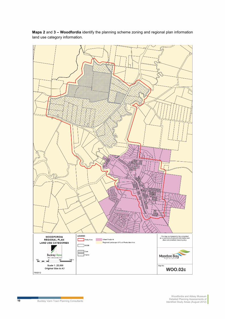
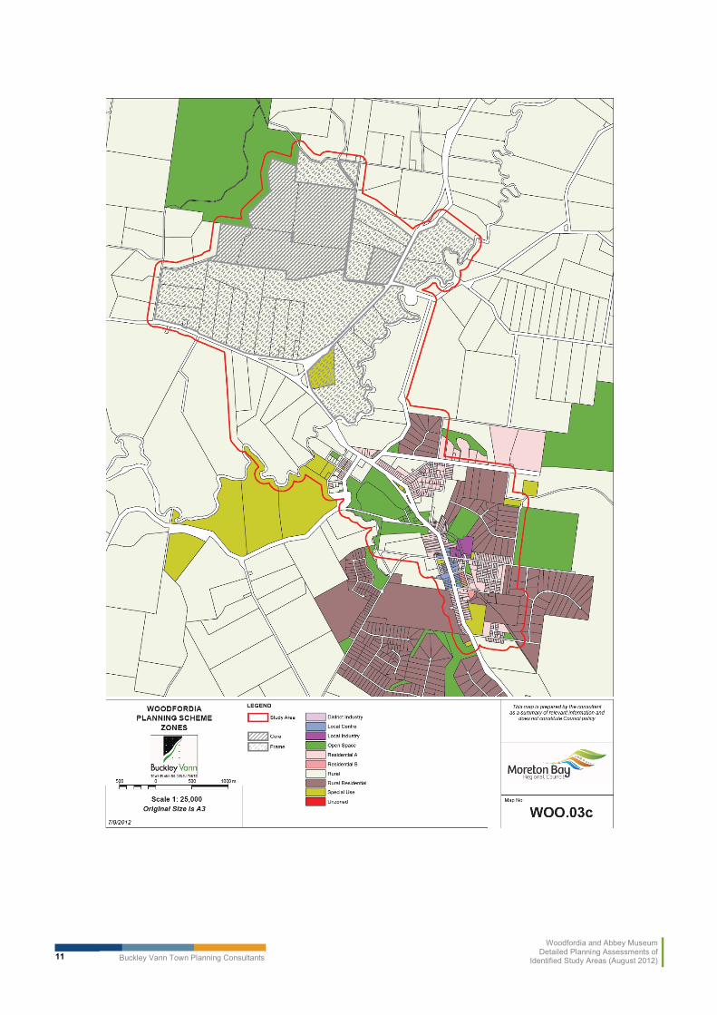
Maps 2 and 3 – Woodfordia identify the planning scheme zoning and regional plan informationland use category information.
Buckley Vann Town Planning Consultants
Woodfordia and Abbey MuseumDetailed Planning Assessments of
Identified Study Areas (August 2012)11
Buckley Vann Town Planning Consultants
Woodfordia and Abbey MuseumDetailed Planning Assessments of
Identified Study Areas (August 2012)12
3.2.1 SEQ Regional Plan
As shown in Map 3, The Woodfordia festival site (precinct core) and much of the northern half of the wider study area are identified within the regional landscape and rural production (RLRP) land use category of the Regional Plan. The regional plan establishes that the intention for land identified within this land use category is to “…protect this land from inappropriate development, particularly urban or rural residential development. These areas support the lifestyle and wellbeing of the regional population, primarily located in the Urban Footprint. Natural assets within this area require management to improve the capacity to provide ecosystem services, increase the region’s resilience and support the population.”
The southern part of the study area includes part of the Woodford township. This township is identified by the regional plan within the ‘urban footprint’ land use category. The intention for this land use category is “…land that can meet the region’s urban development needs to 2031 in a more compact form…” and identifies land that is suitable for future urban development.
In addition to the broad development intentions established by the land use categories identified by the Regional Plan within the study area, the Regional Plan also includes the ‘Moreton Bay Sub-regional Narrative’3. This sub-regional narrative establishes more specific development intentions for land within the Moreton Bay sub-region.
The extracts from the subregional narrative included below are considered to be most relevant in establishing the Regional Plan’s intentions for the study area:
� “Land in the Caboolture West is an identified growth area and may also help accommodate long term employment and enterprise growth;
� Additional land for other business and industry employment (that is, large footprint uses) will need further investigation;
� While protected from large-scale urban development, the rural areas of Moreton Bay will also continue to provide economic and employment opportunities by accommodating rural industries, rural and home-based enterprises, small business, industry and tourism; and
� …encouraging rural and tourism-related business opportunities outside the Urban Footprint, will achieve further economic and employment diversity.”
(Note: Land is Caboolture West is now a master planned area.)
This sub-regional narrative is further supported by the Desired Regional Outcomes (DRO’s) of the Regional Plan. The DROs represent a number of key objectives which must be met by development. Relevant outcomes include:
� consolidation of urban uses within urban areas;� promotion of innovative use of rural land for rural purposes (this may not extend to
commercial development); and� additional development outside the Urban Footprint should only be considered where there
is good access to transport and infrastructure services.
Although the Moreton Bay sub-regional narrative and the DRO’s of the Regional Plan do not establish any development intentions for the Woodfordia study area specifically, it does establish a general intention for land within the Good Quality Agricultural Lands of Moreton Bay to accommodate some business and tourism activities, particularly rural and tourism related activities.
3 Pages 24 and 25, SEQ Regional Plan 2009-2031

Buckley Vann Town Planning Consultants
Woodfordia and Abbey MuseumDetailed Planning Assessments of
Identified Study Areas (August 2012)13
It also appears to encourage the innovative use of rural areas where this will provide some economic and employment opportunities.
However, in contrast, the Regional Plan also establishes a clear intention for urban uses to be consolidated within the urban footprint. Accordingly, any urban uses should be consolidated with the Woodford township (being that part of the study area within the urban footprint).
On the basis of the above, it is considered that the ongoing use of the Woodfordia precinct core for festival and event activities is generally supported by the Regional Plan. Furthermore, some rural and other tourism related activities may also be appropriate within the precinct frame and study area where they are of a limited scale and intensity. However, any urban activities should be consolidated within the urban footprint of Woodford.
3.2.2 Moreton Bay Rural Areas Strategy 2012
The key aspects of the strategy report in relation to the study area are:
� Open Space and Landscape Analysis:
� The western parts of the Moreton Bay region, including much of the area surrounding the Woodfordia site, have vegetation, ecological and scenic amenity values of regional significance.
� Ecosystem function of remnant vegetation (and certain areas of regrowth) within non-urban areas is protected under existing state legislation.
� The potential for strong north-south connectivity through the western extent of the Strategy study area is contingent on one or more of three partially fragmented corridors being viable and subject to a combined review of the Caboolture Shire linkages and Pine Rural Area corridors once the latter is available.
� Sustainable connections to urban and coastal areas in the east are typically via the major and minor waterways, with stream health and condition (both within large rural holdings and through urban areas) being a significant factor in the success of the open space network
� The protection and enhancement of significant ecological values throughout the region, along with a consistent approach to landscape character and scenic amenity, will ensure a diverse and well-integrated open space network is maintained throughout the Council area.
� Housing Analysis:
� The preferred scenario for future residential development within the rural study area involves limiting growth within the Regional Landscape and Rural Production Area and Rural Living areas and accommodating projected future dwellings within the main townships of Woodford, Samford and Dayboro.
� There is a consistent need for retirement and aged care accommodation in the main rural townships of Woodford, Dayboro and Samford. It is estimated that one facility is required in each township in the short term, with the flexibility to expand in the longer term to accommodate increasing demand.

Buckley Vann Town Planning Consultants
Woodfordia and Abbey MuseumDetailed Planning Assessments of
Identified Study Areas (August 2012)14
� A range of smaller dwelling options is needed to respond to the noticeable trend of older people seeking to move from rural or rural residential lots into rural townships.
� Economic Analysis:
� All main rural centres in the Moreton Bay region, including Woodford, are functioning well. They are currently fulfilling roles that are conducive to their main catchment areas and can be described as successful rural towns/centres.
� There is adequate floorspace at Samford and Woodford now and into the future. Even by 2031, it is unlikely that more floorspace will be required. It has been recommended that these centres’ roles and floorspace remain as they were in 2012.
� In comparison to the Samford and Dayboro areas, the Woodford and Coastal areas in Moreton Bay generally have a lower socio-economic status when compared to the Queensland average.
� The predominant driver behind the lower socio-economic status of those living in Woodford is the high level of employment in rural industries. The exceptions to this arethe high proportion of managers, people working from home and those owning their own home that have been identified in these communities of interest.
� The predominant rural sector that underpins the economy of the Moreton Bay region’s rural areas, in particular Woodford, is in decline and this may have a significant impact on the ability to achieve high rates of self containment, with former rural industry workers seeking employment outside their relative community of interest and potentially, outside the Moreton Bay region. Furthermore, continual decline in this industry could see major changes to employment rates and industries of employment over the coming years.
� Given the high level of fragmentation on rural land, the key question for the future is how rural land can be maintained for its ecological and landscape values in this new era. In particular, how can pressure for the establishment of dwellings on existing isolated lots be managed, and how can landowners be encouraged to care for the land when it doesn’t provide a living? There is not much to be achieved by Council setting up its own regulations or programs – generally, more is to be gained by working with regional planning frameworks.
� Notwithstanding that, rural industries will continue to require support in the life of the new planning scheme. The main focus of support for the rural sector in the future should be the north-west part of the study area, centred on Woodford. The fragmentation of Dayboro and Samford means it is too late for these areas.
� From 2006 figures, there is a high proportion of workers in a variety of industries were over the age of 55. As this data is now five years old, it is appropriate to conclude that a significant number of these residents are either already retired or close to retiring. Should the rural areas of Moreton Bay not be able to attract new workers to these communities of interest, significant employment and economic impacts will be observed.

Buckley Vann Town Planning Consultants
Woodfordia and Abbey MuseumDetailed Planning Assessments of
Identified Study Areas (August 2012)15
� A review of other possible economic opportunities suggests there is some scope for targeted economic development in the Woodford area generally based on the following:
o Tourist accommodation: Where it can be targeted and branded in a consistent way. For example, an approach to promoting the marine/coastal interface to attract the RV (caravan) sector and the day tripper/inland water sports sector has some potential.
o Home-based businesses: Particularly given proximity of the study area to urban areas of SEQ, there is potential to capitalise on the demand for rural living byencouraging the establishment of home-based businesses. These businesses typical spend a large proportion of their income locally.
o Footloose industries could be attracted to the area, but need adequate internet and communications is essential. To support a ‘Smart Communities’ strategy, adequate communications are needed so connections can be virtual as opposed to physical.
o Bruce Highway alternative as a tourist attraction: An ‘inland’ alternative to the Bruce Highway could be developed as a tourist experience. Small scale tourism businesses associated with the alternative route would support low skilled, local jobs and serve as steeping stones to other work opportunities for the rural youth.
o Festivals/events: The Woodfordia site is now well known and successful and likely to grow to some extent in future years depending on management of impacts and effective links to services in Woodford. An approach which links festivals to the tourist sectors identified above could have potential while not encroaching on remaining rural activities. Tamworth manages to do this successfully. (The Rural Areas Strategy noted that retail uses should not be encouraged at Woodfordia as these would detract from the vitality of the Woodford centre.)
� Finally, in balancing all the findings, the Rural Areas Strategy recommends the inclusion ofthe Woodfordia site and surrounds in the ‘Foothills’ place type in the new planning scheme.(See section 4.6.7 of the strategy report), which reads as follows.
“4.6.7 Foothills
Key characteristics, trends/pressures and opportunities
The Foothills precincts occur along edges of the Ranges. Of the 21,000ha in the Foothills, 18,000 is already cleared. They are characterised by more gently sloping than the Ranges - grazing quality land, generally cleared, with east-west vegetated linkages worth enhancing.
The vegetated ridges have high scenic amenity values but better access to services and utilities than Hills and Ranges. They are heavily subdivided, with approximately two-thirds of the 1,000 lots already built on. More suitable for rural living than for agriculture because of fragmentation.

Buckley Vann Town Planning Consultants
Woodfordia and Abbey MuseumDetailed Planning Assessments of
Identified Study Areas (August 2012)16
Planning Response
Planning intent/indicative planning criteria
Predominant use is rural, particularly sustainable grazing. Protect existing landscape characteristics especially where they contribute to biodiversity linkages and conservation values. Rural living on existing lots supported where a building envelope can be identified not on ridgelines.
Identify opportunities for east-west linkages. No further subdivision. Building envelope provisions reflecting planning intent. Overlay provisions – bushfire. Identify opportunities for consolidation of development in key areas, rather than dispersed, and away from high biodiversity value areas.
Link to offsets strategy where possible.
Other considerations
Education program to encourage residents to limit further land clearing and rehabilitate landscape values where possible.”
In addition, in section 4.6.2 the strategy makes a number of recommendations about the townships, including the following regarding the town of Woodford:
For all townships, a local area planning exercise is recommended to determine:
� possible need to expand urban footprint boundaries in Dayboro and Samford, which could inform a submission to DSDIP;
� locations within the townships where re-development/re-subdivision of existing areas may be appropriate;
� locations where dwelling types other than separate houses would be most appropriate (eg. multiple dwellings, duplexes, shop top housing etc); and
� character precincts that need to be preserved under the new planning scheme.
� For Woodford and D’Aguilar
� Retain and reconfirm Woodford as the centre of activity for the north western rural communities of the MBRC.
� Direct population growth away from rural residential areas into the centres/urban footprints (Woodford and to a lesser extent D’Aguilar).
� Majority of growth within the north western rural area to be accommodated within the Woodford urban footprint, subject to further assessment of the capacity of existing vacant land and the need for additional land within the urban footprint.
� Facilitate greater housing diversity.
� Accommodate expansion of existing retirement village to accommodate low and high care beds within new planning scheme zones.

Buckley Vann Town Planning Consultants
Woodfordia and Abbey MuseumDetailed Planning Assessments of
Identified Study Areas (August 2012)17
3.2.3 Key Implications of Rural Areas Strategy
The strategy identified the important role of rural areas in Moreton Bay in conserving landscape, open space, ecological and scenic amenity values for the whole of the Moreton Bay region.
Mapping forming part of the ecological assessments for the strategy project shows theWoodfordia study area and areas near it as having a number of ecological and scenic values and being on the edge of larger forest areas which contribute to inter-urban breaks to the north of Caboolture. Koala habitat forms part of these areas. The new planning scheme will need to reflect these values and limit development which might detract from them.
In addition, the strategy highlights the role played by Woodford (as well as Dayboro and Samford) in supporting retail, commercial, economic development and housing outcomes in Moreton Bay, and notes that any development on the Woodfordia site should not detract from this role.
3.2.4 Consultation
On Monday 2 July, 2012, the consultant team held a phone meeting with the Queensland Folk Federation’s town planner, Mr Paul Summers of Paul Summers Planning Strategies.
The meeting discussed the QFF objectives for establishing a long-term presence on the site for not only the annual Woodford Folk Festival, but other festivals at a range of scales.
While it was noted that this study is not intended to review the draft Rural Precinct Plan, a range of possible uses were discussed, particularly for within the core site, which could assist the QFF to achieve its objectives by providing an income stream, while also recognising the need for the site to operate in a way which is complementary to the town of Woodford. Consultation outcomes were in line with all the earlier recommendations in the Rural Areas Strategy, with the exception of the QFF indicating that they would like to see a small retail outlet at the core site within the proposed administration building, to showcase products associated with the festival/s. Should retail facilities be limited to those products that are directly related to the festival/s, this is not likely to detract from the Woodford Town Centre.
It was noted that connectivity to Woodford is a key element in achieving complementarity, and that there may be value in undertaking further detailed planning investigations of the area south of the core site and other sites between Woodfordia and Woodford, to better understand existing conditions and opportunities.
3.2.5 Key Constraints
The following assessment provides a finer level of detail in relation to the site and its surroundings that was possible in the rural strategy investigations.
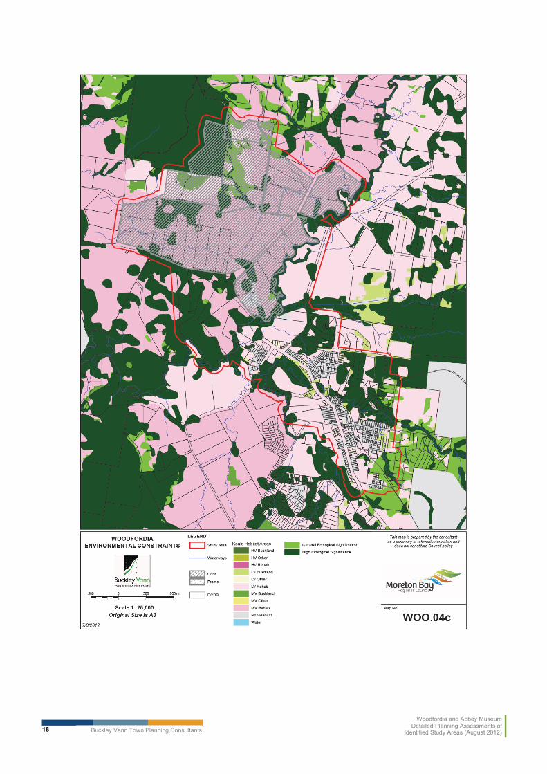
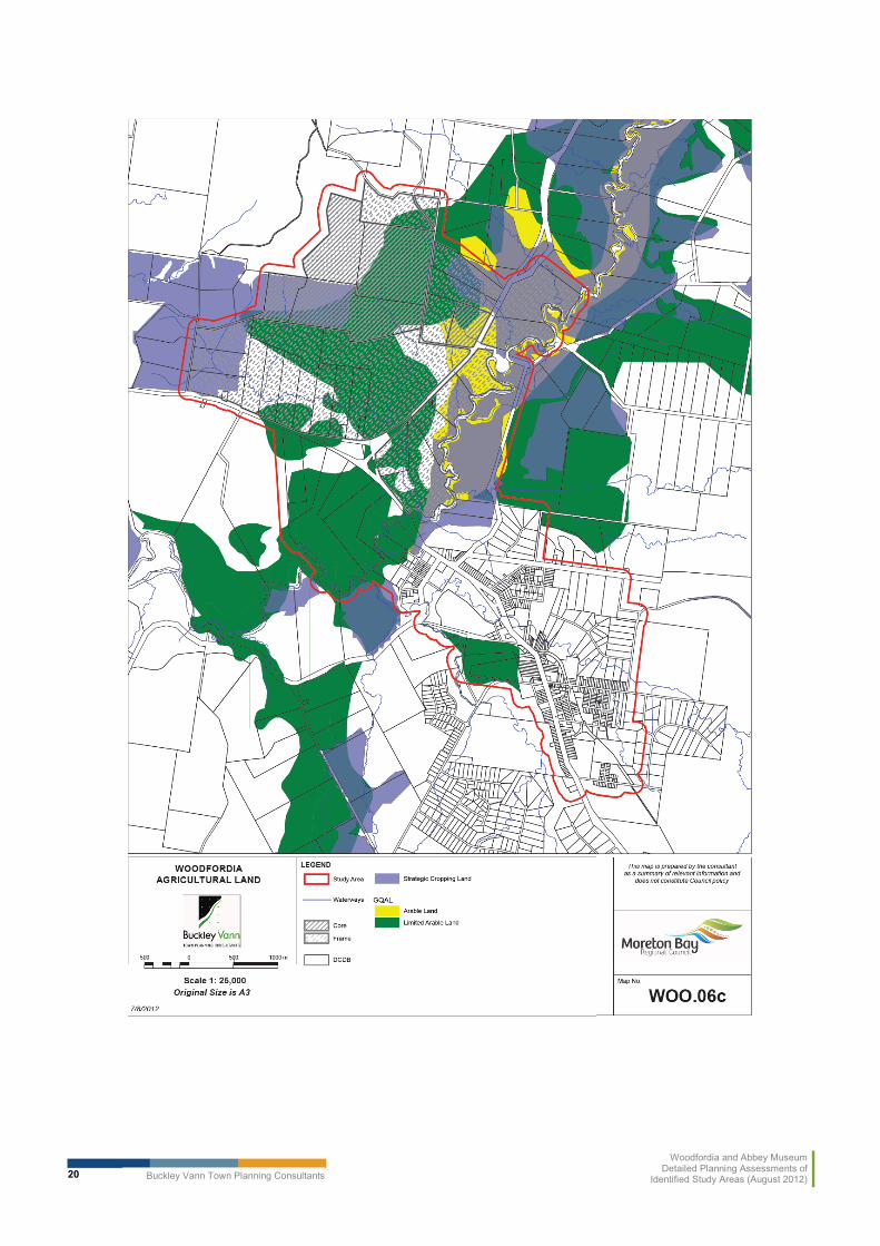
Maps 4, 5 and 6 – Woodfordia describe the key constraints - by groups of ecosystem, hazard constraints and agricultural value of land.
Buckley Vann Town Planning Consultants
Woodfordia and Abbey MuseumDetailed Planning Assessments of
Identified Study Areas (August 2012)18

Buckley Vann Town Planning Consultants
Woodfordia and Abbey MuseumDetailed Planning Assessments of
Identified Study Areas (August 2012)19
Buckley Vann Town Planning Consultants
Woodfordia and Abbey MuseumDetailed Planning Assessments of
Identified Study Areas (August 2012)20

Buckley Vann Town Planning Consultants
Woodfordia and Abbey MuseumDetailed Planning Assessments of
Identified Study Areas (August 2012)21
Strategic Cropping Land (SCL)/Good Quality Agricultural Land (GQAL)
Large parts of the study area are identified as being Good Quality Agricultural Land. In addition, Lot 10 and part of Lot 60 of the Woodfordia precinct core and much of the land around the creek is identified as potential Strategic Cropping Land) by State mapping and as ‘arable land’ within the Caboolture Shire Plan. State Planning Policies 1/12 – Protection of Queensland’s Strategic Cropping Land and 1/92 – Development and the Conservation of Agricultural Land will have implications for any development in the mapped areas.
The overall objective of these SPPs is to ensure that development preserves the productive capacity of this land so that it is available for future generations. To ensure this objective is facilitated, any planning instrument regulating development within the study area will need to ensure that land identified as potential Strategic Cropping Land and arable land is protected from activities which may adversely impact on the productive capacity of this land.
In order to avoid adversely impacting on the future productive capacity of this land and achieve consistency with these SPP’s, any future development within the Woodfordia Study Area is likely to need to either avoid areas of potential Strategic Cropping Land and arable land or be capable of addressing the requirements of the SPPs.
Natural Hazards
Much of the northern part of the Woodfordia precinct core and study area are identified as at risk from bushfire and landslide by the current planning scheme. These areas generally correspond with the sloped areas within the study area. Part of Lot 7 on RP840560 and Lot 1 on CG4923 are also identified on the Queensland Reconstruction Authority’s (QRA) flood mapping as within a flood plain area. Accordingly, the objectives of State Planning Policy 1/03 –Mitigating the Adverse Impacts for Flood, Bushfire and Landslide Hazard and temporary State Planning Policy 2/11 – Planning for Stronger, More Resilient Floodplains are relevant considerations in the development of any future land use planning for the area.
These SPP’s essentially require hazard areas to be identified and that development should either avoid these areas or manage the risk from these hazards where development is proposed in these areas.
As this is a hazard which can be effectively managed through design, this is considered to be a relatively minor constraint to future development within the study area. Furthermore, those parts of the study area identified as subject to natural hazards are predominantly located on sloping areas to the north of the study area. It is considered that demand for flatter, unconstrained land to the south of the precinct core is likely to be in greater demand for any future development within the study area.
Any future land use planning within the study area should seek to discourage development in locations where it may be at risk from natural hazards. However, where development is proposed within these areas, such development must ensure that any risks associated with natural hazards are appropriately managed.

Buckley Vann Town Planning Consultants
Woodfordia and Abbey MuseumDetailed Planning Assessments of
Identified Study Areas (August 2012)22
Traffic
Kilcoy-Beerwah Road runs along the south-eastern boundary of the Woodfordia site and is a State controlled road. As part of the first State interests review of the Rural Precinct Plan, the Department of Transport and Main Roads (DTMR) expressed concerns about the impacts that major events Woodfordia may have on the state controlled road network.
Accordingly, DTMR have requested a traffic impact assessment as part of the ongoing development of the Rural Precinct Plan for the site. It is considered likely that a similar investigation may be required as part of the development of any land use plan for the locality.
This matter has not been investigated as part of this report. However, the capacity of transport infrastructure to support events within the Woodfordia study area is potentially a major development constraint. Further direction should be sought from DTMR in the context of the overall planning scheme drafting, to confirm their views on this matter.
Environmental Values
Much of the Woodfordia site and the wider study area is identified as having some environmental value. A number of these have also been identified as part of the first state interest check. These values include:
� koala habitat areas (State mapping);� Bellthorpe forest reserve (protected area under EPBC Act4);� conservation estate (State mapping);� remnant vegetation (State mapping);� biodiversity significance (planning scheme overlay); and� potable water catchment and minor waterway (planning scheme overlay).
State Planning Policy 2/10 – South East Queensland Koala Conservation identifies much of the study area as high and medium value bushland and medium and low value rehabilitation areas. This SPP seeks to ensure that development “contributes to a net increase in koala habitat in south-east Queensland, and assist in the long term retention of viable koala populations in south-east Queensland“. As essentially the entire Woodford study area (outside of the urban footprint) is identified as either medium value rehabilitation habitat or medium value bushland habitat for koalas, allowing additional development within the study area may be seen to be compromising the objective of this SPP. Unless it can be demonstrated that a future planning instrument can ensure development can occur within these areas in a manner which does not compromise the objectives of this SPP being achieved (in accordance with section 3.3-3.5 of the SPP), this may be a major constraint to further development within the study area. Offsets may apply.
The following summary from the Rural Areas Strategy report is relevant here:
“South East Queensland Koala Conservation. State Planning Regulatory Provisions. (Koala SPRP) Assessable Development Area Koala Habitat Values Map May 31 2010 (SEQKPA v.1.2)
4 Environmental Protection Biodiversity and Conservation Act 1999
Buckley Vann Town Planning Consultants
Woodfordia and Abbey MuseumDetailed Planning Assessments of
Identified Study Areas (August 2012)23
The SPRP provides statutory protection to koala habitat within the old Pine Rivers LGA. Koala Habitat Trees within Priority Koala Assessable Development Areas (PKADA) Bushland Habitat are not to be cleared, and, within Koala Assessable Development Area, Bushland Habitat is not to be cleared outside the urban footprint. Clearing of Koala Habitat Trees within High and Medium Value Rehabilitation Areas are to be offset.”
The Woodford study area also encroaches into part of the Bellthorpe forest reserve. This constraints and opportunities analysis has identified that this forest reserve may be protected area under the Environmental Protection Biodiversity and Conservation Act 1999 and is identified as a conservation area by the Department of Environment and Resource Management. State mapping also shows large pockets of regrowth and remnant vegetation and Vegetation Management Act “essential habitat” within the study area. Accordingly, any future development within the study area should seek to avoid these areas in order to ensure these environmental values are preserved.
Much of the Woodfordia study area is also identified within the ‘Biodiversity significance’planning scheme overlay. It is assumed the study area has been included in this overlay due to the presence of those environmental values identified above. This overlay also seeks to ensure that those matters of environmental value are adequately protected from development.
Some ‘minor waterways’ are also identified within the ‘Potable Water Catchment and Catchment Protection Minor Waterway Overlay’ in the local planning scheme.
Given the amount of disturbance within the study area currently, it is considered that disturbed areas are only likely to have limited environmental value. Provided that future development is limited to those areas other than undisturbed bushland, it appears that the existing environmental values on site pose only a minor constraint to development on this site.
Other
Part of the study area is also identified within the Scenic Amenity overlay and within the public safety area associated with a gas pipeline which traverses the Woodfordia site as identified on the Electricity & Gas Infrastructure planning scheme overlay.
Provided that development is of a limited scale and avoids this public safety area, these matters and not likely to constrain development within the study area.
The detail contained in the Rural Areas strategy mapping remains relevant for the study area.
3.3 Abbey Museum Study Area
Map 1 – Abbey Museum describes the location of the study area, include a core and a frame.
Maps 2 and 3 – Abbey Museum identify the areas including planning scheme zoning and Regional Plan information land use category information.
The following sections discuss these in detail.

Buckley Vann Town Planning Consultants
Woodfordia and Abbey MuseumDetailed Planning Assessments of
Identified Study Areas (August 2012)24

Buckley Vann Town Planning Consultants
Woodfordia and Abbey MuseumDetailed Planning Assessments of
Identified Study Areas (August 2012)25

Buckley Vann Town Planning Consultants
Woodfordia and Abbey MuseumDetailed Planning Assessments of
Identified Study Areas (August 2012)26

Buckley Vann Town Planning Consultants
Woodfordia and Abbey MuseumDetailed Planning Assessments of
Identified Study Areas (August 2012)27
3.3.1 SEQ Regional Plan 2009 - 2031
State Planning Regulatory Provisions
As the Abbey Museum site is included in the Regional Landscape and Rural Production area,and unlike Woodfordia is not located within a Rural Precinct area, the provisions of the South East Queensland State Planning Regulatory Provisions apply to this study area.
Within the Regional Landscape and Rural Production area, the South East Queensland State Planning Regulatory Provisions the supports community, tourist and sport and recreation facilities where they are below the thresholds listed below:
� GFA of no more than 5000m2;� incidental commercial or retail is no more than 250m2; and� short term accommodation containing no more than 300 persons.
Accordingly, development in both the core and frame are limited by the provisions of this SPRP unless Council seeks to propose another rural precinct.
Moreton Bay Sub-Regional Narrative
A review of the SEQ Regional Plan 2009-2031 has also been undertaken as part of this local area investigation. This Regional Plan includes a sub-regional specific direction for the Moreton Bay sub-region. The following extracts from this narrative are considered to be most relevant to the Abbey Museum study area.
“Additional land for other business and industry employment (that is, large footprint uses) will need further investigation.
While protected from large-scale urban development, the rural areas of Moreton Bay will also continue to provide economic and employment opportunities by accommodating rural industries, rural and home-based enterprises, small business, industry and tourism.
…encouraging rural and tourism-related business opportunities outside the Urban Footprint, will achieve further economic and employment diversity’.”
While this sub-regional narrative doesn’t provide any strategic direction about the intended use of the Abbey Museum site specifically, it does establish that the wider area may be suitable for tourism and associated activities where they are of a limited scale (as determined by the SPRP thresholds).
Desired Regional Outcomes
In addition to the sub-regional narrative, the Regional Plan also includes desired regional outcomes (DRO’s) which are outcomes which must be achieved by all development throughout the region. Those DRO’s considered to be most relevant to the Abbey Museum study area are summarised below:
� strong focus of consolidation of urban uses within urban areas;� does promote innovative use of rural land for rural purposes;� promotes additional development in areas outside urban footprint only where they have
good access to transport and infrastructure services.

Buckley Vann Town Planning Consultants
Woodfordia and Abbey MuseumDetailed Planning Assessments of
Identified Study Areas (August 2012)28
These DRO’s also support the use of the Abbey Museum study are for some innovative uses such as tourist activities. However, the Regional Plan does establish a clear direction that no urban uses should occur within this area at an urban scale. Such activities should be consolidated within the urban footprint.
3.3.2 Moreton Bay Rural Areas Strategy 2012
The Rural Areas Strategy included the subject site in the Coastal community of interest. In general terms, because of the relatively high level of constraints, particularly those resulting from coastal processes, the residential and housing component of the assessmentrecommended limiting development in the coastal community of interest in the future.
In the Strategy itself, it was recommended that the subject site be included in the ‘Undulating Plains’ place type within the new planning scheme. (See section 4.6.9 of the strategy).
“4.6.9 Undulating Plains
Key characteristics, trends/pressures and opportunities
Undulating plains act to separate urban areas from uplands, hills and ranges. The precinct has considerable diversity of rural uses, not necessarily compatible with each other. The precinct contains areas of Good Quality Agricultural Land/Strategic Cropping Land,currently used for pineapples, plantation forestry, and grazing. However, proximity to urban areas and major utility and access corridors means rural and other landscape values have largely been replaced.
The pineapple industry in the Wamuran area of the precinct is likely to face rural living pressures due to challenges facing the industry and its location near networks and services – just over half of the existing lots in this area appear to be built on.
Planning Response
Planning intent
Predominant use is rural, particularly sustainable cropping and grazing.
A large portion of this land (within and surrounding Wamuran) is included within the West Caboolture West Master Planned Area and will be the subject to further investigation as part of the West Caboolture West Master Planned Area master plan.
Indicative planning criteria
Limited opportunity to regulate house development/rural living due to large number of existing lots. Possible use of an overlay to provide detailed criteria to manage on-site and local impacts, subject to consideration of impacts on Council resourcing, housing affordability and so on.
Other considerations
Education program to encourage residents to limit further clearing and rehabilitate landscape values where possible. Other challenges associated with rural living.”
(Note: A more specific planning intent statement for this place type will need to be drafted to reflect the outcomes of the master planning for Caboolture West.)
Key implications of Rural Areas Strategy
The strategy seeks to limit development in the Undulating Plains place type, largely due to its coastal constraints and remoteness from urban services and infrastructure.

Buckley Vann Town Planning Consultants
Woodfordia and Abbey MuseumDetailed Planning Assessments of
Identified Study Areas (August 2012)29
3.3.3 Key Constraints
The following assessment provides a finer level of detail in relation to the site and its surroundings that was possible in the rural strategy investigations.
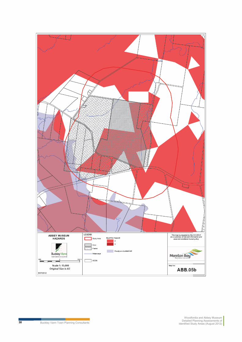
Maps 4, 5 and 6 – Abbey describe the key constraints by groups of ecosystem and hazard constraints, and agricultural land values.
Buckley Vann Town Planning Consultants
Woodfordia and Abbey MuseumDetailed Planning Assessments of
Identified Study Areas (August 2012)30

Buckley Vann Town Planning Consultants
Woodfordia and Abbey MuseumDetailed Planning Assessments of
Identified Study Areas (August 2012)31

Buckley Vann Town Planning Consultants
Woodfordia and Abbey MuseumDetailed Planning Assessments of
Identified Study Areas (August 2012)32
General
The following is a summary discussion of each issue.
As identified in Map 4, significant areas of the Abbey Museum study area are identified as potential Strategic Cropping Land and almost the entire study area is identified as good quality agriculture land.
Accordingly, the objectives of State Planning Policies 1/12 – Protection of Queensland’s Strategic Cropping Land and 1/92 – Development and the Conservation of Agricultural Landshould be considered as part of any future land use planning for this area. As indicated previously, these SPPs seek to ensure that these areas are protected from development which may impact on the productive capacity of this land for future generations.
Given the extent of Good Quality Agricultural Land within the study area, this may be a major constraint to future development in this area in the future.
Development should seek to avoid areas identified as potential Strategic Cropping Land in order to ensure that the future productive capacity of this land is not compromised and the objectives of SPP 1/12 are achieved. The same can generally be said about Good Quality Agricultural Land and SPP 1/92. However, as the entire study area is identified as Good Quality Agricultural Land, this may not be possible. Development within the study area is likely to trigger code assessment in accordance with the Good Quality Agricultural Land overlay. Alternatively, Council may need to demonstrate an ‘overriding community need’ in a review of existing mapping, to ensure compliance with SPP 1/92 in this regard.
Environmental Values
Much of the study is also identified as being of ‘High Environmental Significance’ by the mapping associated with SPP 3/11 – Coastal Protection and is within the coastal zone. The SPP seeks to ensure that “areas of high ecological significance are protected …on land and other ecological values are conserved”.
Accordingly, the extent of any future development would need be limited to those areas not identified as being of high environmental significance in order to ensure that this policy outcome of SPP 3/11 is achieved.
As with Woodfordia, the majority of the study area is also identified as medium value bushland habitat and medium value rehabilitation habitat area in the mapping associated with SPP 2/10 –South East Queensland Koala Conservation. This SPP seeks to ensure that land use planning “assists in the long term retention of viable koala populations in South East Queensland”. Any land use strategy for this study area will need to ensure that development aligns with the objectives of this SPP. Given the extent of rehabilitation habitat area within the study area, this could potentially be a major constraint to future development. Again, there may be implications for offsets.
Pockets of the site are also identified as containing remnant vegetation including endangered ecosystems, Vegetation Management Act 1999 essential habitat and high value regrowth vegetation. The study area contains part of a “conservation estate” to the north and east of the Abbey museum site (precinct core). In order to ensure that development does not adversely impact on these environmental values, any additional development in the study area should seek to avoid these areas.

Buckley Vann Town Planning Consultants
Woodfordia and Abbey MuseumDetailed Planning Assessments of
Identified Study Areas (August 2012)33
The local government planning scheme also identifies a wetland area located in the south-western corner of the study area. Some minor waterways also exist within the precinct core.These are also considered to be environmental values which may warrant protection and/or buffering from future development within the study area.
Much of the study area is also contained within the Biodiversity Significance planning scheme overlay. It is assumed that these areas have been included in this overlay owing to the above values identified on site. Accordingly, development should seek to avoid these areas in order to ensure that these environmental values are preserved.
Natural Hazards
Part of the study area is also identified as being subject to bushfire and flood hazard. Asignificant proportion of the study area, particularly the core, is subject to level 2 bushfire hazard risk. Accordingly, the objectives of SPP 1/03 – Mitigating the Adverse Impacts of Flood, Bushfire and Landslide Hazard are a relevant consideration for any land use direction established for the Abbey Museum study area.
The impact of flooding is limited to the south western extent of the study area, and is not considered a serious risk. However, the identification of the frame boundary has taken this into account.
In order to ensure the objectives of this SPP are achieved, development will either need to avoid these hazard areas or be designed to ensure that development can mitigate the risks associated with such hazards. This constraint is considered to be manageable through effective siting and design of development and does not pose a major constraint to development within the study area. No landslide hazard areas have been identified within the study area.
Transport
Bribie Island Road divides the study area and traverses the southern boundary of the precinct core in a generally east-west direction. This road is a State controlled road and DTMR may have some concerns that the scale or intensity of future development within the study area may adversely impact on the safety or efficiency of this state controlled road infrastructure. Accordingly, the capacity of this State controlled road may constrain the scale and intensity ofdevelopment which can reasonably occur within the study area.
In discussions with the Council’s project team, it was agreed that further direction should be sought from DTMR to confirm their views on this matter, probably in the context of the first Stateinterest review of the overall planning scheme.
Scenic Amenity
The study area is also identified within the Scenic Amenity overlay of the Caboolture ShirePlan. Should the forthcoming new planning scheme seek to include similar provisions, as discussed in the Rural Areas Strategy, the scale and intensity of development and built form should be limited in order to ensure that these scenic amenity values, and environment values generally,are preserved.
However, in its own right, scenic amenity is not considered to be a major constraint to development in the study area.

Buckley Vann Town Planning Consultants
Woodfordia and Abbey MuseumDetailed Planning Assessments of
Identified Study Areas (August 2012)34
4.0 RECOMMENDED FUTURE DIRECTIONS
4.1 General
The overall objective of this study has been to provide Council with recommendations supporting the drafting of a clear land use policy framework for the study areas, as part of the forthcoming new planning scheme.
Following the assessment in section 3.0, the following conclusions can be drawn.
� both study areas contain significant natural values which should be retained as far as possible, and parts of both study areas are subject to natural hazards and constraints including Strategic Cropping Land and Good Quality Agricultural Land to some degree;
� the overall approach to the planning of rural areas, as expressed in the Rural Areas Strategy, remains appropriate for the two identified areas. In particular, uses and activities which are identified in the SEQ Regional Plan as intended to be located within the Urban Footprint should generally be excluded from the study areas;
� conversely, uses and activities in the study areas should not undermine or duplicate those within the Urban Footprint, especially in the case of Woodfordia, in the town of Woodford;
� however, recognising the potential for continuing development pressures resulting from the long term continuation (and possible expansion) of the existing uses and activities in the core sites, it is necessary to provide direction about the types of development which could be appropriate both within the core sites and in the remainder of the study areas, and which are not;
� the overall objective is to balance the retention of the rural character and environmental values of both study areas with providing for a specific and limited range of opportunities for development which are compatible with the character and values.
For each identified study area, the following section recommends criteria for use in the new planning scheme. The recommendations relate to:
� the core as defined in the project brief; and� the frame area, resulting from the assessment in this report, and extracted from the wider
study area.
All maps for each area identify both the core and the frame.
The balance of both study areas (ie. not included in the frame areas) are specifically excluded from the recommended approaches on the basis that they contain values which should be retained and/or are constrained by hazards. No further development should be contemplated in these areas, beyond those provided for in the Rural Areas strategy.
4.2 Woodfordia
The Woodfordia site is the result of a unique set of circumstances and, while continuing to form part of the rural areas of Moreton Bay, also supports cultural and economic development objectives both locally and in a broader way within South East Queensland.

Buckley Vann Town Planning Consultants
Woodfordia and Abbey MuseumDetailed Planning Assessments of
Identified Study Areas (August 2012)35
The primary role of Woodfordia in providing for a long term future for the Woodford Folk Festival and the potential of more similar events, is the highest priority for planning policy for the site and its surrounding area. However, this will need to be balanced with the protection of the full range of identified natural and ecological values, and the continued use of land in the surrounding area for rural activities.
The following proposed planning scheme provisions are designed to help ensure the achievement of this objective.
4.2.1 Vision/Strategic Framework and Indicative Planning Criteria
Woodford/WoodfordiaEither the Vision or Strategic Framework
Relationship between Woodfordia and Woodford
The town of Woodford remains the centre for all permanent commercial, retail and higher density residential development in the vicinity of Woodfordia.
Uses and activities within the Woodfordia core (as defined by the proposed Woodfordia Rural Precinct Plan) and its frame area are limited to those which:
(i) support festivals and events; and(ii) cannot reasonably be accommodated within the town of
Woodford.
All uses and activities within both the Woodfordia core and frameare limited to a scale and type which do not compromise the social and economic health of Woodford.
1. Core
Primary Role
� Festivals and events
The Woodfordia core is well known destination for open air festivals and similar outdoor entertainment events.
The important contribution of such events to the economic development of the Moreton Bay region and South East Queensland is recognised and protected. The protection of the core for this purpose is the highest priority. Festival related uses and activities remain the primary focus of the core. They have the greatest impacts of any uses in the precinct.
� Year round
For the remainder of the year (when no event/festival is occurring),some small-scale permanent uses may be appropriate in the corewhere they have a direct nexus to the primary role and do not conflict with or detract from uses in the town of Woodford.

Buckley Vann Town Planning Consultants
Woodfordia and Abbey MuseumDetailed Planning Assessments of
Identified Study Areas (August 2012)36
Woodford/Woodfordia2. Frame
The Woodfordia frame area is generally defined as the area immediately south and east of the core. The frame is roughly bound by the D’Aguilar Highway to the south-west and by the creek to the east of Kilcoy-Beerwah Road.
� Primary Role - Supporting events in core
During events
To support ongoing economic development objectives, where these can be balanced with other planning objectives, uses which have a nexus with the festival activities and events in the core are encouraged in the frame, during these events.
These uses, including temporary camping and accommodation facilities, walking tracks and trails, recreational activities, eco-tourism and agri-tourism, support and complement the primary role of Woodfordia festivals and events, and are limited to a scale and type which:
(i) do not compete with similar uses in the Woodford township, and
(ii) do not detract from the primary role of the core Woodfordia site.
Outside of events
For the remainder of the year, the frame is used primarily for rural uses, and development in these areas which may detract from environmental or agricultural values or the primary role of the core precinct, is not appropriate.
� Secondary Role – Tourism
The intermittent use of the Woodfordia core for festivals and events means that the economic benefit derived from these support activities is discontinuous and sporadic throughout the year. Accordingly, in addition to traditional rural uses, the frame may have a secondary role as a node for year-round small-scale eco-based tourism and recreation activities.
Tourism activities of a small scale compatible with the rural and environmental values of the precinct are encouraged within the frame. These activities attract people to the site ‘year round’ generating consistent and continuous activity within the frame to enhances and sustains economic benefits for the local economy.
Development within the frame is low impact and limited in scale. In addition to rural activities, the following types of activities may
Buckley Vann Town Planning Consultants
Woodfordia and Abbey MuseumDetailed Planning Assessments of
Identified Study Areas (August 2012)37
Woodford/Woodfordiaoccur in the precinct where their impacts can be minimised.
Indicative planning criteria – core and frame
Built form and scale
The built form associated with uses and activities is limited so that it does not adversely impact on the natural values or the rural character of the precinct. Buildings are generally low-set, set back from major roads, not located on ridgelines and are designed to be consistent with the predominant building style in the locality.
Transport infrastructure
As it is unlikely that transport infrastructure connecting Woodford and Woodfordia will be augmented to any extent in the medium term, activities that have the potential to generate large numbers of vehicle movements during festivals and events (including but not limited to short-term accommodation), are not appropriate.
Generally, uses and activities are located within walking or cycling distance of the core (generally up to 800 m) to reduce the need for private vehicle trips between Woodford and Woodfordia and reduce pressure on local transport infrastructure during events.
Environmental values
Areas of high environmental value (including those identified on Map 4 – Woodfordia Ecosystems), particularly areas of High Ecological Significance to the north and west of the core are separated from development so that natural values are not adversely impacted.
The vegetated ridgelines of the Bellthorpe National Park act as a ‘green’ inter-urban break between the town of Woodford and other urban areas to the north and west. Development does not compromise the visual or ecological integrity of these vegetated ridgelines.
Development does not adversely impact on potable water quality.
Agricultural values
As indicated on Map 4 – Woodfordia Ecosystems, StrategicCropping Land and arable land are identified within the core and frame. Non-rural development will generally not be appropriate in the frame where it would be located on Strategic Cropping Land.Proposals on land where Good Quality Agricultural Land may be acceptable where they comply with overlay provisions.
Hazards
Parts of the Woodfordia precinct are at risk from bushfire, landslide

Buckley Vann Town Planning Consultants
Woodfordia and Abbey MuseumDetailed Planning Assessments of
Identified Study Areas (August 2012)38
Woodford/Woodfordiaand flood hazard. Development either avoids identified hazard areas (as indicated on Map 5 – Woodfordia – Hazards) or is designed to mitigate the risk from these hazards.
A gas pipeline traverses part of the precinct. Development is sufficiently separated from this infrastructure to avoid risk to people if this infrastructure fails.
4.2.2 Potential Uses
There are economic opportunities associated with the Woodfordia core and frame that can be seen as complementary to the overall rural precinct vision (that is, to showcase festivals and events) as well as being complementary to the Woodford Town Centre. These are outlined in Table 4 below.
Table 4: Appropriate uses and activities for Woodfordia Core and Frame
Potential Uses Core Frame
Retail/Commercial
Market stalls - fresh produce, prepared food & crafts, services, food outlets, alternative therapies
Accommodation/Tourism
Tourist Cabin Accommodation
Bed and Breakfast
Camping Grounds
Caravan parking – temporary only, and where related to festival events
Caretakers residence
Education/Community
Agricultural education/training facilities
Primary and secondary education
Intergenerational education
Small scale social or community uses
Recreation
Passive open space
Formal open space
BBQ and Playgrounds
Tennis, basketball, sports

Buckley Vann Town Planning Consultants
Woodfordia and Abbey MuseumDetailed Planning Assessments of
Identified Study Areas (August 2012)39
Potential Uses Core Frame
Enviro park
Walks and trails
Horse trails
Golf Course
Non-motorised adventure activities (flying foxes, skirmish, bmx trails)
Economic Development/Tourism
Festivals and Events
Agri-tourism
Eco-tourism
Exhibition Space, Administrative Centre, Art Space. Use premises as wedding/reception venue.
Other
Car parks
4.2.3 Criteria to Augment/Amend Rural Areas Strategy Place Type Provisions
It is recommended that ‘Foothills’ place type criteria be amended slightly to note the central role of Woodfordia core in economic development, as articulated in section 4.2.1 above.
4.2.4 Additional work required
Planning Scheme
� The frame area may benefit from some local structure planning to identify the location of walking trails, cycle paths and so on, linking the Woodfordia frame to the town of Woodford, and sites within the frame to the core.
� The constraints analysis suggests that uses in the frame are likely to trigger the good quality agricultural land overlay if it is carried forward in its current form. This would mean all applications would be code assessable. This is considered appropriate. However, if Council wished to provide for self-assessable uses, a case may need to be put for ‘overridingcommunity need’ in relation to SPP 1/92. A similar investigation may be needed to address requirements for SCL.
Non Planning Scheme
Depending on the outcome of discussions with DTMR in the context of either the rural precinct plan or the new planning scheme, it may be necessary to undertake further traffic investigations regarding festival uses. It is unlikely that the range of uses suggested in section 4.2.2 would have significant impacts on the road network, however.

Buckley Vann Town Planning Consultants
Woodfordia and Abbey MuseumDetailed Planning Assessments of
Identified Study Areas (August 2012)40
4.3 Abbey Museum
Again, the group of uses currently located on the Abbey Museum site has developed over many years, and result from a particular set of circumstances and need to be recognised in the scheme. Nevertheless, the site and the surrounding area have a number of constraints and, when considered with its context in a rural area outside the Urban Footprint, expansion of either the range or scale of uses on the site is not recommended.
Nevertheless, it is acknowledged that some provision is necessary for consolidation of existing uses within the frame, and provision of opportunities for small-scale supporting uses in both the core and the frame. The frame may also provide for small-scale tourist and tourist accommodation uses and uses which reflect the rural nature of the area.
The existing infrastructure in the core does provide some scope for events where they do not result in permanent development and don’t result in additional development pressure in the frame.
4.3.1 Vision/Strategic framework
Abbey Museum Study Area
Either Vision or strategic framework
1. Core
The Abbey Museum and associated uses owned by the Confraternity of the Kingdom of Christ, forms the basis of the precinct core. It contains educational facilities and facilitiessuitable for events up to a specified size.
Further development for events and educational activities within the core may be appropriate where it:
� is limited in scale and intensity; � does not detract from the values of the core;� is compatible with rural uses in the vicinity;� does not compete with or detract from the functioning of
retail and commercial centres elsewhere in the Council area;
� has a nexus with the existing educational or entertainment uses on the site; and/or
� provides for uses supporting rural or tourism industries.
2. Frame
Development within the Abbey frame is of a lesser scale and intensity when compared with development within the core. Land in the frame is used primarily for rural purposes, and may also be suitable for passive uses and activities that support the permanent or temporary uses in the core including events (eg. overflow car parking).
No primary or secondary educational facilities or events are established in the precinct frame.

Buckley Vann Town Planning Consultants
Woodfordia and Abbey MuseumDetailed Planning Assessments of
Identified Study Areas (August 2012)41
Abbey Museum Study Area
As in the precinct core, uses supporting rural or tourism industries may be acceptable where they not detract from the values of the frame and are compatible with rural uses in the vicinity.
4.3.2 Potential Uses
There are some opportunities associated with the Abbey core and frame that can be seen as complementary to the overall vision. These are outlined in Table 5 below.
Table 5: Appropriate uses and activities for Abbey Core and Frame
Potential Uses Core Frame
Retail/Commercial
Market stalls - fresh produce, prepared food & crafts, services, food outlets, alternative therapies
where temporary and aligned with agricultural activities surrounding core and frame
Accommodation/Tourism
Tourist Cabin Accommodation
Bed and Breakfast
Camping Grounds
Caravan parking - temporary only, and where related to festival events
Caretakers residence
Education/Community
Agricultural education/training facilities
Primary and secondary education
Intergenerational education
Small scale social or community uses
Recreation
Passive open space
Formal open space
BBQ and Playgrounds
Tennis, basketball, sports
Enviro park
Walks and trails

Buckley Vann Town Planning Consultants
Woodfordia and Abbey MuseumDetailed Planning Assessments of
Identified Study Areas (August 2012)42
Potential Uses Core Frame
Horse trails
Golf Course
Non motorised adventure activities (flying foxes, skirmish, bmx trails)* Resolve through Rural zone provisions
Economic Development/Tourism
Festivals and Events
Agri-tourism
Eco-tourism
Exhibition Space, Administrative Centre, ArtSpace
Wedding/reception venue
Other
Car parks
4.3.3 Criteria to Augment/Amend Rural Areas Strategy Place Type Provisions
Some amendment to the ‘Undulating Plains’ place type description may be warranted, for example, if Council were to confirm the core as the location of ‘Farm Fantastic’ eventpermanently.
4.3.4 Additional Work Required
Planning Scheme
None considered necessary at this time.
Non Planning Scheme
It is noted that the Abbey area is outside the Urban Footprint and uses within the Regional Landscape and Rural Production Area are subject to the South East Queensland State Planning Regulatory Provisions. Depending on the scale of any new uses proposed, the thresholds set by the State Planning Regulatory Provisions are likely to provide for the potential uses listed in section 4.3.2.
However, Council may wish to consider declaring an additional Rural Precinct in the future if the State Planning Regulatory Provisions thresholds provide to be overly restrictive for the range of uses identified.