WOODBORO LAKES WILDLIFE AREA MASTER PLANdnr.wi.gov/files/PDF/pubs/lf/LF0088.pdf · Woodboro Lakes...
93
WOODBORO LAKES WILDLIFE AREA MASTER PLAN October, 2015 PUB-LF-088
Transcript of WOODBORO LAKES WILDLIFE AREA MASTER PLANdnr.wi.gov/files/PDF/pubs/lf/LF0088.pdf · Woodboro Lakes...
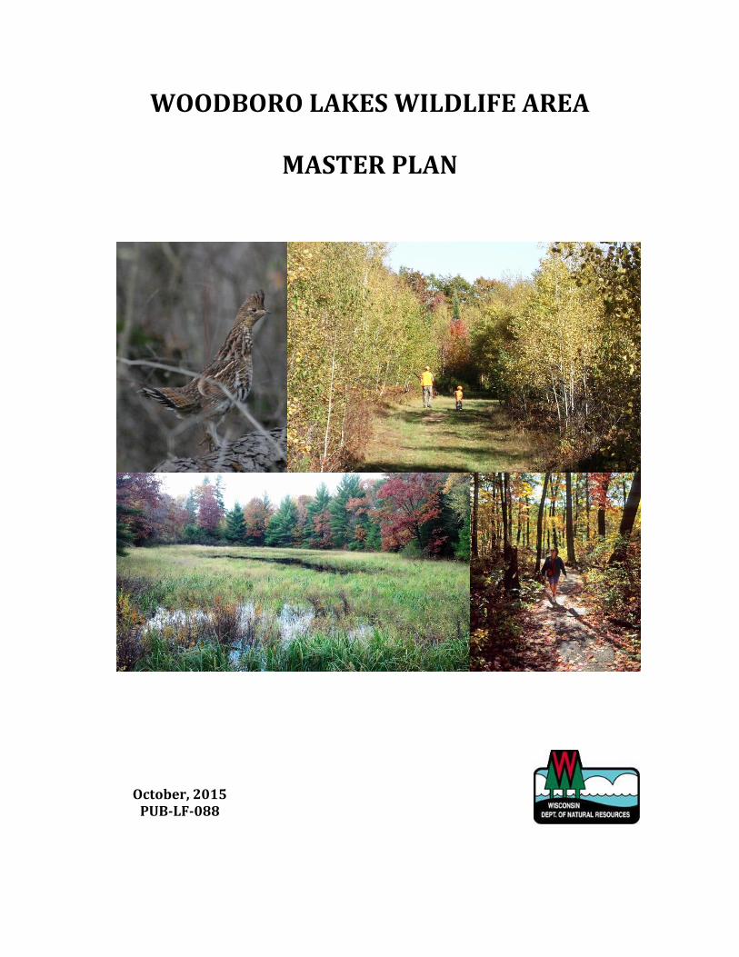
WOODBORO LAKES WILDLIFE AREA
MASTER PLAN
October, 2015 PUB-LF-088


WOODBORO LAKES WILDLIFE AREA MASTER PLAN
APPROVED BY THE NATURAL RESOURCES BOARD OCTOBER, 2015
Wisconsin Department of Natural Resources
Cathy Stepp – Secretary
Natural Resources Board
Preston D. Cole, Chair Terry Hilgenberg, Vice-Chair
Gregory Kazmierski, Secretary Julie Anderson William Bruins
Dr. Frederick Prehn Gary Zimmer
101. S Webster Street, P.O. Box 7921
Madison, WI 53707-7921
DNR PUB-LF-088
This publication is available on the Internet at http://dnr.wi.gov/ , keyword search
“master planning”.
Cover photo credits (clockwise from top, left): Ruffed grouse; photo by Pennsylvania Game Commission
Father and son ruffed grouse hunting on the WLWA; photo by Jeremy Holtz
Fall hiking; photo by WDNR
Ephemeral pond on the WLWA; photo by Jeremy Holtz
The Wisconsin Department of Natural Resources provides equal opportunity in its employment,
programs, services and functions under an Affirmative Action Plan. If you have any questions, please
write to the Equal Opportunity Office, Department of the Interior, Washington D.C. 20240. This
publication is available in alternative formats (large print, Braille, audio tape, etc.) upon request. Please
contact the Wisconsin Department of Natural Resources, Bureau of Facilities and Lands at 608-266-2135
for more information.
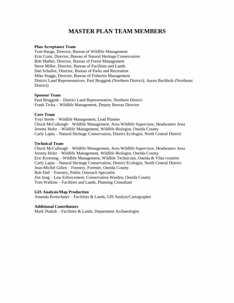
MASTER PLAN TEAM MEMBERS
Plan Acceptance Team
Tom Hauge, Director, Bureau of Wildlife Management
Erin Crain, Director, Bureau of Natural Heritage Conservation
Bob Mather, Director, Bureau of Forest Management
Steve Miller, Director, Bureau of Facilities and Lands
Dan Schuller, Director, Bureau of Parks and Recreation
Mike Staggs, Director, Bureau of Fisheries Management
District Land Representatives: Paul Bruggink (Northern District); Aaron Buchholz (Northeast
District)
Sponsor Team
Paul Bruggink – District Land Representative, Northern District
Frank Trcka – Wildlife Management, Deputy Bureau Director
Core Team Yoyi Steele – Wildlife Management, Lead Planner
Chuck McCullough – Wildlife Management, Area Wildlife Supervisor, Headwaters Area
Jeremy Holtz – Wildlife Management, Wildlife Biologist, Oneida County
Carly Lapin – Natural Heritage Conservation, District Ecologist, North Central District
Technical Team
Chuck McCullough – Wildlife Management, Area Wildlife Supervisor, Headwaters Area
Jeremy Holtz – Wildlife Management, Wildlife Biologist, Oneida County
Eric Kroening – Wildlife Management, Wildlife Technician, Oneida & Vilas counties
Carly Lapin – Natural Heritage Conservation, District Ecologist, North Central District
Jean-Michel Gillen – Forestry, Forester, Oneida County
Bob Dall – Forestry, Public Outreach Specialist
Jim Jung – Law Enforcement, Conservation Warden, Oneida County
Tom Watkins – Facilities and Lands, Planning Consultant
GIS Analysis/Map Production
Amanda Kretschmer – Facilities & Lands, GIS Analyst/Cartographer
Additional Contributors
Mark Dudzik – Facilities & Lands, Department Archaeologist
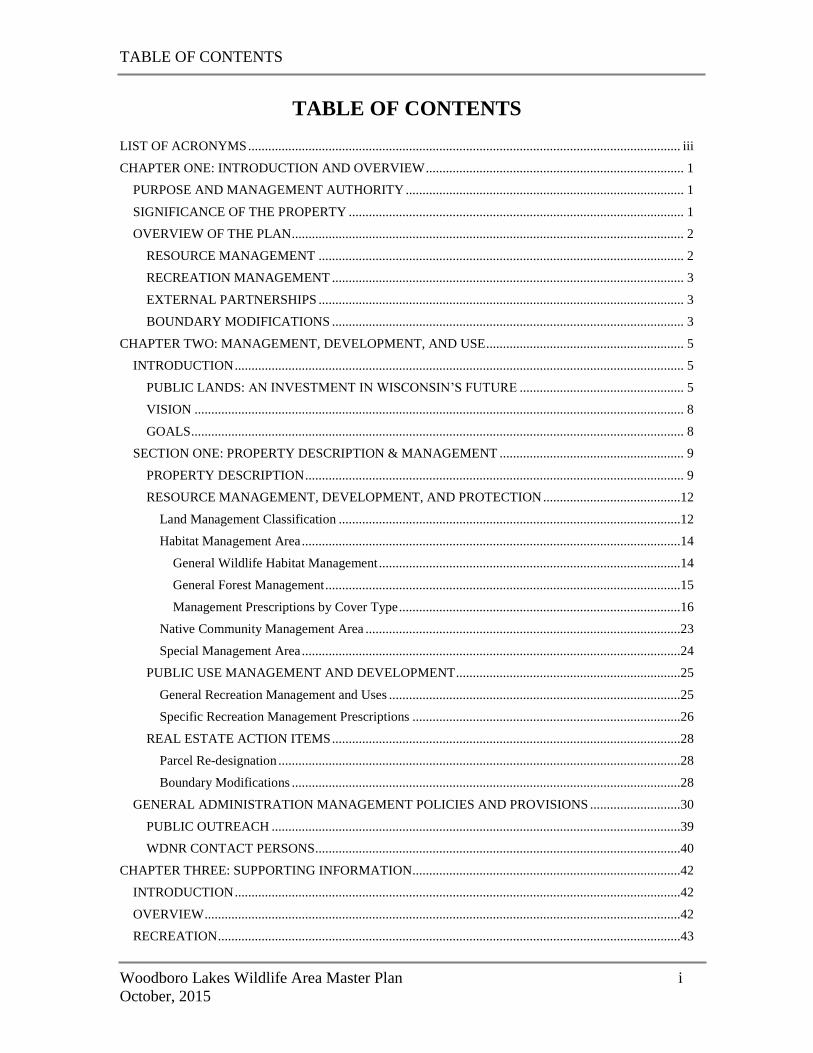
TABLE OF CONTENTS
Woodboro Lakes Wildlife Area Master Plan i
October, 2015
TABLE OF CONTENTS LIST OF ACRONYMS ................................................................................................................................. iii
CHAPTER ONE: INTRODUCTION AND OVERVIEW ............................................................................. 1
PURPOSE AND MANAGEMENT AUTHORITY ................................................................................... 1
SIGNIFICANCE OF THE PROPERTY .................................................................................................... 1
OVERVIEW OF THE PLAN ..................................................................................................................... 2
RESOURCE MANAGEMENT ............................................................................................................. 2
RECREATION MANAGEMENT ......................................................................................................... 3
EXTERNAL PARTNERSHIPS ............................................................................................................. 3
BOUNDARY MODIFICATIONS ......................................................................................................... 3
CHAPTER TWO: MANAGEMENT, DEVELOPMENT, AND USE ........................................................... 5
INTRODUCTION ...................................................................................................................................... 5
PUBLIC LANDS: AN INVESTMENT IN WISCONSIN’S FUTURE ................................................. 5
VISION .................................................................................................................................................. 8
GOALS ................................................................................................................................................... 8
SECTION ONE: PROPERTY DESCRIPTION & MANAGEMENT ....................................................... 9
PROPERTY DESCRIPTION ................................................................................................................. 9
RESOURCE MANAGEMENT, DEVELOPMENT, AND PROTECTION .........................................12
Land Management Classification ......................................................................................................12
Habitat Management Area .................................................................................................................14
General Wildlife Habitat Management ..........................................................................................14
General Forest Management ..........................................................................................................15
Management Prescriptions by Cover Type ....................................................................................16
Native Community Management Area ..............................................................................................23
Special Management Area .................................................................................................................24
PUBLIC USE MANAGEMENT AND DEVELOPMENT ...................................................................25
General Recreation Management and Uses .......................................................................................25
Specific Recreation Management Prescriptions ................................................................................26
REAL ESTATE ACTION ITEMS ........................................................................................................28
Parcel Re-designation ........................................................................................................................28
Boundary Modifications ....................................................................................................................28
GENERAL ADMINISTRATION MANAGEMENT POLICIES AND PROVISIONS ...........................30
PUBLIC OUTREACH ..........................................................................................................................39
WDNR CONTACT PERSONS .............................................................................................................40
CHAPTER THREE: SUPPORTING INFORMATION ................................................................................42
INTRODUCTION .....................................................................................................................................42
OVERVIEW ..............................................................................................................................................42
RECREATION ..........................................................................................................................................43
TABLE OF CONTENTS
Woodboro Lakes Wildlife Area Master Plan ii
October, 2015
ECOLOGICAL AND HABITAT SIGNIFICANCE .................................................................................43
CONCLUSION .........................................................................................................................................44
WORKS CITED ............................................................................................................................................45
APPENDIX A: BCPL EASEMENT AREA FOREST STEWARDSHIP PLAN .........................................47
APPENDIX B: NR 44 ROAD CLASSIFICATIONS ...................................................................................85
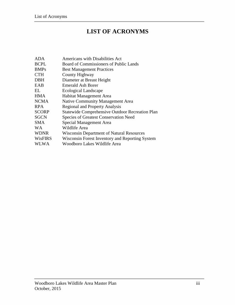
List of Acronyms
Woodboro Lakes Wildlife Area Master Plan iii
October, 2015
LIST OF ACRONYMS
ADA Americans with Disabilities Act
BCPL Board of Commissioners of Public Lands
BMPs Best Management Practices
CTH County Highway
DBH Diameter at Breast Height
EAB Emerald Ash Borer
EL Ecological Landscape
HMA Habitat Management Area
NCMA Native Community Management Area
RPA Regional and Property Analysis
SCORP Statewide Comprehensive Outdoor Recreation Plan
SGCN Species of Greatest Conservation Need
SMA Special Management Area
WA Wildlife Area
WDNR Wisconsin Department of Natural Resources
WisFIRS Wisconsin Forest Inventory and Reporting System
WLWA Woodboro Lakes Wildlife Area
CHAPTER 1:
Introduction and Overview
Woodboro Lakes Wildlife Area Master Plan 1
October, 2015
CHAPTER ONE: INTRODUCTION AND OVERVIEW
The Woodboro Lakes Wildlife Area (WLWA) is located in south-central Oneida County
(Map A). It encompasses some 2,632 acres of mostly forested land. A 962-acre
Scattered Forest Land parcel directly adjacent to the property has been managed as part
of the wildlife area since acquisition and is included in this master plan, for a total of
3,594 acres of state owned and managed land. The Board of Commissioners of Public
Lands (BCPL) holds a forest management easement on 778 acres of the large Scattered
Forest Land parcel (Map B-1).
PURPOSE AND MANAGEMENT AUTHORITY
Property master planning is a process that determines how a property will be managed
and developed. The development of master plans is governed by NR 44, Wisconsin
Administrative Code, the master plan rule. This rule defines master planning, sets forth
its purposes, and specifies the general planning process and content of a master plan.
This rule also establishes a uniform land management classification system to be applied
in the master plan. By administrative code, the master plan is the controlling authority
for all actions and uses on a property. The scope of management and use of state
property depends upon its official designation.
WILDLIFE AREAS
Wildlife Areas (WAs) are acquired and managed under the authority of Section
23.09(2)(d)3, Wisconsin Statutes, and Chapter NR 1.51, Wisconsin Administrative Code.
They are designated to provide places where people can hunt, trap, and fish. WAs also
are open for traditional outdoor uses of walking, skiing, snow shoeing, nature study,
berry picking, and other low-impact recreational activities. As directed by NR 1.51 and
NR 1.61, other recreational uses may be allowed on WAs by the Master Plan if those uses
do not detract from the primary purpose of these properties.
SCATTERED FOREST LANDS
A 962-acre parcel directly adjacent to WLWA was purchased as Scattered Forest Land, a
statewide program authorizing acquisition of parcels outside of existing project
boundaries. This parcel was acquired to protect wildlife habitat and provide for
sustainable forest management and public recreation, and is open to all the uses that are
permitted on WAs.
SIGNIFICANCE OF THE PROPERTY
The WLWA is located within the Northern Highland Ecological Landscape (WDNR
2014a), a region characterized by extensive forest cover and interspersed with abundant
lakes and wetlands. The property is mostly (93%) forested, largely with aspen but also
with stands of oak, red and white pine, red maple, and several other species. There are
CHAPTER 1:
Introduction and Overview
Woodboro Lakes Wildlife Area Master Plan 2
October, 2015
areas of conifer wetlands containing tamarack, spruce, and white cedar, alder thickets,
several small, shallow lakes, and a portion of Little Rice Creek. Ephemeral ponds are
scattered throughout the property. Little Rice Creek contains stands of wild rice and
other emergent and submergent vegetation. These habitats support a variety of wildlife,
both common and rare, including ruffed grouse, American woodcock, wild turkey, white-
tailed deer, black bear, gray wolf, various wetland furbearers, reptiles and amphibians,
invertebrates, bats, waterfowl, and many other types of birds.
Recreationally, this region is notable for its high proportion of public recreation land,
abundant water resources, high seasonal home ownership, and influx of retirees
influencing recreation demand. The area has long been known as a vacation destination.
Large federal, state, and county land holdings provide a wide array of outdoor
recreational opportunities, including both motorized and non-motorized trails. Vilas and
Oneida counties are considered primary providers of silent sport activities and camping in
northern Wisconsin. On the WLWA, hunting is the top recreational use, particularly
ruffed grouse hunting but also large- and small-game, waterfowl, and turkey hunting.
Trappers also make use of the property. WLWA also is used for other nature-based
activities such as hiking, bird-watching, paddling, cross-country skiing, biking, and
berry-picking. A snowmobile trail that connects to a regional trail network traverses the
property.
OVERVIEW OF THE PLAN
The WLWA Master Plan describes how this property will be managed, used, and
developed. The plan focuses on maintenance and enhancement of forests, particularly
early-successional types, and wetlands for an array of associated wildlife species through
habitat management, and protection of high-quality riparian wetland communities
through native community management. Recreation management emphasizes the
traditional outdoor activities of hunting and trapping, as well as other nature-based
recreational pursuits such as hiking and wildlife viewing. The plan also recognizes the
importance of working with external partners, including other government agencies
(local, state, and federal) and nonprofit conservation groups, to achieve common goals.
RESOURCE MANAGEMENT
The plan emphasizes habitat management of early-successional upland and lowland
forest types, including aspen, oak, white birch, and alder. These habitats support a wide
variety of game and non-game wildlife species, including ruffed grouse, American
woodcock, wild turkey, white-tailed deer, furbearers, and a variety of songbirds. The
plan also supports management of some stands of red pine, white pine, and oak for older
age classes through extended rotation, encouragement of old-growth characteristics, and
passive management in some areas. Protection of the property’s many ephemeral ponds
and management to enhance emergent vegetation associated with the property’s lakes
will maintain and improve habitat for reptiles, amphibians, waterfowl, and other wetland-
dependent species.
CHAPTER 1:
Introduction and Overview
Woodboro Lakes Wildlife Area Master Plan 3
October, 2015
Native community management of a high-quality vegetated riparian zone associated with
Little Rice Creek will protect and maintain lowland conifer, alder thicket, emergent
marsh, and floating-leaved and submergent wetland habitats which protect water quality
in the creek and provide habitat for a variety of fish, amphibians, invertebrates, and birds.
RECREATION MANAGEMENT
Hunting is the primary recreational use of the WLWA, and the focus of recreation
management in the Master Plan. Ruffed grouse hunting is the top use, and large- and
small-game, waterfowl, and turkey hunting also are significant draws for users.
Management to support these activities consists largely of habitat management,
maintenance of existing facilities, and maintaining and improving access. New proposals
include development of two additional parking areas and formally designation of a
network of hunter walking paths as hunter access/hiking trails. Maintenance and
enhancement of existing facilities and access also support other nature-based recreational
activities on the property, such as hiking, wildlife viewing, biking, and cross-country
skiing/snow-shoeing. The plan opens the entire property to bike use.
The plan is also adding a new motorized recreational opportunity. In response to a
request from a local ATV club, a connector ATV trail will be routed across a portion of
the WLWA.
EXTERNAL PARTNERSHIPS
Partnerships are critical to WDNR’s work. The Department collaborates with various
organizations and local governments to acquire, restore, and manage wildlife habitat,
monitor wildlife populations, control invasive species, and plan, develop, and maintain
recreational opportunities and facilities. These partners include the Ruffed Grouse
Society, Board of Commission of Public Lands, Oneida County Forest and the
Northwoods Passage Snowmobile Club. The WLWA Master Plan acknowledges the
importance of these public-private partnerships and calls for continuing collaboration
with these and other partners and private landowners to achieve recreational resource
management and protection objectives.
BOUNDARY MODIFICATIONS
Current state ownership on the WLWA is 3,594 acres. This includes lands within and
outside of existing project boundaries. The following project boundary and acreage goal
adjustments have been approved for the WLWA: 2,665 acres of project boundary
expansions, 768 acres of which are already in WDNR ownership. This yields a net total
expansion of 1,897 acres.
Boundary modifications seek to achieve the following goals:
Encompass lands the Department already owns and manages within project
boundaries.
CHAPTER 1:
Introduction and Overview
Woodboro Lakes Wildlife Area Master Plan 4
October, 2015
Exclude isolated areas with poor access.
Increase opportunities for public access and improve customer service by modifying
boundaries to follow existing roads.
Expand current recreational opportunities and provide the potential to add new ones.
Provide larger contiguous blocks of ownership to improve efficiency of habitat
management activities and to encompass or protect significant natural features and
habitats (e.g., lakes; streams).
Of the 1,897 expansion acres that are not already in Department ownership, land cover
consists primarily of forests, wetland, and water (approximately 1,606 acres), with much
smaller amounts of upland grass/shrub and developed areas. Agricultural lands comprise
only 148 acres of the expansions.
CHAPTER 2:
Management, Development, and Use
Woodboro Lakes Wildlife Area Master Plan 5
October, 2015
CHAPTER TWO: MANAGEMENT, DEVELOPMENT, AND
USE
INTRODUCTION
This chapter details the management, development and use of the WLWA needed to
achieve the property’s long-range vision and goals. The property is planned and
managed to optimize its own inherent capabilities, yet at the same time to realize its
importance as a component of the larger landscape mosaic of public and private
properties. Chapter Two is organized into three main parts: the Introduction contains an
overview of the benefits of public land protection and the Vision and Goals that guide the
overall project; Section One contains a property description as well as both general and
specific management objectives and prescriptions for the WLWA; and Section Two
describes general property administration and management policies and provisions that
apply to all state managed lands.
PUBLIC LANDS: AN INVESTMENT IN WISCONSIN’S FUTURE
Wisconsin is known for its abundant natural resources, for the value our citizens place on
the rich traditions of hunting, fishing, trapping, camping and hiking, and for the ease of
access to recreational land and wild places for everyone who lives here, including those
who live in our largest metropolitan areas. We are defined by our clean lakes and rivers,
vast forests, and abundant fish and wildlife. Conserving these resources is not an
expense, but an investment that pays many dividends, both economic and social. A
University of Minnesota study found that for every $1 invested in conserving natural
areas in that state, there is a return of up to $4 (MEP 2011). Although similar data are not
available for Wisconsin, one can imagine that a similar return of $4 on each $1
investment in public land in Wisconsin is quite possible.
The State of Wisconsin manages about 1.6 million acres of publicly-owned forests,
barrens and savannas, grasslands, wetlands, shrublands, streams and lakes. Most of these
lands are open to hunting, fishing, trapping, hiking, cross-county skiing, wildlife
watching, and other outdoor, nature-based recreation. The economic impact of fishing,
hunting and wildlife watching in Wisconsin is considerable. According to the 2011
National Survey of Fishing, Hunting and Wildlife-Associated Recreation, Wisconsin
report (USFWS and USCB 2014), a total of 3.5 million residents and non-residents aged
16 years and older fished, hunted and/or watched wildlife in Wisconsin in 2011, spending
$5.5 billion in the process.
Total wildlife-watching participants numbered 2.4 million, with over 6 million days of
participation and total expenditures of almost $1.5 billion (USFWS and USCB 2014).
Over 1.2 million anglers spent over 21 million days fishing in 2011, accounting for nearly
$1.5 billion in retail sales and $2.26 billion in overall economic output. This generated
$148 million in state and local taxes and provided over 21,000 jobs (Southwick
Associates 2013). Over 894,000 hunters spent over 12.1 million days hunting in 2011,
CHAPTER 2:
Management, Development, and Use
Woodboro Lakes Wildlife Area Master Plan 6
October, 2015
accounting for over $2.5 billion in retail sales, almost $4 billion in overall economic
impact, and generating over $228 million in state and local tax revenue and over 34,000
jobs (Southwick Associates 2012).
In addition, Wisconsin’s $17.5 billion/year tourism industry (TFW 2015) and $23
billion/year forest industry (WDNR 2012) both are inextricably linked to abundant
natural resources and a vibrant public land base.
All WDNR-managed lands have been certified as sustainable by two separate third-party
audit firms, indicating that these lands meet the social, ecological, and economic rights
and needs of the present generation without compromising those of future generations.
All timber harvested from state lands can be marketed as sustainable and therefore has an
enhanced value.
Even those citizens who do not engage in hunting, fishing, hiking, camping, or other
outdoor activities on public lands have a reason to value them. These lands provide
“ecosystem services” that improve our quality of life in various ways. Ecosystem
services are conditions or processes associated with natural ecosystems that provide
benefits to humans.
For example, land conservation protects human health by keeping our drinking water
clean and is a cost-effective tool in protecting water quality. A growing understanding of
the role that forests and natural lands play in filtering pollutants and maintaining water
quantity and quality has led many municipalities and water suppliers, particularly those in
growing communities, to consider land protection as part of a multiple-barrier approach
to providing safe drinking water. A study conducted by the Trust for Public Land and the
American Water Works Association showed that forestland in particular greatly reduces
the cost of treating drinking water. For every 10 percent increase in the source area’s
forest cover (up to 60 percent), treatment and chemical costs decreased approximately 20
percent (Ernst 2004).
Wetlands provide natural flood insurance by acting as sponges, storing rain that runs off
the land and slowly releasing it to the atmosphere, groundwater, and adjacent lakes, rivers
and streams. Strategic wetland protection and restoration can help reduce flood peaks
and damage, protect human health and safety, and reduce the need for expensive projects
such as levees, detention ponds, and the reconstruction of flood-damaged roads.
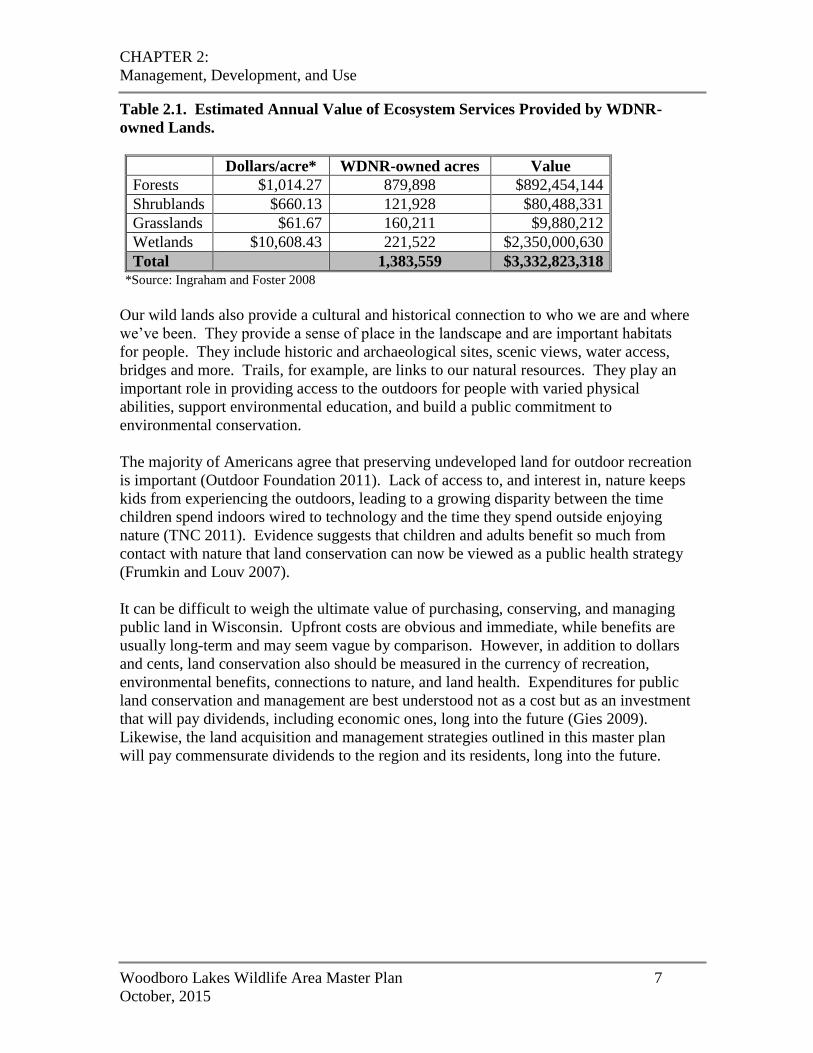
Ingraham and Foster (2008) estimated the value of some of these basic ecosystem
services. They calculated an economic value for the wildlife habitat, carbon
sequestration, disturbance prevention (e.g., flood control), freshwater management and
supply, nutrient regulation, and waste management provided by USFWS National
Wildlife Refuges in the contiguous United States. The value of services provided by
forests, shrublands, grasslands, and wetlands amounted to $2,900/acre/year. Using the
same approach, Wisconsin’s public lands provide a total return of $3.33 billion/year or
$2,400/acre/year (Table 2.1).
CHAPTER 2:
Management, Development, and Use
Woodboro Lakes Wildlife Area Master Plan 7
October, 2015
Table 2.1. Estimated Annual Value of Ecosystem Services Provided by WDNR-
owned Lands.
Dollars/acre* WDNR-owned acres Value
Forests $1,014.27 879,898 $892,454,144
Shrublands $660.13 121,928 $80,488,331
Grasslands $61.67 160,211 $9,880,212
Wetlands $10,608.43 221,522 $2,350,000,630
Total 1,383,559 $3,332,823,318 *Source: Ingraham and Foster 2008
Our wild lands also provide a cultural and historical connection to who we are and where
we’ve been. They provide a sense of place in the landscape and are important habitats
for people. They include historic and archaeological sites, scenic views, water access,
bridges and more. Trails, for example, are links to our natural resources. They play an
important role in providing access to the outdoors for people with varied physical
abilities, support environmental education, and build a public commitment to
environmental conservation.
The majority of Americans agree that preserving undeveloped land for outdoor recreation
is important (Outdoor Foundation 2011). Lack of access to, and interest in, nature keeps
kids from experiencing the outdoors, leading to a growing disparity between the time
children spend indoors wired to technology and the time they spend outside enjoying
nature (TNC 2011). Evidence suggests that children and adults benefit so much from
contact with nature that land conservation can now be viewed as a public health strategy
(Frumkin and Louv 2007).
It can be difficult to weigh the ultimate value of purchasing, conserving, and managing
public land in Wisconsin. Upfront costs are obvious and immediate, while benefits are
usually long-term and may seem vague by comparison. However, in addition to dollars
and cents, land conservation also should be measured in the currency of recreation,
environmental benefits, connections to nature, and land health. Expenditures for public
land conservation and management are best understood not as a cost but as an investment
that will pay dividends, including economic ones, long into the future (Gies 2009).
Likewise, the land acquisition and management strategies outlined in this master plan
will pay commensurate dividends to the region and its residents, long into the future.
CHAPTER 2:
Management, Development, and Use
Woodboro Lakes Wildlife Area Master Plan 8
October, 2015
VISION
Located within the Northern Highland Ecological Landscape, the Woodboro Lakes
Wildlife Area provides high-quality habitats for diverse wildlife species and high-quality
outdoor, nature-based recreational opportunities in lightly-developed settings for current
and future users. These opportunities will be provided within a matrix of forested and
wetland/aquatic communities, including mixed upland hardwood-conifer forests, lakes
and streams, ephemeral ponds, alder thickets, and lowland conifer wetlands. These
habitats will be managed sustainably for wildlife benefit and user enjoyment in a manner
consistent with the property’s statutory designation and physical capability.
GOALS
Goal 1: Protect, enhance, and manage for a variety of forested and wetland/aquatic
habitats, including aspen, oak, white birch, red maple, red and white pine, lakes
and streams, alder thickets, ephemeral ponds, and white cedar/tamarack conifer
wetlands.
Goal 2: Consistent with resource capabilities, provide recreational opportunities for
hunting, trapping, hiking, paddling, bird-watching, and other nature-based
outdoor pursuits.
Goal 3: Promote quality habitat for desirable game and non-game species, including
rare and special-concern species.
Goal 4: Practice and promote scientifically sound wildlife management, ecosystem
management, and sustainable forestry practices.
Goal 5: In consultation with tribal governments, provide for the availability and
enhancement of treaty resources.
CHAPTER 2 – Section One:
Property Description & Management
Woodboro Lakes Wildlife Area Master Plan 9
October, 2015
SECTION ONE: PROPERTY DESCRIPTION & MANAGEMENT
PROPERTY DESCRIPTION
Woodboro Lakes Wildlife Area (WLWA) is a forested property located approximately
ten miles west of the City of Rhinelander in south-central Oneida County (Map A). It
consists of 2,632 acres of Wildlife Area and an adjacent 962-acre Scattered Forest Lands
parcel that was acquired at the same time and has been managed as part of the wildlife
area, for a total of 3,594 acres of state owned and managed land (Map B-1). The property
was purchased in 1999 as part of the “Great Addition”, a large acquisition of former
Packaging Corporation of America lands. It was acquired to protect 1.52 miles of
frontage on Little Rice Creek and two miles of frontage on seven small lakes, five of
which are completely contained within the property; to provide for wildlife habitat and
sustainable forest management; and to maintain public access and provide for public
recreation, especially hunting and trail use. In 2002, WDNR granted a forest
management easement to the Board of Commissioners of Public Lands (BCPL) on 778
acres of the Scattered Forest Lands parcel.
Topography on the WLWA is generally typical of glacial pitted outwash plain and varies
from nearly level, to gently rolling, to steep in some areas. Several soil types are present,
exhibiting variable drainage. Wet soils occur throughout the WLWA and are quite
extensive in some portions of the property. Other areas have sandy soils. These soils
have exhibited low soil strength, wetness, ponding, and rutting, particularly in lowland
areas or those with steeper slopes. In other areas, large boulders are located just beneath
the surface, barely emerging in some spots. These characteristics pose some challenges
to trail development, heavy equipment use, and motorized access.
Numerous small lakes give the property its name. Four named lakes and 15 small,
unnamed lakes, marshes, and bogs are partially or completely contained within the
property boundary. The lakes exhibit a wild character, with undeveloped shorelines and
unimproved, foot-only access. Most are shallow and contain little if any vegetation other
than a few broad-leaved cattail plants, lily pads or water shield plants around the
shallows. The property also contains several streams, including Little Rice Creek which
traverses the southeast corner and Bearskin Creek which passes along the northwest
boundary.
Existing cover types on WLWA are shown on Map B-2. WLWA is approximately 90%
forested. Early-successional types, especially aspen, dominate the forest cover. Other
Note: A variety of DNR, federal and county sources were used to estimate the cover types and land uses
on or adjacent to the WLWA property. They include existing DNR Wildlife, Fisheries, and Facilities
and Lands records, Forestry WisFIRS database, Water Division Wetland acreages and WISCLAND
cover types. These data sources use different criteria for assessing habitat types and land uses, so
different estimates may be developed depending on the source(s) used. Also small inclusions of
different cover types may be embedded within a more dominant cover type in the following acreage
descriptions and related maps.
CHAPTER 2 – Section One:
Property Description & Management
Woodboro Lakes Wildlife Area Master Plan 10
October, 2015
forest types present include oak, red maple, red and white pine, northern hardwoods,
tamarack, black spruce, and white birch. Numerous small stands of mature red and white
pine are scattered throughout the property, generally associated with the lakes and Little
Rice Creek. Several small stands of lowland conifer dominated by Northern white cedar
occur near the southern property boundary, adjacent to Little Rice Creek.
Wetland communities are found throughout the WLWA. A large wetland mosaic in the
northwestern portion includes shrub thickets dominated by tall speckled alder with an
herbaceous understory and tamarack swamp containing a broken-to-closed canopy of
tamarack with a dense alder understory in some areas. Little Rice Creek, a slow-moving,
sandy-bottomed, warm-water stream, contains some stands of wild rice and other
emergent and submergent vegetation along the shoreline and stands of alder along its
banks. Numerous high-quality ephemeral ponds are scattered throughout the property.
These seasonal water features are small depressions that hold water for a period of time
following spring thaw, flourish with a variety of common wetland plants, and then
typically dry out in mid-to-late summer. They are critically important to the lifecycles of
many species of invertebrates and amphibians.
WLWA hosts a diversity of wildlife species, both common and rare. Game species
include white-tailed deer, wild turkey, ruffed grouse, woodcock, and snowshoe hare.
Large carnivores including black bear and gray wolf are commonly found on the
property, and smaller furbearers such as bobcat, coyote, raccoon, fox, beaver, muskrat,
mink, and otter utilize the property’s various habitat types as well. Waterfowl use the
property heavily for production as well as for migratory staging and stopover. Species
recorded on the property include teal, wood duck, mallard, American black duck, ring-
necked duck, and hooded merganser. A multitude of non-game species also occur on
WLWA, including herptiles, small mammals, invertebrates, and especially birds. Species
observed range from red squirrel, bats, and snapping turtle to golden-winged warbler and
chestnut-sided warbler, great blue heron, osprey, and bald eagle. There is one osprey nest
currently on the property and given the numerous large red and white pines, potential
exists for bald eagle nesting.
WLWA can be accessed from the north via County Highway K, from the east via Oneida
Lake Road, from the south via Oscar Jenny Road (which runs through the property on the
south end), and from the west via Jennie Lake Road. There are two gravel parking lots
and 4.5 miles of gravel road on WLWA for public access. Both parking lots and 2 miles
of the gravel road were graded and re-graveled in 2012 using a Conservation
Infrastructure Grant. A small amount of funding from segregated funds is allocated for
access maintenance each year. A network of logging roads runs throughout the entire
property but historic access was limited to high-clearance and four-wheel-drive vehicles.
A snowmobile trail traverses the property from southeast to northwest.
Almost 16 miles of hunter walking paths have been developed on the property in
cooperation with the Ruffed Grouse Society. Recent work has improved some trails for
vehicle access and maintained others for foot traffic. Twelve gates on the property allow
maintenance access to the hunter walking path system and snowmobile trail but exclude

CHAPTER 2 – Section One:
Property Description & Management
Woodboro Lakes Wildlife Area Master Plan 11
October, 2015
other motor vehicles. A Forestry Fire Equipment Training Course has 0.5 miles of trails
and 3 acres of open grassland that double as wildlife openings and hunter walking paths.
Dispersed camping is allowed on the property between September 1 and December 31.
There are four designated camp areas with no developed facilities. A bridge in the
southeast portion of the property crossing a small feeder creek that flows into Little Rice
Creek is currently maintained by the local snowmobile club. Infrastructure is shown on
Map B-3 and motorized access is shown on Map B-4.
Hunting is the top recreational use of WLWA. The property is heavily used by hunters,
especially for ruffed grouse hunting which is the number-one use. Bow and gun deer
hunting, bear, turkey, small game and waterfowl hunting also are popular. Other uses
include trapping, bird-watching and wildlife observation, hiking, cross-country skiing,
canoeing, kayaking, and berry-picking. A snowmobile trail traverses the property from
southeast to northwest. Mountain bikers have been known to access the property via
Oscar Jenny Road and then take the snowmobile trail south and off the property, and it’s
likely that there also is some bike use along hunter walking trails in the interior of the
property, both by hunters and non-hunters. The various small lakes scattered throughout
the property are considered largely fishless, and fishing opportunity is limited.
ATV riding is popular in the Woodboro area. A local ATV route (on local roads) abuts
the WLWA on the east, extending north and south. There is some local demand for
extending the miles of motorized routes and trails. In 2014, a local ATV club requested
that a connector trail be routed across a portion of the WLWA.
Habitat management on WLWA has focused mainly on early-successional forest
management. The property’s blocks of aspen and oak are well suited to this kind of
management, and it was managed as working forest prior to WDNR acquisition.
Management primarily consists of periodic timber sales. Managing the red oak well
beyond normal rotation and the scattered small old white pine and red pine stands for old-
growth are high priorities. The aspen and white birch are managed for ruffed grouse and
woodcock habitat according to stand size and rotation recommendations from Best
Management Practices (BMPs) for American woodcock (Wildlife Management Institute
2009) and golden-winged warbler (Golden-winged Warbler Working Group 2013). In
aspen clearcuts for ruffed grouse habitat, the prescription has been to retain all the red
oak and conifers as well as scattered clumps of mature aspen for beneficial composition
and structure. No-cut zones of various widths have been established around the small
lakes during timber sale operations. Trail maintenance and forest openings work also are
employed to benefit wildlife that depends on this kind of habitat. Wildlife staff also
conduct invasive brush and tree removal work and employ chemical spot treatments for
exotic invasive vegetation. Invasive exotic plants found on the property include common
buckthorn, honeysuckle, spotted knapweed, reed canary grass, spotted tansy, hoary
alyssum, birds-foot trefoil, sweet clover, bull thistle and Canada thistle.
Most of WLWA’s small lakes are considered fishless. Indian Lake, the largest of the
lakes at 38 acres and also the deepest at 7 feet, is reported to contain largemouth bass and
panfish. However, it’s likely that winterkill occurs on all the lakes due to the shallow
CHAPTER 2 – Section One:
Property Description & Management
Woodboro Lakes Wildlife Area Master Plan 12
October, 2015
water depth. Little Rice Creek likely supports a warmwater fishery. It reportedly
supports spring spawning runs of northern pike and muskellunge from Gary Lake, a
shallow 47-acre lake located south of the property. More detailed fisheries information is
lacking, and no fisheries management activities are currently conducted nor planned on
the property.
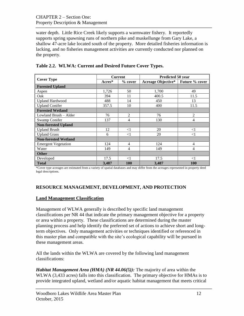
Table 2.2. WLWA: Current and Desired Future Cover Types.
Cover Type Current Predicted 50 year
Acres* % cover Acreage Objective* Future % cover
Forested Upland
Aspen 1,726 50 1,700 49
Oak 394 11 400.5 11.5
Upland Hardwood 488 14 450 13
Upland Conifer 357.5 10 400 11.5
Forested Wetland
Lowland Brush – Alder 76 2 76 2
Swamp Conifer 137 4 130 4
Non-forested Upland
Upland Brush 12 <1 20 <1
Upland Grass 6 <1 20 <1
Non-forested Wetland
Emergent Vegetation 124 4 124 4
Water 149 4 149 4
Other
Developed 17.5 <1 17.5 <1
Total 3,487 100 3,487 100 *Cover type acreages are estimated from a variety of spatial databases and may differ from the acreages represented in property deed
legal descriptions.
RESOURCE MANAGEMENT, DEVELOPMENT, AND PROTECTION
Land Management Classification
Management of WLWA generally is described by specific land management
classifications per NR 44 that indicate the primary management objective for a property
or area within a property. These classifications are determined during the master
planning process and help identify the preferred set of actions to achieve short and long-
term objectives. Only management activities or techniques identified or referenced in
this master plan and compatible with the site’s ecological capability will be pursued in
these management areas.
All the lands within the WLWA are covered by the following land management
classifications:
Habitat Management Area (HMA) (NR 44.06(5)): The majority of area within the
WLWA (3,433 acres) falls into this classification. The primary objective for HMAs is to
provide integrated upland, wetland and/or aquatic habitat management that meets critical
CHAPTER 2 – Section One:
Property Description & Management
Woodboro Lakes Wildlife Area Master Plan 13
October, 2015
life-cycle needs for a variety of plant and animal species. Typically the emphasis is to
provide habitats needed to sustain productive game species populations. Areas that
initially do not have desired habitat conditions but have a high potential to be restored
may be included under this classification.
Native Community Management Area (NCMA) (NR 44.06(6): One management unit
comprising 79 acres is classified as NCMA on the property. NCMAs are managed to
perpetuate presettlement plant and animal communities, whether upland, wetland, or
aquatic, and protect the biological diversity of the native ecosystems. A native
community is a distinct and reoccurring assemblage of indigenous flora and fauna
associated with a particular set of physical characteristics. Areas that initially do not
have the desired community conditions but have a reasonable potential to be restored
may be included in this classification.
All traditional recreational uses, such as hunting, fishing, trapping, and nature enjoyment,
are allowed on NCMAs unless an area needs to be closed to protect a rare species during
breeding season or to protect a very fragile habitat.
Special Management Area (SMA) (NR 44.06(7): Lands in this classification are
managed to provide and maintain areas or facilities for special uses not included under
other land management classifications. One 82-acre area encompassing the Forestry Fire
Equipment Training Course has been classified as a SMA.
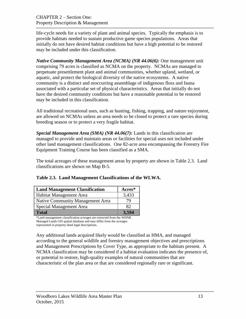
The total acreages of these management areas by property are shown in Table 2.3. Land
classifications are shown on Map B-5.
Table 2.3. Land Management Classifications of the WLWA.
Land Management Classification Acres*
Habitat Management Area 3,433
Native Community Management Area 79
Special Management Area 82
Total 3,594 *Land management classification acreages are extracted from the WDNR
Managed Lands GIS spatial database and may differ from the acreages represented in property deed legal descriptions.
Any additional lands acquired likely would be classified as HMA, and managed
according to the general wildlife and forestry management objectives and prescriptions
and Management Prescriptions by Cover Type, as appropriate to the habitats present. A
NCMA classification may be considered if a habitat evaluation indicates the presence of,
or potential to restore, high-quality examples of natural communities that are
characteristic of the plan area or that are considered regionally rare or significant.
CHAPTER 2 – Section One:
Property Description & Management
Woodboro Lakes Wildlife Area Master Plan 14
October, 2015
Habitat Management Area
The following general wildlife habitat and forestry management objectives and
prescriptions apply broadly to areas classified as HMA across the entire WLWA
property. Additional prescriptions are described in the Management Prescriptions by
Cover Type section later in this chapter. Additional objectives and prescriptions for
unique habitats and management that should be implemented in addition to/instead of
these general objectives and cover type prescriptions also are provided later in the
chapter.
The following objectives and prescriptions will be implemented contingent upon the
availability of staff and material resources, and may be modified as needed to respond to
unpredictable or catastrophic events (e.g., storm damage, severe insect or disease
infestations).
General Wildlife Habitat Management
Objectives
Provide the largest practicable blocks of habitat, particularly forests and wetlands,
including a continuum of habitats from lowland to upland. Also, establish and
maintain linkages, including hydrologic connections, between habitat blocks to create
travel corridors for the movement of species over time.
Provide high-quality habitat for forest wildlife, including game and non-game species,
furbearers, and breeding and migrating birds.
Protect, and enhance as practicable, the quality of wetland and aquatic communities,
including lakes, streams, ephemeral ponds, alder thicket, tamarack and white cedar
conifer swamp, and emergent/submergent vegetation along Little Rice Creek for
wetland-dependent species.
Monitor and control populations of invasive species and eradicate them where
feasible. Invasive species of particular concern currently include spotted knapweed,
tansy, bird’s foot trefoil, white and yellow sweet clovers, Canada and bull thistles,
hoary alyssum, reed canary grass, common buckthorn, and honeysuckle.
Manage habitats to protect and enhance native communities and populations of rare
species, including endangered, threatened, and special concern species and Species of
Greatest Conservation Need (SGCN).
As appropriate, follow the Management Prescriptions by Cover Type provided later in
this chapter when conducting management actions that support the above objectives.
Prescriptions
Provide a “soft edge” of shrubs between cover types, as appropriate, to minimize sharp
transitions and create movement corridors.
CHAPTER 2 – Section One:
Property Description & Management
Woodboro Lakes Wildlife Area Master Plan 15
October, 2015
Follow best management practices for American woodcock, ruffed grouse, and
golden-winged warbler when managing aspen and white birch for these species.
Conduct a biotic inventory of the property. If sensitive species habitat or important
high-quality natural community sites are found, determine management of those sites
through consultation with staff in the Natural Heritage Conservation program.
Substantially follow the consultation protocols in Manual Code 1750.15.
Control invasive species using appropriate techniques including, but not limited to,
prescribed fire, mechanical (e.g., mowing, cutting) control, and chemical (herbicide
application) control.
Evaluate condition of existing lakes and wetlands using parameters such as depth,
water quality, and aquatic plant species present. Manage lakes and wetlands as needed
to optimize wildlife production, including removing beaver dams, controlling
undesirable plant species, and seeding or planting desirable native plant species.
General Forest Management
Forest management activities follow the Wisconsin Forest Management Guidelines
(PUB-FR-226-2011) as well as the WDNR Silviculture and Forest Aesthetics Handbook
(2431.5), the Public Forest Lands Handbook (2460.5), the Timber Sale Handbook
(2461), the Old-growth and Old Forests Handbook (2480.5), and Forestry Best
Management Practices (BMPs) for water quality and invasives species. Consult these
resources for additional details and management considerations. The objectives and
prescriptions listed below are for the primary forest types found throughout the WLWA.
The prescriptions include an overview of the general management methods and guidance
from the Silviculture Handbook, as well as some additional considerations to be applied
to this property. Additional prescriptions relating to management of specific forest types
on the property are found in the Management Prescriptions by Cover Type section later in
this chapter.
Objectives
Maintain and enhance the quality of forest habitats with an emphasis on aspen, white
birch, oak, white and red pine, and swamp conifer.
Provide a diversity of size and age classes and structural features that enhance wildlife
habitat value across the forest types on the property.
Promote forest health by managing forest types to discourage invasion by, and reduce
loss from, invasive species and forest diseases such as oak wilt, gyspy moth, forest tent
caterpillar, two-lined chestnut borer, and annosum root-rot.
CHAPTER 2 – Section One:
Property Description & Management
Woodboro Lakes Wildlife Area Master Plan 16
October, 2015
Prescriptions
Apply a wide range of silviculture prescriptions around lakes where this helps to
advance management goals for particular species (e.g., removing red maple to favor
pine, coppice harvesting to provide vital woodcock habitat).
Retain snags and course woody habitat whenever their retention does not conflict with
other management objectives or pose a danger to loggers.
Leave long-lived reserve trees as individuals or in groups to provide timber, wildlife,
and aesthetic value whenever their retention does not conflict with regeneration and
other forest management objectives.
Do not salvage trees damaged by wind, ice, fire, insects, and disease. However,
salvage may be re-evaluated in the event of catastrophic events, risk of widespread
pest or disease outbreaks, threats to public safety, and as long as salvage is
economically feasible.
Where appropriate, lengthen the rotation age for some stands of oak, red pine and
white pine in order to increase the abundance of older-age forest habitat.
Require loggers to utilize established best management practices for all aspects of
conducting timber harvest and removal, and require logging equipment to be cleaned
prior to entry to and exit of state lands in order to prevent the spread of invasive plants.
Management Prescriptions by Cover Type
The Department commonly uses several habitat classification systems when planning and
performing management activities. The two that are used most in this plan are natural
communities and cover types. Each has a different purpose, function, and scale. The
natural community system is broader and ecologically defined, based on assemblages of
plant and animal species that are repeated across the landscape in an observable pattern.
It is a particularly useful tool for identifying interconnected, functional natural elements.
The cover type system is more focused, generally looking at a finer scale. This system
breaks out the primary vegetative types on the landscape and classifies them by the
dominant vegetation present on a particular site. The cover type system was developed
as a forest management tool, used to identify and apply management to different timber
types and other types of vegetation. Specifically, a forest stand is designated as a certain
cover type if ≥50% of its basal area is dominated by a particular tree species or
combination of species. Sites having <10% trees are considered non-forested and are
classified as various other habitat types (e.g., grassland, lowland brush, etc.) according to
the predominant vegetation present. Forest reconnaissance data are collected using these
cover types, and are stored in the Wisconsin Forest Inventory & Reporting System
(WisFIRS).
Because the cover type system focuses on specific vegetation types, it is useful for
directing and carrying out vegetation management activities. However, consideration of
CHAPTER 2 – Section One:
Property Description & Management
Woodboro Lakes Wildlife Area Master Plan 17
October, 2015
natural communities along with cover types is essential in planning and management to
assure that the overall integrity and function of managed resources are maintained.
Aspen-dominated Mixed Forest
Aspen forests are a premier wildlife cover type in the uplands. Young aspen forests
provide feeding and hiding cover for a host of game species and non-game species. While
aspen is currently the second most common forest cover type north of the Tension Zone
and is present at much higher levels than it was prior to Euro-American settlement, the
cover type currently is in decline across the state. New research is indicating that young
aspen stands, particularly those containing large scattered oaks, may provide important
breeding habitat for golden-winged warblers, especially if adjacent to mature forest for
the post-fledging period. White pine, another component of these stands, can increase
once sunlight reaches the young trees in the understory. Trees retained may wind throw
and become coarse woody debris on the forest floor. Creating and maintaining greater
age class diversity of aspen on the property is a major goal. This will enhance the
opportunity to accommodate a variety of wildlife species.
Prescriptions
Regenerate aspen primarily through coppice (i.e., root sprouts) cutting with a
management emphasis on its habitat value for ruffed grouse and woodcock
populations.
Where feasible and appropriate, regenerate aspen within Riparian Management Zones
(RMZs) to provide critical habitat for woodcock. This prescription will be
implemented where the practice will not compromise important ecological
characteristics and water quality that BMPs are intended to protect.
Harvest portions of larger stands at staggered intervals of 40-65 years of age.
Provide a variety of age classes and stand sizes across the landscape for wildlife
habitat benefits, ecological diversity, and aesthetic value.
Retain individual longer-lived species such as oak, white pine, hemlock, and red pine,
as well as older individual aspen. These reserve trees can improve stand structure,
diversity, wildlife habitat, and aesthetic beauty as well as promoting wildlife travel
corridors. In order to maintain vigorous aspen growth, 20% crown closure is typically
ideal; however, crown closure may be slightly higher or lower depending on site
conditions.
Evaluate hardwood stands that contain a remnant aspen component and determine if
they may be converted to aspen/birch. Convert to aspen where the potential exists.
Whenever possible, leave cavity trees (living and dead).
CHAPTER 2 – Section One:
Property Description & Management
Woodboro Lakes Wildlife Area Master Plan 18
October, 2015
Oak-dominated Mixed Forest
Oak forests historically developed or regenerated following a significant disturbance
event such as fire or blow-down and fire. Oak stands on the WLWA are dominated by
red oak. Much of the current red oak developed following the large scale cutover and
wildfire era in the early 1900’s. Red oak may be encouraged on sites with appropriate
soil, slope and other conditions. This forest type is of high value to a wide number of
game and non-game wildlife species. Disturbance is required to regenerate existing
stands and to maintain an oak component in mixed stands.
Prescriptions
Main current oak acreage on the property and look for opportunities to expand this
cover type.
Use thinnings to develop oak stands as they move toward biological maturity, and use
a shelterwood harvest to regenerate this species at 90-150 years of age, depending on
site characteristics. Other management techniques that may be applied when needed
to red oak stands include single-tree selection, scarification, hand-release, prescribed
burning, and herbicide treatments to promote regeneration.
In the first stage of a two-stage shelterwood harvest, maintain 40-50% crown closure
in dominant crown red oak trees to allow for sunlight and the regeneration of young
oak. After the young oak trees have regenerated, about 5 to 10 years later, harvest the
majority of the mature trees, maintaining up to 20% crown closure of reserve trees in
the form of clumps, corridors, or uniformly spaced individuals.
Attempt to retain ≥3 trees per acre to develop into large, old trees for age, structural
diversity and wildlife.
On mixed stands of red oak with white pine, northern hardwoods or other species
manage to promote components of older long-lived trees and natural regeneration of
these species and other secondary species. Retain white & red pine.
Monitor oak stands for signs of oak wilt and treat to prevent the spread when feasible
and practical.
Retain all bur and white oak on the property.
Red Maple
Red maple is found on the property on both dry and wet sites and on a variety of soil
types. It is dominant on some stands and can be a minor or major component of mixed
stands. It can be present to varying degrees in the understory of stands and tends to
increase following thinning or other moderate disturbances. Because of its shade
tolerance red maple may be found as a secondary canopy layer in mature stands of white
pine, red pine, or oak. It is an aggressive competitor to these species and outlives aspen
and birch. As a result, as aspen, oak, and pine stands decline with age, red maple
becomes the dominant tree species. The red maple cover type is not as valued for wildlife
CHAPTER 2 – Section One:
Property Description & Management
Woodboro Lakes Wildlife Area Master Plan 19
October, 2015
habitat as the aspen, oak, or pine cover types, and so conversion to aspen, oak, or red or
white pine through coppice cutting when possible is the preferred management
alternative for these stands. When there is no opportunity for natural or forced conversion
in these stands, red maple may be maintained.
Prescriptions
Use coppice or shelterwood cutting to convert red maple-dominated stands to aspen,
oak, or pine wherever possible and appropriate
Where management for red maple is most appropriate and is the primary objective,
utilize even-aged management with a shelterwood cut at a rotation age of 70-90 years.
Retain a pine and oak component where present.
In mixed stands, red maple maintenance will be considered on a stand-by-stand basis
for forest diversity and aesthetics.
Prescribed fire may be used to reduce red maple where conversion to pine or oak is
desired.
Red and White Pine Dominated Mixed Forest
Most red or white pine stands on the property are fairly small in size. This forest type
occurs in a wide range of current conditions that require a range of management
intensities and a variety of techniques. Techniques for successful regeneration may
require mechanical soil disturbance, fire, herbicides, and plantings.
Prescriptions
Maintain the existing acreage of red and white pine (with red oak as an associate
species).
Manage red and white pine stands on an extended rotation, and encourage old growth
characteristics. Passively manage small, scattered stands and swamp islands.
Thin pine plantations (red and white) on a recurring basis (8-15 year intervals),
according to prescriptions outlined in the Silviculture Handbook.
Mixed pine stands containing a large percentage of tree species other than pine may be
treated with selection harvest, shelterwood harvest or overstory removal of other
species to promote pine dominance of the future stand or increase the amount of pine
in natural regeneration after harvest. Several harvest entries may be required to bring
pine to a dominant position.
Where red or white pine is a viable understory component, use natural regeneration
techniques. Plant pine if natural regeneration fails or is not possible.
Ground disturbance or prescribed fire may be used to promote regeneration of red or
white pine where feasible and safe. The natural trend within these stands is a
CHAPTER 2 – Section One:
Property Description & Management
Woodboro Lakes Wildlife Area Master Plan 20
October, 2015
conversion from pine to other hardwood species. Prescribed burning trials have
proven effective at maintaining these sites in pine by killing the encroaching hardwood
species. Prescribed burns coupled with shelterwood harvests have also proven
effective at regenerating these sites. Scarification has also shown promising results,
especially when used with burning and shelterwood management.
Alder
Alder (speckled alder or “tag” alder) on the property typically occurs along margins
between forests and riparian zones, lakes, wetlands, or muskegs. These alder stands
traditionally have not been managed, and have subsequently matured. When alder stands
become old and decadent, stem density decreases substantially and understories are
overtaken by grasses and other ground covers. Regenerating alder by cutting or shearing
and creating a diversity of age classes benefits game species such as American
woodcock, ruffed grouse, cotton-tailed rabbits, and snowshoe hares as well as a variety of
songbirds including the golden-winged warbler. Alder is not considered an important
browse species for deer, but provides excellent cover for travel, bedding, escape, and
fawning. For all these reasons, creating and maintaining greater age class diversity of
alder on the property is an important goal. Like aspen, alder sprouts vigorously when cut,
although most alder sprouting is directly from the stump, not from roots. Alder will also
grow naturally from seed.
Prescriptions
Regenerate alder by cutting, mowing, or shearing with a management emphasis on its
habitat value for woodcock, golden-winged warblers, and a variety of other species
dependent on early-successional habitat.
Harvest portions of larger stands of mature decadent alder at staggered intervals. To
determine the suitability of the age of a stand of alder, observe the growth form of
alder stems: when old, alder frequently grows horizontally instead of vertically. Alder
stands with horizontal growth are good candidates for regeneration.
Where suitable and appropriate, cut strips of alder that are 50-100-feet-wide through
the alder stand. Position strips so that an adjacent strip can be cut every 5 years, thus
ensuring that all alder strips will be revisited once every 20 years. As with aspen, the
percentage of the area cut can be accelerated in decadent stands with substantial
horizontal growth.
Conduct work during the dormant season to optimize resprouting from the root crown
during the following growing season.
Conduct work when the ground is frozen to minimize potential impacts to wetlands.
Alder stands with standing water, saturated soils throughout the year, or heavy sedge
growth are likely too wet to provide benefits for target species under normal
circumstances and are not suitable for this kind of management work.
CHAPTER 2 – Section One:
Property Description & Management
Woodboro Lakes Wildlife Area Master Plan 21
October, 2015
Where alder stands are interspersed with trees of other species, retain widely spaced
overstory trees with a DBH >9 inches, particularly deciduous species, as this structure
is beneficial for golden-winged warbler.
Forested Wetlands
Forested wetland areas on the property contain stands of swamp conifer, including black
spruce, tamarack, white cedar, and associated species. Swamp hardwood stands,
dominated by black ash, are very limited on this property and will be passively managed.
Prescriptions
Management activities will be minimal within wetlands with small sized, slow
growing, non-merchantable trees, lowland brush, or open bogs and marshes. However,
access across these areas may be necessary periodically for temporary roads. These
roads will be limited to frozen ground conditions. Where appropriate and feasible,
alder may be managed and regenerated using shearing techniques.
Productive stands of tamarack and black spruce will be regenerated using strip clearcut
and/or seed tree method following guidelines in the Silviculture Handbook. Timber
harvests will only be conducted under frozen ground or very dry conditions, using
techniques and equipment that prevent rutting and other negative impacts to the
hydrology of the wetland.
Retain all white cedar. Exceptions to this will be where management opportunities
provide for encouraging regeneration of this species. Cedar trees damaged by wind,
ice, fire, insects, and disease will not be salvaged unless there is a public safety issue
with not doing so.
BCPL Easement Area
The Board of Commissioners of Public Lands (BCPL) holds a forest management
easement on 778 acres of WLWA in the southwestern portion of the property (see Map
B-1). This easement was granted to BCPL in perpetuity by WDNR on July 30, 2002,
with the easement recorded on June 26, 2003. The easement grants BCPL forest
management rights on these acres, using sustainable forest management practices, and
retains public access for recreation. Under the terms of the easement, a forest
management plan prepared by BCPL and approved by WDNR guides forest management
on easement acres. The plan is reviewed on a 15-year cycle. The current plan was
approved in 2003 and is effective through 2018 (see copy of plan in Appendix A).
Objective
Adhere to the terms of the forest management easement on the BCPL easement acres.

CHAPTER 2 – Section One:
Property Description & Management
Woodboro Lakes Wildlife Area Master Plan 22
October, 2015
Prescriptions
Participate in the review, amendment, and approval of the forest management plan, as
appropriate, according to the terms of the easement.
In the event that management of these acres should revert back to WDNR (e.g., as a
result of a land exchange), management will occur according to the general wildlife
and forestry management objectives and prescriptions and prescriptions by cover type
provided earlier in this chapter.
Ephemeral Ponds
Ephemeral ponds are depressions with impeded drainage, usually in forest landscapes,
that hold water for a period of time following snowmelt and spring rains but typically dry
out by mid-summer. There are numerous high-quality ephemeral ponds on WLWA,
some of which formed as a result of historic ground-disturbing activities, such as the
creation of a rail line bed in the southeast portion of the property. Ephemeral ponds are
highly productive in the spring and early summer and provide critical breeding habitat for
certain invertebrates and amphibians. They also provide feeding and resting habitat for a
variety of songbirds and mammals. Trees adjacent to ephemeral ponds provide a variety
of benefits such as maintaining cool water temperatures, preventing premature drying,
and adding to the detritus-based food web. Safeguarding the integrity of ephemeral
ponds on the property is important so they can continue to provide habitat for wildlife.
Objective
Protect and maintain existing ephemeral ponds on the property.
Prescriptions
Seek opportunities to map ephemeral ponds on the property as time, funding, and
staffing allow.
Attempt to map ephemeral ponds prior to timber sale establishment. Prohibit forest
management activities, including heavy equipment movement or landing creation in or
within 15 feet of ephemeral ponds. Adhere to water quality BMPs during harvest
operations.
Passively manage ephemeral ponds, except to control invasive species. Aquatic-
approved pesticide use is permitted for invasive species management.
Consider maintaining long-lived tree species around ephemeral ponds.
Consider leaving connecting strips from riparian zones to the ponds for amphibian
travel corridors.
Consider maintaining or increasing coarse woody debris within 300 feet of ephemeral
ponds by retaining legacy trees and snags.
CHAPTER 2 – Section One:
Property Description & Management
Woodboro Lakes Wildlife Area Master Plan 23
October, 2015
Encourage research on ephemeral ponds, including inventory, mapping, and
monitoring as well as surveys on vascular plants, invertebrates, herptiles, and abiotic
attributes associated with them.
Lakes
WLWA contains all or a portion of four named lakes and 15 unnamed lakes. The lakes
exhibit a wild character, with undeveloped shorelines and unimproved, foot-only access,
making them attractive to both breeding and migratory waterfowl. Most of the lakes are
small and shallow and contain little vegetation and no game fish.
Objective
Manage lakes on the property to maintain their wild character and enhance habitat
quality for wetland-dependent species.
Prescriptions
Maintain stands of older/larger pine around lakes for aesthetics.
Where an herbaceous fringe exists, explore the feasibility of using prescribed fire to
enhance nesting habitat for ducks such as American black duck and ring-necked duck.
Where water depth, flow, and substrate conditions are suitable, seek opportunities to
spread local-origin wild rice seed to enhance or restore wild rice beds.
Where practicable, implement priority conservation actions for Emergent Marsh listed
in the Wisconsin Wildlife Action Plan (WDNR 2006a) on the lakes within the
property.
Native Community Management Area
Little Rice Creek Riparian Corridor
Little Rice Creek is a warmwater stream with a high-quality vegetated riparian zone that
includes lowland conifer forest, alder thicket, emergent marsh, and floating and
submerged aquatic plants. These vegetation types protect the water quality of Little Rice
Creek and stabilize the shoreline, preventing erosion. There likely are springs and spring
runs in some areas. The aquatic plants in Little Rice Creek provide spawning habitat for
fish and amphibians, and the riparian zone provides feeding, resting, and breeding habitat
for a number of bird species and invertebrates, including many SGCN, resources for
mammals, and important habitat for herptiles that inhabit Little Rice Creek. The primary
management approach in this NCMA is passive management with exceptions for
invasive species control and maintenance of existing trails.
CHAPTER 2 – Section One:
Property Description & Management
Woodboro Lakes Wildlife Area Master Plan 24
October, 2015
Objective
Protect and maintain beds of emergent and submergent aquatic vegetation along the
shoreline of Little Rice Creek.
Prescriptions
Use passive management except for activities associated with clearing and
maintenance of existing trails and invasive species management.
Periodically monitor for and control invasive species. Aquatic- and upland-approved
pesticide use is permitted for invasive species management.
Survey the Little Rice Creek riparian zone to locate and document high quality
community occurrences and rare species populations.
Special Management Area
This area encompasses the 82-acre Forestry Fire Equipment Training Course in the north-
central portion of the property. The site consists of several openings, including one large
open area for staging equipment and driving larger engines, and a 4x4 vehicle driving
course. This facility provides a standard proving ground for specialized equipment
training and certification of WDNR personnel assigned to wildfire response and control.
It is located in close proximity to the WDNR LeMay Forestry Center in Tomahawk
where many training courses are held, and also meets certification needs statewide for
personnel without access to a training site on state land. The site allows for accurate
duplication of the same measurable conditions for each student and provides for testing in
a variety of upland and low ground situations similar to actual conditions that may be
encountered during fire response. The open areas double as a wildlife openings and the
driving course is also maintained as a series of hunter walking paths.
Objective
Maintain a permanent facility for Forestry fire equipment training while continuing
compatible management for wildlife habitat and hunter access.
Prescriptions
Mow the openings and trails annually and seed as needed.
Keep trails clear of downed trees.

CHAPTER 2 – Section One:
Property Description & Management
Woodboro Lakes Wildlife Area Master Plan 25
October, 2015
PUBLIC USE MANAGEMENT AND DEVELOPMENT
General Recreation Management and Uses
The entire WLWA property is open to traditional outdoor recreational uses including
hunting, fishing, and trapping. These activities are the primary recreational uses of the
property. Other activities allowed on these lands include wildlife viewing, seasonal
camping, hiking, biking, paddling, cross-country skiing, snowshoeing, collection of wild
edibles, and nature study. However, unless specifically noted below, no facilities or
infrastructure will be designated or maintained for these uses.
Foot travel (including skiing and snowshoeing) is allowed on all service roads unless
restricted during habitat management activities (e.g., temporary closure during a timber
harvest) or due to safety concerns (e.g., flooding).
Edible fruits and nuts, wild mushrooms, wild asparagus, and watercress may be removed
by hand without a permit for the purpose of personal consumption by the collector.
Cutting of willow branches is allowed with a permit from the property manager.
Collection of seeds, roots, or other plant parts is prohibited.
Horses are allowed on the property only on roads open to public vehicles.
Motorized vehicle access is available on designated public access roads and parking lots
(see Motorized Access plan, pp. 31-32). Snowmobiles and ATVs/UTVs are allowed only
on trails designated for their use. There are allowances for motorized use by individuals
with mobility impairments under the power-driven mobility device regulations of the
Americans with Disabilities Act. For more information on these allowances, please refer
to specific language under “Disabled Accessibility” in the General Administration
Management Policies and Provisions section of this chapter.
Information on rules governing public use of Department-owned lands is found in
Chapter NR 45, Wisconsin Administrative Code.
General Recreation and Public Use Objectives
Provide opportunities for hunting and trapping, with a focus on quality ruffed grouse
hunting.
Accommodate non-hunting-related nature-based recreational activities, such as hiking,
biking, paddling, cross-country skiing, and wildlife viewing, as compatible with the
property’s capabilities and the primary objective, above.
Improve accessibility for mobility-impaired individuals where feasible.
CHAPTER 2 – Section One:
Property Description & Management
Woodboro Lakes Wildlife Area Master Plan 26
October, 2015
General Recreation and Public Use Prescriptions
Install, maintain, and monitor parking areas, access roads, and signage consistent with
Department rules and policies.
Post property boundaries with signs to assist visitors in finding and staying on state
lands. Post other property regulatory and informational signs at parking areas and
access points as appropriate.
The entire property is open to bike use except for any area posted closed. No
designated trails or facilities will be provided for this use.
Integrate accessibility into development and construction of any new infrastructure.
Accommodate requests from external partners or stakeholders to provide accessible
recreational opportunities or facilities where feasible and compatible with the primary
purpose of the property.
Specific Recreation Management Prescriptions
Parking Areas
Maintain two existing parking areas, and add two new areas accommodating 4-6
vehicles each, as shown on Map B-3. Additional parking lots may be constructed in
the future at other locations to facilitate access if demand warrants.
Adjust locations of gates as necessary to accommodate new parking areas or better
access points to hunter access/hiking trails.
Snowmobile Trail
Maintain a trail agreement with the Northwoods Passage Snowmobile Club for
maintenance and operation of the existing snowmobile trail.
Conduct repairs to, or replacement of, the existing snowmobile bridge as needed to
comply with all applicable state standards.
Hunter Walking Paths
The almost 16 miles of hunter walking paths on the WLWA were developed from a
network of logging roads that was present at the time WDNR acquired the property.
Funding from the Ruffed Grouse Society was used to mow and widen paths where
vegetation had grown in, to install gates, and to rock off all other access points. Turkey
Stamp funds currently are being used for grading and seeding. These paths primarily are
maintained to provide foot access for hunting, but also provide access for other uses such
as casual hiking, berry-picking, and wildlife watching.
CHAPTER 2 – Section One:
Property Description & Management
Woodboro Lakes Wildlife Area Master Plan 27
October, 2015
Designate hunter walking paths as hunter access/hiking trails and maintain for the
primary purpose of providing hunting access. Some trails or trail segments may not be
mowed or otherwise maintained in the non-hunting seasons. Maintain trails at a
development level ranging from primitive to lightly developed.
The property manager may temporarily close or relocate any trail to accommodate
management activities (e.g., timber harvesting).
The property manager may establish new hunter/hiker trails or trail segments or
abandon existing trails or trail segments as appropriate to maximize hunting access
and to maintain compatibility with resource management objectives.
The property manager will evaluate any new logging roads established for timber
harvesting and determine whether they will be abandoned or designated and
maintained as part of the hunter access/hiking trail network.
Camping
Provide for dispersed camping during the fall hunting season, from September 1st
through December 31st, at designated areas. Camping permits will be available via
self-registration; fees will not be charged. No facilities are provided for dispersed
camping.
ATV Trail
In 2014, the Nokomis ATV Club requested that a connector trail be established across a
portion of the WLWA. The WDNR conducted a trail feasibility study (WDNR 2014b)
which concluded that the proposed trail route could be approved with several
modifications, particularly regarding the location of a portion of the route.
Work with the Nokomis ATV Club to establish a connector trail between Oscar Jenny
Road and the Oneida County Forest that meets the development and operations
requirements below.
Construction needs
The trail will substantially follow the route of the existing snowmobile trail.
Approximately 0.3 miles of new trail will be constructed to avoid adjacent wetlands.
ATV/UTV trails on WDNR managed lands must be built to meet the Department’s
established ATV/UTV trail design standards (WDNR 2010). Following current design
standards, the trail tread (2-way trail) would be a minimum of 12 ft. wide and up to 16 ft.
wide on turns. There would be a cleared width extending 2 ft. on each side of the trail
and tree limbs overhead would be cleared a minimum height of 12 ft.
At minimum, the trail tread should be surfaced with crushed gravel or crushed stone; the
gradation #3 WDOT mix (3/8- inch sieve) is recommended. Potentially, additional
CHAPTER 2 – Section One:
Property Description & Management
Woodboro Lakes Wildlife Area Master Plan 28
October, 2015
armoring on specific sites may be required. Not only would surfacing address concerns
about ponding and rutting, emerging boulders, slope, and sand pockets, it would also
reduce the need for maintenance.
The existing 23-ft. snowmobile bridge must be upgraded or replaced to meet standards
for ATV/UTV traffic and to support trail maintenance equipment.
Use Period
The trail use season must be consistent with that of the Oneida County ATV/UTV trail
system when connectivity is realized.
Trail Memorandum of Understanding
Prior to trail establishment the sponsoring club is required to enter into certain
agreements related to trail use, construction, and maintenance. The Department’s
ATV/UTV Trail policy requires that connector trails across properties be constructed and
maintained by a local sponsor under a Memorandum of Understanding (MOU).
Specifically, the MOU includes a Land Use Agreement covering use of the trail route,
and a Construction and Maintenance Agreement. The policy also stipulates that the
local/regional trail system be under county or municipal management.
Trail Connectivity
The Department’s ATV/UTV Trail policy requires that a connector trail crossing a
property connect established trails or routes in the local or regional system. Oscar-Jenny
Road is not currently designated as an ATV/UTV route, and the logging road onto
Oneida County Forest is not designated as an ATV/UTV trail or route. These
routes/trails must be established prior to construction of the section of trail on the
WLWA.
REAL ESTATE ACTION ITEMS
The following real estate action items were approved for the WLWA.
Parcel Re-designation
An 80-acre parcel of Scattered Forest Land located within the WLWA property boundary
is re-designated as Wildlife Area.
Boundary Modifications
Expansion of the project boundary in the southwest to encompass the Scattered
Forest Land parcel (768 acres).
o This parcel is already owned by the Department and has been managed as part of
the WLWA since acquisition; the parcel is re-designated as Wildlife Area.
CHAPTER 2 – Section One:
Property Description & Management
Woodboro Lakes Wildlife Area Master Plan 29
October, 2015
o This expansion excludes all the acreage west of Hwy 51 as this area has very poor
access potential and is being considered for sale. If sold, it would decrease current
ownership by 153 acres.
Expansion of the northern project boundary to follow CTH K (412 acres).
o If acquired, will improve public access and management efficiency and decrease
confusion for property users by adjusting the property boundary to follow an
existing road.
o Provides the potential for expanded recreational opportunities: additional acres for
hunting; inclusion of parcels with open habitats currently rare on the property
where new activities such as dog training or target shooting could be developed.
Oneida County currently lacks public dog training areas or shooting ranges.
o Will protect additional large blocks of wetland habitat if acquired.
Expansion of the boundary in the northeastern portion of the property to follow
CTH K, Old CTH K, and Oneida Lake Road (569 acres).
o If acquired, would improve public access and management efficiency and decrease
confusion for property users by adjusting the boundary to follow existing roads.
o Provides the potential for expanded recreational opportunities: additional acres for
hunting; inclusion of parcels with open habitats currently rare on the property
where new activities such as dog training or target shooting could be developed.
Oneida County currently lacks public dog training areas or shooting ranges.
o Will protect lake frontage on Indian, Perry, and Boggy Lakes if acquired.
o Will protect additional large blocks of wetland habitat if acquired.
Expansion of the boundary in the west-central and northwestern portions of the
property to follow Hwy 51 and CTH K (637 acres).
o If acquired, will improve public access and management efficiency and decrease
confusion for property users by adjusting the boundary to follow existing roads.
o Will protect wetland habitat and lake and stream frontage on Oscar Jenny Lake and
Bearskin Creek if acquired.
o Provides the potential for expanded recreational opportunities: additional acres for
hunting; fishing on Oscar Jenny Lake, etc.
Expansion of the boundary in the southeastern corner to follow Oneida Lake
Road (279 acres).
o If acquired, will improve public access and management efficiency and decrease
confusion for property users by adjusting the boundary to follow existing roads.
o Provides the potential for a public access site on Little Rice Creek.
o Will protect wetland habitat and stream frontage along Little Rice Creek if
acquired.
CHAPTER 2 – Section Two:
General Management Policies
Woodboro Lakes Wildlife Area Master Plan 30
October, 2015
GENERAL ADMINISTRATION MANAGEMENT POLICIES AND
PROVISIONS
The following section describes general property administration and management
policies and provisions that apply to all state managed lands.
Funding Constraints
Implementation of the master plan is dependent upon staffing and funding allocations that
are set by a process outside of the master plan. Funding for land acquisition can come
from a variety of federal (e.g., Pittman-Robertson and others), state (e.g., Stewardship),
local, and private (e.g., land trusts) sources as well as land donations. Capital and
operational funding for the Department is established by the state legislature. Funds also
are provided by federal programs and occasionally from private sources. Development
projects similarly follow an administrative funding and approval process outside of the
master plan. Many of the initiatives contained within the plan are dependent upon
additional funding and staffing support. Therefore, a number of legislative and
administrative processes outside of the master plan will determine the rate at which this
master plan will be implemented.
Properties that have either been purchased or managed using funding from the Federal
Aid in Wildlife Restoration Act (also known as the Pittman-Robertson Act) or the
Federal Aid in Sport Fish Restoration Act have additional management constraints that
must be considered. The statutes and applicable regulations prohibit a state fish and
wildlife agency from allowing recreational activities and related facilities that would
interfere with the purpose for which the State acquired, developed, or is managing the
land.
Facility Management
All infrastructure used for habitat management and public access shall be inspected and
maintained as required in program guidance and manual codes. This infrastructure
includes, but is not limited to, dikes, spillways, water control devices, roads, gates,
parking lots, boat launches and buildings.
The property manager may relocate or temporarily close road and trail segments or other
public use facilities as deemed necessary to conduct timber harvests or other habitat
management activities or for public safety or law enforcement reasons (see the Road
Management section below for road closure information).
The location and design of new roads or trails must be consistent with the land
classification requirements (NR 44) and the management objectives for the area in which
they are to be located.
CHAPTER 2 – Section Two:
General Management Policies
Woodboro Lakes Wildlife Area Master Plan 31
October, 2015
Public Health and Safety
All facilities will comply with federal, state, and local health and sanitation codes. The
property manager has the authority to close trails and other facilities on the property
when necessary due to health, safety, or environmental damage concerns. In designated
public use areas, such as designated parking lots and designated trails, trees or other
natural elements that are deemed public hazards will be removed. Safety inspections are
done at least twice per year.
Refuse Management
Visitors are required to carry out any refuse they bring in because no designated refuse or
recycling receptacles are available. Burying of refuse is not allowed anywhere on the
properties.
Road Management and Motorized Public Access
Public access roads and management roads (permanent and temporary) form the
property’s transportation and public access network. Roads open to public vehicles along
with their associated parking lots provide vehicle access for visitors to enjoy a variety of
non-motorized recreational uses. Management roads provide access to WDNR staff for
habitat and forest management activities. Additionally, some roads also serve as
snowmobile routes in winter.
While management roads are not specifically designed or maintained as public use
facilities, property visitors may walk, ski or snowshoe on them, unless posted closed to
public access.
Federal highways, state highways and county/town roads bordering or passing through
the property are the management responsibility of these respective jurisdictions and are
not covered by this road management plan.
Motorized access is shown on Map B-4. This map indicates which roads are open to
public vehicle access (street-licensed vehicles). Motorized access and NR 44 road
classifications are summarized in Table 2.4. NR 44 road classifications are described in
Appendix B.
All roads are closed to ATVs unless designated for such use. Roads closed to public
vehicles are gated, blocked or signed. However, they are open to foot access for hunting,
trapping, hiking and other general recreational uses. Most public vehicle access roads
managed by the WDNR are constructed and maintained to be accessible by all street-
licensed vehicles. However, primitive roads may not be accessible by all vehicles. If
open, high-clearance four-wheel-drive vehicles may be required.
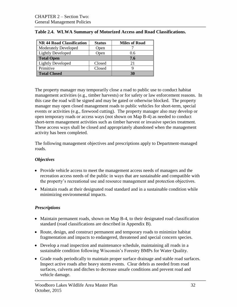
CHAPTER 2 – Section Two:
General Management Policies
Woodboro Lakes Wildlife Area Master Plan 32
October, 2015
Table 2.4. WLWA Summary of Motorized Access and Road Classifications.
NR 44 Road Classification Status Miles of Road
Moderately Developed Open 7
Lightly Developed Open 0.6
Total Open 7.6
Lightly Developed Closed 21
Primitive Closed 9
Total Closed 30
The property manager may temporarily close a road to public use to conduct habitat
management activities (e.g., timber harvests) or for safety or law enforcement reasons. In
this case the road will be signed and may be gated or otherwise blocked. The property
manager may open closed management roads to public vehicles for short-term, special
events or activities (e.g., firewood cutting). The property manager also may develop or
open temporary roads or access ways (not shown on Map B-4) as needed to conduct
short-term management activities such as timber harvest or invasive species treatment.
These access ways shall be closed and appropriately abandoned when the management
activity has been completed.
The following management objectives and prescriptions apply to Department-managed
roads.
Objectives
Provide vehicle access to meet the management access needs of managers and the
recreation access needs of the public in ways that are sustainable and compatible with
the property’s recreational use and resource management and protection objectives.
Maintain roads at their designated road standard and in a sustainable condition while
minimizing environmental impacts.
Prescriptions
Maintain permanent roads, shown on Map B-4, to their designated road classification
standard (road classifications are described in Appendix B).
Route, design, and construct permanent and temporary roads to minimize habitat
fragmentation and impacts to endangered, threatened and special concern species.
Develop a road inspection and maintenance schedule, maintaining all roads in a
sustainable condition following Wisconsin’s Forestry BMPs for Water Quality.
Grade roads periodically to maintain proper surface drainage and stable road surfaces.
Inspect active roads after heavy storm events. Clear debris as needed from road
surfaces, culverts and ditches to decrease unsafe conditions and prevent road and
vehicle damage.
CHAPTER 2 – Section Two:
General Management Policies
Woodboro Lakes Wildlife Area Master Plan 33
October, 2015
Close and restore temporary access roads to non-erosive conditions in accordance with
Wisconsin's Forestry BMPs for Water Quality after the management activity for which
they were established is completed.
Collaborate with municipal, town, and county roadside maintenance crews to protect
and enhance the quality of roadside easement areas, especially to control the spread of
invasive species.
Disabled Accessibility
The Department is committed to providing exceptional outdoor recreation opportunities
around the state for people of all abilities. All new construction and renovation of
infrastructure will follow guidelines set forth within the Americans with Disabilities Act
and also be done in a manner consistent with NR 44 standards of the land use
classification of the site where the development is located.
The property manager has the authority to make reasonable accommodations for people
with disabilities, consistent with the requirements of the area’s land use classification.
Property managers also may allow the use of power-driven mobility devices with a
WDNR-issued permit, consistent with a March 15, 2011 U.S. Department of Justice
ruling. Approval will depend on various factors including: the physical characteristics of
the device; the volume of pedestrian traffic at the location; the design and operational
characteristics of the site; safety considerations; and whether the proposed use creates
substantial risk of serious harm to environmental, natural or cultural resources.
Endangered, Threatened and Species of Special Concern Protection
Individuals of all endangered, threatened, special concern species and populations of
SGCN will be protected. All known critical habitat for these species will be protected or
maintained through management which incorporates guidance from staff specialists,
research and current literature, and consultation with the Bureau of Natural Heritage
Conservation. The Natural Heritage Inventory (NHI) will be checked prior to any
management activity to ensure that any adverse impacts associated with listed species are
avoided or minimized to the greatest extent practical.
Protection of Cultural Resources
Only one recorded archaeological site is known to be co-incident with the WLWA.
However, archaeological surveys have been very limited in this area. The presence of
many lakes and wetlands suggest a high potential for the presence of other, as yet
unrecorded sites within the WLWA.
All sites occurring on public lands are protected against unauthorized disturbance under
provisions of various federal and/or state laws, and burial sites (including cemeteries and
mound sites) are protected on private lands as well.
CHAPTER 2 – Section Two:
General Management Policies
Woodboro Lakes Wildlife Area Master Plan 34
October, 2015
Management policy requires that any activities with potential to disturb archaeological
sites will only be undertaken after consultation with the Departmental Archaeologist.
Any sites with cultural or historical value identified on the LWRBNRA or acquired with
future land purchases will be managed in accordance with Department guidance and
statutory requirements (see Wis. Stats. 44.40 and Manual Code 1810.10). Archaeological
and other cultural resource investigations may be necessary before a project is approved,
and projects should designate funds for required investigations as a component of the
project budget.
Water Quality Issues
All forest management activities will comply with the most recent version of Wisconsin
Forestry’s BMPs for Water Quality. Maintenance of natural shorelines and a minimum
of a 30-ft-wide associated buffer should be encouraged on state lands to protect water
quality and maintain the aesthetic quality of the river for recreational boaters. Buffer
strips on developed lots should be encouraged to intercept the runoff from lawns, which
can carry excess nutrients, fertilizers, herbicides and pesticides directly to the water.
Forest Certification
In 2004, Wisconsin State Forests gained dual Forest Certification from the Forest
Stewardship Council (FSC) and Sustainable Forestry Initiative (SFI). In 2009, State
Forests were re-certified under FSC and SFI and the balance of WDNR-owned land was
added to the certification. Independent, third-party certification means that management
of Wisconsin’s DNR-owned land meets strict standards for ecological, social, and
economic sustainability. Forest certification helps Wisconsin remain competitive in
global markets that increasingly demand certified raw materials. Management of multi-
use lands involves balancing the goals of conserving forestland, supporting economic
activities, protecting wildlife habitat, and providing recreational opportunities. Objective
review is also instrumental in improving how we care for the land we manage.
Prescribed Fire
Prescribed fire is a management tool that mimics natural fire disturbance and helps
control many woody plants and invasive weeds, improves the quality of wildlife habitat,
reduces fuels to lessen wildfire hazard, and liberates nutrients tied up in dead plant
material. It can help regenerate forest cover types such as oak, and create or maintain
grassland/prairie and savanna/barrens habitat. Upland nesting cover used by grouse,
waterfowl and songbirds is more productive if periodically burned. Wetlands also benefit
from fire. Prescribed fire may be used as a management tool where feasible and safe
except when restricted by management area prescription.
Fire Suppression
As stated in Wisconsin Statute 26.11, “The Department is vested with power, authority
and jurisdiction in all matters relating to the prevention, detection and suppression of
CHAPTER 2 – Section Two:
General Management Policies
Woodboro Lakes Wildlife Area Master Plan 35
October, 2015
forest fires outside the limits of incorporated villages and cities in the state except as
provided in sub (2), and to do all things necessary in the exercise of such power, authority
and jurisdiction.” Wildland fire suppression actions will consider the property
management goals and the threats of the fire to life and property. Appropriate techniques
will be used in each event to provide effective fire suppression while minimizing
resource damage.
Forest Pest Control
Wisconsin Statute 26.30 states, “It is the public policy of the state to control forest pests
on or threatening forests of the state…”. Any significant forest pest events will be
evaluated with consideration given to the property management goals and the potential
threat of the pest to other landowners. Infestations will be managed according to the
relevant management plan, if such exists. Responses to significant infestations from
pests (e.g., emerald ash borer) include timber salvage or pesticide treatments. Any
response to a significant pest outbreak or threat of a significant pest outbreak will be
evaluated by an interdisciplinary team of scientists and communicated through press
releases and notices to interested parties. If necessary, an immediate emergency response
to prevent a major outbreak may be authorized by the State Forester.
Authorized Response to Catastrophic Events
Catastrophic events are rare, but allowances must be made to provide management
flexibility when such events occur. These events may include severe flooding, ice and
wind storms, insect and disease infestations, wildfires, or other catastrophic occurrences.
The immediate management responses to these events will follow existing Department
protocols. If management objectives and prescriptions need to be revised, a variance to
the master plan must be approved by the Natural Resources Board.
Wildfires, tree diseases and insect infestations shall be controlled to the degree
appropriate to protect the values of each management area. However, emergency actions
may be taken to protect public health and safety, or as directed by the State Forester to
prevent a catastrophic incident from spreading to adjacent forest lands.
Management responses to catastrophic events are determined on a case-by-case basis.
Salvage of trees damaged by wind, fire, ice, disease, or insects may occur if consistent
with the objectives and prescriptions for the management area. Salvage also may occur
as part of an emergency response plan authorized by the State Forester.
Control of Invasive Species
Invasive non-native species are a major threat to the integrity of most of our native plant
communities, and can significantly harm the habitat and recreational value of Department
lands. These species have the ability to invade natural systems and proliferate, often
dominating a community to the detriment and sometimes the exclusion of native species.
Invasive species can alter natural ecological processes by reducing the interactions of
CHAPTER 2 – Section Two:
General Management Policies
Woodboro Lakes Wildlife Area Master Plan 36
October, 2015
many species to the interaction of only a few species. Best Management Practices
(BMPs) for Invasive Species will be incorporated into management practices on the
WLWA. If detected, invasive species may be controlled using appropriate and effective
methods, including but not limited to the use of bio-control, herbicides, cutting,
smothering, hand removal, or fire. Control methods may be restricted in certain sensitive
management areas. Before initiating control measures, the management prescriptions for
the area being treated will be referenced.
The rules set forth in Chapter NR 40 of the Wisconsin Administrative Code create a
comprehensive, science-based system with criteria to classify invasive species into two
categories: "Prohibited" and "Restricted". These rules are aimed at preventing new
invasive species from getting to Wisconsin, and enabling quick action to control or
eradicate those here but not yet established. The rules also include preventive measures
that are not species-specific but instead address common pathways that may allow
invasives to spread.
Chemical Use
Herbicides and pesticides may be used for various purposes such as the control of
invasive plants, controlling plant competition in vegetation regeneration areas, or insect
control except as restricted in the management prescriptions in this master plan. All
Department procedures and herbicide and pesticide label requirements will be followed.
Non-metallic Mining Policy
The Department may use gravel, sand, fill dirt, or other fill material from Department-
owned lands for Department use. Under certain circumstances other government bodies
or agencies may also have access to these materials. Section 23.20 of the Wisconsin
Statutes states, “the Department may permit any town, county, or state agency to obtain
gravel, sand, fill dirt or other fill material needed for road purposes from any department-
owned gravel pit or similar facility if this material is unavailable from private vendors
within a reasonable distance of the worksite. The Department shall charge a fee for this
material commensurate with the fee charged by private vendors.”
Nonmetallic mining is regulated under the requirements of NR 135 Nonmetallic Mining
Reclamation, Wis. Adm. Code, except for sites that do not exceed one acre in total for the
life of the mining operation. Site reclamation under NR 135 is administered by the
county. NR 135 requires mining sites to be located appropriately, operated in a sound
environmental manner, and that all disturbed areas be reclaimed according to a
reclamation plan. New sites will not be considered where they would impact geological
or ecological features of significance or within any designated State Natural Area.
Department of Transportation (DOT) projects are exempt due to project reclamation
requirements.
CHAPTER 2 – Section Two:
General Management Policies
Woodboro Lakes Wildlife Area Master Plan 37
October, 2015
Real Estate Management
Acquisition Policies
It is the policy of the Natural Resources Board and the Department to acquire lands from
willing sellers only. As required by state and federal laws, the Department pays just
compensation (i.e., estimated fair market value based on an appraisal) for property. At
times, it is in the interest of the Department and the landowner for the Department to
acquire only part of the rights to a property, or an easement. The Department has a
number of easement options available to address these situations. Fisheries easements
provide access for anglers, protection of riparian habitat, and control of land to conduct
habitat development or management projects. This option should be pursued on streams
and rivers to protect critical or unique habitat when fee acquisition is not feasible due to
costs, local concerns, or an owner’s desire to retain fee title to the land.
Staff may periodically contact landowners within the property boundary to explain the
Department’s land acquisition program and to see if they have an interest in selling their
property. Acquisition priorities for the properties vary from year to year and are based on
a number of factors, such as resource management or recreation needs and available
funding, which may be from a variety of sources.
The following are some criteria typically used to assess the conservation and recreation
merits of property being offered by willing sellers:
Lands greater than 40 acres with no or low-value improvements.
Lands containing high-quality wildlife habitats, including critical habitat for SGCN or
natural communities identified as rare within the Northern Highland Ecological
Landscape.
Lands that could provide high-quality hunting, trapping, and fishing experiences as
well as opportunities for other compatible nature-based outdoor activities.
Lands adjacent to current state lands or other protected lands, particularly if they can
provide a buffer from existing or future incompatible land uses.
Lands that currently affect the hydrology of important conservation lands (e.g.,
spawning marshes).
Lands affected by wetland restoration projects (i.e., private lands affected by raising
water levels).
Portions of properties not needed for conservation purposes may be sold/leased back for
agricultural or other compatible uses, though the state may retain development and public
access rights.
Project boundary adjustments often follow roads or natural features (e.g., streams or
rivers). This approach greatly facilitates providing public access to lands that may be
CHAPTER 2 – Section Two:
General Management Policies
Woodboro Lakes Wildlife Area Master Plan 38
October, 2015
acquired in the future, and makes it easier to depict boundaries on maps. Nearly all
project boundaries encompass more land than their respective acreage goals. This
provides the Department and partners with flexibility when negotiating the purchase, sale
or trade of land for recreation and conservation purposes.
Using roads as boundaries will bring some developed parcels (e.g., homes, farmsteads
and other improvements) into project boundaries. The WDNR does not seek to acquire
parcels with improvements. Acquisition criteria reduce the scores of parcels with
substantial improvements. When buildings are purchased as part of a larger land holding,
the buildings are typically split from the larger parcel and sold according to and
consistent with local ordinances. An occasional purchase/easement across developed
parcels may be sought to provide public access to an isolated portion of a property.
Project boundary changes of 40 acres or more require approval by the Natural Resources
Board. Wisconsin Administrative Code, Chapter NR 44 provides a plan amendment
process that may be used to make adjustments in the project boundary after the master
plan is approved. Where land purchase or easements are being considered, the
Department can acquire land under the various authorities described in S. 23.09,
Wisconsin Statutes.
Aids in Lieu of Taxes
State law requires the Department to make payments in lieu of property taxes (PILT).
The Department uses an automated process for collecting information and calculating
PILT payments. The process is determined by statute with little room for interpretation
or calculation by the Department. There are two separate statutes and several formulas
under each statute that dictate the amount of each individual payment.
Section 70.113, Wisconsin Statutes, applies to land acquired by the Department prior to
January 1, 1992. Payments under this statute are made directly to the taxation district in
which the land is located. Schools, VTAE (Vocational, Technical, and Adult Education)
institutions, and counties do not receive any payment under this law.
Section 70.114, Wisconsin Statutes, governs payments in lieu of property taxes for all
lands purchased by the Department after January 1, 1992. This law has been amended
several times, so the specific formula used by the Department to determine each specific
payment varies depending on when the property was acquired and how. Payments are
made to each taxing district in January, similar to the way a private citizen would pay
property taxes, and each taxing district then makes payments to all taxing jurisdictions in
the taxing district.
For detailed information on how the Department pays property taxes, visit
http://dnr.wi.gov and search “PILT”.
CHAPTER 2 – Section Two:
General Management Policies
Woodboro Lakes Wildlife Area Master Plan 39
October, 2015
Future Boundary Adjustment Process
From time to time adjustments in property boundaries are needed. In some cases parcels
of land are removed from the boundary to allow alternative, necessary public uses by
local governments. In other cases it may be desirable to add small parcels adjacent to the
property so they can be purchased for resource protection or to meet expanding
recreational needs. Property boundary changes of 40 acres or more require approval by
the Natural Resources Board. Wisconsin Administrative Code Ch. NR 44 provides a
plan amendment process that may be used to make adjustments to property boundaries
after a master plan is approved.
Easements, Access Permits, and Land Use Agreements
Easements, access permits, land use agreements, and leases provide access across state
property for utilities, public roads, or other public-benefit infrastructure, access to private
ownership within a property boundary, and provide for a variety of temporary uses on a
Department property (e.g., marsh hay cutting). Such arrangements require consultation
and joint action by the affected program and the Bureau of Facilities and Lands, Real
Estate Program staff. While such situations may serve a public purpose (e.g., a utility
corridor or a road) they can adversely affect a management unit by:
Restricting the Department's future management options;
Limiting the public's full use and enjoyment of a property;
Preventing natural succession of cover types;
Introducing exotic and invasive species to the property;
Introducing additional herbicides and other contaminants to the property; and
Creating liability concerns.
The conveyance of easements and other agreements is subject to sections NR 1.48 and
NR 1.485, Wis. Adm. Code. Before any rights are conveyed, the Bureau of Facilities and
Lands Real Estate staff must determine if federal funds were used to acquire the land and,
if so, obtain the appropriate approvals.
PUBLIC OUTREACH
The public and other governments are provided opportunities to have ongoing
involvement both in the development of this Master Plan and in its implementation after
the plan is approved by the Natural Resources Board (NRB). During the development of
the Master Plan, stakeholders and the general public are invited to provide input through
a public comment period and public meetings at two points in the planning process: after
the completion of the Draft Regional and Property Analysis and after the completion of
the Draft Master Plan.
Once the Master Plan is approved by the NRB, the Department communicates
periodically with the public regarding activities and developing issues on the WLWA,
and provides information on how the public will be notified of opportunities for
CHAPTER 2 – Section Two:
General Management Policies
Woodboro Lakes Wildlife Area Master Plan 40
October, 2015
involvement when significant new issues related to management of these properties arise.
The three main avenues for this public outreach are the Master Plan Implementation
Monitoring Report, the individual property Web pages, and the Master Plan variance or
amendment notification.
The Master Plan Implementation Monitoring Report is a document prepared and released
annually that summarizes for the past year the primary management and development
activities that were completed as well as other significant issues that were addressed.
The Department will also use the individual property Web pages on its Web site to
update the public regarding any planned management and development activities and any
changing management actions or approaches. The individual property Web pages may
also include other information of interest to the public on various topics related to
management and use of the properties. Examples of additional types of information that
may be included from time to time are: the status of forest insect or disease problems;
storm damage; new information on endangered or threatened species; recreational
management problems or new opportunities; and recreational use changes or trends.
A plan variance or amendment notification is released only if the Department is
considering a change to the Master Plan. A variance is a relatively minor change to the
plan, for example a new management activity or change to an activity or public use
authorized in the plan that is consistent with the plan’s land management classifications
and objectives. An amendment is a more significant change to the plan, for example a
change in land management classification. In the event the Department considers a
variance or amendment to the Master Plan, the public will be informed of the proposal
and the review and comment process. As appropriate, news releases will be used to
announce Master Plan amendment/variance proposals and review procedures. The
Department also will maintain a contact list of persons, groups, and governments who
have requested to be notified of potential plan changes.
WDNR CONTACT PERSONS
The following Department staff may be contacted regarding questions about the WLWA
or the master plan. At the time of this publication, the contact information is:
General WLWA or State Wildlife Area questions:
Jeremy Holtz, Wildlife Biologist, Oneida County
715-365-8999
Forest management questions:
John Gillen, Forester, Oneida County
715-365-2634
CHAPTER 2 – Section Two:
General Management Policies
Woodboro Lakes Wildlife Area Master Plan 41
October, 2015
Rare species and natural communities questions:
Carly Lapin, District Ecologist, North Central District
715-365-8954
CHAPTER 3:
Supporting Information
Woodboro Lakes Wildlife Area Master Plan 42
October, 2015
CHAPTER THREE: SUPPORTING INFORMATION
INTRODUCTION
This chapter contains a revised version of the Findings and Conclusions from the
Woodboro Lakes Wildlife Area Regional and Property Analysis (WDNR 2014c). The
Findings and Conclusions section is a summary and synthesis of all the regional and
property-specific ecological, socio-economic, and recreational information contained in
the RPA. The first two sub-sections summarize existing conditions and trends on the
properties and in the region, including the ecological opportunities, limitations, and
significance. The final sub-section presents the main findings and conclusions,
highlighting major themes.
OVERVIEW
The Woodboro Lakes Wildlife Area (WLWA) is a 2,632-acre property located
approximately 10 miles west of the City of Rhinelander in south-central Oneida County
(Map A). A 962-acre Scattered Forest Land parcel is located directly adjacent to the west
and is managed as part of the wildlife area. The property is mostly (93%) forested,
dominated by early-successional aspen and white birch interspersed with stands of oaks
and pines. There are areas of conifer wetlands containing scattered tamarack or spruce
and stands of alder, several small, shallow lakes, and a portion of Little Rice Creek.
The WLWA is embedded in a landscape of extensive forest cover interspersed with an
abundance of lakes and wetlands. This region is characterized by many seasonal
residential properties dispersed around lakeshores and the highest proportion of public
recreation land in the state. Population density is low and there is a large seasonal
population increase in the summer due to tourist visitors and seasonal homeowners. The
region’s population grew significantly over the past decade, largely driven by seasonal
homeowners retiring to live in the area permanently or for a longer season, a trend that is
expected to continue. The population is older than that of the state as a whole and is
aging rapidly, such that a third of the population is projected to be over age 65 by 2040.
Economically, the region is transitioning from a production-based to a service-based
economy, and employment in many of the region’s major industries has been declining in
recent years.
This chapter presents an updated version of the Findings and Conclusions section from the Woodboro
Lakes Wildlife Area Regional and Property Analysis (WDNR 2014c), a document that lays out a foundation
for the master plan by providing background information and describing how the property fits into a larger
regional context. Individuals interested in learning more about the WLWA and its ecological, socio-
economic, and recreational contexts are encouraged to consult this document.
CHAPTER 3:
Supporting Information
Woodboro Lakes Wildlife Area Master Plan 43
October, 2015
RECREATION
Recreationally, this region is notable for its high proportion of public recreation land,
abundant water resources, high seasonal home ownership, and influx of retirees
influencing recreation demand. The area has long been known as a vacation destination.
Large federal, state, and county land holdings provide a wide array of outdoor
recreational opportunities, including both motorized and non-motorized trails. Vilas and
Oneida counties are considered primary providers of silent sport activities and camping in
northern Wisconsin. In terms of recreational needs and issues, recent trends suggest the
region is not meeting demand for biking and hiking trails, and that there is increasing
concern over conflicts with ATV use and with loss of public access to lands and waters.
Hunting is the top recreational use on the WLWA. Ruffed grouse hunting tops the list,
and large- and small-game, waterfowl, and turkey hunting also are popular. Trappers
also make use of the property. A network of hunter walking trails across the property and
several seasonally-available dispersed camping areas cater to this primary use. WLWA
is used to a lesser extent for other nature-based activities such as hiking, bird-watching,
paddling, cross-country skiing, biking, and berry-picking. A snowmobile trail that
connects to a regional trail network traverses the property.
ECOLOGICAL AND HABITAT SIGNIFICANCE
WLWA is located in the Northern Highland Ecological Landscape, a region notable for
extensive forest cover and a high concentration of kettle lakes. WLWA is largely
forested, with early-successional aspen, white birch, and oak types dominating. Bird
surveys and an assessment of natural communities were conducted on the property in
2015. Bird surveys recorded small numbers of several rare species, but none listed as
state threatened or endangered nor any that are tracked by the state’s Natural Heritage
Inventory program. The natural community assessment suggests the property may offer
some opportunity to manage for several wetland types, including alder thicket and
tamarack-dominated conifer swamp in the northern part of the property, emergent
vegetation, alder, and white cedar associated with Little Rice Creek in the southeastern
portion, and ephemeral ponds throughout. There also is some potential for mature red
and white pines in upland portions of the property. These sites have the potential to host
state-listed Endangered, Threatened, or Special Concern species.
WLWA hosts a variety of wildlife species including large carnivores and other
furbearers, bats, herptiles, birds, and invertebrates. The current focus on managing for
early-successional forest types provides excellent habitat for game species such as white-
tailed deer, ruffed grouse, and wild turkey and also benefits uncommon or rare species
such as American woodcock and golden-winged warbler. Ephemeral ponds are
especially important for breeding amphibians and invertebrates. Large pines have the
potential to attract nesting bald eagles.
CHAPTER 3:
Supporting Information
Woodboro Lakes Wildlife Area Master Plan 44
October, 2015
CONCLUSION
WLWA’s large blocks of aspen and oak are well suited to early-successional forest
management. This habitat management focus closely compliments the property’s top
recreational use of hunting by providing excellent habitat for game species, particularly
ruffed grouse. The property offers some opportunity to manage compatibly for
regionally significant or rare communities, especially conifer wetlands, ephemeral ponds,
and mature pines.
Recreationally, the traditional consumptive uses and other nature-based activities
currently available on WLWA are the best suited to the property’s primary purpose and
are compatible with the property’s current management focus and physical
characteristics. There may be opportunity to provide carry-in boat access for paddlers to
Rice Creek where it passes close to the snowmobile trail, where access previously existed
prior to the addition of gates between Oscar Jenny Road and Cruiser’s Lane. WLWA
offers very limited opportunity to address regional trail shortages identified for the
Northwoods Region in the 2005-2010 SCORP (WDNR 2006b). The existing network of
hunter walking trails already provides hiking opportunity. There also is some bike use of
the property, though this is along public roads and on existing trails that are not
designated for biking use (snowmobile trail; hunter walking trails). Wetlands and
wetland soils throughout large portions of the property may present challenges for siting
additional designated trails.
WORKS CITED
Woodboro Lakes Wildlife Area Master Plan 45
October, 2015
WORKS CITED
APL. 2010. Regional Profile: Region 2, Oneida County and Vilas County. Applied
Population Laboratory, Department of Community and Environmental Sociology,
University of Wisconsin-Madison.
Ernst, C. 2004. Protecting the Source: Land Conservation and the Future of America’s
Drinking Water. The Trust for Public Land and the American Water Works
Association. http://cloud.tpl.org/pubs/water-protecting-the-source-04.pdf
Frumkin, H. and R. Louv. 2007. The Powerful Link Between Conserving Land and
Preserving Health. For the Land Trust Alliance Special Anniversary Report, 2007.
Gies, E. 2009. Conservation: An Investment that Pays. The Economic Benefits of Parks
and Open Spaces. The Trust for Public Land.
http://cloud.tpl.org/pubs/benefits_econbenefits_rpt_7_2009.pdf
Golden-winged Warbler Working Group. 2013. Best Management Practices for
Golden-winged Warblers in the Great Lakes Region: A Guide for Land Managers
and Landowners. www.gwwa.org
Ingraham, M.W. and S.G. Foster. 2008. The value of ecosystem services provided by
the U.S. National Wildlife Refuge System in the contiguous U.S. Ecological
Economics 67: 608-618.
MEP. 2011. Why Invest in Conserving Natural Areas? Minnesota Environmental
Partnership. Online at:
http://www.embraceopenspace.org/vertical/Sites/%7B82DBC2D2-DFA6-4A33-879D-
A8D2AF1A5804%7D/uploads/%7BF7878996-2C1B-448D-95DB-
CDC11682857F%7D.PDF
Outdoor Foundation. 2011. Outdoor Recreation Participation Report 2011.
http://www.outdoorfoundation.org/pdf/ResearchParticipation2011.pdf
Southwick Associates. 2013. Sportfishing in America: An Economic Force for
Conservation. Produced for the American Sportfishing Association (ASA) under a
U.S. Fish and Wildlife Service (USFWS) Sport Fish Restoration grant (F12AP00137,
VA M-26-R) awarded by the Association of Fish and Wildlife Agencies (AFWA),
2012.
Southwick Associates. 2012. Hunting in America: An Economic Force for
Conservation. Produced for the National Shooting Sports Foundation in partnership
with the Association of Fish and Wildlife Agencies.
TFW. 2014. Tourism Federation of Wisconsin. Accessed 30 January, 2015.
http://www.witourismfederation.org/
WORKS CITED
Woodboro Lakes Wildlife Area Master Plan 46
October, 2015
TNC. 2011. Connecting America’s Youth to Nature: Survey Results. The Nature
Conservancy. http://www.nature.org/newsfeatures/kids-in-nature/youth-and-nature-
poll-results.pdf
USFWS and USCB. 2014. National Survey of Fishing, Hunting, and Wildlife-
Associated Recreation: Wisconsin. U.S. Department of the Interior, U.S. Fish and
Wildlife Service and U.S. Department of Commerce, U.S. Census Bureau.
WDNR. 2006a. Wisconsin’s Strategy for Wildlife Species of Greatest Conservation
Need. Wisconsin Department of Natural Resources, Madison, WI. http://dnr.wi.gov,
keyword search “wildlife action plan”.
WDNR. 2006b. The 2005-2010 Wisconsin Statewide Comprehensive Outdoor
Recreation Plan. Wisconsin Department of Natural Resources PUB-PR-026-2006,
Madison, WI.
WDNR. 2010. Department Design Standards. Wisconsin Department of Natural
Resources Handbook 8605.1, Madison, WI.
WDNR. 2012. Forest Economy Wisconsin. Economic factsheet. Wisconsin
Department of Natural Resources, Division of Forestry, Madison, WI.
WDNR. 2014a. Ecological Landscapes of Wisconsin: An Assessment of Ecological
Resources and a Guide to Planning Sustainable Management. Chapter 14, Northern
Highland Ecological Landscape. 84 pp. Wisconsin Department of Natural Resources,
PUB-SS-1131P-2014, Madison, WI.
WDNR. 2014b. Woodboro Lakes Wildlife Area ATV/UTV Trail Analysis. Wisconsin
Department of Natural Resources PUB-LF-082, Madison, WI.
WDNR. 2014c. Woodboro Lakes Wildlife Area Regional and Property Analysis.
Wisconsin Department of Natural Resources PUB-LF-084, Madison, WI.
Wildlife Management Institute. 2009. Best Management Practices for Woodcock and
Associated Species. Upper Great Lakes Woodcock and Young Forest Initiative.
APPENDIX A
Woodboro Lakes Wildlife Area Master Plan 47
October, 2015
APPENDIX A: BCPL EASEMENT AREA FOREST STEWARDSHIP
PLAN
State of Wisconsin State of Wisconsin Department of Natural Resources Board of Commissioners of Public Lands Page 1 of 25
BCPL FOREST MANAGEMENT EASEMENT
STEWARDSHIP FORESTRY PLAN Name(s) and Address of Easement Holder: Board of Commissioners of Public Lands Dan Wisniewski, Executive Secretary P.O. Box 8943 Madison, Wi. 53708-8943 (608) 266-1370 (608)267-2787 (FAX) District Office: Board of Commissioners of Public Lands Michael Paus, District Administrator 7271 Main Street, P.O. Box 277 Lake Tomahawk, Wi. 54539-0277 (715) 277-3366 (715) 277-3363 (FAX) Email: [email protected]
Purpose: The purpose of this forest management plan is to specify the management steps and intentions of the easement holder, in consultation with the Department of Natural Resources. The overall goal of the plan is to encourage the growth and restoration of future healthy forests, through sound forestry practices which consider the objectives of the easement holder and the Department. These objectives includes: reasonable economic returns, forest aesthetics, wildlife habitat, erosion control, protection of endangered or threatened plants and animals, and compatible recreational activities. Forestry under the law "means managing forest lands and their related resources, including trees and other plants, animals, soil, water and air." To guide the Department in fulfilling this stewardship objective, a statement of the easement holder's forest management objectives is submitted in the plan. The following statement has been provided by the easement holder, in consultation with Department forest and wildlife managers. By signing this plan, the easement holder and the Department agree to cooperate in its implementation.
GENERAL MANAGEMENT OBJECTIVES FOR THE BCPL WOODBORO FOREST MANAGEMENT EASEMENT:
1. Promote and protect forest health. 2. Protect and enhance biological diversity. Protect wetland resources and their associated flora and fauna. 3. Provide sustainable economic returns for the BCPL’s beneficiaries. 4. Provide non-motorized recreational opportunities. 5. Provide sustainable timber income without sacrificing environmental quality. 6. Use this forest as a demonstration forest for excellence in sustainable management and restoration of a variety of northern forest types and resources.
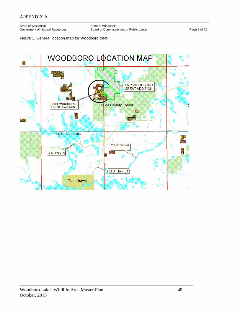
APPENDIX A
Woodboro Lakes Wildlife Area Master Plan 48
October, 2015
State of Wisconsin State of Wisconsin Department of Natural Resources Board of Commissioners of Public Lands Page 2 of 25
Figure 1. General location map for Woodboro tract.

APPENDIX A
Woodboro Lakes Wildlife Area Master Plan 49
October, 2015
State of Wisconsin State of Wisconsin Department of Natural Resources Board of Commissioners of Public Lands Page 3 of 25
General Description and Location: The Woodboro forest management easement (Figure 1) currently consists of 778 acres granted to the Wisconsin Board of Commissioners of Public Lands (BCPL) by the Wisconsin DNR on July 30, 2002. The easement was recorded on June 26, 2003. The land covered by the easement was a part of the “Great Addition” of former Packaging Corporation lands, purchased by the Stewardship Fund in 1999. The BCPL obtained the easement as part of a three-way land trade also involving the Nicolet National Forest, and the Wisconsin DNR (see Appendix 1). The 778-acre tract is located in south central Oneida County, in a relatively level to gently rolling landscape comprised of generally tight and poorly drained sandy-silt clay loam soil. All but 60 acres of the tract lie east of Highway 51. The tract is bordered by private land on the north, a small wetland (adjacent to Oscar Jenny Lake) on the northeast, other WDNR land on the east, and Oneida County Forest on the south. To the east and north of this easement is a WDNR block of nearly 1700 acres (Figure 1). Together with the land in the BCPL easement, the 2,500 acres is now known as the “Woodboro Tract”. Perhaps the most important factor in the DNR’s purchase of this tract with Stewardship funds was its abundance of shallow aquatic seepage ponds, marshes, sedge meadows, and open bogs. Thus, the area was originally called the “Woodboro Lakes Wildlife Area”. Because these lakes are not fishing or typical recreational waters, the name has since been changed to the “Woodboro Wildlife Area”. (Eckstein, personal communication 2003). This management plan assumes that the management of both parts of the DNR “Woodboro Tract” will be complementary, aimed at fulfilling similar goals and objectives. Access: The major access to the tract is from the east, from an iron gate located a short distance from the end of Oscar Jenny Road. (Directions: follow Co. Hwy K 2.5 miles east of State Highway 51 to Old Hwy. K Road, then south to Oneida Lake Road, then south to Oscar Jenny Road). There is also a potential access from the south using the old Nokomis Road. This logging road begins on the north side of Highway N, ¼ mile east of Hwy. 51. The road continues about 2.4 miles to the north (parallel to Hwy. 51) through Oneida County Forest land in Sections 25 and 24, T36N R6E, before ending near the south end of the BCPL easement, near the southeast corner of Section 13. To access timber in the southeastern quadrant of the easement, this road would need to be upgraded for about 0.3 miles across Oneida County Forest in the NE ¼ NE ¼, Section 24, T.36N.-R.6E. Management access from Highway 51 is no longer feasible due to highway improvements. Logging access is also not feasible from the northeast, due to wetlands and private riparian owners on Oscar Jenny Lake. Woodboro Tract Ownership and Cutting History: Based on Courthouse research, it appears that most of the original 7000-acre “Woodboro” tract bordered this 778-acre tract just to the east. Oneida County records deeds show that much of the land covered by this plan was deeded to early settlers. Some of these settlers may have made an attempt to crop or pasture parts of the tract in the early 1900’s. The lack of large pine stumps here provides evidence that this may be true.
APPENDIX A
Woodboro Lakes Wildlife Area Master Plan 50
October, 2015
State of Wisconsin State of Wisconsin Department of Natural Resources Board of Commissioners of Public Lands Page 4 of 25
Woodboro Tract Ownership and Cutting History (continued): Chicago lumber baron George E. Wood had a large sawmill six miles due east of the tract. Logging railroads were built to haul logs to his sawmill. Between 1892 and 1904 large amounts of red and white pine were cut from the area. (Jones et al. 1924). Following “the big cut”, in about 1920 the land was sold to a Chicago group interested in real estate development—a scheme that evidently failed. By the 1930s this land had become part of the Owens-Illinois corporate timberland base. The main crop of today’s red oak probably had its origin in slash fires in the years after most of the big pine was cut. DNR forest tax law records (Lietz 2002) and field observations show that, more recently, timber was probably cut by corporate owners in parts of this stand around 1972 (aspen), 1989 (pine, hardwood, and aspen), and 2000 (pine). BCPL staff estimate most of the larger white and red pine on the tract to be 120-140 years old (a few pines are probably about 200), and the larger red oak to be 85-95 years old. The aspen, birch, and maple appear to be significantly younger, probably 30-50 years old. It is likely the stand has sustained a series of partial cuts over the past 50-60 years, some heavier than others, but none of them approaching a complete clearcut. Large (18-30”) pine stumps were observed near the northeast corner of the tract, indicating harvest within the past 10-15 years. Some of the scattered pine had large old fire scars, and one pine stub about 18 feet high, charcoaled to its top, indicative of at least one very hot fire, was found. Landforms and Soils: There are two Land Type Associations (LTAs) on the property, and a third one just to the west (Figure 2, p. 4a). The two dominant LTAs are the Rhinelander Moraines and the Oneida Sandy Moraines. The Rhinelander moraine has a characteristic landform pattern of undulating moraine and outwash plain, with soils that are predominantly moderately well-drained loam over acid loamy sand till or outwash. The Oneida Sandy Moraine has a characteristic landoform pattern of rolling moraine with bogs and swmaps common, and soils that are mostly well-drained sandy loam over acid loamy sand till. The third (off-site) LTA is the Vilas and Oneida Outwash Plains. This LTA has a characteristic landform of a nearly level pitted and unpitted outwash plain. Soils here are mostly excessively drained sand over outwash. On the Woodboro easement as a whole the dominant habitat types are AVVb, AVb, ParVAa (former PMV), TMC, and ArQV. The dominant soils are: Keewenaw loamy sand, Goodman stony loam, Monico stony loam, Pequaming loamy sand, Cable wet silt loam, and Greenwood peat. Historic Role Of Fire: Finley’s original vegetation map shows that this tract lies on the eastern edge of the historic lower Tomahawk River pine barrens. Even though the soils on the tract are fairly productive and capable of supporting mixed oak-hardwood-pine communities, the historic fire regime maintained portions of the area as barrens habitat and other pine forest types. Prevailing westerly winds carried fires off the outwash plain and into this area. Just to the west, historic and current plat maps, for example, use the term “Prairie” frequently, for example, “Prairie Lake”, “Prairie Rapids”. The early surveys of the area west of today’s Highway 51 note the preponderance of jack pine of “worthless quality”, and that the eastern part of the BCPL easement was covered “…principally by white and yellow [red] pine
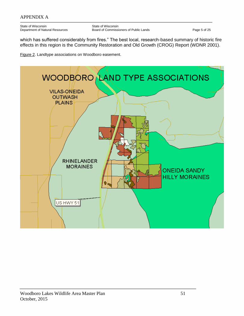
APPENDIX A
Woodboro Lakes Wildlife Area Master Plan 51
October, 2015
State of Wisconsin State of Wisconsin Department of Natural Resources Board of Commissioners of Public Lands Page 5 of 25
which has suffered considerably from fires.” The best local, research-based summary of historic fire effects in this region is the Community Restoration and Old Growth (CROG) Report (WDNR 2001).
Figure 2. Landtype associations on Woodboro easement.
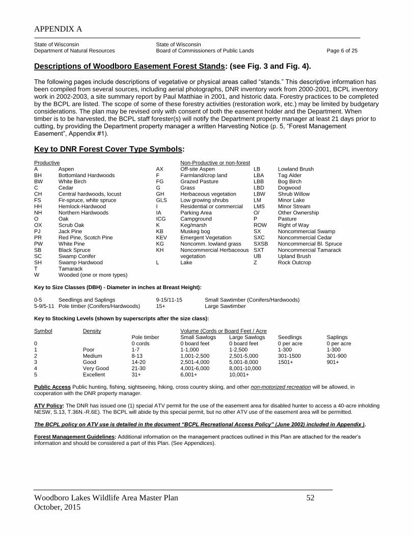
APPENDIX A
Woodboro Lakes Wildlife Area Master Plan 52
October, 2015
State of Wisconsin State of Wisconsin Department of Natural Resources Board of Commissioners of Public Lands Page 6 of 25
Descriptions of Woodboro Easement Forest Stands: (see Fig. 3 and Fig. 4). The following pages include descriptions of vegetative or physical areas called “stands.” This descriptive information has been compiled from several sources, including aerial photographs, DNR inventory work from 2000-2001, BCPL inventory work in 2002-2003, a site summary report by Paul Matthiae in 2001, and historic data. Forestry practices to be completed by the BCPL are listed. The scope of some of these forestry activities (restoration work, etc.) may be limited by budgetary considerations. The plan may be revised only with consent of both the easement holder and the Department. When timber is to be harvested, the BCPL staff forester(s) will notify the Department property manager at least 21 days prior to cutting, by providing the Department property manager a written Harvesting Notice (p. 5, “Forest Management Easement”, Appendix #1).
Key to DNR Forest Cover Type Symbols: Productive Non-Productive or non-forest A Aspen AX Off-site Aspen LB Lowland Brush BH Bottomland Hardwoods F Farmland/crop land LBA Tag Alder BW White Birch FG Grazed Pasture LBB Bog Birch C Cedar G Grass LBD Dogwood CH Central hardwoods, locust GH Herbaceous vegetation LBW Shrub Willow FS Fir-spruce, white spruce GLS Low growing shrubs LM Minor Lake HH Hemlock-Hardwood I Residential or commercial LMS Minor Stream NH Northern Hardwoods IA Parking Area O/ Other Ownership O Oak ICG Campground P Pasture OX Scrub Oak K Keg/marsh ROW Right of Way PJ Jack Pine KB Muskeg bog SX Noncommercial Swamp PR Red Pine, Scotch Pine KEV Emergent Vegetation SXC Noncommercial Cedar PW White Pine KG Noncomm. lowland grass SXSB Noncommercial Bl. Spruce SB Black Spruce KH Noncommercial Herbaceous SXT Noncommercial Tamarack SC Swamp Conifer vegetation UB Upland Brush SH Swamp Hardwood L Lake Z Rock Outcrop T Tamarack W Wooded (one or more types) Key to Size Classes (DBH) - Diameter in inches at Breast Height): 0-5 Seedlings and Saplings 9-15/11-15 Small Sawtimber (Conifers/Hardwoods) 5-9/5-11 Pole timber (Conifers/Hardwoods) 15+ Large Sawtimber Key to Stocking Levels (shown by superscripts after the size class): Symbol Density Volume (Cords or Board Feet / Acre Pole timber Small Sawlogs Large Sawlogs Seedlings Saplings 0 0 cords 0 board feet 0 board feet 0 per acre 0 per acre 1 Poor 1-7 1-1,000 1-2,500 1-300 1-300 2 Medium 8-13 1,001-2,500 2,501-5,000 301-1500 301-900 3 Good 14-20 2,501-4,000 5,001-8,000 1501+ 901+ 4 Very Good 21-30 4,001-6,000 8,001-10,000 5 Excellent 31+ 6,001+ 10,001+ Public Access Public hunting, fishing, sightseeing, hiking, cross country skiing, and other non-motorized recreation will be allowed, in cooperation with the DNR property manager. ATV Policy: The DNR has issued one (1) special ATV permit for the use of the easement area for disabled hunter to access a 40-acre inholding NESW, S.13, T.36N.-R.6E). The BCPL will abide by this special permit, but no other ATV use of the easement area will be permitted. The BCPL policy on ATV use is detailed in the document “BCPL Recreational Access Policy” (June 2002) included in Appendix ). Forest Management Guidelines: Additional information on the management practices outlined in this Plan are attached for the reader’s information and should be considered a part of this Plan. (See Appendices).
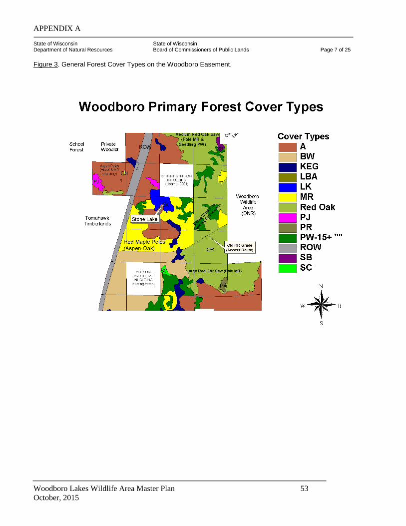
APPENDIX A
Woodboro Lakes Wildlife Area Master Plan 53
October, 2015
State of Wisconsin State of Wisconsin Department of Natural Resources Board of Commissioners of Public Lands Page 7 of 25 Figure 3. General Forest Cover Types on the Woodboro Easement.
APPENDIX A
Woodboro Lakes Wildlife Area Master Plan 54
October, 2015
State of Wisconsin State of Wisconsin Department of Natural Resources Board of Commissioners of Public Lands Page 8 of 25
Summary of Some Key Issues Related To BCPL Management Objectives: I. FOREST HEALTH: The only way to “promote forest health” is to gain a better understanding of forest health problems across time and space. Stand history must be understood because it represents the legacy of past forest health problems. Stand condition must be understood because it dictates what can be achieved in the foreseeable future. And forest health trends across the region must be understood because many forest health issues looming in Woodboro are already occurring in other forests of the eastern United States. Forest health concerns, and the BCPL’s management options and recommended responses, are spelled out in each prescription. However, for clarity it is best to outline the range of anticipated forest health concerns in this section. At this writing (2003), the major forest health concerns on the tract are these: 1. Gypsy moth* (first egg mass discovered spring 2003).
2. Forest tent caterpillar and two-lined chestnut borer.
3. Potential for oak wilt introduction.
4. Oak mortality and decline, uncertainty re: future oak health in general.
5. Excessive deer browsing compromising regeneration efforts.
6. Impacts to forest and wetlands by expansion of U.S. Hwy 51.
7. Introduction and spread of non-native invasive species.
8. The fate of two private in-holdings. One of these has already been clearcut (2001); the other is in the middle of the “best” and most diverse part of the easement.
9. Red pine needle blight (Sirococcus shoot blight)
10. White pine blister rust.
11. White pine weevil. * Gypsy Moth Considerations: This management plan has taken into consideration the potential impact of the gypsy moth on the property. Gypsy moth defoliates mainly hardwood trees, although it does feed on some conifers. In pure conifer stands, defoliation is minimal; however, in hardwood – conifer mixtures some conifers can be severely defoliated. Gypsy moth has been spreading across forest and residential wooded land in northern Wisconsin. Large numbers of gypsy moth caterpillars were observed feeding on white oak and other trees on BCPL lands in Marinette County in June 2003. In May 2003, viable egg masses were discovered on the Woodboro tract in the SWNW, Section 13, Nokomis Township. Oak, especially stressed oak, is one of the gypsy moth’s preferred foods. Gypsy moth, a European insect species that was accidentally released in Massachusetts in 1869, has been spreading westward across North America since that time. The gypsy moth is an exotic species having very few natural predators. Large population outbreaks of larvae can denude vast areas of trees, shrubs and understory plants (including white pine) and can kill from 10–40% of all the trees in a forest. Outbreaks often last for 3 or 4 years. Defoliated trees may be killed directly or be weakened and killed by other insects and disease. Research has shown that the mortality caused by gypsy moth can be minimized by spraying foliage with Bt (Btk), a preparation of Bacillus thuringiensis var. Kurstaki, a natural strain of bacteria found in soil and on plants. This product, which has 40 years of proven safe use, is much less harsh on the environment and non-target organisms than conventional insecticides. This product is often used by organic farmers to control leaf-eating caterpillars on crops such as broccoli
APPENDIX A
Woodboro Lakes Wildlife Area Master Plan 55
October, 2015
State of Wisconsin State of Wisconsin Department of Natural Resources Board of Commissioners of Public Lands Page 9 of 25
and cabbage. After spraying, the caterpillar ingests Bt while feeding on leaves. Bt produces protein crystals that become toxic in the digestive system of the caterpillars. Aerial spraying therefore takes place after the caterpillars have emerged and are actively feeding, often in late May or early June. One option that the DNR may consider (depending on the severity of gypsy moth outbreaks) would be to have certain portions of the Woodboro tract aerial sprayed with Btk if appropriate conditions are met. The BCPL would cooperate with the DNR if such a strategy were deemed mutually beneficial. One long-term biological control that the BCPL is strongly considering is the introduction of Entomophaga spp., a fungus that attacks gypsy moths and prevents infestations from getting too severe. This fungus has been introduced successfully in other areas of Wisconsin and Michigan, by “seeding” infected gypsy moth corpses into areas where the moth is just becoming fully established (Dr. Leah Bauer, personal communication 2003). It appears that early introduction of the fungus may be a viable option for long-term protection of the oak component in the Woodboro tract. Active forest management is probably the best overall strategy to protect forests from GM impacts. The vigor of the Woodboro stands will be maintained through periodic thinning, release cuttings and restoration treatments, and occasional regeneration harvests, which will thereby minimize losses by gypsy moths. Research has shown that forests can be made less prone to GM mortality by increasing the proportion of less-preferred species, such as ash, pine, and maple. II. BIOLOGICAL DIVERSITY: “Biological Diversity” is a term that has been given numerous meanings by land managers. In this plan, the following definition will be used: “Biological Diversity is the variety of life forms and processes within an area. Included in the consideration of diversity are genetic variation, number and distribution of species, and the ways in which the variety of biologic communities interact and function.”**
(**Source: The Forest Service Program for Forest and Rangeland Resources: A Long-Term Strategic Plan; Draft 1995 RPA Program; October, 1995).
In general, the following management actions will be used to enhance or maintain diversity: 1. Extend rotations of managed species.
2. Favor species that are well adapted to the site and historically important but under-represented in the current forest mix.
3. Discriminate against species over-represented in the current forest (e.g., red maple on pine sites).
4. Wherever possible, favor mixed species stands. Enhance or take advantage of restoration processes that Nature has already begun.
5. Protect wetlands through the use of recommended buffers and Best Management Practices (BMPs). Generally, wetlands will not be logged unless there is a major restoration objective attainable through careful silvicultural manipulation (example—release of tamarack or spruce-fir from low-quality red maple). Log wet areas with the least invasive techniques possible—frozen winter logging, light-on-the-land equipment, and excellent supervision.
APPENDIX A
Woodboro Lakes Wildlife Area Master Plan 56
October, 2015
State of Wisconsin State of Wisconsin Department of Natural Resources Board of Commissioners of Public Lands Page 10 of 25
6. Be constantly aware of, look for and deliberately manage for opportunities to protect, and if
possible, provide wildlife habitat. This goal can be accomplished in several ways, including but not limited to: retaining nest, den and snag trees; retaining low conifer cover; protecting vernal pools; and providing coarse woody debris on the forest floor.
7. Look for the many elements of diversity, and use local and regional experts to assist in the identification of rare or special species and habitats. By careful field inventory and monitoring, species and habitat elements that are rare will be identified in advance of treatments. Use the Wisconsin Natural Heritage Inventory as a starting point, but through vigilant management attention, be certain to add to this knowledge base**.
** Natural Heritage Inventory: This management Plan has included an initial screening for Natural Heritage Inventory. This screening relates to endangered or threatened species and is intended to prevent/limit the incidental taking of these endangered or threatened species. The initial screening for the BCPL easement property has found no endangered or threatened species present. The BCPL will, however, invest in more detailed biotic inventory work—particularly in wetland habitats—to determine if further management precautions or modifications are needed. This work was begun in July 2003. Matthiae Site Summary Report: Paul Matthiae’s “Great Additions Site Summary Report (May 2001) identified several key elements that he believed were noteworthy, deserving of special protection and management. They are: 1. The several large groves of white and red pine, including numerous supercanopy trees. He
recommended their retention to biologic rather than economic maturity, focusing on their seed tree and aesthetic value.
2. The wet and wet-mesic white pine “flatwoods” surrounding Joan’s Lake (west ½ of the SW ¼, Section 13). Most of these are 12-18” white pine, but there are a few scattered groups of large super canopy white and red pine up to 24-30”. In this flatwoods are groups of swamp white oak and bur oak, a community type that is highly localized and rare in northern Wisconsin. He recommended management to favor pine and protect the big tree features of the stand.
3. The excellent stocking of northern red oak, especially in the eastern half of the property. He recommended management to larger sizes and longer rotations, especially for mast production.
4. The numerous vernal ponds, pothole wetlands and wet sedge/heath meadows, many of them interconnected. He recommended their protection through use of buffers, best management practices and winter logging.
5. A few small areas in the western 1/3 of the tract with “park-like, open, dry sedge meadows and jack pine”, perhaps indicative of former pine barrens habitat. He hinted at the potential use of prescribed fire for the maintenance and restoration of some of these habitats, as well as the use of fire as tool for competition control in the large white-red pine groves to the east.
In general, Paul Matthiae recommended that the DNR retain the tract for its natural values, employ “Big Tree Silviculture” and manage for old-growth character, use prescribed fire as a tool to enhance both oak and pine reproduction, and employ winter logging and BMPs to protect wet soil sites. He
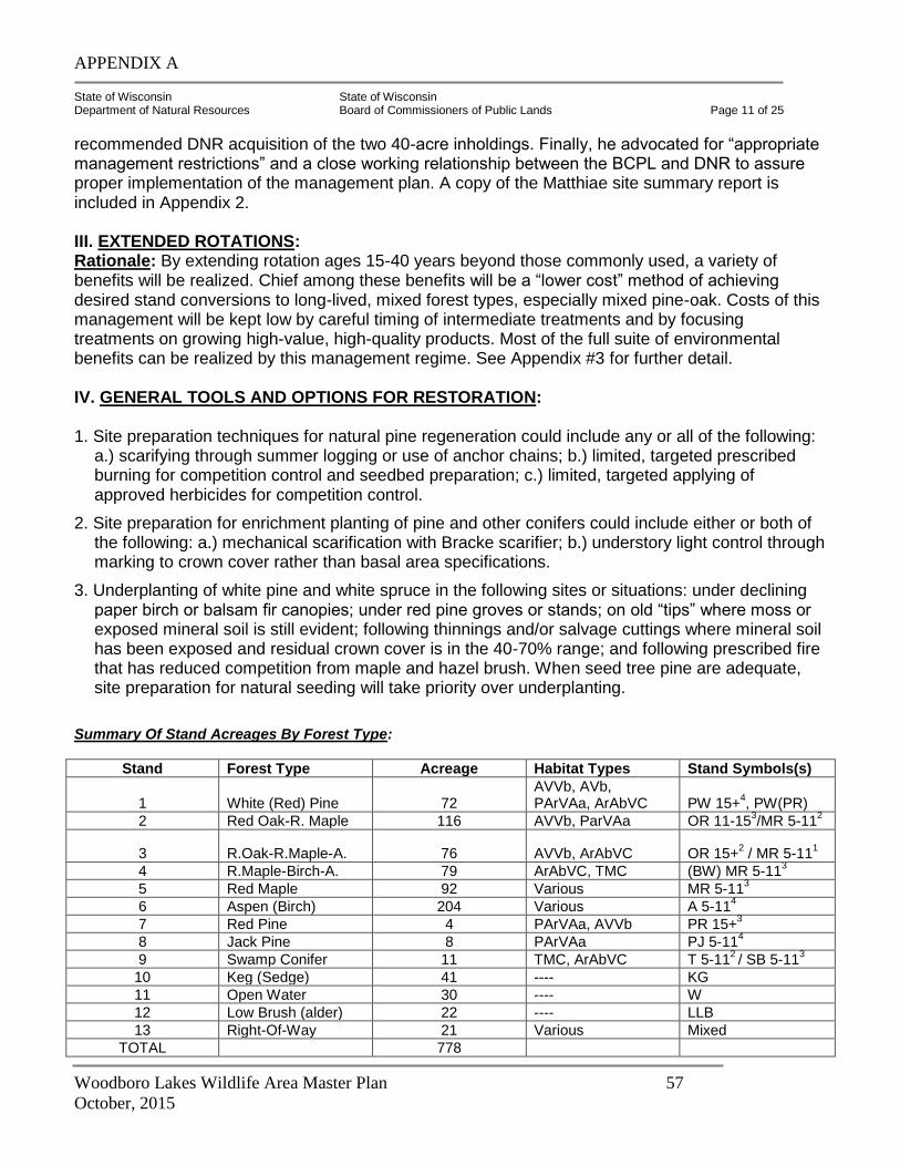
APPENDIX A
Woodboro Lakes Wildlife Area Master Plan 57
October, 2015
State of Wisconsin State of Wisconsin Department of Natural Resources Board of Commissioners of Public Lands Page 11 of 25
recommended DNR acquisition of the two 40-acre inholdings. Finally, he advocated for “appropriate management restrictions” and a close working relationship between the BCPL and DNR to assure proper implementation of the management plan. A copy of the Matthiae site summary report is included in Appendix 2. III. EXTENDED ROTATIONS: Rationale: By extending rotation ages 15-40 years beyond those commonly used, a variety of benefits will be realized. Chief among these benefits will be a “lower cost” method of achieving desired stand conversions to long-lived, mixed forest types, especially mixed pine-oak. Costs of this management will be kept low by careful timing of intermediate treatments and by focusing treatments on growing high-value, high-quality products. Most of the full suite of environmental benefits can be realized by this management regime. See Appendix #3 for further detail. IV. GENERAL TOOLS AND OPTIONS FOR RESTORATION: 1. Site preparation techniques for natural pine regeneration could include any or all of the following:
a.) scarifying through summer logging or use of anchor chains; b.) limited, targeted prescribed burning for competition control and seedbed preparation; c.) limited, targeted applying of approved herbicides for competition control.
2. Site preparation for enrichment planting of pine and other conifers could include either or both of the following: a.) mechanical scarification with Bracke scarifier; b.) understory light control through marking to crown cover rather than basal area specifications.
3. Underplanting of white pine and white spruce in the following sites or situations: under declining paper birch or balsam fir canopies; under red pine groves or stands; on old “tips” where moss or exposed mineral soil is still evident; following thinnings and/or salvage cuttings where mineral soil has been exposed and residual crown cover is in the 40-70% range; and following prescribed fire that has reduced competition from maple and hazel brush. When seed tree pine are adequate, site preparation for natural seeding will take priority over underplanting.
Summary Of Stand Acreages By Forest Type:
Stand Forest Type Acreage Habitat Types Stand Symbols(s)
1 White (Red) Pine 72 AVVb, AVb, PArVAa, ArAbVC PW 15+
4, PW(PR)
2 Red Oak-R. Maple 116 AVVb, ParVAa OR 11-153/MR 5-11
2
3 R.Oak-R.Maple-A. 76 AVVb, ArAbVC OR 15+2 / MR 5-11
1
4 R.Maple-Birch-A. 79 ArAbVC, TMC (BW) MR 5-113
5 Red Maple 92 Various MR 5-113
6 Aspen (Birch) 204 Various A 5-114
7 Red Pine 4 PArVAa, AVVb PR 15+3
8 Jack Pine 8 PArVAa PJ 5-114
9 Swamp Conifer 11 TMC, ArAbVC T 5-112 / SB 5-11
3
10 Keg (Sedge) 41 ---- KG
11 Open Water 30 ---- W
12 Low Brush (alder) 22 ---- LLB
13 Right-Of-Way 21 Various Mixed
TOTAL 778
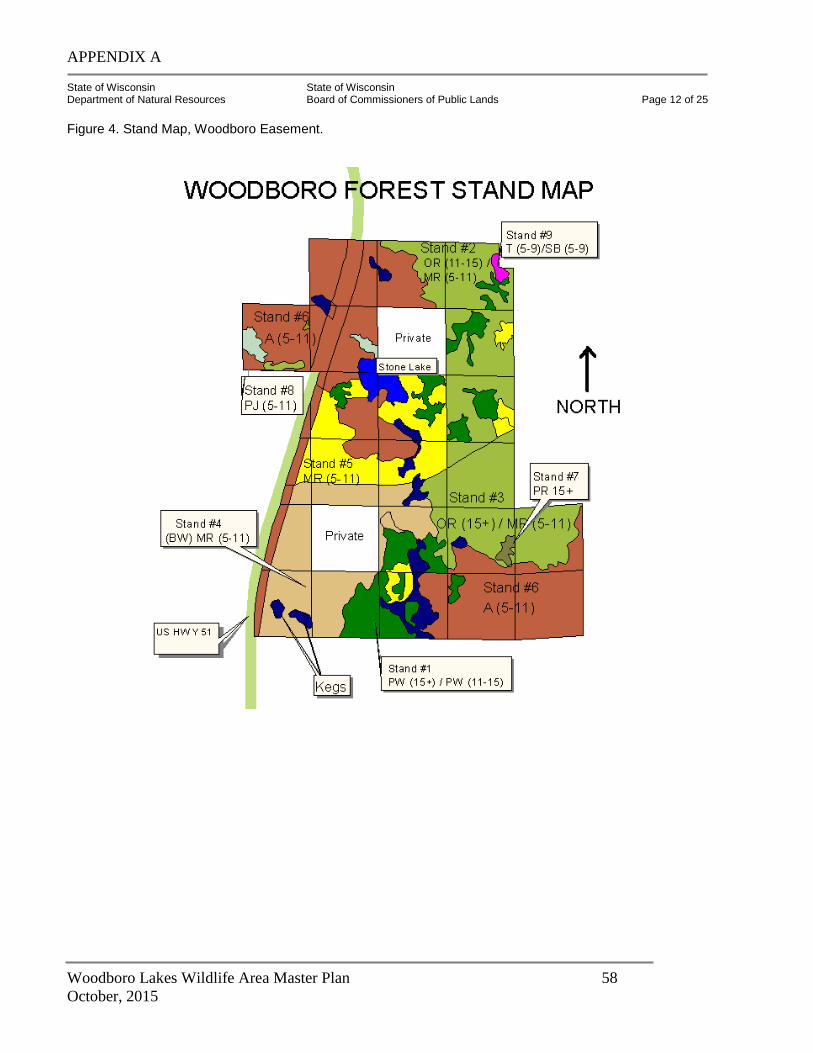
APPENDIX A
Woodboro Lakes Wildlife Area Master Plan 58
October, 2015
State of Wisconsin State of Wisconsin Department of Natural Resources Board of Commissioners of Public Lands Page 12 of 25
Figure 4. Stand Map, Woodboro Easement.
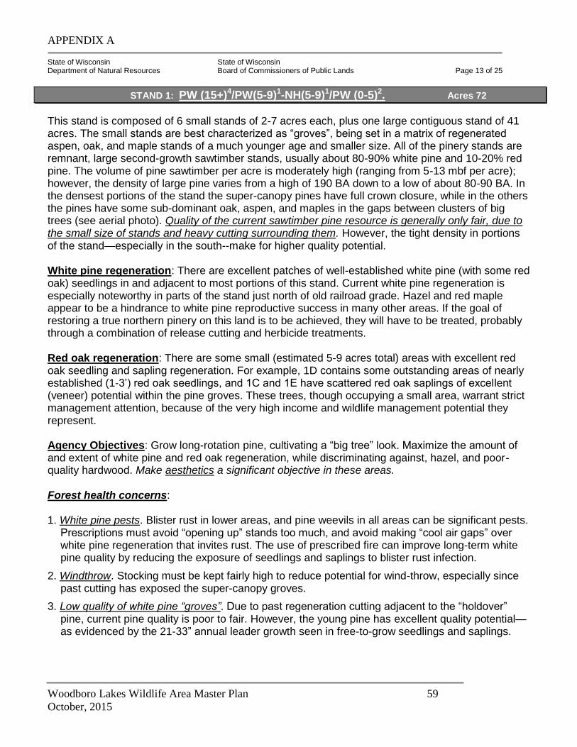
APPENDIX A
Woodboro Lakes Wildlife Area Master Plan 59
October, 2015
State of Wisconsin State of Wisconsin Department of Natural Resources Board of Commissioners of Public Lands Page 13 of 25
This stand is composed of 6 small stands of 2-7 acres each, plus one large contiguous stand of 41 acres. The small stands are best characterized as “groves”, being set in a matrix of regenerated aspen, oak, and maple stands of a much younger age and smaller size. All of the pinery stands are remnant, large second-growth sawtimber stands, usually about 80-90% white pine and 10-20% red pine. The volume of pine sawtimber per acre is moderately high (ranging from 5-13 mbf per acre); however, the density of large pine varies from a high of 190 BA down to a low of about 80-90 BA. In the densest portions of the stand the super-canopy pines have full crown closure, while in the others the pines have some sub-dominant oak, aspen, and maples in the gaps between clusters of big trees (see aerial photo). Quality of the current sawtimber pine resource is generally only fair, due to the small size of stands and heavy cutting surrounding them. However, the tight density in portions of the stand—especially in the south--make for higher quality potential. White pine regeneration: There are excellent patches of well-established white pine (with some red oak) seedlings in and adjacent to most portions of this stand. Current white pine regeneration is especially noteworthy in parts of the stand just north of old railroad grade. Hazel and red maple appear to be a hindrance to white pine reproductive success in many other areas. If the goal of restoring a true northern pinery on this land is to be achieved, they will have to be treated, probably through a combination of release cutting and herbicide treatments. Red oak regeneration: There are some small (estimated 5-9 acres total) areas with excellent red oak seedling and sapling regeneration. For example, 1D contains some outstanding areas of nearly established (1-3’) red oak seedlings, and 1C and 1E have scattered red oak saplings of excellent (veneer) potential within the pine groves. These trees, though occupying a small area, warrant strict management attention, because of the very high income and wildlife management potential they represent. Agency Objectives: Grow long-rotation pine, cultivating a “big tree” look. Maximize the amount of and extent of white pine and red oak regeneration, while discriminating against, hazel, and poor-quality hardwood. Make aesthetics a significant objective in these areas. Forest health concerns: 1. White pine pests. Blister rust in lower areas, and pine weevils in all areas can be significant pests.
Prescriptions must avoid “opening up” stands too much, and avoid making “cool air gaps” over white pine regeneration that invites rust. The use of prescribed fire can improve long-term white pine quality by reducing the exposure of seedlings and saplings to blister rust infection.
2. Windthrow. Stocking must be kept fairly high to reduce potential for wind-throw, especially since past cutting has exposed the super-canopy groves.
3. Low quality of white pine “groves”. Due to past regeneration cutting adjacent to the “holdover” pine, current pine quality is poor to fair. However, the young pine has excellent quality potential—as evidenced by the 21-33” annual leader growth seen in free-to-grow seedlings and saplings.
STAND 1: PW (15+)4/PW(5-9)1-NH(5-9)1/PW (0-5)2. Acres 72
APPENDIX A
Woodboro Lakes Wildlife Area Master Plan 60
October, 2015
State of Wisconsin State of Wisconsin Department of Natural Resources Board of Commissioners of Public Lands Page 14 of 25
Most of the existing large pine should be treated conservatively (Matthiae 2001), as their best value is for aesthetics, old-growth character (including coarse woody debris), and a seed source. Therefore, all cutting within pine groves should be done from below. The only canopy trees that should be removed are those with broken, split, or lightning struck tops; or in certain cases, those that have become badly “root-sprung”. Recommended Practices: (See attached white pine prescription summaries)** 1. First, favor white pine of all sizes and ages. Second, favor dominant red pine and high-quality oak
and northern hardwood able to respond to release. In 2004-06, thin from below to a residual basal area of 120-130 square feet. Stocking may be reduced to 100-110 BA only where established white pine and oak are in need of release (examine leader growth). NOTE: Management should follow published white pine management guides from New England (Lancaster 1978) and Menominee Tribal Enterprises.
2. Release white pine reproduction through TSI or commercial treatment. GPS delineation of these areas should be done to get an accurate estimate of the restoration potential for white pine.
3. Restore and release red oak, especially vigorous saplings and poles.
4. Where the mixed hardwood component is significant (>50% of stems below super-canopy pine), consider moving small portions of these “pockets” toward uneven-aged management, depending on quality potential and habitat typing.
5. Conduct thinning to avoid risk of windthrow. Pine groves should be thinned lightly from below to a residual BA of 120-130, depending on wind exposure, tree quality, and regeneration potential.
6. Inventory two of the smaller sub-stands to determine if there are areas of smaller diameter (9-15” dbh) trees worthy of pruning. If so, prune 50-75 white pine crop trees per acre following commercial cut.
7. Schedule treatment for late summer or fall of 2004-05, to provide scarification.
8. Time scarification with the presence of a good-excellent cone crop (usually only occurs every 3-5 years). If this cannot be done commercially, schedule use of the Oneida County anchor chain scarifier, and do treatment before or after timber harvest, depending on the best seed year.
APPENDIX A
Woodboro Lakes Wildlife Area Master Plan 61
October, 2015
State of Wisconsin State of Wisconsin Department of Natural Resources Board of Commissioners of Public Lands Page 15 of 25
STAND 2: OR (11-15)3/MR (5-11)2/MR (0-5)1 116 Acres
This maturing stand is located in the northeastern part of the property, generally covering a well-drained high ridge and hill area to the east of Stone Lake. The northern two-thirds of the stand generally lies above the 1550 foot contour, while the southern third is north of the main E-W road and generally lies above the 1560 foot contour. The soils here are mostly Keewenaw sandy loam, though there are also pockets of Goodman silt loam. The most important management difference between the two soil types is the higher productivity of the Goodman soil for northern hardwood (sugar maple, red maple, red oak), and the greater problem of hardwood competition for seedling/sapling white pine. Any serious effort to restore and grow quality red oak, white pine, and red pine in this stand must recognize the differences between these two soil types. Forest habitat typing and delineation can be very helpful here. In January 2003, BCPL staff noted an abundance of maple-leaf viburnum (Viburnum acerifolium) throughout the stand. This plant is good evidence that much of the stand would type out as AVVb, the best type in Oneida County for growing both quality red oak and quality white pine. (Note: current quality of these species is significantly lower than the site’s capability). The red oak in this stand is “patchy”, sometimes dominating the overstory (BA 50-70) and sometimes only being a small (BA 10-30) component. The small sawtimber oak is generally of good quality and growth, while the pole timber oak is needs release from crown competition with other hardwoods. Where the oak is scarce, there is most frequently a higher component of aspen (BA 30-70), red maple (BA 30-90), and white birch (BA 10-40). Occasionally there are areas with 1-2 scattered super-canopy white pine in the stand, but pine reproduction is mostly very sparse. Most of the aspen is quaking aspen 6-8” diameter, but there are some very good quality clones of larger (11-15”) bigtooth aspen, usually located on the highest parts of the land. Site index for bigtooth is outstanding here (SI 75+). Forest health concerns:
1. Oak decline. Several years of defoliation by the Forest Tent Caterpillar (FTC) has slowed growth, weakened oak crowns, and caused Twolined Chestnut Borer (TLCB) numbers to increase significantly. Some oak, including normally healthy dominant trees, are in need of salvage (especially on the ridge in Section 12, west of Oscar-Jenny Lake).
2. Gypsy moth (GM). Species mix (oak, aspen, birch) and history of defoliation stress make this stand a high risk for a large Gypsy Moth impact. Research (Gottschalk and other USFS, W.Va., 1987-99) shows that the key to mitigating impact of the gypsy moth is to reduce the percentage of highly-preferred species within forest stands needing Gypsy Moth protection. In this stand the stocking and crown cover of less-preferred species, should be increased.
Note: On 5/29/03, BCPL foresters discovered gypsy moth egg masses on a 14” dbh (dying) red oak on the east side of US 51, just north of the Oscar Jenny railroad grade (BCPL Stand #4, DNR stand #22). This was the first gypsy moth egg mass found on the tract. Recommended Practices:
1. Conduct a stocking survey of established red oak regeneration taking one (1) systematic 1/500th-acre plot per acre. Stocking cruisers must be certain to clearly differentiate between “established” red oak (> waist-high) and non-established red oak.
APPENDIX A
Woodboro Lakes Wildlife Area Master Plan 62
October, 2015
State of Wisconsin State of Wisconsin Department of Natural Resources Board of Commissioners of Public Lands Page 16 of 25
2. In spring and early summer of 2003, conduct a pre-salvage inventory of areas where red oak and
paper birch have been heavily-damaged by forest tent caterpillar and subsequent two-lined chestnut borer. (This was done 5/29/03).
3. Based on the results of #1 and #2 above, determine areas within the “oak matrix” that are in need of crop tree release, limited salvage cutting, and/or gypsy moth protection.
4. Salvage Cutting: Currently (June 2003) BCPL forestry staff anticipates that approximately 23 acres, mostly in the N ½ of the SE ¼, Section 12, will need to be marked in August 2003 for salvage cutting, with an average of 1000 board feet per acre (equivalent) needing salvage. Unfortunately, this area coincides with the same area where naturalist Paul Matthiae identified outstanding mast production and developing mature red oak (Matthiae, Woodboro Great Additions Site Summary Report, 5/7/01, Appendix #2).
5. Prior to marking, identify all areas where red oak stocking is sufficient to benefit from a crop tree release (BA 60 or more in oak, BA 100 or more total. Follow red oak crop tree release guidelines from Perkey (1993). Thin from below in areas where hardwood dominates. Thin aspen and white birch from above in areas where oak stocking is low, but keep a minimum of 60 square feet of basal area at all times (70-80% crown cover). Where aspen and paper birch comprise half or more of the projected residual, keep stocking levels somewhat higher (75-85 BA) to allow for additional mortality.
6. In 2004-2005, conduct a commercial improvement cut and crop tree release cut in this stand. Reduce residual basal area to 70-90 square feet in the best dominant and co-dominant oak, birch, and aspen, along with the best intermediate and co-dominant maple and pine. Leave tree aspen should either be bigtooth (preferable) or disease-free, full-crowned quaking aspen. (Average yield estimate: 4-5 cd/ac pulpwood and 300-500 bf/ac. sawtimber).
STAND 3: OR (15+)2/MR (5-11)1 76 Acres
This stand is located in the eastern part of the property, south of the old railroad grade that divides the property. The stand is confined to a series of low ridges just southeast of the railroad grade, generally above the 1550 foot contour. It covers 80% of the NWSW of Section 18, and the northern 2/3 of the NESE of Section 13. In contrast with Stand #2, the soils here are almost exclusively Keewenaw sandy loams, ranging from moderate (3-15%) to steep slopes (15-25%) in the extreme northeast. Most of the highest basal areas of large red oak lie either on the higher elevations, or on the slope breaks and transitions. Desired future condition: A stand dominated by large red oak and scattered large pine, with a manageable oak-northern hardwood mid-story, and an understory with increased amounts of white pine reproduction. Recommended Practices: 1. Inventory the groves of large red oak. Determine where they are concentrated, and which trees or
groups of trees have the best mast production.
2. Inventory established red oak regeneration in first week of October 2003.
3. Assess the feasibility of harvesting much of the mature aspen, while favoring aspen that can be grown to higher-quality products, such as bigtooth bolts.
APPENDIX A
Woodboro Lakes Wildlife Area Master Plan 63
October, 2015
State of Wisconsin State of Wisconsin Department of Natural Resources Board of Commissioners of Public Lands Page 17 of 25
4. In 2009-10, conduct a commercial improvement cut, aspen removal cut, and oak crop tree release cut
(combined treatment). Reduce stand average basal area to 70-90 square feet per acre in oak, maple, bigtooth aspen, and paper birch. Leave some aspen where needed to maintain desirable stocking levels.
Crop tree release: Identify timber crop trees of 5-16” dbh in the following species: red oak, white pine, red maple, bigtooth aspen, paper birch. Follow crop tree ID guidelines developed by Perkey (1993). Where stand structure and crown quality permit, give a 3-sided release to intolerant (oak, aspen, birch, red pine) crop trees, and a 2-sided release to mid-tolerant (white pine, red maple, occasional ash) crop trees. Be sure to concentrate crop tree release in areas where crop trees are concentrated, and leave residual basal areas higher (BA 80-100+) in adjacent areas, to maintain overall forest health.
STAND 4: BW-MR (5-11)2 / A (5-11)
1 79 Acres
This stand is somewhat nondescript. It is dominated by a mixture of fair quality pole-sized red maple, and somewhat larger pole-sized declining paper birch. (It was originally typed as paper birch with a maple component in 2000, but now the maple is more dominant than the birch). Aspen is present in significant patches, but is not as dominant as either the maple or the birch. There are also small “inclusions” of several other forest types, including spruce-fir, black ash, and wet-phase northern hardwoods. Most of the scattered red oak in this stand is smaller, sparser, and of poorer quality than in neighboring stands. The southern one-third of the stand is brushier (hazel and alder) than the rest, and has more old elm stubs, indicating poorer drainage. Quality of the red maple shows a definite trend from fair-poor in the southwest to fair-good in the northeastern part of the stand (perhaps due to site quality or to past fire effects). Desired Future Condition: A diverse stand dominated by long-lived species capable of growing in stony, wet soils, including red maple, ash, spruce, fir, white pine, and oaks. Some patches of aspen and paper birch will be perpetuated as a desirable secondary component. Recommended Practices: 1. In 2005-06, harvest the dying paper birch and some of the aspen in areas with a well-established
hardwood-conifer component, leaving a residual basal area of 70-80 square feet per acre. Cut heavier (residual BA 60-70) in areas that have a heavier stocking of understory oak, ash, pine, and mixed conifer.
2. Monitor stand for regeneration release/establishment in 2008.
3. Conduct a timber stand improvement cutting (marked selection) in 2020, favoring mixed hardwood, oak, healthy dominant paper birch, and pine of crop-tree quality. Complete aspen removal in this cut.
APPENDIX A
Woodboro Lakes Wildlife Area Master Plan 64
October, 2015
State of Wisconsin State of Wisconsin Department of Natural Resources Board of Commissioners of Public Lands Page 18 of 25
STAND 5: MR 5-113 / A 5-11
1 92 Acres
This stand is dominated by pole-sized red maple of inconsistent quality, with a secondary component of scattered patches of somewhat larger quaking aspen. The eastern half of the stand has a fair stocking of young sugar maple poles and saplings. Like Stand #4, quality of the maples shows a definite trend from fair-poor in the southwest to fair-good in the northeastern part of the stand (perhaps due to site quality or to past fire effects). Unlike Stand #4, there is very little paper birch in this stand, and there are some small pockets of sapling and pole white/green ash and basswood in a few areas, indicative of better drainage and site quality. The eastern edge of this stand has areas with viable quantities of understory white pine and red oak. These areas should be inventoried and included in the release cutting prescribed for the adjacent pine and oak-hardwood stands. Desired Future Condition: A maturing mixed hardwood stand dominated by red and sugar maple, but with a secondary component to include ash, white pine, aspen-birch, spruce-fir, red oak, and swamp white oak. Recommended Practices:
1. No management is recommended currently, other than occasional “spot” areas where clusters of sapling red oak or white pine can be released through pre-commercial cutting. Do this treatment (if feasible) in 2003-05, when adjacent areas in Stand #1 and Stand #2 are treated.
2. In 2015, check stocking, and, if at least 130 square feet of basal area, thin aspen from above and hardwood from below to a residual basal area of 80-90 square feet per acre. Focus on releasing maple, pine, ash, and oak of crop tree quality. This stand should be winter-logged because of the wet soils and many adjacent wetlands.
STAND 6: A (5-11)3 / MR (5-11)
1 / UB 204 Acres
This aspen-dominated stand is the largest one on the property, covering about 26% of the Woodboro easement. The aspen is concentrated in two areas: the northwest quadrant (both sides of US 51), and in the southeast quadrant, east of the marshy lakes. West of US 51, the aspen is smaller and has occasional jack pine pockets, indicating more recent fire disturbance. East of US 51, the aspen is concentrated on mesic and wet-mesic stony “flats” near drainages, and red maple, red oak, and white pine are commonly in the understory. A patchy, dense understory of hazel and alder is common in parts of the stand. Where there is less hazel, there are higher levels of stocking of desired long-lived species. Desired Future Condition: A mixed aspen-hardwood-conifer forest. The restoration of a more diverse community (both in species and stand structures), including mixed conifers, swamp hardwoods, and aspen-birch.
APPENDIX A
Woodboro Lakes Wildlife Area Master Plan 65
October, 2015
State of Wisconsin State of Wisconsin Department of Natural Resources Board of Commissioners of Public Lands Page 19 of 25
Recommended Practices: 1. No management is recommended currently, other than occasional spot areas where clusters of
sapling red oak or white pine can be released through pre-commercial cutting. Retain healthy paper birch seed trees in these treatment areas.
2. In 2020, check stocking of understory conifers and hardwood. If stocking is sufficient, begin to release these components by harvesting the aspen in two stages, spaced about 7-10 years apart. Some patches or small stands of aspen will be regenerated in this process, but they will be interspersed with mixed species stands of similar size.
STAND 7: PR (15+)3/PW (11-15)1/MR (0-5)1 4 Acres
This stand is the only older pine stand in the Woodboro tract that is dominated by very large (20-26”) red pine. The stand is a large “grove” of 60-70 well-spaced remnant red pine, located on a hill, in an area of scattered red oak with small hardwoods and younger aspen-birch to the south. Desired Future Condition: Maintain as a remnant old-growth red pine stand. Establish a component of long-lived species (oak, pine, hardwoods) in this stand and the area surrounding it. Restore natural fire regime to regenerate red pine within this stand. Recommended Practices: None during this plan. Alternative could be to control understory hardwood, and maintain understory white pine, through a combination of any or all of the following treatments: prescribed fire, scarification, or mechanical removal.
STAND 8: PJ(5-11)5/OR-MR (0-5)3 8 Acres
This jack pine stand is composed of a 5-acre piece west of Highway 51 and a 3-acre piece east of the highway and just north of Stone Lake. The larger portion is heavily stocked, about 60 years old and of natural origin. It is bordered on the west by a recent private clearcut. This jack pine is beginning to break up, and should be harvested soon. Under the jack pine is a well-established understory of red oak saplings and red maple seedlings. If the jack pine is harvested carefully, the next stand should be oak-dominated. The smaller jack pine portion is about the same age as the commercial stand, but is more open-grown, providing an island of patchy coniferous cover for wildlife within a large deciduous stand. Therefore, this portion of Stand 8 should not be harvested. Recommended Practices: 1. In 2003-04 clearcut the jack pine, protecting the oak understory, in the 5-acre stand west of US
51. No cutting should be done during oak wilt season of April 1 – September 1. To favor oak and pine and discourage maple, schedule cutting in fall if feasible.
2. Retain the mature jack pine east of US 51 for wildlife, and to hold the site for underplanting of white spruce and white pine at the rate of 200-300 trees per acre (beginning in 2004). Focus planting on “microsites” where there is moss or loamy sand exposed, and a lack of sedge competition.
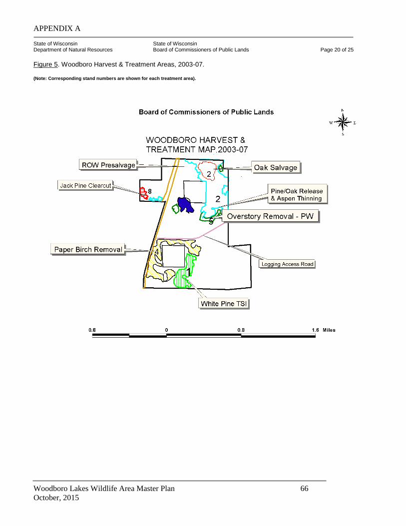
APPENDIX A
Woodboro Lakes Wildlife Area Master Plan 66
October, 2015
State of Wisconsin State of Wisconsin Department of Natural Resources Board of Commissioners of Public Lands Page 20 of 25
Figure 5. Woodboro Harvest & Treatment Areas, 2003-07. (Note: Corresponding stand numbers are shown for each treatment area).
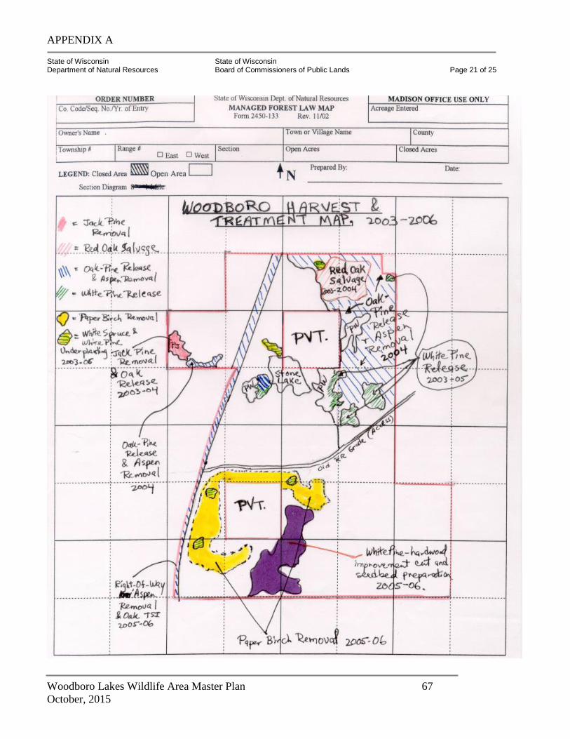
APPENDIX A
Woodboro Lakes Wildlife Area Master Plan 67
October, 2015
State of Wisconsin State of Wisconsin Department of Natural Resources Board of Commissioners of Public Lands Page 21 of 25
APPENDIX A
Woodboro Lakes Wildlife Area Master Plan 68
October, 2015
State of Wisconsin State of Wisconsin Department of Natural Resources Board of Commissioners of Public Lands Page 22 of 25
STAND 9: T (5-11)2 / SB (5-11)
3 11 Acres
This stand is in 3-4 separate pieces of 2-4 acres each. Small portions of stand on west are of lower stocking than those on the east and south, suggesting fire may have run through the wetland areas in the past. Desired Future Condition: A mature, closed canopy swamp conifer forest. Recommended Practices: None. Leave this stand to develop naturally. Protect from highway construction impacts.
STAND 10: Keg 41 Acres
This stand is composed of sedge meadows, emergent marsh, and some open boggy heath areas. Wet sedge meadows are predominant. Recommended Practices: None. Protect these wildlife-rich areas from adjacent upland activities.
STAND 11: W 30 Acres
Stand Description: (With credit due to Paul Matthiae 2001) This stand consists of the open water of two small shallow lakes. An adjacent lake (Oscar Jennie) is also described (acreage not included) because it is ecologically and socially a part of the Woodboro tract as a whole. Stone Lake. Stone Lake is a shallow, rock-strewn water body (~13 acres) highly dependent on direct rainfall and surface runoff. When visited in fall 2000, water level was low with a large exposed sedge-covered shore/beach line; leather leaf was abundant at the high water shore edge. Scattered white pine surround the lake near the shoreline. The northeastern “shoulder” of Stone Lake (roughly 2.5 acres) is in the southwest corner of the northern inholding, thus impacted by private ownership management (the parcel was clearcut in 2001 with a scant shoreline buffer being left). The Stone Lake drainage consists of the lake itself and a series of interconnected wetlands, a pond, and intermittent surface flows. Historically, it appears that this drainage served as a very effective firebreak, dividing the more heavily burned jack pine-scrub oak vegetation to the west from the more mesic white pine-red pine-red oak vegetation along its shores and to the east. Joan’s Lake (unnamed lake in south-central part of property). This shallow “lake” is a special place, both for aesthetics and for wildlife. It spans approximately 28 acres, of which 22 acres are on the BCPL easement and the remaining 6 acres are on Oneida County forest land to the south. This shallow lake appears to be an old series of interconnected old beaver ponds; the most of the open water is in the largest or middle of the three basins that comprise the lake. A recently active beaver lodge was observed at the south end of the lake’s largest basin in January 2003. One old beaver dam on the south end of the easement has had past use as a skid trail.
APPENDIX A
Woodboro Lakes Wildlife Area Master Plan 69
October, 2015
State of Wisconsin State of Wisconsin Department of Natural Resources Board of Commissioners of Public Lands Page 23 of 25
Joan’s Lake is heavily clothed with mature second-growth white pine forest, making it extremely scenic. There is one large pine-dominated island in the south, and a shallow connected keg on the north. Oscar-Jenny Lake: This large, shallow lake borders the BCPL easement on the northeast, but is critical to the integrity of the Woodboro tract. The rest of the DNR Woodboro tract borders this lake on the south and on the east. The small (3 acre) black spruce-tamarack stand on the northeast corner of the BCPL easement is also actually a part of the OJ Lake complex. The northeastern portion of Stand #2 drains into the lake. There is moderate development of OJ Lake’s shoreline on its northeastern, southern, and eastern shores. The BCPL should endeavor to work closely with riparian owners on OJ Lake, to be sure that private recreational pressure does not damage this wetland area.
Desired Future Condition: Preserve in its current state. Protect shorelines and adjacent buffer zones and communities from erosion and aesthetic diminishment. Recommended Practices:
1. Minimize beaver activity by maintaining mixed-species buffers with strong conifer component adjacent to shallow ponds and wetlands.
2. Conduct all harvest management activities in adjacent stands in frozen winter conditions, to protect wet, compactible soils.
3. Improve waterfowl habitat with assistance of DNR biologists.
4. Investigate collaborative management opportunities with Oneida County Forest managers, to be sure BCPL and DNR management is consistent with adjacent county management, especially bordering Joan’s Lake.
STAND 12: LB 22 Acres
This is a lowland brush stand dominated by alder with some willow. It occurs in scattered small patches throughout the property, especially in the southwest corner of the tract and in narrow strips slightly along stream corridors and adjacent to wet meadows. Recommended Practices: None.There are no recommended practices for this stand, other than to protect it using approved BMPs.
STAND 13: Right-Of-Way* 21 Acres
This stand consists of the highway right-of-way for US 51. While this parcel is owned by the WDOT, it is included in this plan because WDOT has requested the BCPL’s assistance in its management. The stand includes all of the ROW east of the highway (approximately 1.6 miles long and 200 feet wide), and about one-half mile of the ROW west of the highway in the northwest part of the tract (see map). Most of the ROW east of the highway is about 50% wooded at this time. The highway expansion is scheduled to occur between 2010 and 2015 (Weigandt, personal communication, 2002). BCPL forestry staff have met with WDOT staff to develop an agreement whereby BCPL would manage the timber resources of the ROW in conjunction with ongoing management activities.
APPENDIX A
Woodboro Lakes Wildlife Area Master Plan 70
October, 2015
State of Wisconsin State of Wisconsin Department of Natural Resources Board of Commissioners of Public Lands Page 24 of 25
Desired Future Condition: A linear stand that provides a dense coniferous buffer between the expanded US Highway 51 and the BCPL forest management easement, especially in areas where forested wetlands and remnant patches of older oak-pine are bordering the ROW. Recommended Practices: 1. In 2005-06, mark east side of ROW to 60-70% crown closure, favoring oak, pine, and other
conifers. Temporarily retain healthy aspen for needed crown cover. Use USDA crown condition marking guide for determining oak crop and leave trees.
2. In 2006-07, plant white spruce (and white pine) under residual crown cover, favoring spruce in wet areas and a mixture in the upland areas. Avoid planting in areas dominated by aspen and maple sprouts.
3. In 2012 or 2013, remove overstory, being extremely careful to protect established conifer and hardwood. Overstory removal will be confined to ROW corridor, while planted conifer areas will be immediately to the east of ROW on BCPL easement.
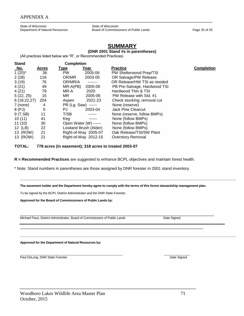
APPENDIX A
Woodboro Lakes Wildlife Area Master Plan 71
October, 2015
State of Wisconsin State of Wisconsin Department of Natural Resources Board of Commissioners of Public Lands Page 25 of 25
SUMMARY
(DNR 2001 Stand #s in parentheses) (All practices listed below are “R”, or Recommended Practices)
The easement holder and the Department hereby agree to comply with the terms of this forest stewardship management plan. To be signed by the BCPL District Administrator and the DNR State Forester. Approved for the Board of Commissioners of Public Lands by:
_________________________________________________________________________________________ Michael Paus, District Administrator, Board of Commisioners of Public Lands Date Signed
____________________________________________________________________________________ Approved for the Department of Natural Resources by: ___________________________________________________________ _______________ Paul DeLong, DNR State Forester Date Signed
Stand Completion No. Acres Type Year Practice Completion 1 (20)* 36 PW 2005-06 PW Shelterwood Prep/TSI 2 (28) 116 OR/MR 2003-05 OR Salvage/PW Release 3 (19) 76 OR/MR/A ------- OR Release/HW TSI as needed 4 (21) 49 MR-A(PB) 2005-06 PB Pre-Salvage, Hardwood TSI 4 (21) 79 MR-A 2020 Hardwood Thin & TSI 5 (22, 25) 15 MR 2005-06 PW Release with Std. #1 6 (18,22,27) 204 Aspen 2021-23 Check stocking; removal cut 7 (none) 4 PR (Lg. Saw) ------ None (reserve) 8 (PJ) 5 PJ 2003-04 Jack Pine Clearcut 9 (T,SB) 11 T/SB ------ None (reserve, follow BMPs) 10 (11) 41 Keg ------ None (follow BMPs) 11 (10) 30 Open Water (W) ------ None (follow BMPs) 12 (LB) 22 Lowland Brush (Alder) None (follow BMPs) 13 (ROW) 21 Right-of-Way 2005-07 Oak Release/TSI/SW Plant 13 (ROW) 21 Right-of-Way 2012-15 Overstory Removal
TOTAL: 778 acres (in easement); 318 acres to treated 2003-07
R = Recommended Practices are suggested to enhance BCPL objectives and maintain forest health.
* Note: Stand numbers in parentheses are those assigned by DNR forester in 2001 stand inventory.
APPENDIX A
Woodboro Lakes Wildlife Area Master Plan 72
October, 2015
REFERENCES Bauer, Dr. Leah. 2003. USDA, Forest Service, North Central Forest Experiment Station, E. Lansing, Mi. Personal communication re: gypsy moth and its susceptibility to Entomaphaga sp. Eckstein, Ron. 2003. Wisconsin Department of Natural Resources, Rhinelander. Personal Communication re: recent history of Woodboro tract. Jones, G.O., McVean, N.S. 1924. History of Lincoln, Oneida, and Vilas Counties, Wisconsin. Minneapolis, MN, H.C. Cooper, Jr. & Co. 787 p. Kotar, J.K.; Kovach, J.A.; Burger, T.L. 2002. A Guide to Forest Communities and Habitat Types of Northern Wisconsin (second edition). Madison, Wi., University of Wisconsin-Madison, Department of Forest Ecology and Management. 479 p. Lietz, Michael. 2002. Wisconsin Department of Natural Resources, Tomahawk. Personal Communication re: Forest Tax Law history of the Woodboro tract. Matthiae, Paul. 2001. “Great Additions Site Summary Report—Woodboro Easement to BCPL.” Lake Tomahawk, Wisconsin, May 7,2001. 5 p. Perkey, Arlyn W..; Wilkins, Brenda L. ; Smith H. Clay 1993. Crop Tree Management in Eastern Hardwoods. Morgantown, WV, USDA, Forest Service, NE Area State & Private Forestry. NA-TP-19-93. 58 p. U.S. Department of Agriculture, Soil Conservation Service 1993. Soil Survey of Oneida County, Wisconsin. Washington, D.C., USDA. 181 p. Weigandt, Paul. 2002. Personal Communication re: Wisconsin Department of Transportation and U.S. Highway 51 Right-of-Way management through the Woodboro tract in Oneida County. Wisconsin Department of Natural Resources 2001. “Community Restoration and Old Growth on the Northern Highland-American Legion State Forest.” Madison, Wi., WDNR. 185 p.
APPENDIX A
Woodboro Lakes Wildlife Area Master Plan 73
October, 2015
APPENDIX #1 (copy of 7/30/02 DNR and BCPL Easement Agreement)
Forest Management Easement The State of Wisconsin Department of Natural Resources (DNR), represented by the Secretary, hereinafter referred to as Grantor, conveys and warrants to the Wisconsin Board of Commissioners of Public Lands (BCPL), represented by the Executive Secretary, hereinafter referred to as the Grantee, a Forest Management Easement, hereinafter referred to as the Easement, on sustainable forest lands (Lands) located in Oneida County, and more particularly described on Exhibit 1, attached hereto and made a part of this Easement. The State of Wisconsin, Board of Commissioners of Public Lands is qualified to hold conservation easements. This Easement will be administered through the District Office of Wisconsin’s Board of Commissioners of Public Lands. CONVEYANCE: Grantor hereby grants and conveys to Grantee in perpetuity the right to harvest timber, for the sum of $1.00 and other valuable consideration. WHEREAS: The parties acknowledge that the Lands have historically been managed as a forested resource, producing a variety of public benefits including recreational opportunities, wood products, improved air and water quality, and wildlife habitat, and that the Lands are environmentally important forest lands with significant forest and natural resource values, including a mosaic of plants, animals, natural communities, and forest cover types, hereinafter referred to as Conservation Values. WHEREAS: The State of Wisconsin Department of Natural Resources Forestry Program promotes forest land protection and other conservation opportunities through the use of conservation easements and other mechanisms. WHEREAS: The parties intend to permanently protect the Conservation Values and public use of the Lands and to prevent or remedy any subsequent activity or use that impairs or interferes with the Conservation Values or public use of the Lands. All forest management and timber harvesting activities on the Lands will be outlined in a Timber Harvesting and Management Plan (Plan) and are subject to the approval of the Grantor and Grantee. NOW, THEREFORE, in consideration of the mutual covenants, terms, conditions, and restrictions contained herein, the Grantor conveys to the Grantee, its successors and assigns, an easement in perpetuity. 1. PURPOSE OF THIS EASEMENT The purpose of this Easement is to grant forest management rights to the Grantee, through the use of sound sustainable forest practices. The public has access for outdoor recreational purposes, watershed protection, and the continuation of fish and wildlife habitat management and conservation in perpetuity. 2. FOREST MANAGEMENT PLAN A. A Timber Harvesting and Forest Management Plan (Plan) will be developed by the grantee and
will be approved by the Grantor and Grantee. This Plan is intended to be a record of the Land’s condition not only at the time this Easement is conveyed from Grantor to Grantee, but throughout
APPENDIX A
Woodboro Lakes Wildlife Area Master Plan 74
October, 2015
the term of the Easement, and is to be used by Grantor and Grantee for the purpose of maintaining and enforcing the terms of this Easement. The Plan will be submitted to the Administrator of the Division of Forestry, to be approved or modified within 60 days of submittal. Any proposed modifications shall require agreement by the Grantee. If the Administrator of the Division of Forestry and the Grantee are unable to agree on the Plan within 90 days, the Secretary of the DNR and the Executive Secretary of BCPL shall meet within 10 days to resolve any disagreement. The Plan may be modified with the mutual agreement of both the Grantor and Grantee at any time. Elements of the Plan shall include:
(i) Identification of the natural and physical features of the Lands, or the harvest area; (ii) An Inventory of natural and recreational resources and their current condition; (iii) The location of management units including forest type, stocking, age, quality, health, (iv) stand history, existing access routes; and management objectives for the unit; (v) The location and condition of wetlands and water bodies, both intermittent and year-
around; (vi) The location and condition of roads, trails, undeveloped campsites and other areas
used by the public, if known; (vii) The location and description of special plant or wildlife habitat; (viii) Proposed management activities over the next ten-years or longer, if known; (ix) Proposed timber harvesting schedule and estimated volumes to be removed;
(x) Acceptable maps of the harvest units;
(xi) Road and trail construction and maintenance not related to harvesting; B. The Plan shall be reviewed every fifteen (15) years, and amended as appropriate, consistent with
this Easement and as approved by the Grantor and Grantee.
3. GRANTEES RIGHTS AND OBLIGATIONS To accomplish the parties’ intent as set forth herein, the Grantor conveys the following rights to the Grantee and the Grantee undertakes the following obligations: A. The right to harvest forest vegetation for commercial use, in accordance with sound sustainable
forestry practices and in accordance with The Plan described in item 2 above.
B. Grantee has the right to control or limit motorized access to ensure public safety during harvest operations as necessary or to protect the conservation values of the property, except that the grantor has access for fire control, law enforcement and emergency vehicles.
APPENDIX A
Woodboro Lakes Wildlife Area Master Plan 75
October, 2015
C. Forestry timber harvesting practices, other land management activities and land use shall be conducted in strict compliance with all applicable laws and regulations.
D. All cutting, harvesting, and removal of timber and forest products shall be conducted in conformance with WISCONSIN’S FORESTRY BEST MANAGEMENT PRACTICES FOR WATER QUALITY FIELD MANUAL FOR LOGGERS, LANDOWNERS AND LAND MANAGERS, PUB-FR-093 97 REV, Published by the Bureau of Forestry, Department of Natural Resources March, 1995 and Reprinted August, 1997, which is made a part of this Easement, or such successor standard approved by the Grantee.
E. The Grantee shall use reasonable efforts not to introduce non-native plants and animals into the Lands. To the extent reasonably possible, the Grantee shall manage the Lands, as specified in the management plan, to reduce or eliminate non-native plants that may be present or subsequently enter the Lands.
F. The right to construct and repair roads for the purpose of timber harvesting, according to the approved Plan. Grantee shall employ the applicable practices consistent with the guidelines in WISCONSIN FORESTRY BEST MANAGEMENT PRACTICES FOR WATER QUALITY FIELD MANUAL FOR LOGGERS, LANDOWNERS AND LAND MANAGERS, PUB-FR-O93 REV97, Published by the Bureau of Forestry, Department of Natural Resources March, 1995 and Reprinted August, 1997, or such successor standard approved by the Grantor.
G. The Grantee shall be guaranteed motor access via existing forest roads and
bridges that are located upon the Grantor’s land (SW SW, SE SW, SW SE Sec 7 and NW NW, NE NW, NW NE Sec 18 of T36N R7E) and are capable of supporting loaded logging trucks, to access the lands covered by the easement.
H. The Grantee will have the right of first refusal in the event the Land is to be sold or traded.
I. The grantor shall make reasonable efforts to assist the grantee in obtaining access across private lands for that portion west of Highway 51.
4. RIGHTS AND OBLIGATIONS OF THE GRANTOR The Grantor retains all ownership rights that are not expressly conveyed by this Easement. In particular, the following rights are reserved, subject to the following obligations: A. The Grantor may enter the Lands at reasonable times to monitor subsequent activities and uses
and to enforce the terms and conditions of this Easement.
B. The Grantor shall act to prevent or remedy all subsequent activities and uses of the Lands inconsistent with the terms and conditions of this Easement to enforce the terms and conditions of this Easement, and to require that the Grantee restore areas that may be damaged by activities or uses that are inconsistent with the easement.
C. The Grantor shall have the right to permit the general public to access and use the Lands to hunt, fish, hike, sightsee, snowshoe, and cross-country ski.
D. Grantor reserves the right to maintain existing roads, trails and landings, or any associated bridges or culverts, necessary to provide for the use of the Lands by the public and to maintain public safety.
E. The Grantor may permit others to use the system of forest management roads now existing or which may be developed in the future on the Lands, when such use is not in conflict with the terms and conditions of this Easement.
APPENDIX A
Woodboro Lakes Wildlife Area Master Plan 76
October, 2015
5. GENERAL RESTRICTIONS A. Neither the Grantee nor the Grantor shall perform any activities or uses in or on the Lands that
would or are likely to impair or interfere with the commitments made in this Easement.
B. The Lands shall be maintained as a system of forest communities, with associated education and research benefits and public access for specified recreational purposes, consistent with this Easement. No residential, commercial, industrial, agricultural or mining activities shall be permitted, other than as provided in this Easement. No buildings, structures, or appurtenant facility or improvement may be constructed, created, installed, erected or moved onto the area, except as specifically permitted under this Easement, or as approved in writing by the Grantor and the Grantee. Furthermore, no portion of the Lands may be rented, leased or made available by the Grantee for recreational purposes in exchange for a fee. Existing state-wide or county-wide trail systems may be maintained in their current form for current uses, if deemed by the Grantor to be consistent with this Easement
C. Neither the Grantor nor the Grantee shall dump or store ashes, trash, solid waste as defined in s. 144.01(5), Wis. Stats., or any unsightly or offensive material on or within the Lands.
D. Except as specifically provided for in this Easement, or approved in writing by the Grantor, no rights-of-way, easements of ingress or egress, driveways, roads, trails, parking lots, utility lines, communications or cellular towers, or any other such public utility or facility which may be inconsistent with the terms of this Easement shall be constructed, developed, or maintained on, over, under or across the Lands, or moved onto the Lands by the Grantee. Permission from the Grantor for such improvements or installations must be consistent with the purpose of the Easement. The Grantor shall pay the Grantee for any timber harvested for any rights-of-way, easements of ingress or egress, driveways, roads, trails, parking lots, utility lines, communications or cellular towers, or any other such public utility or facility which require timber cutting at rates equal to the average values obtained for each species by the Northern Highland American Legion State Forest during the proceeding fiscal year’s timber sales. If such timber species were not sold by the NHAL during the preceding fiscal year, the average price from the latest fiscal year in which such timber was sold will be used.
E. Public motor vehicle access and use may be limited by the Grantor to roads and snowmobile trails identified on the map attached hereto and marked as Exhibit 3 “Public Motorized Use Areas”, and made a part of this Easement. No All Terrain Vehicle (ATV) or other recreational motorized vehicle routes shall be designated on the trails or roads except for snowmobiles.
F. Neither the Grantee nor the Grantor shall erect or display signs, billboards, or outdoor advertising of any kind on the Lands except as needed to properly identify the land to the public. Grantee may erect temporary signs indicating special restrictions or conditions, which may be required from time to time to comply with the terms of this Easement.
G. There shall be no disturbance of the surface of the Lands, including, but not limited to, filling, excavating, removal of topsoil, sand, gravel, rock, minerals or any change to the topography of the land in any manner on the Lands, except as may be specifically permitted in this Easement.
APPENDIX A
Woodboro Lakes Wildlife Area Master Plan 77
October, 2015
H. Any new roads, trails, landings, bridges or culverts shall be constructed upon the mutual agreement of both the Grantor and Grantee. Said costs shall be shared equally by the grantor and the grantee.
I. Grantee may not harvest timber or other forest vegetation unless the grantee has provided a written Harvesting Notice of any cutting or harvest at least twenty-one (21) days prior to the commencement of the cutting or harvest. The Harvest Plan may be modified at any time with the concurrence of the Grantor if consistent with the plan. A Harvesting Notice shall include the following:
(i) A description or map of contemplated harvesting including a proposed access plan,
indicating principal routes of ingress and egress for all areas to be harvested, including woods roads, timber landing areas, and any setback or limitations planned to achieve compliance with this Easement. This is for notification purposes only and the harvest is not subject to the approval of the Grantor.
6. SUCCESSORS The covenants, terms, conditions and restrictions of this Easement shall be binding upon, and inure to the benefit of, the Grantor’s and Grantee’s respective personal representatives, designees, successors, and assigns and shall continue as a servitude running in perpetuity with the Sustainable Forest regardless of whether future conveyances of the Sustainable Forest expressly refer to the Easement. 7. WISCONSIN LAW This Easement shall be construed in accordance with State of Wisconsin Law. This Easement shall in no way usurp the Grantor’s rights or responsibilities to enforce all applicable game, fish, wildlife, recreation and land-use laws, rules and regulations which include, but is not limited to NR 45. 8. AMENDMENT AND DISCRETIONARY CONSENT Grantor and Grantee recognize that circumstances could arise which might justify modification of certain terms, covenants or restrictions contained in this Easement. To this end, Grantor and Grantee have the right to agree to amendments to this Easement, provided that such amendment furthers or is not inconsistent with the purposes of this Easement. Grantor and Grantee have no right or power to agree to any amendment that would limit the term or result in termination of this Easement. Any discretionary consent by the Grantor, permitted by this Easement for uses that are conditional or not expressly reserved by the Grantor, may be granted only if the Grantor and Grantee have determined that the proposed use substantially conforms to the intent of this Easement and does not materially increase the adverse impact of expressly permitted actions under this Easement.
APPENDIX A
Woodboro Lakes Wildlife Area Master Plan 78
October, 2015
WITNESS the hands and seals of the Grantor and the Grantee and of any person joining in and consenting to this
conveyance on the day and year herein before written.
STATE OF WISCONSIN
DEPARTMENT OF NATURAL RESOURCES For the Secretary By _________________________ Richard E. Steffes
STATE OF WISCONSIN )
) ss.
ONEIDA COUNTY )
Personally appeared before me this 30th day of July, 2002, the above named Richard E. Steffes to me known to be the
person(s) who executed the foregoing instrument and acknowledged the same.
____________________________
Michael Paus Notary Public, State of Wisconsin My commission (expires)(is) September 1, 2002
ACCEPTED this _________ day of _____________________, 20____.
STATE OF WISCONSIN
BOARD OF COMMISSIONERS OF PUBLIC LANDS
By _________________________ Daniel E. Wisniewski STATE OF WISCONSIN )
) ss.
ONEIDA COUNTY )
Personally appeared before me this 30th day of July, 2002, the above named Richard E. Steffes to me known to be the
person(s) who executed the foregoing instrument and acknowledged the same.
____________________________
Michael Paus Notary Public, State of Wisconsin My commission (expires)(is) September 1, 2002
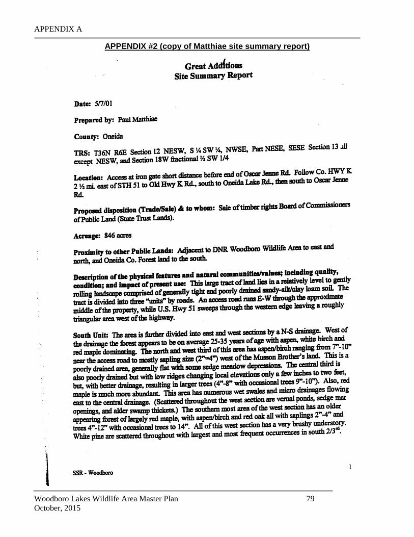
APPENDIX A
Woodboro Lakes Wildlife Area Master Plan 79
October, 2015
APPENDIX #2 (copy of Matthiae site summary report)
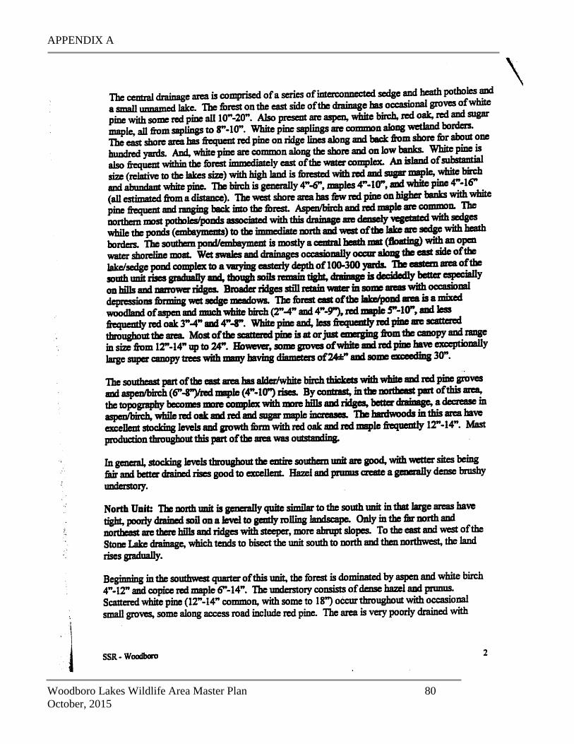
APPENDIX A
Woodboro Lakes Wildlife Area Master Plan 80
October, 2015
APPENDIX A
Woodboro Lakes Wildlife Area Master Plan 81
October, 2015
APPENDIX A
Woodboro Lakes Wildlife Area Master Plan 82
October, 2015
APPENDIX A
Woodboro Lakes Wildlife Area Master Plan 83
October, 2015
APPENDIX A
Woodboro Lakes Wildlife Area Master Plan 84
October, 2015
APPENDIX #3: ROTATION AGES ON WOODBORO EASEMENT
Rotation ages for the major species on the Woodboro Tract are: 1. White Pine: 175 years (up to 300 for seed and aesthetic trees) 2. Red Pine: 120 years (up to 200 for seed and aesthetic trees) 3. Red Oak: 150 years (up to 220 for mast/wildlife trees) Rotation ages for the secondary species on the Woodboro Tract are: 1. Quaking Aspen*: 50 years (if desirable regeneration established)
60 years (normally) 80 years (maximum for wildlife trees)
2. Big-tooth Aspen*: 55 years (if desirable regeneration established) 70 years (normally) 90 years (maximum for nurse/wildlife trees)
3. Red Maple: 100 years (up to 125 years for wildlife trees) 4. Paper Birch: 80 years (up to 90 years for seed trees) 5. White Spruce: 120 years (up to 160 years for seed/wildlife trees) Rotation ages for Minor Species on Woodboro Tract: 1. Jack Pine: 60 years 2. N. Pin Oak: 80 years (up to 100 years for wildlife trees) 3. Balsam fir: 70 years (up to 80 years for nurse trees) 4. Sugar Maple: 175 years (+50 yrs. if good site; eg. Goodman stony loam) 5. Ash: 150 years 6. Swamp white oak: None (no harvest planned) 7. Elm species: None (no harvest planned)
(*Note: For aspen, these roughly correspond to economic, biological, and pathological rotation ages.)
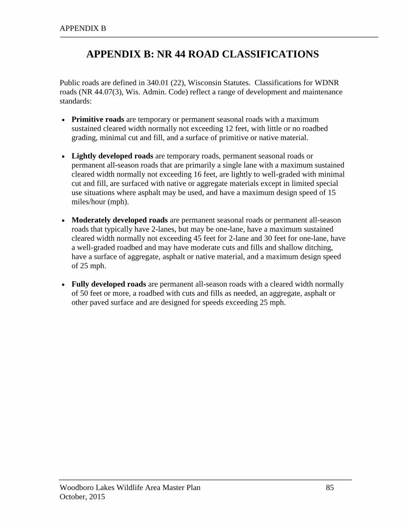
APPENDIX B
Woodboro Lakes Wildlife Area Master Plan 85
October, 2015
APPENDIX B: NR 44 ROAD CLASSIFICATIONS
Public roads are defined in 340.01 (22), Wisconsin Statutes. Classifications for WDNR
roads (NR 44.07(3), Wis. Admin. Code) reflect a range of development and maintenance
standards:
Primitive roads are temporary or permanent seasonal roads with a maximum
sustained cleared width normally not exceeding 12 feet, with little or no roadbed
grading, minimal cut and fill, and a surface of primitive or native material.
Lightly developed roads are temporary roads, permanent seasonal roads or
permanent all-season roads that are primarily a single lane with a maximum sustained
cleared width normally not exceeding 16 feet, are lightly to well-graded with minimal
cut and fill, are surfaced with native or aggregate materials except in limited special
use situations where asphalt may be used, and have a maximum design speed of 15
miles/hour (mph).
Moderately developed roads are permanent seasonal roads or permanent all-season
roads that typically have 2-lanes, but may be one-lane, have a maximum sustained
cleared width normally not exceeding 45 feet for 2-lane and 30 feet for one-lane, have
a well-graded roadbed and may have moderate cuts and fills and shallow ditching,
have a surface of aggregate, asphalt or native material, and a maximum design speed
of 25 mph.
Fully developed roads are permanent all-season roads with a cleared width normally
of 50 feet or more, a roadbed with cuts and fills as needed, an aggregate, asphalt or
other paved surface and are designed for speeds exceeding 25 mph.