Wirraminna gold resource more than doubles following ...€¦ · The Mineral Resource (JORC 2012)...
17
Page 1 Middle Island Resources Ltd ACN 142 361 608 ASX code: MDI www.middleisland.com.au Capital Structure: 586 million ordinary shares 38,300,000 unlisted options Cash $1.3m (as at 30 September 2017) Directors & Management: Peter Thomas Non-Executive Chairman Rick Yeates Managing Director Beau Nicholls Non-Executive Director Dennis Wilkins Company Secretary Contact: Rick Yeates Mob: +61(0)401 694 313 [email protected] ASX Release – 8 December 2017 Wirraminna gold resource more than doubles following infill drilling at Sandstone project, WA The Mineral Resource (JORC 2012) at the Company’s Sandstone gold project’s Wirraminna deposit more than doubles to 550,000t at 1.3g/t Au for 23,000oz gold (at a 0.5g/t lower cut-off grade) following verification, infill and extension drilling. 55% of the new Wirraminna Mineral Resource is classified as Indicated, with the balance in the Inferred category. The updated estimate compares with a previous Inferred Mineral Resource estimate (JORC 2004) of 106,300t at 2.07g/t Au (10,674oz). The increase in tonnage reflects a higher degree of mineralised zone continuity demonstrated by infill and extension drilling, and the application of a lower cut-off grade. Pit optimisation of the Wirraminna deposit will now be completed to determine the deposit’s potential contribution to the planned Sandstone gold project production schedule. Considerable opportunity remains to further extend and enhance the Wirraminna deposit via follow-up RC drilling, including confirming the location of historic higher grade holes and infill drilling of Inferred Mineral Resources.
Transcript of Wirraminna gold resource more than doubles following ...€¦ · The Mineral Resource (JORC 2012)...

Page 1
Middle Island Resources Ltd ACN 142 361 608 ASX code: MDI www.middleisland.com.au
Capital Structure: 586 million ordinary shares 38,300,000 unlisted options Cash $1.3m (as at 30 September 2017) Directors & Management: Peter Thomas Non-Executive Chairman Rick Yeates Managing Director Beau Nicholls Non-Executive Director Dennis Wilkins Company Secretary Contact: Rick Yeates Mob: +61(0)401 694 313 [email protected]
ASX Release – 8 December 2017
Wirraminna gold resource more than doubles following infill drilling at Sandstone project, WA
The Mineral Resource (JORC 2012) at the Company’s Sandstone gold project’s Wirraminna deposit more than doubles to 550,000t at 1.3g/t Au for 23,000oz gold (at a 0.5g/t lower cut-off grade) following verification, infill and extension drilling.
55% of the new Wirraminna Mineral Resource is classified as Indicated, with the balance in the Inferred category.
The updated estimate compares with a previous Inferred Mineral Resource estimate (JORC 2004) of 106,300t at 2.07g/t Au (10,674oz).
The increase in tonnage reflects a higher degree of mineralised zone continuity demonstrated by infill and extension drilling, and the application of a lower cut-off grade.
Pit optimisation of the Wirraminna deposit will now be completed to determine the deposit’s potential contribution to the planned Sandstone gold project production schedule.
Considerable opportunity remains to further extend and enhance the Wirraminna deposit via follow-up RC drilling, including confirming the location of historic higher grade holes and infill drilling of Inferred Mineral Resources.

ASX Release – 8 December 2017
Page 2
SANDSTONE GOLD PROJECT (WA)
Wirraminna Deposit Mineral Resource Update
Middle Island Resources Limited (ASX: MDI, Middle Island, the Company) advises that updated Mineral Resource estimates, reported in compliance with the 2012 JORC Code guidelines, have been completed for the Wirraminna deposit, situated immediately adjacent to the Company’s Sandstone gold project in Western Australia and within 1km of the processing plant.
Following the completion of verification, infill and extension reverse circulation percussion (RC) and diamond core drilling, resource estimation of the Wirraminna deposit was undertaken by independent consulting firm, Ashmore Advisory Pty Ltd.
Reported at a 0.5g/t Au lower cut-off grade, the updated Mineral Resource (JORC 2012) comprises 550,000t at 1.3g/t Au for 23,000oz gold. Some 55% of the estimate is classified as Indicated Mineral Resource, with the balance in the Inferred category, as summarised in Table 1 below.
Table 1 Wirraminna Deposit
December 2017 Mineral Resource Estimate (0.5 g/t Au cut-off)
Indicated Inferred Total Type Tonnage Au Au Tonnage Au Au Tonnage Au Au
kt g/t Ounces kt g/t Ounces kt g/t Ounces Oxide 304 1.5 14,500 165 1.1 5,800 468 1.4 20,400
Transitional 3 1.2 100 52 1.1 1,800 55 1.1 1,900 Fresh 26 0.9 700 26 0.9 700 Total 307 1.5 14,600 243 1.1 8,400 550 1.3 23,000
There is a low level of geological confidence associated with Inferred Mineral Resources and there is no certainty that further exploration will result in the conversion of Inferred Mineral Resources to Indicated Mineral Resources.
The updated estimate compares with a previous Inferred Mineral Resource estimate (JORC 2004) of 106,300t at 2.07g/t Au (10,674oz). The increase in tonnage reflects a higher degree of mineralised zone continuity demonstrated by infill and extension drilling, combined with the application of a lower reporting cut-off grade. Conversely, the lower average resource grade reflects the application of a lower wireframe cut-off grade.
RESOURCE ESTIMATION METHODOLOGY AND DATA
The following information is required to meet the requirements under Listing Rule 5.8.1.
Geology and Geological Interpretation
Gold mineralisation at the Wirraminna deposit is hosted in a quartz-ironstone shear zone, which in the North Zone, is confined to a chert band within a quartz-chlorite-sericite schist flanked by talc-chlorite ultramafic schist. The Central and South Zones are hosted in the talc-carbonate-chlorite schist with a dolerite hanging wall. The mineralisation pinches and swells in these zones, has variable grades and is structurally controlled along the north-south shear zone where crosscutting east-northeast structures intersect the lodes. Between the three zones, mineralisation consists of narrow, low grade zones or un-mineralised sections (Figure 1 and Figure 2). The vast majority of the Wirraminna mineralisation occurs in the oxide weathering zone.

ASX Release – 8 December 2017
Page 3
Figure 1 Plan View of Wireframes and Drilling
RC
RCD

ASX Release – 8 December 2017
Page 4
Figure 2 Cross Section of Block Model on Section 6,891,135mN, Facing North
Drilling Techniques
Drilling was completed by a number of historical operators and MDI. The historic operators used RC drilling and MDI used RC drilling, with four of those RC holes extended with diamond tails. For RC holes, a 5¼’ face-sampling hammer bit was used. For diamond holes, HQ core diameter was obtained using triple tube.
Sampling and Sub-Sampling Techniques
For Consolidated Mining & Finance, Herald and Troy drilling, RC samples were passed directly from the in-line cyclone through a rig mounted multi-tier riffle splitter. Samples were collected in 1m intervals into bulk plastic bags and 1m calico splits (which were retained for later use). From the bulk sample, a 5m composite sample was collected using a split PVC scoop and then submitted to the laboratory for analysis. The 1m calico splits were submitted to the laboratory if the composite sample returned assay values equal to or greater than 0.2g/t Au. In certain cases, selected samples from some holes were passed from the cyclone through a rig mounted multi-tier riffle splitter, and samples collected into calico bags at 1m intervals were submitted directly for analyses. The remaining bulk sample was placed on the ground in 1m intervals.

ASX Release – 8 December 2017
Page 5
For MDI RC drilling, sampling was undertaken by collecting 2-3kg of RC chips off the drill rig’s cone splitter; the 1m samples were then composited to 4m interval samples with a two-tier riffle splitter, but intervals of expected mineralisation were sampled at 1m intervals. Where 4m composites returned assays greater than 0.2g/t Au, the 1m bulk samples were split down to 2-3kg sub-samples using a two-tier riffle splitter and submitted for analysis. For diamond drilling, HQ core was sampled as half core, cut using a diamond core saw and sampled at 1m intervals or to geological contacts. The core samples were always collected from the same side of core for consistency.
For Herald and Troy drilling, SGS Australia Pty Ltd, located in Perth WA, was responsible for sample preparation and assaying. No specifications of sample preparation at the laboratory were described.
Consolidated Mining and Finance drill samples were prepared by Analytical Services of Willeton WA. Samples were dried and hammer milled to -500 microns. A 100 gram split was ring pulverised to -75 microns, a 30 gram charge was taken from this for gold fire assay with an AAS finish.
MDI samples were sent to Intertek Laboratory in Perth, WA for preparation and analysis. The samples were dried in an industrial oven for a minimum of 12 hours at greater than 105°C and crushed to -10mm before being split. A 300g subsample was pulverised to 95% passing 75µm. This fraction was then split again to a 50g sample charge for fire assay.
Sample Analysis Method
For Herald and Troy drilling, assays were conducted by SGS Australia Pty Ltd in Perth WA using 50g charge Fire Assay with AAS finish.
Consolidated Mining and Finance, assays were conducted by Analytical Services in Willeton WA using 30g charge fire assay with an AAS finish.
For MDI drilling, assays were conducted by Intertek Laboratory in Perth WA using 50g charge Fire Assay with ICP-OES finish.
Estimation Methodology
The deposit mineralisation was constrained by wireframes constructed using a 0.4g/t Au cut-off grade and geological logging. The wireframes were applied as hard boundaries in the estimate.
Statistical analysis was carried out on data from 19 lodes. The moderate coefficient of variation and the scattering of high grade values observed on the histogram for some of the lodes suggested that high grade cuts were required if linear grade interpolation was to be carried out. It was determined that high grade cuts between 15g/t Au and 25g/t Au were warranted for some domains, resulting in three composites being cut.
Using parameters derived from modelled variograms, Ordinary Kriging (OK) was used to estimate average block grades in three passes using Surpac software. The parent block dimensions used were 5m NS by 5m EW by 5m vertical with sub-cells of 1.25m by 1.25m by 1.25m. The parent block size dimension was selected on the results obtained from Kriging Neighbourhood Analysis that suggested this was the optimal block size for the Wirraminna dataset.

ASX Release – 8 December 2017
Page 6
An orientated ‘ellipsoid’ search was used to select data and adjusted to account for the variations in lode orientations. However, all other parameters were taken from the variography derived from Domain 1. Up to three passes were used for each domain. The first pass had a range of 30m, with a minimum of 6 samples. For the second pass, the range was extended to 60m, with a minimum of 4 samples. For the third pass, the range was extended to 120m to 150m, with a minimum of 2 samples. A maximum of 20 samples was used for each pass with a maximum of 6 samples per hole.
Validation of the model included detailed comparison of composite grades and block grades by northing and elevation. Validation plots showed good correlation between the composite grades and the block model grades.
Bulk densities were assigned in the block model based on mined bulk densities from the nearby Eureka deposit. Values of 1.9t/m3, 2.3t/m3 and 2.7t/m3 were applied to oxide, transitional and fresh (primary) material respectively.
Resource Classification Criteria
The Mineral Resource was classified as a combination of Indicated and Inferred Mineral Resource based on data quality, sample spacing and lode continuity. The sample spacing criteria was based on the ranges of the variogram models. The Indicated Mineral Resource was defined within areas of close spaced RC and RCD drilling of less than 20m by 20m (approximately 60% of the variogram major direction range), and where the continuity and predictability of the lode positions was good. The Inferred Mineral Resource was assigned to areas where drill hole spacing was greater than 20m by 20m, where small isolated pods of mineralisation occur outside the main mineralised zones, and to geologically complex zones.
Mining, Cut-off Parameters and Metallurgical Methods
It is assumed that the deposit could be mined using open pit mining techniques as the mineralisation is mainly defined in the oxide zone, within 105m of the surface. The Statement of Mineral Resources has been constrained by the mineralisation solids and reported above a cut-off grade of 0.5g/t Au. The cut-off grade was estimated based on parameters derived from the Sandstone gold project Pre-Feasibility Study completed in 2016.
No metallurgical testing has been conducted on the Wirraminna deposit. MDI expects that similar overall recoveries could be achieved to the nearby Eureka deposit of 93%.
Wirraminna Pit Optimisation Study
Pit optimisation of the Wirraminna resource estimate will be undertaken to determine the deposit’s contribution to the planned Sandstone gold project production schedule. This work is anticipated to be completed by the end of this month.

ASX Release – 8 December 2017
Page 7
COMPANY CONTACTS:
Rick Yeates – Managing Director +61 (0)401 694 313
MEDIA CONTACT:
Kevin Skinner Field Public Relations +61 (0)8 8234 9555 / +61 (0)414 822 631
WEBSITE: www.middleisland.com.au
Forward Looking Statements
Statements contained in this release, particularly those regarding possible or assumed future performance, costs, dividends, production levels or rates, prices, resources, reserves or potential growth of Middle Island, industry growth or other trend projections are, or may be, forward looking statements. Such statements relate to future events and expectations and, as such, involve known and unknown risks and uncertainties. Actual results and developments may differ materially from those expressed or implied by these forward looking statements depending on a variety of factors. Competent Persons’ Statement
Information in this report that relates to Mineral Resources is based on information compiled by Mr Shaun Searle (a Member of the Australian Institute of Geoscientists). Mr Searle is a director of Ashmore Advisory Pty Ltd, an independent consultant to Middle Island. Mr Searle has sufficient experience which is relevant to the style of mineralisation and type of deposits under consideration to qualify as a Competent Person as defined in the 2012 edition of the ‘Australasian Code for Reporting of Exploration Results, Mineral Resources and Ore Reserves’. Mr Searle consents to the inclusion in the release of the statements based on his information in the form and context in which they appear.

Page 8
Appendix 1 The following Table and Sections are provided to ensure compliance with the JORC Code Section 1 Sampling Techniques and Data
Criteria JORC Code explanation Commentary
Sampling techniques
• Nature and quality of sampling (eg cut channels, random chips, or specific specialised industry standard measurement tools appropriate to the minerals under investigation, such as down hole gamma sondes, or handheld XRF instruments, etc). These examples should not be taken as limiting the broad meaning of sampling.
• Include reference to measures taken to ensure sample representivity and the appropriate calibration of any measurement tools or systems used.
• Aspects of the determination of mineralisation that are Material to the Public Report. In cases where ‘industry standard’ work has been done this would be relatively simple (eg ‘reverse circulation drilling was used to obtain 1 m samples from which 3 kg was pulverised to produce a 30 g charge for fire assay’). In other cases more explanation may be required, such as where there is coarse gold that has inherent sampling problems. Unusual commodities or mineralisation types (eg submarine nodules) may warrant disclosure of detailed information.
• For Consolidated Mining & Finance, Herald and Troy drilling, RC samples were passed directly from the in-line cyclone through a rig mounted multi-tier riffle splitter. Samples were collected in 1m intervals into bulk plastic bags and 1m calico splits (which were retained for later use). From the bulk sample, a 5m composite sample was collected using a split PVC scoop and then submitted to the laboratory for analysis. The 1m calico splits were submitted to the laboratory if the composite sample returned assay values equal to or greater than 0.2g/t Au. In certain cases, selected samples from some holes were passed from the cyclone through a rig mounted multi-tier riffle splitter, and samples collected into calico bags at 1m intervals were submitted directly for analyses. The remaining bulk sample was placed on the ground in 1m intervals.
• For MDI RC drilling, sampling was undertaken by collecting 2-3kg of RC chips off the drill rig’s cone splitter; the 1m samples were then composited to 4m interval samples with a two-tier riffle splitter, but intervals of expected mineralisation were sampled at 1m intervals. Where 4m composites returned assays greater than 0.2g/t Au, the 1m bulk samples were split down to 2-3kg sub-samples using a two-tier riffle splitter and submitted for analysis. For diamond drilling, NQ core was sampled as half core, cut using a diamond core saw and sampled at 1m intervals or to geological contacts. The half core samples were always collected from the same side of core for consistency.
• RC chips and core were sent to the laboratory to be crushed (-10mm) and pulverised to produce a 300g pulp, then split to a 50g charge for fire assay analysis.
Drilling techniques
• Drill type (e.g. core, reverse circulation, open-hole hammer, rotary air blast, auger, Bangka, sonic, etc.) and details (e.g. core diameter, triple or standard tube, depth of diamond tails, face-sampling bit or other type, whether core is oriented and if so, by what method, etc.).
• For RC holes, a 5¼’ face sampling bit was used. For diamond holes, HQ core diameter was obtained using triple tube.
Drill sample recovery
• Method of recording and assessing core and chip sample recoveries and results assessed.
• Measures taken to maximise sample recovery and ensure representative nature of the samples.
• Whether a relationship exists between sample recovery and grade and whether sample bias may have occurred due to preferential loss/gain of fine/coarse material.
• Recoveries from historical drilling are unknown. • Recoveries RC recovery data was measured for each interval and captured
in a digital logging software package. The data has been reviewed and the core recovery was effectively 100% throughout.
• The water table was encountered at a 40 – 60m hole depth however all RC samples remained dry.
• In MDI drilling no relationship exists between sample recovery and grade.
Page 9
Criteria JORC Code explanation Commentary
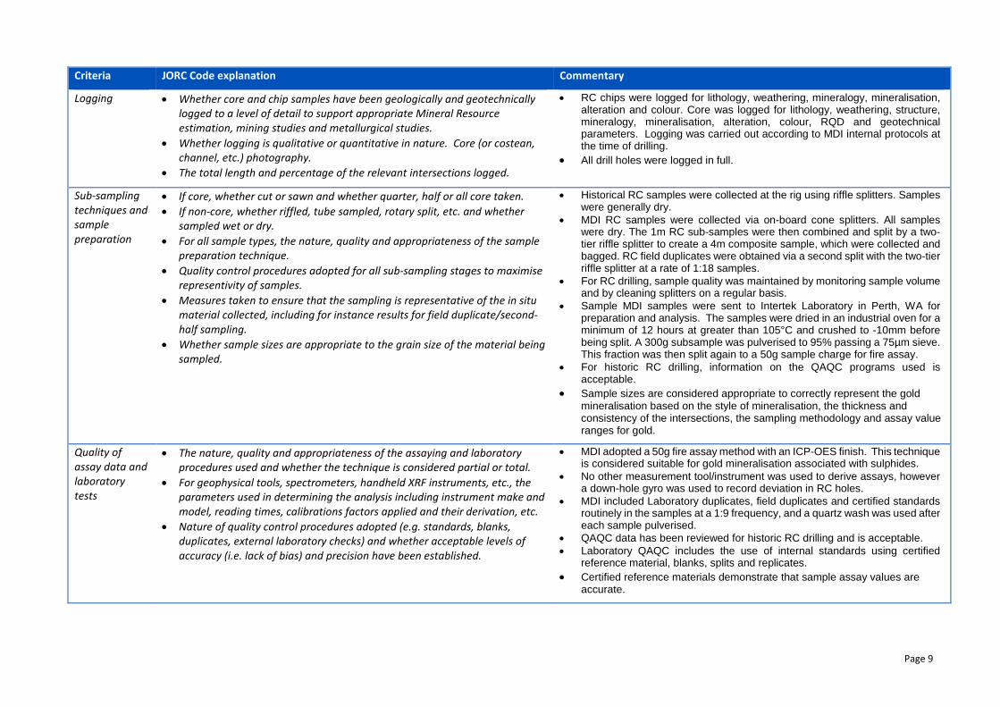
Logging • Whether core and chip samples have been geologically and geotechnically logged to a level of detail to support appropriate Mineral Resource estimation, mining studies and metallurgical studies.
• Whether logging is qualitative or quantitative in nature. Core (or costean, channel, etc.) photography.
• The total length and percentage of the relevant intersections logged.
• RC chips were logged for lithology, weathering, mineralogy, mineralisation, alteration and colour. Core was logged for lithology, weathering, structure, mineralogy, mineralisation, alteration, colour, RQD and geotechnical parameters. Logging was carried out according to MDI internal protocols at the time of drilling.
• All drill holes were logged in full.
Sub-sampling techniques and sample preparation
• If core, whether cut or sawn and whether quarter, half or all core taken. • If non-core, whether riffled, tube sampled, rotary split, etc. and whether
sampled wet or dry. • For all sample types, the nature, quality and appropriateness of the sample
preparation technique. • Quality control procedures adopted for all sub-sampling stages to maximise
representivity of samples. • Measures taken to ensure that the sampling is representative of the in situ
material collected, including for instance results for field duplicate/second-half sampling.
• Whether sample sizes are appropriate to the grain size of the material being sampled.
• Historical RC samples were collected at the rig using riffle splitters. Samples were generally dry.
• MDI RC samples were collected via on-board cone splitters. All samples were dry. The 1m RC sub-samples were then combined and split by a two-tier riffle splitter to create a 4m composite sample, which were collected and bagged. RC field duplicates were obtained via a second split with the two-tier riffle splitter at a rate of 1:18 samples.
• For RC drilling, sample quality was maintained by monitoring sample volume and by cleaning splitters on a regular basis.
• Sample MDI samples were sent to Intertek Laboratory in Perth, WA for preparation and analysis. The samples were dried in an industrial oven for a minimum of 12 hours at greater than 105°C and crushed to -10mm before being split. A 300g subsample was pulverised to 95% passing a 75µm sieve. This fraction was then split again to a 50g sample charge for fire assay.
• For historic RC drilling, information on the QAQC programs used is acceptable.
• Sample sizes are considered appropriate to correctly represent the gold mineralisation based on the style of mineralisation, the thickness and consistency of the intersections, the sampling methodology and assay value ranges for gold.
Quality of assay data and laboratory tests
• The nature, quality and appropriateness of the assaying and laboratory procedures used and whether the technique is considered partial or total.
• For geophysical tools, spectrometers, handheld XRF instruments, etc., the parameters used in determining the analysis including instrument make and model, reading times, calibrations factors applied and their derivation, etc.
• Nature of quality control procedures adopted (e.g. standards, blanks, duplicates, external laboratory checks) and whether acceptable levels of accuracy (i.e. lack of bias) and precision have been established.
• MDI adopted a 50g fire assay method with an ICP-OES finish. This technique is considered suitable for gold mineralisation associated with sulphides.
• No other measurement tool/instrument was used to derive assays, however a down-hole gyro was used to record deviation in RC holes.
• MDI included Laboratory duplicates, field duplicates and certified standards routinely in the samples at a 1:9 frequency, and a quartz wash was used after each sample pulverised.
• QAQC data has been reviewed for historic RC drilling and is acceptable. • Laboratory QAQC includes the use of internal standards using certified
reference material, blanks, splits and replicates. • Certified reference materials demonstrate that sample assay values are
accurate.

Page 10
Criteria JORC Code explanation Commentary
Verification of sampling and assaying
• The verification of significant intersections by either independent or alternative company personnel.
• The use of twinned holes. • Documentation of primary data, data entry procedures, data verification,
data storage (physical and electronic) protocols. • Discuss any adjustment to assay data.
• Significant intersections were visually field verified by company geologists. • Sampling was undertaken by experienced geologists from MDI who
confirmed the intersections as prospective for gold mineralisation. • Twinned holes were completed as part of this program. Results indicated that
historical very high grade hits could not be replicated in NGRC072, HOLE002 and HOLE011. Additional investigation of the historical collar coordinates resulted in these holes being excluded.
• Sampling data were imported and validated using a GBIS database software system by an experienced database consultancy.
• Assay values that were below detection limit were adjusted to equal half of the detection limit value.
Location of data points
• Accuracy and quality of surveys used to locate drill holes (collar and down-hole surveys), trenches, mine workings and other locations used in Mineral Resource estimation.
• Specification of the grid system used. • Quality and adequacy of topographic control.
• Surface collar coordinates were surveyed via DGPS. Given magnetism inherent in the host rock, a high quality downhole gyro was used to determine the dip and azimuth of the RC holes.
• MGA94 Zone 50. • The supplied topography was derived from a ground gravity survey with
points surveyed using a DGPS on a 50m by 50m grid. Drill collars surveyed by DGPS were snapped to the topography by Ashmore.
Data spacing and distribution
• Data spacing for reporting of Exploration Results.
• Whether the data spacing and distribution is sufficient to establish the degree of geological and grade continuity appropriate for the Mineral Resource and Ore Reserve estimation procedure(s) and classifications applied.
• Whether sample compositing has been applied.
• Nominal hole spacing of all drilling is approximately 20m by 20m. • The mineralised domains have sufficient continuity in both geology and grade
to be considered appropriate for the Mineral Resource and Ore Reserve estimation procedures and classification applied under the 2012 JORC Code.
• Composting of RC samples was adopted to generate 4m intervals for initial assays, with anomalous results resampled on 1m intervals.
• Samples have been composited to 1m lengths using fixed length techniques prior to Mineral Resource estimation.
Orientation of data in relation to geological structure
• Whether the orientation of sampling achieves unbiased sampling of possible structures and the extent to which this is known, considering the deposit type.
• If the relationship between the drilling orientation and the orientation of key mineralised structures is considered to have introduced a sampling bias, this should be assessed and reported if material.
• Drill holes are angled to 270o (West) which is approximately perpendicular to the orientation of the expected trend of mineralisation.
• No orientation based sampling bias has been identified in the data.
Sample security
• The measures taken to ensure sample security. • Chain of custody is managed by MDI. Samples are stored on site until collected for transport to Intertek Laboratory in Perth WA. MDI personnel have no contact with the samples once they are picked up for transport. Tracking sheets have been set up to track the progress of samples.

Page 11
Criteria JORC Code explanation Commentary
Audits or reviews
• The results of any audits or reviews of sampling techniques and data. • Shaun Searle of Ashmore reviewed drilling and sampling procedures during the 2017 site visit and found that all procedures and practices conform to industry standards.
• The database was validated and audited by Expedio database consultants. Field data collected is logged and validated in a custom field logging tool.

Page 12
Section 2 Reporting of Exploration Results
(Criteria listed in the preceding section also apply to this section.) Criteria JORC Code explanation Commentary
Mineral tenement and land tenure status
• Type, reference name/number, location and ownership including agreements or material issues with third parties such as joint ventures, partnerships, overriding royalties, native title interests, historical sites, wilderness or national park and environmental settings.
• The security of the tenure held at the time of reporting along with any known impediments to obtaining a licence to operate in the area.
• The Wirraminna deposit occurs on Prospect Lease P57/1395, which is held under an option deed agreement between Sandstone Operations Pty Ltd (a wholly owned subsidiary of MDI) and Kym McClaren & Karl Mansen. Sandstone Operations Pty Ltd has the option to acquire a 100% interest in the lease anytime within the next four years.
• The tenement is in good standing with no known impediments to obtaining a mining lease in the future.
Exploration done by other parties
• Acknowledgment and appraisal of exploration by other parties. • Previous exploration was undertaken and reported by Consolidated Mining & Finance, Herald Resources Limited and Troy Resources Limited during their respective tenure of the Sandstone gold project.
Geology • Deposit type, geological setting and style of mineralisation. • The Wirraminna gold deposit is situated approximately 1.2km west-northwest of the MDI-owned Sandstone Mill. Gold mineralisation is hosted in a quartz-ironstone shear zone, which in the North Zone, is confined to a chert band within a quartz-chlorite-sericite schist flanked by talc-chlorite ultramafic schist. The Central and South Zones are hosted in the talc-carbonate-chlorite schist with a dolerite hanging wall. The mineralisation pinches and swells in these zones, has variable grades and is structurally controlled along the north-south shear zone where crosscutting east-northeast structures intersect the lodes. Between the three zones mineralisation consists of narrow, low grade zones or un-mineralised sections. The vast majority of the Wirraminna mineralisation occurs in the oxide weathering zone.
Drill hole Information
• A summary of all information material to the understanding of the exploration results including a tabulation of the following information for all Material drill holes: o easting and northing of the drill hole collar o elevation or RL (Reduced Level – elevation above sea level in metres) of
the drill hole collar o dip and azimuth of the hole o down hole length and interception depth o hole length.
• If the exclusion of this information is justified on the basis that the information is not Material and this exclusion does not detract from the understanding of the report, the Competent Person should clearly explain why this is the case.
• Exploration results are not being reported. • All information has been included in the appendices. No drill hole
information has been excluded.
Page 13
Criteria JORC Code explanation Commentary
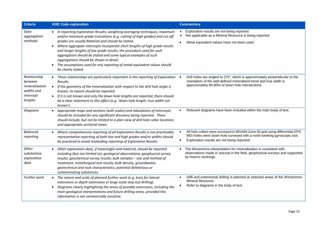
Data aggregation methods
• In reporting Exploration Results, weighting averaging techniques, maximum and/or minimum grade truncations (e.g. cutting of high grades) and cut-off grades are usually Material and should be stated.
• Where aggregate intercepts incorporate short lengths of high grade results and longer lengths of low grade results, the procedure used for such aggregation should be stated and some typical examples of such aggregations should be shown in detail.
• The assumptions used for any reporting of metal equivalent values should be clearly stated.
• Exploration results are not being reported. • Not applicable as a Mineral Resource is being reported.
• Metal equivalent values have not been used.
Relationship between mineralisation widths and intercept lengths
• These relationships are particularly important in the reporting of Exploration Results.
• If the geometry of the mineralisation with respect to the drill hole angle is known, its nature should be reported.
• If it is not known and only the down hole lengths are reported, there should be a clear statement to this effect (e.g. ‘down hole length, true width not known’).
• Drill holes are angled to 270°, which is approximately perpendicular to the orientation of the well-defined mineralised trend and true width is approximately 60-80% of down hole intersections.
Diagrams • Appropriate maps and sections (with scales) and tabulations of intercepts should be included for any significant discovery being reported. These should include, but not be limited to a plan view of drill hole collar locations and appropriate sectional views.
• Relevant diagrams have been included within the main body of text.
Balanced reporting
• Where comprehensive reporting of all Exploration Results is not practicable, representative reporting of both low and high grades and/or widths should be practiced to avoid misleading reporting of Exploration Results.
• All hole collars were surveyed in MGA94 Zone 50 grid using differential GPS. MDI holes were down-hole surveyed with a north-seeking gyroscopic tool.
• Exploration results are not being reported.
Other substantive exploration data
• Other exploration data, if meaningful and material, should be reported including (but not limited to): geological observations; geophysical survey results; geochemical survey results; bulk samples – size and method of treatment; metallurgical test results; bulk density, groundwater, geotechnical and rock characteristics; potential deleterious or contaminating substances.
• The Wirraminna interpretation for mineralisation is consistent with observations made in outcrop in the field, geophysical surveys and supported by historic workings.
Further work • The nature and scale of planned further work (e.g. tests for lateral extensions or depth extensions or large-scale step-out drilling).
• Diagrams clearly highlighting the areas of possible extensions, including the main geological interpretations and future drilling areas, provided this information is not commercially sensitive.
• Infill and extensional drilling is planned at selected areas of the Wirraminna Mineral Resource.
• Refer to diagrams in the body of text.

Page 14
Section 3 - Estimation and Reporting of Mineral Resources
Criteria JORC Code explanation Commentary Database integrity
• Measures taken to ensure that data has not been corrupted by, for example, transcription or keying errors, between its initial collection and its use for Mineral Resource estimation purposes.
• Data validation procedures used.
• The data base has been systematically audited by MDI’s geologists and the Company’s independent database consultants. Original drilling records were compared to the equivalent records in the data base (where original records were available). Any discrepancies were noted and rectified by the data base manager.
• All MDI drilling data has been verified as part of a continuous validation procedure. Once a drill hole is imported into the data base a report of the collar, down-hole survey, geology, and assay data are produced. This is then checked by a MDI geologist and any corrections are completed by the data base manager.
Site visits • Comment on any site visits undertaken by the Competent Person and the outcome of those visits.
• If no site visits have been undertaken indicate why this is the case.
• A site visit was conducted by Shaun Searle of Ashmore during November 2017. Shaun inspected the deposit area, drill chips, diamond core, outcrop and the core logging and sampling facility. During this time, notes and photos were taken. Discussions were held with site personnel regarding drilling and sampling procedures. No major issues were encountered.
• A site visit was conducted, therefore not applicable. Geological interpretation
• Confidence in (or conversely, the uncertainty of) the geological interpretation of the mineral deposit.
• Nature of the data used and of any assumptions made. • The effect, if any, of alternative interpretations on Mineral Resource estimation. • The use of geology in guiding and controlling Mineral Resource estimation. • The factors affecting continuity both of grade and geology.
• The confidence in the geological interpretation is considered to be good and is based on visual confirmation in outcrop and within drill hole intersections.
• Geochemistry and geological logging has been used to assist identification of lithology and mineralisation.
• Gold mineralisation is hosted in a quartz-ironstone shear zone, which in the North Zone, is confined to a chert band within a quartz-chlorite-sericite schist flanked by talc-chlorite ultramafic schist. The Central and South Zones are hosted in the talc-carbonate-chlorite schist with a dolerite hanging wall. Infill drilling has supported and refined the model and the current interpretation is considered robust.
• Outcrops of mineralisation and host rocks confirm the geometry of the mineralisation.
• Infill drilling has confirmed geological and grade continuity. Dimensions • The extent and variability of the Mineral Resource expressed as length (along
strike or otherwise), plan width, and depth below surface to the upper and lower limits of the Mineral Resource.
• The Wirraminna Mineral Resource area extends over a north-south strike length of 725m (from 6,890,625mN – 6,891,350mN), has a maximum width of 30m (720,730mE – 720,760mE) and includes the 105m vertical interval from 505mRL to 400mRL.
Estimation and modelling techniques
• The nature and appropriateness of the estimation technique(s) applied and key assumptions, including treatment of extreme grade values, domaining, interpolation parameters and maximum distance of extrapolation from data points. If a computer assisted estimation method was chosen include a description of computer software and parameters used.
• The availability of check estimates, previous estimates and/or mine production records and whether the Mineral Resource estimate takes appropriate account of such data.
• The assumptions made regarding recovery of by-products.
• Using parameters derived from modelled variograms, Ordinary Kriging (OK) was used to estimate average block grades in three passes using Surpac software. Linear grade estimation was deemed suitable for the Wirraminna Mineral Resource due to the geological and structural control on mineralisation. Maximum extrapolation of wireframes from drilling was 20m along strike and 40m down-dip. Extrapolation for lodes terminating between drill cross sections was half drill hole spacing.
• There are historical mining records for the Wirraminna area, however the records were not separated to specific shafts or pits, therefore reconciliation

Page 15
Criteria JORC Code explanation Commentary • Estimation of deleterious elements or other non-grade variables of economic
significance (eg sulphur for acid mine drainage characterisation). • In the case of block model interpolation, the block size in relation to the average
sample spacing and the search employed. • Any assumptions behind modelling of selective mining units. • Any assumptions about correlation between variables. • Description of how the geological interpretation was used to control the
resource estimates. • Discussion of basis for using or not using grade cutting or capping. • The process of validation, the checking process used, the comparison of model
data to drill hole data, and use of reconciliation data if available.
was not conducted. • No recovery of by-products is anticipated. • Only gold was interpolated into the block model. • The parent block dimensions used were 5m NS by 5m EW by 5m vertical
with sub-cells of 1.25m by 1.25m by 1.25m. The parent block size dimension was selected on the results obtained from Kriging Neighbourhood Analysis that suggested this was the optimal block size for the Wirraminna dataset.
• An orientated ‘ellipsoid’ search was used to select data and adjusted to account for the variations in lode orientations, however all other parameters were taken from the variography derived from Domain 1. Up to three passes were used for each domain. First pass had a range of 30m, with a minimum of 6 samples. For the second pass, the range was extended to 60m, with a minimum of 4 samples. For the third pass, the range was extended to 120m to 150m, with a minimum of 2 samples. A maximum of 20 samples was used for each pas with a maximum of 6 samples per hole.
• No assumptions were made on selective mining units. • Only gold assay data was available, therefore correlation analysis was not
possible. • The deposit mineralisation was constrained by wireframes constructed using
a 0.4g/t Au cut-off grade and geological logging. The wireframes were applied as hard boundaries in the estimate.
• Statistical analysis was carried out on data from 19 lodes. The high coefficient of variation and the scattering of high grade values observed on the histogram for some of the lodes suggested that high grade cuts were required if linear grade interpolation was to be carried out. It was determined that high grade cuts between 15g/t Au and 25g/t Au were warranted for some domains, resulting in three composites being cut.
• Validation of the model included detailed comparison of composite grades and block grades by northing and elevation. Validation plots showed good correlation between the composite grades and the block model grades.
Moisture • Whether the tonnages are estimated on a dry basis or with natural moisture, and the method of determination of the moisture content.
• Tonnages and grades were estimated on a dry in situ basis.
Cut-off parameters
• The basis of the adopted cut-off grade(s) or quality parameters applied. • The Mineral Resource is reported at a cut-off of 0.5g/t Au. The cut-off grade was estimated based on parameters derived from the Sandstone gold project Pre-Feasibility Study completed in 2016.
• The shallow gold mineralisation defined at Wirraminna could provide an additional source of oxide mill feed to the 600ktpa CIL Sandstone mill that could be refurbished granted positive outcomes from ongoing mining studies at the Project. The Wirraminna gold deposit is situated approximately 1.2km west-northwest of the Sandstone Mill. Further geological, geotechnical, engineering and metallurgical studies are planned to further define gold mineralisation and determine the viability of mining at Wirraminna.

Page 16
Criteria JORC Code explanation Commentary Mining factors or assumptions
• Assumptions made regarding possible mining methods, minimum mining dimensions and internal (or, if applicable, external) mining dilution. It is always necessary as part of the process of determining reasonable prospects for eventual economic extraction to consider potential mining methods, but the assumptions made regarding mining methods and parameters when estimating Mineral Resources may not always be rigorous. Where this is the case, this should be reported with an explanation of the basis of the mining assumptions made.
• Ashmore has assumed that the deposit could be mined using open pit mining techniques.
Metallurgical factors or assumptions
• The basis for assumptions or predictions regarding metallurgical amenability. It is always necessary as part of the process of determining reasonable prospects for eventual economic extraction to consider potential metallurgical methods, but the assumptions regarding metallurgical treatment processes and parameters made when reporting Mineral Resources may not always be rigorous. Where this is the case, this should be reported with an explanation of the basis of the metallurgical assumptions made.
• No metallurgical testing has been conducted on the Wirraminna deposit. MDI expects that similar overall recoveries could be achieved to the nearby Eureka deposit of 93%.
Environmental factors or assumptions
• Assumptions made regarding possible waste and process residue disposal options. It is always necessary as part of the process of determining reasonable prospects for eventual economic extraction to consider the potential environmental impacts of the mining and processing operation. While at this stage the determination of potential environmental impacts, particularly for a greenfields project, may not always be well advanced, the status of early consideration of these potential environmental impacts should be reported. Where these aspects have not been considered this should be reported with an explanation of the environmental assumptions made.
• No assumptions have been made regarding environmental factors. MDI will work to mitigate environmental impacts as a result of any future mining or mineral processing.
Bulk density • Whether assumed or determined. If assumed, the basis for the assumptions. If determined, the method used, whether wet or dry, the frequency of the measurements, the nature, size and representativeness of the samples.
• The bulk density for bulk material must have been measured by methods that adequately account for void spaces (vugs, porosity, etc), moisture and differences between rock and alteration zones within the deposit.
• Discuss assumptions for bulk density estimates used in the evaluation process of the different materials.
• Diamond drilling has been conducted at the deposit, however no designated density data has been obtained. The nearby Eureka open pit mine along strike to the south contains similar lithologies. Measurements obtained from that deposit have been used as a guide to assign bulk density into the Wirraminna block model.
• It is assumed there are minimal void spaces in the rocks at Wirraminna. • MDI will obtain bulk density measurements from future diamond drilling at
the deposit. Classification • The basis for the classification of the Mineral Resources into varying confidence
categories. • Whether appropriate account has been taken of all relevant factors (ie relative
confidence in tonnage/grade estimations, reliability of input data, confidence in continuity of geology and metal values, quality, quantity and distribution of the data).
• Whether the result appropriately reflects the Competent Person’s view of the deposit.
• The Mineral Resource estimate is reported here in compliance with the 2012 Edition of the ‘Australasian Code for Reporting of Exploration Results, Mineral Resources and Ore Reserves’ by the Joint Ore Reserves Committee (JORC). The resource was classified as Indicated and Inferred Mineral Resource based on data quality, sample spacing, and lode continuity. The sample spacing criteria was based on the ranges of the variogram models. The Indicated Mineral Resource was defined within areas of close spaced RC drilling of less than 20m by 20m (approximately 60% of the variogram major direction range), and where the continuity and predictability of the lode positions was good. The Inferred Mineral Resource was assigned to areas where drill hole spacing was greater than 20m by 20m, where small isolated pods of mineralisation occur outside the main mineralised zones, and to

Page 17
Criteria JORC Code explanation Commentary geologically complex zones.
• The input data is comprehensive in its coverage of the mineralisation and does not favour or misrepresent in-situ mineralisation. The definition of mineralised zones is based on high level geological understanding producing a robust model of mineralised domains. This model has been confirmed by infill drilling which supported the interpretation. Validation of the block model shows good correlation of the input data to the estimated grades.
• The Mineral Resource estimate appropriately reflects the view of the Competent Person.
Audits or reviews
• The results of any audits or reviews of Mineral Resource estimates. • Internal audits have been completed by Ashmore which verified the technical inputs, methodology, parameters and results of the estimate.
Discussion of relative accuracy/ confidence
• Where appropriate a statement of the relative accuracy and confidence level in the Mineral Resource estimate using an approach or procedure deemed appropriate by the Competent Person. For example, the application of statistical or geostatistical procedures to quantify the relative accuracy of the resource within stated confidence limits, or, if such an approach is not deemed appropriate, a qualitative discussion of the factors that could affect the relative accuracy and confidence of the estimate.
• The statement should specify whether it relates to global or local estimates, and, if local, state the relevant tonnages, which should be relevant to technical and economic evaluation. Documentation should include assumptions made and the procedures used.
• These statements of relative accuracy and confidence of the estimate should be compared with production data, where available.
• The lode geometry and continuity has been adequately interpreted to reflect the applied level of Indicated and Inferred Mineral Resource. The data quality is good and the drill holes have detailed logs produced by qualified geologists. A recognised laboratory has been used for all analyses.
• The Mineral Resource statement relates to global estimates of tonnes and grade.
• There are historical mining records for the Wirraminna area, however the records were not separated to specific shafts, therefore reconciliation was not conducted.

![Intégrales doubles [Correction] · []éditéle16octobre2015 Enoncés 1 Intégrales doubles Calculs d’intégrales doubles Exercice 1 [ 01947 ] [Correction] Calculer I= ZZ D ...](https://static.fdocuments.us/doc/165x107/5e7dab322672273fc1050594/intgrales-doubles-correction-ditle16octobre2015-enoncs-1-intgrales.jpg)