
Wind Decision Support for UAS Operations - NASA · Wind Decision Support for UAS Operations ......
26
Jim Evans Senior Staff Air Traffic Control Systems Group 19 July 2015 Wind Decision Support for UAS Operations
-
Upload
duongkhuong -
Category
Documents
-
view
216 -
download
0
Transcript of Wind Decision Support for UAS Operations - NASA · Wind Decision Support for UAS Operations ......

Jim Evans Senior Staff
Air Traffic Control Systems Group
19 July 2015
Wind Decision Support for UAS
Operations

• Operational needs
• Current capability for low altitude (below 500 ft AGL) winds information 1. Forecasts (e.g., HRRR) plus ASOS 2. FAA Weather Systems
• Integrated Terminal Weather System (ITWS) for 34 major metropolitan areas Gridded winds analysis Wind shear phenomena (microbursts, gust fronts)
• NextGen Weather Processor and CSS-Wx product distribution
• Experience with low altitude strategic (multi-hour lead time) wind forecasts for airport AAR decision support
• Suggestions for next steps
Outline
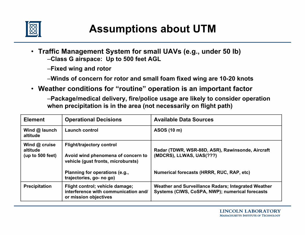
• Traffic Management System for small UAVs (e.g., under 50 lb) – Class G airspace: Up to 500 feet AGL – Fixed wing and rotor – Winds of concern for rotor and small foam fixed wing are 10-20 knots
• Weather conditions for “routine” operation is an important factor – Package/medical delivery, fire/police usage are likely to consider operation when precipitation is in the area (not necessarily on flight path)
Assumptions about UTM
Element Operational Decisions Available Data Sources
Wind @ launch altitude
Launch control ASOS (10 m)
Wind @ cruise altitude (up to 500 feet)
Flight/trajectory control Avoid wind phenomena of concern to vehicle (gust fronts, microbursts) Planning for operations (e.g., trajectories, go- no go)
Radar (TDWR, WSR-88D, ASR), Rawinsonde, Aircraft (MDCRS), LLWAS, UAS(???) Numerical forecasts (HRRR, RUC, RAP, etc)
Precipitation Flight control; vehicle damage; interference with communication and/or mission objectives
Weather and Surveillance Radars; Integrated Weather Systems (CIWS, CoSPA, NWP); numerical forecasts

• Operational needs
• Current capability for low altitude (below 500 ft AGL) winds information 1. Forecasts (e.g., HRRR) plus ASOS 2. FAA Weather Systems
• Integrated Terminal Weather System (ITWS) for 34 major metropolitan areas Gridded winds analysis Wind shear phenomena (microbursts, gust fronts)
• NextGen Weather Processor and CSS-Wx product distribution
• Experience with low altitude strategic (multi-hour lead time) wind forecasts for airport AAR decision support
• Suggestions for next steps
Outline
• NASA / Lincoln Lab consensus to use as a baseline forecast
• Provides a readily available generalized “solution” – Leverages numerical weather prediction R&D that has evolved for decades – Provides forecasts of nearly all relevant UTM weather elements – Coverage over entire CONUS
• Observed shortcomings (see next slides) – Skill diminishes at local scale, which may be a factor for UTM ops
• Spatial scale of physics • Inherent “smoothing” of analysis field (observations) and forecast fields
– Does not fully exploit high resolution information from recent observations in its shorter horizon forecasts (~ under 3 hours)
HRRR model as a Baseline Decision Support System

SFO observed 10-m wind (ASOS) versus forecast wind, all forecast horizons
Forecast bias observed at 10 m
9 AM forecast target 3 PM forecast target
HRRR substantially under-forecasting observed 10 m ASOS wind

• There is a diurnal cycle in observed winds • At 10m AGL: HRRR captures cycle, underestimates magnitude • At 80m AGL: HRRR misses cycle, overestimates magnitude
Comparison of Observations and HRRR at 10 m and 80 m
40 day period:
5 days period:
10m AGL 80m AGL
80 m obs made using
LIDAR
Blue – obs Red - HRRR

• Operational needs
• Current capability for low altitude (below 500 ft AGL) winds information 1. Forecasts (e.g., HRRR) plus ASOS 2. FAA Weather Systems
• Integrated Terminal Weather System (ITWS) for 34 major metropolitan areas Gridded winds analysis
Wind shear phenomena (microbursts, gust fronts)
• NextGen Weather Processor and CSS-Wx product distribution
• Experience with low altitude strategic (multi-hour lead time) wind forecasts for airport AAR decision support
• Suggestions for next steps
Outline

Integrated Terminal Weather System (ITWS) Locations

Integrated Terminal Weather System (ITWS)
Pilots (TWIP)
TRACON / ATCT / ARTCC -TMU -Supervisors -Controllers -ARTCC CWSU
Aircraft (MDCRS) Lightning(NLDS)
ASR-9/11
LLWAS
AWOS/ASOS
TDWR NEXRAD
External Users - Airlines - Other non-FAA Users
Microburst Gust Front
Storm Location & Motion Storm Cell Information
Terminal Winds Tornado
RAP
ATCSCC
ITWS PG(Product
Generator)
ITWS SD
Ribbon Display (RBDT)

LLWAS
Aircraft
AWOS/ASOS
NEXRAD
TDWR
TWINDS Output: Several ‘layers’ of horizontal winds on 2 different grids ~25 mb
Top: 100 mb 400 mb
Bottom: .360
COARSE grid Spacing: 10 km
FINE grid Spacing: 2 km
Updates every 5 minutes
Terminal Winds Analysis
TDWR scans and detects wind shear
360° in azimuth

Example—DFW Terminal Winds
TRACON Area (x 1000 sq km)
Dallas 23
New York 40
Orlando 104
Washington Baltimore
112
Northern California
112
Areas of fine grid winds

Solid purple line indicates current location of gust front. Dashed purple lines indicate estimated location of gust front 10 and 20 minutes in the future. Purple arrow and number indicate direction and speed of wind behind the gust front. If a gust front is strong enough, it can generate a wind shear with gain alert on the ribbon displays and the alerted runways and/or runway extensions are purple. Gust Front Impact Timer indicates when most imminent gust front is expected to arrive at the airport. A purple timer without a number indicates a gust front is on the airport. Range of coverage for gust front is 60 km from the radar.
Gust Front 17min
Gust Front 17 min
Gust Front Product (ITWS, NEXRAD)
Microbursts are detected by both TDWR and NEXRAD - range of coverage is 35 km from radar
Microbursts can create very strong winds a considerable
distance from the rain core – see the back up information slide # 1
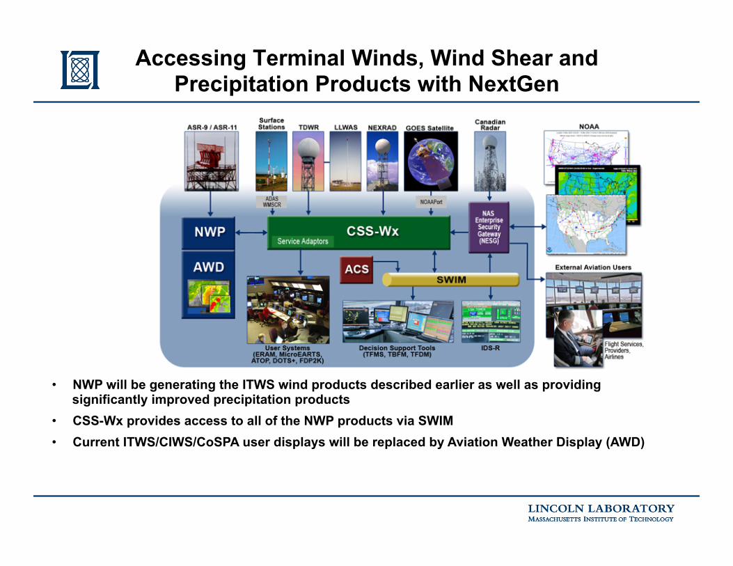
Accessing Terminal Winds, Wind Shear and Precipitation Products with NextGen
• NWP will be generating the ITWS wind products described earlier as well as providing significantly improved precipitation products
• CSS-Wx provides access to all of the NWP products via SWIM • Current ITWS/CIWS/CoSPA user displays will be replaced by Aviation Weather Display (AWD)

Milestone CSS-Wx NWP Final Investment Decision (FID) March 2015 March 2015 Contract Award* June 2015 June 2015 Preliminary Design Review (PDR) Completed March 2016 June 2016 Critical Design Review (CDR) Completed September 2016 December 2016 Factory Acceptance Test (FAT) Completed March 2018 February 2019 Operational Test (OT) Completed November 2018 May 2020 Key Site Initial Operational Capability (IOC) January 2019 August 2020 In Service Decision September 2019 April 2021 First Site Operational Readiness Date (ORD) October 2019 May 2021 Last Site ORD August 2022 August 2022
CSS-Wx/NWP Milestones (as of spring 2016)
! !
• Contract awarded April 2015* Complete On Track Key:
!
APB = Acquisition Program Baseline

• Operational needs
• Current capability for low altitude (below 500 ft AGL) winds information 1. Forecasts (e.g., HRRR) plus ASOS 2. FAA Weather Systems
• Integrated Terminal Weather System (ITWS) for 34 major metropolitan areas Gridded winds analysis Wind shear phenomena (microbursts, gust fronts)
• NextGen Weather Processor and CSS-Wx product distribution
• Experience with low altitude strategic (multi-hour lead time) wind forecasts for airport AAR decision support
• Suggestions for next steps
Outline

Key Factors in Airport Arrival Rate Setting for GDP Planning
Surface winds
Final approach
winds
Winds aloft
“Compression”

• A study of numerical model and TAF wind forecast accuracy for purposes of GDP decision support was conducted for the FAA (Lincoln Laboratory Project Report ATC-414) • Accuracy for various numerical models (RUC, RAP, HRRR) was similar to the TAF • Probability of infeasible runway selection was low (<1%), but probability of non optimal runway selection was about 50% • Timing of significant changes was not assessed --- this is a very important issue
Wind Forecast Accuracy for GDP Decision Support
-40
-30
-20
-10
0
10
20
30
40
-40 -30 -20 -10 0 10 20 30 40
2 hour
Forecast headwind (knots)
Obs
erve
d he
adw
ind
(kno
ts)
Key:Forecast selection correctForecast selection within toleranceForecast selection infeasible
Perfect forecast
-40
-30
-20
-10
0
10
20
30
40
-40 -30 -20 -10 0 10 20 30 40
8 hour
Perfect forecast

Display Concept – Surface Winds Forecasts With Real
Time Forecast Accuracy Verification
Verification using observations from outlying locations
ORD 0-2 Hr Forecast Winds
NOAA Front Forecast

• Operational needs
• Current capability for low altitude (below 500 ft AGL) winds information 1. Forecasts (e.g., HRRR) plus ASOS 2. FAA Weather Systems
• Integrated Terminal Weather System (ITWS) for 34 major metropolitan areas Gridded winds analysis Wind shear phenomena (microbursts, gust fronts)
• NextGen Weather Processor and CSS-Wx product distribution
• Experience with low altitude strategic (multi-hour lead time) wind forecasts for airport AAR decision support
• Suggestions for next steps
Outline
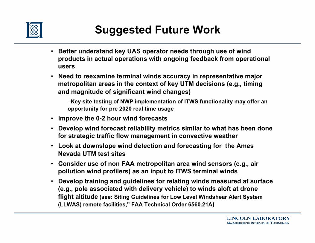
• Better understand key UAS operator needs through use of wind products in actual operations with ongoing feedback from operational users
• Need to reexamine terminal winds accuracy in representative major metropolitan areas in the context of key UTM decisions (e.g., timing and magnitude of significant wind changes)
– Key site testing of NWP implementation of ITWS functionality may offer an opportunity for pre 2020 real time usage
• Improve the 0-2 hour wind forecasts • Develop wind forecast reliability metrics similar to what has been done
for strategic traffic flow management in convective weather • Look at downslope wind detection and forecasting for the Ames
Nevada UTM test sites • Consider use of non FAA metropolitan area wind sensors (e.g., air
pollution wind profilers) as an input to ITWS terminal winds • Develop training and guidelines for relating winds measured at surface
(e.g., pole associated with delivery vehicle) to winds aloft at drone flight altitude (see: Siting Guidelines for Low Level Windshear Alert System (LLWAS) remote facilities," FAA Technical Order 6560.21A)
Suggested Future Work

• Low altitude winds are important to operation of low altitude UAS – Significant horizontal and/or vertical shear will be a challenge for use of a
single surface observation plus HRRR as the sole basis for UTM related wind decision support
– Safety of the UAS is particularly important in major metropolitan areas
• Many of the UAS wind operational issues mirror longstanding issues for conventional aircraft operations – Low altitude wind shear and anticipation of wind changes at airports
• FAA terminal weather decision support systems provide high time/space resolution wind fields plus gust front and wind shear information at 34 major metropolitan areas – Product access for use in UTM will be significantly improved when the
NextGen Weather Processor (NWP) is operational
• Ongoing work to improve FAA strategic and tactical management of wind impacts will often be applicable to UTM operations
Summary

Backup Information

Microburst Observed in Phoenix on July 18 2016
Note that the surface winds spread out a long distance from the region of heavy rain at the surface (see the video at http://mashable.com/2016/07/19/striking-microburst-photo-phoenix/#ohTWSKDA2EqD )

CY 2015 2020 2030 2040
CSS-Wx Work Package 1
CSS-Wx/NWP Implementation
IOC
Current Wx Dissemination: WARP WINS CDDS
ITWS Web Server
CREWS
Current Wx Processing: WARP RAMP CIWS
ITWS
NWP Work Package 1 IOC
CSS-Wx Work Package 2
Legacy Wx Dissemination: WMSCR ADAS ALDARS WIFS
NWP Work Package 2
NWP Work Package 3
Common Support Services- Weather (CSS-Wx)
NextGen Weather Processor (NWP)
Contract Award: April 2015
Contract Award: April 2015
IARD
IARD
ORD
ORD

• ADAS Automated Weather Observing System (AWOS) Data Acquisition System
• ALDARS Automated Lightning Detection and Reporting System • CDDS CIWS Data Distribution Service • CIWS Corridor Integrated Weather System • CREWS CTAS Remote Weather System • CSS-Wx Common Support Services- Weather • IARD Investment Analysis Readiness Decision • IOC Initial Operational Capability • ITWS Integrated Terminal Weather System • NWP NextGen Weather Processor • ORD Operational Readiness Date • RAMP Radar Acquisition and Mosaic Processor • WARP Weather and Radar Processor • WIFS World Area Forecast System (WAFS) Internet File Service • WINS Weather Information Network Server • WMSCR Weather Message Switching Center Replacement
Key Acronyms