Willow Chute Bayou Drainage Project - FEMA.gov Chute Bayou Drainage Project . Bossier Parish,...
140
Draft Environmental Assessment Willow Chute Bayou Drainage Project Bossier Parish, Louisiana Hazard Mitigation Grant Program Project Number 1603-0349 July 2015 U.S. Department of Homeland Security Federal Emergency Management Agency, Region VI Louisiana Recovery Office Baton Rouge, Louisiana
-
Upload
nguyencong -
Category
Documents
-
view
217 -
download
2
Transcript of Willow Chute Bayou Drainage Project - FEMA.gov Chute Bayou Drainage Project . Bossier Parish,...
Draft Environmental Assessment
Willow Chute Bayou Drainage Project Bossier Parish, Louisiana Hazard Mitigation Grant Program Project Number 1603-0349 July 2015
U.S. Department of Homeland Security Federal Emergency Management Agency, Region VI
Louisiana Recovery Office Baton Rouge, Louisiana
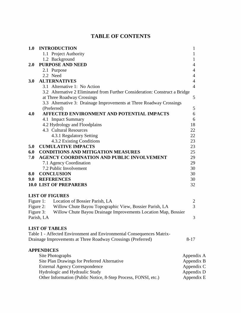
TABLE OF CONTENTS
1.0 INTRODUCTION 1 1.1 Project Authority 1 1.2 Background 1
2.0 PURPOSE AND NEED 4 2.1 Purpose 4 2.2 Need 4
3.0 ALTERNATIVES 4 3.1 Alternative 1: No Action 4 3.2 Alternative 2 Eliminated from Further Consideration: Construct a Bridge at Three Roadway Crossings 5 3.3 Alternative 3: Drainage Improvements at Three Roadway Crossings (Preferred) 5 4.0 AFFECTED ENVIRONMENT AND POTENTIAL IMPACTS 6
4.1 Impact Summary 6 4.2 Hydrology and Floodplains 18 4.3 Cultural Resources 22 4.3.1 Regulatory Setting 22 4.3.2 Existing Conditions 23
5.0 CUMULATIVE IMPACTS 23 6.0 CONDITIONS AND MITIGATION MEASURES 25 7.0 AGENCY COORDINATION AND PUBLIC INVOLVEMENT 29
7.1 Agency Coordination 29 7.2 Public Involvement 30
8.0 CONCLUSION 30 9.0 REFERENCES 30 10.0 LIST OF PREPARERS 32 LIST OF FIGURES Figure 1: Location of Bossier Parish, LA 2 Figure 2: Willow Chute Bayou Topographic View, Bossier Parish, LA 3 Figure 3: Willow Chute Bayou Drainage Improvements Location Map, Bossier Parish, LA 3 LIST OF TABLES Table 1 - Affected Environment and Environmental Consequences Matrix- Drainage Improvements at Three Roadway Crossings (Preferred) 8-17 APPENDICES
Site Photographs Appendix A Site Plan Drawings for Preferred Alternative Appendix B External Agency Correspondence Appendix C Hydrologic and Hydraulic Study Appendix D Other Information (Public Notice, 8-Step Process, FONSI, etc.) Appendix E

LIST OF ACRONYMS APE Area of Potential Effects ACHP Advisory Council on Historic Preservation BMP Best Management Practices CAA Clean Air Act CBRA Coastal Barrier Resources Act CBRS Coastal Barrier Resources System CUP Coastal Use Permit CWA Clean Water Act CZMA Coastal Zone Management Act DEA Draft Environmental Assessment DFIRM Digital Flood Insurance Rate Map DOTD Department of Transportation and Development EA Environmental Assessment EHP Environmental and Historic Preservation EIS Environmental Impact Statement EPA Environmental Protection Agency ESA Endangered Species Act FEMA Federal Emergency Management Agency FIRM Flood Insurance Rate Map FONSI Finding of No Significant Impact FPPA Farmland Protection Policy Act GOHSEP Governor's Office of Homeland Security and Emergency Preparedness HMP Hazard Mitigation Plan LA HMGP PA Louisiana State-Specific Hazard Mitigation Grant Program Programmatic Agreement LDEQ Louisiana Department of Environmental Quality LDNR Louisiana Department of Natural Resources NAAQS National Ambient Air Quality Standards NAVD North American Vertical Datum NEPA National Environmental Policy Act NFIP National Flood Insurance Program NHPA National Historic Preservation Act NRHP National Register of Historic Places NRCS Natural Resources Conservation Services OPA Otherwise Protected Area RCRA Resource Conservation and Recovery Act RHA Rivers and Harbors Act ROW Right of Way SHPO State Historic Preservation Office/Officer SOW Scope of Work THPO Tribal Historic Preservation Office/Officer USACE United States Army Corps of Engineers USDA United States Department of Agriculture USFWS United States Fish and Wildlife Service USGS United States Geological Survey WSRA Wild and Scenic Rivers Act

This Page was Intentionally Left Blank

1 Bossier Parish – Willow Chute Bayou Drainage Project – Draft Environmental Assessment
1.0 INTRODUCTION 1.1 Project Authority On August 29, 2005 Hurricane Katrina, a Category 4 hurricane with a storm surge well above normal high tide levels, moved across the Louisiana, Mississippi, and Alabama Gulf Coasts. Maximum sustained winds at landfall were estimated at 140 miles per hour. President George W. Bush declared a major disaster for the state of Louisiana due to damages from Hurricane Katrina and signed a disaster declaration (FEMA-1603-DR-LA) on August 29, 2005, authorizing the Department of Homeland Security’s Federal Emergency Management Agency (FEMA) to provide federal assistance in designated areas of Louisiana. FEMA is administering this disaster assistance pursuant to the Robert T. Stafford Disaster Relief and Emergency Assistance Act (Stafford Act), PL 93-288, as amended. Section 404 and Section 406 of the Stafford Act authorizes FEMA’s Hazard Mitigation Grant Program (HMGP) to provide funds to states and local governments to implement long-term hazard mitigation measures after a major disaster declaration.
This Environmental Assessment (EA) is being prepared in compliance with the National Environmental Policy Act of 1969 (NEPA), the President’s Council on Environmental Quality (CEQ) regulations implementing NEPA (Title 40 of the Code of Federal Regulations [CFR] Parts 1500 to 1508), and FEMA’s regulations implementing NEPA (44 CFR Parts 9 and 10).
Bossier Parish, through the Governor’s Office of Homeland Security and Emergency Preparedness (GOHSEP) applied for funding under Federal Emergency Management Agency’s (FEMA) Hazard Mitigation Grant Program (HMGP) to reduce flooding in the Willow Chute Drainage Basin during rain, flooding, and hurricane/storm events. FEMA’s HMGP provides grants to states and local governments to implement long-term hazard mitigation measures after a major disaster declaration. The purpose of this EA is to analyze potential environmental impacts of the proposed project. FEMA will use the findings in this EA to determine whether to prepare an Environmental Impact Statement (EIS) or a Finding of No Significant Impact (FONSI).
1.2 Background Bossier Parish is located in northwestern Louisiana and encompasses an approximate 867 square mile area, of which 840 square miles is land and 27 square miles is water (Figure 1). Bossier Parish is adjacent to Red River Parish to the south, Webster and Bienville Parishes to the east, and Caddo Parish to the west. The Red River forms the border with Caddo Parish and is complemented by other bayous and lakes including Bodcau, Caney, Clarke, Cypress, Red Chute, and Willow Chute Bayous; Cypress Bayou Reservoir; and Lake Bistineau. Approximately 34% of the total land area of Bossier Parish is located within FEMA’s 100-year floodplain. The majority of the floodplain is found along the Flat River, Red River, Bayou Bodcau, and Cypress Bayou, as well as many other bayous and around the lakes in the Parish.’

2 Bossier Parish – Willow Chute Bayou Drainage Project – Draft Environmental Assessment
Figure 1: Location of Bossier Parish, LA
All alluvial lands in Bossier Parish are subject to or liable to overflow from the Red River, its tributaries or outlets. Very little direct runoff from the Parish flows into the Red River due to the levee system, but high waters continue to threaten the area due to backwater. Record elevations on the Red River will produce near bank-full conditions on some streams in the area without any rainfall occurring within their basins (Bossier Parish Hazard Mitigation Plan (HMP) Update 2011). Due to the vast amounts of low lying, flat land, particularly to the north and south of Bossier City, most of the construction in the area has infringed on the wide floodplains of the major drainage streams. However, the topography of mostly flat land makes the area vulnerable to backwater flooding during heavy and continued rainfall and provides very little gravity drainage. This flooding can overwhelm the local waterways as well as the integrity of any flood control structures.
Willow Chute is a principal drainage channel which meanders through the alluvial of the Red River Basin in west central Bossier Parish for approximately 17 miles to its confluence with Flat River just north of Bossier City, Louisiana (Figure 2). Through the years, the Willow Chute drainage system has been modified by man. A long meander has been divided to form two tributary streams and a large diversion canal has been constructed. The entire upper reach of Willow Chute has been diverted to the Flat River Drainage Canal. Willow Chute is a slow flowing stream which overflows its banks in significant rainfall events. In spite of this condition, development is drawn to its floodplain. The lands adjacent to Willow Chute are prime residential and commercial development areas, due primarily to the availability of utilities and proximity to the Bossier City/Shreveport metroplex. The history of this channel and land use was primarily agricultural until the land use began to change to residential and commercial development. This trend continues today and is anticipated to increase in the coming years.

3 Bossier Parish – Willow Chute Bayou Drainage Project – Draft Environmental Assessment
Figure 2: Willow Chute Bayou Topographic View, Bossier Parish, LA
The specific sites for the proposed improvements are within the Willow Chute Basin north of Bossier City, Bossier Parish, Louisiana and are located on 1) Kingston Road at Willow Chute Bayou between LA 3 and Airline Road (Latitude 32.629978, Longitude -93.728678), 2) Lafitte Lane between LA 3 and Audubon Drive (Latitude 32.611406, Longitude -93.726917), and 3) Cross Creek Drive at the entrance to Lakewood Subdivision (Latitude 32.590028, Longitude -93.705703). See Figure 3 for the project location map.
Figure 3: Willow Chute Bayou Drainage Improvements Location Map, Bossier Parish, LA
4 Bossier Parish – Willow Chute Bayou Drainage Project – Draft Environmental Assessment
The majority of the flood events in the area have been the direct result of significant rainfall. Between 1995 and 2011, there have been ninety-nine (99) recorded flood events in Bossier Parish (Bossier Parish HMP Update 2011). A study by Owen & White, Inc. in 2009 states that undersized roadway crossings obstruct the flow on the Willow Chute, thereby increasing upstream water surface elevations. During these events the area floods because the water table rises quickly and inundates the surrounding area offering little capacity for proper drainage causing the streets to be flooded and affecting approximately 240 homes in the project area. 2.0 PURPOSE AND NEED 2.1 Purpose Through the HMGP, FEMA provides grants to states and local governments to implement long-term hazard mitigation measures. The purpose of the HMGP is to reduce the loss of life and property due to natural disasters and to enable mitigation measures to be implemented during the immediate recovery from a disaster. The HMGP is authorized under Section 404 of the Robert T. Stafford Disaster Relief and Emergency Assistance Act. Bossier Parish, as well as most municipalities, identified “flooding” and “hurricanes/tropical storms” as two (2) of the most prevalent hazards to the community (Bossier Parish HMP Update 2011). In addition, review of the HMP Update resulted in the identification of goals including, but not limited to the following:
• Enhance and develop emergency services, including response and • Protect lives and property from the dangers of natural hazards.
2.2 Need Due to the land use change and development trends, increased run-off has significantly impacted the drainage in the subject and adjacent areas along the Willow Chute. The additional stormwater from these developments, make the problem even worse. Some developments have constructed detention basins to lessen the peak discharge to Willow Chute, however, this does not resolve the problem since the total volume discharging into Willow Chute increases and Willow Chute is sensitive to increases in volume. The specific need of this project is to effectively alleviate major drainage and flooding problems experienced within residential subdivisions in the Willow Chute Basin. 3.0 ALTERNATIVES 3.1 No Action Alternative Under the No Action Alternative, flooding would not be abated or improved. The No Action Alternative would result in continued inundation within the Willow Chute and adjacent flooding in the area from low frequency storm events. Under this alternative, continual flooding of the surrounding residential areas would result in serious safety issues and continued increases in flood-related damages. This would result in hazardous conditions for not only the residents of Bossier Parish, but also businesses and emergency responders who utilize the roadways and live in this area. The No Action Alternative will continue to be evaluated throughout this EA.
5 Bossier Parish – Willow Chute Bayou Drainage Project – Draft Environmental Assessment
3.2 Alternative 2 Eliminated from Further Consideration: Construct a Bridge at Three Roadway Crossings Per the HMGP application, Alternative 2 includes the replacement of the existing culverts at three (3) roadway crossings with bridges. Each bridge would have to be at least two (2) spans approximately 40 feet in length, would meet Department of Transportation and Development (DOTD) standards and would cost approximately $350,000 to $500,000 per location. This option would require the closure of the roadway at each location for 90 to 120 days to construct the new bridge. Therefore, this alternative was not considered cost effective and will not be carried forward. 3.3 Proposed Action: Drainage Improvements at Three Roadway Crossings The proposed action is to replace three (3) existing culverts in the Willow Chute Drainage Basin in Bossier Parish, Louisiana, to prevent potential flooding of residential subdivisions in the Willow Chute Basin. The undersized roadway crossings obstruct the flow on the Willow Chute, thereby increasing upstream and downstream water surface elevations. Approximately 240 homes would be affected if the recommended improvements are not made. As such, the following drainage improvements to protect subdivisions in the Willow Chute Basin from flooding are proposed as part of this project, which include: 1) Removal of the existing system of two (2) -42” reinforced concrete culverts and replace with two (2) -120” reinforced concrete pipes (RCPs) on Kingston Road at Willow Chute Bayou between LA 3 and Airline Road. Associated proposed site work includes removing the existing guardrail (approximately 155 LF, each side) and reusing it in kind and removing and replacing the existing pavement; 2) Removal of the existing system of one (1) -8’ iron pipe and replace with four (4) -96” reinforced concrete pipes (RCPs) on Lafitte Lane between LA 3 and Audubon Drive. Associated proposed site work includes installing guardrails (approximately 156 LF, each side) and removing and replacing the existing pavement; and 3) Removal of the existing system of two (2) -108” corrugated metal pipes and replacement with four (4) -120” reinforced concrete pipes (RCPs) on Cross Creek Drive at the entrance to Lakewood Subdivision. Associated proposed site work includes installing guardrails (approximately 156 LF, each side) and removing/replacing the existing pavement. Site photographs are exhibited in Appendix A. The extensive site plan drawings are shown in Appendix B. Per the report from Owen & White, Inc., the land use change and development trends have increased run-off and created a need to modify and construct new culverts at existing roadway crossings of Willow Chute in the three locations. The proposed improvements will lower the water surface elevation 3.5 feet at Kingston Road, 1.5 feet at Lafitte Lane and 0.4 feet at Wemple Road, alleviating major drainage and flooding problems at these locations. The proposed action will protect more than 200 structures against the 25-year flood. During the site visit on June 8, 2015, unrelated road repairs/widening were actively taking place within the project area and surrounding right of way (ROW). The activities appeared to be expanding the existing road ROW and creating a right turning lane into the Saint Charles Court subdivision heading eastbound on Kingston Road. The south side of the road had been excavated to an average depth of two to three feet below the current road grade exposing only construction fill. The north side of the road berm also evidenced recent heavy that they
6 Bossier Parish – Willow Chute Bayou Drainage Project – Draft Environmental Assessment
had been working in this location for almost a year and that their current scope of work (SOW) did not include replacing the existing culverts. 4.0 AFFECTED ENVIRONMENT AND POTENTIAL IMPACTS The following resource was not discussed in this EA due to the limited impacts to the resource from the Proposed Action and alternative. Resource not addressed is as follows:
• Climate Change – the proposed drainage improvements within the community would not significantly adversely affect climate in Bossier Parish.
4.1 Impact Summary FEMA-EHP consulted with resource agencies on June 8, 2015 (submitted to the Natural Resources Conservation Services (NRCS) on June 18, 2015). To date, FEMA-EHP has not received responses/concurrence from all of the resource agencies. However, FEMA-EHP has reviewed the proposed action and alternatives and determined that there would be no significant impacts to any natural resources which are documented in the matrix below. This matrix summarizes the results of the environmental review process (Table 1). Potential environmental impacts that were found to be negligible are not further evaluated. Resource areas that have the potential for impacts of minor, moderate, or major intensity are further developed in the subsequent sections. Definitions of impact intensity are described below:
Negligible: The resource area (e.g., geology) would either not be affected, changes would be non-detectable, or if detected, would have effects that would be slight and local. Impacts would be well below regulatory standards, as applicable. Effects to Cultural Resources would be either non-existent, i.e., a building is less than 50 years old and/or no known archeological sites are present on the site, or the project is determined not likely to affect and State Historic Preservation Officer (SHPO)/Tribal Historic Preservation Officer (THPO) concurs. No mitigation is needed.
Minor: Changes to the resource would be measurable, although the changes would be small and localized. Impacts would be within or below regulatory standards, as applicable. Mitigation measures would reduce any potential adverse effects. Effects to Cultural Resources are not likely, i.e., building is at least 50 years old and/or known archeological sites are near the project area, but special conditions/mitigation are sufficient to maintain the “not likely to affect determination.”
Moderate: Changes to the resource would be measurable and have both localized and regional scale impacts. Impacts would be within or below regulatory standards, but historical conditions would be altered on a short-term basis. Mitigation measures would be necessary to reduce any potential adverse effects. Effects to Cultural Resources are likely, i.e., building is 50 years old and/or known archeological sites are in the project area. Impacts would have at least local and possibly regional scale impacts.
Major: Changes would be readily measurable and would have substantial consequences on a local and regional level. Impacts would exceed regulatory standards. Mitigation measures to offset the adverse effects would be required to reduce impacts, although long-term changes to the resource would be expected. Effects to Cultural Resources are likely, i.e., building is at least 50 years old and/or known archeological sites are in the project area. Impacts would have substantial consequences on a local and regional level.
7 Bossier Parish – Willow Chute Bayou Drainage Project – Draft Environmental Assessment
Potential environmental impacts for Proposed Action: Drainage Improvements at Three Roadway Crossings were analyzed and summarized in the Affected Environment and Environmental Consequences Matrix Table below (Table 1). This alternative would not result in significant impacts. This is due to the project location being located in an urban area, with most of the area being pre-disturbed and previously developed.
8 Bossier Parish – Willow Chute Bayou Drainage Project – Draft Environmental Assessment
Table 1: Affected Environment and Environmental Consequences Matrix: Preferred Action: Drainage Improvements at Three Roadway Crossings
Resource Area Impact Negligible
Impact Minor
Impact Moderate
Impact Major Impact Summary Agency Coordination /
Permits Mitigation
Geology and Soils
X
The Farmland Protection Policy Act (FPPA: Public Law 97-98, §§ 1539-1549; 7 U.S.C. 4201, et seq.) was enacted in 1981 and is intended to minimize the impact federal actions may have on the unnecessary and irreversible conversion of farmland to non-agricultural uses. It assures that, to the extent possible, federal programs and policies are administered to be compatible with state and local farmland protection policies and programs. Potential for short-term localized increase in soil erosion during construction. Per review of the NRCS Web Soil Survey, the soils located on the proposed project area (Moreland clay, frequently flooded [MsA],) are not classified as a prime farmland soil; Farmland Protection Policy Act is precluded.
A solicitation of views (SOV) was prepared and sent out to the United States Department of Agriculture (USDA) Natural Resources Conservation Service (NRCS) by the FEMA on June 18, 2015. The 45 day response period ends on August 1, 2015, at which time FEMA-EHP will update this EA to reflect comments and conditions received by the regulatory agency. See Appendix C External Agency Correspondence.
Implement construction Best Management Practices (BMPs); install silt fences/straw bales to reduce sedimentation. Area soils would be covered and/or wetted during construction. If fill is stored on site as part of unit installation or removal, the contractor would be required to appropriately cover it. Construction contractor would be required to obtain a Louisiana Pollutant Discharge Elimination System (LPDES) permit, if applicable, and implement stormwater pollution prevention plan. The LDEQ has stormwater general permits for construction areas equal to or greater than one (1) acre. It is recommended that the LDEQ Water Permit Division be contacted at (225) 219-3181 to determine whether the proposed improvements require one of these permits. All precaution should be observed to control nonpoint source pollution from construction activities. See also Section 6.0 Conditions and Mitigation Measures.
9 Bossier Parish – Willow Chute Bayou Drainage Project – Draft Environmental Assessment
Resource Area Impact Negligible
Impact Minor
Impact Moderate
Impact Major Impact Summary Agency Coordination /
Permits Mitigation
Hydrology and Floodplains (Executive Order 11988)
X
Executive Order (EO) 11988 (Floodplain Management) requires Federal agencies to avoid direct or indirect support or development within the 100-year floodplain whenever there is a practicable alternative. FEMA’s regulations for complying with EO 11988 are found at 44 CFR Part 9. Digital Flood Insurance Map (DFIRM) Panels; Willow Chute at Kingston Road: 22015C0315E, dated 03/19/2013, site is located in Flood Zone AE, Base Flood Elevation (BFE) 175 feet determined (North American Vertical Datum 88 (NAVD88). This site is also located within a designated floodway. Willow Chute at Lafitte Lane: 22015C0401D, dated 09/26/2008, the site is located within Zone X. Willow Chute Bayou at Cross Creek Drive and Wemple Road: 22015C0404D, dated 09/26/2008, the site is located within Flood Zone A, no BFE determined. The site is also located within an undesignated floodway. See also Section 4.2 Hydrology and Floodplains.
DFIRM Panels 22015C0315E, dated 03/19/2013; 22015C0401D, dated 09/26/2008; and 22015C0404D, dated 09/26/2008.
The applicant is required to coordinate with the local floodplain administrator regarding floodplain permit(s) prior to the start of any activities. New construction must be compliant with current codes and standards. Per 44 CFR 9.11 (d) (9), mitigation or minimization standards must be applied, where possible. The replacement of building contents, materials and equipment should be, where possible, wet or dry-proofed, elevated, or relocated to or above the DFIRM BFE or local floodplain ordinances, whichever is more stringent. Per 44 CFR 9.11(d) (4) Until a regulatory floodway is designated, no new construction, substantial improvements, or other development (including fill) shall be permitted within the base floodplain unless it is demonstrated that the cumulative effect of the proposed development, when combined with all other existing and anticipated development, will not increase the water surface elevation of the base flood more than one (1) foot at any point within the community. Per 44 CFR 9.11(d)(4) There shall be no encroachments, including fill, new construction, substantial improvements of structures or facilities, or other development within a designated regulatory floodway that would result in any increase in flood levels within the community during the occurrence of the base flood discharge. All coordination pertaining to these activities and applicant compliance with any conditions should be documented and copies forwarded to the state and FEMA for inclusion in the permanent project files. See also Section 6.0 Conditions and Mitigation Measures.

10 Bossier Parish – Willow Chute Bayou Drainage Project – Draft Environmental Assessment
Resource Area Impact Negligible
Impact Minor
Impact Moderate
Impact Major Impact Summary Agency Coordination /
Permits Mitigation
Wetlands (Executive Order 11990)
X
EO 11990, Protection of Wetlands, directs Federal agencies to minimize the destruction, loss, or degradation of wetlands and to preserve and enhance the values of wetlands for federally funded projects. FEMA regulations for complying with EO 11990 are found at 44 CFR Part 9, Floodplain Management and Protection of Wetlands. Per correspondence from U.S. Environmental Protection Agency (USEPA), jurisdictional waters of the U.S. may occur on the proposed site. U.S. Fish and Wildlife Service (USFWS) - National Wetlands Inventory map http://www.fws.gov/wetlands/Wetlands-Mapper.html queried on 06/19/2015 shows there are mapped riverine wetlands present in the proposed project area.
A SOV was prepared and submitted to the U.S. Army Corps of Engineers (USACE), USFWS and U.S. Environmental Protection Agency (EPA), by FEMA on June 8, 2015. The 30- day response period ended on July 8, 2015. No comments were received. USEPA response dated 06/19/2015. See Appendix C External Agency Correspondence.
Any changes or modifications to the proposed project will require a revised determination. Off-site locations of activities such as borrow, disposals, haul- and detour roads, and work mobilization site developments may be subject to USACE regulatory requirements. Applicant must coordinate with USACE at the Vicksburg District Office to verify if jurisdictional waters of the U.S. occur on site and which permits or authorizations, if any, are required. See also Section 6.0 Conditions and Mitigation Measures.

11 Bossier Parish – Willow Chute Bayou Drainage Project – Draft Environmental Assessment
Resource Area Impact Negligible
Impact Minor
Impact Moderate
Impact Major Impact Summary Agency Coordination /
Permits Mitigation
Surface Water and Water Quality
X
The United States Army Corps Engineers (USACE) regulates the discharge of dredged or fill material into waters of the U.S., including wetlands, pursuant to §§ 401 and 404 of the Clean Water Act (CWA). Section 402 of the CWA, entitled National Pollutant Discharge Elimination System (NPDES), authorizes and sets forth standards for state administered permitting programs regulating the discharge of pollutants into navigable waters within the state’s jurisdiction. The USACE also regulates the building of structures in waters of the U.S. pursuant to §§ 9 and 10 of the Rivers and Harbors Act (RHA). Potential for short-term localized increase in sedimentation during construction.
A SOV was prepared and submitted to the USACE and the LDEQ by the FEMA on June 8, 2015. The 30-day response period ended on July 8, 2015. No comments were received. See Appendix C External Agency Correspondence.
Applicant must coordinate with USACE prior to the start of construction to acquire any necessary permits or authorizations. The project results in a discharge to waters of the State; submittal of a Louisiana Pollutant Discharge Elimination System LPDES application is necessary. All precautions must be observed to control nonpoint source pollution from construction activities. LDEQ has stormwater general permits for construction areas equal to or greater than one (1) acre. The applicant must contact the LDEQ Water Permits Division at (225) 219-9371 to determine if the proposed project requires a permit. Additional information may be obtained on the LDEQ website at http://www.deq.louisiana.gov/portal/tabid/2296/Default.aspx or by contacting the LDEQ Water Permits Division at (225) 219-9371. If any solid or hazardous wastes, or soils and/or groundwater contaminated with hazardous constituents are encountered during the project, notification to LDEQ’s Single-Point-of-Contact (SPOC) at (225) 219-3640 is required. Additionally, precautions must be taken to protect workers from these hazardous constituents Erosion Control Devices (ECD’s) must be used and maintained extensively to prevent any potential direct or indirect adverse impacts to nearby wetland areas per the CWA and EO 11990. Any adverse impacts to adjacent wetlands resulting from the construction of this project will jeopardize receipt of federal funding. See also Section 6.0 Conditions and Mitigation Measures.
Groundwater
X
The Safe Drinking Water Act (SDWA) was originally passed by Congress in 1974 to protect public health by regulating the nation's public drinking water supply. Bossier Parish does not overlay a Sole Source Aquifer. Project as proposed is not expected to affect any groundwater.
The USEPA did not object to the proposed project per USEPA response dated 06/19/2015. See Appendix C. External Agency Correspondence.
The contractor must observe all precautions to protect the groundwater of the region. See also Section 6.0 Conditions and Mitigation Measures.

12 Bossier Parish – Willow Chute Bayou Drainage Project – Draft Environmental Assessment
Resource Area Impact Negligible
Impact Minor
Impact Moderate
Impact Major Impact Summary Agency Coordination /
Permits Mitigation
Wild and Scenic River
X
The Wild and Scenic Rivers Act (Act), (P. L. 90-543 as amended: 16 U.S.C. 1271-1287) established a method for providing federal protection for certain free-flowing rivers, preserving them and their immediate environments for the use and enjoyment of present and future generations. There are no Wild and Scenic Rivers in the vicinity.
National Wild and Scenic Rivers http://www.rivers.gov/louisiana.php queried on June 17, 2015.
Coastal Resources
X
The Coastal Zone Management Act of 1972 (CZMA, or the Act) encourages the management of coastal zone areas and provides grants to be used in maintaining coastal zone areas. It is intended to ensure that federal activities are consistent with state programs for the protection and, where, possible, enhancement of the nation’s coastal zones. The USFWS regulates federal funding in Coastal Barrier Resource System (CBRS) units under the Coastal Barrier Resources Act (CBRA). This Act protects undeveloped coastal barriers and related areas (i.e., Otherwise Protected Areas [OPAs]) by prohibiting direct or indirect Federal funding of projects that support development in these areas. According to the Louisiana Department of Natural Resources (LDNR), the project site is not located within the Louisiana Coastal Zone and would not require a Coastal Use Permit (CUP). The project is not located within the Coastal Barrier Resource System (CBRS).
LDNR response letter dated 06/18/2015. See Appendix C External Agency Correspondence.
The applicant is responsible for coordinating with and obtaining any required permit(s) from the LDNR Coastal Management Division prior to initiating work. The applicant shall comply with all conditions of the required permit. All coordination pertaining to these activities and applicant compliance with any conditions should be documented and copies forwarded to the state and FEMA for inclusion in the permanent project files.
Air Quality
X
The Clean Air Act (CAA) requires the State of Louisiana to adopt ambient air quality standards to protect the public from potentially harmful amounts of pollutants. The LDEQ has designated areas meeting the state’s ambient air quality standards by their monitoring and modeling program efforts. During construction, there is potential for a short-term localized increase in vehicle emissions and dust particles. Bossier Parish is classified as attainment under the National Ambient Air Quality Standards (NAAQS) and has no general conformity determination obligations.
A SOV was prepared and sent out to LDEQ by the FEMA on June 8, 2015. The 30-day response period ended on July 8, 2015. No comments were received. See Appendix C External Agency Correspondence.
Vehicle operation times would be kept to a minimum. Area soils must be covered and/or wetted during construction to minimize dust. Applicant is required to use BMPs. See also Section 6.0 Conditions and Mitigation Measures.
13 Bossier Parish – Willow Chute Bayou Drainage Project – Draft Environmental Assessment
Resource Area Impact Negligible
Impact Minor
Impact Moderate
Impact Major Impact Summary Agency Coordination /
Permits Mitigation
Vegetation and Wildlife
x
The Fish and Wildlife Coordination Act (FWCA) provides the basic authority for the USFWS involvement in evaluating impacts to fish and wildlife from proposed water resource development projects. It requires that fish and wildlife resources receive equal consideration to other project features. It also requires Federal agencies that construct, license or permit water resource development projects to first consult with the Service (and the National Marine Fisheries Service in some instances) and State fish and wildlife agency regarding the impacts on fish and wildlife resources and measures to mitigate these impacts. The site is developed in an urban area with little native vegetation present. In addition the project does not involve the diversion, modification, or control of a waterway. The project is directly adjacent to canal waters and there would be no permanent impacts to vegetation and wildlife.
A SOV was prepared and sent out to LDWF by the FEMA on June 8, 2015. The 30 day response period ended on July 8, 2015. No comments were received. See Appendix C External Agency Correspondence.
Extreme care must be taken during the construction process through the appropriate use and maintenance of BMP’s. See also Section 6.0 Conditions and Mitigation Measures.
Threatened and Endangered Species (Endangered Species Act Section 7)
X
The Endangered Species Act (ESA) of 1973 prohibits the taking of listed, threatened, and endangered species unless specifically authorized by permit from the USFWS or the National Marine Fisheries Service. No rare, threatened, or endangered species are present on the site. No impacts to rare, threatened, or endangered species or critical habitats are anticipated for the proposed project. No state or Federal parks, wildlife refuges, or wildlife management areas are known at the site.
A SOV was prepared and sent out to LDWF by the FEMA on June 8, 2015. The 30 day response period ended on July 8, 2015. No comments were received. See Appendix C External Agency Correspondence. As previously directed by USFWS, FEMA utilized the self-screening website www.fws.gov/lafayette to make a no effects determination dated June 19, 2015.
Any changes to the scope or location of the proposed project or if the project has not been initiated one year from the date of the solicitation of views (June 8, 2016), the applicant is responsible for coordinating with United States Fish and Wildlife Service. See also Section 6.0 Conditions and Mitigation Measures.

14 Bossier Parish – Willow Chute Bayou Drainage Project – Draft Environmental Assessment
Resource Area Impact Negligible
Impact Minor
Impact Moderate
Impact Major Impact Summary Agency Coordination /
Permits Mitigation
Cultural Resources (National Historic Preservation Act Section 106)
X
A review of this alternative was conducted in accordance with FEMA’s 2011 Louisiana State-Specific Hazard Mitigation Grant Program Programmatic Agreement (LA HMGP PA) dated January 31st, 2011. While FEMA determined that all three (3) Area of Potential Effects (APEs) are located in areas with a high potential for the presence of prehistoric archaeological resources, that soils data suggests that portions of these APEs may have been moderately favorable to prehistoric and/or historic occupation, and that, consistent with available historic maps, the potential for historic archaeological site components seems most likely to be attributable to the 1890-1940 Industrialization and Modernization LA SHPO Cultural Unit, and no archaeological deposits were identified within any of the three (3) APE’s during the June 08, 2015 site visits to each of the three (3) APEs and collectively, the three (3) APEs revealed only modern plastic items and utility conduits and no artifacts dating older than 50 years of age. This is consistent with the findings from Heartfield and Price (n/d) and Girard (1993) who previously evaluated all three project areas as part of survey conducted during the mid- to- late 1990s during which no archaeological resources were identified within any of the three (3) present project locations. Furthermore, any archaeological deposits not identified within the present APEs would likely have been deeply buried and/or obliterated as a result of the previous installation of the extant culvert systems and the construction/elevation of the existing ROW. Based on all the available evidence, FEMA has determined that it is unlikely that any of the APEs possess National Register of Historic Places (NRHP)-eligible archaeological deposits.
On 06/24/2015, FEMA submitted a finding of No Adverse Effect to Historic Properties to SHPO, the Alabama-Coushatta Tribe of Texas, the Caddo Nation, the Choctaw Nation of Oklahoma, Coushatta Tribe of Louisiana, the Jena Band of Choctaw Indians, the Mississippi Band of Choctaw Indians, and the Quapaw Tribe of Oklahoma. SHPO concurrence with this determination is pending. Consultation with affected Tribes (the Alabama-Coushatta Tribe of Texas, the Caddo Nation, the Choctaw Nation of Oklahoma, Coushatta Tribe of Louisiana, the Jena Band of Choctaw Indians, the Mississippi Band of Choctaw Indians, and the Quapaw Tribe of Oklahoma) was conducted. FEMA does not anticipate objections from the affected Tribes. However, should the SHPO or Tribes not object within the regulatory timeframes, FEMA may proceed with funding the undertaking assuming concurrence. See Appendix C
If human bone or unmarked grave(s) are present within the project area, compliance with the Louisiana Unmarked Human Burial Sites Preservation Act (R.S. 8:671 et seq.) is required. The applicant shall notify the law enforcement agency of the jurisdiction where the remains are located within twenty-four hours of the discovery. The applicant shall also notify FEMA and the Louisiana Division of Archaeology at 225-342-8170 within seventy-two hours of the discovery. (Louisiana Unmarked Human Burial Sites Preservation Act) If during the course of work, archaeological artifacts (prehistoric or historic) are discovered, the applicant shall stop work in the vicinity of the discovery and take all reasonable measures to avoid or minimize harm to the finds. The applicant shall inform their, GOSHEP State Applicant Liaison and Hazard Mitigation Assistance contacts at FEMA, who will in turn contact FEMA Historic Preservation (HP) staff. The applicant will not proceed with work until FEMA HP completes consultation with the SHPO, and others as appropriate (Inadvertent Discovery Clause). See also Section 6.0 Conditions and Mitigation Measures.
15 Bossier Parish – Willow Chute Bayou Drainage Project – Draft Environmental Assessment
Resource Area Impact Negligible
Impact Minor
Impact Moderate
Impact Major Impact Summary Agency Coordination /
Permits Mitigation
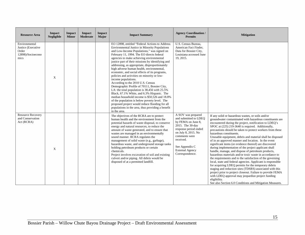
Environmental Justice (Executive Order 12898)/Socioeconomics
X
EO 12898, entitled “Federal Actions to Address Environmental Justice in Minority Populations and Low-Income Populations,” was signed on February 11, 1994. The EO directs federal agencies to make achieving environmental justice part of their missions by identifying and addressing, as appropriate, disproportionately high adverse human health, environmental, economic, and social effects of its programs, policies and activities on minority or low-income populations. According to the 2010 U.S. Census Demographic Profile of 70111, Bossier City, LA: the total population is 38,456 with 25.5% Black, 67.1% White, and 6.3% Hispanic. The median household income is $50,526 and 18.8% of the population is below poverty level. The proposed project would reduce flooding for all populations in the area, thus providing a benefit in the area.
U.S. Census Bureau, American Fact Finder, Data for Bossier City, Louisiana accessed June 19, 2015.
Resource Recovery and Conservation Act (RCRA)
X
The objectives of the RCRA are to protect human health and the environment from the potential hazards of waste disposal, to conserve energy and natural resources, to reduce the amount of waste generated, and to ensure that wastes are managed in an environmentally sound manner. RCRA regulates the management of solid waste (e.g., garbage), hazardous waste, and underground storage tanks holding petroleum products or certain chemicals. Project involves excavation of soil and existing culvert and/or piping. All debris would be disposed of at a permitted landfill.
A SOV was prepared and submitted to LDEQ by FEMA on June 8, 2015. The 30-day response period ended on July 8, 2015. No comments were received. See Appendix C External Agency Correspondence.
If any solid or hazardous wastes, or soils and/or groundwater contaminated with hazardous constituents are encountered during the project, notification to LDEQ’s SPOC at (225) 219-3640 is required. Additionally, precautions should be taken to protect workers from these hazardous constituents. Unusable equipment, debris and material shall be disposed of in an approved manner and location. In the event significant items (or evidence thereof) are discovered during implementation of the project applicant shall handle, manage, and dispose of petroleum products, hazardous materials and/or toxic waste in accordance to the requirements and to the satisfaction of the governing local, state and federal agencies. Applicant is responsible for acquiring LDEQ permits for the temporary debris staging and reduction sites (TDSRS) associated with this project prior to project closeout. Failure to provide FEMA with LDEQ approval may jeopardize project funding eligibility. See also Section 6.0 Conditions and Mitigation Measures.
16 Bossier Parish – Willow Chute Bayou Drainage Project – Draft Environmental Assessment
Resource Area Impact Negligible
Impact Minor
Impact Moderate
Impact Major Impact Summary Agency Coordination /
Permits Mitigation
Noise
X
Noise is commonly defined as unwanted or unwelcome sound, and most commonly measured in decibels (dB) on the A-weighted scale, which is the scale most similar to the range of sounds that the human ear can hear. Sound is federally regulated by the Noise Control Act of 1972, which charges the EPA with preparing guidelines for acceptable ambient noise levels. EPA guidelines, and those of many other federal agencies, state that outdoor sound levels in excess of 55 dB day-night average sound level (DNL) are “normally unacceptable” for noise-sensitive land uses including residences, schools, or hospitals. During the construction period there would be a short-term increase in noise levels.
Bossier Parish Noise Ordinance, Article II, Noise, Section 46-31.
Bossier Parish limits noise levels by receiving land use in residential, public, commercial, and industrial areas to decibel levels of 60 during the “daytime” hours of 6 AM to 10 PM, Monday through Saturday, and 6 AM to 6 PM on Sunday. Construction activities should be limited to this schedule on weekdays. Mitigation and abatement measures will be required to reduce the noise levels to a range that would be considered acceptable. See also Section 6.0 Conditions and Mitigation Measures
Public Safety and Access
X
Congress passed the Occupational and Safety Health Act to ensure worker and workplace safety. The goal was to make sure employers provide their workers a place of employment free from recognized hazards to safety and health, such as exposure to toxic chemicals, excessive noise levels, mechanical dangers, heat or cold stress, or unsanitary conditions. During construction heavy equipment would be located in a populated area. Impacts to public safety and security would be minimized with mitigation measures, including following Occupational Safety and Health Administration (OSHA) regulations.
The contractor must place fencing around the work area perimeters to protect nearby residents from vehicular traffic. To minimize worker and public health and safety risks from project construction and closure, all construction and closure work must be done using qualified personnel trained in the proper use of construction equipment, including all appropriate safety precautions. Additionally, all activities must be conducted in a safe manner in accordance with the standards specified in OSHA regulations and the USACE safety manual. The contractor must post appropriate signage and fencing to minimize potential adverse public safety concerns. See also Section 6.0 Conditions and Mitigation Measures.
Traffic and Transportation
X
Traffic volumes near the respective work access areas would increase temporarily during work activities.
Appropriate signage and barriers should be in place prior to construction activities in order to alert pedestrians and motorists of project activities and traffic pattern changes. The contractor should implement traffic control measures, as necessary. See also Section 6.0 Conditions and Mitigation Measures.
17 Bossier Parish – Willow Chute Bayou Drainage Project – Draft Environmental Assessment
Resource Area Impact Negligible
Impact Minor
Impact Moderate
Impact Major Impact Summary Agency Coordination /
Permits Mitigation
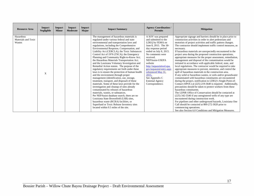
Hazardous Materials and Toxic Wastes
X
The management of hazardous materials is regulated under various federal and state environmental and transportation laws and regulations, including the Comprehensive Environmental Response, Compensation, and Liability Act (CERCLA); the Toxic Substances Control Act of 1976 (TSCA); the Emergency Planning and Community Right-to-Know Act; the Hazardous Materials Transportation Act; and the Louisiana Voluntary Investigation and Remedial Action statute. The purpose of the regulatory requirements set forth under these laws is to ensure the protection of human health and the environment through proper management (identification, use, storage, treatment, transport, and disposal) of these materials. Some of these laws provide for the investigation and cleanup of sites already contaminated by releases of hazardous materials, wastes, or substances. Per NEPAssist database search, there are no Louisiana State Brownfield (LSB) sites, hazardous waste (RCRA) facilities, or Superfund or Toxic Release Inventory sites located within 0.5 miles of the site.
A SOV was prepared and submitted to the LDEQ by FEMA on June 8, 2015. The 30- day response period ended on July 8, 2015. No comments were received. NEPAssist-USEPA website http://nepassisttool.epa.gov/nepassist/entry.aspx referenced May 31, 2015, See Appendix C External Agency Correspondence.
Appropriate signage and barriers should be in place prior to construction activities in order to alert pedestrians and motorists of project activities and traffic pattern changes. The contractor should implement traffic control measures, as necessary. If hazardous materials are unexpectedly encountered in the project area during the proposed construction operations, appropriate measures for the proper assessment, remediation, management and disposal of the contamination would be initiated in accordance with applicable federal, state, and local regulations. The contractor would be required to take appropriate measures to prevent, minimize, and control the spill of hazardous materials in the construction area. If any solid or hazardous wastes, or soils and/or groundwater contaminated with hazardous constituents are encountered during the project, notification to LDEQ’s Single-Point-of-Contact (SPOC) at (225) 219-3640 is required. Additionally, precautions should be taken to protect workers from these hazardous constituents. The LDNR Office of Conservation should be contacted at (225) 342-5540 if any unregistered wells of any type are encountered during construction work. For pipelines and other underground hazards, Louisiana One Call should be contacted at 800-272-3020 prior to commencing operations. See also Section 6.0 Conditions and Mitigation Measures.

18 Bossier Parish – Willow Chute Bayou Drainage Project – Draft Environmental Assessment
4.2 Hydrology and Floodplains The applicant’s consultant, Owen & White, Inc., studied the current hydrology of the existing conditions. The proposed improvements for the Willow Chute Bayou Drainage Project consist of replacing undersized culverts. Based on the hydrologic and hydraulic study (H &H) prepared by Owen & White, Inc., dated May 2009, the proposed drainage improvements will not have any adverse effect on the area and the surrounding environment. The USACE regulates the discharge of dredged or fill material into waters of the U.S., including wetlands, pursuant to Section 404 of the CWA. USACE also regulates the building of any structures in waters of the U.S. pursuant to Section 10 of the RHA. There are no wild and scenic rivers, as designated under the Wild and Scenic Rivers Act (WSRA), in or near the property. Jurisdictional wetlands are defined as those areas that are inundated or saturated by surface or ground water at a frequency and duration sufficient to support, and that under normal circumstances do support, a prevalence of vegetation typically adapted for life in saturated soil conditions. The sites contain riverine wetlands. Jurisdictional wetland determinations are regulated by the USACE pursuant to the CWA. In addition, Executive Order 11990, Protection of Wetlands, directs federal agencies to take actions to minimize the destruction, loss, or degradation of wetlands. No Action Alternative: The No Action alternative would have no effect on wetlands or other waters of the U.S. and would not require permits regulated under Sections 401 or 404 of the CWA, or Section 10 regulated under the RHA. Proposed Action: During construction there is the potential to impact surface waters through minor erosion and runoff. Storm water runoff could carry sediment offsite into the receiving streams or bodies of water. In order to minimize impacts to waters of the U.S., the contractor is required to implement Best Management Practices (BMPs) that meet the LDEQ’s permitting specifications for storm water discharge regulated under Section 402 of the CWA. This includes designing the site with specific construction measures to reduce or eliminate run-off impacts. Any adverse effects to water quality associated with the construction of the projects would be short term and minimized by the measures described above. There would be no long-term effects to water quality because once structures are in place, natural vegetation would re-emerge. FEMA initiated consultation with the USACE on June 8, 2015 regarding potential impacts to waters of the U.S., including wetlands. The response period ended on July 8, 2015. No comments were received. Applicant is required to coordinate with the USACE and LDEQ prior to initiating any construction related activities to secure any necessary permits and/or authorizations.

19 Bossier Parish – Willow Chute Bayou Drainage Project – Draft Environmental Assessment
Any changes or modifications to the proposed project will require a revised determination. Other off-site locations of activities such as borrow, disposals, haul-and detour-roads, and work mobilization site developments may be subject to the Department of the Army regulatory requirements and may impact a Department of Army project. Executive Order (EO) 11988 (Floodplain Management) requires federal agencies to avoid direct or indirect support of development within the 100-year floodplain whenever there is a practicable alternative. A floodplain is defined as the lowland and relatively flat areas adjoining inland and coastal waters, including food-prone areas of off-shore islands, and including at a minimum that area subject to a 1 percent or greater chance of flooding in any given year. FEMA complies with EO 11988 through 44 CFR Part 9, Floodplain Management and Protection of Wetlands. FEMA uses flood insurance rate maps (FIRM) created by the National Flood Insurance program (NFIP). Digital versions of these maps are called DFIRMS. According to the FEMA DFIRM Panel 22015C0315E, dated 03/19/2013, the project area for Kingston Road lies within zone AE (EL 175), the 100-year floodplain with Base Flood Elevation (BFE) determined. The project area is also located within a designated floodway which is the channel of a river or other watercourse where the adjacent land areas must be reserved in order to discharge the base flood without cumulatively increasing the water surface elevation more than a designated height. Communities must regulate development in these floodways to ensure that there are no increases in upstream flood elevations. As per FEMA DFIRM Panel 22015C0401D, dated 09/26/2008, the project area for Lafitte Lane lies within zone X, areas of minimal flood hazard, which are the areas outside the SFHA and higher than the elevation of the 0.2% annual chance flood. The project area for Cross Creek Drive and Wemple Road is located within flood zone A, a SFHA subjected to inundation by the 1% annual chance flood event generally determined using approximate methodologies, no BFE determined, and is found on FEMA DFIRM Panel 22015C0404D, dated 09/26/2008. The Cross Creek Drive/Wemple Road site is located within an undesignated floodway. Floodplain development in undesignated floodways must be reviewed by the community on a case-by-case basis to ensure that increases in water surface elevations do not occur, or identify the need to adopt a floodway if adequate information is available. A copy of the applicable DFIRMs has been included in Appendix E. Per EO 11988, federal agencies proposing activities in a 100-year floodplain must consider alternatives to avoid adverse effects and incompatible development in the floodplain. If no practicable alternative exists to implementing an action in the floodplain, the action must be designed to minimize potential harm to or within the floodplain. A notice must be publically circulated explaining the action and the reasons for implementing an action in a floodplain. When evaluating actions in the floodplain, FEMA utilizes the decision process described in 44 CFR Part 9, referred to as the 8-Step Process. The 8-Step Process ensures that the action is consistent with EO 11988. No Action Alternative: Moderate ongoing impacts to floodplains are anticipated under the No Action Alternative due to localized flooding in an urban residential area and erosional forces and potential contaminants.
20 Bossier Parish – Willow Chute Bayou Drainage Project – Draft Environmental Assessment
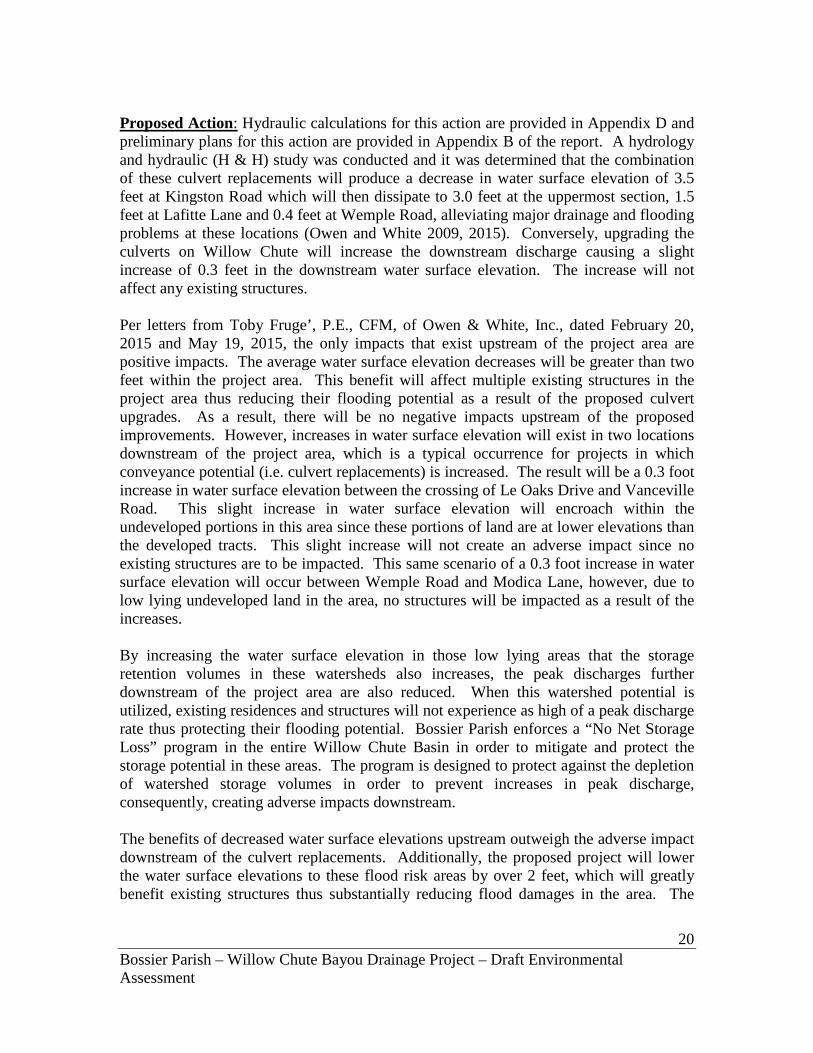
Proposed Action: Hydraulic calculations for this action are provided in Appendix D and preliminary plans for this action are provided in Appendix B of the report. A hydrology and hydraulic (H & H) study was conducted and it was determined that the combination of these culvert replacements will produce a decrease in water surface elevation of 3.5 feet at Kingston Road which will then dissipate to 3.0 feet at the uppermost section, 1.5 feet at Lafitte Lane and 0.4 feet at Wemple Road, alleviating major drainage and flooding problems at these locations (Owen and White 2009, 2015). Conversely, upgrading the culverts on Willow Chute will increase the downstream discharge causing a slight increase of 0.3 feet in the downstream water surface elevation. The increase will not affect any existing structures. Per letters from Toby Fruge’, P.E., CFM, of Owen & White, Inc., dated February 20, 2015 and May 19, 2015, the only impacts that exist upstream of the project area are positive impacts. The average water surface elevation decreases will be greater than two feet within the project area. This benefit will affect multiple existing structures in the project area thus reducing their flooding potential as a result of the proposed culvert upgrades. As a result, there will be no negative impacts upstream of the proposed improvements. However, increases in water surface elevation will exist in two locations downstream of the project area, which is a typical occurrence for projects in which conveyance potential (i.e. culvert replacements) is increased. The result will be a 0.3 foot increase in water surface elevation between the crossing of Le Oaks Drive and Vanceville Road. This slight increase in water surface elevation will encroach within the undeveloped portions in this area since these portions of land are at lower elevations than the developed tracts. This slight increase will not create an adverse impact since no existing structures are to be impacted. This same scenario of a 0.3 foot increase in water surface elevation will occur between Wemple Road and Modica Lane, however, due to low lying undeveloped land in the area, no structures will be impacted as a result of the increases. By increasing the water surface elevation in those low lying areas that the storage retention volumes in these watersheds also increases, the peak discharges further downstream of the project area are also reduced. When this watershed potential is utilized, existing residences and structures will not experience as high of a peak discharge rate thus protecting their flooding potential. Bossier Parish enforces a “No Net Storage Loss” program in the entire Willow Chute Basin in order to mitigate and protect the storage potential in these areas. The program is designed to protect against the depletion of watershed storage volumes in order to prevent increases in peak discharge, consequently, creating adverse impacts downstream. The benefits of decreased water surface elevations upstream outweigh the adverse impact downstream of the culvert replacements. Additionally, the proposed project will lower the water surface elevations to these flood risk areas by over 2 feet, which will greatly benefit existing structures thus substantially reducing flood damages in the area. The

21 Bossier Parish – Willow Chute Bayou Drainage Project – Draft Environmental Assessment
proposed improvements, with the help of the Parish’s Floodplain Storage Mitigation Program, will not create an adverse impact downstream of the project area. In accordance with EO 11988 (Floodplain Management) and EO 11990 (Wetland Protection), an 8 Step-Process assessment was prepared by FEMA to evaluate the impacts related to the construction of the Proposed Action within the 100-year floodplain (Appendix E). The 8-Step Process reviewed practicable alternatives, identified direct and indirect impacts, minimization and mitigation of impacts, and provided an evaluation of the Proposed Action’s location within the floodplain. Based on the 8-Step Process evaluation, FEMA has determined that no other practicable alternative to the Proposed Action would meet the purpose and need of the project. Per the Willow Chute 100-Year Culvert Replacement Comparison prepared by Owen & White, Inc., dated June 2015, the results of the post culvert replacement analysis conclude that the BFEs are not increased by more than 0.16 feet in any location within the zone A SFHA as a result of the proposed improvements. Therefore, 100-year water surface elevations will not increase by more than one foot in the area with an undesignated floodway and the proposed action complies with the 44 CFR 9.11(d) (4) regulation. Also, the associated H & H analysis concludes that water surface elevation increases do not exist as a result of the proposed improvements within the designated floodway. Thus, the project will be in compliance with 44 CFR 9.11 (d) (4). No significant direct impact would occur to floodplains under the Proposed Action; however, indirect short-term impacts to the surrounding area could occur during construction. Construction BMPs will be included into the daily construction activities. Other conditions found in Section 6.0 Conditions intended to protect floodplains and hydrology is as follows: The project area must be kept cleared so as not to interfere with floodplain functions. Per 44 CFR 9.11(d)(6), no project should be built to a floodplain management standard that is less protective than what the community has adopted in local ordinances through their participation in the National Flood Insurance Program. New construction must be compliant with current codes and standards. Per 44 CFR 9.11(d) (4) Until a regulatory floodway is designated, no new construction, substantial improvements, or other development (including fill) shall be permitted within the base floodplain unless it is demonstrated that the cumulative effect of the proposed development, when combined with all other existing and anticipated development, will not increase the water surface elevation of the base flood more than one (1) foot at any point within the community. Per 44 CFR 9.11(d)(4) There shall be no encroachments, including fill, new construction, substantial improvements of structures or facilities, or other development within a
22 Bossier Parish – Willow Chute Bayou Drainage Project – Draft Environmental Assessment
designated regulatory floodway that would result in any increase in flood levels within the community during the occurrence of the base flood discharge. The applicant is required to coordinate with the local floodplain administrator regarding floodplain permit(s) prior to the start of any activities. All correspondence must be submitted to FEMA and FEMA-EHP for inclusion in the project files. Should the site plans (including drainage design) change the applicant must submit changes to FEMA-EHP for review and approval prior to the start of construction. In addition, the construction contractor must contact the LDEQ to determine if a LPDES permit is required, and if applicable, implement a stormwater pollution prevention plan (SWPPP). The construction contractor would therefore be required to follow all stipulations in the LPDES permit and all applicable BMPs noted in the permit. Nonpoint source pollution must be controlled during all construction activities. BMPs outlined in the plan would reduce the potential of soils, oil and grease, and construction debris to enter into local watersheds including floodplains. 4.3 Cultural Resources 4.3.1 Regulatory Setting The consideration of impacts to historic and cultural resources is mandated under Section 101(b) 4 of the NEPA as implemented by 40 CFR Part 1501-1508. Section 106 of the NHPA requires Federal agencies to take into account their effects on historic properties (i.e. historic and cultural resources) and allow the Advisory Council on Historic Preservation (ACHP) an opportunity to comment. FEMA has chosen to address potential impacts to historic properties through the “Section 106 consultation process” of NHPA as implemented through 36 CFR Part 800. In order to fulfill its Section 106 responsibilities, FEMA has initiated consultation on this project in accordance with the LA HMGP PA dated January 31, 2011, between the Louisiana SHPO, the Louisiana GOHSEP, the Alabama-Coushatta Tribe of Texas, the Chitimacha Tribe of Louisiana, the Choctaw Nation of Oklahoma, Choctaw Nation of Oklahoma, the Jena Band of Choctaw Indians, the Mississippi Band of Choctaw Indians, the Seminole Tribe of Florida, and the Advisory Council on Historic Preservation (http://www.fema.gov/pdf/hazard/hurricane/2005katrina/LA_HMGP%20PA.pdf). The PA was created to streamline the Section 106 review process. The “Section 106 process” outlined in the LA HMGP PA requires the identification of historic properties that may be affected by the proposed action or alternatives within the project’s APE. Historic properties, defined in Section 101(a)(1)(A) of NHPA, include districts, sites (archaeological and religious/cultural), buildings, structures, and objects that are listed in or determined eligible for listing in the NRHP. Historic properties are identified by qualified agency representatives in consultation with interested parties. Below is a consideration of various alternatives and their effects on historic properties.

23 Bossier Parish – Willow Chute Bayou Drainage Project – Draft Environmental Assessment
4.3.2 Existing Conditions On June 1, 2015, FEMA Historic Preservation Staff plotted the three (3) proposed Willow Chute Bayou Drainage Project locations against various data sets: the NRHP database, the Louisiana Division of Archaeology (LDOA), Louisiana Cultural Resources Map (LDOA Website), and historic aerial photography. Map research reviewed for each elevation property included the following reference materials: USDA Web Soil Survey, U.S. Geological Survey (USGS) Quadrangle Maps, and other available historic maps. Additional background information consulted included: the Louisiana Cultural Resources Management (CRM) Bibliography (LDOA Website), LDOA Site Forms, and pertinent site and survey reports regarding previous investigations within 1-mile (1.6 km) of each archaeological APE. Additionally, a site visit was conducted on June 08, 2015, at each of the three (3) project locations to determine potential impacts to historic properties, if any. FEMA verified that none of the proposed Willow Chute Bayou Drainage project areas are located within a listed historic district nor are they located within view-shed of a property individually listed in the NRHP. Additionally, FEMA has determined that that no previously recorded archaeological sites fell within any of the three (3) project areas. An additional post-field review of background data and construction documents was also conducted while taking into consideration the existing conditions observed during the June 08, 2015 site visits to each of the three (3) APEs. As well as reviewing, the results of previous surveys, effects of past episodes of construction and sub-surface ground disturbance (e.g., utilities, construction of the existing right-of-ways/culverts/crossings), landscape alteration, and modern development. All of this was taken into account and weighted against the potential impacts of each individual proposed project action (e.g., new culvert diameters, site access, and existing hardscape). 5.0 CUMULATIVE IMPACTS The CEQ’s regulations state that cumulative impacts represent the “impact on the environment which results from the incremental impact of the action when added to other past, present, and reasonably foreseeable future actions, regardless of what agency (Federal or non-Federal) or person undertakes such other actions.” Cumulative impacts can result from individually minor but collectively significant actions taking place over a period of time (40 C.F.R. § 1508.7). In its comprehensive guidance on cumulative impacts analysis under NEPA, the CEQ notes that: “[t]he range of actions that must be considered includes not only the project proposal, but all connected and similar actions that could contribute to cumulative effects” (CEQ, 1997). The term “similar actions” may be defined as “reasonably foreseeable or proposed agency actions [with] similarities that provide a basis for evaluating the environmental consequences together, such as common timing or geography” (40 C.F.R. § 1508.25[a][3]; see also 40 C.F.R. §§ 1508.25[a][2] and [c]). Not all potential issues identified during cumulative effects scoping need be included in an EA. Because some effects may be irrelevant or inconsequential to decisions about the

24 Bossier Parish – Willow Chute Bayou Drainage Project – Draft Environmental Assessment
proposed action and the alternative, the focus of the cumulative effects analysis should be narrowed to important issues of national, regional, or local significance. To assist agencies in this narrowing process, CEQ lists seven (7) basic questions, including: (1) is the proposed action one of several similar past, present, or future actions in the same geographic area?; (2) do other activities (governmental or private) in the region have environmental effects similar to those of the proposed action?; (3) have any recent or ongoing NEPA analyses of similar actions or nearby actions identified important adverse or beneficial cumulative effect issues?; and, (4) has the impact been historically significant, such that the importance of the resource is defined by past loss, past gain, or investments to restore resources? (CEQ, 1997) It is normally insufficient when analyzing the contribution of a proposed action to cumulative effects to merely analyze effects within the immediate area of the proposed action (CEQ, 1997, pg. 12). Geographic boundaries should be expanded for cumulative effects analysis, and conducted on the scale of human communities, landscapes, watersheds, or airsheds. Temporal frames should be extended to encompass additional effects on the resources, ecosystems, and human communities of concern. A useful concept in determining appropriate geographic boundaries for a cumulative effects analysis is the project impact zone; that is, the area (and resources within that area) that could be affected by the proposed action. The area appropriate for analysis of cumulative effects will, in most instances, be a larger geographic area occupied by resources outside of the project impact zone. The proposed project sites are within the Willow Chute Basin and are located at Kingston Road at Willow Chute Bayou between LA 3 and Airline Road (Latitude 32.629978, Longitude -93.728678), Lafitte Lane between LA 3 and Audubon Drive (Latitude 32.611406, Longitude -93.726917), and Cross Creek Drive at the entrance to Lakewood Subdivision (Latitude 32.590028, Longitude -93.705703). The project boundary is defined by LA 3 to the west, Kingston Road to the north, Lakewood Point Drive to the east, and Cross Creek Drive to the south and includes approximately 240 residences. FEMA has determined that the area within the 4,480 acres (7 square miles) constitutes an appropriate project impact zone, and the larger geographic area consisting of the 70111 zip code constitutes an appropriate boundary for a cumulative impact analysis of the proposed action and the alternatives. In accordance with NEPA, and to the extent reasonable and practicable, this EA considered the combined effects of the Proposed Action Alternative, as well as other actions undertaken by FEMA and other public and private entities that also affect environmental resources the proposed action would affect, and that occur within the considered geographic area and temporal frame(s). Specifically, a range of past, present, and reasonably foreseeable actions undertaken by FEMA within the designated geographic boundary area were reviewed: (1) for similarities such as scope of work, common timing, and geography; (2) to determine environmental effects similar to those of the proposed action, if any; and (3) to identify

25 Bossier Parish – Willow Chute Bayou Drainage Project – Draft Environmental Assessment
the potential for cumulative impacts. As part of the cumulative effects analysis, FEMA also reviewed known past, present, and reasonably foreseeable projects of Federal resource agencies and other parties within the designated geographic boundary. These reviews were performed in order to assess past proposed actions, as well as the effects of completed and ongoing actions in order to determine whether the incremental impacts of the current proposed action, when combined with the effects of other past, present, and reasonably foreseeable future projects, are cumulatively considerable or significant. From August 2005 continuing to July 2015, within the 70111 geographic area, numerous Public Assistance and HMGP program funded, and numerous non-FEMA funded, debris removal, protective measures, mitigation, and repair projects have occurred, are occurring, or are reasonably foreseen to occur (developed with enough specificity to provide useful information to a decision maker and the interested public) to buildings, roads and bridges, recreational and educational facilities, public utilities, waterways, and more. All FEMA funded actions are subject to various levels of environmental review as a requirement for the receipt of Federal funding. An applicant’s failure to comply with any required environmental permitting or other condition is a serious violation which can result in the loss of Federal assistance, including funding. FEMA has determined that the incremental effects of the other infrastructure recovery and improvement actions are likely to be similar to the impacts and effects this EA previously described for the present proposed action, in that the effects to socioeconomic resources are expected to be beneficial, and effects to other resources expected to be either non-existent or minimal and temporary. FEMA has further determined that the incremental impact of the present proposed project, when combined with the effects of other past, present, and reasonably foreseeable future projects, is neither cumulatively considerable nor significant. These infrastructure actions, some of which have already occurred, and many of which will occur concurrent with and/or subsequent to the proposed action, are necessary as a result of the unprecedented devastation caused by the 2005 hurricanes, both Katrina and Rita, in order to restore pre-disaster conditions. Considered in relation to past, present, and reasonably foreseeable future actions, the cumulative impact of the proposed action to the built and natural environment would be minimal, beneficial rather than detrimental, and is not expected to contribute to any adverse effects or to otherwise significantly affect the human environment. 6.0 CONDITIONS AND MITIGATION MEASURES
• Implement construction Best Management Practices (BMPs); install silt fences/straw bales to reduce downslope sedimentation. Area soils must be covered and/or wetted during construction.
• If fill is stored on site as part of unit installation or removal, the contractor is
required to appropriately cover it.

26 Bossier Parish – Willow Chute Bayou Drainage Project – Draft Environmental Assessment
• Construction contractor is required to obtain applicable Louisiana Pollutant
Discharge Elimination System (LPDES) permit, and implement stormwater pollution prevention plan.
• The applicant is required to coordinate with the local floodplain administrator
regarding floodplain permit(s) prior to the start of any activities. • New construction must be compliant with current codes and standards.
• As per 44 CFR 9.11 (d)(9), mitigation or minimization standards must be
applied, where possible. The replacement of building contents, materials and equipment should be, where possible, wet or dry-proofed, elevated, or relocated to or above the DFIRM BFE or local floodplain ordinances, whichever is more stringent.
• Per 44 CFR 9.11(d)(4) Until a regulatory floodway is designated, no new construction, substantial improvements, or other development (including fill) shall be permitted within the base floodplain unless it is demonstrated that the cumulative effect of the proposed development, when combined with all other existing and anticipated development, will not increase the water surface elevation of the base flood more than one (1) foot at any point within the community.
• Per 44 CFR 9.11(d)(4)There shall be no encroachments, including fill, new construction, substantial improvements of structures or facilities, or other development within a designated regulatory floodway that would result in any increase in flood levels within the community during the occurrence of the base flood discharge.
• All coordination pertaining to these activities and applicant compliance with any
conditions should be documented and copies forwarded to the state and FEMA for inclusion in the permanent project files.
• Any changes or modifications to the proposed project will require a revised
determination. Off-site locations of activities such as borrow, disposals, haul- and detour roads, and work mobilization site developments may be subject to USACE regulatory requirements.
• Applicant must coordinate with USACE prior to the start of construction to acquire any necessary permits and/or authorizations.

27 Bossier Parish – Willow Chute Bayou Drainage Project – Draft Environmental Assessment
• Applicant must coordinate with USACE at the Vicksburg District Office to verify if jurisdictional waters of the U.S. do occur on site and which permits, if any, are required.
• The project results in a discharge to waters of the State; submittal of a Louisiana Pollutant Discharge Elimination System LPDES application is necessary.
• Applicant must coordinate with LDEQ prior to the start of construction to acquire any necessary permits and/or authorizations.
• All precautions must be observed to control nonpoint source pollution from construction activities. LDEQ has stormwater general permits for construction areas equal to or greater than one (1) acre. The applicant must contact the LDEQ Water Permits Division at (225) 219-9371 to determine if the proposed project requires a permit.
• Erosion Control Devices (ECD’s) must be used and maintained extensively to prevent any potential direct or indirect adverse impacts to nearby wetland areas per the CWA and EO 11990. Any adverse impacts to adjacent wetlands resulting from the construction of this project will jeopardize receipt of federal funding.
• If any solid or hazardous wastes, or soils and/or groundwater contaminated with hazardous constituents are encountered during the project, notification to LDEQ’s Single-Point-of-Contact (SPOC) at (225) 219-3640 is required. Additionally, precautions must be taken to protect workers from these hazardous constituents.
• The contractor must observe all precautions to protect the groundwater of the region.
• All debris should be disposed of in an approved landfill.
• The applicant is responsible for coordinating with and obtaining any required permit(s) from the LDNR Coastal Management Division prior to initiating work. The applicant shall comply with all conditions of the required permit. All coordination pertaining to these activities and applicant compliance with any conditions should be documented and copies forwarded to the state and FEMA for inclusion in the permanent project files.
• Vehicle operation times would be kept to a minimum. Area soils must be covered and/or wetted during construction to minimize dust.

28 Bossier Parish – Willow Chute Bayou Drainage Project – Draft Environmental Assessment
• Any changes to the scope or location of the proposed project or if the project has not been initiated one (1) year from the date of the solicitation of views (June 8, 2016), the applicant is responsible for coordinating with United States Fish and Wildlife Service.
• If during the course of work, archaeological artifacts (prehistoric or historic) are
discovered, the applicant shall stop work in the vicinity of the discovery and take all reasonable measures to avoid or minimize harm to the finds. The applicant shall inform their, GOSHEP State Applicant Liaison and Hazard Mitigation Assistance contacts at FEMA, who will in turn contact FEMA Historic Preservation (HP) staff. The applicant will not proceed with work until FEMA HP completes consultation with the SHPO, and others as appropriate (Inadvertent Discovery Clause).
• If human bone or unmarked grave(s) are present within the project area, compliance with the Louisiana Unmarked Human Burial Sites Preservation Act (R.S. 8:671 et seq.) is required. The applicant shall notify the law enforcement agency of the jurisdiction where the remains are located within twenty-four hours of the discovery. The applicant shall also notify FEMA and the Louisiana Division of Archaeology at 225-342-8170 within seventy-two hours of the discovery. (Louisiana Unmarked Human Burial Sites Preservation Act)
• Unusable equipment, debris and material shall be disposed of in an approved manner and location. In the event significant items (or evidence thereof) are discovered during implementation of the project applicant shall handle, manage, and dispose of petroleum products, hazardous materials and/or toxic waste in accordance to the requirements and to the satisfaction of the governing local, state and federal agencies. Applicant is responsible for acquiring LDEQ permits for the temporary debris staging and reduction sites (TDSRS) associated with this project prior to project closeout. Failure to provide FEMA with LDEQ approval may jeopardize project funding eligibility.
• Bossier Parish limits noise levels by receiving land use in residential, public, commercial, and industrial areas to decibel levels of 60 during the “daytime” hours of 6 AM to 10 PM, Monday through Saturday, and 6 AM to 6 PM on Sunday. Construction activities should be limited to this schedule on weekdays. Mitigation and abatement measures will be required to reduce the noise levels to a range that would be considered acceptable.
• To minimize worker and public health and safety risks from project construction and closure, all construction and closure work must be done using qualified personnel trained in the proper use of construction equipment, including all appropriate safety precautions. Additionally, all activities must be conducted in a safe manner in accordance with the standards specified in OSHA regulations and the USACE safety manual.

29 Bossier Parish – Willow Chute Bayou Drainage Project – Draft Environmental Assessment
• The contractor must post appropriate signage and fencing to minimize potential
adverse public safety concerns, and to protect nearby residents from vehicular traffic.
• Appropriate signage and barriers should be in place prior to construction activities in order to alert pedestrians and motorists of project activities and traffic pattern changes.
• The contractor should implement traffic control measures, as necessary.
• If hazardous materials are unexpectedly encountered in the project area during the proposed construction operations, appropriate measures for the proper assessment, remediation, management and disposal of the contamination would be initiated in accordance with applicable federal, state, and local regulations. The contractor would be required to take appropriate measures to prevent, minimize, and control the spill of hazardous materials in the construction area.
• The LDNR Office of Conservation should be contacted at (225) 342-5540 if any unregistered wells of any type are encountered during construction work.
• For pipelines and other underground hazards, Louisiana One Call should be contacted at 800-272-3020 prior to commencing operations.
Failure to comply with these conditions may make part or all of these projects ineligible for FEMA funding. 7.0 AGENCY COORDINATION AND PUBLIC INVOLVEMENT
7.1 Agency Coordination As part of the development of this EA, federal, state and local agencies were contacted. All initial Solicitation of Views letters and the respective responses from these agencies are included in Appendix C External Agency Correspondence. The following agencies were contacted and asked to review the proposed project and include federal, state and local agencies as listed below: Federal
• U.S. Department of Agriculture (USDA) • U.S. Environmental Protection Agency (EPA) • U.S. Army Corps of Engineers (USACE) • U.S. Fish and Wildlife (USFWS)
State
30 Bossier Parish – Willow Chute Bayou Drainage Project – Draft Environmental Assessment
• State Historic Preservation Officer (SHPO) • Louisiana Department of Wildlife and Fisheries (LDWF) • Louisiana Department of Environmental Quality (LDEQ) • Louisiana Department of Natural Resources (LDNR)
7.2 Public Involvement The Draft EA has been made available for public review and comment for a period of 30 days. Per FEMA requirements, a public notice will be published in The Bossier Press-Tribune, on Wednesday, July 15, and Wednesday, July 22, 2015. This public notice will also run in The Shreveport Times Monday, July 13 through Friday, July 17, 2015 to alert the public that the Draft EA is available for review. There will be a 15 day comment period beginning on July 13, 2015 and concluding on July 28, 2015 at 4 p.m. Additionally, the Environmental Assessment was made available at the Bossier Parish Central Library. The Environmental Assessment was published on FEMA’s website. A copy of the Public Notice is attached in Appendix E. Once the public comment period for the Draft EA is completed, comments will be addressed and incorporated into the Final EA as an appendix. Copies of proofs of publication will also be included in this appendix. If no comments are received, revisions to finalize the EA include updating the date of the Final EA and updating the Public Involvement section of the EA. 8.0 CONCLUSION Construction of the proposed improvements at the proposed location was analyzed based on the studies, consultations, and reviews undertaken as reported in this draft EA. The findings of this EA conclude that the proposed action at the proposed site would result in no significant adverse impacts to geology, groundwater, floodplains, public health and safety, hazardous materials, socioeconomic resources, environmental justice, or cultural resources are anticipated under the Proposed Action Alternative. During project construction, short-term impacts to soils, surface water, transportation, air quality, and noise are anticipated and conditions have been incorporated to mitigate and minimize the effects. Project short-term adverse impacts would be mitigated using BMPs, such as silt fences, proper vehicle and equipment maintenance, and appropriate signage. No long-term adverse impacts are anticipated from the proposed project. Therefore, FEMA presently finds the proposed action meets the requirements for a Finding of No Significant Impacts (FONSI) under NEPA and the preparation of an EIS will not be required. If new information is received that indicates there may be significant adverse effects, then FEMA would revise the findings and issue a second public notice, for additional comments. However, if there are no changes, this Draft EA will become the Final EA.

31 Bossier Parish – Willow Chute Bayou Drainage Project – Draft Environmental Assessment
Based upon the studies and consultations undertaken in this environmental assessment, and given the precautionary and mitigating measures, there does not appear to be any significant environmental impacts associated with the Willow Chute Bayou Drainage Project. 9.0 REFERENCES Coyle Engineering Co. Inc. Site Plans for HMGP Drainage Project along Willow Chute Bayou at Kingston Road, Lafitte Lane, and Crosscreek Drive. November 4, 2014. Environmental Protection Agency. Enviromapper.
[Online]: http://www.epa.gov/enviro/katrina/emkatrina.html Environmental Protection Agency. 2006. Nonattainment Status for each Parish by year.
[Online]: http://www.epa.gov/oar/oaqps/greenbk/anay.html Environmental Protection Agency. Brownfields.
[Online]: http://oaspub.epa.gov/enviro/bms_report.get_list?juris_value=&juris_search_type=Beginning+With&juris_type_label=-1&state_code=LA&zip_code=&proj_value=&proj_search_type=Beginning+With&rec_value=&rec_search_type=Beginning+With&cfda_type=NULL&CFDA_ID=&prop_value=&prop_search_type=Beginning+With&propaddr_name=&propcity_name=&propstate_code=LA
Environmental Protection Agency. Envirofacts. [Online]: http://www.epa.gov/enviro/ Girard, Jeffrey S. 1993. Regional Archaeology Program, Management Unit 1: Fourth
Annual Report. Northwestern State University (Report No. 22-1722). Report on file at the Division of Archaeology, Louisiana Department of Culture, Recreation and Tourism, Baton Rouge.
Heartfield, Lorraine and G.R. Dennis Price. A Cultural Background Review of a Portion
of the Cypress-Black Watershed, Bossier Parish, Louisiana. Northeast Louisiana University (Report No. 22-0107). Report on file at the Division of Archaeology, Louisiana Department of Culture, Recreation and Tourism, Baton Rouge.
Louisiana Department of Environmental Quality. Air quality data. [Online]:
http://www.deq.louisiana.gov/portal/tabid/37/Default.aspx?Search =non-attainment+areas
Louisiana Department of Environmental Quality. Authorized Debris Sites (updated
4/23/09). [Online]: http://159.39.17.27/Debris_Sites/
32 Bossier Parish – Willow Chute Bayou Drainage Project – Draft Environmental Assessment
Louisiana Department of Environmental Quality. Electronic Document Management System. [Online]: http://www.deq.louisiana.gov/portal/tabid/2604/Default.aspx
Louisiana Department of Environmental Quality. Louisiana Department of Environmental Quality. Louisiana State Brownfields List.
[Online]: http://www.deq.louisiana.gov/portal/tabid/2620/Default.aspx Louisiana Department of Environmental Quality. Voluntary Remediation Program List.
[Online]: http://www.deq.louisiana.gov/portal/Portals/0/RemediationServices/VRP/form_5226_current.pdf
Louisiana Department of Natural Resources. SONRIS Integrated Applications.
[Online]: http://sonris-www.dnr.state.la.us/www_root/sonris_portal_1.htm National Oceanic and Atmospheric Administration. Coastal Barrier Resources Act. [Online] Available: http://www.csc.noaa.gov/cmfp/reference /Coastal_Barrier _Resources_Act.htm Owen & White Consulting Engineers, Inc. Hydraulics and Hydrology Study (H &H) prepared May 2009, Theodore E. DeBaene, P.E. Owen & White Consulting Engineers, Inc. Willow Chute 100-Year Culvert Replacement Comparison prepared June 2015, Toby Fruge’, P.E. Providence Engineering and Environmental Group LLC. Bossier Parish Hazard Mitigation Plan (HMP) Update. June 2011. U.S. Census Bureau. 2010 Census Data for Bossier City, Louisiana. [Online]:
http://factfinder.census.gov/faces/tableservices/jsf/pages/productview.xhtml?src=CF
U.S. Fish and Wildlife Service. Endangered species data. [Online] Available: http://www. fws.gov/endangered/ 10.0 LIST OF PREPARERS
Tiffany Spann-Winfield, Deputy Environmental Liaison Officer Jamie Schexnayder, Environmental Protection Specialist Jeremiah Kaplan, Historic Preservation Specialist/Archaeologist LeSchina Holmes, Lead Environmental Specialist Melanie Pitts, Lead Environmental Specialist

APPENDIX A
SITE PHOTOS

Photo 1. Overview facing north at Kingston Road and Willow Chute Bayou between LA 3 and Airline Road. Latitude 32.629978, Longitude -93.728678
Photo 2. Overview of site facing south on Kingston Road.
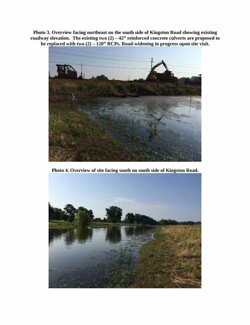
Photo 3. Overview facing northeast on the south side of Kingston Road showing existing roadway elevation. The existing two (2) – 42” reinforced concrete culverts are proposed to
be replaced with two (2) – 120” RCPs. Road-widening in progress upon site visit.
Photo 4. Overview of site facing south on south side of Kingston Road.
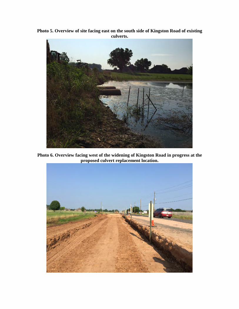
Photo 5. Overview of site facing east on the south side of Kingston Road of existing culverts.
Photo 6. Overview facing west of the widening of Kingston Road in progress at the proposed culvert replacement location.

Photo 7. Overview facing north on north side of Lafitte Lane. Latitude 32.611406, Longitude -93.726917
Photo 8. Overview facing north on north side of Lafitte Lane.
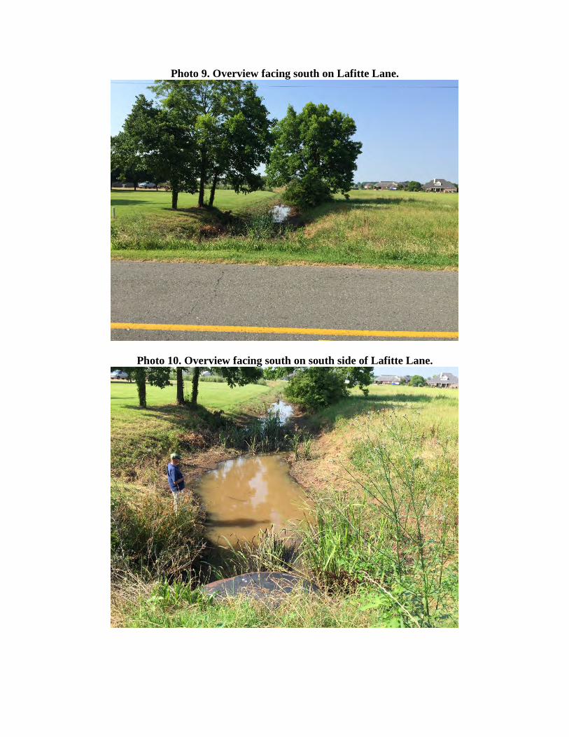
Photo 9. Overview facing south on Lafitte Lane.
Photo 10. Overview facing south on south side of Lafitte Lane.
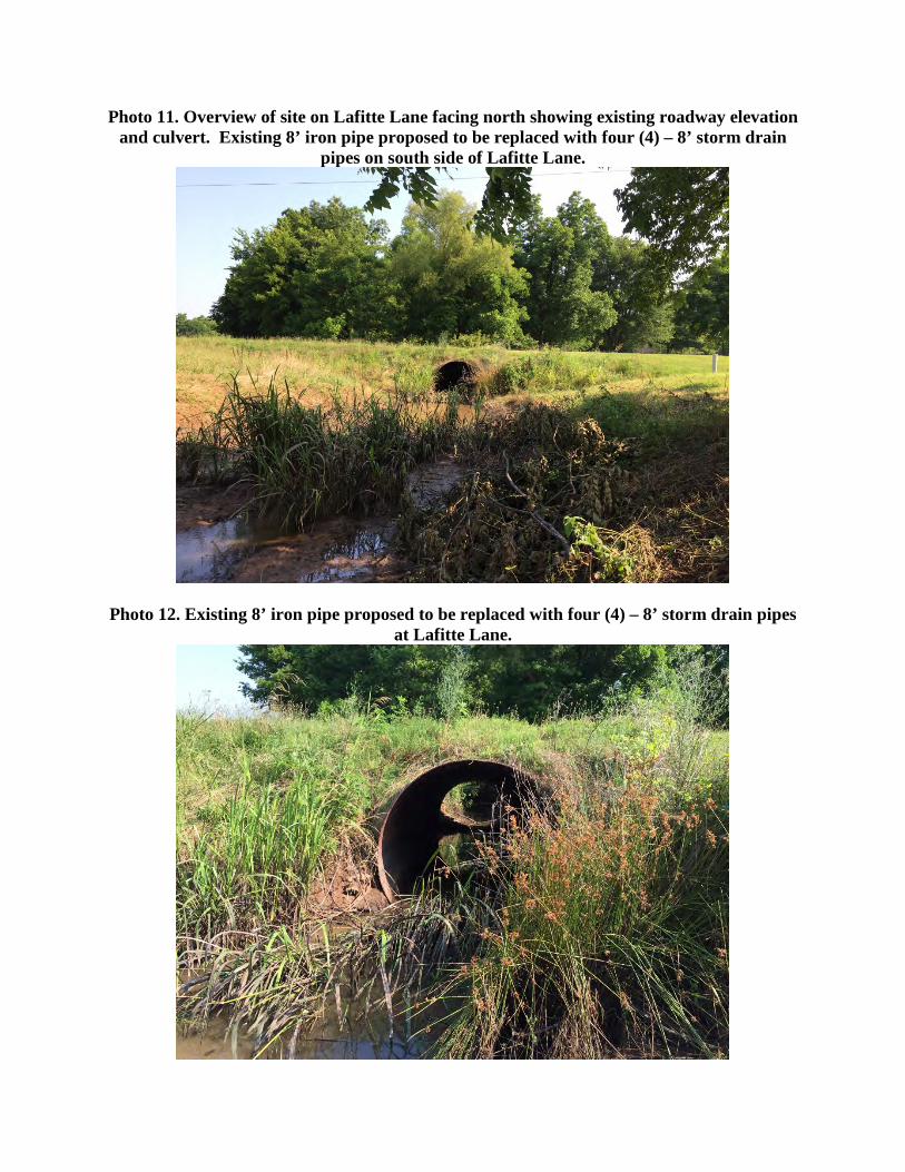
Photo 11. Overview of site on Lafitte Lane facing north showing existing roadway elevation and culvert. Existing 8’ iron pipe proposed to be replaced with four (4) – 8’ storm drain
pipes on south side of Lafitte Lane.
Photo 12. Existing 8’ iron pipe proposed to be replaced with four (4) – 8’ storm drain pipes at Lafitte Lane.
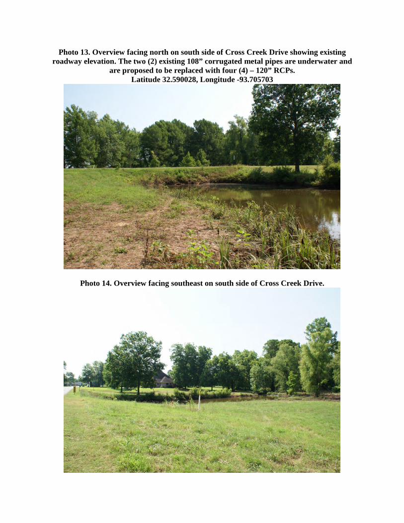
Photo 13. Overview facing north on south side of Cross Creek Drive showing existing roadway elevation. The two (2) existing 108” corrugated metal pipes are underwater and
are proposed to be replaced with four (4) – 120” RCPs. Latitude 32.590028, Longitude -93.705703
Photo 14. Overview facing southeast on south side of Cross Creek Drive.

Photo 15. Overview facing southeast on north side of Cross Creek Drive showing existing roadway elevation. The two (2) existing 108” corrugated metal pipes are underwater and
are proposed to be replaced with four (4) – 120” RCPs.
Photo 16. Overview facing northeast on north side of Cross Creek Drive.
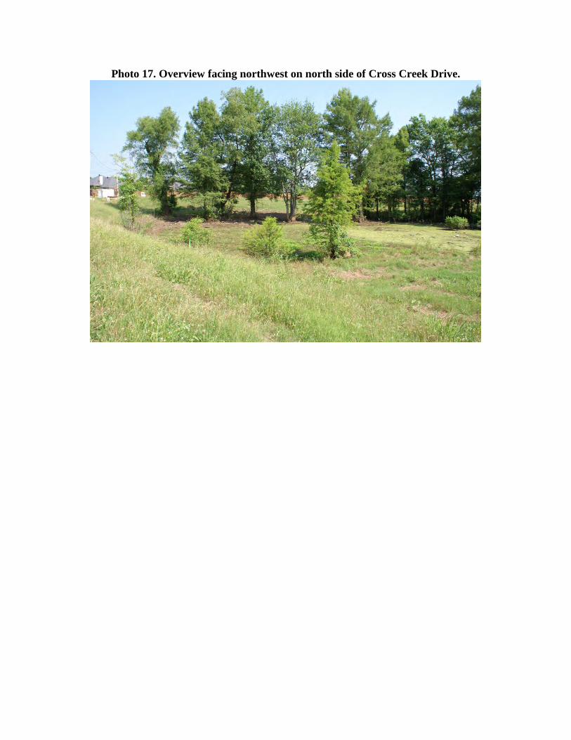
Photo 17. Overview facing northwest on north side of Cross Creek Drive.

APPENDIX B
SITE PLAN DRAWINGS
FOR PREFERRED ALTERNATIVE
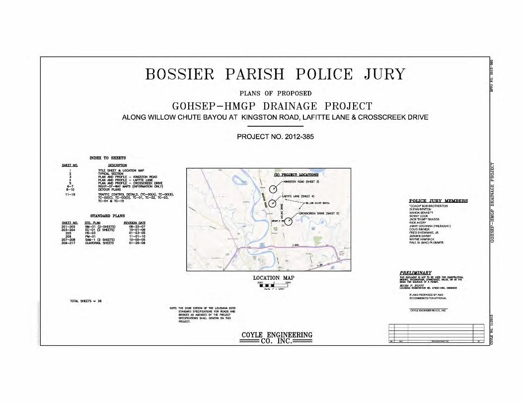
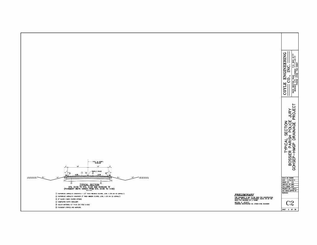
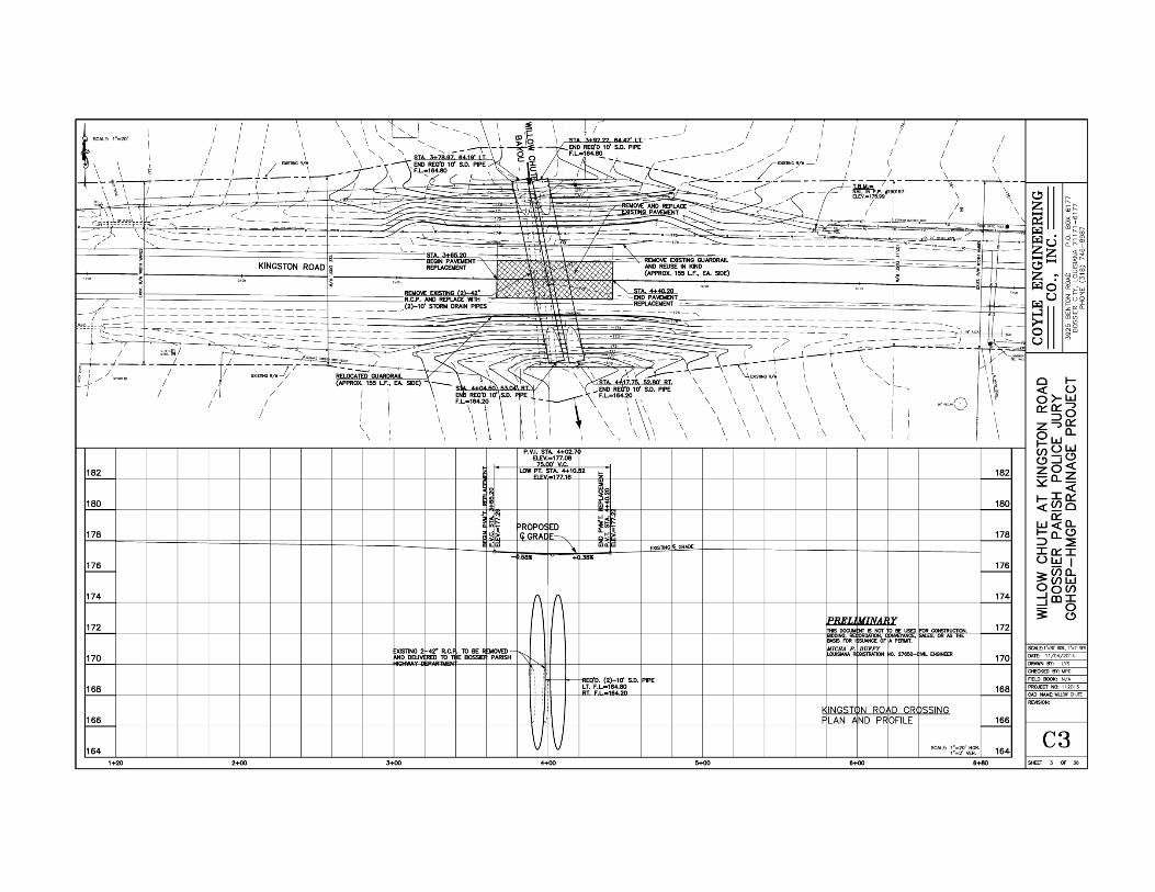


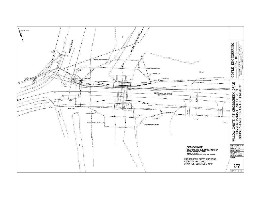
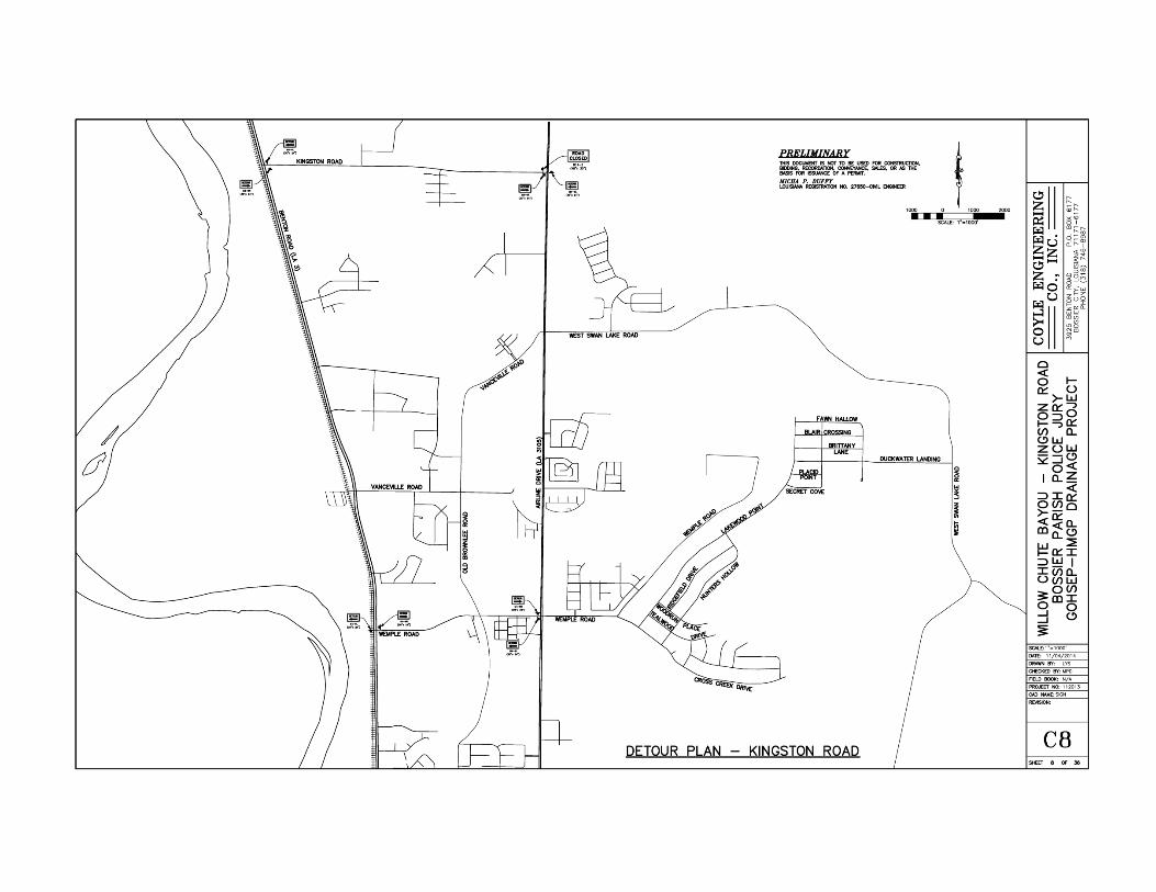


APPENDIX C
EXTERNAL AGENCY CORRESPONDENCE

From: Pitts, Melanie To: [email protected]; [email protected]; Raul Gutierrez <[email protected]>
([email protected]); [email protected]; [email protected] Cc: Spann, Tiffany; Schexnayder, Jamie; Holmes, Leschina Subject: Request for Solicitation of Views (SOV) for HMGP# 1603-0349 Willow Chute Bayou Drainage Date: Monday, June 08, 2015 4:16:21 PM Attachments: image001.png
image002.png Willow Chute Bayou Drainage Project SOV Consultation Information.pdf Design-and-Plans-for-Willow-Chute-Draiange-01-27-2015-35991-28859[1].pdf
Importance: High
Security U.S. Department of Homeland
June 8, 2015 Federal Emergency Management Agency
70802
FEMA-DR 1603/1607 LA Louisiana Recovery Office 1500 Main St., Baton Rouge, LA
MEMORANDUM TO: See Distribution
SUBJECT: Scoping Notification/Solicitation of Views
Bossier Parish Police Jury, Willow Chute Bayou Drainage Project, HMGP# 1603- 0349, FEMA-1603-DR-LA
To Whom It May Concern: The Department of Homeland Security’s Federal Emergency Management Agency (FEMA) is mandated by the U.S. Congress to administer Federal disaster assistance pursuant to the Robert T. Stafford Disaster Relief and Emergency Assistance Act (Stafford Act), PL 93-288, as amended. Section 404 and Section 406 of the Stafford Act authorizes FEMA’s Hazard Mitigation Program to provide funds to states and local governments to implement long-term hazard mitigation measures after a major disaster declaration. FEMA is considering providing Hazard Mitigation Grant Program funding for the attached project in relation to Hurricanes Katrina and Rita (FEMA-1603/1607-DR-LA).
Please review the attached project description to determine whether your office has any objections to the proposed project and whether any permits from your office would need to be obtained. The applicant is the Bossier Parish Police Jury.

This project is the applicant’s request to replace three (3) existing culverts in the Willow Chute Drainage Basin in Bossier Parish, Louisiana, to prevent potential flooding of residential subdivisions in the Willow Chute Basin. The project sites are located at: 1) Latitude 32.629978 and Longitude -93.728678, 2) Latitude 32.611406 and Longitude -93.726917, and 3) Latitude 32.590028 and Longitude -93.705703, Bossier City, Louisiana.
To ensure compliance with the National Environmental Policy Act (NEPA), Executive Orders (EOs), and other applicable Federal regulations, FEMA-EHP will be preparing an Environmental Assessment (EA). To assist us in preparation of the EA, FEMA-EHP requests that your office review the attached documents for a determination as to the requirements of any formal consultations, regulatory permits, determinations, or authorizations.
We would appreciate your comments on this project within thirty (30) days. If we do not receive comments from you within this time period, we will assume that you have no concerns or issues with the proposed project. If appropriate, FEMA will add the condition that the applicant will be required to obtain applicable permits from your office.
Comments may be emailed to [email protected] or mailed to the attention of Jamie Schexnayder, Environmental Department, at the address above. For questions regarding this matter, please contact Jamie Schexnayder, Environmental Protection Specialist at (225) 200-4961.
Sincerely,
Tiffany Spann-Winfield, Deputy Environmental Liaison Officer, FEMA LRO FEMA 1603/1607-DR-LA
Distribution: LDEQ, USEPA, LDWF, LDNR, USACE
Attachment: Scope of Work, Project Plans
Jamie Schexnayder, CFM Environmental Protection Specialist FEMA Region VI – LRO 1500 Main Street Baton Rouge, LA 70802 BB (225) 200-4961 [email protected]
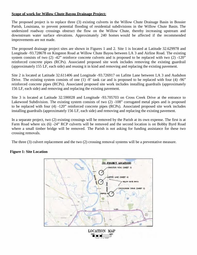
Scope of work for Willow Chute Bayou Drainage Project:
The proposed project is to replace three (3) existing culverts in the Willow Chute Drainage Basin in Bossier Parish, Louisiana, to prevent potential flooding of residential subdivisions in the Willow Chute Basin. The undersized roadway crossings obstruct the flow on the Willow Chute, thereby increasing upstream and downstream water surface elevations. Approximately 240 homes would be affected if the recommended improvements are not made.
The proposed drainage project sites are shown in Figures 1 and 2. Site 1 is located at Latitude 32.629978 and Longitude -93.728678 on Kingston Road at Willow Chute Bayou between LA 3 and Airline Road. The existing system consists of two (2) -42” reinforce concrete culverts and is proposed to be replaced with two (2) -120” reinforced concrete pipes (RCPs). Associated proposed site work includes removing the existing guardrail (approximately 155 LF, each side) and reusing it in kind and removing and replacing the existing pavement.
Site 2 is located at Latitude 32.611406 and Longitude -93.726917 on Lafitte Lane between LA 3 and Audubon Drive. The existing system consists of one (1) -8’ tank car and is proposed to be replaced with four (4) -96” reinforced concrete pipes (RCPs). Associated proposed site work includes installing guardrails (approximately 156 LF, each side) and removing and replacing the existing pavement.
Site 3 is located at Latitude 32.590028 and Longitude -93.705703 on Cross Creek Drive at the entrance to Lakewood Subdivision. The existing system consists of two (2) -108” corrugated metal pipes and is proposed to be replaced with four (4) -120” reinforced concrete pipes (RCPs). Associated proposed site work includes installing guardrails (approximately 156 LF, each side) and removing and replacing the existing pavement.
In a separate project, two (2) existing crossings will be removed by the Parish at its own expense. The first is at Farm Road where six (6) -24” RCP culverts will be removed and the second location is on Bobby Byrd Road where a small timber bridge will be removed. The Parish is not asking for funding assistance for these two crossing removals.
The three (3) culvert replacement and the two (2) crossing removal systems will be a preventative measure.
Figure 1: Site Location

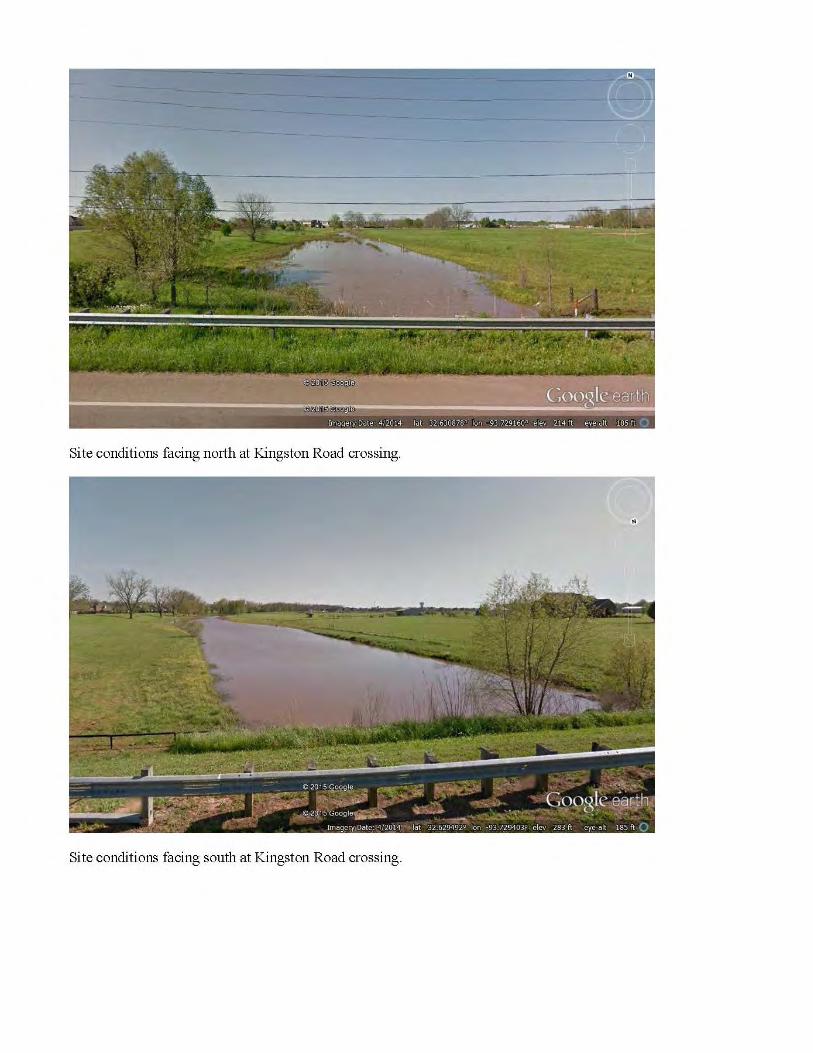
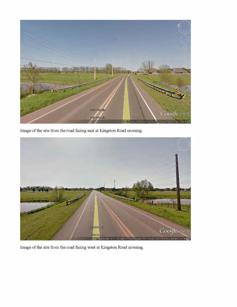


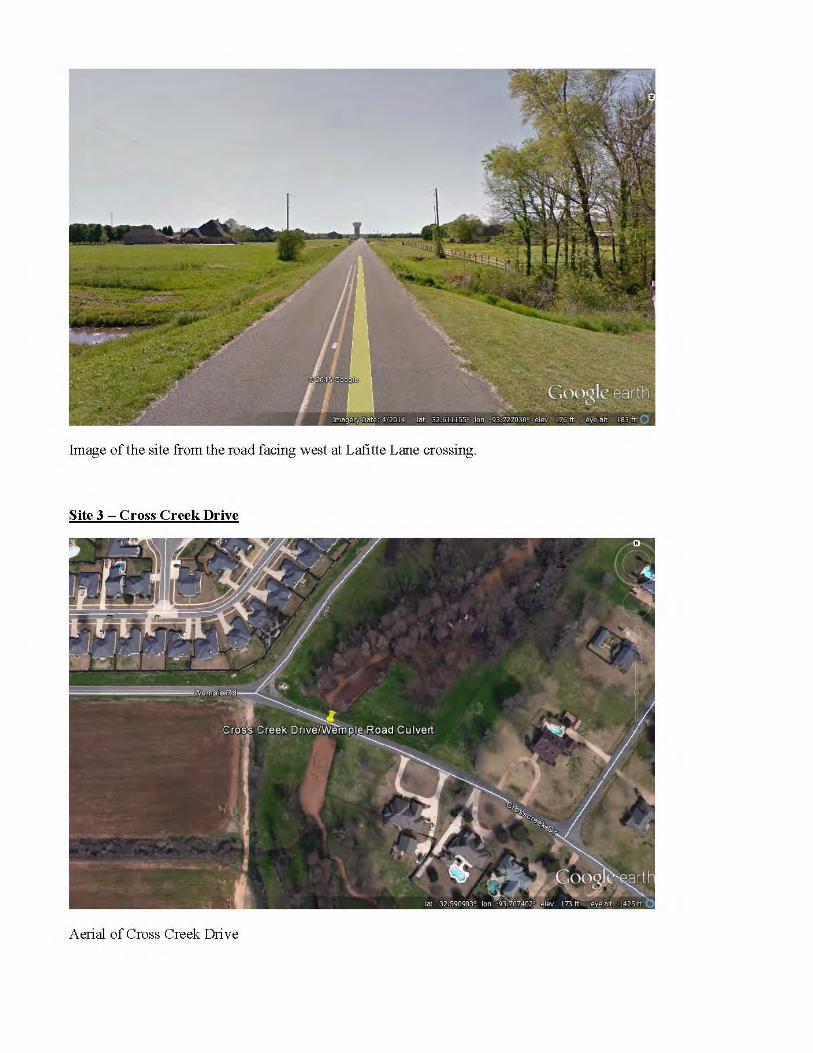


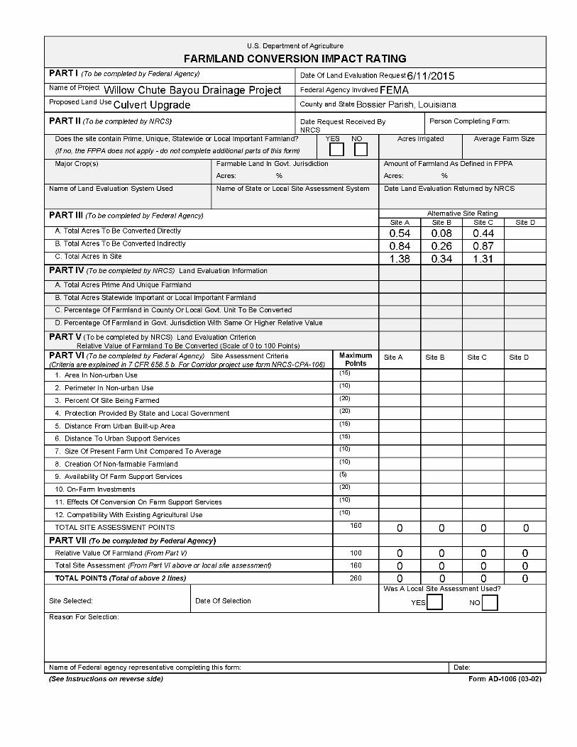

STEPS IN THE PROCESSING THE FARMLAND AND CONVERSION IMPACT RATING FORM
Step 1 - Federal agencies (or Federally funded projects) involved in proposed projects that may convert farmland, as defined in the Farmland Protection Policy Act (FPPA) to nonagricultural uses, will initially complete Parts I and III of the form. For Corridor type projects, the Federal agency shall use form NRCS-CPA-106 in place of form AD-1006. The Land Evaluation and Site Assessment (LESA) process may also be accessed by visiting the FPPA website, http://fppa.nrcs.usda.gov/lesa/.
Step 2 - Originator (Federal Agency) will send one original copy of the form together with appropriate scaled maps indicating location(s)of project site(s), to the Natural
Resources Conservation Service (NRCS) local Field Office or USDA Service Center and retain a copy for their files. (NRCS has offices in most counties in the U.S. The USDA Office Information Locator may be found at http://offices.usda.gov/scripts/ndISAPI.dll/oip_public/USA_map, or the offices can usually be found in the Phone Book under U.S. Government, Department of Agriculture. A list of field offices is available from the NRCS State Conservationist and State Office in each State.)
Step 3 - NRCS will, within 10 working days after receipt of the completed form, make a determination as to whether the site(s) of the proposed project contains prime,
unique, statewide or local important farmland. (When a site visit or land evaluation system design is needed, NRCS will respond within 30 working days.
Step 4 - For sites where farmland covered by the FPPA will be converted by the proposed project, NRCS will complete Parts II, IV and V of the form.
Step 5 - NRCS will return the original copy of the form to the Federal agency involved in the project, and retain a file copy for NRCS records.
Step 6 - The Federal agency involved in the proposed project will complete Parts VI and VII of the form and return the form with the final selected site to the servicing NRCS office.
Step 7 - The Federal agency providing financial or technical assistance to the proposed project will make a determination as to whether the proposed conversion is consistent
with the FPPA.
INSTRUCTIONS FOR COMPLETING THE FARMLAND CONVERSION IMPACT RATING FORM (For Federal Agency)
Part I: When completing the "County and State" questions, list all the local governments that are responsible for local land
use controls where site(s) are to be evaluated.
Part III: When completing item B (Total Acres To Be Converted Indirectly), include the following:
1. Acres not being directly converted but that would no longer be capable of being farmed after the conversion, because the conversion would restrict access to them or other major change in the ability to use the land for agriculture.
2. Acres planned to receive services from an infrastructure project as indicated in the project justification (e.g. highways, utilities planned build out capacity) that will cause a direct conversion.
Part VI: Do not complete Part VI using the standard format if a State or Local site assessment is used. With local and NRCS assistance, use the local Land Evaluation and Site Assessment (LESA).
1. Assign the maximum points for each site assessment criterion as shown in § 658.5(b) of CFR. In cases of corridor-type
project such as transportation, power line and flood control, criteria #5 and #6 will not apply and will, be weighted zero, however, criterion #8 will be weighed a maximum of 25 points and criterion #11 a maximum of 25 points.
2. Federal agencies may assign relative weights among the 12 site assessment criteria other than those shown on the
FPPA rule after submitting individual agency FPPA policy for review and comment to NRCS. In all cases where other weights are assigned, relative adjustments must be made to maintain the maximum total points at 160. For project sites where the total points equal or exceed 160, consider alternative actions, as appropriate, that could reduce adverse impacts (e.g. Alternative Sites, Modifications or Mitigation).
Part VII: In computing the "Total Site Assessment Points" where a State or local site assessment is used and the total maximum number of points is other than 160, convert the site assessment points to a base of 160. Example: if the Site Assessment maximum is 200 points, and the alternative Site "A" is rated 180 points:
For assistance in completing this form or FPPA process, contact the local NRCS Field Office or USDA Service Center.
NRCS employees, consult the FPPA Manual and/or policy for additional instructions to complete the AD-1006 form.
Total points assigned Site A Maximum points possible =
180 200 X 160 = 144 points for Site A
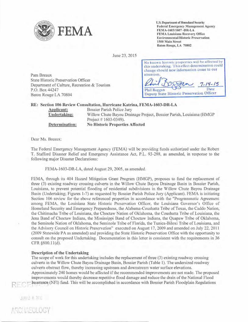
FEMA U.S. Department of Homeland Security Federal Emergency Management Agency FEMA-1603/1607 -DR-LA FEMA Louisiana Recovery Office Environmental/Historic Preservation 1500 Main Street Baton Rouge, LA 70802
June 23, 2015
Nu known historic properties will be affected by this undertaking. This effect determination could change should new information come to our aucntion.
~'!?~ 7- ~;:.:5 Deputy State Historic Preservation Officer
Rt . l, ;
Pam Breaux State Historic Preservation Officer Department of Culture, Recreation & Tourism P.O. Box 44247 Baton Rouge LA 70804
RE: Section 106 Review Consultation, Hurricane Katrina, FEMA-1603-DR-LA Applicant: Bossier Parish Police Jury Undertaking: Willow Chute Bayou Drainage Project, Bossier Parish, Louisiana (HMGP
Project# 1603-0349). Determination: No Historic Properties Affected
Dear Ms. Breaux:
The Federal Emergency Management Agency (FEMA) will be providing funds authorized under the Robert T. Stafford Disaster Relief and Emergency Assistance Act, P.L. 93-288 , as amended, in response to the following major Disaster Declarations:
FEMA-1603-DR-LA, dated August 29, 2005 , as amended.
FEMA, through its 404 Hazard Mitigation Grant Program (HMGP), proposes to fund the replacement of three (3) existing roadway crossing culverts in the Willow Chute Bayou Drainage Basin in Bossier Parish, Louisiana, to prevent potential flooding of residential subdivisions in the Willow Chute Bayou Drainage Basin (Undertaking; Figures 1-7) as requested by Bossier Parish Police Jury (Applicant). FEMA is initiating Section 106 review for the above referenced properties in accordance with the "Programmatic Agreement among FEMA, the Louisiana State Historic Preservation Officer, the Louisiana Governor' s Office of Homeland Security and Emergency Preparedness, the Alabama-Coushatta Tribe of Texas, the Caddo Nation, the Chitimacha Tribe of Louisiana, the Choctaw Nation of Oklahoma, the Coushatta Tribe of Louisiana, the Jena Band of Choctaw Indians, the Mississippi Band of Choctaw Indians, the Quapaw Tribe of Oklahoma, the Seminole Nation of Oklahoma, the Seminole Tribe of Florida, the Tunica-Biloxi Tribe of Louisiana, and the Advisory Council on Historic Preservation" executed on August 17, 2009 and amended on July 22, 2011 (2009 Statewide PA as amended) and providing the State Historic Preservation Office with the opportunity to consult on the proposed Undertaking. Documentation in this letter is consistent with the requirements in 36 CFR §800.11 ( d).
Description of the Undertaking The scope of work for this undertaking includes the replacement of three (3) existing roadway crossing culverts in the Willow Chute Bayou Drainage Basin, Bossier Parish (Table 1). The undersized roadway culverts obstruct flow, thereby increasing upstream and downstream water surface elevations. Approximately 240 homes would be affected if the recommended improvements are not made. The proposed improvements would thereby decrease repetitive flood damage and reduce the drain of the National Flood
- ~n,su;m~ (NFI) fund. This will be accomplished in accordance with Bossier Parish Floodplain Regulations
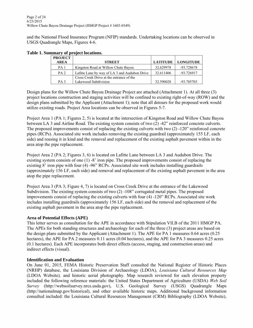
Page 2 of 24 6/23/2015 Willow Chute Bayou Drainage Project (HMGP Project # 1603-0349)
and the National Flood Insurance Program (NFIP) standards. Undertaking locations can be observed in USGS Quadrangle Maps, Figures 4-6. Table 1. Summary of project locations.
PROJECT
AREA STREET LATITUDE LONGITUDE
PA 1 Kingston Road at Willow Chute Bayou 32.629978 -93.728678 PA 2 Lafitte Lane by way of LA 3 and Audubon Drive 32.611406 -93.726917
PA 3 Cross Creek Drive at the entrance of the Lakewood Subdivision 32.590028 -93.705703
Design plans for the Willow Chute Bayou Drainage Project are attached (Attachment 1). At all three (3) project locations construction and staging activities will be confined to existing right-of-way (ROW) and the design plans submitted by the Applicant (Attachment 1); note that all detours for the proposed work would utilize existing roads. Project Area locations can be observed in Figures 5-7. Project Area 1 (PA 1; Figures 2, 5) is located at the intersection of Kingston Road and Willow Chute Bayou between LA 3 and Airline Road. The existing system consists of two (2) -42” reinforced concrete culverts. The proposed improvements consist of replacing the existing culverts with two (2) -120” reinforced concrete pipes (RCPs). Associated site work includes removing the existing guardrail (approximately 155 LF, each side) and reusing it in kind and the removal and replacement of the existing asphalt pavement within in the area atop the pipe replacement. Project Area 2 (PA 2; Figures 3, 6) is located on Lafitte Lane between LA 3 and Audubon Drive. The existing system consists of one (1) -8’ iron pipe. The proposed improvements consist of replacing the existing 8’ iron pipe with four (4) -96” RCPs. Associated site work includes installing guardrails (approximately 156 LF, each side) and removal and replacement of the existing asphalt pavement in the area atop the pipe replacement. Project Area 3 (PA 3; Figure 4, 7) is located on Cross Creek Drive at the entrance of the Lakewood Subdivision. The existing system consists of two (2) -108” corrugated metal pipes. The proposed improvements consist of replacing the existing culverts with four (4) -120” RCPs. Associated site work includes installing guardrails (approximately 156 LF, each side) and the removal and replacement of the existing asphalt pavement in the area atop the pipe replacement. Area of Potential Effects (APE)
This letter serves as consultation for the APE in accordance with Stipulation VII.B of the 2011 HMGP PA. The APEs for both standing structures and archaeology for each of the three (3) project areas are based on the design plans submitted by the Applicant (Attachment 1). The APE for PA 1 measures 0.64 acres (0.25 hectares), the APE for PA 2 measures 0.11 acres (0.04 hectares), and the APE for PA 3 measures 0.25 acres (0.1 hectares). Each APE incorporates both direct effects (access, staging, and construction areas) and indirect effects (visual). Identification and Evaluation
On June 01, 2015, FEMA Historic Preservation Staff consulted the National Register of Historic Places (NRHP) database, the Louisiana Division of Archaeology (LDOA), Louisiana Cultural Resources Map (LDOA Website), and historic aerial photography. Map research reviewed for each elevation property included the following reference materials: the United States Department of Agriculture (USDA) Web Soil Survey (http://websoilsurvey.nrcs.usda.gov), U.S. Geological Survey (USGS) Quadrangle Maps (http://nationalmap.gov/historical), and other available historic maps. Additional background information consulted included: the Louisiana Cultural Resources Management (CRM) Bibliography (LDOA Website),

Page 3 of 24 6/23/2015 Willow Chute Bayou Drainage Project (HMGP Project # 1603-0349)
Louisiana Department of Archaeology (LDOA) Site Forms, and pertinent site and survey reports regarding previous investigations within 1-mile (1.6 km) of each archaeological APE. Additionally, a site visit was conducted on June 08, 2015, at each APE to determine potential impacts to historic properties, if any. Standing Structures There are no standing structures located within any of the three (3) individual APEs, none of the APEs are located within a listed or eligible National Register Historic District, nor are any of the APEs located within the view-shed of a property individually listed in the NRHP. Archaeology Primarily based on the proximity of each APE to water resources and previously recorded sites, it was determined by FEMA that a site visit would be conducted at each APE to ascertain the presence or absence of archaeological deposits. Site visits were conducted on June 08, 2015, by FEMA archaeologists Jeremiah Kaplan and Cheraki Williams. The following standardized data collection procedures were followed when conducting site visits to determine if archaeological resources existed within these APEs:
Visual inspection of the ground surface at each project area, primarily focusing on observing ground disturbances, artifact concentrations, and above-ground cultural features.
As warranted based on the existing conditions, site visits entailed the placement of 1-2 shovel/auger tests within each APE to assess if archaeological deposits existed within the APE and for the purpose of recording soil profile/s in order to define the soil conditions at each project area. Sub-surface testing was focused on areas of exposed soil with the lowest probability of disturbance.
All recovered sediments were screened through ¼” mesh hardware cloth. Photography of project area to document field and soil conditions. Production of a map of each project area indicating testing location(s). Appropriate documentation of each project area recorded in field notes.
An additional post-field review of background data and construction documents (Attachment 1) was also conducted while taking into consideration the observed existing conditions within each APE. As well as reviewing, the results of previous surveys, effects of past episodes of construction and sub-surface ground disturbance (e.g., utilities, construction of the existing ROW/culverts/crossings), landscape alteration, and modern development. All of this was taken into account and weighted against the potential impacts of each individual proposed project action (e.g., new culvert diameters, site access, and existing hardscape).
The results of this analysis for each of the three (3) project APEs is presented below.
Project Area 1- Kingston Road at Willow Chute Bayou The highest elevated soils within the APE (http://websoilsurvey.nrcs.usda.gov) that comprise the banks of Willow Chute Bayou consist of Gallion silt loam, a soil-type typically indicative of natural levees. The recessed portions of the APE (approximately one-half) that represent the Willow Chute Bayou drainage channel consist of Moreland clay, a soil type typically indicative of flood plains. This suggests that portions of this location may have been advantageous for Prehistoric and/or early-historic use of the APE focused along the banks of the bayou or utilized as a resource extraction locale.
The present project area was evaluated as part of survey conducted by Heartfield and Price (n/d) during the mid- to- late 1990s. Northeast Louisiana University was contracted to conduct an archeological and historical review of two areas within the Cypress-Black Watershed, Bossier Parish, Louisiana. The first area includes approximately 55 linear miles of proposed channel improvement (encompassing the present APE). The
Page 4 of 24 6/23/2015 Willow Chute Bayou Drainage Project (HMGP Project # 1603-0349)
second area is defined by a 750 acres proposed reservoir, near the southernmost reach of Black Bayou. No archaeological sites were identified within the present APE at the time of this survey and FEMA has additionally verified that presently no previously recorded archaeological sites are located within the APE. However, there are 32 previously recorded sites located within 1-mile (1.6 km) of the present APE.
Following the LA SHPO Cultural Units defined in Smith et al. (1983), out of 32 sites that represent a total of 44 individual cultural components, 26 sites possessed prehistoric components (primarily Caddo-affiliated), one (1) site possess cultural components attributed to the 1803-1860 Antebellum Louisiana Cultural Unit, one (1) site possess cultural components attributed to the 1860-1890 War and Aftermath Cultural Unit, and 15 sites possess cultural components attributed to the 1890-1940 Industrialization and Modernization Cultural Unit. Based on proximity to previously recorded sites, this trend indicates that there is a high potential for the presence of prehistoric deposits and that the primary historic Cultural Unit affiliation for any potential archaeological deposits within this area is most likely to encompass the early-twentieth-century through the present.
FEMA also conducted a review of historic maps and documentation pertinent to the APE. The current review of historic maps revealed that the 1848 La Tourrette's reference map of the state of Louisiana provides coverage of the APE but does not indicate any development within the surrounding vicinity of the project area. The 1932 USGS Bossier NW, LA Quadrangle map (Figure 8) first depicts Kingston Road with the present APE falling within the ROW in the location of the extant culvert/drainage crossing. This map further indicates that by this time some light rural development had occurred to the east and southeast of the present APE but otherwise shows the surrounding area as largely undeveloped. The 1975 Benton, LA and the 2007 Benton, LA USGS Quadrangle maps do not provide any additional details beyond what is presented in the 1932 USGS map. Aerial imagery indicates that the area to the southeast of the APE was not incorporated into the Saint Charles Court subdivision until sometime between the years 2004 and 2005.
A site visit was conducted to PA 1 (Figure 2) on June 8, 2015, to find that unrelated road repairs/widening were actively taking place within the APE and surrounding ROW. The active SOW appeared to be to expand the existing road ROW within the APE and to create a right hand turning lane into the Saint Charles Court subdivision heading eastbound on Kingston Road. At the time of arrival, it appeared that all construction was occurring in a primarily a man-made landform (Figures 13-15). The south side of the road had been excavated to an average depth of 60-90 centimeters (2-3 ft) below the current road grade exposing only construction fill (Figure 13-14).The north side of the road berm also evidenced recent heavy disturbance (i.e., excavation, silt runoff, in-filling; Figure 15). A visual inspection of the ROW revealed only recently discarded refuse. Additionally, it appeared that the surrounding drainage has been heavily channelized. The FEMA archaeologist present on-site was informed by the construction crew that they had been working in this location for almost a year and that their current SOW did not include replacing the existing culverts. As the entire APE appeared to be heavily impacted by the ongoing road repairs/widening and channelization of the drainage, no STPs were excavated within PA 1.
Project Area 2- Lafitte Lane by way of LA 3 and Audubon Drive Soils within the APE (http://websoilsurvey.nrcs.usda.gov) consist of Moreland clay, a soil type typically indicative of flood plains. This suggests that this location has a low potential for Prehistoric and/or early-historic use of the APE.

Page 5 of 24 6/23/2015 Willow Chute Bayou Drainage Project (HMGP Project # 1603-0349)
The present project area was evaluated as part of the aforementioned survey conducted by Heartfield and Price (n/d; see above) during the mid- to- late 1990s. No archaeological sites were identified within the present APE at the time of this survey and FEMA has additionally verified that presently no previously recorded archaeological sites are located within the APE. However, there are 15 previously recorded sites located within 1-mile (1.6 km) of the present APE.
Following the LA SHPO Cultural Units defined in Smith et al. (1983), out of 15 sites that represent a total of 27 individual cultural components, 14 sites possessed prehistoric components (primarily Caddo-affiliated), two (2) sites possessed cultural components attributed to the 1803-1860 Antebellum Louisiana Cultural Unit, two (2) sites possessed cultural components attributed to the 1860-1890 War and Aftermath Cultural Unit, and nine (9) sites possess cultural components attributed to the 1890-1940 Industrialization and Modernization Cultural Unit. Based on proximity to previously recorded sites, this trend indicates that there is a high potential for the presence of prehistoric deposits and that the primary historic Cultural Unit affiliation for any potential archaeological deposits within this area is most likely to encompass the early-twentieth-century through the present.
FEMA also conducted a review of historic maps and documentation pertinent to the APE. The current review of historic maps revealed that the 1848 La Tourrette's reference map of the state of Louisiana provides coverage of the APE but does not indicate any development within the surrounding vicinity of the project area. The 1932 USGS Bossier City, LA Quadrangle map (Figure 9) does not depict Lafitte Lane or the drainage that it presently intersects with. This map does however depict a single structure, likely a farmstead, located approximately 34 meters (111.5 ft) to the northeast of the APE but otherwise shows no other development within the surrounding area. The 1955 USGS Bossier City, LA Quadrangle map (Figure 10) shows the present APE as vacant. This map again depicts the single structure appearing to the northeast of the project area in the 1932 USGS map and additionally places this structure on the southeastern edge of an ovular depression partially encompassing the present location of the intermediate channel of the Willow Chute Bayou that the extant culvert and roadway crossing is constructed within. The 1960 Bossier City, LA USGS Quadrangle map does not provide any additional details beyond what is presented in the 1955 USGS map. The 2007 Bossier City, LA USGS Quadrangle map (Figure 11) first depicts Lafitte Lane and the present configuration of the intermediate channel of the Willow Chute Bayou that the extant culvert and roadway crossing is constructed within. It is likely that by this time the original depression shown in the 1955 USGS map (Figure 10) had been further channelized to facilitate drainage. Aerial imagery indicates that, aside from scattered farmsteads, residential sub-development development of the area surrounding the APE did not occur primarily until after 2002.
A site visit was conducted to PA 2 (Figure 6) on June 8, 2015. The culvert location is in a modern sub-development. In the area of the existing culvert the road berm has been previously elevated an average of 1-2 meters (3.2-6.5 ft) above the base of the drainage to match the existing grade to the east and west (Figures 16-17). The north side of the road berm had signs indicating the location of buried fiber-optic cables and in the area surrounding the existing culvert, rip-rap and construction fill that appeared to have been imported to stabilize the bank was now eroding into the drainage from water action (Figure 17). A visual inspection of the ROW revealed only recently discarded refuse and imported fill material containing gravel and construction debris. Additionally, it appeared that the surrounding drainage and existing road ditches have been repeatedly excavated for maintenance purposes. A single auger test was excavated in the southeast portion of the APE (Figure 6) in what visually appeared to be the most intact location and closest to natural

Page 6 of 24 6/23/2015 Willow Chute Bayou Drainage Project (HMGP Project # 1603-0349)
ground surface within the APE. No artifacts were recovered from within this test and at 50 cmbs (19.6 in) a buried conduit was encountered (likely fiber-optic) and excavation was ceased. As the remainder of the APE appeared to be heavily impacted by the construction of the existing ROW, culverts, and periodic grading/maintenance excavation no additional tests were excavated within PA 2.
Project Area 3- Cross Creek Drive at the entrance of the Lakewood Subdivision Though marginal within the APE (http://websoilsurvey.nrcs.usda.gov), higher elevated soils within the project area that comprise the banks of Willow Chute Bayou consist of Gallion silt loam, a soil-type typically indicative of natural levees. The recessed portions of the APE (approximately two-thirds) that represent the Willow Chute Bayou drainage channel consist of Moreland clay, a soil type typically indicative of flood plains. This suggests that portions of this location may have been advantageous for Prehistoric and/or early-historic use of the APE focused along the banks of the bayou or utilized as a resource extraction locale.
The present project area was evaluated as part of survey conducted by Girard (1993). This report presents the results of an archaeological survey carried out along Willow Chute Bayou in Bossier Parish, Louisiana as part of the 1992/1993 Regional Archaeology Program for Management Unit 1. Approximately 1200 acres were surveyed. Thirty new sites were recorded and information was updated on four previously recorded sites. No archaeological sites were identified within the present APE at the time of this survey and FEMA has additionally verified that presently no previously recorded archaeological sites are located within the APE. However, there are 16 previously recorded sites located within 1-mile (1.6 km) of the present APE.
Following the LA SHPO Cultural Units defined in Smith et al. (1983), out of 16 sites, that represent a total of 27 individual cultural components, 13 sites possessed Prehistoric components (primarily Caddo-affiliated), one (1) site possessed cultural components attributed to the 1860-1890 War and Aftermath Cultural Unit, and seven (7) sites possess cultural components attributed to the 1890-1940 Industrialization and Modernization Cultural Unit. Based on proximity to previously recorded sites, this trend indicates that there is a high potential for the presence of prehistoric deposits and that the primary historic Cultural Unit affiliation for any potential archaeological deposits within this area is most likely to encompass the early-twentieth-century through the present.
FEMA also conducted a review of historic maps and documentation pertinent to the APE. The current review of historic maps revealed that the 1848 La Tourrette's reference map of the state of Louisiana provides coverage of the APE but does not indicate any development within the surrounding vicinity of the project area. The 1932 USGS Bossier City, LA Quadrangle map (Figure 12) depicts Wemple Road to the west of the APE but indicates that Cross Creek Drive had not yet been constructed and only indicates scattered rural development in the surrounding area. The 1955 and 1960 Bossier City, LA USGS Quadrangle maps do not provide any significant details beyond what is presented in the 1932 USGS map. Aerial imagery indicates that sometime prior to 1989 Cross Creek Drive and the extant culvert/roadway crossing had been constructed in their present locations and that sometime between the years of 1989 and 1998 a street grid was established in the area to the east of the APE followed by dense residential subdivision.
A site visit was conducted to PA 3 (Figure 7) on June 8, 2015. The culvert and roadway crossing location is bordered by modern sub developments to the east and west. In the area of the existing culvert the road berm has been previously elevated an average of 1-2 meters (3.2-6.5 ft) above the base of the drainage to match the existing grade to the northwest to southeast east (Figure 18). Additionally, it appeared that the surrounding drainage has been periodically excavated for maintenance purposes. A visual inspection of the ROW

Page 8 of25 6/23/2015 Willow Chute Bayou Drainage Project (HMGP Project # 1603-0349)
revealed only recently discarded refuse. The northwest portion of the APE had signs indicating buried utility locations and otherwise was inundated leaving no accessible place within the ROW for shovel testing. STP 2 was excavated in the northeast quadrant of the APE. STP 2 exhibited two stratigraphic layers and was excavated 32 cm (12.5 in) into Stratum II to a maximum depth of 50 cmbs (19.6 in). A single freshwater mussel shell was recovered from stratum II (discarded in-field) . No other artifacts were recovered from this STP. STP 1 was excavated in the southwest comer of the APE. Modem bottle glass (not collected) and gravel were visible on the surface of this STP. A modern "Big-Shot" bottle was encountered within Stratum I at 20cmbs (7.8 in). Stratum II consisted of sterile clay and excavation of this STP was ceased at 55 cmbs (21 .6 in) .The southeast portion of the APE had signs indicating buried utility locations and otherwise fell within the elevated road berm and therefore was not shovel tested.
Summary of Archaeological Identification and Evaluation While FEMA determined that all three (3) APEs are located in areas with a high potential for the presence of prehistoric archaeological resources, that soils data suggests that portions of these APEs may have been moderately favorable to prehistoric and/or historic occupation, and that, consistent with available historic maps, the potential for historic archaeological site components seems most likely to be attributable to the 1890-1940 Industrialization and Modernization Cultural Unit , no archaeological deposits were observed in any of the three (3) APE' s. Collectively, the three (3) APEs revealed only modem plastic items and utility conduits and no artifacts dating older than 50 years of age. This is consistent with the findings from Heartfield and Price (n/d) and Girard (1993) during which no archaeological resources were identified. Furthermore, any archaeological deposits not identified within the present APEs would likely have been deeply buried and/or obliterated as a result of the previous installation of the extant culvert systems and the construction/elevation of the existing ROW. Based on all the available evidence, FEMA has determined that it is unlikely that any of the APEs possess NRHP-eligible archaeological deposits .
Assessment of Effects Based on the aforementioned identification and evaluation, FEMA has determined that there are no historic properties as defined in 36 CFR 800.16(1) within the APE. Therefore, FEMA has determined a finding of No Historic Properties Affected for this Undertaking and is submitting this Undertaking to you for your review and comment. FEMA requests your comments within 15 days.
We look forward to your concurrence with this determination. Should you have any questions or need additional information regarding this Undertaking, please contact me at (504) 247-7771 or [email protected] .gov, or Jason Emery, Lead Historic Preservation Specialist at (504) 570-7292 or [email protected] .gov, or Jeremiah Kaplan, Historic Preservation Specialist/Archaeologist at (504) 908-5397 or [email protected] .gov.
Sincerely,
JERAME J CRAMER Jerame J. Cramer
Digitally signed by JERAME J CRAMER DN: c=US, o=U.S. Government, ou=Department of Homeland Security, ou=FEMA, ou=People, cn=JERAME J CRAMER, 0.9.2342.19200300. l 00.1.1 =097289391 O.FEMA Date: 2015.06.23 11 :08:34 -05'00'
Environmental Liaison Officer FEMA-DR-1603-LA, FEMA-DR-1607-LA

Page 8 of 24 6/23/2015 Willow Chute Bayou Drainage Project (HMGP Project # 1603-0349)
CC: File
Division of Archaeology Reviewer Division of Historic Preservation Reviewer State Historic Preservation Office
Enclosures

Page 9 of 24 6/23/2015 Willow Chute Bayou Drainage Project (HMGP Project # 1603-0349)
References:
Girard, Jeffrey S
1993 Regional Archaeology Program, Management Unit 1: Fourth Annual Report. Northwestern State University (Report No. 22-1722). Report on file at the Division of Archaeology, Louisiana Department of Culture, Recreation and Tourism, Baton Rouge.
Heartfield, Lorraine and G.R. Dennis Price N/D A Cultural Background Review of a Portion of the Cypress-Black Watershed, Bossier Parish,
Louisiana. Northeast Louisiana University (Report No. 22-0107). Report on file at the Division of Archaeology, Louisiana Department of Culture, Recreation and Tourism, Baton Rouge.
La Tourrette, John 1848 La Tourrette's reference map of the state of Louisiana: from the original surveys of the United States,
which show the townships, sections, or mile squares, Spanish grants, settlement rights & c., also the plantations with the owners names engraved thereon. New Orleans, John La Tourrette, 1848.
Smith, Steven D., Phillip G. Rivet, Kathleen M. Byrd and Nancy W. Hawkins 1983 Louisiana’s Comprehensive Archaeological Plan. State of Louisiana Department of Culture,
Recreation and Tourism, Office of Cultural Development, Division of Archaeology, Baton Rouge, Louisiana.
U.S. Geological Survey 1932 Bossier City, LA [Contours]. 1:24,000. 7.5 Minute Series (Topographic). Reston, VA: USGS. Copy
on file, FEMA Historic Preservation, 1500 Main Street, Baton Rouge, LA 70802. 1932 Bossier NW, LA [Contours]. 1:24,000. 7.5 Minute Series (Topographic). Reston, VA: USGS. Copy
on file, FEMA Historic Preservation, 1500 Main Street, Baton Rouge, LA 70802. 1955 Bossier City, LA [Contours]. 1:24,000. 7.5 Minute Series (Topographic). Reston, VA: USGS. Copy
on file, FEMA Historic Preservation, 1500 Main Street, Baton Rouge, LA 70802. 1960 Bossier City, LA [Contours]. 1:24,000. 7.5 Minute Series (Topographic). Reston, VA: USGS. Copy
on file, FEMA Historic Preservation, 1500 Main Street, Baton Rouge, LA 70802. 1975 Benton, LA [Contours]. 1:24,000. 7.5 Minute Series (Topographic). Reston, VA: USGS. Copy on
file, FEMA Historic Preservation, 1500 Main Street, Baton Rouge, LA 70802. 2007 Bossier City, LA [Contours]. 1:24,000. 7.5 Minute Series (Topographic). Reston, VA: USGS. Copy
on file, FEMA Historic Preservation, 1500 Main Street, Baton Rouge, LA 70802.
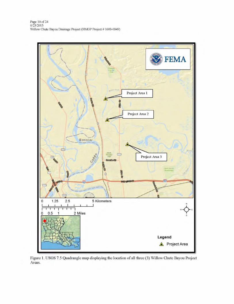


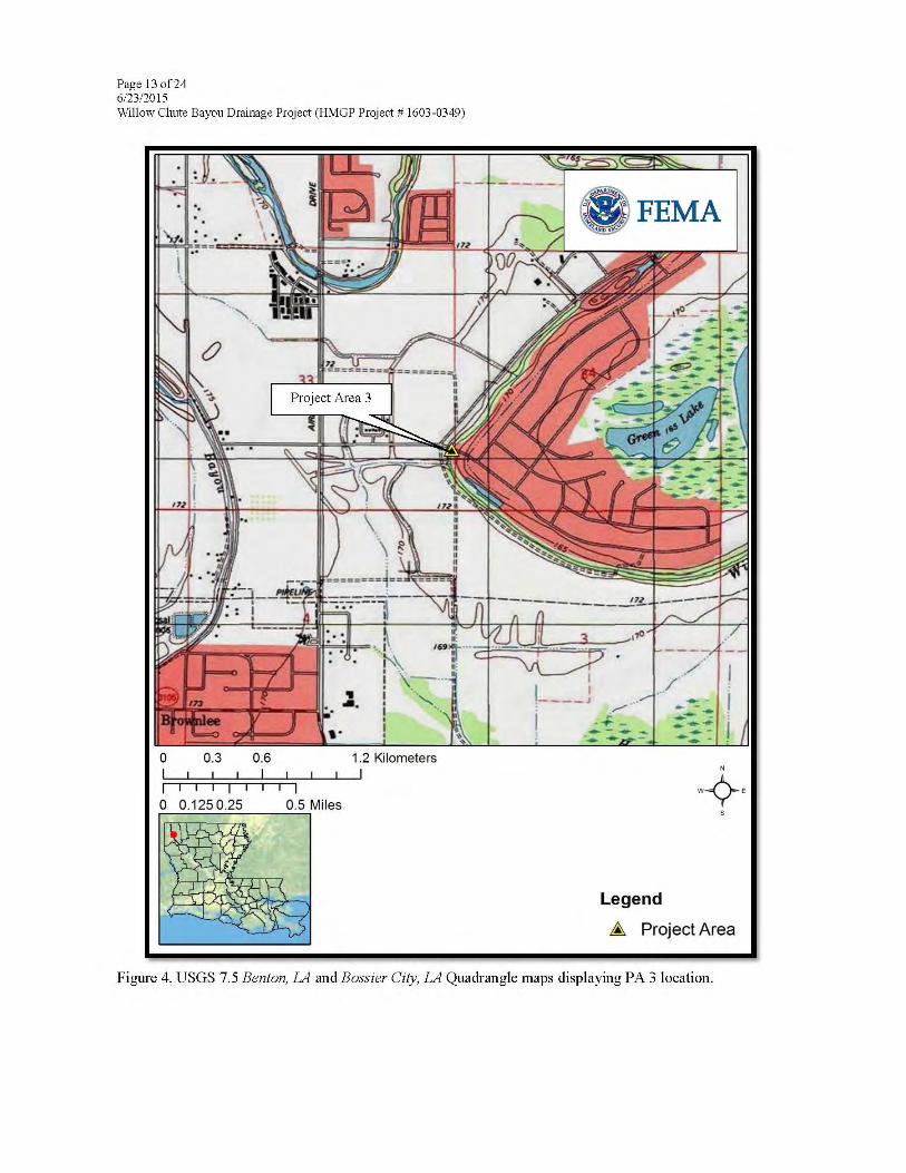


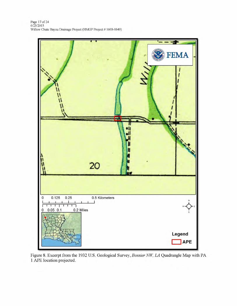
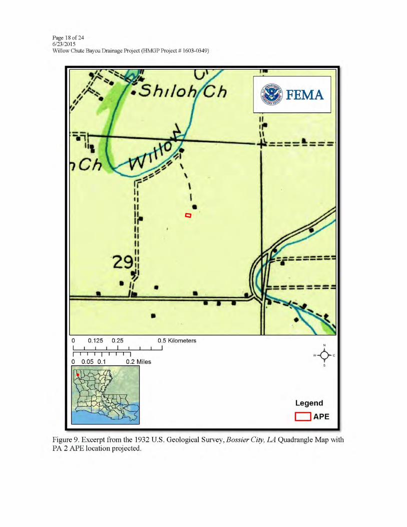

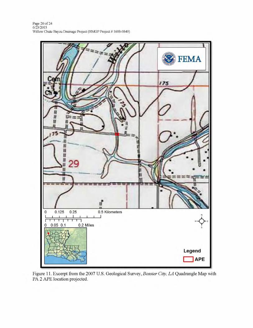


Louisiana Ecological Services Office
ESA Technical Assistance Form
6/19/2015
General Information
Name: FEMA
Point of Contact: Jamie Schexnayder
Address: 1500 Main Street
City: Baton Rouge State: Louisiana Zip Code: 70802
Phone Number 1: 225-200-4961 Phone Number 2: __________________
Email Address: [email protected]
Proposed Project Information
Project Reference ID: 5109
Project Latitude: 32.629978 Project Longitude: -93.728678
Project Parish(es): Bossier
Project Description: The proposed project is to replace three (3) existing culverts in
the Willow Chute Drainage Basin in Bossier Parish, Louisiana, to prevent potential
flooding of residential subdivisions in the Willow Chute Basin. The undersized roadway
crossings obstruct the flow on the Willow Chute, thereby increasing upstream and
downstream water surface elevations. Approximately 240 homes would be affected if the
recommended improvements are not made.
The proposed drainage project sites are shown in Figures 1 and 2. Site 1 is located at
Latitude 32.629978 and Longitude -93.728678 on Kingston Road at Willow Chute Bayou
between LA 3 and Airline Road. The existing system consists of two (2) -42” reinforce
concrete culverts and is proposed to be replaced with two (2) -120” reinforced concrete
pipes (RCPs). Associated proposed site work includes removing the existing guardrail
(approximately 155 LF, each side) and reusing it in kind and removing and replacing the
existing pavement.
Site 2 is located at Latitude 32.611406 and Longitude -93.726917 on Lafitte Lane
between LA 3 and Audubon Drive. The existing system consists of one (1) -8’ tank car
and is proposed to be replaced with four (4) -96” reinforced concrete pipes (RCPs).

Louisiana Ecological Services Office
ESA Technical Assistance Form
6/19/2015
Associated proposed site work includes installing guardrails (approximately 156 LF, each
side) and removing and replacing the existing pavement.
Site 3 is located at Latitude 32.590028 and Longitude -93.705703 on Cross Creek Drive
at the entrance to Lakewood Subdivision. The existing system consists of two (2) -108”
corrugated metal pipes and is proposed to be replaced with four (4) -120” reinforced
concrete pipes (RCPs). Associated proposed site work includes installing guardrails
(approximately 156 LF, each side) and removing and replacing the existing pavement.
In a separate project, two (2) existing crossings will be removed by the Parish at its own
expense. The first is at Farm Road where six (6) -24” RCP culverts will be removed and
the second location is on Bobby Byrd Road where a small timber bridge will be removed.
The Parish is not asking for funding assistance for these two crossing removals.
The three (3) culvert replacement and the two (2) crossing removal systems will be a
preventative measure.
Based on the information provided, the proposed project is not an activity that would affect a federally listedthreatened or endangered species; nor is there proposed or designated critical habitat present within thisParish.
Therefore, a "no effect" conclusion is appropriate. No further ESA coordination with the Service is necessary forthe proposed action, unless there are changes in the scope or location of the proposed project or the projecthas not been initiated one year from the date of this letter.
If the proposed project has not been initiated within one year, follow-up coordination via this website should beaccomplished prior to making expenditures because our threatened and endangered species information isupdated annually. If the scope or location of the proposed project is changed, coordination via this websiteshould occur as soon as such changes are made.
This finding completes project review by the Service for effects to Federal trust resources under our jurisdictionand currently protected by the ESA.
Please keep a copy of this pre-development coordination for your records. Do not send it to the Lafayette ESOffice.
If you have additional questions, please contact Louisiana ES Office Biological Science Technician at 337/291-3100 for further assistance.
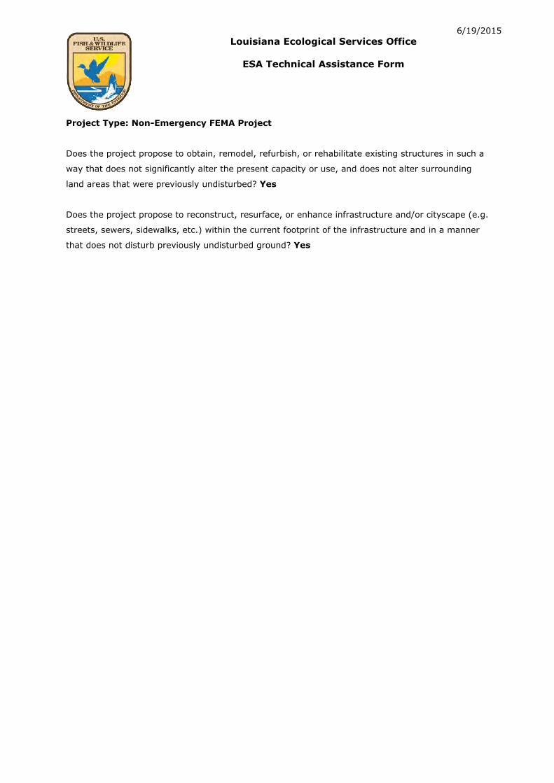
Louisiana Ecological Services Office
ESA Technical Assistance Form
6/19/2015
Project Type: Non-Emergency FEMA Project
Does the project propose to obtain, remodel, refurbish, or rehabilitate existing structures in such a
way that does not significantly alter the present capacity or use, and does not alter surrounding
land areas that were previously undisturbed? Yes
Does the project propose to reconstruct, resurface, or enhance infrastructure and/or cityscape (e.g.
streets, sewers, sidewalks, etc.) within the current footprint of the infrastructure and in a manner
that does not disturb previously undisturbed ground? Yes
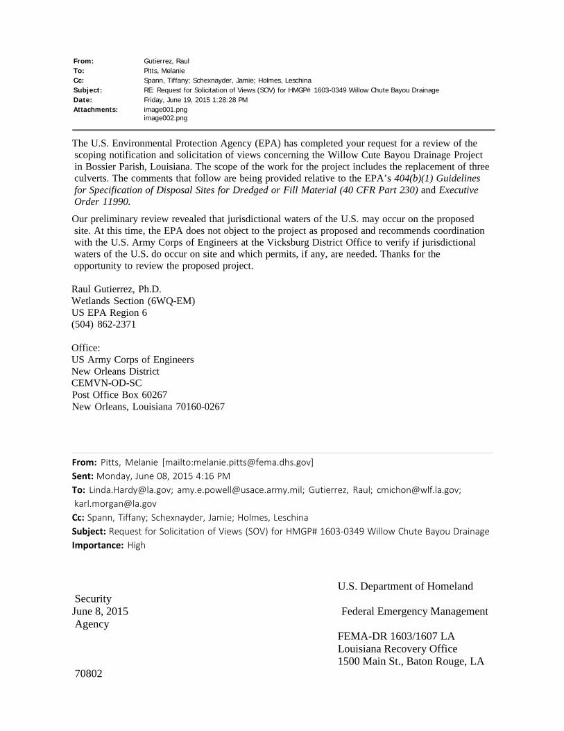
From: Gutierrez, Raul To: Pitts, Melanie Cc: Spann, Tiffany; Schexnayder, Jamie; Holmes, Leschina Subject: RE: Request for Solicitation of Views (SOV) for HMGP# 1603-0349 Willow Chute Bayou Drainage Date: Friday, June 19, 2015 1:28:28 PM Attachments: image001.png
image002.png
The U.S. Environmental Protection Agency (EPA) has completed your request for a review of the scoping notification and solicitation of views concerning the Willow Cute Bayou Drainage Project in Bossier Parish, Louisiana. The scope of the work for the project includes the replacement of three culverts. The comments that follow are being provided relative to the EPA’s 404(b)(1) Guidelines for Specification of Disposal Sites for Dredged or Fill Material (40 CFR Part 230) and Executive Order 11990.
Our preliminary review revealed that jurisdictional waters of the U.S. may occur on the proposed site. At this time, the EPA does not object to the project as proposed and recommends coordination with the U.S. Army Corps of Engineers at the Vicksburg District Office to verify if jurisdictional waters of the U.S. do occur on site and which permits, if any, are needed. Thanks for the opportunity to review the proposed project.
Raul Gutierrez, Ph.D. Wetlands Section (6WQ-EM) US EPA Region 6 (504) 862-2371
Office: US Army Corps of Engineers New Orleans District CEMVN-OD-SC Post Office Box 60267 New Orleans, Louisiana 70160-0267
From: Pitts, Melanie [mailto:[email protected]] Sent: Monday, June 08, 2015 4:16 PM To: [email protected]; [email protected]; Gutierrez, Raul; [email protected]; [email protected]
Cc: Spann, Tiffany; Schexnayder, Jamie; Holmes, Leschina Subject: Request for Solicitation of Views (SOV) for HMGP# 1603-0349 Willow Chute Bayou Drainage Importance: High
Security U.S. Department of Homeland
June 8, 2015 Federal Emergency Management Agency
70802
FEMA-DR 1603/1607 LA Louisiana Recovery Office 1500 Main St., Baton Rouge, LA

MEMORANDUM TO: See Distribution
SUBJECT: Scoping Notification/Solicitation of Views
Bossier Parish Police Jury, Willow Chute Bayou Drainage Project, HMGP# 1603- 0349, FEMA-1603-DR-LA
To Whom It May Concern: The Department of Homeland Security’s Federal Emergency Management Agency (FEMA) is mandated by the U.S. Congress to administer Federal disaster assistance pursuant to the Robert T. Stafford Disaster Relief and Emergency Assistance Act (Stafford Act), PL 93-288, as amended. Section 404 and Section 406 of the Stafford Act authorizes FEMA’s Hazard Mitigation Program to provide funds to states and local governments to implement long-term hazard mitigation measures after a major disaster declaration. FEMA is considering providing Hazard Mitigation Grant Program funding for the attached project in relation to Hurricanes Katrina and Rita (FEMA-1603/1607-DR-LA).
Please review the attached project description to determine whether your office has any objections to the proposed project and whether any permits from your office would need to be obtained. The applicant is the Bossier Parish Police Jury.
This project is the applicant’s request to replace three (3) existing culverts in the Willow Chute Drainage Basin in Bossier Parish, Louisiana, to prevent potential flooding of residential subdivisions in the Willow Chute Basin. The project sites are located at: 1) Latitude 32.629978 and Longitude -93.728678, 2) Latitude 32.611406 and Longitude -93.726917, and 3) Latitude 32.590028 and Longitude -93.705703, Bossier City, Louisiana.
To ensure compliance with the National Environmental Policy Act (NEPA), Executive Orders (EOs), and other applicable Federal regulations, FEMA-EHP will be preparing an Environmental Assessment (EA). To assist us in preparation of the EA, FEMA-EHP requests that your office review the attached documents for a determination as to the requirements of any formal consultations, regulatory permits, determinations, or authorizations.
We would appreciate your comments on this project within thirty (30) days. If we do not receive comments from you within this time period, we will assume that you have no concerns or issues with the proposed project. If appropriate, FEMA will add the condition that the applicant will be required to obtain applicable permits from your office.
Comments may be emailed to [email protected] or mailed to the attention of Jamie Schexnayder, Environmental Department, at the address above. For questions
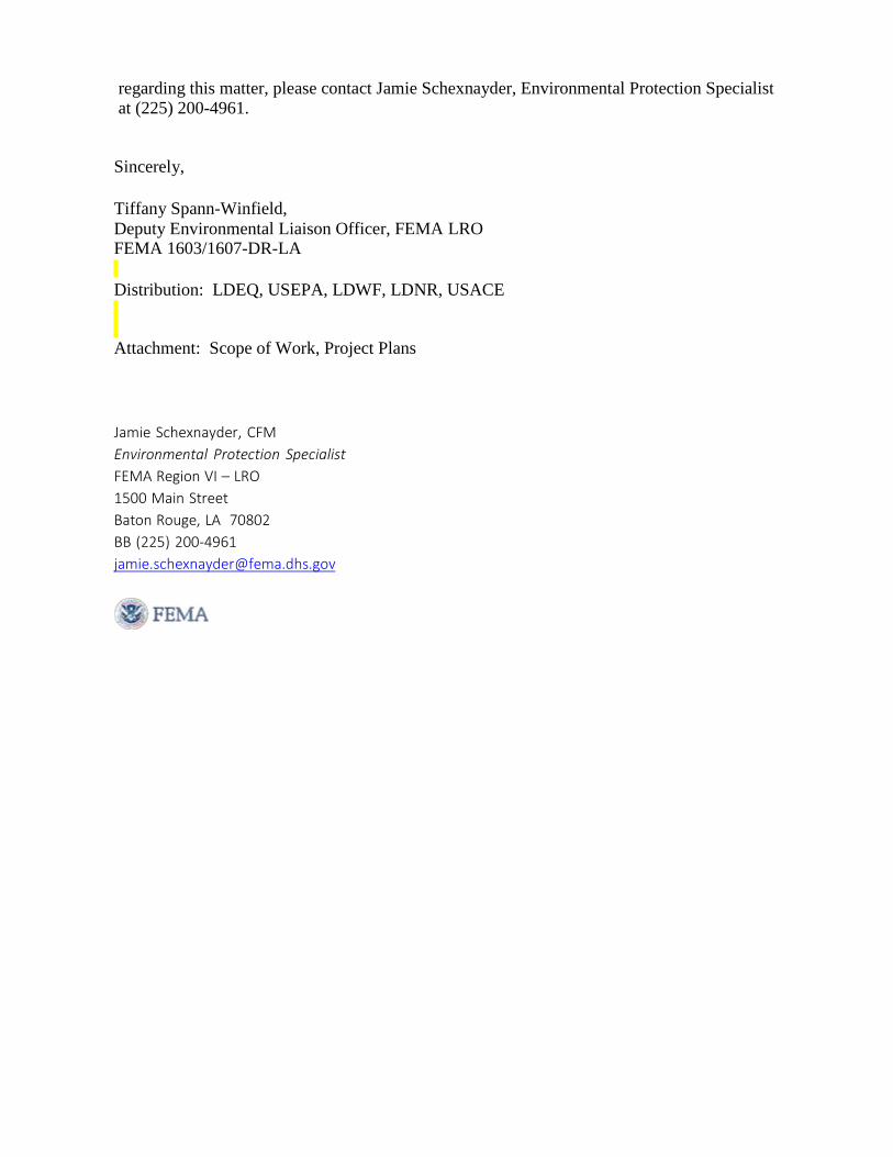
regarding this matter, please contact Jamie Schexnayder, Environmental Protection Specialist at (225) 200-4961.
Sincerely,
Tiffany Spann-Winfield, Deputy Environmental Liaison Officer, FEMA LRO FEMA 1603/1607-DR-LA
Distribution: LDEQ, USEPA, LDWF, LDNR, USACE
Attachment: Scope of Work, Project Plans
Jamie Schexnayder, CFM Environmental Protection Specialist FEMA Region VI – LRO 1500 Main Street Baton Rouge, LA 70802 BB (225) 200-4961 [email protected]
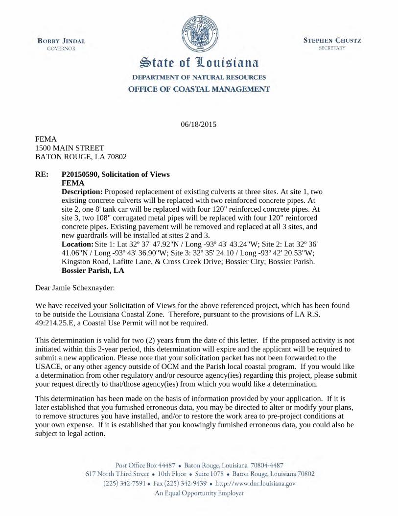
06/18/2015
FEMA 1500 MAIN STREET BATON ROUGE, LA 70802
RE: P20150590, Solicitation of Views FEMA Description: Proposed replacement of existing culverts at three sites. At site 1, two existing concrete culverts will be replaced with two reinforced concrete pipes. At site 2, one 8' tank car will be replaced with four 120" reinforced concrete pipes. At site 3, two 108" corrugated metal pipes will be replaced with four 120" reinforced concrete pipes. Existing pavement will be removed and replaced at all 3 sites, and new guardrails will be installed at sites 2 and 3. Location: Site 1: Lat 32º 37' 47.92"N / Long -93º 43' 43.24"W; Site 2: Lat 32º 36' 41.06"N / Long -93º 43' 36.90"W; Site 3: 32º 35' 24.10 / Long -93º 42' 20.53"W; Kingston Road, Lafitte Lane, & Cross Creek Drive; Bossier City; Bossier Parish. Bossier Parish, LA
Dear Jamie Schexnayder: We have received your Solicitation of Views for the above referenced project, which has been found to be outside the Louisiana Coastal Zone. Therefore, pursuant to the provisions of LA R.S. 49:214.25.E, a Coastal Use Permit will not be required.
This determination is valid for two (2) years from the date of this letter. If the proposed activity is not initiated within this 2-year period, this determination will expire and the applicant will be required to submit a new application. Please note that your solicitation packet has not been forwarded to the USACE, or any other agency outside of OCM and the Parish local coastal program. If you would like a determination from other regulatory and/or resource agency(ies) regarding this project, please submit your request directly to that/those agency(ies) from which you would like a determination.
This determination has been made on the basis of information provided by your application. If it is later established that you furnished erroneous data, you may be directed to alter or modify your plans, to remove structures you have installed, and/or to restore the work area to pre-project conditions at your own expense. If it is established that you knowingly furnished erroneous data, you could also be subject to legal action.

P20150590, Solicitation of Views FEMA 06/18/2015 Page 2
The drawings submitted with your referenced application are attached hereto and made a part of the record. If you have any questions regarding this authorization, please contact our office at (225) 342- 7591 or (800) 267-4019.
Sincerely,
Karl L. Morgan/mo
Attachments
Karl L. Morgan Administrator

P20150590, Solicitation of Views FEMA 06/18/2015 Page 3
Final Plats:
1) P20150590 Final Plats 06/18/2015
cc: Jessica Diez, OCM w/plats
APPENDIX D
HYDROLOGIC AND HYDRAULIC STUDY
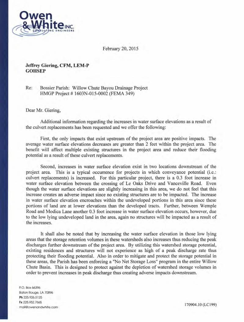
Owen ~~Tl~~!~~;
February 20, 2015
Jeffrey Giering, CFM, LEM-P GOHSEP
Re: Bossier Parish: Willow Chute Bayou Drainage Project HMGP Project# 1603N-015-0002 (FEMA 349)
Dear Mr. Giering,
Additional information regarding the increases in water surface elevations as a result of the culvert replacements has been requested and we offer the following:
First, the only impacts that exist upstream of the project area are positive impacts. The average water surface elevations decreases are greater than 2 feet within the project area. The benefit will affect multiple existing structures in the project area and reduce their flooding potential as a result of these culvert replacements.
Second, increases in water surface elevation exist in two locations downstream of the project area. This is a typical occurrence for projects in which conveyance potential (i.e. : culvert replacements) is increased. For this particular project, there is a 0.3 foot increase in water surface elevation between the crossing of Le Oaks Drive and V anceville Road. Even though the water surface elevations are slightly increasing in this area, we do not feel that this increase creates an adverse impact since no existing structures are to be impacted. The increase in water surface elevation encroaches within the undeveloped portions in this area since these portions of land are at lower elevations than the developed tracts. Further, between Wemple Road and Modica Lane another 0.3 foot increase in water surface elevation occurs, however, due to the low lying undeveloped land in the area, again no structures will be impacted as a result of the increases.
It shall also be noted that by increasing the water surface elevation in those low lying areas that the storage retention volumes in these watersheds also increases thus reducing the peak discharges further downstream of the project area. By utilizing this watershed storage potential, existing residences and structures will not experience as high of a peak discharge rate thus protecting their flooding potential. Also in order to mitigate and protect the storage potential in these areas, the Parish has been enforcing a "No Net Storage Loss" program in the entire Willow Chute Basin. This is designed to protect against the depletion of watershed storage volumes in order to prevent increases in peak discharge thus creating adverse impacts downstream.
P.O. Box 66396
Baton Rouge. LA 70896
Ph 225. 926.5125
Fx 225.952.7665
[email protected] 170904. I 0(LC199)

Mr. Jeffrey Giering, CFM, LEM-P GO SHEP Page2
It is because of this that we feel that the proposed improvements with the help of the Floodplain Storage Mitigation Program will not create an adverse impact downstream of the project area.
Yours very truly,
OWEN AND WIDTE, INC.
Toby J. Fruge', P.E., CFM
TJF/bls
170904.10 (LC199)

May 19, 2015
Jeffrey Giering, CFM, LEM-P GOHSEP
Re: Bossier Parish: Willow Chute Bayou Drainage Project HMGP Project # 1603N-015-0002 (FEMA 349)
Dear Mr. Giering,
Additional information regarding upstream and downstream impacts has been requested and we offer the following:
First, the only impacts that exist upstream of the project area are positive impacts. The average water surface elevation decreases are greater than 2 feet within the project area. This benefit will affect multiple existing structures in the project area thus reducing their flooding potential as a result of these culvert replacements. As a result, there will be no negative impacts upstream of the proposed improvements.
Second, increases in water surface elevation exist in two locations downstream of the project area. This is a typical occurrence for projects in which conveyance potential (i.e.: culvert replacements) is increased. For this particular project, there is a 0.3 foot increase in water surface elevation between the crossing of Le Oaks Drive and Vanceville Road. Even though the water surface elevations are slightly increasing in this area, this increase does not create an adverse impact since no existing structures are to impacted. The increase in water surface elevation encroaches within the undeveloped portions in this area since these portions of land are at lower elevations than the developed tracts. Further, between Wemple Road and Modica Lane another 0.3 foot increase in water surface elevation occurs, however, due to the low lying undeveloped land in this area, again no structures will be impacted as a result of the increases.
Furthermore, this drainage project will not result in any future flood damages to this area. This project will lower the water surface elevations to these flood risk areas by over 2 feet which will greatly benefit these existing structure thus reducing flood damages in this area substantially.
It also shall be noted that once this project is concluded, the FEMA Flood Insurance Rate Maps (FIRMs) will be modified to include these conveyance improvements. By remapping and reclassifying these flood zones, the Parish will have more accurate data to instruct new development as to what elevations to build to as to further reduce the risk of future flood damages. By redeveloping these flood maps, the existing structures located within these benefit areas will experience reductions to their flood insurance rates as a result of the reduced Base Flood Elevations.
P.O. Box 66396
Baton Rouge. LA 70896
Ph 225. 926.5125
Fx 225.952.7665
170904.10 (LC 199)

Mr. Jeffrey Giering, CFM, LEM-P Page 2
The Parish also has a one foot freeboard requirement which mandates that proposed structures be built to at least one foot above the FEMA required Base Flood Elevations. Lastly, the Parish has more stringent requirements for this basin in which all future development must provide a Drainage Impact Study demonstrating that the proposed development will create a zero net impact on water surface elevations as well as peak runoff from this area. These requirements restrict development in a way that existing developments are not adversely impacted by proposed developments thus reducing the risk of future flood damages.
Yours very truly,
OWEN AND WHITE, INC.
Toby J. Fruge', P.E., CFM
TJF/bls
170904.10 (LC199)
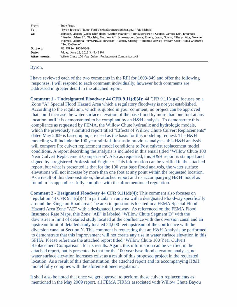
From: Toby Fruge To: "Byron Brooks"; "Butch Ford"; [email protected]; "Rae Nichols" Cc: Johnson, Joseph (CTR); Ellen Ibert; "Marion Pearson"; "Tonia Bergeron"; Cooper, James; Lain, Emanuel;
"Reeder, Adam J."; "Goolsby, Matthew A."; Schexnayder, Jamie; Emery, Jason; Spann, Tiffany; Pitts, Melanie; Holmes, Leschina; "HMGP1603TechAssist"; "Jeffrey Giering"; "Shontae Davis"; "William Oiler"; "Eula Ghoram"; "Ted DeBaene"
Subject: RE: RFI for 1603-0349 Date: Friday, June 19, 2015 3:45:49 PM Attachments: Willow Chute 100 Year Culvert Replacement Comparison.pdf
Byron,
I have reviewed each of the two comments in the RFI for 1603-349 and offer the following responses. I will respond to each comment individually; however both comments are addressed in greater detail in the attached report.
Comment 1 - Undesignated Floodway 44 CFR 9.11(d)(4): 44 CFR 9.11(d)(4) focuses on a Zone "A" Special Flood Hazard Area which a regulatory floodway is not yet established. According to the regulation, which is quoted in your comment, no project can be approved that could increase the water surface elevation of the base flood by more than one foot at any location until it is demonstrated to be compliant by an H&H analysis. To demonstrate this compliance as requested by FEMA, the Willow Chute hydraulic and hydrologic models, which the previously submitted report titled "Effects of Willow Chute Culvert Replacements" dated May 2009 is based upon, are used as the basis for this modeling request. The H&H modeling will include the 100 year rainfall. Just as in previous analyses, this H&H analysis will compare Pre culvert replacement model conditions to Post culvert replacement model conditions. A report describing the analysis is included in this email titled "Willow Chute 100 Year Culvert Replacement Comparison". Also as requested, this H&H report is stamped and signed by a registered Professional Engineer. This information can be verified in the attached report, but what is presented is that for the 100 year base flood analysis, the water surface elevations will not increase by more than one foot at any point within the requested location. As a result of this demonstration, the attached report and its accompanying H&H model as found in its appendices fully complies with the aforementioned regulation.
Comment 2 - Designated Floodway 44 CFR 9.11(d)(4): This comment also focuses on regulation 44 CFR 9.11(d)(4) in particular in an area with a designated Floodway specifically around the Kingston Road area. The area in question is located in a FEMA Special Flood Hazard Area Zone "AE" with a designated floodway. As referenced on the FEMA Flood Insurance Rate Maps, this Zone "AE" is labeled "Willow Chute Segment D" with the downstream limit of detailed study located at the confluence with the diversion canal and an upstream limit of detailed study located 24,000 feet upstream of the confluence with the diversion canal at Section N. This comment is requesting that an H&H Analysis be performed to demonstrate that this improvement will not create any rise in water surface elevation in this SFHA. Please reference the attached report titled "Willow Chute 100 Year Culvert Replacement Comparison" for its results. Again, this information can be verified in the attached report, but is presented is that for the 100 year base flood elevation analysis, no water surface elevation increases exist as a result of this proposed project in the requested location. As a result of this demonstration, the attached report and its accompanying H&H model fully complies with the aforementioned regulation.
It shall also be noted that once we get approval to perform these culvert replacements as mentioned in the May 2009 report, all FEMA FIRMs associated with Willow Chute Bayou
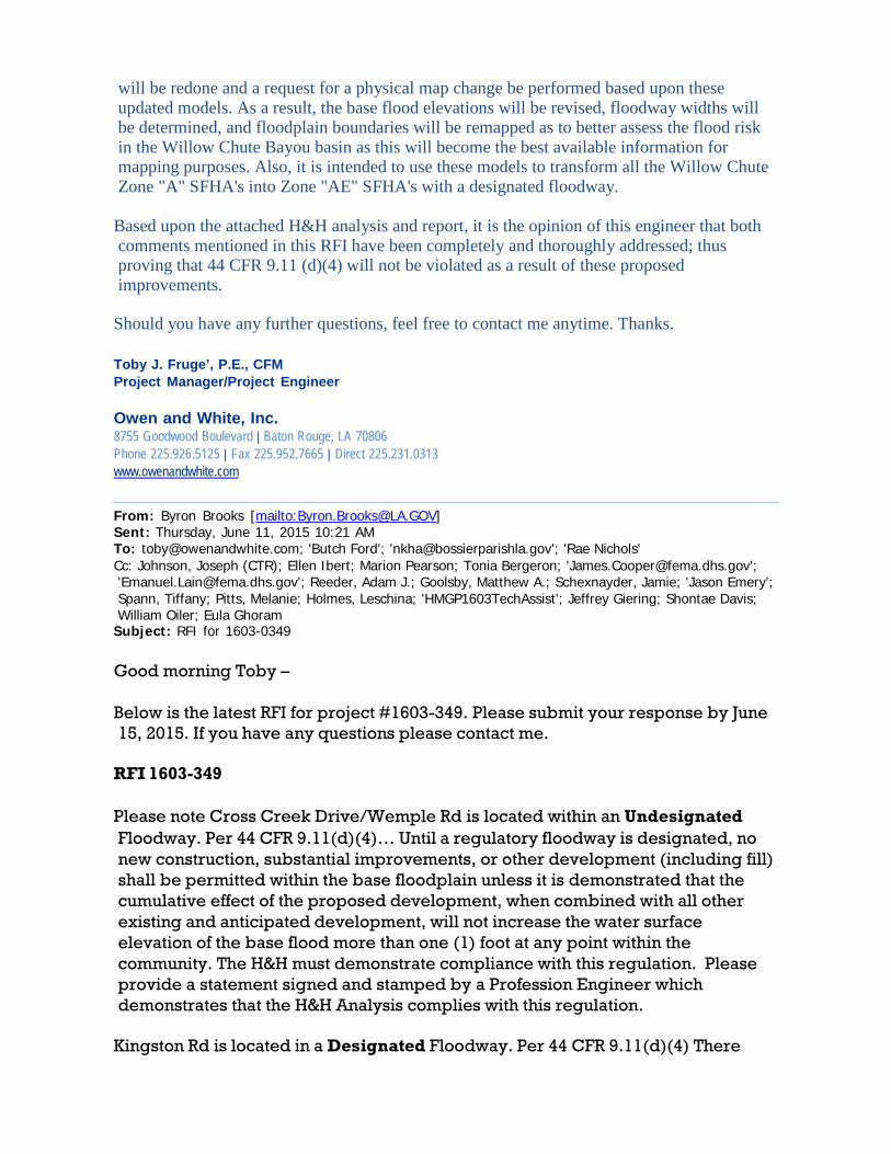
will be redone and a request for a physical map change be performed based upon these updated models. As a result, the base flood elevations will be revised, floodway widths will be determined, and floodplain boundaries will be remapped as to better assess the flood risk in the Willow Chute Bayou basin as this will become the best available information for mapping purposes. Also, it is intended to use these models to transform all the Willow Chute Zone "A" SFHA's into Zone "AE" SFHA's with a designated floodway.
Based upon the attached H&H analysis and report, it is the opinion of this engineer that both comments mentioned in this RFI have been completely and thoroughly addressed; thus proving that 44 CFR 9.11 (d)(4) will not be violated as a result of these proposed improvements.
Should you have any further questions, feel free to contact me anytime. Thanks.
Toby J. Fruge’, P.E., CFM Project Manager/Project Engineer
Owen and White, Inc. 8755 Goodwood Boulevard | Baton Rouge, LA 70806 Phone 225.926.5125 | Fax 225.952.7665 | Direct 225.231.0313 www.owenandwhite.com
From: Byron Brooks [mailto:[email protected]] Sent: Thursday, June 11, 2015 10:21 AM To: [email protected]; 'Butch Ford'; '[email protected]'; 'Rae Nichols' Cc: Johnson, Joseph (CTR); Ellen Ibert; Marion Pearson; Tonia Bergeron; '[email protected]'; '[email protected]'; Reeder, Adam J.; Goolsby, Matthew A.; Schexnayder, Jamie; 'Jason Emery'; Spann, Tiffany; Pitts, Melanie; Holmes, Leschina; 'HMGP1603TechAssist'; Jeffrey Giering; Shontae Davis; William Oiler; Eula Ghoram
Subject: RFI for 1603-0349 Good morning Toby –
Below is the latest RFI for project #1603-349. Please submit your response by June 15, 2015. If you have any questions please contact me.
RFI 1603-349
Please note Cross Creek Drive/Wemple Rd is located within an Undesignated Floodway. Per 44 CFR 9.11(d)(4)… Until a regulatory floodway is designated, no new construction, substantial improvements, or other development (including fill) shall be permitted within the base floodplain unless it is demonstrated that the cumulative effect of the proposed development, when combined with all other existing and anticipated development, will not increase the water surface elevation of the base flood more than one (1) foot at any point within the community. The H&H must demonstrate compliance with this regulation. Please provide a statement signed and stamped by a Profession Engineer which demonstrates that the H&H Analysis complies with this regulation.
Kingston Rd is located in a Designated Floodway. Per 44 CFR 9.11(d)(4) There

shall be no encroachments, including fill, new construction, substantial improvements of structures or facilities, or other development within a designated regulatory floodway that would result in ANY increase in flood levels within the community during the occurrence of the base flood discharge. The H&H must demonstrate compliance with this regulation. Please provide a statement signed and stamped by a Profession Engineer which demonstrates that the H&H Analysis complies with this regulation.
FEMA EHP will need this information to demonstrate compliance with EO 11988 to move this project forward.
Thanks,
Byron D. Brooks State Applicant Liaison, Mitigation Governor's Office of Homeland Security and Emergency Preparedness Office: 225-267-2540 Cell: 225-788-4101 Fax: 225-267-2605
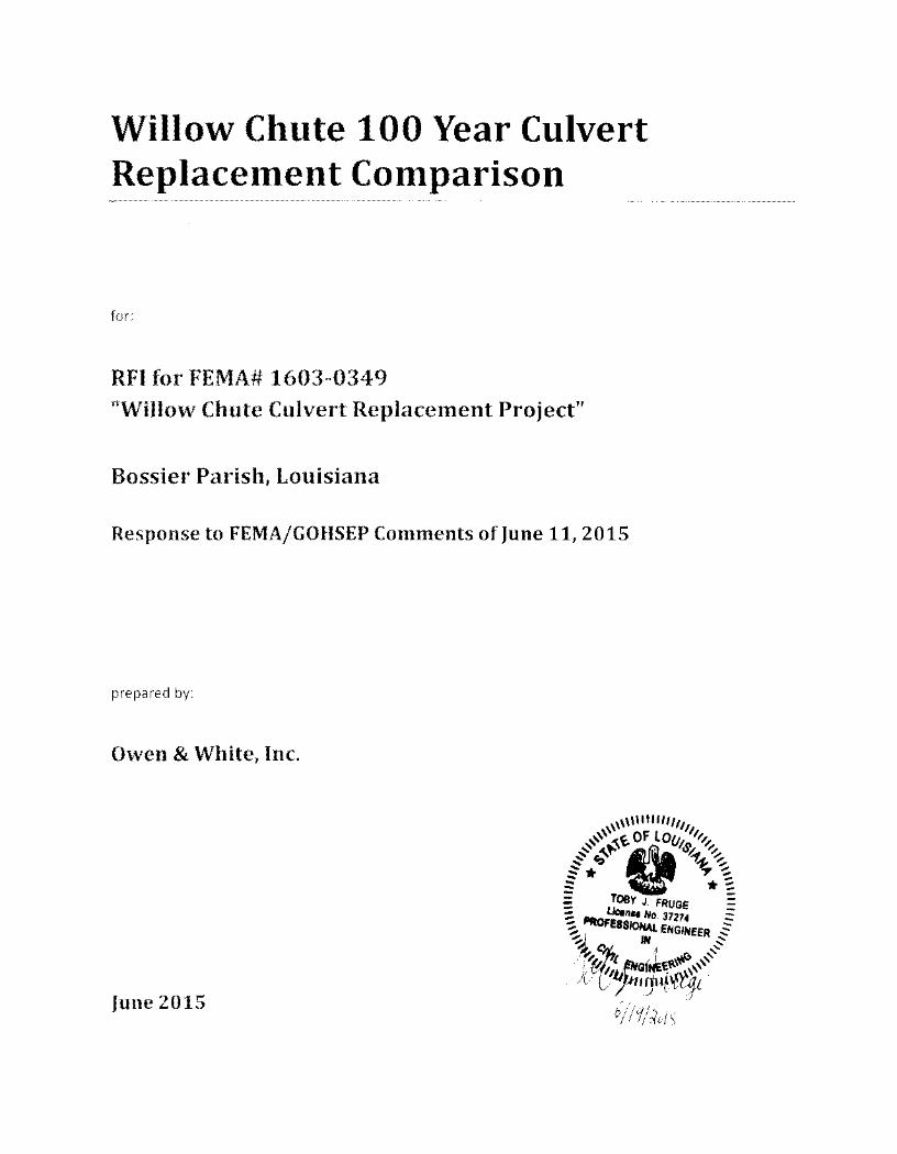
Year Culve .. Replace mpar1son
RFI 1 Projectn
5
Introduction
A Request for Information, or RFI, from FEMA/GOHSEP was received in regards to the Willow
Chute Culvert Replacements Project in June 2015. This proposed project as discussed in the report titled
"Effects of Willow Chute Culvert Replacements" dated May 2009 contains conveyance improvements by
means of culvert replacements along Willow Chute Bayou in Bossier Parish, Louisiana at three stream
crossing locations: Kingston Road, Lafitte Road, and Wemple Road.
This RFI specifically references a regulation in Section 44 CFR 9.11(d)(4) which states, "There
shall be no encroachments, including fill, new construction, substantial improvements of structures or
facilities, or other development within a designated regulatory floodway that would result in any
increase in flood levels within the community during the occurrence of the base flood discharge. Until a
regulatory floodway is designated, no new construction, substantial improvements, or other
development (including fill) shall be permitted within the base floodplain unless it is demonstrated that
the cumulative effect of the proposed development, when combined with all other existing and
anticipated development, will not increase the water surface elevation of the base flood more than one
foot at any point within the community."
It is requested by FEMA/GOSHEP to perform an H&H analysis to demonstrate that regulation 44
CFR 9.11(d)(4) is satisfied. The RFI is divided into two parts which are to be referred to as Comment 1
and Comment 2 within this report. Comment 1 focuses on an area described within a Special Flood
Hazard Area (SFHA) with an undesignated floodway. This area is the Zone "A" SFHA located between
Willow Chute Segment A and Willow Chute Segment D as shown on the Flood Insurance Rate Map. This
Zone "A" contains the proposed Lafitte Road and Wemple Road improvements. Comment 2 focuses on a
SFHA with a designated floodway which is the Zone "AE" SFHA of Willow Chute Segment D. This
segment contains the proposed Kingston Road improvement.
It is the goal of this analysis to satisfy Comments 1 and 2 by demonstrating that the proposed
improvements as mentioned in the report titled "Effects of Willow Chute Culvert Replacements" dated
May 2009 will not violate regulation 44 CFR 9.11(d)(4) for the 100 year base flood for the two requested
areas of Willow Chute Bayou.
Hydrologic and Hydraulic Model
In order to achieve the goal, two hydrologic and hydraulic models are developed. The first
model is called the "Pre Culvert Replacement Model." This model calculates the 100 year water surface
elevations assuming that the proposed improvements as mentioned in the May 2009 report have not
yet been constructed. This model acts as the base model for the 100 year water surface elevation
comparison. The second model is called the "Post Culvert Replacement Model." This model also
calculates the 100 year water surface elevations but models with the culvert replacements in place. By
directly comparing these two model results, conclusions can be drawn as to if the above mentioned
regulation is satisfied for these two areas.
As in the previous May 2009 report, the NRCS method (formally the SCS method) is selected to
perform all discharge calculations for both Pre and Post Culvert Replacement Models. Refer to the
previous May 2009 report Hydrology section for a detail account of the methodology used which
includes all NRCS method inputs such as lag time, CN values, slope values, percent imperviousness, etc.
Since this model is being used to calculate the 100 year water surface elevations, the selected
NRCS rainfall value for this storm event is 10.2 inches in a twenty four hour period using Type III rainfall
distribution for both models.
As in the previous May 2009 report, the Hec-HMS program is used to aid in the hydrologic
calculations. This program combines the runoff hydrographs in the upstream subbasins and routes the
combined hydrographs using the Modified Puls routing method. This routing method accounts for
potential storage in the basin. The peak 100 year storm discharges can be found in the attached
Hydrologic and Hydraulic Appendix.
The peak discharges as calculated from Hec-HMS are then used as input values into both Hec-
RAS models. Hydraulic methodology can be referenced in the previous May 2009 report since none of
the methodology has changed.
Both the Pre and Post Culvert Replacement Models were ran, and a summary of the resulting
100 year water surface elevations as calculated by Hec-RAS can be found Appendix A; while the Hec-RAS
report for the Pre Culvert Replacement Model can be found in Appendix B, and the Hec-RAS report for
the Post Culvert Replacement Model can be found in Appendix C.
Conclusions
After performing the analysis, conclusions for both Comment 1 and Comment 2 can be drawn.
For Comment 1, the concern as described in regulation 44 CFR 9.11(d)(4) is that the Post Culvert
Replacement Model would increase the 100 year water surface elevations by more than one foot in the
area with an undesignated floodway, the Zone "A", thus violating the regulation. After performing the
analysis, a direct comparison of 100 year water surface elevations were made at every point within the
Zone "A". This comparison can be found in Appendix A. Results from this analysis show that the
maximum water surface elevation increase within this Zone "A" is 0.16 feet, or 1.9 inches at River
Station 60712 of the Hec-RAS model. The average water surface elevation increase within this area is
0.12 feet. As a result, it can be concluded that since the Base Flood Elevations are not increased by more
than 0.16 feet at any location within the Zone "A" SFHA as a result of the requested culvert
improvements, thus the analysis proves the 44 CFR 9.11(d)(4) regulation is not violated for Comment 1.
For Comment 2, the concern as described in regulation 44 CFR 9.11(d)(4) is that the Post Culvert
Replacement Model would increase the 100 year water surface elevations in Willow Chute D, thus
violating the regulation. After performing the analysis, a direct comparison of 100 year water surface
elevations were made at every point within Willow Chute Segment D. Results from this analysis show
that in no location of Willow Chute Segment D does a water surface elevation increase exist. This
comparison can be found in Appendix A. In fact, the average water surface elevation reduction in
Willow Chute Segment D is 1.85 feet with a minimum reduction 0.84 feet and a maximum reduction of
2.97 feet. As a result, it can be concluded that since no increase in the 100 year water surface elevations
exist at any point within Willow Chute Segment D as a result of the requested culvert improvements, the
analysis proves the 44 CFR 9.11(d)(4) regulation is not violated for Comment 2.
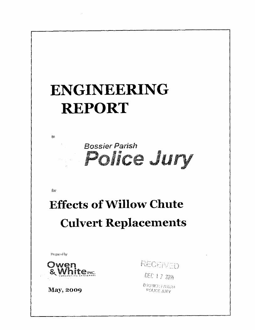
ENGINEERING REPORT
to
Bossier Parish
Ju for
Effects of Willow Chute
Culvert Replacements
Prepared by
May, 2009 F1C)L/CE ,JUF?Y
EXECUTIVE SUMMARY
Willow Chute meanders through 17 miles of western Bossier Parish to its confluence at Flat River Drainage Canal.
Willow Chute is a slow moving stream which overflows its banks in significant rainfall events. In spite of this condition, development is drawn to its floodplain.
A drainage impact ordinance addresses the problem for future development, but an existing condition model needs to be developed to properly address the ordinance. The first feature of this report presents the Existing Conditions Model. This model assumes all runoff is contained within the Willow Chute basin.
The second feature of this report considers the replacement of roadway culverts in the system. The most favorable combination considers replacements at:
Kingston Road with 2-10 ft tank cars Lafitte Road with 4 - 8 ft corrugated metal pipes Wemple Rd with 4 - 10 ft tank cars
This combination will produce a decrease in water surface elevation of 0.4 feet at Wemple Road, 1.5 feet at Lafitte Road and 3 .5 feet at Kingston Road. The reduction at Kingston Road will then dissipate to 3.0 feet at the uppermost section.
It is recommended that these three roadway crossings be replaced.
It shall also be noted that the upgrading of the culverts on Willow Chute will increase the downstream discharge causing an increase in the downstream water surface elevation. The maximum increase is 0.3 feet. The increase will not affect any existing structures. The benefits of decreased water surface elevations upstream outweigh the adverse impact downstream of the culvert replacements.
170904.10 (LC150)
INTRODUCTION
Willow Chute meanders through 17 miles of western Bossier Parish from Bossier City to near Benton as presented on Exhib.it 1. The mouth of Willow Chute is at Flat River Drainage Canal near the Tiburon Subdivision. Through the years, Willow Chute drainage system has been modified by man. A long meander has been divided to fonn two tributary streams. A large diversion canal has been constructed. The entire upper reach of Willow Chute has been diverted to the Flat River Drainage Canal.
Willow Chute is characterized as being a slow flowing stream which overflows whenever a significant rainfall occurs. The stream is badly overgrown throughout much of its length.
In spite of these negative conditions, development is drawn to its floodplain. The additional stonnwater from these developments, make the problem even worse. Some developments have constructed detention basins to lessen the peak discharge to Willow Chute. However, this does not resolve the problem since the total volume discharging into Willow Chute increases and Willow Chute is sensitive to increases in volume.
It has long been suspected that undersized roadway crossing obstruct the flow on Willow Chute, thereby increasing upstream water surface elevations. To determine the potential for improving this condition, alternative modifications are prepared for consideration. Subsequently, a three culvert replacement and a two crossing removal system has been decided to be implemented. This Alternative Improvements Model is contained in this report.
170904.10 (LCl50)
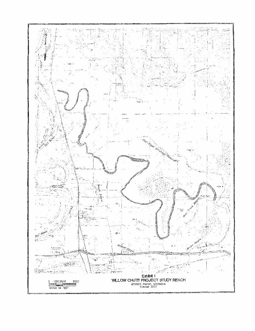


HYDROLOGY
The SCS method is selected to perform the discharge computations. This method is selected due to its familiarity with engineers in the region.
The sub basins, as presented on Exhibit 2, are defined with the aid of the WMS computer program which also computed the length, slope, and basin area. The percent of each soil type is obtained from the NRCS Web Soil Survey and converted into the CN number. The imperviousness is estimated using recent aerial imagery.
The lag time is computed by the SCS formula:
T LAG= L o.s (S+ll 0 7 ·
1900 y o.s
where: L= Hydraulic Length of watershed in feet S= Maximum retention in the watershed in inches as defined by
s = 1000-10 CN
Y = Watershed slope in percent CN = SCS curve member for watershed n = Manning's roughness coefficient along longest watercourse
The table of values is as follows:
170904.10 (LC150)

SCS Input Values and Computed Lag Time Subbasin Length, ft CN % Slope Lag (hrs) Lag {min) %Imp Area, sq mi WC-1 7,752 76 1.05 1.80 108 1.0 0.55 WC-2 5,864 75 0.25 3.04 182 6.0 0.21 WC-3 4,376 70 1.43 1.16 69 5.0 0.12 WC-4 5,295 69 0.43 2.52 151 0.0 0.27 WC-5 12,766 76 0.95 2.82 169 4.0 0.66 WC-6 1, 188 68 1.90 6.92 415 4.5 0.71 WC-7 19,566 76 0.94 3.99 239 00 0.63 WC-8 8,420 72 0.49 3. 15 189 8.3 1. 18 WC-9a 10,080 70 0.99 2.71 162 10.0 0.74 WC-9b 2,994 78 0.40 1.28 77 35.4 0.24 WC-9c 3,568 74 1.62 0.83 50 15.0 0. 11 WC-10 12,853 75 0.93 2.95 177 20.2 0.64 WC-11 10,830 83 2. 18 1.31 79 1.0 0.28 WC-12 4,965 72 0.30 2.64 158 3.0 0.49 WC-13 2,400 72 1.85 0.59 36 24.0 0.05 WC-14 11,881 78 0.26 4.80 288 8.8 0.59 WC-15 6,670 77 0.57 2. 10 126 14.5 0.40 WC-16 9,449 77 2.29 1.39 83 18.2 0.24 WC-17 18,572 84 2.66 1.77 106 2.0 0.49 WC-18 14,503 73 0.42 5. 12 307 60.0 1.94 WC-19 13,052 82 3.87 1. 18 71 1.0 0.28 Racetrack 13,272 84 1 06 2. 14 129 5.0 1.28 WC-20 1,327 84 5.03 0. 16 9 1.0 0.01

I
Peak 25 Year Discharges
Location Subbasin Q2s Accumulated Q2s I WC-1 485 cfs WC-2 130 cfs
RS 82400 584 cfs WC-3 126 cfs
RS 78800 255 cfs WC-4 162 cfs
·--RS 78000 300 cfs
WC-5 434 cfs ·-
RS 66461 449 cfs WC-6 205 cfs
RS 65500 470 cfs WC-7 320 cfa
RS 65000 502 cfs WC-8 674 cfs
RS 62740 907 cfs -- ·-WC-9 692 cfs
RS 62000 1026 cfs -WC-10 423 cfs
RS 53200 727 cfs WC-11 339 cfs
RS 44000 609 cfs WC-12 309 cfs
~;,r43200 636 cfs -- - ·-··
-- --0 84 cfs
I - --
RS 42400 __ 633 cfs - ···------
The Loss Rate for each sub basin is computed by the HEC HMS computer program using the drainage area, imperviousness, and CN number. The computer program computes the initial loss and all subsequent losses for each time interval.
The 25 year 24 hour duration return storm in the model is a Type III distribution with a 9.0 inch storm depth.
The HEC HMS program combines all the proceeding data to form a runoff hydro graph for each subbasin.
The HEC HMS program combines the runoffhydrographs in the upstream subbasins and then routes the combined hydro graph to the next point of combination. A Modified Puls routing system is used. This system accounts for storage in the stream by comparing water surface elevations for various discharges. A schematic diagram of the drainage system is presented as Exhibit 3.
The peak 25 year return storm discharges resulting from these calculations are presented in the following table:
170904.10 (LC150)
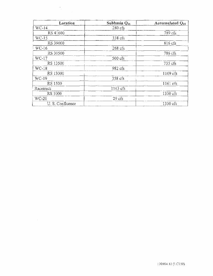
Location Subbasin Q2s Accumulated Q25
WC-14 280 cfs RS 41600 789 cfs
WC-15 338 cfs RS 39000 I 816 cfs '
WC-16 268 cfs RS 30500 786 cfs
-· -·--WC-17 500 cfs
RS 13500 735 cfs WC-18 982 cfs ..
RS 13000 1169 cfs WC-19 358 cfs
RS 1500 1161 cfa Racetrack 1163 cfs
RS 1000 1330 cfs -
WC-20 29 cfs -· U. S. Confluence 1330 cfs
170904.10 (LC150)
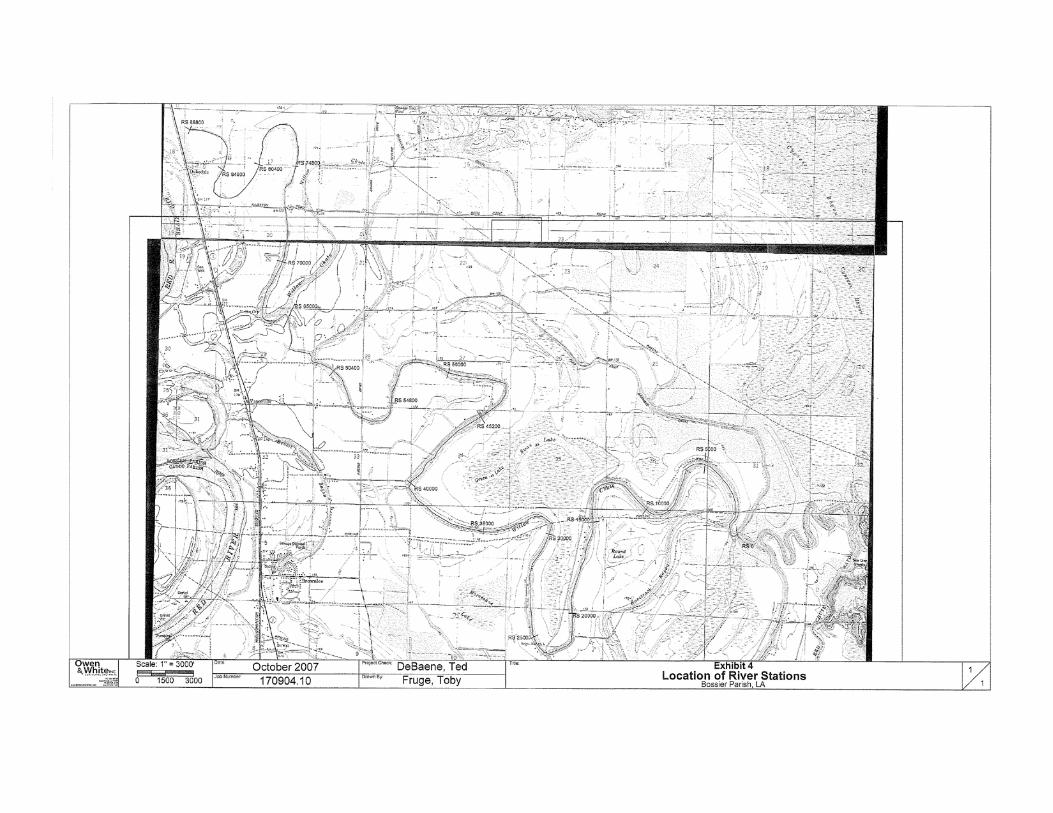
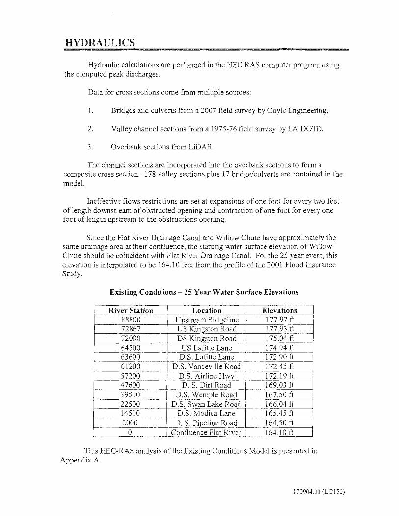
HYDRAULICS
Hydraulic calculations are performed in the HEC RAS computer program using the computed peak discharges.
Data for cross sections come from multiple sources:
1. Bridges and culverts from a 2007 field survey by Coyle Engineering,
2. Valley channel sections from a 1975-76 field survey by LA DOTD,
3. Overbank sections from LiDAR.
The channel sections are incorporated into the overbank sections to form a composite cross section. 178 valley sections plus 17 bridge/culverts are contained in the model.
Ineffective flows restrictions are set at expansions of one foot for every two feet of length downstream of obstructed opening and contraction of one foot for every one foot oflength upstream to the obstructions opening.
Since the Flat River Drainage Canal and Willow Chute have approximately the same drainage area at their confluence, the starting water surface elevation of Willow Chute should be coincident with Flat River Drainage Canal. For the 25 year event, this elevation is interpolated to be 164.10 feet from the profile of the 2001 Flood Insurance Study.
Existing Conditions -25 Year Water Surface Elevations
River Station Location Elevations l -- --88800 Upstream Ridgeline 177.97 ft 72867 US Kingston Road 177.93 ft 72000 DS Kingston Road 175.04 ft 64500 US Lafitte Lane 174.94 ft 63600 D.S. Lafitte Lane 172.90 ft 61200 D.S. Vanceville Road 172.45 ft 57200 D.S. Airline Hwy 172.19 ft --47600 D. S. Dirt Road 169.03 ft 39500 D.S. Wemple Road 167.50 ft 22500 D.S. Swan Lake Road 166.04 ft 14500 D.S. Modica Lane 165.45 ft 2000 D. S. Pipeline Road 164.50 ft
0 Confluence Flat River 164.lOft
This HEC-RAS analysis of the Existing Conditions Model is presented in Appendix A.
170904.10 (LC150)

ALTERNATIVE IMPROVEMENT MODEL
It has long been suspected that undersized roadway crossing obstruct the fiow on Willow Chute, thereby increasing upstream water surface elevations. To determine the potential for improving this condition, alternative modifications were prepared for consideration. Subsequently, a three culvert replacement and a two crossing removal system has been decided to be implemented.
The proposed three culvert replacements and two crossing removals are as follows:
Alternative Location River Station Existing Crossing Proposed Kingston Road 72791 2-36" CMP 2-1 0 ft. tank cars Lafitte Lane 64088 1-7.5 ft CMP 4-8 ft. CMP Farm Road 60726 6-24" RCP Removal Bobby Bvrd Road 58367 Timber Bridge Removal Wemple Road 39906 2-10 ft CMP 4-10 ft. tank cars
The resulting water surface elevations and discharges for the Alternative Improvement Model as compared to the Existing Co11ditions Model at key locations arc as follows:
Peak 25 Year I Water Surface Location River Stations Discharge ( cfs) Elevation (ft)
Existing I Proposed / Existing Proposed Kingston Ln 72867 373 543 177.93 174.44 Laffite Ln 64135 657 684 174.94 173.44 V anceville Rd 61622 1013 1145 172.47 172.79 Airline Dr 57304 866 1037 172.18 172.43 Wemple Rd 39945 806 973 168.33 168.25
·-Swan Lake Rd 22952 763 907 166.06 166.37
It shall be noted that the upgrading of the culverts on Willow Chute will increase the downstream discharge causing a slight increase in the downstream water surface elevation. The maximum increase is 0.3 feet. The increase will not affect any existing structures.
It is recommended that these three roadway crossings be replaced, because it benefits of decreased water surface elevations upstream outweigh the adverse impact downstream of the culvert replacements.
This HEC-RAS analysis of the Alternative Improvement Model is presented in Appendix B.
170904.10 (LC 150)

APPENDIX E
OTHER INFORMATION
(PUBLIC NOTICE, 8-STEP, FONSI ETC.)

PUBLIC NOTICE FEMA NOTICE OF AVAILABILITY
DRAFT ENVIRONMENTAL ASSESSMENT DRAFT FINDING OF NO SIGNIFICANT IMPACT
MITIGATION PROPOSAL FOR THE WILLOW CHUTE BAYOU DRAINAGE PROJECT, BOSSIER CITY, BOSSIER PARISH, LOUISIANA
Interested parties are hereby notified that the Federal Emergency Management Agency (FEMA) has prepared a draft Environmental Assessment (EA) and draft Finding of No Significant Impact (FONSI) in compliance with the National Environmental Policy Act (NEPA). The purpose of the EA is to assess the effects on the human and natural environment for the Willow Chute Bayou Drainage Project, which proposes to implement drainage improvements in the Willow Chute Drainage Basin to prevent potential flooding of residential subdivisions in the Willow Chute Basin. Willow Chute meanders through 17 miles of western Bossier Parish to its confluence at Flat River Drainage Canal. During significant rainfall events, the banks of Willow Chute overflow due to undersized roadway crossings obstructing the flow on the Willow Chute, thereby increasing upstream water surface elevations. To address these issues, the Applicant proposes drainage improvements at three (3) roadway crossings on the Willow Chute. The purpose of the draft EA is to analyze the potential environmental impacts associated with the preferred action and alternatives. The draft EA evaluates a No Action Alternative; Alternative 2, which would install bridges at three (3) locations in the Willow Chute Basin; and the Preferred Action Alternative, which would replace existing culverts at three (3) locations in the Willow Chute Basin. The draft FONSI is FEMA’s finding that the preferred action would not have a significant effect on the human and natural environment. The draft EA and draft FONSI are available for review at the following locations: Bossier Parish Central Library, at 2206 Beckett Street, Bossier City, LA – Mondays through Thursdays 9:00am to 8:00pm; Fridays 9:00am to 6:00pm; Saturdays 9:00am to 5:00pm; Sundays 2:00pm to 5:00pm. This public notice will run in the local newspaper, the Bossier Press-Tribune, on Monday, July 6, Wednesday, July 8, and Friday, July 10, 2015; and in The Shreveport Times Monday, July 6 through Friday, July 10, 2015. The documents can also be downloaded from FEMA’s website at http://www.fema.gov/resource-document-library. There will be a fifteen (15) day comment period, beginning on July 6, 2015 and concluding on July 21, 2015 at 4 p.m. Comments may be mailed to: DEPARTMENT OF HOMELAND SECURITY-FEMA EHP, 1500 MAIN STREET, BATON ROUGE, LOUISIANA 70802. Comments may be emailed to: [email protected] or faxed to 225-346-5848. Verbal comments will be accepted or recorded at 504-427-8000. If no substantive comments are received, the draft EA and associated FONSI will become final.
8-STEP PROCESS
EO 11988-FLOODPLAIN MANAGEMENT
EO 11990-WETLAND PROTECTION
DATE: 06/16/2015 PREPARED BY: Jamie Schexnayder, CFM/Environmental Protection Specialist PROJECT: Willow Chute Bayou Drainage Project Hazard Mitigation Grant Program Project No. 1603-0349, FEMA Disaster 1603-DR-LA LOCATION: Willow Chute Bayou Drainage Basin, Bossier City, Bossier Parish, LA 71111 LATITUDE/ LONGITUDE: Crossings 32.629978, -93.728678; Kingston Rd at Willow Chute Bayou 32.611406, -93.726917; Willow Chute at Lafitte Lane 32.590028, -93.705703; Willow Chute at Cross Creek Drive/Wemple Road STEP 1 Determine whether the proposed action is located in a wetland and/or
The 100-yr floodplain (500-year floodplain for critical actions [44 CFR 9.4]), or whether it has the potential to affect or be affected by a floodplain or a wetland (see 44 CFR 9.7). Bossier Parish enrolled in the National Flood Insurance Program (NFIP) on 04/18/1983. Per Digital Flood Insurance Map (DFIRM) Panels; Willow Chute at Kingston Road: 22015C0315E, dated 03/19/2013, the site is located within Flood Zone AE, a special flood hazard area (SFHA) subject to inundation by the 1% annual chance (100-year) flood event; Base Flood Elevation (BFE) 175 feet determined (North American Vertical Datum 88 (NAVD88). This site is also located within a designated floodway. Willow Chute at Lafitte Lane: 22015C0401D, dated 09/26/2008, the site is located within Zone X, areas of minimal flood hazard, which are the areas outside the SFHA and higher than the elevation of the 0.2% annual chance flood. Willow Chute Bayou at Cross Creek Drive and Wemple Road: 22015C0404D, dated 09/26/2008, the site is located within Flood Zone A, a SFHA subjected to inundation by the 1% annual chance flood event generally determined using approximate methodologies, no BFE determined. The site is also located within an undesignated floodway.
STEP 2 Notify the public at the earliest possible time of the intent to carry out an action in a floodplain or wetland, and involve the affected and interested public in the decision making process (see 44 CFR 9.8). A cumulative public notice concerning the Hazard Mitigation Grant Program (HMGP) Assistance in floodplain and wetland areas will be or has been published in the New Orleans Times-Picayune, Baton Rouge Advocate, Lafayette Daily Advertiser, Lake Charles American Press, Hammond Star, Monroe News-Star, Shreveport Times, and the Alexandria Daily Town Talk.

STEP 3 Identify and evaluate practicable alternatives to locating the proposed action
in a floodplain or wetland (including alternative sites, actions and the "no action" option) [see 44 CFR 9.9]. If a practicable alternative exists outside the floodplain or wetland, FEMA must locate the action at the alternative site.
Drainage Improvements at Three Roadway Crossings (Proposed Action) Alternative Action 1: The preferred alternative is to improve the drainage on the Willow Chute by upgrading culverts at three (3) roadway crossings to prevent potential flooding of residential subdivisions in the Willow Chute Basin. The applicant proposes: 1) to remove the existing two (2) -42” reinforce concrete culverts and replace with two (2) -120” reinforced concrete pipes (RCPs) at the Kingston Road crossing. Associated proposed site work includes removing the existing guardrail (approximately 155 LF, each side) and reusing it in kind and removing and replacing the existing pavement; 2) to remove one (1) -8’ iron pipe and replace with four (4) -96” RCPs at the Lafitte Lane crossing. Associated proposed site work includes installing guardrails (approximately 156 LF, each side) and removing and replacing the existing pavement; and 3) to remove two (2) -108” corrugated metal pipes and replace with four (4) -120” RCPs at the Cross Creek Drive/Wemple Road crossing. Associated proposed site work includes installing guardrails (approximately 156 LF, each side) and removing and replacing the existing pavement. According to the Hydrologic and Hydraulic Study, the proposed action combined would produce a decrease in water surface elevation of 3.5 feet at Kingston Road, 1.5 feet at Lafitte Lane and 0.4 feet at Wemple Road. The reduction at Kingston Road would then dissipate to 3.0 feet at the uppermost section. Dismissed Alternatives: No Action: Implementation of the No Action Alternative would entail no hazard mitigation measures for the Willow Chute Bayou Drainage Basin. Consequently, flooding would not be abated or improved. This alternative would also result in hazardous conditions for not only the residents of Bossier Parish, but also businesses and emergency responders who utilize the roadways and live in this area. The No Action Alternative does not meet the purpose and need. This alternative would perpetuate the “damage-repair-damage” cycle thus requiring additional funding to be drawn from the National Flood Insurance Program as well as depleting local and National disaster funds. Alternative Action 2: This Alternative includes the replacement of the existing culverts at three (3) roadway crossings with bridges. Each bridge would have to be at least two (2) spans approximately 40 feet in length, meet Department of Transportation and Development (DOTD) standards and would cost approximately $350,000 to $500,000 per location. This option would require the
closure of the roadway at each location for 90 to 120 days to construct the new bridge. Therefore, this alternative was not considered cost effective.
STEP 4 Identify the full range or potential direct or indirect impacts associated with, the occupancy or modification of floodplains and wetlands and the potential direct and indirect support of floodplain and wetland development that could result from the proposed action (see 44 CFR 9.10).
Alternative Action 1: This alternative consists of improving the drainage on the Willow Chute by upgrading culverts at three (3) roadway crossings to prevent potential flooding of residential subdivisions in the Willow Chute Basin. Hydraulic calculations for this action are provided in Appendix D and preliminary plans for this action are provided in Appendix B. Per correspondence from Toby Fruge’, P.E., CFM, of Owen and White, Inc., dated May 19, 2015, the only impacts that exist upstream of the proposed project area are positive impacts. The average water surface elevation decreases are greater than two feet within the project area. This benefit will affect multiple existing structures in the project area thus reducing their flooding potential as a result of the culvert replacements. As a result, there will be no negative impacts upstream of the proposed improvements. For this proposed project, there would be a 0.3 foot increase in water surface elevation between the crossing of Le Oaks Drive and Vanceville Road, however, this increase does not create an adverse impact since no existing structures are to be impacted. The increase in water surface elevation encroaches within the undeveloped portions in this area since these portions of land are at lower elevations than the developed tracts. Due to the low lying undeveloped land in the area between Wemple Road and Modica Lane, another 0.3 foot increase in water surface elevations would occur as a result of the proposed project, however, no structures would be impacted as a result of the increases. Incorporation of construction methods that meet the local floodplain ordinance will likely reduce risk and protect against future flood damage. E.O. 11988 conditions and BMPs for the proposed project must meet the local floodplain management standard within the community for which local ordinances were adopted through their participation in the NFIP.
STEP 5 Minimize the potential adverse impacts and support to or within floodplains and wetlands to be identified under step # 4, restore and preserve the natural and beneficial values served by floodplains, and preserve and enhance the natural and beneficial values served by wetlands (see 44 CFR 9.11).
Alternative Action 1: The Drainage Improvements at Three Roadway Crossings shall be in accordance with local floodplain ordinances with applicable codes and standards applied to mitigate and minimize adverse effects (compliance with minimum National Flood Insurance Program standards and requirements). No significant direct impact would occur to floodplains under this alternative. However, indirect, short-term impacts to the surrounding area could occur during construction.

STEP 6 Reevaluate the proposed action to determine first, if it is still practicable in
light of its exposure to flood hazards, the extent to which it will aggravate the hazards to others. And it’s potential to disrupt floodplain and wetland values and second, if alternatives preliminarily rejected at step # 3 are practicable in light of the information gained in steps # 4 and # 5. FEMA shall not act in a floodplain or wetland unless it is the only practicable location (see 44 CFR 9.9). The proposed action is the chosen practicable alternative based upon a review of possible adverse effects on the floodplain and community and socioeconomic expectations. The actions proposed are located in the only practicable location. There are no other practicable alternate locations outside the floodplain available.
STEP 7 Prepare and provide the public with a finding and public explanation of any
final decision that the floodplain or wetland is the only practicable alternative (see 44 CFR 9.12).
The draft EA went out for public review in the Bossier Press-Tribune, on Monday, July 6, Wednesday, July 8, and Friday, July 10, 2015; and in The Shreveport Times Monday, July 6 through Friday, July 10, 2015.
STEP 8 Review the implementation and post-implementation phases of the proposed action to ensure that the requirements of the order are fully implemented. Oversight responsibility shall be integrated into existing processes.
Project shall be reviewed by FEMA at grant closeout to ensure the project was completed in accordance with all relevant and applicable floodplain ordinances, codes and standards and that all project actions were undertaken in accordance with terms and conditions stipulated to mitigate and minimize adverse effects in or to the floodplain and wetlands. Approval conditioned on reviews of implementation and post implementation phases to ensure compliance with the order(s). Project has been reviewed for compliance with 44 CFR Part 9.

U.S. Department of Homeland Security Louisiana Recovery Office
1500 Main Street Baton Rouge, LA 70802
DRAFT FINDING OF NO SIGNIFICANT IMPACT
for the WILLOW CHUTE BAYOU DRAINAGE PROJECT
WILLOW CHUTE BASIN, BOSSIER PARISH, LOUISIANA PROJECT NUMBER 1603-0349
FEMA-1603-DR-LA BACKGROUND Hurricane Katrina, a Category 4 hurricane with a storm surge above normal high tide levels, moved across the Louisiana, Mississippi and Alabama Gulf Coasts on August 29, 2005. Extensive flooding damaged drainage capacity for neighborhoods, and improved drainage is needed in Bossier Parish, with mostly low-lying flat land, Bossier City, Louisiana incurs flooding frequently. The project area is situated north of the City of Bossier City and includes approximately 240 homes in the Willow Chute Basin. In accordance with 44 CFR Part 10, FEMA regulations to implement the National Environmental Policy Act (NEPA), an Environmental Assessment (EA) was prepared. The purpose of the EA was to analyze the potential environmental impacts associated with drainage improvements and determine whether to prepare an Environmental Impact Statement (EIS) or Finding of No Significant Impact (FONSI). The need for the proposed action is to effectively improve the drainage capacity and eliminate recurrent prolonged flooding experienced in the neighborhoods in the Willow Chute Basin; thereby, protecting the health and well-being of the people of Bossier Parish, protecting existing public and private infrastructure, and reducing the risk of future damage from flooding. If left unprotected, future storm events have the potential to repeatedly damage homes and property in this area. The alternatives considered include: 1) No Action, 2) Construct a Bridge at Three Roadway Crossings, and 3) Drainage Improvements at Three Roadway Crossings (Proposed Action). The undersized roadway crossings obstruct the flow on the Willow Chute, thereby increasing upstream and downstream water surface elevations. The preferred alternative is to construct new culverts at three existing roadway crossings to alleviate major drainage and flooding problems experienced within residential subdivisions in the Willow Chute Basin. As such, the following improvements are proposed as part of this project which include: 1) Removing the existing system of two (2) -42” reinforce concrete culverts and replacing with two (2) -120” reinforced concrete pipes (RCPs) on Kingston Road at Willow Chute Bayou between LA 3 and Airline Road; 2) Removing the existing system of one (1) -8’ iron pipe and replacing with four (4) -96” reinforced concrete pipes (RCPs) on Lafitte Lane between LA 3 and Audubon Drive; and 3)

Removing the existing system of two (2) -108” corrugated metal pipes and replacing with four (4) -120” reinforced concrete pipes (RCPs) on Cross Creek Drive at the entrance to Lakewood Subdivision. According to the Hydrologic and Hydraulic Study, the proposed action will lower the water surface elevation 3.5 feet at Kingston Road, 1.5 feet at Lafitte Lane and 0.4 feet at Wemple Road, alleviating major drainage and flooding problems at these locations. The proposed action will protect more than 200 structures against the 25-year flood. FINDINGS FEMA has evaluated the proposed project for significant adverse impacts to geology, soils, water resources (surface water, groundwater, and wetlands), floodplains, coastal resources, air quality, biological resources (vegetation, fish and wildlife, Federally-listed threatened or endangered species and critical habitats), cultural resources, socioeconomics (including minority and low income populations), safety, noise, and hazardous materials. The results of these evaluations as well as consultations and input from other federal and state agencies are presented in the EA. CONDITIONS The following conditions must be met as part of the implementation of the project. Failure to comply with these conditions may jeopardize federal funds:
• Implement construction Best Management Practices (BMPs); install silt fences/straw bales to reduce downslope sedimentation. Area soils must be covered and/or wetted during construction.
• If fill is stored on site as part of unit installation or removal, the contractor is required to appropriately cover it.
• Construction contractor is required to obtain applicable Louisiana Pollutant Discharge Elimination System (LPDES) permit, and implement stormwater pollution prevention plan.
• The applicant is required to coordinate with the local floodplain administrator regarding floodplain permit(s) prior to the start of any activities.
• New construction must be compliant with current codes and standards.
• As per 44 CFR 9.11 (d) (9), mitigation or minimization standards must be applied, where possible. The replacement of building contents, materials and equipment should be, where possible, wet or dry-proofed, elevated, or relocated to or above the DFIRM BFE or local floodplain ordinances, whichever is more stringent.

• Per 44 CFR 9.11(d) (4)… Until a regulatory floodway is designated, no new construction, substantial improvements, or other development (including fill) shall be permitted within the base floodplain unless it is demonstrated that the cumulative effect of the proposed development, when combined with all other existing and anticipated development, will not increase the water surface elevation of the base flood more than one (1) foot at any point within the community.
• Per 44 CFR 9.11(d)(4) There shall be no encroachments, including fill, new construction, substantial improvements of structures or facilities, or other development within a designated regulatory floodway that would result in any increase in flood levels within the community during the occurrence of the base flood discharge.
• All coordination pertaining to these activities and applicant compliance with any conditions should be documented and copies forwarded to the state and FEMA for inclusion in the permanent project files.
• Any changes or modifications to the proposed project will require a revised determination. Off-site locations of activities such as borrow, disposals, haul- and detour roads, and work mobilization site developments may be subject to USACE regulatory requirements.
• Applicant must coordinate with USACE prior to the start of construction to acquire any necessary permits.
• Applicant must coordinate with USACE at the Vicksburg District Office to verify if jurisdictional waters of the U.S. do occur on site and which permits, if any, are required.
• The project results in a discharge to waters of the State; submittal of a Louisiana Pollutant Discharge Elimination System LPDES application is necessary.
• All precautions must be observed to control nonpoint source pollution from construction activities. LDEQ has stormwater general permits for construction areas equal to or greater than one (1) acre. The applicant must contact the LDEQ Water Permits Division at (225) 219-9371 to determine if the proposed project requires a permit.
• Erosion Control Devices (ECD’s) must be used and maintained extensively to prevent any potential direct or indirect adverse impacts to nearby wetland areas per the CWA and EO 11990. Any adverse impacts to adjacent wetlands resulting from the construction of this project will jeopardize receipt of federal funding.

If any solid or hazardous wastes, or soils and/or groundwater contaminated with hazardous constituents are encountered during the project, notification to LDEQ’s Single-Point-of-Contact (SPOC) at (225) 219-3640 is required. Additionally, precautions must be taken to protect workers from these hazardous constituents.
• The contractor must observe all precautions to protect the groundwater of the region.
• All debris should be disposed of in an approved landfill.
• The applicant is responsible for coordinating with and obtaining any required permit(s) from the LDNR Coastal Management Division prior to initiating work. The applicant shall comply with all conditions of the required permit. All coordination pertaining to these activities and applicant compliance with any conditions should be documented and copies forwarded to the state and FEMA for inclusion in the permanent project files.
• The LDNR coastal zone determination is valid for two (2) years beginning 06/18/2015. If the proposed activity is not initiated within this 2-year period, this determination will expire and the applicant will be required to submit a new application.
• Vehicle operation times would be kept to a minimum. Area soils must be covered and/or wetted during construction to minimize dust.
• Any changes to the scope or location of the proposed project or if the project has not been initiated one (1) year from the date of the solicitation of views (June 8, 2016), the applicant is responsible for coordinating with United States Fish and Wildlife Service.
• If during the course of work, archaeological artifacts (prehistoric or historic) are discovered, the applicant shall stop work in the vicinity of the discovery and take all reasonable measures to avoid or minimize harm to the finds. The applicant shall inform their, GOSHEP State Applicant Liaison and Hazard Mitigation Assistance contacts at FEMA, who will in turn contact FEMA Historic Preservation (HP) staff. The applicant will not proceed with work until FEMA HP completes consultation with the SHPO, and others as appropriate (Inadvertent Discovery Clause).
• If human bone or unmarked grave(s) are present within the project area, compliance with the Louisiana Unmarked Human Burial Sites Preservation Act (R.S. 8:671 et seq.) is required. The applicant shall notify the law enforcement agency of the jurisdiction where the remains are located within twenty-four hours of the discovery. The applicant shall also notify FEMA and the Louisiana Division of Archaeology at 225-342-8170 within seventy-two hours of the discovery. (Louisiana Unmarked Human Burial Sites Preservation Act)
• Unusable equipment, debris and material shall be disposed of in an approved manner and location. In the event significant items (or evidence thereof) are discovered during implementation of the project applicant shall handle, manage, and dispose of petroleum products, hazardous materials and/or toxic waste in accordance to the requirements and to the satisfaction of the governing local, state and federal agencies. Applicant is responsible for acquiring LDEQ permits for the temporary debris staging and reduction sites (TDSRS) associated with this project prior to project closeout. Failure to provide FEMA with LDEQ approval may jeopardize project funding eligibility.
• Bossier Parish limits noise levels by receiving land use in residential, public, commercial, and industrial areas to decibel levels of 60 during the “daytime” hours of 6 AM to 10 PM, Monday through Saturday, and 6 AM to 6 PM on Sunday. Construction activities should be limited to this schedule on weekdays. Mitigation and abatement measures will be required to reduce the noise levels to a range that would be considered acceptable.
• To minimize worker and public health and safety risks from project construction and closure, all construction and closure work must be done using qualified personnel trained in the proper use of construction equipment, including all appropriate safety precautions. Additionally, all activities must be conducted in a safe manner in accordance with the standards specified in OSHA regulations and the USACE safety manual.
• The contractor must post appropriate signage and fencing to minimize potential adverse public safety concerns, and to protect nearby residents from vehicular traffic.
• Appropriate signage and barriers should be in place prior to construction activities in order to alert pedestrians and motorists of project activities and traffic pattern changes.
• The contractor should implement traffic control measures, as necessary.
• If hazardous materials are unexpectedly encountered in the project area during the proposed construction operations, appropriate measures for the proper assessment, remediation, management and disposal of the contamination would be initiated in accordance with applicable federal, state, and local regulations. The contractor would be required to take appropriate measures to prevent, minimize, and control the spill of hazardous materials in the construction area.
• The LDNR Office of Conservation should be contacted at (225) 342-5540 if any unregistered wells of any type are encountered during construction work.
• For pipelines and other underground hazards, Louisiana One Call should be contacted at 800-272-3020 prior to commencing operations.

CONCLUSIONS Based upon the incorporated EA, and in accordance with Presidential Executive Orders 12898 (Environmental Justice), 11988 (Floodplain Management), and 11990 (Wetland Protection), FEMA has determined that the proposed action implemented with the conditions and mitigation measures outlined above and in the EA will not have any significant adverse effects on the quality of the natural and human environment. As a result of this FONSI, an Environmental Impact Statement will not be prepared (44 CFR Part 10.8) and the proposed action alternative as described in the EA may proceed.
APPROVALS Kevin Jaynes Date Regional Environmental Officer Region VI FEMA 1603-1607-DR-LA ____________________________________________________ Thomas “Mike” Womack Date Director of the Louisiana Recovery Office Region VI FEMA 1603-1607-DR-LA