WILLOUGHBY CARVOLTH BUSINESS PARK - Tom … · 2005-09-29 · The Carvolth Plan area is primarily...
22
N EIGHBOURHOOD P LAN WILLOUGHBY CARVOLTH BUSINESS PARK Adopted July 16, 2001 Re-Adopted July 30, 2001 $5.00
-
Upload
dangkhuong -
Category
Documents
-
view
217 -
download
0
Transcript of WILLOUGHBY CARVOLTH BUSINESS PARK - Tom … · 2005-09-29 · The Carvolth Plan area is primarily...
NEIGHBOURHOOD PLAN
WILLOUGHBY
CARVOLTH BUSINESS PARK
Adopted July 16, 2001
Re-Adopted July 30, 2001
$5.00

THE CORPORATION OF THE TOWNSHIP OF LANGLEY
Schedule W-200
Willoughby Community Plan
Carvolth Business Park Plan
Bylaw No. 3991


THE CORPORATION OF THE TOWNSHIP OF LANGLEY
AMENDMENT (WILLOUGHBY COMMUNITY PLAN) BYLAW 1998 NO. 3800
LANGLEY OFFICIAL COMMUNITY PLAN BY-LAW, 1979 NO. 1842
AMENDMENT (CARVOLTH BUSINESS PARK) BYLAW 2000NO. 3991
Adopted by Council on July 30, 2001
AMENDMENTS
BYLAW NO./NAME TEXT/MAP CHANGE DATE OF ADOPTION
4369 (Wesgroup Income Properties L.P./Nash)
Map/Text April 4, 2005
THE CORPORATION OF THE TOWNSHIP OF LANGLEY
LANGLEY OFFICIAL COMMUNITY PLAN BYLAW 1979 NO. 1842
AMENDMENT (CARVOLTH BUSINESS PARK)
BYLAW 2000 NO. 3991
Adopted by Council on July 16, 2001
Re-Adopted by Council on July 30, 20001
AMENDMENTS
BYLAW NO./NAME MAP/TEXT CHANGE DATE OF ADOPTION
4052 (Wesgroup Income Properties L.P. /House of Concord)
Map/Text December 15, 2003

THE CORPORATION OF THE TOWNSHIP OF LANGLEY
LANGLEY OFFICIAL COMMUNITY PLAN BY-LAW, 1979 NO. 1842 AMENDMENT (WILLOUGHBY COMMUNITY PLAN) BYLAW 1998 NO. 3800 AMENDMENT (CARVOLTH BUSINESS PARK PLAN) BYLAW 2000 NO. 3991
A Bylaw to amend Langley Official Community Plan Bylaw 1979 No. 1842 WHEREAS the Municipal Council of the Corporation of the Township of Langley deems it necessary and desirable to amend the Langley Official Community Plan Bylaw 1979 No. 1842 Amendment (Willoughby Community Plan) Bylaw 1998 No. 3800; NOW THEREFORE, the Municipal Council of the Corporation of the Township of Langley, in Open Meeting Assembled, ENACTS AS FOLLOWS: 1. This Bylaw may be cited as the “Langley Official Community Plan Bylaw 1979 No. 1842
Amendment (Willoughby Community Plan) Bylaw 1998 No. 3800 Amendment (CARVOLTH BUSINESS PARK PLAN) Bylaw 2000 No. 3991”.
2. The “Langley Official Community Plan Bylaw 1979 No. 1842 Amendment (Willoughby
Community Plan) Bylaw 1998 No. 3800” as amended is hereby amended as set out on Schedule “A” attached to and forming part of this Bylaw.
READ A FIRST TIME the 21st day of August , 2000 READ A SECOND TIME the 21st day of August , 2000 PUBLIC HEARING HELD the 14th day of May , 2001 READ A THIRD TIME the 4th day of June , 2001 RECONSIDERED AND ADOPTED the 16th day of July , 2001 RECONSIDERED AND RE-ADOPTED the
30th
day of
July
, 2001
“KURT ALBERTS”
Mayor
“IRENE GAULD”
Acting Manager of Corporate Administration
Certified a True Copy:
Acting Manager of Corporate Administration

Carvolth Business Park Plan
TABLE OF CONTENTS
1.0 Introduction ............................................................................................................................. 1
2.0 Existing Conditions and Context ........................................................................................... 1
2.1 Existing Conditions ............................................................................................................... 1
2.1.1 Land Use, Land Ownership and Current Zoning............................................................... 1
2.1.2 Natural Features................................................................................................................. 2
2.1.3 Views ................................................................................................................................... 2
2.1.4 Archaeological and Heritage Resources ........................................................................... 2
2.2 Community Context .............................................................................................................. 3
2.2.1 Willoughby Community Plan .............................................................................................. 3
2.2.2 Adjacent Neighbourhoods and Linkages........................................................................... 3
3.0 Business Park Plan Objectives................................................................................................ 3
4.0 Business Park Plan Policies.................................................................................................... 4
4.1 Description of Land Use Concept......................................................................................... 4
4.1.1 Land Use Principles ........................................................................................................... 4
4.1.2 Commercial......................................................................................................................... 4
4.1.3 Business/Office Park .......................................................................................................... 5
4.1.4 Residential.......................................................................................................................... 6
4.1.5 Suburban Residential.......................................................................................................... 6
4.1.6 Conservation ...................................................................................................................... 6
4.1.7 Buffer/Greenway................................................................................................................. 6
4.2 Environmental Protection ..................................................................................................... 7
4.3 Archaeological Resources Protection................................................................................... 7
5.0 Facilities................................................................................................................................... 7
5.1 Park & Ride ........................................................................................................................... 7
6.0 Servicing................................................................................................................................... 8
6.1 Roads ..................................................................................................................................... 8
6.2 Water..................................................................................................................................... 9
6.3 Sewer..................................................................................................................................... 9
6.4 Storm Drainage ...................................................................................................................... 9 MAPS
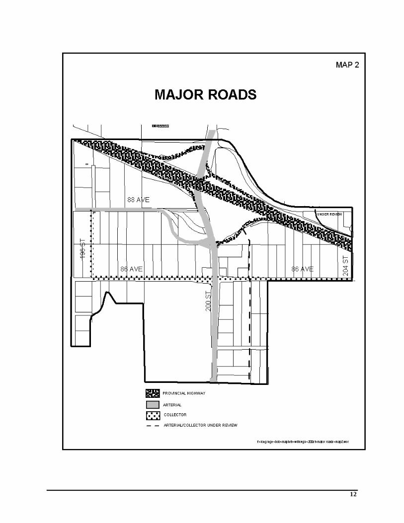
Map 1 Land Use Concept Map 2 Major Roads Map 3 Water Map 4 Sewer

1
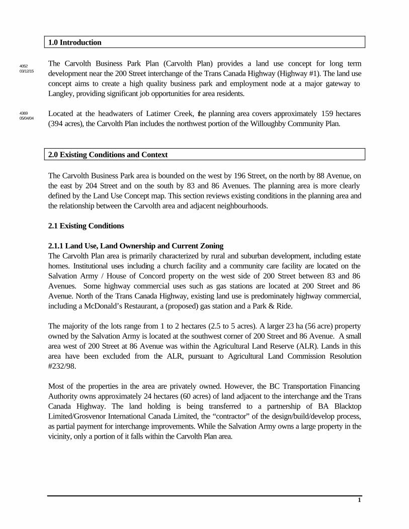
1.0 Introduction The Carvolth Business Park Plan (Carvolth Plan) provides a land use concept for long term development near the 200 Street interchange of the Trans Canada Highway (Highway #1). The land use concept aims to create a high quality business park and employment node at a major gateway to Langley, providing significant job opportunities for area residents. Located at the headwaters of Latimer Creek, the planning area covers approximately 159 hectares (394 acres), the Carvolth Plan includes the northwest portion of the Willoughby Community Plan. 2.0 Existing Conditions and Context The Carvolth Business Park area is bounded on the west by 196 Street, on the north by 88 Avenue, on the east by 204 Street and on the south by 83 and 86 Avenues. The planning area is more clearly defined by the Land Use Concept map. This section reviews existing conditions in the planning area and the relationship between the Carvolth area and adjacent neighbourhoods. 2.1 Existing Conditions 2.1.1 Land Use, Land Ownership and Current Zoning The Carvolth Plan area is primarily characterized by rural and suburban development, including estate homes. Institutional uses including a church facility and a community care facility are located on the Salvation Army / House of Concord property on the west side of 200 Street between 83 and 86 Avenues. Some highway commercial uses such as gas stations are located at 200 Street and 86 Avenue. North of the Trans Canada Highway, existing land use is predominately highway commercial, including a McDonald’s Restaurant, a (proposed) gas station and a Park & Ride. The majority of the lots range from 1 to 2 hectares (2.5 to 5 acres). A larger 23 ha (56 acre) property owned by the Salvation Army is located at the southwest corner of 200 Street and 86 Avenue. A small area west of 200 Street at 86 Avenue was within the Agricultural Land Reserve (ALR). Lands in this area have been excluded from the ALR, pursuant to Agricultural Land Commission Resolution #232/98. Most of the properties in the area are privately owned. However, the BC Transportation Financing Authority owns approximately 24 hectares (60 acres) of land adjacent to the interchange and the Trans Canada Highway. The land holding is being transferred to a partnership of BA Blacktop Limited/Grosvenor International Canada Limited, the “contractor” of the design/build/develop process, as partial payment for interchange improvements. While the Salvation Army owns a large property in the vicinity, only a portion of it falls within the Carvolth Plan area.
4052 03/12/15
4369 05/04/04
2
2.1.2 Natural Features The Carvolth Plan area is gently undulating, and ranges from approximately 27 metres (above sea level) in the northwest to 50 metres in the east. Latimer Creek is the main natural feature in the area. It is composed of a mainstem and two tributaries. The mainstem generally drains west along the 89 Avenue alignment, north of the interchange, and exits the area just south of Trans Canada Highway. Riparian habitat is being rehabilitated in conjunction with developments east of 200 Street. Habitat downstream from (west of) 200 Street has excellent riparian vegetation. A tributary of Latimer Creek exists between 83 and 87 Avenue, west of 200 Street. Riparian vegetation varies from mixed forest to field meadow and then to lawn grasses near the interchange. Another tributary flows north from 86 Avenue, east of 200 Street, and into the mainstem north of the Trans Canada Highway. Industrial grade soils were deposited on two sites in the plan area in 1993 from the Expo 86 site. These soils in their present state are not suitable for residential development (contaminant levels are marginally above residential levels), but do meet industrial and commercial criteria, which would allow them to be used for highway construction. 2.1.3 Views The gently undulating topography of the Carvolth Plan area offers excellent views of the Coast Mountain Ranges to the north. The Willoughby Community Plan encourages tourist commercial uses southeast of the interchange to take advantage of convenient freeway access and excellent views. There is a continuous visual buffer along the south side of the Trans Canada Highway. Consideration should be given to maintain a visual screen between the freeway and future developments. 2.1.4 Archaeological and Heritage Resources This plan area is within the traditional territory of the Sto:lo Nation. Their lifestyle relied on fishing, especially salmon, and plant gathering. Salmon was primarily caught during major runs in creeks and rivers tributary to the Fraser River. No archaeological sites have been recorded in the area. A study of the lands immediately adjacent to the 200 Street interchange was carried out by Rick Howard Consulting Archaeologist for the Ministry of Transportation and Highways in February, 1999. This study found that the archaeological potential of the area is low, except in the vicinity of Latimer Creek and its tributaries. The low potential is due to the inland location, the high level of disturbance from farming, road construction and deposition of fill, and the lack of aquatic features, forest cover and landforms that convey archaeological potential. Areas within 25 metres of Latimer Creek were determined to have moderate potential for camp sites and tool manufacture sites due to the presence of a level terrace above a creek with fish values. The Sto:lo Nation provided traditional use information on a trail adjacent to the creek. There is also potential for culturally modified trees if trees near the creek have not been logged. There are no identified built heritage resources or trees in the plan area.

3
2.2 Community Context 2.2.1 Willoughby Community Plan The Carvolth Plan area is located in the northwest corner of the Willoughby Community Plan area. The Willoughby Community Plan designates the area as Commercial and Business Office Park. These designations permit a mix of office, light industrial, retail and service commercial uses. 2.2.2 Adjacent Neighbourhoods and Linkages One of the key goals of the Willoughby Community Plan is to create distinct but interrelated neighbourhoods. As part of Shannon and Yorkson neighbourhoods in the Willoughby Community Plan, the Carvolth Plan area will be linked to other parts of Willoughby by a grid road system and a series of greenbelts and trails. The Carvolth Plan area will be a major entrance or gateway to the Township of Langley. The area is functionally linked to an arterial road (200 Street) and a federal/provincial highway (Highway # 1). While Highway # 1 serves as a major transportation route in the region, 200 Street is a heavily travelled north-south route in Langley. Peak hour traffic on the interchange currently exceeds 2,500 cars per hour and is projected to increase to 3,900 cars per hour by 2021. As the Township of Langley has grown, the 200 Street interchange has become congested. The BC Transportation Financing Authority (BCTFA) and the Township of Langley have worked together as partners since 1998 to improve the 200 Street Interchange through the design/build/develop model. In 1999, the Township and BCTFA contracted construction contractor BA Blacktop Ltd. to design and reconstruct the new Highway 1/200 Street Interchange. Improvements include widening 200 Street to four lanes from 84 Avenue to 91A Avenue, and redesigning the Highway 1 on/off-ramps. The 200 Street Interchange Project is one of the first in the province to use the design/build/develop model to fund public infrastructure programs. It features an agreement that involves the $24.9 million cost of the new interchange shared by the Province and the Township of Langley. The Township will contribute $6.9 million toward the project. The Province’s shared of the cost will be $18 million, including cash and land holding of approximately 24 hectares (60 acres) adjacent to the interchange. 3.0 Business Park Plan Objectives The objectives of the Carvolth Business Park Plan are:
3.1. To create a functional and visually appealing gateway to the Langley area. 3.2. To promote high quality development, including corporate offices, light industrial
development and limited commercial areas to serve the travelling public. 3.3. To provide an aesthetically pleasing environment and protect or enhance significant
natural habitat, both on and off site. 3.4. To ensure provision of adequate road, water, sanitary sewer and storm sewer.
4
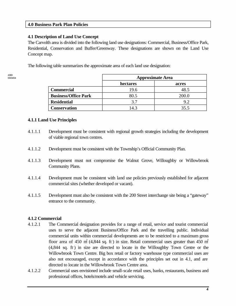
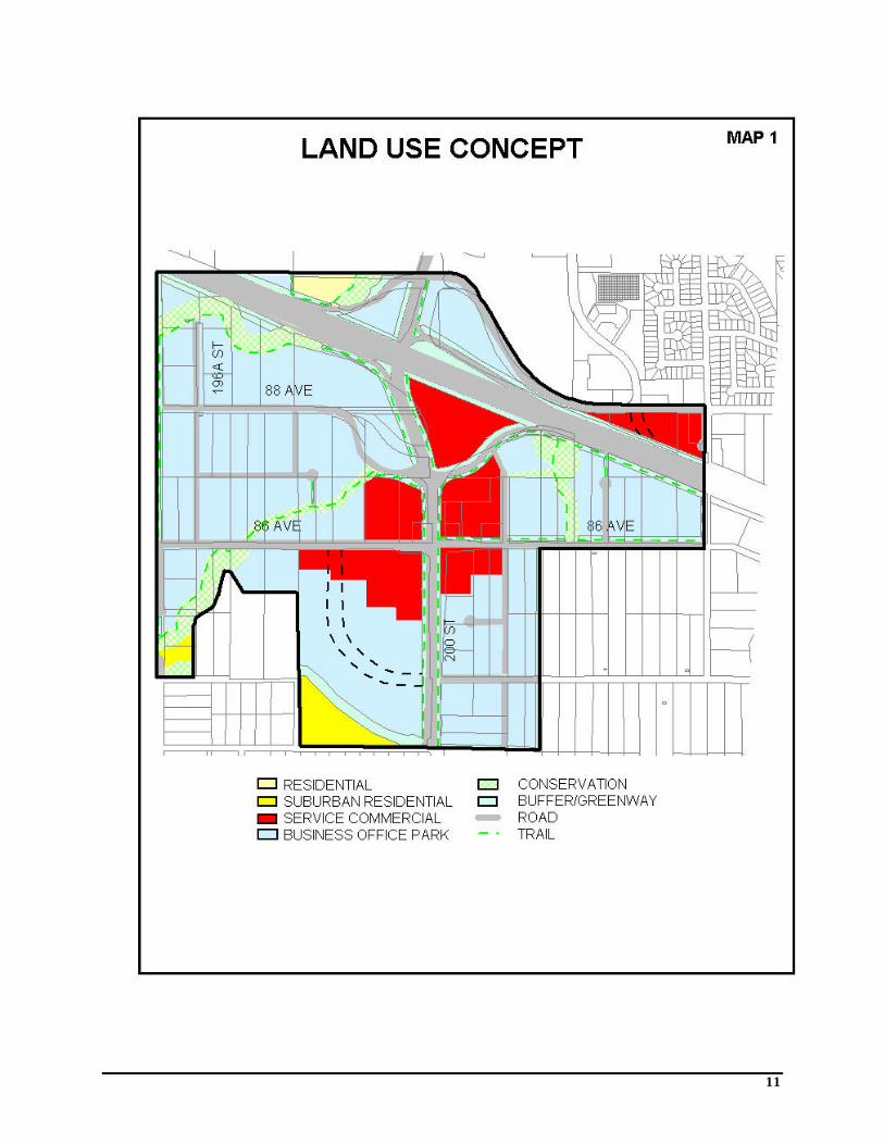
4.0 Business Park Plan Policies 4.1 Description of Land Use Concept The Carvolth area is divided into the following land use designations: Commercial, Business/Office Park, Residential, Conservation and Buffer/Greenway. These designations are shown on the Land Use Concept map. The following table summarizes the approximate area of each land use designation:
Approximate Area hectares acres Commercial 19.6 48.5 Business/Office Park 80.5 200.0 Residential 3.7 9.2 Conservation 14.3 35.5
4.1.1 Land Use Principles 4.1.1.1 Development must be consistent with regional growth strategies including the development
of viable regional town centres. 4.1.1.2 Development must be consistent with the Township’s Official Community Plan. 4.1.1.3 Development must not compromise the Walnut Grove, Willoughby or Willowbrook
Community Plans. 4.1.1.4 Development must be consistent with land use policies previously established for adjacent
commercial sites (whether developed or vacant). 4.1.1.5 Development must also be consistent with the 200 Street interchange site being a “gateway”
entrance to the community. 4.1.2 Commercial 4.1.2.1 The Commercial designation provides for a range of retail, service and tourist commercial
uses to serve the adjacent Business/Office Park and the travelling public. Individual commercial units within commercial developments are to be restricted to a maximum gross floor area of 450 m2 (4,844 sq. ft.) in size. Retail commercial uses greater than 450 m2
(4,844 sq. ft.) in size are directed to locate in the Willoughby Town Centre or the Willowbrook Town Centre. Big box retail or factory warehouse type commercial uses are also not encouraged, except in accordance with the principles set out in 4.1, and are directed to locate in the Willowbrook Town Centre area.
4.1.2.2 Commercial uses envisioned include small-scale retail uses, banks, restaurants, business and professional offices, hotels/motels and vehicle servicing.
4369 05/04/04
5
4.1.2.3 For CPTED (Crime Prevention Through Environmental Design) purposes, one residential dwelling unit per lot is encouraged.
4.1.2.4 Business/Office Park use (pursuant to Section 4.1.3) are also permitted. 4.1.2.5 At the time of development, a specific zoning category incorporating the above land use
policy objectives will be implemented. 4.1.2.6 Commercial areas isolated from development may be used for environmental compensation. 4.1.2.7 Commercial entertainment and recreation uses (or a complex) similar in size to the Colossus
complex would be permitted. Education, performing arts, sports and institutional facilities are also considered.
4.1.2.8 Uses that normally anchor community level shopping centres such as grocery stores and pharmacy/drug stores are not permitted. Duplication of these facilities will compromise the viability of existing and developing town centres.
4.1.3 Business/Office Park 4.1.3.1 The Business/Office Park designations are intended for corporate headquarters, business &
professional offices, research & development laboratories, warehousing & distribution and light manufacturing uses wholly enclosed within buildings. No outside storage shall be permitted.
4.1.3.2 Small scale retail commercial uses (such as child care, restaurants, printing/copy centres, banks, recreation facilities and conference facilities) less than 450 m2 (4,844 sq. ft.) gross floor area to serve the Business/Office Park will be considered. The maximum retail commercial floor area is applied to each individual development.
4.1.3.3 Big box retail uses are not permitted in the Business/Office Park areas. Such uses are encouraged to locate in the Willowbrook Town Centre area.
4.1.3.4 For CPTED (Crime Prevention Through Environmental Design) purposes, one residential dwelling unit per lot is encouraged.
4.1.3.5 Other industrial uses may be considered provided outside storage is only accessory to and part of an integrated office or manufacturing use and is totally screened by buildings and/or vegetation from adjacent non-industrial uses.
4.1.3.6 Uses in the interchange loops shall be low profile, one and two storey buildings that generate low traffic volumes and designed to be attractive with substantial screening and landscaping. Such uses may include:
• park & ride and accessory retail use to serve riders • mini warehousing and other related uses
4.1.3.7 A Park & Ride site will be located near the interchange or in one of the interchange loops. Small-scale retail commercial uses for the users of the Park and Ride and bus terminal, consisting of a newsstand and minor food services, shall be permitted accessory to the Park & Ride site.
4.1.3.8 The minimum site area for Business/Office Park development is 0.5 ha. (1.25 acres). Undersized sites and adjacent properties will be required to coordinate development proposals, including site access, to ensure acceptable layouts.
4.1.3.9 At the time of development, a specific zoning category incorporating the above land use policy objectives will be implemented.
4.1.3.10 Business/Office Park areas isolated from development may be used for environmental compensation.
6
4.1.4 Residential 4.1.4.1 Residential designation is restricted to expansion of the existing mobile home park to the
north. 4.1.5 Suburban Residential 4.1.5.1 Suburban, larger lot country residential development shall be permitted at a minimum lot size
of 1,765 m2. 4.1.6 Conservation 4.1.6.1 Conservation areas identify significant watercourses to be protected for fish and wildlife
habitat. Sensitive environmental areas have been designated in the Plan to help protect conservation lands and to mitigate the impact of nearby commercial and business/office park uses. If a comprehensive conservation/drainage plan can be achieved on less area than required for DFO/MoE mandated non-disturbance areas, then the Township is prepared to support alternatives provided a net gain in current environmental values is achieved.
4.1.6.2 To avoid potential for ground and surface water quality degradation, a soil erosion and sediment control plan shall be implemented as part of the Stormwater Management Plan required prior to final reading of the rezoning by-law.
4.1.6.3 Unstable stream banks susceptible to erosion shall be reinforced through planting and/or armouring.
4.1.6.4 Biofiltration ponds shall be utilized to filter stormwater and moderate the effects of peak runoff flows. Dry detention ponds should be utilized in areas where the water table is perched.
4.1.6.5 Oil-water separators shall be installed in major parking lots and areas where the water table is perched (resulting in insufficient area for filtration through soil).
4.1.6.6 Instream complexing and the creation of ponds, side channels and overhanging banks shall be provided to increase the diversity of rearing habitat for fish. Instream engineering should be carried out where necessary to create more pools and riffles as well as replacing sections of sand/silty substrate with gravel suitable for spawning.
4.1.6.7 Nest boxes for birds and brushpiles for wildlife habitat shall be installed within conservation areas.
4.1.7 Buffer/Greenway 4.1.7.1 A public open space network that follows stream corridors, wooded areas and other
environmentally sensitive areas is to be provided as shown on the Land Use Concept map. 4.1.7.2 Municipal trails have been designated to provide public access to the areas of community
value. Trails and walkway linkages to the public street network and to other community trails beyond the neighbourhood are as shown on the Land Use Concept map.
4.1.7.3 The buffer along the south side of the Trans Canada Highway is to be 15 metres wide with a municipal trail alignment as shown on the Land Use Concept map. Existing vegetation in the buffer should be preserved and enhanced where appropriate.
4.1.7.4 A 2 metre wide landscaping area shall be provided adjacent to 200 Street and along 86 Avenue east of 200 Street as a boulevard between the curb and the sidewalk to create an attractive streetscape. In addition, a 3.5 metre corridor, including a 2.5 metre shared use
7
(pedestrian and bicycle) concrete sidewalk, shall be provided. Each proponent will have to show how this can be accommodated. Additional right-of-way may be required. This greenway corridor along 200 Street can be achieved by on-site landscaping as a requirement of a Development Permit. On the north side of 86 Avenue across from future residential development a 5 metre landscaping area and a 3.5 metre corridor shall be provided
4.2 Environmental Protection The riparian areas of Latimer Creek and its tributaries shall be protected as determined by the Ministry of Environment and Department of Fisheries and Oceans, or in accordance with a memorandum of understanding between the Township and environmental agencies. 4.3 Archaeological Resources Protection If land altering activities are planned for areas with 25 metres of Latimer Creek, an archaeological impact assessment should be carried out to ensure that there are no unrecorded archaeological sites that would be affected. It should be noted that archaeological remains are protected from disturbance by the Heritage Conservation Act. If archaeological remains are encountered, all ground altering activities that threaten the archaeological site must be suspended. It is the responsibility of the individual to inform the Archaeology Branch and the Sto:lo Nation of the location and type of archaeological remains and the nature of the disturbance. 5.0 Facilities 5.1 Park & Ride A Park & Ride site will be located near the interchange or in one of the interchange loops. Small-scale commercial retail uses accessory to the Park & Ride site shall be permitted as described in 4.1.2.7.
8
6.0 Servicing
6.1 Roads The NP area is primarily served by 200 Street and the 200 Street Interchange. The Province and the Township are planning to upgrade the Interchange. The targeted completion date for the first phase of the Interchange upgrade is September 30, 2000. 200 Street and 88 Avenue are classified as Arterial roads and as such are access controlled:
• No ingress or egress will be permitted onto 200 Street between 86 and 88 Avenue east.
• Access to 88 Avenue east will be consistent with the access control plan submitted for the Thunderbird Entertainment Centre. No additional full movement access points will be granted. Right-in, right-out access points may be granted at the discretion of the Township.
• Access to 88 Avenue west will be subject to Township standards. Full movement access must be a minimum of 150 metres from 200 Street.
The functionality of the 202 Street off-ramp needs to be examined with respect to traffic analysis and planning issues. All other roads within the plan area are to be dedicated and constructed to the Township of Langley Industrial road classifications. The upgrading of roads in the plan area will either be the responsibility of the Township of Langley through the Development Cost Charge program or be the responsibility of developers to construct through the development process. The local road pattern shown on the Land Use Concept is designed to provide an efficient and equitable yield within an overall hierarchy of streets. Minor variations to the road layout shown will be permitted based on detailed development proposal. Developers will be encouraged to co-ordinate development proposals with adjacent property owners. Cul-de-sacs and other roads not needed for overall circulation within the area may be eliminated as part of a comprehensive development. The design of roads must incorporate the need for pedestrians and cyclists to use the system. Considerations should be given to sidewalks or multi-use paths for pedestrians/cyclists and wide curb lanes for cyclists. The lands in area are within 800 metres of an existing point of access to the Trans Canada Highway. Approval of Ministry of Transportation of Highways is required for all rezoning applications and all access control points.
9
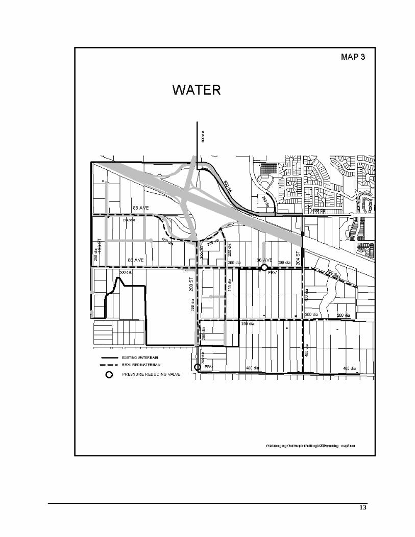
6.2 Water GVRD water is the primary source of water supply for the Willoughby area. The existing distribution network terminates at 200 Street and 83 Avenue and at 205 Street and 84 Avenue. Service to the neighbourhood will extend from both of these locations and will include the installation of two Pressure Reducing Stations in order to create a new 81-metre pressure zone. A crossing at 200 Street and 83 Avenue is already provided to bring the watermain to the east side of 200 Street. The watermain on the west side of 200 Street can be extended northwards to form a west leg supply to the proposed neighbourhood. Looping will be achieved through an east side main on 204 Street and 86 Avenue to the existing watermain on 84 Avenue. Distribution mains in the neighbourhood will be designed to follow the internal road pattern to suit developments. The area of the neighbourhood at the north west corner of Highway 1 and 200 Street will get its water supply from an existing watermain on 200 Street at 88 Avenue. A schematic diagram of the water supply network is shown on the Water System Map. The water pipe sizes are shown for information only. Actual required sizes shall be confirmed with detailed engineering. 6.3 Sewer Sewage from the neighbourhood will be conveyed to the GVRD sewage treatment plant in Northwest Langley. The existing trunk sewer ends south of Highway 1 at approximately 203 Street. The topography east of 200 Street allows sewage to drain to this outlet by gravity. The area west of 200 Street will be serviced by a proposed pump station at approximately 196 Street and 84 Avenue. Sewage will be pumped through a forcemain to the end of the gravity trunk main located at 200 Street and 86 Avenue. Internal sewers will follow internal road pattern to suit developments. The area of the neighbourhood at the northwest corner of highway 1 and 200 Street will drain towards an existing sewer on 200 Street at 90 Avenue. A schematic diagram of the sewer network is shown on the Sanitary Sewer System Map. The sewer sizes are for information only. Actual required sizes shall be confirmed with detailed engineering. 6.4 Storm Drainage Drainage for the area is currently provided through overland flow, ditches, culverts, and the Latimer Creek watercourse. There are no existing stormwater detention facilities to service this development area. An in-line stormwater detention pond is located on Latimer Creek east of 200 Street, however this pond services a catchment area outside of the proposed interchange project. Some preliminary drainage planning for a portion of this area has been conducted through a study entitled Technical Supplement for Willoughby Community Plan Stormwater Management Plan. Preliminary information on post-development flows and current culvert capacities are provided. As well, a general indication of the stormwater detention requirements are outlined for a portion of the development area. This study is very preliminary in nature and additional information is required for the interchange development area.

10
A major problem which must be addressed by all developers in the Latimer Creek area is the volume and peak flow of stormwater runoff. Latimer Creek flows from the Township of Langley through the City of Surrey and discharges into the Serpentine River. The lowland area of the Serpentine River has experienced very frequent flooding events which have been attributed in part to increased volume and peak flow from the upstream catchment areas. In order to mitigate possible development impacts from the Township of Langley on the Serpentine lowlands, it is required that all new developments control runoff volumes and peak flows to pre-development levels. Innovative methods of controlling development discharges need to be explored. Some of the possibilities include the use of infiltration ponds to reduce the volume of post-development runoff. A detailed surface and subsurface soils study is required to identify possible areas for infiltration. In order to fully identify the drainage requirements for the development area, the developer must provide the following:
• pre and post development peak flows • pre and post development flow volumes • trunk sewer size and location • new culvert sizes and locations • culvert upgrade sizes and locations • detailed surface and subsurface soils report identifying possible areas to be used for
infiltration • infiltration and/or detention pond size and location • environmental review of the proposed works and submission of the proposed works for
review and approval by the Ministry of Environment and Department of Fisheries and Oceans
The Township of Langley and the City of Surrey have commissioned a Master Drainage Plan for the Latimer Creek area. All new development within the Latimer Creek drainage area will be required to conform to the requirements of this study.
11
12
13

14