Willis Lateral Project - ferc.gov
149
Office of Energy Projects March 2019 Gulf South Pipeline Company, LP Docket No. CP18-525-000 Willis Lateral Project Environmental Assessment Washington, DC 20426
Transcript of Willis Lateral Project - ferc.gov

Office of Energy Projects March 2019
Gulf South Pipeline Company, LP Docket No. CP18-525-000
Willis Lateral Project
Environmental Assessment
Washington, DC 20426

FEDERAL ENERGY REGULATORY COMMISSION WASHINGTON, D.C. 20426 OFFICE OF ENERGY PROJECTS In Reply Refer To:
OEP/DG2E/Gas 4 Gulf South Pipeline Company, LP Willis Lateral Project Docket No. CP18-525-000
TO THE INTERESTED PARTY:
The staff of the Federal Energy Regulatory Commission (FERC or Commission) has prepared an environmental assessment (EA) for the Willis Lateral Project (Project), proposed by Gulf South Pipeline Company, LP (Gulf South) in the above-referenced docket. Gulf South requests authorization to construct and operate certain natural gas pipeline facilities in Liberty, Polk, Montgomery, and San Jacinto Counties, Texas. The proposed facilities would allow Gulf South to provide about 200 million cubic feet of natural gas per day to Entergy Texas, Inc.’s Montgomery County Power Station Project near Willis, Texas.
The EA assesses the potential environmental effects of the construction and operation of the Willis Lateral Project in accordance with the requirements of the National Environmental Policy Act. The FERC staff concludes that approval of the proposed Project, with appropriate mitigating measures, would not constitute a major federal action significantly affecting the quality of the human environment.
The proposed Willis Lateral Project includes the following facilities entirely within the state of Texas:
• construction of approximately 19 miles of 24-inch-diameter pipeline in Montgomery and San Jacinto Counties;
• addition of a new 15,876 horsepower turbine engine to the existing Goodrich Compressor Station and construction of a new meter and regulator station at the compressor station in Polk County;
• construction of the Index 129 tie-in and pig1 launcher facility in San Jacinto County;
• construction of the new Willis meter and regulator station at the terminus of the Project (including a pig receiver, filter separators with a liquid storage tank, and ancillary equipment) in Montgomery County; and
• construction of a mainline valve facility in Montgomery County.
1 A “pig” is a tool that the pipeline company inserts into and pushes through the pipeline for cleaning the pipeline, conducting internal inspections, or other purposes.
2
The Commission mailed a copy of the Notice of Availability for the EA to federal, state, and local government representatives and agencies; elected officials; environmental and public interest groups; Native American tribes; potentially affected landowners and other interested individuals and groups; and newspapers and libraries in the Project area. The EA is only available in electronic format. It may be viewed and downloaded from the FERC’s website (www.ferc.gov), on the Environmental Documents page (https://www.ferc.gov/industries/gas/enviro/eis.asp). In addition, the EA may be accessed by using the eLibrary link on the FERC’s website. Click on the eLibrary link (https://www.ferc.gov/docs-filing/elibrary.asp), click on General Search, and enter the docket number in the “Docket Number” field, excluding the last three digits (i.e. CP18-525). Be sure you have selected an appropriate date range. For assistance, please contact FERC Online Support at [email protected] or toll free at (866) 208-3676, or for TTY, contact (202) 502-8659.
Any person wishing to comment on the EA may do so. Your comments should
focus on EA’s disclosure and discussion of potential environmental effects, reasonable alternatives, and measures to avoid or lessen environmental impacts. The more specific your comments, the more useful they will be. To ensure that the Commission has the opportunity to consider your comments prior to making its decision on this Project, it is important that we receive your comments in Washington, DC on or before 5:00 pm Eastern Time on April 3, 2019.
For your convenience, there are three methods you can use to file your comments
to the Commission. The Commission encourages electronic filing of comments and has staff available to assist you at (866) 208-3676 or [email protected]. Please carefully follow these instructions so that your comments are properly recorded.
(1) You can file your comments electronically using the eComment feature on the Commission’s website (www.ferc.gov) under the link to Documents and Filings. This is an easy method for submitting brief, text-only comments on a project;
(2) You can also file your comments electronically using the eFiling feature on
the Commission’s website (www.ferc.gov) under the link to Documents and Filings. With eFiling, you can provide comments in a variety of formats by attaching them as a file with your submission. New eFiling users must first create an account by clicking on “eRegister.” You must select the type of filing you are making. If you are filing a comment on a particular project, please select “Comment on a Filing”; or

3
(3) You can file a paper copy of your comments by mailing them to the following address. Be sure to reference the Project docket number (CP18-525-000) with your submission: Kimberly D. Bose, Secretary, Federal Energy Regulatory Commission, 888 First Street NE, Room 1A, Washington, DC 20426
Any person seeking to become a party to the proceeding must file a motion to
intervene pursuant to Rule 214 of the Commission’s Rules of Practice and Procedures (18 CFR 385.214). Motions to intervene are more fully described at http://www.ferc.gov/resources/guides/how-to/intervene.asp. Only intervenors have the right to seek rehearing or judicial review of the Commission’s decision. The Commission may grant affected landowners and others with environmental concerns intervenor status upon showing good cause by stating that they have a clear and direct interest in this proceeding which no other party can adequately represent. Simply filing environmental comments will not give you intervenor status, but you do not need intervenor status to have your comments considered.
Additional information about the Project is available from the Commission’s
Office of External Affairs, at (866) 208-FERC, or on the FERC website (www.ferc.gov) using the eLibrary link. The eLibrary link also provides access to the texts of all formal documents issued by the Commission, such as orders, notices, and rulemakings.
In addition, the Commission offers a free service called eSubscription which allows you to keep track of all formal issuances and submittals in specific dockets. This can reduce the amount of time you spend researching proceedings by automatically providing you with notification of these filings, document summaries, and direct links to the documents. Go to www.ferc.gov/docs-filing/esubscription.asp.

i
TABLE OF CONTENTS
A. PROPOSED ACTION .............................................................................................. 1
1. Introduction ............................................................................................................ 1
2. Project Purpose and Need ...................................................................................... 1
3. Scope of this Environmental Assessment .............................................................. 2
4. Proposed Facilities ................................................................................................. 2
5. Construction and Operation Procedures ................................................................ 3
6. Land Requirements ................................................................................................ 1
7. Non-Jurisdictional Facilities .................................................................................. 4
8. Public Review and Comment ................................................................................ 5
9. Permits ................................................................................................................... 6
B. ENVIRONMENTAL ANALYSIS ........................................................................... 8
1. Geology .................................................................................................................. 8
1.1 Physiographic Setting and Geologic Conditions ................................................ 8
1.2 Mineral and Non-Mineral Resources ................................................................. 8
1.3 Geologic Hazards ............................................................................................... 9
1.4 Paleontology ....................................................................................................... 9
2. Soils ..................................................................................................................... 10
3. Water Resources and Wetlands ........................................................................... 11
3.1 Groundwater Resources .................................................................................... 11
3.2 Surface Water ................................................................................................... 14
3.3 Wetlands ........................................................................................................... 17
4. Fisheries, Vegetation, Wildlife, and Threatened and Endangered Species ......... 20
4.1 Fisheries ............................................................................................................ 20
4.2 Vegetation ......................................................................................................... 22
4.3 Wildlife ............................................................................................................. 24
4.4 Special Status Species ...................................................................................... 25
5. Land Use, Recreation, and Visual Resources ...................................................... 29
5.1 Residential Land and Commercial Areas ......................................................... 31
5.2 Public or Conservation Land; and Recreational Areas..................................... 33
5.3 Visual Resources .............................................................................................. 34

ii
5.4 Traffic ............................................................................................................... 34
6. Cultural Resources ............................................................................................... 35
7. Air Quality ........................................................................................................... 37
7.1 Existing Environment ....................................................................................... 37
7.2 Greenhouse Gases ............................................................................................. 38
7.3 Regulatory Requirements ................................................................................. 39
7.4 Construction Emissions Impacts and Mitigation .............................................. 42
7.5 Operational Emissions Impacts and Mitigation ............................................... 44
8. Noise .................................................................................................................... 47
8.1 Federal and State Noise Regulations ................................................................ 47
8.2 Construction Noise Impacts and Mitigation ..................................................... 48
8.3 Operation Noise Impacts and Mitigation ......................................................... 50
9. Reliability and Safety .......................................................................................... 55
9.1 Safety Standards ............................................................................................... 56
9.2 Pipeline Accident Data ..................................................................................... 59
9.3 Impact on Public Safety .................................................................................... 61
10. Cumulative Impacts ............................................................................................. 63
10.1 Other Actions identified within the Geographic Scope ................................ 64
10.2 Potential Cumulative Impacts of the Proposed Project ................................. 64
C. ALTERNATIVES .................................................................................................... 76
1. No-Action Alternative ......................................................................................... 76
2. System Alternatives ............................................................................................. 77
3. Conclusion ........................................................................................................... 77
D. CONCLUSIONS AND RECOMMENDATIONS ................................................ 78
E. REFERENCES ........................................................................................................ 84
F. LIST OF PREPARERS .......................................................................................... 89

iii
FIGURES Figure 1: Project Location Map .......................................................................................... 4 Figure 2: General Pipeline Construction Sequence ............................................................ 6
TABLES
Table 1. Summary of Contractor/Rail Yards for the Willis Lateral Project ...................... 2 Table 2. Temporary and Permanent Access Roads for the Project .................................... 3 Table 3. Environmental Permits, Approvals, and Consultations ....................................... 6 Table 4. Hydrostatic Test Water Source and Discharge Locations .................................. 17 Table 5. Proposed Volumes of Water for Horizontal Directional Drill Operations ......... 17 Table 6. Wetland Resources Crossed by the Willis Lateral Project ................................. 18 Table 7. Vegetation and Wildlife Commonly Found in Habitat Types Crossed by the Project ................................................................................................................................ 23 Table 8. Summary of Land Use Impacts .......................................................................... 30 Table 9. Structures within 100 feet of the Willis Lateral Project ..................................... 31 Table 10. Emissions from Project Construction ............................................................... 43 Table 11. Potential Operational Emissions from the modified Goodrich Compressor Station (tpy) ....................................................................................................................... 45 Table 12. Predicted Air Quality Impacts – modified Goodrich Compressor Station and nearby Compressor Station 555 (µg/m3) ........................................................................... 46 Table 13. HDD Operations Having Estimated Unmitigated Noise Exceeding an Leq of 48.6 dBA at nearby NSAs ................................................................................................. 49 Table 14. Noise Analysis for the modified Goodrich Compressor Station (CS) ............. 53 Table 15. Noise Analysis for the Proposed Willis M&R Station ..................................... 55 Table 16. Natural Gas Transmission Pipeline Significant Incidents by Cause (1998-2017) .................................................................................................................................. 60 Table 17. Outside Force Incidents by Cause (1998-2017) ............................................... 61 Table 18. Injuries and Fatalities – Natural Gas Transmission Pipelines .......................... 62 Table 19. Nationwide Accidental Fatalities by Cause ..................................................... 62 Table 20. Resource-Specific Geographic Regions for Determining Cumulative Impacts of the Projects .................................................................................................................... 65 Table 21. Projects With Potential Cumulative Impacts on Resources Within the Study Area ................................................................................................................................... 66
APPENDICES
Appendix A: Over-sized Tables Appendix B: Site-specific Residential Crossing Drawings

iv
TECHNICAL ACRONYMS AND ABBREVIATIONS
µg/m3 micrograms per cubic meter ATWS temporary workspace CAA Clean Air Act CEQ Council on Environmental Quality Certificate Certificate of Public Convenience and Necessity CFR Code of Federal Regulations CO carbon monoxide CO2 carbon dioxide CO2e carbon dioxide equivalent Commission Federal Energy Regulatory Commission CS compressor station dBA decibels on the A-weighted scale EA Environmental Assessment EI environmental inspector EPA U.S. Environmental Protection Agency Entergy Entergy Texas, Inc. Gulf South Gulf South Pipeline Company, LP ESA Endangered Species Act ESSS Ecologically Significant Stream Segment FERC Federal Energy Regulatory Commission FERC Plan FERC’s Upland Erosion Control, Revegetation, and Maintenance Plan FERC Procedures FERC’s Wetland and Waterbody Construction and Mitigation Procedures GHG greenhouse gas
Goodrich Noise Report Results of Ambient Sound Survey and Acoustical Analysis for the Goodrich Compressor Station
GWP global warming potential HAP hazardous air pollutant HCA high consequence area HDD horizontal directional drill
HDD Plan Plan for Containment of Inadvertent Release of Drilling Mud during Horizontal Directional Drilled Wetland and Waterbody Crossings
HDD Noise Plan Plan for Reducing Noise Impacts from Horizontal Directional Drill Operations
HDD Noise Report Results of Ambient Sound Survey and Acoustical Analysis for the Horizontal Directional Drills
HUC Hydrologic Unit Code Leq 24-hour equivalent sound level Ldn day-night sound level M&R station meter and regulator station

v
MBTA Migratory Bird Treaty Act MCPS Montgomery County Power Station MOU memorandum of understanding MP milepost NAAQS National Ambient Air Quality Standards NEPA National Environmental Policy Act NESHAP National Emission Standards for Hazardous Air Pollutants NGA Natural Gas Act NNSR Nonattainment New Source Review NO2 nitrogen dioxide
NOI Notice of Intent to Prepare an Environmental Assessment for the Proposed Willis Lateral Project and Request for Comments on Environmental Issues
NOx nitrogen oxides NPS National Park Service NRCS Natural Resources Conservation Service NRHP National Register of Historic Places NSA noise sensitive area NSPS New Source Performance Standards NSR New Source Review OEP Office of Energy Projects PAR permanent access road PEM wetland Palustrine emergent wetland PFO wetland Palustrine forested wetland Phase I report Phase I Cultural Resources Survey report PHMSA Pipeline and Hazardous Materials Safety Administration PM2.5 particulate matter less than or equal to 2.5 microns in aerodynamic diameter PM10 particulate matter less than or equal to 10 microns in aerodynamic diameter Project Willis Lateral Project PSD Prevention of Significant Deterioration PSS wetland Palustrine scrub-shrub wetland PUCT Public Utilities Commission of Texas Secretary Secretary of the Commission SHPO State Historic Preservation Office SO2 sulfur dioxide SPCC Plan Spill Prevention, Control, and Countermeasure Plan SWPA Source Water Protection Area TAR temporary access road TCEQ Texas Commission on Environmental Quality TPWD Texas Parks and Wildlife Department

vi
tpy tons per year TWS temporary workspace Unanticipated Discovery Plan
Plan for the Unanticipated Discovery of Historic Properties or Human Remains, during Construction
USACE U.S. Army Corps of Engineers USDOT U.S. Department of Transportation USFWS U.S. Fish and Wildlife Service USGS U.S. Geological Survey VOC volatile organic compound WMA Wildlife Management Area

A. PROPOSED ACTION
1
A. PROPOSED ACTION
1. Introduction
The staff of the Federal Energy Regulatory Commission (FERC or Commission) prepared this environmental assessment (EA) to address the environmental impacts of the construction and operation of the proposed Willis Lateral Project (Project). On July 13, 2018, Gulf South Pipeline Company, LP (Gulf South) filed an application with the Commission in Docket No. CP18-525-000 under Section 7(c) of the Natural Gas Act (NGA) and Part 157 of the Commission’s regulations. Gulf South seeks to obtain a Certificate of Public Convenience and Necessity (Certificate) to construct and operate certain natural gas pipeline facilities in Liberty, Polk, Montgomery, and San Jacinto Counties, Texas.
We2 prepared this EA in compliance with the requirements of the National Environmental Policy Act (NEPA); the Council on Environmental Quality’s (CEQ) regulations for implementing NEPA (Title 40 Code of Federal Regulations, Parts 1500-1508 [40 CFR 1500-1508]); and the Commission’s regulations at 18 CFR 380. The EA is an integral part of the Commission’s decision-making process on whether to issue Gulf South a Certificate to construct and operate the proposed facilities. Our principal purposes in preparing this EA are to:
• identify and assess potential impacts on the natural and human environment that could result from implementation of the proposed action; and
• identify and recommend reasonable alternatives and specific mitigation measures, as necessary, to avoid or minimize Project-related environmental impacts.
2. Project Purpose and Need
Under Section 7(c) of the NGA, the Commission determines whether interstate natural gas transportation facilities are in the public convenience and necessity and, if so, grants a Certificate to construct and operate them. The Commission bases its decisions on technical competence, financing, rates, market demand, natural gas supply, environmental impact, long-term feasibility, and other issues concerning a proposed Project.
Gulf South states that the Project would provide about 200 million standard cubic feet of natural gas per day to Entergy Texas, Inc.’s (Entergy) planned Montgomery County Power Station (MCPS) near Willis, Texas. Construction of the MCPS commenced in February 2019 in order to be ready for operation in summer 2021. Once constructed, the MCPS Project will provide approximately one gigawatt of electricity to southeast Texas. Additionally, the MCPS Project will utilize emission control
2 “We,” “us,” and “our” refer to the environmental staff of the FERC’s Office of Energy Projects (OEP).

A. PROPOSED ACTION
2
technology that will lower emissions through the use of high-efficiency combined cycle gas turbines.
Gulf South has requested a Certificate by June 2019 in order to construct the Project and be in service by July 1, 2020. Although the MCPS is not scheduled to go on-line until 2021, Gulf South states that MCPS has requested interim natural gas service for testing during the 12-month period preceding the planned commercial in-service in Summer 2021. Gulf South would provide at least 130 million standard cubic feet of natural gas per day during the initial four months of the interim term and at least 165 million standard cubic feet of natural gas per day during the remainder of the interim term.
3. Scope of this Environmental Assessment
The resources and topics addressed in this EA include geology, soils, groundwater, surface waters, wetlands, fisheries, wildlife, vegetation, species of special concern, land use, recreation, visual impacts, cultural resources, air quality, noise, reliability and safety, cumulative impacts, and alternatives. This EA describes the affected environment as it currently exists and the anticipated environmental consequences of the Project, and compares the Project’s potential impact with that of various alternatives. This EA also presents our recommended mitigation measures.
As the lead federal agency for the Project, FERC is required to comply with Section 7 of the Endangered Species Act and Section 106 of the National Historic Preservation Act. These statutes have been considered in the preparation of this EA. In addition to FERC, other federal, state, and local agencies may use this EA in approving or issuing any permits necessary for all or part of the proposed Project. Permits, approvals, and consultations for the Project are discussed in section A.9, below.
4. Proposed Facilities
Gulf South’s Project would consist of the following:
• construction of about 19 miles of 24-inch-diameter pipeline in Montgomery and San Jacinto Counties;
• addition of a new 15,876-horsepower turbine engine to the existing Goodrich Compressor Station in Polk County, and construction of a new meter and regulator (M&R) station at this compressor station;
• construction of the Index 129 tie-in and pig3 launcher facility in San Jacinto County;
3 A “pig” is a tool that the pipeline company inserts into and pushes through the pipeline for cleaning the pipeline, conducting internal inspections, or other purposes.

A. PROPOSED ACTION
3
• construction of the new Willis M&R station at the terminus of the Project (including a pig receiver, filter separators with a liquid storage tank, and ancillary equipment) in Montgomery County; and
• construction of a mainline valve facility in Montgomery County.
Figure 1 illustrates the general Project location.
5. Construction and Operation Procedures
The new Project facilities would be designed, constructed, tested, operated, and maintained to conform with or exceed federal, state, and local requirements, including the U.S. Department of Transportation’s (USDOT) regulations in 49 CFR 192, Transportation of Natural and Other Gas by Pipeline: Minimum Federal Safety Standards; FERC’s Siting and Maintenance Requirements in 18 CFR 380.15; and other applicable federal and state safety regulations.
During construction and restoration of the Project, Gulf South would implement the measures contained in the following plans, in addition to other federal, state, and local permit requirements:
• FERC’s Upland Erosion Control, Revegetation, and Maintenance Plan (FERC Plan) and Wetland and Waterbody Construction and Mitigation Procedures (FERC Procedures);4
• Fugitive Dust Control Plan; • Plan for Reducing Noise Impacts from Horizontal Directional Drill
Operations (HDD Noise Plan); • Plan for the Unanticipated Discovery of Contaminated Environmental
Media; • Plan for Containment of Inadvertent Release of Drilling Mud during
Horizontal Directional Drilled Wetland and Waterbody Crossings (HDD Plan);
• Spill Prevention, Control, and Countermeasure Plan (SPCC Plan); • Stormwater Pollution Prevention Plan; • Residential Construction Implementation Plan; • Environmental Complaint Resolution Plan; • Revegetation Plan; • Exotic and Invasive Species Control Plan; and • Plan for the Unanticipated Discovery of Historic Properties or Human
Remains, during Construction (Unanticipated Discovery Plan).
4 The FERC Plan and Procedures are a set of baseline construction and mitigation measures developed to minimize the potential environmental impacts of construction on upland areas, wetlands, and waterbodies. The Plan and Procedures can be viewed on the FERC website at: www.ferc.gov/industries/gas/enviro/plan.pdf and www.ferc.gov/industries/gas/enviro/procedures.pdf.

A. PROPOSED ACTION
4
Figure 1: Project Location Map

A. PROPOSED ACTION
5
Gulf South anticipates beginning construction in the fourth quarter of 2019, in order to have all facilities in service by July 1, 2020. One construction spread with a temporary workforce of 500 workers is anticipated. No new permanent employees would be required for operation or maintenance of the Project. Gulf South states that the typical construction schedule would be limited to only daylight hours or 7:00 am to 7:00 pm Monday through Saturday.
In order to monitor environmental compliance during construction, Gulf South would employ at least one environmental inspector (EI). All Project-related construction personnel would be informed of the EI’s authority and would receive job-appropriate environmental training prior to commencement of work on the Project. The EI would be responsible for ensuring that construction activities are in compliance with the environmental requirements from construction through restoration. This includes the requirements of the FERC Plan and Procedures; environmental conditions of any Certificate; mitigation measures proposed by Gulf South; and the requirements of any other environmental permits and approvals. The EI would be responsible for identifying, documenting, and overseeing any corrective actions to bring any non-conforming activity back into compliance. The EI would also have authority to stop activities that violate the environmental conditions of a Certificate or other applicable permits. In addition, the Commission staff would conduct its own independent compliance inspections during construction and restoration of the Project to confirm compliance with the Commission’s Certificate.
Upland Construction
Gulf South would install the new pipeline using conventional pipeline construction methods, which are illustrated in figure 2. Construction of a pipeline typically begins with the marking or staking of the construction work area. Once marking is completed, it is followed by these activities: clearing, fencing, grading, trenching, pipe laying, stringing, bending, welding, coating, lowering-in, backfilling, hydrostatic testing, and cleanup and restoration. In addition to the standard construction techniques, Gulf South would use specialized techniques where certain features such as wetlands, waterbodies, and roads are crossed.

A. PROPOSED ACTION
6
Figure 2: General Pipeline Construction Sequence

A. PROPOSED ACTION
1
Specialized Construction Techniques
Horizontal directional drilling (HDD) is a trenchless crossing method involving drilling a hole beneath the waterbody and installing a pre-fabricated pipe segment through the hole. The first step in an HDD is to directionally drill a small-diameter pilot hole from one side of the crossing to the other. The pilot hole is then enlarged by several reaming passes using successively larger reaming tools until the borehole is of sufficient diameter to allow for pullback of the pre-fabricated pipe. Throughout the drilling process, a slurry of non-toxic, bentonite clay and water is pressurized and pumped through the drilling head to lubricate the drill bit, remove drill cuttings, and hold the hole open. Although requiring overall greater land disturbance on either side of a feature to accommodate the drilling and receiving equipment, the HDD method reduces impacts on the feature (e.g., roads; streams; riparian areas). This method is proposed for Peach Creek, Caney Creek, County Line Road, and Rogers Road. About 827,133 gallons of water would be required to complete the HDD crossings. The water for the Peach Creek and Caney Creek HDD crossings would be sourced from the respective waterbodies. The water for the County Line Road and Rogers Road HDD crossings would be purchased from municipal wells and trucked to the crossing sites for use.
The conventional bore crossing method is similar to an HDD in that it is a trenchless construction technique; however, conventional bores are not directionally drilled and are not typically as deep underground as an HDD. The conventional bore method involves excavating large bell holes on each side of the feature that are deep enough for the bore equipment to auger a hole horizontally from one bell hole to the other, typically a minimum of 5 feet below the surface or feature. Once the bell hole has been created, the pipeline is then pushed or pulled through the hole. This method is proposed for the majority of paved roads, highways, and railroads along the Project pipeline alignment.
A “wet,” or open-cut, crossing involves trenching directly across/through the waterbody and installing the pipeline without isolating the construction work area from stream flow. The objective of this method is to complete the crossing as quickly as practical to minimize the duration of impacts on aquatic resources. This method is proposed for the majority of waterbodies along the Project pipeline alignment.
6. Land Requirements
Gulf South has proposed to construct the pipeline within a new 95-foot-wide nominal construction right-of-way. About 91 percent of the right-of-way would be collocated along existing utilities, including natural gas and crude oil pipelines and electric transmission lines. Construction activities for the aboveground facilities would generally take place within existing facilities or the 95-foot-wide construction right-of-way. Gulf South proposes to maintain a permanent 50-foot-wide right-of-way for pipeline operation.
A. PROPOSED ACTION
2
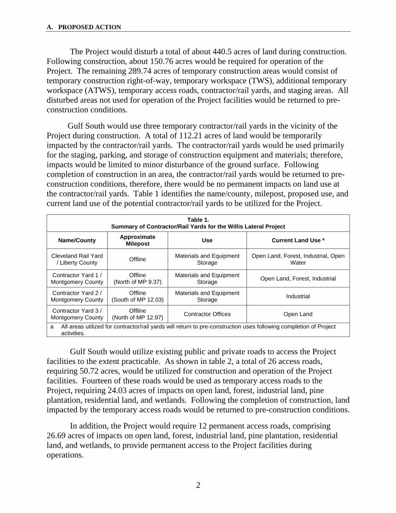
The Project would disturb a total of about 440.5 acres of land during construction. Following construction, about 150.76 acres would be required for operation of the Project. The remaining 289.74 acres of temporary construction areas would consist of temporary construction right-of-way, temporary workspace (TWS), additional temporary workspace (ATWS), temporary access roads, contractor/rail yards, and staging areas. All disturbed areas not used for operation of the Project facilities would be returned to pre-construction conditions.
Gulf South would use three temporary contractor/rail yards in the vicinity of the Project during construction. A total of 112.21 acres of land would be temporarily impacted by the contractor/rail yards. The contractor/rail yards would be used primarily for the staging, parking, and storage of construction equipment and materials; therefore, impacts would be limited to minor disturbance of the ground surface. Following completion of construction in an area, the contractor/rail yards would be returned to pre-construction conditions, therefore, there would be no permanent impacts on land use at the contractor/rail yards. Table 1 identifies the name/county, milepost, proposed use, and current land use of the potential contractor/rail yards to be utilized for the Project.
Table 1. Summary of Contractor/Rail Yards for the Willis Lateral Project
Name/County Approximate Milepost Use Current Land Use a
Cleveland Rail Yard / Liberty County Offline Materials and Equipment
Storage Open Land, Forest, Industrial, Open
Water
Contractor Yard 1 / Montgomery County
Offline (North of MP 9.37)
Materials and Equipment Storage Open Land, Forest, Industrial
Contractor Yard 2 / Montgomery County
Offline (South of MP 12.03)
Materials and Equipment Storage Industrial
Contractor Yard 3 / Montgomery County
Offline (North of MP 12.97) Contractor Offices Open Land
a All areas utilized for contractor/rail yards will return to pre-construction uses following completion of Project activities.
Gulf South would utilize existing public and private roads to access the Project
facilities to the extent practicable. As shown in table 2, a total of 26 access roads, requiring 50.72 acres, would be utilized for construction and operation of the Project facilities. Fourteen of these roads would be used as temporary access roads to the Project, requiring 24.03 acres of impacts on open land, forest, industrial land, pine plantation, residential land, and wetlands. Following the completion of construction, land impacted by the temporary access roads would be returned to pre-construction conditions.
In addition, the Project would require 12 permanent access roads, comprising 26.69 acres of impacts on open land, forest, industrial land, pine plantation, residential land, and wetlands, to provide permanent access to the Project facilities during operations.

A. PROPOSED ACTION
3
Table 2. Temporary and Permanent Access Roads for the Project
Access Road ID Milepost Proposed Use Existing Use Upgrade Requirements Approx.
Length (feet) Approx.
Width (feet)
PAR-01 0.00 Permanent Existing Roadway Grading/Gravel/Widening 5,113 25
TAR-01.1 Offline (0.00) Temporary Forested Land New Road:
Grading/Gravel 165 25
PAR-02 0.71 Permanent Existing Roadway Grading/Gravel/Widening 4,407 25
TAR-03 0.69 Temporary Existing Roadway Grading/Gravel/Widening 22,456 25
PAR-05 1.23 Permanent Existing Roadway Grading/Gravel/Widening 17,485 25
PAR-06 2.98 Permanent Existing Roadway Grading/Gravel/Widening 7,006 25
PAR-07 3.45 Permanent Existing Roadway Grading/Gravel 2,555 25
TAR-08 3.44 Temporary Existing Roadway Grading/Gravel/Widening 2,381 25
PAR-09 4.03 Permanent Existing Roadway Grading/Gravel/Widening 2,624 25
TAR-11 5.73 Temporary Existing Roadway
Grading/ Gravel/ Widening 1,515 25
PAR-12 6.71 Permanent Existing Roadway Grading/Gravel/Widening 1,916 25
TAR-13 8.49 Temporary Existing Roadway Grading/Gravel/Widening 1,721 25
TAR-14 8.95 Temporary Existing Roadway Grading/Gravel/Widening 1,036 25
PAR-15 9.29 Permanent Forested Land New Road: Grading/Gravel 120 25
PAR-16 9.83 Permanent Existing Roadway Grading/Gravel/Widening 2,885 25
TAR-16.1 11.20 Temporary Existing
Roadway/Open Field
Grading/Gravel/Widening 4,488 25
TAR-17 12.97 Temporary Existing Roadway Grading/Gravel/Widening 226 25
PAR-18 13.42 Permanent Existing Roadway Grading/Gravel/Widening 497 25
TAR-19 14.34 Temporary Existing
Powerline Corridor
Grading/Gravel/Widening 696 25
TAR-20 16.76 Temporary Existing Roadway Grading/Gravel/Widening 640 25
TAR-21 18.44 Temporary Existing
Powerline Corridor
Grading/Gravel 376 50
TAR-22 18.96 Temporary Existing Roadway None 2,556 50
PAR-23 19.08 Permanent Open Field New Road: Grading/Gravel 269 25
PAR-24 Offline Permanent Existing Roadway None 698 25
TAR-25 Offline Temporary Open Field New Road: Grading/Gravel 45 20
TAR-25.1 Offline Temporary Existing Roadway Grading/Gravel 263 20
PAR = permanent access road; TAR = temporary access road

A. PROPOSED ACTION
4
Although Gulf South has identified areas where extra workspace would be required, additional or alternative areas could be identified in the future due to changes in site-specific construction requirements. Gulf South would be required to file information on any such areas for our review and approval prior to use.
Further discussion of land requirements for the Project is provided in section B.5, below.
7. Non-Jurisdictional Facilities
Under Section 7 of the NGA, the Commission is required to consider, as part of its decision to authorize jurisdictional facilities, all factors bearing on the public convenience and necessity. The primary jurisdictional facilities for the Project are the proposed 19-mile-long pipeline, the new compressor unit and M&R station at the existing Goodrich Compressor Station, the Index 129 tie-in and pig launcher facility, the new mainline valve, and the new Willis M&R station.
Occasionally, proposed projects have associated facilities that do not come under the jurisdiction of the Commission. These non-jurisdictional facilities may be integral to the need for the proposed facilities (e.g., a gas-fueled power plant at the end of a jurisdictional pipeline) or they may be minor, non-integral components of the jurisdictional facilities that would be constructed and operated as a result of the proposed facilities.
The Willis Lateral Project is under FERC’s jurisdiction and is proposed as a result of construction of the non-jurisdictional MCPS. The MCPS is a new natural gas combined-cycle power generation facility, consisting of two combustion turbines and associated equipment, which will generate 993 megawatts of electricity annually. The Public Utilities Commission of Texas (PUCT) has jurisdiction over the planned MCPS. As part of the permitting process, an EA was developed by Entergy and submitted to the PUCT in September 2016.5 The EA evaluated effects on water resources, wildlife, threatened and endangered species, vegetation, water quality, air quality, noise, socio-economic resources, land use, cultural resources and infrastructure.
According to Entergy’s EA, MCPS is located on a 50-acre parcel, on Entergy's existing property adjacent to the existing Lewis Creek Facility in Montgomery County, Texas. The MCPS site is predominantly rural, with a number of unincorporated residential subdivisions and isolated residences in the vicinity, some within one-half mile of the site. Due to industrial usage, the site has been previously disturbed by activities such as construction of pipelines, utility infrastructure, and aboveground facilities. The MCPS footprint consists of a mixture of grasses, shrubs, and trees with no identified wetlands or waterbodies that support aquatic species. No threatened or endangered species, or migratory bird species of special concern, or their nests, were identified on the
5 http://interchange.puc.texas.gov/Search/Documents?controlNumber=46416&itemNumber=2.

A. PROPOSED ACTION
5
site. No previously recorded archaeological resources, architectural resources, State Archaeological Landmarks, or State Antiquity Landmarks were documented on the site. There are no public and open spaces in the direct vicinity of the MCPS site. Approximately 8.5 million gallons of water per day will be required for operation, primarily sourced from the Lewis Creek Reservoir that abuts the site; FEMA Flood Hazard Maps indicated that the site is not within the Reservoir's 100-year floodplain. Construction and operation of the MCPS will have both short-term and long-term impacts on air quality. Short-term adverse effects from dust and air emissions during construction will be controlled through use of best management practices. While the MCPS project results in a long-term increase in emissions, long-term adverse effects will be reduced through the application of Best Available Control Technology (BACT) and Lowest Achievable Emissions Rate (LAER) to the emission sources. The emissions must be modeled to demonstrate acceptable air quality impacts against the National Ambient Air Quality Standards (NAAQS). Noise level in the immediate vicinity will increase due to the operation of turbines and other equipment. However, the noise increases are expected to be below the threshold at which a noticeable change in community response occurs and will comply with state regulations. The EA concluded that environmental consequences vary in a range of negligible to moderate prior to implementation of mitigation measures, and after the implementation of mitigation measures, the potential environmental consequences are considered to be manageable and acceptable.
The PUCT approved the MCPS in July 20176 and Entergy granted Full Notice to Proceed in September 2018. Full Notice to Proceed is based on formal approval of both the air permit application and the PUCT regulatory approval. Construction of the MCPS commenced in February 2019, and is expected to be complete in summer 2021. The MCPS is subject to state and local permitting requirements; however, the impacts associated with construction that would overlap the proposed Willis Lateral Project are addressed in section B.10 of this EA (cumulative impacts).
Other non-jurisdictional facilities associated with the Project include minor facilities to provide electrical power to the proposed Willis M&R Station and the Project facilities at the Goodrich Compressor Station. These required utilities would be extended from the existing Goodrich Compressor Station utilities and the MCPS. The limits of disturbance associated with the extension of these utilities to the Project facilities would be within the temporary workspaces for the compressor station or pipeline construction, or within the MCPS project workspace, and thus no new land disturbance would be necessary for construction of these utilities.
8. Public Review and Comment
On August 31, 2018, the Commission issued a Notice of Intent to Prepare an Environmental Assessment for the Proposed Willis Lateral Project and Request for
6 http://interchange.puc.texas.gov/Documents/46416_390_949529.PDF.

A. PROPOSED ACTION
6
Comments on Environmental Issues (NOI). The NOI was sent to affected landowners; federal, state, and local government agencies; elected officials; environmental and public interest groups; Native American tribes; other interested parties; and local libraries and newspapers.
In response to the NOI, the Commission received comments from the Texas Parks and Wildlife Department (TPWD). The primary issues raised included concerns for appropriate best management practices for construction and restoration; special status species; surface water; and impacts on vegetation and wildlife. The environmental issues raised are discussed in the applicable sections of this EA.
9. Permits
A number of federal, state, and local regulatory agencies have permit requirements, approval authority, or consultations associated with the proposed Project. Table 3 provides a list of permits and consultations for the Project; the applicable local, state, and federal agencies; as well as any responses received to date. Gulf South would be responsible for obtaining all permits and approvals required for construction and operation of the Project, regardless of whether or not they appear in the table.
Table 3. Environmental Permits, Approvals, and Consultations
Agency Permit/Approval/Consultation Application Date and Status
FEDERAL
Federal Energy Regulatory Commission
Certificate of Public Convenience and Necessity under Section 7(c) of the Natural Gas Act.
Application filed July 13, 2018.
U.S. Army Corps of Engineers – Galveston District
Nationwide 12 permit for the discharge of dredge or fill material into waters of the United States under Section 404 of the Clean Water Act.
Permit application filed July 13, 2018. Amended October 15,
2018. Permit received January 22, 2019.
U.S. Fish and Wildlife Service, Texas Coastal Ecological Services Field Office
Consultations for impacts on federally listed threatened and endangered species and critical habitat under Section 7 of the Endangered Species Act. Migratory Bird Treaty Act Clearance.
Permit application filed July 13, 2018. Amended October 15, 2018. Consultation complete
October 15, 2018.
U.S. Environmental Protection Agency
Hydrostatic Test Water Discharge Permit. Permit submittal anticipated 1st Quarter 2019. Approval
anticipated 4th Quarter 2019.
TEXAS
Texas Commission on Environmental Quality
Hydrostatic Test Water Appropriations Permit. Permit submittal anticipated 4th Quarter 2019. Approval
anticipated 1st Quarter 2020.
Air Permits Permit application filed July 10, 2018. Permit received July 12,
2018.

A. PROPOSED ACTION
7
Table 3. Environmental Permits, Approvals, and Consultations
Agency Permit/Approval/Consultation Application Date and Status
Railroad Commission of Texas
Permit for Discharge of Hydrostatic Test Water. Permit submittal anticipated 4th Quarter 2019. Approval
anticipated 1st Quarter 2020.
Section 401 Water Quality Certification. Coastal Zone Management Act. (Automatic with Nationwide 12 Permit.)
Permit application filed July 13, 2018. Amended October 15,
2018. Permit received January 22, 2019.
Minor Permit: Off Lease Landfarming of Water Based Drilling Fluids
Permit submittal anticipated 4th Quarter 2019. Approval
anticipated 1st Quarter 2020.
Texas Parks and Wildlife Department
Consultation of state-listed species – wildlife habitat assessment.
Consultation initiated July 13, 2018. Amended October 15, 2018. Consultation complete
January 23, 2019.
Texas Department of Transportation
Utility Crossing / Temporary Driveway Permit Permit submittal anticipated 2nd Quarter 2019. Approval
anticipated 3rd Quarter 2019.
Texas Historical Commission, State Historic Preservation Office
Consultation under Section 106, National Historic Preservation Act, including Native American Tribes.
Consultation initiated July 13, 2018. Response received
September 28, 2018. Amendment submitted October 15, 2018. Responses received November 6, 2018 and January
7, 2019.
LOCAL
San Jacinto County – County Roads
Heavy Load / Pipeline Utility / Permit to Transfer. Permit submittal anticipated 1st Quarter 2019. Approval
anticipated 2nd Quarter 2019.
Montgomery County – County Roads
Heavy Load / Pipeline Utility / Permit to Transfer. Permit submittal anticipated 1st Quarter 2019. Approval
anticipated 2nd Quarter 2019.
City of Willis Application for Pipeline Installation. Permit submittal anticipated 1st Quarter 2019. Approval
anticipated 2nd Quarter 2019.
B. ENVIRONMENTAL ANALYSIS
8
B. ENVIRONMENTAL ANALYSIS
The following sections discuss the Project’s potential direct and indirect impacts on environmental resources. When considering the environmental consequences of the proposed Project, the duration and significance of any potential impacts are described below according to the following four levels: temporary, short-term, long-term, and permanent. Temporary impacts generally occur during construction, with the resources returning to pre-construction conditions almost immediately. Short-term impacts could continue for up to three years following construction. Long-term impacts would require more than three years to recover, but eventually would recover to pre-construction conditions. Permanent impacts could result because of activities that modify resources to the extent that they would not return to pre-construction conditions during the life of the Project, such as with the construction of an aboveground facility. An impact would be considered significant if it would result in a substantial adverse change in the physical environment.
1. Geology
1.1 Physiographic Setting and Geologic Conditions
The Project is within the West Gulf Coastal Plain section of the Coastal Plain Physiographic Province. The West Gulf Coastal Plain section consists of late Cretaceous Period to Holocene Epoch deposits that were formed in a mostly marine environment 135 million years ago, were later uplifted, and now tilt seaward. Deposits are characterized as unconsolidated to semi-consolidated sands, silts, and clays. The topography of the Project area ranges from flat to gently rolling hills with elevations of approximately 205 to 405 feet above mean sea level.
As indicated by U.S. Department of Agriculture, Natural Resources Conservation Service (NRCS) soils data, approximately 0.25 mile (about 1 percent) of the proposed pipeline is characterized as having shallow bedrock at a depth of 5 feet or less. If shallow bedrock is encountered, Gulf South would first attempt to use hydraulic hammers to break the rock. If blasting is found to be necessary, Gulf South would develop a Project-specific blasting plan in coordination with the appropriate agencies. The plan would address pre- and post-blast inspections and monitoring; advanced public notification; and mitigation measures for building foundations, groundwater wells, and springs.
1.2 Mineral and Non-Mineral Resources
While no active quarries, mines, or mine spoil areas were identified within 1 mile of the Project, several inactive or historical gravel pits were identified within 0.25 mile. However, based on aerial photographs and field surveys, the inactive locations are partially or fully revegetated and are no longer in use. Twenty oil and gas wells were identified within 0.25 mile of the Project, three of which are within 200 feet of the Cleveland Rail Yard in Liberty County. No identified oil and gas wells are within 200

B. ENVIRONMENTAL ANALYSIS
9
feet of the pipeline centerline. We conclude there would not be a significant impact on mineral and non-mineral resources.
1.3 Geologic Hazards
Geologic hazards are natural physical conditions that can, when present, result in damage to land and structures or injury to people. Potential geologic hazards in the Project area were determined through database searches and literature and topographic map reviews, and include seismicity (earthquakes and faults), slope stability and landslides, subsidence and karst conditions, flooding/scour, soil liquefaction, soil expansion, and volcanism. The review of available data showed that the proposed Project is not characterized by seismic hazards (including soil liquefaction), volcanic conditions, surface faults, subsidence and karst conditions, or susceptible to landslides; thus, the Project would not be affected by these hazards. Flooding is discussed below.
Flooding
Near-surface groundwater and flooding can cause buoyancy in pipelines. Flooding can also induce lateral migration of streams and cause scour that can undermine or expose a pipeline. Approximately 1.37 miles of the Project would cross Federal Emergency Management Agency 100-year floodplains. Additionally, approximately 0.97 mile of the Project would cross a regulatory floodway. A regulatory floodway is a stream channel and adjacent land areas reserved for floodwaters to avoid the water surface elevation more than a designated height. The pipeline would be installed below the ground surface, and the surface of the right-of-way restored and stabilized following construction. This would minimize environmental impacts and avoid any measurable modification of the floodplain. No aboveground facilities are proposed to be constructed within the 100-year floodplain or in the regulatory floodway.
1.4 Paleontology
No known significant fossil locations were identified within the Project area based on a review of known paleontological sites. If unique or significant fossil specimens are discovered during excavation activities, Gulf South would cease construction activities and consult with the appropriate county or State paleontological specialist. Thus, we conclude that significant paleontological resources are unlikely to be affected by construction or operation of the Project.
Given the geologic conditions within the Project area, and the fact that about 91 percent of the Project would be collocated with existing utilities, we conclude that the overall effect of the Project on topography and geology would be minor, and significant adverse effects on geological resources are not anticipated. Likewise, we do not anticipate that Project facilities would be compromised due to seismicity, ground rupture, soil liquefaction, subsidence or karst conditions, flooding, or landslides; and that the

B. ENVIRONMENTAL ANALYSIS
10
proposed facilities would not result in significant impact on geologic or paleontologic resources.
2. Soils
Information regarding the soil types and characteristics occurring in the Project area was obtained from the NRCS Soil Survey Geographic database, which provides detailed information useful for natural resource planning and management.
Construction activities such as clearing, grading, excavation, backfilling, heavy equipment traffic, and restoration activities could result in adverse impacts on soil resources in temporary work areas, on access roads, and at aboveground facilities. Clearing would remove protective vegetation cover and would expose soils to the effects of wind, sun, and precipitation, which could increase soil erosion and the transport of sediment to sensitive areas such as waterbodies or dry washes (also referred to as ephemeral washes). Grading and equipment traffic could compact soil, reducing porosity and percolation rates, which could result in increased runoff potential. Soil contamination from equipment spills and/or leakage of fuels, lubricants, and coolants could also impact soils. Certain practices, such as the use of FERC’s Plan and Procedures, and Gulf South’s Project-specific plans listed in section A.5 would help adequately minimize impacts on soils.
According to a search of federal and state databases, no reported sources of known or potential soil contamination were identified in the vicinity of the Project (EPA, 2018a, 2018b; TCEQ, 2018a, 2018b, 2018c). Therefore, no impact from contaminated soil is anticipated. Should unanticipated contaminated soils be encountered during construction, Gulf South would evaluate and treat impacted soils in accordance with its Plan for the Unanticipated Discovery of Contaminated Environmental Media and applicable federal and state requirements. We have reviewed this plan and find it adequate.
Soil contamination from equipment spills and/or leakage of fuels, lubricants, and coolants could impact soils. Gulf South has filed its SPCC Plan, which addresses fluid leaks and spills. Measures outlined in Gulf South’s SPCC Plan include, but are not limited to:
• spill prevention and response training for construction personnel; • regular inspection of construction equipment for leaks; • secondary containment for storage of fuels, oils, hazardous materials, and
equipment; • collection and disposal procedures for wastes generated during equipment
maintenance; and • standard procedures for excavation and offsite disposal of any soils
contaminated by spillage.

B. ENVIRONMENTAL ANALYSIS
11
We reviewed the SPCC plan and find it adequate to address the storage and transfer of fuels and hazardous materials as well as the response to be taken in the event of a spill. Adherence with Gulf South’s SPCC Plan would adequately minimize impacts on soils from inadvertent releases or spills during construction of Project facilities.
The U.S. Department of Agriculture defines prime farmland soils as those that have the best combination of physical and chemical characteristics for producing food, feed, forage, fiber, and oilseed crops and that is available for these uses. Prime farmland soils can include either actively cultivated land or land that is potentially available for cultivation. Farmland that does not meet the criteria for prime farmland may still be considered farmland of statewide importance for the production of food, feed, fiber, forage, and oilseed crops. The criteria for defining and delineating farmland of statewide importance are determined by the local conservation districts. Generally, this land includes soils that nearly meet the requirements for prime farmland and that economically produce high yields of crops when treated and managed according to acceptable farming methods.
Approximately 55.77 acres of the soils that would be temporarily impacted by the Project are considered prime farmland, farmland of statewide importance, or farmland of local importance. Of this, about 1.15 acres would be permanently converted from prime farmland to industrial use. Gulf South would attempt to overcome compaction and low revegetation potential by implementing appropriate best management practices such as those included in FERC’s Plan. Based on previous experience with revegetation of pipeline facilities, and with adherence to the protocols outlined in the Plan and Procedures, we do not anticipate significant issues with compaction or successful revegetation.
Soil erosion would be mitigated through temporary erosion and sedimentation control measures and implementation of permanent measures in accordance with FERC’s Plan and Procedures, as well as through Gulf South’s plans listed in section A.5. Given the Project areas’ soil characteristics and the impact minimization and mitigation measures described in these plans, we conclude that soils would not be significantly affected by Project construction and operation.
3. Water Resources and Wetlands
3.1 Groundwater Resources
Aquifers
The Project is within the Coastal Lowlands aquifer system, also known as the Gulf Coast Aquifer, which extends from Texas to Florida. There are three major aquifers in the Coastal Lowlands: the Chicot, Evangeline, and Jasper aquifers. Aquifer units within the system are overlain by a surficial confining unit consisting of dense clays and interbedded sands. These interbedded shallow sands are hydraulically connected to

B. ENVIRONMENTAL ANALYSIS
12
underlying aquifer units. Groundwater quality diminishes in the Coastal Lowlands aquifer system towards the coast where it becomes more saline. Groundwater recharge is derived from precipitation and seepage loss from outcrop areas. In the Project areas groundwater is used for recreation, drinking, irrigation, industrial uses, and stock watering.
Source Water Protection Areas and Sole-Source Aquifers
Source Water Protection Areas (SWPAs) are regions where states manage the land use around and above groundwater used to supply public drinking water. Generally, states do not disclose specifics regarding these plans, such as pumping centers and protection area limits, due their critical nature. Four SWPAs were identified within 1 mile of the Project. One SWPA is crossed by the Project from milepost (MP) 17.52 to MP 17.82 and is managed by the City of Willis. According to the City of Willis, no additional measures beyond those prescribed by the Texas Commission on Environmental Quality (TCEQ) would be required to cross the SWPA. Gulf South would implement measures included in its SPCC Plan, in accordance with the TCEQ regulations, to prevent or control inadvertent spills of hazardous materials.
The Project is not within any sole-source aquifer designated by the U.S. Environmental Protection Agency (EPA).
Water Wells and Springs
Based on a literature review and field surveys, no seeps or springs are within 150 feet of the Project. Twelve active groundwater wells and three plugged wells were identified within 150 feet of the Project. Three of the active wells were listed as public supply, three were listed as industrial, five were listed as residential supply, and one was listed as an agricultural supply well. Of these, three wells (two industrial and one public supply) are within the Goodrich Compressor Station footprint, and one residential supply well is on the edge of the pipeline workspace.
Groundwater Contamination
According to a search of federal and state databases, no reported sources of known or potential groundwater contamination were identified in the vicinity of the Project (EPA, 2018a, 2018b; TCEQ, 2018a, 2018b, 2018c). Therefore, no impact from contaminated groundwater is anticipated. Should unanticipated contaminated groundwater be encountered during construction, Gulf South would evaluate and treat impacted groundwater in accordance with its Plan for the Unanticipated Discovery of Contaminated Environmental Media, as well as with applicable federal and state requirements. We have reviewed this plan and find it adequate.
Pipeline and related infrastructure construction necessitates the use of heavy equipment and associated fuels, lubricants, and other potentially hazardous substances

B. ENVIRONMENTAL ANALYSIS
13
that, if spilled, could affect shallow groundwater and/or aquifers. Accidental spills or leaks of hazardous materials associated with vehicle fueling, vehicle maintenance, and material storage would present the greatest potential contamination threat to groundwater resources. Soil contamination resulting from these spills or leaks could continue to add pollutants to the groundwater long after a spill had occurred.
Implementation of proper storage, containment, and handling procedures would effectively minimize the chance of such releases. Gulf South’s SPCC Plan, discussed above, addresses preventative and mitigative measures that would be used to avoid or minimize the potential impacts of hazardous material spills during construction.
Pipeline and aboveground facility construction activities such as trench dewatering, blasting, and spills or leaks of hazardous materials have the potential to affect groundwater in several different ways. Clearing, grading, trenching, and soil stockpiling activities within the right-of-way may cause minor fluctuations in local groundwater levels and/or increased turbidity due to erosion and sediment runoff, especially where shallow aquifers exist. Soil compaction caused by heavy equipment could reduce water infiltration rates. Construction of aboveground facilities may result in minor, permanent increases of impervious areas; however, the facilities are unlikely to affect infiltration or groundwater recharge beyond the facility limits. In areas where groundwater is near the surface, trench excavation may intersect the shallow water table and dewatering may be required. Dewatering of trenches may result in temporary fluctuations in local groundwater levels; however, Gulf South would dewater into adjacent, well-vegetated upland areas to allow infiltration and minimize impacts on the local water table.
Gulf South would coordinate with well owners and provide pre- and post-construction testing, as requested, in order to document water quality and flow for all active wells within 150 feet of Project areas. If testing revealed that impacts to a well occurred as a result of Project construction, Gulf South would coordinate with the well owner to provide a temporary source of water and repair or replace the impacted well. No refueling or storage of hazardous liquids would be allowed within a 200-foot radius of private or industrial wells. Additionally, no refueling or storage of hazardous liquids would be allowed within 400 feet of public water wells.
After installation of the pipeline and aboveground facilities, the ground surface would be restored as close as practicable to original contours, and any exposed soils would be revegetated to ensure restoration of preconstruction overland flow and recharge patterns. Therefore, these minor, direct, and indirect impacts would be temporary and would not significantly affect groundwater resources. We conclude that groundwater impacts during construction would be effectively minimized or avoided by implementing construction practices outlined in FERC’s Plan and Procedures and Gulf South’s plans listed in section A.5.

B. ENVIRONMENTAL ANALYSIS
14
3.2 Surface Water
The Project is within three watersheds: West Fork San Jacinto (hydrologic unit code [HUC] 12040101), East Fork San Jacinto (HUC 12040103), and Lower Trinity-Kickapoo (HUC 12030202).
Waterbodies7 in the Project area were identified through desktop evaluations and field delineations conducted by Gulf South between March 2018 and September 2018. Gulf South completed surveys for about 98 percent of the Project. For areas not yet field surveyed, a desktop analysis was conducted using U.S. Geological Survey topographic maps, National Wetland Inventory data, and Google Earth historical aerial photography.
Gulf South identified 137 waterbodies that are either crossed or impacted by the Project, of which 20 are perennial, 17 intermittent, 89 ephemeral, and 11 ponds or lakes (open water). According to the Texas Water Quality Standards (Texas Administrative Code §307.1-307.10), surface waters in Texas are characterized by recreation, aquatic life, and domestic/public water supply. Details about the waterbodies crossed by the Project, including state water quality classifications and proposed crossing methods, are listed in table A-1 in appendix A (over-sized tables).
Sensitive Surface Waters
The Project crosses one waterbody (Caney Creek) that is designated by the TPWD as an Ecologically Significant Stream Segment (ESSS) (TPWD, 2018a). Caney Creek is designated as an ESSS due to the biological function of the bottomland hardwood habitat that comprises its riparian corridor, as well as its overall hydrologic function (e.g., flood attenuation, water quality, and groundwater recharge of the Chicot Aquifer). Per 16.051(f) of the Texas Water Code, the designation of a stream as an ESSS prevents state agencies or political subdivisions from financing the construction of a reservoir within designated river or stream segments. Gulf South proposes to cross Caney Creek via an HDD to minimize impacts on both the waterbody and the adjacent riparian corridor. No other sensitive surface waters are within 0.50 mile of the Project or would be otherwise impacted by the Project.
Waterbody impacts would be limited to temporary equipment crossings, temporary access road crossings, and pipeline installation. Gulf South proposes to install the pipeline across waterbodies using open-cut, conventional bore, or HDD methods. Gulf South would cross waterbodies with no perceptible flow at the time of crossing using standard open-cut construction techniques, in accordance with the FERC’s Procedures.
7 Waterbodies are defined in the FERC Procedures as any natural or artificial stream, river, or drainage with perceptible flow at the time of crossing, and other permanent waterbodies such as ponds and lakes. Waterbody crossings are classified as major (greater than 100 feet), intermediate (less than 100 feet but greater than 10 feet), or minor (less than 10 feet), defined by the distance of water’s edge to the opposing edge at the time of crossing.
B. ENVIRONMENTAL ANALYSIS
15
Pipeline construction could affect surface water resources, depending on the type of crossing used and the specific characteristics of the waterbody. The greatest potential impacts include increases in local sediment loading and turbidity from in-waterbody construction activities, or from construction adjacent to waterbody channels. Clearing and grading of waterbody banks and in-waterbody construction could result in temporary modifications of aquatic habitat and decreased dissolved oxygen concentration. In addition, backfilling and settling of the streambed trench over time could result in modified contours that lead to minor changes in waterbody flow patterns and velocity. These changes could further result in waterbody bed scouring and/or deposition in new areas. Further, inadvertent spills of fuels, lubricants, or solvents could result in surface water contamination.
In general, impacts would be limited to the in-waterbody construction period and immediately thereafter. Gulf South anticipates completing crossings of minor and intermediate waterbodies as expeditiously as possible (in 24 to 48 hours, where practicable) and would restore the bed and banks to pre-construction conditions. Conditions are expected to return to normal after waterbody restoration activities. Gulf South would install temporary equipment bridges across waterbodies, in accordance with the Procedures and permit requirements, which would allow construction equipment and personnel to cross the waterbodies and avoid direct impacts. During operation, a buffer at least 25 feet wide adjacent to waterbodies would be revegetated to pre-construction conditions over the entire width of the right-of-way (except for a 10-foot-wide strip centered over the pipeline to be maintained in an herbaceous state for pipeline inspection). Trees would not be allowed to grow within 15 feet of the pipeline. Riparian cover on affected waterbody banks would be expected to recover over several months to several years. Gulf South would monitor and maintain erosion controls during construction and throughout restoration and would only remove the controls once restoration is deemed successful.
Use of HDD greatly reduces the temporary and permanent impacts on waterbodies and wetlands by eliminating direct in-stream construction impacts. However, with the use of HDD, there is potential for inadvertent returns of drilling fluid, which is mostly non-toxic bentonite. The primary impact of losses of drilling fluid in waterbodies and wetlands is increased sedimentation and turbidity. Gulf South would implement its HDD Plan should there be inadvertent returns of drilling fluid while crossing waterbodies. We have reviewed a revised version of this plan and find it acceptable.8
To minimize impacts from inadvertent leaks and spills of hazardous materials, Gulf South would implement measures in the Procedures and its SPCC Plan. Hazardous materials, chemicals, lubricating oils, and fuels used during construction would be stored no less than 100 feet from surface waterbodies. Additionally, whenever practicable, heavy equipment would not be parked or refueled less than 100 feet from surface
8 The final version of the HDD Plan can be accessed via FERC’s eLibrary at Accession no. 20181031-5317.

B. ENVIRONMENTAL ANALYSIS
16
waterbodies, or precautions such as continual monitoring of fuel transfer, secondary containment structures, and utilization of spill kit readiness by the EI would be employed.
In accordance with the FERC’s Procedures, Gulf South would site ATWS a minimum of 50 feet from the edges of waterbodies. However, Gulf South has requested modifications to section V.B.2.a of FERC’s Procedures for a number of ATWS within 50 feet of a waterbody. Table A-2 in appendix A lists each location and purpose for the ATWS. Gulf South would employ erosion control measures at these workspaces such as silt fence, straw/hay bales, to prevent sedimentation of waterbodies. We find the justifications and equal compliance measures for these ATWS to be acceptable.
Given Gulf South’s proposed waterbody crossing methods, adherence to the Procedures and its HDD Contingency Plan, and compliance with conditions of all applicable permits, we conclude that the Project’s impacts on surface waters would be adequately minimized.
Water Needs for Hydrostatic Testing, HDDs, and Dust Control
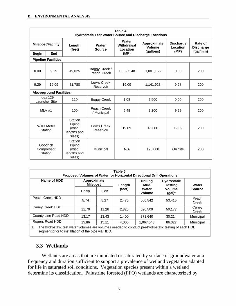
In compliance with USDOT regulations (49 CFR 192, Subpart J), Gulf South would perform hydrostatic testing of the new pipeline segments and the new aboveground facility piping prior to placing the Project facilities into service. All water would be sourced from either surface waterbodies or municipal sources (see table 4). All withdrawals would be conducted in accordance with applicable permits and in a manner that would not reduce water flow to a point that would impair flow or impact fishery and recreational uses. No chemicals or additives would be added to the test water. Following hydrostatic testing, water would be discharged through an energy dissipation device, into a well-vegetated, upland area. Gulf South would also source water needs from municipal and surface water sources for HDD operations (see table 5).
In addition, Gulf South would utilize a maximum of 20,000 gallons of water per day during construction to control fugitive dust emissions. All water utilized for dust control would be acquired from municipal water sources and/or the permitted surface water withdrawal locations identified in tables 4 and 5. Gulf South would only apply water for dust control when necessary.
Given that Gulf South would obtain all applicable permits, and water withdrawal and discharge would be conducted in accordance with the Plan and Procedures, we conclude that impacts resulting from hydrostatic testing and water withdrawals for HDD operations and dust control would not be significant.
B. ENVIRONMENTAL ANALYSIS
17
Table 4. Hydrostatic Test Water Source and Discharge Locations
Milepost/Facility Length (feet)
Water Source
Water Withdrawal Location
(MP)
Approximate Volume
(gallons)
Discharge Location
(MP)
Rate of Discharge (gal/min) Begin End
Pipeline Facilities
0.00 9.29 49,025 Boggy Creek / Peach Creek 1.08 / 5.48 1,081,166 0.00 200
9.29 19.09 51,780 Lewis Creek Reservoir 19.09 1,141,923 9.28 200
Aboveground Facilities Index 129
Launcher Site 110 Boggy Creek 1.08 2,500 0.00 200
MLV #1 100 Peach Creek / Municipal 5.48 2,200 9.29 200
Willis Meter Station
Station Piping (misc.
lengths and sizes)
Lewis Creek Reservoir 19.09 45,000 19.09 200
Goodrich Compressor
Station
Station Piping (misc.
lengths and sizes)
Municipal N/A 120,000 On Site 200
Table 5. Proposed Volumes of Water for Horizontal Directional Drill Operations
Name of HDD Approximate Milepost Length
(feet)
Drilling Mud
Water Volume
Hydrostatic Testing Volume
(gal)a
Water Source Entry Exit
Peach Creek HDD 5.74 5.27 2,475 660,542 53,415 Peach
Creek Caney Creek HDD 11.70 11.26 2,325 620,509 50,177 Caney
Creek County Line Road HDD 13.17 13.43 1,400 373,640 30,214 Municipal Rogers Road HDD 15.86 15.11 4,000 1,067,543 86.327 Municipal
a The hydrostatic test water volumes are volumes needed to conduct pre-hydrostatic testing of each HDD segment prior to installation of the pipe via HDD.
3.3 Wetlands
Wetlands are areas that are inundated or saturated by surface or groundwater at a frequency and duration sufficient to support a prevalence of wetland vegetation adapted for life in saturated soil conditions. Vegetation species present within a wetland determine its classification. Palustrine forested (PFO) wetlands are characterized by

B. ENVIRONMENTAL ANALYSIS
18
woody vegetation greater than 20 feet in height with more than 30 percent canopy cover. Palustrine scrub-shrub (PSS) wetlands are similar to PFO wetlands in that they are characterized by greater than 30 percent canopy cover of woody vegetation; however, dominant vegetation in a PSS wetland is less than 20 feet in height. Finally, palustrine emergent (PEM) wetlands are characterized by dominance of rooted herbaceous (non-woody) wetland plants (Cowardin et al., 1979).
Field surveys and desktop evaluations were conducted by Gulf South from March
2018 through September 2018 in accordance with the Corps of Engineers Wetland Delineation Manual (U.S. Army Corps of Engineers [USACE], 1987) and the Regional Supplement to the Corps of Engineers Wetland Delineation Manual: Atlantic and Gulf Coastal Plain Region (USACE, 2010). Gulf South identified a total of 80 wetlands that would be impacted or otherwise crossed by the Project: 43 PEM, 34 PFO, and 3 PSS. Table 6 provides a summary of wetlands that would be impacted by the Project (see table A-3 in appendix A for more detail on each impacted wetland).
Table 6. Wetland Resources Crossed by the Willis Lateral Project
Wetland Type Number of Wetlands Crossed
Construction Impacts (acres) a
Operational Impacts (acres) b
San Jacinto County PEM 7 0.32 0.01 PSS 0 0 0 PFO 17 1.45 0.59
San Jacinto County Subtotal 24 1.77 0.60
Montgomery County PEM 36 5.46 0 PSS 3 0.05 0 PFO 17 0.99 0.13
Montgomery County Subtotals 56 6.50 0.13
Project Totals 80 8.27 0.73 a Construction impact acreages were calculated using digital configuration data and desktop analysis.
Construction acreages include TWS, permanent easement, and ATWS. b With the exception of those that would be permanently filled, no operational impacts on PEM wetlands are
expected, as these wetlands will revert to the same type following construction. Operational impacts for PFO and PSS wetlands are based on a 10-foot-wide strip in the right-of-way that would be converted to other wetland types due to right-of-way maintenance. Operational impacts on PFO wetlands also reflect potential for selective thinning of trees within 15 feet of the pipeline that have roots that could compromise the integrity of the pipeline coating.
Construction of the pipeline facilities, inclusive of ATWS, would result in a total
of about 8 acres of impacts on wetlands, of which less than 1 acre represents impacts associated with the operation of the permanent right-of-way. Access roads would result in a total of 0.15 acre of construction impacts, of which 0.01 acre of one PFO wetland and 0.01 acre of one PEM wetland would be impacted by the widening of permanent

B. ENVIRONMENTAL ANALYSIS
19
access road no. 1 (PAR-01) and PAR-06, respectively. Construction of PAR-01 and PAR-06 would require the placement of gravel/dirt fill within two wetlands.
Gulf South would cross wetlands using conventional construction methods and HDD. Construction procedures within wetlands found to be unsaturated at the time of construction would be similar to those used in upland areas. Additionally, topsoil would be segregated in unsaturated wetlands over the trenchline only to preserve the natural seedstock and encourage the growth of native plant species during restoration. Pipe stringing and fabrication may take place within the wetland adjacent to the trench, or adjacent to the wetland in a designated ATWS. In saturated wetlands, construction would proceed in a manner similar to unsaturated wetlands, except topsoil would not be segregated due to the saturated, unconsolidated conditions. Where soils do not support the weight of the equipment, temporary work surfaces consisting of timber or travel pads would be installed within the right-of-way to support construction equipment traffic to avoid rutting and subsurface mixing of soils.
Gulf South would maintain a 10-foot-wide strip of the permanent right-of-way (centered over the pipe) in an herbaceous state in accordance with the Procedures. Trees within 15 feet of the pipeline with roots that could compromise the integrity of the pipeline coating would be selectively cut and removed from the permanent right-of-way to maintain pipeline integrity.
Gulf South would site ATWS a minimum of 50 feet from the edges of wetlands. However, Gulf South has requested modifications to section VI.B.1.a of FERC’s Procedures for a number of ATWS within 50 feet of a wetland. Due to topography and construction constraints, a 50-foot setback is not possible for the placement of these ATWS. Gulf South would employ erosion control measures at these workspaces such as silt fence, and straw/hay bales to prevent sedimentation of wetlands and waterbodies. In addition, Gulf South also requested modifications to section VI.B.1.d of the Procedures for use of access roads that require improvements in wetlands (PAR-01 and PAR-06). Table A-2 in appendix A lists each location, justification, and equal compliance measures for the ATWS and access roads. We find these acceptable.
The primary impacts of construction in wetlands would be the permanent fill required for the installation of two permanent access roads, the alteration of wetland type, and impacts on water quality within wetlands due to sediment loading or inadvertent spills of hazardous materials. As similarly discussed in section B.3.2, inadvertent returns from HDD could increase sedimentation in wetlands; however, Gulf South would implement its HDD Contingency Plan to minimize impacts from a release.
PEM wetlands would revert to the same type following construction, therefore operational impacts are not expected for this wetland type, except for the construction of PAR-01, which would permanently impact about 0.01 acre of a PEM wetland. In addition, the construction of PAR-06 would also require about 0.01 acre of permanent impacts on a PFO wetland. Further, less than 1 acre of PFO wetlands would be converted

B. ENVIRONMENTAL ANALYSIS
20
to PEM or PSS due to vegetation maintenance, but these wetlands would still provide important ecological functions including flood control and providing wildlife habitat. The Project would require impacts on about 2 acres of PFO for TWS, which would be considered a long-term impact as it could take decades for forested wetland vegetation to return to pre-construction conditions.
Gulf South would minimize impacts on wetlands by incorporating the measures outlined in the Procedures. Some of these measures include leaving root systems intact to hasten revegetation, installing hay bales and silt fence to prevent runoff from upland areas reaching wetlands, and installing trench breakers (physical barriers at the bottom of the trench) to maintain wetland hydrology. Gulf South would also limit the right-of-way width to 75 feet in wetlands to minimize the overall disturbance of construction. On January 22, 2019, Gulf South received authorization under Nationwide Permit 12 from the USACE. As a condition of this permit, Gulf South is required to adhere to a mitigation plan for the Project’s impacts on wetlands, including the permanent conversion and fill of PFO wetlands and the permanent fill of PEM wetlands. Additionally, Gulf South would be required to complete successful restoration of the wetland and waterbody crossings as a part of Project restoration, which would be verified during FERC staff’s construction and restoration inspections. For these reasons, we conclude the Project’s impacts on wetlands would not be significant.
4. Fisheries, Vegetation, Wildlife, and Threatened and Endangered Species
4.1 Fisheries
The quality of a fishery is associated with the quality of its inhabited waterbody. As discussed in section B.3.2, Gulf South identified 137 waterbodies that are either crossed or impacted by the Project, of which 20 are perennial, 17 intermittent, 89 ephemeral, and 11 ponds or lakes (open water). All waterbodies crossed by the Project are classified as fresh, warmwater fisheries and are typically comprised of sport fish, rough fish, forage minnows, or a combination of the three groups. Fish species common in waterbodies in the Project area may include various shiners and minnows, bullhead and other catfish, suckers, sunfish, various bass species, gar, and crappie (TPWD, 2018b). Some fish that could occur in the Project area and that are known to be particularly tolerant to poor quality habitats include carp, suckers, topminnows, and bullhead catfish (TPWD, 2014).
Based on a review of the Texas Administrative Code Chapter 307 of the TCEQ Standards, waterbodies crossed by the Project that are considered to support sustainable fisheries include several perennial waterbodies (see table A-1 in appendix A). Sustainable fisheries are defined by the TCEQ as waterbodies that “potentially have sufficient fish production or fishing activity to create significant long-term human consumption of fish. Sustainable fisheries include perennial streams or rivers with a stream order of three or greater; lakes and reservoirs greater than or equal to 150 acre-feet

B. ENVIRONMENTAL ANALYSIS
21
or 50 surface acres; and all bays, estuaries, and tidal rivers.” While the Project area may cross sustainable fisheries, no designated fishing areas are within the Project area (TCEQ, 2010).
Perennial streams crossed by the Project may contain a state-listed species, the threatened creek chubsucker. State-protected fish species are discussed further in section B.4.3. No Essential Fish Habitat is designated within the Project area.
Measures that Gulf South would implement during construction in or near waterbodies to protect aquatic resources would also be protective of fisheries. Some waterbodies would be crossed by bore or HDD methods, thereby avoiding direct impacts on fisheries. However, when using HDD, there is potential for inadvertent returns of drilling fluid (mostly bentonite), which could lead to an increase in turbidity as mentioned in section B.3.2. Gulf South would implement measures outlined in its HDD Contingency Plan to stop, contain, and clean up any returns.
As discussed in section B.3.2, all other waterbodies would be crossed with an open-cut method. In-water construction and removal of riparian vegetation may cause a temporary increase in turbidity levels, which can increase the sedimentation rate immediately downstream of the work area. Temporary habitat alteration and substrate disturbance could also occur resulting in potential impacts on fish populations. Loss of riparian vegetation in forested areas could affect fish populations that may be present downstream of construction activities by reducing shade and cover, and increasing water temperature.
Refueling of construction equipment and storage of fuel oil or other hazardous materials near waterbodies could contaminate waterbodies, if a spill were to occur. Therefore, Gulf South would adhere to its SPCC plan and would not refuel equipment within 100 feet of these resources without secondary containment. Gulf South would also ensure that all equipment is parked overnight at least 100 feet from a waterbody and that hazardous materials, including chemicals, fuels, and lubricating oils are not stored within 100 feet of a waterbody unless the location is designated for such use by the EI, in accordance with the Procedures.
Waterbodies that may be of local importance for recreational fishing that are crossed by open-cut construction methods would only be temporarily impacted, with waterbody crossings being completed within 24 or 48 hours. Therefore, adverse impacts on recreational fishing are not anticipated as a result of the Project.
Gulf South would restore waterbody banks to pre-construction contours and promptly re-seed and stabilize banks, in accordance with the Plan and Procedures. In accordance with section V.B.1 of the FERC Procedures, Gulf South would be required to complete all in-stream work between June 1 and November 30, unless expressly permitted or further restricted by the appropriate federal or state agency in writing on a

B. ENVIRONMENTAL ANALYSIS
22
site-specific basis. Any in-stream work time window restrictions are expected to be incorporated in the Project’s Clean Water Act Sections 401 and 404 permitting.
Gulf South also proposes to withdraw surface water for the Project’s water needs for hydrostatic testing, HDD operations, and dust control. Gulf South would obtain all applicable permits, including a TCEQ Temporary Water Use Permit, prior to surface water withdrawal. Gulf South would also adhere to measures in the Procedures, which include screening intake hoses to minimize the potential for entrainment of fish and maintaining adequate flow rates to protect aquatic life. Following hydrostatic testing, water would be discharged through an energy dissipation device into a well-vegetated, upland area, and therefore, would not impact fisheries.
Based on Gulf South’s proposed measures, and compliance with FERC’s Procedures and other state and federal permits and approvals, we conclude that the Project’s impacts on fisheries would not be significant.
4.2 Vegetation
In general, vegetation within the Project area is characterized by pine plantation, forest, open land, developed land, wetland, and open water (aquatic vegetation) habitat types. Table 7 describes vegetation commonly found in each habitat type crossed by the Project. Pine plantations are planted stands of pine species managed and harvested on rotations for a variety of timber products. Open land is comprised of non-forested areas that are not otherwise classified as agriculture, and includes existing utility rights-of way and unimproved pastures, which are typically characterized as open areas with mixed herbaceous vegetation interspersed with scrub-shrub vegetation. Developed land encompasses both industrial and residential areas, including landscaped areas associated with a residence. Developed lands are typically either sparsely vegetated or lack vegetation due to the presence of impervious surfaces such as cement foundations, pavement, or gravel pads. Open water within the Project area includes multiple natural and manmade ponds. Wetland types found within the Project areas are PEM, PSS, and PFO (see section B.3.3). No vegetation communities of special concern would be affected by the Project.
The primary impact on vegetation from the Project would be the new permanent conversion of about 37 acres of forested upland and pine plantation to open land, comprised of maintained right-of-way and permanent access roads. In addition, about 120 acres of forested land and pine plantation would be cleared for temporary construction workspaces. This would be considered a long-term impact as it would take more than 20 years for forested vegetation to return to pre-construction conditions. However, vegetation within open land, developed land, and herbaceous wetland habitat types would likely return to their pre-construction conditions within 1 to 5 years.

B. ENVIRONMENTAL ANALYSIS
23
Table 7. Vegetation and Wildlife Commonly Found in Habitat Types Crossed by the Project
Vegetation Habitat Type
Vegetation Wildlife
Pine Plantation Recently harvested pine plantations: sweetgum, northern red oak, American beautyberry, loblolly pine Unharvested pine plantations: loblolly pine, yaupon, American beautyberry, Chinese tallow, southern magnolia
white-tailed deer, opossum, raccoon, striped skunk, copperhead, fox squirrel, coyote, gray fox, wild turkey, feral hog, eastern cottontail rabbit, white-winged dove, northern cardinal, and Gulf coast ribbon snake
Forest red maple, American hornbeam, American holly, sweetgum, loblolly pine, water oak, white oak, winged elm, yaupon, sweetbay magnolia, American beautyberry, white fringetree, deertongue, sawtooth greenbrier, summer grape, and white-edged sedge.
Similar species as found in pine plantation (above).
Open land little bluestem, Brazilian vervain, common carpetgrass, common sheep sorrel, southern dewberry, bermudagrass, Carolina geranium, sticky-willy, perennial ryegrass, giant ragweed, sawtooth greenbrier, Japanese honeysuckle, johnsongrass, annual bluegrass, bahiagrass, sawtooth blackberry, common ragweed
Open land provides habitat to species such as mourning dove, white-winged dove, coyote, deer mouse, eastern cottontail, red-tailed hawk, field sparrow, and American kestrel
Developed land peppervine, bahiagrass, poison ivy, Brazilian vervain, sawtooth blackberry, southern dewberry, sawtooth greenbrier, Bermuda grass
Wildlife species common in developed area consist mostly of human commensal species such as raccoon, opossum, northern mockingbird, and rock dove.
PEM wetland sand spikerush, sawtooth blackberry, common rush, false hop sedge, tapered rosette grass, peppervine, anglestem beaksedge, curly dock, grassy arrowhead, small spikerush, poverty rush, bushy bluestem, alligatorweed, seedbox, American water horehound, and swamp smartweed
Wetlands provide foraging, breeding, and nesting habitat for a variety of wildlife species including water snakes, leopard frog, cottonmouth, cattle egret, snowy egret, blue heron, and raccoon.
PSS wetland Chinese tallow, sweetgum, trumpet creeper, slender woodoats, velvet panicum, bushy bluestem, white edge sedge, eastern baccharis, loblolly pine
PFO wetland Chinese tallow, common rush, red maple, sweetbay magnolia, wax myrtle, trumpet creeper, loblolly pine, water oak, American hornbeam, summer grape, false hop sedge, tapered rosette grass, river birch, willow oak, blackgum, cinnamon fern, royal fern
Open water Vegetation commonly found along the banks of the ponds in the area include cattails, water lilies, water hyacinth, widgeon grass, and duckweed.
Many semi-aquatic and aquatic species may utilize open water within the Project area such as blue heron, red-eared slider, yellow-bellied slider, cottonmouth, water snakes, leopard frog, mosquito fish, blue-gill perch, and largemouth bass.
After construction, Gulf South would revegetate the right-of-way and TWS/
ATWS according to its Revegetation Plan, which was developed in consultation with the NRCS and state agencies. Staging areas would also be restored as close as practicable to previous conditions or left in an improved state if requested by the landowner. Given that the pipeline right-of way is mostly collocated with existing utility rights-of-way and that almost all Project workspaces would be revegetated, we conclude that the Project would not have a significant impact on vegetation.

B. ENVIRONMENTAL ANALYSIS
24
Invasive Species and Noxious Weeds
Invasive plant species are non‐native species that can disrupt functioning ecosystems by displacing native species and reducing overall diversity. Invasive species and noxious weeds that have the potential to occur in the Project area include Chinese tallow tree, ragweed, giant reed, and waterthyme.
Removal of existing vegetation and disturbance of soils during construction of the Project could create conditions conducive to the establishment of noxious weeds and invasive species. Gulf South would implement its Exotic and Invasive Species Control Plan to minimize the spread of noxious weeds and invasive species. Specific measures include:
• minimizing sediment movement and the associated movement of non-native seeds;
• minimizing the time that bare soil is exposed, and thus minimizing the opportunity for exotic species to become established;
• sowing a cover crop along all exposed soil surfaces as soon as practicable to assure that a suitable growing substrate for exotic or invasive species is not available for long periods of time; and
• monitoring the pipeline right-of-way and disturbed sites following construction to verify that revegetation has been successful and that invasive species have not become widely established. Noxious weeds and invasive species discovered during monitoring would be appropriately treated.
We find these measures to be acceptable.
4.3 Wildlife
The Project consists of pine plantation, forest, open land, developed land, wetland, and open water (aquatic vegetation) habitat types. Common wildlife in the area include a wide variety of mammal, amphibian, birds, and reptile species. Table 7 includes examples of species found within each habitat type.
Potential impacts on wildlife include habitat removal, construction-related ground disturbance, and noise. Some individuals could be inadvertently injured or killed by construction equipment. However, more mobile species such as birds and larger mammals would likely relocate to other nearby suitable habitat and avoid the Project area once construction activities commence. The temporary disturbance of local habitat is not expected to have population-level effects on wildlife because the amount of habitat crossed represents only a small portion of the habitat available to wildlife throughout the Project area, and much of the disturbed habitat would return to preconstruction condition after construction. Furthermore, approximately 91 percent of the pipeline is collocated with an existing utility corridor and would occur within or adjacent to previously

B. ENVIRONMENTAL ANALYSIS
25
disturbed habitat. Long-term impacts from habitat alteration would be further minimized by the implementation of Gulf South’s Revegetation Plan and the Plan and Procedures, which would ensure successful revegetation of most areas disturbed by construction.
The Sam Houston National Forest Wildlife Management Area (WMA) is about 41 feet southwest and 67 feet northwest of temporary access road no. 3 (TAR-03) and TAR-05, respectively. In addition, this WMA is about 0.19 mile south of the pipeline at its closest point. This WMA is cooperatively managed by the U.S. Forest Service and the TPWD and spans 161,508 acres across Montgomery, San Jacinto, and Walker Counties in Texas The TPWD operates the Sam Houston National Forest WMA within the Sam Houston National Forest under a Memorandum of Agreement with the U.S. Forest Service. The Sam Houston National Forest provides wintering habitat for the bald eagle and year-round habitat for the federally endangered red-cockaded woodpecker. The Project’s potential impacts on the bald eagle and the red-cockaded woodpecker are discussed further in section B.4.4. No Project activities would take place within the WMA.
Given Gulf South’s proposed mitigation measures, including its commitment to revegetate the right-of-way and all temporary work areas, and the abundance of similar habitat adjacent to the Project area, we conclude that the Project would not have a significant impact on wildlife or wildlife habitat in the Project area.
4.4 Special Status Species
Special status species are those species for which state or federal agencies provide an additional level of protection by law, regulation, or policy. Included in this category for this EA are federally listed species that are protected under the Endangered Species Act (ESA), those species that are state-listed as threatened or endangered, and state species of special concern.
Migratory Birds
Migratory birds are species that nest in the United States and Canada during the summer and then migrate to and from the tropical regions of Mexico, Central and South America, and the Caribbean for the non-breeding season. Migratory birds are protected under the Migratory Bird Treaty Act ([MBTA] – 16 U.S. Code 703-711), and bald and golden eagles are additionally protected under the Bald and Golden Eagle Protection Act – 16 U.S Code 668-668d). The MBTA, as amended, prohibits the intentional taking, killing, possession, transportation, and importation of migratory birds, their eggs, parts, and nests. In addition, Executive Order 13186 requires that all federal agencies undertaking activities that may negatively affect migratory birds take a prescribed set of actions to further implement the MBTA, and directs federal agencies to develop a memorandum of understanding (MOU) with the U.S. Fish and Wildlife Service (USFWS) that promotes the conservation of migratory birds through enhanced collaboration between the two agencies. In March 2011, FERC entered into a MOU with

B. ENVIRONMENTAL ANALYSIS
26
the USFWS, which focuses on avoiding or minimizing adverse impacts on migratory birds and strengthening migratory bird conservation through enhanced collaboration between the two agencies.
Though all migratory birds are afforded protection under the MBTA, both Executive Order 13186 and the MOU require that Birds of Conservation Concern and federally listed species be given priority when considering effects on migratory birds. Birds of Conservation Concern are a subset of MBTA-protected species identified by the USFWS as those in the greatest need of additional conservation action to avoid future listing under the ESA. Executive Order 13186 states that emphasis should be placed on species of concern, priority habitats, key risk factors, and that particular focus should be given to addressing population-level impacts.
The Project falls within Bird Conservation Region 25: West Gulf Coastal Plains/Ouachitas Region (USFWS, 2008). Of the 28 Birds of Conservation listed for Bird Conservation Region 25, 1 species does not have a range that extends into the Project area, 13 species only occur in the Project area as occasional migrants or during the winter, 9 species have breeding ranges that extend into the Project area, and the remaining 5 inhabit the Project vicinity year-round. Table A-4 in appendix A describes Birds of Conservation Concern with the potential to occur within the Project area.
Gulf South proposes to begin construction in fall 2019, with an in-service date of July 2020. If this schedule holds, vegetation removal and almost all active construction would be conducted prior to the breeding season for migratory birds (generally March 15 - September 15 in the Project area per the TPWD). Therefore, no impacts on nests are anticipated. If construction continues into the breeding season, the right-of-way would already be cleared of vegetation and any birds returning to the area to nest would likely choose other locations in the abundant habitat adjacent to the right-of-way or in the general area.
If the start of vegetation clearing were to be delayed into the breeding season, any birds in the Project area would likely be displaced or avoid the area. Migratory birds not already nesting would be able to avoid these activities and move to abundant nearby habitat. Birds fleeing an area of disturbance could be injured or suffer mortality, or abandon nests, affecting egg-laying and potentially causing the mortality of young. As such, if vegetation clearing or active construction were to begin during the breeding season, individual birds or nests could be affected, but would not have population-level impacts.
Impacts resulting from vegetation clearing within open land, developed land, and herbaceous wetland habitat types are expected to be short term because vegetation within these areas would likely return to their preconstruction conditions within 1 to 5 years. Impacts resulting from vegetation clearing within upland forests and forested wetlands would be permanent or long term. Within the permanent right-of-way, routine vegetation maintenance would preclude the growth of trees. Within TWS, impacts on forests would

B. ENVIRONMENTAL ANALYSIS
27
be considered long term because vegetation within these areas could take decades to return to preconstruction conditions. To minimize these impacts, the Project has been almost entirely collocated with existing utility rights-of-way, which would reduce overall impacts on adjacent forested communities and would minimize forest fragmentation.
Implementation of the Plan and Procedures, as well as Gulf South’s Revegetation Plan would reduce the extent and duration of impacts on migratory bird habitat by restoring a great majority of the construction right-of-way to pre-construction conditions. During operation of the Project, vegetation maintenance clearing would occur outside of the nesting season in accordance with the Plan. Habitat loss could have a greater impact on Birds of Conservation Concern species due to their limited populations in the area and more restrictive habitat needs. However, with the implementation of the measures mentioned previously, we conclude that impacts on migratory birds from construction of the Project would largely be temporary and would not be significant.
Based on a review of Texas Natural Diversity Database occurrence data, bald eagles have been documented at Lake Conroe, west of the Project area. However, during field surveys conducted by Gulf South between March and May 2018, no bald eagle nests were observed in the general Project area. If an active bald eagle nest is observed in the Project area prior to or during construction, Gulf South would adhere to the buffer requirements established in the USFWS National Bald Eagle Management Guidelines (USFWS, 2007). Therefore, the Project would not adversely affect bald eagles.
Federally-listed species
Gulf South, acting as a non-federal representative for FERC in accordance with Section 7(a)(2) of the ESA, initiated informal consultation with the USFWS to identify federally listed threatened and endangered species that may occur in the Project area. A review of the USFWS Information for Planning and Consultation System identified a total of five federally listed species that could potentially occur within the Project area. Three of these species, least tern, piping plover, and red knot, are only considered during analysis of wind-related projects in the Project area, as it is within the migratory route of these birds. Additionally, there is no suitable habitat in the Project area, as they all prefer sparsely vegetated or bare wide open flats, beaches, or shorelines. Therefore, these three species are not discussed further. For the remaining two species, the red-cockaded woodpecker and the Texas trailing phlox (an endangered plant), Gulf South conducted field surveys from March 2018 through May 2018 to determine if these species, or their associated habitats, were present within the Project area. Gulf South later conducted additional surveys for modifications to the Project. Table A-5 in appendix A describes federally and state-listed threatened and endangered species potentially occurring within the Project area and their associated habitats. Based upon the results of field surveys conducted to date and desktop reviews, the Project area does not contain suitable habitat for these species. Therefore, we conclude that the Project would have no effect on the red-cockaded woodpecker and Texas trailing phlox.

B. ENVIRONMENTAL ANALYSIS
28
Gulf South submitted a consultation letter to the USFWS on July 13, 2018, documenting this determination. In email correspondence to Gulf South dated October 15, 2018, the USFWS requested additional information regarding the surveys conducted for the Texas trailing phlox. In a letter dated October 25, 2018, Gulf South notified the USFWS of subsequent modifications made to the Project. This letter explained that based on the additional field surveys conducted for these modifications, the habitats impacted by the proposed modifications are similar to those previously presented, and the Project would still have no effect on federally listed species. In email correspondence to Gulf South dated October 29, 2018, the USFWS stated that no additional coordination is required as it relates to the Texas trailing phlox.
We conclude that the Project would not affect any federally listed species; thus, no further Section 7 consultation is necessary.
State-listed species
A search of the Texas Natural Diversity Database was conducted to identify the state-listed species that could potentially occur within the Project area. Twenty-five state-listed or protected species that are not also federally listed were identified within the counties in which the Project is located (see table A-5 in appendix A). Species identified include one amphibian, eight birds, two fish, three mammals, five reptiles, and six mollusks. The Project would have no impact on 13 state-listed threatened and endangered species due to lack of suitable habitat, and is not likely to adversely impact the remaining 12 species (bald eagle [also discussed above], white-faced ibis, American peregrine falcon, Rafinesques’s big-eared bat, Bachman’s sparrow, creek chubsucker, black bear, alligator snapping turtle, timber rattlesnake, Louisiana pigtoe, sandbank pocketbook, and Texas heelsplitter.
Gulf South submitted a letter to the TPWD on July 13, 2018, requesting concurrence with the determination that the Project would not impact or was not likely to adversely impact state-protected species within the Project area. In a letter dated July 23, 2018, the TPWD responded to Gulf South with a number of comments and recommendations. Gulf South responded to the TPWD’s recommendations on September 14, 2018. In response to some of the TPWD’s recommendations, Gulf South explained that it would adhere to measures in the Plan and Procedures as well as its HDD Contingency Plan, Revegetation Plan, and Exotic and Invasive Species Control Plan. Specific measures that Gulf South committed to include:
• minimizing the time between trenching/excavation and backfilling to the greatest extent practicable and inspecting the trench prior to backfilling to ensure no wildlife species have been trapped (if wildlife is observed within the trench, Gulf South would contact appropriate personnel to remove and relocate the trapped individuals);
B. ENVIRONMENTAL ANALYSIS
29
• conducting all clearing activities outside of the general bird nesting season of March 15th to September 15th, which would also avoid impacts on forest habitat during the young-rearing period of the Rafinesque’s big-eared bat (May-October) to the greatest extent practicable;
• training all Project personnel on species that could be encountered along the Project right-of-way, and appropriate steps to take should sensitive species, such as alligator snapping turtles and timber rattlesnakes, be encountered during construction;
• training EIs to identify all federal and state-listed species and contacting the USFWS or TPWD if a protected species is observed;
• decontaminating all equipment that has been operated in a waterbody on the Texas list of zebra mussel infected waterbodies and those waterbodies containing invasive aquatic species such as waterthyme, kariba-weed, and water hyacinth;
• enforcing reduced speed limits along the construction right-of-way; and • stopping work if a rare species is observed during construction and
notifying the TPWD so that appropriate avoidance and minimization measures may be implemented.
In a letter dated October 25, 2018, Gulf South notified the TPWD of subsequent modifications made to the Project. This letter explained that based on the additional field surveys conducted for these modifications, the habitats impacted by the proposed modifications are similar to those previously presented, and the Project modifications would not change determinations of effect for any state-listed species. The TPWD followed up in email correspondence to Gulf South dated January 23, 2019, stating that it has no additional recommendations or comments.
Given Gulf South’s proposed measures, we conclude that the Project would not adversely affect state-listed species.
5. Land Use, Recreation, and Visual Resources
Land use types affected by the Project include open land, forest, industrial, pine plantation, wetland, residential, and open water. Construction of the proposed Project would require about 440.5 acres of land, including 407.54 acres for construction of the pipeline and 32.96 acres for construction of the aboveground facilities. The total acreage for operation of all Project facilities would be about 150.76 acres, including 138.55 acres for the pipeline and 12.21 acres for the aboveground facilities. Temporary and permanent land use impacts are summarized below in table 8.

B. ENVIRONMENTAL ANALYSIS
30
Table 8. Summary of Land Use Impacts
Facility (Totals in Acres)
Open Land Forest Industrial Pine Plantation Wetland Residential Open Water Project Total
Const. a Op. b Const. Op. Const. Op. Const. Op. Const. Op. Const. Op. Const. Op. Const. Op.
Pipeline Facilities
Right-of-Way 104.03 70.33 49.30 18.70 2.43 1.67 29.83 14.62 7.72 0.71 5.16 2.18 0.54 0.50 201.23 115.57 Additional Temporary
Workspace c 20.88 0.00 13.50 0.00 0.61 0.00 10.03 0.00 0.39 0.00 1.62 0.00 0.15 0.00 47.18 0.00
Access Roads 36.88 18.46 0.69 0.32 2.38 0.16 3.81 3.37 0.15 0.01 3.01 0.63 0.00 0.00 46.92 22.98 Contractor/Rail
Yards 62.76 0.00 11.88 0.00 37.57 0.00 0.00 0.00 0.00 0.00 0.00 0.00 0.00 0.00 112.21 0.00
Pipeline Facilities Subtotal 224.55 88.79 75.37 19.02 42.99 1.83 43.67 17.99 8.26 0.72 9.79 2.81 0.69 0.50 407.54 138.55
Aboveground Facilities 24-inch Pipeline
Index 129 Launcher Site 0.15 0.00 0.10 0.00 0.00 0.00 0.98 0.15 0.00 0.00 0.00 0.00 0.00 0.00 1.23 0.15
Willis M&R Station 2.81 0.52 0.00 0.00 <0.01 0.00 0.00 0.00 0.00 0.00 0.00 0.00 0.00 0.00 2.82 0.52
Access Roads 3.26 3.26 0.16 0.07 0.36 0.36 0.01 0.01 0.01 0.01 0.00 0.00 0.00 0.00 3.80 3.71
Mainline Valves and Other
Ancillary Facilities 0.02 0.02 0.04 0.04 0.00 0.00 0.00 0.00 0.00 0.00 0.00 0.00 0.00 0.00 0.06 0.06
Index 129 Legacy System Facilities Goodrich
Compressor Station d
0.00 0.00 0.00 0.00 25.05 7.77 0.00 0.00 0.00 0.00 0.00 0.00 0.00 0.00 25.05 7.77
Aboveground Facilities Subtotal
6.24 3.80 0.30 0.11 25.42 8.13 0.99 0.16 0.01 0.01 0.00 0.00 0.00 0.00 32.96 12.21
Project Total 230.79 92.59 75.67 19.13 68.41 9.96 44.66 18.15 8.27 0.73 9.79 2.81 0.69 0.50 440.50 150.76 a Land affected during construction consists of temporary and new permanent impacts. b Land affected during operation consists only of new permanent impacts. c Additional temporary workspace would be utilized during construction of pipeline facilities and aboveground facilities; however, land use impacts are captured entirely
in pipeline facilities. d Impacts associated with operation are within the existing Goodrich Compressor Station and would not result in new permanent impacts on land use.

B. ENVIRONMENTAL ANALYSIS
31
5.1 Residential Land and Commercial Areas
Construction of the Project would impact approximately 9.8 acres of residential land. A total of 44 structures including 20 single family homes are within 100 feet of the Project as identified during field reconnaissance surveys and review of aerial imagery. Of these, three residences and eight structures are within 25 feet of the Project workspace. Site-specific residential crossing drawings for these residences are provided in appendix B. We encourage affected landowners to review these drawings and provide any comments or concerns during the EA comment period.
Table 9 provides a list of all structures within 100 feet of the Project along with the location, structure type, and approximate distance from the Project.
Table 9. Structures within 100 feet of the Willis Lateral Project
Location (MP) Structure Type Distance from Pipeline (feet)
Distance from Edge of Construction Workspace (feet)
4.09 Single Family (Mobile Home) 55 25 6.98 Shed 148 78 7.22 Single Family (House) 126 69 7.82 Single Family (House) 101 41 7.97 Garage 119 49 8.18 Garage 102 32 8.18 Shed 161 91
11.60 Single Family (House) 83 58 11.63 Single Family (House) 98 73 11.66 Single Family (House) 87 62 11.67 Single Family (House) 86 36 11.68 Shed 150 87 11.68 Garage 74 24 11.68 Shed 100 50 11.98 Single Family (House) 109 54 12.04 Garage 83 23 12.05 Single Family (House) 104 69 12.07 Single Family (House) 88 28 12.07 Shed 55 4 12.43 Shed 140 80 12.49 Single Family (House) 158 98 12.49 Single Family (Mobile Home) 128 68 12.51 Shed 115 55 12.53 Shed 93 33 12.54 Single Family (House) 116 56 12.55 Single Family (Mobile Home) 84 49 12.60 Shed 126 91 12.63 Single Family (House) 80 20

B. ENVIRONMENTAL ANALYSIS
32
Table 9. Structures within 100 feet of the Willis Lateral Project
Location (MP) Structure Type Distance from Pipeline (feet)
Distance from Edge of Construction Workspace (feet)
12.64 Garage 33 8 12.74 Barn 74 14 12.91 Barn 103 68
12.92 Shed 56 10 12.96 Single Family (Mobile Home) 120 60 13.03 Barn 265 60 13.27 Single Family (House) 87 62 13.41 Garage 127 53 13.44 Single Family (Mobile Home) 170 85 13.49 Single Family (House) 179 94 14.30 Shed 44 9 14.63 Business (Ameritex) 111 51 15.44 Shed 96 71 15.98 Single Family (House) 63 23 15.98 Shed 41 1 18.80 Shed 57 32
Note: Table does not include deer stands, which are used seasonally and would be removed or relocated if requested by landowners.
Construction of the Project would result in short-term impacts on residential areas,
including increased construction-related traffic on local roads as well as dust and noise generated during construction. Gulf South would minimize impacts in residential areas through implementation of measures in the Plan including:
• avoidance of the removal of mature trees and landscaping within the construction work area where possible;
• restricting construction activities to occur during daytime hours whenever feasible (considered to be 7:00 am to 6:00 pm) from Monday-Saturday in residential areas;
• fencing the edge of the construction work area for a distance of 100 feet on either side of the residence or covering the open trench with steel plates at the end of each work day;
• notifying all affected and adjacent landowners via both postal mail and phone calls no later than two weeks prior to the start of construction;
• restoring all lawn areas and landscaping immediately following clean-up operations, or as otherwise specified in landowner agreements;
• taking all measures necessary to ensure that utilities are not disrupted during construction. If the need to disrupt utilities arises, Gulf South would provide as much notice as possible to the landowner prior to the disruption; and

B. ENVIRONMENTAL ANALYSIS
33
• maintaining traffic flow and emergency vehicle access on residential roadways, and using traffic detail personnel and/or detour signs as appropriate.
Gulf South contacted the local planning districts with regards to future planned residential developments in Liberty, Montgomery, Polk, and San Jacinto Counties. Two sites of future residential development were identified by the City of Willis (Riley, 2018). One site (Camillo Properties) is less than 100 feet north of MP 16.55, and the other site (Caldwell Companies) is less than 100 feet north of MP 16.90. The Camillo Properties residential development has started clearing activities; and the construction of residences is ongoing. Based upon the preliminary Camillo Development layout provided to Gulf South, no Camillo Development residences would be within 25 feet of the Project. The Caldwell Companies planned residential development construction schedule has not been determined.
The Project would not result in permanent affects to residential land; however, construction could result in short-term impacts on nearby residential areas. Such impacts could include increased construction-related traffic on local roads, as well as increased dust and noise. We conclude that implementation of Gulf South’s proposed construction methods for working in proximity to residences and its site-specific residential construction plans (included as appendix B) would minimize disruption on residents within close proximity to construction to the extent practicable.
5.2 Public or Conservation Land; and Recreational Areas
The Project would not cross and is not within 0.25 mile of any national parks, monuments, preserves, historic sites, historical parks, memorials, battlefields, military parks, cemeteries, recreation areas, seashores, lakeshores, rivers, parkways, or trails (National Park Service [NPS], 2018a; 2010). Additionally, the Project would not cross and is not within 0.25 mile of any Indian Reservations, registered National Landmarks, or USFWS National Wildlife Refuges (NPS, 2018b; 2018c; USFWS, 2018). The Project would not cross and is not within any land designated as Conservation Reserve Program, Conservation Reserve Enhancement Program, or Wetlands Reserve Program land (Clark, 2018; NRCS, 2017; Sullivan, 2018).
As discussed above (section B.4.3), two Project access roads (TAR-03 and TAR-05) are approximately 41 feet southwest and 67 feet northwest of the Sam Houston National Forest WMA boundary, respectively, and the pipeline comes within about 0.19 mile of the WMA at its closest point. The Sam Houston National Forest WMA is used for recreational purposes, including overnight camping, fishing, and hunting (TPWD, 2018c). Construction activities could result in temporary increases in noise impacts within the WMA; however, these impacts would primarily occur during the day and would be localized. In addition, increased noise would be of short duration as construction progresses along the Project route away from the WMA. Therefore, Project

B. ENVIRONMENTAL ANALYSIS
34
activities are not anticipated to result in adverse impacts on the Sam Houston National Forest WMA.
The Project would not cross or come within 150 miles of any rivers in the National Wild and Scenic Rivers System (NPS, 2011). No National Scenic Byways would be crossed or otherwise impacted by the Project (Federal Highway Administration, 2018). The Project would not cross any designated areas included in the National Wilderness Preservation System (the closest such designated area is Little Lake Creek Wilderness area approximately 10.34 miles northwest of PAR-24) (Wilderness Institute, 2018). Also, the Project is not within a Coastal Management Zone (Texas General Land Office, 2018).
5.3 Visual Resources
Impacts on visual and/or aesthetic resources would primarily occur during construction as a result of the presence of construction equipment. Most impacts on visual resources would be temporary; however, the modifications at the Goodrich Compressor Station, and the installation of aboveground facilities at the Index 129 Launcher Site and the Willis M&R Station would create some minor permanent impacts on the visual landscape.
The proposed modifications at the existing Goodrich Compressor Station would be 687 feet at the closest point from the nearest sensitive visual area (residences). The existing Goodrich Compressor Station is within an existing industrial facility which minimizes the possibility of additional visual or aesthetic impairment to nearby residences. The proposed location of the Index 129 Launcher Site is in a predominantly rural area more than 0.25 mile from the nearest visually sensitive area (residence). Additionally, the Index 129 Launcher Site location is adjacent to utility rights-of-way to the north and east and would be surrounded by trees which would minimize any visual or aesthetic impairment to nearby residences.
The proposed location of the Willis M&R Station is adjacent to the existing Entergy Lewis Creek Power Station and electrical substation, and is approximately 0.26 mile from the nearest visually sensitive area (residence). However, this location is in a highly congested area of mixed-use development (i.e., industrial and residential), and we conclude that the addition of the Willis M&R Station is consistent with the existing landscape. Visual impacts from construction and operation of the aboveground facilities would be minor, as the aboveground facilities are primarily in rural areas, or within areas of existing industrial facilities or development.
5.4 Traffic
Transportation systems in the Project area include a network of local, state, and federal roadways. The movement of construction personnel, equipment, and materials to the work areas may slightly impact the transportation system in the Project area. Once

B. ENVIRONMENTAL ANALYSIS
35
equipment and materials reach the construction work area, construction traffic would be confined to the designated workspaces. Traffic related to pipeline construction would be spread out along the length of the pipeline and would not be concentrated in any given area. Construction at the Goodrich Compressor Station and Willis M&R Station sites, however, would be confined to specific roadways leading to each site.
Traffic associated with the Project is expected to be temporary and minimal, as construction working hours and commuting time to work are typically scheduled during off-peak hours, or in areas where traffic is not particularly heavy. It is anticipated that workers would also be carpooling to the worksite in order to keep traffic to a minimum. Appropriate traffic control measures, such as flagmen and signs, would be used as necessary to ensure safety of local traffic. According to the Texas Department of Transportation, the roadways leading to the Goodrich Compressor and Willis M&R Stations have excess capacity over current traffic levels, and construction activities at these two locations would not cause significant impacts to traffic levels on roadways leading to the sites.
In order to ensure the safety of local residents and any vehicular traffic traveling in the Project area during construction, Gulf South would have its construction contractors utilize appropriate traffic control measures (e.g., flagmen and signs), ensure compliance with weight limitations and restrictions on area roadways, remove any soil that falls onto roadway surfaces, and coordinate with state and local officials to obtain all necessary permits for temporary impacts on roadways in the Project area. As a result of these measures, traffic is not expected to be significantly impacted by construction of the Project. Based on the temporary and short-term potential traffic interruptions, we conclude that impacts from Project-related construction traffic would be minor.
During operation, occasional site visits by operations personnel would be required for routine maintenance. The impacts on traffic and transportation routes from personnel commuting to the Goodrich Compressor and Willis M&R Stations and occasional maintenance site visits would be negligible.
6. Cultural Resources
Section 106 of the National Historic Preservation Act, as amended, requires the FERC to take into account the effects of its undertakings on properties listed, or eligible for listing, on the National Register of Historic Places (NRHP), and to afford the Advisory Council on Historic Preservation an opportunity to comment. Gulf South, as a non-federal party, is assisting the FERC staff in meeting our obligations under Section 106 and the FERC’s implementing regulations at 36 CFR 800.
Gulf South conducted a cultural resources survey for the Project and provided the resulting Phase I Cultural Resources Survey report (Phase I report) to the FERC and the Texas State Historic Preservation Office (SHPO). The survey included both archaeological and architectural resources, and was augmented by the excavation of

B. ENVIRONMENTAL ANALYSIS
36
1,468 shovel test units. Approximately 972 acres were surveyed, including a 200- to 450-foot-wide corridor for the pipeline, a 50-foot-wide corridor for access roads, as well as extra workspace and a contractor yard. No survey was conducted for the Goodrich Compressor Station due to previous survey coverage and existing disturbance. Approximately 1.7 miles were not surveyed due to denied access. One historic archaeological site (41SJ238, an artifact scatter), and one pre-contact isolated find were identified as a result of the survey. Both the scatter and the isolated find were recommended as not eligible for the NRHP. In a letter dated August 2, 2018, the SHPO requested that additional information be provided in a revised Phase I report. Gulf South provided a revised report addressing the SHPO’s comments. In a letter dated September 28, 2018, the SHPO indicated that the revised report was acceptable, and concurred that site 41SJ238 was not eligible for the NRHP. We agree with the SHPO.
Subsequently, Gulf South provided an addendum report covering approximately 1.5 miles of previously denied access areas along the pipeline, access roads, two additional contractor yards, and the Cleveland Rail Yard. Approximately 189 acres were surveyed, including a 200- to 300-foot-wide corridor for the pipeline segments and a 50-foot-wide corridor for access roads, augmented by the excavation of 149 shovel test units. As a result of the survey, site 41SJ238 (noted above) was revisited and further documented, and continued to be recommended as not eligible for the NRHP. In a letter dated November 6, 2018, the SHPO commented on the addendum report and requested additional information to be provided in a revised addendum report. Gulf South provided a revised addendum report addressing the SHPO’s comments. In a letter dated January 7, 2019, the SHPO concurred that site 41SJ238 was not eligible for the NRHP. We agree with the SHPO. The SHPO also requested changes to be made in a final addendum report. Gulf South has not yet provided a final addendum report. In addition, approximately 0.3 mile of the Project remains to be surveyed. Therefore, we recommend that:
• Gulf South should not begin construction of facilities and/or use of staging, storage, or temporary work areas and new or to-be-improved access roads until:
a. Gulf South files with the Secretary:
(1) a final addendum report, and any Texas SHPO comments on the final addendum report; and
(2) a second addendum report for the outstanding survey areas, and the SHPO’s comments on the addendum report.
b. the Advisory Council on Historic Preservation is afforded an opportunity to comment if historic properties would be adversely affected; and

B. ENVIRONMENTAL ANALYSIS
37
c. FERC staff reviews and the Director of the OEP approves the survey report, and notifies Gulf South in writing that treatment plans/mitigation measures (including archaeological data recovery) may be implemented and/or construction may proceed.
All materials filed with the Commission containing location, character, and ownership information about cultural resources must have the cover and any relevant pages therein clearly labeled in bold lettering: “CUI//PRIV - DO NOT RELEASE.”
Gulf South provided a plan to address the unanticipated discovery of historic properties and human remains during construction. We requested minor revisions to the plan. Gulf South provided a revised plan which we find acceptable.9
Gulf South contacted the following Native American tribes regarding the Project, and also followed-up with the tribes: Alabama-Coushatta Tribe of Texas; Caddo Nation of Oklahoma; Comanche Nation; and Tonkawa Tribe of Oklahoma. The Caddo Nation responded and indicated the Project did not appear to endanger cultural or religious sites of interest to the Nation, but requested to be notified of inadvertent discoveries. The Project Unanticipated Discovery Plan provides for notification of tribes. The Comanche Nation indicated that after a review of its site files, no properties were identified. No other responses have been received. We sent our NOI to these same tribes. No responses to our NOI have been received.
7. Air Quality
The term “air quality” refers to relative concentrations of pollutants in the ambient air. The subsections below describe air quality concepts that are applied to characterize air quality and to determine the significance of increases in air pollution resulting from construction and operation of the Project.
7.1 Existing Environment
The Project’s area is within Liberty, San Jacinto, Montgomery, and Polk Counties in southeast Texas. The pipeline portion of the Project would cross Liberty, San Jacinto, and Montgomery Counties; a new receipt M&R station would be sited at Gulf South’s existing Goodrich Compressor Station in Polk County.
The climate in the Project area, within the larger geographic area of southeast Texas, including the greater Houston area, is classified as humid subtropical, characterized by hot summers and mild winters, with average annual rainfall of around 49
9 The final version of the Unanticipated Discovery Plan can be accessed via FERC’s eLibrary at Accession no. 20181031-5317.

B. ENVIRONMENTAL ANALYSIS
38
inches, and average temperatures ranging from lows in the low 40s °F in January to highs in the mid-90s °F in July and August (Climate of Houston, 2019).
Ambient air quality is protected by the Clean Air Act (CAA) of 1970, as amended in 1977 and 1990. The EPA oversees the implementation of the CAA and establishes National Ambient Air Quality Standards (NAAQS) to protect human health and welfare (EPA, 2018c). NAAQS have been developed for seven “criteria air pollutants” including nitrogen dioxide (NO2), carbon monoxide (CO), ozone, sulfur dioxide (SO2), particulate matter less than or equal to 2.5 microns in aerodynamic diameter (PM2.5), particulate matter less than or equal to 10 microns in aerodynamic diameter (PM10), and lead, and include levels for short-term (acute) and long-term (chronic) exposures. The NAAQS include two standards, primary and secondary. Primary standards establish limits that are considered to be protective of human health and welfare, including sensitive populations such as children, the elderly, and asthmatics. Secondary standards set limits to protect public welfare, including protection against reduced visibility and damage to crops, vegetation, animals, and buildings (EPA, 2018c). At the state level, the State of Texas has adopted the NAAQS by reference. Additional pollutants, such as volatile organic compounds (VOC) and hazardous air pollutants (HAP), are emitted during fossil fuel combustion. These pollutants are regulated through various components of the CAA that are discussed further in section B.7.3, below.
The EPA and state and local agencies have established a network of ambient air quality monitoring stations to measure concentrations of criteria pollutants across the United States. The data are then averaged over a specific time period and used by regulatory agencies to determine compliance with the NAAQS and to determine if an area is in attainment (criteria pollutant concentrations are below the NAAQS), nonattainment (criteria pollutant concentrations exceed the NAAQS) or maintenance (area was formerly nonattainment and is currently in attainment). Montgomery County is within the Metropolitan Houston/Galveston air quality control region and is classified as in moderate nonattainment for 8-hour ozone (2008 standard) and marginal nonattainment for 8-hour ozone (2015 standard) (EPA, 2018d).
7.2 Greenhouse Gases
Greenhouse gases (GHGs) occur in the atmosphere both naturally and as a result of human activities, such as the burning of fossil fuels. Carbon dioxide (CO2), methane, and nitrous oxide are GHGs that are emitted during fossil fuel combustion. GHGs are non-toxic and non-hazardous at normal ambient concentrations, and there are no applicable ambient standards or emission limits for GHGs under the CAA.
The primary GHGs that would be emitted by the Project are CO2, methane, and nitrous oxide. These GHGs would be emitted from the majority of equipment used for construction of the Project, as well as during operation of the modified Goodrich Compressor Station. In addition, various valves, fittings, and other components

B. ENVIRONMENTAL ANALYSIS
39
associated with the modified Goodrich Compressor Station, and Project pipeline, M&R stations, and ancillary facilities would be minor sources of fugitive methane leaks.
Emissions of GHGs are typically quantified and regulated in units of carbon dioxide equivalent emissions (CO2e). The CO2e takes into account the global warming potential (GWP) of each GHG. The GWP is the measure of a particular GHG’s ability to absorb solar radiation as well as its residence time within the atmosphere. The GWP allows comparison of global warming impacts between different gases; the higher the GWP, the more that gas contributes to climate change in comparison to CO2. Thus, CO2 has a GWP of 1, methane has a GWP of 25, and nitrous oxide has a GWP of 298 (EPA, 2018e).10
7.3 Regulatory Requirements
The provisions of the CAA that are applicable to the Project are discussed below. See section B.7.5 for estimated potential operational emissions for the Project.
Prevention of Significant Deterioration and Nonattainment New Source Review
Proposed new or modified air pollutant emission sources must undergo a New Source Review (NSR) prior to construction or operation. Through the NSR permitting process, state and federal regulatory agencies review and approve project emissions increases or changes, emissions controls, and various other details to ensure air quality does not deteriorate as a result of new or modified existing emission sources. The two basic groups of NSR are major source NSR and minor source NSR. Major source NSR has two components: Prevention of Significant Deterioration (PSD) and Nonattainment New Source Review (NNSR). PSD, NNSR, and minor source NSR are applicable to projects depending on the size of the proposed project, the projected emissions, and if the project is proposed in an attainment area or nonattainment/maintenance area. The TCEQ administers the PSD and NNSR permitting programs in Texas. PSD regulations define a major source as any source type belonging to a list of 28 specifically listed source categories that have a potential to emit 100 tons per year (tpy) or more of any regulated pollutant or 250 tpy for sources not among the listed source categories (such as natural gas compressor stations). These emission rate levels are referred to as the PSD major source thresholds.
The modified Goodrich Compressor Station would not exceed the PSD major source thresholds for any pollutants. Therefore, the proposed construction and operation of the modified Goodrich Compressor Station does not trigger PSD or NNSR.
10 These GWPs are based on a 100-year time period. We have selected their use over other published GWPs for other timeframes because these are the GWPs the EPA has established for reporting of GHG emissions and air permitting requirements. This allows for a consistent comparison with these regulatory requirements.

B. ENVIRONMENTAL ANALYSIS
40
Title V Permitting
Title V, also known as “CAA Part 70,” is an air quality operating permit program delegated by the EPA to each state for facilities defined by these regulations as “major sources.” The major source threshold for an air emission source is 100 tpy for criteria pollutants, 10 tpy for any single HAP, and 25 tpy for total HAPs. The proposed modified Goodrich Compressor Station has the potential to emit greater than 100 tpy of NOx and CO, and therefore meets the definition of a major source that requires a Title V Operating Permit.
In July 2018, Gulf South filed its Application for Permit by Rule under Title 30, Texas Administrative Code, Chapter 106 (air permit application) with the TCEQ.
New Source Performance Standards
The EPA promulgates New Source Performance Standards (NSPS) for new, modified, or reconstructed sources to control emissions to the level achievable by the best-demonstrated technology for stationary source types or categories as specified in the applicable provisions discussed below. The NSPS also establish fuel, monitoring, notification, reporting, and recordkeeping requirements.
As indicated in Gulf South’s air permit application submitted to the TCEQ for the modified Goodrich Compressor Station, the Project may be subject to the following NSPS requirements, subject to TCEQ’s determination:
• 40 CFR 60 Subpart OOOOa – sets emission standards and compliance schedules for VOC and SO2 emissions for new, modified, or reconstructed wet seal centrifugal compressor and reciprocating compressors; limits for bleed rates for natural-gas driven pneumatic controllers; requires work practice standards for compressor rod packing compressor units; and sets fugitive leak monitoring and repair requirements for compressor stations.11 The centrifugal compressor at the modified Goodrich Compressor Station would employ dry seals and therefore would not be subject to Subpart OOOOa requirements; however, the modified station would be required to comply with the Subpart OOOOa leak detection and repair requirements specified in 40 CFR 60.5397a.
• 40 CFR 60 Subpart JJJJ – sets emissions standards for NOx, CO, and VOC for emergency and non-emergency spark-ignition engines manufactured on or after July 1, 2007. The emergency generator at the modified Goodrich Compressor Station would be subject to these requirements.
11 On September 11, 2018, the EPA proposed amendments to Subpart OOOOa, which if implemented may affect the ways in which affected sources are subject to the rule.

B. ENVIRONMENTAL ANALYSIS
41
• 40 CFR 60 Subpart KKKK – sets emissions standards for NOx and SO2 for combustion turbines. The Solar Mars 100 turbine at the modified Goodrich Compressor Station would be subject to these requirements.
National Emission Standards for Hazardous Air Pollutants
The 1990 CAA Amendments established a list of 189 HAPs, resulting in the promulgation of National Emission Standards for Hazardous Air Pollutants (NESHAP). The NESHAP regulate HAP emissions from specific source types at major or area sources of HAPs by setting emission limits, monitoring, testing, record keeping, and notification requirements.
The modified Goodrich Compressor Station would not have the potential to emit any single HAP in amounts greater than the threshold of 10 tpy, nor would it have the potential to emit total HAPs in amounts greater than 25 tpy; therefore, the modified station would not be a major source of HAPs. In addition to major sources, some of the NESHAP also apply to minor, or area, sources of HAPs. No NESHAP standard would apply to the proposed turbine at the modified Goodrich Compressor Station.
The proposed emergency generator at the modified Goodrich Compressor Station would be required to comply with the NESHAP at 40 CFR 63 Subpart ZZZZ, which sets emission and operating limitations for HAPs emitted from reciprocating engines. Gulf South would comply with Subpart ZZZZ by meeting the NSPS requirements of 40 CFR 60 Subpart JJJJ.
Gulf South would comply with the all applicable NSPS and NESHAP standards and requirements, as necessary and as stated in the amended Title V Operating Permit issued by the TCEQ for the proposed modified Goodrich Compressor Station.
General Conformity
According to Section 176(c)(1) of the CAA (40 CFR 51.853), a federal agency cannot approve or support an activity that does not conform to an approved State Implementation Plan. Therefore, a conformity analysis to determine whether a project would conform to an approved State Implementation Plan is required when a federal action would generate emissions exceeding conformity threshold levels of pollutants for which an air basin is designated as nonattainment or maintenance. A conformity applicability determination requires that direct and indirect emissions of nonattainment or maintenance pollutants (or precursors) resulting from the federal action be compared with general conformity applicability emissions thresholds. If the thresholds are exceeded, general conformity applies and a conformity determination is required.
The lead federal agency must conduct a conformity analysis if a federal action would result in the generation of emissions that would exceed the conformity threshold levels of the pollutant(s) for which a county is designated nonattainment or maintenance.

B. ENVIRONMENTAL ANALYSIS
42
For the portion of the Project within Montgomery County (an ozone nonattainment area, as mentioned above), pollutants for which general conformity could potentially apply are NOx and VOC, which would be generated by construction equipment. The applicable general conformity threshold for each of these pollutants is 100 tpy. As shown in table 9, emissions of NOx and VOC from construction of the entire Project fall under the 100 tons per calendar year threshold for each respective pollutant. We also note that no other pollutant emissions from Project construction summarized in table 9 exceeds any applicable threshold for which general conformity could potentially apply. Therefore, the Project is not subject to a general conformity determination.
Mandatory Greenhouse Gas Reporting Rule
The EPA’s Mandatory Reporting of Greenhouse Gases Rule requires reporting from applicable sources of GHG emissions if they emit greater than or equal to 25,000 metric tons of GHG (as CO2e) in 1 year.12 The Mandatory Reporting of Greenhouse Gases Rule does not require emission control devices and is strictly a reporting requirement for stationary sources based on actual emissions. Although the rule does not apply to construction emissions, we have provided GHG construction emission estimates for the Project, as CO2e in section B.7.4, table 9. Potential operational GHG emission estimates as CO2e for the Project are presented in section B.7.5, table 10. Based on the potential emission estimates presented, actual CO2e emissions from the modified Goodrich Compressor Station would likely exceed 25,000 metric tpy, and Gulf South would be required to report actual CO2e emissions from the station in accordance with the rule.
State Air Quality Regulations
In addition to federal standards, the TCEQ establishes additional standards for visible emissions (30 TAC 111.111), NOx and SO2 emissions limitations (30 TAC 106.512, which Gulf South states would met through compliance with 40 CFR 60 Subpart KKKK), and NAAQS compliance demonstrations for proposed facilities (30 TAC 106.512).
7.4 Construction Emissions Impacts and Mitigation
Construction of the Project would result in temporary, localized emissions that would last the duration of active construction activities (estimated at 6 to 9 months, between fourth quarter 2019 and July 1, 2020). Exhaust emissions would be generated by the use of heavy equipment and trucks powered by diesel or gasoline engines. Exhaust emissions would also be generated by delivery vehicles and construction workers commuting to and from work areas.
12 A metric ton is approximately equal to 1.1 tons.

B. ENVIRONMENTAL ANALYSIS
43
Construction activities would also result in the temporary generation of fugitive
dust due to land clearing and grading, ground excavation, and driving on unpaved roads. The amount of dust generated would be a function of construction activity, soil type, soil moisture content, wind speed, precipitation, vehicle traffic and types, and roadway characteristics. Emissions would be greater during dry periods and in areas of fine-textured soils subject to surface activity.
Construction emission estimates are based on the fuel type and anticipated frequency, duration, capacity, and levels of use of various types of construction equipment. Construction emissions were estimated using AP-42 data (EPA, 2018f), EPA MOVES 2014 emission factors, estimated equipment operating capacities, and GWP factors found in 40 CFR 98 (EPA, 2018e).
Construction emissions shown in table 10 are not expected to result in a violation or degradation of ambient air quality standards.
In order to mitigate and minimize fugitive dust and other visible particulate emissions during construction of the Project, Gulf South would employ the following measures, further detailed within its Fugitive Dust Control Plan:
• take reasonable precautions to minimize fugitive dust emissions from construction activities;
• apply water, as necessary, to all affected unpaved roads, with special emphasis on locations where residences may be impacted;
• reduce vehicle speeds on all unpaved roads, and unpaved haul, and access roads;
• clean up Project ingress and egress points at paved road access intersections, as necessary, and construct and maintain construction entrances to minimize mud track out;
• cover open truck beds when transporting materials that may generate dust; • clean up, within one hour of discovery, soil tracked onto a paved road
extending greater than 50 feet from the point of origin;
Table 10. Emissions from Project Construction
Construction Activity
Construction Emissions (tpy) a
CO NOx SO2 VOC PM10 PM2.5 HAP CO2e modifications to Goodrich Compressor Station
1.25 1.93 0.003 0.27 2.55 0.42 0.013 578
pipeline, M&R station, and appurtenant facilities
8.05 23.65 0.038 2.47 61.28 7.28 0.163 6,849
Project Total 9.30 25.6 0.04 2.74 63.8 7.70 0.176 7,426 a Figures are rounded; addends in each column may not sum to total.

B. ENVIRONMENTAL ANALYSIS
44
• clean up, by the end of each work day, soil tracked onto paved roads extending less than 50 feet from the point of origin;
• control dust to minimize impacts on nearby residences; and • following construction, revegetate all areas not rocked or cultivated in
accordance with the FERC Plan and Procedures.
The above measures and requirements that Gulf South would employ during the Project’s construction and operation would ensure that impacts of fugitive dust would be minimized. We conclude that impacts of fugitive particulate emissions on residences, combined with the above mitigation, would not be significant.
Construction emissions would occur over the duration of construction activity and would be emitted at different times throughout the Project’s area. Construction emissions would be relatively minor and would result in short-term, localized impacts in the immediate vicinity of construction work areas. With the mitigation measures proposed by Gulf South, we conclude air quality impacts from construction would be temporary and would not result in a significant impact on local or regional air quality.
7.5 Operational Emissions Impacts and Mitigation
The Project would generate air emissions mainly during operation of the modified Goodrich Compressor Station. The new emission sources at the modified Goodrich Compressor Station would include one new 15,876 horsepower Solar Mars 100 turbine, including flow control, regulation equipment, and other auxiliary appurtenant facilities.
Operation of the Project including the modified Goodrich Compressor Station, pipeline, and M&R station would also emit fugitive releases of methane from valves, fittings, and other components.
Table 11 provides estimates of the potential annual emissions at the modified Goodrich Compressor Station, including fugitive methane releases (as CO2e). These estimated emissions are based on AP-42 data (EPA, 2018f), manufacturer’s emissions data, EPA publication EPA-453/R-95-017, GWP factors found in 40 CFR 98 (EPA, 2018e), and assumptions that the station operates at full capacity year-round (i.e., 8,760 hours per year). The modified Goodrich Compressor Station would not likely operate at full load every day; therefore, table 11 provides conservative, “worst-case” estimates of emissions.
Compressor unit blowdowns (gas venting) can occur during initial construction/ testing, operational startup and shutdown, maintenance activities, and during emergency purposes. Emission estimates of methane releases from compressor unit blowdowns and piping components are also included in table 11. During normal operations, blowdowns resulting from compressor startup/shutdown and during maintenance activities would be infrequent.

B. ENVIRONMENTAL ANALYSIS
45
Table 11. Potential Operational Emissions from the modified Goodrich Compressor Station (tpy) a
Pollutant Existing Goodrich Compressor Station
Proposed Project
Total for modified Goodrich Compressor Station
PM10 5.23 1.96 7.19 PM2.5 5.23 1.96 7.19 SO2 0.18 0.25 0.43 CO 441.38 31.63 473.0 NOX 249.37 31.43 280.8 VOC 74.52 4.81 79.33 HAP 1.64 1.33 2.98 CO2e b 65,899 b
a Figures are rounded; addends in each row may not sum to total. b Gulf South’s application did not provide this information, nor were we able to find sufficient
information about the existing sources at the station to estimate these emission rates.
Fugitive release emissions from the operation of the pipeline and M&R station
(consisting primarily of methane, as CO2e) would be about 84.22 tpy. To minimize fugitive emissions from operation of the Project, Gulf South would comply with the standards in 40 CFR 60 Subpart OOOOa, which specify leak detection and repair programs as applicable.13
Downstream Emissions
As explained in section A.2, Entergy’s proposed MCPS would receive all of the natural gas potentially delivered by the Project.
The Project has been designed to deliver up to 200,000 dekatherms per day (approximately 192.9 million cubic feet per day) of new volumes of natural gas, which if combusted at the MCPS, would produce 2.72 million metric tons of CO2e per year.14 This estimate of potential GHG emissions from the station would result in a 0.41 percent increase in GHG emissions from fossil fuel combustion in Texas,15 and a 0.05 percent increase in national emissions.16
Air Quality Modeling
Gulf South completed an air quality dispersion model to determine the potential impacts of emissions from the modified Goodrich Compressor Station on regional air quality. The analysis was conducted using EPA and TCEQ-approved modeling methods,
13 On September 11, 2018, the EPA proposed amendments to Subpart OOOOa, which if implemented may affect the ways in which affected sources are subject to the rule. 14 Based on information contained in TCEQ Investigation Report No. 1416501 for Permit Number GHGPSD163. Accessed at: https://bit.ly/2GdURkG. 15 Based upon Texas’ GHG emissions of 653.8 million metric tons for calendar year 2016, according to the U.S. Energy Information Administration. Accessed at: https://www.eia.gov/environment/emissions/state/ 16 Based on 5,795 million metric tons of CO2e in 2016 (inclusive of CO2e sources and sinks) as presented by the EPA at https://www.epa.gov/sites/production/files/2018-01/documents/2018_complete_report.pdf.

B. ENVIRONMENTAL ANALYSIS
46
and the latest version of EPA’s AERMOD model version 18081, supporting programs, and EPA guidance for emergency generator emissions modeling. Gulf South’s analysis assumed that the station would be running at full capacity (i.e., 8,760 hours per year at maximum emission rates). The model estimates the maximum predicted concentrations of criteria pollutants emitted from the compressor station using conservative assumptions. In addition, the model incorporated the locally cumulative impacts of the existing Kinder Morgan Texas Pipeline LLC Compressor Station 555, approximately 1.5 kilometers away from the existing Goodrich Compressor Station.17
Ambient background concentrations from the nearest air monitors were then added to the maximum predicted concentrations from the model and the total was compared to the NAAQS. The model results are provided in table 12 below.
Table 12. Predicted Air Quality Impacts – modified Goodrich Compressor Station and nearby Compressor
Station 555 (µg/m3)
Pollutant Averaging Period
Existing Ambient Background Concentration a
Maximum Modeled Concentration (includes background) NAAQS
CO 1-hour 2,514 2,956 40,000 8-hour 1,889 2,161 10,000
NO2 1-hour 51.3 156.8 188 Annual 5.8 15.1 100
PM10 24-hour 48 57.2 150
PM2.5 24-hour 20 26.6 35 Annual 8.7 10.2 12
SO2 1-hour 16.5 17.4 196
24-hour 8.3 8.9 365 Annual 1.1 1.2 80
µg/m3 = micrograms per cubic meter a According to Texas Gas, the background concentration estimates based on data obtained from an air
quality monitoring station in Marshall, TX (ID not specified). Texas Gas states that this monitor location was selected on the basis that it is situated in a rural area representative of the Goodrich Compressor Station vicinity.
The results in table 12 indicate that the combined total of existing background and
maximum modeled concentrations for the modified Goodrich Compressor Station are less than the applicable NAAQS for all pollutants outside the station’s physical fenceline boundary. Therefore, the operation of Gulf South’s modified Goodrich Compressor Station would not cause or significantly contribute to a degradation of ambient air quality. The Project would comply with the NAAQS, which are established to be protective of human health, including sensitive populations such as children, the elderly, and asthmatics.
17 According to Gulf South, another compressor station, operated by Enbridge Inc., is nearly adjacent to the Goodrich Compressor Station; however, this compressor station utilizes electric motor-driven compressor units and has minimal emission rates.

B. ENVIRONMENTAL ANALYSIS
47
Class I Areas
Under the PSD program, federal Class I areas are designated by the EPA to protect certain areas (e.g., wilderness areas, national parks, national forests) to ensure that deterioration of existing air quality-related values, such as visibility, is minimized in these areas. The nearest federal Class I Area, the Caney Creek Wilderness Area in Arkansas, is approximately 425 kilometers from the Goodrich Compressor Station. Therefore, we conclude that the modified Goodrich Compressor Station would have negligible impacts on this and other more distant Class I areas.
8. Noise
Noise is generally defined as sound with intensity greater than the ambient or background sound pressure level. Construction and operation of the Project would affect overall noise levels in the Project area. The magnitude and frequency of environmental noise may vary considerably over the course of the day, throughout the week, and across seasons, in part due to changing weather conditions and the effects of seasonal vegetation cover. Two measures that relate the time-varying quality of environmental noise to its known effect on people are the 24-hour equivalent sound level (Leq) and day-night sound level (Ldn). The Leq is an A-weighted sound level containing the same energy as the instantaneous sound levels measured over a specific time period. Noise levels are perceived differently, depending on length of exposure and time of day. The Ldn takes into account the duration and time the noise is encountered. Specifically, the Ldn is the Leq plus a 10 decibel on the A-weighted scale (dBA) penalty added to account for people’s greater sensitivity to sound levels during late evening and early morning hours (between the hours of 10:00 p.m. and 7:00 a.m.). The A-weighted scale is used to assess noise impacts because human hearing is less sensitive to low and high frequencies than mid-range frequencies. The human ear’s threshold of perception for noise change is considered to be 3 dBA; 6 dBA is clearly noticeable to the human ear, and 10 dBA is perceived as a doubling of noise (Bies and Hansen, 1988).
8.1 Federal and State Noise Regulations
In 1974, the EPA published Information on Levels of Environmental Noise Requisite to Protect Public Health and Welfare with an Adequate Margin of Safety (EPA, 1974). This document provides information for state and local governments to use in developing their own ambient noise standards. The EPA has indicated that an Ldn of 55 dBA protects the public from indoor and outdoor activity interference. We have adopted this criterion and use it to evaluate the potential noise impacts from the proposed Project at NSAs. NSAs are defined as homes, schools, churches, or any location where people reside or gather. FERC requires that the noise attributable to any new or modified compressor station or M&R station during full load operation not exceed an Ldn of 55 dBA at any NSAs. FERC also applies this noise limitation criterion more generally to construction operations having the potential to take place on 24-hour-per-day basis (e.g.,

B. ENVIRONMENTAL ANALYSIS
48
HDDs). Due to the 10 dBA nighttime penalty added prior to the logarithmic calculation of the Ldn, for a facility to meet the 55 dBA Ldn limit, it must be designed such that actual constant noise levels on a 24-hour basis do not exceed 48.6 dBA Leq at any NSA.
We have not identified, and Gulf South states it has not identified, state or local noise regulations applicable to construction or operation of the Project.
8.2 Construction Noise Impacts and Mitigation
Noise would be generated during construction of the Project. With the exception of noise from HDDs (discussed below), typical construction activities in any one area could last from several weeks to several months on an intermittent basis. While individuals in the immediate vicinity of the construction activities would experience an increase in noise, this effect would be temporary, local, and primarily limited to a 10-hour timeframe during daylight hours.
Construction at the Goodrich Compressor Station could take place over a period of 6 to 7 months. Noise from construction activities at the station would impact nearby NSAs during this time. Based on the types of construction equipment and activities proposed at the station, Gulf South predicts that construction noise would not exceed a daytime sound level of 55.1 dBA at any nearby NSA in the station’s vicinity.
HDD Noise
Gulf South would conduct HDD activities at four locations along the pipeline route (see table 13 below). HDD construction often extends into the evening hours, may be conducted on a 24-hour-per-day basis, and persist up to a period of weeks until drilling is complete. HDD noise typically has the potential to impact nearby NSAs out to a distance of 0.5 mile. With the exception of the Peach Creek HDD, mitigation would be necessary at each HDD entry and exit location to limit noise impact contributions at NSAs to less than the Ldn criterion of 55 dBA. The estimated noise contribution of each proposed HDD entry and exit location including required mitigation is summarized in table 13.
Noise from HDD operations, although noticeable at all NSAs listed in table 13, are estimated to be mitigated to below the Leq noise criterion of 48.6 dBA (55 dBA Ldn). Mitigation that Gulf South would implement to reduce noise at the Caney Creek HDD entry, County Line Road HDD entry and exit, and Rogers Road HDD entry sites to the levels in table 13 would include the installation of reinforced, contiguously constructed vinyl curtain barriers having a weight of 2.0 pounds per square foot, type KNC-200RB by Kinetics Noise Control, or equivalent. Site-specific diagrams illustrating the barrier placements for each of these respective HDD sites were included in Appendix 9G (Results of Ambient Sound Survey and Acoustical Analysis for the Horizontal

B. ENVIRONMENTAL ANALYSIS
49
Directional Drills [HDD Noise Report])18 of Gulf South’s Environmental Report submitted as part of the July 13, 2018 application. Dimensions of the barrier at each site would consist of the following:
• Caney Creek HDD entry site. A 10-foot-high, 46-foot-long barrier (west to east) would be constructed on the site’s south side, and a 10-foot-high, 75-foot-long barrier (north to south) would be constructed on the site’s east side. Both barriers would join at the site’s southeast corner;
• County Line Road HDD entry site. A 14-foot-high, 34-foot-long barrier (east to west) would be constructed on the site’s north side, and a 14-foot-high, 50-foot-long barrier (south to north) would be constructed on the site’s west side. Both barriers would join at the site’s northwest corner;
• County Line Road HDD exit site. A 10-foot-high, 46-foot-long barrier (east to west) would be constructed on the site’s south side, and a 10-foot-high, 43-foot-long barrier (north to south) would be constructed on the site’s west side. Both barriers would join at the site’s southwest corner; and
• Rogers Road HDD entry site. A 12-foot high, 88-foot-long barrier (east to west) would be constructed on the site’s north side, and a 12-foot-high, 52-foot-long barrier (south to north) would be constructed on the site’s west side. Both barriers would join at the site’s northwest corner.
Table 13. HDD Operations Having Estimated Unmitigated Noise Exceeding an Leq of 48.6 dBA at nearby NSAs
HDD Name
Entry or Exit
Site
NSA Distance and
Direction from HDD
Ambient Leq Noise
Level (dBA)
Estimated Leq Noise
Contribution from HDD (unmitigated,
dBA)
Estimated Leq Noise
Contribution from HDD
(mitigated, dBA)
Total Leq Noise
Level at NSA
(dBA)
Increase above
Ambient (dBA)
Peach Creek
Entry 518 ft. SE 46.6 47.3 No mitigation 50.0 3.4 Exit 1,092 ft. SW 38.1 38.0 No mitigation 41.1 3.0
Caney Creek
Entry 470 ft. E 41.1 52.3 48.2 49.0 7.9 Exit 1,375 ft. SW 42.0 37.9 No mitigation 43.4 1.4
County Line Road
Entry 423 ft. NE 33.9 53.3 47.1 47.3 13.4 Exit 216 ft. SW 38.1 51.5 45.5 46.2 8.1
Rogers Road
Entry 420 ft. NW 48.8 53.4 47.2 51.1 2.3 Exit 351 ft. NW 42.3 46.8 No mitigation 48.1 5.8
With its application, Gulf South provided a preliminary Plan for Reducing Noise
Impacts from Horizontal Directional Drills. However, this plan does not describe Gulf South’s commitments to follow all noise control mitigation recommended in the HDD Noise Report. To ensure that Gulf South’s plan incorporates all of the HDD Noise Report’s recommended mitigation measures and that noise attributable to the Project’s proposed HDDs would not be significant at nearby NSAs, we recommend that:
• Prior to construction of the Caney Creek HDD entry site, County Line
18 The HDD Noise Report can be accessed via FERC’s eLibrary at Accession no. 20180713-5138 in file name “37_Appendix 9G.PDF.”

B. ENVIRONMENTAL ANALYSIS
50
Road HDD entry and exit sites, and Rogers Road HDD entry site, Gulf South should file with the Secretary, for the review and written approval by the Director of OEP, an updated HDD noise mitigation plan to reduce the projected noise level attributable to the proposed drilling operations at NSAs with predicted noise levels above 55 dBA Ldn. During drilling operations, Gulf South should implement the approved plan, monitor noise levels, include the initial noise levels in its biweekly status reports, and make all reasonable efforts to restrict the noise attributable to the drilling operations to no more than Ldn of 55 dBA at the NSAs.
8.3 Operation Noise Impacts and Mitigation
The modified Goodrich Compressor Station would generate noise when operating, and its operation would typically occur on a continuous (24 hours per day) basis. The noise impact associated with the compressor station would attenuate with distance. Noise generated from new equipment at the compressor station would be from the following operational noise sources:
• one Solar Mars 100 gas turbine-driven compressor unit and associated air intake, combustion exhaust, and air-cooled lube oil cooler;
• four new cooling bays equipped with three electric motor-driven fans; • gas piping (in addition to the Goodrich Compressor Station’s existing
piping) serving the new compressor unit; • one filter/separator skid; • one ultrasonic meter skid; and • one control skid.
The Goodrich Compressor Station’s primary existing sources of noise consist of six existing gas compressor units. In addition, according to Appendix 9E (Results of Ambient Sound Survey and Acoustical Analysis for the Goodrich Compressor Station [Goodrich Noise Report]) of Gulf South’s Environmental Report, extensive gas metering also exists on the southwest side of the Goodrich Compressor Station site, contributing to the existing ambient noise levels at the site.
The existing Goodrich Compressor Station is in a predominantly developed and suburban setting near the City of Goodrich within Polk County. According to the Goodrich Noise Report, the station’s existing natural gas-fired compressor engines were installed “prior to 1954.” The existing units at the station, therefore, are not subject to the FERC’s 55 dBA Ldn noise criterion and are considered “grandfathered” units. In March 2018, Gulf South’s consultant Hoover and Keith conducted an ambient sound survey to measure the existing sound levels during the daytime and nighttime at the nearest NSAs to the existing Goodrich Compressor Station, which Hoover and Keith determined to be situated to the north and east of the station. The results of the ambient sound survey for

B. ENVIRONMENTAL ANALYSIS
51
conditions during which the existing Goodrich Compressor Station was shut down, and during full-load operation of the existing station, are provided in table 14. The Goodrich Noise Report notes that existing sources of ambient noise in the vicinity of the station include the nearby U.S. Highway 59 as well as gas metering stations.
The results of the ambient sound survey were combined with the predicted noise impacts from the proposed compressor station equipment to estimate the noise impacts from operation of the compressor station at the NSA. The predictive noise analysis incorporates noise control measures for operational noise. Noise control measures at the Goodrich Compressor Station assumed in this analysis, more fully described in the Goodrich Noise Report, include:
• reskinning the existing compressor building by removing the existing Transite skin and windows and recovering the existing steel structure with a 4-inch thick metal panel consisting of a 24-gauge exterior metal panel, 4-inch thick mineral wool (minimum 6 pounds per cubic foot uniform density), and an interior 24-gauge perforated (minimum 33 percent open) metal liner;
• equipping the station with well-sealed, self-closing entry doors having a minimum STC-25 sound rating, and optionally including door glazing if a 2-foot by 2-foot maximum view port is employed, e.g., half-inch thick laminated glazing or double pane safety glass);
• not installing any windows, skylights, or “open” louvers on any portion of the building structure;
• performing well-sealed patching on all voids and openings in the building walls resulting from penetrations, and in general, following building construction methods consistent with those implemented in the designs of high-performance acoustical compressor buildings;
• utilizing an overhead sectional roll-up door system for equipment access having a minimum 20-gauge insulated design (e.g., 20-gauge exterior with a 22-gauge backskin with insulation core) completely weather-stripped with a minimum laboratory STC rating of 25;
• designing the building ventilation system to properly ventilate and cool the building and equipment during maximum outside ambient temperatures with all personnel and equipment doors closed, so that personnel and/or equipment doors would only be opened during maintenance activities;
• designing/equipping ventilation inlets and exhaust outlets to meet a maximum sound level of 45 dBA at 50 feet from the building penetration (i.e., inlet louver, acoustic inlet hood, exhaust louver, exhaust hood, etc.), noting that each ventilation outlet is at or near the compressor station roof, which must not utilize a ridge vent, and must not exceed the maximum sound pressure levels per octave-band center frequencies and A-weighted

B. ENVIRONMENTAL ANALYSIS
52
levels at the interior surface of the compressor building wall as specified in the Goodrich Noise Report;
• at a minimum, installing air-supply fans used for ventilation having a metal boot enclosing the fan, a minimum 36-inch length exterior silencer, and a weather hood lined with acoustical insulation, and installing a 36-inch length silencer (baffle-type design), mounted between the building surface and vent/hood (i.e., in the ventilator throat) or each roof exhaust vent;
• mitigating noise created by the ventilation fans and potential breakout or break-in noise through interior or exterior ducting, silencers, etc. for the ventilation inlet and exhaust air systems;
• equipping the Solar Mars 100 turbine exhaust system with a muffler system capable of achieving dynamic insertion loss values specified in the Hoover and Keith report;
• completely covering the exhaust ducting between the building and muffler stack with an acoustical lagging consisting of a heavy-gauge steel jacketing (minimum 18-gauge) along with a 3-inch-thick inner layer of mineral wool insulation having 10 pounds per cubic foot density;
• covering any exhaust duct expansion joint/flanges located outside the compressor building with a removable/reusable acoustical blanket material consisting of a core of two-inch-thick needled fiber mat (6.0 – 8.0 pounds per cubic foot density) and a liner material of mass-loaded vinyl (1.0 – 1.25 pounds per square foot surface weight) covered with a coated fiberglass cloth, and covering the inner layer of insulation with a stainless steel mesh;
• completely covering the exhaust muffler shell with an acoustical lagging consisting of a minimum 18-gauge steel jacketing along with a 3-inch-thick (10 pounds per cubic foot density) inner layer of insulation;
• equipping the Solar Mars 100 turbine intake system with “in-duct” air intake and in-line silencers catered to the type of turbine air intake filter employed on the outside of the compressor building, and having dynamic insertion loss values specified in the Goodrich Noise Report;
• equipping the Solar Mars 100 turbine with a lube oil cooler having a sound power level not exceeding 90 dBA;
• equipping aboveground discharge gas piping between the compressor building and the gas coolers with acoustical insulation (pipe lagging) consisting of a minimum 4-inch-thick fiberglass or mineral wool (e.g., 8.0 pounds per cubic foot uniform density) covered with a mass-filled jacket (e.g., a composite of 1.0 pounds per square foot mass-filled vinyl laminated to 0.020-inch-thick aluminum), and locating all recycle piping and valves within the compressor building;
• configuring pipe runs so that insulation can be added in the future if needed;

B. ENVIRONMENTAL ANALYSIS
53
• covering aboveground valves with removable and/or reusable acoustic material and/or blankets, e.g., 2-inch-thick needled fiber mat (6.0 – 8.0 pounds per square foot density) and a liner material of mass-loaded vinyl (1.0 – 1.25 pounds per square foot surface weight) covered with a coated fiberglass cloth, and an inner layer covered with a stainless steel mesh;
• equipping the gas cooler units with fans (including motor and belt drive) having sound power levels no greater than 85 dBA, and limiting the sound power level of the 3-fan bay to no greater than 95 dBA;
• installing globe-style unit and/or station recycle/suction pressure control valves with noise attenuating trim, or equipping the control valve with less trim if located inside the compressor building;
• installing the flow control skid within a 26-gauge metal building with interior R-10 faced 202-96 insulation over girts;
• installing a gas blowdown silencer capable of limiting sound to 60 dBA at 300 feet, measured 5 feet above the ground; and
• locating the fuel gas skid inside the compressor building, or if not inside the building, designing the skid with regulators achieving a sound level of 80 dBA at 3 feet for worst-case design conditions.
Gulf South commits to employing all of the recommended noise mitigation measures specified in detail within section 5.0 of the Goodrich Noise Report, including those summarized above. The results of the operational noise analysis are included in table 14.
Table 14. Noise Analysis for the modified Goodrich Compressor Station (CS)
NSA
Distance and Direction
from site of proposed Mars 100 Turbine
Ambient Background Ldn Noise Level with
existing Goodrich CS
Shut Down (dBA)
Ldn Noise Level contribution of
existing Goodrich CS
during full-load operation (dBA)
Predicted Ldn Noise Level Contribution
from modified Goodrich CS at full load (dBA)
Predicted Total (Ambient + modified
Goodrich CS) Ldn Noise Level
(dBA)
Predicted Change in Ldn
noise level attributable to Goodrich CS
(dBA) 1 687 feet NW 57.7 66.2 64.7 65.5 -1.5 2 881 feet NE 52.4 64.1 62.4 62.8 -1.7 3 818 feet ENE 53.1 62.5 57.3 58.7 -5.2 4 1,095 feet ESE 50.3 57.4 55.4 56.6 -2.0 5 1,146 feet SE 50.5 46.3 47.0 52.1 +0.7
The operational noise analysis summarized in table 14 indicates that the
compressor station’s noise contribution at nearby NSAs would decrease at four of the five nearby NSAs, and would increase at one NSA after the Project’s modifications; however, it is likely that the change in the modified Goodrich Compressor Station’s operational noise levels (a decrease) would be detected at NSA 3. Although an increase in noise is predicted at NSA 5, the station’s noise contribution at this NSA is predicted to remain below the 55 dBA Ldn noise criterion.
B. ENVIRONMENTAL ANALYSIS
54
Blowdown events generate noise at compressor stations and occur when pressure in the compressor casing, piping, or the entire station must be released in a controlled manner. Blowdown events cause a temporary increase in sound levels that would typically last for about 1 to 5 minutes. As indicated above, Gulf South would install blowdown silencers specified to meet a sound level of 60 dBA at 300 feet, measured 5 feet above the ground. At the nearest NSA (NSA 1), we expect that noise from a blowdown event, with blowdown silencer mitigation, would not exceed a sound level of 53 dBA.
The analysis summarized in table 14 above shows that the Project’s modifications of the Goodrich Compressor Station would either result in no perceptible change in noise levels at nearby NSAs, or result in some perceptible decrease in noise levels. To ensure that noise attributable to the proposed Project facilities does not exceed an Ldn of 55 dBA at NSA 5, and to ensure that noise attributable to the modified Goodrich Compressor Station does not exceed the pre-existing full-load noise level at any of the NSAs 1 through 4, we recommend that:
• Gulf South should conduct a noise survey for the modified Goodrich Compressor Station to verify that the noise from all the equipment operated at full capacity does not exceed the previously existing noise levels that are at or above an Ldn of 55 dBA at the nearby NSAs, and to verify that noise attributable to the new Project facilities does not exceed an Ldn of 55 dBA at the nearby NSAs. The results of this noise survey should be filed with the Secretary no later than 60 days after placing the modified units in service. If a full power load condition noise survey is not possible, Gulf South should file an interim survey at the maximum possible power load within 60 days of placing the modified station into service and file the full power load survey within 6 months. If any of these noise levels are exceeded, Gulf South should:
a. file a report with the Secretary, for review and written approval by the Director of OEP, on what changes are needed;
b. within 1 year of the in-service date, implement additional noise control measures to reduce the operating noise level of the modified station at the NSAs to or below the previously existing noise level, and reduce the operating noise level attributable to the new Project facilities at the NSAs to less than an Ldn of 55 dBA; and
c. confirm compliance with this requirement by filing a second noise survey with the Secretary no later than 60 days after it installs the additional noise controls.
The proposed Willis M&R station is also a source of noise, and noise from operation this station has the potential to impact nearby NSAs.

B. ENVIRONMENTAL ANALYSIS
55
On May 24, 2018, Gulf South’s consultant Hoover and Keith conducted an ambient sound survey to measure the existing sound levels at the nearest NSAs to the Willis M&R Station. The results of the operational noise from the station combined with the ambient sound level is provided in table 15.
Table 15. Noise Analysis for the Proposed Willis M&R Station
Nearest NSA
Nearest NSA Distance and
Direction
Predicted Noise Contribution of M&R Station at NSA (dBA
Ldn)
Ambient Sound Level
(dBA Ldn)
Predicted Combined M&R Station Noise and Ambient (dBA
Ldn)
Predicted Increase Above Ambient (dBA)
NSA 1 1,850 feet NW 37.2 43.0 44.0 1.0 NSA 2 1,868 feet E 41.8 45.9 47.3 1.4
The estimates in table 15 assume an average sound level pressure of 80 dBA from
the Willis M&R Station’s meter run (flow conditioner), and an average sound level pressure of 90 dBA from the station’s meter skid (control valves).
Based on the estimates summarized in table 15 above, we conclude that the noise increase over existing ambient levels attributable to the Willis M&R Station at full-load operation would likely not be perceptible at nearby NSAs, and the noise contribution from this station at nearby NSAs would also remain well below the FERC’s Ldn noise criterion of 55 dBA.
While existing noise levels would be impacted by operation of the modified Goodrich Compressor Station and new Willis M&R Station, based on our analyses that incorporate proposed noise mitigation measures, and our recommendations stated above, we conclude that the Project would not result in significant noise impacts on any nearby NSAs.
9. Reliability and Safety
The transportation of natural gas by pipeline involves some incremental risk to the public due to the potential for accidental release of natural gas. The greatest hazard is a fire or explosion following a major pipeline rupture.
Methane, the primary component of natural gas, is colorless, odorless, and tasteless. It is not toxic, but is classified as a simple asphyxiate, possessing a slight inhalation hazard. If breathed in high concentration, oxygen deficiency can result in serious injury or death.
Methane has an auto-ignition temperature of 1,000 degrees Fahrenheit and is flammable at concentrations between 5.0 percent and 15.0 percent in air. An unconfined mixture of methane and air is not explosive, however it may ignite and burn if there is an ignition source. A flammable concentration within an enclosed space in the presence of an ignition source can explode. It is buoyant at atmospheric temperatures and disperses rapidly in air.

B. ENVIRONMENTAL ANALYSIS
56
9.1 Safety Standards
The DOT is mandated to prescribe minimum safety standards to protect against risks posed by pipeline facilities under Title 49, U.S.C. Chapter 601. The DOT’s Pipeline and Hazardous Materials Safety Administration (PHMSA) administers the national regulatory program to ensure the safe transportation of natural gas and other hazardous materials by pipeline. It develops safety regulations and other approaches to risk management that ensure safety in the design, construction, testing, operation, maintenance, and emergency response of pipeline facilities. Many of the regulations are written as performance standards which set the level of safety to be attained and allow the pipeline operator to use various technologies to achieve safety. PHMSA’s safety mission is to ensure that people and the environment are protected from the risk of pipeline incidents. This work is shared with state agency partners and others at the federal, state, and local level.
Title 49, U.S.C. Chapter 601 provides for a state agency to assume all aspects of the safety program for intrastate facilities by adopting and enforcing the federal standards. A state may also act as DOT's agent to inspect interstate facilities within its boundaries; however, the DOT is responsible for enforcement actions.
The state of Texas does not have delegated authority to inspect interstate pipeline facilities (PHMSA 2018a).
The DOT pipeline standards are published in Parts 190-199 of Title 49 of the CFR. Part 192 specifically addresses natural gas pipeline safety issues.
The DOT has the exclusive authority to promulgate federal safety standards used in the transportation of natural gas. Section 157.14(a)(9)(vi) of the FERC's regulations require that an applicant certify that it would design, install, inspect, test, construct, operate, replace, and maintain the facility for which a Certificate is requested in accordance with federal safety standards and plans for maintenance and inspection. Alternatively, an applicant must certify that it has been granted a waiver of the requirements of the safety standards by the DOT in accordance with Section 3(e) of the Natural Gas Pipeline Safety Act. Under a Memorandum of Understanding on Natural Gas Transportation Facilities (Memorandum) dated January 15, 1993, between the DOT and the FERC, the FERC accepts this certification and does not impose additional safety standards. If the Commission becomes aware of an existing or potential safety problem, there is a provision in the Memorandum to promptly alert DOT. The Memorandum also provides for referring complaints and inquiries made by state and local governments and the general public involving safety matters related to pipelines under the Commission's jurisdiction.
The FERC also participates as a member of the DOT's Technical Pipeline Safety Standards Committee which determines if proposed safety regulations are reasonable, feasible, and practicable.

B. ENVIRONMENTAL ANALYSIS
57
The pipeline and aboveground facilities associated with the Project must be designed, constructed, operated, and maintained in accordance with the DOT Minimum Federal Safety Standards in 49 CFR 192. The regulations are intended to ensure adequate protection for the public and to prevent natural gas facility accidents and failures. The DOT specifies material selection and qualification; minimum design requirements; and protection from internal, external, and atmospheric corrosion.
The DOT also defines area classifications, based on population density in the vicinity of the pipeline, and specifies more rigorous safety requirements for populated areas. The class location unit is an area that extends 220 yards on either side of the centerline of any continuous 1-mile length of pipeline. The four area classifications are defined below:
Class 1 Location with 10 or fewer buildings intended for human occupancy.
Class 2 Location with more than 10 but less than 46 buildings intended for human occupancy.
Class 3 Location with 46 or more buildings intended for human occupancy or where the pipeline lies within 100 yards of any building, or small well-defined outside area occupied by 20 or more people on at least 5 days a week for 10 weeks in any 12-month period.
Class 4 Location where buildings with four or more stories aboveground are prevalent.
Class locations representing more populated areas require higher safety factors in pipeline design, testing, and operation. For instance, pipelines constructed on land in Class 1 locations must be installed with a minimum depth of cover of 30 inches in normal soil and 18 inches in consolidated rock. Class 2, 3, and 4 locations, as well as drainage ditches of public roads and railroad crossings, require a minimum cover of 36 inches in normal soil and 24 inches in consolidated rock.
Class locations also specify the maximum distance to a sectionalizing block valve (e.g., 10.0 miles in Class 1, 7.5 miles in Class 2, 4.0 miles in Class 3, and 2.5 miles in Class 4). Pipe wall thickness and pipeline design pressures; hydrostatic test pressures; maximum allowable operating pressure (MAOP); inspection and testing of welds; and frequency of pipeline patrols and leak surveys must also conform to higher standards in more populated areas. Preliminary class locations for the Project have been developed based on the relationship of the pipeline centerline to other nearby structures and manmade features. The Project would consist of 8.76 miles of Class 1, 8.80 miles of Class 2, and 1.53 miles of Class 3 pipe.
If a subsequent increase in population density adjacent to the right-of-way results in a change in class location for the pipeline, Gulf South would reduce the MAOP or

B. ENVIRONMENTAL ANALYSIS
58
replace the segment with pipe of sufficient grade and wall thickness, if required to comply with the DOT requirements for the new class location.
The DOT Pipeline Safety Regulations, which require operators to develop and follow a written integrity management program, contain all the elements described in 49 CFR 192.911 and address the risks on each transmission pipeline segment. The rule establishes an integrity management program which applies to all high consequence areas (HCA).
The DOT has published rules that define HCAs where a gas pipeline accident could do considerable harm to people and their property and requires an integrity management program to minimize the potential for an accident. This definition satisfies, in part, the Congressional mandate for DOT to prescribe standards that establish criteria for identifying each gas pipeline facility in a high-density population area.
The HCAs may be defined in one of two ways. In the first method an HCA includes:
• current class 3 and 4 locations; • any area in Class 1 or 2 where the potential impact radius19 is greater than
660 feet and there are 20 or more buildings intended for human occupancy within the potential impact circle20; or
• any area in Class 1 or 2 where the potential impact circle includes an identified site.
An identified site is an outside area or open structure that is occupied by 20 or more persons on at least 50 days in any 12-month period; a building that is occupied by 20 or more persons on at least 5 days a week for any 10 weeks in any 12-month period; or a facility that is occupied by persons who are confined, are of impaired mobility, or would be difficult to evacuate.
In the second method, an HCA includes any area within a potential impact circle which contains:
• 20 or more buildings intended for human occupancy; or • an identified site.
Once a pipeline operator has determined the HCAs along its pipeline, it must apply the elements of its integrity management program to those segments of the pipeline within HCAs. The DOT regulations specify the requirements for the integrity management plan at section 192.911. The HCAs have been determined based on the relationship of the pipeline centerline to other nearby structures and identified sites. Of 19 The potential impact radius is calculated as the product of 0.69 and the square root of: the MAOP of the pipeline in psig multiplied by the square of the pipeline diameter in inches. 20 The potential impact circle is a circle of radius equal to the potential impact radius.

B. ENVIRONMENTAL ANALYSIS
59
the 19.09 miles of proposed pipeline route, Gulf South has identified approximately 1.86 miles that would be classified as an HCA. The pipeline integrity management rule for HCAs requires inspection of the pipeline HCAs every 7 years.
The DOT prescribes the minimum standards for operating and maintaining pipeline facilities, including the requirement to establish a written plan governing these activities. Each pipeline operator is required to establish an emergency plan that includes procedures to minimize the hazards of a natural gas pipeline emergency. Key elements of the plan include procedures for:
• receiving, identifying, and classifying emergency events, gas leakage, fires, explosions, and natural disasters;
• establishing and maintaining communications with local fire, police, and public officials, and coordinating emergency response;
• emergency system shutdown and safe restoration of service; • making personnel, equipment, tools, and materials available at the scene of
an emergency; and • protecting people first and then property, and making them safe from actual
or potential hazards.
The DOT requires that each operator establish and maintain liaison with appropriate fire, police, and public officials to learn the resources and responsibilities of each organization that may respond to a natural gas pipeline emergency, and to coordinate mutual assistance. The operator must also establish a continuing education program to enable customers, the public, government officials, and those engaged in excavation activities to recognize a gas pipeline emergency and report it to appropriate public officials. Gulf South would provide the appropriate training to local emergency service personnel before the pipeline is placed in service.
9.2 Pipeline Accident Data
The DOT requires all operators of natural gas transmission pipelines to notify the DOT of any significant incident and to submit a report within 30 days. Significant incidents are defined as any leaks that:
• caused a death or personal injury requiring hospitalization; or • involve property damage of more than $50,000 (1984 dollars)21.
During the 20-year period from 1998 through 2017 a total of 1,365 significant incidents were reported on the more than 300,000 total miles of natural gas transmission pipelines nationwide (PHMSA, 2018b & 2018c).
21 $50,000 in 1984 dollars is approximately $112,955.73 as of May 2015 (CPI, Bureau of Labor Statistics, 2015)

B. ENVIRONMENTAL ANALYSIS
60
Additional insight into the nature of service incidents may be found by examining the primary factors that caused the failures. Table 16 provides a distribution of the causal factors as well as the number of each incident by cause.
Table 16. Natural Gas Transmission Pipeline Significant Incidents by Cause (1998-2017) a
Cause Number of Incidents Percentage Corrosion 324 23.7 Excavation b 198 14.5 Pipeline material, weld, or equipment failure 403 29.5 Natural forces 148 10.8 Outside forces c 90 6.6 Incorrect operation 54 4.0 All other causes d 148 10.8 Total 1,365 - a Source: PHMSA, 2018d. b Includes third party damage. c Fire, explosion, vehicle damage, previous damage, intentional damage. d Miscellaneous or unknown causes.
The dominant causes of pipeline incidents are corrosion and pipeline material,
weld or equipment failure constituting 53.2 percent of all significant incidents. The pipelines included in the data set in Table 16 vary widely in terms of age, diameter, and level of corrosion control. Each variable influences the incident frequency that may be expected for a specific segment of pipeline.
The frequency of significant incidents is strongly dependent on pipeline age. Older pipelines have a higher frequency of corrosion incidents and material failure, because corrosion and pipeline stress/strain is a time-dependent process.
The use of both an external protective coating and a cathodic protection system22, required on all pipelines installed after July 1971, significantly reduces the corrosion rate compared to unprotected or partially protected pipe.
Outside force, excavation, and natural forces are the cause in 31.9 percent of significant pipeline incidents. These result from the encroachment of mechanical equipment such as bulldozers and backhoes; earth movements due to soil settlement, washouts, or geologic hazards; weather effects such as winds, storms, and thermal strains; and willful damage. Table 17 provides a breakdown of external force incidents by cause.
Older pipelines have a higher frequency of outside forces incidents partly because their location may be less well known and less well marked than newer lines. In addition, the older pipelines contain a disproportionate number of smaller-diameter pipelines; 22 Cathodic protection is a technique to reduce corrosion (rust) of the natural gas pipeline through the use of an induced current or a sacrificial anode (like zinc) that corrodes at faster rate to reduce corrosion.

B. ENVIRONMENTAL ANALYSIS
61
which have a greater rate of outside forces incidents. Small diameter pipelines are more easily crushed or broken by mechanical equipment or earth movement.
Table 17. Outside Force Incidents by Cause (1998-2017) a
Cause Number of Incidents Percentage of
Outside Force Incidents Third party excavation damage 160 36.7 Operator excavation damage 26 6.0 Unspecified excavation damage / previous damage 12 2.8 Heavy rain / floods 78 17.9 Earth movement 29 6.7 Lightning / temperature / high winds 30 6.9 Natural force (other) / unspecified natural force 11 2.5 Vehicle (not engaged with excavation) 52 11.9 Fire / explosion 10 2.3 Previous mechanical damage 6 1.4 Fishing or maritime activity / maritime equipment 9 2.1 Intentional damage 1 0.2 Electrical arcing from other equipment / facility 1 0.2 Unspecified / other outside force 11 2.5 Total 436 - a Excavation, outside force, and natural force from table 16 (PHMSA, 2018d).
Since 1982, operators have been required to participate in "One Call" public utility
programs in populated areas to minimize unauthorized excavation activities in the vicinity of pipelines. The "One Call" program is a service used by public utilities and some private sector companies (e.g., oil pipelines and cable television) to provide preconstruction information to contractors or other maintenance workers on the underground location of pipes, cables, and culverts.
9.3 Impact on Public Safety
The service incidents data summarized in table 16 include natural gas transmission system failures of all magnitudes with widely varying consequences.
Table 18 presents the annual injuries and fatalities that occurred on natural gas transmission lines from incidents for the 5-year period between 2013 and 2017.
The majority of fatalities from pipelines are due to local distribution pipelines not regulated by FERC. These are natural gas pipelines that distribute natural gas to homes and businesses after transportation through interstate natural gas transmission pipelines. In general, these distribution lines are smaller diameter pipes and/or plastic pipes which are more susceptible to damage. Local distribution systems do not have large right-of-ways and pipeline markers common to the FERC regulated natural gas transmission pipelines. Therefore, incident statistics inclusive of distribution pipelines are inappropriate to use when considering natural gas transmission projects.

B. ENVIRONMENTAL ANALYSIS
62
Table 18. Injuries and Fatalities – Natural Gas Transmission Pipelines a
Year Injuries Fatalities 2013 2 0 2014 1 1 2015 16 6 2016 3 3 2017 3 3 a All data gathered from DOT significant incident files, May 1, 2018 (PHMSA, 2018b).
The nationwide totals of accidental fatalities from various anthropogenic and
natural hazards are listed in table 19 in order to provide a relative measure of the industry-wide safety of natural gas transmission pipelines. Direct comparisons between accident categories should be made cautiously, however, because individual exposures to hazards are not uniform among all categories. The data nonetheless indicate a low risk of death due to incidents involving natural gas transmission pipelines compared to the other categories. Furthermore, the fatality rate is much lower than the fatalities from natural hazards such as lightning, tornados, or floods.
Table 19. Nationwide Accidental Fatalities by Cause
Type of Accident Annual Number of Deaths All accidents 123,706 Motor vehicle 43,945 Poisoning 29,846 Falls 22,631 Injury at work 5,025 Drowning 3,443 Fire, smoke inhalation, burns 3,286 Floods 85 Lightning b 44 Tornadoes b 69 Tractor turnover c 238 Natural gas distribution lines d 11 Natural gas transmission pipelines d 3 a All data, unless otherwise noted, reflects 2007 statistics from U.S. Census Bureau, Statistical
Abstract of the United States: 2010b (129th Edition) Washington, DC, 2009; http://www.census.gov/statab.
b NOAA National Weather Service, Office of Climate, Water and Weather Services, 30-year average (1988-2017) http://www.weather.gov/om/hazstats.shtml. c Bureau of Labor Statistics, 2016 Census of Occupational Injuries. d USDOT-PHMSA Significant Incident files, May 1, 2018. http://www.phmsa.dot.gov/pipeline/library/datastats/pipelineincidenttrends, 20-year average.
The available data show that natural gas transmission pipelines continue to be a
safe, reliable means of energy transportation. From 1998 to 2017, there were an average of 68 significant incidents, 9 injuries, and 3 fatalities per year (PHMSA 2018d). The number of significant incidents over the more than 303,000 miles of natural gas

B. ENVIRONMENTAL ANALYSIS
63
transmission lines indicates the risk is low for an incident at any given location. The operation of the Project would represent a slight increase in risk to the nearby public.
10. Cumulative Impacts
In accordance with NEPA and with FERC policy, we identified other actions in the vicinity of the proposed Project facilities and evaluated the potential for a cumulative impact on the environment. As defined by the CEQ, a cumulative effect is the impact on the environment that results from the incremental impact of the action when added to other past, present, and reasonably foreseeable future actions regardless of the agency or party undertaking such other actions. Cumulative impacts can result from individually minor, but collectively significant actions, taking place over time. The CEQ guidance states that an adequate cumulative effects analysis may be conducted by focusing on the current aggregate effects of past actions without delving into the historical details of individual past actions. In this analysis, we consider the impacts of past projects within defined geographic scopes as part of the affected environment (environmental baseline) which were described and evaluated in the preceding environmental analysis. However, present effects of past actions that are relevant and useful are also considered. Table 20 summarizes the resource-specific geographic scopes that were considered in this analysis.
Our cumulative effects analysis focuses on potential impacts from the proposed Project on resource areas or issues where the incremental contribution could result in cumulative impacts when added to the potential impacts of other actions. To avoid unnecessary discussions of insignificant impacts and projects and to adequately address and accomplish the purposes of this analysis, an action must first meet the following three criteria to be included in the cumulative analysis:
• affects a resource also potentially affected by the Project; • causes this impact within all, or part of, the Project area defined by the
resource-specific geographic scope; and • causes this impact within all, or part of, the time span of the proposed
Project’s estimated impacts.
As described in our analysis above within section B of this EA, constructing and operating the Project would temporarily and permanently affect the environment. However, with the exceptions noted below, we concluded that most of the Project-related impacts would be contained within or adjacent to the temporary construction workspaces. For example, erosion control measures included in FERC’s Plan would keep disturbed soils within the work areas and would therefore not contribute to cumulative impacts on soil resources. Resources that could be affected outside the immediate Project area and are subject to our cumulative impacts review include watershed-level impacts on vegetation and wildlife; visual resources; traffic; air quality and noise (both construction-related and operational); and climate change. However, for some resources, the contribution to regional cumulative impacts is lessened by the expected recovery of

B. ENVIRONMENTAL ANALYSIS
64
ecosystem function. For example, non-forested vegetation communities and wildlife habitats would be cleared, but restoration would proceed immediately following construction.
The following resources would not be affected by the Project, and therefore no cumulative impacts would occur on:
• active mineral resources or oil wells, as none are present within the immediate Project area; and
• natural or scenic areas and parks, recreational areas, registered natural landmarks, designated National or State Wild and Scenic Rivers, special use areas, or visually sensitive areas, because none are within the Project area.
Table 20 below summarizes the resource-specific geographic boundaries considered in this analysis, and the justification for each. Actions outside of these boundaries were not evaluated because their potential to contribute to cumulative impacts diminishes with increasing distance from the Project.
10.1 Other Actions identified within the Geographic Scope
Table 21 summarizes recent past, current, and reasonably foreseeable actions and affected resources potentially falling within one or more geographic scopes identified in table 20. Information about present and future planned actions summarized in table 21 was obtained by consulting federal, state, and local agency and municipality websites, as well as local news websites.
10.2 Potential Cumulative Impacts of the Proposed Project
The actions considered in our cumulative impact analysis are included based on the likelihood of their impacts coinciding with impacts from Gulf South’s Project, meaning the other actions have current or ongoing impacts or are “reasonably foreseeable.” The actions we considered are those that could affect similar resources during the same timeframe as Gulf South’s proposed Project. The anticipated cumulative impacts of the Project and these other actions are discussed below.

B. ENVIRONMENTAL ANALYSIS
65
Table 20. Resource-Specific Geographic Regions for Determining Cumulative Impacts of the Projects
Resource(s) Cumulative Impact Geographic Scope Justification for Geographic Scope Temporal Scope
Geology and Soils
Area of disturbance of the Project and other activities that would be overlapping or abutting each other
Project impacts on geology and soils would be highly localized and limited to the immediate areas of disturbance during active construction. Cumulative impacts on geology and soils would only occur if construction of other projects were geographically overlapping or abutting Gulf South’s Project.
Construction through successful revegetation
Surface Water and Groundwater
HUC-12 watershed boundary Impacts on surface waters can result in downstream contamination or turbidity; therefore, the geographic scope we used to assess cumulative impacts on waterbodies is the HUC-12 subwatershed crossed by the Project.
Construction through revegetation
Vegetation and Wildlife
HUC-12 watershed boundary Vegetation clearing can temporarily reduce or permanently eliminate wildlife habitat; affecting both resident and transient species. The geographic scope we used to assess cumulative impacts on vegetation and wildlife are the HUC-12 subwatersheds the Project occupies. Watersheds can serve as a geographic proxy for impacts on vegetation and wildlife and provides a natural boundary, as recommended by CEQ.
Construction through revegetation; except areas of permanent conversion of vegetation (including permanent tree clearing)
Cultural Resources
Area of disturbance of the Project
Project impacts on cultural resources would be highly localized and limited to the immediate areas of disturbance during active construction.
Limited to construction duration unless unanticipated permanent impacts on cultural resources (buried or visual) occur
Land Use 1.0 mile from the Project Project impacts on general land uses would be restricted to the construction workspaces. Land use in the Project areas is mainly agricultural and open land. We considered a 1.0-mile distance from the Project for the geographic scope because this would cover any land use impacts that could be incremental to the Project.
Limited to construction except for areas of permanent land use conversion
Traffic 5.0 miles from the Project Due to the Project’s limited scope and the short construction duration, the geographic scope for assessing contributions to cumulative impacts on traffic were evaluated in the general vicinity of the Project (i.e., within 5 miles).
Limited to construction duration
Air Quality – Construction
0.25 mile from all active construction (pipeline and aboveground facilities)
Since construction emissions are localized, the geographic scope used to assess potential cumulative impacts on air from construction activities was set at 0.25 mile from the Project areas.
Limited to construction duration
Air Quality – Operation
50-kilometer radius from compressor station facilities
This geographic scope is based on EPA guidance for Gaussian plume modeling under the PSD program.
Long term / permanent
Noise – Construction
NSAs within 0.25 mile of conventional construction activities and 0.5 mile of HDD activities.
The geographic scope for assessing potential cumulative impacts on construction noise was determined to be areas within the identified proximity to construction activities.
Limited to construction duration
Noise – Operation
1-mile radius from compressor stations; 0.5-mile radius from M&R stations
The geographic scopes are based on our knowledge of similar facilities and the potential for noise from these facilities to impact nearby NSAs.
Long term / permanent

B. ENVIRONMENTAL ANALYSIS
66
Table 21. Projects With Potential Cumulative Impacts on Resources Within the Study Area
Project County Distance and Direction
from Project Description
Construction and Estimated or Actual
Operation Timeframe Potentially Affected
Environmental Resources Coastal Bend Header Project (Gulf South Pipeline Company, LP)
Polk Overlaps with the Goodrich Compressor
Station
66-mile-long natural gas pipeline, new gas-fired
compressor station, two new electric compressor stations,
new M&R stations, appurtenant facilities, and modifications to existing facilities (including at
the Goodrich CS)
Construction: began July 2017
Operation: February 2018
Geology, Soils, Surface Water, Wetlands, Groundwater,
Vegetation, Wildlife, Cultural Resources, Land Use, Traffic, Air Quality, Noise-Operation
Montgomery County Power Station Project (Entergy Texas, Inc.)
Montgomery Adjacent/Overlaps proposed Willis M&R
Station
New 993-megawatt combined-cycle natural gas power station
Construction: first quarter 2019
Operation: summer 2021
Geology, Soils, Surface Water, Wetlands, Groundwater,
Vegetation, Wildlife, Cultural Resources, Land Use, Traffic, Air Quality, Noise-Operation
Shin Oak Pipeline Project (Enterprise Products Operating LLC)
Montgomery, San Jacinto, Liberty, and Chambers
Runs parallel to the Project from
approximately MPs 0.2 to 9.3; overlaps with Project workspace near MP 9.3
New 511-mile-long, 24-inch-diameter natural gas pipeline
Construction: began June 2018
Operation: second quarter 2019
Geology, Soils, Surface Water, Wetlands, Groundwater,
Vegetation, Wildlife, Cultural Resources, Land Use, Traffic,
Air Quality Residential Development Project (Camillo Properties)
Montgomery 85 feet north of MP 16.55 Construction of an approximately 40-acre
residential development
Construction: currently underway and ongoing as
lots are sold
Surface Water, Wetlands, Groundwater, Vegetation,
Wildlife, Cultural Resources, Land Use, Traffic, Air Quality-
Construction, Noise-Construction
FM 1097 Widening Project (Texas Department of Transportation)
Montgomery 0.89 mile southeast of MP 17.63
Widen road from two to four lanes with continuous left turn
lane
Construction: anticipated to begin by 2022
Operation: TBD
Surface Water, Wetlands, Groundwater, Vegetation, Wildlife, Land Use, Traffic
Lake Livingston Hydropower Project (East Texas Electric Cooperative)
Polk 1.82 miles northwest of the Goodrich Compressor
Station
New 24-megawatt hydroelectric plant
Construction: began May 2015; Operation: mid-2019
Surface Water, Wetlands, Groundwater, Vegetation,
Wildlife, Traffic, Air Quality-Operation
Arbuckle II Pipeline Project (ONEOK Partners, LP)
San Jacinto, Liberty
2.11 miles northeast from Cleveland Railyard
New 530-mile-long, 30-inch-diameter natural gas pipeline
Construction: first quarter 2019
Operation: first quarter 2020
Surface Water, Wetlands, Groundwater, Vegetation,
Wildlife, Traffic SH 105 Widening Project (Texas Department of Transportation)
Montgomery 3.0 miles southwest of PAR-01
Widen road to a four-lane divided highway
Construction: anticipated to begin by 2022
Operation: TBD
Surface Water, Wetlands, Groundwater, Vegetation,
Wildlife, Traffic

B. ENVIRONMENTAL ANALYSIS
67
Geology and Soils
As discussed in sections B.1 and B.2 of this EA, the Project’s impacts on geology and soils would be highly localized and limited primarily to the Project’s footprints during the period of active construction. Identified projects that overlap with or are immediately adjacent to the Willis Lateral Project include the Coastal Bend Header, the Shin Oak Pipeline, and the MCPS. A portion of the Coastal Bend Header overlaps with the Goodrich Compressor Station and was completed in February 2018. A portion of the MCPS would overlap with the planned Willis M&R station. Approximately 9.1 miles of the Shin Oak Pipeline runs parallel to the planned Willis Lateral. Additionally a portion of the Shin Oak Pipeline would overlap with the planned Willis Lateral Project workspace at about MP 9.3. Cumulative impacts on geology and soils would only occur if other geographically overlapping projects were constructed at the same time (and place) as the Project (and the exposure of soils to erosion and sedimentation) occurs. Two identified actions fall or could fall within the geographic and temporal scopes for geology and soils, including the Shin Oak Pipeline and the MCPS.
To the extent that ground-disturbing activities for the Shin Oak Pipeline and the MCPS occur at the same time as construction of the Project, there would be a minor cumulative increase in the potential for soil erosion from stormwater, high winds, or other soil impacts. However, the Willis Lateral Project and the Shin Oak Pipeline would implement BMPs (such as the FERC Plan) to limit erosion and sedimentation. We expect that other projects would implement BMPs as well, in accordance with any applicable state of Texas or other local regulations. We believe that the measures the Gulf South would adopt to minimize impacts on soils would prevent any significant contribution to cumulative impacts on geology and soils from the Project in consideration with the other identified actions.
Surface Water and Fisheries
As discussed in sections B.3.2 and B.4.1 of this EA, the Project’s impacts on surface water resources and fisheries are expected to be short term and minor. Cumulative impacts would be limited primarily to the waterbodies that are affected by other actions within the same HUC-12 watershed that are constructed in a similar timeframe as the Willis Lateral Project. These identified projects include three pipelines (Coastal Bend Header, Shin Oak Pipeline, and Arbuckle II Pipeline), the Lake Livingston Hydropower Plant, the MCPS, a new residential development, and two road repair and improvement projects. The Shin Oak Pipeline and the Lake Livingston Hydropower Project are predicted to be completed within months prior to or around the time that the Willis Lateral Project is estimated to start construction. Construction of the Camillo Properties Residential Development, the Arbuckle II Pipeline, and the MCPS would overlap the timing of construction of the Willis Lateral Project, to varying extent.
B. ENVIRONMENTAL ANALYSIS
68
According to Entergy’s September 2016 environmental assessment submitted to the PUCT, 23 the MCPS is adjacent to the Lewis Creek Reservoir. Additionally, the MCPS crosses two small ephemeral features and one ponded feature. According to the assessment, the features do not appear to have a direct significant nexus with the Lewis Creek Reservoir nor do they support aquatic species. Thus, it does not appear likely that the MCPS would contribute cumulative impacts on surface water resources. No information was attainable regarding the surface water impacts of the remaining projects. However, it is expected that the impacts would be minimized through the various permitting processes, which may require best management practices during construction, including use of erosion control devices, and that adequate stabilization would be attained through successful revegetation of disturbed areas associated with those projects.
Cumulative impacts could occur in the event that more than one project affects the same waterbody within a similar period of time, or residual effects from the earlier project construction are present at the same time as construction of any project or projects that may follow. However, because of the minimal and temporary impacts of the Willis Lateral Project on water resources, we conclude that any impact contribution by the Project on waterbodies and the fisheries they contain would also be temporary and minor and not be cumulatively significant with any of the other projects listed in table 21.
Wetlands
The Project’s impacts on wetlands range from short-term to permanent. Specifically, impacts on PFO wetlands include long-term construction impacts and permanent operational impacts from clearing and routine maintenance activities. PEM and PSS wetlands would also be impacted by the Project, but are expected to transition relatively quickly back to a community with functionality similar to that of the pre-construction state (typically within 1 to 5 years). Potential cumulative impacts on PFO wetlands in the geographic scope could occur from construction and operation of the Willis Lateral Project in combination with the identified past, present, or reasonably foreseeable projects within the HUC-12 watersheds crossed by the Project. No wetlands would be impacted by the construction of the MCPS or by activities at the Goodrich Compressor Station for the Coastal Bend Header Project or the Willis Lateral Project. However, each proponent for the identified projects that affects wetlands would be required to comply with applicable federal and state permit requirements. It is assumed each of the project proponents would take steps to minimize these impacts by implementing wetland construction and mitigation measures, potentially including compensatory mitigation for permanent impacts on wetlands. Measures may include, but are not limited to, the installation and monitoring of temporary and permanent erosion controls. These efforts are expected to minimize the cumulative impacts on wetlands affected by the Project.
23 http://interchange.puc.texas.gov/Search/Documents?controlNumber=46416&itemNumber=2.

B. ENVIRONMENTAL ANALYSIS
69
Most of the Project would be collocated with existing pipeline or other utility rights-of-way, avoiding wetlands as much as practicable and minimizing tree clearing in PFO wetlands. Routine vegetation maintenance in accordance with FERC’s Procedures would maintain less than 1 acre of PFO wetland in an emergent state, but these wetlands would maintain their hydrologic function as wetlands. Further, Gulf South would coordinate with the USACE to mitigate the Project’s impacts on wetlands. As a result, although Project impacts include long-term and permanent impacts on wetlands, the extent of these impacts would minimal and would not contribute to a significant cumulative impact on wetland resources.
Forested Areas
The primary impact on vegetation would be a result of the permanent loss of forested areas, including pine plantation, as a result of mowing and maintenance of the permanent pipeline right-of-way. Long-term impacts would occur where forested areas are cleared for TWS because these areas could take decades to return to pre-construction conditions. Forested impacts associated with the Project include about 120 acres of impacts during construction, with about 37 acres of this being permanently maintained for operation.
Potential cumulative impacts on forested areas in the geographic scope could occur from construction and operation of the Project in combination with the identified projects within the HUC-12 watersheds if these other projects also involve tree clearing. A number of these projects are road repairs or improvements to existing roads and, therefore, it is likely that trees would not be affected. The Coastal Bend Header Project included activities at the Goodrich Compressor Station, which is the only component of the Willis Lateral Project in the same HUC 12. No tree clearing is required at the Goodrich Compressor Station as part of either project; therefore, there is no potential for cumulative impacts on forest vegetation regarding this portion of the Project. The construction of the three pipeline projects, Lake Livingston Hydropower Plant, MCPS, and the residential development could permanently affect forested areas. The Shin Oak Pipeline route is also collocated with an existing utility line, which reduces forest fragmentation impacts. Additionally, because the alignment of the Shin Oak Pipeline runs adjacent to the alignment of the Willis Lateral for a portion of the pipeline route, and because it is expected to be completed prior to the construction of the Willis Lateral, Gulf South would minimize the amount of new forested habitat clearing by utilizing areas cleared by the Shin Oak Pipeline to the greatest extent practicable, which further reduces the amount of new forest fragmentation impacts. Further, most of these projects are in or near developed areas that are already fragmented with residences, businesses, and infrastructure. Although some of these projects would be completed before or after the construction of the Project, forested areas may take several years to return to pre-construction conditions, and the effects of tree clearing would continue beyond restoration.

B. ENVIRONMENTAL ANALYSIS
70
Although the identified projects and the Willis Lateral Project could result in some forest fragmentation within the HUC-12 watershed, this would only incrementally affect the cumulative impacts on regional forests. Similar to the proposed Project, it is expected that a majority of the forested areas impacted by the identified projects would use best management practices during construction to limit the extent of impacts on forested areas (e.g., minimizing tree clearing) and would revegetate all areas not necessary for operation. Gulf South has minimized potential impacts on forested lands by co-locating 91 percent of the proposed Project with existing utility rights-of-way. Gulf South would also implement its Revegetation Plan and the FERC Plan to revegetate all disturbed areas, and would allow the regrowth of trees for about 70 percent of the disturbed forested areas. In terms of forested lands functioning as migratory bird habitat, the majority of the forested land consists of small tracts that are already fragmented by residential and industrial development and utility rights-of-way, which has a decreased likelihood of fostering pristine migratory bird habitat. Tree clearing would push back the forest edge and have a long-term effect on forest vegetation, but would not result in a population-level impact on migratory birds, as discussed in section B.4.4. For these reasons, we conclude that the projects considered in this analysis would not have a significant cumulative impact on forested lands.
Groundwater Resources
Nearby projects that could contribute to cumulative impacts on groundwater resources include the MCPS, the Shin Oak Pipeline, Camillo Properties’ Residential Development, and the Lake Livingston Hydropower project.
Construction of the Willis Lateral Project could result in minor, temporary impacts on groundwater infiltration due to tree, herbaceous vegetation, or scrub-shrub vegetation clearing. There is a chance that construction associated from the Project in combination with construction associated with the MCPS, the Shin Oak Pipeline, Camillo Properties’ Residential Development, and the Lake Livingston Hydropower project could result in temporary cumulative impacts within the aquifers if construction activities occur concurrently or within several days of one another. If temporary impacts occur, it would likely be limited to short-term turbidity visible in groundwater or reduced infiltration. We also anticipate that Gulf South’s SPCC Plan would prevent or minimize the opportunity for and necessitate immediate control and clean-up of spills of fuels, lubricants, or other hazardous material, and would therefore minimize the opportunity for cumulative impacts that could result if other projects were to also result in spills. For these reasons, we conclude that any cumulative impact on groundwater from the Project would be negligible.
Land Use
The Willis Lateral Project, the Shin Oak Pipeline, and the MCPS would result in both temporary and permanent modifications to existing land uses. The Shin Oak Pipeline would be adjacent or collocated with the proposed Project route for about 9

B. ENVIRONMENTAL ANALYSIS
71
miles (about 45 percent of the proposed route). Overall, about 91 percent of the Willis Lateral Project is collocated along existing pipelines or utility corridors. Permanent impacts on land use associated with the Project would be minimal as the land impacted by construction of the Willis Lateral Project and Shin Oak Pipeline facilities would be allowed to revert to pre-construction uses following construction, except for the small permanent footprints related to the aboveground facilities outside of existing infrastructure (e.g., block valves, pigging facility). Following construction, the affected areas along the pipeline routes would be restored and relinquished back to the landowner without restrictions except for the new permanent right-of-way.
The Willis M&R Station is proposed to be constructed adjacent to the MCPS at the at the Project terminus at MP 19.09. The new Willis M&R Station and the MCPS would be constructed on the same Entergy-owned parcel, next to the existing Entergy Lewis Creek Power Station and electrical substation, therefore the Willis M&R Station facilities would not result in a change in land use in this area.
Because a relatively small area of land used by the Willis Lateral Project would be permanently converted to another land use type, the Willis Lateral Project would contribute negligibly to cumulative impacts on land use.
Traffic
As described in section B.5.5, traffic impacts from Project construction are expected to be minimal. Traffic levels and congestion in Project areas may be affected during the construction period due to personnel movement and materials and equipment deliveries. If this takes place during the same time period as other active projects listed in table 21, there could be a cumulative impact on local traffic. However, we would expect the projects that involve considerable use of local road systems to have traffic management plans, and that related impacts would be short-term and minor. We conclude that the Project would result in a minimal cumulative impact on traffic within the geographic scope.
Cultural Resources
Cumulative impacts would occur if the Willis Lateral Project and another project were to result in overlapping effects on a cultural resource. Projects defined as federal actions would have to adhere to Section 106 of the National Historic Preservation Act and include mitigation measures designed to avoid or minimize additional impacts on cultural resources. Non-federal actions would need to comply with mitigation measures required by the affected states. Because Gulf South would be required to implement treatment measures if historic properties would be adversely affected, impacts on cultural resource would be minimized and would not contribute to significant cumulative impacts on cultural resources.

B. ENVIRONMENTAL ANALYSIS
72
Air Quality
As discussed in section B.7.5, the modified Goodrich Compressor Station and Willis M&R Station would be operational sources of air emissions (chiefly from the compressor station), including minor amounts of fugitive emission releases from various valves and fittings, and periodic maintenance activities; these emissions would result in long-term impacts on air quality. Emissions generated during construction of the Willis Lateral Project would result in short-term impacts on air quality.
Based on Gulf South’s identification of permitted air emission sources within the 50-kilometer-radius geographic scope, none of these sources are in close proximity to the proposed modified Goodrich Compressor Station, and no pending permits for proposed major (i.e., Title V) emission sources were identified within the geographic scope; therefore, we conclude that the ambient background concentrations sufficiently capture the cumulative air emissions within the Project’s airshed. As we conclude in section B.7.5, the modified Goodrich Compressor Station’s emissions, when combined with existing ambient background concentrations, fall under applicable NAAQS thresholds. In addition, Gulf South identified one source, existing Kinder Morgan, Inc. Compressor Station 555, approximately 1.5 kilometers southeast of the Goodrich Compressor Station, and performed a cumulative air quality modeling analysis on the modified Goodrich Compressor Station and Compressor Station 555 to estimate the potential for localized cumulative air impacts, and found that the maximum modeled concentration of NO2, on an annual average for the emissions from both stations, increased from 9.1 to 9.3 micrograms per cubic meter. The modeled aggregate concentration (15.1 micrograms per cubic meter) for the proposed modified Goodrich Compressor Station and the nearby Compressor Station 555 remains well below the NAAQS.
The MCPS and residential development (Camillo Properties) projects identified in table 21 would occur concurrently with Project construction, and the Project’s construction emissions could result in cumulative air impacts with the emissions from these projects; however, these impacts would be minor, temporary, and last only during the periods during which active concurrent construction was taking place within the 0.25-mile geographic scope.
We therefore conclude that the Project’s potential to result in cumulative air impacts would not be significant.
Noise
As discussed in section B.8.2, construction of the Project’s facilities would result in intermittent, short-term noise impacts in areas of active construction. The MCPS and the residential development (Camillo Properties) identified in table 21 would take place in full or in part concurrently with Project construction, and combined with Project construction noise, result in cumulative noise impacts. However, as with cumulative air quality impacts, these impacts would be minor, temporary, and last only during the

B. ENVIRONMENTAL ANALYSIS
73
periods during which active construction of either of these projects and the Project was taking place within the 0.25-mile geographic scope.
On the basis that we conclude in section B.8.3 that the proposed Willis M&R Station would result in minimal noise impacts at nearby NSAs, we conclude here that any cumulative noise impacts at these or other nearby NSAs with the proposed MCPS, which would be sited approximately 0.75 mile to the south of the Willis M&R Station site, as well as the existing Lewis Creek Power Station, would be negligible. No other projects listed in table 21 have the potential to result in cumulative noise impacts for operational noise.
Climate Change
Climate change is the change in climate over time, whether due to natural variability or as a result of human activity, and cannot be represented by single annual events or individual anomalies. For example, a single large flood event or particularly hot summer are not indications of climate change, while a series of floods or warm years that statistically change the average precipitation or temperature over years or decades may indicate climate change. However, recent research has begun to attribute certain extreme weather events to climate change (U.S. Global Change Research Program, 2018).
Climate change has resulted in a wide range of impacts across every region of the country. Impacts extend beyond atmospheric climate change alone and include changes to water resources, agriculture, ecosystems, and human health. The United States and the world are warming; global sea level is rising and acidifying; and certain weather events are becoming more frequent and more severe. These changes are driven by accumulation of GHG in the atmosphere through combustion of fossil fuels (coal, petroleum, and natural gas), combined with agriculture and clearing of forests. These impacts have accelerated throughout the end 20th and into the 21st century (U.S. Global Change Research Program, 2018). Although climate change is a global concern, for this analysis, we focus on the potential cumulative impacts in the Project area.
The following observations of environmental impacts are attributed to climate change in the Gulf Coast and Southeast regions with a high or very high level of confidence (U.S. Global Change Research Program, 2013, 2017, & 2018; Kloesel et al., 2018; National Oceanic and Atmospheric Administration, 2017):
• The region’s climate is generally warm and wet, with mild and humid winters. Since 1970, average annual temperatures in the region have increased by about 2 °F. Higher average temperatures are occurring in the summer months. There have been increasing number of days above 95 °F and decreasing number of extremely cold days since the 1970s.
• Average annual temperatures in the region are projected to increase by 4 to 8 °F by 2100.

B. ENVIRONMENTAL ANALYSIS
74
• Most areas, with the exception of southern Florida, are getting wetter. Autumn precipitation has increased by 40 percent since 1948. The number of heavy downpours has increased in many parts of the region.
• Despite increases in fall precipitation, the area affected by moderate and severe drought, especially in the spring and summer, has increased since the mid-1970s.
• The coasts will likely experience stronger hurricanes and sea level rise. Storm surge could present problems for coastal communities and ecosystems.
• Many coastal areas in Texas and Louisiana are subsiding; local land elevation is sinking relative to sea level. Combined with global sea level rise, local subsidence will lead to a higher “relative” change in sea level at the local scale. Observed subsidence rates in the southeast are significant. The highest rise in relative sea level in the United States is found in Louisiana (0.3 to 0.4 inch per year) and Texas (0.2 to 0.3 inch per year).
• Higher temperatures increase evaporation and water loss from plants. Projected increases in temperature will likely increase the frequency, duration, and intensity of droughts in the area.
• Projected changes in surface water runoff to the coast and groundwater recharge will likely allow saltwater to intrude and mix with shallow aquifers in some coastal areas of the Southeast, particularly in Florida and Louisiana.
• If the region increases groundwater pumping to offset water shortfalls, then aquifers will be further depleted. In the long term, the depletion of groundwater supplies would place additional strain on surface-water resources.
• Higher temperatures will likely increase heat stress, respiratory illnesses, and heat-related deaths in the Southeast. High temperatures also correlate with poor air quality and pose a risk to people with respiratory problems. While the number of cold-related deaths is projected to decrease, net climate-related mortality will likely increase.
• Increased flooding and hurricanes could present extreme public-health and emergency-management challenges.
• The spread of some types of bacteria has been linked to warmer temperatures. For example, food poisoning from eating shellfish infected with Vibrio spp. bacteria is reported both a month earlier and a month later than historically observed, increasing the infection report period by two months. As temperatures increase, the frequency of these types of shellfish-borne disease outbreaks in coastal waters is likely to increase.
The rate and magnitude of expected changes would exceed those experienced in the last century. In November 2018, Volume II of the Fourth National Climate Assessment was issued by the U.S. Global Change Research Program. The National

B. ENVIRONMENTAL ANALYSIS
75
Climate Assessment, a report mandated by the Global Change Research Act of 1990, assesses the science of climate change and variability and its impacts across the United States. Volume II focuses on societal response strategies (mitigation and adaptation), providing examples of actions underway in communities across the United States to reduce risk, increase resilience, and improve livelihoods (U.S. Global Change Research Program, 2018).
The FERC staff has presented the GHG emissions associated with construction and operation of the Project in sections B.7.4 and B.7.5.
Construction and operation emissions from the Project would increase the atmospheric concentration of GHGs, in combination with past and future emissions from all other sources, and contribute incrementally to future climate change impacts. There is no generally accepted methodology to estimate what extent a project’s incremental contribution to greenhouse gas emissions would result in physical effects on the environment for the purposes of evaluating the Project’s impacts on climate change, either locally or nationally.
The state of Texas does not have any GHG reduction or climate goals. Because we cannot determine the Project’s incremental physical impacts due to climate change on the environment, we cannot determine whether or not the Project’s contribution to cumulative impacts on climate change would be significant.

C. ALTERNATIVES
76
C. ALTERNATIVES
In accordance with NEPA, we evaluated alternatives to Gulf South’s proposed action to determine whether they would be preferable to constructing the Project as proposed. Our evaluation criteria for selecting potentially preferable alternatives are:
• ability to meet the objectives of the proposed action; • technical and economic feasibility and practicality; and • significant environmental advantage over the proposed action.
Our evaluation of alternatives is based on Project-specific information provided by the applicant; publicly available information; our consultations with federal and state resource and permitting agencies; our expertise and experience regarding the siting, construction, and operation of natural gas projects and such projects’ potential environmental impacts; and the specific environmental impacts associated with the Willis Lateral Project, as described in section B of this EA. Because the only proposed new aboveground facilities would be within an existing right-of-way or within other existing natural gas facilities, and we did not receive any comments regarding siting of the new facilities, we did not evaluate any aboveground facility site alternatives for the Project.
Likewise, the proposed route primarily parallels existing natural gas and utilities right-of-way for about 91 percent of the alignment, with minor deviations already incorporated to avoid specific environmental resources. We found this routing acceptable and that it minimizes environmental impact without interruption of service to existing customers. Further, we did not receive any comments regarding alternative routes. Therefore, we did not evaluate alternative routes.
1. No-Action Alternative
Under the no-action alternative, Gulf South would not construct or operate the Willis Lateral Project, and none of the impacts associated with the Project would occur. However, the Project objectives would not be met. Gulf South would not be able to meet the Project’s stated need in section A.2, including providing about 200 million standard cubic feet of natural gas per day to Entergy’s MCPS project near Willis, Texas.
Although a Commission decision to deny the proposed action would avoid the environmental impacts addressed in this EA, other natural gas projects could be constructed and provide a substitute for the natural gas supplies offered by Gulf South; or other fuel sources could be sought. Such alternative projects would require the construction of additional and/or new facilities in the same or other locations to meet the Project objectives. These alternatives would result in their own set of specific environmental impacts that could be greater or equal to those associated with the current proposal. Therefore, we have dismissed this alternative as a reasonable alternative to meet the Project objectives.

C. ALTERNATIVES
77
2. System Alternatives
System alternatives are alternatives to the proposed action that would make use of Gulf South’s (or other companies’) existing, modified, or proposed pipeline systems to meet the stated objective of the proposed Project. Because Gulf South and its parent companies currently operate a transmission system in eastern New Mexico and western Texas, Gulf South can supply the increased demand for natural gas in this area using efficiencies afforded by its existing system. The Project has a firm purchaser commitment and can meet the demand sooner than a hypothetical project not yet planned or committed. Further, the proposed Project route was selected to minimize environmental impacts to the greatest extent possible while using existing right-of-way to limit the need for construction on undisturbed lands.
We did not identify any other existing systems in the area that could deliver the same quantities of gas, at similar locations, without additional pipeline construction. The modification or expansion of another existing or new pipeline system that does not connect at or near the specified receipt and delivery points would require construction with similar or greater environmental impact than Gulf South’s proposal. Therefore, we did not further evaluate the expansion of another existing pipeline system to meet the Project objectives.
3. Conclusion
We reviewed alternatives to Gulf South’s proposal based on our independent analysis. No system or other alternative was identified that would provide a significant environmental advantage over the Project design. Therefore, we conclude that the proposed Project is the preferred alternative to meet the Project objectives.

D. CONCLUSIONS AND RECOMMENDATIONS
78
D. CONCLUSIONS AND RECOMMENDATIONS
Based on the analysis in this EA, we have determined that if Gulf South constructs and operates the proposed facilities in accordance with its application and supplements, and the staff’s recommended mitigation measures below, approval of the Project would not constitute a major action significantly affecting the quality of the human environment. We recommend that the Commission Order contain a finding of no significant impact and include the measures listed below as conditions in any authorization the Commission may issue to Gulf South.
1. Gulf South shall follow the construction procedures and mitigation measures described in its application and supplements (including responses to staff data requests) and as identified in the EA, unless modified by the Order. Gulf South must:
a. request any modification to these procedures, measures, or conditions in a filing with the Secretary;
b. justify each modification relative to site-specific conditions; c. explain how that modification provides an equal or greater level of
environmental protection than the original measure; and d. receive approval in writing from the Director of OEP before using that
modification.
2. The Director of OEP, or the Director’s designee, has delegated authority to address any requests for approvals or authorizations necessary to carry out the conditions of the Order, and take whatever steps are necessary to ensure the protection of environmental resources during construction and operation of the Project. This authority shall allow:
a. the modification of conditions of the Order; b. stop-work authority; and c. the imposition of any additional measures deemed necessary to ensure
continued compliance with the intent of the conditions of the Order as well as the avoidance or mitigation of unforeseen adverse environmental impact resulting from Project construction and operation.
3. Prior to any construction, Gulf South shall file an affirmative statement with the Secretary, certified by a senior company official, that all company personnel, environmental inspectors (EIs), and contractor personnel will be informed of the EI’s authority and have been or will be trained on the implementation of the environmental mitigation measures appropriate to their jobs before becoming involved with construction and restoration activities.

D. CONCLUSIONS AND RECOMMENDATIONS
79
4. The authorized facility locations shall be as shown in the EA, as supplemented by filed alignment sheets. As soon as they are available, and before the start of construction, Gulf South shall file with the Secretary any revised detailed survey alignment maps/sheets at a scale not smaller than 1:6,000 with station positions for all facilities approved by the Order. All requests for modifications of environmental conditions of the Order or site-specific clearances must be written and must reference locations designated on these alignment maps/sheets. Gulf South’s exercise of eminent domain authority granted under NGA Section 7(h) in any condemnation proceedings related to the Order must be consistent with these authorized facilities and locations. Gulf South’s right of eminent domain granted under NGA Section 7(h) does not authorize it to increase the size of its natural gas facilities to accommodate future needs or to acquire a right-of-way for a pipeline to transport a commodity other than natural gas.
5. Gulf South shall file with the Secretary detailed alignment maps/sheets and aerial
photographs at a scale not smaller than 1:6,000 identifying all route realignments or facility relocations, and staging areas, pipe storage yards, new access roads, and other areas that would be used or disturbed and have not been previously identified in filings with the Secretary. Approval for each of these areas must be explicitly requested in writing. For each area, the request must include a description of the existing land use/cover type, documentation of landowner approval, whether any cultural resources or federally listed threatened or endangered species would be affected, and whether any other environmentally sensitive areas are within or abutting the area. All areas shall be clearly identified on the maps/sheets/aerial photographs. Each area must be approved in writing by the Director of OEP before construction in or near that area. This requirement does not apply to extra workspace allowed by the Commission’s Upland Erosion Control, Revegetation, and Maintenance Plan and/or minor field realignments per landowner needs and requirements which do not affect other landowners or sensitive environmental areas such as wetlands. Examples of alterations requiring approval include all route realignments and facility location changes resulting from: a. implementation of cultural resources mitigation measures; b. implementation of endangered, threatened, or special concern species
mitigation measures; c. recommendations by state regulatory authorities; and d. agreements with individual landowners that affect other landowners or
could affect sensitive environmental areas.

D. CONCLUSIONS AND RECOMMENDATIONS
80
6. Within 60 days of the acceptance of the authorization and before construction begins, Gulf South shall file an Implementation Plan with the Secretary for review and written approval by the Director of OEP. Gulf South must file revisions to the plan as schedules change. The plan shall identify:
a. how Gulf South will implement the construction procedures and mitigation
measures described in its application and supplements (including responses to staff data requests), identified in the EA, and required by the Order;
b. how Gulf South will incorporate these requirements into the contract bid documents, construction contracts (especially penalty clauses and specifications), and construction drawings so that the mitigation required at each site is clear to onsite construction and inspection personnel;
c. the number of EIs assigned, and how the company will ensure that sufficient personnel are available to implement the environmental mitigation;
d. company personnel, including EIs and contractors, who will receive copies of the appropriate material;
e. the location and dates of the environmental compliance training and instructions Gulf South will give to all personnel involved with construction and restoration (initial and refresher training as the Project progresses and personnel change);
f. the company personnel (if known) and specific portion of Gulf South’s organization having responsibility for compliance;
g. the procedures (including use of contract penalties) Gulf South will follow if noncompliance occurs; and
h. for each discrete facility, a Gantt or PERT chart (or similar project scheduling diagram), and dates for:
(1) the completion of all required surveys and reports; (2) the environmental compliance training of onsite personnel; (3) the start of construction; and (4) the start and completion of restoration.
7. Gulf South shall employ at least one EI. The EI shall be:
a. responsible for monitoring and ensuring compliance with all mitigation
measures required by the Order and other grants, permits, certificates, or other authorizing documents;
b. responsible for evaluating the construction contractor's implementation of the environmental mitigation measures required in the contract (see condition 6 above) and any other authorizing document;
c. empowered to order correction of acts that violate the environmental conditions of the Order, and any other authorizing document;

D. CONCLUSIONS AND RECOMMENDATIONS
81
d. a full-time position, separate from all other activity inspectors; e. responsible for documenting compliance with the environmental conditions
of the Order, as well as any environmental conditions/permit requirements imposed by other federal, state, or local agencies; and
f. responsible for maintaining status reports.
8. Beginning with the filing of its Implementation Plan, Gulf South shall file updated status reports with the Secretary on a biweekly basis until all construction and restoration activities are complete. On request, these status reports will also be provided to other federal and state agencies with permitting responsibilities. Status reports shall include: a. an update on Gulf South’s efforts to obtain the necessary federal
authorizations; b. the construction status of the Project, work planned for the following
reporting period, and any schedule changes for stream crossings or work in other environmentally-sensitive areas;
c. a listing of all problems encountered and each instance of noncompliance observed by the EI during the reporting period (both for the conditions imposed by the Commission and any environmental conditions/permit requirements imposed by other federal, state, or local agencies);
d. a description of the corrective actions implemented in response to all instances of noncompliance;
e. the effectiveness of all corrective actions implemented; f. a description of any landowner/resident complaints which may relate to
compliance with the requirements of the Order, and the measures taken to satisfy their concerns; and
g. copies of any correspondence received by Gulf South from other federal, state, or local permitting agencies concerning instances of noncompliance, and Gulf South’s response.
9. Gulf South must receive written authorization from the Director of OEP
before commencing construction of any Project facilities. To obtain such authorization, Gulf South must file with the Secretary documentation that it has received all applicable authorizations required under federal law (or evidence of waiver thereof).
10. Gulf South must receive written authorization from the Director of OEP before
placing the Project into service. Such authorization will only be granted following a determination that rehabilitation and restoration of the right-of-way and other areas affected by the Project are proceeding satisfactorily.

D. CONCLUSIONS AND RECOMMENDATIONS
82
11. Within 30 days of placing the authorized facilities in service, Gulf South shall file an affirmative statement with the Secretary, certified by a senior company official:
a. that the facilities have been constructed in compliance with all applicable
conditions, and that continuing activities will be consistent with all applicable conditions; or
b. identifying which of the conditions in the Order Gulf South has complied with or will comply with. This statement shall also identify any areas affected by the Project where compliance measures were not properly implemented, if not previously identified in filed status reports, and the reason for noncompliance.
12. Gulf South shall not begin construction of facilities and/or use of staging, storage, or temporary work areas and new or to-be-improved access roads until: a. Gulf South files with the Secretary:
(1) a final addendum report, and any Texas SHPO comments on the final addendum report; and
(2) a second addendum report for the outstanding survey areas, and the SHPO’s comments on the addendum report.
b. the Advisory Council on Historic Preservation is afforded an opportunity to
comment if historic properties would be adversely affected; and c. FERC staff reviews and the Director of OEP approves the cultural
resources reports and plans, and notifies Gulf South in writing that treatment plans/mitigation measures (including archaeological data recovery) may be implemented and/or construction may proceed.
All materials filed with the Commission containing location, character, and ownership information about cultural resources must have the cover and any relevant pages therein clearly labeled in bold lettering: “CUI//PRIV- DO NOT RELEASE.
13. Prior to construction of the Caney Creek HDD entry site, County Line Road HDD entry and exit sites, and Rogers Road HDD entry site, Gulf South shall file with the Secretary, for the review and written approval by the Director of OEP, an updated HDD noise mitigation plan to reduce the projected noise level attributable to the proposed drilling operations at NSAs with predicted noise levels above 55 dBA Ldn. During drilling operations, Gulf South shall implement the approved plan, monitor noise levels, include the initial noise levels in its biweekly

D. CONCLUSIONS AND RECOMMENDATIONS
83
status reports, and make all reasonable efforts to restrict the noise attributable to the drilling operations to no more than Ldn of 55 dBA at the NSAs.
14. Gulf South shall conduct a noise survey for the modified Goodrich Compressor Station to verify that the noise from all the equipment operated at full capacity does not exceed the previously existing noise levels that are at or above an Ldn of 55 dBA at the nearby NSAs, and to verify that noise attributable to the new Project facilities does not exceed an Ldn of 55 dBA at the nearby NSAs. The results of this noise survey shall be filed with the Secretary no later than 60 days after placing the modified units in service. If a full power load condition noise survey is not possible, Gulf South shall file an interim survey at the maximum possible power load within 60 days of placing the modified station into service and file the full power load survey within 6 months. If any of these noise levels are exceeded, Gulf South shall:
a. file a report with the Secretary, for review and written approval by the Director of OEP, on what changes are needed;
b. within 1 year of the in-service date, implement additional noise control measures to reduce the operating noise level of the modified station at the NSAs to or below the previously existing noise level, and reduce the operating noise level attributable to the new Project facilities at the NSAs to less than an Ldn of 55 dBA; and
c. confirm compliance with this requirement by filing a second noise survey with the Secretary no later than 60 days after it installs the additional noise controls.

E. REFERENCES
84
E. REFERENCES
Bies, D.A., and C.H. Hansen. 1988. Engineering Noise Control. Unwin Hyman Ltd., London, pg. 36, Table 2.1.
Centers for Disease Control and Prevention. 2013. Deaths: Final Data for 2013. http://www.cdc.gov/nchs/data/nvsr/nvsr64/nvsr64_02.pdf. Accessed February 17, 2019.
Clark, Darren. April 3, 2018. NRCS Easement Program Specialist. Personal Communication with Belle Harris (Staff Scientist, Perennial Environmental Services, LLC).
Climate of Houston. 2019. https://en.wikipedia.org/wiki/Climate_of_Houston. Accessed January 2019.
Cowardin, L.M., V. Carter, F.C. Golet, and E.T. LaRoe. 1979. The Classification of Wetlands and Deepwater Habitats of the United States. US Fish and Wildlife Service, Washington, D.C. FWS/OBS-79/31.
Federal Highway Administration. 2018. National Scenic Byways. http://www.fhwa.dot.gov/byways/. Accessed April 2018.
Kloesel, K., B. Bartush, J. Banner, D. Brown, J. Lemory, X. Lin, G. McManus, E. Mullens, J. Nielsen-Gammon, M. Shafer, C. Sorenson, S. Sperry, D. Wildcat, and J. Ziolkowska. 2018. Southern Great Plains. In Impacts, Risks, and Adaptation in the United States: Fourth National Climate Assessment, Volume II [Reidmiller, D.R., C.W. Avery, D.R. Easterling, K.E. Kunkel, K.L.M. Lewis, T.K. Maycock, and B.C. Stewart (eds.)]. U.S. Global Change Research Program, Washington, DC, USA, pp. 987–1035. doi: 10.7930/NCA4.2018.CH23
National Oceanic and Atmospheric Administration. 2016. National Weather Service, Office of Climate, Water and Weather Services, National Hazard Statistics, 30-year average, 1985 – 2014. http://www.nws.noaa.gov/om/hazstats.shtml. Accessed February 17, 2019.
_____. 2017. Global and Regional Sea Level Rise Scenarios for the United States. NOAA Technical Report NOS CO-OPS 083, U.S. Department of Commerce, National Ocean Service, Center for Operational Oceanographic Products and Services, January 2017. https://tidesandcurrents.noaa.gov/publications/techrpt83_Global_and_Regional_SLR_Scenarios_for_the_US_final.pdf. Accessed January 2019.
National Park Service. 2010. National Park System Trails. https://www.nps.gov/hfc/carto/PDF/TRAILSmap1.pdf. Accessed April 2018.

E. REFERENCES
85
_____. 2011. Nationwide Rivers Inventory. http://www.nps.gov/ncrc/programs/rtca/nri/index.html. Accessed April 2018.
_____. 2018a. Find a Park. Search by State Interactive Map. http://www.nps.gov/findapark/index.htm. Accessed April 2018.
_____. 2018b. Indian Reservations in the Continental U.S. https://www.nps.gov/nagpra/documents/claimsmap.htm. Accessed April 2018.
_____. 2018c. Listing of Historic National Landmarks by State. https://www.nps.gov/nhl/find/statelists.htm. Accessed April 2018.
Natural Resource Conservation Service. 2017. NRCS Texas Conservation Easements. https://www.nrcs.usda.gov/wps/portal/nrcs/main/tx/programs/easements/. Accessed April 2018.
Pipeline and Hazardous Materials Safety Administration (PHMSA). 2018a. States Participating in the Federal/State Cooperative Gas and Hazardous Liquid Pipeline Safety Programs. https://primis.phmsa.dot.gov/comm/Cooplist.htm. Accessed January 2019.
_____. 2018b. Pipeline Incident 20 Year Trends. https://www.phmsa.dot.gov/data-andstatistics/pipeline/pipeline-incident-20-year-trends. Accessed May 1, 2018.
_____. 2018c. Pipeline Mileage and Facilities.
https://www.phmsa.dot.gov/data-and-statistics/pipeline/pipeline-mileage-andfacilities. Accessed May 1, 2018.
_____. 2018d. Significant Pipeline Incidents by Cause.
https://hip.phmsa.dot.gov/analyticsSOAP/saw.dll?Go. Accessed May 1, 2018. Riley, Pat. April 20, 2018. Director of Public Works, City of Willis. Email
Communication with Virginia Steen (Staff Scientist, Perennial Environmental Services, LLC).
Sullivan, David. May 9, 2018 and May 14, 2018. Chief, Program Analysis Division, Farm Service Agency – Texas State Office. Email Communication with Virginia Steen (Staff Scientist, Perennial Environmental Services, LLC).
Texas Commission on Environmental Quality. 2010. Chapter 307 – Texas Surface Water Quality Standards. https://www.tceq.texas.gov/assets/public/legal/rules/rules/pdflib/307%60.pdf. Accessed January 2019.

E. REFERENCES
86
_____. 2018a. Download TCEQ GIS Data. https://www.tceq.texas.gov/gis/download-tceq-gis-data#land. Accessed April 2018.
_____. 2018b. Central Registry Query – Regulated Entity Search. http://www15.tceq.texas.gov/crpub/index.cfm?fuseaction=regent.RNSearch. Accessed April 2018.
_____. 2018c. Email communication with Remediation Division, PST-DCRP Section on April 20, 2018.
Texas General Land Office. 2018. Texas Coastal Boundary Map. http://www.glo.texas.gov/coast/coastal-management/forms/files/CoastalBoundaryMap.pdf. Accessed April 2018.
Texas Parks and Wildlife Department. 2014. Texas Non-Game Freshwater Fishes. https://tpwd.texas.gov/publications/pwdpubs/media/pwd_bk_w7000_0798.pdf. Accessed January 2019.
_____. 2018a. Ecologically Significant River and Stream Segments – Caney Creek. https://tpwd.texas.gov/publications/pwdpubs/pwd_rp_t3200_1059c/caney_creek.phtml. Accessed April 2018.
_____. 2018b. Freshwater Fishes Found in Texas. https://tpwd.texas.gov/landwater/water/aquaticspecies/inland.phtml. Accessed January 2019.
_____. 2018c. Sam Houston National Forest WMA. https://tpwd.texas.gov/huntwild/hunt/wma/find_a_wma/list/?id=30. Accessed April 2018.
U.S. Army Corps of Engineers. 1987. U.S. Corps of Engineers Wetlands Delineation Manual. TR Y- 87-1. Vicksburg, MS: Environmental Laboratory, U.S. Army Corps of Engineers Waterways Experiment Station. Accessed October 2018.
_____. 2010. Regional Supplement to the Corps of Engineers Wetlands Delineation Manual: Atlantic and Gulf Coastal Plain Region. Version 2.0. U.S. Army Engineers Research and Development Center, Vicksburg, MS. Accessed October 2018.
U.S. Bureau of Labor Statistics. 2015. Consumer Price Index Inflation Calculator. https://www.bls.gov/data/inflation_calculator.htm. Accessed November 2018.
U.S. Environmental Protection Agency. 1974. Information on Levels of Environmental Noise Requisite to Protect Public Health and Welfare with an Adequate Margin of Safety. Office of Noise Abatement and Control. EPA 550/9-74-004. March 1974. http://www.nonoise.org/epa/Roll1/roll1doc11.pdf. Accessed June 9, 2016.

E. REFERENCES
87
_____. 2018a. NEPAssist. https://www.epa.gov/nepa/nepassist. Accessed April 2017.
_____. 2018b. Cleanups in my Community. https://www.epa.gov/cleanups/cleanups-my-community. Accessed April 2018.
_____. 2018c. National Ambient Air Quality Standards. https://www.epa.gov/criteria-air-pollutants/naaqs-table. Accessed August 24, 2017.
_____. 2018d. The Green Book Nonattainment Areas for Criteria Pollutants. https://www3.epa.gov/airquality/greenbook/astate.html. Accessed 2018.
_____. 2018e. 40 CFR 98. Global Warming Potentials. https://www.epa.gov/sites/production/files/2015-06/documents/ghg-mrr-finalrule.pdf. Accessed April 2018.
_____. 2018f. Emissions Factors & AP-42, Compilation of Air Pollutant Emission Factors. https://www.epa.gov/air-emissions-factors-and-quantification/ap-42-compilation-air-emissions-factors. Accessed 2018.
U.S. Fish and Wildlife Service. 2007. National Bald Eagle Management Guidelines. http://www.fws.gov/southdakotafieldoffice/NationalBaldEagleManagementGuidelines.pdf. Accessed January 2019.
_____. 2008. Birds of Conservation Concern 2008. https://www.fws.gov/migratorybirds/pdf/grants/BirdsofConservationConcern2008.pdf. Accessed January 2019.
_____. 2018. National Wildlife Refuge System Map. https://www.fws.gov/refuges/maps/NWRS_National_Map.gif. Accessed April 2018.
U.S. Global Change Research Program. 2013. 2014: Climate Change Impacts in the United States: The Third National Climate Assessment [Melillo, Jerry M., Terese (T.C.) Richmond, and Gary W. Yohe (eds.)]. U.S. Global Change Research Program, Washington, DC, USA, 841 pp., doi: 10.7930/J0Z31WJ2.
_____. 2017. Climate Science Special Report: Fourth National Climate Assessment, Volume I [Wuebbles, D.J., D.W. Fahey, K.A. Hibbard, D.J. Dokken, B.C. Stewart, and T.K. Maycock (eds.)]. U.S. Global Change Research Program, Washington, DC, USA, 470 pp., doi: 10.7930/J0J964J6.
_____. 2018. Impacts, Risks, and Adaptation in the United States: Fourth National Climate Assessment, Volume II [Reidmiller, D.R., C.W. Avery, D.R. Easterling, K.E. Kunkel, K.L.M. Lewis, T.K. Maycock, and B.C. Stewart (eds.)]. U.S. Global Change Research Program, Washington, DC, USA, 1515 pp. doi: 10.7930/NCA4.2018.
https://www.epa.gov/air-emissions-factors-and-quantification/ap-42-compilation-air-emissions-factors

E. REFERENCES
88
Wilderness Institute, College of Forestry and Conservation, University of Montana. 2018. Texas Wilderness Areas. https://www.wilderness.net/NWPS/stateView?state=TX. Accessed April 2018.
F. LIST OF PREPARERS
89
F. LIST OF PREPARERS
Rodgers, Keith – Project Manager, Geology, Groundwater, Soils, Contaminated Sites, Cumulative Impacts, and Alternatives
Professional Geologist, 2008, North Carolina Board for the Licensing of Geologists M.E., Master of Engineering in Water Resources (i.e., Hydrogeochemistry), 2008,
University of Arizona B.S., Geological Sciences (Geochemistry option), 2004, Virginia Tech Mallory, Christine – Surface Water, Wetlands, Vegetation, Fisheries, Wildlife,
Special Status Species M.S., Environmental Management, 2013, Samford University B.S., Biology, 2012, Stillman College Boros, Laurie – Cultural Resources B.A., Anthropology/Archaeology, 1980, Queens College, City University of New York Cotton, Douglas – Land Use M.S., University of Wisconsin-Madison, 1980, Urban & Regional Planning B.A., University of Massachusetts-Amherst, 1977, Geography Warn, Kenneth – Air Quality, Noise, Safety, and Reliability M.P.P., Environmental Policy, 2005, George Washington University M.S., Chemical Engineering, 1995, Lehigh University B.S., Chemical Engineering, 1992, Colorado School of Mines

Appendix A Over-sized Tables

Appendix A
1
Table A-1 Surface Waterbodies Crossed or Otherwise Impacted by the Willis Lateral Project
Milepost Feature ID Waterbody Name
State Water Quality
Classification a
Fishery Classification
Flow Regime
FERC Classification
Waterbody Width (feet)
Pipeline Crossing Length (feet)
Proposed Crossing Method
Pipeline Facilities
San Jacinto County
0.00 SP3SJ001
Unnamed Tributary to
Gum Branch
PCR, M Warmwater Ephemeral Minor 2 0 b Workspace Only
0.25 SP1SJ001
Unnamed Tributary to
Gum Branch
PCR, M Warmwater Ephemeral Minor 3 3 Open Cut
0.81 SP1SJ002
Unnamed Tributary to
Gum Branch
PCR, M Warmwater Ephemeral Minor 2 2 Open Cut
0.86 SP1SJ003
Unnamed Tributary to
Gum Branch
PCR, M Warmwater Ephemeral Minor 1 1 Open Cut
1.02 SP1SJ004 Boggy Creek PCR, H Warmwater Perennial Intermediate 16 26 Open Cut
1.09 SP1SJ017 Boggy Creek PCR, M Warmwater Intermittent Intermediate 15 25 Open Cut
1.22 SP1SJ018
Unnamed Tributary to
Boggy Creek
PCR, M Warmwater Ephemeral Minor 4 13 Open Cut
1.22 SP1SJ019
Unnamed Tributary to
Boggy Creek
PCR, M Warmwater Ephemeral Minor 1 1 Open Cut
1.23 SP1SJ020
Unnamed Tributary to
Boggy Creek
PCR, M Warmwater Ephemeral Minor 1 0 b Workspace Only

Appendix A
2
Table A-1 Surface Waterbodies Crossed or Otherwise Impacted by the Willis Lateral Project
Milepost Feature ID Waterbody Name
State Water Quality
Classification a
Fishery Classification
Flow Regime
FERC Classification
Waterbody Width (feet)
Pipeline Crossing Length (feet)
Proposed Crossing Method
1.51 SP1SJ021
Unnamed Tributary to
Peach Creek
PCR, M Warmwater Ephemeral Minor 2 2 Open Cut
1.59 SP1SJ022
Unnamed Tributary to
Peach Creek
PCR, M Warmwater Ephemeral Minor 1 0 b Workspace Only
1.68 OWP1SJ001 Unnamed Pond N/A N/A Manmade
Pond N/A 5 0 b Workspace Only
2.04 SP1SJ023
Unnamed Tributary to
Peach Creek
PCR, M Warmwater Ephemeral Minor 2 2 Open Cut
2.06 SP1SJ025
Unnamed Tributary to
Peach Creek
PCR, M Warmwater Ephemeral Minor 2 3 Open Cut
2.29 OWP2SJ003 Unnamed Pond N/A N/A Manmade
Pond N/A 5 0 b Workspace Only
3.18 SP1SJ028
Unnamed Tributary to
Peach Creek
PCR, M Warmwater Ephemeral Minor 2 3 Bore
3.19 SP1SJ027
Unnamed Tributary to
Peach Creek
PCR, M Warmwater Intermittent Minor 5 7 Bore
3.50 SP1SJ029
Unnamed Tributary to
Peach Creek
PCR, M Warmwater Ephemeral Minor 2 5 Open Cut
3.60 SP1SJ030
Unnamed Tributary to
Peach Creek
PCR, M Warmwater Ephemeral Minor 5 5 Open Cut

Appendix A
3
Table A-1 Surface Waterbodies Crossed or Otherwise Impacted by the Willis Lateral Project
Milepost Feature ID Waterbody Name
State Water Quality
Classification a
Fishery Classification
Flow Regime
FERC Classification
Waterbody Width (feet)
Pipeline Crossing Length (feet)
Proposed Crossing Method
3.83 SP1SJ067
Unnamed Tributary to Manmade
Pond
PCR, M Warmwater Intermittent Minor 2 0 b Workspace Only
3.84 OWP1SJ002 Unnamed Pond N/A N/A Manmade
Pond N/A 35 35 Open Cut
4.24 SP1SJ034
Unnamed Tributary to
Peach Creek
PCR, M Warmwater Intermittent Minor 4 4 Open Cut
4.97 SP1SJ035
Unnamed Tributary to
Peach Creek
PCR, M Warmwater Ephemeral Minor 3 5 Open Cut
5.30 SP1SJ036
Unnamed Tributary to
Peach Creek
PCR, M Warmwater Ephemeral Minor 5 5 HDD
Montgomery County
5.48 SP1MO037 Peach Creek PCR, H Warmwater Perennial Intermediate 20 15 HDD
5.49 SP2MO033
Unnamed Tributary to
Peach Creek
PCR, M Warmwater Intermittent Minor 6 13 HDD
5.63 SP2MO036
Unnamed Tributary to
Peach Creek
PCR, M Warmwater Ephemeral Minor 2 2 HDD
6.19 SP2MO037
Unnamed Tributary to
Peach Creek
PCR, M Warmwater Ephemeral Minor 8 0 b Workspace Only
6.26 SP2MO038
Unnamed Tributary to
Peach Creek
PCR, M Warmwater Ephemeral Minor 4 10 Open Cut

Appendix A
4
Table A-1 Surface Waterbodies Crossed or Otherwise Impacted by the Willis Lateral Project
Milepost Feature ID Waterbody Name
State Water Quality
Classification a
Fishery Classification
Flow Regime
FERC Classification
Waterbody Width (feet)
Pipeline Crossing Length (feet)
Proposed Crossing Method
6.90 SP1MO040
Unnamed Tributary to
McRae Creek
PCR, M Warmwater Ephemeral Minor 4 0 b Workspace Only
6.93 OWP1MO003 Unnamed Pond N/A N/A Manmade
Pond N/A 139 139 Bore
7.30 SP1MO043
Unnamed Tributary to
McRae Creek
PCR, M Warmwater Ephemeral Minor 3 3 Open Cut
7.42 SP1MO044
Unnamed Tributary to Manmade
Pond
PCR, M Warmwater Ephemeral Minor 4 5 Open Cut
7.68 SP1MO045 McRae Creek PCR, H Warmwater Perennial Intermittent 15 34 Open Cut
8.51 SP1MO046
Unnamed Tributary to
McRae Creek
PCR, M Warmwater Ephemeral Minor 2 2 Open Cut
8.60 SP1MO049
Unnamed Tributary to
McRae Creek
PCR, M Warmwater Ephemeral Minor 1 1 Open Cut
8.60 SP1MO051
Unnamed Tributary to
McRae Creek
PCR, M Warmwater Ephemeral Minor 1 0 b Workspace only
8.60 SP1MO050
Unnamed Tributary to
McRae Creek
PCR, M Warmwater Ephemeral Minor 1 1 Open Cut
8.63 SP1MO054
Unnamed Tributary to
McRae Creek
PCR, M Warmwater Ephemeral Minor 1 1 Open Cut

Appendix A
5
Table A-1 Surface Waterbodies Crossed or Otherwise Impacted by the Willis Lateral Project
Milepost Feature ID Waterbody Name
State Water Quality
Classification a
Fishery Classification
Flow Regime
FERC Classification
Waterbody Width (feet)
Pipeline Crossing Length (feet)
Proposed Crossing Method
8.63 SP1MO053
Unnamed Tributary to
McRae Creek
PCR, M Warmwater Ephemeral Minor 1 1 Open Cut
8.64 SP1MO055
Unnamed Tributary to
McRae Creek
PCR, M Warmwater Ephemeral Minor 1 1 Open Cut
8.66 SP1MO057
Unnamed Tributary to
McRae Creek
PCR, M Warmwater Ephemeral Minor 2 2 Open Cut
8.67 SP1MO058
Unnamed Tributary to
McRae Creek
PCR, M Warmwater Ephemeral Minor 2 2 Open Cut
8.96 OWP1MO005 Unnamed Pond N/A N/A Manmade
Pond N/A 29 0 b Workspace Only
9.77 SP2MO012 Unnamed
Tributary to Spring Lake
PCR, M Warmwater Ephemeral Minor 2 2 Open Cut
10.17 SP2MO013 Unnamed
Tributary to Spring Lake
PCR, M Warmwater Ephemeral Minor 3 3 Open Cut
11.00 SP2MO014
Unnamed Tributary to Manmade
Pond
PCR, M Warmwater Ephemeral Minor 1 1 Open Cut
11.09 SP2MO016
Unnamed Tributary to Manmade
Pond
PCR, H Warmwater Perennial Minor 8 10 Open Cut
11.47 SP2MO017 Caney Creek PCR, H Warmwater Perennial Intermediate 20 45 HDD
11.48 SP2MO040
Unnamed Tributary to
Caney Creek
PCR, M Warmwater Intermittent Minor 10 0 b HDD

Appendix A
6
Table A-1 Surface Waterbodies Crossed or Otherwise Impacted by the Willis Lateral Project
Milepost Feature ID Waterbody Name
State Water Quality
Classification a
Fishery Classification
Flow Regime
FERC Classification
Waterbody Width (feet)
Pipeline Crossing Length (feet)
Proposed Crossing Method
11.56 SP2MO042_DT
Unnamed Tributary to
Caney Creek
PCR, M Warmwater Intermittent Minor 2 0 b HDD
11.56 SP2MO042
Unnamed Tributary to
Caney Creek
PCR, M Warmwater Intermittent Minor 2 2 HDD
11.60 SP2MO043
Unnamed Tributary to
Caney Creek
PCR, M Warmwater Ephemeral Minor 1 4 HDD
12.84 SP1MO059
Unnamed Tributary to
Camp Creek
PCR, M Warmwater Ephemeral Minor 2 2 Open Cut
13.23 OWP2MO013 Unnamed Pond N/A N/A Manmade
Pond N/A 104 104 HDD
13.29 OWP2MO013 Unnamed Pond N/A N/A Manmade
Pond N/A 76 76 HDD
13.34 OWP2MO012 Unnamed Pond N/A N/A Manmade
Pond N/A 37 37 HDD
13.53 SP2MO050
Unnamed Tributary to
Camp Creek
PCR, M Warmwater Intermittent Minor 3 4 Open Cut
13.78 SP2MO048 Unnamed
Tributary to Clifton Lake
PCR, M Warmwater Intermittent Minor 3 3 Open Cut
13.85 SP2MO047 Unnamed
Tributary to Clifton Lake
PCR, M Warmwater Ephemeral Minor 2 2 Open Cut
13.92 SP2MO046 Unnamed
Tributary to Clifton Lake
PCR, M Warmwater Ephemeral Minor 1 0 b Workspace Only

Appendix A
7
Table A-1 Surface Waterbodies Crossed or Otherwise Impacted by the Willis Lateral Project
Milepost Feature ID Waterbody Name
State Water Quality
Classification a
Fishery Classification
Flow Regime
FERC Classification
Waterbody Width (feet)
Pipeline Crossing Length (feet)
Proposed Crossing Method
14.34 SP2MO044
Unnamed Tributary to
Camp Creek
PCR, M Warmwater Ephemeral Minor 2 2 Open Cut
14.42 SP2MO045
Unnamed Tributary to
Camp Creek
PCR, M Warmwater Intermittent Minor 6 6 Open Cut
14.43 SP2MO025
Unnamed Tributary to
Camp Creek
PCR, M Warmwater Ephemeral Minor 3 4 Open Cut
14.59 SP2MO026
Unnamed Tributary to
Camp Creek
PCR, M Warmwater Ephemeral Minor 2 3 Bore
14.59 SP2MO027
Unnamed Tributary to
Camp Creek
PCR, M Warmwater Ephemeral Minor 2 3 Bore
14.63 SP2MO027
Unnamed Tributary to
Camp Creek
PCR, M Warmwater Ephemeral Minor 2 2 Open Cut
14.82 SP2MO028
Unnamed Tributary to
Camp Creek
PCR, M Warmwater Ephemeral Minor 2 0 b Workspace Only
14.84 SP2MO029
Unnamed Tributary to
Camp Creek
PCR, M Warmwater Intermittent Minor 3 3 Open Cut
15.28 SP2MO030
Unnamed Tributary to
Camp Creek
PCR, M Warmwater Intermittent Minor 5 5 HDD
15.29 SP2MO051 Camp Creek PCR, H Warmwater Perennial Minor 5 0 b HDD

Appendix A
8
Table A-1 Surface Waterbodies Crossed or Otherwise Impacted by the Willis Lateral Project
Milepost Feature ID Waterbody Name
State Water Quality
Classification a
Fishery Classification
Flow Regime
FERC Classification
Waterbody Width (feet)
Pipeline Crossing Length (feet)
Proposed Crossing Method
15.49 SP2MO051 Camp Creek PCR, H Warmwater Perennial Minor 5 12 HDD
15.63 SP2MO051 Camp Creek PCR, H Warmwater Perennial Minor 5 56 HDD
15.72 OWP2MO008 Unnamed Pond N/A N/A Manmade
Pond N/A 66 66 HDD
15.76 SP2MO051 Camp Creek PCR, H Warmwater Perennial Minor 5 22 HDD
15.86 SP1MO063
Unnamed Tributary to
Camp Creek
PCR, M Warmwater Ephemeral Minor 1 0 b Workspace Only
16.02 SP1MO064
Unnamed Tributary to
Camp Creek
PCR, M Warmwater Ephemeral Minor 1 0 Workspace Only
16.26 SP1MO068 Camp Creek PCR, H Warmwater Perennial Minor 5 5 Bore
16.33 SP1MO068 Camp Creek PCR, H Warmwater Perennial Minor 5 0 b Workspace
Only
16.38 SP1MO078
Unnamed Tributary to
Camp Creek
PCR, M Warmwater Ephemeral Minor 2 2 Open Cut
16.41 SP1MO077
Unnamed Tributary to
Camp Creek
PCR, M Warmwater Ephemeral Minor 1 1 Open Cut
16.54 SP1MO073
Unnamed Tributary to
Camp Creek
PCR, M Warmwater Ephemeral Minor 2 2 Open Cut
16.56 SP1MO068 Camp Creek PCR, H Warmwater Perennial Minor 5 0 b Workspace
Only
16.59 SP1MO079
Unnamed Tributary to
Camp Creek
PCR, M Warmwater Ephemeral Minor 1 1 Open Cut

Appendix A
9
Table A-1 Surface Waterbodies Crossed or Otherwise Impacted by the Willis Lateral Project
Milepost Feature ID Waterbody Name
State Water Quality
Classification a
Fishery Classification
Flow Regime
FERC Classification
Waterbody Width (feet)
Pipeline Crossing Length (feet)
Proposed Crossing Method
16.62 SP1MO068 Camp Creek PCR, H Warmwater Perennial Minor 5 0 b Workspace
Only
16.63 SP1MO070
Unnamed Tributary to
Camp Creek
PCR, M Warmwater Ephemeral Minor 1 1 Open Cut
16.64 SP1MO068 Camp Creek PCR, H Warmwater Perennial Minor 5 0 b Workspace
Only
16.66 SP1MO069
Unnamed Tributary to
Camp Creek
PCR, M Warmwater Intermittent Minor 3 4 Open Cut
17.02 SP1MO103
Unnamed Tributary to Manmade
Pond
PCR, M Warmwater Ephemeral Minor 2 22 Open Cut
17.08 SP1MO103
Unnamed Tributary to Manmade
Pond
PCR, M Warmwater Ephemeral Minor 2 2 Open Cut
17.09 SP1MO101
Unnamed Tributary to Manmade
Pond
PCR, M Warmwater Ephemeral Minor 2 3 Open Cut
17.20 SP1MO102
Unnamed Tributary to
Lewis Creek
PCR, M Warmwater Ephemeral Minor 3 3 Bore
17.36 SP1MO088
Unnamed Tributary to Manmade
Pond
PCR, M Warmwater Intermittent Minor 2 2 Open Cut
17.36 SP1MO087
Unnamed Tributary to Manmade
Pond
PCR, M Warmwater Ephemeral Minor 2 0 b Workspace Only

Appendix A
10
Table A-1 Surface Waterbodies Crossed or Otherwise Impacted by the Willis Lateral Project
Milepost Feature ID Waterbody Name
State Water Quality
Classification a
Fishery Classification
Flow Regime
FERC Classification
Waterbody Width (feet)
Pipeline Crossing Length (feet)
Proposed Crossing Method
17.59 SP1MO086
Unnamed Tributary to
Lewis Creek
PCR, M Warmwater Ephemeral Minor 2 2 Open Cut
17.90 SP2MO024
Unnamed Tributary to
Lewis Creek
PCR, M Warmwater Ephemeral Minor 4 4 Open Cut
18.35 SP1MO095 Lewis Creek PCR, H Warmwater Perennial Minor 7 7 Open Cut
18.44 c OWP1MO009 Lewis Creek
Reservoir N/A N/A Lake N/A 34 0 b Workspace
Only
18.64 SP1MO085
Unnamed Tributary to
Lewis Creek
Reservoir
PCR, M Warmwater Ephemeral Minor 5 6 Open Cut
18.69 SP3MO003
Unnamed Tributary to
Lewis Creek
Reservoir
PCR, M Warmwater Ephemeral Minor 3 0 b Workspace Only
18.69 d OWP1MO013 Lewis Creek
Reservoir N/A N/A Lake N/A 25 0 b Workspace
Only
Aboveground Facilities
24-inch Pipeline
San Jacinto County
Index 129 Launcher
Site SP3SJ001
Unnamed Tributary of
Gum Branch
PCR, M Warmwater Ephemeral Minor 2 N/A b Timber Matting
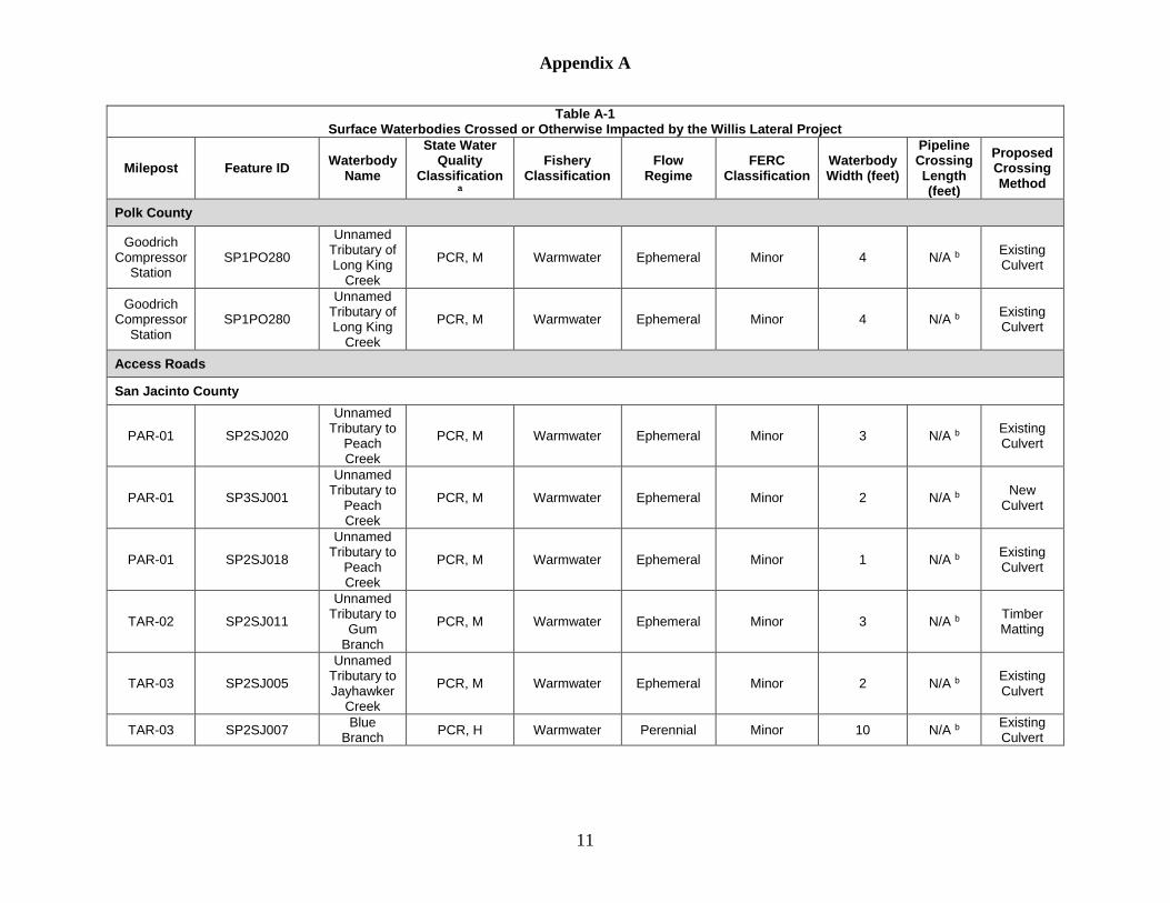
Appendix A
11
Table A-1 Surface Waterbodies Crossed or Otherwise Impacted by the Willis Lateral Project
Milepost Feature ID Waterbody Name
State Water Quality
Classification a
Fishery Classification
Flow Regime
FERC Classification
Waterbody Width (feet)
Pipeline Crossing Length (feet)
Proposed Crossing Method
Polk County
Goodrich Compressor
Station SP1PO280
Unnamed Tributary of Long King
Creek
PCR, M Warmwater Ephemeral Minor 4 N/A b Existing Culvert
Goodrich Compressor
Station SP1PO280
Unnamed Tributary of Long King
Creek
PCR, M Warmwater Ephemeral Minor 4 N/A b Existing Culvert
Access Roads
San Jacinto County
PAR-01 SP2SJ020
Unnamed Tributary to
Peach Creek
PCR, M Warmwater Ephemeral Minor 3 N/A b Existing Culvert
PAR-01 SP3SJ001
Unnamed Tributary to
Peach Creek
PCR, M Warmwater Ephemeral Minor 2 N/A b New Culvert
PAR-01 SP2SJ018
Unnamed Tributary to
Peach Creek
PCR, M Warmwater Ephemeral Minor 1 N/A b Existing Culvert
TAR-02 SP2SJ011
Unnamed Tributary to
Gum Branch
PCR, M Warmwater Ephemeral Minor 3 N/A b Timber Matting
TAR-03 SP2SJ005
Unnamed Tributary to Jayhawker
Creek
PCR, M Warmwater Ephemeral Minor 2 N/A b Existing Culvert
TAR-03 SP2SJ007 Blue Branch PCR, H Warmwater Perennial Minor 10 N/A b Existing
Culvert

Appendix A
12
Table A-1 Surface Waterbodies Crossed or Otherwise Impacted by the Willis Lateral Project
Milepost Feature ID Waterbody Name
State Water Quality
Classification a
Fishery Classification
Flow Regime
FERC Classification
Waterbody Width (feet)
Pipeline Crossing Length (feet)
Proposed Crossing Method
TAR-03 SP2SJ009
Unnamed Tributary to
Gum Branch
PCR, M Warmwater Ephemeral Minor 3 N/A b Existing Culvert
TAR-03 SP2SJ010 Gum Branch PCR, H Warmwater Perennial Intermediate 12 N/A b Existing
Culvert
TAR-05 SP1SJ005
Unnamed Tributary to
Blue Branch
PCR, M Warmwater Ephemeral Minor 2 N/A b Existing Culvert
TAR-05 SP1SJ005_A
Unnamed Tributary to
Blue Branch
PCR, M Warmwater Ephemeral Minor 2 N/A b Existing Culvert
TAR-05 SP1SJ006
Unnamed Tributary to
Gum Branch
PCR, M Warmwater Ephemeral Minor 2 N/A b Existing Culvert
TAR-05 SP1SJ011
Unnamed Tributary to
Gum Branch
PCR, M Warmwater Ephemeral Minor 2 N/A b Existing Culvert
TAR-05 SP1SJ013 Gum Branch PCR, H Warmwater Perennial Intermediate 15 N/A b Existing
Culvert
TAR-05 SP1SJ010
Unnamed Tributary to
Gum Branch
PCR, M Warmwater Ephemeral Minor 3 N/A b Existing Culvert
TAR-05 SP1SJ007
Unnamed Tributary to
Gum Branch
PCR, M Warmwater Ephemeral Minor 2 N/A b Timber Matting
TAR-05 SP1SJ007
Unnamed Tributary to
Gum Branch
PCR, M Warmwater Ephemeral Minor 2 N/A b Existing Culvert
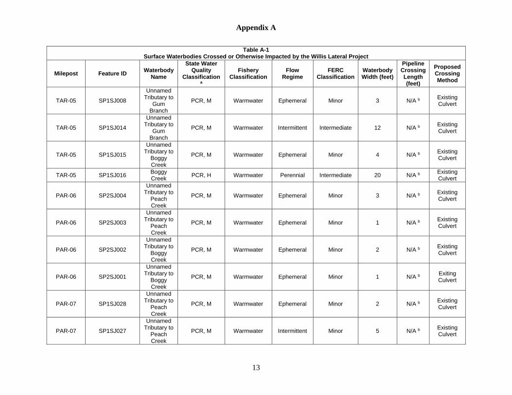
Appendix A
13
Table A-1 Surface Waterbodies Crossed or Otherwise Impacted by the Willis Lateral Project
Milepost Feature ID Waterbody Name
State Water Quality
Classification a
Fishery Classification
Flow Regime
FERC Classification
Waterbody Width (feet)
Pipeline Crossing Length (feet)
Proposed Crossing Method
TAR-05 SP1SJ008
Unnamed Tributary to
Gum Branch
PCR, M Warmwater Ephemeral Minor 3 N/A b Existing Culvert
TAR-05 SP1SJ014
Unnamed Tributary to
Gum Branch
PCR, M Warmwater Intermittent Intermediate 12 N/A b Existing Culvert
TAR-05 SP1SJ015
Unnamed Tributary to
Boggy Creek
PCR, M Warmwater Ephemeral Minor 4 N/A b Existing Culvert
TAR-05 SP1SJ016 Boggy Creek PCR, H Warmwater Perennial Intermediate 20 N/A b Existing
Culvert
PAR-06 SP2SJ004
Unnamed Tributary to
Peach Creek
PCR, M Warmwater Ephemeral Minor 3 N/A b Existing Culvert
PAR-06 SP2SJ003
Unnamed Tributary to
Peach Creek
PCR, M Warmwater Ephemeral Minor 1 N/A b Existing Culvert
PAR-06 SP2SJ002
Unnamed Tributary to
Boggy Creek
PCR, M Warmwater Ephemeral Minor 2 N/A b Existing Culvert
PAR-06 SP2SJ001
Unnamed Tributary to
Boggy Creek
PCR, M Warmwater Ephemeral Minor 1 N/A b Exiting Culvert
PAR-07 SP1SJ028
Unnamed Tributary to
Peach Creek
PCR, M Warmwater Ephemeral Minor 2 N/A b Existing Culvert
PAR-07 SP1SJ027
Unnamed Tributary to
Peach Creek
PCR, M Warmwater Intermittent Minor 5 N/A b Existing Culvert

Appendix A
14
Table A-1 Surface Waterbodies Crossed or Otherwise Impacted by the Willis Lateral Project
Milepost Feature ID Waterbody Name
State Water Quality
Classification a
Fishery Classification
Flow Regime
FERC Classification
Waterbody Width (feet)
Pipeline Crossing Length (feet)
Proposed Crossing Method
Montgomery County
TAR-13 SP2MO054
Unnamed Tributary to
McRae Creek
PCR, M Warmwater Ephemeral Intermediate 25 N/A b Existing Culvert
TAR-16.1 SP1MO114
Unnamed Tributary to
Caney Creek
PCR, M Warmwater Ephemeral Minor 3 N/A b Existing Culvert
TAR-19 SP2MO044
Unnamed Tributary to
Camp Creek
PCR, M Warmwater Ephemeral Minor 2 N/A b
Existing Culver / Timber Matting
TAR-21 SP1MO097 Lewis Creek PCR, H Warmwater Perennial Intermediate 20 N/A b Timber
Matting
TAR-22 SP3MO003
Unnamed Tributary to
Lewis Creek
Reservoir
PCR, M Warmwater Ephemeral Minor 3 N/A b Existing Culvert
TAR-22 SP3MO004
Unnamed Tributary to
Lewis Creek
Reservoir
PCR, M Warmwater Ephemeral Minor 6 N/A b Timber Matting
TAR-22 SP3MO005
Unnamed Tributary to
Lewis Creek
Reservoir
PCR, M Warmwater Ephemeral Minor 6 N/A b Timber Matting
Contractor / Rail Yards
Liberty County
There will be no impacts to waterbodies located within the Contractor / Rail Yard Footprint.

Appendix A
15
Table A-1 Surface Waterbodies Crossed or Otherwise Impacted by the Willis Lateral Project
Milepost Feature ID Waterbody Name
State Water Quality
Classification a
Fishery Classification
Flow Regime
FERC Classification
Waterbody Width (feet)
Pipeline Crossing Length (feet)
Proposed Crossing Method
Note: Waterbody data is based on field delineations conducted to date. For a summary of areas not surveyed, see Table 2.0-1. Features documented during desktop (DT) analysis are notated with a DT at the end of the feature name. State Water Quality Classifications and Fisheries Classifications were obtained from the Texas Surface Water Quality Standards (Chapter 307). N/A – Not applicable. a PCR-primary contact recreation; H-High Aquatic Life Use; M-Minimal Aquatic Life Use; PS-Public Water Supply b Waterbody will not be crossed by the pipeline centerline, but is located within the Project footprint. c Waterbody will not be crossed by the pipeline centerline, but is located within additional temporary workspace (ATWS) at the southern terminus of TAR-21.
The ATWS will be utilized to Gulf South during water withdraws from Lewis Creek Reservoir. d Waterbody will not be crossed by the pipeline centerline, but is located within ATWS at the southern terminus of TAR-22. The ATWS will be utilized to Gulf
South during water withdraws from Lewis Creek Reservoir.
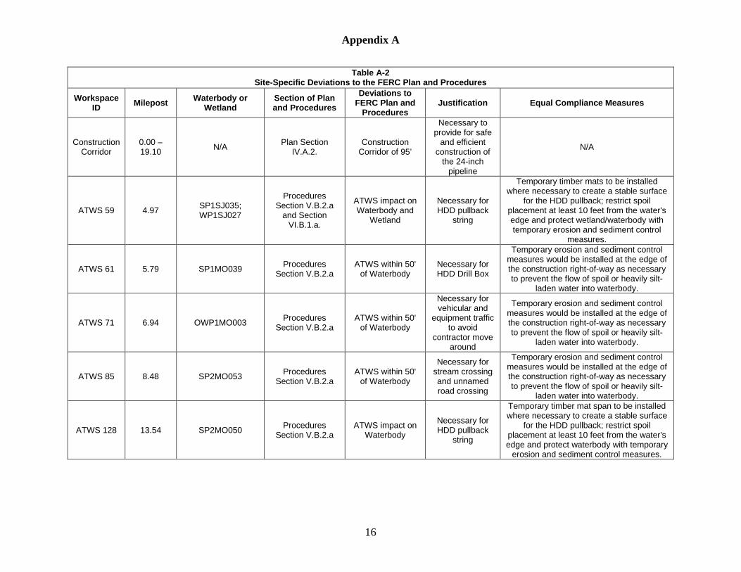
Appendix A
16
Table A-2 Site-Specific Deviations to the FERC Plan and Procedures
Workspace ID Milepost Waterbody or
Wetland Section of Plan and Procedures
Deviations to FERC Plan and
Procedures Justification Equal Compliance Measures
Construction Corridor
0.00 – 19.10 N/A Plan Section
IV.A.2. Construction
Corridor of 95’
Necessary to provide for safe
and efficient construction of
the 24-inch pipeline
N/A
ATWS 59 4.97 SP1SJ035; WP1SJ027
Procedures Section V.B.2.a
and Section VI.B.1.a.
ATWS impact on Waterbody and
Wetland
Necessary for HDD pullback
string
Temporary timber mats to be installed where necessary to create a stable surface
for the HDD pullback; restrict spoil placement at least 10 feet from the water's edge and protect wetland/waterbody with temporary erosion and sediment control
measures.
ATWS 61 5.79 SP1MO039 Procedures Section V.B.2.a
ATWS within 50' of Waterbody
Necessary for HDD Drill Box
Temporary erosion and sediment control measures would be installed at the edge of the construction right-of-way as necessary to prevent the flow of spoil or heavily silt-
laden water into waterbody.
ATWS 71 6.94 OWP1MO003 Procedures Section V.B.2.a
ATWS within 50' of Waterbody
Necessary for vehicular and
equipment traffic to avoid
contractor move around
Temporary erosion and sediment control measures would be installed at the edge of the construction right-of-way as necessary to prevent the flow of spoil or heavily silt-
laden water into waterbody.
ATWS 85 8.48 SP2MO053 Procedures Section V.B.2.a
ATWS within 50' of Waterbody
Necessary for stream crossing and unnamed road crossing
Temporary erosion and sediment control measures would be installed at the edge of the construction right-of-way as necessary to prevent the flow of spoil or heavily silt-
laden water into waterbody.
ATWS 128 13.54 SP2MO050 Procedures Section V.B.2.a
ATWS impact on Waterbody
Necessary for HDD pullback
string
Temporary timber mat span to be installed where necessary to create a stable surface
for the HDD pullback; restrict spoil placement at least 10 feet from the water's edge and protect waterbody with temporary
erosion and sediment control measures.

Appendix A
17
Table A-2 Site-Specific Deviations to the FERC Plan and Procedures
Workspace ID Milepost Waterbody or
Wetland Section of Plan and Procedures
Deviations to FERC Plan and
Procedures Justification Equal Compliance Measures
ATWS 134 14.38 WP2MO038_PEM; SP2MO045
Procedures Section V.B.2.a
and Section VI.B.1.a.
ATWS within 50' of Wetland and
Waterbody
Necessary for extra work area for powerline, wetland, and waterbody crossings
Temporary erosion and sediment control measures would be installed at the edge of the construction right-of-way as necessary to prevent the flow of spoil or heavily silt-laden water into wetland and waterbody.
ATWS 137 14.53 SP2MO025 Procedures Section V.B.2.a
ATWS within 50' of Waterbody
Necessary for boring
equipment that would be utilized for the trenchless
crossing of FM 1097
Temporary erosion and sediment control measures would be installed at the edge of the construction right-of-way as necessary to prevent the flow of spoil or heavily silt-
laden water into waterbody.
ATWS 139 14.84 SP2MO029 Procedures Section V.B.2.a
ATWS impact on Waterbody
Necessary for HDD pullback
string
Temporary timber mat span to be installed where necessary to create a stable surface
for the HDD pullback; restrict spoil placement at least 10 feet from the water's edge and protect waterbody with temporary
erosion and sediment control measures.
ATWS 142 15.86 SP1MO063 Procedures Section V.B.2.a
ATWS impact on Waterbody
Necessary for HDD Drill Box
Temporary timber mat span to be installed where necessary to create a stable surface
for the HDD equipment; restrict spoil placement at least 10 feet from the water's edge and protect waterbody with temporary
erosion and sediment control measures.
ATWS 143 15.86 WP1MO025 Procedures Section VI.B.1.a.
ATWS impact on Wetland
Necessary for HDD Drill Box
Temporary timber mats to be installed where necessary to create a stable surface
for the HDD equipment; protect wetland with temporary erosion and sediment
control measures.
ATWS 144 15.97 WP1MO026; WP1MO025
Procedures Section VI.B.1.a.
ATWS within 50' of Wetland
Necessary for additional spoil storage area between two
wetland areas
Temporary erosion and sediment control measures would be installed at the edge of the construction right-of-way as necessary to prevent the flow of spoil or heavily silt-
laden water into wetland.

Appendix A
18
Table A-2 Site-Specific Deviations to the FERC Plan and Procedures
Workspace ID Milepost Waterbody or
Wetland Section of Plan and Procedures
Deviations to FERC Plan and
Procedures Justification Equal Compliance Measures
ATWS 145 16.16 WP1MO026 Procedures Section VI.B.1.a.
ATWS within 50' of Wetland
Necessary for boring
equipment that would be utilized
for trenchless crossing of US HWY 75 and
African Hill Road
Temporary erosion and sediment control measures would be installed at the edge of the construction right-of-way as necessary to prevent the flow of spoil or heavily silt-
laden water into wetland.
ATWS 148 17.02 SP1MO103 Procedures Section V.B.2.a
ATWS impact no Waterbody
Necessary for boring
equipment that would be utilized
for trenchless crossing of I-45
Temporary timber mat span to be installed where necessary to create a stable surface
for boring equipment; restrict spoil placement at least 10 feet from the water's edge and protect waterbody with temporary
erosion and sediment control measures.
ATWS 150.1 17.19 SP1MO102 Procedures
Section V.B.2.a ATWS within 50'
of Waterbody
Necessary for material and equipment
storage
Temporary erosion and sediment control measures would be installed at the edge of the construction right-of-way as necessary to prevent the flow of spoil or heavily silt-
laden water into waterbody.
ATWS 155 17.60 WP2MO024 Procedures Section VI.B.1.a.
ATWS within 50' of Wetland
Necessary for powerline
crossing and major point of intersection
Temporary erosion and sediment control measures would be installed at the edge of the construction right-of-way as necessary to prevent the flow of spoil or heavily silt-
laden water into wetland.
ATWS 160 18.68 SP3MO003 Procedures Section V.B.2.a
ATWS impact on Waterbody
Necessary for powerline
crossing and major point of intersection
Temporary timber mat span to be installed where necessary to create a stable surface
for construction equipment; restrict spoil placement at least 10 feet from the water's edge and protect waterbody with temporary
erosion and sediment control measures.
ATWS 164 Offline OWP5MO002_DT Procedures Section V.B.2.a
ATWS impact on Waterbody
Necessary to retrieve water for
hydrostatic testing
Temporary erosion and sediment control measures would be installed at the edge of the construction right-of-way as necessary to prevent the flow of spoil or heavily silt-
laden water into waterbody.

Appendix A
19
Table A-2 Site-Specific Deviations to the FERC Plan and Procedures
Workspace ID Milepost Waterbody or
Wetland Section of Plan and Procedures
Deviations to FERC Plan and
Procedures Justification Equal Compliance Measures
ATWS 165 Offline OWP1MO009;
WP1MOO046_PEM; WP1MO046_PSS
Procedures Section V.B.2.a
and Section VI.B.1.a.
ATWS impact on Wetland and Waterbody
Necessary to retrieve water for
Hydrostatic testing.
Temporary timber mats to be installed where necessary to create a stable surface
to access the water source; protect wetland/waterbody with temporary erosion
and sediment control measures.
PAR-01 - WP2SJ017 Procedures Section VI.B.1.d.
Access road impact on wetland
(fill)
Use of existing road requires improvements
Gulf South would continue to coordinate with the Corps to determine appropriate
mitigation. A compensatory mitigation plan would be required by the Corps as a
condition of an issued permit
PAR-06 - WP2SJ001 Procedures Section VI.B.1.d.
Access road impact on wetland
(fill)
Use of existing road requires improvements
Gulf South would continue to coordinate with the Corps to determine appropriate
mitigation. A compensatory mitigation plan would be required by the Corps as a
condition of an issued permit

Appendix A
20
Table A-3 Wetland Resources Crossed or Otherwise Impacted by the Willis Lateral Project
Feature ID Approximate
Milepost / Location
Wetland Type a
Proposed Crossing Method
Jurisdictional Status
Approximate Pipeline Crossing
Length (feet)
Construction Impacts (acres)
Operational Impacts (acres) b
Pipeline Facilities
San Jacinto County
WP1SJ001 0.25 PFO Open Cut § 404 22 0.02 0.01
WP1SJ002_PFO 0.49 PFO Workspace Only § 404 0 c 0.01 0.00
WP1SJ002_PFO 0.51 PFO Workspace Only § 404 0 c 0.02 0.00
WP1SJ003_PFO 0.99 PFO Open Cut § 404 261 0.45 0.18
WP1SJ006_PFO 1.07 PFO Open Cut § 404 121 0.20 0.08
WP1SJ008_PFO 1.72 PFO Open Cut § 404 122 0.17 0.08
WP1SJ009_PFO 1.86 PFO Workspace Only § 404 0 c 0.01 0.00
WP1SJ009_PFO 1.87 PFO Workspace Only § 404 0 c <0.01 0.00
WP1SJ009_PEM 1.87 PEM Workspace Only § 404 0 c 0.01 0.00
WP1SJ009_PFO_B 1.88 PFO Open Cut § 404 146 0.28 0.12
WP1SJ010_PFO 2.15 PFO Workspace Only § 404 0 c 0.02 <0.01
WP2SJ003 2.28 PFO Open Cut § 404 101 0.13 0.07
WP2SJ002 2.46 PEM Workspace Only § 404 0 c 0.01 0.00
WP1SJ028 3.83 PFO Open Cut § 404 35 0.05 0.02
WP1SJ012_PEM 4.23 PEM Open Cut § 404 166 0.27 0.00
WP1SJ027 4.97 PFO Workspace Only § 404 0 c 0.05 0.02
WP1SJ013_PFO_B 5.39 PFO HDD § 404 488 0.00 0.00
WP1SJ013_PEM 5.43 PEM HDD § 404 0 c 0.00 0.00

Appendix A
21
Table A-3 Wetland Resources Crossed or Otherwise Impacted by the Willis Lateral Project
Feature ID Approximate
Milepost / Location
Wetland Type a
Proposed Crossing Method
Jurisdictional Status
Approximate Pipeline Crossing
Length (feet)
Construction Impacts (acres)
Operational Impacts (acres) b
San Jacinto County Totals 1,462 1.70 0.58
Montgomery County
WP2MO032_PFO 5.49 PFO HDD § 404 85 0.00 0.00
WP2MO032_PFO 5.52 PFO HDD § 404 622 0.00 0.00
WP1MO016_PEM 7.63 PEM Open Cut § 404 490 0.61 0.00
WP1MO016_PFO 7.66 PFO Workspace Only § 404 0 c 0.23 0.04
WP1MO018 9.03 PEM Open Cut § 404 38 0.01 0.00
WP2MO010_PEM 9.77 PEM Open Cut § 404 90 0.10 0.00
WP2MO010_PFO 9.77 PFO Workspace Only § 404 0 c 0.05 0.00
WP2MO011 10.99 PEM Open Cut § 404 39 0.06 0.00
WP2MO012_PEM 11.04 PEM Open Cut § 404 156 0.35 0.00
WP2MO013 11.12 PEM Open Cut § 404 230 0.40 0.00
WP2MO014 11.33 PEM HDD § 404 21 0.00 0.00
WP2MO015_PEM 11.39 PEM HDD § 404 13 0.00 0.00
WP2MO015_PFO 11.39 PFO HDD § 404 0 c 0.00 0.00
WP2MO015_PFO 11.42 PFO HDD § 404 0 c 0.00 0.00
WP2MO015_PFO 11.46 PFO HDD § 404 0 c 0.00 0.00
WP2MO036 11.57 PEM HDD § 404 74 0.00 0.00
WP1MO023 12.12 PEM Open Cut § 404 137 0.14 0.00
WP1MO024 12.13 PSS Workspace Only § 404 0 c 0.01 0.00
WP1MO020 12.84 PEM Open Cut § 404 57 0.08 0.00

Appendix A
22
Table A-3 Wetland Resources Crossed or Otherwise Impacted by the Willis Lateral Project
Feature ID Approximate
Milepost / Location
Wetland Type a
Proposed Crossing Method
Jurisdictional Status
Approximate Pipeline Crossing
Length (feet)
Construction Impacts (acres)
Operational Impacts (acres) b
WP1MO019_PFO 12.84 PFO Workspace Only § 404 0 c <0.01 0.00
WP2MO052 13.26 PEM HDD § 404 53 0.00 0.00
WP2MO053_PFO 13.30 PFO HDD § 404 92 0.00 0.00
WP2MO043_PEM 13.60 PEM Open Cut § 404 183 0.21 0.00
WP2MO043_PFO 13.62 PFO Workspace Only § 404 0 c 0.07 0.00
WP2MO042 13.85 PFO Workspace Only § 404 0 c 0.01 0.00
WP2MO041 13.93 PEM Open Cut § 404 92 0.10 0.00
WP2MO040 14.18 PEM Open Cut § 404 21 0.04 0.00
WP2MO040 14.20 PEM Open Cut § 404 152 0.19 0.00
WP2MO038_PFO 14.31 PFO Open Cut § 404 37 0.06 0.03
WP2MO038_PEM 14.32 PEM Open Cut § 404 17 0.03 0.00
WP2MO038_PEM 14.33 PEM Open Cut § 404 19 0.04 0.00
WP2MO039 14.42 PFO Open Cut § 404 64 0.11 0.04
WP2MO028 14.81 PEM Open Cut § 404 170 0.18 0.00
WP2MO031_PEM 15.19 PEM HDD § 404 157 0.00 0.00
WP2MO044 15.42 PEM HDD § 404 139 0.00 0.00
WP2MO045_PEM 15.47 PEM HDD § 404 0 c 0.00 0.00
WP2MO046 15.59 PEM HDD § 404 0 c 0.00 0.00
WP2MO047 15.65 PFO HDD § 404 0 c 0.00 0.00
WP2MO049 15.65 PEM HDD § 404 0 c 0.00 0.00
WP2MO048 15.69 PEM HDD § 404 0 c 0.00 0.00

Appendix A
23
Table A-3 Wetland Resources Crossed or Otherwise Impacted by the Willis Lateral Project
Feature ID Approximate
Milepost / Location
Wetland Type a
Proposed Crossing Method
Jurisdictional Status
Approximate Pipeline Crossing
Length (feet)
Construction Impacts (acres)
Operational Impacts (acres) b
WP1MO025 15.83 PEM HDD / Open Cut § 404 705 1.03 0.00
WP1MO026 15.99 PEM Open Cut § 404 700 0.91 0.00
WP1MO029 16.22 PEM Bore § 404 83 0.15 0.00
WP1MO030_PEM 16.27 PEM Bore § 404 444 0.51 0.00
WP1MO030_PFO 16.33 PFO Workspace Only § 404 0 c 0.29 0.00
WP1MO030_PEM 16.41 PEM Open Cut § 404 43 0.15 0.00
WP1MO031 16.59 PEM Workspace Only § 404 0 c 0.01 0.00
WP1MO042_PFO 17.36 PFO Open Cut § 404 26 0.16 0.02
WP2MO024 17.60 PEM Workspace Only § 404 0 c <0.01 0.00
WP2MO025 17.89 PEM Workspace Only § 404 0 c 0.01 0.00
WP1MO046_PSS 18.44 d PSS Workspace Only § 404 0 c <0.01 0.00
WP1MO046_PEM 18.44 d PEM Workspace Only § 404 0 c 0.10 0.00
Montgomery County Totals 5,249 6.41 0.13
Pipeline Facilities Totals 6,711 8.11 0.71
Aboveground Facilities
24-inch Pipeline
There are no wetlands located within the footprint of the proposed aboveground facilities located along the 24-inch lateral pipeline.
Index 129 Legacy System Facilities
There are no wetlands located within the Project footprint of the proposed aboveground facilities located at the Goodrich Compressor Station.

Appendix A
24
Table A-3 Wetland Resources Crossed or Otherwise Impacted by the Willis Lateral Project
Feature ID Approximate
Milepost / Location
Wetland Type a
Proposed Crossing Method
Jurisdictional Status
Approximate Pipeline Crossing
Length (feet)
Construction Impacts (acres)
Operational Impacts (acres) b
Access Roads
San Jacinto County
WP2SJ017 PAR-01 PFO Gravel / Dirt Fill § 404 N/A c 0.01 0.01
WP2SJ004 TAR-04 PEM
Timber Matting /
Temporary Culvert
§ 404 N/A c 0.01 0.00
WP2SJ005 TAR-04 PEM
Timber Matting /
Temporary Culvert
§ 404 N/A c 0.01 0.00
WP1SJ004 TAR-05 PFO
Timber Matting /
Temporary Culvert
§ 404 N/A c 0.02 0.00
WP1SJ005 TAR-05 PFO
Timber Matting /
Temporary Culvert
§ 404 N/A c 0.01 0.00
WP2SJ001 PAR-06 PEM Gravel / Dirt Fill § 404 N/A c 0.01 0.01
San Jacinto County Totals N/A c 0.07 0.02
Montgomery County
WP2MO037 TAR-19 PEM
Timber Matting /
Temporary Culvert
§ 404 N/A c 0.04 0.00
WP1MO045 TAR-21 PEM
Timber Matting /
Temporary Culvert
§ 404 N/A c 0.01 0.00
WP1MO044 TAR-21 PFO
Timber Matting /
Temporary Culvert
§ 404 N/A c 0.01 0.00

Appendix A
25
Table A-3 Wetland Resources Crossed or Otherwise Impacted by the Willis Lateral Project
Feature ID Approximate
Milepost / Location
Wetland Type a
Proposed Crossing Method
Jurisdictional Status
Approximate Pipeline Crossing
Length (feet)
Construction Impacts (acres)
Operational Impacts (acres) b
WP1MO046_PSS TAR-21 PSS
Timber Matting /
Temporary Culvert
§ 404 N/A c 0.03 0.00
Montgomery County Totals N/A c 0.09 0.00
Access Roads Totals N/A c 0.16 0.02
Project Totals 6,711 8.27 0.73 Note: Wetland data is based on field delineations conducted to date. For a summary of areas not surveyed, see Table 2.0-1. Features documented during desktop (DT) analysis are notated with a DT at the end of the feature name. The permanent easement located between HDDs will not be maintained, in accordance with the FERC Procedures; therefore, no impacts are presented for these areas. In the land use and habitat impact tables presented in Resource Report 3 – Fish, Wildlife, and Vegetation and Resource Report 8 – Land Use, Recreation, and Aesthetics, respectively, the full 50-foot-wide permanent easement that would be operated by Gulf South is represented; therefore, wetland impacts presented herein cannot be compared with tables presented in other resource reports. HDD = Horizontal Directional Drill N/A = Not applicable a Cowardin Wetland Types: PEM - palustrine emergent; PSS - palustrine scrub-shrub; PFO - palustrine forested b There will be no operational impacts on PEM wetlands as these wetlands will revert back to the same type following construction. Operational impacts in
this column are based on a 10-foot-wide area in PFO and PSS wetlands that will be converted to other wetland types due to pipeline maintenance. Additionally, operational impacts on forested wetlands in this column reflect potential for selective thinning of trees within 15 feet of the pipeline that have roots that could compromise the integrity of the pipeline coating.
c Wetland is not crossed by proposed centerline, but is located within the Project footprint. d Wetland will not be crossed by the pipeline centerline, but is located within additional temporary workspace (ATWS) at the southern terminus of TAR-21.
The ATWS will be utilized to Gulf South during water withdraws from Lewis Creek Reservoir.

Appendix A
26
Table A-4 Birds of Conservation Concern with Potential to Occur within the Project Area
Species Season Present Preferred Habitat Assessment of Potential
American Kestrel Falco sparverius
paulus
Wintering Found in open areas with short ground vegetation and sparse trees, including
deserts, wood edges, parks, meadows, grasslands, farm fields,
cities, and suburbs.
Suitable wintering habitat exists in the Project area;
however, individuals potentially present during construction would likely
avoid the area or displace to similar adjacent habitats.
Bachman’s Sparrow Peucaea aestivalis
Year-round Occurs in open pine or oak forests, open grassland, palmetto scrub and brushy pastures. Historically found in the understory of mature pine forest, although now found in utility rights-of-
way, old pastures, and clear-cut areas.
Suitable habitat exists in the Project area; however, individuals potentially
present during construction would likely avoid the area
or displace to similar adjacent habitats.
Additionally, all clearing is anticipated to occur outside
of the nesting season. Bald Eagle Haliaeetus
leucocephalus
Year-round Inhabits rivers, large lakes, and coasts. Nests in forested areas near large
waterbodies. During migration, stops near water in mountains and open country. Typically roosts in trees.
Suitable habitat exists in the Project area; however, if individuals are present
during winter clearing, they would likely avoid the area
or displace to similar adjacent habitats.
Additionally, no nests were observed in the Project area
during field surveys. Bewick’s Wren
Thryomanes bewickii bewickii
Wintering Inhabits gardens, underbrush, scrub, thickets, oak woodlands,
desert scrub, brushy areas around the edges of woods, and suburban
plantings. Breeds in areas with open woodland and thick scrubby
vegetation.
Suitable wintering habitat exists in the Project area;
however, individuals potentially present during construction would likely
avoid the area or displace to similar adjacent habitats.
Brown-headed Nuthatch Sitta pusilla
Year-round Found in Southeastern pine forests year-round. Vegetation in habitat includes loblolly, slash, pond, and
longleaf pines, bald cypress, sweetgum, hickory, Atlantic white
cedar, sycamore, and oak.
Suitable habitat exists in the Project area; however,
individuals potentially present during construction would
likely avoid the area or displace to similar adjacent habitats. Additionally, all clearing is anticipated to
occur outside of the nesting season.
Buff-breasted Sandpiper
Tryngites subruficollis
Migration Occurs in shortgrass prairies. Breeds on ridges with nearby
streams or ponds and dry, grassy tundra. Migrates and winters in
short, dry grasslands; stubble fields, airports, pastures, plowed fields,
and mudflats.
Suitable migration habitat exists in the Project area;
however, individuals potentially present during construction would likely
avoid the area or displace to similar adjacent habitat.

Appendix A
27
Table A-4 Birds of Conservation Concern with Potential to Occur within the Project Area
Species Season Present Preferred Habitat Assessment of Potential
Cerulean Warbler Setophaga cerulea
Migration Inhabits deciduous forests and river valleys. Breeds in deciduous forest with open understory and mature
hardwoods. Winters in broad- leaved evergreen forests.
Suitable migration habitat exists in the Project area;
however, individuals potentially present during construction would likely
avoid the area or displace to similar adjacent habitats.
Chuck-will’s-Widow Antrostomus carolinensis
Breeding Inhabits open areas of oak-hickory, pine, and other forests. Winters in hedgerows, fields, brush, thickets,
and woodlands.
Suitable breeding habitat exists in the Project area; however, all clearing is
anticipated to occur outside of the nesting season.
Henslow’s Sparrow Ammodramus
henslowii
Wintering Occurs in large, flat fields with standing, dead vegetation; tall,
dense grass; no woody plants, and dense layer of litter. Breeds in low-
lying damp areas with tall grass, standing dead weeds, and
scattered shrubs, including fields and meadows. Winters in weedy
fields.
Suitable wintering habitat is present in the Project area;
however, individuals potentially present during construction would likely
avoid the area or displace to similar adjacent habitats.
Hudsonian Godwit Limosa haemastica
Migration Inhabits mudflats, marshes, and prairie pools. Nests near the tree
line, where tundra, ponds, and open woods mix. Breeds in grassy
tundra edges near water. During migration, stops in flooded
pastures, shallow marshy lakes, mudflats around ponds, and rice fields in the spring and marshy ponds or tidal flats in the fall.
Suitable migration habitat exists in the Project area;
however, individuals potentially present during construction would likely
avoid the area or displace to similar adjacent habitats.
Kentucky Warbler Geothlypis formosa
Breeding Occurs in woodland undergrowth. Breeds in bottomlands near creeks
and rivers, edges of swamps, ravines in upland deciduous woods, and deep shaded woods with dense humid thickets. Winters in second
growth and dense lowland forests in the tropics.
Suitable breeding habitat exists in the Project area; however, all clearing is
anticipated to occur outside of the nesting season.
Least Bittern Ixobrychus exilis
Breeding Occurs in freshwater marshes with tall, dense vegetation. Occasionally
would utilize salt marshes or mangroves.
Suitable breeding habitat exists in the Project area;
however, all clearing is anticipated to occur outside
of the nesting season.

Appendix A
28
Table A-4 Birds of Conservation Concern with Potential to Occur within the Project Area
Species Season Present Preferred Habitat Assessment of Potential
Little Blue Heron Egretta caerulea
Year-round Occurs in rice fields, marshes, swamps, and ponds. Winters near mangroves, lagoons, salt ponds,
mudflats, streams, tidal flats, canals, ditches, fish hatcheries, flooded fields, savannas, wet
meadows, and dry fields. Nests in trees, shrubs, and dense low
thickets near water.
Suitable habitat exists in the Project area; however,
individuals potentially present during construction would
likely avoid the area or displace to similar adjacent habitats. Additionally, all clearing is anticipated to
occur outside of the nesting season
Loggerhead Shrike Lanius ludovicianus
Year-round Found in agricultural fields, riparian areas, old orchards, pastures,
desert scrublands, golf courses, prairies, savannas, cemeteries, and open and semi-open country with
well-spaced shrubs, low trees, and short vegetation. Breeds in
semi-open terrain, such as open grasslands, large clearings in
wooded areas, and desert with scattered trees and large shrubs. Winters in open country, including
areas with scattered or no trees, as long as hunting perches, which may
include fences or wires, are present.
Suitable habitat exists in the Project area; however,
individuals potentially present during construction would
likely avoid the area or displace to similar adjacent habitats. Additionally, all clearing is anticipated to
occur outside of the nesting season
Louisiana Waterthrush
Parkesia motacilla
Breeding Inhabits wooded swamps, brooks, bottomlands, lagoon edges,
streams, and ravines. Breeds within bottomland habitat, swamps, and near streams. Winters in the tropics near streams in lowland woods and coastal mangroves.
Suitable breeding habitat exists in the Project area; however, all clearing is
anticipated to occur outside of the nesting season.
Orchard Oriole Icterus spurius
Breeding Inhabits open woodlands along river edges, wood edges, shade trees,
orchards, marsh edges, lakeshores, farms, open shrublands. Nests in scattered deciduous trees in semi- open habitat, riverside trees, forest
edges and clearings, orchards, prairie groves, and suburbs. Winters in shady pastures,
plantations, woodland edges in lowlands of the tropics, thickets,
and lightly wooded areas.
Suitable breeding habitat exists in the Project area; however, all clearing is
anticipated to occur outside of the nesting season.
Painted Bunting Passerina ciris
Breeding Occurs in brush, towns, woodland edges, gardens, and semi-open
areas with dense low growth. Breeds in hedgerows, woodland
clearings and edges, thickets, and semi-open habitat with scattered
trees or shrubs. Winters in thickets and high grass, shrubby, overgrown
pasture.
Suitable breeding habitat exists in the Project area; however, all clearing is
anticipated to occur outside of the nesting season.

Appendix A
29
Table A-4 Birds of Conservation Concern with Potential to Occur within the Project Area
Species Season Present Preferred Habitat Assessment of Potential
Prairie Warbler Setophaga discolor
Breeding Occurs in low pines, brushy pastures and slashings, and a
variety of shrubby habitats, such as Christmas-tree farms, regenerating forests, open fields, and mangrove forests. Breeds in edges of forest,
and clearings. Winters in flat grasslands with scattered bushes
and trees.
Suitable breeding habitat exists in the Project area; however, all clearing is
anticipated to occur outside of the nesting season.
Prothonotary Warbler Protonotaria citrea
Breeding Found in wooded swamps. Breeds in flooded river bottom hardwoods or wooded swamps. Nests near
borders of rivers, lakes, and ponds. During migration, found in marshes,
citrus groves, coastal areas, and scrub. Winters in lowland tropical woods and dry forest as well as
mangrove swamps.
Suitable breeding habitat exists in the Project area; however, all clearing is
anticipated to occur outside of the nesting season.
Red-headed Woodpecker Melanerpes
erythrocephalus
Wintering Inhabits pine savannas and other open forests with clear
understories, forest edges, open pine plantations, standing timber, groves, farm country, orchards, shade trees in towns, and large
scattered trees. Avoids unbroken forest, favoring open country or
forest clearings.
Suitable wintering habitat exists in the Project area;
however, individuals potentially present during construction would likely
avoid the area or displace to similar adjacent habitats.
Smith's Longspur Calcarius pictus
Outside of Range Breeds along the tree line in the dry tundra with grasses or sedges, low shrubs, and short conifers. Winters
on heavily grazed pastures, shortgrass prairies, and airport
fields.
The Project does not occur within the known range of the
species.
Solitary Sandpiper Tringa solitaria
Migration Breeds in muskeg region in taiga. During migration and winter, found
along freshwater ponds, stream edges, marshes, riverbanks, temporary pools, and flooded
ditches and fields; more commonly found in wooded regions, and less frequently on mudflats and open
marshes.
Suitable migration habitat exists in the Project area;
however, individuals potentially present during construction would likely
avoid the area or displace to similar adjacent habitats.
Sprague’s Pipit Anthus spragueii
Wintering Occurs in plains and shortgrass prairies. Breeds, winters, and
migrates in open dry grassland, avoiding brushy areas and
cultivated fields.
Suitable wintering habitat is not present in the Project
area.

Appendix A
30
Table A-4 Birds of Conservation Concern with Potential to Occur within the Project Area
Species Season Present Preferred Habitat Assessment of Potential
Swainson’s Warbler Limnothlypis swainsonii
Breeding Occurs in river floodplain forests and swamps. Breeds in
bottomlands and swamps of the southern coastal plain and
Appalachian region. Winters in undergrowth of woodlands within
tropics.
Suitable breeding habitat exists in the Project area; however, all clearing is
anticipated to occur outside of the nesting season.
Swallow-tailed Kite Elanoides forficatus
Migration Inhabits wooded river swamps. Breeds in lowland forests, marshes,
and swamps. Nests in tall trees near open country, cypress
swamps, hardwood hammocks, mangrove forests, open pine woods near marsh, lowland rainforest, wet
prairies, freshwater or brackish marshes, and mountain cloud
forest.
Suitable migration habitat exists in the Project area;
however, individuals potentially present during construction would likely
avoid the area or displace to similar adjacent habitats.
Wood Thrush Hylocichla mustelina
Migration Occurs in deciduous woodlands. Breeds in woodland understory,
damp forest, and mature deciduous and mixed forest. Nests in
suburban areas, fragmented forests, and woodlands. Winters in
mature, broad-leaved, and palm tropical forests, and lowland tropical
forest understory.
Suitable migration habitat exists in the Project area;
however, individuals potentially present during construction would likely
avoid the area or displace to similar adjacent habitats.
Worm-eating Warbler Helmintheros vermivorum
Migration Occurs in wooded areas. Breeds in mature, dense deciduous
woodlands, mixed deciduous- coniferous forest with patches of
deep understory, and steep, forested slopes. Winters in tropical dense thickets and dense tropical
forest undergrowth.
Suitable migration habitat exists in the Project area;
however, individuals potentially present during construction would likely
avoid the area or displace to similar adjacent habitats.
Yellow Rail Coturnicops
noveboracensis
Wintering Inhabits grassy, shallow marshes and wet meadows. Breeds in sedge or grass-dominated wet meadows and shallow fresh or
brackish marshes. Winters in rice fields, damp meadows, or coastal
salt marsh.
Suitable wintering habitat exists in the Project area;
however, individuals potentially present during construction would likely
avoid the area or displace to similar adjacent habitats.
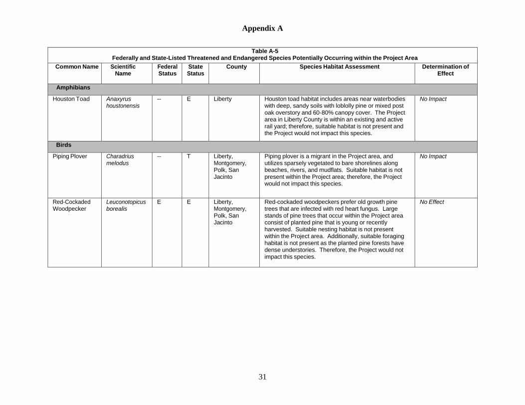
Appendix A
31
Table A-5 Federally and State-Listed Threatened and Endangered Species Potentially Occurring within the Project Area
Common Name Scientific Name
Federal Status
State Status
County Species Habitat Assessment Determination of Effect
Amphibians
Houston Toad Anaxyrus houstonensis
-- E Liberty Houston toad habitat includes areas near waterbodies with deep, sandy soils with loblolly pine or mixed post oak overstory and 60-80% canopy cover. The Project area in Liberty County is within an existing and active rail yard; therefore, suitable habitat is not present and the Project would not impact this species.
No Impact
Birds
Piping Plover Charadrius melodus
-- T Liberty, Montgomery, Polk, San Jacinto
Piping plover is a migrant in the Project area, and utilizes sparsely vegetated to bare shorelines along beaches, rivers, and mudflats. Suitable habitat is not present within the Project area; therefore, the Project would not impact this species.
No Impact
Red-Cockaded Woodpecker
Leuconotopicus borealis
E E Liberty, Montgomery, Polk, San Jacinto
Red-cockaded woodpeckers prefer old growth pine trees that are infected with red heart fungus. Large stands of pine trees that occur within the Project area consist of planted pine that is young or recently harvested. Suitable nesting habitat is not present within the Project area. Additionally, suitable foraging habitat is not present as the planted pine forests have dense understories. Therefore, the Project would not impact this species.
No Effect

Appendix A
32
Table A-5 Federally and State-Listed Threatened and Endangered Species Potentially Occurring within the Project Area
Common Name Scientific Name
Federal Status
State Status
County Species Habitat Assessment Determination of Effect
Bald Eagle Haliaeetus leucephalus
DL T Liberty, Montgomery, Polk, San Jacinto
Bald eagles prefer to nest in tall trees or cliffs near large waterbodies that can provide a sufficient source of prey. Based on Texas Natural Diversity Database occurrence data, bald eagle nests have been documented west of the Project area at Lake Conroe; however, no bald eagle nests were observed within the Project area during field surveys. In addition, this species is highly mobile and would likely disperse during construction. Therefore, the Project is not likely to adversely impact this species. In the event that a nest is observed in the Project area, Gulf South would adhere to the buffer requirements established in the FWS National Bald Eagle Management Guidelines.
Not Likely to Adversely Impact
White-faced Ibis Plegadis chihi -- T Liberty, Montgomery
White-faced ibis prefers wetland habitats. Suitable wetland habitat is present within the Project area; however, according to Texas Natural Diversity Database occurrence data, no colonial waterbird nesting sites have been documented near the Project area. Furthermore, no individuals were identified during field surveys. Clearing activities would not occur during the nesting season, and this species is highly mobile and would likely disperse during construction. Therefore, the Project is not likely to adversely impact this species.
Not Likely to Adversely Impact

Appendix A
33
Table A-5 Federally and State-Listed Threatened and Endangered Species Potentially Occurring within the Project Area
Common Name Scientific Name
Federal Status
State Status
County Species Habitat Assessment Determination of Effect
Wood Stork Mycteria americana
-- T Liberty, Montgomery, Polk, San Jacinto
Wood storks prefer wetland habitats and waterbodies for foraging. Suitable habitat is present in the Project area; however, no individuals were identified during field surveys. Additionally, no colonial waterbird nesting sites have been documented near the Project area based on Texas Natural Diversity Database occurrence data and this species typically leaves the Project area by October. Finally, this species is highly mobile and would likely disperse during construction if they were present when construction began. Therefore, the Project would have no impact on this species.
No Impact
American Peregrine Falcon
Falco peregrinus anatum
-- T Liberty, Montgomery, Polk, San Jacinto
American peregrine falcons are a utilitarian species that nests in open habitats ranging from seacoasts to open forested regions. The species nests on rocky cliffs with ledges overlooking waterbodies and on tall buildings. Suitable habitat is present in the Project area; however, no individuals were identified during field surveys. This species is highly mobile and would likely disperse during construction. Therefore, the Project is not likely to adversely impact this species.
Not Likely to Adversely Impact
Whooping Crane Grus ameriana -- E Montgomery Whooping cranes are migrants that winter along the coast at Aransas National Wildlife Refuge and breed in Buffalo National Park in Canada. In Texas, whooping cranes are known to utilize wetlands, marshes, and agriculture fields as stop-over habitat. Suitable stop- over habitat is not present within the Project area due to the Projects location relative to urban areas and overhead utility lines.
No Impact
Swallow-tailed Kite
Elanoides forficatus
-- T Liberty, Polk, San Jacinto
Swallow-tailed kites prefer tall trees in pine forests or swamps in areas with abundance of prey to support young. Suitable migration habitat is present in the Project area; however, this species is not anticipated to be found within the Project area during the construction time period. Therefore, the Project would have no impact on this species.
No Impact

Appendix A
34
Table A-5 Federally and State-Listed Threatened and Endangered Species Potentially Occurring within the Project Area
Common Name Scientific Name
Federal Status
State Status
County Species Habitat Assessment Determination of Effect
Bachman’s Sparrow
Aimophila aestivalis
-- T Liberty, Polk, San Jacinto
Bachman’s sparrow prefers pine forests with open understory and would utilize pastures and powerline ROWs. Suitable habitat is present within the Project area; however, clearing activities are not anticipated to occur during the nesting season. In addition, this species is highly mobile and would likely disperse during construction. Therefore, the Project is not likely to adversely impact this species.
Not Likely to Adversely Impact
Fishes
Paddlefish Polyodon spathula
-- T Liberty, Montgomery, Polk, San Jacinto
Paddlefish prefer slow-moving waters of large rivers and reservoirs with depths greater than four feet. The Project crosses small perennial streams with water depths ranging from less than a foot to approximately four feet. Suitable habitat is not present within the Project area; therefore, the Project would not impact this species.
No Impact
Creek chubsucker
Erimyzon oblongus
-- T Liberty, Montgomery, Polk, San Jacinto
Creek chubsuckers prefers small streams and rivers with various substrates and sufficient vegetation. The Project crosses numerous waterbodies in Montgomery and San Jacinto Counties in which suitable habitat is present. However, Gulf South proposes to cross the largest waterbodies located along the pipeline route utilizing HDDs. Additionally, implementation of the measures outlined within the FERC Procedures for waterbody crossings would minimize potential impacts on fish species. Therefore, the Project is not likely to adversely impact this species.
Not Likely to Adversely Impact

Appendix A
35
Table A-5 Federally and State-Listed Threatened and Endangered Species Potentially Occurring within the Project Area
Common Name Scientific Name
Federal Status
State Status
County Species Habitat Assessment Determination of Effect
Mammals
Black Bear Ursus americanus
-- T Liberty, Polk, San Jacinto
Black bears prefer a combination of forest, edge habitats, riparian borders, and forest openings spread throughout remote areas. The species dens within mature or old-growth forest containing coarse, woody debris, snags, and adequate cover. Suitable habitat is present within the Project area; however, the species is highly mobile and would likely disperse during construction. Therefore, the Project is not likely to adversely impact this species.
Not Likely to Adversely Impact
Red Wolf Canis rufus -- E Liberty, Montgomery, Polk, San Jacinto
Red wolf inhabits coastal prairie and marsh habitat in the Southeastern United States. This species is presumed extirpated throughout the state of Texas; therefore, the Project would not impact this species.
No Impact
Rafinesques’s Big-Eared Bat
Corynorhinus rafinesquii
-- T Liberty, Montgomery, Polk, San Jacinto
Rafinesque’s big-eared bat is a nocturnal species that prefers older growth bottomland hardwood forests. Roosting habitat consists of mature, hollow trees; abandoned buildings, bunkers, and tunnels; and bridges. Suitable habitat is potentially present within the Project area; however, Gulf South would avoid impacts on forest habitat during the young-rearing period May-October. Therefore, the Project is not likely to adversely impact the species.
Not Likely to Adversely Impact
Reptiles
Alligator snapping turtle
Macrochelys temminckii
-- T Liberty, Montgomery, Polk, San Jacinto
Alligator snapping turtle inhabits large rivers, lakes, reservoirs, and canals, preferring slow moving highly turbid waters. Suitable habitat exists within Project area; however, the utilization of HDDs to cross large waterbodies as well as the implementation of the measures outlined within the FERC Procedures for various waterbody crossing methods would minimize potential impacts on this species. Therefore, the Project is not likely to adversely impact this species.
Not Likely to Adversely Impact

Appendix A
36
Table A-5 Federally and State-Listed Threatened and Endangered Species Potentially Occurring within the Project Area
Common Name Scientific Name
Federal Status
State Status
County Species Habitat Assessment Determination of Effect
Texas Horned Lizard
Phrynosoma cornutum
-- T Liberty, Montgomery
Texas horned lizards prefer habitat consisting of desert, prairie, playa edge, bajada, dune, and foothill habitats that contain grass, cactus, and/or scattered brush or scrubby trees. Suitable habitat is not present within the Project area; therefore, the Project would not impact this species.
No Impact
Timber Rattlesnake
Crotalus horridus
-- T Liberty, Montgomery, Polk, San Jacinto
Timber rattlesnakes prefer habitat consisting of contiguous deciduous forest containing thick understory vegetation and large, coarse, woody debris. Bottomland hardwood forest dominated by oaks, hickories, and sweetgum are most preferred in Texas. Suitable habitat is present within the Project areas; however, this species is highly mobile and would likely disperse during construction. Therefore, the Project is not likely to adversely impact this species.
Not Likely to Adversely Impact
Louisiana Pine Snake
Pituophis ruthveni
-- T Polk Louisiana pine snake habitat consists of sandy, well- drained soils in open pine forest, a sparse mid-story, and well-developed herbaceous groundcover where forbs and grasses dominate. All Project activities that would occur in Polk County would be conducted within the existing Goodrich Compressor Station fence line. Suitable habitat is not present in the Project area within Polk County; therefore, the Project would not impact this species.
No Impact
Northern Scarlet Snake
Cemophora coccinea copei
-- T Liberty Northern scarlet snake habitat consists of sandy or loamy soils beneath forested or open areas such as agricultural fields. All Project activities that would occur in Liberty County would be conducted within an existing and active rail yard. Suitable habitat is not present in the Project area within Liberty County; therefore, the Project would not impact this species.
No Impact

Appendix A
37
Table A-5 Federally and State-Listed Threatened and Endangered Species Potentially Occurring within the Project Area
Common Name Scientific Name
Federal Status
State Status
County Species Habitat Assessment Determination of Effect
Mollusks
Texas Pigtoe Fusconaia askewi
-- T Liberty, Montgomery, Polk, San Jacinto
Texas pigtoe is found within Texas and Louisiana, including the Trinity River above Lake Livingston, a tributary of the West Branch San Jacinto River, and the Sabine River above Toledo Bend Reservoir. Suitable habitat is not present within the Project area; therefore, the Project would not impact this species.
No Impact
Louisiana Pigtoe Pleurobema riddellii
-- T Liberty, Montgomery, Polk, San Jacinto
Louisiana pigtoe has been found in the San Jacinto, Trinity, Neches-Angelina, Sabine, Big Cypress, and Sulphur River basins in Texas. Preferred habitat consists of streams and moderate-size rivers on substrates of mud, sand, and gravel, with low to moderate flow. The Project crosses numerous waterbodies where suitable habitat is present within Montgomery and San Jacinto counties; however, utilization of the HDD crossing method and implementation of the measures outlined within the FERC Procedures for waterbody crossings would minimize potential impacts on this species. Therefore, the Project is not likely to adversely impact this species.
Not Likely to Adversely Impact
Triangle Pigtoe Fusconaia lananensis
-- T Liberty, Polk Triangle pigtoe is found in the San Jacinto and Neches River basins and Village Creek in eastern Texas. The species prefers small rivers with mixed mud, sand, and fine gravel substrates. All Project activities that would occur in Polk and Liberty counties would be conducted within the existing Goodrich Compressor Station fence line and an existing and active rail yard, respectively. Suitable habitat is not present within the Project area in Polk or Liberty counties; therefore, the Project would not impact this species.
No Impact

Appendix A
38
Table A-5 Federally and State-Listed Threatened and Endangered Species Potentially Occurring within the Project Area
Common Name Scientific Name
Federal Status
State Status
County Species Habitat Assessment Determination of Effect
Sandbank Pocketbook
Lampsilis satura
-- T Liberty, Montgomery, Polk, San Jacinto
Sandbank pocketbook has been found in southern portions of the Mississippi interior basin and western gulf drainages of Arkansas, Mississippi, Louisiana, and Texas. This species prefers large creeks and rivers with moderate flows on gravel, gravel-sand, and sand substrates. The Project crosses numerous small waterbodies in Montgomery and San Jacinto counties; however, implementation of the HDD method for some of the large waterbody crossings would minimize potential impacts. Additionally, the measures outlined within the FERC Procedures for waterbody crossings would minimize potential impacts on this species. Therefore, the Project is not likely to adversely impact this species.
Not Likely to Adversely Impact
Texas Heelsplitter
Potamilus amphichaenu
-- T Liberty, Polk, San Jacinto
Texas heelsplitter is endemic to the Neches, Sabine, and Trinity River basins in Texas. This species prefers habitats consisting of streams or rivers with low to moderate flow on mud, sand, and fine gravel substrates and may tolerate impoundments. The Project crosses numerous waterbodies where suitable habitat is present within San Jacinto County; however, implementation of the HDD method for some of the large waterbody crossings would minimize potential impacts. Additionally, the measures outlined within the FERC Procedures for waterbody crossings would minimize potential impacts on this species. Therefore, the Project is not likely to adversely impact this species.
Not Likely to Adversely Impact
Southern Hickorynut
Obovaria jacksoniana
-- T Polk Southern hickorynut prefers large rivers with medium- sized gravel with a low to moderate current. This species may persist in Village Creek; however, it is possible that it is extirpated from Texas. All Project activities that will occur in Polk County will be conducted within the existing Goodrich Compressor Station fence line. Suitable habitat is not present within the Project area in Polk County; therefore, the Project will not impact this species.
No Impact

Appendix A
39
Table A-5 Federally and State-Listed Threatened and Endangered Species Potentially Occurring within the Project Area
Common Name Scientific Name
Federal Status
State Status
County Species Habitat Assessment Determination of Effect
Plants
Texas trailing phlox
Phlox nivalis ssp texensis
E E Polk Texas trailing phlox is found on deep, sandy to sandy- loam soils overlaying open hardwood-pine or pine communities. The species benefits from fire maintenance of plant communities. All Project activities that will occur in Polk County will be conducted within the existing Goodrich Compressor Station fence line. Suitable habitat is not present within the Project area; therefore, the Project will not impact this species.
No Effect
Federal/State Status Abbreviations: E – Endangered species T - Threatened species DL – Delisted; Bald Eagle is federally delisted, but is protected by the Bald and Golden Eagle Protection Act of 1940

Appendix B Site-specific Residential Crossing Drawings

!
25 FT
MP4.1
G U L F S O U T H P IPELINEG U L F S O U T H P IPELINEW I L L I S L ATERALW I L L I S L ATERAL
R E S I D E N T I A L I M PACT EXHIBITR E S I D E N T I A L I M PACT EXHIBIT
40 0 40 8020FEET
DOCUMENTS COMPILED UTILIZING PUBLICLY AVAILABLE GIS RESOURCES AND MINIMAL ON THE GROUND RECONNAISSANCE
.PAGE: 10018-129-P-113-020
7/5/2018
REV:
PROJECT: 10018
APPROVED BY: KDM
CHECKED BY: MN
DATE:
20180614-1117-EXH-001
DRAWN BY: DEP
PROPRIETARYGULF SOUTH PIPELINE
Document Path: C:\Users\pis60731\Desktop\Temp\ByProject\Will isLateral\MITIGATION.mxd
1:480ABSOLUTE SCALE:
REFERENCE SCALE:1 IN = 40 FT
CONTRACTOR SHALL ERECT AND MAINTAIN A SAFETYFENCE BETWEEN THE CONSTRUCTION ZONE AND THEADJACENT RESIDENCES EXTENDING 100 FEET ONEITHER SIDE OF THE RESIDENCE TO ENSURE THATEQUIPMENT, MATERIALS AND SPOIL REMAIN WITHIN THECONSTRUCTION WORK AREA.
A MINIMUM OF 25 FEET WILL BE MAINTAINED BETWEENTHE RESIDENCE AND CONSTRUCTION WORK AREA FORA DISTANCE OF 100 FEET ON EITHER SIDE OF THERESIDENCE. IF THE FACILITY MUST BE WITHIN 25 FEETOF A RESIDENCE, IT MUST BE INSTALLED SUCH THAT THETRENCH DOES NOT REMAIN OPEN OVERNIGHT.
MATURE TREES AND LANDSCAPING WILL NOT BEREMOVED FROM WITHIN THE EDGE OF THECONSTRUCTION WORK AREA UNLESS NECESSARY FORSAFE OPERATION OF CONSTRUCTION EQUIPMENT OR ASSPECIFIED IN LANDOWNER AGREEMENTS.
OTHER EXISTING PHYSICAL FEATURES THAT NEED TO BEPROTECTED WILL BE ENCLOSED IN SAFETY FENCE TOAVOID DISTURBANCE DURING CONSTRUCTION.
ALL OPEN DITCHES SHALL BE BARRICADED/FENCED OFFOR PLATED WHEN CONSTRUCTION ACTIVITIES ARE NOTIN PROGRESS.
AFTER BACKFILLING THE TRENCH, ALL LAWN ANDLANDSCAPING WILL BE RESTORED TO FINALRESTORATION, OR TEMPORARY RESTORATION PENDINGWEATHER AND SOIL CONDITIONS. IF SEASONAL ORWEATHER CONDITIONS PREVENT COMPLIANCE WITHTHESE TIME FRAMES, TEMPORARY EROSION CONTROLSMUST BE MONITORED AND MAINTAINED UNTILCONDITIONS ALLOW COMPLETION OF RESTORATION.
CONTRACTOR SHALL UTILIZE WATER TRUCKS ASNECESSARY TO MINIMIZE FUGITIVE DUST FROMCONSTRUCTION ACTIVITIES NEARRESIDENCES/BUSINESSES.
ACCESS TO RESIDENCES WILL BE MAINTAINED AT ALLTIMES, OR OTHER ACCOMMODATIONS WILL BE MADEWITH EACH RESPECTIVE LANDOWNER.
CONTRACTOR SHALL MAINTAIN AGREED UPON ACCESSTO THE IMPACTED AREA DURING CONSTRUCTION.
CONTRACTOR SHALL LIMIT WORK IN THIS AREA TODAYLIGHT HOURS, UNLESS OTHERWISE AGREED UPONWITH LANDOWNER/OCCUPANT.
LANDOWNER/OCCUPANT SHALL BE NOTIFIED OFPROPOSED CONSTRUCTION ACTIVITIES PRIOR TOCONSTRUCTION WORK.
CONSTRUCTION REQUIREMENTS1.
2.
3.
4.
5.
6.
7.
8.
9.
10.
11.
DESCRIPTIONTHIS DRAWING DOCUMENTS MITIGATION MEASURES THATWILL BE IMPLEMENTED FOR ALL RESIDENCES WITHIN 25FEET OF THE PROPOSED CONSTRUCION WORK AREA.
CONTRACTOR SHALL COMPLY WITH THE FOLLOWINGCONSTRUCTION MITIGATION REQUIREMENTS IN ADDITIONTO THOSE LISTED IN THE CONSTRUCTION SPECIFICATIONS.
TX-SJ-0013.00000Structure ID 3: SINGLE FAMILY (MOBILE HOME)
Proposed Willis Lateral (19.1 miles)
Temp. Safety Fence
Foreign Pipeline
Utility Line
Residential Structure
Permanent Easement
Temporary Workspace
Add'l Temp. Workspace
Property Line
Stream
Wetland
Waterbody
ID: 3
NOTE: NO STRUCTURES TO BE REMOVED IN THIS AREA
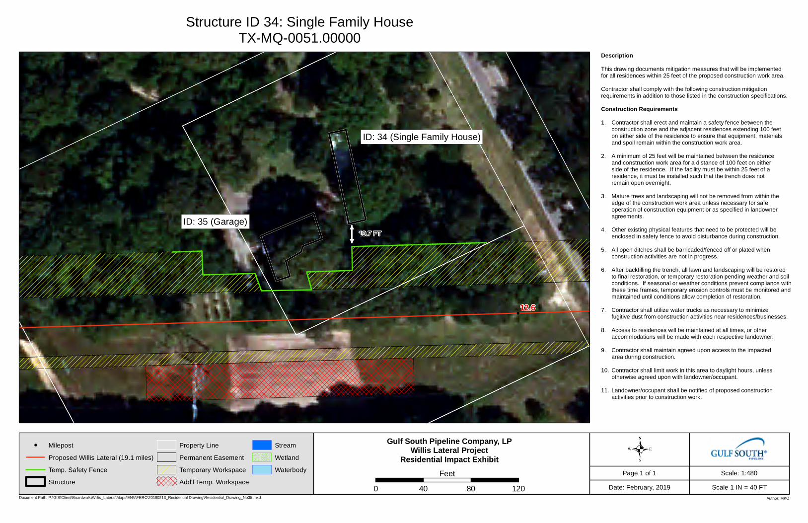
!
12.6
Page 1 of 1
Scale 1 IN = 40 FT
Scale: 1:480
Date: February, 2019Document Path: P:\GIS\Client\Boardwalk\Willis_Lateral\Maps\ENV\FERC\20190213_Residential Drawing\Residential_Drawing_No35.mxd Author: MKO
Gulf South Pipeline Company, LPWillis Lateral Project
Residential Impact Exhibit .0 40 80 120
Feet
Structure ID 34: Single Family HouseTX-MQ-0051.00000
! Milepost
Proposed Willis Lateral (19.1 miles)
Temp. Safety Fence
Structure
Property Line
Permanent Easement
Temporary Workspace
Add'l Temp. Workspace
Stream
Wetland
Waterbody
Description This drawing documents mitigation measures that will be implemented for all residences within 25 feet of the proposed construction work area. Contractor shall comply with the following construction mitigation requirements in addition to those listed in the construction specifications. Construction Requirements 1. Contractor shall erect and maintain a safety fence between the
construction zone and the adjacent residences extending 100 feet on either side of the residence to ensure that equipment, materials and spoil remain within the construction work area.
2. A minimum of 25 feet will be maintained between the residence
and construction work area for a distance of 100 feet on either side of the residence. If the facility must be within 25 feet of a residence, it must be installed such that the trench does not remain open overnight.
3. Mature trees and landscaping will not be removed from within the
edge of the construction work area unless necessary for safe operation of construction equipment or as specified in landowner agreements.
4. Other existing physical features that need to be protected will be
enclosed in safety fence to avoid disturbance during construction. 5. All open ditches shall be barricaded/fenced off or plated when
construction activities are not in progress. 6. After backfilling the trench, all lawn and landscaping will be restored
to final restoration, or temporary restoration pending weather and soil conditions. If seasonal or weather conditions prevent compliance with
these time frames, temporary erosion controls must be monitored and maintained until conditions allow completion of restoration.
7. Contractor shall utilize water trucks as necessary to minimize
fugitive dust from construction activities near residences/businesses. 8. Access to residences will be maintained at all times, or other
accommodations will be made with each respective landowner. 9. Contractor shall maintain agreed upon access to the impacted
area during construction. 10. Contractor shall limit work in this area to daylight hours, unless
otherwise agreed upon with landowner/occupant. 11. Landowner/occupant shall be notified of proposed construction
activities prior to construction work.
ID: 35 (Garage)
ID: 34 (Single Family House)
19.7 FT
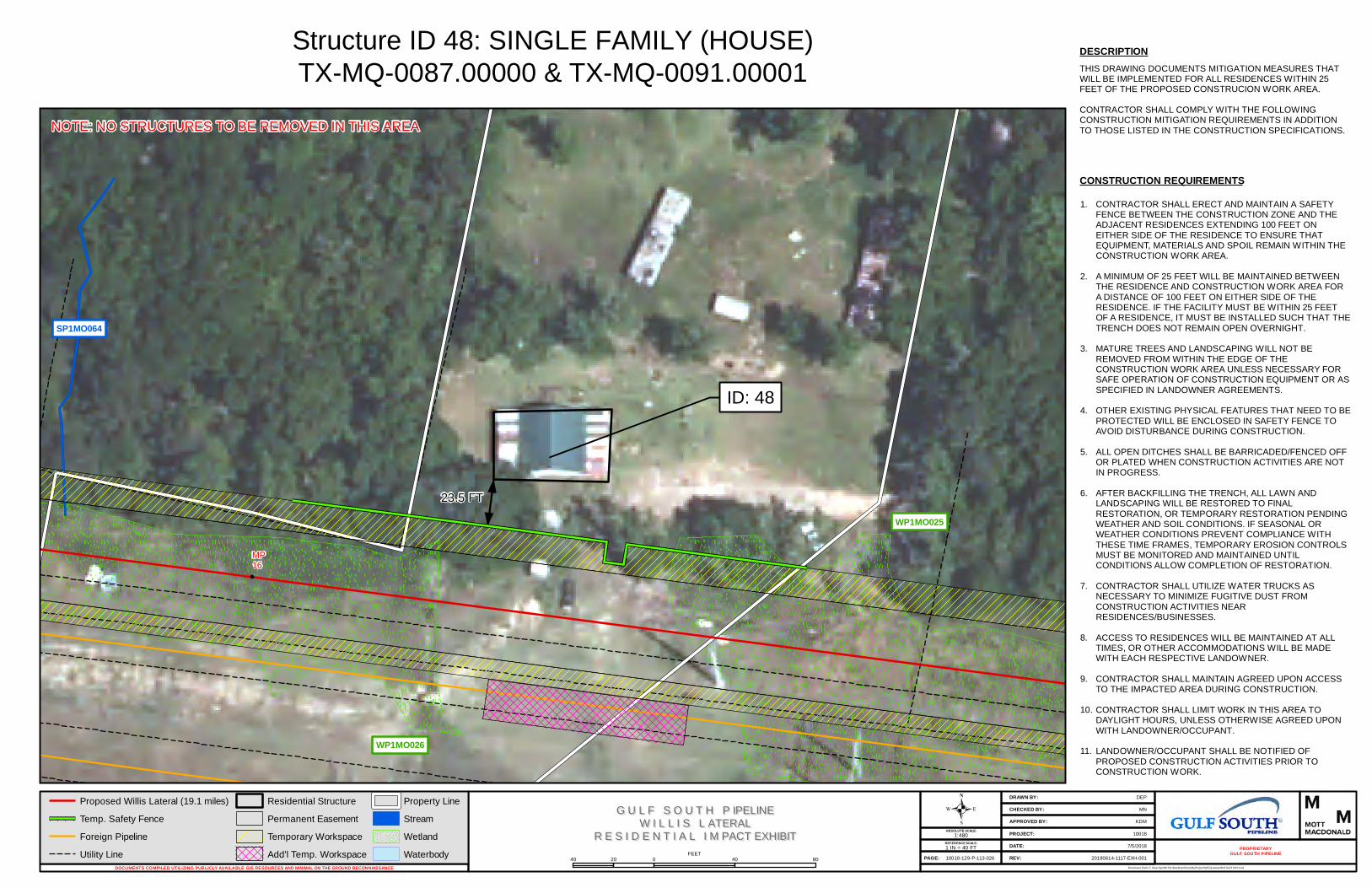
!
SP1MO064
23.5 FT
MP16
WP1MO025
WP1MO026
G U L F S O U T H P IPELINEG U L F S O U T H P IPELINEW I L L I S L ATERALW I L L I S L ATERAL
R E S I D E N T I A L I M PACT EXHIBITR E S I D E N T I A L I M PACT EXHIBIT
40 0 40 8020FEET
DOCUMENTS COMPILED UTILIZING PUBLICLY AVAILABLE GIS RESOURCES AND MINIMAL ON THE GROUND RECONNAISSANCE
.PAGE: 10018-129-P-113-026
7/5/2018
REV:
PROJECT: 10018
APPROVED BY: KDM
CHECKED BY: MN
DATE:
20180614-1117-EXH-001
DRAWN BY: DEP
PROPRIETARYGULF SOUTH PIPELINE
Document Path: C:\Users\pis60731\Desktop\Temp\ByProject\Will isLateral\MITIGATION.mxd
1:480ABSOLUTE SCALE:
REFERENCE SCALE:1 IN = 40 FT
CONTRACTOR SHALL ERECT AND MAINTAIN A SAFETYFENCE BETWEEN THE CONSTRUCTION ZONE AND THEADJACENT RESIDENCES EXTENDING 100 FEET ONEITHER SIDE OF THE RESIDENCE TO ENSURE THATEQUIPMENT, MATERIALS AND SPOIL REMAIN WITHIN THECONSTRUCTION WORK AREA.
A MINIMUM OF 25 FEET WILL BE MAINTAINED BETWEENTHE RESIDENCE AND CONSTRUCTION WORK AREA FORA DISTANCE OF 100 FEET ON EITHER SIDE OF THERESIDENCE. IF THE FACILITY MUST BE WITHIN 25 FEETOF A RESIDENCE, IT MUST BE INSTALLED SUCH THAT THETRENCH DOES NOT REMAIN OPEN OVERNIGHT.
MATURE TREES AND LANDSCAPING WILL NOT BEREMOVED FROM WITHIN THE EDGE OF THECONSTRUCTION WORK AREA UNLESS NECESSARY FORSAFE OPERATION OF CONSTRUCTION EQUIPMENT OR ASSPECIFIED IN LANDOWNER AGREEMENTS.
OTHER EXISTING PHYSICAL FEATURES THAT NEED TO BEPROTECTED WILL BE ENCLOSED IN SAFETY FENCE TOAVOID DISTURBANCE DURING CONSTRUCTION.
ALL OPEN DITCHES SHALL BE BARRICADED/FENCED OFFOR PLATED WHEN CONSTRUCTION ACTIVITIES ARE NOTIN PROGRESS.
AFTER BACKFILLING THE TRENCH, ALL LAWN ANDLANDSCAPING WILL BE RESTORED TO FINALRESTORATION, OR TEMPORARY RESTORATION PENDINGWEATHER AND SOIL CONDITIONS. IF SEASONAL ORWEATHER CONDITIONS PREVENT COMPLIANCE WITHTHESE TIME FRAMES, TEMPORARY EROSION CONTROLSMUST BE MONITORED AND MAINTAINED UNTILCONDITIONS ALLOW COMPLETION OF RESTORATION.
CONTRACTOR SHALL UTILIZE WATER TRUCKS ASNECESSARY TO MINIMIZE FUGITIVE DUST FROMCONSTRUCTION ACTIVITIES NEARRESIDENCES/BUSINESSES.
ACCESS TO RESIDENCES WILL BE MAINTAINED AT ALLTIMES, OR OTHER ACCOMMODATIONS WILL BE MADEWITH EACH RESPECTIVE LANDOWNER.
CONTRACTOR SHALL MAINTAIN AGREED UPON ACCESSTO THE IMPACTED AREA DURING CONSTRUCTION.
CONTRACTOR SHALL LIMIT WORK IN THIS AREA TODAYLIGHT HOURS, UNLESS OTHERWISE AGREED UPONWITH LANDOWNER/OCCUPANT.
LANDOWNER/OCCUPANT SHALL BE NOTIFIED OFPROPOSED CONSTRUCTION ACTIVITIES PRIOR TOCONSTRUCTION WORK.
CONSTRUCTION REQUIREMENTS1.
2.
3.
4.
5.
6.
7.
8.
9.
10.
11.
DESCRIPTIONTHIS DRAWING DOCUMENTS MITIGATION MEASURES THATWILL BE IMPLEMENTED FOR ALL RESIDENCES WITHIN 25FEET OF THE PROPOSED CONSTRUCION WORK AREA.
CONTRACTOR SHALL COMPLY WITH THE FOLLOWINGCONSTRUCTION MITIGATION REQUIREMENTS IN ADDITIONTO THOSE LISTED IN THE CONSTRUCTION SPECIFICATIONS.
TX-MQ-0087.00000 & TX-MQ-0091.00001Structure ID 48: SINGLE FAMILY (HOUSE)
Proposed Willis Lateral (19.1 miles)
Temp. Safety Fence
Foreign Pipeline
Utility Line
Residential Structure
Permanent Easement
Temporary Workspace
Add'l Temp. Workspace
Property Line
Stream
Wetland
Waterbody
ID: 48
NOTE: NO STRUCTURES TO BE REMOVED IN THIS AREA