William B. Abrams 1519 Branch Owl Place Santa Rosa, CA, 95409
53
1 William B. Abrams 1519 Branch Owl Place Santa Rosa, CA, 95409 March 29, 2021 VIA ELECTRONIC MAIL Transmittal to: [email protected], [email protected], and R.18-10-007 service list RE: WILLIAM B. ABRAMS COMMENTS ON 2021 WILDFIRE MITIGATION PLANS Dear Director Thomas Jacobs: William B. Abrams serves these comments pursuant to Resolution WSD-011, which authorizes public comment on the 2021 Wildfire Mitigation Plans (WMPs) of the three major investor-owned utilities (IOUs) by March 17, 2021, and the Wildfire Safety Division’s (WSD’s) approval of the Joint Stakeholders’ request for an extension setting a due date of March 29, 2021. Ms. Caroline Thomas Jacobs Director, Wildfire Safety Division California Public Utilities Commission 505 Van Ness Avenue San Francisco, CA, 94102
Transcript of William B. Abrams 1519 Branch Owl Place Santa Rosa, CA, 95409

1
William B. Abrams
1519 Branch Owl Place
Santa Rosa, CA, 95409
March 29, 2021 VIA ELECTRONIC MAIL
Transmittal to: [email protected],
[email protected], and R.18-10-007 service list
RE: WILLIAM B. ABRAMS COMMENTS ON 2021 WILDFIRE MITIGATION PLANS
Dear Director Thomas Jacobs:
William B. Abrams serves these comments pursuant to Resolution WSD-011, which
authorizes public comment on the 2021 Wildfire Mitigation Plans (WMPs) of the three major
investor-owned utilities (IOUs) by March 17, 2021, and the Wildfire Safety Division’s (WSD’s)
approval of the Joint Stakeholders’ request for an extension setting a due date of March 29, 2021.
Ms. Caroline Thomas Jacobs
Director, Wildfire Safety Division
California Public Utilities Commission
505 Van Ness Avenue
San Francisco, CA, 94102

2
SUBJECT INDEX
I. Introduction……………………………………………………………Page 2
II. Adherence to Statutory Requirements……..……………...………… Page 3
III. Actuals and Planned Spending for Mitigation Plan…………………Page 3
IV. Lessons Learned and Risks Trends…………………………………..Page 3
V. Inputs to Plan & Directional Vision for Wildfire Risk Exposure…..Page 5
VI. Performance Metrics and Underlying Data………………………….Page 7
VII. Mitigation Initiatives and Wildfire Mitigation Strategy………….…Page 10
VIII. Public Safety Power Shutoff, Including Directional Vision…….…...Page 11
IX. Summary and Conclusion……………………………………..………Page 16
I. Introduction
The utility Wildfire Mitigation Plan Updates (WMPs) are more thorough than in prior years
and demonstrate advances in risk modeling and increased coordination with some stakeholder
groups in key mitigation activities. The Pacific Gas and Electric Corporation (PG&E) plan is
particularly weighty at nearly 1,000 pages and shows some marked improvements over prior
years. However, there are still considerable disconnects between the methodology, the
measurement and the on-the-ground reality associate with preparation and planning for wildfire
risks. The primary reason for these sizeable gaps in the risk approaches of the Investor Owned
Utilities (IOUs) seem to be a lack of recognition regarding recent failures and causes of recent
catastrophic wildfires.
On the whole, these recent cascading and compounding IOU failures that created a wrath of
wildfires from 2017 to today are by enlarge not even mentioned in their Wildfire Mitigation

3
Plans. As one of the many and growing number of wildfire survivors throughout our state, the
fact that these IOU caused catastrophes and their causes are not even named and addressed in
these plans is beyond troubling. However, the IOU patterns of financial risk avoidance being
prioritized over our public safety is not a lapse in judgement but a demonstrated strategic tactic
to distract the public and dissuade the commission from taking further actions to ensure a more
targeted performance-based regulatory structure tied to IOU financials.
The failures associated with the Northern California Wildfires of 2017 through and including
the recent swath of utility caused wildfires in 2020 must all be specifically mapped to IOU
mitigation tactics if we are to justify any sense of progress represented in these plans. We cannot
let the legal tactics of our IOUs and other parties who have large financial interests in avoiding
liabilities allow us to disassociate these plans from the causes of wildfires. Indeed, as a wildfire
survivor and claimant in the PG&E bankruptcy proceeding, I have a significant financial stake in
ensuring that PG&E remains financially strong and able to pay out my claim and the claims of
my neighbors throughout our impacted communities. However, no claimants want this security
on the backs of future wildfire survivors who will pay the price in their homes, their lives and
their livelihoods if we do not confront the causes of these wildfires head on.
II. Adherence to the Statutory Requirements
III. Actuals and Planned Spending for Mitigation Plans
I am not providing comments on sections 2 and 3 at this time but may provide reply
comments. The following are my comments for sections 4 through 8 of the Wildfire Mitigation
Plans:
IV. Comments: Lessons Learned and Risks Trends
This section should be important to the commission as an indication of how quickly their
regulatory posture needs to move to a performance-based regulatory structure tied to IOU
bottom-line financials. Within environments where lessons learned are self-investigated and
self-identified there may be less of a need for a regulatory body to intercede with specific
4
performance-based measures tied to rates. However, it is clear from these submitted Wildfire
Mitigation Plans that increased regulatory oversight and interventions from outside agencies will
be required to ensure the utilities are taking a proactive rather than reactive stance. What is
important to note about the “lessons learned” identified by the utilities is that they almost
exclusively represent lessons they have been forced to learn by outside investigations such as
those conducted by CAL Fire and those that have been publicly aired through commission
proceedings or other court processes. Nowhere within these plans do the IOUs identify specific
failures tied to these catastrophic wildfires and describe how they have incorporated those
learnings into specific mitigation actions. It is not enough to generally state that increased
vegetation management and hardening of the grid has occurred. We must tie specific asset
failures and the business process failures that caused these recent fires to their mitigation
activities. PG&E summarizes their lessons learned with the following statement on page 41 of
their proposed WMP:
“The primary gaps identified and lessons learned from 2020 include risk prioritization of
Enhanced Vegetation Management (EVM) work, prioritizing the scheduling and
execution of system inspections, and the quality of vegetation management activities, as
discussed below.”1
All of these lessons are those which PG&E was forced to confront through criminal, civil
or regulatory actions. This section within their plan does not include any self-reflection beyond
the failures that we already know about through outside investigations. Moreover, it doesn’t
even acknowledge any failures or learnings associated with the Tubbs Fire, Camp Fire, Kincade
Fire, Zogg Fire, Glass Fire or any other wildfire in recent years that they caused. This PG&E
approach of waiting until another court proves beyond a reasonable doubt is not a recipe for
proactive wildfire mitigation and significantly impedes the efficacy of their plan and the safety of
our communities.
No new information is provided within the WMPs not because there aren’t other lessons
to be learned beyond those identified by outside parties but because the utilities continue to be
guided by a strategy of liability avoidance and not a higher corporate ethos focused on safety that
would be marked by the self-identification of failures. While PG&E may be most egregious
1 See Pacific Gas and Electric Company 2021 Wildfire Mitigation Plan Report, page 41

5
when it comes to this head-in-the-sand “lessons learned” approach, they are certainly not alone.
As an example, nowhere within the Southern California Edison (SCE) proposed WMP does it
acknowledge or address failures associated with the Woolsey Fire of 2018 or the Bobcat Fire of
2020 among many other wildfires they should own through their actions. Please, keep in mind
that I am not arguing that these WMPs should be focused on criminal or civil culpability but
rather that they need to identify and indicate lessons learned associated with these incidents if we
are ever going to make real progress in terms of wildfire risk mitigation.
I urge the commission to make sure that each utility identifies failures for each and every
wildfire where their equipment, business processes or decision-making has contributed to recent
wildfires. We must be able to track how every utility has identified failures, lessons learned
from those failures and the wildfire mitigation tactics that followed if we are going to have
Wildfire Mitigation Plans that are based upon on-the-ground realities rather than focused on
financial liability avoidance.
V. Comments: Inputs to the Plan and Directional Vision of Wildfire Risk Exposure
Unfortunately, the “directional vision” expressed in this section by the utilities is clouded by
their inability or unwillingness to acknowledge lessons learned beyond those they have been
forced to acknowledge by outside parties and court processes as described in the prior section.
There are entire areas of their risk modeling that are skewed away from addressing very
significant risks to avoid culpability or general association with past wildfires. Consider the
following statement by Paul McGregor, Director EO Risk Management and Analytics from a
recent CPUC workshop on February 22, 2021:
"As part of our wildfire mitigation plan and our model, there are a lot of Failure Modes
Effects and Analysis (FMEA) that goes on and gets done. So, we are looking at
components that we need to mitigate... Also, as you said with regards to the Kincade
Fire… the particular piece of equipment that was suspected of being part of this was a
jumper cable and that particular piece of analysis is NOT discussed in our Wildfire
Mitigation Plan because our transmission wildfire risk model is currently in
6
development... with regards to our planning models as far as transmission wildfire risk
assessment, we are still building that process in there. So, we got a ways to go in that and
is one of the things we are working on in 2021. Unfortunately, we are struggling with
data on that... but we are making progress."2
Now, combine this with the statement the following day from Aaron Johnson, Vice President
Wildfire Safety Public Engagement:
“We understand at a high-level that our equipment was responsible for that fire… So, we
looked at what are the criteria… that was a very healthy piece of equipment that had been
inspected multiple times, there were high definition cameras and nothing was identified.
However, the fire conditions on the ground were quite extreme during that time, so we
adopted something in our transmission protocols, called black swan criteria.”3
This “black swan” reference seems to only be leveraged by PG&E to describe events and is
referenced 17 times within their WMP as an excuse for why events were not considered because
they were deemed as extremely rare but with severe consequences. This phrase and its
application to risk modeling was developed by Nassim Nicholas Taleb but seems to be overused
across the PG&E WMP and throughout their filed comments across proceedings including those
filings in US District court as somehow a catch all phrase for the causes of recent fires.4 This
term has been used by PG&E to explain away failures associated with the Kincade Fire, Zogg
Fire and other fires across their territory. It is used so often that it would seem that there is a
bevy of black swans (wedge if in flight) plaguing PG&E risk modeling and it was just their bad
luck that these instances were hoisted upon them. If we are amenable to this characterization by
PG&E regarding these events, it will be important to note a warning Nassim Nicholas Taleb also
states in reference to black swan events:
2 See 2021 Wildfire Mitigation Plan Updates Technical Workshop, February 22, 2021 (admin monitor mark 2:00)
http://www.adminmonitor.com/ca/cpuc/workshop/20210222/ 3 See 2021 Wildfire Mitigation Plan Updates Technical Workshop, February 23, 2021 (admin monitor mark 5:11)
http://www.adminmonitor.com/ca/cpuc/workshop/20210223/ 4 See Attachment A: Response to Request for Follow Up by PG&E, Case No. 14-CR-00177-WHA, filed 11/18/2020

7
“Some business bets in which one wins big but infrequently, yet loses small but
frequently, are worth making if others are suckers for them and if you have the personal
and intellectual stamina.”5
I suggest that the commission and parties to this proceeding not be played as “suckers” by
this PG&E misuse and mischaracterization of these failures as “black swans” but rather
understand that these failures are common white swans and deserving of more integration into
the WMPs and to provide a broader “directional vision” to the wildfire mitigation plans. The
alternative position is to believe that rusted C-hooks, jumper cables, misuse of wind sensor data,
leaving abandoned infrastructure energized, poor de-energization decision making and a host of
other utility ailments are all just unfortunate, rare and unavoidable occurrences that cannot be
accounted for in risk mitigation efforts. The commission and communities across California
should not be subjected to these utility diversion tactics. I urge the commission to make sure that
these failures are incorporated into the utility Wildfire Mitigation Plans. We cannot wait on
CAL Fire reports or Federal Monitors proving incidents were the fault of a utility before we
ingrain learnings from past failures into these risk mitigation efforts. Similarly, we can’t wait for
these failures to be deemed statistically significant enough by the IOUs to warrant inclusion into
their WMPs. If a failure contributed to or directly caused a catastrophic wildfire, that
should be enough of a reason for the WSD to require it to be addressed within the 2021
Wildfire Mitigation Plans.
VI. Comments: Performance Metrics and Underlying Data
Undoubtedly, the underlying data is much improvement over past WMPs for the utilities but
the commission should be careful not to assume this data supports “performance metrics” when
they are not outcome-oriented and do not adequately describe the safety or wildfire mitigation
performance of the utility. Throughout these plans, the utilities continue to conflate activity
metrics with performance metrics and do not adequately incorporate common measures of risk or
risk mitigation. Moreover, the plans seem to equate linear relationships between particular
tactics and the risk reduction associated with their implementation as opposed to the compound
5 The Black Swan: The Impact of the Highly Probable, Nassim Nicholas Taleb, Random House Pub., April, 2007
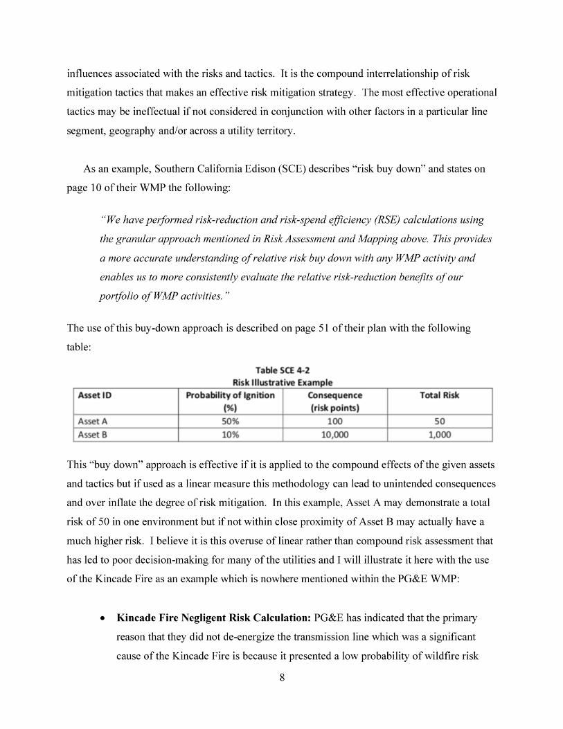

9
(i.e. black swan). It is this same negligent miscalculation that has led them to not
incorporate these same risks (jumper cable failures, mismatched de-energization
protocols, etc.) into their 2021 WMP as that they are deemed “low probability
events.” However, this infrastructure DOES pose a much higher risk when in close
proximity of other assets. Jumper wire and clearances or spaces are determined by
considering the sag length of the jumper wire so as to create distance between the
tower or arms. The swinging movement of the jumper wire or the movements of the
power transmission line itself can dramatically increase the interdependent risks of
these component parts on the transmission line. Therefore, it is desirable to have the
jumper in a more rigid state where conditions are likely to cause more swinging (exp.
high wind events). Further compounding these risks is the catenary angle of the
conductor and the insulated string which may cause extreme temperature variations
and movements such as sleet-jumping and galloping.
• PG&E Mitigation Mismanagement: If these compound risks were considered by
PG&E then perhaps they would have not drawn the wrong-headed linear conclusion
that transmission lines are low risk. Instead, they may have identified those
transmission lines that are more exposed to wind and measured the rigidity of jumper
configurations. The transmission lines that have less rigid jumper configurations in
higher wind conditions might be moved up on the priority list when the de-
energization decisions were made on October 23rd, 2019 leading to the largest
wildfire in Sonoma County history. In addition to these types of mitigations for the
asset risks, there are operational and process specific mitigations that could and
should have occurred. As an example, the practice of cutting the jumper wire in the
field might be substituted with a process that determines the jumper arrangement
(including wire size) at the manufacturing facility where more precise and consistent
tensions and tolerances can be assured.
Now, the purpose of this example is not to define the mitigations that were necessary to
prevent the PG&E Kincade Fire but only to point out that the linear methodology that PG&E
uses within their WMP is negligent in its simplified application and often times just plain wrong.

10
The linear assessments of risk levels that is the default approach for these WMPs leads to
unintended consequences at best and at worst exacerbates and increases risks due to a lack of
foresight and consideration of compound risk factors. These compound risk factors must be
considered within the Wildfire Mitigation Plans particularly in those cases where catastrophic
wildfires are the result.
Similarly, the Zogg Fire is another example of the catastrophic consequences when PG&E
negligently applies linear risk factors. It is not just that they did not have the right quality
controls in place for their vegetation management on certain line segments that ignited the Zogg
Fire. It is the failed decision-making processes that led to an over-reliance on inapplicable wind
sensors and de-energization assessments plus many other interrelated and unreported factors that
led to the Zogg Fire. Nowhere within the PG&E WMP are these inter-related risk factors
identified or considered to improve the mitigation tactics and strategies deployed.
VII. Comments: Mitigation Initiatives and Wildfire Mitigation Strategy
Yes, these 2021 wildfire mitigation strategies proposed by the utilities are more thorough but
are too often based upon oversimplified metrics and linear calculations of probability and
consequence for particular assets or line segments. More troubling is the fact that these
mitigation strategies do not recognize or directly address the catastrophic failures that have
occurred in recent years. Nowhere within their WMP does SCE address their failures that led to
the 2017 Thomas Fire, the 2018 Woolsey Fire or the 2020 Bobcat Fire. Similarly, the constant
and consistent failures of PG&E (2017 Tubbs Fire, 2018 Camp Fire, 2019 Kincade Fire, 2020
Zogg Fire and Glass Fire, etc.) are not even addressed within their WMP except for recognizing
the financial liabilities and regulatory penalties that might result. This head-in-the-sand
approach does not benefit the utilities or the commission. It may benefit shareholders that bank
on short-term yield but it certainly does not bode well for the longer-term prospects of our
California residents that live among the lines.
Also, noticeably missing from the utility wildfire mitigation strategies is any mention or
integration with the Community Wildfire Protection Plans (CWPPs) that stretch across

11
California at the local-level. We will never have effective utility wildfire mitigation strategies if
they are not deliberately and strategically integrated with our CWPPs. Moreover, through this
strategic integration we can share best-practices and resources to develop more comprehensive
strategies. How can we leverage these combined strategies to create fire breaks and fuel breaks?
How can we leverage shared wildfire mitigation resources to improve vegetation management,
infrastructure hardening and to better prepare our residents in high fire threat districts (HFTDs)?
How might we crowd-source the identification of tree, animal and balloon contacts with line
segments if we collaborated around these type of solutions? There are many advantages that
could be realized through the strategic integration of WMPs and CWPPs and we should require
this integrated approach in these 2021 WMPs and not wait until another year of catastrophic
wildfires.
VIII. Public Safety Power Shutoff (PSPS)
I am very concerned that these WMPs are not considering the phase 3 de-energization
guidelines that are now being considered by the commission within Rulemaking 18-12-005.
Prior to approving these WMPs we should ensure that the finalized guidelines are reflected in
these plans especially considering that PSPS events are often considered the mitigations of last
resort. There are a number of areas that need considerable improvement in those de-energization
guidelines and in these WMPs prior to approval. This includes how our Community Resource
Centers (CRCs), Emergency Operation Centers (EOCs), critical Infrastructures and de-
energization exercises are treated along with improvements to how IOUs conduct outreach
particularly to our Access and Functional Needs (AFN) populations. My comments for
improvements to the WMPs are much the same as the improvements that should be made in the
de-energization guidelines so I will reemphasize and highlight them here.
Our CRCs need specific customer engagement strategies incorporated into Service Level
Agreements and provided to the “respective local governments and health agencies.” Service
Level Agreements are readily used by our utilities to manage vendors and they should not be
abandoned here as a tool to promote public safety. All the utilities should identify measurable
levels of service for these activities beyond the measurements provided within their WMPs

12
which are simply counts of the services and supplies provided. We need to ensure the
QUALITY of the services by identifying the quality attributes and the quality controls (tools and
measures) that will ensure a high-level of service particularly for these populations that are
disproportionately at risk during de-energization events.
Moreover, simply using AQI as the only environmental benchmark for determining the
suitability of indoor vs. outdoor CRCs is insufficient. The other factors which are common
during these events coinciding with high wildfire threat levels include high heat and high wind.
The WMPs should include these measures when determining whether indoor CRCs should be
required. The National Weather Service defines an “Excessive Heat Warning” as having “a heat
index of 105 °F or greater that will last for 2 hours or more” and I recommend that the WMPs
also include this as a threshold.6 Similarly, the National Weather Service defines a “high wind
warning” when there are “sustained winds or 40 mph or higher for one hour or more OR wind
gusts of 58 mph or higher for any duration.”7 These three measures (temperature, wind and air
quality) could be used to set an interdependent threshold or be used as independent criteria for
when CRCs should be required to move indoors. The WMPs should also consider the fact that
our elderly populations are particularly vulnerable to these adverse conditions and are often
overrepresented at these centers during peak usage times.8
This typical 24-hour timeframe identified by the utilities is insufficient notice regarding the
location of these CRC locations. These CRC locations should rarely change and both the
outdoor and indoor alternatives should be communicated to resident ratepayers prior to wildfire
season (March/April timeframe) so they can prepare and plan accordingly. Waiting until the
adverse conditions are heaped upon a community is the wrong time to be providing this
information. Many residents will need to identify alternate means of transportation and rely
upon the accessibility of these sites for their health, safety and general peace-of-mind. Primary
and backup locations should be pre-identified within the WMPs if a utility in coordination with
local agencies determines that is prudent for public safety. We have pre-defined evacuation
6 See National Weather Service, Heat Watch vs. Heat Warning, https://www.weather.gov/safety/heat-ww 7 See National Weather Service, Wind Warnings, Watches & Advisories, https://www.weather.gov/safety/wind-ww 8 See Sacramento Bee, “It being 95 degrees in our house… what it’s like at Placerville PG&E power shutoff center”,
October 26, 2020, https://www.sacbee.com/news/local/article245585740.html
13
routes and shelters for all sorts of disaster scenarios (exp. tornado shelters, hurricane/flood
evacuation routes, etc.) and should do so with these IOU events.
Moreover, these WMPs should include maps of “sectionalization devices” and a functional
description of these devices. In the 2018 and 2019 timeframe, the utilities and the commission
have focused on the number of “reclosers” as indicative of the degree to which de-energization
events might be limited for a particular utility or community. Now, our IOUs leverage the broad
term “sectionalization devices” more often in their communications to describe and in many
cases to inflate their progress on being able to manage and limit these events. The result of this
definitional conflation is that public officials, emergency managers and others often use these
terms interchangeably which leads to a significant gaps in understanding regarding our
capabilities to manage these events.
The commission should require that pre-season reports contain maps with the location of
these devices and associated device descriptions. This would enable our local agencies to have
the information necessary to provide recommendations regarding the use of these devices to limit
the scale and scope of these events. As an example, emergency managers in collaboration with
others might be able to advise on how our telecommunication infrastructure might be
safeguarded so our communities have more options to stay connected during these events.
Without this information, the public is kept in the dark and disconnected from the true
capabilities of our utilities to guard against the significant public safety and financial
implications of these events. If this information was shared transparently, it would also help
build public trust in the prudent use of these de-energization tactics. Moreover, this information
will help us better understand the balance between the risks associated with de-energization and
the wildfire risks they are designed to mitigate.
Similarly, the mapped location of wind sensors and weather stations should also be supplied
in pre-season reports and within the WMPs. Recent investigations and associated reporting have
revealed that poor utility decision-making regarding where not to de-energize was in part due to
the misuse of wind data far from the impacted locations. This was particularly true with the
recent 2020 Zogg Fire where an investigation revealed “PG&E ran a complicated algorithm

14
designed to gauge the risk of a wind-sparked wildfire starting in each grid square on its map
without knowing the actual wind conditions in each square.”9 Of course, the fact that utilities
work with incomplete and often times inconclusive data is not the point. It is the transparency of
this information which must be incorporated into these WMPs so that the public understands the
limitations of this information and can help guide decision-making.
If Shasta County Emergency Managers and other public officials understood where PG&E
was sampling this wind data, might they have advised against this application of the data given
their local knowledge of their county conditions? Might this have led to different decisions and
perhaps avoided the Zogg Fire ignition? If this wind sensor map was provided to Shasta County
officials prior to the 2020 wildfire season, might they have advocated to ensure an additional
inexpensive wind sensor was positioned closer to their location? We must not let the lack of
disclosure around the Zogg Fire investigation or other undisclosed reports limit our ability to
improve these de-energization standards within the WMPs. We need to push for the evidentiary
record in these official reports AND until these reports are released to the public we need to
work with the investigative reporting that provides us a strong indication of likely causes. This
information must inform how we improve these WMPs or we may misfocus our attention away
from the types of improvements that will really make a positive impact on how these de-
energization events are managed.
The WMPs contain some improvements in the quality of outreach and communications
around de-energization but there is more improvements that should be required to move us
beyond the quantity of communications as the sole measure of success and instead focused on
the quality or effectiveness of these communications. This is particularly true for our AFN
populations where WMPs seem not focus on communication methodology and prioritize process
over product and results. The commission should not concern itself with HOW communications
are managed by the utilities. Every communications tactic and strategy should be built upon
9 See ABC10, “Investigation: PG&E made shutoff decisions on junk science”, February 2, 2021,
https://www.abc10.com/article/news/investigations/investigation-pge-shutoff-decisions-zogg-fire/103-273163f6-
c0f6-4404-b36b-9053b2980d3d

15
driving measurable results which is nowhere mentioned within this section of the WMPs. I
believe Mr. Vesey, Former PG&E CEO expressed this view quite clearly a year ago stating:
“the only arbiter of effectiveness of communications are those people who are supposed to be
receiving the communications. I think that’s the point you’re getting. Effective communication
is not just touching and getting a response that somebody’s been communicated for. It’s what
has been communicated, was the message received, was it actionable. These are all very good
points, and it’s something that we have to really up our game in, because I will say that when I
say there were failures in the way we executed the PSPS in the last fire season, it also comes
down to coordination and communication with the parties outside of the company.”10
Yes, the communication strategies should always be modified based upon the populations for
which they target. Effective communications strategies and tactics are always modified based
upon the targeted communities and audiences and certainly AFN populations will need different
accommodations. However, I would advise the commission not to be concerned about the types
of partnerships the IOUs build or the mode of those communications. I suggest that the WMPs
be built upon surveys, focus groups and other means to measure the effectiveness of
communications. Distinct surveys may be provided for specific medical baseline customer
segments and AFN communities to measure the quality of de-energization communications. As
an example, we might set the standard that 95% of ratepayers that rely upon electric-powered
wheelchairs must be aware of where to charge their wheelchair during a de-energization event
and how to get there.
Similar performance-based measures should be established to gauge the effectiveness of
other utility PSPS protocols. We need to set quality targets for effective communications and
effective operations for PSPS events. As an example, we might set a standard that 98% of
ratepayers that rely on medical equipment must be aware of the utility defined process to receive
a free backup battery and that a minimum of 95% of these ratepayers that request the battery
must receive it within 30 days. The “how” should be at the discretion of the utility and whether
10 Proceeding I.19-09-016 Hearing Transcript (vol. 3), February 27, 2020 (pgs. 440-443)

16
they manage this internally and/or through partners should not matter to the commission. Only
results.
IX. Summary and Conclusion
The proposed wildfire mitigation plans are robust in size and scope but lack the specific
integration that we need and largely do not address the on-the-ground conditions and internal
systemic issues that will unfortunately lead to more catastrophic wildfires. They rely too heavily
on linear risk measures when the lines that are the most at-risk lie within complex and
interdependent environments where compound internal and external risk variables are present.
We must not let the lack of disclosure by the utilities, CAL Fire and other entities regarding these
events get in the way of important wildfire mitigation work that could be represented within
these WMPs. This ongoing cycle of not releasing the evidentiary record associated with wildfire
reporting, producing IOU mitigation plans that ignore systemic failures followed by more
catastrophic wildfires needs to be curtailed within this 2021 WMP process. This vicious cycle
prioritizes the tactical legal advantage of certain utility stakeholders and shareholders over the
commission’s mission to promote “SAFE, clean and affordable utility service.” I urge the
Wildfire Safety Division and the California Public Utilities Commission to take decisive actions
so we can all move forward together with a unified strategy to address our shared wildfire and
climate change adaptation challenges.
Dated:
March 29, 2021
Respectfully submitted,
/s/ William B. Abrams
William B. Abrams
California Resident
1519 Branch Owl Place
Santa Rosa, CA, 95409
Tel: (707) 397-5727
E-mail: [email protected]
RESPONSE TO REQUEST FOR FOLLOW UP BY PG&E CONCERNING ITS OCTOBER 26 SUBMISSION Case No. 14-CR-00175-WHA
1
2
3
4
5
6
7
8
9
10
11
12
13
14
15
16
17
18
19
20
21
22
23
24
25
26
27
28
JENNER & BLOCK LLP
Reid J. Schar (pro hac vice)
353 N. Clark Street
Chicago, IL 60654-3456
Telephone: +1 312 222 9350
Facsimile: +1 312 527 0484
CLARENCE DYER & COHEN LLP
Kate Dyer (Bar No. 171891)
899 Ellis Street
San Francisco, CA 94109-7807
Telephone: +1 415 749 1800
Facsimile: +1 415 749 1694
CRAVATH, SWAINE & MOORE LLP
Kevin J. Orsini (pro hac vice)
825 Eighth Avenue
New York, NY 10019
Telephone: +1 212 474 1000
Facsimile: +1 212 474 3700
Attorneys for Defendant PACIFIC GAS AND ELECTRIC
COMPANY
UNITED STATES DISTRICT COURT
NORTHERN DISTRICT OF CALIFORNIA
SAN FRANCISCO DIVISION
UNITED STATES OF AMERICA,
Plaintiff,
v.
PACIFIC GAS AND ELECTRIC COMPANY,
Defendant.
Case No. 14-CR-00175-WHA
RESPONSE TO REQUEST FOR
FOLLOW UP BY PG&E
CONCERNING ITS OCTOBER 26
SUBMISSION
Judge: Hon. William Alsup
Case 3:14-cr-00175-WHA Document 1265 Filed 11/18/20 Page 1 of 37
William Abrams
Attachment A: Response to Request for Follow Up by PG&E
2
RESPONSE TO REQUEST FOR FOLLOW UP BY PG&E CONCERNING ITS OCTOBER 26 SUBMISSION Case No. 14-CR-00175-WHA
1
2
3
4
5
6
7
8
9
10
11
12
13
14
15
16
17
18
19
20
21
22
23
24
25
26
27
28
Defendant Pacific Gas and Electric Company (“PG&E”) respectfully submits this
response to the Court’s October 29, 2020 order requesting information based on PG&E’s
October 26, 2020 submission regarding the Zogg Fire. (Dkt. 1256.) The responses below
address three main subjects, presented in the same order as the Court’s questions:
First, PG&E’s responses to Question 1-13 and 19 of the Court’s October 29, 2020
order, in addition to the below supplement to Questions 1-3 of the Court’s October 21, 2020
order, provide information relating to PG&E’s September 27, 2020 Public Safety Power Shutoff
(“PSPS”) event.
Second, PG&E’s responses to Questions 14-17 concern the specific tree
apparently identified by CAL FIRE, and prior inspections and patrols of the area of interest.1
Third, PG&E’s response to Question 18 provides further information as to why
there was no separate Catastrophic Event Memorandum Account (“CEMA”) inspection for the
Zogg Mine Road area of the Girvan 1101 12 kV Distribution Circuit (“Girvan Circuit”) between
the routine inspections of the circuit in 2019 and 2020.
The Court asked that PG&E’s responses be submitted under oath. (Dkt. 1256 at
5.) Attached to this submission as Exhibits A and B are two declarations addressing matters for
which PG&E employees have personal knowledge. Other PG&E responses, such as those
addressing actions by CAL FIRE or PG&E vegetation management contractors, are based on
PG&E’s investigation and review of relevant records, and are not based on the personal
knowledge of PG&E employees. One response, to Question 14 concerning the history of
vegetation management work performed in the area of interest following the Carr Fire, is
preliminary given that PG&E’s investigation is in its beginning stages. PG&E is continuing to
investigate and will provide an updated response, along with a declaration or declarations as
requested by the Court, once it has analyzed further records and advanced its investigation.
1 When PG&E refers to the “area of interest”, it is referring specifically to the vicinity of the
three specific spans of line from which CAL FIRE collected evidence, not the entire Girvan 1101
12 kV Distribution Circuit (“Girvan Circuit”) (which spans approximately 117 line miles). The
area of interest is depicted in Exhibit C to PG&E’s October 26, 2020 submission.
Case 3:14-cr-00175-WHA Document 1265 Filed 11/18/20 Page 2 of 37
3
RESPONSE TO REQUEST FOR FOLLOW UP BY PG&E CONCERNING ITS OCTOBER 26 SUBMISSION Case No. 14-CR-00175-WHA
1
2
3
4
5
6
7
8
9
10
11
12
13
14
15
16
17
18
19
20
21
22
23
24
25
26
27
28
Supplement to PG&E’s October 26, 2020 Submission Responding to Questions 1-3
of the Court’s October 21, 2020 Order for Further Information Regarding the Zogg Fire
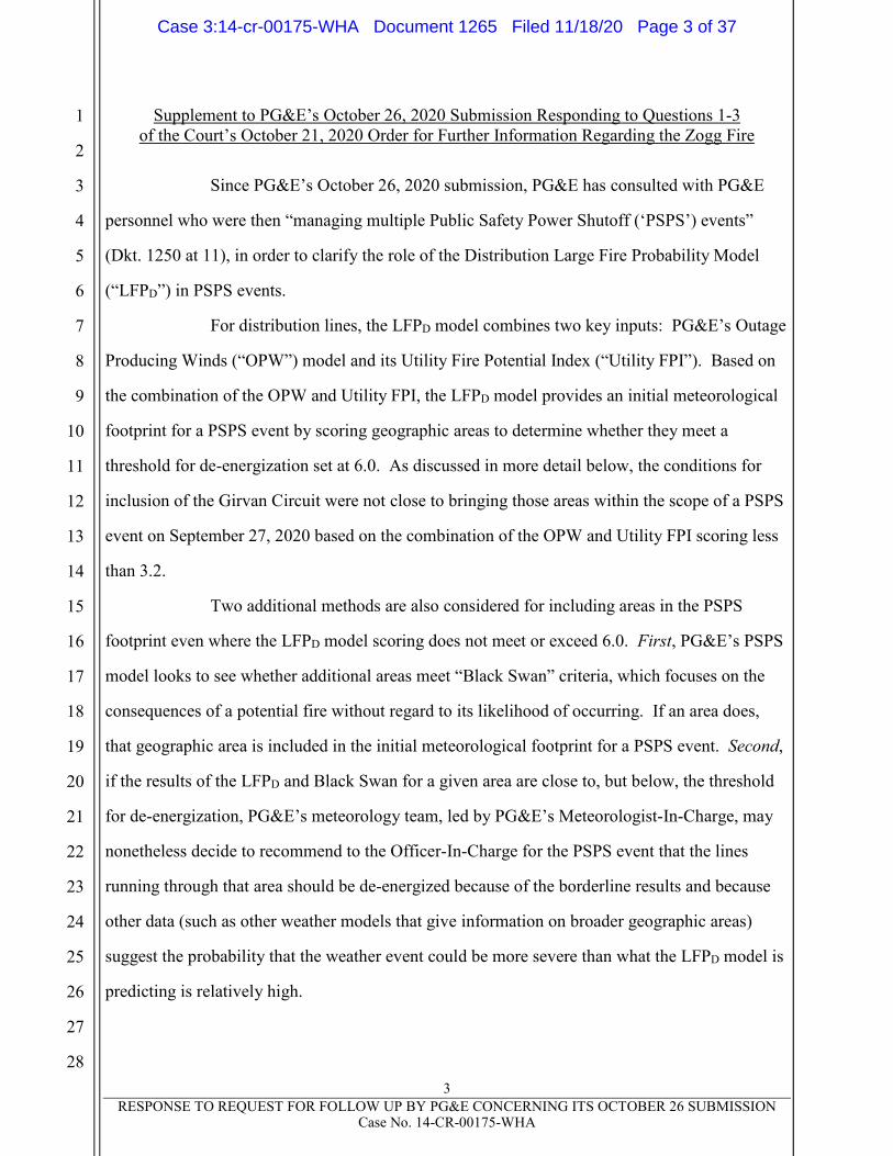
Since PG&E’s October 26, 2020 submission, PG&E has consulted with PG&E
personnel who were then “managing multiple Public Safety Power Shutoff (‘PSPS’) events”
(Dkt. 1250 at 11), in order to clarify the role of the Distribution Large Fire Probability Model
(“LFPD”) in PSPS events.
For distribution lines, the LFPD model combines two key inputs: PG&E’s Outage
Producing Winds (“OPW”) model and its Utility Fire Potential Index (“Utility FPI”). Based on
the combination of the OPW and Utility FPI, the LFPD model provides an initial meteorological
footprint for a PSPS event by scoring geographic areas to determine whether they meet a
threshold for de-energization set at 6.0. As discussed in more detail below, the conditions for
inclusion of the Girvan Circuit were not close to bringing those areas within the scope of a PSPS
event on September 27, 2020 based on the combination of the OPW and Utility FPI scoring less
than 3.2.
Two additional methods are also considered for including areas in the PSPS
footprint even where the LFPD model scoring does not meet or exceed 6.0. First, PG&E’s PSPS
model looks to see whether additional areas meet “Black Swan” criteria, which focuses on the
consequences of a potential fire without regard to its likelihood of occurring. If an area does,
that geographic area is included in the initial meteorological footprint for a PSPS event. Second,
if the results of the LFPD and Black Swan for a given area are close to, but below, the threshold
for de-energization, PG&E’s meteorology team, led by PG&E’s Meteorologist-In-Charge, may
nonetheless decide to recommend to the Officer-In-Charge for the PSPS event that the lines
running through that area should be de-energized because of the borderline results and because
other data (such as other weather models that give information on broader geographic areas)
suggest the probability that the weather event could be more severe than what the LFPD model is
predicting is relatively high.
Case 3:14-cr-00175-WHA Document 1265 Filed 11/18/20 Page 3 of 37

4
RESPONSE TO REQUEST FOR FOLLOW UP BY PG&E CONCERNING ITS OCTOBER 26 SUBMISSION Case No. 14-CR-00175-WHA
1
2
3
4
5
6
7
8
9
10
11
12
13
14
15
16
17
18
19
20
21
22
23
24
25
26
27
28
It is the responsibility of the meteorology team to recommend areas for potential
de-energization based on their assessment of the models, as well as other available
meteorological data. If an area is not initially recommended for de-energization by the
meteorology team, that determination will not be reviewed by other departments at PG&E,
which do not have meteorological expertise.
The precise mechanics of the scoping process are described further herein in
response to the Court’s October 29, 2020 follow-up questions.
Question 1: With respect to PG&E’s Large Fire Probability model identification,
PG&E’s description in Exhibit E states at page 14:
PG&E’s Large Fire Probability (LFP) model identification of areas on
both PG&E’s distribution and transmission systems with high wind-driven
outage probability combined with high probability of a large fire if an
ignition were to occur.
• On the distribution system, the Distribution Large Fire
Probability Model (LFPD) is a product of PG&E’s Outage
Producing Wind (OPW) model and FPI models. The LFPD
model provides hourly output at 2km model resolution and
highlights locations with concurrence of a high probability
for large fires and high probability of wind-related outages
on PG&E’s distribution system.
• On the transmission system, the Transmission Large Fire
Probability Model (LFPT) is the product of PG&E’s
Transmission Operability Assessment (OA) model and FPI
models. The LFPT model provides hourly forecast outputs
for each transmission structure. The model highlights
locations with both an increased probability for large fires
and high probability of wind-related failures on PG&E’s
transmission system.
Leading up to the Zogg Fire, how close did the Distribution Large Fire Probability model
come to assessing specifically the Girvan Distribution Line? Describe all September
2020 assessments made for the smallest area that included the Girvan Line.
PG&E Response:
To determine the recommended de-energization scope, the PG&E meteorology
department analyzes the meteorological conditions and fire potential for each portion of the
Case 3:14-cr-00175-WHA Document 1265 Filed 11/18/20 Page 4 of 37
5
RESPONSE TO REQUEST FOR FOLLOW UP BY PG&E CONCERNING ITS OCTOBER 26 SUBMISSION Case No. 14-CR-00175-WHA
1
2
3
4
5
6
7
8
9
10
11
12
13
14
15
16
17
18
19
20
21
22
23
24
25
26
27
28
potential PSPS scope by breaking PG&E’s service territory into preset grid cells of
two kilometers-by-two kilometers, as described in further detail below.
The Girvan Circuit traverses 50 two kilometer-by-two kilometer grid cells and the
LFPD model specifically assessed each of these grid cells during the September 27, 2020 PSPS
event. At no point in the lead up to the September 27, 2020 PSPS event did any grid cell
traversed by the Girvan Circuit meet the 6.0 threshold for de-energization nor did any grid cell
satisfy the Black Swan criteria. The highest two kilometer-by-two kilometer LFPD output was
less than 3.2 (compared to the requisite 6.0 for inclusion), and it was forecast for grid cell
142_377, which is located approximately 11 miles from the area of interest.2
While the primary initial driver of the scope of de-energization is the
two-kilometer model, the model also assessed each of the 30 three kilometer-by-three kilometer
grid cells traversed by the Girvan Circuit. The highest output of the LFPD model for the
three kilometer-by-three kilometer grid cells traversed by the Girvan Circuit was 4.76, and it was
forecast for grid cell 89_245, which overlaps with grid cell 142_377 and is approximately
10.8 miles away from the area of interest.
As a result of the PG&E meteorology team’s review of this weather data, the
Girvan Circuit was not considered in scope for potential de-energization during the
September 27, 2020 PSPS event.
PG&E is producing at Bates PGE-ZOGG-NDCAL-00009368 to PGE-ZOGG-
NDCAL-00009371 each of the LFPD model outputs that were run in September 2020 for the
two kilometer-by-two kilometer grid cells traversed by the Girvan Circuit. PG&E is producing
at Bates PGE-ZOGG-NDCAL-00009372 each of the LFPD model outputs that were run in
September 2020 for the three kilometer-by-three kilometer grid cells traversed by the Girvan
2 When PG&E refers to distances in relation to grid cells in this submission, such distances
are calculated from the mid-point of the grid cell.
Case 3:14-cr-00175-WHA Document 1265 Filed 11/18/20 Page 5 of 37

6
RESPONSE TO REQUEST FOR FOLLOW UP BY PG&E CONCERNING ITS OCTOBER 26 SUBMISSION Case No. 14-CR-00175-WHA
1
2
3
4
5
6
7
8
9
10
11
12
13
14
15
16
17
18
19
20
21
22
23
24
25
26
27
28
Circuit.3 The table in Appendix A lists the column headers for the output of the LFPD model
alongside a brief description of what each column header means.
Question 2: What were the specific ratings, scores and weightings considered by the
PG&E team, broken out for each distribution line in Shasta County in the September
PSPS?
PG&E Response:
PG&E does not have any “specific ratings, scores and weightings . . . broken out
for each distribution line in Shasta County” but rather has such data for each geographic grid
cell in Shasta County. PG&E determines the scope of de-energization for distribution circuits by
analyzing the LFPD model outputs and related forecast meteorological conditions of
two kilometer-by-two kilometer geographic regions called grid cells, which then leads to the
creation of the de-energization polygon. After the de-energization polygon is created, PG&E
determines which distribution lines, if any, traverse that polygon.
In response to the Court’s question, PG&E has therefore identified the
two kilometer-by-two kilometer and three kilometer-by-three kilometer grid cells traversed by
each of the 39 distribution circuits in Shasta County. For the grid cells traversed by each of these
distribution circuits, PG&E is producing at Bates PGE-ZOGG-NDCAL-00009373 the LFPD
model output for the run immediately prior to PG&E’s final scoping decision based on the
two kilometer-by-two kilometer grid cells and at Bates PGE-ZOGG-NDCAL-00009374 for the
three kilometer-by-three kilometer grid cells. PG&E refers the Court to the table in Appendix A
that describes what each column of the LFPD output represents.
PG&E runs the LFPD model four times each day—initialized at 00:00, 06:00,
12:00 and 18:00 UTC. Bates PGE-ZOGG-NDCAL-00009373 and Bates PGE-ZOGG-NDCAL-
3 PG&E is providing these LFPD model outputs, as well as the other data referred to in
response to Questions 2, 6, 7 and 8, on the same thumb drive that it is delivering to the Court in
response to Question 19. Appendix B contains an index of the Bates-stamped data.
Case 3:14-cr-00175-WHA Document 1265 Filed 11/18/20 Page 6 of 37

7
RESPONSE TO REQUEST FOR FOLLOW UP BY PG&E CONCERNING ITS OCTOBER 26 SUBMISSION Case No. 14-CR-00175-WHA
1
2
3
4
5
6
7
8
9
10
11
12
13
14
15
16
17
18
19
20
21
22
23
24
25
26
27
28
00009374 contain the September 27, 2020 00:00 UTC model run because it was the latest model
run that informed the final PSPS scope.4
Question 3: To what extent, if at all, did the Distribution Large Fire Probability model
take into account the extent to which vegetation had been cleared or trimmed or not
cleared or trimmed in the immediate vicinity of a specific distribution line?
PG&E Response:
The LFPD model is not based on the extent to which vegetation had been cleared
or trimmed. Even in a perfectly trimmed area, severe wind conditions are capable of causing
catastrophic fires by causing healthy trees and limbs to make contact with a line or by causing
equipment failures. PG&E determines the scope of de-energization for distribution circuits by
analyzing the forecast meteorological and fuel conditions of two kilometer-by-two kilometer
geographic regions called grid cells. The specific factors and data inputs for the LFPD model are
discussed in response to Question 9, below.
Thus, even when PG&E has patrolled a line and worked trees prior to fire season,
PG&E will still consider such lines for de-energization. Vegetation is dynamic, such that
vegetation that did not qualify for removal during PG&E’s latest patrol may have changed by the
time of a PSPS event. Vegetation management patrols rely on trained and qualified arborists, but
as with any process that involves subjective human judgment, may not be executed perfectly.
Additionally, there are potential sources of wildfire ignition other than hazard trees and limbs.
For example, extreme weather presents the risk of high winds causing a healthy tree or limb to
break and make contact with a line; in the case of a limb, the limb could be carried some distance
before it strikes the line. Moreover, high winds could cause a piece of equipment to fail, such as
a pole that is blown over, or cause lines to slap together. Lastly, PG&E’s power lines could be
struck by other objects, such as metallic balloons or other airborne debris carried by the wind.
4 As explained in the response to Question 9, PG&E’s meteorology department may also
consider earlier model runs at any point in the process or to see the evolution of scores. PG&E
does not keep a record of when earlier model runs are reviewed by meteorologists.
Case 3:14-cr-00175-WHA Document 1265 Filed 11/18/20 Page 7 of 37
8
RESPONSE TO REQUEST FOR FOLLOW UP BY PG&E CONCERNING ITS OCTOBER 26 SUBMISSION Case No. 14-CR-00175-WHA
1
2
3
4
5
6
7
8
9
10
11
12
13
14
15
16
17
18
19
20
21
22
23
24
25
26
27
28
Question 4: To what extent, if at all, did the Distribution Large Fire Probability model
take into account the fire threat tier level through which a specific distribution line ran?
PG&E Response:
The LFPD model is run only with respect to PG&E’s High Fire Risk Area, which
includes the CPUC-defined High Fire-Threat Districts (“HFTD”). Beyond that, whether the area
is Zone 1 or Tiers 2 or 3 is not itself directly relevant to the analysis, though the meteorological
and fuel conditions, which in the long-term inform Tier determination, are factored into the
model for each individual cell. The specific factors and data inputs for the LFPD model are
discussed below in PG&E’s response to Question 9.
Question 5: Did the Distribution Large Fire Probability model take into account the
difficulty or ease with which residents would be able to evacuate on short notice in the
event of a wildfire?
PG&E Response:
The LFPD model did not take into account the difficulty or ease with which
residents would be able to evacuate on short notice in the event of a wildfire, which would vary
based on the location of each resident and the circumstances of individual fires and shifting
winds. The specific factors and data inputs for the LFPD model are discussed below in PG&E’s
response to Question 9.
Question 6: For the smallest region that included the Girvan Line, what were PG&E’s
ratings and/or assessments in days and hours leading up to the late September PSPS with
respect to (see page 14 of Exh. E):
(a) Fuel moisture;
(b) Humidity;
(c) Wind speed;
(d) Air temperature;
(e) Land type; and
(f) Historical fire occurrences.
Case 3:14-cr-00175-WHA Document 1265 Filed 11/18/20 Page 8 of 37

9
RESPONSE TO REQUEST FOR FOLLOW UP BY PG&E CONCERNING ITS OCTOBER 26 SUBMISSION Case No. 14-CR-00175-WHA
1
2
3
4
5
6
7
8
9
10
11
12
13
14
15
16
17
18
19
20
21
22
23
24
25
26
27
28
PG&E Response:
PG&E’s ratings and/or assessments of the fuel moisture, humidity, wind speed
and air temperature values for each grid cell traversed by the Girvan Circuit are located in the
LFPD model outputs produced in response to Question 1. PG&E refers the Court to the table in
Appendix A, which describes what each column of the LFPD output represents.
PG&E is producing its ratings and/or assessments of the “land type” for each
two kilometer-by-two kilometer grid cell traversed by the Girvan Circuit at Bates PGE-ZOGG-
NDCAL-00009375 and for each three kilometer-by-three kilometer grid cell at Bates PGE-
ZOGG-NDCAL-00009376. As seen therein, the land type for such grid cells is a combination of
Forests, Shrublands and Grass-Savannas.
Neither the Utility FPI nor the LFPD models consider whether a given grid cell or
distribution line has experienced historical fires. But historical fire occurrences are used as a
data input to develop the Utility FPI model, and the output thereof is incorporated into the LFPD
model, as discussed below in response to Question 9. Thus, instead of looking to whether a
given area has experienced fires in the past, PG&E correlates decades of historical fire data and
related weather conditions to develop a model that predicts the likelihood that in a given area,
under the input weather, fuel and related conditions, a 40-acre fire will grow to 1,000 acres. By
relying on a comparison to the weather and related conditions of past fires, PG&E is able to
provide forecasts applicable across its service territory. The two historical fire datasets used to
develop the Utility FPI model are the U.S. Forest Service’s Fire Program Analysis—Fire-
Occurrence Database and a database compiled by PG&E of large fires and their associated
perimeters from the Visible Infrared Imaging Radiometer Suite.
Question 7: How did those assessments compare specifically to the smallest
region that included the de-energized line nearest the Girvan Line?
PG&E Response:
For the September 27, 2020 PSPS event, PG&E’s meteorology department
recommended de-energizing a polygon through which three distributions circuits traversed (the
Case 3:14-cr-00175-WHA Document 1265 Filed 11/18/20 Page 9 of 37

10
RESPONSE TO REQUEST FOR FOLLOW UP BY PG&E CONCERNING ITS OCTOBER 26 SUBMISSION Case No. 14-CR-00175-WHA
1
2
3
4
5
6
7
8
9
10
11
12
13
14
15
16
17
18
19
20
21
22
23
24
25
26
27
28
Deschutes 1101, Volta 1101 and Volta 1102 Distribution Circuits) and which was comprised of
95 two kilometer-by-two kilometer grid cells. The nearest de-energized circuit to the Girvan
Circuit is the Deschutes 1101 Distribution Circuit (the “Deschutes Circuit”).
The two kilometer-by-two kilometer grid cell that comprises part of the
de-energization polygon nearest the Girvan Circuit that contains a de-energized portion of the
Deschutes Circuit is 157_377. PG&E’s ratings and/or assessments of the fuel moisture,
humidity, wind speed and air temperature values for each two kilometer-by-two kilometer grid
cell comprising the de-energization polygon (including grid cell 157_377) are located in the
LFPD model outputs for those grid cells, which PG&E is producing at Bates PGE-ZOGG-
NDCAL-00009377 to PGE-ZOGG-NDCAL-00009380.
The three kilometer-by-three kilometer grid cell that comprises part of the
de-energization polygon nearest the Girvan Circuit that contains a de-energized portion of the
Deschutes Circuit is 99_245. PG&E is producing the LFPD model outputs for the
three kilometer-by-three kilometer grid cells traversed by the de-energization polygon (including
grid cell 95_245) at Bates PGE-ZOGG-NDCAL-00009381 to PGE-ZOGG-NDCAL-00009384.
PG&E refers the Court to the table in Appendix A that describes what each
column of the LFPD output represents.5
Question 8: Explain specifically why some lines in Shasta County were de-energized
but the Girvan Line in Shasta County was not. How close were any de-energized lines to
the Girvan Line and what specifically accounted for the difference?
PG&E Response:
Three distribution circuits in Shasta County were de-energized as part of the
September 27, 2020 PSPS event (the Deschutes 1101, Volta 1101 and Volta 1102 Distribution
Circuits). The decision to de-energize the polygon traversed by those three circuits and not to
5 PG&E is also producing its ratings and/or assessments of the “land type” for each
two kilometer-by-two kilometer grid cell traversed by the de-energization polygon at Bates PGE-
ZOGG-NDCAL-00009385 and for each three kilometer-by-three kilometer grid cell at
Bates PGE-ZOGG-NDCAL-00009386.
Case 3:14-cr-00175-WHA Document 1265 Filed 11/18/20 Page 10 of 37
11
RESPONSE TO REQUEST FOR FOLLOW UP BY PG&E CONCERNING ITS OCTOBER 26 SUBMISSION Case No. 14-CR-00175-WHA
1
2
3
4
5
6
7
8
9
10
11
12
13
14
15
16
17
18
19
20
21
22
23
24
25
26
27
28
de-energize the Girvan Circuit was due to differences in the forecast weather conditions for their
respective grid cells. As discussed above in response to Question 1, none of the two kilometer-
by-two kilometer or three kilometer-by-three kilometer grid cells traversed by the Girvan Circuit
exceeded the de-energization guidance values of the LFPD model or Black Swan criteria.
The forecast weather conditions inside the de-energized polygon through which
the three de-energized distribution lines traversed were significantly more severe than those
forecast to face the Girvan Circuit. While none of the two kilometer-by-two kilometer grid cells
in the de-energization polygon exceeded the de-energization guidance values of the LFPD model
or Black Swan criteria, 26 of the three kilometer-by-three kilometer grid cells did exceed the
6.0 de-energization guidance values of the LFPD model, with values as high as 15.3. And so, in
light of the relatively more severe forecast weather in the polygon, and based on the available
data and their subject matter expertise, PG&E’s meteorology team recommended that the
polygon should be de-energized.
The two kilometer-by-two kilometer grid cell nearest the Girvan Circuit that
contains a de-energized portion of each of three distribution circuits in Shasta County that were
de-energized as part of the September 27, 2020 PSPS event, and the grid cell’s distance from the
Girvan Circuit, is listed below:
For the Deschutes Circuit, grid cell 157_377 is approximately 18.9 miles
from the Girvan Circuit.
For the Volta 1101 Circuit, grid cell 158_374 is approximately 20.5 miles
from the Girvan Circuit.
For the Volta 1102 Circuit, grid cell 157_377 is approximately 18.9 miles
from the Girvan Circuit.6
6 PG&E notes that each of these three circuits have de-energized spans that are nearer to the
Girvan Circuit than are the grid cells listed in response to Question 8 but that such spans fell
outside of the de-energization polygon. These spans were de-energized only because they were
connected to spans located inside the de-energization polygon. PG&E does not interpret the
Court’s request to be focused on these outside-the-polygon grid cells and so PG&E is not
producing detail or data concerning such spans or their grid cells.
Case 3:14-cr-00175-WHA Document 1265 Filed 11/18/20 Page 11 of 37
12
RESPONSE TO REQUEST FOR FOLLOW UP BY PG&E CONCERNING ITS OCTOBER 26 SUBMISSION Case No. 14-CR-00175-WHA
1
2
3
4
5
6
7
8
9
10
11
12
13
14
15
16
17
18
19
20
21
22
23
24
25
26
27
28
LFPD model outputs for the grid cells traversed by the Girvan Circuit were
produced in response to Question 1, and LFPD model outputs for the grid cells traversed by the
de-energization polygon were produced in response to Question 7. PG&E is also producing the
LFPD model outputs for each of the two kilometer-by-two kilometer grid cells traversed by the
Deschutes 1101, Volta 1101 and Volta 1102 Circuits at Bates PGE-ZOGG-NDCAL-00009387 to
PGE-ZOGG-NDCAL-00009390 and for each such three kilometer-by-three kilometer grid cell at
Bates PGE-ZOGG-NDCAL-00009391 to PGE-ZOGG-NDCAL-00009394.
Question 9: Describe with specificity and step-by-step how the “Distribution Large Fire
Probability Model” works, how it weights various factors, and all other factors used and
their weights in deciding which lines to de-energize. Is the decision done by algorithm or
by subjective assessment? Please attach examples of any worksheets used for Shasta
County in the late September PSPS.
PG&E Response:
Weather models inform many operational decisions throughout PG&E to prepare
for forecast conditions and to mitigate fire risk, including PSPS. PG&E has tested and deployed
high-resolution weather models and built high-resolution historical datasets by partnering with
external experts. These high-resolution historical datasets and forecasts drive the OPW and
Utility FPI models, which are the main inputs into the framework PG&E utilizes to make the
decision to execute a PSPS event.
The 6.0 LFPD threshold is the product of PG&E’s OPW and Utility FPI models.
The OPW and Utility FPI models are used together by the LFPD model to understand both the
probability of an outage and potential ignition together with the potential consequence of a
resulting fire. These models were derived by analyzing historical PG&E outage events and the
conditions that existed during the worst fires in California history.
The OPW model is based on an analysis of windspeeds for every unplanned
sustained and momentary outage that occurred over the last decade and forecasts the probability
of unplanned outages associated with wind events occurring in PG&E’s service area. The OPW
Case 3:14-cr-00175-WHA Document 1265 Filed 11/18/20 Page 12 of 37

13
RESPONSE TO REQUEST FOR FOLLOW UP BY PG&E CONCERNING ITS OCTOBER 26 SUBMISSION Case No. 14-CR-00175-WHA
1
2
3
4
5
6
7
8
9
10
11
12
13
14
15
16
17
18
19
20
21
22
23
24
25
26
27
28
model is driven by PG&E’s high-resolution weather modeling output. The OPW model is
trained through an analysis of wind speeds during approximately 400,000 outages on PG&E’s
distribution grid. For every sustained and momentary outage, the wind speed was extracted from
PG&E’s historical dataset based on the time and location that each event occurred. This
extraction allowed PG&E data scientists to develop wind-outage relationships and models that
can then be run in forecast-mode. The OPW model forecasts the probability for a wind-driven
outage based on forecast windspeed for each grid cell for every hour of the forecast.
Outage-producing winds vary across PG&E’s system based on differences in topography,
vegetation and climatological weather exposure in different parts of PG&E’s service territory.
The Utility FPI model uses logistic regression to predict the probability of a
40-acre fire growing to 1,000 acres or more in a given geographic location based on
three decades of meteorological data (including weather, fuel moisture and climatology data) and
26 years of historical wildfire data from the U.S. Forestry Service (“USFS”) in PG&E’s service
territory. Similar to with the OPW model, PG&E extracted the weather data and dead and live
fuel moisture data for each historical fire in the USFS fire occurrence dataset in California.
PG&E’s data scientists constructed over 4,000 Utility FPI model variants to determine the
optimal combination of the fire weather parameters, dead and live fuel moisture, and other
factors. The Utility FPI model takes the forecast meteorological and fuel conditions for each
grid cell as an input and provides, for each forecast hour, the probability of a 40-acre fire
growing to 1,000 acres or more.7
Using the outputs from the OPW and Utility FPI models as well as other criteria
listed below, the LFPD model indicates for each two kilometer-by-two kilometer and
7 The output of the Utility FPI model for a given grid cell is shown by the below series of
equations where LFM is the live fuel moisture percentage, DFM10hr is the 10-hour dead fuel
moisture percentage, FFWI is the Fosberg Fire Weather Index and LUShrublands and LUForest are
land-use variables. Each input is standardized using the mean and standard deviation of the
historical fire dataset.
Case 3:14-cr-00175-WHA Document 1265 Filed 11/18/20 Page 13 of 37
14
RESPONSE TO REQUEST FOR FOLLOW UP BY PG&E CONCERNING ITS OCTOBER 26 SUBMISSION Case No. 14-CR-00175-WHA
1
2
3
4
5
6
7
8
9
10
11
12
13
14
15
16
17
18
19
20
21
22
23
24
25
26
27
28
three kilometer-by-three kilometer grid cell each hour, a categorization relating to the probability
of a large fire originating from PG&E distribution equipment, to which PG&E has pre-assigned a
recommendation for de-energization. The LFPD model categorizes each grid cell over the
forthcoming 104-hour period into one of four categories (called “dx_conditions”):
“Below_Guidance” indicates that the grid cell fails to meet minimum
fire-potential conditions which are those minimum conditions present during the
vast majority of large fires in California history based on the USFS fire
occurrence data, and so the model does not recommend de-energization.8
“Fire_Potential” indicates that the grid cell meets the minimum fire-potential
conditions that must be exceeded for de-energization to be considered, but the
product of the OPW and the Utility FPI models does not exceed 6.0, indicating
that the forecast probability of a large fire occurring, while possible, is insufficient
for the model to recommend de-energization based on the set threshold.
“Dx_Fire_Potential” indicates that the grid cell meets the minimum fire-potential
conditions and that the product of the OPW and the Utility FPI models exceeds
6.0, PG&E’s threshold for recommending de-energization.
“Black_Swan” indicates that the grid cell meets the minimum fire-potential
conditions and the product of the OPW and the Utility FPI models does not
exceed 6.0, but that the consequences of a fire igniting are severe enough that,
regardless of the likelihood of such a fire, de-energization is recommended.9
8 The LFPD model defines minimum fire-potential conditions as satisfying all of the
following criteria: Utility FPI greater than 0.2; sustained wind speed greater than 20 mph;
relative humidity less than 30%; dead fuel moisture – 10-hour less than 8%; dead fuel moisture –
100-hour less than 10%; and dead fuel moisture – 1000-hour less than 14%.
9 The LFPD model defines Black Swan conditions as satisfying all of the following criteria:
Utility FPI greater than 0.3; sustained wind speed greater than 30 mph; relative humidity less
than 20%; dead fuel moisture – 10-hour less than 8%; dead fuel moisture – 100-hour less than
10%; and dead fuel moisture – 1000-hour less than 14%. Until mid-October 2020, the model
inadvertently used a 40-mph wind speed criterion rather than the decided-upon 30 mph criterion
for the Black Swan conditions. PG&E notes that the forecast sustained wind speed during the
Case 3:14-cr-00175-WHA Document 1265 Filed 11/18/20 Page 14 of 37

15
RESPONSE TO REQUEST FOR FOLLOW UP BY PG&E CONCERNING ITS OCTOBER 26 SUBMISSION Case No. 14-CR-00175-WHA
1
2
3
4
5
6
7
8
9
10
11
12
13
14
15
16
17
18
19
20
21
22
23
24
25
26
27
28
The PG&E meteorology team is not limited to only analyzing or considering for
de-energization the grid cells that meet the 6.0 LFPD threshold or the Black Swan criteria. The
PG&E meteorology team is able to review those grid cells that are below the recommended
guidance and utilize their expertise and knowledge of past weather events to recommend grid
cells that do not satisfy the 6.0 threshold or the Black Swan criteria for de-energization based on
the totality of the meteorological data available. For example, the team is able to review earlier
model run outputs because the LFPD model is run four times a day—at 00:00, 06:00, 12:00 and
18:00 UTC. Due to the fact that weather forecasts constantly change, this look-back can identify
areas that are not currently satisfying the criteria but that may have previously exceeded
guidance or that may be on the cusp of satisfying the criteria and could exceed criteria if there
are relatively small weather shifts. In addition, PG&E meteorologists utilize other public and
proprietary weather forecast model data to help put the PG&E’s weather forecast model in
perspective and better understand the forecast uncertainty.
While the primary initial driver of the scope of a de-energization decision is the
algorithmic output of the two kilometer-by-two kilometer LFPD model and its application of the
Black Swan criteria based on objective weather data, PG&E also considers additional factors in
deciding on the recommended de-energization scope, and the decision is ultimately a judgment
by the meteorology team based on all of the available data. These data include the LFPD model
run on three kilometer-by-three kilometer grid cells and weather forecasts generated by other
weather models.
PG&E notes that the meteorology department cannot begin scoping specific areas
for de-energization until approximately four days before a potential de-energization event when
its high-resolution forecast model data become available. Once inside that time window, the
meteorology department begins that process of analyzing the LFPD model on each of those grid
cells and analyzing the results on a grid cell-by-grid cell basis. The LFPD model estimates the
September 27, 2020 PSPS event for the two kilometer-by-two kilometer grid cells traversed by
the Girvan Circuit did not exceed 26 mph.
Case 3:14-cr-00175-WHA Document 1265 Filed 11/18/20 Page 15 of 37
16
RESPONSE TO REQUEST FOR FOLLOW UP BY PG&E CONCERNING ITS OCTOBER 26 SUBMISSION Case No. 14-CR-00175-WHA
1
2
3
4
5
6
7
8
9
10
11
12
13
14
15
16
17
18
19
20
21
22
23
24
25
26
27
28
probability of a large fire originating in each grid cell that traverses the geographical scope of a
potential PSPS event. When the LFPD model’s output indicates that the forecast weather
conditions in certain grid cells exceed guidance values, or when the output approaches those
guidance values, PG&E’s meteorology team considers whether to recommend de-energizing
those grid cells and any surrounding area. To convey the geographical and temporal
recommendation for the scope of de-energization, PG&E’s meteorology department develops a
polygon in its ArcGIS Pro mapping program and passes that map and associated metadata on to
the PSPS Viewer Team, which determines which of PG&E’s distribution assets traverse that area
of the map—in essence, converting the geographical/temporal polygon into a list of distribution
circuits to be de-energized. PG&E’s meteorology team has to make its initial recommendation
for the scope of any de-energization 72 hours in advance and again 24-48 hours in advance of the
de-energization window because PG&E needs time to operationally prepare for the shut-off and
the subsequent re-energization,10 and because PG&E is required to notify public safety partners
and affected customers in advance of an anticipated de-energization.
With respect to the Court’s request for examples of “any worksheets used for
Shasta County in the late September PSPS”, PG&E refers the Court to the output of the LFPD
models produced herein, including in response to Question 2.
Question 10: At page 16 of Exhibit E, PG&E states:
In light of the meteorological information indicating the potential for
catastrophic wildfire and the customer impacts from mitigating that fire
risk through de-energization, PG&E considered whether alternatives to de-
energizing, such as additional vegetation management and disabling
10 For example, after each PSPS event, PG&E patrols all de-energized lines for signs of
damage before re-energization. In 2019, PG&E’s target was to restore service after a PSPS
event within 24 hours after the weather conditions cleared. In 2020, PG&E has substantially
increased the resources necessary to quickly patrol power lines, and PG&E’s 2020 Wildfire
Mitigation Plan (“WMP”) aimed for a 50% improvement in daylight restoration time, restoring
power for 98% of customers within 12 daylight hours from the time the weather conditions clear.
See WMP at 5-287. Throughout 2020, PG&E had five PSPS events and was able to restore
power for 95.5% of customers within 12 daylight hours from the time the weather conditions
cleared. PG&E notes that it was able to accomplish this notwithstanding the fact that smoke
from wildfires prevented PG&E from flying helicopters in many locations to quickly inspect
lines and restore power following the September 7, 2020 PSPS event.
Case 3:14-cr-00175-WHA Document 1265 Filed 11/18/20 Page 16 of 37

17
RESPONSE TO REQUEST FOR FOLLOW UP BY PG&E CONCERNING ITS OCTOBER 26 SUBMISSION Case No. 14-CR-00175-WHA
1
2
3
4
5
6
7
8
9
10
11
12
13
14
15
16
17
18
19
20
21
22
23
24
25
26
27
28
automatic reclosers, could adequately reduce the risk of catastrophic
wildfire to obviate the need for de-energization. PG&E determined that
these measures alone did not reduce the risk of catastrophic wildfire in
areas within the PSPS scope sufficiently to protect public safety.
PG&E conducted hazard tree mitigation efforts on circuits potentially
in PSPS scope in the days leading up to the event and continued up
through the day of de-energization.
PG&E conducted pre-patrols of circuits and equipment in de-
energization scope in the days leading up to the time of de-
energization.
The company disabled automatic reclosing in Tier 2/Tier 3 areas.
PG&E deployed Safety and Infrastructure Protection (SIP) crews for
real-time observations and fire response.
With respect to this statement:
(a) What hazard tree mitigation efforts were done on the Girvan Circuit
“in the days leading up to the event and continued up through the day of
de-energization” Please append all pertinent reports, photographs and
documents and name the people who made any such effort.
(b) What “pre-patrols” were done on the Girvan Circuit within the
meaning of your statement in the run-up to the PSPS?
(c) Was the Girvan Circuit in Tier 2 or Tier 3 and were any of its
automatic reclosers “disabled” within the meaning of your statement?
(d) Were any real-time crews deployed along the Girvan Circuit?
PG&E Response:
With respect to subquestion (c), the Girvan Circuit is in a Tier 2 HFTD. As part
of PG&E’s ongoing wildfire-mitigation efforts, PG&E disables automatic reclosing in Tier 2 and
Tier 3 HFTDs at the start of fire season and, therefore, automatic reclosing was disabled on all
reclosers on the Girvan Circuit throughout the September 27, 2020 PSPS event.
With respect to the remaining subquestions, each of these three wildfire safety
measures were considered only “on circuits potentially in PSPS scope” and “in de-energization
Case 3:14-cr-00175-WHA Document 1265 Filed 11/18/20 Page 17 of 37

18
RESPONSE TO REQUEST FOR FOLLOW UP BY PG&E CONCERNING ITS OCTOBER 26 SUBMISSION Case No. 14-CR-00175-WHA
1
2
3
4
5
6
7
8
9
10
11
12
13
14
15
16
17
18
19
20
21
22
23
24
25
26
27
28
scope” for the September 27, 2020 PSPS event in order to potentially avoid the necessity of a
shut-off and to expedite re-energization of the de-energized lines. Exhibit E to PG&E’s
October 26 filing explains that “PG&E considered whether [these] alternatives to de-energizing
. . . could adequately reduce the risk of catastrophic wildfire to obviate the need for de-
energization” but “determined that these measures alone did not reduce the risk of catastrophic
wildfire in areas within the PSPS scope sufficiently to protect public safety”. (Dkt. 1250-5 at
18.)
As discussed above and in PG&E’s October 26 submission, the Girvan Circuit
was never in scope for the September 27, 2020 PSPS event. Because the Girvan Circuit was
never in scope for the PSPS event, the measures undertaken to potentially avoid de-energization
referenced in subquestions (a), (b) and (d) were not conducted on the Girvan Circuit in the days
leading up to the September 27, 2020 PSPS event.
Question 11: At page 23, Exhibit E states:
PG&E teams met to discuss the models trending weaker in TP8 (Kern
county). Leaders decided to abort the TP8 PSPS event as the latest
forecasts indicated that no areas exceeded PSPS guidance. By 1142 PDT,
all areas de-energized in this event were given the Weather All Clear.
Specifically, please identify by name and position and role each member of the “PG&E
Team” and each one of the “Leaders” referenced in this paragraph.
PG&E Response:
The members of the PG&E Team and the Leaders, along with their positions and
roles, referenced in the paragraph quoted by the Court are identified in Exhibit C, which PG&E
is filing under seal.
Question 12: In its PSPS program, has PG&E ever de-energized a distribution line even
though it had been cleared of hazard trees and limbs? If so, please give examples and
explain why it de-energized lines with no such risk?
Case 3:14-cr-00175-WHA Document 1265 Filed 11/18/20 Page 18 of 37
19
RESPONSE TO REQUEST FOR FOLLOW UP BY PG&E CONCERNING ITS OCTOBER 26 SUBMISSION Case No. 14-CR-00175-WHA
1
2
3
4
5
6
7
8
9
10
11
12
13
14
15
16
17
18
19
20
21
22
23
24
25
26
27
28
PG&E Response:
As stated above in response to Question 3, the LFPD model currently used by
PG&E is not based on the extent to which vegetation has been cleared or trimmed. PG&E’s
PSPS determinations for distribution circuits are based on severe weather and fuel conditions,
regardless of whether the lines in those areas have been cleared of vegetation per all
requirements. A risk of electrically caused wildfires exists regardless of whether a particular
segment of line has been cleared of hazard trees and limbs, as discussed above in response to
Question 3.
Question 13: Why isn’t the PSPS decision made by asking this simple question –– Is the
line safe to conduct power during high winds? If yes, then PG&E would leave it on. If
not, then PG&E would turn it off during the storm. The balancing-of-factors approach
that PG&E uses, according to its generalized description, leaves open the possibility that
a line will remain powered up even though it’s unsafe to do so in a windstorm (due to the
presence of hazard trees or threatening limbs not yet fixed by PG&E).
PG&E Response:
PG&E’s PSPS decision-making process is intended to answer the question
whether it is safe for a line to conduct power during a forecast high-wind event. In particular, the
process has been designed to put in place the appropriate tools and framework necessary to be
able to forecast unsafe conditions in advance of severe weather events (i.e., high winds, low
humidity and dry fuels) with sufficient time to make the necessary notices and take the necessary
preparatory operational steps. PG&E must make PSPS decisions across large geographic areas
on a compressed timeline with changing forecast information, and it is not feasible for PG&E to
do so without reliance on appropriate models that weigh the relevant factors to identify areas that
exceed or approach the determined threshold risk for de-energization. That process has
necessarily been designed to identify specific criteria that allow PG&E’s decision-makers to
translate what “safe” means into operationally consistent and executable real-world decisions of
whether to de-energize a particular area.
Case 3:14-cr-00175-WHA Document 1265 Filed 11/18/20 Page 19 of 37
20
RESPONSE TO REQUEST FOR FOLLOW UP BY PG&E CONCERNING ITS OCTOBER 26 SUBMISSION Case No. 14-CR-00175-WHA
1
2
3
4
5
6
7
8
9
10
11
12
13
14
15
16
17
18
19
20
21
22
23
24
25
26
27
28
Further, whether conducting power in a certain area based on forecast weather
data is safe is not a question with an absolute answer but rather depends on a balancing of
competing risks, as de-energization itself poses significant public safety risks. Thus, while
PG&E could lower its thresholds for de-energization to reduce wildfire risk, that would lead to
other consequences. As the CPUC notes, “a PSPS can leave communities and essential facilities
without power, which brings its own risks and hardships, particularly for vulnerable communities
and individuals”.11 De-energization impacts first responders, critical medical care and the
provision of water, sewer and other essential services, including street lights and signals and
communications systems. There are also significant economic costs to the affected community
from de-energization.
Further still, hotter and drier weather, more severe droughts and stronger winds
have created pervasive fire risk across large swaths of California for extended periods of time.
In 2020 alone, thousands of wildfires have burned over four million acres in California from a
variety of causes.12 To eliminate all safety risk of wildfires from energized power lines, the level
of outages that would be required would be pervasive and would carry an enormous level of
adverse consequences that have been discussed by PG&E in greater detail in prior filings
(see, e.g., Dkt. 976), and PG&E believes would be unacceptable to its regulators and the public
at large.
Within these boundaries, PG&E’s PSPS decision-making process is designed and
has allowed PG&E to systematically and in an operationally executable manner to identify areas
where forecast weather conditions pose the greatest risk of leaving a line energized, and are
therefore not “safe”, and to execute de-energizations with the required notifications to customers
and safety partners and the associated operational mobilizations.
11 See CPUC, Public Safety Power Shutoff (PSPS) / De-Energization, https://www.cpuc.ca
.gov/deenergization/ (last accessed Nov. 18, 2020).
12 See, e.g., CAL FIRE, 2020 Fire Season Outlook, https://www.fire.ca.gov/incidents/ (last
accessed Nov. 18, 2020).
Case 3:14-cr-00175-WHA Document 1265 Filed 11/18/20 Page 20 of 37
21
RESPONSE TO REQUEST FOR FOLLOW UP BY PG&E CONCERNING ITS OCTOBER 26 SUBMISSION Case No. 14-CR-00175-WHA
1
2
3
4
5
6
7
8
9
10
11
12
13
14
15
16
17
18
19
20
21
22
23
24
25
26
27
28
Question 14 [Part 1]: With respect to Exhibit D, the first photograph shows a
gray pine uphill from the distribution line looming in the direction of the
transmission line. Is this the gray pine that was eventually recovered by
CAL FIRE? Is that gray pine still there?
PG&E Response:
PG&E is attaching as Exhibit D annotated copies of the photographs included in
Exhibit D to its October 26 submission, indicating the tree that PG&E currently believes to have
been partially collected by CAL FIRE during its investigative process (the “Gray Pine of
interest”). As PG&E indicated in its October 26, 2020 submission, only portions of the Gray
Pine of interest appeared to have been collected by CAL FIRE, including one trunk section
(which PG&E estimates may have been approximately eight feet long) and branches from higher
up on the tree. As further indicated in its October 26 submission, PG&E is preserving the
remainder of the Gray Pine of interest in an abundance of caution pending the outcome of CAL
FIRE’s investigation.
All portions of the Gray Pine of interest left behind by CAL FIRE (other than the
root system) were collected by PG&E on November 4. Prior to the collection, PG&E gave
notice of the collection to the CPUC, CAL FIRE, the Shasta County District Attorney and
lawyers representing certain civil plaintiffs to provide them the opportunity to document the site
beforehand and to observe the collection. As with the remainder of potential evidence collected
from the area of interest, the Gray Pine of interest was collected and is being preserved by Fire
Cause Analysis (“FCA”), a third-party evidence collection vendor retained by PG&E.
Employees of FCA are International Association of Arson Investigators (“IAAI”) Certified
Evidence Collection Technicians and collect evidence in accordance with the standards of
evidence collection established by the National Fire Protection Association (“NFPA”) and
ASTM International.
As the Court referenced in its November 6, 2020 order, the sections of the Gray
Pine of interest collected on November 4 were removed by helicopter due to their size and
Case 3:14-cr-00175-WHA Document 1265 Filed 11/18/20 Page 21 of 37

22
RESPONSE TO REQUEST FOR FOLLOW UP BY PG&E CONCERNING ITS OCTOBER 26 SUBMISSION Case No. 14-CR-00175-WHA
1
2
3
4
5
6
7
8
9
10
11
12
13
14
15
16
17
18
19
20
21
22
23
24
25
26
27
28
weight and the terrain in the area. All evidence collected in the field on November 4 was logged
by FCA and affixed with evidence tags to identify its approximate location when removed and
document the chain of custody.
PG&E is still in the process of coordinating the collection of parts of the root
system of the Gray Pine of interest. Before it commences that collection, PG&E will provide
notice to the CPUC, CAL FIRE, the Shasta County District Attorney and lawyers representing
certain civil plaintiffs.
Question 14 [Part 2]: Is there specific evidence that this particular gray pine was
trimmed or removed prior to the Zogg Fire? Was this tree identified for work by
any patrol?
PG&E Response:
PG&E currently believes the Gray Pine of interest may have been identified for
removal (but not removed) during restoration efforts following the Carr Fire in 2018, based on
certain records recently reviewed by PG&E concerning that restoration work. What PG&E has
learned so far in its investigation is set forth here. The information provided here is preliminary,
as PG&E’s investigation is incomplete and in its beginning stages, and PG&E’s understanding of
the facts may change as that investigation continues. PG&E will provide an updated response,
along with a declaration or declarations attesting to that response as requested by the Court, once
it has analyzed further records and furthered its investigation.
As PG&E noted in its prior response on November 3, records associated with
post-Carr Fire vegetation management work in the area of interest are stored by a third party,
Mountain G Enterprises, Inc. (“Mountain G”). Since PG&E’s prior responses, Mountain G has
provided PG&E with some records associated with that work. Other requests from PG&E to
Mountain G for records associated with the work that Mountain G and its affiliates and
subcontractors performed for PG&E remain outstanding. PG&E is also collecting and reviewing
its own documents that relate to the post-Carr Fire vegetation management work in the area of
interest. PG&E is providing the information below based on its preliminary review of records
Case 3:14-cr-00175-WHA Document 1265 Filed 11/18/20 Page 22 of 37
23
RESPONSE TO REQUEST FOR FOLLOW UP BY PG&E CONCERNING ITS OCTOBER 26 SUBMISSION Case No. 14-CR-00175-WHA
1
2
3
4
5
6
7
8
9
10
11
12
13
14
15
16
17
18
19
20
21
22
23
24
25
26
27
28
and its investigation, which PG&E will share with CAL FIRE, the Shasta County District
Attorney and the CPUC.
Following the Carr Fire in July 2018, PG&E engaged a number of contractors to
perform vegetation management work in the Carr Fire footprint, which included the Zogg Mine
Road area. As part of these efforts, Mountain G maintained a database of information generated
during the post-Carr Fire vegetation management work. The database maintained by
Mountain G is known as “ArcGIS”.13
Vegetation management personnel, including pre-inspectors and Quality Control
(“QC”) inspectors were instructed to upload information to the ArcGIS database using a
smartphone and computer tablet app called “Collector”. During post-Carr Fire vegetation
management work, pre-inspectors and QC inspectors would identify trees requiring work
through the Collector app. The inspectors also would input information about the tree, including
any additional location information, the tree species, and the removal class of the tree based on
its size. The pre-inspectors were also asked to spray paint trees identified for removal so that the
specific tree in question could be located by tree removal crews.
PG&E currently understands that Mountain G would subsequently assign the
work to a tree removal contractor, which included contractors associated with a Mountain G
affiliate (Mountain F Enterprises, Inc. (“Mountain F”)) or one of Mountain F’s subcontractors, as
well as other tree removal contractors. PG&E currently understands that work was assigned
directly through Collector or through paper work orders provided by Mountain G to the tree crew
contractors. These work orders were completed by tree crew contractors and returned to
Mountain G. PG&E currently understands that the tree removal contractor also had access to the
Collector app and could note when work was completed on a given tree. PG&E currently
understands that the post-Carr Fire restoration work was the first significant use of the Collector
13 The ArcGIS database maintained by Mountain G to track the post-Carr Fire vegetation
management work is different from the ArcGIS database used for PG&E’s PSPS program
described above.
Case 3:14-cr-00175-WHA Document 1265 Filed 11/18/20 Page 23 of 37

24
RESPONSE TO REQUEST FOR FOLLOW UP BY PG&E CONCERNING ITS OCTOBER 26 SUBMISSION Case No. 14-CR-00175-WHA
1
2
3
4
5
6
7
8
9
10
11
12
13
14
15
16
17
18
19
20
21
22
23
24
25
26
27
28
app by PG&E for vegetation management work and that tree removal contractors were not
consistent in recording completed trees in the app during this project.
In addition to pre-inspectors who performed patrols of the Girvan Circuit, PG&E
also engaged another contractor, California Forestry and Vegetation Management (“CFVM”), to
perform QC inspections of sample areas within the Carr Fire footprint. The area of interest was
one of the areas subject to such a QC inspection in August 2018. Based on PG&E’s review of
records maintained by Mountain G in connection with the post-Carr Fire restoration work, the
CFVM inspector who performed the QC inspection of the area of interest in August 2018 used
the Collector app to identify for removal two Gray Pine trees that have a location consistent with
the location of the Gray Pine from which CAL FIRE appears to have collected sections after the
Zogg Fire. Due to the fact that there were three other Gray Pines near the Gray Pine collected by
CAL FIRE, PG&E has been unable at this time to confirm whether either of the two Gray Pines
identified for removal were the Gray Pine from which CAL FIRE appears to have collected
portions after the Zogg Fire.
Following the CFVM QC inspector’s identification of these trees for removal,
Mountain G subsequently generated a work order that included the two Gray Pines identified by
the CFVM QC inspector. PG&E has requested from Mountain G on a priority basis any further
records associated with the work order that Mountain G or its affiliates have in their possession,
including any transmittals of the work order by Mountain G, and is awaiting Mountain G’s
response.
PG&E’s review of the ArcGIS records maintained by Mountain G indicates that
these two trees, together with certain other trees in the area of interest, may not have been
worked despite being identified for work by the CFVM QC inspector. Specifically, the
“TC_WORKED” field—which PG&E understands stands for “Tree Crew Worked”—associated
with these trees have “No” values in the ArcGIS database extract provided by Mountain G to
PG&E. Further, the July 2019 photographs of the area of interest that PG&E previously
Case 3:14-cr-00175-WHA Document 1265 Filed 11/18/20 Page 24 of 37
25
RESPONSE TO REQUEST FOR FOLLOW UP BY PG&E CONCERNING ITS OCTOBER 26 SUBMISSION Case No. 14-CR-00175-WHA
1
2
3
4
5
6
7
8
9
10
11
12
13
14
15
16
17
18
19
20
21
22
23
24
25
26
27
28
submitted to the Court do not appear to show any Gray Pines that had been felled in the
immediate area of the tree from which CAL FIRE collected sections.
PG&E is continuing to investigate why the two Gray Pines identified for work in
the area where the Gray Pine of interest was located do not appear to have been worked. PG&E
is aware that work in the Zogg Mine Road area was interrupted in October 2018 due to
interactions with a resident of Zogg Mine Road, who believed that PG&E crews were cutting
trees unnecessarily and had previously brandished a firearm to tree crews attempting to work in
the area and was threatening to do so again. PG&E is also aware based on its records that
inquiries were subsequently made in October 2018 about attempting to secure help from law
enforcement to stand by and protect tree crews against the resident that had brandished a firearm.
Among other things, PG&E is investigating what role, if any, that work interruption played in the
two Gray Pines apparently not having been worked.14
As the Court is aware, the Camp Fire started on November 8, 2018. PG&E
currently understands that at that point the post-Carr Fire response effort concluded and
resources were shifted to the post-Camp Fire response. By then, based on records reviewed by
PG&E, the vast majority of trees identified for work as part of the Carr Fire response had been
completed, but PG&E understands, that some trees remained unworked due to customer refusals
or other issues. Based on its investigation, PG&E understands that a PG&E vegetation
management regional manager, perhaps with other regional vegetation management personnel
14 Records from Mountain G indicate that four trees in the area of interest—defined, again,
as the vicinity of the three specific spans of line from which CAL FIRE collected evidence—
were removed following post-Carr Fire vegetation management efforts, including one Ponderosa
Pine, one Valley Oak, one California Oak and one Gray Pine. Nine other trees in the area of
interest were identified during post-Carr Fire pre-inspections or the August 2018 QC inspection,
but have a value of “delisted” in the TC_WORKED field associated with database entries for
them. PG&E understands “delisted” to mean that a tree had been evaluated prior to tree removal
work and that a determination had been made that it did not need to be removed or trimmed at
that time. As described above, there are also trees in the area of interest that have a “No” value
in the TC_WORKED field, including the two Gray Pines discussed above, which suggests that
they may have neither been worked nor delisted. In total in the area of interest, there are
ten trees that have “No” value in the TC_WORKED field.
Case 3:14-cr-00175-WHA Document 1265 Filed 11/18/20 Page 25 of 37
26
RESPONSE TO REQUEST FOR FOLLOW UP BY PG&E CONCERNING ITS OCTOBER 26 SUBMISSION Case No. 14-CR-00175-WHA
1
2
3
4
5
6
7
8
9
10
11
12
13
14
15
16
17
18
19
20
21
22
23
24
25
26
27
28
managing the post-fire response work, decided that the remaining trees should be left to be
addressed by routine vegetation management patrols.
PG&E does not believe that the Gray Pine of interest was identified for removal
or trimming as a result of any of the routine or CEMA vegetation management patrols of the
Girvan Circuit that took place in the years preceding or following the Carr Fire. Specifically, in
its November 3 supplemental response, PG&E produced a table summarizing tree work in the
area of interest resulting from vegetation management patrols conducted by PG&E vegetation
management contractors from 2015 to 2020.15 As indicated by those records, 14 Gray Pines16 in
the area of interest were identified for work as a result of routine and separate CEMA patrols
between 2015 and 2020. Of the 14 Gray Pines in the area of interest that were identified for
work as a result of routine and CEMA vegetation management patrols between 2015 and 2020,
11 were identified for removal and subsequently removed. The remaining three Gray Pines were
identified for trimming and subsequently trimmed. PG&E believes that the Gray Pine of interest
was not one of the three trees identified for trimming as a result of routine and CEMA vegetation
management patrols between 2015 and 2020.17
15 The table set forth on the second and third pages of PG&E’s November 3 submission
indicates the months during which CEMA and routine vegetation management patrols along the
portion of the Girvan Circuit that includes the Zogg Mine Road area were performed. PG&E
notes that some of the patrols along other portions of the Girvan Circuit began or ended in
months other than those performed along the portion of the Girvan Circuit that includes the Zogg
Mine Road area. PG&E also notes that the date and tree figures reported for the 2018 CEMA
patrol apply only to the section of the Girvan Circuit that includes the Zogg Mine Road area. In
total, approximately 20 trees were identified during CEMA patrols along the entire Girvan
Circuit in 2018
16 The table summarizing tree work in the area of interest provided in PG&E’s November 3,
2020 submission indicated that four Ponderosa Pines and one Gray Pine were removed from the
area of interest pursuant to CEMA patrols in 2016 and 2017, respectively. Following further
checks of the underlying data, PG&E’s current understanding is that only one tree—a Ponderosa
Pine—was removed from the area of interest pursuant to the 2016 CEMA patrol, and that no
trees were removed from the area of interest pursuant to the 2017 CEMA patrol.
17 This belief is based on the estimated height difference between the three Gray Pines that
were trimmed and the Gray Pine of interest, as well as the location of the these three trees as
indicated by lat/long coordinates associated with the trees in PG&E’s records.
Case 3:14-cr-00175-WHA Document 1265 Filed 11/18/20 Page 26 of 37

27
RESPONSE TO REQUEST FOR FOLLOW UP BY PG&E CONCERNING ITS OCTOBER 26 SUBMISSION Case No. 14-CR-00175-WHA
1
2
3
4
5
6
7
8
9
10
11
12
13
14
15
16
17
18
19
20
21
22
23
24
25
26
27
28
Question 15: If this is not the tree taken by CAL FIRE, then do we have
anywhere a pre-fire photograph of the tree that was taken?
PG&E Response:
PG&E refers to its response to Question 14.
Question 16: At page 8, lines 20–22, PG&E states that “work” was done on ten
trees in the area of interest. What, specifically, was that work, tree by tree?
PG&E Response:
PG&E refers to the table set forth on the second and third pages of its
November 3, 2020 submission. The work performed on each of the trees referenced in
Question 16 is indicated under the “Type of Work” column.18 An excerpt of the relevant portion
of the table is reproduced below.
Patrol Area of Interest (3 Spans)
Trees Identified Type of Work
Apr. 2019
Routine
2 Live Oaks Trimmed
4 Gray Pines Removed
1 Black Oak Removed
1 Knobcone Pine Removed
3 Ponderosa Pines Removed
Question 17: Same question for the “work” referenced at page 9, line 13.
PG&E Response:
PG&E refers to the table set forth on the second and third pages of its
November 3, 2020 submission. The work performed on each of the trees referenced in
18 As the Court notes, PG&E’s October 26 submission identified ten trees in the area of
interest that were worked as a result of the 2019 routine patrol. PG&E identified in its
November 3 submission one additional tree in the area of interest (a Ponderosa Pine) that also
was worked as a result of the 2019 routine patrol but was inadvertently omitted from its prior
submission. Based on PG&E’s current understanding of tree work in the area, PG&E interprets
the Court’s reference to “the ten [trees] referenced at page 8” as a reference to these 11 trees in
the area of interest that were worked as a result of the 2019 routine patrol.
Case 3:14-cr-00175-WHA Document 1265 Filed 11/18/20 Page 27 of 37
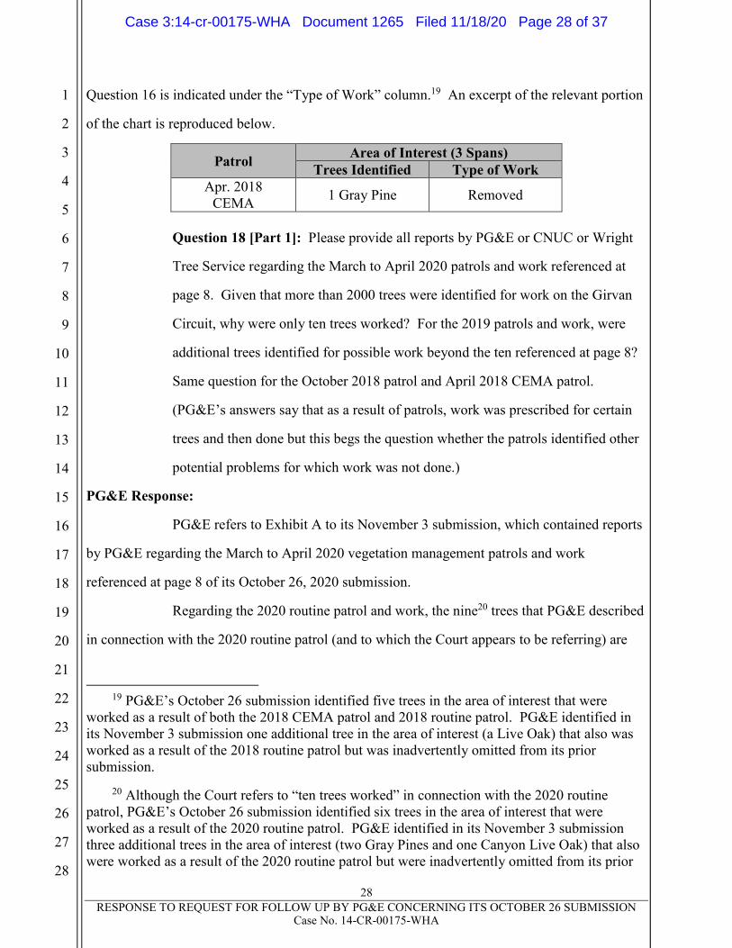
28
RESPONSE TO REQUEST FOR FOLLOW UP BY PG&E CONCERNING ITS OCTOBER 26 SUBMISSION Case No. 14-CR-00175-WHA
1
2
3
4
5
6
7
8
9
10
11
12
13
14
15
16
17
18
19
20
21
22
23
24
25
26
27
28
Question 16 is indicated under the “Type of Work” column.19 An excerpt of the relevant portion
of the chart is reproduced below.
Patrol Area of Interest (3 Spans)
Trees Identified Type of Work
Apr. 2018
CEMA 1 Gray Pine Removed
Question 18 [Part 1]: Please provide all reports by PG&E or CNUC or Wright
Tree Service regarding the March to April 2020 patrols and work referenced at
page 8. Given that more than 2000 trees were identified for work on the Girvan
Circuit, why were only ten trees worked? For the 2019 patrols and work, were
additional trees identified for possible work beyond the ten referenced at page 8?
Same question for the October 2018 patrol and April 2018 CEMA patrol.
(PG&E’s answers say that as a result of patrols, work was prescribed for certain
trees and then done but this begs the question whether the patrols identified other
potential problems for which work was not done.)
PG&E Response:
PG&E refers to Exhibit A to its November 3 submission, which contained reports
by PG&E regarding the March to April 2020 vegetation management patrols and work
referenced at page 8 of its October 26, 2020 submission.
Regarding the 2020 routine patrol and work, the nine20 trees that PG&E described
in connection with the 2020 routine patrol (and to which the Court appears to be referring) are
19 PG&E’s October 26 submission identified five trees in the area of interest that were
worked as a result of both the 2018 CEMA patrol and 2018 routine patrol. PG&E identified in
its November 3 submission one additional tree in the area of interest (a Live Oak) that also was
worked as a result of the 2018 routine patrol but was inadvertently omitted from its prior
submission.
20 Although the Court refers to “ten trees worked” in connection with the 2020 routine
patrol, PG&E’s October 26 submission identified six trees in the area of interest that were
worked as a result of the 2020 routine patrol. PG&E identified in its November 3 submission
three additional trees in the area of interest (two Gray Pines and one Canyon Live Oak) that also
were worked as a result of the 2020 routine patrol but were inadvertently omitted from its prior
Case 3:14-cr-00175-WHA Document 1265 Filed 11/18/20 Page 28 of 37
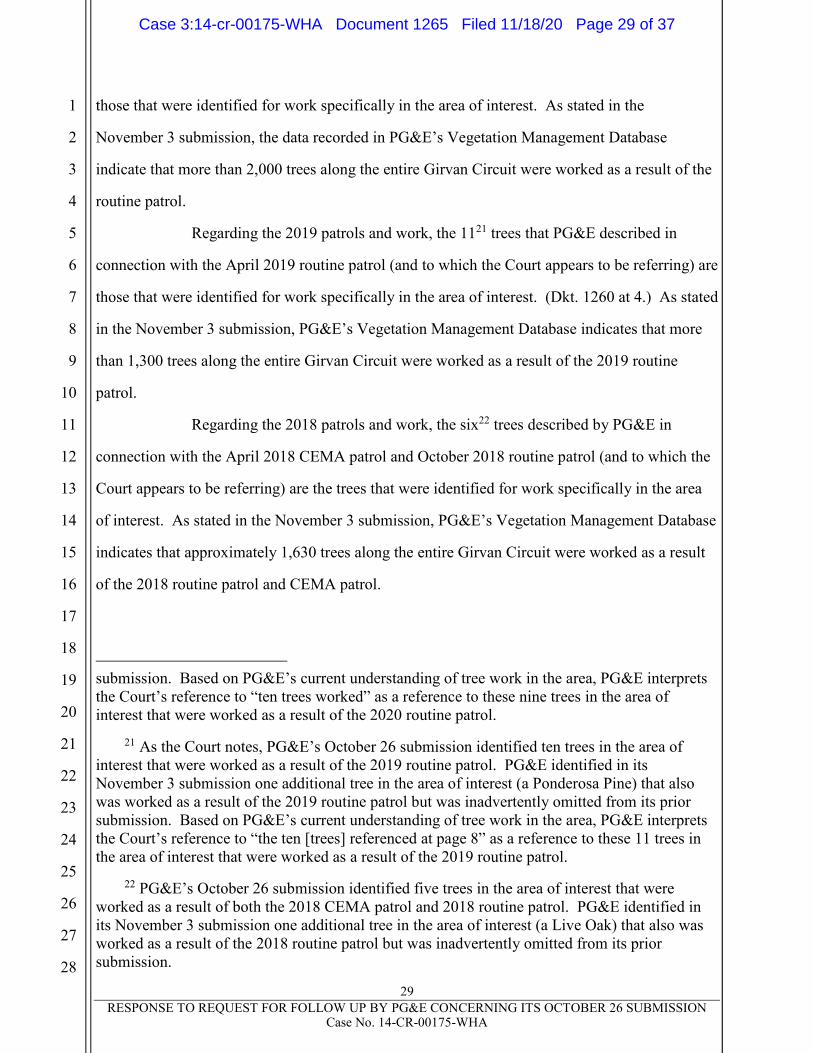
29
RESPONSE TO REQUEST FOR FOLLOW UP BY PG&E CONCERNING ITS OCTOBER 26 SUBMISSION Case No. 14-CR-00175-WHA
1
2
3
4
5
6
7
8
9
10
11
12
13
14
15
16
17
18
19
20
21
22
23
24
25
26
27
28
those that were identified for work specifically in the area of interest. As stated in the
November 3 submission, the data recorded in PG&E’s Vegetation Management Database
indicate that more than 2,000 trees along the entire Girvan Circuit were worked as a result of the
routine patrol.
Regarding the 2019 patrols and work, the 1121 trees that PG&E described in
connection with the April 2019 routine patrol (and to which the Court appears to be referring) are
those that were identified for work specifically in the area of interest. (Dkt. 1260 at 4.) As stated
in the November 3 submission, PG&E’s Vegetation Management Database indicates that more
than 1,300 trees along the entire Girvan Circuit were worked as a result of the 2019 routine
patrol.
Regarding the 2018 patrols and work, the six22 trees described by PG&E in
connection with the April 2018 CEMA patrol and October 2018 routine patrol (and to which the
Court appears to be referring) are the trees that were identified for work specifically in the area
of interest. As stated in the November 3 submission, PG&E’s Vegetation Management Database
indicates that approximately 1,630 trees along the entire Girvan Circuit were worked as a result
of the 2018 routine patrol and CEMA patrol.
submission. Based on PG&E’s current understanding of tree work in the area, PG&E interprets
the Court’s reference to “ten trees worked” as a reference to these nine trees in the area of
interest that were worked as a result of the 2020 routine patrol.
21 As the Court notes, PG&E’s October 26 submission identified ten trees in the area of
interest that were worked as a result of the 2019 routine patrol. PG&E identified in its
November 3 submission one additional tree in the area of interest (a Ponderosa Pine) that also
was worked as a result of the 2019 routine patrol but was inadvertently omitted from its prior
submission. Based on PG&E’s current understanding of tree work in the area, PG&E interprets
the Court’s reference to “the ten [trees] referenced at page 8” as a reference to these 11 trees in
the area of interest that were worked as a result of the 2019 routine patrol.
22 PG&E’s October 26 submission identified five trees in the area of interest that were
worked as a result of both the 2018 CEMA patrol and 2018 routine patrol. PG&E identified in
its November 3 submission one additional tree in the area of interest (a Live Oak) that also was
worked as a result of the 2018 routine patrol but was inadvertently omitted from its prior
submission.
Case 3:14-cr-00175-WHA Document 1265 Filed 11/18/20 Page 29 of 37

30
RESPONSE TO REQUEST FOR FOLLOW UP BY PG&E CONCERNING ITS OCTOBER 26 SUBMISSION Case No. 14-CR-00175-WHA
1
2
3
4
5
6
7
8
9
10
11
12
13
14
15
16
17
18
19
20
21
22
23
24
25
26
27
28
Question 18 [Part 2]: Please explain why the area of interest was not subject to a
separate CEMA patrol in 2019.
PG&E Response:
PG&E responded to this question in its November 3 submission. There, PG&E
explained the facts known to PG&E regarding why the area of interest was not subject to a
separate CEMA patrol in 2019, and PG&E refers the Court to that response. PG&E is now
supplementing its November 3 submission based on further investigation to include facts PG&E
has since learned regarding one issue described in that submission—specifically, the April 4,
2019 change in PG&E’s Project Management Database (“PMD”) to move the scheduled start
date for the CEMA patrol of the Zogg Mine Road area from November 15, 2019 to February 15,
2019.
Beginning in 2019, management of PG&E’s CEMA program was transferred
from a centralized CEMA team to each of the local PG&E offices that managed routine
vegetation management patrols. Also at this time, as previously noted, PG&E was moving to a
risk-informed schedule for vegetation management work that prioritized routine patrols for high
fire-risk circuits so that they occurred before fire season.
As described in PG&E’s November 3 submission, on January 29, 2019, a
database management specialist changed the scheduled start date for the routine patrol of the
Zogg Mine Road area to May 27, 2019, consistent with changes to the risk-based schedule for
2019. Prior to 2019, the routine patrol of the Zogg Mine Road area had been conducted in
October or November. On March 12, 2019, the same database management specialist changed
the scheduled start date for the separate CEMA patrol of the Zogg Mine Road area to
November 15, 2019, creating an approximate six-month offset from the new date for the routine
patrol. The database management specialist who made these changes was based in the local
office that had responsibility for the Zogg Mine Road area.
In late March 2019, a review of PMD was conducted to attempt to confirm that
the scheduled dates for all 2019 CEMA patrols were appropriately offset from the scheduled date
Case 3:14-cr-00175-WHA Document 1265 Filed 11/18/20 Page 30 of 37

31
RESPONSE TO REQUEST FOR FOLLOW UP BY PG&E CONCERNING ITS OCTOBER 26 SUBMISSION Case No. 14-CR-00175-WHA
1
2
3
4
5
6
7
8
9
10
11
12
13
14
15
16
17
18
19
20
21
22
23
24
25
26
27
28
of the corresponding routine patrol. This review was conducted by comparing the quarter in
which a routine patrol of a given circuit was scheduled to begin with the quarter in which the
corresponding CEMA patrol was scheduled to begin. At the time of the March 2019 review, the
routine patrol of the Zogg Mine Road area was scheduled to begin on May 27, 2019, a date in the
third quarter of PG&E’s pre-inspection calendar, and the CEMA patrol was scheduled for
November 15, 2019, a date in the fourth quarter of PG&E’s pre-inspection calendar.23
The data management specialist contractor conducting the March 2019 review
identified entries in the PMD that did not have a two-quarter offset between routine and CEMA
patrols for each circuit. PG&E understands that because the routine and CEMA patrols of the
Zogg Mine Road area were scheduled to occur in consecutive quarters (Q3 and Q4), the database
management specialist contractor conducting the March 2019 review changed, on April 4, 2019,
the scheduled start date of the CEMA patrol for the Zogg Mine Road area from Q4 (November
15) to a date in Q1 (February 15) to create a two-quarter offset from the routine patrol that had
been scheduled for May 27 (a date in Q3). Because Q1 had already passed by April 4, 2019, the
CEMA patrol registered in PMD as overdue after this change. PG&E notes that the routine
patrol conducted from March to April 2020 involved an assessment of the Zogg Mine Road area
for dead, diseased or dying trees (as would a CEMA patrol), but is not regarded by PG&E as a
separate CEMA patrol that counted toward PG&E’s 2019 Wildfire Mitigation Plan target of
100% completion of CEMA patrols on in-scope line miles. As noted above, trees were identified
for work and worked in the area of interest during the 2019 and 2020 routine patrols.
While the intent of the March 2019 review was to create an appropriate offset
between the routine and CEMA patrols, the use of quarters to identify CEMA patrols that needed
rescheduling did not account for the fact that the routine and CEMA patrols for the Zogg Mine
23 PG&E’s pre-inspection calendar begins approximately six weeks prior to the start of the
calendar year, running from November 16 to November 15, as opposed to January 1 to
December 31. Under this calendar, the beginning dates for each quarter are November 16,
February 16, May 16 and August 16 for the first, second, third and fourth quarters, respectively.
Case 3:14-cr-00175-WHA Document 1265 Filed 11/18/20 Page 31 of 37
32
RESPONSE TO REQUEST FOR FOLLOW UP BY PG&E CONCERNING ITS OCTOBER 26 SUBMISSION Case No. 14-CR-00175-WHA
1
2
3
4
5
6
7
8
9
10
11
12
13
14
15
16
17
18
19
20
21
22
23
24
25
26
27
28
Road area were already scheduled approximately six months apart, even though they were
scheduled for consecutive quarters.
These mid-year scheduling adjustments to the CEMA patrols were unique to
2019, given the previously detailed transition in that year to risk-based reprioritization of routine
patrols.
The fact that a separate CEMA inspection was not performed when the schedule
would have caused it to be completed close in time to a routine patrol is consistent with guidance
from PG&E’s vegetation management team in 2019. Under that guidance, PG&E did not
perform a separate CEMA inspection and closed the CEMA project in PG&E’s PMD following
commencement of the routine patrol in situations where, as a result of risk-based prioritization
changes to the routine patrol schedule, the CEMA patrol (the scope of which is subsumed in a
routine patrol) had been scheduled close in time to the routine patrol.
Question 19: Please attach in chronological order paper copies of all maps, charts,
diagrams, reports, memos, text messages, emails, recordings, or other documents in your
possession that refer to the Girvan Line or any PSPS in Shasta County that were
consulted or prepared in the period from September 21 to September 30, 2020, in
connection with the PSPS. Videos or recordings of Zoom or similar meetings may be
provided by thumb drive along with a paper index of the drive’s contents.
PG&E Response:
PG&E has delivered to the Court 12 indexed binders containing paper copies of
the 1,422 documents bearing Bates PGE-ZOGG-NDCAL-00000001 to PGE-ZOGG-NDCAL-
00009367 that PG&E has identified as potentially responsive to this request. Because certain
potentially responsive Excel files and mapping files are not formatted to be conducive to easy
printing, PG&E included slipsheets bearing the Bates numbers in lieu of such files in the binders
and has provided such files on a thumb drive that PG&E has also delivered.
PG&E understands the phrase “any PSPS in Shasta County” in the Court’s
request to refer to the three circuits in Shasta County that were de-energized as part of the
Case 3:14-cr-00175-WHA Document 1265 Filed 11/18/20 Page 32 of 37

33
RESPONSE TO REQUEST FOR FOLLOW UP BY PG&E CONCERNING ITS OCTOBER 26 SUBMISSION Case No. 14-CR-00175-WHA
1
2
3
4
5
6
7
8
9
10
11
12
13
14
15
16
17
18
19
20
21
22
23
24
25
26
27
28
September 27, 2020 PSPS event. To respond to the Court’s document request in the time
provided by the Court, PG&E has attempted to conduct a reasonable search for responsive
documents by using the following parameters. PG&E identified a list of eight custodians (the
“Custodians”) likely to have documents responsive to the Question, including individuals who
served during the September 27, 2020 PSPS event as the Officer-In-Charge, Emergency
Operations Center (“EOC”) Commander, Deputy EOC Commander, Meteorologist-In-Charge,
Operations Chief, Planning Chief and Customer Strategy Officer. PG&E also identified the
September 27, 2020 PSPS event folders (the “Folders”) of three electronic repositories likely to
have documents responsive to the request: the Emergency Operations Center SharePoint, the
Emergency Operations Center Operations SharePoint and the Meteorology Shared Drive.
PG&E ran the following search terms against the Custodians’ and Folders’
documents: Girvan*, Shasta*, Deschutes*, Volta*, Time Place 6, TimePlace6, TimePlace 6,
Time Place 06, TimePlace06, TimePlace 06, TP 6, TP6, TP 06 and TP06. Each of the
Custodians’ and Folders’ documents dated between September 21 and September 30, 2020 that
contained one or more of the Search Terms was reviewed and, if determined to be potentially
responsive to the request, produced to the Court. Where applicable, PG&E has redacted portions
of documents determined to be protected by attorney-client privilege or to constitute attorney
work product.
PG&E notes that certain documents in the binders being produced to the Court
contain confidential information, including employee-identifying information. PG&E is in the
process of identifying and redacting such confidential information and, when it has done so, will
file a motion to seal the documents provided to the Court on the docket with such redactions
applied.
Case 3:14-cr-00175-WHA Document 1265 Filed 11/18/20 Page 33 of 37

34
RESPONSE TO REQUEST FOR FOLLOW UP BY PG&E CONCERNING ITS OCTOBER 26 SUBMISSION Case No. 14-CR-00175-WHA
1
2
3
4
5
6
7
8
9
10
11
12
13
14
15
16
17
18
19
20
21
22
23
24
25
26
27
28
Dated: November 18, 2020 Respectfully Submitted,
JENNER & BLOCK LLP
By: /s/ Reid J. Schar
Reid J. Schar (pro hac vice)
CRAVATH, SWAINE & MOORE LLP
By: /s/ Kevin J. Orsini
Kevin J. Orsini (pro hac vice)
CLARENCE DYER & COHEN LLP
By: /s/ Kate Dyer
Kate Dyer (Bar No. 171891)
Attorneys for Defendant PACIFIC
GAS AND ELECTRIC COMPANY
Case 3:14-cr-00175-WHA Document 1265 Filed 11/18/20 Page 34 of 37
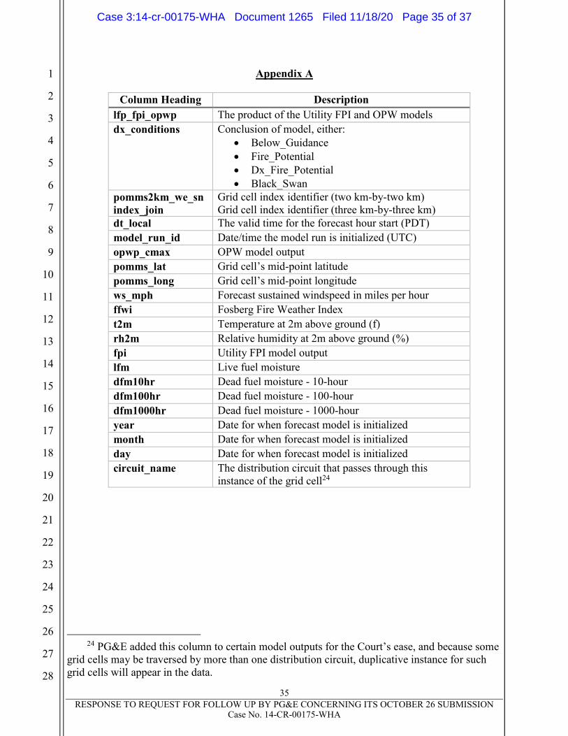
35
RESPONSE TO REQUEST FOR FOLLOW UP BY PG&E CONCERNING ITS OCTOBER 26 SUBMISSION Case No. 14-CR-00175-WHA
1
2
3
4
5
6
7
8
9
10
11
12
13
14
15
16
17
18
19
20
21
22
23
24
25
26
27
28
Appendix A
24 PG&E added this column to certain model outputs for the Court’s ease, and because some
grid cells may be traversed by more than one distribution circuit, duplicative instance for such
grid cells will appear in the data.
Column Heading Description
lfp_fpi_opwp The product of the Utility FPI and OPW models
dx_conditions Conclusion of model, either:
Below_Guidance
Fire_Potential
Dx_Fire_Potential
Black_Swan
pomms2km_we_sn
index_join
Grid cell index identifier (two km-by-two km)
Grid cell index identifier (three km-by-three km)
dt_local The valid time for the forecast hour start (PDT)
model_run_id Date/time the model run is initialized (UTC)
opwp_cmax OPW model output
pomms_lat Grid cell’s mid-point latitude
pomms_long Grid cell’s mid-point longitude
ws_mph Forecast sustained windspeed in miles per hour
ffwi Fosberg Fire Weather Index
t2m Temperature at 2m above ground (f)
rh2m Relative humidity at 2m above ground (%)
fpi Utility FPI model output
lfm Live fuel moisture
dfm10hr Dead fuel moisture - 10-hour
dfm100hr Dead fuel moisture - 100-hour
dfm1000hr Dead fuel moisture - 1000-hour
year Date for when forecast model is initialized
month Date for when forecast model is initialized
day Date for when forecast model is initialized
circuit_name The distribution circuit that passes through this
instance of the grid cell24
Case 3:14-cr-00175-WHA Document 1265 Filed 11/18/20 Page 35 of 37
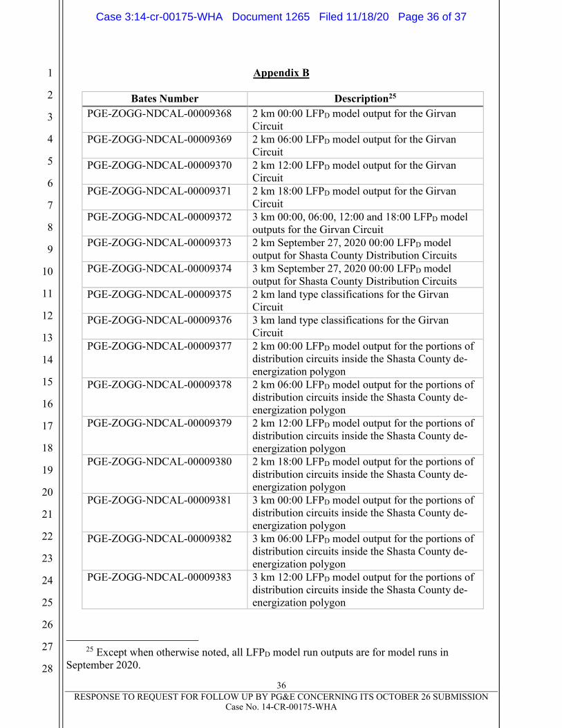
36
RESPONSE TO REQUEST FOR FOLLOW UP BY PG&E CONCERNING ITS OCTOBER 26 SUBMISSION Case No. 14-CR-00175-WHA
1
2
3
4
5
6
7
8
9
10
11
12
13
14
15
16
17
18
19
20
21
22
23
24
25
26
27
28
Appendix B
25 Except when otherwise noted, all LFPD model run outputs are for model runs in
September 2020.
Bates Number Description25
PGE-ZOGG-NDCAL-00009368 2 km 00:00 LFPD model output for the Girvan
Circuit
PGE-ZOGG-NDCAL-00009369 2 km 06:00 LFPD model output for the Girvan
Circuit
PGE-ZOGG-NDCAL-00009370 2 km 12:00 LFPD model output for the Girvan
Circuit
PGE-ZOGG-NDCAL-00009371 2 km 18:00 LFPD model output for the Girvan
Circuit
PGE-ZOGG-NDCAL-00009372 3 km 00:00, 06:00, 12:00 and 18:00 LFPD model
outputs for the Girvan Circuit
PGE-ZOGG-NDCAL-00009373 2 km September 27, 2020 00:00 LFPD model
output for Shasta County Distribution Circuits
PGE-ZOGG-NDCAL-00009374 3 km September 27, 2020 00:00 LFPD model
output for Shasta County Distribution Circuits
PGE-ZOGG-NDCAL-00009375 2 km land type classifications for the Girvan
Circuit
PGE-ZOGG-NDCAL-00009376 3 km land type classifications for the Girvan
Circuit
PGE-ZOGG-NDCAL-00009377 2 km 00:00 LFPD model output for the portions of
distribution circuits inside the Shasta County de-
energization polygon
PGE-ZOGG-NDCAL-00009378 2 km 06:00 LFPD model output for the portions of
distribution circuits inside the Shasta County de-
energization polygon
PGE-ZOGG-NDCAL-00009379 2 km 12:00 LFPD model output for the portions of
distribution circuits inside the Shasta County de-
energization polygon
PGE-ZOGG-NDCAL-00009380 2 km 18:00 LFPD model output for the portions of
distribution circuits inside the Shasta County de-
energization polygon
PGE-ZOGG-NDCAL-00009381 3 km 00:00 LFPD model output for the portions of
distribution circuits inside the Shasta County de-
energization polygon
PGE-ZOGG-NDCAL-00009382 3 km 06:00 LFPD model output for the portions of
distribution circuits inside the Shasta County de-
energization polygon
PGE-ZOGG-NDCAL-00009383 3 km 12:00 LFPD model output for the portions of
distribution circuits inside the Shasta County de-
energization polygon
Case 3:14-cr-00175-WHA Document 1265 Filed 11/18/20 Page 36 of 37
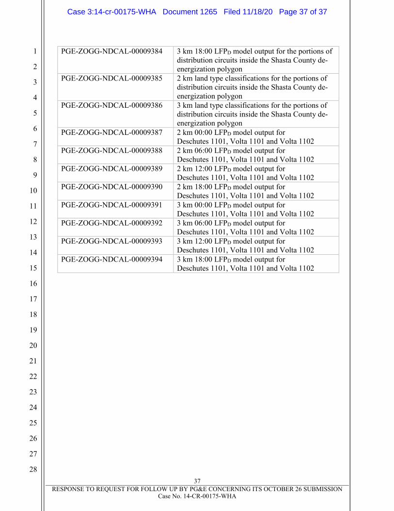
37
RESPONSE TO REQUEST FOR FOLLOW UP BY PG&E CONCERNING ITS OCTOBER 26 SUBMISSION Case No. 14-CR-00175-WHA
1
2
3
4
5
6
7
8
9
10
11
12
13
14
15
16
17
18
19
20
21
22
23
24
25
26
27
28
PGE-ZOGG-NDCAL-00009384 3 km 18:00 LFPD model output for the portions of
distribution circuits inside the Shasta County de-
energization polygon
PGE-ZOGG-NDCAL-00009385 2 km land type classifications for the portions of
distribution circuits inside the Shasta County de-
energization polygon
PGE-ZOGG-NDCAL-00009386 3 km land type classifications for the portions of
distribution circuits inside the Shasta County de-
energization polygon
PGE-ZOGG-NDCAL-00009387 2 km 00:00 LFPD model output for
Deschutes 1101, Volta 1101 and Volta 1102
PGE-ZOGG-NDCAL-00009388 2 km 06:00 LFPD model output for
Deschutes 1101, Volta 1101 and Volta 1102
PGE-ZOGG-NDCAL-00009389 2 km 12:00 LFPD model output for
Deschutes 1101, Volta 1101 and Volta 1102
PGE-ZOGG-NDCAL-00009390 2 km 18:00 LFPD model output for
Deschutes 1101, Volta 1101 and Volta 1102
PGE-ZOGG-NDCAL-00009391 3 km 00:00 LFPD model output for
Deschutes 1101, Volta 1101 and Volta 1102
PGE-ZOGG-NDCAL-00009392 3 km 06:00 LFPD model output for
Deschutes 1101, Volta 1101 and Volta 1102
PGE-ZOGG-NDCAL-00009393 3 km 12:00 LFPD model output for
Deschutes 1101, Volta 1101 and Volta 1102
PGE-ZOGG-NDCAL-00009394 3 km 18:00 LFPD model output for
Deschutes 1101, Volta 1101 and Volta 1102
Case 3:14-cr-00175-WHA Document 1265 Filed 11/18/20 Page 37 of 37