
wildlifereport2013
26
1 Boulder County Parks and Open Space Wildlife Program Annual Report 2013 TABLE OF CONTENTS Goals and Accomplishments 2013 2 Goals 2013 Results Summaries 4 Goals 2013 Background Information 5 Annual Program of Work Avian Monitoring 9 Mammals 14 Fish 18 Amphibians 19 Volunteer Contributions Long-term projects 21 One-day projects 25 Planning and Coordination 25 Research 27
Transcript of wildlifereport2013
1
Boulder County Parks and Open Space Wildlife Program Annual Report 2013
TABLE OF CONTENTS Goals and Accomplishments 2013 2 Goals 2013 Results Summaries 4 Goals 2013 Background Information 5 Annual Program of Work Avian Monitoring 9 Mammals 14 Fish 18 Amphibians 19 Volunteer Contributions Long-term projects 21 One-day projects 25
Planning and Coordination 25 Research 27

2
Accomplishment of Stated Goals for 2013 Goals 2013
1. Complete the update to the Environmental Resources Element of the Boulder County Comprehensive Plan. Results:
We achieved this goal by October, 2013. We accomplished this by dedicating two full-time wildlife specialists to work exclusively on the update. Additionally, considerable time from the rest of wildlife staff was dedicated towards the accomplishment of this significant goal.
The update includes a comprehensive overhaul of the Goals and Policies of the ERE, as well as a
complete set of new Resource Maps. The maps are based on a comprehensive set of data staff created which is presented as a set of supplemental materials. These supplemental materials include critically reviewed lists of Species of Special Concern, the in-house developed sets of scientific criteria and detailed information describing each Critical Wildlife Habitat (CWH) and Environmental Conservation Area (ECA).
The Update was approved by the Boulder County Planning Commission in November, 2013. We
expect final adoption by mid-2014 when its relation to Boulder County Land Use codes is finalized.
2. Continue developing the Wildlife Geodatabase with prioritization given to completing the Breeding Bird database. Continue to develop and refine the Special Habitat Features and Road Ecology databases. Results:
A database for housing Road Ecology information (wildlife collision locations, crossing locations) was completed and combined into one usable data layer in the wildlife geodatabase. The Abert’s squirrel, shrub monitoring, bobolink, camera, raptor nest databases continue to be populated with recent data on an annual and rolling basis.
Development of the Breeding Bird database was delayed in 2013 due to work load adjustments
following the September flood. This dataset continues to be next in priority.
3. Complete a thorough feasibility assessment of establishing a designated, safe highway crossing on US 36 for wildlife movement. Results:
Wildlife staff completed a feasibility study for facilitated crossings of US36 near Lyons. The rural nature, snow-free winter range, and attractive irrigated cropland make habitat east of US36 attractive to elk. Crossing the Foothills Highway is dangerous for both elk and motorists traveling or commuting in the late winter, and especially the spring. Collisions are common, and not just elk, but include large carnivores like cougars and black bear. The study identified sites along the highway that could support either a constructed overpass or redeveloped underpass for wildlife to safely traverse the busy and dangerous Foothills Highway.

3
4. Develop Forestry BMPs, including consideration of snags/hazard trees.
Results: This goal was partially met in 2013. Input into forestry treatment prescriptions, including
consistent language regarding snag retention, and coarse woody debris was achieved. However, standardized and adopted BMPs have not been formally crafted.
5. Incorporate OSMP’s waterfowl monitors’ data into the BCPOS- developed waterfowl online database. Results:
Changes in the development of an online waterfowl monitoring database precluded the ability of OSMP and BCPOS to combine data for this program. Development of this option will continue to be discussed with OSMP as the database structure is improved.
6. Develop a program that uses volunteers to sample for aquatic insects and other bottom-dwelling
invertebrate species in BCPOS lakes and streams for implementation in 2014. Results:
We have been developing the framework for the BCPOS Aquatic Macroinvertebrate Monitoring and Research Volunteer Program. The program is actively being developed, which includes decisions about the monitoring design and coordinating with other local groups who have been conducting this kind of work, and we expect to start monitoring by mid-2014.
7. Continue owl surveys, and participate formally in the national effort to document nightjar (common
poorwill, nighthawk) presence on our properties. Results:
Owl surveys continued for a second season in 2013 with several routes on Hall Ranch, Heil Valley Ranch, and Rabbit Mountain. Northern pygmy Owl and Great-horned owl were detected. Nightjar surveys were combined with Flammulated owl surveys at Heil Valley Ranch. Common Nighthawk and Common Poorwill were detected.
Goals 2013 Background Information
1. Complete the update to the Environmental Resources Element of the Boulder County Comprehensive Plan.
After many months of meeting all the experts, digging up every old and new map and every report ever written about natural resources in Boulder County, the ERE update process is now complete. The successful update of the BCCP ERE has received numerous accolades and praise from the BOCC, PC, POSAC and a variety of natural resource agencies, experts and local groups. Many people from the public have written and appeared at hearings to express support of the ERE update, its aspirations and positive influence it will continue to provide to our County way of life.

4
The update includes a comprehensive overhaul of the Goals and Policies of the ERE, as well as a complete set of new Resource Maps. The maps are based on a comprehensive set of data staff created which is presented as a set of supplemental materials. These supplemental materials include critically reviewed lists of Species of Special Concern, the in-house developed sets of scientific criteria and a vast amount (over 200 pages) of detailed, written information describing, for instance, each Critical Wildlife Habitat and Environmental Conservation Area. Also crafted are extensive narrative backgrounds and detailed listing of information sources for the resources we mapped and species placed on lists. Our hope is that these narratives, and the rest of the supplemental materials, gives context and understanding to the historical impact of the ERE, as well as shedding light on how the current maps and lists uphold the Goals and Vision of the Boulder County Comprehensive Plan.
The ERE Update team is extremely proud of their work, and thankful to every member of staff
who supported, guided and nurtured this process along. It should be noted that this process was truly a team effort and we feel that the update will positively influence our community for many years to come. We are grateful for the opportunity to have participated.
A full list of all the ERE materials are currently available on the Boulder County website by
querying “Boulder County Comprehensive Plan Update”. We expect the ERE to be fully adopted by the Planning Commission sometime in mid-2014.
2. Continue developing the Wildlife Geodatabase with prioritization given to completing the Breeding Bird database. Continue to develop and refine the Special Habitat Features and Road Ecology databases.
In 2010, a wildlife geodatabase was created using ArcMap software that all wildlife staff are familiar with. Thousands of records were merged, and staff was trained to use queries to extract data subsets.
Development of a flexible schema and database for Breeding Bird data is a priority for 2014.
The Abert’s squirrel, shrub monitoring, bobolink, camera, raptor nest databases continue to be populated with recent data on an annual and rolling basis. Each of these geodatabase elements serve as a digital repository for the ongoing datasets collected or accumulated by wildlife staff.
In addition to the development of the above databases, wildlife staff recognized a need to create a shared location for capturing additional field data that is not part of formal surveys. Field observations such as wildlife travel routes, high value habitat, den sites, and occurrence of non-target species are included.
A Road Ecology geodatabase component was recently created by wildlife staff to support
interest in exploring options to reduce wildlife mortality and wildlife-vehicle collisions in elk migration areas along US Highway 36 from Boulder to Lyons. The CDOT Annual Roadkill Report for US36/Foothills highway is not always complete, and this database enables wildlife staff to compare the annual report to staff observations, and pinpoint wildlife crossings and hazard locations. (See Goal 3 for related information).
3. Complete a thorough feasibility assessment of establishing a designated, safe highway crossing on US 36 for wildlife movement.
This study outlined various strategies (and their costs) that could be employed along this stretch
of highway to reduce collisions. One of them, night speed limits, was enacted by Colorado Department of Transportation in 2010. The study also identified sites along the highway that could support a

5
constructed overpass, redeveloped underpass, or lighted at-grade crossing, like the one in nearby Golden, for wildlife to safely traverse the busy and dangerous Foothills Highway.
The lighted crossing cost $450,000 in 2010 dollars. Bridges and underpasses will cost in excess of $1,000,000 and perhaps as high as $5,000, 000 for a substantive overpass. This stretch of highway is not a high priority for modification when compared to elk/deer/lynx populations in the I-70 corridor or other deer ranges in the state. The first constructed overpass in Colorado is scheduled to be built in 2014 in dense deer habitat near Kremmling on State Highway 9. The feasibility study is a first step to identifying issues and possibilities should the collision rate increase and as other crossings get completed, or as money becomes available.
4. Develop Forestry BMPs, including consideration of snags/hazard trees. See details above.
5. Incorporate OSMP’s waterfowl monitors’ data into the BCPOS- developed waterfowl online database.
Development of a shared, secure online waterfowl monitoring database for OSMP and BCPOS will continue to be discussed with OSMP as the database structure is explored and improved. Both organizations have staff and volunteer programs collecting waterfowl data at specific locations year-round, therefore an online database allowing staff access to monitoring records would provide a valuable clearinghouse to help inform management decisions.
6. Develop a program that uses volunteers to sample for aquatic insects and other bottom-dwelling invertebrate species in BCPOS lakes and streams for implementation in 2014.
We have been developing the framework for the BCPOS Aquatic Macroinvertebrate Monitoring and Research Volunteer Program. This kind of program provides a well-established, accurate and rapid method of assessing the ecological health of our water resources. The presence or absence (and number) of particular insect species or group of species indicates how clean the water is, the diversity of habitat structure in a stream reach and the overall ecological value of a water body. Aquatic insects respond very quickly to changes in the habitat and water quality.
This will be a particularly applied program for assessing the recovery of our waterways and
water resources following the 2013 flooding because it provides a baseline ecological condition report and, using a rapid assessment protocol, a way to track the recovery and regeneration of habitat in streams or ponds in near real-time. It also allows us another way to explain the diversity of waterfowl tracked by our wildlife group, as well as assist in our fisheries program. In addition to the scientific value, well-qualified volunteers have an opportunity to participate in an engaging, educational and rewarding new BCPOS program.
It is anticipated that volunteers will be selected from a variety of backgrounds, with some
emphasis placed on providing practical field experience to local college students as well as volunteer naturalists, engaged members of local environmental groups and other qualified members of the public. The long-term goal of the program will be to successfully publish results in scientific journals.
The primary method of the research and monitoring involves the use of specific equipment, such
as pocket stream nets and D-ring dipnets. For identification of many insects (and other invertebrates), it will be necessary to use dissecting microscopes with digital imaging capability, and we expect this will be a fun component for volunteers as they learn about the morphology and behavior of the organisms we

6
are identifying. We will also be collecting stream water quality using a digital multiparameter instrument which measures oxygen, pH, temperature and conductivity—all of which relate to biological water quality.
The program is actively being developed, which includes decisions about the monitoring design
and coordinating with other local groups who have been conducting this kind of work, and we expect to start monitoring by mid-2014.
7. Continue owl surveys, and participate formally in the national effort to document nightjar (common poorwill, nighthawk) presence on our properties.
In order to provide the most information for land assessment and management activities, staff recognized the need to include surveys for nocturnal owl species. Multi-species surveys such as breeding bird and diurnal raptor surveys utilize methods that are poor for detecting the presence of owls. Using standard techniques for determining owl status, range, and habitat associations, survey points were placed along routes through and adjacent to the area of treatment.
Nocturnal owl surveys at Heil Valley Ranch resulted in new detections of Great-horned Owl and Northern pygmy Owl in the area of the Picture Rock trail and Pyrite Road, in addition to a second year of detections west of the Wapiti Trail. Additional surveys were done on Rabbit Mountain, and although no detections were made, Great-horned owl and Short-eared Owl were recorded as using the area during later winter of 2013. Eastern Screech Owls were opportunistically detected at Pella Ponds during the spring of 2013.
In May of 2012 and 2013, surveys were done specifically for Flammulated Owl within the forestry treatment area at Heil Valley Ranch, and no detections were made. In 2012, staff discovered areas adjacent to the treatment unit were being utilized by a high number of breeding nightjars, which are generally in decline across the United States. Spring surveys for nightjars at Heil Valley Ranch did not result in the high numbers of poorwill detected the previous year. Documentation of nightjar use on Open Space continues to be of interest and will again be pursued in 2014.
Goals 2014
1. The flood event of September, 2013 caused major changes in the direction of our department. As such, our goal is to remain flexible and adaptable to accommodate new priorities as they evolve. As such:
Continue to consult with USFWS on ESA issues with emergency actions and restoration planning.
o Document actions taken to ensure conservation measures were/are implemented for all projects occurring within suitable habitat for T&E species.
Develop long-term monitoring to assess baseline status and then recovery of affected species within flood-damaged habitat areas.
Work towards providing Environmental information within Project Worksheets to expedite the FEMA review process.
Provide expertise towards informing Stream Master Planning efforts. Assist department by providing information and effort towards grant application development as
requested. As possible, wildlife staff will research grant opportunities.
7
2. Continue our long-term monitoring volunteer programs, at a minimum maintaining their current level of
participation. 2a). Attempt to increase our long-term monitoring program despite the changes caused by the flooding event. Incorporate the marcro-invertebrate sampling into our long-term monitoring program, as a pilot year (may succeed in recruiting volunteers for 2014, but if not, focus on full implementation for 2015).
3. Incorporate the newly updated Species of Special Concern (SSC) and Critical Wildlife Habitats (CWH)
into our internal program of work. Draft guidelines on how the Wildlife group will approach management recommendations where SSC or CWH are factors.
4. Continue to work towards the completion of the Wildlife Policy.
4a). While the official process of developing Wildlife Policy has been officially delayed, Wildlife staff will continue to work on compiling information to develop our already created outline. We will conduct literature reviews, etc., to assist in drafting guidelines for each defined topic.
5. Stabilize and make accessible all the documents, literature, and information used to inform the Update
of the BCCP-ERE. This step is critical in assuring the long-term usability of these documents, and maintaining the continuity of knowledge towards the next update process.

8
Avian Program 2013 Raptors Raptor nests were again monitored in 2012 for productivity. Monitoring is done by BCPOS volunteers and staff, CPW and Rocky Mountain Bird Observatory Bald Eagle Watch. BCPOS Volunteers and staff monitor golden eagle, osprey, and prairie falcon nests. Volunteers (6) contributed 409 hours to this effort in 2013. All nesting information was sent to the University of Colorado for inclusion into the annual cliff-nesting raptor report for the Front Range (golden eagles, prairie falcons and peregrine falcons.) Bald Eagle Nest Monitoring We continued to coordinate monitoring three bald eagles nests on POS property with the CPW. We observed a new nesting attempt at Western Mobile in 2011, and this new pair territorially displaced the pair referred to as the “Braly” pair in past records. In 2011, this new pair (Western Mobile) successfully nested and fledged 3. In late 2011, another new pair attempted to nest near POS property south of Lagerman Reservoir. This pair’s first nesting attempt in 2012 failed, but fledged 2 young in 2013. 2013 Results
Nest Location-Bald Eagles Number of Fledglings Wambsganss (Panama) 2 Keyes North 1 Western Mobile 1 IMEL 2 Braly Displaced by W. Mobile pair in 2011
Golden Eagle Nest Monitoring Staff and volunteers monitored the six known golden eagle nest sites on BCPOS properties in 2013.

9
We identified a previously unknown nest site at BLM South (Walker Ranch Southern parcel), which staff will continue to monitor in 2014. 2013 Results
Nest Location-Golden Eagles Number of Fledglings Heil Valley Ranch 2 Heil Valley Ranch 2 Wyn/Forsberg 2 Meadow Park 2 Rabbit Mountain 1 BLM South – South Draw Pair present, but no nesting BLM South – East Draw 2 (jointly monitored by
OSMP/POS) Burrowing Owl Nest Monitoring In 2013, seven sites had burrowing owl sightings, including three never before used sites. Six of these sites had potential burrowing owl nests located, but most failed early in the season. Several returning males did not appear to find a mate by the start of nesting. Late snowstorms may have impacted this year’s nesting success. 2013 Results
Nest Locations-Burrowing Owls Number of Fledglings Rock Creek Farm 0 Rock Creek Farm 0 Lagerman 0 Lagerman 0 Swanson 4 Wasson 0 Wolf Run 0 (owl present early season,
but no nesting documented) Osprey Nest Monitoring BCPOS staff and wildlife volunteers monitored osprey nests at Lagerman Reservoir, Western Mobile, and the St. Vrain private Conservation Easement platform. We monitored the osprey platform at Boulder County Fairgrounds using a newly installed remote camera linked to an online hosting website. The osprey-cam allowed anyone to observe the nesting activity in real-time, day and night. The camera failed early season, but funds have been appropriated for a new, improved camera. We hope to have it up and running for the 2014 season. Returning ospreys used platforms at Lagerman and the conservation easement on St. Vrain Road in 2011, 2012, and 2013. New platforms were installed by the City of Longmont (75th and Nelson Rd.) and Longmont Power (owned by Martin Marietta Materials) adjacent to BCPOS Toteve property. 2013 Results
Nest Location-Osprey Number of Fledglings Lagerman Reservoir 2 Fairgrounds 1 Conservation Easement – St. Vrain Road 2 Western Mobile\Toteve 2 75th and Nelson Pair present, not successful.

10
Prairie Falcon Nest Monitoring Staff and volunteers determined known nesting sites were inactive during the 2013 season. All nesting information was sent to the University of Colorado for inclusion into the annual cliff-nesting raptor report for the Front Range (golden eagles, prairie falcons and peregrine falcons.) 2013 Results
Nest Location-Prairie Falcon Number of Fledglings Walker Ranch-Castle Rock Inactive Hall Ranch Inactive Heil Valley Ranch Inactive Geer Canyon Inactive Steamboat Mountain Inactive
Northern Goshawk Monitoring In 2013, surveys for northern goshawks were conducted at Heil Valley Ranch, and Caribou Ranch (Sherwood Gulch). No detections were made. 2013 Results Heil Valley Ranch- Broadcast surveys were conducted in several locations of northwest Heil Valley Ranch along USFS and the Ochs Conservation Easement. Peck Gulch- the Peck Gulch nest was inactive in 2012, but was revisited by staff late in the summer of 2013. The primary nest appeared to be usurped by Great-horned owl. One of two nearby, alternate nests on private land was being utilized by ravens. Close coordination continues with the private landowner adjacent to this territory, and they alerted us to the possibility of an active nest on another adjacent private parcel in 2013. We will continue to monitor this site in 2014. Additionally, resource protection staff worked with wildlife staff to inform adjacent neighbors of the need to minimize activities near one of the nest locations. It is believed that increased neighbor activity in the form of ATV use and social trail construction lead to nest failure. The neighbors were cooperative and will cease access of the closed area adjacent to their parcel. Meyers Gulch- Dawn acoustical surveys were not conducted on the northern Meyers Gulch pipeline in 2013, however staff continued to see goshawk in the area of the Staley property during the summer months. Additional Detections of Raptor Species POS staff located or monitored several additional sites in 2013. At Duck Lake, Resource Protection and Wildlife Staff confirmed an active Sharp-shinned hawk nest. A Cooper’s hawk nested again at BLM South in 2013. 2013 Breeding Bird Surveys In 2013, breeding bird survey methodology was updated to follow the 2011 Rocky Mountain Bird Observatory design which selects survey points in a spatially balanced way, and includes distance sampling as part of the field protocol. Selection of new survey points was done using a combination of Program-R and ArcMap, (See below for a summary of the sampling design). Breeding bird surveys were conducted using this new method on six properties in 2013:
Western Mobile Braly BLM South Rabbit Mountain

11
Southeast Buffer Hall-II
All point count stations were surveyed four times during the timeframe of May 15 through July 15. Selection of properties to be surveyed was based on the need for initial baseline information, continuation of baseline/trend monitoring via long-term survey schedule or in response to future management activities. All surveys were conducted by wildlife staff. Resource protection assisted with Hall-II surveys. Back ground on Sampling Design Using Program-R and Generalized Random Tessellation Stratified (GRTS) Selection of survey points involved the use of Program-R and ArcMap 10.0. A POS fee properties shapefile was provided to RMBO as the Sample Frame. Using the United States National Grid (USNG), RMBO created an attributed shapefile of gridded POS fee properties using the grid centroid. Attributes of the grid include land ownership, hydrography, and NRCS ecoregions. The USNG is the standard format used at the national level for emergency response and geospatial industries. This scalable and customizable design allows land managers to stratify based on individual agency needs objectives. Wildlife staff attributed the grid with additional components that would satisfy the potential need for stratification of the sampling units. Additional processing of the Sampling Frame of POS fee properties utilizing spsurvey package in Program-R which uses the GRTS algorithm to spatially select points based on preferred strata. Figure 1: Creation of strata using ArcMap involved the union of the sampling grid to clipped slope and vegetation data. The vector grid of 16 spatially arranged points per cell is shown.

12
Results Results from these surveys, including species detected and relative abundance indices are on file and can be accessed via communication with wildlife staff at Parks and Open Space. Pilot data collected using the new spatially balanced method will not be available until staff evaluates use of this method on POS. Bluebird Nest Box Project In 2013, volunteers from both BCNA and Boulder County Audubon Society (BCAS) monitored approximately 100 bluebird nest boxes. The box routes are located at Heil Valley Ranch, Betasso Preserve, Walker Ranch, Minnick and Bald Mountain. At the end of 2013, after two seasons of high predation rates, OSMP and BCPOS agreed to discontinue the Shanahan and Eldorado bluebird routes. As in previous years, all data are being shared with the Cornell Lab of Ornithology Nestwatch Program, which monitors nest box data nationwide. Volunteers worked in pairs and visited their assigned nest box route approximately once per week. In total, 18 volunteers contributed 830 hours to this project between late April and early August. Waterfowl Monitoring Project The aquatic bird volunteers covered four major plains aquatic habitat areas; Braly/Western Mobile complex, Pella Ponds, Kenosha Ponds and Walden Ponds. Two volunteers were teamed up on each property to allow them to schedule their own monitoring days as necessary. All aquatic species seen during these visits, including wading birds and shorebirds were recorded. In total, 7 volunteers contributed 223 hours to this program in 2013. Post flood monitoring occurred starting in November 2013, and the altered use patterns will be analyzed over time.
Mammals 2013 Prairie Dog Management Relocation In 2012, we successfully relocated 45 prairie dogs from our Alexander Dawson property to Rabbit Mountain. In 2013, we continued to monitor the success of this effort, and found that these animals are still on site, and successfully reproduced in 2013. We continue to monitor the site. Removal Removal via trapping of prairie dogs occurred on 7 properties in 2013. 3 of these properties are designated as No Prairie Dog (NPD) and 4 are designated as Multiple Objective Area (MOA). A total of 990 prairie dogs were successfully trapped in 2013. Of these, 618 prairie dogs were contributed to the U.S. Fish and Wildlife Service Black-footed Ferret Recovery Facility, 372 were contributed to the Birds of Prey Foundation. Trapping occurred on the following properties: AHI, IMEL, Lagerman, IBM, Western Mobile, Becky and Lohr.
Lethal control occurred on 34 properties, 15 of which are designated as NPD, and 19 as MOA. Some of these properties were trapped first, as referenced above, then received lethal follow up. These properties are as follows: AHI, IMEL, Becky, AHI, Lagerman, Lohr, IBM. All control was done using CO cartridges or CO machine. (MOA) properties are AHI, Alexander Dawson, Lagerman Reservoir (east side is not MOA), Darby (only partial MOA), Broomfield North, Cushman, Dowe Flats, IMEL, James Construction, Rock Creek Farm,
13
Leonard, Liley, Monarch Park, Peck, Ruth Roberts, Thompson (Tommy), Trillium, Doniphan, and Western Mobile. NPD properties are Autry, Boulder County Land Venture (BCLV), Beachem/Roberts, Brewbaker, Dodd, Eddy, J. Family, James, Keyes West, Lohr, Macy, Piazzia, Sisters of St. Francis, Swanson, and Western Mobile.
Control by Tenants occurred on 3 properties. Properties that received treatments via tenants included: RCF, Eddy, and Leonard.
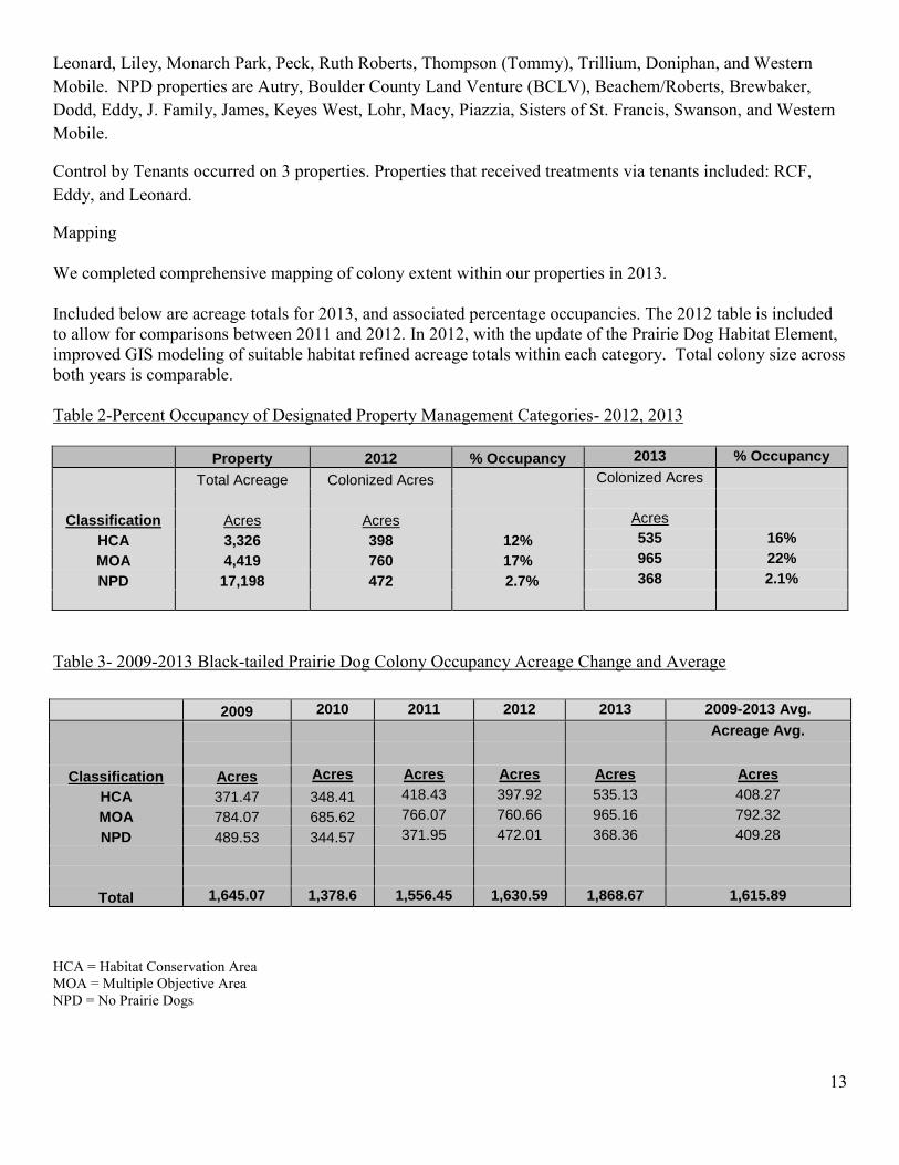
Mapping We completed comprehensive mapping of colony extent within our properties in 2013. Included below are acreage totals for 2013, and associated percentage occupancies. The 2012 table is included to allow for comparisons between 2011 and 2012. In 2012, with the update of the Prairie Dog Habitat Element, improved GIS modeling of suitable habitat refined acreage totals within each category. Total colony size across both years is comparable. Table 2-Percent Occupancy of Designated Property Management Categories- 2012, 2013
Property 2012 % Occupancy 2013 % Occupancy
Total Acreage Colonized Acres Colonized Acres
Classification Acres Acres Acres
HCA 3,326 398 12% 535 16%
MOA 4,419 760 17% 965 22%
NPD 17,198 472 2.7% 368 2.1%
Table 3- 2009-2013 Black-tailed Prairie Dog Colony Occupancy Acreage Change and Average
HCA = Habitat Conservation Area MOA = Multiple Objective Area NPD = No Prairie Dogs
2009 2010 2011 2012 2013 2009-2013 Avg.
Acreage Avg.
Classification Acres Acres Acres Acres Acres Acres
HCA 371.47 348.41 418.43 397.92 535.13 408.27
MOA 784.07 685.62 766.07 760.66 965.16 792.32
NPD 489.53 344.57 371.95 472.01 368.36 409.28
Total 1,645.07 1,378.6 1,556.45 1,630.59 1,868.67 1,615.89

14
Remote Camera Surveys The use of remote cameras to collect data on species use continued in 2013. A total of 8 cameras were deployed on three BCPOS properties: Meyers Gulch pipeline, Sherwood Gulch, and Hall-II. Selection of properties for camera studies is based on management planning schedules, previous data or a need for baseline inventory. Camera locations were selected using the same grid and random, spatially balanced points generated for 2012 Breeding Bird Surveys. Points in areas lacking previous camera surveys were prioritized. Hall II was prioritized for camera surveys in order to capture a high volume of data in preparation for the upcoming planning process for that property. The stations ran from mid-April to early-June and mid-August through October of 2013. Sites were rotated twice in 2013 to expand coverage of the dataset. The September flood event destroyed one camera along the St. Vrain on Hall-II and limited access to all sites for the remainder of 2013. Cameras resumed operation at the start of 2014. Front Range Cougar Study Wildlife staff continued its support of the CPW Front Range Cougar study in 2013. The large expanses of properties like Hall Ranch, Heil Valley Ranch, and Walker Ranch have allowed CPW to conduct their operations safely and relatively undisturbed, without disturbance to the visiting public. Project coordination and success has been greatly facilitated by the resident Resource Protection caretakers. Staff assisted with captures, access, study locations, and specific research questions. There were three specific sub-project studies. One involved developing and refining technique for DNA sampling of cougars. DNA collection allows researchers to identify individuals, relatedness, habitat overlap, and even population size – all without expensive and dangerous capture of subject animals. This technique can be used for any cougar population, marked or unmarked. The second study, involving 118 remote cameras placed throughout cougar habitat in the county, data collection concluded in 2013 and will compare cougar prey choices versus cougar prey availability, including analysis of human and natural variables. The third study continues to collect information about cougar diet (what, when, where they eat) by investigating cougar kill sites. These 3 specific studies augment the (very) large data set of cougar territories, movements, and interactions provided by 5+ years of radiocollar data. Future studies will tease out more information from this data set, including how, when, and where cougars exist on the landscape in conjunction with human development like roads, towns, rural subdivisions, and trails. Front Range Bobcat Study The Front Range bobcat study completed its final year in 2012. This study is coincident with the cougar study; a unique situation of an ongoing study of two different predator species using the same habitats/areas at the same time. This study will attempt to illuminate the following: habitat use, home range size, movements, bobcat density, range overlap between males and females, proximity to developed areas, etc. - and how they relate to cougars using same areas. The study emphasis areas contrasting more rural, natural, undeveloped areas like Betasso Preserve, Hall Ranch, and Heil Valley Ranch versus more heavily developed/used areas like the mountain backdrop of Boulder. Twenty bobcats were collared in the study area and 40 trail cameras were deployed for 14 months. The camera data and the radio-collar data will also allow the researcher to learn about the interactions of bobcats with other species that were captured on camera, by location and time of day. The researcher is in the process of compiling and analyzing the hundreds of locations, and thousands of time-stamped photographs.

15
Elk Movement Pattern Assessments CPW is interested in assessing the population size and distribution of elk in Larimer County and northern Boulder County after some major population shifting. They began placing radio collars on animals in that area in 2012, and have plans to eventually include four animals in the Rabbit Mountain vicinity. BCPOS is contributing two radio-collars towards this effort (collaring will occur in 2014), as well as staff time towards herd counts, which occurred in 2013, and will continue in 2014.
Fisheries Program
2013 was a tumultuous year for BCPOS fisheries. It was the 2nd (and very successful) year of our volunteer Angler Host program, where volunteers held kids fishing clinics at all of our major fisheries throughout the year.
The annual Senior Fish-Off (photo) was a rousing success in April, culminating a nice spring fishing
season, including the opening of several new fishing amenities.
Anglers at the 2013 Senior Fish-Off. We were ready to begin the fall stocking of the Wally Toevs Pond at Walden Ponds when the dramatic
flooding of September occurred. Boulder Creek sustained a 35-50-year flood event and put much of Walden Ponds underwater for several days. The shoreline/dam of Bass Pond was breached, creating an unstable dam, wrecking the trail, lowering the water level, impacting the fish population, and creating an outwash of sediment and cobble into the shallow aquatic habitat of Cottonwood Marsh.

16
Bass Pond dam breach after flood.
The dam of Cottonwood Marsh also breached, connecting it with the Wally Toevs Pond. They currently
share the same water level and are essentially one pond. Perhaps the only bright spot associated with the flooding is that Duck Pond, which was essentially dry in August, is now filled and available to become a fishery again. Walden Ponds re-opened following the flood and 2 stockings were made into the Wally Toevs Pond for a brief fall fishing experience.
The flooding wrecked the best public fishery in the county at Pella Crossing. Of the 6 ponds open to fishing, 3 of them breached and the public parking lot on 75th Street was about 50% destroyed, leaving a large deep hole in the ground.

17
Destruction at Pella Crossing parking lot after flooding.
The breaches at Dragonfly Pond (into a private pond), Heron Lake (flooding into a private farm field), and Webster Pond (into Heron Lake) are estimated to cost tens of thousands of dollars to fix. The damage at the shallow Webster Pond is extensive. So much sediment flooded into the basin that it may never be a fishable pond again. The dam breaches at Webster Pond and Heron Lake destroyed the trail as well. The property (and ponds) is likely to remain closed through 2014 as POS prioritizes and fixes the many facilities damaged or destroyed by the flooding. It is the fishery program’s highest priority to re-establish this valuable fishery. The prospective fishery located at the Braly Property, west of Hygiene, was severely damaged by the flooding as well. The wiper fishery in the west pond was upset with a large dam breach and siltation from a breach and flooding from the west. The long, deep pond by the A-Frame house was damaged in the same way: breach of east dam, lowered water level/capacity, and heavy sedimentation from the west. It is unknown where these breaches will fall in the repair prioritization of POS. The damage to these fisheries and the basic elimination of Lake’s 4 and 3 (by severe dam failure and sedimentation) may cause impacts to the local established raptor territories of a bald eagle pair and osprey pair. Amenities BCPOS Grounds staff nearly completed the fishing amenity development of the 2012 Fishing-is-Fun Grant for Walden Ponds and Pella Crossing. Seven new fishing platforms were completed: 2 at Wally Toevs Pond, 2 at Duck Pond, and 3 at Webster Pond. The disabled access fishing pier at Wally Toevs Pond was also refinished with new decking and a new staircase. Stone steps for safe access were also constructed on the steep shoreline to both platforms at Wally Toevs Pond. The amenities at Walden (Wally Toevs and Duck Pond) escaped damage from the flooding. Of the three platforms at Webster Pond, one was completely destroyed in the dam breach and another one collapsed. The in-water habitat structures and bench planned for Webster Pond will now not be constructed as a part of the grant.

18
New fishing platform at Wally Toevs Pond (Feb 2013).
Lower Boulder Creek Restoration In a dramatic development, the long-awaited reconstruction of Lower Boulder Creek on the Alexander Dawson Property (east of US 287) was funded by the Army Corps of Engineers. The funding is for the finished design and earthwork/reconstruction of 1 ½ miles of the channelized stream through an old gravel-mined area. Elimination of the trapezoidal channel with very limited riparian community development will be replaced by a meandering, well-vegetated channel with a floodplain. This area was only slightly impacted by the September flooding. Staff will assist the Corps with its 30%, 60%, and 90% design drawings in early 2014 with construction anticipated to begin in the fall/winter of 2014 during the low-flow conditions.
Amphibians 2013 Northern Leopard Frog The Northern Leopard Frog (Lithobates (=Rana) pipiens) (NLF) underwent review by the US Fish and Wildlife Service to determine if protection under the Endangered Species Act (ESA) was warranted. On October 5, 2011, the USFWS published its decision that this species does not merit protection under the ESA. This decision was based on the determination that the eastern population of NLF is not distinct from the western population. As the eastern population is more numerous, it was decided that listing was not currently warranted. http://www.fws.gov/policy/library/2011/2011-25498.html However, this species has declined precipitously within Boulder County. It used to be quite common in Boulder County, but its decline has coincided with habitat loss and alteration, invasion by American bullfrogs and infectious diseases, such as that caused by chytrid fungus which is easily transferred between water bodies.

19
It is considered a sensitive species by USFS, BLM and CPW, and is on both the County’s Species of Concern List, and is one of our program’s selected indicator species. In 2012, BCPOS funded a small grant for a researcher to assess foraging and dispersal behaviors of this species. This research continues in 2013 via a grant from OSMP. Results of this research can be found at: http://www.bouldercounty.org/os/culture/pages/posresearch.aspx Management considerations for this species involve limiting impact to breeding sites. To protect one of the most consistent breeding sites located on BCPOS lands, we have implemented, with our agricultural staff, a fencing project to restrict cattle and human access to this area. As a program we are looking at providing protections for these frogs, in collaborative efforts with our plant ecology staff, such as habitat restoration. In all post-flood restoration efforts, we will ensure this species is considered in designing habitat characteristics such as areas of meanders which provide slow moving, shallow water which is what this species requires. Volunteer Contributions 2013 Natural Resource Monitoring and Long-Term Monitoring Programs
There were several different monitoring programs that took place in 2013. The following are brief descriptions of volunteer programs and contributions. Natural Resource Monitoring Programs-Wildlife-Related Projects The Natural Resource Monitoring program was initiated in 2009, in an attempt to incorporate long-term monitoring projects into the BCPOS overall volunteer program. The recruitment process is overseen by Education and Outreach staff, and the projects are designed and coordinated by wildlife staff. Wildlife staff developed two programs: Abert’s squirrel and shrub monitoring. Abert’s Squirrel Monitoring Wildlife staff continued its citizen science work with the Natural Resource Monitors and mammals. In the spring of 2013, volunteers read 12 transects at Heil Valley Ranch associated with either recent forestry activities or future cutting/burning. The goal of this monitoring is to gather before/after data as well as squirrel responses to forestry treatments. This information is helping us develop our forestry prescriptions and operations to reduce impacts on squirrels and to retain them in areas of harvest/treatment. Six volunteers contributed 68 hours to this program.
Program Vols Hours Vols Hours Vols Hours Vols Hours Vols Hours
Long-Term Monitoring 70 2191 51 2105 94 2464 99 2466 80 1942
Natural Resource Monitors 2 12 9 230 10 40 9 74 10 92
Totals 72 2356 60 2335 104 2504 108 2540 90 2034
20132009 2010 2010 2012

20
Shrub Monitoring (Mountain Mahogany) Staff continued to monitor shrub stands in Foothills ungulate winter range. In the fall of 2013, volunteers read one new transect, one old transect, and re-established an existing transect at Rabbit Mountain. Work at both Hall Ranch and Heil Valley Ranch was precluded by lack of access after the flooding. The goal of this monitoring is to gather stand information that may lead us to treatment options (cutting or burning) to improve habitat quality and diversity. Four volunteers contributed 24 hours to this program. Long-Term Monitoring Programs These programs were initiated in the wildlife department. As wildlife monitoring is typically implemented to determine baseline, or trends over time, ongoing, long-term projects are a good fit for the needs of the wildlife department’s scope of work. In 2013, the number of volunteers utilized decreased in response to shifting program needs. Fewer agriculture properties were available for monitoring burrowing owls, post- trail construction breeding bird surveys along the picture rock trail were completed, two bluebird routes were discontinued for predation issues, and the September floods temporarily suspended volunteer efforts to survey waterfowl. Figure 1- Long-Term Wildlife Projects- Volunteer Hours
Bluebird Program The bluebird monitoring program is a partnership with Boulder County Audubon Society. The program was initiated in its current form in 2005, and we now monitor 111 boxes on BCPOS properties. The boxes are located at Heil Valley Ranch, Betasso Preserve, Walker Ranch and Bald Mountain. Additional routes monitored on OSMP’s Shanahan Ridge and Eldorado areas were discontinued due to repeated predation issues. We continue to share a route with the US Forest Service on the Minnick property north of Caribou Ranch Open Space. Volunteers typically work in pairs and monitor boxes approximately once every ten days during the breeding season, late April to early August. They record species and number of fledglings for each box used. Each route had up to 14 boxes and the project was successful due to dedicated volunteers, including outstanding volunteer project coordinators. Despite discontinuing two routes and an abbreviated season due to the flood event, eighteen volunteers contributed 830 hours to this program in 2013.
0
500
1000
1500
2000
2500
3000
2008 2009 2010 2011 2012 2013
2008-2013 Volunteer Hours
Volunteer Hours

21
Breeding Bird Surveys BCPOS has been recording information on birds on county open space properties since 1976. Historically, surveys included anecdotal observations during field visits and point counts. In the past decade however, we have adopted the Rocky Mountain Bird Observatory protocol for standardization of data collection. In 2013 one volunteer completed the post-trail construction bird surveys along the Picture Rock trail at Heil Valley Ranch and contributed 25 hours to the survey effort in 2013. A third volunteer contributed 25 hours of field surveys for nocturnal owl species. A total of 25 hours were contributed by the one volunteer. Burrowing Owl Monitoring Program This program was initiated in 2008 by BCPOS. In 2009, a partnership arrangement was proposed to Boulder County Nature Association and Boulder County Audubon Society. Currently, this program represents a large-scale, comprehensive volunteer monitoring program for burrowing owls. The survey methodology developed by the Colorado Division of Wildlife is used, as it has high success in determining presence and absence of burrowing owls if repeated four times during the breeding season (April-mid August). In 2013, volunteers helped look for owls on thirty-one properties. Forty-six volunteers contributed 452 hours to this project in 2013. Barn Owl Monitors In 2013, volunteers monitored a pair of barn owls utilizing a structure on the AHI property, adjacent to Lagerman Reservoir. Volunteers were unable to determine the continued use of the structures by barn owls or by great horned owls. In total, two volunteers contributed 2.5 hours to this effort. Raptor Nest Monitors Volunteers monitored cliff-nesting raptor nests from December through July. They observe the nests for at least two hours at a time and note behavior, number of nestlings, prey deliveries, and status. Gathering nesting data for raptors is important to developing long and short-term management decisions. Six raptor nest volunteers contributed 409 hours to the program in 2013. Waterfowl Monitoring Program Waterfowl volunteers monitored five wetland sites in 2013. They counted waterfowl species and numbers. In the past, the department used data from this program in property management plans (Walden Ponds Wildlife Habitat) and data collected in 2012 and 2013 will be used to develop the Kenosha property management plan. Unfortunately, the September flood event caused damage to all monitoring locations. The volunteer effort was suspended for the remainder of 2013 due to access and safety concerns. In total, seven volunteers contributed 223 hours to this effort. Table 3- Volunteer Contributions Per Program- 2013
Program Vols Hours
Bluebird Nest Box Monitoring 18 830
Breeding Bird Surveys 1 25
Raptor Monitoring 6 409
Burrowing Owl Monitoring 46 452
Waterfowl Monitoring 7 223
Shrub Surveys 4 24
Abert's Squirrel Monitoring 6 68
Barn Owl Monitoring 2 2.5
Totals 90 2033.5
22
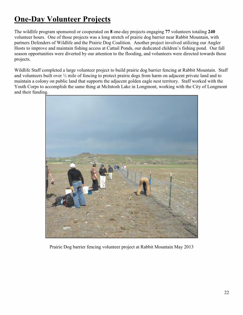
One-Day Volunteer Projects The wildlife program sponsored or cooperated on 8 one-day projects engaging 77 volunteers totaling 240 volunteer hours. One of those projects was a long stretch of prairie dog barrier near Rabbit Mountain, with partners Defenders of Wildlife and the Prairie Dog Coalition. Another project involved utilizing our Angler Hosts to improve and maintain fishing access at Cattail Ponds, our dedicated children’s fishing pond. Our fall season opportunities were diverted by our attention to the flooding, and volunteers were directed towards those projects. Wildlife Staff completed a large volunteer project to build prairie dog barrier fencing at Rabbit Mountain. Staff and volunteers built over ½ mile of fencing to protect prairie dogs from harm on adjacent private land and to maintain a colony on public land that supports the adjacent golden eagle nest territory. Staff worked with the Youth Corps to accomplish the same thing at McIntosh Lake in Longmont, working with the City of Longmont and their funding.
Prairie Dog barrier fencing volunteer project at Rabbit Mountain May 2013

23
Prairie Dog barrier fencing at Rabbit Mountain, May 2013.
Collaborations
External Collaboration An essential part of our program is the collaborative relationships we maintain with other agencies. For
instance, wildlife staff was involved with Colorado Parks and Wildlife on many fronts in 2013. Perhaps the most important of these was the work staff did in engaging state and local experts in developing the Environmental Resource Element of the Boulder County Comprehensive Plan (ERE and BCCP). The information exchange and interaction from this process was some of the most valuable work our staff has done.
We also solidified working relationships with many experts and developed plans and ideas for surveys,
monitoring, and projects. Staff worked with and engaged many CPW staff in the field, including: several District Wildlife Managers, Northeast Region Area Manager, Northeast Region Terrestrial Biologist, Northeast Region Area Terrestrial Biologist, Northeast Region Aquatic Biologist, Northeast Region Aquatic Management Biologist, Northeast Region (and other) Habitat Management Biologist, and the Statewide Native Fish Coordinator. Many more issues than the BCCP and ERE were involved, including: input on the Management Plan for Rabbit Mountain, pre- and post-flood fish sampling of county streams, stocking and sampling recreational fisheries, beaver distribution, raptor monitoring, annual bighorn sheep and elk counts, and issues dealing with varied species like coyote, moose, Northern leopard frogs, and bats.
Wildlife staff began serious dialogue with CPW about the increasing elk population at Rabbit Mountain.
Animals that use Rabbit Mountain are also using neighboring farmland and causing crop damage, incurring damage payments to CPW. Elk in nearby Larimer County have undergone some dramatic population shifts in recent years and CPW needs to study the new distribution and movement patterns. POS and CPW will include some study animals from Rabbit Mountain to try to discover cross-county movements, as well as key areas and

24
movement corridors for those elk that use Rabbit Mountain. This data should help POS in its upcoming Rabbit Mountain Management Plan Update. It should help CPW design harvest and management strategies as well.
Wildlife staff continued its involvement with universities as well. The ERE/BCCP relied heavily on
experts from academia, especially at Colorado State University and the University of Colorado. Additionally, staff interacted with researchers from universities, CPW, and other experts to coordinate projects and surveys on BCPOS lands on a variety of species/projects such as: native bees, butterflies, tent caterpillars, cougars, plumbeous vireos, bird banding, lizards, Northern leopard frogs, damselflies and dragonflies, crayfish, and bats! Internal Collaboration
Wildlife staff produced timely comments on several AG Operating Plans in 2013. Comments serve to
value wildlife in concert with how AG leases are conducted and include safeguards to riparian vegetation and special status species such as burrowing owls and bald eagles. Staff also worked with AG staff on water development projects at Mayhoffer and Reynolds Ranch, and created plans for an exclosure fence at Giggey Lake at Reynolds Ranch.
Wildlife staff provided a memo to the Forestry Program about prospective lodgepole thinning at
Reynolds Ranch near Magnolia Road. Staff encouraged timing and area restrictions to protect elk use and movements, and habitat use by olive-sided flycatcher. Staff also worked with both Forestry and AG staff on a pasture fence on the western side of Reynolds Ranch that will protect new aspen regeneration from combined heavy grazing pressure of livestock and elk. Wildlife Staff worked with Youth Corps to construct several elk jumps in 2013 that will be incorporated in this fence when it is constructed in 2014. Staff also collaborated with Forestry on a 4th type of exclosure design for aspen that was built in summer of 2013 on a two acre site at Reynolds Ranch. Planning and Coordination 2013 Management Plans Annually, wildlife staff contributes to the development and completion of comprehensive management plans and policy documents as requested by Resource Planning. This work required extensive field work, site visits, meetings, document creation and review: Wildlife staff provided input for the management planning below:
• Lagerman-Imel-AHI Management Plan • Lower Boulder Creek Riparian Restoration Project • Reynolds Ranch Management Plan • Walker Ranch Management Plan • Rabbit Mountain Management Plan • Grassland and Shrubland Policy • Sensitive Data Policy • Wildlife Policy
Information on all current and recent management plan and policy processes can be found at: http://www.bouldercounty.org/os/culture/pages/.aspx

25
Team Projects Wildlife staff provided input for the projects below:
Trail Maintenance Team Pollinators Habitat Improvement Team Amenities Team Fence Team Two Creeks Trail Construction GOCO trail grant (St. Vrain Greenway Trail) VN & Wildlife Masters Research Permits Regional Trails
Real Estate – Acquisitions and Oil/Gas issues Wildlife staff assisted with initial surveys and evaluations on several land transactions in 2013. Staff provided wildlife information and mitigation measures for CE plans and oil/gas operations as well. This information helped to inform staff and the Parks and Open Space Advisory Committee of the wildlife habitat values and/or issues on proposed purchases, easements, and sales. Staff provided information on actions involving: Santon, Samuels, Lyman, Lawrence, Smith, Smoljan, Doniphan, Wambsganss, Nygren CE, and Trevarton CE. The parcel acquisition of the Loukonen Dairy Farm continued with the 4th (of 10) installment purchase occurred, acquiring more shortgrass prairie (and elk winter range). The Sherwood Gulch Property acquisitions encompassed over 200 acres of land in the Mud Lake/Caribou Ranch complex area.
Riparian habitat at Sherwood Gulch acquisition.

26
Wildlife staff participated in several site visits to identify key habitats and also employed remote cameras that identified use areas for elk and moose. Staff also contributed comments on 3 mining claim purchases that served to remove development from rural forest areas and block up habitat in public ownership. Of these three, the Cree Property purchase was an important parcel of elk winter range and migration corridor in the Reynolds Rogers complex. New oil and gas activity slowed considerably this year, due to the countywide moratorium. One well along the Two Creeks Trail on the Stephenson Nelson Property was re-fracked successfully with very little disturbance to the site or the neighboring prairie dog colony. It is anticipated that activity on BCPOS lands will remain quiet in the short-term. Small Grants and Non-funded Research 2013 Small Grants In 2013, two wildlife-related proposals for small grant funding were approved and awarded to Jan Chu (Butterfly Inventories), and Jesse Lewis (Nighttime Recreational Impacts to Wildlife). All final reports are available at: http://www.bouldercounty.org/os/culture/pages/posresearch.aspx Non-funded Research 2013 Several wildlife-focused research projects were conducted on Boulder County Parks and Open Space properties in 2013. Projects included entomological inventories (for species such as moths, dragonflies, damselflies, bumblebees, grasshoppers, and butterflies), amphibian surveys, work with assessing conservation development implications to wildlife, and various bird monitoring studies, counts, and banding. Large mammal research was conducted as well (the aforementioned continuing cougar study). All reports are available at: http://www.bouldercounty.org/os/culture/pages/posresearch.aspx


