Wildfire in Valencia
19
Forest Fires in the Valencian Community (Spain) Student: Juan José Mena Costa
Transcript of Wildfire in Valencia
Forest Fires in theValencian Community
(Spain)
Student: Juan José Mena Costa
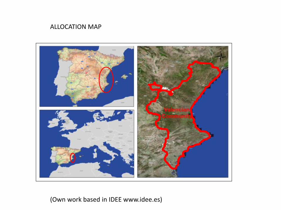
ALLOCATION MAP
(Own work based in IDEE www.idee.es)

PHYSIOGRAPHY
http://cartoweb.cma.gva.es/
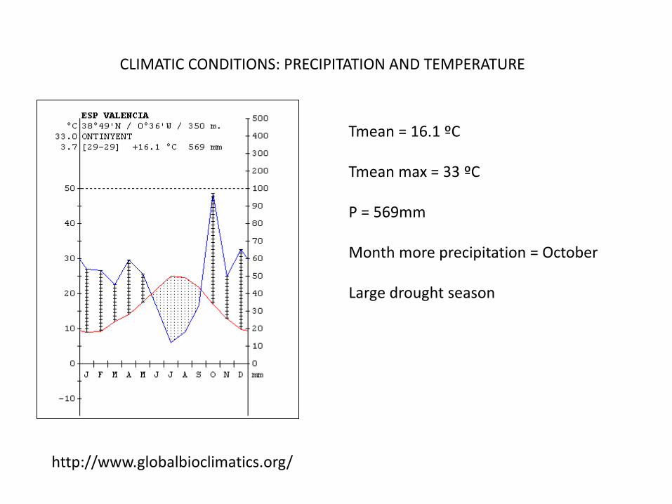
CLIMATIC CONDITIONS: PRECIPITATION AND TEMPERATURE
Tmean = 16.1 ºC
Tmean max = 33 ºC
P = 569mm
Month more precipitation = October
Large drought season
http://www.globalbioclimatics.org/

CLIMATIC CONDITIONS: NORMALIZED WIND INDEX
(Estrela Navarro et al. 2005)

FOREST COVER MAP
- Forested area: 754.459.12 ha
- Mixed: 20%- Broadleaves: 10%- Coniferous: 70%
MARM, 2008

29%
3%22%
46%
Land Cover in the IFN3 in % (2006)
Forest cover > 20%
Forest cover < 20%
Shrublands andgrasslands
Total non forested
680,069
74,390
500,879
1,070,114
Land Cover in the IFN3 in ha. (2006)
Forest cover > 20%
Forest cover < 20%
Shrublands andgrasslands
Total non forested
493,176
135,103
586,798
1,110,432
Land Cover in the IFN2 in ha. (1994)
Forest cover > 20%
Forest cover < 20%
Shrublands andgrasslands
Total non forested
21%
6%
25%
48%
Land Cover in the IFN2 in % (1994)
Forest cover > 20%
Forest cover < 20%
Shrublands andgrasslands
Total non forested
EVOLUTION OF LAND COVER BETWEEN 1994 2006
Tercer Inventario Forestal Nacional (IFN3)
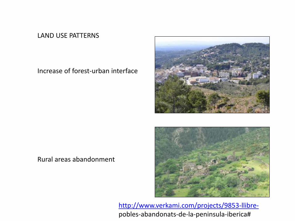
LAND USE PATTERNS
Increase of forest-urban interface
Rural areas abandonment
http://www.verkami.com/projects/9853-llibre-pobles-abandonats-de-la-peninsula-iberica#
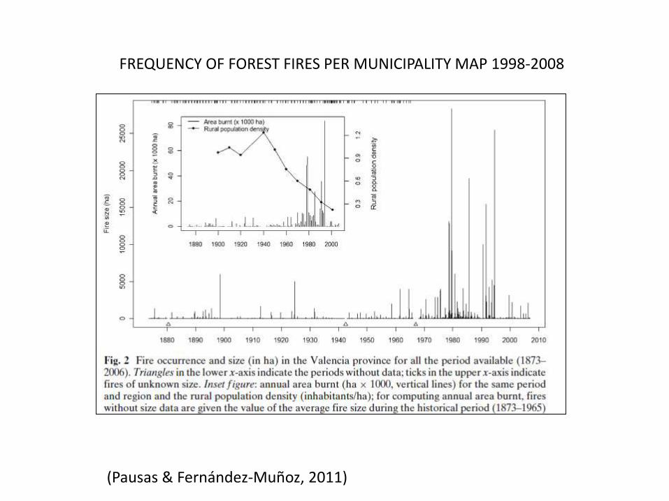
FREQUENCY OF FOREST FIRES PER MUNICIPALITY MAP 1998-2008
(Pausas & Fernández-Muñoz, 2011)

WILDFIRE INDEX RISK ACCORDING VEGETATION AND PHYSIOGRAPHY
(Estrela Navarro et al. 2005)

WILDFIRE INDEX RISK ACCORDING WEST WINDS AND ITS COMBINATION
(Estrela Navarro et al. 2005)
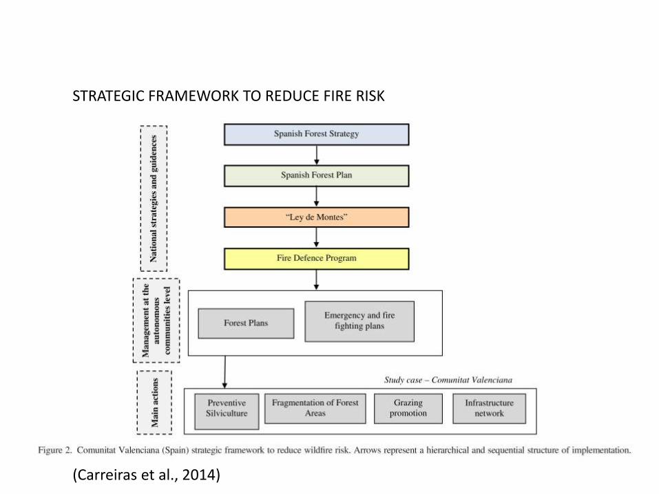
STRATEGIC FRAMEWORK TO REDUCE FIRE RISK
(Carreiras et al., 2014)
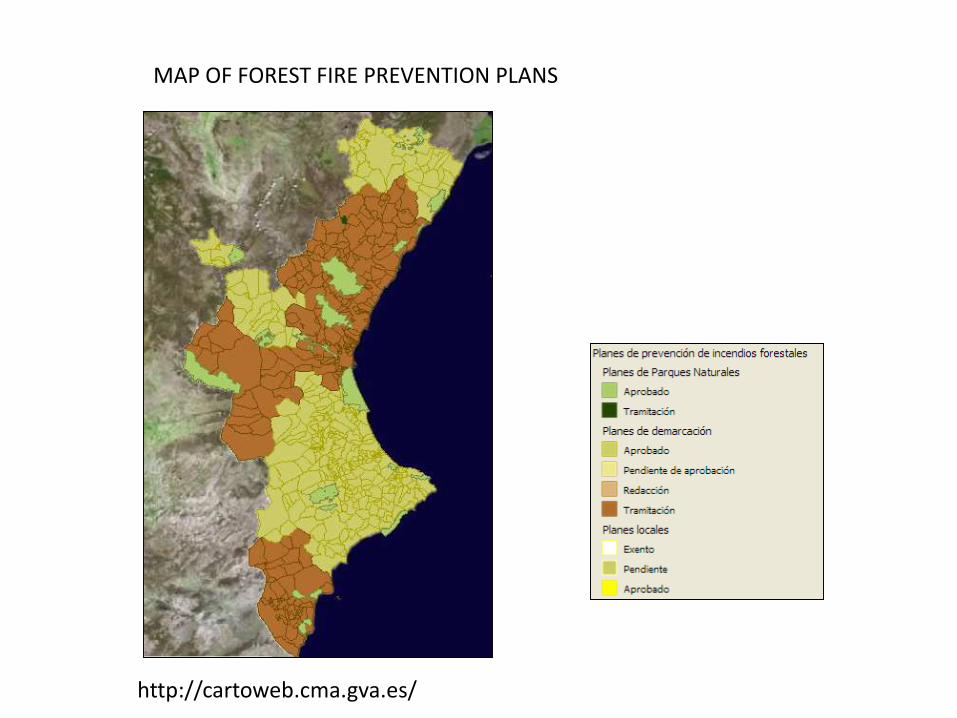
http://cartoweb.cma.gva.es/
MAP OF FOREST FIRE PREVENTION PLANS
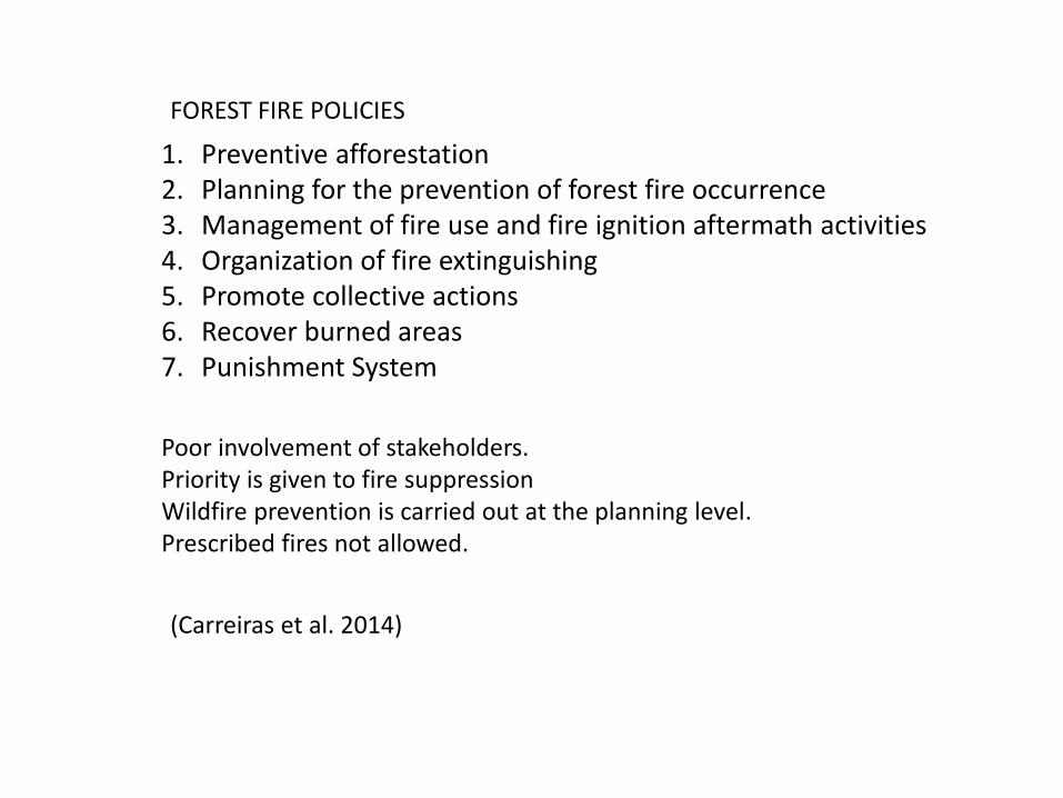
Poor involvement of stakeholders.Priority is given to fire suppression Wildfire prevention is carried out at the planning level.Prescribed fires not allowed.
1. Preventive afforestation2. Planning for the prevention of forest fire occurrence3. Management of fire use and fire ignition aftermath activities4. Organization of fire extinguishing 5. Promote collective actions6. Recover burned areas 7. Punishment System
(Carreiras et al. 2014)
FOREST FIRE POLICIES

BIG SIMULTANEOUS FOREST FIRES “CORTES AND ANDILLA” (2012)
Cortes de Pallás : 28.643 ha
Andilla: 19.940 ha
2 Helicopter crassed
1 pilot dead
2 bounded persons
20 municipalities
About 3000 persons evacuated.
Satellite Aqua: NASA
EFE
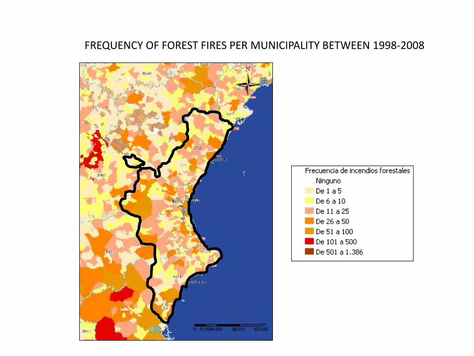
FREQUENCY OF FOREST FIRES PER MUNICIPALITY BETWEEN 1998-2008

POTENTIAL EROSSION
References:
Carreiras, M. et al., 2014. COMPARATIVE ANALYSIS OF POLICIES TO DEAL WITH WILDFIRE RISK. Land Degrad. & Develop., 103(January), pp.92–103.
Estrela Navarro, M.J. et al., 2005. Integración de una cartografía de vientos en situaciones meteorológicas de riesgo de incendios forestales en la ComunidadValenciana mediante un SIG”. GeoFocus, 5, pp.94–114.
Pausas, J.G. & Fernández-Muñoz, S., 2011. Fire regime changes in the Western Mediterranean Basin: from fuel-limited to drought-driven fire regime. ClimaticChange, 110(1-2), pp.215–226. Available at: http://link.springer.com/10.1007/s10584-011-0060-6 [Accessed September 8, 2014].

Thanks for your attention