Wilderness Inventory Unit: Squaw Creek OR-034-034 1 – Documentation of BLM Wilderness Inventory:...
23
Wilderness Inventory Unit Index of Documents Squaw Creek OR-034-034, 23 total pages Page 1: Index Cover Sheet Page 2: Form 1 – Documentation of BLM Wilderness Inventory: Findings on Record Page 5: Form 2 – Documentation of Current Wilderness Inventory Conditions Page 9: Form 2 – Summary of Findings and Conclusion Page 10: Wilderness Characteristics Overview – Squaw Creek OR-034-034 Map 1 of 2 Page 11: Wilderness Characteristics-Land Treatments-Squaw Creek OR-034-034 Map 2 of 2 Page 12: Wilderness Characteristics – BLM Photo Points – Squaw Creek Map & Log Page 13: OR-034-034 Squaw Creek BLM Photos Page 16: H-6300-1-Wilderness Inventory Maintenance in BLM Oregon/Washington Appendix C – Road* Analysis: O34-RT41 Page 20: H-6300-1-Wilderness Inventory Maintenance in BLM Oregon/Washington Appendix C – Road* Analysis: O34-RT42 Prepared by: U.S. Department of the Interior Bureau of Land Management Vale District Office 100 Oregon Street Vale, Oregon 97918
Transcript of Wilderness Inventory Unit: Squaw Creek OR-034-034 1 – Documentation of BLM Wilderness Inventory:...

Wilderness Inventory Unit Index of Documents Squaw Creek OR-034-034, 23 total pages
Page 1: Index Cover Sheet Page 2: Form 1 – Documentation of BLM Wilderness Inventory: Findings on Record Page 5: Form 2 – Documentation of Current Wilderness Inventory Conditions Page 9: Form 2 – Summary of Findings and Conclusion Page 10: Wilderness Characteristics Overview – Squaw Creek OR-034-034 Map 1 of 2 Page 11: Wilderness Characteristics-Land Treatments-Squaw Creek OR-034-034 Map 2 of 2 Page 12: Wilderness Characteristics – BLM Photo Points – Squaw Creek Map & Log Page 13: OR-034-034 Squaw Creek BLM Photos
Page 16: H-6300-1-Wilderness Inventory Maintenance in BLM Oregon/Washington
Appendix C – Road* Analysis: O34-RT41
Page 20: H-6300-1-Wilderness Inventory Maintenance in BLM Oregon/Washington
Appendix C – Road* Analysis: O34-RT42
Prepared by: U.S. Department of the Interior Bureau of Land Management
Vale District Office 100 Oregon Street
Vale, Oregon 97918

Form 1 – Documentation of BLM Wilderness Inventory: Findings on Record 1 of 3
H-6300-1-WILDERNESS INVENTORY MAINTENANCE IN BLM OREGON/WASHINGTON
APPENDIX B – INVENTORY AREA EVALUATION
Evaluation of Current Conditions: 1) Document and review the existing BLM wilderness inventory findings on file, if available, regarding the presence or absence of individual wilderness characteristics, using Form 1, below. 2) Consider relevant information regarding current conditions available in the office to identify and describe any changes to the existing information (use interdisciplinary (ID) team knowledge, aerial photographs, field observations, maps, etc.), and document your findings on Form 2, below. When Citizen Information has been submitted regarding wilderness characteristics, document the submitted materials including: date of Submission; Name of District(s) and Field Office(s) Affected; Type of material Submitted (e.g. narrative, map, photo). Evaluate any submitted citizen information regarding the validity of proposed boundaries of the unit(s), the existence of roads and other boundary features, the size of the unit(s), and the presence or absence of wilderness characteristics based on relevant information available in the office (prior BLM inventories, ID team knowledge, aerial photographs, field observations, maps, etc.) Conduct field reviews as necessary to verify information and to ascertain current conditions. Reach conclusions on current conditions including boundaries, size of areas and presence or absence of wilderness characteristics. Fully explain the basis for each conclusion on form 2, including any critical differences between BLM and citizen information. Document your findings regarding current conditions for each inventoried area. Describe how the present conditions are similar to, or have changed from, the conditions documented in the original wilderness inventory. Document your findings on Form 2 for each inventory area. Cite to or attach data considered, including photographs, maps, GIS layers, field trip notes, project files, etc.

Form 1 – Documentation of BLM Wilderness Inventory: Findings on Record 2 of 3
Year: __2009_ Unit Number/Name:
OR-034-034 -- Squaw Creek_______
FORM 1
Yes
-- DOCUMENTATION OF BLM WILDERNESS INVENTORY FINDINGS ON RECORD
1. Is there existing BLM wilderness inventory information on all or part of this area?
No __X__ (If yes, and if more than one unit is within the area, list the names of those units.):
____
A.) Inventory Source(s) -- (X) Denotes all applicable BLM Inventory files, printed maps, or published BLM Decision documents with information pertaining to this unit.
Wilderness Inventories
(X) 1978 – BLM Wilderness Inventory Units OR-03-03-04, 3-34 Squaw Creek (unpublished BLM documents stored in 6-way case files)
( ) April 1979 – Wilderness -- Proposed Initial Inventory – Roadless Areas and Islands Which Clearly Do Not have Wilderness Characteristics, Oregon and Washington
Wilderness Decision Documents
( ) August 1979 – Wilderness Review – Initial Inventory, Final Decision on Public Lands Obviously Lacking Wilderness Characteristics and Announcement of Public Lands to be Intensively Inventoried for Wilderness Characteristics, Oregon and Washington (green document)
( ) October 1979 – Wilderness Review – Intensive Inventory - Oregon, Proposed Decision on the Intensive Wilderness Inventory of Selected Areas (grey document).
(X) March 1980 – Wilderness Review – Intensive Inventory; Final Decisions on 30 Selected Units in Southeast Oregon and Proposed Decisions on Other Intensively Inventoried Units in Oregon and Washington (orange document)
(X) November 1980 - Wilderness Inventory – Oregon and Washington, Final Intensive Inventory Decisions (brown document)
( ) November 1981 Stateline Intensive Wilderness Inventory Final Decision, Oregon, Idaho, Nevada, Utah (tan document).
B.) Inventory Unit Name(s)/Number(s)
BLM OR-03-03-04; Squaw Creek 3-34 (1978 unpublished BLM documents stored in 6-way case files)

Form 1 – Documentation of BLM Wilderness Inventory: Findings on Record 3 of 3
C.) Map Name(s)/Number(s)
(X) Final Decision – Initial Wilderness Inventory Map, August 1979, Oregon
( ) Proposed Decision -- Intensive Wilderness Inventory of Selected Areas
Map, October 1979, Oregon
(X) Intensive Wilderness Inventory Map, March 1980, Oregon
( ) Intensive Wilderness Inventory --Final Decisions Map, November 1980, Oregon.
( ) November, 1981 Stateline Intensive Wilderness Inventory Final Decision, Oregon, Idaho, Nevada, Utah (tan document).
D.) BLM District(s)/Field Office(s)
Vale District Office/ Field Office Malheur
2. BLM Inventory Findings on Record (Existing inventory information regarding wilderness characteristics (if more than one BLM inventory unit is associated with the area, list each unit and answer each question individually for each inventory unit): Inventory Source: See above.
Unit#/ Name
Size (historic acres)
Natural Condition? Y/N
Outstanding Solitude? Y/N
Outstanding Primitive & Unconfined Recreation? Y/N
Supplemental Values? Y/N
(3-34) OR-03-03-04 Squaw Creek
3,040 * N N N
TOTAL 3,040 * -- The March 1980 and November 1980 decision documents make it difficult for a reader to know whether or not the unit meets the naturalness criteria. However, since the minimum size requirement was not met for the unit, a naturalness determination made no difference regarding wilderness characteristics. Additionally, there were negative determinations of the other criteria.

Form 2 – Documentation of Current Wilderness Inventory Conditions 1 of 4
H-6300-1-WILDERNESS INVENTORY MAINTENANCE IN BLM OREGON/WASHINGTON
APPENDIX B – INVENTORY AREA EVALUATION
Evaluation of Current Conditions: 1) Document and review the existing BLM wilderness inventory findings on file, if available, regarding the presence or absence of individual wilderness characteristics, using Form 1, below. 2) Consider relevant information regarding current conditions available in the office to identify and describe any changes to the existing information (use interdisciplinary (ID) team knowledge, aerial photographs, field observations, maps, etc.), and document your findings on Form 2, below. When Citizen Information has been submitted regarding wilderness characteristics, document the submitted materials including: date of Submission; Name of District(s) and Field Office(s) Affected; Type of material Submitted (e.g. narrative, map, photo). Evaluate any submitted citizen information regarding the validity of proposed boundaries of the unit(s), the existence of roads and other boundary features, the size of the unit(s), and the presence or absence of wilderness characteristics based on relevant information available in the office (prior BLM inventories, ID team knowledge, aerial photographs, field observations, maps, etc.) Conduct field reviews as necessary to verify information and to ascertain current conditions. Reach conclusions on current conditions including boundaries, size of areas and presence or absence of wilderness characteristics. Fully explain the basis for each conclusion on form 2, including any critical differences between BLM and citizen information. Document your findings regarding current conditions for each inventoried area. Describe how the present conditions are similar to, or have changed from, the conditions documented in the original wilderness inventory. Document your findings on Form 2 for each inventory area. Cite to or attach data considered, including photographs, maps, GIS layers, field trip notes, project files, etc.

Form 2 – Documentation of Current Wilderness Inventory Conditions 2 of 4
FORM 2
Unit Number/Name:
-- DOCUMENTATION OF CURRENT WILDERNESS INVENTORY CONDITIONS
Description of Current Conditions: [Include land ownership, location, topography, vegetation features and summary of major human uses/activities.] 1. Is the unit of sufficient size?
Yes
OR-034-034 – Squaw Creek________________
___X____ No_______
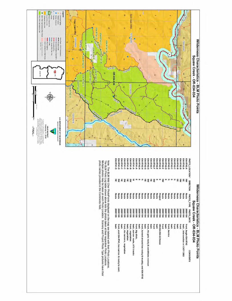
Description: Refer to this unit’s associated Map 1 for its location. The boundary of 12, 646-acre unit encompasses substantially more area than the original 1970’s BLM Squaw Creek inventory unit (3-34 of OR-03-03-04). Adjacent public lands to the original unit’s north and to its southwest are now included due to BLM’s conclusion that certain routes which were determined to be roads during the 1970’s inventory are now motorized primitive trails (MPT). The unit’s boundary consists of the BLM roads 7332-0-00and 7332-0-0A0 (alias 7332-0-00 and 7332-0-0A0, depending on which map is referenced)), County Road 3583, other roads traversing public lands on its central east, one cherry-stem road (1.3 miles), the US Highway 20/utility ROW, and a mineral materials site which abuts that ROW. One 320-acre private inholding is a feature of the unit’s boundary. In addition, all of the abutting Gold Creek WSA’s (OR-3-33) east boundary – which was previously determined to be a road -- is now considered to be a MPT, as has a portion of the Camp Creek WSA’s (OR-3-31) abutting east boundary route with this OR-034-034 Squaw Creek inventory unit.
2. Is the unit in a natural condition? Yes___X____ No_______ N/A_______
Description: The unit consists predominately of portions of the South Fork Squaw Creek watershed, most of the North Fork Squaw Creek watershed, a short stretch of the Cottonwood Creek’s watershed in the unit’s southeast reaches, and of some short creek drainages flowing toward US Highway 20. Associated with these creeks are dominate sharp to moderate-rising slopes to ridgelines, buttes and hilltops with rock outcrops distributed throughout the unit. Drainage patterns are highly diverse (length, elevation depth ranges, slopes’ steepness, etc) and, collectively, are multi-directional within the unit amongst rugged terrain. Elevations range from approximately 2,180 to 6,500 feet. Dominant vegetation type is sagebrush community with native and non-native rangeland grasses.

Form 2 – Documentation of Current Wilderness Inventory Conditions 3 of 4
Refer to the attached maps for human developments within the unit. They include 7.1 miles of rangeland fence, 3 earthen reservoirs, 2 developed springs, 2 fence enclosures, and 31.4 miles of 14 motorized primitive trails (which includes those portions abutting the two WSA’s which changed from road to MPT status). There is remnant evidence of two abandoned vehicle route segments within the unit. Approximately 120 acres of a 1969 drilled seeding affected the unit along its east boundary road. A portion of a 1970 drilled seeding project affected approximately 1,900 acres of a southeast stretch of the unit along County Route 3583. While visually evident during the 1970’s inventory, currently only small scattered remnants of the 1970 drilled affect is noticeable; none of the 1966 drilled is visual noticeable today. Due to the unit’s topographic screening properties, appearance and wide distribution of its varied natural features (e.g., the complex and extent of steep, rugged draws and drainages), combined with the distribution, extent and types/nature of the human developments within the unit in context of the unit’s size, the developments’ presence -- when considered individually and collectively -- result in the unit appearing to be affected primarily by the forces of nature, with human imprints substantially unnoticeable to the average visitor.
3. Does the unit have outstanding opportunities for solitude? Yes___X____ No_______ N/A_______ Description: The unit is irregular in shape, with a maximum length of approximately 12
miles and widths ranging from less than one mile to 4.25 miles. The complex and diverse topography associated with the multiple drainages of the unit provide excellent screening for outstanding opportunities to experience a sense of solitude. The unit has very few locations where creek-side vegetation would assist screening users from each other to any significant extent within the unit. Additionally, now with no road or other feature being a separating boundary between the unit and the abutting 2 WSAs – thus, the unit being contiguous with the two WSAs and their associated wilderness characteristics -- the outstanding opportunities for solitude within this unit and within both WSAs are further benefited.
4. Does the unit have outstanding opportunities for primitive and unconfined recreation?
Yes ___X____ No _______ N/A _______
Description: Primary primitive and unconfined outdoor recreation activities include dispersed hunting of common game species chukar and big game (deer, predominately), day hiking, backpacking, horseback riding, wildlife viewing and other sightseeing, and photography. Additionally, Squaw Creek Reservoir is accessible by motorized vehicle via a cherry-stem road, which continues to be periodically stocked with trout by ODFW for recreational fishing. There are no unique sights or attractions within the unit, itself. While there are a variety of recreation activities provided for within the unit itself, none -- individually or in combination – are outstanding primitive and confined recreation

Form 2 – Documentation of Current Wilderness Inventory Conditions 4 of 4
opportunities. However, with no road now between the unit and the abutting 2 WSAs – thus, the unit being contiguous with the two WSAs and their associated wilderness characteristics -- the outstanding opportunities for primitive and unconfined recreation associated with the two WSAs (for each WSA, a combination of all of the above-mentioned activities and with the recreational draw of the major Gold Creek and Camp Creek canyons) -- now extends into this unit, thus enhancing such opportunities within a larger area.
5. Does the unit have supplemental values?
Yes ___X____ No ___ ___ N/A
_______
Description: The western approximate half of the unit is within a notably larger suitable bighorn sheep habitat use area that extend further west, although the animal – a BLM special
status species in Oregon – rarely visits or occupies this part of the habitat.
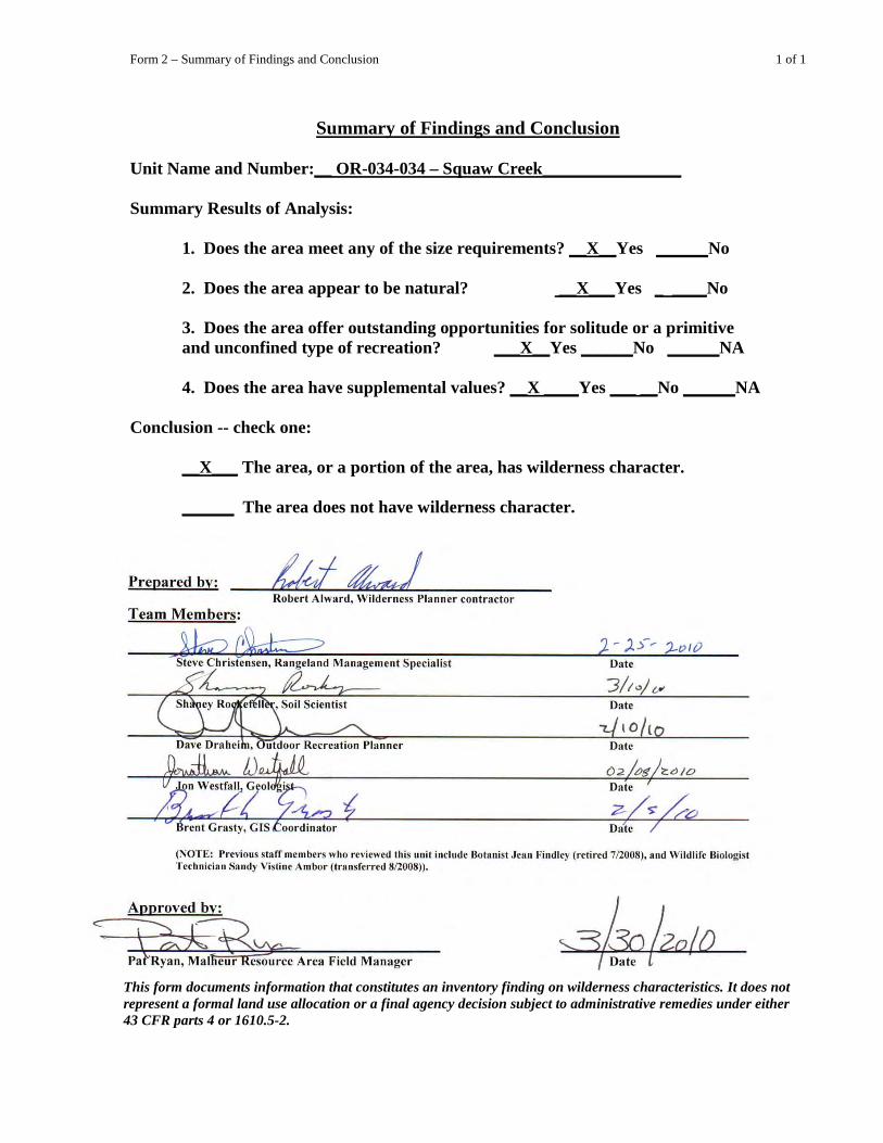
Form 2 – Summary of Findings and Conclusion 1 of 1
Summary of Findings and Conclusion Unit Name and Number:__ OR-034-034 – Squaw Creek________________ Summary Results of Analysis:
1. Does the area meet any of the size requirements? __X__Yes ______No 2. Does the area appear to be natural? __X___Yes _ ____No 3. Does the area offer outstanding opportunities for solitude or a primitive and unconfined type of recreation? ___X__Yes ______No ______NA
4. Does the area have supplemental values? __X ____Yes ___ __No ______NA
Conclusion -- check one: __X___ The area, or a portion of the area, has wilderness character. ______
The area does not have wilderness character.
This form documents information that constitutes an inventory finding on wilderness characteristics. It does not represent a formal land use allocation or a final agency decision subject to administrative remedies under either 43 CFR parts 4 or 1610.5-2.

Form 2 – Summary of Findings and Conclusion 2 of 1

Form 2 – Summary of Findings and Conclusion 3 of 5
Form 2 – Summary of Findings and Conclusion 4 of 5
Form 2 – Summary of Findings and Conclusion 5 of 5

Form 2 – Summary of Findings and Conclusion 6 of 5
Form 2 – Summary of Findings and Conclusion 7 of 5

Appendix C – Road* Analysis: 034-RT41 1 of 4
H-6300-1-WILDERNESS INVENTORY MAINTENANCE IN BLM OREGON/WASHINGTON
APPENDIX C – ROAD* ANALYSIS
(Factors to consider when determining whether a route is a road for wilderness inventory purposes.)
Wilderness Inventory Unit Name/Number: OR-034-034 -- Squaw Creek Route Name and/or Identifier (Include Transportation Plan Identifier, if known; include route number supplied by citizen information when available): 034-RT41
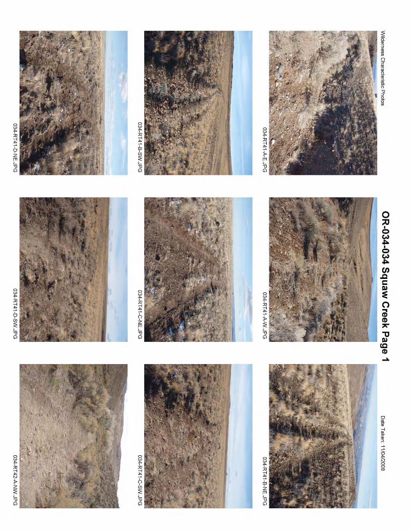
I. LOCATION: Is this BLM inventory unit’s west boundary route along the east boundary of Gold Creek WSA. List photo point references (if applicable): Refer to this BLM inventory unit’s associated hard copy of its BLM Photo Points map, and affiliated Photo Log and photos -- retained in this unit’s permanent hard copy file, and electronically retained under this unit’s subfolder Final Findings/GIS Products.
II. CURRENT PURPOSE OF ROUTE:
(Examples: Rangeland/Livestock Improvements (stock tank, developed spring, reservoir, fence, corral), Inholdings (ranch, farmhouse), Mine Site, Concentrated Use Site (camp site), Utilities (transmission line, telephone, pipeline), Administrative (project maintenance, communication site, vegetation treatment).)
Describe: Accesses two rangeland reservoirs adjacent to the route, both within the adjacent Gold Creek WSA. Within this BLM inventory unit, a motorized primitive trail branches from this route to a private land parcel. The parcel has no improvements for developments associated with it; rather, it traverses the private parcel back onto public land as a motorized primitive trail to eventually connect with 034-RT 42 of this inventory unit.
III. ROAD RIGHT-OF-WAY:
Is a road right-of-way associated with this route? Yes ______ No ___X
IV. CONSTRUCTION
__ Unknown _____
Yes __X___ No __X_____
Examples: Paved __________ Bladed __________ Graveled _____ Roadside Berms_____ Cut/Fill ___X__ Other ______

Appendix C – Road* Analysis: 034-RT41 2 of 4
Describe: At photo point 034-RT-A-E, appears cut/fill was done to cross the drainage. No evidence of mechanical construction on remainder of this route.
V. IMPROVEMENTS
Yes ______ No ___X____
By Hand Tools _______ By Machine _____ Examples: Culverts _______ Stream Crossings ______ Bridges _______ Drainage ________ Barriers ________ Other ________
Describe: VI. MAINTENANCE:
A. Is there Evidence or Documentation of Maintenance using hand tools or machinery? Yes ___________ No ____X________
If yes: Hand Tools (Y/N) _______ Machine (Y/N) _________
Explain: B. If the route is in good condition, but there is no evidence of maintenance, would mechanical maintenance with hand tools or machines be approved by BLM in the event this route became impassable?
Yes ______ No __X__
Comments: Not in good condition, although is passable with a high clearance, favorably four-wheel drive ATV type of vehicle.
VII. REGULAR AND CONTINUOUS USE:
Yes _______ No ___X____
Describe evidence (vehicle tracks observed) and other rationale for whether use has occurred and will continue to occur on a relatively regular basis: There is no evidence of regular and continuous use, although the route is likely traveled (likely using mostly an ATV type of vehicle) occasionally by hunters of upland and/or big game species.

Appendix C – Road* Analysis: 034-RT41 3 of 4
VIII. CONCLUSION: To meet the definition of a road, items IV or V, and VI-A or B, and VII must be checked yes. Road: Yes ________ No __X____
Explanation: Does not meet road criteria. Appears this route was established for developing the two reservoirs, with no maintenance performed on it for a long time to present. This route was used as a boundary for the adjacent Gold Creek WSA, but presently is the status of a motorized primitive trail.
-------------------------------------------------------------------------------------------------------
* road: An access route which has been improved and maintained by mechanical means to insure relatively regular and continuous use. A way maintained solely by the passage of vehicles does not constitute a road. a. “Improved and maintained” – Actions taken physically by people to keep the road open to vehicle traffic. “Improved” does not necessarily mean formal construction. “Maintained” does not necessarily mean annual maintenance. b. “Mechanical means” – Use of hand or power machinery or tools. c. “Relatively regular and continuous use” – Vehicular use that has occurred and will continue to occur on a relatively regular basis. Examples are: access roads for equipment to maintain a stock water tank or other established water sources; access roads to maintained recreation sites or facilities; or access roads to mining claims.
________________________________________________ Following is the definition from Glossary of OSO 7-3-2007 Draft H-6300-1: road: The BLM will continue to base the definition of what constitutes a “road” from the FLPMA’s legislative history. The language below is from the House of Representatives Committee Report 94-1163, page 17, dated May 15, 1976, on what became the FLPMA. It is the only statement regarding the definition of a road in the law or legislative history.

Appendix C – Road* Analysis: 034-RT41 4 of 4
“The word ‘roadless’ refers to the absence of roads which have been improved and maintained by mechanical means to insure relatively regular and continuous use. A way maintained solely by the passage of vehicles does not constitute a road.” The BLM previously adopted and will continue to use the following sub-definitions of certain words and phrases in the BLM road definition stated above: a. “Improved and maintained” – Actions taken physically by people to keep the road open to vehicle traffic. “Improved” does not necessarily mean formal construction. “Maintained” does not necessarily mean annual maintenance. b. “Mechanical means” – Use of hand or power machinery or tools. c. “Relatively regular and continuous use” – Vehicular use that has occurred and will continue to occur on a relatively regular basis. Examples are: access roads for equipment to maintain a stock water tank or other established water sources; access roads to maintained recreation sites or facilities; or access roads to mining claims. A road that was established or has been maintained solely by the passage of vehicles would not be considered a road, even if it is used on a relatively regular and continuous basis. Vehicle roads constructed by mechanical means but that are no longer being maintained by mechanical methods are not roads. Sole use of hands and feet to move rocks or dirt without the use of tools or machinery does not meet the definition of “mechanical means.” Roads need not be “maintained” on a regular basis but rather “maintained” when road conditions warrant actions to keep it in a usable condition. A dead-end (cherry-stem) road can form the boundary of an inventory area and does not by itself disqualify an area from being considered “roadless”.
Appendix C – Road* Analysis: 034-RT42 1 of 4
H-6300-1-WILDERNESS INVENTORY MAINTENANCE IN BLM OREGON/WASHINGTON
APPENDIX C – ROAD* ANALYSIS
(Factors to consider when determining whether a route is a road for wilderness inventory purposes.)
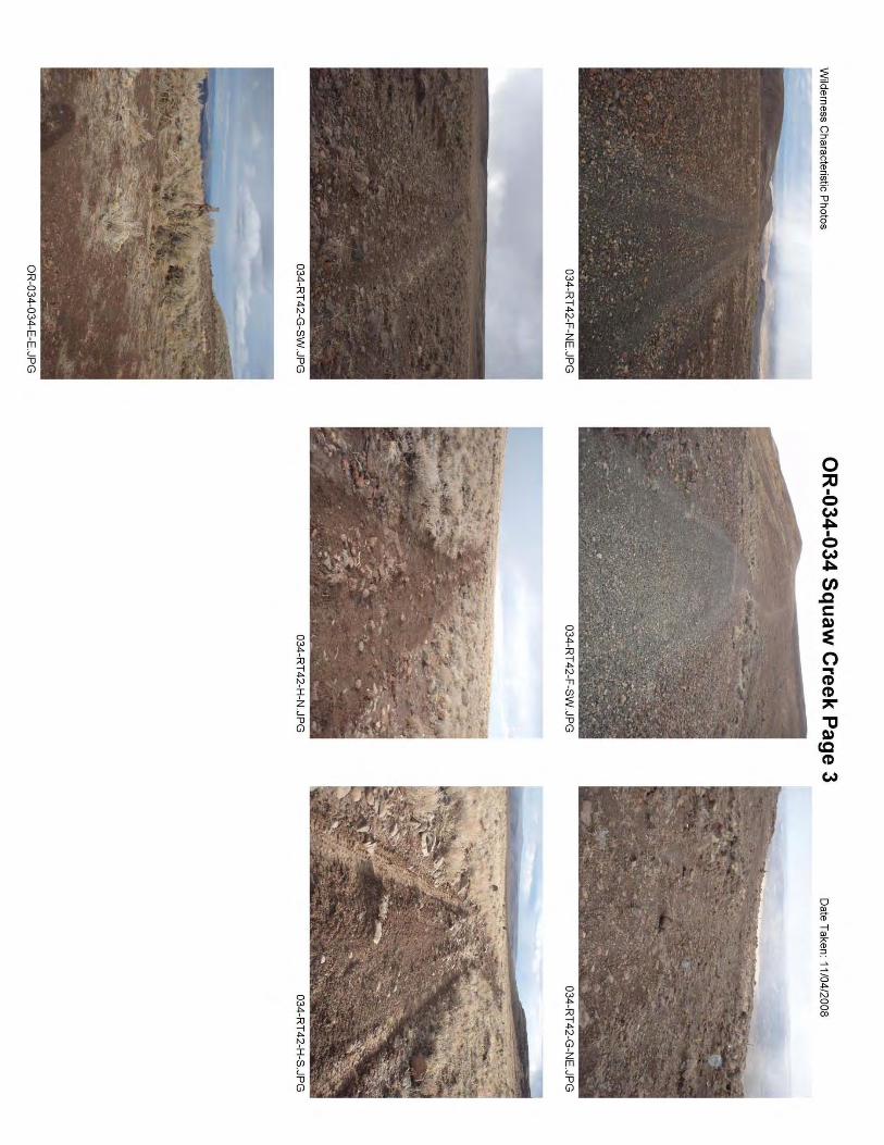
Wilderness Inventory Unit Name/Number: OR-034-034 -- Squaw Creek Route Name and/or Identifier (Include Transportation Plan Identifier, if known; include route number supplied by citizen information when available): 034-RT 42 VIII. LOCATION: Is that portion of this BLM unit’s southwest boundary that is a route
along the North boundary of Camp Creek WSA. List photo point references (if applicable): Refer to this BLM inventory unit’s associated hard copy of its BLM Photo Points map, and affiliated Photo Log and photos -- retained in this unit’s permanent hard copy file, and electronically retained under this unit.
IX. CURRENT PURPOSE OF ROUTE: (Examples: Rangeland/Livestock Improvements (stock tank, developed spring, reservoir, fence, corral), Inholdings (ranch, farmhouse), Mine Site, Concentrated Use Site (camp site), Utilities (transmission line, telephone, pipeline), Administrative (project maintenance, communication site, vegetation treatment).)
Describe: Route eventually bypasses a rangeland reservoir which is within the adjacent Camp Creek WSA. A fence is near it for a portion of the route (between photo points (PP) 034-RT42-E and the reservoir in section 3), but no vehicle travel occurs along the fence line, itself. Within this BLM inventory unit, a motorized primitive trail (MPT) branches from this route to a private land parcel. The parcel has no improvements or developments associated with it; rather it traverses the private parcel back onto public land as a MPT to eventually connect with 034-RT 41 of this inventory unit (which also is a MPT at this location in section 35).
X. ROAD RIGHT-OF-WAY:
Is a road right-of-way associated with this route? Yes ______ No ___X__ Unknown _____
XI. CONSTRUCTION

Appendix C – Road* Analysis: 034-RT42 2 of 4
Yes ___X___ No _______
Examples: Paved __________ Bladed __________ Graveled _____ Roadside Berms__X___ Cut/Fill _____ Other ______
Describe: Time of construction is unknown, although it was present at the time of the late 1970’s BLM wilderness characteristics inventory, and was identified as a boundary road for the adjacent Camp Creek WSA. Some isolate stretches indicate evidence of berms, apparently at time of construction since, at present, no evidence of mechanical maintenance is associated with this route.
XII. IMPROVEMENTS
Yes ______ No __X_____
By Hand Tools _______ By Machine _____ Examples: Culverts _______ Stream Crossings ______ Bridges _______ Drainage ________ Barriers ________ Other ________
Describe: XIII. MAINTENANCE:
A. Is there Evidence or Documentation of Maintenance using hand tools or machinery? Yes ___________ No _____X_______
If yes: Hand Tools (Y/N) _______ Machine (Y/N) _________
Explain: B. If the route is in good condition, but there is no evidence of maintenance, would mechanical maintenance with hand tools or machines be approved by BLM in the event this route became impassable?
Yes ______ No __X ____
Comments: Some segments of the more western portion of this route appear to be in fair condition (see PP 034-RT42-G as an example). This is due more so to the nature of the surface materials on fairly flat to slightly sloped terrain. Other

Appendix C – Road* Analysis: 034-RT42 3 of 4
segments of this western portion of the route are in poor condition (see PPS 034-RT42-H as an example). Photo Points 034-RT42-A through 034-RT42-F reflect the route being in fair condition, most which traverses either a ridge line or steeper terrain than does the western portion of this route. None of the route is in good condition, though is passable by a high clearance vehicle. Motorized heavy equipment to maintain the earthen reservoirs associated with this route would not require mechanical maintenance of this route to access the reservoirs.
XIV. REGULAR AND CONTINUOUS USE:
Yes _______ No ___X____
Describe evidence (vehicle tracks observed) and other rationale for whether use has occurred and will continue to occur on a relatively regular basis: Use does occur, but not on a relatively regular basis along this route’s entire length; travel is likely largely by the occasional seasonal big or small game hunter.
VIII. CONCLUSION: To meet the definition of a road, items IV or V, and VI-A or B, and VII must be checked yes. Road: Yes ___ ___ No __X____
Explanation: Does not meet road criteria, as described and explained, above. Thus, this route has changed since the late 1970’s from a road to a MPT, resulting in this inventory unit being contiguous with the Camp Creek WSA.
-------------------------------------------------------------------------------------------------------
* road: An access route which has been improved and maintained by mechanical means to insure relatively regular and continuous use. A way maintained solely by the passage of vehicles does not constitute a road. a. “Improved and maintained” – Actions taken physically by people to keep the road open to vehicle traffic. “Improved” does not necessarily mean formal construction. “Maintained” does not necessarily mean annual maintenance. b. “Mechanical means” – Use of hand or power machinery or tools.
Appendix C – Road* Analysis: 034-RT42 4 of 4
c. “Relatively regular and continuous use” – Vehicular use that has occurred and will continue to occur on a relatively regular basis. Examples are: access roads for equipment to maintain a stock water tank or other established water sources; access roads to maintained recreation sites or facilities; or access roads to mining claims.
________________________________________________ Following is the definition from Glossary of OSO 7-3-2007 Draft H-6300-1: road: The BLM will continue to base the definition of what constitutes a “road” from the FLPMA’s legislative history. The language below is from the House of Representatives Committee Report 94-1163, page 17, dated May 15, 1976, on what became the FLPMA. It is the only statement regarding the definition of a road in the law or legislative history. “The word ‘roadless’ refers to the absence of roads which have been improved and maintained by mechanical means to insure relatively regular and continuous use. A way maintained solely by the passage of vehicles does not constitute a road.” The BLM previously adopted and will continue to use the following sub-definitions of certain words and phrases in the BLM road definition stated above: a. “Improved and maintained” – Actions taken physically by people to keep the road open to vehicle traffic. “Improved” does not necessarily mean formal construction. “Maintained” does not necessarily mean annual maintenance. b. “Mechanical means” – Use of hand or power machinery or tools. c. “Relatively regular and continuous use” – Vehicular use that has occurred and will continue to occur on a relatively regular basis. Examples are: access roads for equipment to maintain a stock water tank or other established water sources; access roads to maintained recreation sites or facilities; or access roads to mining claims. A road that was established or has been maintained solely by the passage of vehicles would not be considered a road, even if it is used on a relatively regular and continuous basis. Vehicle roads constructed by mechanical means but that are no longer being maintained by mechanical methods are not roads. Sole use of hands and feet to move rocks or dirt without the use of tools or machinery does not meet the definition of “mechanical means.” Roads need not be “maintained” on a regular basis but rather “maintained” when road conditions warrant actions to keep it in a usable condition. A dead-end (cherry-stem) road can form the boundary of an inventory area and does not by itself disqualify an area from being considered “roadless”.