Wifi-based Indoor Navigation with Mobile GIS and … launched NAVTEQ systems, ... the group voice...
8
Wifi-based Indoor Navigation with Mobile GIS and Speech Recognition Jiangfan Feng 1 , Yanhong Liu 2 1 College of Computer Science and Technology, Chongqing University of Post and Telecommunications, Chongqing 400065, China 2 College of Computer Science and Technology, Chongqing University of Post and Telecommunications, Chongqing 400065, China Abstract As the development of mobile communications and wireless networking technology and people's increasing demand for wireless location services, positioning services are more and more important and become the focus of research. However, the most common technology which supports outdoor positioning services is global positioning system (GPS), but GPS has been subjected to some restrictions in the complex environment. WLAN (Wireless Local Area Networks) has matured gradually in recent years, so positioning technique based on Wi-Fi can assist GPS. In this paper, we describe two positioning techniques based on WLAN: Triangulation and fingerprinting. Additionally, the method which associated with speech recognition and spatial data model is presented. Ultimately, the experimental result is encouraging and indicates that the proposed approach is effective. Keywords: Wireless Networks, Navigation, Speech Recognition, Geographic Information Systems, Mobile Computing 1. Introduction Location positioning is more and more important in many application services. The maturity of application services and enormous governmental support has driven the rapid advancement of navigation industry. People find their way every day: from home to the company, from company to a shop, from the shop to a sports club and back home. Today, knowing where you are outside, or how far you are from someone or something, is typically not sufficient. What if we had a navigation system that worked indoors, though? While indoor navigation systems are available, they are not as popular as outdoor navigation systems. From the user's view, the major reasons for this lack of popularity are (a) navigation assistance in indoors (buildings) is not crucial as people do not consider getting lost inside of buildings and (b) options for making navigation decision in buildings are very rare. Further, there may be many questions to request an indoor location service: Firstly, GPS signal may be interfered by obstructions and delay of multi-path easily, and the GPS receiver must receive signals from a minimum of 3 visible satellites. So in the dense city zone, or an indoor environment, GPS system is not reliable. Because of these issues, other positioning techniques need to be used to assist positioning. With the development of WLAN, wireless local area network using Wi-Fi is becoming more and more ubiquitous. Wi-Fi based on the IEEE 802.11 standards, is by far the pervasive WLAN class today. The access points (AP) of the wireless network have been set up in many places. Compared with GPS, Wi-Fi allows the deployment of WLAN without wires for client devices, typically reducing the costs of network deployment and expansion. The wi-Fi signal is not definitely interfered by the climate and NLOS (Non Light of sight). It can apply in the impenetrable city zone or other complex environment. There are two main options for WLAN positioning: Triangulation and fingerprinting. Triangulation involves mapping signal strength as a function of distance while fingerprinting creates a database of signal strengths at a given area and finds the closest match to predict a location given signal strength samples[1,2,3]. In addition, with the continuous progress of the Internet and mobile communication technology, mobile geographic information system (Mobile GIS) has become one of the mainstream research directions of indoor navigation applications. Currently, the lack of ubiquitous mobile terminal equipment, such as limited screen space, input methods, computing power and memory, and often appears in the process of moving "hands busy" and "eyes busy", using voice way has been in the industry widely IJCSI International Journal of Computer Science Issues, Vol. 9, Issue 6, No 2, November 2012 ISSN (Online): 1694-0814 www.IJCSI.org 256 Copyright (c) 2012 International Journal of Computer Science Issues. All Rights Reserved.
Transcript of Wifi-based Indoor Navigation with Mobile GIS and … launched NAVTEQ systems, ... the group voice...

Wifi-based Indoor Navigation with Mobile GIS and Speech Recognition
Jiangfan Feng1, Yanhong Liu2
1 College of Computer Science and Technology, Chongqing University of Post and Telecommunications, Chongqing 400065, China
2 College of Computer Science and Technology, Chongqing University of Post and Telecommunications, Chongqing 400065, China
Abstract
As the development of mobile communications and wireless networking technology and people's increasing demand for wireless location services, positioning services are more and more important and become the focus of research. However, the most common technology which supports outdoor positioning services is global positioning system (GPS), but GPS has been subjected to some restrictions in the complex environment. WLAN (Wireless Local Area Networks) has matured gradually in recent years, so positioning technique based on Wi-Fi can assist GPS. In this paper, we describe two positioning techniques based on WLAN: Triangulation and fingerprinting. Additionally, the method which associated with speech recognition and spatial data model is presented. Ultimately, the experimental result is encouraging and indicates that the proposed approach is effective. Keywords: Wireless Networks, Navigation, Speech Recognition, Geographic Information Systems, Mobile Computing
1. Introduction
Location positioning is more and more important in many application services. The maturity of application services and enormous governmental support has driven the rapid advancement of navigation industry. People find their way every day: from home to the company, from company to a shop, from the shop to a sports club and back home. Today, knowing where you are outside, or how far you are from someone or something, is typically not sufficient. What if we had a navigation system that worked indoors, though? While indoor navigation systems are available, they are not as popular as outdoor navigation systems. From the user's view, the major reasons for this lack of popularity are (a) navigation assistance in indoors (buildings) is not crucial as people do not consider getting lost inside of buildings and (b) options for making navigation decision in buildings are very rare. Further,
there may be many questions to request an indoor location service: Firstly, GPS signal may be interfered by obstructions and delay of multi-path easily, and the GPS receiver must receive signals from a minimum of 3 visible satellites. So in the dense city zone, or an indoor environment, GPS system is not reliable. Because of these issues, other positioning techniques need to be used to assist positioning. With the development of WLAN, wireless local area network using Wi-Fi is becoming more and more ubiquitous. Wi-Fi based on the IEEE 802.11 standards, is by far the pervasive WLAN class today. The access points (AP) of the wireless network have been set up in many places. Compared with GPS, Wi-Fi allows the deployment of WLAN without wires for client devices, typically reducing the costs of network deployment and expansion. The wi-Fi signal is not definitely interfered by the climate and NLOS (Non Light of sight). It can apply in the impenetrable city zone or other complex environment. There are two main options for WLAN positioning: Triangulation and fingerprinting. Triangulation involves mapping signal strength as a function of distance while fingerprinting creates a database of signal strengths at a given area and finds the closest match to predict a location given signal strength samples[1,2,3].
In addition, with the continuous progress of the Internet and mobile communication technology, mobile geographic information system (Mobile GIS) has become one of the mainstream research directions of indoor navigation applications. Currently, the lack of ubiquitous mobile terminal equipment, such as limited screen space, input methods, computing power and memory, and often appears in the process of moving "hands busy" and "eyes busy", using voice way has been in the industry widely
IJCSI International Journal of Computer Science Issues, Vol. 9, Issue 6, No 2, November 2012 ISSN (Online): 1694-0814 www.IJCSI.org 256
Copyright (c) 2012 International Journal of Computer Science Issues. All Rights Reserved.

regarded as a major solution to obtain a high degree of attention.
Here, we describe the framework of wifi-based indoor navigation, relate it to the speech recognition in mobile GIS, and discuss new avenues of research.
2. Related Work
2.1 Indoor navigation
In [4], a survey of several positioning technologies has been presented from which many approaches were applicable for indoor use. Since it is clear, indoor applications may have very different requirements we will focus on the environments which covered areas are not very large but installation and operation should be user friendly and the systems may not be costly.
In the early 1990s, Olivetti laboratory developed the active badge indoor positioning system [5], which is considered as the original indoor positioning system. It uses infrared technology, each of the objects positioned to carry an infrared transmitter that periodically transmits its unique code, and to receive these signals for positioning by the infrared sensor throughout the chamber. Because infrared sight propagation cannot cross the obstacles itself, the propagation distance shorter infrared positioning system is mainly used in small-scale indoor positioning. This technology is a rough positioning, which provide room-level accuracy. In the field of indoor ultrasonic location systems, we analyze two samples: The Active Bat developed by the university of Cambridge, AT & T Labs [6], and the cricket system developed by Massachusetts institute of technology[7]. By measuring the arrival time of the ultrasonic wave of the ultrasonic positioning techniques to calculate the propagation distance of the ultrasonic wave, to determine the position of the object to be positioned by a triangulation method. The ultrasonic system identification, signals receiver and the monitoring center. Configuration identification, positioning in the subject that is to be positioned through the monitoring center when transmission request, identifies the ultrasonic wave is transmitted after receiving the request to the distribution in the interior of the signal receiver, the receiver to send feedback to the monitoring center, thereby calculating out the identification to the respective receivers the distance between the position of the object to be positioned is calculated by a triangulation method. The experiments show that the positioning error is less than
9cm in the case of 95% under ideal conditions. But the ultrasonic vulnerable to the effects of multi-path and non-line-of-sight transmission, and large receiver needs to be arranged in the room, so the cost is higher, is not easy to deploy.
Radio frequency identification (RFID) is the technology that put an RFID tag on objects or people, so that they can be identified, tracked, and managed automatically [8]. Each of the objects positioned to carry an RFID tag position or relative position of the object, presented by the estimated distance between each label. The Spot ON indoor positioning system [9] is the use of radio frequency identification technology, point-to-point positioning system. Due to the characteristics of this non-contact positioning technology and the advantages of non-line-of-sight to become one of the heated indoor positioning technologies. However, due to its role in a shorter distance, the longest of tens of meters, and there is no communication capability, not easy to integrate into other systems, the application is limited.
Nokia launched NAVTEQ systems, using Bluetooth technology for positioning. Bluetooth positioning technology needs to be installed in the room proper Bluetooth access point. The user holds a mobile terminal integrated Bluetooth device, turn on Bluetooth function estimates the distance and angle between the terminal and a Bluetooth transmitter installed in the indoor positioning system to locate. Bluetooth positioning technology devices are small, easy to integrate in a mobile terminal, and the technology impact from sight propagation, and therefore straightforward to popularize. However, due to the Bluetooth signal noise signal interference, poor stability. Bluetooth positioning system is used in complex indoor environments.
Based on infrared, ultrasonic, RFID, Bluetooth positioning technologies are called perceptual positioning technology, the technology requires deployment of the sensor in the interior, can determine its position, when the object enters the sensor to be positioned within the detection range. Perceived positioning technologies require specialized hardware to increase system costs, poor scalability. Infrared, ultrasonic susceptible to obstructions, not suitable for long-distance transmission, and to limit the range and accuracy of the positioning.
The EasyLiving project at Microsoft research is working to make computing more accessible and more pervasive than desktop computer [10]. However, this positioning technology is susceptible to the influence of complex indoor scene and closed action. In addition, this
IJCSI International Journal of Computer Science Issues, Vol. 9, Issue 6, No 2, November 2012 ISSN (Online): 1694-0814 www.IJCSI.org 257
Copyright (c) 2012 International Journal of Computer Science Issues. All Rights Reserved.

positioning technology privacy issues related to computer vision technology, the development of positioning are limited.
2.2 Sound and speech as interface of Mobile GIS
In recent years, despite the technical limitations and the complexity of the language, the voice in mobile GIS application is nevertheless drawn widespread attention. Given the fact that use non-visual way can help people understand geospatial information (Krygier, 1994). The use of ordinary auditory, tactile feedback, to verify the information to obtain a more idyllic (Jacobson & Jeong). The study showed that due to difficult for ordinary users to use complex GIS data query tool, the voice became effective way to obtain spatial information for them. IBM's ViaVoice speech engine in the country made an in-depth study of integration of speech technology and mobile navigation system commands and system commands for navigation and mobile navigation data and functions are divided into two categories, then abstracted the group voice command is used to achieve.
The earliest mobile GIS appear to be stand-alone structure. And the movable terminal stores all data and independently of all computing tasks, but due to its limited memory and processing capabilities, the movable terminal could not do some memory consumption, or calculate the time-consuming complex operation. Insufficient for this hardware, mainly through the efficient algorithms and data organization to compensate for the domestic and foreign scholars have put forward a series of data model and spatial indexing strategy [11, 12, 13]. However, the improvement does not fundamentally overcome the lack of movable terminal hardware, and thus the emergence and development of distributed mobile GIS, more flexible solutions. In distributed mobile GIS research, the content of a basic research is the establishment of its structural system, the main structure in accordance with its functional logic can be divided into the presentation layer, web services layer, the GIS transaction layer, data layer four levels This structure can reduce the redundant transmission between client and server [14]. Further consider the synergy between the various levels of transmission problems, the principal research has focused on the mobile database design, longitudinal information compression, and spatial information of nomadic computing. In recent years, many GIS platform manufacturers, handset manufacturers, large database developers launched their allocated solutions such as the ESRI ArcLocation, Oracle 9i AS Wireless, OGC OpenLS that distributed mode mobile GIS
architecture has become the development of the mainstream model.
3. Proposed Methodology
3.1 Triangulation
Firstly, collect signal strength from three APs (access point) at positioning location; calculate distance between positioning location to each AP by Log-distance path loss model. Then, the positioning location is estimated by triangulation algorithms [15]. Because of signal strength will loss by distance in the process of transmission. Log-distance path loss model is described as:
Pr (d) =Pt - PL (d) (1)
Where Pr (d) [dBm] is signal strength of receiver. Pt [dBm] is the signal strength of transmitter. d is the distance from transmitter to receiver, which is the distance between AP and user.PL(d) [dB] is the path loss of signal strength between transmitter and receiver.PL(d)[dB] can be written as:
PL(d)=PL(d0)+ 10nlog(d/d0)+ Xg (2)
Where n is the rate of path loss increases with distance. Xg is random variable which has Gaussian distribution with standard deviation and zero mean, d0 is the distance of a “close-in” point, usually 1m. The values of n depend on the building layout and construction material, they are derived empirically. PL(do)[dB] indicates the path loss of signal strength between transmitter and reference point.
2
L 0 2 20
P d 10log4
t rG Gd
(3)
Where Gt is the antenna gain of transmitter, it usually equals 1, Gr is the antenna gain of receiver, it usually equals 1, h is signal wavelength of transmitter, and frequency band of Wi-Fi signal is 2.4 GHz.
Distance between positioning location to AP1,AP2,AP3 which calculated by Log-distance path loss model is written as (d1,d2,d3) , then construct three intersecting circles with radius of (d1,d2,d3),the centre of circles are the locations of three AP, the intersection of these circle will be the positioning location(X,Y). The condition illustrates in Fig1. Positioning Equations can be written as:
(X-xi)2+(Y-yi)2=di2,i=1,2,3. (4)
Where (xi, yi) indicates the coordinate of ith AP, (X,Y)
IJCSI International Journal of Computer Science Issues, Vol. 9, Issue 6, No 2, November 2012 ISSN (Online): 1694-0814 www.IJCSI.org 258
Copyright (c) 2012 International Journal of Computer Science Issues. All Rights Reserved.

indicates coordinate of positioning location.
Because the actual environment is complex, calculated distance always not exactly equal to real distance between AP and positioning location. So these intersecting circle cannot intersect to one single point (Fig.2).So this approach is not viable. Enhance approach is used usually. Enhance approach is triangulation centroid algorithm.
Fig.1.Triangulation positioning algorithms
Fig.2.Triangulation centroid algorithms
The idea of the algorithm is calculating the coordinates of the intersection of three circles. There are 6 points of intersection, marked A1, A2, B1, B2, C1, C2. A1(xa1,ya1), A2(xa2,ya2)is the intersection of circle AP1 and AP2. B1(xb1,yb1),B2(xb2,yx2) is the intersection of circle AP1 and AP.C1(xc1,yc1),C2(xc2,yc2) is the intersection of circle AP2 and AP3.Then calculate the distance between A1,A2 and AP1,pick the point of smaller distance. Similarly, get B1 and C1.Then calculate the centroid of triangle (A1,B1,C1).The coordinates of estimated positioning location is (X,Y).
1 2 3 1 2 3, ,, ,3 3
a a a a a ax x x y y yX Y
(5)
3.2 Fingerprinting
Fingerprinting positioning has two phases: Off-line phase, a location fingerprint database must be constructed. Each entry in the database is a mapping between a position and a location fingerprint. The fingerprint can be an average value of RSS; real-time positioning phase, live RSSI values are then compared to the fingerprint in database to find the closest match and generate a predicted location. The whole process is illustrated in Fig. 3.
Fig.3. Principle of Fingerprinting positioning
Off-line phase is the training phase. A location fingerprint database must be constructed. First, divide the targeted positioning area into grids, usually the grid is 1m*1m.Then, at each reference point, the signal strength data are collected. Each reference point correspond vector R. A typical R= (r1,r2,…,rN) consists of RSS values from N APs. The database contains all such RSS vectors for a grid of locations in the positioning area, the location L of grid, AP information like SSID and MAC. Different APs can be distinguished by the SSID .There are a couple of alternative approaches.
The first is the empirical model. We collect average RSS value from different APs. Because the value of RSS is unstable, many samples of RSS in each grid should be collected to get the average value. To achieve a good estimation of user location, the more measurements obtained at each point the better. It is a significant task in
B2
C2 B1
(x1,y1) C1 (x3,y3)
A2 (x2,y2)
L
AP1 AP 3
AP 2
A1
(x3,y3)
AP 1
L(X,Y)
AP 2
AP 3
(x1,y1) (x2,y2)
d1 d2
d3
IJCSI International Journal of Computer Science Issues, Vol. 9, Issue 6, No 2, November 2012 ISSN (Online): 1694-0814 www.IJCSI.org 259
Copyright (c) 2012 International Journal of Computer Science Issues. All Rights Reserved.

features[16].
The spatial model is developed for indoor navigation by ESRI, which to provide essential geographic feature
should consider where to put the burden, and how the update processes will occur.
manage from external systems. For implementation, we
terms of labor and time. So in the large area, this approach is not a viable option.
The second approach is a deterministic model. A model of accounts for RSS loss should be developed. RSS is lost by distance and influenced by walls and doors in the indoor environment. RADAR model usually be used in the indoor environment. RADAR system is proposed by Bahl, P and Padmanabhan,V.N. It provides flexibility in accommodating wall attenuation factor whiling taking into account large-scale path loss. The model is described as (6).
00
( )[ ] ( )[ ] 10 lognW WAF nW CdP d dBm P d dBm nC WAF nW Cd
(6)
In this format, n is the rate of path loss increases with distance. P(do)[dBm]indicates the signal power at some reference distance, does and d is the distance from transmitter to receiver, that is the distance between AP and user location. C is the maximum number of obstructions (walls) up to which the attenuation factor makes a difference. NW is the number of obstructions (walls) between the AP and the user location. WAF is the wall attenuation factor. Values of n and WAF depend on the building layout and construction material. They are derived empirically. The value of P(do)[dBm] can be derived empirically, or obtained from wireless network hardware specifications.
On-line phase is the location determination phase. In this phase, user observed a sample RSS vector S (s1, s2, …, sN), S consists of user observed RSS values from N APs, S should be matched in the database, the location is estimated to be the L for the one that best matches. The matching is mostly based on the Euclidean distance. Many algorithms can be used to estimate the positioning location. The basic one is Nearest Neighbor in Signal Space (NNSS). The idea is to compute the Euclidean distance between the observed vector S(s1, s2, …, sN) from the user and the recorded R(r1, r2, …, rN) in database, calculate the Euclidean distance L between each R in database and S.
( )2
1
min ( , ), ( , )N
j jj
L dis S R dis S R s r=
= = -å (7)
Where sj is signal strength observed by user form jth AP, rj is signal strength recorded in database, j=1… N. L is Euclidean distance between each R in database and S. The smallest Euclidean distance between R and S mean the smallest distance between reference point and user current position.
So the estimated location is the location correspond smallest RSS Euclidean distance which is recorded in database.
3.3 Spatial data model
classes that correspond to indoor elements, and leave options for implementation for the integration of the GIS
Fig.4. Spatial data model
While this model does not contain a large number of tables, the separation of the attribute tables does create some complexity for the end user - joins, queries, and other aspects of a split model are a bit harder to work with. The counter-argument is that it makes the data easier to
3.4 Mobile GIS and speech recognition
Mutual conversion of the GIS language and Chinese language is one of the core content of the research, including natural language translation to the GIS language. The conversion from natural language to GIS language divided into two steps: (1) interpret the text of the command parameters. To clause text statement through the establishment of a thesaurus (including command operation words, the spatial relationship of the word, space object word), build input syntactic rules specific sentence is divided into command operation class, class of spatial query, spatial analysis, the use of the rules of the sentence has divided the text sentence analysis, analysis of the text of the sentence and normalized text. Further, through the semantic understanding of the text is interpreted as the specific commands and parameters. (2) command parameters to the GIS language. The steps are divided into the analysis of queries and interactive
IJCSI International Journal of Computer Science Issues, Vol. 9, Issue 6, No 2, November 2012 ISSN (Online): 1694-0814 www.IJCSI.org 260
Copyright (c) 2012 International Journal of Computer Science Issues. All Rights Reserved.
operation in two ways, one way to determine the command for the analysis of query parameters to generate the appropriate SQL statements using SQL vocabulary and syntax of the incoming command, and then access the database. Another way to determine if the command interactive operations, such as map handling, system control, etc. Through the query command mapping table to find the command set corresponding to the command statement, generate the GIS operations, the use of mobile GIS functions operating. (See Figure 5) The GIS language and natural language conversion process (see Figure 4, B section)as follows: The result of the operation of mobile GIS information through the output of syntactic rules to determine the sentence structure, and then use the final synthesis of the text, the text incoming Chinese speech lexicon determined criteria The output optimization module.
Fig.5. The cross-conversion of GIS language with Chinese
language
Fig.6. The command parameter of GIS manipulate
4. Experiments
In order to examine the performance of those two approaches, we do experiment in practice. Then measure error of the calculated locations of each mobile user and compare those two approaches for positioning.
4.1 Experiment environment
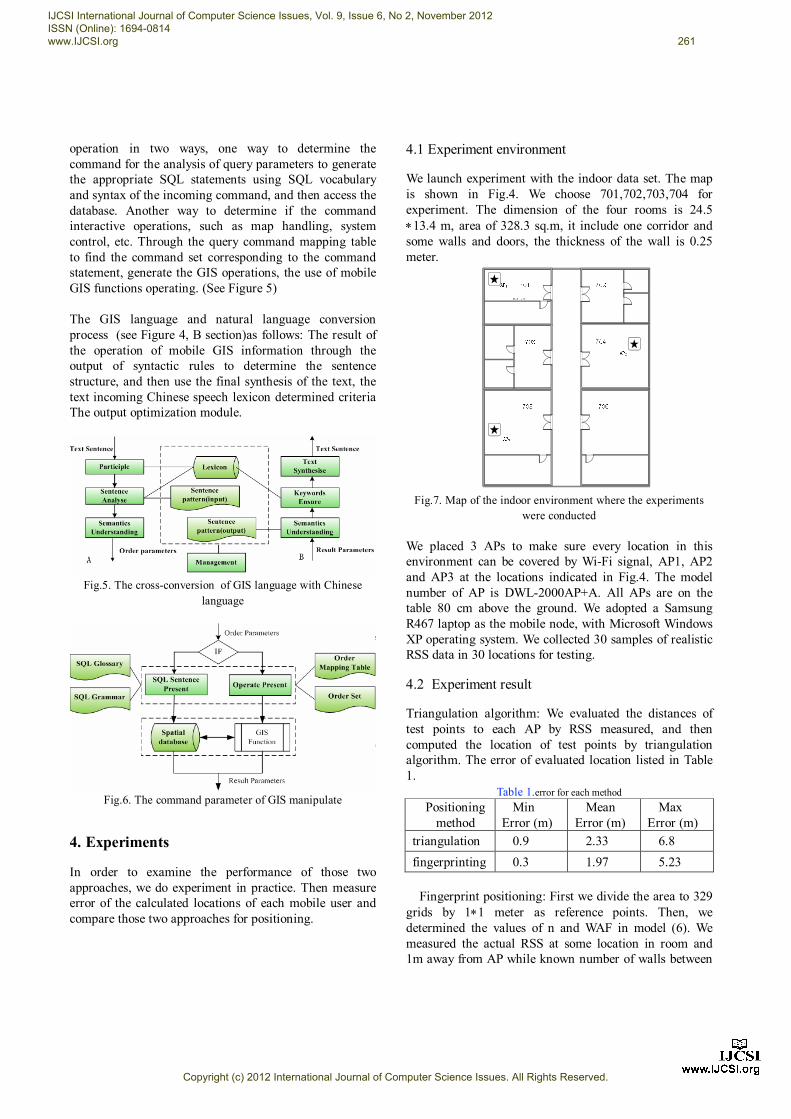
We launch experiment with the indoor data set. The map is shown in Fig.4. We choose 701,702,703,704 for experiment. The dimension of the four rooms is 24.5 13.4 m, area of 328.3 sq.m, it include one corridor and some walls and doors, the thickness of the wall is 0.25 meter.
Fig.7. Map of the indoor environment where the experiments
were conducted We placed 3 APs to make sure every location in this environment can be covered by Wi-Fi signal, AP1, AP2 and AP3 at the locations indicated in Fig.4. The model number of AP is DWL-2000AP+A. All APs are on the table 80 cm above the ground. We adopted a Samsung R467 laptop as the mobile node, with Microsoft Windows XP operating system. We collected 30 samples of realistic RSS data in 30 locations for testing.
4.2 Experiment result
Triangulation algorithm: We evaluated the distances of test points to each AP by RSS measured, and then computed the location of test points by triangulation algorithm. The error of evaluated location listed in Table 1.
Table 1.error for each method Positioning
method Min
Error (m) Mean
Error (m) Max
Error (m) triangulation 0.9 2.33 6.8 fingerprinting 0.3 1.97 5.23
Fingerprint positioning: First we divide the area to 329
grids by 11 meter as reference points. Then, we determined the values of n and WAF in model (6). We measured the actual RSS at some location in room and 1m away from AP while known number of walls between
IJCSI International Journal of Computer Science Issues, Vol. 9, Issue 6, No 2, November 2012 ISSN (Online): 1694-0814 www.IJCSI.org 261
Copyright (c) 2012 International Journal of Computer Science Issues. All Rights Reserved.

the receiver and transmitter. Base on measurement, we choose WAF to be 9 dBm and n to be 2.5, we substituted those parameters in model (6). We used the model (6) to compute the signal strength at each grid. The database of RSS distribution will be constructed by calculated RSS value. The error of evaluated location listed in Table 1. Compare with those two approaches of positioning. We conclude that the accuracy of WLAN positioning is higher than GPS. The accuracy of triangulation algorithm is lower than fingerprinting. The average error of triangulation is 2.33 meter, compared to 1.97 meter for fingerprinting. Further, there must be 3 APs when using triangulation algorithm while large database should be constructed in fingerprinting positioning system. Fingerprinting is more complexity than triangulation algorithm. See Figure 8, the terminal scan time near the AP and access to the Wi-Fi signal strength send every five seconds.
Fig.8. Data acquisition interface with Wifi information collected
Fig.9. User interface
5. Conclusions
In this paper, we described two WLAN positioning: Triangulation and fingerprinting, and then both algorithms have been evaluated in experimenting with mobile GIS and speech recognition. From the experiment, we find that the accuracy of positioning application using Wi-Fi signal is higher than using GPS. Wi-Fi can assist GPS in positioning application for higher accuracy, and it can apply in indoor, outdoor and other complex environment. After those two techniques based on WLAN have been compared, features of triangulation and fingerprinting have been concluded. User can choose suitable approach in different occasions. Triangulation can apply to the application of lower required accuracy in three APs environments. Fingerprinting applies to application which requires high accuracy. Accuracy and positioning time should be a weighting when alternative. Therefore, more work still needs to do. The effect of user's orientation is significant and the orientation should be considered in future study and design of location positioning based on WLAN. We can use TD-SCDMA signals to assist positioning using fingerprinting positioning. Positioning technique using WLAN is still needed to be research.
Acknowledgments
The Project is supported by the Natural Science Foundation Project of Chongqing CSTC (2010BB2416, 2012jjA40064), the Education Science and Technology Foundation of Chongqing (No.KJ120526). References [1] Bahl, P and Padmanabhan, V.N., “RADAR: An in-building RF-based
user location and tracking system”, Proc. IEEE INFOCOM 2000,IEEEPress,March.2000,vol.2,pp.775-784,doi:10.1109/INFCOM. 2000.832252.
[2] Sheng-Cheng Hsu, Wu-Hsiao Yeh Ching-Hui Chen, Ming-Yang Su and Ko-Hung Liu, “A Study on Outdoor Positioning Technology Using GPS and WiFiNetworks”, Proc. IEEE International Conference on Networking, Sensing and Control, IEEEPress,26-29 March. 2009 ,dio: 10.1109/ICNSC.2009.4919345.
[3] G. M. Djuknic, and R. E. Richton, “Geolocation and Assisted GPS”, IEEE Computer, vol. 2, pp. 123–125, Feb.2001.
[4] Hightower G., and Boriello G., Location Systems for Ubiquitous Computing. Computer,34(8), (2001), 57-66.
[5] Want R, Hopper A, Falcao V, et al. The Active Badge Location system [J]. ACM Transaction on Information Systems, 1992, 10(1):91-102.
[6] Hightower J, Borriello G. Location System for Ubiquitous Computing [J]. IEEE Computer, 2001, 34(8):57-66.
[7] Nissanka B.Priyantha, Anit Chakraborty, Hari Balakrishnan. The Cricket Location Support System[C]. Proceedings of the 6th annual
IJCSI International Journal of Computer Science Issues, Vol. 9, Issue 6, No 2, November 2012 ISSN (Online): 1694-0814 www.IJCSI.org 262
Copyright (c) 2012 International Journal of Computer Science Issues. All Rights Reserved.

international conference on mobile computing and networking, 2000:32-43.
[8] S.L. Ting, S.K. Kwok, Albert H.C.The Study on Using Passive RFID Tags for Indoor Positioning[J]. International Journal of Engineering Business Management, 2011,3(1):9-15.
[9] Hightower J, Want R, Borriello G. SpotON: An indoor 3D Location Sensing Technology Based on RF Signal Strength[C]. UW CSE Technical Report 2000, 2000.
[10] Krumm J, Harris S, Meyers B, et al. Multi-camera Multi-person Tracking for EasyLiving[C]. Proceedings of the Third IEEE International Workshop on Visual Surveillance, 2000:3-10.
[11] MORAISES,VIOLAROF,BARBOSA P.Prosodic Speech Modifications Using Pitch-Synchronous Time-Frequency Interpolation[c]//Proceedings of the Intemational Telecommunication Symposium.SP,Brazil Sao Paulo 1998:225-230.
[12] A.Dix, T. Rodden, N. Davies, J. Trevor, A. Friday, and K. Palfreyman (2000) Exploiting Space and Location as a Design Framework for Interactive Mobile Systems. ACM Transactions on Computer-Human Interaction 7(3): 285-321.
[13] Jeffrey Scott Vitter. External memory algorithms and data structures: dealing with massive data [J]. ACM Computing Surveys, 2001, 33 (2): 209.
[14] K. Cheverst, N. Davies, K. Mitchell, A. Friday, and C. Efstrati (2000) Developing a Context-aware Electronic Tourist Guide: Some Issues and Experiences, SIGCHI conference on Human factors in computing systems, The Hague, The Netherlands, ACM Press New York, USA.
[15] Chong Liu ,Kui Wu and Tian He ,“Sensor localization with Ring Overlapping based on Comparison of Received Signal Strength Indicator,”2004 IEEE International Conference on Mobile Ad-hoc and Sensor Systems,pp.516-518, Feb.2004.
[16] http://downloads.esri.com/support/datamodels/Building%20Interior%20Space/ESRI_Building_Interior_Space_Data_Model.zip
JiangFan Feng He received his B.S. degree from Southwest Agricultural University, and his Ph.D. degree from Nanjing Normal University, in 2002 and 2007. He works as associate professor of Chongqing University of Posts and Telecommunications. His main research area include spatial information integration and multimedia geographical information system. YanHong Liu She received the B.S. degree in communication engineering from AnHui Normal Univ. in 2008 and 2012. She is currently working towards her M.S. in the Chongqing University of Posts and Telecommunications. Her current research interests include mobile GIS and location based service.
IJCSI International Journal of Computer Science Issues, Vol. 9, Issue 6, No 2, November 2012 ISSN (Online): 1694-0814 www.IJCSI.org 263
Copyright (c) 2012 International Journal of Computer Science Issues. All Rights Reserved.