Widespread deformation of basin-plain sediments in … · Widespread deformation of basin-plain...
13
Widespread deformation of basin-plain sediments in Aysén fjord (Chile) due to impact by earthquake-triggered, onshore-generated mass movements Maarten Van Daele a, ⁎, Willem Versteeg a , Mario Pino b , Roberto Urrutia c , Marc De Batist a a Renard Centre of Marie Geology (RCMG), Ghent University, Krijgslaan 281/S8, B-9000 Gent, Belgium b Instituto de Geociencias, Universidad de Valdivia, Casilla 567, Valdivia, Chile c Centro EULA, Universidad de Concepción, Casilla 160-C, Concepción, Chile abstract article info Article history: Received 7 July 2012 Received in revised form 18 January 2013 Accepted 25 January 2013 Available online 16 February 2013 Communicated by D.J.W. Piper Keywords: 2007 Aysén earthquake landslide multibeam seismic-reflection Liquiñe-Ofqui Fault Zone The 2007 M w 6.2 earthquake in Aysén fjord caused widespread basin-plain deformation and has had prehistorical predecessors. Both superficial and buried deformed basin-plain deposits are mapped using multibeam bathymetry and seismic-reflection (sparker) profiling. The seismic signature of the sediment was ground-truthed with short cores on key locations. Deformed basin-plain deposits induced by the 2007 earthquake can be divided in frontally emergent and confined deposits, with both a deep and shallow basal shear surface. All deformed basin-plain deposits with a deep basal shear surface are induced by the weight and impact of a slope-adjacent mass-flow wedge. The frontally emergent – most mobile – basin-plain deformation is triggered by mass flows originating from onshore mass movements (i.e. debris flows, rock slides and avalanches) propagating into the fjord. This basin-plain deformation results in vertical seafloor offsets of up to 20 m. Therefore it might be even more impor- tant for far-field tsunami propagation than the impact of the onshore mass movements on the sea surface. In the depressions created by the basin-plain deformation, megaturbidites occur, while more distally, sandy density-flow deposits cover the seafloor. The data also indicates that these density flows propagate slower than the basin-plain deformation. Based on correlations with the two main eruptions of the Hudson Volcano, we hypothesize that dur- ing the Holocene three to four similar events have struck the fjord. The small variability of the structural character- istics of the Liquiñe-Ofqui Fault Zone in the northern Patagonian fjordland and historical seismic swarms in this area make us conclude that similar hazards should be taken into account for most of the fjords in this region. © 2013 Elsevier B.V. All rights reserved. 1. Introduction Offshore mass movements have repeatedly proven their value in paleoseismological research; both in marine and lacustrine settings (Dawson, 1999; Strasser et al., 2006; Moernaut et al., 2007; Tripsanas et al., 2008; Moernaut et al., 2009; Masson et al., 2011). They have been successfully correlated to historical earthquakes and were used to identify prehistorical events. Especially in fjords or bays, mass move- ments can be catastrophic (Syvitski and Schafer, 1996; Bøe et al., 2000; Urgeles et al., 2002) and potentially induce tsunamis (Tocher and Miller, 1959; Ward, 2001; L'Heureux et al., 2011; Suleimani et al., 2011). These, in turn, represent great hazards for coastal villages and harbors, which in many cases provide the best access to remote inland areas. The northern Chilean fjordland is a tectonically active region. Not only is it crossed from north to south by the Liquiñe-Ofqui Fault Zone, an active dextral strike-slip structural lineament, it is also located along the subduction zone that produced the largest earthquake ever instrumentally recorded (i.e. the 1960 Great Chilean earthquake) (Fig. 1A; Melnick et al., 2009). Nevertheless, except for the study of St-Onge et al. (2012), in which mass-wasting events in Reloncaví fjord were linked to megathrust earthquakes, and Araya Vergara (2011), who detected buried submarine mass-transport deposits in Aysén fjord, no studies have had the objective to map and date submarine mass-movement deposits or basin-plain deformation in the Chilean fjordland. However, the 2007 Aysén fluid-driven seismic swarm (Fig. 1B; Legrand et al., 2011) and 21 April 2007 M w 6.2 main shock clearly highlight that research on the characteristics and the recurrence of such catastrophic events is essential for establishing reliable hazard assessments in the region. After the extensive onshore mass movement triggered by the 2007 main earthquake, studies were performed on these mass movements and the tsunamis induced by them (Fig. 1C; Naranjo et al., 2009; Sepúlveda and Serey, 2009; Sepúlveda et al., 2010). Unfortunately, older (i.e. historical and prehistorical) onshore mass movements are often hard to detect and to date (Jibson, 1996), complicating any study of such older events and of possible recurrence rates between events. Ward and Day (2010) propose that the 1958 seismically induced onshore rockslide in Lituya Bay (Alaska) trig- gered a submarine landslide. Introducing this submarine slide into their tsunami model was necessary to fit the high run-ups – derived from eyewitness and trimline accounts – at the more remote locations. Marine Geology 337 (2013) 67–79 ⁎ Corresponding author. Tel.: +32 9 264 45 73; fax: +32 9 264 49 67. E-mail address: [email protected] (M. Van Daele). 0025-3227/$ – see front matter © 2013 Elsevier B.V. All rights reserved. http://dx.doi.org/10.1016/j.margeo.2013.01.006 Contents lists available at SciVerse ScienceDirect Marine Geology journal homepage: www.elsevier.com/locate/margeo
Transcript of Widespread deformation of basin-plain sediments in … · Widespread deformation of basin-plain...
Marine Geology 337 (2013) 67–79
Contents lists available at SciVerse ScienceDirect
Marine Geology
j ourna l homepage: www.e lsev ie r .com/ locate /margeo
Widespread deformation of basin-plain sediments in Aysén fjord (Chile) due toimpact by earthquake-triggered, onshore-generated mass movements
Maarten Van Daele a,⁎, Willem Versteeg a, Mario Pino b, Roberto Urrutia c, Marc De Batist a
a Renard Centre of Marie Geology (RCMG), Ghent University, Krijgslaan 281/S8, B-9000 Gent, Belgiumb Instituto de Geociencias, Universidad de Valdivia, Casilla 567, Valdivia, Chilec Centro EULA, Universidad de Concepción, Casilla 160-C, Concepción, Chile
⁎ Corresponding author. Tel.: +32 9 264 45 73; fax: +E-mail address: [email protected] (M. Va
0025-3227/$ – see front matter © 2013 Elsevier B.V. Allhttp://dx.doi.org/10.1016/j.margeo.2013.01.006
a b s t r a c t
a r t i c l e i n f oArticle history:Received 7 July 2012Received in revised form 18 January 2013Accepted 25 January 2013Available online 16 February 2013
Communicated by D.J.W. Piper
Keywords:2007 Aysén earthquakelandslidemultibeamseismic-reflectionLiquiñe-Ofqui Fault Zone
The 2007Mw 6.2 earthquake in Aysén fjord caused widespread basin-plain deformation and has had prehistoricalpredecessors. Both superficial and buried deformed basin-plain deposits aremapped usingmultibeambathymetryand seismic-reflection (sparker) profiling. The seismic signature of the sediment was ground-truthed with shortcores on key locations. Deformed basin-plain deposits induced by the 2007 earthquake can be divided in frontallyemergent and confined deposits, with both a deep and shallow basal shear surface. All deformed basin-plaindeposits with a deep basal shear surface are induced by the weight and impact of a slope-adjacent mass-flowwedge. The frontally emergent – most mobile – basin-plain deformation is triggered by mass flows originatingfrom onshore mass movements (i.e. debris flows, rock slides and avalanches) propagating into the fjord. Thisbasin-plain deformation results in vertical seafloor offsets of up to 20 m. Therefore it might be even more impor-tant for far-field tsunami propagation than the impact of the onshore mass movements on the sea surface. In thedepressions created by the basin-plain deformation,megaturbidites occur, whilemore distally, sandy density-flowdeposits cover the seafloor. The data also indicates that these density flows propagate slower than the basin-plaindeformation. Based on correlations with the twomain eruptions of the Hudson Volcano, we hypothesize that dur-ing the Holocene three to four similar events have struck the fjord. The small variability of the structural character-istics of the Liquiñe-Ofqui Fault Zone in the northern Patagonian fjordland and historical seismic swarms in thisarea make us conclude that similar hazards should be taken into account for most of the fjords in this region.
© 2013 Elsevier B.V. All rights reserved.
1. Introduction
Offshore mass movements have repeatedly proven their value inpaleoseismological research; both in marine and lacustrine settings(Dawson, 1999; Strasser et al., 2006; Moernaut et al., 2007; Tripsanaset al., 2008; Moernaut et al., 2009; Masson et al., 2011). They havebeen successfully correlated to historical earthquakes and were usedto identify prehistorical events. Especially in fjords or bays, mass move-ments can be catastrophic (Syvitski and Schafer, 1996; Bøe et al., 2000;Urgeles et al., 2002) and potentially induce tsunamis (Tocher andMiller,1959;Ward, 2001; L'Heureux et al., 2011; Suleimani et al., 2011). These,in turn, represent great hazards for coastal villages and harbors, whichin many cases provide the best access to remote inland areas.
The northern Chilean fjordland is a tectonically active region. Notonly is it crossed from north to south by the Liquiñe-Ofqui Fault Zone,an active dextral strike-slip structural lineament, it is also locatedalong the subduction zone that produced the largest earthquakeever instrumentally recorded (i.e. the 1960 Great Chilean earthquake)
32 9 264 49 67.n Daele).
rights reserved.
(Fig. 1A; Melnick et al., 2009). Nevertheless, except for the study ofSt-Onge et al. (2012), in which mass-wasting events in Reloncaví fjordwere linked to megathrust earthquakes, and Araya Vergara (2011),who detected buried submarine mass-transport deposits in Aysénfjord, no studies have had the objective to map and date submarinemass-movement deposits or basin-plain deformation in the Chileanfjordland. However, the 2007 Aysén fluid-driven seismic swarm(Fig. 1B; Legrand et al., 2011) and 21 April 2007 Mw 6.2 main shockclearly highlight that research on the characteristics and the recurrenceof such catastrophic events is essential for establishing reliable hazardassessments in the region. After the extensive onshore mass movementtriggered by the 2007 main earthquake, studies were performed onthese mass movements and the tsunamis induced by them (Fig. 1C;Naranjo et al., 2009; Sepúlveda and Serey, 2009; Sepúlveda et al.,2010). Unfortunately, older (i.e. historical and prehistorical) onshoremass movements are often hard to detect and to date (Jibson, 1996),complicating any study of such older events and of possible recurrencerates between events. Ward and Day (2010) propose that the 1958seismically induced onshore rockslide in Lituya Bay (Alaska) trig-gered a submarine landslide. Introducing this submarine slide intotheir tsunami model was necessary to fit the high run-ups – derivedfrom eyewitness and trimline accounts – at the more remote locations.

Fig. 1. Setting of Aysén fjord; A: shaded relief map of the inner fjord area with indication of the various types of onshore mass movements that were triggered by the 2007Mw 6.2earthquake (Sepúlveda et al., 2010). In the fjord, location of reflection-seismic (sparker) profiles and short sediment cores are shown. B: region around Aysén fjord with indi-cation of the Liquiñe-Ofqui Fault Zone (after Cembrano et al., 2000; Melnick et al., 2009), volcanoes, tephra and pumice fallout isopachs (after Naranjo and Stern, 1998, 2004;MEN=Mentolat, MAC=Macá, H=Hudson) and the region of the 2007 seismic swarm andmain shock (afterMora et al., 2010; Legrand et al., 2011) and C: northern Patagonianfjordland with Liquiñe-Ofqui Fault Zone and the epicenter of the 1927 earthquake, which – similarly to the 2007 event – triggered onshore mass-movements and tsunamis in theChilean fjordland (Naranjo et al., 2009).
68 M. Van Daele et al. / Marine Geology 337 (2013) 67–79
Bozzano et al. (2009) and Watt et al. (2012) have successfully shownthat seismic-reflection profiling and/or multibeam bathymetry can beutilized to detect deposits of onshore landslides propagating into thesea or a lake. They also show that these onshore landslides havethe potential to trigger offshore mass movements, thereby demon-strating that on- and offshore mass movements can be related. Suchoffshore mass-movement deposits are more efficiently preserved inthe sedimentary record, and can potentially be dated much easier.Finally, Schnellmann et al. (2005) proposed a model in which mass
movements trigger basin-plain deformation with fold and thrust belts,accompanied by a lake tsunami or seiche.
In this study, we link offshore basin-plain deformation to onshoremass movements triggered by the Mw 6.2 2007 earthquake, usingseismic-reflection profiling and multibeam bathymetry data. Thisstrategy allows identifying and mapping not only the recent, butalso older (buried) basin-plain deformation. Furthermore, short sedi-ment cores are used for ground-truthing the superficial deposits andin this way better understand the seismic signature of older deposits.

69M. Van Daele et al. / Marine Geology 337 (2013) 67–79
A hypothesis, based on seismic stratigraphy, for the age of these olderdeposits is presented.
2. Setting
2.1. Geographical setting
Aysén fjord is one of themany fjords in the Chilean part of Patagonia,located between PuertoMontt in the north andCapeHorn in the south. Itis carved in the Andean Cordillera, which reaches altitudes of approxi-mately 2000 m asl (meters above sea level) in this region. At the easternextremity of the fjord lies Puerto Chacabuco, the largest harbor of theAysén District and through Puerto Aysén the main access to Coyhaique,the district capital (Fig. 1).
2.2. Geological, tectonic and volcanic setting
The geology of this area is dominated by the Patagonian Batholith.This granitic to dioritic batholith outcrops from the Llaima volcano(38°40′S) in the north to Cape Horn (56°00′S) in the south. Therefore,most of the catchment of Aysén fjord consists of this granitic to dioriticbedrock, locally interrupted by someQuaternary volcanic centerswith as-sociated basaltic to rhyolitic volcanic rocks that cover the batholith. Theeastern part of the Aysén River catchment consists mainly of Mesozoïcvolcanic rocks (basaltic–rhyolitic composition) with some intercalatedsedimentary sequences (Sernageomin, 2003).
A second important geological feature in the study area is theLiquiñe-Ofqui Fault Zone (LOFZ; Fig. 1). The LOFZ is a 1000 km longdextral strike-slip lineament, which has been accommodating theoblique subduction of the Nazca Plate underneath the South-AmericanPlate since the Mid Miocene. The fault zone separates the north-moving (6.5 mm/yr) Chiloé sliver (in the west) from the rest of theSouth-American Plate (in the east) (Cembrano et al., 2000; Wang et al.,2007; Melnick et al., 2009). In the study area, the LOFZ consists oftwo overlapping, NNE-striking, master faults, connected by a seriesof NE-striking, right-lateral en echelon faults (Legrand et al., 2011).In Aysén fjord, one of these en echelon faults joins the easternmostmaster fault (Fig. 1A and B).
During the first months of 2007 a seismic swarm with more than7000 recorded earthquakes affected the region around Aysén fjord.The series of seismic events started on 22 January 2007 and reacheda maximum on 21 April 2007 with an Mw 6.2 earthquake. The epicen-ter of this Mw 6.2 earthquake was located in the fjord (Fig. 1B) and theearthquake occurred at a depth of b9 km. Intensities as high as VIII toIX on the Modified Mercalli scale were reported around the epicenter,where the largest mass movements occurred. In Puerto Chacabucoand Puerto Aysén (at the eastern end of the fjord) Modified MercalliIntensities decreased to VII (Naranjo et al., 2009; Sepúlveda andSerey, 2009; Sepúlveda et al, 2010). Multiple debris flows, rock slidesand rock avalanches were triggered along the fjord's coastline, with aconcentration of the mass movements around the LOFZ, attributed tothe fracturation of the bedrock by this fault zone (Figs. 1A and 2). Thetwo most voluminous rock avalanches and one rock slide/avalanchewere reported to have caused tsunamis (Naranjo et al., 2009). Severaltsunamiwaveswith a height of up to 6 m reached the shores of the fjord,where they not only destroyed salmon farms, houses and small villages,but also resulted in 10 casualties (Sepúlveda and Serey, 2009). In 1927, asimilar seismic swarm, which lasted for at least 2 months, affected thenorthern part of the Patagonian fjordland (i.e. Aysén to Chiloé). On 21November 1927, an earthquake with an estimated magnitude of 7.1occurred approximately 100 km north of Aysén fjord (Fig. 1A), causinglandslides and tsunamis in the fjords (Naranjo et al., 2009). In August2005 a seismic cluster with predominantly dextral strike-slip focalmechanisms and a maximum magnitude of Mw 3.8 occurred in theHornopirén Channel (Lange et al., 2008; Fig. 1C)). The same area was
struck by a seismic swarm in May–June 2008; during this swarm mag-nitudes reached Mw 5.3 (Servicio Sismológico, 2012).
Several major Pleistocene–Holocene volcanoes are present closeto Aysén fjord. The Macá and Cay volcanoes, 20 and 30 km north ofthe fjord, respectively, and the Hudson Volcano, 50 km south of thefjord, are the three southernmost volcanoes of the Andean SouthernVolcanic Zone (SVZ) (Fig. 1B). The Hudson Volcano (45°54′S, 72°58′W, 1905 m asl) is an active volcano, with a 10 km wide, ice-filledcaldera. The largest known eruptions of this basaltic–dacitic volcanoare prehistorical and date from ~3600 14C yr BP (H2) and ~7430 14C yrBP (~8260 cal yr BP) (H1), the latter probably having formed the caldera(Naranjo and Stern, 1998; Stern andWeller, 2012). The basaltic to daciticMacá Volcano (45°06′S, 73°10′W, 2960 m asl) is the highest volcano inthe region, but has only one known eruption: in 410±50 AD. The CayVolcano (45°3′33″S, 72°59′3″W, 2090 m asl) is a basaltic to daciticstratovolcano with no historical records of eruptions (Naranjo andStern, 2004).
3. Materials and methods
The data used in this study (multibeambathymetry, high-resolutionreflection-seismic profiles and short sediment cores) were acquired inDecember 2009 on board of RV Don Este.
3.1. Multibeam bathymetry
The bathymetry of the inner part of the fjord (i.e. east of TortugaPoint; Figs. 1 and 2) was mapped using an ELAC SeaBeam 1050multibeam sonar. The two 50 kHz transducer arrays were installedon a pole at the bow of RV Don Este, and operated with 120° swath,transmitting and receiving 108 beams of 3° by 3° beam angle. Inorder to correct for roll, pitch and heave an IXSEA Octans motion sen-sor was installed right above the transducers, to minimize errors. Thesound-velocity profile was made using the pressure, temperature andsalinity data from an IDROMAR IP039D CTD. Continuous CTD mea-surements at the surface were made with a Valeport CTD. The datawas first cleaned with HDPedit and tide information was added inHDPpost. Final data cleaning and interpretation were done using theIVS 3D Fledermaus™ software. Grid resolutions are depth-dependentand range from 4 m for the shallow areas to 20 m for the deeper areas.
3.2. Seismic-reflection data
High-resolution seismic-reflection data was acquired using RCMG'sin-house designed Centipede multi-electrode sparker source. The spark-er, operated at 300–400 J, produces a broad-spectrum seismic signal,with a mean frequency of ~1.3 kHz. A single-channel streamer with 10hydrophones and a total group length of 2.7 m, was used as a receiver.Data was acquired at an average survey speed of 4 knots. Seismic andGPS data were digitally recorded and converted to SEG-Y format withthe IXSEA™ Delph Seismic Acquisition system. Interpretation of thedata was done using The Kingdom Suite™ software. Up to 35 seismicprofiles with a total length of 133 km were acquired in the inner partof the fjord (Fig. 1A). Thickness of sediment packages was calculatedbased on a sound velocity of 1500 m/s.
3.3. Sediment cores
Several short gravity cores were collected in the inner part of thefjord, three of which, taken from key locations in the fjord, were usedin this study (AY11, AY12 and AY20; Fig. 1A). The cores were takenwith a Swiss gravity corer and have a length ranging between 50 and130 cm. Magnetic susceptibility (MS) of the sediment was measuredevery 2.5 mmwith a BartingtonMS2E point sensor (3.5 mm resolution).Grain size was measured with a Malvern Mastersizer 2000 at 1–5 mmspatial resolution, depending on the sediment, without pretreatment.
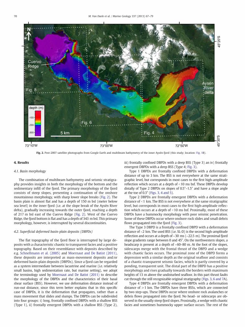
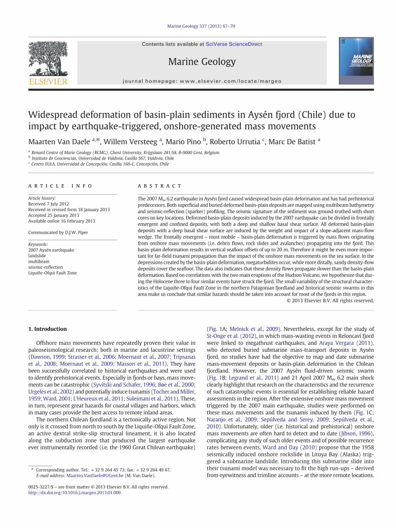
Fig. 2. Post-2007 satellite photographs from Google Earth and multibeam bathymetry of the inner Aysén fjord (this study; location: Fig. 1B).
70 M. Van Daele et al. / Marine Geology 337 (2013) 67–79
4. Results
4.1. Basin morphology
The combination of multibeam bathymetry and seismic stratigra-phy provides insights in both the morphology of the bottom and thesedimentary infill of the fjord. The primary morphology of the fjordconsists of steep slopes, presenting a continuation of the onshoremountainous morphology, with sharp lower slope breaks (Fig. 2). Thebasin plain is almost flat and has a depth of 150 m bsl (meter belowsea level) in the inner fjord (i.e. at the slope break of the Aysén Riverdelta), gradually increasing towards the outer fjord, reaching a depthof 217 m bsl east of the Cuervo Ridge (Fig. 2). West of the CuervoRidge, the fjord bottom is flat and has a depth of 343 mbsl. This primarymorphology, however, is interrupted by several discontinuities.
4.2. Superficial deformed basin-plain deposits (DBPDs)
The flat topography of the fjord floor is interrupted by large de-posits with a characteristic chaotic to transparent facies and a positivetopography. Based on their resemblance with deposits described bye.g. Schnellmann et al. (2005) and Moernaut and De Batist (2011),these deposits are interpreted as mass-movement deposits and/ordeformed basin-plain deposits (DBPDs). Since a fjord can be regardedas a system intermediate between lacustrine and marine (i.e. relativelysmall basins, high sedimentation rate, but marine setting), we adoptthe terminology used by Moernaut and De Batist (2011) to describethe morphology of the DBPDs and the characteristics of their basalshear surface (BSS). However, we use deformation distance instead ofrun-out distance, since this term better explains that in this specificcase of DBPDs, it is the deformation that propagates, rather than amass movement that slides and slumps. The DBPDs can be subdividedinto four groups: i) long, frontally confined DBPDs with a shallow BSS(Type 1), ii) frontally emergent DBPDs with a shallow BSS (Type 2),
iii) frontally confined DBPDs with a deep BSS (Type 3) an iv) frontallyemergent DBPDs with a deep BSS (Type 4; Fig. 3).
Type 1 DBPDs are frontally confined DBPDs with a deformationdistance of up to 3 km. The BSS is not everywhere at the same strati-graphic level, but corresponds in most cases to the first high-amplitudereflection which occurs at a depth of b10 ms bsf. These DBPDs developdistally of Type 2 DBPDs on slopes of 0.5°–1.5° and have a slope angleat the toe of 0.3° (Figs. 3, 4 and 5).
Type 2 DBPDs are frontally emergent DBPDs with a deformationdistance of b1 km. The BSS is not everywhere at the same stratigraphiclevel, but corresponds in most cases to the first high-amplitude reflec-tion which occurs at a depth of b10 ms bsf. Proximally, most of theseDBPDs have a hummocky morphology with poor seismic penetration.Some of these DBPDs occur where onshore rock slides and small debrisflows propagated into the fjord (Fig. 3).
The Type 3 DBPD is a frontally confined DBPD with a deformationdistance of ~2 km. The used BSS (i.e. SL-D) is the second high-amplitudereflection and occurs at a depth of ~30 ms (~22.5 m). The proximal fjordslope gradients range between 0 and 45°. On the northwestern slopes, aheadscarp is present at a depth of ~60–80 m. At the foot of the slopes,sidescarps merge with the frontal thrust of the DBPD and a wedgewith chaotic facies occurs. The proximal zone of the DBPD forms adepression with a similar depth as the original seafloor and consistsof a chaotic-transparent seismic facies, which is partly covered by aponding, transparent unit. The distal part of the DBPD has a positivemorphology and rises gradually towards the borders with maximumheights of 13 m above the undisturbed seafloor. In this part thrust faultscut through the still recognizable original stratigraphy (Figs. 3, 6 and 7A).
Type 4 DBPDs are frontally emergent DBPDs with a deformationdistance of >1 km. The DBPDs have three BSSs, which are connectedby two step-ups. These DBPDs occur where onshore rock avalanches ordebris flows propagated into the fjord. No head- or sidescarps are ob-served in the usually steep fjord slopes. Proximally, awedgewith chaoticfacies and sometimes hummocky upper surface occurs. The rest of the

Fig. 3. Schematic illustration of the 4 types of basin-plain deformation encountered inAysén fjord.
71M. Van Daele et al. / Marine Geology 337 (2013) 67–79
DBPD can be subdivided in four areas: i) the inner depression, ii) theinner thrust belt, iii) the outer thrust belt and iv) the unconfined part(Figs. 3, 6 and 7B):
- In the inner depression the seafloor has a similar depth or iseven deeper than the undisturbed basin floor, and the DBPD ispartially covered by a ponding unit with a transparent faciesand a maximum thickness of 4 ms (~3 m). The BSS is hard todistinguish on the seismic-reflection data due to blanking by theDBPD. The seismic facies of the deposit is transparent to chaotic(Figs. 6 and 7B).
- The inner thrust belt uses SL-C as BSS, has a transparent to chaoticseismic facies forming a positive topography in which (frontal)thrusts are present close to the outer BSS step-up (Figs. 6 and 7B).
- The outer thrust belt has a positive topography, although lowerthan the one of the inner thrust belt. The BSS that is used in thispart of the deposit is SL-F (Figs. 6 and 7B).
- The unconfined part of the deposit emerges distally or laterallyfrom the outer thrust belt (Fig. 6).
4.2.1. Acantilada BayAcantilada Bay is characterized by the Aysén River delta, situated
at the eastern extremity of the fjord. The subaqueous topset of thedelta is only a few meters deep and therefore not covered by thebathymetry map. The delta slopes extend from 20 to 120 m bsl andhave a mean slope angle of 6°–8° (Fig. 4). The seismic penetrationin the delta front sediments is limited to only a few meters and theseismic facies is chaotic. The north-facing slopes are interrupted bymultiple small channels, which are up to 5 m deep and extendstraight towards the gently SW-inclined basin floor (1.5° to 0.22°from northeast to southwest, respectively). These channels convergeinto a larger channel that originates at the northern foot of the deltaslope, circumventing the delta to the west and then following a SWcourse adjacent to Partida Island, ending up at Mano Point. This chan-nel has a width and depth of 100–250 m and 0–4 m, respectively(Figs. 4 and 5). Along the Aysén River delta and the western andnorthern shores of Acantilada Bay, multiple Type 2 DBPDs and oneType 4 DBPD occur. The most characteristic for this area, however,are several Type 1 DBPDs, originating at the distal parts of the otherDBPDs and covering a large part of Acantilada Bay (Figs. 4 and 5).Adjacent to these Type 1 DBPDs, also channels occur with widthsand depths of 50–200 m and 0–3 m, respectively. These channels lo-cally cut through the Type 1 DBPDs and the western channel only cutsthrough the upper sediments without disturbing deeper stratigraphiclevels; they merge south of Mano Point (Figs. 4 and 5).
4.2.2. Cola Point–Mentirosa Island areaIn the area comprised between Mano Point in the east and the
Quitralco Fault in the west, multiple DBPDs are present. The depthof the flat basin floor ranges between 180 and 210 m bsl. Along theshores, several Type 2 DBPDs occur, but the most prominent DBPDsare of Type 3 (Cola Point NW) or Type 4 (Cola Point SE, MentirosaIsland W, Mentirosa Island SE, Fernández Creek and Aguas Calientes;Figs. 6 and 7). All these DBPDs are named after onshore geographicfeatureswhere also subaerial debris flows and rock slides and avalanchesoccurred during the 2007 earthquake (Figs. 4). In the Cola Point SE DBPD,both the inner and the outer thrust belts are incised by a NNE-SSWstriking channel (Fig. 6).
4.2.3. Cuervo Ridge and surroundingsIn the southern part of the northwest-facing slopes of the Cuervo
Ridge a Type 2 DBPD occurs. Also distally from Playa Blanca, a Type 2DBPD with a hummocky morphology is present. Lacking seismic-reflection data in this area prevents us frommaking further observa-tions concerning this DBPD (Fig. 8).
4.2.4. Ground-truthingSouthwest of Mentirosa Island, a transparent, ponding deposit can
be observed on the seismic-reflection profiles. The deposit is filling amorphological depression delimited by the confined part of the DBPDsin the north, west and south, and by the gently rising undisturbedbasin floor in the east (Figs. 6, 7 and 9). Core AY11was taken in the cen-tral part of this deposit (Figs. 6 and 7C), and penetrates a 106 cm thick,normally graded unit (Fig. 10). The lower 18 cm consist of normallygraded coarse to very fine sands, followed by 12 cm of normally gradedfine sands to silts and finally 76 cm of homogenous silts. The upper2 cm of the core consist of silts similar to the sediments underneaththis deposit (Fig. 10).
Core AY20, which was taken south of the Fernández Creek DBPD(Fig. 6), sampled a 12.5 cm thick sandy deposit. The lower 5 cm of
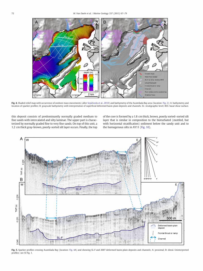
Fig. 4. Shaded relief map with occurrence of onshore mass movements (after Sepúlveda et al., 2010) and bathymetry of the Acantilada Bay area (location: Fig. 2); A: bathymetry andlocation of sparker profiles; B: grayscale bathymetry with interpretation of superficial deformed basin-plain deposits and channels. SL: stratigraphic level; BSS: basal shear surface.
72 M. Van Daele et al. / Marine Geology 337 (2013) 67–79
this deposit consists of predominantly normally graded medium tofine sands with intercalated and silty laminae. The upper part is charac-terized by normally graded fine to very fine sands. On top of this unit, a1.2 cm thick gray-brown, poorly-sorted silt layer occurs. Finally, the top
Fig. 5. Sparker profiles crossing Acantilada Bay (location: Fig. 4A) and showing SL-F and 20profiles: see SI Fig. 1.
of the core is formed by a 1.8 cm thick, brown, poorly sorted–sorted siltlayer that is similar in composition to the bioturbated (mottled, butwith horizontal stratification) sediment below the sandy unit and tothe homogenous silts in AY11 (Fig. 10).
07 deformed basin-plain deposits and channels; A: proximal; B: distal. Uninterpreted
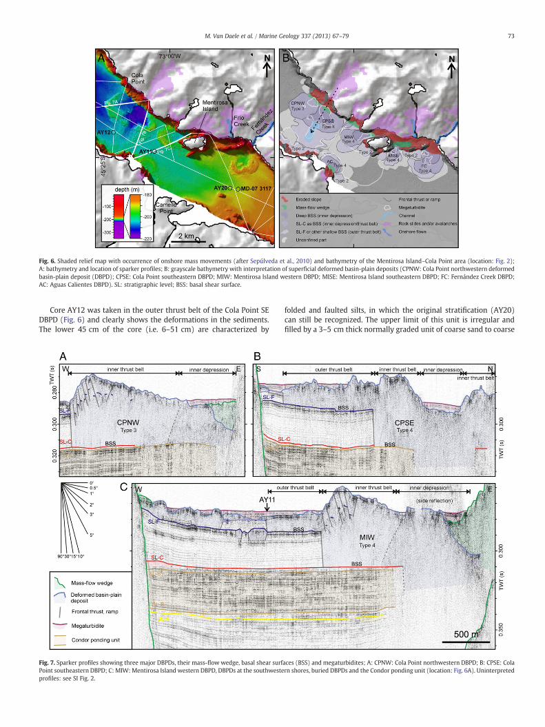
Fig. 6. Shaded relief map with occurrence of onshore mass movements (after Sepúlveda et al., 2010) and bathymetry of the Mentirosa Island–Cola Point area (location: Fig. 2);A: bathymetry and location of sparker profiles; B: grayscale bathymetry with interpretation of superficial deformed basin-plain deposits (CPNW: Cola Point northwestern deformedbasin-plain deposit (DBPD); CPSE: Cola Point southeastern DBPD; MIW: Mentirosa Island western DBPD; MISE: Mentirosa Island southeastern DBPD; FC: Fernández Creek DBPD;AC: Aguas Calientes DBPD). SL: stratigraphic level; BSS: basal shear surface.
73M. Van Daele et al. / Marine Geology 337 (2013) 67–79
Core AY12 was taken in the outer thrust belt of the Cola Point SEDBPD (Fig. 6) and clearly shows the deformations in the sediments.The lower 45 cm of the core (i.e. 6–51 cm) are characterized by
Fig. 7. Sparker profiles showing three major DBPDs, their mass-flow wedge, basal shear surfPoint southeastern DBPD; C: MIW:Mentirosa Island western DBPD, DBPDs at the southwesteprofiles: see SI Fig. 2.
folded and faulted silts, in which the original stratification (AY20)can still be recognized. The upper limit of this unit is irregular andfilled by a 3–5 cm thick normally graded unit of coarse sand to coarse
aces (BSS) and megaturbidites; A: CPNW: Cola Point northwestern DBPD; B: CPSE: Colarn shores, buried DBPDs and the Condor ponding unit (location: Fig. 6A). Uninterpreted

Fig. 8. Shaded relief map with occurrence of onshore mass movements (after Sepúlveda et al., 2010) and bathymetry of the Cuervo Ridge area (location: Fig. 2); A: bathymetry andlocation of sparker profiles; B: grayscale bathymetry with interpretation of superficial deformed basin-plain deposits. SL: stratigraphic level; BSS: basal shear surface.
74 M. Van Daele et al. / Marine Geology 337 (2013) 67–79
silt. The upper 2.5 cm of the core consist of homogenous silt similar tothe top of AY20 (Fig. 10).
4.3. Buried DBPDs
The upper part of the sedimentary infill of the fjord consists ofdraping sediments with a continuous, stratified facies (Fig. 9). Withinthese draping sediments, seismic-reflection data reveal several buriedDBPDs (Fig. 9), some of which share the same stratigraphic level (SL),all with high reflection amplitudes (i.e. SL-A, SL-C, SL-D and SL-F).Three stratigraphic levels (i.e. SL-A, SL-C and SL-F) comprise all
Fig. 9. Sparker profile showing the upper part of the Aysén fjord sedimentary infill anlens-shaped megaturbidites, the Condor River fan, the associated ponding unit and sedimentthe H1 probably formed the caldera (Naranjo and Stern, 1998; Stern and Weller, 2012; loca
except one of the buried DBPDs. The geographical extent of DBPD-occurrence at the three levels is similar as for the superficialDBPDs: from the Cuervo Ridge in the west to the Aysén River deltain the east (Fig. 11).
The largest DBPD occurs at SL-A, in the area between the CondorRiver mouth and Mano Point. This deposit is accompanied by a largetransparent, ponding deposit, covering the northeastern part of theDBPD and the area comprised by this deposit and the Aysén Riverdelta. Other, smaller, DBPDs occur at this level in the northwesternpart of Acantilada Bay, in the Mentirosa Island–Aguas Calientes areaand south of the Cuervo River delta (Figs. 9 and 11).
d the different stratigraphic levels (SL), deformed basin-plain deposits, transparentcores. H1=~7430 14C yrs BP Hudson eruption; H2=~3600 14C yrs BP Hudson eruption,tion: Fig. 1). Uninterpreted profiles: see SI Fig. 3.

Fig. 10. Three gravity cores taken in Aysén fjord showing the folded and faulted upper part of the DBPDs (AY12 and AY11), distal density-flow deposits (AY20 and AY12) and amegaturbidite (AY11). The dotted correlation lines between AY20 and AY12 show how the original stratification can still be recognized in the deformed sediments. For eachcore: left: unprocessed core photograph; middle: photograph processed with histogram equalization; right (only for AY20 and AY11): grain-size distribution (location of thecores: Figs. 1 and 6A); and the magnetic susceptibility of the sediments on a logarithmic scale (yellow line).
75M. Van Daele et al. / Marine Geology 337 (2013) 67–79
At SL-C, DBPDs are present in the same areas as for SL-A, withthe largest one south of Mano Point. Probably some more, shallowexcavating DBPDs occur in Acantilada Bay, but the resolution of theseismic-reflection data does not allow mapping these deposits(Fig. 11).
Only a single DBPD was found at SL-D, west of the Condor Rivermouth. This stratigraphic level only has a high-amplitude reflectionin the area close to this deposit (Figs. 9 and 11).
At SL-F, DBPDs were found in Acantilada Bay, Mentirosa Island andin the Playa Blanca–Cola Point area. East of the DBPD at Playa Blanca, a
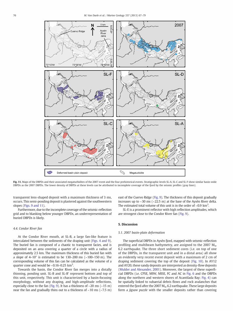
Fig. 11.Maps of the DBPDs and their associated megaturbidites of the 2007 event and the four prehistorical events. Stratigraphic levels SL-A, SL-C and SL-F show similar basin-wideDBPDs as the 2007 DBPDs. The lower density of DBPDs at these levels can be attributed to incomplete coverage of the fjord by the seismic profiles (gray lines).
76 M. Van Daele et al. / Marine Geology 337 (2013) 67–79
transparent lens-shaped deposit with a maximum thickness of 3 ms,occurs. This semi-pondingdeposit is plastered against the southwesternslopes (Figs. 9 and 11).
Furthermore, due to the incomplete coverage of the seismic-reflectiongrid and to blanking below younger DBPDs, an underrepresentation ofburied DBPDs is likely.
4.4. Condor River fan
At the Condor River mouth, at SL-B, a large fan-like feature isintercalated between the sediments of the draping unit (Figs. 4 and 9).The buried fan is composed of a chaotic to transparent facies, and isdeposited on an area covering a quarter of a circle with a radius ofapproximately 2.5 km. The maximum thickness of this buried fan witha slope of 4–10° is estimated to be 130–200 ms (~100–150 m). Thecorresponding volume of this fan can be calculated as the volume of aquarter cone and would be ~0.16–0.25 km3.
Towards the basin, the Condor River fan merges into a distallythinning, ponding unit. SL-B and SL-B' represent bottom and top ofthis unit, respectively. This unit is characterized by a basin-focusingmorphology, without any draping, and high-amplitude reflections,especially close to the fan (Fig. 9). It has a thickness of ~20 ms (~15 m)near the fan and gradually thins out to a thickness of ~10 ms (~7.5 m)
east of the Cuervo Ridge (Fig. 9). The thickness of this deposit graduallyincreases up to ~30 ms (~22.5 m) at the base of the Aysén River delta.The estimated total volume of this unit is in the order of ~0.9 km3.
SL-E is a prominent reflector with high reflection amplitudes, whichare strongest close to the Condor River fan (Fig. 9).
5. Discussion
5.1. 2007 basin-plain deformation
The superficial DBPDs in Aysén fjord, mapped with seismic-reflectionprofiling and multibeam bathymetry, are assigned to the 2007 Mw
6.2 earthquake. The three short sediment cores (i.e. on top of oneof the DBPDs, in the transparent unit and in a distal area) all showan evidently very recent event deposit with a maximum of 2 cm ofdraping sediment covering the top of the deposit (Fig. 10). In AY12and AY20, these sandy deposits are interpreted as density-flowdeposits(Mulder and Alexander, 2001). Moreover, the largest of these superfi-cial DBPDs (i.e. CPSE, MIW, MISE, FC and AC in Fig. 6 and the DBPDsalong the northern and western shores of Acantilada Bay; Fig. 4) canbe spatially linked to subaerial debris flows and rock avalanches thatentered the fjord after the 2007Mw6.2 earthquake. These large depositsform a jigsaw puzzle with the smaller deposits rather than covering

77M. Van Daele et al. / Marine Geology 337 (2013) 67–79
them (Fig. 6), indicating that all the superficial deposits mapped usingthe seismic-reflection data and themultibeambathymetry are triggeredby a single event: the 2007Mw6.2 earthquake. The transparent pondingunits that fill the depressions created by the DBPDs (Figs. 7 and 9)and are cored by AY11 (Fig. 10), are interpreted as megaturbidites(Bouma, 1987).
All the DBPDs along the northwestern shores of Acantilada Bayoccur where onshore debris flows, rock slides and avalanches enteredthe fjord. In the east, where the basin slopes are very steep (i.e. 15–35°),the deposits are likelymainly composed ofmaterial from these onshoremass movements, as suggested by the hummocky morphology. Inthe western part of Acantilada Bay, where the slopes are less steep(i.e. 3–20°) and therefore possibly sediment-bearing, the onshoremass movements likely triggered offshore DBPDs, which have a highermobility. The DBPDs at the base of the west-facing delta slopes and theabsence of large channels on these slopes, suggest that these slopeshave indeed failed during the 2007 earthquake.
A major part of Acantilada Bay basin plain is covered by Type 1basin-plain deformation (Fig. 4). In the east, this basin-plain deforma-tion developed adjacent to a preexisting channel, which channelizeddensity flows that originated at the delta and the northeastern shoresof Acantilada Bay. In the west, a channel incises the Type 1 DBPD andcontinues to Mano Point, where it merges with the eastern channel(Fig. 4). This channel wasmost likely formed by density flows postdatingthe DBPD, indicating that the deformation of the basin-plain depositspropagated faster than the density flows.
All the large DBPDs (i.e. Type 3 and 4) occur at locations wherelarge subaerial debris-flows and rock slides/avalanches entered thefjord, and vice versa (Fig. 6). Only the Type 3 DBPD at Cola Point iscaused by a mass flow of slope sediments, in turn triggered by anonshore rock avalanche that entered the fjord. For all the large andmost of the Type 2 DBPDs, the model proposed by Schnellmann et al.(2005), with some minor adaptations, can be used to explain theirformation and geometry. This model assumes that the increasing loadat the slope break marking the transition between the fjord slope andbasin floor induces gravity spreading of the basin-plain sedimentleading to propagating overthrusting and sediment deformation,with the latter causing a completely transparent facies. The proximalmass-flowwedge (i.e. the load) was recognized on top of some of ourDBPDs (Fig. 7).
The structure of the Type 3 DBPD at Cola Point can be explainedby this model. However, the proximal depression that is characteris-tic for the Cola Point DBPD does not occur in the deposits studied bySchnellmann et al. (2005). A possible explanation for this differenceis the larger height drop of the mass flow in Aysén fjord (>150 mversus ~100 m). This difference can cause higher impact velocities,resulting in a higher energy transfer, resulting in the stronger basin-plain deformation.
In the Type 4 DBPDs, not only the central depression is deeper, butalso proximal deformation penetrates deeper in the fjord sediments(Fig. 7). A succession of step-ups and a distal unconfined part is typicalfor these deposits. This enhanced displacement is probably caused by alarger height drop and steeper slopes (Moernaut and De Batist, 2011).All the Type 4 DBPDs occur where onshore rock avalanches and debrisflows entered the fjord, resulting in an offshore height drop of >195 m.Moreover, the higher density of the rocks compared to the slope sedi-ments will increase the inertia and energy transferred during impactwith the basin-plain sediments. Types 3 and 4 of basin-plain deformationin Aysén fjord could thus be considered to be the two next steps in themodel of Schnellmann et al. (2005), in which energy transfer during im-pact becomes increasingly important for the deformation. Alternatively,the different morphology of the Aysén DBPSs compared to the DBPDs inthe Swiss peri-alpine lakes (Schnellmann et al., 2005) could also be relat-ed to different mechanical properties of the basin-plain sediments in thetwo settings. Also, apart from the mechanical properties of the muddysediments, the occurrence of the high-amplitude reflectors SL-A and
SL-C (interpreted in Section 5.2 as density-flow deposits of prehistoric2007-like events) can also have had an influence on the deformation.These sandy density-flow deposits are used as a BSS by the 2007 DBPDsand thus have the right mechanical properties to act as a shear surface.We can therefore conclude that the prehistoric event-deposits influencedthe formation of the 2007 event deposits and thatwithout the occurrenceof these density-flow deposits, the deformation in 2007would have pen-etrated less deep into the basin-plain sediments and would thereforehave caused less vertical deformation of the seafloor.
The large height difference between the inner depressions and thethrust belts (up to 20 m) suggests that the Types 3 and 4 basin-plaindeformation could have the potential to be tsunamogenic. Similarlyas in Lituya Bay (Alaska), such a tsunami sensu stricto can potentiallypropagate further than an impact wave produced by onshore massmovements impacting on the fjord water (Ward and Day, 2010).The tsunamogenic potential is therefore also influenced by the me-chanical properties of the basin plain sediments and the occurrenceof sand layers such as density-flow deposits. However, all types of de-formation and resulting waves should be modeled to confirm thesehypotheses.
Similarly to Acantilada Bay, the data also clearly shows how thebasin-plain deformation of the Type 4 deposits propagates fasterthan the overriding density flow. The channel that incises the innerthrust belt of the southeastern Cola Point frontally emergent DBPD,is aligned with the on- and offshore mass-flow pathways (Fig. 6).Hence, we interpret that the density flow broke through the freshlydeformed and up-thrusted basin-plain sediments. This delay can belogically explained by the rigid basin-plain sediment, in which alldeformation occurs quasi-instantaneously through grain-to-graincontact, compared to the density flow, which has to travel the entiredistance. On top of the deformed basin-plain sediments, these densityflows only leave a thin (i.e. a few centimeters) normally graded gravel tosilt layer, while, distally, these density flows are preserved as ~10 cmthick sandy deposits (core AY20; Fig. 10).
5.2. Prehistoric events and chronology
Also the older DBPDs coincide with a distal density-flow deposit.The older DBPDs distally correspond to basin-wide high-amplitudereflections in the case of multiple DBPDs on one stratigraphic level,originating from different slope segments of the fjord (i.e. SL-A, SL-Cand SL-F), or to local high amplitudes in the case of a single DBPD onone stratigraphic level (i.e. SL-D). Some of these stratigraphic levelscan be tied to the MD-07 3117 core, a Calypso core which was takenfrom the RV Marion Dufresne, in the context of the PACHIDERME pro-ject, 2 months prior to the Mw 6.2 earthquake. In this ~21 m longcore, sandy layers at depths of ~5 m, ~17 m and ~20 m are interpretedas tephra layers, and at a depth of ~10 m a 50 cm thick tephra and pum-ice layer occurs (Kissel and The shipboard scientific party, 2007). Thetephras at ~5 m and ~20 m depth correlate with SL-F and SL-D, respec-tively (Fig. 9). Based on our seismic-stratigraphicmapping and interpre-tation of the DBPDs in the fjord, we suggest that these high-amplitudereflections represent distal density-flow deposits, similar to the 2007density-flow deposit (i.e. ~10 cm thick sandy layers in AY20, at approx-imately the same location; Fig. 6A), containing reworked tephra. Thepumice–tephra layer correlates with SL-E (Fig. 9).
Based on its intercalated, local nature, we interpret the CondorRiver fan and its coeval ponding unit to be deposited in a relativelyshort time period (Fig. 9) and tentatively attribute it to the ~8260 cal yrBP H1 Hudson eruption. The dimensions at sea level of the Condor Riverfan (i.e. ~1.1 km2) are of the same magnitude as the fan deposited inChaitén Bay (Fig. 1C) after the 2008 Chaitén eruption (i.e. ~1.3 km2)presented by Lara (2009) (Fig. 8), indicating that it is possible for such afan to be deposited during a single event. The H1 eruptionwas the largestHolocene eruption of the Hudson Volcano and the characteristics ofthe related tephras are consistent with a caldera formation during

78 M. Van Daele et al. / Marine Geology 337 (2013) 67–79
this eruption (Naranjo and Stern, 1998). The Condor River is drainingsome of the southern slopes of the Hudson Caldera (Fig. 1), hence, cal-dera formation could produce pyroclastic flows potentially reachingthe fjord, and/or provide the Condor River with large amounts ofvolcanoclastic sediment. The thickening of the ponding unit towardsthe Aysén River delta is consistent with the fact that also the AysénRiver drains a part of the Hudson Volcano (Fig. 1). However, studyingvolcanic outcrops in the Condor River valley is necessary to confirmthis hypothesis.
Correlating the Condor River fan with the ~8260 cal yr BP H1
Hudson eruption, results in an average sedimentation rate of about0.3 cm/yr at the location of the MD-07 3117 Calypso core. Thissedimentation rate is very similar to the sedimentation rates of0.19–0.30 cm/yr that Salamanca and Jara (2003) determined in theupper 25 cm of sediment on two locations in the inner Aysén fjord.Hence, these sedimentation rates support our correlation and byassuming a constant sedimentation (in TWT ms) – and in the ab-sence of any direct age control on these deposits –wemake a simple,back-of-the-envelope assessment of the ages of the prehistoric eruptionsand earthquakes. The resulting age for the pumice–tephra layer at SL-E –
which is best developed close to the Condor River fan – would be~3170 yr BP and can be tentatively attributed to the 3600 14C yr BP H2
Hudson eruption. This H2 pumice–tephra layer was deposited in largeareas south of Aysén fjord (Naranjo and Stern, 1998), and is the onlyknown pumice deposit that close south of the fjord (Naranjo and Stern,1998, 2004; Stern, 2008; Fig. 1B). The ages of SL-A, SL-C, SL-D and SL-Fwould be ~9160 yr BP, ~7160 yr BP, ~5830 yr BP and ~1500 yr BP, re-spectively. On stratigraphic levels SL-A, SL-C and SL-F basin-widemass-movements occurred on a scale comparable to that of the 2007event (Fig. 11). We infer that these mass-movement events were trig-gered by 2007-like earthquakes along the LOFZ, with epicenters veryclose to Aysén fjord. The SL-DDBPDwas probably formed during a small-er earthquake in the fjord or a similar earthquake, but with an epicenterfurther away from the fjord. Hence, three to four catastrophic eventscomparable in effect to the 2007 earthquake and tsunami have struckAysén fjord during the Holocene.
In the studied inner part of the fjord we do not see signs of majorDBPDs that could be attributed to the 1927 seismic swarmand associatedM 7.1 earthquake. The estimated epicenter of this major earthquake islocated about 100 km to the north of the fjord, probably along one ofthe northernmost en echelon faults connecting the two overlappingmaster faults of the LOFZ. By using the formulas of Keefer (1984) andRodriguez et al. (1999) to extrapolate the maximum epicentral distancesfor onshore disrupted landslides and flows obtained by Sepúlveda et al.(2010) for the 2007 earthquake, we findmaximum epicentral distancesof ~90 km and ~50–70 km for disrupted landslides and flows, respec-tively. Hence, it could be expected that no major subaerial landslidingaffected Aysén fjord.
5.3. Activity along the Liquiñe-Ofqui Fault Zone (LOFZ)
2007-like events can occur regularly in the Patagonian fjordland.Scarce historical and instrumental records indicate that seismicswarms, both with and without a large main shock, are commonalong the southern part of the LOFZ (i.e. south of Puerto Montt). The1927, 2005, 2007 and 2008 seismic swarms in the Patagonian fjordlands(Lange et al., 2008; Naranjo et al., 2009; Servicio Sismológico, 2012)demonstrate that these swarms, which are often accompanied by largemain shocks, are common along the LOFZ. The low recurrence rate ofon average 2500–3000 yr in Aysén fjord shows that at a specific locationalong the LOFZ, these catastrophic events are scarce.We expect, however,that similar events occur relatively frequently along the LOFZ in thePatagonian fjords between Reloncaví fjord in the north (41.50° S) andSan Rafael Lake in the south (46.75° S), and should be taken into accountfor hazard assessments. North of Reloncaví fjord, the nature of theLOFZ becomesmore segmented and displacement decreases (especially
north of 40° S, dying out at 38° S) (Rosenau et al., 2006), reducing therisk of large earthquakes in this area.
6. Conclusions
This study gives an overview of the impact of the 2007 seismicswarm and Mw 6.2 main shock on the sedimentary record of the fjord,and provides a hypothesis on the recurrence of such events. The mainconclusions are listed hereafter:
1) The onshoremass movements that were triggered by the 2007Mw
6.2 earthquake and propagated into the fjord, all triggered defor-mation of basin-plain sediments. Multiple small offshore massmovements have been triggered directly by the earthquake.
2) The largest offshore deformed basin-plain deposits were producedby the impact and load of the onshoremassmovements, resulting inunique morphologies of the basin-plain deformation, characterizedby proximal depressions and high inner and outer thrust belts.
3) Some of these DBPDs might have been more important for far-fieldtsunami propagation than the impact of the onshore mass move-ments themselves.
4) Densityflowsoriginating from theAcantilada Bay andCola Pointmassflows, formed or enlarged channels, occasionally cutting through thedeformed basin plain, indicating that the latter propagate faster.
5) The data shows that three to four similar events have struck thefjord during the Holocene. A similar frequency pattern should betaken into account for hazard assessments in the other fjords between41.5° and 46.5° S.
Supplementary data to this article can be found online at http://dx.doi.org/10.1016/j.margeo.2013.01.006.
Acknowledgments
This research was funded mainly by the Fund for Scientific ResearchFlanders (FWO-Vlaanderen) and by the Special Research Fund of GhentUniversity (BOF).We are grateful to Litoral Austral and the RV Don Estecrew (especially captain J. Matamala Nuñez) to make the 2009 surveypossible and successful.We thankK. DeRycker for the technical supportduring the survey in 2009. J. Greinert is acknowledged for the substan-tial help in processing of the multibeam data. We are grateful to C. Lealfor the use of the CTD. B. Beuselinck andM. Vincx are acknowledged forthe use of the Malvern Mastersizer 2000. We thank Ph. De Smedt forsharing the Bartington MSE2 point sensor. M. Cuylaerts is acknowl-edged for her work in the sedimentary lab. We thank K. Heirman,I. Meyer, J. Moernaut andW. Vandoorne for the fruitful discussions. Fi-nally we thank M. Strasser and an anonymous reviewer for their con-structive comments on an earlier version of this manuscript. M. VanDaele is currently funded by the Fund for Scientific Research Flanders(FWO-Vlaanderen).
References
Araya Vergara, J.F., 2011. Submarine failures in the bottom of the Aysén fjord, NorthernPatagonia, Chile. Investigaciones Geográficas — Santiago, Chile 43, 17–34.
Bøe, R., Hovland, M., Instanes, A., Rise, L., Vasshus, S., 2000. Submarine slide scars andmass movements in Karmsundet and Skudenesfjorden, southwestern Norway:morphology and evolution. Marine Geology 167 (1–2), 147–165.
Bouma, A.H., 1987.Megaturbidite— An acceptable term. Geo-Marine Letters 7 (2), 63–67.Bozzano, F., Mazzanti, P., Anzidei, M., Esposito, C., Floris, M., Fasani, G.B., Esposito, A.,
2009. Slope dynamics of Lake Albano (Rome, Italy): insights from high resolutionbathymetry. Earth Surface Processes and Landforms 34 (11), 1469–1486.
Cembrano, J., Schermer, E., Lavenu, A., Sanhueza, A., 2000. Contrasting nature of deforma-tion along an intra-arc shear zone, the Liquine-Ofqui fault zone, southern ChileanAndes. Tectonophysics 319, 129–149.
Dawson, A.G., 1999. Linking tsunami deposits, submarine slides and offshore earthquakes.Quaternary International 60, 119–126.
Jibson, R.W., 1996. Use of landslides for paleoseismic analysis. Engineering Geology 43(4), 291–323.
Keefer, D.K., 1984. Landslides caused by earthquakes. Bulletin of the Geological Societyof America 95 (4), 406–421.
79M. Van Daele et al. / Marine Geology 337 (2013) 67–79
Kissel, C., The shipboard scientific party, 2007. MD159 - PACHIDEME IMAGES XV, cruisereport. Institut polaire français Paul-Emile Victor, Plouzané, France (84 pp.).
L'Heureux, J.S., Glimsdal, S., Longva, O., Hansen, L., Harbitz, C., 2011. The 1888 shorelinelandslide and tsunami in Trondheimsfjorden, central Norway. Marine GeophysicalResearch 32 (1), 313–329.
Lange, D., Cembrano, J., Rietbrock, A., Haberland, C., Dahm, T., Bataille, K., 2008. Firstseismic record for intra-arc strike-slip tectonics along the Liquiñe-Ofqui fault zoneat the obliquely convergent plate margin of the southern Andes. Tectonophysics455 (1–4), 14–24.
Lara, L.E., 2009. The 2008 eruption of the Chaiten Volcano, Chile: a preliminary report.Andean Geology 36 (1), 125–129.
Legrand, D., Barrientos, S., Bataille, K., Cembrano, J., Pavez, A., 2011. The fluid-driventectonic swarm of Aysen Fjord, Chile (2007) associated with two earthquakes(Mw = 6.1 and Mw = 6.2) within the Liquiñe-Ofqui Fault Zone. ContinentalShelf Research 31 (3–4), 154–161.
Masson, D.G., Arzola, R.G., Wynn, R.B., Hunt, J.E., Weaver, P.P.E., 2011. Seismic trigger-ing of landslides and turbidity currents offshore Portugal. Geochemistry, Geophys-ics, Geosystems 12, Q12011 (19 pp.).
Melnick, D., Bookhagen, B., Strecker, M.R., Echtler, H.P., 2009. Segmentation ofmegathrust rupture zones from fore-arc deformation patterns over hundreds tomillions of years, Arauco peninsula, Chile. Journal of Geophysical Research-SolidEarth 114 (B01407), 23pp.
Moernaut, J., De Batist, M., 2011. Frontal emplacement and mobility of sublacustrinelandslides: results from morphometric and seismostratigraphic analysis. MarineGeology 285 (1–4), 29–45.
Moernaut, J., De Batist, M., Charlet, F., Heirman, K., Chapron, E., Pino, M., Brummer, R.,Urrutia, R., 2007. Giant earthquakes in South-Central Chile revealed by Holo-cene mass-wasting events in Lake Puyehue. Sedimentary Geology 195 (3–4),239–256.
Moernaut, J., De Batist, M., Heirman, K., Van Daele, M., Pino, M., Brümmer, R., Urrutia, R.,2009. Fluidization of burried mass-wasting deposits in lake sediments and its rele-vance for paleoseismology: results from a reflection seismic study of lakes Villarricaand Calafquén (South-Central Chile). Sedimentary Geology 213, 121–135.
Mora, C., Comte, D., Russo, R., Gallego, A., Mocanu, V., 2010. Aysen seismic swarm(January 2007) in southern Chile: analysis using Joint Hypocenter Determination.Journal of Seismology 14 (4), 683–691.
Mulder, T., Alexander, J., 2001. The physical character of subaqueous sedimentary den-sity flows and their deposits. Sedimentology 48 (2), 269–299.
Naranjo, J.A., Stern, C.R., 1998. Holocene explosive activity of Hudson Volcano, southernAndes. Bulletin of Volcanology 59 (4), 291–306.
Naranjo, J.A., Stern, C.R., 2004. Holocene tephrochronology of the southernmost part(42 degrees 30′–45 degrees S) of the Andean Southern Volcanic Zone. RevistaGeologica de Chile 31 (2), 225–240.
Naranjo, J.A., Arenas, M., Clavero, J., Munoz, O., 2009. Mass movement-induced tsunamis:main effects during the Patagonian Fjordland seismic crisis in Aisen (45 degrees 25′S), Chile. Andean Geology 36 (1), 137–145.
Rodriguez, C.E., Bommer, J.J., Chandler, R.J., 1999. Earthquake-induced landslides:1980–1997. Soil Dynamics and Earthquake Engineering 18 (5), 325–346.
Rosenau, M., Melnick, D., Echtler, H., 2006. Kinematic constraints on intra-arc shear andstrain partitioning in the southern Andes between 38 degrees S and 42 degrees Slatitude. Tectonics 25 (4), TC4013 (16 pp.).
Salamanca, M.A., Jara, B., 2003. Distribución y acumulación de plomo (Pb y 210Pb) ensedimentos de los fiordos de la XI región, Chile. Ciencia y Tecnología del Mar 26 (2),61–71.
Schnellmann, M., Anselmetti, F.S., Giardini, D., McKenzie, J.A., 2005. Mass movement-induced fold-and-thrust belt structures in unconsolidated sediments in Lake Lucerne(Switzerland). Sedimentology 52 (2), 271–289.
Sepúlveda, S.A., Serey, A., 2009. Tsunamigenic, earthquake-triggered rock slope failuresduring the April 21, 2007 Aisén earthquake, southern Chile (45.5 degrees S). AndeanGeology 36 (1), 131–136.
Sepúlveda, S., Serey, A., Lara, M., Pavez, A., Rebolledo, S., 2010. Landslides induced bythe April 2007 Aysén Fjord earthquake, Chilean Patagonia. Landslides 7 (4), 483–492.
Sernageomin, 2003. Mapa Geológico de Chile: versión digital, escala 1:1.000.000., Santiago,Chile.
Servicio Sismológico, 2012. Todos los sismos en Chile (2000-Presente). ServicioSismológico, Depto. de Geovísica, Universidad de Chile, Santiago (Available at:http://www.sismologia.cl/seismo.html, accessed on May 2012).
Stern, C., 2008. Holocene tephrochronology record of large explosive eruptions in thesouthernmost Patagonian Andes. Bulletin of Volcanology 70 (4), 435–454.
Stern, C.R., Weller, D., 2012. A revised Age of 7430±250 14C yrs BP for the Very Largemid-Holocene Explosive H1 Eruption of the Hudson Volcano, Southern Chile. 13thChilean Geologic Congress, Antofagasta, Chile (2 pp.).
St-Onge, G., Chapron, E., Mulsow, S., Salas, M., Viel, M., Debret, M., Foucher, A., Mulder, T.,Winiarski, T., Desmet, M., Costa, P.J.M., Ghaleb, B., Jaouen, A., Locat, J., 2012. Comparisonof earthquake-triggered turbidites from the Saguenay (Eastern Canada) and Reloncavi(Chileanmargin) Fjords: implications for paleoseismicity and sedimentology. Sedimen-tary Geology 243, 89–107.
Strasser, M., Anselmetti, F.S., Fah, D., Giardini, D., Schnellmann, M., 2006. Magnitudesand source areas of large prehistoric northern Alpine earthquakes revealed byslope failures in lakes. Geology 34 (12), 1005–1008.
Suleimani, E., Nicolsky, D., Haeussler, P., Hansen, R., 2011. Combined effects of tectonicand landslide-generated tsunami runup at Seward, Alaska During the Mw 9.2 1964earthquake. Pure and Applied Geophysics 168 (6), 1053–1074.
Syvitski, J.P.M., Schafer, C.T., 1996. Evidence for an earthquake-triggered basin collapsein Saguenay Fjord, Canada. Sedimentary Geology 104 (1–4), 127–153.
Tocher, D., Miller, D.J., 1959. Field observations on effects of Alaska earthquake of 10July 1958. Science 129 (3346), 394–395.
Tripsanas, E.K., Piper, D.J.W., Campbell, D.C., 2008. Evolution and depositional structureof earthquake-induced mass movements and gravity flows: Southwest OrphanBasin, Labrador Sea. Marine and Petroleum Geology 25 (7), 645–662.
Urgeles, R., Locat, J., Lee, H.J., Martin, F., 2002. The Saguenay Fjord, Quebec, Canada:integrating marine geotechnical and geophysical data for spatial seismic slopestability and hazard assessment. Marine Geology 185 (3–4), 319–340.
Wang, K., Hu, Y., Bevis, M., Kendrick, E., Smalley, R., Lauria, E., 2007. Crustal motion inthe zone of the 1960 Chile earthquake: Detangling earthquake-cycle deformationand forearc-sliver translation. Geochemistry, Geophysics, Geosystems 8 (14 pp.).
Ward, S.N., 2001. Landslide tsunami. Journal of Geophysical Research-Solid Earth 106(B6), 11201–11215.
Ward, S.N., Day, S., 2010. The 1958 Lituya Bay landslide and tsunami – A tsunami ballapproach. Journal of Earthquake and Tsunami 4 (4), 285–319.
Watt, S.F.L., Talling, P.J., Vardy, M.E., Heller, V., Hühnerbach, V., Urlaub, M., Sarkar, S.,Masson, D.G., Henstock, T.J., Minshull, T.A., Paulatto, M., Le Friant, A., Lebas, E.,Berndt, C., Crutchley, G.J., Karstens, J., Stinton, A.J., Maeno, F., 2012. Combinations ofvolcanic-flank and seafloor-sediment failure offshore Montserrat, and their implica-tions for tsunami generation. Earth and Planetary Science Letters 319–320, 228–240.