Wide area forest monitoring of Insular SE Asia and Guiana ...€¦ · Insular SE Asia and Guiana...
27
Product Delivery Report for K&C Phase 3 Wide area forest monitoring of Insular SE Asia and Guiana Shield Dirk Hoekman Wageningen University Martin Vissers and Marcela Quiñones, SarVision Hidayat and Johannes Reiche, Wageningen University Science Team meeting #21 – Phase 3 Result Presentations Kyoto Research Park, Kyoto, Japan, December 3-4, 2014
Transcript of Wide area forest monitoring of Insular SE Asia and Guiana ...€¦ · Insular SE Asia and Guiana...
Product Delivery Report for K&C Phase 3
Wide area forest monitoring of Insular SE Asia and Guiana Shield
Dirk HoekmanWageningen University
Martin Vissers and Marcela Quiñones, SarVisionHidayat and Johannes Reiche, Wageningen University
Science Team meeting #21 – Phase 3 Result PresentationsKyoto Research Park, Kyoto, Japan, December 3-4, 2014
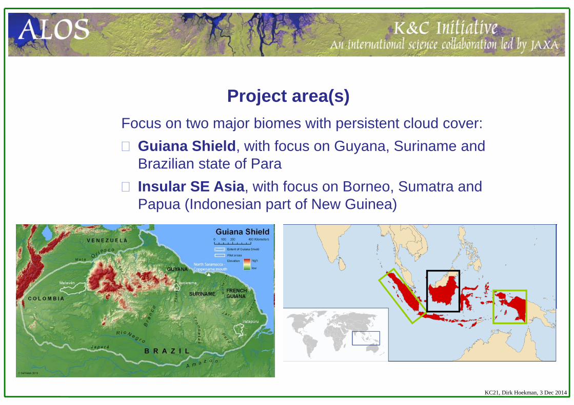
Focus on two major biomes with persistent cloud cover:Guiana Shield, with focus on Guyana, Suriname and Brazilian state of ParaInsular SE Asia, with focus on Borneo, Sumatra and Papua (Indonesian part of New Guinea)
Project area(s)
KC21, Dirk Hoekman, 3 Dec 2014

Primary objectives (done)The project primarily aims to develop techniques
to improve time-consistency (and avoid error propagation) over wide areas.
This includes the automated adaptation of radar signatures to changing environmental conditions and the use of ScanSAR data to support classification in dynamic and irregularly inundated areas.
Note: Integration with Landsat is studied for development of high accuracy “GFOI Forest Information Products”
Project objectives
KC21, Dirk Hoekman, 3 Dec 2014
Secondary objectivesTo improve classification and biomass stratification
accuracy (and spatial resolution) it is intended to address technical issues such as:
Further development of slope correction by adaptation to terrain characteristics (done, published in RSE)Study of the utility of texture (and preferably using 10 m mosaic data) (done for TSX, not PALSAR)Processing of denser time series and application of multi-temporal speckle filtering (done)
Project objectives
KC21, Dirk Hoekman, 3 Dec 2014
Indicate which of the original K&C thematic drivers (Carbon cycle science, International Conventions, Environmental Conservation) the project has managed to address
Carbon cycle: INCAS (REDD+, Indonesia)Environmental Conservation: Environmental impact monitoring
Para, New national forest type map SurinameInternational Conventions: Monitoring Ramsar sites, such as Danau
Sentarum National Park, Indonesia
Contributions to GEO-FCT and GEO-GFOI (for REDD+)
Project objectives
KC21, Dirk Hoekman, 3 Dec 2014
Describe project outcomes and significant findings (several slides!)
Results and significant findings
KC21, Dirk Hoekman, 3 Dec 2014
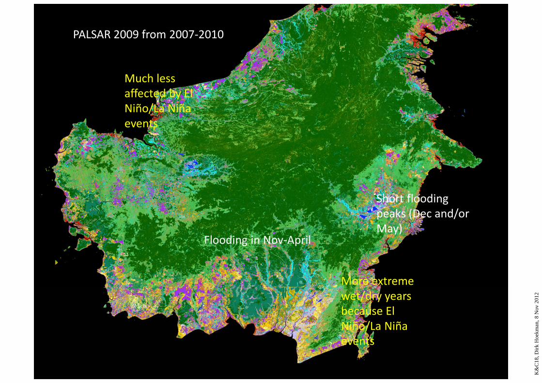
Short flooding peaks (Dec and/or May)
Flooding in Nov‐April
More extreme wet/dry years because El Niño/La Niña events
Much less affected by El Niño/La Niña events
PALSAR 2009 from 2007‐2010
K&
C18
, Dirk
Hoe
kman
, 8 N
ov 2
012
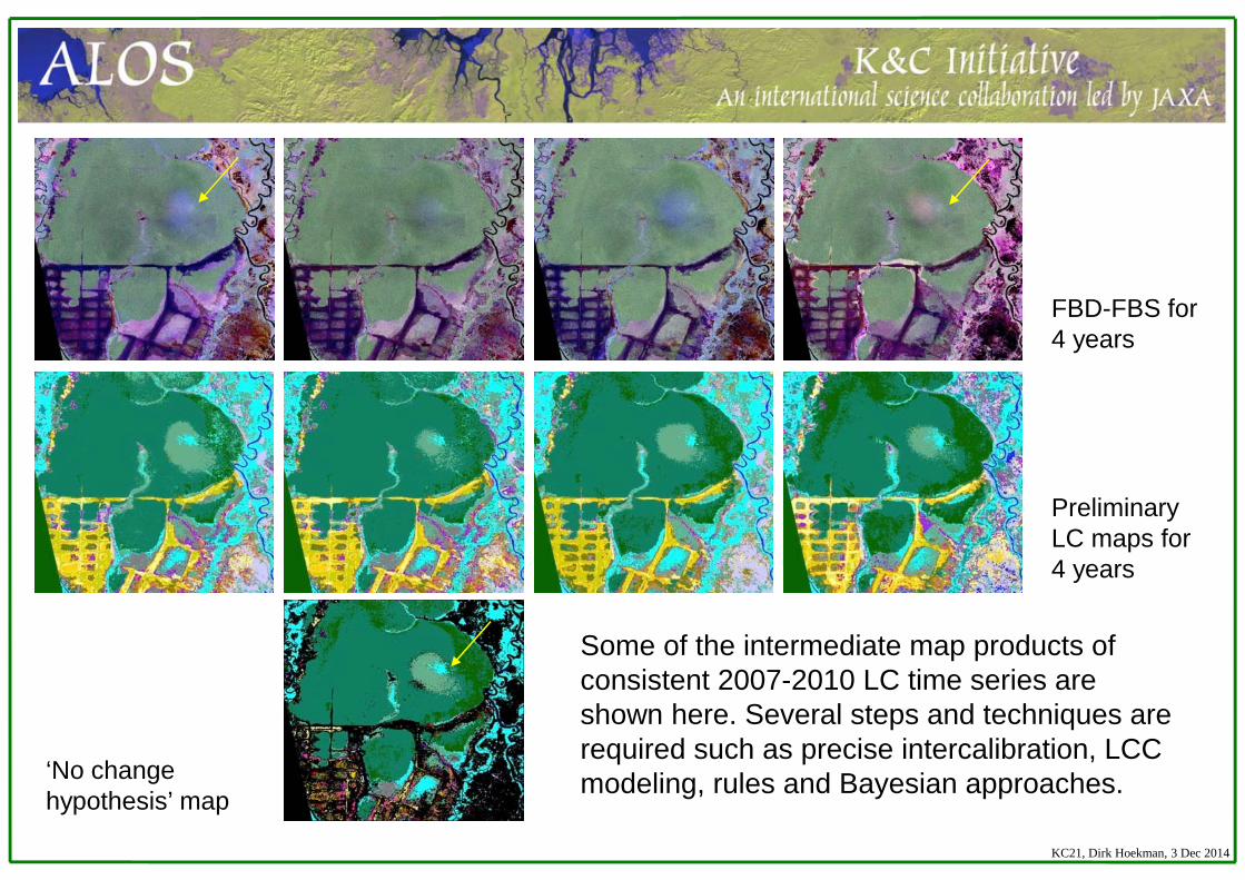
Some of the intermediate map products of consistent 2007-2010 LC time series are shown here. Several steps and techniques are required such as precise intercalibration, LCC modeling, rules and Bayesian approaches.
FBD-FBS for 4 years
Preliminary LC maps for 4 years
‘No change hypothesis’ map
KC21, Dirk Hoekman, 3 Dec 2014
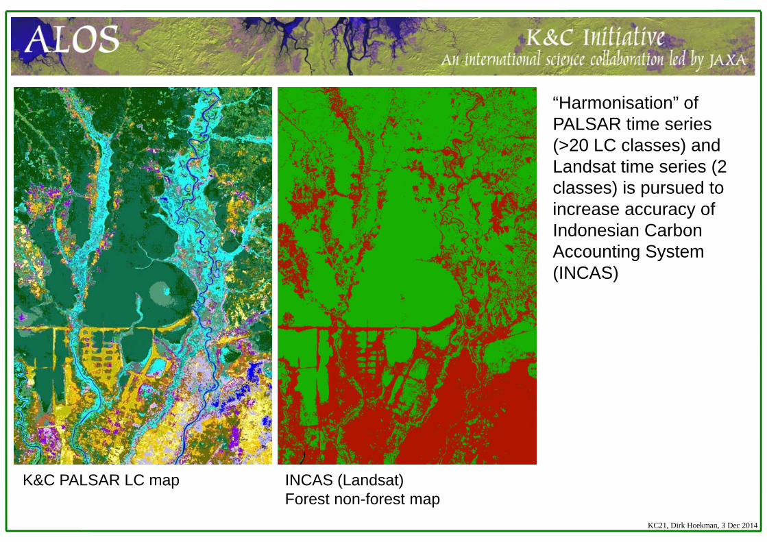
K&C PALSAR LC map INCAS (Landsat)Forest non-forest map
KC21, Dirk Hoekman, 3 Dec 2014
“Harmonisation” of PALSAR time series (>20 LC classes) and Landsat time series (2 classes) is pursued to increase accuracy of Indonesian Carbon Accounting System (INCAS)
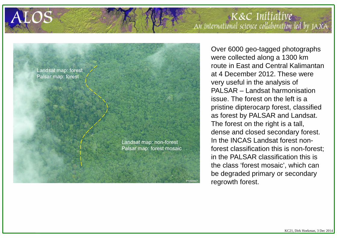
Over 6000 geo-tagged photographs were collected along a 1300 km route in East and Central Kalimantan at 4 December 2012. These were very useful in the analysis of PALSAR – Landsat harmonisation issue. The forest on the left is a pristine dipterocarp forest, classified as forest by PALSAR and Landsat. The forest on the right is a tall, dense and closed secondary forest. In the INCAS Landsat forest non-forest classification this is non-forest; in the PALSAR classification this is the class ‘forest mosaic’, which can be degraded primary or secondary regrowth forest.
KC21, Dirk Hoekman, 3 Dec 2014
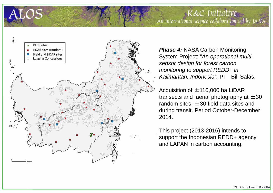
Phase 4: NASA Carbon Monitoring System Project: “An operational multi-sensor design for forest carbon monitoring to support REDD+ in Kalimantan, Indonesia”. PI – Bill Salas.
Acquisition of ±110,000 ha LiDAR transects and aerial photography at ±30 random sites, ±30 field data sites and during transit. Period October-December 2014.
This project (2013-2016) intends to support the Indonesian REDD+ agency and LAPAN in carbon accounting.
KC21, Dirk Hoekman, 3 Dec 2014
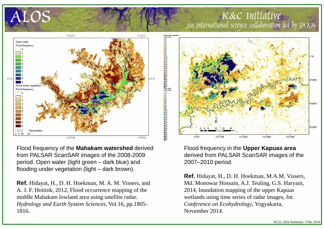
Flood frequency in the Upper Kapuas area derived from PALSAR ScanSAR images of the 2007–2010 period.
Ref. Hidayat, H., D. H. Hoekman, M.A.M. Vissers, Md. Monowar Hossain, A.J. Teuling, G.S. Haryani, 2014, Inundation mapping of the upper Kapuas wetlands using time series of radar images, Int. Conference on Ecohydrology, Yogyakarta, November 2014.
Flood frequency of the Mahakam watershed derived from PALSAR ScanSAR images of the 2008-2009 period. Open water (light green – dark blue) and flooding under vegetation (light – dark brown).
Ref. Hidayat, H., D. H. Hoekman, M. A. M. Vissers, and A. J. F. Hoitink, 2012, Flood occurrence mapping of the middle Mahakam lowland area using satellite radar. Hydrology and Earth System Sciences, Vol.16, pp.1805-1816.
KC21, Dirk Hoekman, 3 Dec 2014
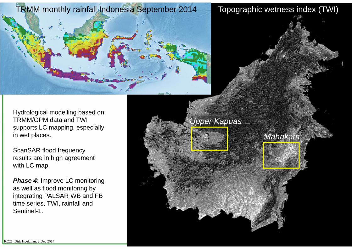
Topographic wetness index (TWI)
Upper Kapuas
Mahakam
TRMM monthly rainfall Indonesia September 2014
Hydrological modelling based on TRMM/GPM data and TWI supports LC mapping, especially in wet places.
ScanSAR flood frequency results are in high agreement with LC map.
Phase 4: Improve LC monitoring as well as flood monitoring by integrating PALSAR WB and FB time series, TWI, rainfall and Sentinel-1.
KC21, Dirk Hoekman, 3 Dec 2014
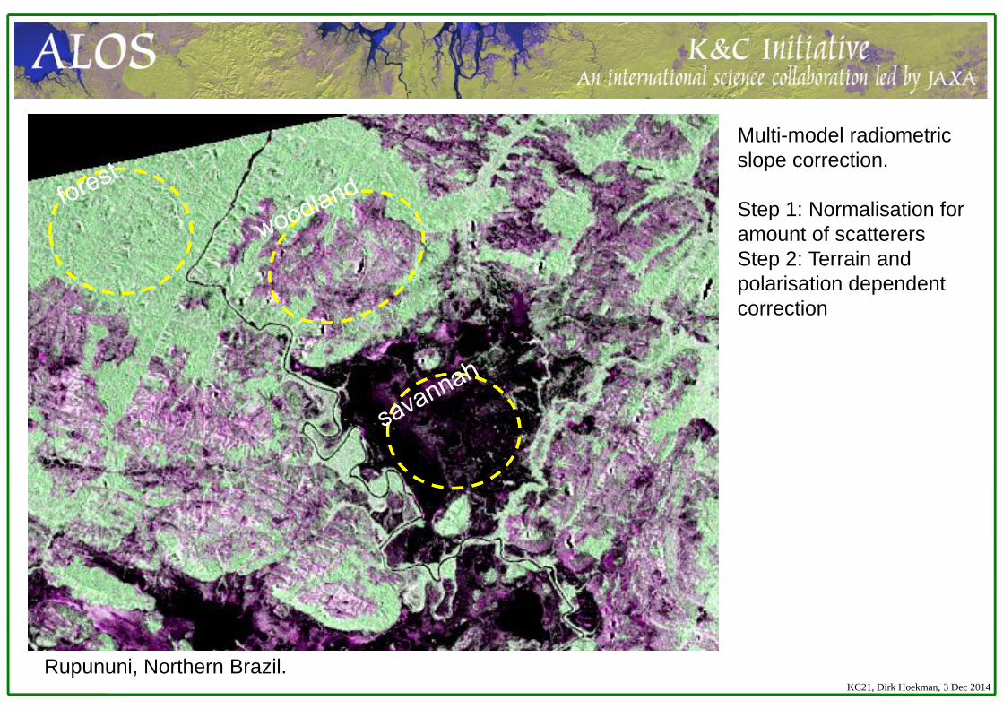
Multi-model radiometric slope correction.
Step 1: Normalisation for amount of scatterersStep 2: Terrain and polarisation dependent correction
Rupununi, Northern Brazil.KC21, Dirk Hoekman, 3 Dec 2014
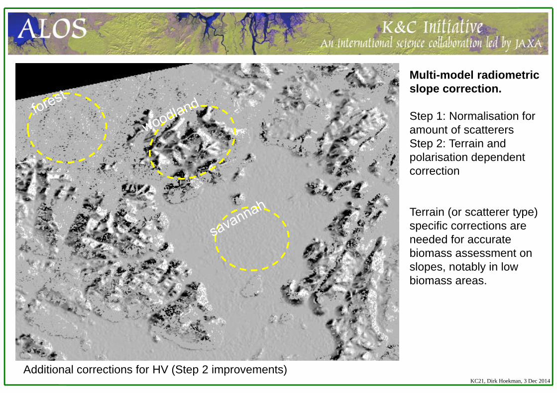
Additional corrections for HV (Step 2 improvements)
Multi-model radiometric slope correction.
Step 1: Normalisation for amount of scatterersStep 2: Terrain and polarisation dependent correction
Terrain (or scatterer type) specific corrections are needed for accurate biomass assessment on slopes, notably in low biomass areas.
KC21, Dirk Hoekman, 3 Dec 2014
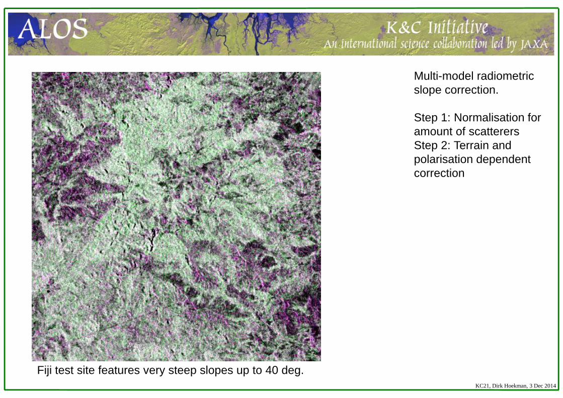
Fiji test site features very steep slopes up to 40 deg.KC21, Dirk Hoekman, 3 Dec 2014
Multi-model radiometric slope correction.
Step 1: Normalisation for amount of scatterersStep 2: Terrain and polarisation dependent correction
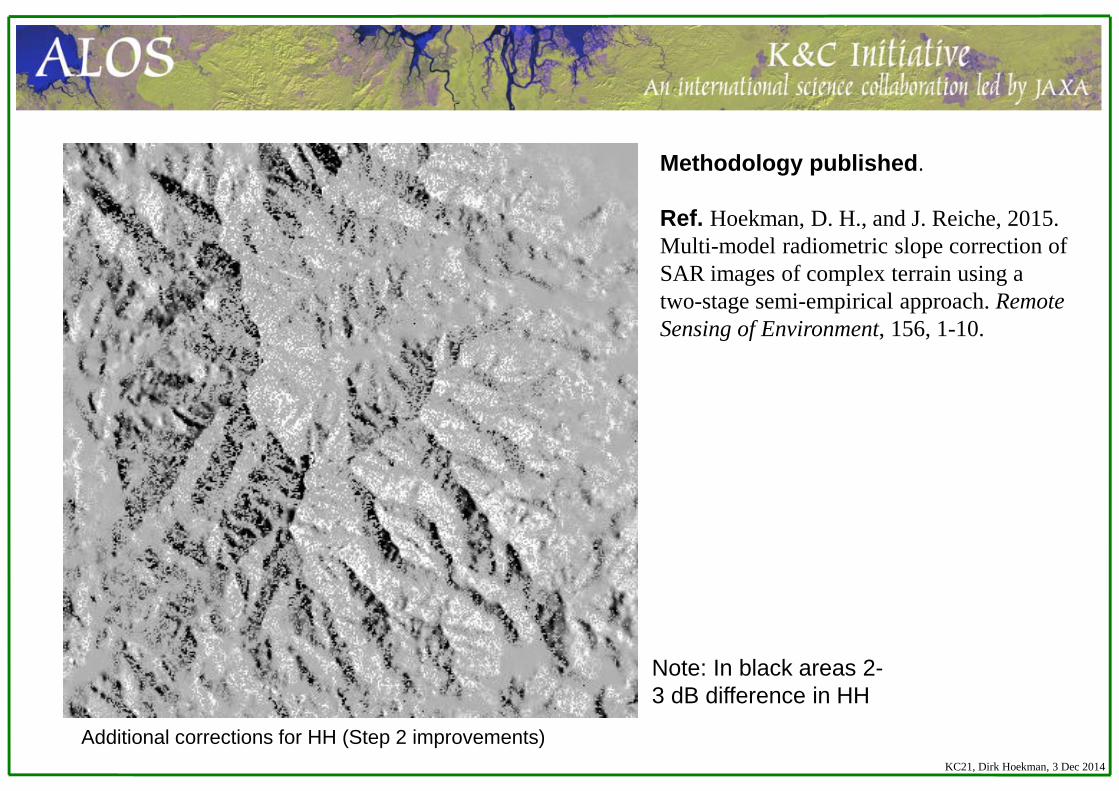
Methodology published.
Ref. Hoekman, D. H., and J. Reiche, 2015. Multi-model radiometric slope correction of SAR images of complex terrain using a two-stage semi-empirical approach. Remote Sensing of Environment, 156, 1-10.
Additional corrections for HH (Step 2 improvements)
Note: In black areas 2-3 dB difference in HH
KC21, Dirk Hoekman, 3 Dec 2014
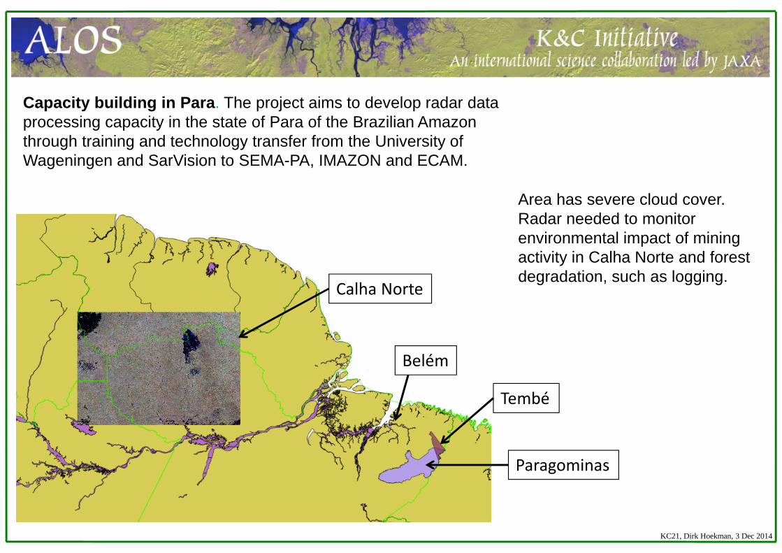
Belém
Tembé
Paragominas
Calha Norte
Capacity building in Para. The project aims to develop radar data processing capacity in the state of Para of the Brazilian Amazon through training and technology transfer from the University of Wageningen and SarVision to SEMA-PA, IMAZON and ECAM.
Area has severe cloud cover. Radar needed to monitor environmental impact of mining activity in Calha Norte and forest degradation, such as logging.
KC21, Dirk Hoekman, 3 Dec 2014
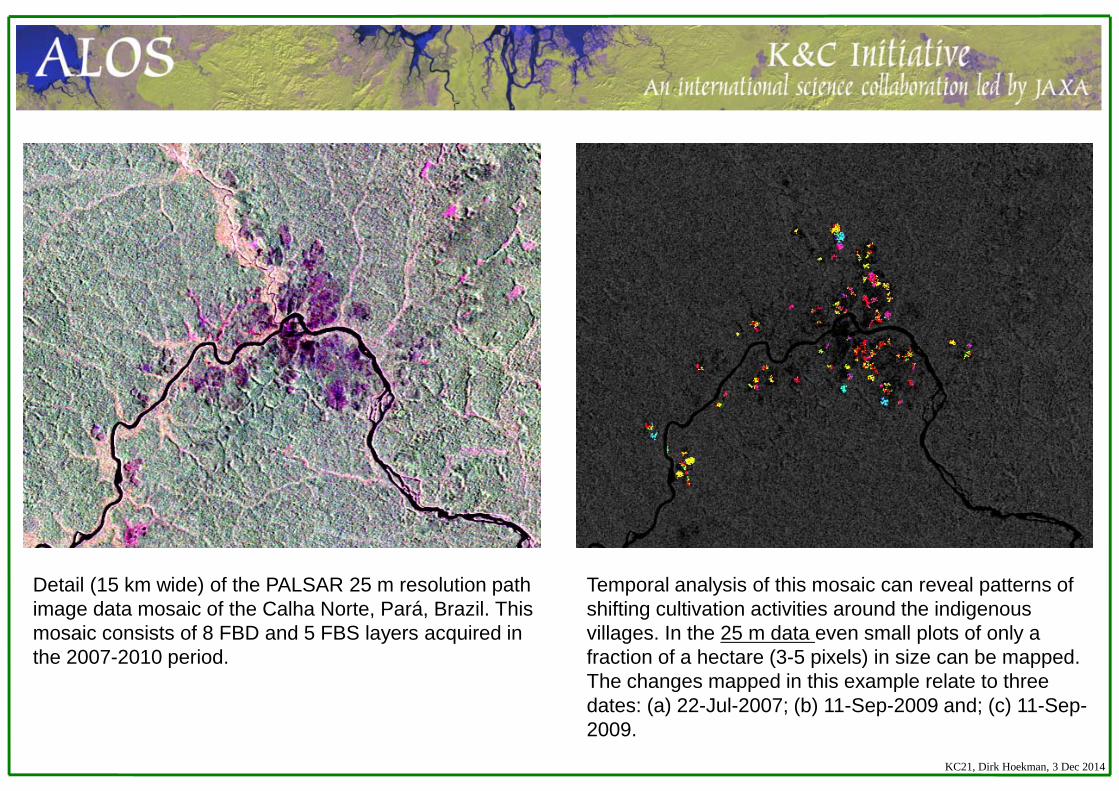
Detail (15 km wide) of the PALSAR 25 m resolution path image data mosaic of the Calha Norte, Pará, Brazil. This mosaic consists of 8 FBD and 5 FBS layers acquired in the 2007-2010 period.
Temporal analysis of this mosaic can reveal patterns of shifting cultivation activities around the indigenous villages. In the 25 m data even small plots of only a fraction of a hectare (3-5 pixels) in size can be mapped. The changes mapped in this example relate to three dates: (a) 22-Jul-2007; (b) 11-Sep-2009 and; (c) 11-Sep-2009.
KC21, Dirk Hoekman, 3 Dec 2014
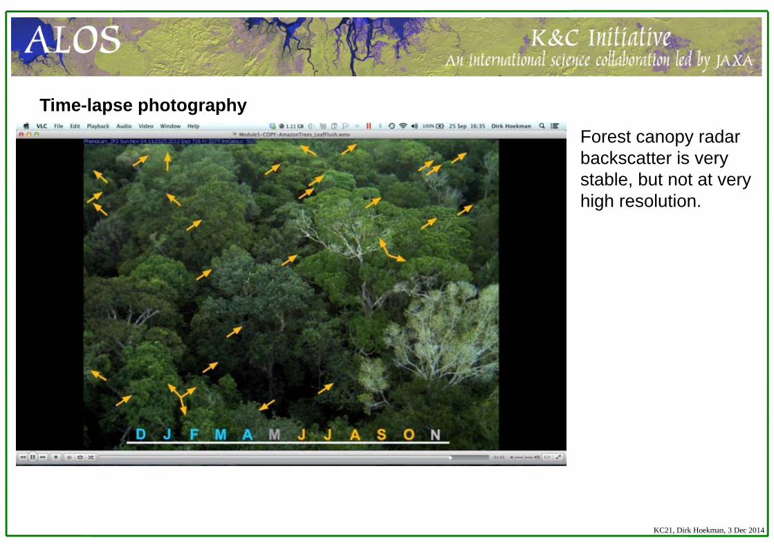
Time-lapse photography
Forest canopy radar backscatter is very stable, but not at very high resolution.
KC21, Dirk Hoekman, 3 Dec 2014
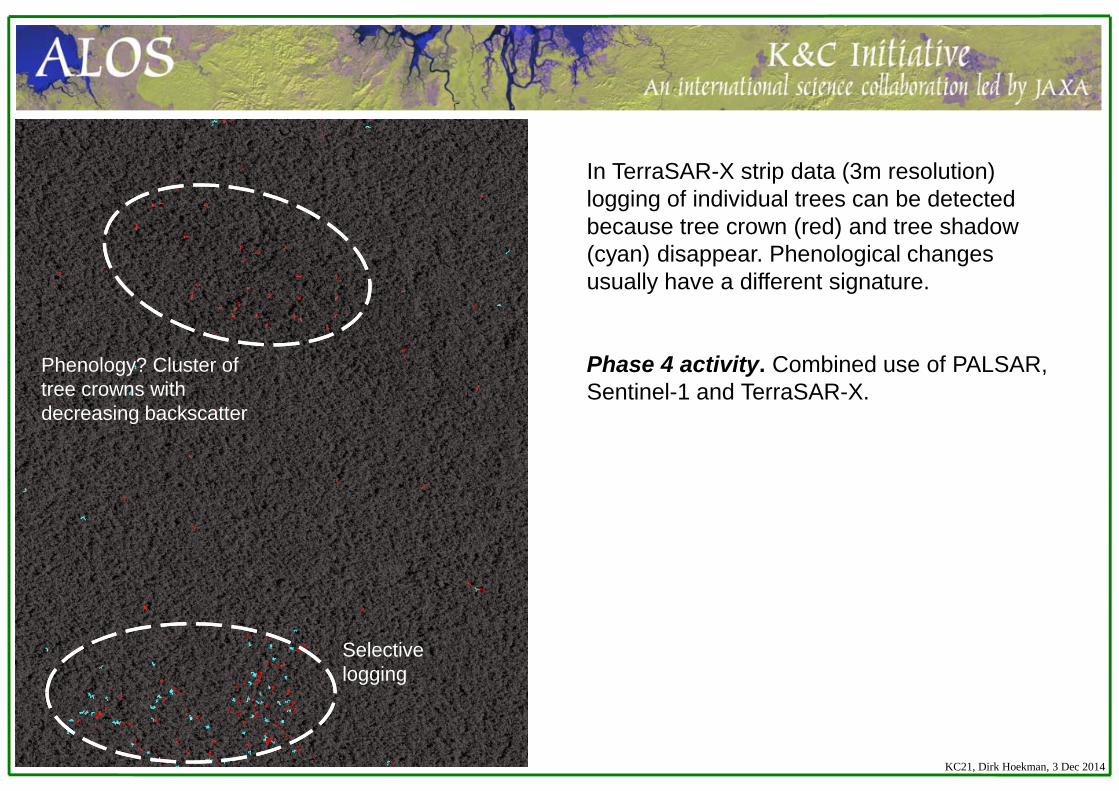
Phenology? Cluster of tree crowns with decreasing backscatter
Selective logging
In TerraSAR-X strip data (3m resolution) logging of individual trees can be detected because tree crown (red) and tree shadow (cyan) disappear. Phenological changes usually have a different signature.
Phase 4 activity. Combined use of PALSAR, Sentinel-1 and TerraSAR-X.
KC21, Dirk Hoekman, 3 Dec 2014
1. PublishedReports• K&C phase 3 reportConference presentations and papers• Hidayat, H., D. H. Hoekman, M.A.M. Vissers, Md. Monowar Hossain, A.J. Teuling, G.S.
Haryani, 2014, Inundation mapping of the upper Kapuas wetlands using time series of radar images, Int. Conference on Ecohydrology, Yogyakarta, November 2014.
Journal papers (on methodology)• Hoekman, D.H., M.A.M. Vissers, and N.J. Wielaard, 2010, PALSAR wide-area mapping of
Borneo: methodology and map validation, IEEE Journal of Selected Topics in Applied Earth Observations and Remote Sensing (J-STARS), 3,No.4, December 2010, pp.605-617.
• Hoekman, D. H., and J. Reiche, 2015. Multi-model radiometric slope correction of SAR images of complex terrain using a two-stage semi-empirical approach. Remote Sensing of Environment, Vol.156, pp.1-10.
Deliverables – Papers and reports
KC21, Dirk Hoekman, 3 Dec 2014
Journal papers cont. (on wetlands, sensor fusion)•Hidayat, H., D. H. Hoekman, M. A. M. Vissers, and A. J. F. Hoitink, 2012, Flood occurrence mapping of the middle Mahakam lowland area using satellite radar. Hydrology and Earth System Sciences, Vol.16, pp.1805-1816. •Reiche, J., J. Verbesselt, D.H. Hoekman, and M. Herold, 2015, Fusing Landsat and SAR time series to detect deforestation in the tropics. Remote Sensing of Environment, 156, pp.276-293.•Reiche, J., C.M. Souza, D.H. Hoekman, J. Verbesselt, H. Persaud, M. Herold, 2013, Feature level fusion of multi-temporal ALOS PALSAR and Landsat data for mapping and monitoring of tropical deforestation and forest degradation, IEEE Journal of Selected Topics in Applied Earth Observations and Remote Sensing (J-STARS), Vol.6. No.5, October 2013, pp.2159-2173. •Schlund, M. F. von Poncet, D.H. Hoekman, S. Kuntz, and C. Schmullius, 2014, Importance of bistatic SAR features from TanDEM-X for forest mapping and monitoring, Remote Sensing of Environment, Vol.151, pp.16-28.•Schlund, M. F. von Poncet, S. Kuntz, C. Schmullius, and D.H. Hoekman, 2015, TanDEM-X data for aboveground biomass retrieval in a tropical peat swamp forest, Remote Sensing of Environment (in press)
Deliverables – Papers and reports
KC21, Dirk Hoekman, 3 Dec 2014
Others•Contribution to book chapter “Global forest monitoring with radar (SAR) data, In: Global Forest Monitoring from Earth Observation”.•Contribution to GOFC-GOLD Sourcebook chapter “Status of Evolving Technologies “.•Contribution to the GEO-FCT “Product Development Team Technical Status Reports” in 2010, 2011 and 2012.•Contribution to the GEO-GFOI “Review of Priority Research & Development Topics”.•Contribution to the GEO-GFOI “Methods and Guidance Document”.
Deliverables – Papers and reports
KC21, Dirk Hoekman, 3 Dec 2014
2. . Submitted/in preparationJournal papers• Time-series PALSAR-Landsat fusion, Bayesian approach, Fiji, RSE (submitted) • Borneo consistent LC time-series mapping methodology, (in prep.)• Borneo hydrology, Hydrology and Earth System Sciences, (in prep.)• PALSAR mapping Brazilian part Guiana Shield, (in prep.)• Others, see presentations Marcela Quiñones, Bill Salas
Deliverables – Papers and reports
KC21, Dirk Hoekman, 3 Dec 2014
1. Completed and Delivered to JAXA• Mahakam watershed flood frequency map• Borneo land cover map for 2009• Biomass stratification map Borneo• Land use / land cover map Suriname • Map of forest degradation in mining areas Mahdia, Guyana
2. Completed, but not yet delivered (please deliver ASAP)
• Borneo land cover map for 2007, 2008 and 2010• Calha Norte, 25m mosaic• Maps of shifting cultivation in Calha Norte, Pará, Brazil• Danau Sentarum watershed flood frequency map• Products Colombia (see presentation Marcela)
Deliverables –Data sets and Thematic products
(mosaics, classification maps etc.)
KC21, Dirk Hoekman, 3 Dec 2014
Moore Foundation for financial support in radar capacity building in state of Para.
This work has been undertaken within the framework of the JAXA Kyoto & Carbon Initiative. ALOS PALSAR data have been provided by JAXA EORC
Thank you
Acknowledgement
KC21, Dirk Hoekman, 3 Dec 2014