Why GPS? Trying to figure out where you are and where you're going is probably one of man's oldest...
31
-
Upload
barnard-norris -
Category
Documents
-
view
217 -
download
0
Transcript of Why GPS? Trying to figure out where you are and where you're going is probably one of man's oldest...

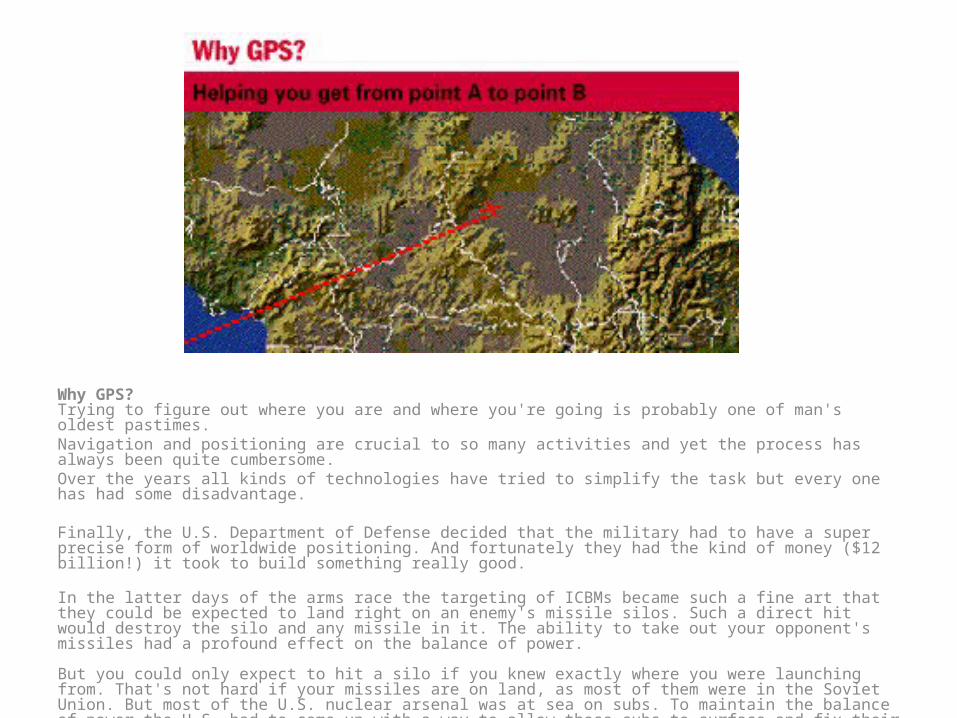
Why GPS?Trying to figure out where you are and where you're going is probably one of man's oldest pastimes. Navigation and positioning are crucial to so many activities and yet the process has always been quite cumbersome. Over the years all kinds of technologies have tried to simplify the task but every one has had some disadvantage.
Finally, the U.S. Department of Defense decided that the military had to have a super precise form of worldwide positioning. And fortunately they had the kind of money ($12 billion!) it took to build something really good.
In the latter days of the arms race the targeting of ICBMs became such a fine art that they could be expected to land right on an enemy's missile silos. Such a direct hit would destroy the silo and any missile in it. The ability to take out your opponent's missiles had a profound effect on the balance of power.
But you could only expect to hit a silo if you knew exactly where you were launching from. That's not hard if your missiles are on land, as most of them were in the Soviet Union. But most of the U.S. nuclear arsenal was at sea on subs. To maintain the balance of power the U.S. had to come up with a way to allow those subs to surface and fix their exact position in a matter of minutes anywhere in the world Hello GPS! The result is the Global Positioning System, a system that's changed navigation forever.

What is GPS?The Global Positioning System (GPS) is a worldwide radio-navigation system formed from a constellation of 24 satellites and their ground stations. GPS uses these "man-made stars" as reference points to calculate positions accurate to a matter of meters. In fact, with advanced forms of GPS you can make measurements to better than a centimeter! In a sense it's like giving every square meter on the planet a unique address. GPS receivers have been miniaturized to just a few integrated circuits and so are becoming very economical. And that makes the technology accessible to virtually everyone. These days GPS is finding its way into cars, boats, planes, construction equipment, movie making gear, farm machinery, even laptop computers. Soon GPS will become almost as basic as the telephone. Indeed, at Trimble, we think it just may become a universal utility.

How GPS works?Here's how GPS works in five logical steps:The basis of GPS is "triangulation" from satellites. We're using the word "triangulation" very loosely here because it's a word most people can understand, but purists would not call what GPS does "triangulation" because no angles are involved. It's really "trilateration." Trilateration is a method of determining the relative positions of objects using the geometry of triangles. To "triangulate," a GPS receiver measures distance using the travel time of radio signals. To measure travel time, GPS needs very accurate timing which it achieves with some tricks. Along with distance, you need to know exactly where the satellites are in space. High orbits and careful monitoring are the secret. Finally you must correct for any delays the signal experiences as it travels through the atmosphere. We'll explain each of these points in the next five sections of the tutorial. We recommend you follow the tutorial in order. Remember, science is a step-by-step discipline!
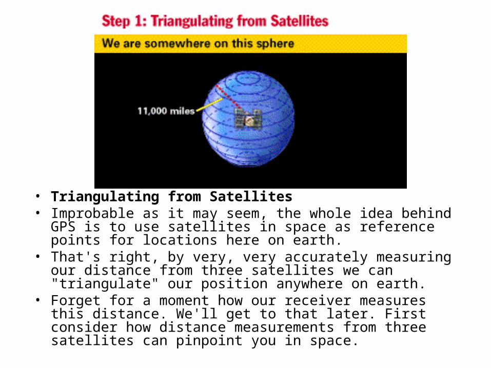
• Triangulating from Satellites• Improbable as it may seem, the whole idea behind GPS is to use
satellites in space as reference points for locations here on earth. • That's right, by very, very accurately measuring our distance from
three satellites we can "triangulate" our position anywhere on earth.
• Forget for a moment how our receiver measures this distance. We'll get to that later. First consider how distance measurements from three satellites can pinpoint you in space.
The Big Idea Geometrically:Step One:
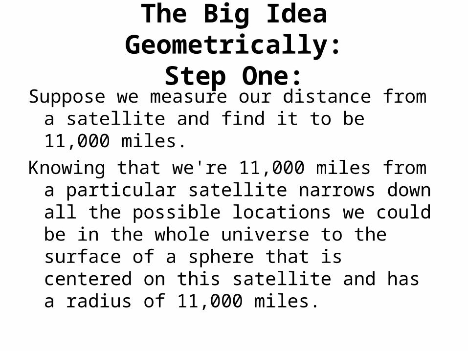
Suppose we measure our distance from a satellite and find it to be 11,000 miles.
Knowing that we're 11,000 miles from a particular satellite narrows down all the possible locations we could be in the whole universe to the surface of a sphere that is centered on this satellite and has a radius of 11,000 miles.

• Next, say we measure our distance to a second satellite and find out that it's 12,000 miles away.
• That tells us that we're not only on the first sphere but we're also on a sphere that's 12,000 miles from the second satellite. Or in other words, we're somewhere on the circle where these two spheres intersect.
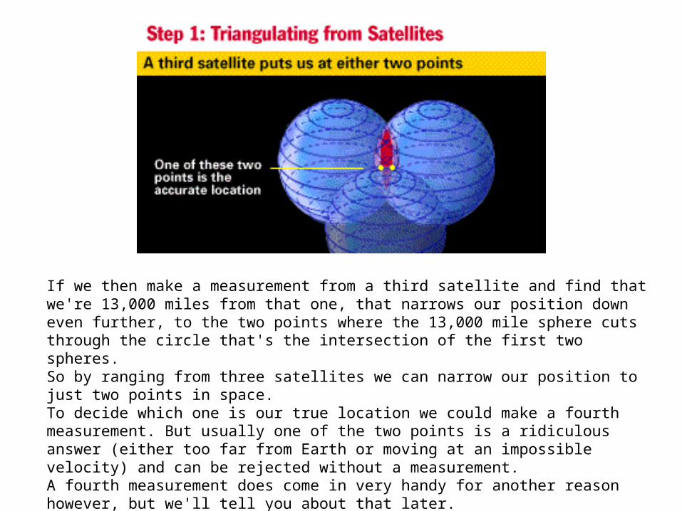
If we then make a measurement from a third satellite and find that we're 13,000 miles from that one, that narrows our position down even further, to the two points where the 13,000 mile sphere cuts through the circle that's the intersection of the first two spheres. So by ranging from three satellites we can narrow our position to just two points in space. To decide which one is our true location we could make a fourth measurement. But usually one of the two points is a ridiculous answer (either too far from Earth or moving at an impossible velocity) and can be rejected without a measurement. A fourth measurement does come in very handy for another reason however, but we'll tell you about that later. Next we'll see how the system measures distances to satellites.

In Review:•Position is calculated from distance measurements (ranges) to satellites.•Mathematically we need four satellite ranges to determine exact position.•Three ranges are enough if we reject ridiculous answers or use other tricks.•Another range is required for technical reasons to be discussed later.

Measuring distance from a satelliteWe saw in the last section that a position is calculated from distance measurements to at least three satellites.
The Big Idea Mathematically:In a sense, the whole thing boils down to those "velocity times travel time" math problems we did in high school. Remember the old: "If a car goes 60 miles per hour for two hours, how far does it travel?"
Velocity (60 mph) x Time (2 hours) = Distance (120 miles) In the case of GPS we're measuring a radio signal so the velocity is going to be the speed of light or roughly 186,000 miles per second.
The problem is measuring the travel time.

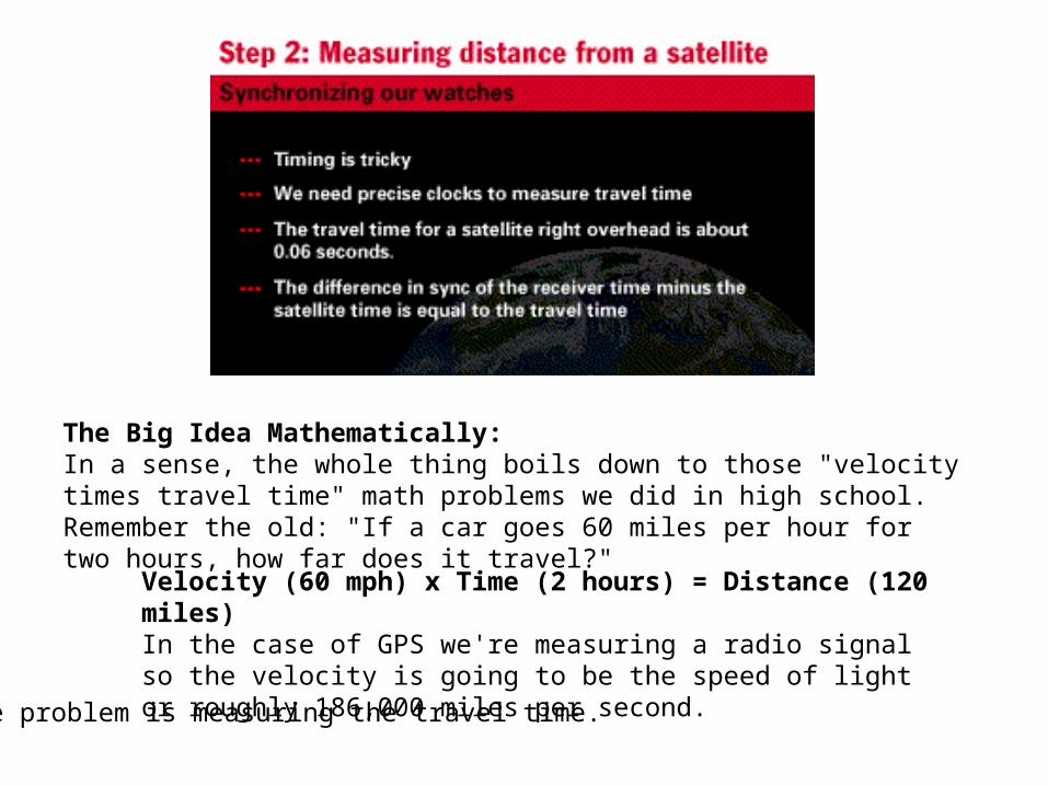
•Timing is tricky•We need precise clocks to measure travel time•The travel time for a satellite right overhead is about 0.06 seconds•The difference in sync of the receiver time minus the satellite time is equal to the travel time
• The timing problem is tricky. First, the times are going to be awfully short. If a satellite were right overhead the travel time would be something like 0.06 seconds. So we're going to need some really precise clocks. We'll talk about those soon.
• But assuming we have precise clocks, how do we measure travel time? To explain it let's use a goofy analogy:
• Suppose there was a way to get both the satellite and the receiver to start playing "The Star Spangled Banner" at precisely 12 noon. If sound could reach us from space (which, of course, is ridiculous) then standing at the receiver we'd hear two versions of the Star Spangled Banner, one from our receiver and one from the satellite.
• These two versions would be out of sync. The version coming from the satellite would be a little delayed because it had to travel more than 11,000 miles.
• If we wanted to see just how delayed the satellite's version was, we could start delaying the receiver's version until they fell into perfect sync.
• The amount we have to shift back the receiver's version is equal to the travel time of the satellite's version. So we just multiply that time times the speed of light and BINGO! we've got our distance to the satellite.
• That's basically how GPS works. • Only instead of the Star Spangled Banner the satellites and receivers use something
called a "Pseudo Random Code" - which is probably easier to sing than the Star Spangled Banner.

In Review:1. Distance to a satellite is determined by measuring how long a radio signal takes
to reach us from that satellite.2. To make the measurement we assume that both the satellite and our receiver
are generating the same pseudo-random codes at exactly the same time.3. By comparing how late the satellite's pseudo-random code appears compared to
our receiver's code, we determine how long it took to reach us.4. Multiply that travel time by the speed of light and you've got distance.

• Getting perfect timing• If measuring the travel time of a radio signal is the key to GPS, then our stop watches had better be darn good, because if
their timing is off by just a thousandth of a second, at the speed of light, that translates into almost 200 miles of error! • On the satellite side, timing is almost perfect because they have incredibly precise atomic clocks on board. • Atomic Clocks• Atomic clocks don't run on atomic energy. They get the name because they use the oscillations of a particular atom as
their "metronome." This form of timing is the most stable and accurate reference man has ever developed. • But what about our receivers here on the ground? • Remember that both the satellite and the receiver need to be able to precisely synchronize their pseudo-random codes
to make the system work. • If our receivers needed atomic clocks (which cost upwards of $50K to $100K) GPS would be a lame duck technology.
Nobody could afford it. • Luckily the designers of GPS came up with a brilliant little trick that lets us get by with much less accurate clocks in our
receivers. This trick is one of the key elements of GPS and as an added side benefit it means that every GPS receiver is essentially an atomic-accuracy clock.
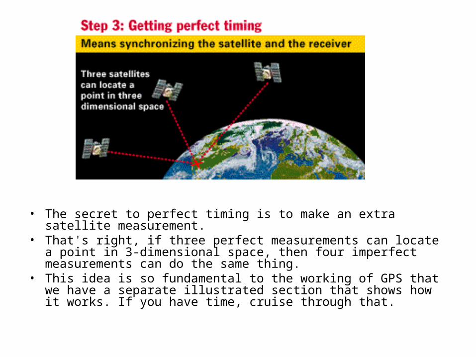
• The secret to perfect timing is to make an extra satellite measurement. • That's right, if three perfect measurements can locate a point in 3-
dimensional space, then four imperfect measurements can do the same thing.
• This idea is so fundamental to the working of GPS that we have a separate illustrated section that shows how it works. If you have time, cruise through that.
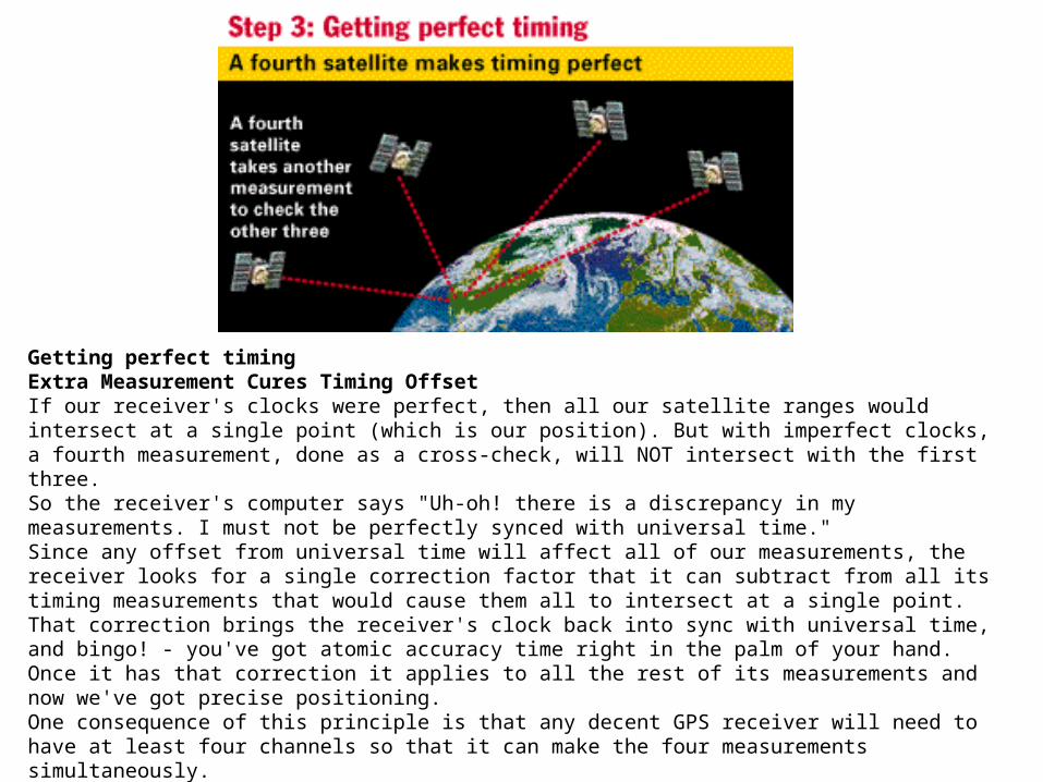
Getting perfect timingExtra Measurement Cures Timing OffsetIf our receiver's clocks were perfect, then all our satellite ranges would intersect at a single point (which is our position). But with imperfect clocks, a fourth measurement, done as a cross-check, will NOT intersect with the first three. So the receiver's computer says "Uh-oh! there is a discrepancy in my measurements. I must not be perfectly synced with universal time." Since any offset from universal time will affect all of our measurements, the receiver looks for a single correction factor that it can subtract from all its timing measurements that would cause them all to intersect at a single point. That correction brings the receiver's clock back into sync with universal time, and bingo! - you've got atomic accuracy time right in the palm of your hand. Once it has that correction it applies to all the rest of its measurements and now we've got precise positioning. One consequence of this principle is that any decent GPS receiver will need to have at least four channels so that it can make the four measurements simultaneously. With the pseudo-random code as a rock solid timing sync pulse, and this extra measurement trick to get us perfectly synced to universal time, we have got everything we need to measure our distance to a satellite in space. But for the triangulation to work we not only need to know distance, we also need to know exactly where the satellites are.
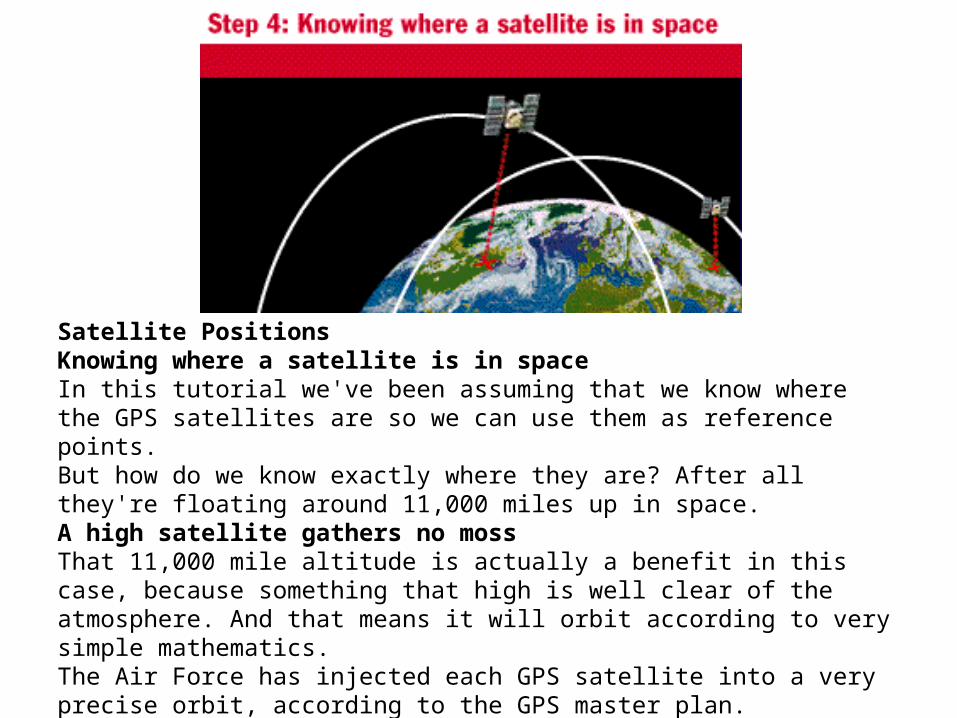
Satellite PositionsKnowing where a satellite is in spaceIn this tutorial we've been assuming that we know where the GPS satellites are so we can use them as reference points. But how do we know exactly where they are? After all they're floating around 11,000 miles up in space. A high satellite gathers no mossThat 11,000 mile altitude is actually a benefit in this case, because something that high is well clear of the atmosphere. And that means it will orbit according to very simple mathematics. The Air Force has injected each GPS satellite into a very precise orbit, according to the GPS master plan.

On the ground all GPS receivers have an almanac programmed into their computers that tells them where in the sky each satellite is, moment by moment. The basic orbits are quite exact but just to make things perfect the GPS satellites are constantly monitored by the Department of Defense. They use very precise radar to check each satellite's exact altitude, position and speed. The errors they're checking for are called "ephemeris errors" because they affect the satellite's orbit or "ephemeris." These errors are caused by gravitational pulls from the moon and sun and by the pressure of solar radiation on the satellites. The errors are usually very slight but if you want great accuracy they must be taken into account.

Satellite PositionsGetting the message outOnce the DoD has measured a satellite's exact position, they relay that information back up to the satellite itself. The satellite then includes this new corrected position information in the timing signals it's broadcasting. So a GPS signal is more than just pseudo-random code for timing purposes. It also contains a navigation message with ephemeris information as well. With perfect timing and the satellite's exact position you'd think we'd be ready to make perfect position calculations. But there's trouble afoot. Check out the next section to see what's up.
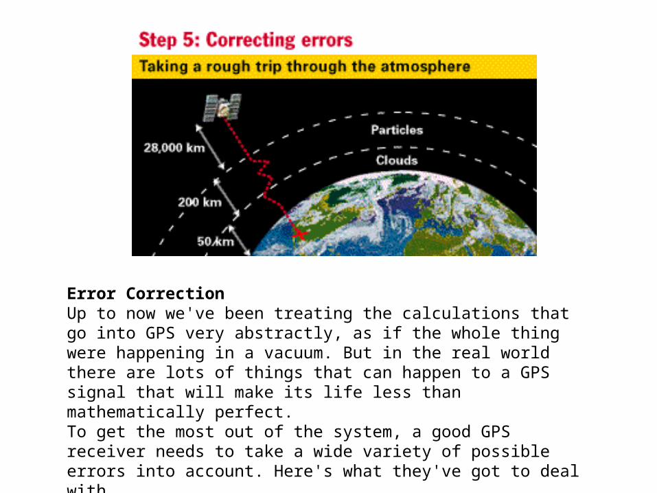
Error CorrectionUp to now we've been treating the calculations that go into GPS very abstractly, as if the whole thing were happening in a vacuum. But in the real world there are lots of things that can happen to a GPS signal that will make its life less than mathematically perfect. To get the most out of the system, a good GPS receiver needs to take a wide variety of possible errors into account. Here's what they've got to deal with.

First, one of the basic assumptions we've been using throughout this tutorial is not exactly true. We've been saying that you calculate distance to a satellite by multiplying a signal's travel time by the speed of light. But the speed of light is only constant in a vacuum. As a GPS signal passes through the charged particles of the ionosphere and then through the water vapor in the troposphere it gets slowed down a bit, and this creates the same kind of error as bad clocks.
• IonosphereThe ionosphere is the layer of the atmosphere ranging in altitude from 50 to 500 km.
• It consists largely of ionized particles which can exert a perturbing effect on GPS signals.
• While much of the error induced by the ionosphere can be removed through mathematical modeling, it is still one of the most significant error sources.
• TroposphereThe troposphere is the lower part of the earth's atmosphere that encompasses our weather.
• It's full of water vapor and varies in temperature and pressure.
• But as messy as it is, it causes relatively little error.• There are a couple of ways to minimize this kind of
error. For one thing we can predict what a typical delay might be on a typical day. This is called modeling and it helps but, of course, atmospheric conditions are rarely exactly typical.
• Error ModelingMuch of the delay caused by a signal's trip through our atmosphere can be predicted.
• Mathematical models of the atmosphere take into account the charged particles in the ionosphere and the varying gaseous content of the troposphere.
• On top of that, the satellites constantly transmit updates to the basic ionospheric model.
• A GPS receiver must factor in the angle each signal is taking as it enters the atmosphere because that angle determines the length of the trip through the perturbing medium.
• Another way to get a handle on these atmosphere-induced errors is to compare the relative speeds of two different signals. This "dual frequency" measurement is very sophisticated and is only possible with advanced receivers.
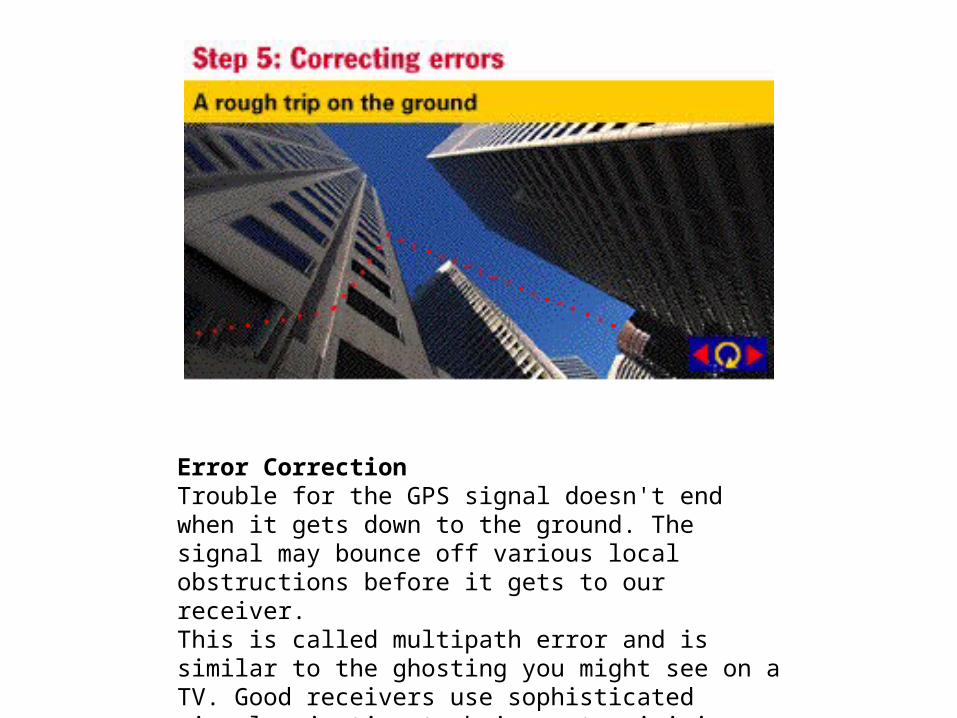
Error CorrectionTrouble for the GPS signal doesn't end when it gets down to the ground. The signal may bounce off various local obstructions before it gets to our receiver. This is called multipath error and is similar to the ghosting you might see on a TV. Good receivers use sophisticated signal rejection techniques to minimize this problem.
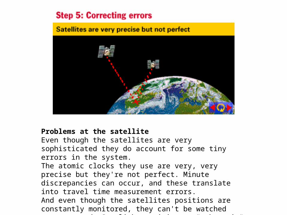
Problems at the satelliteEven though the satellites are very sophisticated they do account for some tiny errors in the system. The atomic clocks they use are very, very precise but they're not perfect. Minute discrepancies can occur, and these translate into travel time measurement errors. And even though the satellites positions are constantly monitored, they can't be watched every second. So slight position or "ephemeris" errors can sneak in between monitoring times.

There are a couple of ways to minimize this kind of error. For one thing we can predict what a typical delay might be on a typical day. This is called modeling and it helps but, of course, atmospheric conditions are rarely exactly typical.

Intentional Errors!As hard as it may be to believe, the same government that spent $12 billion to develop the most accurate navigation system in the world intentionally degraded its accuracy. The policy was called "Selective Availability" or "SA" and the idea behind it was to make sure that no hostile force or terrorist group can use GPS to make accurate weapons. Basically the DoD introduced some "noise" into the satellite's clock data which, in turn, added noise (or inaccuracy) into position calculations. The DoD may have also been sending slightly erroneous orbital data to the satellites which they transmitted back to receivers on the ground as part of a status message. Together these factors made SA the biggest single source of inaccuracy in the system. Military receivers used a decryption key to remove the SA errors and so they're much more accurate.

• Turning Off Selective Availability• On May 1, 2000 the White House announced a
decision to discontinue the intentional degradation of the GPS signals to the public beginning at midnight. Civilian users of GPS are now able to pinpoint locations up to ten times more accurately. As part of the 1996 Presidential Decision Directive goals for GPS, President Clinton committed to discontinuing the use of SA by 2006. The announcement came six years ahead of schedule. The decision to discontinue SA was the latest measure in an on-going effort to make GPS more responsive to civil and commercial users worldwide.
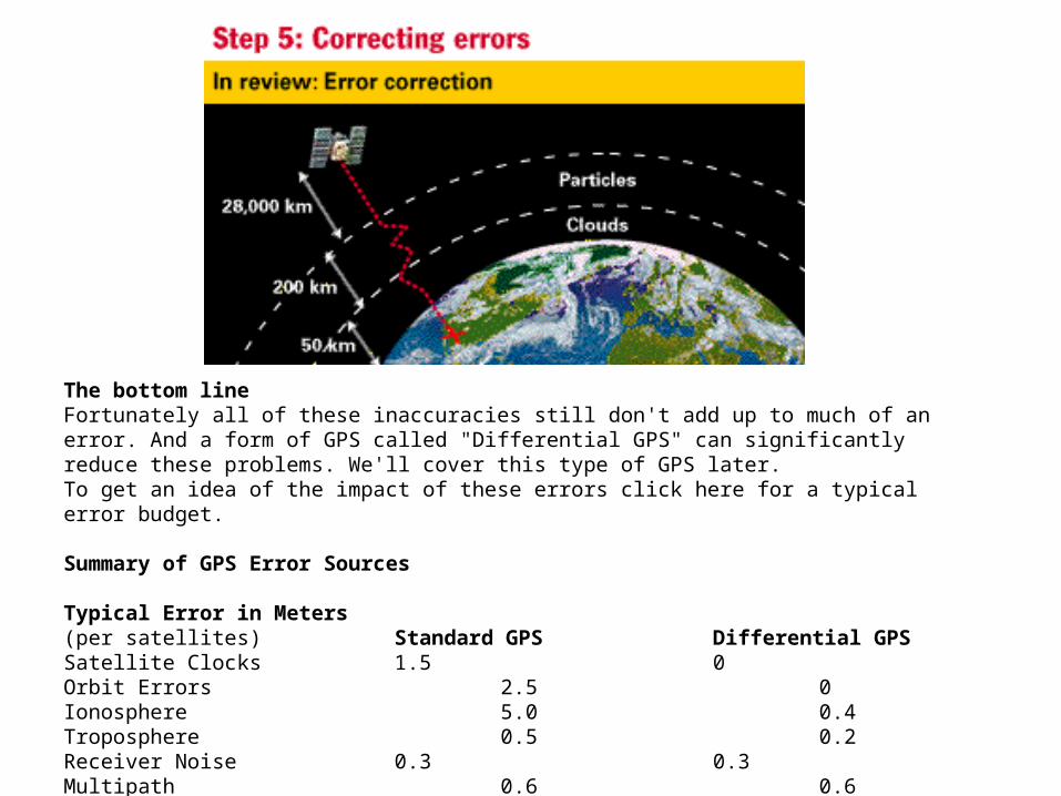
The bottom lineFortunately all of these inaccuracies still don't add up to much of an error. And a form of GPS called "Differential GPS" can significantly reduce these problems. We'll cover this type of GPS later. To get an idea of the impact of these errors click here for a typical error budget.
Summary of GPS Error Sources
Typical Error in Meters(per satellites) Standard GPS Differential GPSSatellite Clocks 1.5 0Orbit Errors 2.5 0Ionosphere 5.0 0.4 Troposphere 0.5 0.2 Receiver Noise 0.3 0.3 Multipath 0.6 0.6