WHEREAS, 35 MILES PER HOUR OR LESS ON COUNTY … · Community Club 0.12 NIP 0.00 . 12 Pickering...
26
ORDINANCE NO. ~-16 AN ORDINANCE AMENDING MASON COUNTY CODE CHAPTER 10 TO ALLOW THE OPERATION OF WHEELED ALL-TERRAIN VEHICLES, AS DESCRIBED IN RCW 46.09, ON COUNTY MAINTAINED ROADS WITH POSTED SPEED LIMITS OF 35 MILES PER HOUR OR LESS WHEREAS, Washington State's Engrossed Substitute House Bill (ESHB) 1632, passed by the State of Washington during the 2013 2nd Special Session, and HB 1918, passed by the State of Washington in 2016, amended the Revised Code of Washington (RCW) 46.09 "Off- Road, Non- Highway, and Wheeled All-Terrain Vehicles," allowing counties to regulate the operation of non- highway vehicles on streets, roads, or highways; and WHEREA, on February I 0, 2015, dming the Board of County Commissioners (BOCC) and Public Works study session, the BOCC requested Public Works Depa1tment staff to work with the Mason County's Sheriff's Office to consider whether or not to allow non-highway vehicles to operate on county maintained roads; and WHEREAS, RCW 46.09.310(19) defines "wheeled all-terrain vehicles" and classifies them as non-highway vehicles; and WHEREAS, RCW 46.09.455(1) describes authorized and prohibited uses of wheeled all-terrain vehicles, which includes allowing them to be operated on public roadways having a speed limit of thirty- five miles per hour or less; and WHEREAS, RCW 46.09 .455(1 )(c)(i) requires that counties, with population of fifteen thousand or more, who desire to allow the operation of wheeled all-terrain vehicles on county roadways, not including non-highway roads and trails, must approve an ordinance to designate county roadways for said usage; and WHEREAS, RCW 46.09.455(l)(c)(iii) requires Mason County to list publicly, and make accessible from the main page of the county web site, those public roadways that wheeled all-terrain vehicles may operate upon; and WHEREAS, Mason County's Sheriffs Office, the Public Works Depa1tment, and interested individuals met to discuss said usage on Mason County maintained roads; and WHEREAS, Mason County has determined that the safety requirements for wheeled all-terrain vehicles, as described in RCW 46.09, with the additional requirement that wheeled all-terrain vehicles have headlights that are utilized at all times, provides for a level of safety similar to other street legal vehicles that are allowed to travel on public roads; and WHEREAS, Mason County has determined that allowing wheeled all -terrain vehicles, as described in RCW 46.09, provides increased opportunities for a variety of outdoor recreation activities in Mason County; and WHEREAS, Mason County has determined that the county should allow operation of wheeled all-terrain vehicles, as described in RCW 46.09, with the additional requirement that wheeled all-terrain vehicles have headlights that are utilized at all times, on county maintained roads that have posted speed limits of 35 miles per hour or less; and
Transcript of WHEREAS, 35 MILES PER HOUR OR LESS ON COUNTY … · Community Club 0.12 NIP 0.00 . 12 Pickering...

ORDINANCE NO. ~-16
AN ORDINANCE AMENDING MASON COUNTY CODE CHAPTER 10 TO ALLOW THE OPERATION OF WHEELED ALL-TERRAIN VEHICLES, AS DESCRIBED IN RCW 46.09,
ON COUNTY MAINTAINED ROADS WITH POSTED SPEED LIMITS OF 35 MILES PER HOUR OR LESS
WHEREAS, Washington State's Engrossed Substitute House Bill (ESHB) 1632, passed by the
State of Washington during the 2013 2nd Special Session, and HB 1918, passed by the State of
Washington in 2016, amended the Revised Code of Washington (RCW) 46.09 "Off- Road, Non
Highway, and Wheeled All-Terrain Vehicles," allowing counties to regulate the operation of non
highway vehicles on streets, roads, or highways; and
WHEREA, on February I 0, 2015, dming the Board of County Commissioners (BOCC) and
Public Works study session, the BOCC requested Public Works Depa1tment staff to work with the Mason
County's Sheriff's Office to consider whether or not to allow non-highway vehicles to operate on county
maintained roads; and
WHEREAS, RCW 46.09.310(19) defines "wheeled all-terrain vehicles" and classifies them as
non-highway vehicles; and
WHEREAS, RCW 46.09.455(1) describes authorized and prohibited uses of wheeled all-terrain
vehicles, which includes allowing them to be operated on public roadways having a speed limit of thirty
five miles per hour or less; and
WHEREAS, RCW 46.09 .455(1 )( c )(i) requires that counties, with population of fifteen thousand
or more, who desire to allow the operation of wheeled all-terrain vehicles on county roadways, not
including non-highway roads and trails, must approve an ordinance to designate county roadways for said
usage; and
WHEREAS, RCW 46.09.455(l)(c)(iii) requires Mason County to list publicly, and make
accessible from the main page of the county web site, those public roadways that wheeled all-terrain
vehicles may operate upon; and
WHEREAS, Mason County's Sheriffs Office, the Public Works Depa1tment, and interested
individuals met to discuss said usage on Mason County maintained roads; and
WHEREAS, Mason County has determined that the safety requirements for wheeled all-terrain
vehicles, as described in RCW 46.09, with the additional requirement that wheeled all-terrain vehicles
have headlights that are utilized at all times, provides for a level of safety similar to other street legal
vehicles that are allowed to travel on public roads; and
WHEREAS, Mason County has determined that allowing wheeled all -terrain vehicles, as
described in RCW 46.09, provides increased opportunities for a variety of outdoor recreation activities in
Mason County; and
WHEREAS, Mason County has determined that the county should allow operation of wheeled
all-terrain vehicles, as described in RCW 46.09, with the additional requirement that wheeled all-terrain
vehicles have headlights that are utilized at all times, on county maintained roads that have posted speed
limits of 35 miles per hour or less; and

Ordinance No.11_-16
WHEREAS, the Mason County Board of County Commissioners held a public hearing at the
Mason County Couithouse in Shelton to hear public comment on the proposed amendments to Mason
County Code Title 1 O; and
NOW, THEREFORE BE IT ORDAINED, that the Mason County Board of County
Commissioners, after due deliberation and in the best interest of the public, does hereby approve the
operation of wheeled all-terrain vehicles, as described in RCW 46.09, with the additional requirement that
wheeled all-terrain vehicles have headlights that are utilized at all times, on county maintained roads with
posted speed limits of35 miles per hour or less.
BE IT FURTHER ORDAINED, that the Mason County Code be amended, and any and all
inconsistent resolutions and ordinances are hereby replaced by this ordinance to allow the operation of
wheeled all-terrain vehicles, as described in RCW 46.09, on county maintained roads with posted speed
limits of 35 miles per hour or less .
BE IT FURTHER ORDAINED, that all users of wheeled all-terrain vehicles on public
roadways and rights of way within Mason County shall strictly comply with the provisions of Chapter
49.09 RCW and any other provisions of the local, state and federal laws, codes or regulations.
BE IT FURTHER ORDAINED, that the Board of County Commissioners, by this ordinance,
adopts a new Chapter, I 0.54, to Mason County Code regarding off-road vehicles and wheeled all-terrain
vehicles, as set fo1th in the attached Exhibit "A". ·
BE IT FURTHER ORDAINED, that the list of county maintained roads that are authorized for
operation of wheeled all-terrain vehicles be made accessible to the public from the main page of the
county web site.
ADOPTEDthisg__of A>svs.+-: 2016.
TTEST:
LG{~t
APPROVED AS TO FORM:
c ~ Tim ite'e, Deputy Prosecuting Attorney
BOARD OF COUNTY COMMISSIONERS MASON COUNTY, WASHINGTON
BOARD OF COUNTY COMMISSIONERS M~O Y, WASHINGTON
Terri Jeffreys,
~ -evi-r Tim Sheldon, Vice Chair
omm1ss10ner

EXHIBIT A TO ORDINANCE NO.Lft1..- lb --
Chapter 10.54
OFF-ROAD AND WHEELED ALL-TERRAIN VEHICLES
Sections:
10.54.005 Applicability.
10.54.010 Operation of off-road vehicles prohibited on county roads - Exceptions.
10.54.015 Operation of wheeled all-terrain vehicles prohibited on county roads -
Exceptions
10.54.020 Compliance with chapter 46.09 RCW required .
10.54.025 Speed limit for non-highway vehicles.
10.54.030 Violations -Penalty.
10.54.035 Relation to other laws.
10.54.040 Disposition of traffic fines and forfeitures.
10.54.045 Severability.
Appendix 1- Roadways upon which wheeled all-terrain vehicles may be operated.
10.54.005 Applicability. This chapter shall apply to operation of off-road and wheeled
all-terrain vehicles on the county roads in Mason County, Washington.
10.54.010 Operation of off-road vehicles prohibited on county roads - Exceptions.
Except as otherwise provided in RCW 46.09, a person may not operate an off-road
vehicle, "ORV", as defined in RCW 46.04.365, on any county road within Mason
County. Off-road vehicles are authorized upon those county roads and segments of
county roads that meet the statutory criteria for primitive roads, or non-highway roads
and as provided in RCW 46.09.450(1 )(a).
10.54.015 Operation of wheeled all-terrain vehicles prohibited on county roads -
Exceptions. Except as otherwise provided in Chapter 46.09 RCW, a person may not
operate a wheeled all- terrain vehicle, "WATV", as defined in RCW 46.09.310(19), on
any county road in Mason County. Wheeled all-terrain vehicles are authorizes upon

those county roads and segments of county roads designated in Appendix I as
approved for operation of wheeled all-terrain vehicles.
10.54.020 Compliance with RCW 46 .09 required. A person may not operate an off-road
or wheeled all-terrain vehicle on any county roadway within Mason County except in
strict compliance with the provisions and requirements of RCW 46.09.
10.54.025 Speed limit for wheeled all-terrain vehicles. A person may not operate an off
road or a wheeled all-terrain vehicle on a Mason County roadway at a speed exceeding
the lesser of 35 miles per hour or the posted speed limit.
10.54.030 Violations -Penalties.
(1) A person who violates sections 10.54.010, 10.54.015, and 10.54.025 of the
county code commits a traffic infraction.
(2) A person who violates section 10.54.020 shall be subject to the penalty for the
violation as provided in RCW 46.09.
10.54.035 Relation to other laws.
(1) Definitions contained in RCW 46.04 and 46.09 are adopted by this reference
and shall apply to this Chapter.
(2) Except as otherwise provided in RCW 46.09, nothing in this Chapter shall
exempt any operator or owner of a non-highway vehicle from any rule of the road,
traffic law or code, parking regulation, road use restriction, or road closure.
(3) Amendment of or addition to any part of the RCW 46.04 or 46.09 by the state
legislature shall be deemed to amend or add to Chapter 10.54 of the county code
or a part thereof, and it shall not be necessary for the board of county
commissioners to take any action with respect to such amendment or addition.
10.54.040 Disposition of traffic fines and forfeitures. Persons violating this chapter may
be subject to traffic infractions, misdemeanors, gross misdemeanors, and/or civil
penalties as governed by Washington State law prescribing the applicable punishment.
10.54.045 Severability. If any provision of this Chapter or its application to any person
or circumstance is held invalid, the remainder of this Chapter, or the application of the
provision to other persons or circumstances is not affected.

··~~--·--· - ·-----~------· 'usr OF MASOI\I cbUNTY ROAD & SEGMENT OFROADS
:WITH A SPEEC> UMIT OF 35MPH OR LESS
Road Name length speed BMP EMP
River Drive West 0.04 NIP 0.00 0.04
Ford Loop 1.70 NIP 0.00 1.70
Kelly Hall 1.95 NIP 0.00 1.95
Boyer 1.07 NIP 0.00 1.07
Olympic View Drive 0.11 NIP 0.00 0.11
Highland Road "Y" 0.07 NIP 0.00 0 .07
Hulbert Road East 0.02 NIP 0.00 0.02
Old Cloquallum 0.22 NIP 0.00 0.22
Wivell East 0.10 NIP 0.00 0.10
Bolling 0.28 NIP 0.00 0.28
lnsels Road East 0.05 NIP 0.00 0.05
Park Drive 0.16 NIP 0.00 0.16
Waldrip 0.26 NIP 0.00 0.26
Bariekman Boulevard 0.12 NIP 0.00 0.12
Blackwelder 0.28 NIP 0.00 0.28
Ellis 0.72 NIP 0.00 0.72
Holly Place 0.08 NIP 0.00 0.08
Sunrise Drive 0.29 NIP 0.00 0.29
Mt. Washington Court 0.05 NIP 0.00 0.05
Copper Mt. Court 0.04 NIP 0.00 0.04
Mt. Ellinore Court 0.06 NIP 0.00 0.06
Mt. Constance Court 0.05 NIP 0.00 0.05
Satterthwaite 0.09 NIP 0.00 0.09
Audubon Way 0.05 NIP 0.00 0.05
Snider 0.72 NIP 0.00 0.72
Brigham Court 0.13 NIP 0.00 0.13
Arcadia Place 0.15 NIP 0.00 0.15
Teagle Drive 0.18 NIP 0.00 0.18
Arcadia Point 0.23 NIP 0.00 0.23
Arkada Court 0.05 NIP 0.00 0.05
Valley Rose Drive 0.65 NIP 0.00 0.65
Libby Road West 0.10 NIP 0.00 0.10
Scott Drive 0.24 NIP 0.00 0.24
Cove Drive 0.13 NIP 0.00 0.13
Franjo Beach Drive 0.13 NIP 0.00 0.13
Schneider 0.22 NIP 0.00 0.22
Scenic View Drive 0.06 NIP 0.00 0.06
Scenic View 0.15 NIP 0.00 0.15
Gray Avenue 0.37 NIP 0.00 0.37
North Cove 0.17 NIP 0.00 0.17
Community Club 0.12 NIP 0.00 0.12
Pickering Lane 0.08 NIP 0.00 0.08
Sea Vista Court 0.02 NIP 0.00 0.02

'.
~ ITH0ASPEED.LIMIT OF 35MPH OR LESS
Road Name
Orchard Beach Drive
Smith Cove Way
Case View Place
Case View Way
Maples
Plantation Way
Coyote Lane
Cemetery
Ballow Road Extension
Yates
Four Corners
Eells Hill
California
California Cut-Off
Deyette
Skokomish River
Skokomish Indian Flats
Minerva Terrace
Valley Drive
Potlatch
Olympic Avenue
Baskin Lane
Harrison Avenue
Susan Avenue
Nancy Avenue
Janet Lane
Myrtle Street
Mardell Avenue
Virginia Avenue
Sharon Avenue
Terrace
Westward Way
Shields
Beach Drive
Canal View
Stickney Street
SharLane
Beacon Place West
Beacon Place East
Beacon Lane
Beacon Court
Jorstad Creek
Island Lake Court
Madrona Way
length
0.14
0.21
0.04
0.05
0.57
0.36
0.04
0.13
0.15
1.36
3.27
5.68
5.43
0.57
0.43
0.07
1.06
0.14
0.20
0.35
0.15
0.08
0.10
0.14
0.13
0.03
0.04
0.14
0.17
0.04
0.19
0.16
0.03
0.15
0.16
0.06
0.32
0.13
0.11
0.09
0.03
0.25
0.05
0.07
speed
NIP
NIP
NIP
NIP
NIP
NIP
NIP
NIP
NIP
NIP
NIP
NIP
NIP
NIP
NIP
NIP
NIP
NIP
NIP
NIP
NIP
NIP
NIP
NIP
NIP
NIP
NIP
NIP
NIP
NIP
NIP
NIP
NIP
NIP
NIP
NIP
NIP
NIP
NIP
NIP
NIP
NIP
NIP
NIP
BMP
0.00
0.00
0.00
0.00
0.00
0.20
0.00
0.00
0.00
0.00
0.00
2.30
0.00
0.00
0.00
0.00
0.00
0.00
0.00
0.00
0.00
0.00
0.00
0.00
0.00
0.00
0.00
0.00
0.00
0.00
0.00
0.00
0.00
0.00
0.00
0.00
0.00
0.39
0.00
0.00
0.00
0.00
0.00
0.00
EMP
0.14
0.21
0.04
0.05
0.57
0.56
0.04
0.13
0.15
1.36
3.27
7.98
5.43
0.57
0.43
0.07
1.06
0.14
0.20
0.35
0.15
0.08
0.10
0.14
0.13
0.03
0.04
0.14
0.17
0.04
0.19
0.16
0.03
0.15
0.16
0.06
0.32
0.52
0.11
0.09
0.03
0.25
0.05
0.07

!WITH_A SJ>EED LIMIT OF 35MPH OR LESS
Road Name
MCRA
Oakes
Willey Lane
Lincoln Place
Nason
Webb Hill
Webb Hill
Arellem
Main Street South
Fir Street
Public Access
Merrimount Drive
Merrimount
Mason Lake Court
Mason Place
Sunnyslope
Tina Drive
Power Drive
Olympic View Court
Crest Drive
Olympic View Drive
Norte Place
Lakeview North
Trails End Court
Trails End Place
West Drive
Murray Road South
Mountain Drive
Mountain Place
Stretch Island Road North
Treasure Island
Evans Street
Judy Lane
Evergreen
Timber Lane
Shorebrook Drive
Maple Lane
Spar Tree Drive
Shorebrook Drive
Shore Place
Brook Place
Dewatto Beach Drive
Shore Hill Estates
Blomlie
length
0.06
0.50
0.23
0.10
0.19
1.20
1.21
0.20
0.08
0.02
0.03
0.09
0.15
0.03
0.06
0.54
0.05
0.04
0 .04
0.08
0.10
0.03
0.03
0.04
0.19
0.07
0.31
0.15
0.04
0.23
0.15
0.03
0.09
0.26
0.19
0.09
0.02
0.21
0.14
0.02
0.10
0.85
0.03
0.10
speed
NIP
NIP
NIP
NIP
NIP
NIP
NIP
NIP
NIP
NIP
NIP
NIP
NIP
NIP
NIP
NIP
NIP
NIP
NIP
NIP
NIP
NIP
NIP
NIP
NIP
NIP
NIP
NIP
NIP
NIP
NIP
NIP
NIP
NIP
NIP
NIP
NIP
NIP
NIP
NIP
NIP
NIP
NIP
NIP
BMP
0.00
0.00
0.00
0.00
0.00
0.00
1.79
0.00
0.00
0.00
0.00
0.00
0.00
0.00
0.00
0.00
0.00
0.00
0.00
0.00
0.00
0.00
0.00
0.00
0.00
0.00
0.00
0.00
0.00
0.00
0.00
0.00
0.00
0.00
0.00
0.00
0.09
0.00
0.00
0.00
0.00
0.00
0.00
0.00
EMP
0.06
0.50
0.23
0.10
0.19
1.20
3.00
0.20
0.08
0.02
0.03
0.09
0.15
0.03
0.06
0.54
0.05
0.04
0.04
0.08
0.10
0.03
0.03
0.04
0.19
0.07
0.31
0.15
0.04
0.23
0.15
0.03
0.09
0.26
0.19
0.09
0.11
0.21
0.14
0.02
0.10
0.85
0.03
0.10

[usr oF MASON cou NTY tioAr5.,.& SEGMENT oF ROADS 'WITH A SPEED LIMIT OF 35MPH OR LESS
Road Name
Virginia Avenue
Little Mission Creek Lane
Lincoln Court
Delmore
Belfair Street
Fish Hatchery
Mountain Lake Drive
Cranberry Court
Buck Prairie
Loganberry Court
Salmonberry Drive
Blueberry Lane
Huckleberry Court
Blackberry Lane
Schafer Park
Arrowhead Drive
Cloquallum Court
Chinook Court
Star Lake Drive
Satsop Drive
Cloquallum Drive
Kamilche Drive
Star Point Way
Prairie Loop
Blakely Drive
Fairway Drive
Kidd
Panhandle Lake
Frosty Lane
Lost Lake Park Court
Lost Lake Park Drive
Lost Lake View Drive
Lost Lake
Deegan Road East
Franklin Street
G Street
Patterson
H Street
Lake Isabella Loop
Eich
Evergreen Drive
Grove Place
Valley Lane
Glen Place
length
0.28
0.13
0.07
0.26
0.11
0.08
0.08
0.07
0.34
0.10
0.23
0.22
0.11
0.19
0.43
0.60
0.04
0.05
1.77
0.41
0.11
0.06
0.11
0.17
0.14
0.14
0.52
0.37
0.15
0.05
0.19
0.16
0.83
0.39
0.48
0.12
0.07
0.14
0.39
0.40
0.52
0.05
0.03
0.05
speed
NIP
NIP
NIP
NIP
NIP
NIP
NIP
20
20
20
20
20
20
20
20
20
20
20
20
20
20
20
20
20
20
20
20
20
20
20
20
20
20
20
20
20
20
20
20
20
20
20
20
20
BMP
0.00
0.00
0.00
0.00
0.00
0.00
0.00
0.00
0.00
0.00
0.00
0.00
0.00
0.00
1.05
0.00
0.00
0.00
0 .878
0 .00
0.00
0.00
0.00
0.00
0.00
0.00
0.00
0.00
0.00
0.00
0.00
0.00
0.64
0.00
0.96
0.11
0.23
0.16
0.00
0.00
0.23
0.00
0.00
0.00
EMP
0.28
0.13
0.07
0.26
0.11
0.08
0.08
0.07
0.34
0.10
0.23
0.22
0.11
0.19
1.48
0.60
0.04
0.05
2.65
0.41
0.11
0.06
0.11
0.17
0.14
0.14
0.52
0.37
0.15
0.05
0.19
0.16
1.47
0.39
1.44
0.23
0.30
0.30
0.39
0.40
0.75
0.05
0.03
0.05

rr1srOF MASoN·--cou-ti.JTV R~OAD 8tSEGMENT OF ROADS~' . ·-·=· • . ····· .---=-=-"'
. .
:WITH A SPEED LIMIT OF 35MPH OR LESS
Road Name length speed BMP EMP
Spring Place 0.08 20 0.00 0.08
Highland Drive 0.10 20 0.00 0.10
Fir Lane 0.04 20 0.00 0.04
Spring 0.14 20 0.00 0.14
Craddick 0.27 20 0.00 0.27
Jolliff 0.32 20 0 .00 0.32
Whitener 0.35 20 0.00 0.35
Brewer 0.24 20 0.00 0.24
Brewer 0.09 20 0.24 0.33
Nordquist 0.30 20 0.00 0.30
Currie Way 0.23 20 0.00 0.23
Mya Lane 0.04 20 0.00 0.04
T. A. Fredson Co!!rt 0.02 20 0.00 0.02
Bay East Drive 0.11 20 0 .00 0.11
High 0.13 20 0.00 0.13
Low 0.13 20 0.00 0.13
Court 0.04 20 0.00 0.04
Collier 0.41 20 0.00 0.41
School Zone 0.00 20 0.00 0.10
Morgan 0.64 20 0.00 0.64
Skookum View Drive 0.06 20 0.00 0.06
Channel Point 0.49 20 0.00 0.49
Sunset 0.44 20 0.95 1.39
Libby 0.59 20 0.70 1.29
Bertlesen 0.20 20 0.75 0.95
Willchar Boulevard 0.16 20 0.00 0.16
Halberg 0.25 20 0.00 0.25
School Zone 0.20 20 0.00 0.20
Leaf Lane 0.14 20 0.00 0.14
Plantation Way 0.20 20 0.00 0.20
Chapman 0.13 20 0.00 0.13
Ferry Loop 0.26 20 0 .00 0.26
Cougar Lane South 0.04 20 0.00 0.04
Cougar Lane North 0.03 20 0.00 0.03
Anderson Road North 0.28 20 0.00 0.28
Hartstine Island North 0.28 20 3.35 3.63
Metzler Mill 0.38 20 0.00 0.38
Triton Head Drive 0.32 20 0.00 0.32
Bow Tree Lane 0.14 20 0.00 0.14
Webster Lane 0.37 20 0.00 0.37
Park Place 0.08 20 0.00 0.08
Park Lane 0.06 20 0.00 0.06
Cherry Lane 0.11 20 0.00 0.11
Park 0.10 20 0.00 0.10

:-···----~ --· -~- .... ---~- · ;LIST OF MASON COUNTY ROAD & SEGMENT OF ROADS
iWiTli A SPEED LIMIT OF 35MPH OR LESS
Road Name length speed BMP EMP
Cherry Court 0.10 20 0.00 0.10
Moore Avenue 0.15 20 0.00 0.15
Burns Avenue 0.08 20 0.24 0.32
Poplar Street 0.24 20 0.00 0.24
Walnut Street 0.06 20 0.00 0.06
Second Street 0.06 20 0.00 0.06
Moore's Alley 0.06 20 0.00 0.06
Third Street 0.04 20 0.00 0.04
Springwood Court 0.02 20 0.00 0.02
Springwood Drive 0.20 20 0.00 0.20
Springwood Lane 0.07 20 0.00 0.07
Blevins Road South 0.06 20 0.00 0.06
Rockwood Drive 0.08 20 0.00 0.08
Westwood Drive 0.23 20 0.00 0.23
Wysteria Court 0.11 20 0.00 0.11
Wysteria Circle 0.02 20 0.00 0.02
Haven Court North 0.08 20 0.00 0.08
Heatherwood Court 0.11 20 0.00 0.11
Fairfield Court 0.27 20 0.00 0.27
Fir Drive 0.38 20 0.00 0.38
Alder Place West 0.03 20 0.00 0.03
Maple Drive 0.12 20 0.00 0.12
Alder Place East 0.06 20 0.00 0.06
Pine Place 0.02 20 0.00 0.02
Oak Place 0.03 20 0.00 0.03
Spruce Place 0.04 20 0.00 0.04
Willow Place 0.05 20 0.00 0.05
Elm Place 0.04 20 0.00 0.04
Noble Place 0.05 20 0.00 0.05
Hemlock Court 0.06 20 0.00 0.06
Cypress Place 0.04 20 0.00 0.04
Redwood Court 0.05 20 0.00 0.05
Larch Place 0.06 20 0.00 0.06
Cypress Court 0.07 20 0.00 0.07
Hickory Place 0.06 20 0.00 0.06
Hickory Court 0.06 20 0.00 0.06
Fir Court 0.10 20 0.00 0.10
Birch Place 0.03 20 0.00 0.03
Sycamore Court 0.07 20 0.00 0.07
Sycamore Place 0.12 20 0.00 0.12
Evergreen Drive 0.20 20 0.00 0.20
Lakewood Lane 0.05 20 0.00 0.05
Rainbow Drive 0.17 20 0.00 0.17
Rainbow Place 0.04 20 0.00 0.04

··-··-·. -- ------~-- --· --~------ ---· -··-,· -,.---~--···-.
i_lST Of MASON COUNTY ROAD & SEGMENT OF ROADS
:w1TH A SPEED tiMIT OF 35MPH OR LESS -··=·· ~----~ ·- ----- - . -=-~--:- ·- -· -_ -------
Road Name length speed BMP EMP
Port Townsend St. 0.09 20 0.00 0 .09
Warren Drive 0.40 20 0.00 0.40
Twanoh Tides Place 0.02 20 0.00 0.02
Twanoh Tides Drive 0.18 20 0.00 0.18
Twanoh Place 0.06 20 0.00 0.06
Woods Place 0.13 20 0.00 0.13
Creekside Drive 0.82 20 0.00 0.82
Terrace Drive 0.15 20 0.00 0.15
Terrace Place 0.02 20 0.00 0.02
Twanoh Falls Drive 0.57 20 0.00 0.57
Canyon View 0.30 20 0.00 0.30
Canal View Place 0.05 20 0.00 0.05
Snowcap Drive 0.31 20 0.00 0.31
Mountain View Place 0.03 20 0.00 0.03
Falls Place 0.09 20 0.00 0.09
Christmas Tree Place 0.11 20 0.00 0.11
Hillside Drive 0.25 20 0.00 0.25
Forest Drive 0.28 20 0.00 0.28
Mason Lake Drive South 0.16 20 1.64 1.80
Anthony 0.01 20 2.20 2.21
Lombard Road North 0.77 20 0.00 0.77
Okoneks 0.27 20 0.00 0.27
Nelson 0.12 20 0.00 0.12
Sherwood 0.19 20 0.00 0.19
Hofaker 0.16 20 0.00 0.16
Quinn Court 0.03 20 0.00 0.03
Lakeland Drive 0.27 20 0.70 0.97
Drum Street 0.05 20 0.00 0.05
Wheelwright Street 0.11 20 0.00 0.11
Belwood Lane 0.15 20 0.00 0.15
Skylark Court 0.23 20 0.00 0.23
Warbler Court 0.22 20 0.00 0.22
Campus Drive 0.11 20 0.00 0.11
North Mason School 0.28 20 0.00 0.28
Alderwood 0.17 20 0.00 0.17
North Shore 0.27 20 11 .04 11 .31
North Shore 0.27 20 11.88 12.15
North Shore 0.18 20 14.52 14.70
North Shore 7.59 20 15.02 22.61
DeWatto 0.52 20 3.21 3.73
Leahy Place 0.04 20 0.00 0.04
Haven Lane 0.10 20 0.00 0.10
Vista Place 0.08 20 0.00 0.08

r·~o=--c- -~- -- . -- ... - ~--.. ~· .·- --- .
LIST OF MASON COUNTY ROAD & SEGMENT OF ROADS r . . ·. . .
WITH A SPEED LIMiT OF 35MPH OR LESS .. · ~-=----~- ·-· ..:.z.:. •• • -·---~- • - ··- ---·
Road Name length speed BMP EMP
Haven Place 0.03 20 0.00 0.03
Haven Court 0.06 20 0.00 0.06
Lake Christine 0.19 20 0.23 0.42
Park Lane 0.12 20 0.00 0.12
Rhody Lane 0.05 20 0.00 0.05
Lakeview Lane 0.07 20 0.00 0.07
Christine Lane 0.04 20 0.00 0.04
Belaire Drive 0.12 20 0.00 0.12
Rainbow Place South 0.07 20 0.13 0.20
View Ridge Drive 0.13 20 0.00 0.13
Rainier Place South 0.08 20 0.00 0.08
View Ridge Drive West 0.07 20 0.00 0.07
Rainier Place North 0.15 20 0.00 0.15
Fir Lane 0.08 20 0.00 0.08
Rainbow Place North 0.13 20 0.00 0.13
View Court 0.15 20 0.00 0.15
Sundstrom 0.30 20 0.00 0.30
Cherokee Beach 0.18 20 0.00 0.18
Lynnwood Loop 0.23 20 0.00 0.23
Mission Creek 0.29 20 1.57 1.86
Chinook Drive 0.04 20 0.00 0.04
Rainbow Lane 0.22 20 0.00 0.22
Steelhead Drive South 0.20 20 0.00 0.20
Steelhead Drive North 0.13 20 0.00 0.13
Kathy's Drive 0.10 20 0.00 0.10
Lennie's Loop 0.15 20 0.00 0.15
School Zone 0.31 20 0.696 1.006
Fern Way 0.05 20 0.00 0.05
Romance Hill 0.62 20 0.00 0.62
McKnight 0.40 20 0.00 0.40
Riverhill Drive 0.49 20 0.00 0.49
Mahonia Drive 0.21 20 0.00 0.21
Riverhill Lane 0.22 20 0.00 0.22
Laurel 0.18 20 0.00 0.18
Bella Vista Drive 0.03 20 0.00 0.03
Dogwood 0.10 20 0.00 0.10
Anchor Drive 0.35 20 0.00 0.35
Davey Jones Place 0.11 20 0.00 0.11
Davey Jones Court 0.16 20 0.00 0.16
Anchor Way 0.10 20 0.00 0.10
Anchor Place 0.02 20 0.00 0.02
Anchor Court 0.05 20 0.00 0.05
Larson Boulevard 1.18 20 0.00 1.1 8

··-... - ... ·=-··· ····=~· -~·--··"'""'~· :usT OF MASON .COUNTY ROAD & SEGMENT OF ROADS
--~-· -·~ ·-·-'"<-~
WITH A SPEED LIMIT OF 35MPH OR LESS ~ ···-~ - =...., __ . - . - ...e;:.:.:=.:.,:z.,. ••• ~· = =~---=--
Road Name length speed BMP EMP
Captain Kidds Court 0.07 20 0.00 0.07
Galley Way 0.14 20 0.00 0.14
Skipper Court 0.04 20 0.00 0.04
Schooner Place 0.06 20 0.00 0.06
Peg Leg Court 0.08 20 0.00 0.08
Lanyard Court 0.02 20 0.00 0.02
Schooner Loop 0.46 20 0.00 0.46
Harpoon Drive 0.15 20 0.00 0.15
Harpoon Court 0.05 20 0.00 0.05
Schooner Court 0.03 20 0.00 0.03
Larson Lake Drive 0.57 20 0.00 0.57
Santa Maria Lane 0.52 20 0.00 0.52
Larson Lake Lane 0.29 20 0.00 0.29
Admiral Drive 0.20 20 0.00 0.20
Pirates Den 0.05 20 0.00 0.05
Pirates Place 0.03 20 0.00 0.03
Jolly Rogers Lane 0.26 20 0.00 0.26
Salty Drive 0.09 20 0.00 0.09
Captain Hook Drive 0.23 20 0.00 0.23
Mast 0.10 20 0.00 0.10
Sail Loft Court 0.02 20 0.00 0.02
Saber Drive 0.26 20 0.00 0.26
Briggadun Drive 0.15 20 0.00 0.15
Cutlass Way 0.10 20 0.00 0.10
School Zone 0.52 20 19.65 20.17
Rock Creek Rd 1.14 20 0.00 1.14
Delanty 0.25 20 0.09 0.34
Kelly 0.24 20 0.00 0.24
Vic King 0.20 20 0.00 0.20
Harrier 0.20 20 0.00 0.20
Johns 0.29 20 0.00 0.29
Arcadia Shores 0.80 20 0.00 0.80
Gosnell Lane 0.37 20 0.00 0.37
Franjo Beach 0.36 20 0.00 0.36
School Zone 0.14 20 2.19 2.33
Eagle Creek 0.32 20 0.00 0.32
Tahuya Blacksmith 4.02 20 1.00 5.02
Satsop Maple Glen Dr. 0.95 25 0.00 0.95
Ford Loop 1.21 25 1.70 2.91
Homer Adams 0.93 25 0.00 0.93
Frisken Y 0.85 25 0.00 0.85
Ford 1.03 25 0.00 1.03
Beeville 1.45 25 2.70 4.15
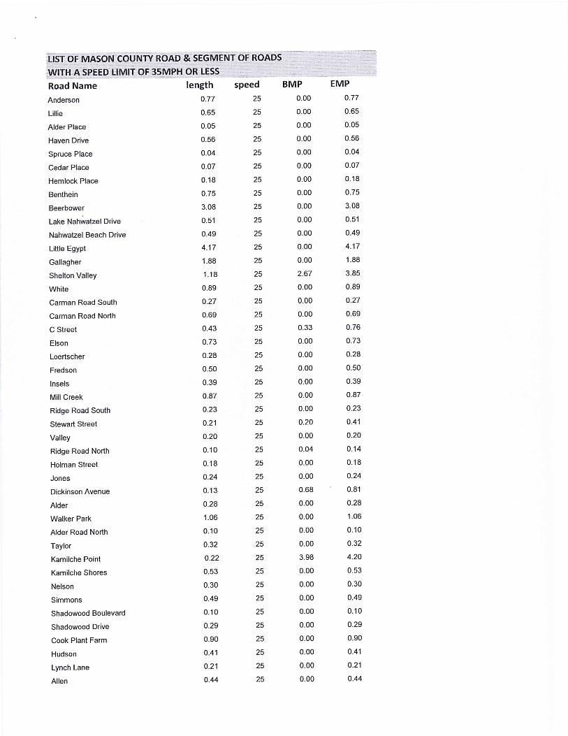
:usTQF MASON COUNTY ROAD & SEGMENT OF ROADS
iWITH,A SPEEQJ:IMIT OF 35MPH qR LESS.
Road Name length speed BMP
Anderson
Lillie
Alder Place
Haven Drive
Spruce Place
Cedar Place
Hemlock Place
Benthein
Beerbower
Lake Nahwatzel Drive
Nahwatzel Beach Drive
Little Egypt
Gallagher
Shelton Valley
White
Carman Road South
Carman Road North
C Street
Elson
Loertscher
Fredson
lnsels
Mill Creek
Ridge Road South
Stewart Street
Valley
Ridge Road North
Holman Street
Jones
Dickinson Avenue
Alder
Walker Park
Alder Road North
Taylor
Kamilche Point
Kamilche Shores
Nelson
Simmons
Shadowood Boulevard
Shadowood Drive
Cook Plant Farm
Hudson
Lynch Lane
Allen
0.77
0.65
0.05
0.56
0.04
0.07
0.18
0.75
3.08
0.51
0.49
4.17
1.88
1.18
0.89
0.27
0.69
0.43
0.73
0.28
0.50
0.39
0.87
0.23
0.21
0.20
0.10
0.18
0.24
0.13
0.28
1.06
0.10
0.32
0.22
0.53
0.30
0.49
0.10
0.29
0.90
0.41
0.21
0.44
25
25
25
25
25
25
25
25
25
25
25
25
25
25
25
25
25
25
25
25
25
25
25
25
25
25
25
25
25
25
25
25
25
25
25
25
25
25
25
25
25
25
25
25
0.00
0.00
0.00
0.00
0.00
0.00
0 .00
0.00
0.00
0.00
0.00
0.00
0.00
2.67
0 .00
0.00
0.00
0.33
0.00
0.00
0.00
0.00
0.00
0.00
0.20
0.00
0.04
0.00
0.00
0.68
0.00
0.00
0.00
0.00
3.98
0.00
0.00
0.00
0.00
0.00
0.00
0.00
0.00
0.00
EMP 0.77
0.65
0.05
0.56
0.04
0.07
0.18
0.75
3.08
0.51
0.49
4.17
1.88
3.85
0.89
0.27
0.69
0.76
0.73
0.28
0.50
0.39
0.87
0.23
0.41
0.20
0.14
0.18
0.24
0.81
0.28
1.06
0.10
0.32
4.20
0.53
0.30
0.49
0.10
0.29
0.90
0.41
0.21
0.44

'.LIST of MASON··coul\ir{ROAD .& SEG.MENT OF ROADS
fWITH A SPEED LIMIT OF 35MPH OR LESS
Road Name
Phillips
Totten Shores Drive
Somers Drive
Picadilly Drive
Stroud
Binns Swiger Loop
Bayview
Orchard Lane
Parkway Boulevard
Shorecrest Parkway
Parkway North
Sherwood Place
Larchmont Place
Peyton Place
Greenwood Lane
Shoreline Lane
Skyline Drive
Seamount Way
Shoreline Place
Shoreline Court East
Shoreline Court West
Shoreline Lane
Midway Lane
Midway Drive
Crestview Drive
Shorecrest Drive
Bridger Lane
Panorama Drive
Maple Lane
Wood Lane
Cross
Sylvan Lane
Evergreen Lane
Olympic Place
Juniper Place
Soundview Drive
Ridgeview Drive
Cedargrove Lane
Kingston Way
Sitka Place
Earll Drive
Ashwood Lane
View Place
Hammond Place
length
0.96
0.81
1.42
0.44
0.27
2.71
0.25
0.38
0.60
0.11
0.20
0.07
0.07
0.18
0.23
0.14
0.17
0.22
0.04
0.02
0.02
0.03
0.36
0.04
0.28
0.61
0.55
0.49
0.05
0.75
0.05
0.09
0.07
0.14
0.03
0.45
0.18
0.12
0.25
0.02
0.15
0.25
0.04
0.04
speed
25
25
25
25
25
25
25
25
25
25
25
25
25
25
25
25
25
25
25
25
25
25
25
25
25
25
25
25
25
25
25
25
25
25
25
25
25
25
25
25
25
25
25
25
BMP 0.00
0.00
0.00
0.00
0.00
0 .00
0.00
0.59
0.00
0.00
0 .00
0.00
0.00
0.00
0.00
0.00
0.00
0 .00
0.00
0 .00
0.00
0 .02
0.00
0.00
2.27
2.55
0.00
0.00
0.00
0.00
0.00
0.00
0.00
0.00
0.00
0.00
0.00
0.00
0.00
0.00
0.00
0.00
0.00
0.00
EMP 0.96
0.81
1.42
0.44
0.27
2.71
0.25
0.97
0.60
0.11
0.20
0.07
0.07
0.18
0.23
0.14
0.17
0.22
0.04
0.02
0.02
0.05
0.36
0.04
2.55
3.16
0.55
0.49
0.05
0.75
0.05
0.09
0.07
0.14
0.03
0.45
0.18
0.12
0.25
0.02
0.15
0.25
0.04
0.04
i 1sr oF· M ASON cou"f..iiv ROAi:>& SEGMENT OF.ROADS--~--~- -- ---;~
. -_ .• . .. .
iWITH A SPEED LIMIT OF 35MPH OR LESS ..,
Road Name length speed BMP EMP
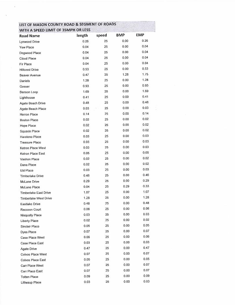
Lynwood Drive 0.26 25 0.00 0.26
Yew Place 0.04 25 0.00 0.04
Dogwood Place 0.04 25 0.00 0.04
Cloud Place 0.04 25 0.00 0.04
Fir Place 0.04 25 0.00 0.04
Hillcrest Drive 0.53 25 0.00 0.53
Beaver Avenue 0.47 25 1.28 1.75
Daniels 1.28 25 0.00 1.28
Gosser 0.93 25 0.00 0.93
Benson Loop 1.69 25 0.00 1.69
Lighthouse 0.41 25 0.00 0.41
Agate Beach Drive 0.48 25 0.00 0.48
Agate Beach Place 0.03 25 0.00 0.03
Herron Place 0.14 25 0.00 0.14
Boston Place 0.02 25 0.00 0.02
Hope Place 0.02 25 0.00 0.02
Squaxin Place 0.02 25 0.00 0.02
Harstene Place 0.03 25 0.00 0.03
Treasure Place 0.03 25 0.00 0.03
Ketron Place West 0.03 25 0.00 0.03
Ketron Place East 0.05 25 0.00 0.05
Vashon Place 0.02 25 0.00 0.02
Dana Place 0.02 25 0.00 0.02
Eld Place 0.03 25 0.00 0.03
Timberlake Drive 0.46 25 0.00 0.46
Mclane Drive 0.29 25 0.00 0.29
Mclane Place 0.04 25 0.29 0.33
Timberlake East Drive 1.07 25 0.00 1.07
Timberlake West Drive 1.28 25 0.00 1.28
Eastlake Drive 0.48 25 0.00 0.48
Raccoon Court 0.06 25 0.00 0.06
Nisqually Place 0.03 25 0.00 0.03
Liberty Place 0.02 25 0.00 0.02
Sinclair Place 0.05 25 0.00 0.05
Dyes Place 0.07 25 0.00 0.07
Case Place West 0.06 25 0.00 0.06
Case Place East 0.03 25 0.00 0.03
Agate Drive 0.47 25 0.00 0.47
Colvos Place West 0.07 25 0.00 0.07
Colvos Place East 0.05 25 0.00 0.05
Carr Place West 0.07 25 0.00 0.07
Carr Place East 0.07 25 0.00 0.07
Totten Place 0.09 25 0.00 0.09
Lilliwaup Place 0.03 25 0.00 0.03

:UST OF MASONCOliNTYROAD & SEGMENT0
0f ROADS
'.WITH A SPEED LIMIT OF 35MPH OR LESS
Road Name
Tahuya Drive
Stavis
Dabob
Vaughn
Dabob Place
Hammersley Place
Skookum Drive
Skookum Place
Skywater Place
Elk Place
Iron Wood Place
Lake Shore Drive West
Treewater Place
Herron Drive
Aspen Place
Aspen Court
West Place
Pickering Drive
Park Drive
Pickering Place
Park Loop
Willopa Place
Willopa
Annas Way
Lakeshore Drive East
Budd Drive
Lakeshore Place South
Annas Place
Annas Court
Lakeshore Place
Timber Parkway
Evergreen Way West
Evergreen Way East
Rose Lane
Budd Place East
Budd Place West
Phillips Lake Loop
Loop Cut-Off
Phillips Lake
Clay
Majesty's Court
Queen's Way
Kings Way
Krabbenhoft
length
0.27
0.22
0.18
0.17
0.08
0.15
0.32
0.03
0.06
0.17
0.08
1.27
0.09
0.56
0.12
0.03
0.03
0.66
0.11
0.04
0.27
0.04
0.26
0.57
0.79
0.59
0.07
0.04
0.13
0.02
0.14
0.04
0.03
0.04
0.03
0.05
2.93
0.07
0.34
0.54
0.07
0.32
0.10
1.10
speed
25
25
25
25
25
25
25
25
25
25
25
25
25
25
25
25
25
25
25
25
25
25
25
25
25
25
25
25
25
25
25
25
25
25
25
25
25
25
25
25
25
25
25
25
BMP 0.00
0.00
0.00
0.00
0.00
0.00
0.00
0.00
0.00
0.00
0.00
0.00
0.00
0.00
0.00
0.00
0.00
0.00
0.00
0.00
0.00
0.00
0.00
0.00
0.00
0.00
0.00
0.00
0.00
0.00
0.00
0.00
0.00
0.00
0.00
0.00
0.00
0.00
0.65
0.99
0.00
0.00
0.00
0.00
EMP 0.27
0.22
0.18
0.17
0.08
0.15
0.32
0.03
0.06
0.17
0.08
1.27
0.09
0.56
0.12
0.03'
0.03
0.66
0.11
0.04
0.27
0.04
0.26
0.57
0.79
0.59
0.07
0.04
0.13
0.02
0.14
0.04
0.03
0.04
0.03
0.05
2.93
0.07
0.99
1.53
0.07
0.32
0.10
1.10

[LIST OF1JiAS0N COUNTY ROAD & SEGMENT OF ROADS~.-- .. ... - .
!WITHA SPEED LIMITOF 35MPH;_6R LESS
Road Name
Lookout Court
Madrona Parkway
Sea Vista Lane
Sea Breeze Drive
Panorama Way
Huckleberry Drive
Rustle Way
Orchard Beach
Island View
Stadium Beach Road West
Stadium Beach Road East
Peale Drive
Squaxin Drive
Camus Drive
Hartstine Island South
Dana Drive
Lansky Drive
Burgundy
Point Wilson
Island Shore
Fox Lane
Ballow
Col. Wright Rd .
McMickin
Sunset Hill
Sunset Hill North
Haskel Hill
Wilson
Wingert
Skokomish Valley
Bourgault Road West
Old Mill Hill
Schoolhouse Hill Road
Upper Finch Creek
Finch Creek
North Hill
Lilliwaup Street
Maple Lane
Beacon Point Drive
Beacon Point Loop North
Beacon Point Loop South
Maple Street
Walnut Street
Blevins Road North
length
0.07
0.46
0.24
0.12
0.11
0.14
0.11
0.51
0.54
1.15
0.92
0.28
0.09
0.46
0.81
0.62
0.50
1.43
1.49
1.15
0.37
0.82
0.62
0.62
1.04
0.49
0.76
0.24
0.52
1.05
0.47
0.36
0.76
0.57
0.22
0.34
0.48
0.09
0.36
0.47
0.39
0.34
0.36
0.21
speed
25
25
25
25
25
25
25
25
25
25
25
25
25
25
25
25
25
25
25
25
25
25
25
25
25
25
25
25
25
25
25
25
25
25
25
25
25
25
25
25
25
25
25
25
BMP 0.00
0.00
0.00
0.00
0.00
0 .00
0.00
0.00
1.06
0.00
0.00
0.00
0.00
0.00
4.27
5.08
0.00
0.00
0.00
0.00
0.00
0.51
0.00
0.00
0.00
0.00
0.00
0.00
0.00
5.70
0.00
0.00
0.00
0.00
0.00
0.00
0.00
0.00
0.00
0.36
0.00
0.67
1.01
0.00
., .. ~l
EMP 0.07
0.46
0.24
0.12
0.11
0.14
0.11
0.51
1.60
1.15
0.92
0.28
0.09
0.46
5.08
5.70
0.50
1.43
1.49
1.15
0.37
1.33
0.62
0.62
1.04
0.49
0.76
0.24
0.52
6.75
0.47
0.36
0.76
0.57
0.22
0.34
0.48
0.09
0.36
0.83
0.39
1.01
1.37
0.21

0
WITH A SPEED LIMIT: OF35MPH OR LESS ..
Road Name
Woodland Drive
Island Lake Drive
Oak Park Way
Oak Park Way
Jensen
Emerald Lake Drive East
Emerald Lake Drive
Carefree Court
Peaceful Place
Leisure Lane
Restful
Emerald Lake Drive West
Mikkelsen
Ecler
Cranberry Creek
Deer Creek
Dartmoor
Dalkeith
Dunvegan
Balbriggan
Errigal Place
Barnsby Place
Angus Court
Olde Lyme Court
Olde Lyme Place
Olde Lyme
Kilmarnock
Peebles Court
Cromarty Court
Clonakilty Drive South
Sealford
Sealford Court
Clonakilty Drive
Road of Tralee
Penzance
Portree Place
Dunoon Place
St Andrews Drive
Tiree Place
Ballantrae Drive
Aycliffe Drive
Donegal Way
TenbyWay
Lambeth Way
length
0.32
2.34
0.51
0.16
0.84
0.53
0.13
0.07
0.18
0.21
0.08
0.33
0.72
0.13
0.50
0.59
0.59
0.22
0.12
0.34
0.08
0.18
0.06
0.03
0.02
0.79
0.25
0.21
0.11
0.03
0.21
0.01
0.21
0.78
0.43
0.03
0.25
2.46
0.08
1.12
0.65
0.1 2
0.17
0.04
speed
25
25
25
25
25
25
25
25
25
25
25
25
25
25
25
25
25
25
25
25
25
25
25
25
25
25
25
25
25
25
25
25
25
25
25
25
25
25
25
25
25
25
25
25
BMP 0.00
0.44
0.00
0.51
0.00
0.13
0.00
0.00
0.00
0.00
0.00
0.00
0.00
0.00
0.00
0.00
0.00
0.00
0.00
0.00
0.00
0.00
0.00
0.00
0.00
0.00
0.00
0.00
0.00
0.00
0.00
0.00
0.00
0.00
0.00
0.00
0.00
0.00
0.00
0.00
0.00
0.00
0.00
0.00
EMP 0.32
2.78
0.51
0.67
0.84
0.66
0.13
0.07
0.18
0.21
0.08
0.33
0.72
0.13
0.50
0.59
0.59
0.22
0.12
0.34
0.08
0.18
0.06
0.03
0.02
0.79
0.25
0.21
0.11
0.03
0.21
0.01
0.21
0.78
0.43
0.03
0.25
2.46
0.08
1.12
0.65
0.12
0.17
0.04

-------..,...,,,..--- ~-~-~ - ---~ • • - - • -- H-•• ,-• :~~;i:-~~~ci:i~~~;3:~:~~:EL~:ENT OF ROADS
Road Name length speed BMP EMP
Muirkirk 0.05 25 0.00 0.05
Shamrock Drive East 0.09 25 0.00 0.09
Shamrock Drive West 0.28 25 0.00 0.28
Connemara Way 0.22 25 0.00 0.22
Blenheim Place 0.11 25 0.00 0.11
Tintagel Place 0.04 25 0.00 0.04
Shannon Place 0.12 25 0.00 0.12
Shetland 0.35 25 0.00 0.35
Somersby Place 0.07 25 0.00 0.07
Paisley Way 0.16 25 0.00 0.16
Balmoral Way 0.52 25 0.00 0.52
Glamis Court 0.05 25 0.00 0.05
Galway 0.15 25 0.00 0.15
Merioneth 0.25 25 0.00 0.25
Balleycastle Way 0.35 25 0.00 0.35
Way To Tipperary 0.59 25 0.00 0.59
Glenmorgan Court 0.06 25 0.00 0.06
Stirling Court 0.03 25 0.00 0.03
Tregaron Court 0.06 25 0.00 0.06
Cardigan Court 0.10 25 0.00 0.10
Weymouth Place 0.10 25 0.00 0.10
Limerick 0.25 25 0.00 0.25
Webb Hill 0.59 25 1.20 1.79
Manzanita Drive 0.99 25 0.74 1.73
Main Street North 0.20 25 0.00 0.20
Fourth Street 0.19 25 0.00 0.19
Alder Street 0.05 25 0.06 0.11
Third Street 0.06 25 0.00 0.06
Fifth Street 0.28 25 0.24 0.52
Seattle Street 0.16 25 0.08 0.24
Tnird Street 0.08 25 0.00 0.08
Fourth Street 0.11 25 0.00 0.11
Orre Noble 0.48 25 0.00 0.48
Mason Avenue 0.15 25 0.00 0.15
Mason Avenue Extension 0.02 25 0.00 0.02
Mason Lake Drive East 0.55 25 0.00 0.55
Olympic Drive 0.59 25 0.00 0.59
Paradise Place 0.08 25 0.59 0.67
Lakeview Drive 0.33 25 0.00 0.33
Shore Court 0.02 25 0.00 0.02
Shore Drive 0.28 25 0.00 0.28
Shore Place 0.02 25 0.00 0.02
Division Street 0.05 25 0.00 0.05
Benson Lake 1.71 25 0.00 1.71

!LIST OF MASON COUNTY ROAD & SEGMENT OF ROADS
;WITH A SPEED LIMIT OF 35MPH OR LESS
Road Name length speed BMP EMP
Roe's Court 0.37 25 0.00 0.37
Trails End Drive 2.37 25 0.00 2.37
Mason Benson 0.27 25 2.86 3.13
Murray Road North 0.43 25 0.00 0.43
Rauschert 0.66 25 0.00 0.66
Treasure Lane 0.21 25 0.00 0.21
Lombard Road South 0.56 25 0.00 0.56
Bahama Drive 0.17 25 0.00 0.17
Barbary Drive 0.16 25 0.00 0.16
Rum Runner 0.03 25 0 .00 0.03
Gem Court 0.04 25 0.00 0.04
Treasure Court 0.04 25 0 .00 0.04
Pirates Grove 0.19 25 0 .00 0.19
Pirates Cove 0.11 25 0.00 0.11
Stretch Island Road South 0.74 25 0 .00 0.74
Eckert 0.84 25 0.00 0.84
Cronquist 0.71 25 0.00 0.71
Sherwood Creek 0.70 25 0.00 0.70
Lakeshore Drive 1.01 25 0.00 1.01
Westlake Drive 0.29 25 0.00 0.29
Westlake Court 0.30 25 0.00 0.30
Westlake Way 0.20 25 0.00 0.20
Westlake Place 0.04 25 0.00 0.04
Old Ranch 1.56 25 0.00 1.56
Elma's Place 0.05 25 0.00 0.05
Sterling Drive 0.55 25 0.00 0.55
Soderberg 1.08 25 0.00 1.08
Homestead Drive 0.22 25 0.00 0.22
Rainier Court 0.28 25 0.00 0.28
Villageview Drive 0.25 25 0.00 0.25
Olympic Court 0.32 25 0.00 0.32
Lake Forest Drive 0.38 25 0.00 0.38
Marine View Drive 0.12 25 0.00 0.12
Mountain View Drive 0.51 25 0.00 0.51
Channel Drive 0.28 25 0.00 0.28
Bay Place 0.03 25 0.00 0.03
Lakeshore Place 0.04 25 0.00 0.04
North Bay Place 0.10 25 0.00 0.10
Lakeland Drive 0.70 25 0.00 0.70
Allynview Drive 0.22 25 0.00 0.22
Lakeland Way 0.23 25 0.00 0.23
Country Club Drive 0.49 25 0.00 0.49
Fairway Drive 0.44 25 0.00 0.44
Rainier Drive 0.52 25 0.00 0.52
:usT OFMASONCOUNTY. ROAo'ifsEGMENT OF .ROADS -.--,
:WITH A SPEED LIMIT OF 35MPH OR LESS
Road Name length speed BMP EMP
Lake Devereaux 0.39 25 0.00 0.39
Coulter Creek 0.88 25 0.00 0.88
Roessel 0.31 25 0.00 0.31
Tahuya River 2.41 25 1.61 4.02
Magnolia Place 0.12 25 0.00 0.12
Pine Place 0.05 25 0.00 0.05
Tahuya Court North 0.03 25 0.00 0.03
Tahuya Court South 0.04 25 0.00 0.04
Cedar Lane 0.25 25 0.00 0.25
Madrona Court 0.07 25 0.00 0.07
Evergreen Way 0.08 25 0.00 0.08
Fir Court 0.04 25 0.00 0.04
Circle Drive 0.42 25 0.00 0.42
Belfair Court 0.04 25 0.00 0.04
Lakeshore Drive South 0.78 25 0.00 0.78
Claireview Drive 0.11 25 0.00 0.11
Fern Court 0.05 25 0.00 0.05
Lake Place 0.02 25 0.00 0.02
Park Place 0.02 25 0.00 0.02
Lakeshore Drive North 0.55 25 0.39 0.94
Madrona Avenue 0.39 25 0.00 0.39
Lake Court 0.03 25 0.00 0.03
Tahuya Boulevard 0.42 25 0.00 0.42
Woodside Place 0.03 25 0.00 0.03
Evergreen Drive 0.19 25 0.00 0.19
Snowcap Drive 0.89 25 0.00 0.89
-I Tahuya River Drive 0.78 25 1.22 2.00
Rainbow Place 0.04 25 0.00 0.04
Snowcap Place 0.09 25 0.00 0.09
I Forest Creek Drive 0.23 25 0.00 0.23
Firwood Place 0.09 25 0.00 0.09
River 0.20 25 0.00 0.20
Woodview Lane 0.13 25 0.00 0.13
Creekside Place 0.07 25 0.00 0.07
Steelhead Place 0.05 25 0.00 0.05
De Walto-Holly 1.63 25 0.00 1.63
Collins Lake 0.22 25 0.00 0.22
Mountain View Place 0.15 25 0.00 0.15
Collins Lake Drive 1.14 25 0.00 1.14
Collins Place 0.26 25 0.00 0.26
Sundown Drive 0.35 25 0.00 0.35
Collins Drive East 0.24 25 0.00 0.24
Pine Tree Lane 0.13 25 0.00 0.13
Lake View Place 0.07 25 0.00 0.07

[ 1ST Of. MASi5NCOUNTY ROAD & SEGMENT OF RO.ADS-···· . : . .
!WITH A SPEED LIMIT OF 35MPH OR LESS -
Road Name
Creek View Place
North Shore Place
Hilltop Place
Pine Tree Place
Lake Drive
Rhododendron Boulevard
Lake Christine
Bear Creek-DeWatto
Landon
Boad Haven
Lynnwood Beach
Lynnwood Drive
Beck
Gladwin
Bryan Lane
Lorna Lee Way
Wanda Lane
Barbara Boulevard
Matthew Drive
Sandra Lane
Barbara Lane
Matthew Court
Laura Lane
Burt Court
Katherine Court
Allen Court
Lorrain Court
Larson Lake
Roy Boad
Clifton Lane
Newkirk
Panther Lake
McReavy
Old Belfair Highway
Stoner
Hulbert Road West
Cloquallum
Manor
Fagergren
Scarlet
Strong
Tee Lake
Tee Lake
Mary M. Knight
length
0.12
0.05
0.27
0.15
0.39
0.15
0.23
1.91
0.80
0.07
0.19
0.18
0.78
0.83
0.24
0.08
0.30
0.69
0.63
0.04
0.25
0.03
0.05
0.11
0.05
0.11
0.10
0.67
0.44
0.21
0.53
0.32
0.23
0.41
0.30
0.14
0.06
0.37
0.46
0.58
0.42
1.33
1.08
1.46
speed
25
25
25
25
25
25
25
25
25
25
25
25
25
25
25
25
25
25
25
25
25
25
25
25
25
25
25
25
25
25
25
25
25
25
25
25
25
25
25
25
25
25
25
30
BMP
0.00
0.00
0.00
0.00
0.00
0.00
0.00
0.00
0.00
0.00
0.00
0.00
0.00
0.00
0.00
0.00
0.00
0.00
0.00
0.00
0.00
0.00
0.00
0.00
0.00
0.00
0.00
0.00
0.09
0.00
0.00
0.00
0.00
3.27
0.00
0.00
1.28
0.00
0.00
0.00
0.00
0.00
1.33
0.00
EMP 0.12
0.05
0.27
0.15
0.39
0.15
0.23
1.91
0.80
0.07
0.19
0.18
0.78
0.83
0.24
0.08
0.30
0.69
0.63
0.04
0.25
0.03
0.05
0.11
0.05
0.11
0.10
0.67
0.53
0.21
0.53
0.32
0.23
3.68
0.30
0.14
1.34
0.37
0.46
0.58
0.42
1.33
2.41
1.46

;LIST OF MASON COUNTY ROAD & SEGMENT OF ROADS ... ··-·--- -· . ~-:··-,.........,~=-
!WITl:I A SPEED LIMIT Of l5MPH OR l,ESS .. Road Name length speed BMP EMP
Matlock-Deckerville 0.95 30 0.00 0.15
Beeville Loop 5.54 30 0.00 5.54
Lynch 0.81 30 8.42 9.23
Sunset 0.95 30 0.00 0.95
Bertlesen 0.75 30 0.00 0.75
Julian 0.26 30 0.00 0.26
Ballow 0.51 30 0.00 0.51
Foothills Park Road 0.30 30 0.00 0.30
Mason Lake Drive East 1.38 30 0.55 1.93
Mason Lake Drive East 1.01 30 1.93 2.94
Victor 1.42 30 0.00 1.42
Tahuya Blacksmith 1.00 30 0.00 1.00
Tahuya Blacksmith 2.93 30 5.02 7.95
Tahuya River 1.61 30 0.00 1.61
Haven Lake Drive 0.77 30 0.00 0.77
Mt. View Drive 1.19 30 0.00 1.19
Mission Creek 1.57 30 0.00 1.57
Shelton-Matlock-Brady 0.22 30 16.67 16.89
Bulb Farm 1.12 30 0.00 1.12
Old Olympic Highway 2.43 30 0.51 2.94
Craig Sorger Lane 0.11 30 0.00 0.11
Satsop Cloquallum 2.38 35 1.31 3.69
Satsop Cloquallum 1.88 35 6.33 8.21
Boundary West 2.31 35 0.00 2.31
Boundary Cut-off West 0.59 35 0.00 0.59
Ford Loop 1.10 35 2.91 4.01
Fish Hatchery 3.78 35 0.00 3.78
Satsop Cloquallum 1.31 35 0.00 1.31
Satsop Cloquallum 2.64 35 3.69 6.33
Satsop Road East 1.12 35 8.19 9.31
Schafer Park 1.05 35 0.00 1.05
Plug Mill 2.29 35 0.00 2.29
Star Lake Drive 0.88 35 0.00 0.878
Highland 3.60 35 0.00 3.595
Lost Lake 0.64 35 0.00 0.64
Shelton Valley 2.67 35 0.00 2.67
Deegan Road West 2.68 35 0.00 2.68
Cloquallum 1.25 35 12.90 14.15
Wivell 0.79 35 0.00 0.79
Hurley-Waldrip 2.43 35 0.00 2.43
Kamilche Lane 1.07 35 0.00 1.07
Ryan 0.23 35 0.00 0.23
Story 0.56 35 0.00 0.56
Delight Park 0.92 35 0.00 0.92
~LIST OF MASON CouNrv ROAD & sE.GME.NT~OF ROADS . . .
:wm-i A SPEED UMIT OF 35MPH OR LESS
Road Name
Golden Pheasant
Craig
Old Olympic Highway
Kamilche Point
Lynch
Cole
Sells Drive
Old Arcadia
Crestview Drive
Leeds Drive
Agate Loop
Northbound Only
Libby
Spencer Lake
Island View
Thomas
Hartstine Bridge
Hartstine Island South
North Island Drive
Eells Hill
Sunnyside
Reservation
Shelton Springs
Island Lake
Mason Lake
Manzanita Drive
Mason Lake Drive West
Mason Lake Estates
Mason Lake Drive South
Trails
Anthony
Anthony
North Shore
North Shore
North Shore
North Shore
North Shore
North Shore
Tahuya River Drive
DeWatto
Bear Creek-DeWatto
Bear Creek-DeWatto
Elfendahl Pass
Sand Hill
length
1.12
1.06
0.42
1.18
1.11
3.26
0.86
0.96
2.27
1.29
1.76
1.00
0.70
2.78
1.06
1.83
0.60
1.58
4.73
2.30
3.45
1.02
0.89
0.53
2.86
0.74
6.63
0.69
1.64
1.46
2.24
0.82
0.46
7.80
0.57
0.27
2.10
0.32
1.22
3.21
3.18
4.01
7.94
5.82
speed
35
35
35
35
35
35
35
35
35
35
35
35
35
35
35
35
35
35
35
35
35
35
35
35
35
35
35
35
35
35
35
35
35
35
35
35
35
35
35
35
35
35
35
35
BMP 0.04
0.00
0.09
2.80
3.34
0.00
0.00
0.00
0.00
0.00
0.00
0.00
0.00
0.00
0.00
0.00
0.00
2.69
0.00
0.00
0.00
0.00
0.00
0.00
0.00
0.00
0.00
0.00
0.00
0.00
0.00
2.21
0.94
3.24
11 .31
12.15
12.42
14.70
0.00
0.00
1.91
6.52
0.00
0.00
EMP 1.16
1.06
0.51
3.98
4.45
3.26
0.86
0.96
2.27
1.29
1.76
1.00
0.70
2.78
1.06
1.83
0.60
4.27
4.73
2.30
3.45
1.02
0.89
0.53
2.86
0.74
6.63
0.69
1.64
1.46
2.24
3.03
1.40
11 .04
11 .88
12.42
14.52
15.02
1.22
3.21
5.09
10.53
7.94
5.82

:usro F MASOI\JCOUNTV ROAD &"sEGM.ENf"oi:·ROADS ·:·· ····---~ - . -
iWITH A SPEED·UMIT OF 35MPH OR LESS
Road Name
Tiger Lake West
Shelton-Matlock-Brady
Shelton-Matlock-Brady
Shelton-Matlock-Brady
Arcadia
McReavy
Old Belfair Highway
Old Belfair Highway
Old Olympic Highway
Pickering
Pickering
Public Works Drive
Skokomish Valley
Capitol Hill
Rasor Road West
North Bay Road
Belfair Tahuya
length
0.41
1.04
0.42
1.04
0.75
0.80
0.51
0.21
1.30
0.90
0.81
0.474
0.10
2.154
2.36
0.35
0.13
speed
35
35
35
35
35
35
35
35
35
35
35
35
35
35
35
35
35
BMP
0.00
0.91
7.20
12.25
0.00
0.23
2.76
3.68
2.94
0.00
1.05
0.00
5.60
0.00
0.00
0.00
0.00
EMP
0.41
1.95
7 .62
13.29
0.75
1.03
3.27
3.89
4.24
0.90
1.86
0.474
5.70
2.154
2.35
0.35
0.133