WHC-08/32.COM/INF.8B2 Convention Concerning the Protection...
174
WHC-08/32.COM/INF.8B2 Convention Concerning the Protection of the World Cultural and Natural Heritage IUCN Evaluation of Nominations of Natural and Mixed Properties to the World Heritage List Report to the World Heritage Committee 32 nd Session 2-10 July 2008, Québec City, Canada Prepared by IUCN (International Union for Conservation of Nature) May 2008
Transcript of WHC-08/32.COM/INF.8B2 Convention Concerning the Protection...
WHC-08/32.COM/INF.8B2
Convention Concerning the Protection of the World Cultural and Natural Heritage
IUCN Evaluation of Nominations of Natural and Mixed Properties
to the World Heritage List
Report to the World Heritage Committee32nd Session
2-10 July 2008, Québec City, Canada
Prepared by IUCN (International Union for Conservation of Nature)May 2008

Cover Photo: Socotra Archipelago, Yemen © IUCN / Khaldoun Al Omari
IUCN Evaluation of Nominations ofNatural and Mixed Properties
to the World Heritage List
2008
Table of Contents
Page No.
Introduction i
IUCN Technical Evaluation Reports
A Natural Properties
A1 New Nominations of Natural Properties
Arab States
Yemen – Socotra Archipelago 1
Asia / Pacifi c
China – Mount Sanqingshan National Park 13
Mongolia – Hovsgol Lake and its Watershed 25
Europe / North America
Canada – The Joggins Fossil Cliffs 33
France – The Lagoons of New Caledonia: Reef Diversity and Associated Ecosystems 43
Iceland – Surtsey 55
Italy – Bradyseism in Phlegraean Area 63
Russian Federation – “The Putorana Plateau” Nature Complex 69
Switzerland – Swiss Tectonic Arena Sardona (former Glarus Overthrust) 79
Latin America / Caribbean
Bolivia – Quarry of the Fabrica Nacional de Cementos S.A. (FANCESA), Cal Orck’O, Sucre, Departamento Chuquisaca 87
Mexico – Monarch Butterfl y Biosphere Reserve 93
A2 Deferred Nominations of Natural Properties
Asia / Pacifi cKazakhstan – Saryarka - Steppe and Lakes of Northern Kazakhstan 101

Page No.
A Natural Properties
A3 Extensions of Natural Properties
Europe / North America
Bulgaria – Pirin National Park (extension) 111
A4 Boundary Modifi cations of Natural Properties
Europe / North America
Bulgaria – Srebarna Nature Reserve (boundary modifi cation) 121
Hungary / Slovakia – Caves of Aggtelek Karst and Slovak Karst (boundary modifi cation) 123
B Mixed Properties
B1 Boundary Modifi cations of Mixed Properties
Europe / North America
Former Yugoslav Republic of Macedonia – Natural and Cultural Heritage of theOhrid Region (boundary modifi cation) 127
C Cultural Properties
C1 New Nominations of Cultural Landscapes
Africa
Mauritius – Le Morne Cultural Landscape 131
Asia / Pacifi c
Indonesia – Cultural Landscape of Bali Province 133
Papua New Guinea – The Kuk Early Agricultural Site 135
Vanuatu – Chief Roi Mata’s Domain 137
C2 Referred Nominations of Cultural Landscapes
Africa
Kenya – The Sacred Mijikenda Kaya Forests 139
Asia / Pacifi c
India – River Island of Majuli in Midstream of Brahmaputra River in Assam 141

ID No. State Party Property Page No.
99 Former Yugoslav Republic of Macedonia
Natural and Cultural Heritage of the Ohrid Region (boundary modifi cation) 127
219 Bulgaria Srebarna Nature Reserve (boundary modifi cation) 121
225 Bis Bulgaria Pirin National Park (extension) 111
725 Bis Hungary / Slovakia Caves of Aggtelek Karst and Slovak Karst (boundary modifi cation) 123
887 Papua New Guinea The Kuk Early Agricultural Site 1351082 Mongolia Hovsgol Lake and its Watershed 25
1102 Rev Kazakhstan Saryarka - Steppe and Lakes of Northern Kazakhstan 101
1115 France The Lagoons of New Caledonia: Reef Diversity and Associated Ecosystems 43
1179 Switzerland Swiss Tectonic Arena Sardona (former Glarus Overthrust) 79
1194 Indonesia Cultural Landscape of Bali Province 133
1206 Rev India River Island of Majuli in Midstream of Brahmaputra River in Assam 141
1231 Rev Kenya The Sacred Mijikenda Kaya Forests 1391234 Russian Federation “The Putorana Plateau” Nature Complex 691259 Mauritius Le Morne Cultural Landscape 1311263 Yemen Socotra Archipelago 11267 Iceland Surtsey 551280 Vanuatu Chief Roi Mata’s Domain 137
1284 BoliviaQuarry of the Fabrica Nacional de Cementos S.A. (FANCESA), Cal Orck’O, Sucre, Departamento Chuquisaca
87
1285 Canada The Joggins Fossil Cliffs 331288 Italy Bradyseism in Phlegraean Area 631290 Mexico Monarch Butterfl y Biosphere Reserve 931292 China Mount Sanqingshan National Park 13
Numerical Index

IUCN Evaluation Report May 2008 i
THE WORLD HERITAGE CONVENTION
IUCN TECHNICAL EVALUATION REPORT OF WORLD HERITAGE NOMINATIONS
May 2008
1. INTRODUCTION
This technical evaluation report of natural and mixed properties nominated for inclusion on the World Heritage List has been conducted by the Programme on Protected Areas (PPA) of IUCN, the International Union for Conservation of Nature. PPA co-ordinates IUCN’s input to the World Heritage Convention. It also works closely with IUCN’s World Commission on Protected Areas (WCPA), the world’s leading expert network of protected area managers and specialists, and other Commissions, members and partners of IUCN.
In carrying out its function under the World Heritage Convention IUCN has been guided by four principles:
(i) the need to ensure the highest standards of quality control and institutional memory in relation to technical evaluation, monitoring and other associated activities;
(ii) the need to increase the use of specialist networks of IUCN, especially WCPA, but also other relevant IUCN Commissions and specialist networks;
(iii) the need to work in support of the UNESCO World Heritage Centre and States Parties to examine how IUCN can creatively and effectively support the World Heritage Convention and individual properties as “fl agships” for conservation; and
(iv) the need to increase the level of effective partnership between IUCN and the World Heritage Centre, ICOMOS and ICCROM.
Members of the expert network of WCPA carry out the majority of technical evaluation missions. The WCPA network now totals 1200 protected area managers and specialists from 140 countries. In addition, PPA has called on experts from IUCN’s other fi ve Commissions (Species Survival, Environmental Law, Education and Communication, Ecosystem Management, and Environmental, Economic and Social Policy), from international earth science unions, other IUCN Global Programmes, and scientifi c contacts in universities and other international agencies. This highlights the considerable “added value” from investing in the use of the extensive networks of IUCN and partner institutions.
These networks allow for the increasing involvement of regional natural heritage experts and broaden the capacity of IUCN with regard to its work under the World Heritage Convention. Reports from fi eld missions and comments from a large number of external reviewers are comprehensively examined by the IUCN World Heritage Panel. PPA then prepares the fi nal technical evaluation reports which are presented in this document and represent the corporate position of IUCN on World Heritage evaluations. IUCN has also placed emphasis on providing input and support to ICOMOS in relation to those cultural landscapes which have important natural values.
In 2005, IUCN commissioned an external review of its work on World Heritage evaluations, which was carried out by Dr. Christina Cameron and resulted in a number of recommendations to improve IUCN’s work. The review and the IUCN management response are available on IUCN’s website. A progress report on the implementation of the review’s recommendations was examined by the IUCN World Heritage Panel in December 2007 and indicated that IUCN has fully or partly addressed all 26 recommendations, with further action ongoing on a number of recommendations.
2. EVALUATION PROCESS
In carrying out the technical evaluation of nominations IUCN is guided by the Operational Guidelines of the Convention. The evaluation process is carried out over the period of one year, from the receipt of nominations at IUCN in April and the submission of the IUCN evaluation report to the World Heritage Centre in May of the following year. The process (outlined in Figure 1) involves the following steps:
1. Data Assembly. A standardised data sheet is compiled on the nominated property by UNEP’s World Conservation Monitoring Centre (UNEP-WCMC), using the nomination document, the World Database on Protected Areas and other available reference material.
2. External Review. The nomination is sent to independent experts knowledgeable about the property or its natural values, including members of WCPA, other IUCN specialist commissions and scientifi c networks or NGOs working in the region (approximately 130 external reviewers provided input in relation to the properties examined in 2007 / 2008).

ii IUCN Evaluation Report May 2008
3. Field Mission. Missions involving one or more IUCN and external experts evaluate the nominated property on the ground and discuss the nomination with the relevant national and local authorities, local communities, NGOs and other stakeholders. Missions usually take place between May and November. In the case of mixed properties and certain cultural landscapes, missions are jointly implemented with ICOMOS.
4. IUCN World Heritage Panel Review. The IUCN World Heritage Panel meets at least once per year, usually in December at IUCN Headquarters in Switzerland to examine each nomination. A second meeting or conference call is arranged as necessary, usually in the following March. The Panel intensively reviews the nomination dossiers, fi eld mission reports, comments from external reviewers, the UNEP-WCMC data sheets and other relevant reference material, and provides its technical advice to IUCN on recommendations for each nomination. A fi nal report is prepared and forwarded to the World Heritage Centre in May for distribution to the members of the World Heritage Committee.
5. Final Recommendations. IUCN presents, with the support of images and maps, the results and recommendations of its evaluation process to the World Heritage Committee at its annual session in June or July, and responds to any questions. The World Heritage Committee makes the fi nal decision on whether or not to inscribe the property on the World Heritage List.
It should be noted that IUCN seeks to develop and maintain a dialogue with the State Party throughout the evaluation process to allow the State Party every opportunity to supply all the necessary information and to clarify any questions or issues that may arise. For this reason, there are three occasions at which IUCN may request further information from the State Party. These are:
• Before the fi eld mission – IUCN sends the State Party, usually directly to the person organising the mission in the host country, a briefi ng on the mission, in many cases raising specifi c questions and issues that should be discussed during the mission. This allows the State Party to prepare properly in advance;
• Directly after the fi eld mission – Based on discussions during the fi eld mission, IUCN may send an offi cial letter requesting supplementary information before the IUCN World Heritage Panel meets in December, to ensure that the Panel has all the information necessary to make a recommendation on the nomination; and
• After the IUCN World Heritage Panel – If the Panel fi nds some questions are still unanswered or further issues need to be clarifi ed, a fi nal letter will be sent to the State Party requesting supplementary information by a specifi c deadline. That deadline must be adhered to strictly in order to allow IUCN to complete its evaluation.
Note: If the information provided by the State Party at the time of nomination and during the mission is adequate, IUCN does not request supplementary information. It is expected that supplementary information will be in response to specifi c questions or issues and should not include completely revised nominations or substantial amounts of new information.
In the technical evaluation of nominated properties, the Udvardy Biogeographic Province concept is used for comparison of nominations with other similar properties. This method makes comparisons of natural properties more objective and provides a practical means of assessing similarity at the global level. At the same time, World Heritage properties are expected to contain special features, habitats and faunistic or fl oristic peculiarities that can also be compared on a broader biome basis. It is stressed that the Biogeographical Province concept is used as a basis for comparison only and does not imply that World Heritage properties are to be selected solely on this criteria. In addition, global classifi cation systems, such as Conservation International Biodiversity Hotspots, WWF Ecoregions, Birdlife International Endemic Bird Areas, IUCN/WWF Centres of Plant Diversity and the IUCN/SSC Habitat Classifi cation, and the 2004 IUCN/UNEP-WCMC Review of the World Heritage Network are used to identify properties of global signifi cance. The guiding principle is that World Heritage properties are only those areas of outstanding universal value.
Finally, the evaluation process is aided by the publication of some 20 reference volumes on the world’s protected areas published by IUCN, UNEP-WCMC and several other publishers. These include (1) Reviews of Protected Area Systems in Africa, Asia and Oceania; (2) the four volume directory of Protected Areas of the World; (3) the six volume Global Biodiversity Atlas series; (4) the three volume directory of Centres of Plant Diversity; (5) the three volume directory of Coral Reefs of the World; and (6) the four volume synthesis on “A Global Representative System of Marine Protected Areas”. These documents together provide system-wide overviews which allow comparison of the conservation importance of protected areas throughout the world.
3. THE IUCN WORLD HERITAGE PANEL
Purpose: The Panel advises the IUCN Secretariat on its work on World Heritage, particularly in relation to the evaluation of World Heritage nominations. The Panel

IUCN Evaluation Report May 2008 iii
normally meets once a year for a week in December. Depending on the progress made with evaluations, and the requirement for follow up action, a second meeting or conference call in the following March may be required. Additionally, the Panel operates by email and/or conference call, as required.
Functions: A core role of the Panel is to provide a technical peer review process for the consideration of nominations, leading to the formal adoption of advice to IUCN on the recommendations it should make to the World Heritage Committee. In doing this, the Panel examines each available nomination document, the fi eld mission report, comments from external reviewers and other material, and uses this to help prepare IUCN’s advice, including IUCN recommendations relating to inscription under specifi ed criteria, to the World Heritage Committee (and, in the case of some cultural landscapes, advice to ICOMOS). It may also advise IUCN on other matters concerning World Heritage, including the State of Conservation of World Heritage properties and on policy matters relating to the Convention. Though it takes account of the policy context of IUCN’s work under the Convention, its primary role is to deliver high quality scientifi c and technical advice to IUCN, which has the fi nal responsibility for corporate recommendations made to the World Heritage Committee.
Membership: The members of the Panel comprise a) those IUCN staff with direct responsibility for IUCN’s World Heritage work, and b) other IUCN staff, Commission members and external experts selected for their high level of experience with the World Heritage Convention. Thus the members are:
• The Head of the IUCN Programme on Protected Areas (Chair)
• Other staff of the Programme on Protected Areas• The IUCN Special Advisor for World Heritage • The IUCN Senior Advisor for World Heritage • The WCPA Vice Chair for World Heritage • The Head of the UNEP-WCMC Protected Areas
Programme • Up to three other technical advisors, whose World
Heritage expertise is recognized at a global level
The Panel’s preparations and its meetings are facilitated through the work of the World Heritage Offi cer (who serves as the Executive Offi cer for the Panel).
The Panel may also be attended by other IUCN staff (particularly from other Global Programmes with expertise in the subject matter of particular nominations), Commission members (including the Chair of WCPA) and external experts, upon invitation, for specifi c items as necessary. The Director General of IUCN and the Director of Global Programmes are also invited to attend a session of the Panel for a full briefi ng on the process and recommendations.
4. EVALUATION REPORTS
Each technical evaluation report presents a concise summary of the nominated property, a comparison with other similar properties, a review of management and integrity issues and concludes with the assessment of the applicability of the criteria and a clear recommendation to the World Heritage Committee. IUCN also submits separately to the World Heritage Centre its recommendation in the form of a draft decision, and a draft Statement of Outstanding Universal Value for all properties it recommends for inscription. Standardised data sheets, prepared for each natural or mixed nomination by UNEP-WCMC, are available separately on request. In addition, IUCN carries out fi eld missions and/or external reviews for cultural landscapes containing important natural values, and provides its comments to ICOMOS. This report contains a short summary of these comments on each cultural landscape nomination reviewed.
5. NOMINATIONS EXAMINED IN 2007 / 2008
19 nomination dossiers were examined by IUCN in the 2007 / 2008 cycle, involving 13 fi eld missions. These comprised:
• 13 natural property nominations (including 11 new nominations, 1 deferred nomination and 1 extension), and
• 6 cultural landscape nominations (including 4 new nominations and 2 referred nominations).
6. COLLABORATION WITH INTERNATIONAL EARTH SCIENCE UNIONS
IUCN has taken further steps to implement the global theme study on Geological Heritage published in 2005. It has concluded collaboration agreements with the International Union of Geological Sciences (IUGS) and the International Association of Geomorphologists (IAG) in 2006. These agreements are focused on strengthening the evaluation process by providing access to the global networks of earth scientists coordinated through IUGS and IAG. As a result, over 30 of the approximately 130 external reviews in 2007 came from IUGS and IAG experts.
It is also anticipated that the collaboration agreements will lead to increased support to States Parties more generally through the preparation of targeted theme studies that provide further guidance on earth science sites. Theme studies on deserts, karst and caves, and volcanoes are in preparation.
IUCN would like to record its gratitude to IUGS and IAG for their willingness to provide support for its advisory role in the implementation of the World Heritage Convention, and will continue to update the World Heritage Committee on the implementation of the collaboration agreements with IUGS and IAG.

iv IUCN Evaluation Report May 2008
7. RECOMMENDATIONS TO THE WORLD HERITAGE COMMITTEE
In the 2007 / 2008 cycle, IUCN has sought to ensure that States Parties have the opportunity to provide all the necessary information on their nominated properties through the process outlined in section 2 above. As per Decision 30 COM 13 of the World Heritage Committee (Vilnius, 2006), IUCN has not taken into consideration or included any information submitted by States Parties after 28 February 2008, as evidenced by the postmark.
In order to allow for adequate evaluation of supplementary information from States Parties on their nominations, IUCN had proposed shifting the deadline for receiving supplementary information to 28 February. However, the Committee shifted the deadline for supplementary information from reception by 31 March to submission by 28 February, potentially leaving as little time as before.
IUCN therefore recommends that the World Heritage Committee reconsider its decision and ensure the deadline of 28 February is the fi nal date of reception, not submission, of supplementary information.
IUCN also recommends that the World Heritage Committee clearly defi ne the meaning of supplementary information, so that States Parties cannot submit substantial amounts of new information
and completely revised nominations late in the evaluation process, when it is impossible to adequately assess such material. IUCN considers supplementary information to include responses to specifi c questions or issues raised by the Advisory Bodies.
IUCN further recommends that the World Heritage Committee clearly defi ne the meaning of factual errors and to shift the deadline for submission of factual error letters, currently at least two working days before the opening of the session of the Committee, to at least two weeks before the opening of the session of the Committee, to allow for their adequate expert evaluation. To further improve this process, IUCN suggests a standard form for submission of factual errors be developed, including a clear defi nition of the meaning of factual errors.
8. ACKNOWLEDGEMENTS
As in previous years, this report is a group product to which a vast number of people have contributed. Acknowledgements for advice received are due to the external evaluators and reviewers, and numerous IUCN staff at Headquarters and in Regional and Country Offi ces. Many others contributed inputs during fi eld missions. This support is acknowledged with deep gratitude.

IUCN Evaluation Report May 2008 v
Figure 1: IUCN Evaluation Process
IUCN Technical Evaluation Report toWorld Heritage Committee
IUCN Technical Evaluation Report toWorld Heritage Committee
Field MissionField MissionExternal ReviewsExternal Reviews
UNEP-WCMC Data Sheet
UNEP-WCMC Data Sheet
Consultation with National and Local Authorities, Local
Communities, NGOs, Other Stakeholders
Consultation with National and Local Authorities, Local
Communities, NGOs, Other Stakeholders
IUCN Programme on Protected AreasIUCN Programme on Protected Areas
Nomination Dossiers fromWorld Heritage Centre
Nomination Dossiers fromWorld Heritage Centre
IUCN World Heritage PanelIUCN World Heritage Panel

A. Natural Properties
A1. New Nominations of Natural Properties
ARAB STATES
SOCOTRA ARCHIPELAGO
YEMEN

IUCN Evaluation Report May 2008 1
WORLD HERITAGE NOMINATION – IUCN TECHNICAL EVALUATION
SOCOTRA ARCHIPELAGO (YEMEN) – ID No. 1263
1. DOCUMENTATION
i) Date nomination received by IUCN: April 2007
ii) Additional information offi cially requested from and provided by the State Party: IUCN requested supplementary information on 20 December 2007 after the fi rst IUCN World Heritage Panel meeting. The State Party response was offi cially received by the World Heritage Centre on 27 February 2008.
iii) UNEP-WCMC Data Sheet: 34 references (including nomination document)
iv) Additional literature consulted: Attorre, F., Francesconi, F., Taleb, N., Scholte, P., Saed, A., Alfo, M. and Bruno, F. (2007) Will dragonblood survive the next period of climate change? Current and future potential distribution of Dracaena cinnabari (Socotra, Yemen). Biological Conservation, 138 (3-4): 430-439; Botting, D.S. (1958) The Island of the Dragon’s Blood. Hodder and Saughton, London; Cheung, C., and DeVantier, L. (2006) Socotra: A Natural History of the Islands and their People. Odyssey, Hong Kong; Government of Yemen (2003) Socotra Archipelago: UNESCO MAB Biosphere Reserve Nomination Form. UNESCO; IUCN (2004) The World Heritage List: Future Priorities for a Credible and Complete List of Natural and Mixed Sites. Strategy Paper, IUCN, Gland, Switzerland; Miller, A.G. and Bazara’a, M. (1998) The conservation status of the fl ora of the Soqotran Archipelago. In H.J. Dumont (ed.): Proceedings of the First International Symposium on Soqotra Island: Present and Future. United Nations Publications, New York; Miller, A.G. and Miranda, M. (2004) Ethnofl ora of the Socotra Archipelago. Royal Botanic Garden, Edinburgh; Porter, R.F. and Stone, F. (1996) An Introduction to Socotra and its Birds. Sandgrouse, 17: 73-80; Royal Botanic Garden (2000) Conservation and Sustainable Use of the Biodiversity of Socotra Archipelago. Unpublished Report, SCDP/EPA, Sana’a, Yemen; Zandri, E. (ed) (2003) Saving Socotra. UNDP/EPA/GEF/UNPOS.
v) Consultations: 7 external reviewers. Extensive consultations were undertaken during the fi eld visit including with representatives of relevant government agencies, local communities and non governmental organizations.
vi) Field visit: David Sheppard, Tarek Abul Hawa and Khaldoun Al Omari, November 2007
vii) Date of IUCN approval of this report: April 2008
2. SUMMARY OF NATURAL VALUES
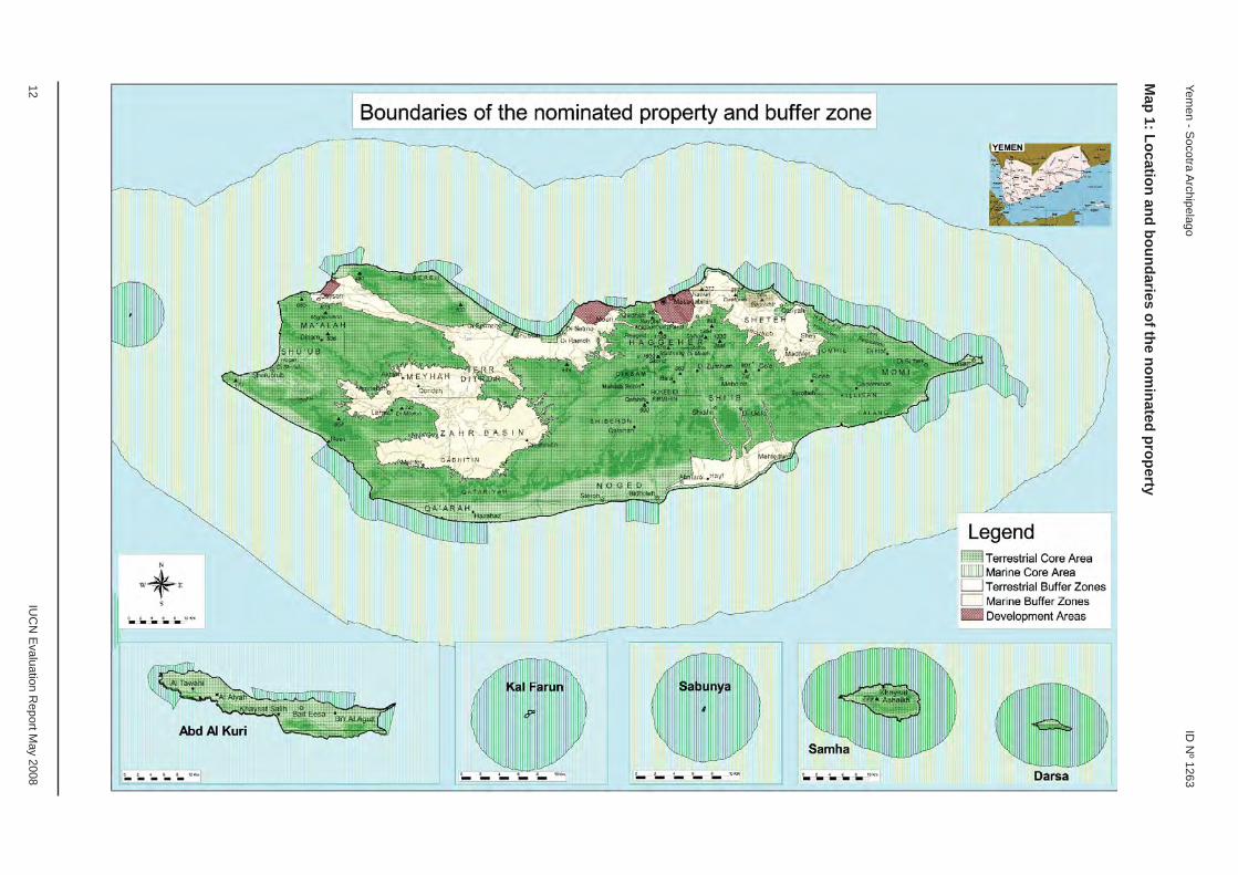
The nominated property, the Socotra Archipelago, lies in the northwest Indian Ocean near the mouth of the Gulf of Aden. Socotra, the largest island, lies 330 km east of Cape Gardafui, Somaliland and 450 km south of the coast of South Yemen. The nominated property comprises a 250 km long archipelago of four islands and two rocky islets which appear as a prolongation of the Horn of Africa. The main island of Socotra is 3,625 km2, Abd Alkuri island is 133 km2 and Samha island is 41 km2. The nominated property comprises a total area of 410,460 ha. In total, 12 terrestrial and 25 marine protected areas are included within the area. The nominated property covers 73% of the land area of Socotra and around 50% of its coastal area, and all the land and coastal areas of the other islands and islets. Buffer zones of a total area of 1,740,958
ha surround the nominated areas. This includes a terrestrial buffer zone of 91,997 ha on Socotra and marine buffer zones of 1,648,961 ha extending 12 nautical miles seawards around all islands. The terrestrial and marine core areas of the nominated property and their buffer zones are summarised in Table 1.
Socotra Island consists of four main elements:
1. A jagged many-peaked granite mountain range, Jabal Haggeher, which rise to 1,526 m in Jabal Skand, steeply on the north side and more gently, with six parallel valleys, on the south;
2. Escarpment-edged limestone plateaus 300-700 m high, in the east, south-centre and west, overlying earlier basement rocks;

2 IUCN Evaluation Report May 2008
Yemen - Socotra Archipelago ID Nº 1263
3. Coastal plains north and south, the northern a series of smaller fertile basins between headlands, the southern a 60 km-long by 6 km-wide dry strip backed by a 400 m escarpment; and
4. An interior basin of plains west of the Haggeher mountains linked to the northern coastal plain.
The coasts are varied: cliffs, wave-cut platforms, fossil reefs, cobble beaches, sand beaches and lagoons. Abd Alkuri is a low limestone-capped granite range rising to 743 m, with raised beaches on the north and sea cliffs along most of the south side. Samha is similarly a granite island capped by a desert platform of limestone surrounded by steep cliffs except at the east end.
Geology: Socotra is an island of continental origin, a block of Precambrian Gondwanaland. It has an igneous and metamorphic basement of schist and gneiss extensively overlaid by sandstones, marls and limestone deposited in Cretaceous and later Eocene seas, though the Precambrian Haggeher granite was probably never submerged. It lies on an undersea platform block that extends from the tip of Somaliland. The block fi nally separated from the Arabian plate during the rifting which began to open the Gulf of Aden in the Oligocene to Miocene epochs some 34-23 million years ago.
Flora: Socotra is a distinct ecoregion of xeric shrubland lying at the intersection of three biogeographic regions, African, Oriental and Palaearctic. Its long isolation has contributed to an assemblage of endemic ecosystems and species, many of which have long disappeared from their Eritreo-Arabian origins. The case for Socotra as a site of Outstanding Universal Value rests largely on its high plant diversity and levels of endemism. Of its 825 plant species in 430 genera, 307 species (37%) and 15 genera are endemic, and are often very localised in their distribution, and adapted to harsh local conditions. The diversity of plant species refl ects the variety of altitude, bedrock, and humidity on Socotra. This is particularly pronounced on the
Name of the area Terrestrial core areas (ha)
Marine core areas (ha)
Terrestrial buffer zones (ha)
Marine buffer zones (ha)
Socotra 260,008 60,041 91,997 840,325Abd Alkuri 11,858 4,874 - 456,179Samha 5,063 26,917 - 243,083Darsa 544 17,624 - 109,374Kal Farun (rock) 31 11,072 - -Sabunya (rock) 8 12,420 - -Total 277,512 132,948 91,997 1,648,961TOTALS 410,460 1,740,958
Table 1: Terrestrial and marine core areas of the nominated property and their buffer zones
Jabal Haggeher where more than half of the 200 plant species are endemic. There are many unique and characteristic plants on Socotra, including a number known from antiquity for their medicinal value, such as the bitter aloe, frankincense and the distinctive dragon’s blood tree.
There are eight main types of vegetation: mangroves, coastal shrubland, croton shrubland, succulent shrubland, semi-evergreen lowland woods, woody limestone plateau herbs, submontane shrubs and a montane mosaic of evergreen woodland, grassland and dwarf shrubland. 157 plant species are classifi ed as critically endangered, endangered and vulnerable. The 138 species classifi ed as vulnerable include all the islands’ eight frankincense species, and both dragon and cucumber trees.
Fauna: Because of the dry climate and small size of the islands, the terrestrial fauna of the archipelago is not large, except for reptiles, though the avifauna is rich. It is important to note that the full extent of the islands’ fauna is yet to be described, including the fauna of the vast underground cave systems on Socotra. The nominated property has particular importance for bird species; of the 192 bird species, 44 breed on the islands and 85 are regular migrants. Six bird species are endemic, 10 subspecies may be endemic, and 26 bird species have internationally important populations on Socotra. The importance of the nominated property for birds is refl ected in its identifi cation as an Endemic Bird Area by BirdLife International; 22 Important Bird Areas have also been identifi ed. Among the 34 reptiles, there is 90% endemism with all six snake species being endemic; 15 out of 18 geckoes are endemic, as are two skinks, two lizards and a chameleon. Three-quarters of the terrestrial fauna is composed of the 600 or more insects and these also have a high level of endemism. The marine life of the archipelago is subject to many converging ocean currents and lies between the major endemic populations of the Red and Arabian Seas. Marine life is very diverse and includes 283 species of coral, 730 species of coastal fi sh and 300 species of crab, lobster and shrimp. Marine habitats are generally

IUCN Evaluation Report May 2008 3
ID Nº 1263 Yemen - Socotra Archipelago
in good condition, although threats are increasing. Socotra represents a transition zone where related but distinct communities overlap. Socotra’s marine communities include local and regional endemics and rare species with restricted global distributions. Marine areas in Socotra are less degraded than most Indian Ocean reefs, and the archipelago itself is a major centre of dispersal and replenishment for the surrounding seas.
3. COMPARISONS WITH OTHER AREAS
The nominated property is proposed for inscription on the World Heritage List under criterion (x) on the basis of its biodiversity values and in particular its value for plant conservation. Socotra also has a number of other important biodiversity values which are outlined in the nomination dossier and summarized in this evaluation report.
General comparison on the basis of biodiversity
Socotra has been identifi ed as a priority area for conservation in a number of global studies and assessments. In particular the Socotra desert ecoregion was identifi ed as “potentially of Outstanding Universal Value” in IUCN’s World Heritage Strategy Paper in 2004 and in subsequent guidance by IUCN to the World Heritage Committee. Socotra is also recognized as globally important for biodiversity by a number of other organizations and classifi cation systems, including by WWF (recognized as a Global 200 Ecoregion), Conservation International (recognized as a Biodiversity Hotspot), BirdLife International (containing 22 Important Bird Areas) and Plantlife International (identifi ed as a Centre of Plant Diversity). Although the primary focus has been on the importance of Socotra for its botanical values, it is important to note the high level of endemism and diversity in many marine and terrestrial groups of organisms, for example land snails (96 species, 95% endemism) and reptiles (34 species, 90% endemism).
These assessments underline the importance of
Socotra for global conservation. Numerous reviews and studies have noted Socotra as a unique living laboratory and have referred to Socotra as the “Galápagos of the Indian Ocean”. Socotra compares very favourably with other comparable coastal and island sites on the World Heritage List in relation to plant diversity and endemism, and biodiversity in general, as outlined in more detail below.
Comparison on the basis of terrestrial plant diversity and endemism
A comparison of the Socotra Archipelago with key oceanic islands in terms of plant diversity and endemism is set out in Table 2. This table shows that Socotra compares very favourably with other oceanic islands in terms of plant diversity and endemism. It is also important to note that Socotra is characterized by a lower relative level of human impact by comparison with the other islands noted in this table, particularly in relation to factors such as invasive species, development of infrastructure, and tourism development.
Socotra is located within the Desert and Xeric Shrublands Biome and thus plant diversity may be compared specifi cally with the Galapagos Islands which are also located within this biome. On this basis it is clear that the total number of plant species and also the number of endemic plant species is much greater on Socotra than Galapagos, even though Socotra is 48% smaller than Galapagos, and the overall percentage of endemism is lower for Socotra.
Some Socotran species and communities, such as the Dragon’s Blood Tree woodland, are relicts of ancient biota. In this respect, the nominated property can be compared with the Laurisilva of Madeira World Heritage property (Portugal) which is considered an outstanding relict of a previously widespread laurel forest type. Socotra’s Dragon’s Blood Tree woodland represents a similarly important relict of the Miocene-Pliocene Laurasian subtropical forest.
Table 2: Comparison of Socotra with key oceanic islands in terms of plant diversity and endemism
Name of island Area (square km)
Total plant species
Endemic plant species
% of endemic plant species
Juan Fernández Islands, Chile 93 147 118 80Galapagos Islands, Ecuador 7844 543 229 42Mauritius 1865 800-900 280 31-35Rodrigues, Mauritius 104 145 48 33Madeira, Portugal 769 760 129 17Canary Islands, Spain 7273 2000 569 28Ascension, UK 94 25 11 44Socotra, Yemen 3799 825 307 37

4 IUCN Evaluation Report May 2008
Yemen - Socotra Archipelago ID Nº 1263
Comparison on the basis of terrestrial animal diversity and endemism
A comparison of Socotra with key coastal and island World Heritage properties in terms of bird diversity is set out in Table 3. Socotra has high importance for bird species as underlined by the identifi cation by BirdLife International of 22 Important Bird Areas on Socotra. Socotra supports signifi cant proportions of the global populations of land and sea birds, including a number of threatened species. The Egyptian Vulture (the most familiar bird on Socotra) has a population in excess of 1,000, the highest concentration in the world. Because of serious declines worldwide, the vulture has been classifi ed as endangered in the 2007 IUCN Red List of Threatened Species. The island hosts six endemic bird species and 10 endemic subspecies (out of 192 species). For comparison, the Galapagos Islands host 22 endemics in an area approximately double that of Socotra. The Hawaiian Islands, approximately four times Socotra’s size, have some 48 endemic species and subspecies. Mauritius, at about half Socotra’s size, hosts 11 endemics. The Azores, at two-thirds Socotra’s size, have one endemic, while the Cape Verde Islands, fractionally bigger than Socotra, host four endemics.
Socotra’s other terrestrial, freshwater and cave
Table 3: Comparison of Socotra with key coastal and island World Heritage properties in terms of bird, fi sh and coral diversity
Name of property Total area (ha) Criteria Bird species Fish species Coral species
Great Barrier Reef, Australia 34,870,000(95% marine) vii, viii, ix, x 242 1500 400
Shark Bay, Australia 2,197,300(31% marine) vii, viii, ix, x 230 323 95
Belize Barrier Reef, Belize 96,300(50% marine) vii, ix, x 187 500 100
Cocos Island, Costa Rica 199,790(97% marine) ix, x 87 300 32
Galapagos Islands, Ecuador 14,066,514(95% marine) vii, viii, ix, x 57 460 120
New Caledonia, France 1,574,300(100% marine)
vii, viii, ix, x (nominated) 105 1695 510
Sian Ka’an, Mexico 528,000(23% marine) vii, x 339 175 83
Coiba Island, Panama 430,825(50% marine) ix, x 147 760 58
Tubbataha Reef, Philippines 33,200(99% marine) vii, ix, x 46 441 396
Aldabra Atoll, Seychelles 34,200(41% marine) vii, ix, x 65 287 210
East Rennell, Solomon Islands 37,000(plus marine) ix 43 759
(island group)300 (island group)
Socotra, Yemen 410,460(32% marine) x 192 730 283
fauna also exhibits high endemism, comparable to or exceeding other coastal and island sites, most notably among molluscs, reptiles, crustaceans and some insects and arachnids. Levels of endemism are 95% for land snails, 90% for reptiles, 73% for isopods and 60% for spiders, with most endemics restricted to just one island and many to only small areas therein. Socotra shares similarly high levels of endemism among land snails with Hawaii and Galapagos. The islands’ isopod fauna is also rich, with 38 species now known from littoral, montane and cave habitats. Isopod diversity compares favourably with other archipelagos, including the Seychelles (43 species), the Comoros (32 species), the Mascarenes (41 species), Maldives (27 species), and Hawaii (52 species).
Comparison on the basis of marine biodiversity
A comparison of Socotra with key coastal and island World Heritage properties in terms of fi sh and coral diversity is set out in Table 3. This table shows that Socotra compares favourably with many other coastal and island sites in terms of marine biodiversity. Four threatened species of sea turtle are present around Socotra, with 2 species, Green and Loggerhead turtles, nesting. The 283 species of coral comprise African and Arabian species and are less degraded than most Indian Ocean reefs. The Socotra Islands

IUCN Evaluation Report May 2008 5
ID Nº 1263 Yemen - Socotra Archipelago
host 85% of the Red Sea’s reef-building coral genera, 75% of the coral species, and 70% of the coastal fi sh families, and are thus very important in sustaining marine diversity of the greater Arabian region.
In summary the Socotra Archipelago exhibits an outstanding level of terrestrial and marine biodiversity and endemism. It has appropriately been termed the “Galapagos of the Indian Ocean”. There is a strong case for the inscription of the nominated property under criterion (x).
4. INTEGRITY
4.1 Legal status
The establishment of protected areas in Socotra is relatively recent and dates from the establishment of the Socotra Island Protected Area in 1996. The nominated property and its buffer zones are governed by Presidential Decree 275 “Conservation Zoning Plan for the Socotra Islands” of 2000. All core areas of the nominated property are zoned as Nature Sanctuaries, National Parks or Areas of Special Botanical Interest in the Zoning Plan. According to Article 17 of this Presidential Decree, “all ministries and institutions involved in the development of Socotra must adhere to the implementation of the Conservation Zoning Plan, each in their areas of specialization”. No other area in Yemen has such a substantial legal framework and zoning scheme. This Presidential Decree is in turn supported by other related laws such as the National Environmental Protection Law of 1995, the Local Council Authority Law of 2000, and the Water Law of 2001. It also links with the national investment plan of the Ministry of Water and Environment (MOWE) of 2002, which notes the conservation of biodiversity and sustainable use of national resources in Socotra as the top priority for habitat conservation in the country.
The Environmental Protection Authority (EPA) under the MOWE is responsible for the implementation of the Conservation Zoning Plan. The Socotra Branch of the EPA has expanded signifi cantly, from having only one representative (in 1996) to over one hundred staff members (in 2007) at two district offi ces (Hadibu and Qalansiya) and across the islands. EPA activities are supported by the Socotra Conservation and Development Programme (SCDP). In the last ten years, the Socotra Branch of the EPA has gained considerable technical expertise and has become a leader in natural resource management in Yemen. Overall, the Zoning Plan has been applied successfully since 2000, although not without major challenges, including inappropriate road development on Socotra which had resulted in confl icts between the MOWE / EPA and SCDP on one hand and the Ministry of Public Works and Highways on the other (refer Section 4.4 relating to Roading).
There is a need to strengthen the legislative framework, management and enforcement capacity in relation to Socotra. The Conservation Zoning Plan is currently being revised and this provides a good opportunity to strengthen the management of the EPA and ensure it is better able to respond to emerging challenges such as extended infrastructure and road development, tourism and fi sheries management. In particular, the revised Zoning Plan should carefully review the boundaries of the existing zones and ensure there is a clear mechanism for enforcement for conservation management, including through the development of By Laws to back up the Zoning Plan. Enforcement cannot be separated from fi nancing and it is important to ensure that overall funding is increased and maintained over the longer term (refer Section 4.3 relating to Financing). The original Zoning Plan was based on inputs from a wide range of scientists, local communities and staff from the EPA and SCDP. This approach should also be applied in any revision of the Conservation Zoning Plan. In particular this legal tool needs to be mainstreamed into the current process addressing the development of the new decentralization law in Yemen.
In response to the issues raised in IUCN’s letter of December 2007, the Government of Yemen recently passed Yemen Cabinet Decrees No. 45-49 of 12 February 2008 which relate to the conservation and sustainable development of the Socotra Archipelago and outline a number of measures in this regard.
4.2 Boundaries
The originally nominated property included both the core areas and buffer zones covering the entire island of Socotra and the surrounding marine areas. This included major towns and other areas of settlement and more intensive human use. IUCN’s letter of December 2007 requested the State Party consider revising the boundaries of the nominated property so that the World Heritage property would only include areas zoned as Nature Sanctuaries, National Parks and Areas of Special Botanical Interest (representing the core areas). The State Party advised in February 2008 that these revised boundaries were provided for in the Yemen Cabinet Decree No. 45 of 12 February 2008. A revised map was submitted refl ecting these changes. IUCN notes that this ensures the nominated property includes the most important areas for biodiversity conservation and that the buffer zones (while no longer formally part of the nominated property) plays an important role in ensuring complementary management for both conservation and development activities. In this context IUCN notes the clear and logical linkages between the management of the World Heritage property and the already established Socotra Biosphere Reserve.
The boundaries of the terrestrial and marine core areas include all key botanical and other biodiversity

6 IUCN Evaluation Report May 2008
Yemen - Socotra Archipelago ID Nº 1263
features required to demonstrate Outstanding Universal Value. The property is of suffi cient size (410,460 ha) to adequately represent all the terrestrial and marine features and processes that are essential for the long term conservation of the archipelago’s rich and distinct biodiversity. The terrestrial core areas encompass about 75% of the total land area and protect all the major vegetation types, areas of high fl oral and faunal values, and important bird areas. The marine core areas are Nature Sanctuaries and encompass the most important elements of marine biodiversity. At present, the terrestrial and marine core areas do not suffer substantially from the adverse effects of development and demonstrate ecological integrity. It is noted, however, that local, regional and global threats are increasing and will need to be addressed in the future (refer Section 4.4).
The terrestrial buffer zone of 91,997 ha should provide adequate additional protection, although it is important that the buffer zone is managed in a complementary manner to the core areas. The terrestrial buffer zones include the Resource Use Reserves and General Use Zones and provide protection against impacts associated with urban development and other activities in these zones. The marine buffer zones of 1,648,961 ha extend 12 nautical miles seawards around all islands.
The boundaries of the core areas were developed based on the input of many scientists, as well as key local stakeholders, and this process aimed to ensure that the most important conservation values were included within the core areas of the nominated property. It is important that the same participatory and science based principles be adopted in the revision of the Conservation Zoning Plan that is currently proposed and that all relevant recent science is used to assist in the revision of the Conservation Zoning Plan and any associated boundary revisions.
4.3 Management
This section considers the adequacy of management authority and capacity, including issues of fi nancing and staffi ng.
Management Authority
At present, the Socotra Branch of the EPA is principally responsible for the management of the nominated property, and its activities are supported by the SCDP (refer Section 4.1). In order to ensure that World Heritage values are maintained or enhanced in the future, it is important that any Management Authority is adequately resourced and able to effectively manage for conservation. Experience has shown that the most effective World Heritage site management is often delivered by a single authority which has adequate resources and enforcement capacity, and also with some autonomy in relation to management issues
such as staff management and the ability to generate and retain revenue. Within Yemen there is current emphasis on decentralising power and authority to local levels of administration. The EPA, through the SCDP and the Management Plan of the Socotra Archipelago (2003–2008), places great emphasis on strengthening local governance, aimed “to put the local councils and administration in their legitimate central place in managing local development and strengthen the necessary and mutually supportive linkages between district, governorate and central authorities.”
The IUCN fi eld mission suggested a separate Authority should be established for the management of Socotra, along the lines of the Sana’a Special Zone, which is managed as a separate Authority and reports directly to the President of Yemen. IUCN again raised the possibility of a separate Authority for Socotra in its letter to the State Party of December 2007. The State Party noted in February 2008 that Yemen Cabinet Decree No. 49 of 12 February 2008 provides for a new island wide “Socotra Authority”, which will aim to ensure “the achievement of the sustainable development of the Socotra Archipelago, while conserving its unique environment, biodiversity, and natural landscapes that are the basis for its World Heritage site nomination”. IUCN notes this as a positive response; however, effective implementation is critical as is the need to give priority to protection of World Heritage values in the property and to ensure that adequate funds are allocated for this Authority to function effectively. It is also important that any Authority works effectively and cohesively with other Yemen Government Agencies and with local communities.
Financing
Secure long term fi nancing is essential for the long term viability of Socotra. Funding for the Socotra Project was initially provided through a GEF project which concluded in 2003 and which was instrumental in establishing the EPA and SCDP. Since that time the SCDP has mainly been funded by UNDP and the Italian Government as well as other donors and partners including the Dutch Government. The current system is donor dependent, with 80% of funding coming from donor sources and 20% from Yemen Government sources. There is also a heavy reliance on a limited number of donors and this situation needs to change to involve a broader range of donors. Current funding covers support for many aspects of management, including a wide range of community development and conservation activities. Overall, the current level of fi nancial support is not adequate for long term conservation management. The fi nancial base needs to be increased and made more long term and secure.
The IUCN fi eld mission noted that there has been a very high level of political commitment to ensuring long term

IUCN Evaluation Report May 2008 7
ID Nº 1263 Yemen - Socotra Archipelago
fi nancing for Socotra and this needs to be translated into adequate and ongoing revenue streams for the property. This issue was reinforced in IUCN’s letter of December 2007. The State Party agreed in February 2008 that fi nancing is a critical issue and identifi ed a two pronged strategy: (a) gradual but steady increase in support for the conservation management of the Socotra Archipelago, backed up by the Yemen Cabinet Decree No. 49 of 12 February 2008 which provides for increased funding for the property (specifi c funds will be allocated in the national budget, starting in 2009); and (b) ongoing collaboration with a range of donors and partners to support management efforts in the property. A GEF Medium Sized Project is shortly to be approved. IUCN notes this is a positive response but that it is important to maintain efforts to increase funding for the property and also that the situation in relation to fi nancing should be kept under review.
Noting that sustainable long term fi nancing is one of the key issues on Socotra, IUCN recommends that a Business Plan for Socotra be developed and implemented which builds on the two approaches noted above. Such a plan should include: (a) substantially increasing the support available for conservation management on Socotra; (b) diversifi cation of the existing funding base; (c) obtaining longer term commitments from donors and partners; (d) increasing the base level of funding from government sources, including through continuation of the existing process of transferring staff employed under the Socotra Project to the government payroll. A review of Trust Fund Options such as those operating for the RSCN in Jordan and elsewhere should also be undertaken as soon as possible, with a view to application in Socotra.
Staffi ng
There is a highly motivated and professional workforce of around 100 staff working on Socotra with the EPA and SCDP. There is a particular emphasis on employing local staff and around 25 staff are employed as local extension offi cers within local communities. The majority of staff on Socotra have been well trained under the SCDP and there has been a high rate of staff retention since the inception of the project. The EPA is the largest government agency represented on the island (outside of the Yemen Army) and thus often plays a wide range of roles, particularly in relation to community development, beyond the role it plays on the mainland. The EPA and SCDP have had some major achievements during their relatively short life, including the cancellation or diversion of proposed new roads and other infrastructure developments, as well as the development of effective working relationships with local communities. The main challenge is that EPA and SCDP staff are undertaking such a large variety of tasks, covering the full range of community development and conservation activities. Overall the number of staff available for full time
conservation management on Socotra is limited and should be increased to ensure that natural values are adequately protected.
There are effective working relationships between EPA and SCDP staff and international experts which visit Socotra (such as from universities, the Royal Botanic Garden of Edinburgh and BirdLife International). Partnerships with local communities have also been very effective and have included joint work on aspects such as tourism development (such as campsite development on Dihamri and Homhil) as well as the involvement of local communities in small scale business development, such as in relation to honey production. The working relationships with researchers and with local communities are very positive and should be strengthened wherever possible.
An important element in retaining the workforce effi ciency is to facilitate necessary means that ensure the current benefi ts offered to staff members are maintained as much as possible as they represent an important part of the staff motivation in return for their exceptional hard work. Additional training and capacity building is also essential to enhance the staff’s enforcement, management and ecological monitoring capacity, particularly in relation to emerging challenges such as extended infrastructure and road development, tourism and fi sheries management, and the management of invasive species.
4.4 Threats and human use
Socotra is not suffering from many of the threats affecting other oceanic islands. This refl ects a number of factors, including the relative isolation of Socotra (until 1989 the island was also politically isolated) and the relatively low resident population on the island. The total population of Socotra is 50,000 (out of 22 million in Yemen). People and nature have a very close relationship on Socotra. Traditional patterns of use involving nomadic herding have evolved over thousands of years and have strongly infl uenced the biodiversity of Socotra.
The traditional land-use management practices employed by the indigenous population played a vital role in protecting against the over-exploitation of natural resources and the diminution of biodiversity. Traditional rules exist, for example, about cutting of live trees for building. However, enforcement of such rules is patchy and there is a great demand for a variety of building purposes, which poses a serious threat to the vegetation. The present building boom on the island is placing great pressure on timber and disputes over land ownership and the consequent breakdown of traditional rules is likely to place an increasing pressure on all trees. This situation should be carefully monitored and strategies developed to minimise the impact of timber removal on biodiversity.

8 IUCN Evaluation Report May 2008
Yemen - Socotra Archipelago ID Nº 1263
Where possible these strategies should build on traditional rules about cutting of live trees.
Traditional land-use management practices are currently changing with urbanization, with more people moving to the capital of Hadibu, increased accessibility around the island with a new road network, and immigration from the mainland. Access to Socotra is still relatively limited and there are only two fl ights per week during the main tourist season. A potential threat is likely to come, however, from new experiments in agriculture. For instance, the development of agroforestry to relieve pressure on native wood, although of obvious benefi t, needs to be closely monitored.
The overall impacts of these trends on the natural environment remain to be seen but experience from Galapagos has shown that impacts of factors such as these can be signifi cant. A number of the key threats and challenges facing Socotra are outlined in more detail below.
Roading
An active road construction programme under the Socotra Roads Master Plan has been initiated in recent years in Socotra. There are two phases: Phase 1 has involved the construction of roads around part of the island and also across the island. In general this roading has been large scale and there have been some signifi cant impacts on natural areas. In a number of areas, such as in the Qalansiya region on the north west of the island, roading has been subject to dispute on the grounds of unacceptable environmental impact and there has been some re-routing of roads and cancellation of road proposals. Phase 2 of the programme has not commenced but the original plans called for this to include a ring road around the island, including in a number of environmentally sensitive areas, including within the nominated property.
Following the concerns expressed in relation to environmental impact of roads on Socotra, a Memorandum of Understanding in relation to environmental road design and construction has been signed between the MOWE on one hand and the Minister of Public Works and Highways (MOPW) on the other. This memorandum, inter alia, includes provision for Environmental Impact Assessment studies for any new roads and notes that “roads should be designed to serve local communities without affecting the environment, in particular national parks and nature sanctuaries”. In a meeting with the IUCN mission team on 17 November 2007, the MOPW also made a commitment that no activities would be undertaken on the island unless the MOWE approves. The State Party advised in February 2008 that they intended to follow a strategy with two elements: (a) developing clear guidelines for road construction
which minimise environmental impact, as noted in the Yemen Cabinet Decree No. 46 of 12 February 2008; and (b) strengthening local and national capacity to enforce road construction guidelines.
Noting that roading is clearly an important future issue on Socotra, IUCN recommends that any future roading should: (a) be located outside of the core zone of the property wherever possible; (b) be consistent with the broad policy direction outlined in the Conservation Zoning Plan and its revision; (c) be at a smaller scale than the existing roading that has been undertaken and higher quality (note disposal with a pre-agreed set of spoil etc) technical specifi cations; (d) be subject to Environmental Impact Assessment studies undertaken by a third party on the expense of the contractor / MOPW; (e) wherever possible, follow existing tracks and connect existing settlements; and (f) involve the EPA in the provision of environmental guidance and might even consider a MOWE / EPA written clearance before any road approval and/or development.
Grazing
Grazing by goats has been occurring on Socotra for thousands of years and is widespread throughout the island. It appears that grazing by goats has not impacted adversely on the high levels of biodiversity on Socotra. This situation cannot be viewed in the same context as goat grazing in World Heritage properties, such as Galapagos, where goats have been introduced relatively recently and are now being treated as an invasive species and eradicated wherever possible. On Socotra, the patterns of grazing were traditionally semi nomadic, with populations fl uctuating markedly in accordance with periodic droughts. This situation is changing with practices such as purchasing and stocking of grains and fodder, and this may lead to an increase in goat numbers on the island in the longer term. More information is required on the environmental impacts of goat grazing on Socotra, particularly in view of these changing practices, and also in relation to whether any control may be necessary in the future. Already overgrazing is a problem around the major settlements. Building of wells and water catchments, not yet a major problem, is likely to increase in the future. This and the impacts of grazing on the rangelands should be closely monitored. Attention also needs to be given to preventing the introduction of new domesticated varieties of goats, sheep, and cattle, something which the EPA and SCDP have been successful in achieving so far. This needs to be part of the overall regulatory mechanisms adopted in the future (e.g. linked with the revised Conservation Zoning Plan; governance arrangements; enforcement, management and ecological monitoring capacity). The State Party noted in February 2008 that it is important to maintain a careful balance between biodiversity and subsistence needs of the pastoral population on

IUCN Evaluation Report May 2008 9
ID Nº 1263 Yemen - Socotra Archipelago
Socotra. The Yemen Cabinet Decree No. 48 of 12 February 2008 establishes a number of measures to be undertaken in cooperation with local communities to reduce impacts from grazing. A work plan is also being developed to address this.
Invasive species
Invasive species pose a future challenge on Socotra, particularly with increasing access and transport to the island. The irreversible impacts of invasive species on islands such as Guam and Christmas Islands illustrate the problem that can be posed on oceanic islands and the need to effectively address this issue on Socotra. The IUCN mission team noted the recent interception of a number of rabbits at the Socotra airport by the Yemeni Army, which could have had potentially disastrous consequences. IUCN recommends that a Quarantine System be developed to assist with more effective management of invasive species on Socotra. Such a system should be coupled with monitoring and eradication programmes across the islands to prevent the establishment of invasive species. Species introduced for amenity horticulture and agriculture are likely to become an increasingly important problem and this should be addressed as part of overall invasive species control plans.
Tourism
Tourism in general, and nature based tourism in particular, are increasing rapidly around the world. These trends will impact on the future planning and management of Socotra where there has been very limited tourism to date, refl ecting the relative isolation of the island. Tourism and associated pressures are increasing on Socotra: one reviewer noted that 450 tourists visited Socotra in 2004, and that the tourist numbers over the December 2006 – January 2007 period alone exceeded this fi gure. Tourism development to date on Socotra has focused on establishing low key camping facilities, developed in conjunction with local communities. This approach of involvement of local communities, in a fully consultative way, is fully endorsed by IUCN. There has been some interest from private developers in establishing tourist accommodation but in general this has not “taken off” in view of the challenges of access to Socotra and the limited tourist season (a number of months of the year it is not possible to visit Socotra due to the monsoon period).
There are a number of options for the future development of tourism on Socotra, unlike for many other natural areas around the world, such as Galapagos, where large scale, long established tourism developments have contributed to major environmental impacts and often constrain future options. There is thus an excellent opportunity to “get it right” in relation to future tourism development on Socotra. IUCN recommends that an Ecotourism Master Plan be developed for
Socotra which: (a) maintains the current focus on low key, nature based tourism, based on the appreciation of natural values; (b) includes a carrying capacity assessment to guide tourism development, in line with the Socotra Presidential Decree 275 (Article 8) which states that “Travel to and from the Socotra islands should be regulated according to the capacity of these islands”, and as noted in the Yemen Cabinet Decree No. 47 of 12 February 2008; (c) provides for direct and adequate fi nancial contributions from tourism to the conservation and community development activities of the EPA and SCDP; (d) closely involves the Yemeni General Tourism Development Authority and Tourism Promotion Board; (e) considers options for engaging in partnerships with environmentally sensitive private sector; and (f) addresses the lack of trained local tourist guides and literature.
Threats to the marine environment
The nominated property includes a large marine component, including a number of small, relatively well protected marine protected areas, which have been established in consultation with local communities. There have been a number of positive developments, including the ban on the taking of sea cucumbers and the development of by laws in relation to marine protection. However, the level of protection outside of the marine protected areas is relatively weak, and constrained by very limited enforcement capacity. This poses a challenge in view of the growing demand for export fi sheries and over fi shing of marine resources in Socotra and the wider Indian Ocean. Increased exploitation of Socotra’s marine resources raises serious concern over long term sustainability. It is thus important that marine enforcement capacity is increased and that the overarching policy framework is strengthened. In particular the revision of the Conservation Zoning Plan should give emphasis to improving marine protection and related regulations should be developed and enforced.
In summary IUCN considers that the property meets the necessary conditions of integrity as set out in the Operational Guidelines.
5. ADDITIONAL COMMENTS
5.1 Justifi cation for serial approach
When IUCN evaluates a serial nomination it asks the following questions:
a) What is the justifi cation for the serial approach?
The nominated property includes all the Nature Sanctuaries, National Parks and Areas of Special Botanical Interest in the Socotra Archipelago. The boundaries of these areas were developed based

10 IUCN Evaluation Report May 2008
Yemen - Socotra Archipelago ID Nº 1263
on the input of many scientists, as well as key local stakeholders, and this process aimed to ensure that the most important terrestrial and marine conservation values were included. The serial approach is therefore fully justifi ed and the selected sites provide a coherent property with a complete and coherent set of unifying values.
b) Are the separate components of the property functionally linked?
There is a high degree of functional linkage amongst the terrestrial and marine components. The terrestrial components encompass about 75% of the total land area of the Socotra Archipelago. They protect all the major vegetation types, areas of high fl oral and faunal values, and important bird areas. The marine components encompass the most important elements of marine biodiversity and act as major centres of dispersal and replenishment for the surrounding waters. The functional linkages are further enhanced by terrestrial and marine buffer zones.
c) Is there an overall management framework for all the components?
All components are governed by the Conservation Zoning Plan for the Socotra Islands. The Socotra Branch of the EPA, supported by the SCDP, is principally responsible for the implementation of this plan and the management of the nominated property. This management framework will be further enhanced by a new island wide “Socotra Authority”, which will aim to ensure “the achievement of the sustainable development of the Socotra Archipelago, while conserving its unique environment, biodiversity, and natural landscapes that are the basis for its World Heritage site nomination”.
IUCN concludes that the serial approach put forward is justifi ed in this case.
5.2 Research
A great deal of scientifi c research has been undertaken on Socotra, dating back to the Balfour Expedition of 1880. This has refl ected the strong interest from the international community in the biodiversity of Socotra and has resulted in a relatively well documented fl ora and fauna, although there are gaps in knowledge, such as in relation to invertebrates. It is also important that research be more oriented towards specifi c management and policy issues, such as: the requirements of endemic and threatened species; the impact of grazing on endemic plants and on rangeland requirements; and the impact of invasive species and methods for control. EPA and SCDP staff need to be involved in setting research agendas and also in developing and applying research protocols to ensure that information arising from research is relevant and also made available to EPA and SCDP staff. The role
of the EPA and SCDP in research coordination and facilitation should be strengthened. The establishment of a research station to act as a focus for these efforts would be useful.
6. APPLICATION OF CRITERIA
The property has been nominated under criterion (x). IUCN considers that the nominated property meets criterion (x) based on the following assessment:
Criterion (x): Biodiversity and threatened species
Socotra is globally important for biodiversity conservation because of its exceptional level of biodiversity and endemism in many terrestrial and marine groups of organisms. Socotra is particularly important for its diversity of plants and has 825 plant species of which 307 (37%) are endemic. Socotra has high importance for bird species as underlined by the identifi cation by BirdLife International of 22 Important Bird Areas on Socotra. Socotra also supports globally signifi cant populations of other land and sea birds, including a number of threatened species. Extremely high levels of endemism occur in Socotra’s reptiles (34 species, 90% endemism) and land snails (96 species, 95% endemism). The marine life of Socotra is also very diverse, with 253 species of reef-building corals, 730 species of coastal fi sh and 300 species of crab, lobster and shrimp, and well represented in the property’s marine areas.
IUCN considers the nominated property meets this criterion.
7. RECOMMENDATIONS AND STATEMENT OF OUTSTANDING UNIVERSAL VALUE
IUCN recommends that the World Heritage Committee adopt the following decision:
The World Heritage Committee,
1. Having examined Documents WHC-08/32.COM/8B and WHC-08/32.COM/INF.8B2,
2. Inscribes the Socotra Archipelago, Yemen, on the World Heritage List on the basis of criterion (x);
3. Adopts the following Statement of Outstanding Universal Value:
ValuesSocotra is globally important for biodiversity conservation because of its exceptionally rich and distinct fl ora and fauna. 37% of Socotra’s plant species, 90% of its reptile species and 95% of its land snail species do not occur anywhere else in

IUCN Evaluation Report May 2008 11
ID Nº 1263 Yemen - Socotra Archipelago
the world. Socotra is of particular importance to the Horn of Africa biodiversity hotspot and, as one of the most biodiversity rich and distinct islands in the world, has been termed the “Galápagos of the Indian Ocean”.
Criterion (x) – Biological diversity and threatened species: Socotra is globally important for biodiversity conservation because of its exceptional level of biodiversity and endemism in many terrestrial and marine groups of organisms. Socotra is particularly important for its diversity of plants and has 825 plant species of which 307 (37%) are endemic. Socotra has high importance for bird species as underlined by the identifi cation by Birdlife International of 22 Important Bird Areas on Socotra. Socotra also supports globally signifi cant populations of other land and sea birds, including a number of threatened species. Extremely high levels of endemism occur in Socotra’s reptiles (34 species, 90% endemism) and land snails (96 species, 95% endemism). The marine life of Socotra is also very diverse, with 253 species of reef-building corals, 730 species of coastal fi sh and 300 species of crab, lobster and shrimp, and well represented in the property’s marine areas.
IntegrityThe property is of suffi cient size to adequately represent all the terrestrial and marine features and processes that are essential for the long term conservation of the archipelago’s rich and distinct biodiversity. The terrestrial nature sanctuaries, national parks and areas of special botanical interest included in the property encompass about 75% of the total land area. They protect all the major vegetation types, areas of high fl oral and faunal values, and important bird areas. The marine nature sanctuaries included in the property encompass the most important elements of marine biodiversity. The property’s integrity is further enhanced by terrestrial and marine buffer zones that are not part of the inscribed property.
Requirements for Protection and Management
All component areas of the property have legal protection; however there is a need to strengthen the legislative framework, and management and enforcement capacity. Whilst the property’s terrestrial and marine habitats are generally still in good condition, management planning needs to deal more effectively with current threats including roading, overgrazing and overharvesting of terrestrial and marine natural resources. Potential future threats include unsustainable tourism and invasive species. Impacts of these threats on Socotra’s biodiversity need to be closely monitored and minimized. A sustainable fi nancing strategy is required to ensure the necessary
human and fi nancial resources for the long term management of the property. Appropriate linkages need to be developed between the management of the property, its buffer zones and the Socotra Biosphere Reserve.
4. Commends the State Party for its major efforts for the long term conservation of the property; and recognises in particular the positive commitments from the State Party as set out in the Government of Yemen’s Cabinet Decrees No. 45-49 of 12 February 2008 which relate to the conservation and sustainable development of the Socotra Archipelago;
5. Requests the State Party to implement these Decrees as quickly as possible and, in particular, that:
a) Management planning for the World Heritage property be enhanced to deal more effectively with key threats, in particular ensuring that: (i) future roading works minimise environmental impacts on biodiversity and where possible are located outside the property; (ii) grazing impacts on biodiversity are monitored and effective measures taken to reduce environmental impacts from grazing; and (iii) invasive species are effectively controlled, including through limiting the entry of invasive species at ports and the airport;
b) A separate management authority be established for the World Heritage property which would give priority attention to the conservation of the unique biodiversity of the property. This Authority should have adequate sustained human and fi nancial resources, and enforcement capacity;
c) The buffer zones (which are not part of the inscribed property) be managed in a complementary manner to the property, with appropriate linkages developed with the management of the Socotra Biosphere Reserve; and
d) A sustainable fi nancing strategy be developed for the World Heritage property, which includes ongoing and adequate support from the Government of Yemen and international support from donors and partners.
6. Further requests the State Party to invite a mission to the property in 2012 to assess progress with the above recommendations and report back to the World Heritage Committee.
12 IU
CN
Evaluation R
eport May 2008
Yemen - S
ocotra Archipelago
ID N
º 1263
Map 1: Location and boundaries of the nom
inated property

ASIA / PACIFIC
MOUNT SANQINGSHAN NATIONAL PARK
CHINA

IUCN Evaluation Report May 2008 13
WORLD HERITAGE NOMINATION – IUCN TECHNICAL EVALUATION
MOUNT SANQINGSHAN NATIONAL PARK (CHINA) – ID No. 1292
1. DOCUMENTATION
i) Date nomination received by IUCN: April 2007
ii) Additional information offi cially requested from and provided by the State Party: IUCN requested supplementary information on 14 November 2007 after the fi eld visit and on 19 December 2007 after the fi rst IUCN World Heritage Panel meeting. The fi rst State Party response was offi cially received by the World Heritage Centre on 6 December 2007, followed by two letters from the State Party to IUCN dated 25 January 2008 and 28 February 2008.
iii) UNEP-WCMC Data Sheet: 11 references (including nomination document)
iv) Additional literature consulted: Dingwall, P., Weighell, T. and Badman, T. (2005) Geological World Heritage: A Global Framework Strategy. IUCN, Gland, Switzerland; Hilton-Taylor, C. (compiler) (2006) IUCN Red List of Threatened Species. IUCN, Gland, Switzerland; IUCN (ed.) (2006) Enhancing the IUCN Evaluation Process of World Heritage Nominations: A Contribution to Achieving a Credible and Balanced World Heritage List. IUCN, Gland, Switzerland; Management Committee (2007) Abstract of the Master Plan of Mount Sanqingshan National Park. Mount Sanqingshan National Park; Management Committee (2007) Mount Sanqingshan International Symposium on Granite Geology and Landscapes. Mount Sanqingshan National Park; Migon, P. (2006) Granite Landscapes of the World. Oxford University Press; Migon, P. (2006) Sanqingshan – The Hidden Treasure of China. Available online; Peng, S.L., Liao, W.B., Wang, Y.Y. et al. (2007) Study on Biodiversity of Mount Sanqingshan in China. Science Press, Beijing; Shen, W. (2001) The System of Sacred Mountains in China and their Characteristics. In: World Heritage Centre et al. (eds) Final Report of the UNESCO Thematic Expert Meeting on Asia-Pacifi c Sacred Mountains, 5-10 September 2001, Wakayama City, Japan, pp. 121-128; Thorsell, J. and Hamilton, L. (2002) A Global Overview of Mountain Protected Areas on the World Heritage List. IUCN, Gland, Switzerland; Thorsell, J. and Sigaty, T. (1997) A Global Overview of Forest Protected Areas on the World Heritage List. IUCN, Gland, Switzerland; Udvardy, M. (1975) A Classifi cation of the Biogeographical Provinces of the World. IUCN, Gland, Switzerland; UNEP-WCMC (1990) UNEP-WCMC Data Sheet: Mount Huangshan Scenic Beauty and Historic Interest Site. UNEP-WCMC, Cambridge; Wen, J. (2007) Mt Sanqingshan, a botanical treasure. Smithsonian National Museum of Natural History, The Plant Press, 10 (4): 1+12.
v) Consultations: 16 external reviewers. Extensive consultations were undertaken during the fi eld visit including with representatives of the State Party at Central Government, Jiangxi Provincial, Shangrao Municipal and community levels; the management authorities of Mount Sanqingshan National Park and the park’s Management Committee. A special session was also organised with local community representatives and other stakeholders including the private sector. The mission benefi ted from the presence of national and international experts on geology, biodiversity and other conservation matters.
vi) Field visit: Peter Shadie, October 2007
vii) Date of IUCN approval of this report: April 2008
2. SUMMARY OF NATURAL VALUES
The nominated property, Mount Sanqingshan National Park, is located at the western end of the Huaiyu mountain range of northeast Jiangxi Province, central east China, 430 km southwest of Shanghai.
The nominated property comprises an area of 22,950 ha coincident with the National Park and surrounded by a buffer zone of 16,850 ha which is not part of the nominated property. The park is divided into a core zone of 3,780 ha and a protected zone of 19,170 ha. Its legal status and management objectives conform

14 IUCN Evaluation Report May 2008
China - Mount Sanqingshan National Park ID Nº 1292
to IUCN Protected Area Management Category II.
Sanqingshan is a little-disturbed, forested granite mountain massif rising steeply to 1,817 m above sea level. The area is subject to a combination of subtropical monsoonal and maritime infl uences with four distinct seasons and forms an island of temperate forest above the surrounding subtropical landscape. The park is dominated by granite geology and granite landforms shaped through uplift, weathering and erosion. Characterized by peak forest (a term used to describe stone peaks juxtaposed with forest vegetation), the property includes a concentration of diverse granite landforms many of which resemble the silhouettes of human and animal shapes (pictographic stones). These features assume signifi cant importance in Chinese culture and add to the broader cultural and spiritual values of the park. The park includes a diversity of physical features including a series of v-shaped valleys, numerous waterfalls up to 60 m in height, lakes and springs, and 48 granite peaks and 89 granite pillars. Of further signifi cance, the nominated property is on the headwaters of Xinjiang River, an important tributary to Poyang Lake, the largest freshwater wetland in the Yangtze River Basin. Due to its location and physiography, Sanqingshan is subject to an interesting combination of meteorological effects giving rise to bright halos on clouds and white rainbows produced by light refraction, cloud seas and atmosphere-enhancing mists. These qualities add to the visual impact of the park’s landform features.
Sanqingshan has a complex geological past. Its rocks give evidence of nearly a billion years of earth’s development reaching back to the late pre-Cambrian (1,000-542 million years ago). The property is a massive uplifted pluton of deeply faulted and dissected granite, with the central massif of Yujing (1,817 m) dominating a fragmented network of jointed granite features. The area sits in the triangular juncture of three fault lines trending SSW-NNE, NW-SE and SW-NE which form the valleys bounding Sanqingshan. The park coincides with the site of collision of the Yangzi and Cathaysia continental plates; however, the granite intrusion which created the Sanqingshan massif itself is of much younger Mesozoic age. The Sanqingshan granites are notable for the compact occurrence of three different types of granite which were formed during the late Cretaceous period. Subsequent uplift, weathering and erosion has resulted in the present forest of pinnacles which are acknowledged as one of the most spectacular granite landscapes in China. The area’s geomorphology is distinguished from nearby areas in showing no evidence of glaciation.
In addition to its scenic and geological values, Sanqingshan is an ecological island comprising temperate forest in a predominantly subtropical landscape. The park falls within the Sino-Japanese deciduous forest realm; however, climatic infl uences combine with altitudinal variation to create a
concentrated and diverse assemblage of fl ora and fauna. The forest displays distinct vertical zonation across nine forest types from warm temperate evergreen broadleaf and coniferous foothill forest to low coppice forest on the summit. In terms of biodiversity, Sanqingshan is home to a number of relict, rare and endangered species of which 45 species are listed in the IUCN Red List of Threatened Species. Examples of rare plant species include Cyclocarya paliurus, Ginkgo biloba, Liriodendron chinense, Magnolia cylindrica, Pseudotaxus chienii and Pseudotsuga gaussenii. Sanqingshan has one of the best developed Pseudotsuga gaussennii forests in eastern Asia, covering an area of 533 hectares. Among the rare animal species are the Chinese anteater or pangolin, the Malayan porcupine, the Asian black bear, the clouded leopard, the Serow, Black Muntjac, two globally threatened pheasant species and the scaly-sided merganser. A notable feature are 68 East Asian – North American disjunct plant genera – i.e. closely related taxa occurring on two continents separated by thousands of kilometres of ocean. Examples of these genera include Acorus, Campsis, Hydrangea, Illicium, Liquidambar, Liriodendron, Magnolia, Menispermum, Nelumbo, Penthorum, Phryma, Pseudotsuga, Sassafras, Saurura, Stewartia, Torreya and Tsuga.
The park is also well known for its array of Taoist cultural relics, stone carvings and temples. Mount Sanqingshan has been a Taoist shrine since a priest, Ge Hong, came to the mountain 400 years ago. The ancient religion of Taoism is based on worship in and of nature, a philosophy which is very much in keeping with the conservation ethic now in practice in Mount Sanqingshan.
3. COMPARISONS WITH OTHER AREAS
As a mountain property, Sanqingshan needs to be compared with comparable mountain properties, including those on the World Heritage List, in particular in the Palearctic Biogeographic Realm. An important basis for comparison are IUCN’s thematic studies “A Global Overview of Forest Protected Areas on the World Heritage List” of 1997 and “A Global Overview of Mountain Protected Areas on the World Heritage List” of 2002. Comparable mountainous properties with temperate and/or subtropical forests in the Palearctic Realm include eight existing World Heritage properties in China (Huanglong, Huangshan, Jiuzhaigou, Mount Emei, Mount Wuyi, Taishan, the Sichuan Giant Panda Sanctuaries and the Three Parallel Rivers of Yunnan Protected Areas), and Yakushima and Shirakami-Sanchi in Japan.
Granites cover 15% of the earth’s surface. The nominated property may be compared with a number of other properties in granitic terrains. The granite massif of Yosemite, USA, much of which is characterized by temperate forest, is perhaps the best comparison

IUCN Evaluation Report May 2008 15
ID Nº 1292 China - Mount Sanqingshan National Park
for Sanqingshan on the basis of its granitic record of Earth’s evolution. In contrast to Sanqingshan, Yosemite was glaciated and displays quite different landscape values. Most other comparable granite World Heritage properties are characterized by massive granite batholiths such as Mount Kinabalu, Malaysia, and/or with granitic columns and pillars modifi ed by the impact of glaciation such as Huangshan.
The closest comparison in terms of aesthetic and geological/geomorphological values is Huangshan, which is already inscribed on the World Heritage List under criterion (vii). The values of Sanqingshan are similar to those of Huangshan; however, the granite features of Huangshan are considered to be less fi ne in detail, and dulled in effect by past glaciation. The aesthetic beauty of Sanqingshan also derives from the juxtaposition of its granite features with the mountain’s vegetation enhanced by the meteorological conditions which create an ever-changing and arresting landscape. In summary, Sanqingshan has aesthetic values that meet or exceed those of Huangshan and this provides a basis for inscription on the World Heritage List under criterion (vii).
The closest comparison in geological/geomorphological terms is also with Huangshan, which also contains Cretaceous granite peak forest landforms. However, IUCN notes that Huangshan is not currently inscribed under criterion (viii), so it does not provide the same benchmark to establish the potential case for Sanqingshan. Reviews note that there are similarities between the two properties such as similar lithology, the age of the rocks, and the mountainous appearance of the landscape. In detailed landform terms, Sanqingshan can be distinguished from Huangshan on some points: the landforms of Sanqingshan are best classifi ed within the so called “all-slopes category” of granitic landforms (i.e. containing all angles of slope), while Huangshan is a plateau which only locally, around its periphery, assumes certain characteristics of all-slopes topography. The granite of Huangshan is also more bulky and tends to be sculpted into massive domes and blocks. Slender shapes and pinnacles do occur although not to the extent seen in Sanqingshan. However, IUCN considers that these distinctions are relatively specialized and that the geological/geomorphological similarities between the properties are much more evident than the differences. IUCN also notes that the values of the two properties are similar and complementary. IUCN considers that, taken alone, there is not a compelling case for inscription of Sanqingshan under criterion (viii); however, there could be a case for the State Party to consider a serial nomination, under this criterion, based on the similar and complementary values of Sanqingshan and Huangshan.
The key value of Sanqingshan noted in the nomination dossier and reviews in relation to ecological
and biological processes is the rich assembly of intercontinental disjunct plants between East Asia and North America. This is an interesting and important value of the property but somewhat of a specialised scientifi c feature in relation to the application of criterion (ix). IUCN does not consider this to be a suffi cient basis for supporting a case for inscription on the World Heritage List under criterion (ix). However, even on the basis of comparative analysis in relation to this specialised feature, the case for inscription appears to be weak. When comparing numbers of disjunct species occurring in Sanqingshan and other properties, it is important to note that there is technical debate over the systematic status of a number of the species listed in the nomination, which includes both species and subspecies. Reviewers have noted the need for caution in relation to comparisons, as the different consideration of species and/or subspecies affects the numbers of disjunct species noted in different lists. An example is Pseudotsuga gaussenii, referred to in the nomination as a key species, but regarded a subspecies by others including the Conifer Specialist Group of the IUCN Species Survival Commission.
IUCN notes that the phenomenon of disjunct species is widespread. In China, eight sites are noted by the State Party as having more than 50 disjunct genera each. Sanqingshan (68 genera) has, by a narrow margin, the largest number of disjunct species, followed by Mount Shenlongjia in Hubei province (67), and the three World Heritage properties Huangshan (58), Mount Lushan (58) and Mount Wuyi (55). It is therefore possible to conclude that the phenomenon is already well represented on the World Heritage List including in three World Heritage properties in China. In addition, Mount Wuyi (99,975 ha), the Sichuan Giant Panda Sanctuaries (924,500 ha) and the Three Parallel Rivers of Yunnan Protected Areas (1,698,419 ha) are much larger properties than Sanqingshan (22,950 ha), and have much larger numbers of relict and endemic species, and demonstrate a much broader range of ecological and biological processes. In conclusion, IUCN considers the values of Sanqingshan in relation to disjunct and relict species are too specialised to be a distinctive claim for Outstanding Universal Value, and in any case are already represented by other World Heritage properties, including in China.
Although Sanqingshan has not been nominated under criterion (x), IUCN has undertaken an initial comparative analysis under this criterion in order to provide guidance to the State Party, and the results of this analysis are shown in Table 1. The nominated property is a relatively undisturbed mountain forest with a rich fl ora and fauna, and functions as a refuge for a number of rare and threatened species that have survived from the Mesozoic and Tertiary Eras. Comparable mountainous properties which have been inscribed on the World Heritage List under criterion (x) include Huangshan, Mount Emei and Mount Wuyi.

16 IUCN Evaluation Report May 2008
China - Mount Sanqingshan National Park ID Nº 1292
Mount Wuyi, four times the size of Sanqingshan and spanning the both Chinese Subtropical Forest and South Chinese Rainforest biomes, has the richest fl ora and fauna amongst these properties, with Mount Emei or Sanqingshan ranking second depending on the attribute considered. Consequently, Mount Wuyi has been recognised as “the most outstanding area for biodiversity conservation in south-east China and a refuge for a large number of ancient, relict species, many of them endemic to China”. Sanqingshan and Huangshan, which include Oriental Deciduous Forest and Chinese Subtropical Forest, have similar and complementary values in terms of the in situ conservation of biodiversity and threatened species, with Sanqingshan’s species numbers generally comparable or greater than those for Huangshan. Therefore, and also because of their relative proximity, there appears to be a potentially strong case for recognition of Sanqingshan under criterion (x) as a serial extension of Huangshan, which is already inscribed under this criterion; and the State Party may wish to give this further consideration.
In summary, IUCN’s comparative analysis concludes that there is a basis for inscription of Sanqingshan under criterion (vii), as its aesthetic values meet or exceed those of Huangshan, which is already inscribed on the World Heritage List. Taken alone, the values of the nominated property under criteria (viii) and (ix) (and maybe also criterion (x) although the property was not nominated under this criterion) are however not of Outstanding Universal Value, and could warrant recognition on the World Heritage List only if re-nominated as a serial property in combination with similar and nearby sites, in particular Huangshan.
Table 1: Comparison of Sanqingshan with Huangshan, Mount Emei and Mount Wuyi World Heritage properties in terms of key biodiversity attributes (species numbers include subspecies; species numbers in brackets for Sanqingshan are from supplementary information provided by the State Party)
Attribute Huangshan Mount Emei Mount Wuyi Sanqingshan First ranked
Second ranked
Date inscribed 1990 1996 1999 Nominated for 32 COM 2008 n/a n/a
Criteria (ii), vii, x (iv, vi), x (did not meet vii)
(iii, vi), vii, x (did not meet ix)
Nominated under vii, viii, ix n/a n/a
Area of property (ha) 15,400 15,400 99,975 22,950 Wuyi Sanqingshan
Plant species 1,805 3,200 3,728 2,373 (1,857) Wuyi Emei
Vertebrate species (total) 297 434 475 401 (-) Wuyi Emei
Fish species 24 60 40 36 (-) Emei Wuyi
Bird species 170 256 256 226 (207) Wuyi, Emei -
Reptile species 38 34 73 49 (31) Wuyi Sanqingshan (Huangshan)
Amphibian species 20 33 35 23 (24) Wuyi Emei
Mammal species 45 51 71 67 (48) Wuyi Sanqingshan (Emei)
4. INTEGRITY
4.1 Legal status
Mount Sanqingshan National Park is the state property of the Peoples Republic of China. It was designated a national park by the State Council of the Peoples Republic of China in 1988. In 2005 it was further designated a national geopark by the Chinese Ministry of Land and Resources and in 2006 inscribed on the list of National Natural Heritage by the Ministry of Construction. The park is protected under a number of national laws with major protection and management afforded under the umbrella of the 2006 Regulations on Management of Mount Sanqingshan National Park of Jiangxi Province.
Management of the property is the responsibility of the Ministry of Construction, Jiangxi Province and Shangrao Municipality with direct management delegated to the Management Committee of the Mount Sanqingshan National Park. The Management Committee also acts as a coordination body bringing together the various departments of government at State, Provincial and Municipal levels who have a mandate or interest in the park. This is crucial as the various departments maintain their separate authorities and therefore must be coordinated to ensure consistent and coherent management and protection for the property. There is clearly close cooperation between all levels of government involved in the protection of the property. Although a number of departments are involved, there is a clear sense of shared objectives and the Management Committee is representative and includes senior representatives

IUCN Evaluation Report May 2008 17
ID Nº 1292 China - Mount Sanqingshan National Park
of the various departments of government, ensuring high level oversight of the property’s management.
4.2 Boundaries
The park boundaries are appropriately drawn to protect the naturalness of the landscape and the areas required to maintain the scenic qualities of the property. The property, although relatively small, includes all of the granite peaks and pillars which provide the framework for its aesthetic values. It also includes important forest remnants and wildlife habitats. Boundaries are accurately surveyed and demarcated on the ground with more than 100 boundary markers and the buffer zone is similarly well demarcated. The park is roughly circular in shape and this is considered an effective design to ensure the integrity of the landscapes and ecosystems it contains. The property’s integrity is further enhanced by the designation of a buffer zone that is actively managed in sympathy with the park.
4.3 Management
Mount Sanqingshan National Park is managed under a well designed zoning system. A Master Plan for the park is in place covering the period 2003-2020. This sets out the development plans for the park over the long term in a national and regional context. A more detailed Conservation and Management Plan was prepared for the park in 2005 and revised in 2007 in line with the World Heritage nomination. The Conservation and Management Plan is consistent with the overall Master Plan although some areas of planned development noted in the latter plan (such as further cable cars) are now considered to be excessive and will not be implemented (see Section 4.4. below). The Conservation and Management Plan adequately describes the park’s values, establishes objectives of management and articulates management prescriptions for park zones. It identifi es sectoral protection policies, monitoring and research activities and management resourcing.
Adequate and effective staffi ng is in place to manage the park. 242 staff are employed with larger numbers engaged seasonally. A mix of technical, maintenance and administrative staff are employed covering geological and biological sciences, management, law enforcement, communication, maintenance and administration. Local villagers are employed in a range of park functions. One advantage of the multi level government administration is that the relevant provincial departments also control rural development in the buffer zone where fi rm controls are in place.
The park is very well funded and receiving particular attention within the Central Government’s fi ve year plan. This, together with fi nancial contributions from Jiangxi Province and Shangrao Municipality, is funding signifi cant interventions in the park including the removal of 12 hotels to eliminate overnight
accommodation in the park. The State Party reports some 235 million USD has been invested in the park since 1990 and annual funding has increased fi fteen-fold in the last fi ve years. Current reported levels of funding are very high by international standards.
Effective research and monitoring programmes are in place, including for water and air quality, noise and visitor use. A recent comprehensive biodiversity survey was completed involving 150 researchers and 20 fi eld trips. A large amount of visitor information is available and a new visitor centre in Fenshui has been built with state of the art interpretation. A new visitor centre and museum is also under construction in the south of the park.
4.4 Threats and human use
The park’s natural resources are in good condition and threats are considered manageable. The most signifi cant threat relates to the future increase in tourism and related infrastructure and access development as outlined in more detail below. There are also some quarrying sites within the nominated property and buffer zone; however none are reported to be operational. The Master Plan commits to eliminating any industrial and mining activity in the park and to progressively rehabilitate quarry sites. IUCN encourages the park authorities to implement these measures as quickly as possible.
Tourism
The most signifi cant threat to the park comes from tourism. Tourism use of the park has increased almost tenfold since 1988 (37,000 visitors), with the park receiving some 300,000 visitors per year at present. The Management and Conservation Plan caps visitation at a targeted 900,000 visitors per year. The park plans to manage tourism growth through developing facilities outside the core zone.
There are two cable car systems in place which focus use. Proposals are in place to establish facilities at the cable car bases of Jinsha and Waishuangxi with natural gas powered buses used to bring in visitors who would park in buffer zone villages. Visitor numbers are monitored and access is controlled through ticket and permit sales. Most use is concentrated around the top stations of the cable cars and associated trail systems. The recently built suspended walkway or ‘Sky Path’ is an impressive 4 km construction which gives access to the scenery of Mount Sanqingshan. Trail use is closely monitored with 20,000-30,000 visitors per year currently using the 50 kms of walking trails in the park. Trails are well constructed in granite and would have the capacity to withstand larger numbers of visitors. As only about 10% of visitors use the more remote trails, tourism pressure is concentrated and will increase mainly in the existing intensive use areas of the park.

18 IUCN Evaluation Report May 2008
China - Mount Sanqingshan National Park ID Nº 1292
Visitor safety and noise management requires additional attention as visitor numbers increase. It is recommended that attention be paid to the trail conditions, limiting access in winter and reviewing the safety of trail barriers. The use of loudspeaker systems for tour groups should also be prohibited because this impacts on the solitude of the park experience for other users. As the park becomes increasingly well known, demand may increase for adventure recreation such as abseiling and rock climbing. Park authorities will need to anticipate this and manage accordingly.
Plans are being implemented to remove 12 hotels (7 removed already) from within the core zone of Mount Sanqingshan National Park. This, together with a ban on overnight accommodation in the park, will help reduce visitor impacts such as solid and liquid waste. Toilets and visitor facilities appear adequate at present but may need to be kept under review as visitor numbers increase. Currently all waste is physically removed from the park and this practice should be continued. Sensitive management of these facilities and measures to anticipate and mitigate waste management problems need to be put in place. The design of facilities to reduce visual impact should also be considered including siting and paint colour of solar panels, surveillance cameras and toilets.
A particular concern relates to plans to develop additional visitor infrastructure which are noted in the plans for the park. Mount Sanqingshan National Park is a relatively small area which needs to remain intact to provide suffi cient area for natural ecological functions to continue. IUCN opposes proposals to construct or upgrade road access in the western part of the park and the construction of any additional cable car systems. Any other development such as that proposed at cable car base stations needs to be carefully monitored and subject to rigorous Environmental Impact Assessment. IUCN welcomes advice that plans for a third cable car have been abandoned as this would have potential impact on the aesthetic values of the park.
IUCN notes that the successful planning and management of infrastructure represents the most important aspect of management of the property in relation to its values. In essence the highest priority should be placed on restricting further infrastructure development to that which is necessary, maintaining any increase in visitor numbers within the capacity of the park, and ensuring that further infrastructure is developed in the existing intensive use areas, so that the values of Mount Sanqingshan National Park remain unspoilt. IUCN recommends that a visitor management plan be developed and implemented as a sub-plan of the Management and Conservation Plan to ensure that the range of relevant issues is given appropriate attention, to plan and regulate any possible development of additional visitor infrastructure and to establish indicators to monitor visitor impacts on the park.
Resident populations
At present, 5,790 people live in a number of villages within the nominated property. The authorities are actively relocating up to 1,000 inhabitants of the park from environmentally sensitive or hazardous areas. The relocation of local communities living in protected areas is a sensitive issue and must be handled in a fair and open manner. IUCN has noted previously that, if local communities are relocated in relation to the management of protected areas, it is essential that this process is negotiated and by consent, and not forced. In the case of Mount Sanqingshan National Park, the process is a negotiated one and those relocated are compensated with free-of-charge new housing, access to alternative land and annual fi nancial payments. Efforts are made to provide alternative livelihoods linked to the park. For example, in the buffer zone village of Guangshan, 30% of the 400 inhabitants are engaged in park related activities.
Controls and standards are in place for village development; however, there is some concern over the mix of building styles and materials. Consistency of design and the use of traditional styles and materials are encouraged in the park’s villages and buffer zone gateway communities to ensure harmony with the park’s features. Considerable efforts have been made to inform and gain the support of local people to the park and its protection. Village Committees are established and involved in the park although more could be done to enhance participatory approaches to management decision making.
Climate change and forest fi res
The park is potentially vulnerable to climate change impacts, particularly due to the vertical zonation of plants and animals and the lack of connectivity of the area to other natural areas. The park is currently free of alien invasive species however this could change under the infl uence of climate change. Climate change could also bring other threats such as increased forest fi res and pests. A monitoring and research programme is recommended to assess climate change impacts and trends and to recommend adaptive strategies. The development of protected areas in the area surrounding the park and connected by appropriate buffer zones and corridors is recommended.
Naturally occurring fi res (lightning strikes) are suppressed and the park has been fi re free for 20 years. Lightning induced fi re is usually accompanied by rain so that these fi res rarely spread. Little is known about the fi re sensitivities of the forests and their natural fi re regimes. As noted above climate change could result in changes to fi re frequency and intensity and warrants additional research. Planting of non native fi re resistant species should not be used as a strategy to mitigate forest fi res as it introduces the threat of alien invasive species.

IUCN Evaluation Report May 2008 19
ID Nº 1292 China - Mount Sanqingshan National Park
In summary IUCN considers that the property meets the necessary conditions of integrity as set out in the Operational Guidelines.
5. ADDITIONAL COMMENTS
5.1 Cultural values
Although not nominated as a cultural property IUCN has looked into the cultural values of the property, noting that the nearby property of Huangshan was nominated and inscribed as a mixed property. Of particular relevance is an assessment by Peking University on “The System of Sacred Mountains in China and their Characteristics” (Shen 2001). This assessment notes that two thirds of Chinese territory are mountainous and that Chinese sacred mountains can be divided into four main categories: Five Grand Mountains, Buddhism Sacred Mountains, Taoism Sacred Mountains and Tibetan Sacred Mountains.
Eight of the Chinese sacred mountains noted in this study are included on the World Heritage List or on the Tentative List of the State Party of China, as noted in Table 2. From this table IUCN notes the following points that appear to be important in relation to the nominated property:
• Sanqingshan, considered a Taoism Sacred Mountain by the study, is the only sacred mountain nominated only as a natural property, rather than as a mixed property. This suggests that the cultural values of the property have not been considered in a consistent way compared to past nominations, and that they appear to have been given insuffi cient attention in the present nomination.
• The study suggests that the values of Sanqingshan as a sacred mountain are comparable or greater than those of Huangshan, which is not considered a Taoism Sacred Mountain and one of the most signifi cant Chinese sacred mountains in the study. Given that Huangshan was inscribed as a
mixed property, this further supports the above observation.
IUCN notes that these matters are for the State Party to consider and are not the subject of the present evaluation. If nominated for cultural values, IUCN considers that a link could be made between the nominated property and the nearby Mount Huangshan World Heritage property, but clearly such a proposal in relation to cultural criteria would need to be evaluated by ICOMOS.
5.2 Nomination of properties with similar values
In the context of the present evaluation, IUCN recalls the decision of the Committee at its 16th session (Santa Fé, 1992) regarding the separate listing of similar sites. In that case China nominated two properties of very similar character that were practically adjoining. The 1992 Committee decision notes: “The Committee recognized that the Jiuzhaigou Valley Scenic and Historic Interest Area and the Huanglong Scenic and Historic Interest Area belong to the same ecological unit, despite being under different county administrations. Taking into account the views expressed by members, the Committee proposed that the separate listing of Huanglong and Jiuzhaigou as World Heritage sites be regarded as Phase I of a two-phase process. The Committee recommended that the Chinese authorities initiate Phase II by investigating the land intervening between the Huanglong and Jiuzhaigou sites (including the previously nominated Wanglang Reserve) and consider submitting a revised nomination for inscription as a unifi ed site in the Minshan Mountains. Such a revised nomination would incorporate the Huanglong and Jiuzhaigou sites and other land considered as meeting World Heritage criteria. The Committee also noted that many precedents exist, including transfrontier sites, where the inscription of a large site does not imply the necessity for a single administrative structure.” IUCN notes that there seems to have been no follow up to this Committee decision by the State Party of China.
Table 2: Chinese sacred mountains on the World Heritage List or on the Tentative List of China
Name Classifi cation (Shen 2001) Category World Heritage Status
Taishan Five Grand Mountains Mixed Inscribed 1987
Huashan Five Grand Mountains Mixed Tentative List
Shongshan Five Grand Mountains Mixed Tentative List
Emeishan Buddhism Sacred Mountain Mixed Inscribed 1996
Wutaishan Buddhism Sacred Mountain Mixed Nominated for 33 COM (2009)
Putuoshan Buddhism Sacred Mountain Mixed Tentative List
Wuyishan Taoism Sacred Mountain Mixed Inscribed 1999
Sanqingshan Taoism Sacred Mountain Natural Nominated for 32 COM (2008)

20 IUCN Evaluation Report May 2008
China - Mount Sanqingshan National Park ID Nº 1292
IUCN considers the 1992 Committee decision is also relevant to the present nomination and recommends that the Committee recalls this decision and notes that further values of Mount Sanqingshan could warrant recognition on the World Heritage List only if re-nominated as a serial property in combination with similar and nearby sites, in particular Mount Huangshan, which is currently inscribed as a mixed site.
5.3 Tentative Lists and serial nominations
IUCN considers that the present nomination would have been more satisfactory had the values of the nominated property and other nearby properties been considered from the outset in a coordinated way through the consideration of a serial nomination. IUCN considers it is disappointing that the State Party did not consider a serial nomination given both the 1992 Committee decision noted in Section 5.2 above and its innovative and successful serial nomination of the South China Karst, inscribed on the World Heritage List in 2007. IUCN considers that the following two important points can be drawn from this experience which would be helpful in guiding further work by the State Party of China and by States Parties in general:
1) There are a number of other potential sites with similar values currently on the Tentative List of the State Party of China which might be put forward for separate consideration by the World Heritage Committee. IUCN recommends that the Committee invites the Chinese authorities to consider carefully, in consultation with the Advisory Bodies, the future strategy for nominations and the potential to develop a wider range of serial approaches in order to reduce the potential for nominations that do not meet the requirements of the Convention. The serial nomination of the South China Karst, inscribed in 2007, provides a model that could be of value in other inter-provincial nominations within China; and
2) The nomination of Mount Sanqingshan illustrates the importance of considering the full range of natural and cultural values that may be relevant for World Heritage inscription during the planning phases of nominations, and potential synergies with similar nearby sites. IUCN therefore recommends that the Committee takes the opportunity to encourage States Parties to give fuller consideration to rigorous, global comparative analysis and to consider the use of the mechanism of extensions (including serial and transnational extensions) where signifi cant sites with similar and/or complementary values are identifi ed through such analyses.
6. APPLICATION OF CRITERIA
The property has been nominated under criteria (vii),
(viii) and (ix). IUCN considers that the nominated property meets criterion (vii) based on the following assessment:
Criterion (vii): Superlative natural phenomena or natural beauty
Mount Sanqingshan’s remarkable granite rock formations combine with diverse forest, near and distant vistas, and striking meteorological effects to create a landscape of exceptional scenic quality. The most notable aspect is the concentration of fantastically shaped pillars and peaks. The closest comparison in terms of natural features is nearby Mount Huangshan which has similar values; however its granite features are less fi ne in detail due to the infl uence of past glaciation. The natural beauty of Mount Sanqingshan also derives from the juxtaposition of its granite features with the mountain’s vegetation enhanced by meteorological conditions which create an ever-changing and arresting landscape. The access afforded by suspended walking trails in the park permits visitors to appreciate the park’s stunning scenery and enjoy its serene atmosphere.
IUCN considers the nominated property meets this criterion.
IUCN considers, however, that the nominated property does not meet criteria (viii) and (ix) based on the following assessment:
Criterion (viii): Earth’s history, geological and geomorphic features and processes
The nominated property illustrates ongoing geological processes in the development of representative granite mountain landforms and provides an important illustration of columnar dissection of a faulted granite batholith. However, the property’s geological and geomorphic values are similar and complementary to those of the nearby Mount Huangshan World Heritage property, and the distinctions are on a relatively specialised basis. Taken alone the property’s values are therefore not suffi cient to be a distinctive claim for Outstanding Universal Value.
IUCN considers the nominated property, taken alone, does not meet this criterion; however, it might have potential to do so in combination with Mount Huangshan.
Criterion (ix): Ecological and biological processes
The nominated property illustrates ecological and biological processes in the evolution and development of plant communities through its rich assemblage of East Asian – North American disjunct plants. It preserves many relict species in relatively large and healthy populations, and is also an important centre for active speciation. The values of the property in

IUCN Evaluation Report May 2008 21
ID Nº 1292 China - Mount Sanqingshan National Park
relation to disjunct and relict species are however too specialised to be a distinctive claim for Outstanding Universal Value, and in any case are already represented by other World Heritage properties, including Mount Huangshan and Mount Wuyi in China.
IUCN considers the nominated property does not meet this criterion.
IUCN notes that the nominated property has a rich fl ora and fauna, including a number of rare and threatened species, which are not put forward for inscription under the relevant criterion (x), but could also provide a basis for further consideration by the State Party, especially in relation to Mount Huangshan which is already inscribed under this criterion. IUCN also notes that the cultural values of the property appear to have been given insuffi cient consideration within the nomination.
7. RECOMMENDATIONS AND STATEMENT OF OUTSTANDING UNIVERSAL VALUE
IUCN recommends that the World Heritage Committee adopt the following decision:
The World Heritage Committee,
1. Having examined Documents WHC-08/32.COM/8B and WHC-08/32.COM/INF.8B2,
2. Inscribes Mount Sanqingshan National Park, China, on the World Heritage List on the basis of criterion (vii);
3. Adopts the following Statement of Outstanding Universal Value:
ValuesMount Sanqingshan National Park displays a unique array of forested, fantastically shaped granite pillars and peaks concentrated in a relatively small area. The looming, intricate rock formations intermixed with delicate forest cover and combined with ever-shifting weather patterns create a landscape of arresting beauty.
Criterion (vii) – Superlative natural phenomena or natural beauty: Mount Sanqingshan’s remarkable granite rock formations combine with diverse forest, near and distant vistas, and striking meteorological effects to create a landscape of exceptional scenic quality. The most notable aspect is the concentration of fantastically shaped pillars and peaks. The closest comparison in terms of natural features is nearby Mount Huangshan which has similar values; however its granite features are less fi ne in detail due to the infl uence of past glaciation. The natural
beauty of Mount Sanqingshan also derives from the juxtaposition of its granite features with the mountain’s vegetation enhanced by meteorological conditions which create an ever-changing and arresting landscape. The access afforded by suspended walking trails in the park permits visitors to appreciate the park’s stunning scenery and enjoy its serene atmosphere.
IntegrityThe park boundaries are appropriately drawn to protect the naturalness of the landscape and the areas required to maintain the scenic qualities of the property. The property, although relatively small, includes all of the granite peaks and pillars which provide the framework for its aesthetic values. Boundaries are accurately surveyed and demarcated. The property’s integrity is enhanced by the designation of a buffer zone that is not part of the inscribed property.
Requirements for Protection and ManagementThe property has effective legal protection, a sound planning framework and is currently well managed. The park benefi ts from strong government support and funding. The park’s natural resources are in good condition and threats are considered manageable. There is an effective management regime in place for the park. The key requirement is to manage the property to retain its aesthetic values, and a delicate balance will need to be maintained with the provision of visitor access. The most signifi cant threat relates to the future increase in tourism, and careful and sensitive planning of the related infrastructure and access development is required.
4. Recommends the State Party, in order to strengthen the integrity and management of the property, to:
a) Develop and implement, in recognition of increasing numbers of park visitors, a visitor management plan as a sub-plan of the Management and Conservation Plan for Mount Sanqingshan National Park. Such a plan should anticipate and address the need to manage the environmental impact of additional visitors, the need to maintain and develop a zoned use plan, and the need to provide appropriate additional visitor facilities in suitable and sensitively selected locations;
b) Ensure that any development of new visitor facility infrastructure in relation to increasing use be limited and subject to rigorous environmental impact assessment. Construction of additional cable car systems or the development of additional roads in the park should not be supported; and
c) Establish research and monitoring programmes

22 IUCN Evaluation Report May 2008
China - Mount Sanqingshan National Park ID Nº 1292
to monitor visitor numbers and their impacts, and assess and adapt to the impacts of climate change on the park including the potentially adverse impact of fi re and invasive alien species on the park’s aesthetic and natural values;
5. Recalls the decision of the Committee at its 16th session (Santa Fé, 1992) regarding the separate listing of similar sites; and notes that further values of Mount Sanqingshan could warrant recognition on the World Heritage List only if re-nominated as a serial property in combination with similar and nearby sites, in particular Mount Huangshan, which is currently inscribed as a mixed site;
6. Notes that there are a number of other potential sites with similar values currently on the Tentative List of the State Party of China which might be put forward for separate consideration by the World Heritage Committee; and therefore invites the Chinese authorities to consider carefully, in consultation with the Advisory Bodies, the future strategy for nominations and the potential to develop a wider range of serial approaches in order to reduce the potential for nominations that do not meet the requirements of the Convention. The serial nomination of the South China Karst, inscribed in 2007, provides a model that could be of value in other inter-provincial nominations within China;
7. Further notes that the nomination of Mount Sanqingshan illustrates the importance of considering the full range of natural and cultural values that may be relevant for World Heritage inscription during the planning phases of nominations, and potential synergies with similar nearby sites; and encourages States Parties to give fuller consideration to rigorous, global comparative analysis and to consider the use of the mechanism of extensions (including serial and transnational extensions) where signifi cant sites with similar and/or complementary values are identifi ed through such analyses.
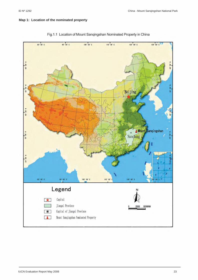
IUCN Evaluation Report May 2008 23
ID Nº 1292 China - Mount Sanqingshan National Park
Map 1: Location of the nominated property

24 IUCN Evaluation Report May 2008
China - Mount Sanqingshan National Park ID Nº 1292
Map 2: Boundaries of the nominated property

ASIA / PACIFIC
HOVSGOL LAKE AND ITS WATERSHED
MONGOLIA
IUCN Evaluation Report May 2008 25
WORLD HERITAGE NOMINATION – IUCN TECHNICAL EVALUATION
HOVSGOL LAKE AND ITS WATERSHED (MONGOLIA) – ID No. 1082
1. DOCUMENTATION
i) Date nomination received by IUCN: April 2007
ii) Additional information offi cially requested from and provided by the State Party: IUCN requested supplementary information on 30 August 2007 before the fi eld visit and on 23 October 2007 after the fi eld visit. The State Party response was received by email on 30 November 2007.
iii) UNEP-WCMC Data Sheet: 4 references (including nomination)
iv) Additional literature consulted: Bloom, A.L. (1998) Geomorphology: A Systematic Analysis of Late Cenozoic Landforms. Prentice Hall, Upper Saddle River, New Jersey; Conservation Ink (2004) Lake Khovsgol National Park: Map and Guide. Jackson, Wyoming; Dingwall, P., Weighell, T. and Badman, T. (2005) Geological World Heritage: A Global Framework Strategy. IUCN, Gland, Switzerland; Discovery Initiatives (1998) Lake Hovsgol National Park: A Visitor’s Guide. London, U.K.; Enkhtaivan, D. (2006) Natural Tour in Khuvsgul Country. Institute of Geography, Ulaanbaatar; Gray, M. (2003) Geodiversity: Valuing and Conserving Abiotic Nature. Wiley, Chichester, U.K.; Kohn, M. (2005) Mongolia. Lonely Planet, 4th Edition; LakeNet (2008): Lakes at a Glance. Online: www.worldlakes.org; Ministry for Nature and Environment (1996) Biodiversity Conservation Action Plan for Mongolia. MNE, Ulaanbaatar; Ministry for Nature and Environment (1996) Mongolia’s Wild Heritage. MNE/UNDP/WWF Ulaanbaatar; Myagmarsuren, D. (2000) Special Protected Areas of Mongolia. Munkhyn Useg Co., Ulaanbaatar.
v) Consultations: 8 external reviewers. Extensive consultations were undertaken during the fi eld visit with: representatives of the Mongolian National Government; Mongolian National Commission for UNESCO; Special Protected Areas Administration Department of the Ministry of Nature and the Environment; Geographic Institute of the Mongolian Academy of Science; UNDP Mongolia; Government of Hovsgol Province; Hovsgol Lake National Park Administration; Khatgal Village Administration; Khatgal Village Citizens Committee; Hovsgol Province Tourism Federation; tourist operators in Hovsgol National Park; and Mongolian NGOs.
vi) Field visit: Paul Dingwall, September 2007
vii) Date of IUCN approval of this report: April 2008
2. SUMMARY OF NATURAL VALUES
Hovsgol Lake (Khuvsgul Nuur) is located in northernmost Mongolia, near the border with Russia, and approximately 900 km northwest of the capital Ulaanbaatar. The lake is 1,645 m above sea level and is fl anked by mountains rising to over 3,000 m on its northern and western shores. The nominated property, comprising the lake and its mountainous watershed, covers a total of 845,349 ha. The lake comprises about one third of the property by area. The property is surrounded by a buffer zone of 624,559 ha which is not part of the nominated property.
Hovsgol Lake is 136 km long by 15-36 km wide with a surface area of 276,000 ha. Its maximum depth is 262 m. With a water volume of 383 km³, it holds about 70% of Mongolia’s freshwater. The lake is fed by more that 100 mainly short and intermittent tributaries and has
one outlet, Egiin River, which fl ows via the Selenge River into Lake Baikal. The lake basin occupies a fault-bounded depression within the Baikal Rift System that originated about 25 million years ago. The lake formed during a period of volcanic and tectonic activity 2.5-3.5 million years ago. The watershed includes the Sayan Mountains to the north, extending along 150 km of the boundary between Russia and Mongolia. These mountains hold glaciers and rise to 3,491 m at Mynk Saridag, the highest summit in the watershed. The Khoridol Saridag Range to the west rises to an altitude of around 3,000 m. To the east there is a lower tableland, dissected by eleven major valleys containing wetlands and wind-blown sands. The geology of the catchment is varied but the presence of dolomites strongly infl uences the lake water chemistry, producing carbonate-rich alkaline water of turquoise or deep blue colour. The lake is surrounded by continuous permafrost, normally several meters

26 IUCN Evaluation Report May 2008
Mongolia - Hovsgol Lake and its Watershed ID Nº 1082
thick but extending to depths greater than 500 m. Consequently, the lake water is very cold, averaging 4ºC. The lake is frozen from around mid-November until May. The lake is oligotrophic and clear.
At lower altitudes the vegetation is primarily old-growth boreal forest, which covers about 30% of the property. Siberian larch Larix sibirica, which makes up about 90% of the forest, is specially adapted to growing on permafrost soils, and many trees are 200-400 years old. The other main forest trees are three species of birch along with pine, willow and aspen. The shrub layer is dominated by four species of Rhododendron. Steppe grassland occupies the valleys and south-facing slopes, covering about 35% of the property. Above 2,300 m the forest gives way to mountain tundra of Kobresia grasses, and above this are alpine meadows. The fl ora of the watershed comprises 68 families, 262 genera and 800 species of vascular plants. More than 60 plant species are used for traditional medicines.
The altitudinal range creates a diversity of habitats, resulting in a diverse fauna. There are 68 mammal species, including grey wolf, Corsac fox, Eurasian lynx, Pallas’s cat, and Argali sheep. Hovsgol Lake is classed as an Important Bird Area by BirdLife International. Some 291 bird species have been recorded in the watershed. The lake basin is a fl yway for migrating birds and is also home to 190 breeding bird species. Notable among the waterbirds are Baikal teal, black-throated loon, black-necked grebe, Pallas’s sea eagle, white-tailed sea eagle and hooded crane. Steppe and forest species include steppe eagle, great bustard, great grey owl, Daurian partridge, steppe lark, raven and crow. Arctic rosy fi nch, Altai snowcock and golden eagle are some of the key species in the high tundra. There are large fi sh populations in the lake, with nine known species of fi sh, of which the Hovsgol grayling is an endemic sub-species. There is no commercial fi shing in the lake and local people have traditionally eaten few fi sh.
3. COMPARISONS WITH OTHER AREAS
The comparative analysis provided by the State Party is incomplete both in coverage and depth. The nomination notes that Hovsgol Lake is among 10 to 15 of the world’s “ancient lakes”, but compares Hovsgol Lake to only four of these. Notable omissions are Lake Tanganyika in East Africa, Lake Titicaca on the Bolivian / Peruvian border, and Lake Biwa in Japan. With reference to ecological and biological values, the analysis omits Mongolia’s largest lake system, Uvs Nuur, which is a transboundary World Heritage property with Russia. Also missing are several major Palaearctic World Heritage properties with cold (mountain) lakes and/or wetlands, including the Waterton Glacier International Peace Park and Kluane / Wrangell-St Elias / Glacier Bay / Tatshenshini-
Alsek (Canada / USA), and Sweden’s Laponian Area, containing the largest mire in Europe. The analysis is neither systematic nor scientifi cally rigorous to demonstrate Hovsgol Lake’s distinctive place among similar global sites in the natural world. It therefore does not support a claim to Outstanding Universal Value for the property in respect of either its geology or biology.
Lake Hovsgol is of regional signifi cance in relation to its tectonic origins, geological age and size. There are many other lakes in the world that are larger and of greater geological age. Hovsgol Lake is neither considered to be one of the 50 largest lakes by surface area nor one of the 50 deepest lakes. However, the nomination makes a primary comparison between Hovsgol Lake and only four other of the world’s major lake systems, as follows:
Lake Baikal, a natural World Heritage property in the Russian Federation, is the most obvious comparison. Lakes Baikal and Hovsgol are both of tectonic origin and part of the same major rift system; however, Baikal is some 22 million years older and located 1,000 m lower than Hovsgol, so it is warmer. Baikal is also much larger than Hovsgol in every respect – it is 60 times larger in volume, 11 times larger in surface area and six times deeper, with a watershed 140 times larger. Baikal is the world’s deepest and, by volume, largest lake in the world, containing 20% of the world’s unfrozen freshwater reserves. The waters of Hovsgol are also far less productive. Hovsgol is one of the world’s most oligotrophic lakes with a biomass only about 25% of that of Baikal. The density of bottom-dwelling fauna (worms, snails, insects and crustaceans) in Hovsgol is only about 10% that of Baikal. Hovsgol has only nine species of fi sh while Baikal has more than 50 species, many of them endemic to the lake.
Lake Issyk-Kul, included on the Tentative List of Kyrgyzstan, is the second-largest high-altitude lake in the world (after Lake Titicaca). It is more than twice the surface area and two and a half times the depth of Hovsgol Lake, and is much older than Hovsgol Lake at 7 million years old.
Lake Ohrid is about the same age as Hovsgol Lake at 2-3 million years old. It is set in a faulted karst region and lies partly within a mixed World Heritage property of the Former Yugoslav Republic of Macedonia.
Lake Malawi, one of the East African Rift Valley lakes, is much older than Hovsgol Lake at 6-9 million years old. It lies partly within a natural World Heritage property of Malawi and has one of the richest fi sh faunas of any of the world’s lakes.
•
•
•
•

IUCN Evaluation Report May 2008 27
ID Nº 1082 Mongolia - Hovsgol Lake and its Watershed
Hovsgol Lake and its watershed are of national and regional signifi cance in relation to ecological and biological processes due to the biologically rich ecosystem characteristics of the transition area between the forests and grasslands of Central Asia. Hovsgol Lake forms part of the WWF Altai-Sayan Ecoregion, a vast wild land on the shared borders of China, Kazakhstan, Mongolia and Russia. This ecoregion is considered to be among the world’s most distinctive reservoirs of biodiversity, providing habitat for rare and endangered species of plants and animals, and an important centre of endemism. However, the ecological and biological values of Hovsgol Lake are secondary when compared with other lakes in the same ecoregion such as Lake Baikal (Russian Federation), Uvs Nuur (Mongolia / Russian Federation) and Issyk-Kul (Kyrgyzstan), or with other mountains in the same ecoregion such as the Golden Mountains of Altai (Russian Federation).
In conclusion, IUCN considers that the values of Hovsgol Lake appear secondary to many other sites, and do not appear to match the levels of values of comparable properties already included on the World Heritage List. However, the property does provide some complementary values to existing properties within the region, and it is therefore possible that it could form a potential extension to one of the more signifi cant properties, most obviously Lake Baikal, or possibly Uvs Nuur. In both cases appropriate cooperation with the Russian Federation would be required.
4. INTEGRITY
4.1 Legal status
The nominated property has good long-term protective legislation. The Hovsgol National Park was established by order of a Government Resolution in 1992, and further Resolutions approved the boundaries of the park and the protection regime in 1995. There is a set of more than 20 regulations for implementing the principal objectives of preservation and protection of the park waters, fl ora and fauna, along with conservation and sustainable use of natural resources. Specifi c rules govern protection of waters, plants, and forests, fi re protection, hunting and land use, among others. The nominated property is owned and managed by the State Government, through the Protected Areas Bureau under the Environment Protection Agency of the Ministry of Nature and the Environment. The local Hovsgol Lake Park Administration is based in the gateway village of Khatgal.
4.2 Boundaries
The boundaries of the nominated property coincide essentially with those of the Hovsgol National Park. The park boundaries follow the watershed boundary,
except for an extension in the Uur-Uilgan area, in the north-eastern sector, south of the Russian border. The boundaries enclose an area suffi cient to contain all the key landforms and biota, and the natural processes essential for long-term conservation of the lake and its watershed. An extensive buffer zone surrounding the national park was offi cially established in 1996. While this is not part of the nominated property, it is intended to prevent and/or reduce adverse impacts to the park through regulating the appropriate use of natural resources by local people. The extent of the buffer zone is determined by agreement between the park authorities and a local citizen board, and activities within the buffer zone are monitored by a representative Buffer Zone Council. A draft management plan for the buffer zone is currently under preparation.
The most obvious anomaly in the boundaries of the nominated property is the exclusion of the Khoridol-Saridag Strictly Protected Area, an area of 189,000 ha adjacent to the south-western sector of the park which was set aside in 1997 to protect the dwindling populations of ibex, Argali sheep, and musk deer. It is managed as an integral part of the national park and appears to have natural values similar to those of the park.
Hovsgol National Park is subdivided for management purposes into three principal zones: Special Zones (9% of the park with strict protection), Travel and Tourism Zones (13.8% of the park bordering the lake), and Limited Use Zones (77.2% of the park where traditional livestock husbandry and fi shing are permitted along with construction of tourist camps). The villages of Khatgal and Khankh are located in the park’s Limited Use Zones but should logically be included in the buffer zone of the nominated property.
4.3 Management
State funding for park management has been inadequate in the past, but has increased in recent years and it is anticipated that this will continue in the future. The total annual park budget increased from 33 million Tughrik (USD 28,375) in 2003 to 58.9 million Tughrik (USD 50,645) in 2007 and is forecast to reach 106.4 million Tughrik (USD 91,488) in 2012. The State contribution was only 58% of the total in 2003, but this increased to 83% in 2007 as the State became less reliant on foreign aid. Despite these encouraging increases, a considerably higher level of funding is required. Revenue from park users is minimal and there is a need to reconsider entrance fees and other sources of funding such as tourist concession fees – the larger camps, for example, pay only a few hundred USD in fees annually. About 60% of the park budget is spent on salaries and 40% on fuel. The shortfall in State funding was supplemented by external sources including the Global Environment Facility and the US Department of the Interior.

28 IUCN Evaluation Report May 2008
Mongolia - Hovsgol Lake and its Watershed ID Nº 1082
Staff numbers have also been increased to a level that appears adequate for current management requirements, but questions remain about the adequacy of techniques, equipment and fi eld resources. A fundamental defi ciency is the lack of a park boat, making it necessary for staff to rent one from a local tourist operator to conduct such vital tasks as surveillance of illegal activities, transport of work camps and equipment, and lake water research and monitoring activities. However, the Ministry of Nature and the Environment is considering making a boat available, and an aircraft for forest survey and fi re control.
A fi ve-year management plan for Hovsgol National Park for the period 1998-2003 was approved in January 1999. A more comprehensive revised draft management plan prepared in 2005 is included in the nomination. This plan is undergoing further consultation and revision in 2007. A draft management plan for the buffer zone is also currently under preparation.
There is some evidence of local involvement in park planning and management, such as through opportunities for volunteers. The Government of Hovsgol Province supports the park and World Heritage nomination, particularly for their potential to boost tourism growth, which is vital to the local economy. The Khatgal Village Citizens Committee also supports the park and World Heritage nomination, though its principal concerns are for the livelihoods of the people.
Law enforcement is problematic because of the limited distribution of rangers within a very large park area, the logistical diffi culties presented by the terrain, and the lack of transport infrastructure and vehicles. The northern half of the park has only six resident staff and there is little evidence of prosecution of illegal hunters and poachers.
Park promotional materials, visitor information and other information and education resources are mostly rudimentary or only available in small numbers and need much further development.
4.4 Threats and human use
The nomination refers to a large number of threats and problems confronting the management of the property and requiring some degree of management intervention. The most signifi cant include:
• Economic pressures have led to some year-round grazing and increases in herd sizes, with consequent overgrazing, and concerns about further growth in these pressures. The park authorities are considering limiting herd sizes and controlling impacts around tributary streams, and have instructed local
herders in sustainable grazing methods and in ways to identify overgrazing problems.
• There has been signifi cant past forestry activity. While commercial logging in the park is banned, an estimated 15,000 m³ of timber is still taken each year by local residents, mainly as fuelwood. Increasing demand for timber from the Chinese market remains of concern, and reforestation efforts have been minimal, averaging only about 12,000 ha per year.
• Fires from campfi res and unregulated tourist camps are of concern. Fire is an integral part of taiga forest but excessive burning leads to changes in the ecosystem. The park authorities have little modern fi re prevention techniques or equipment and can provide effective fi re control for only about 186,000 ha (20% of the watershed) per year.
• Past construction of about 12 km of roads by Russian mineral prospectors has scarred the hillsides in the Khoridol Saridag Range west of the lake, leading to some excessive soil erosion during heavy rains in summer, which is further exacerbated by the presence of 150 abandoned trial phosphorus mining pits. These roads are now mostly closed to tourist use and used primarily for management access.
• Collecting of wild plants by local residents is increasing and there is growing evidence of reduced abundance, distribution and slower recovery of some plants. The park authorities are considering increasing public awareness and law enforcement to combat the problem.
• Illegal trading, hunting and poaching affect populations of snow leopard, Argali sheep, ibex, musk deer, roe and red deer, moose, elk, brown bear, and some waterfowl during spring and autumn migrations. Surveys show that hunting and poaching have severely reduced the populations of marmots, hares, ibex, roe and red deer, and bears. Argali sheep have shrunk to levels from which they may not recover and snow leopards, once numerous, are now rarely seen.
• There is no commercial fi shing in the lake, but fi shing permits are issued to local citizens for household purposes, and to tourists with strict limits on catches. Illegal netting of fi sh around Khankh during the spawning season by Russian fi shermen cannot be properly controlled in the absence of a park boat.
• There is some concern over lake water pollution from fl ooded waste dumps, villages, cattle and motorboat oil spills. Accelerated soil erosion and sedimentation from overgrazed riparian areas, mining pits and roads are also of growing concern.

IUCN Evaluation Report May 2008 29
ID Nº 1082 Mongolia - Hovsgol Lake and its Watershed
There are no industrial pollution sources within the Hovsgol basin at present. In the past the main source of pollution was from accidental fuel and oil spills and the sinking of petrol tanker trucks through the lake ice surface during winter time.
• Potential impacts from possible rapid development of tourism and unregulated tourism operations are a major concern. Currently, about 15,000 people visit the park annually, including small numbers of foreign tourists. There are about 23 tourist camps around the lake, though not all are fully licensed. The larger camps accommodate up to 700 visitors per season. Major concerns are the close proximity of some camps to each other (2-3 km apart) leading to overcrowding, pollution of the lake from waste, runoff from camps located too close to the shore, accidental fi res, excessive road traffi c and trampling, illegal camping and fuel and oil spills from increased boating activities.
• There are fi ve local tribes in the park, with about 20 families living permanently and another 20 families moving in from the mountains during winter, who are either forest-dwelling hunter reindeer herders in the north or steppe pastoralists herding sheep, goats, cattle, yak and horses in the south. The two villages in the park, Khatgal in the south and Khankh in the north, had 2,800 and 2,341 inhabitants respectively in 2004, and are growing slowly after past decline.
Although many of these problems and threats can be managed and are the subject of attention by the park authorities, they represent signifi cant ongoing challenges to the integrity of the property. They also represent a signifi cant degree of human impact on the natural processes for which the property is nominated. It is of signifi cant concern that the management arrangements for the property appear to be very limited in light of the existing problems and threats.
On balance IUCN considers that the property does not meet the necessary conditions of integrity as set out in the Operational Guidelines.
5. ADDITIONAL COMMENTS
5.1 Potential recognition as a UNESCO Man and the Biosphere Reserve
Considering that the nominated property represents an important site at the national and regional levels and, in recognition of the need to balance protection of its natural values with surrounding human uses, IUCN notes that the values of the property might be more suited to potential recognition through other measures such as the UNESCO Man and Biosphere Programme. IUCN also notes that there is a long-term environmental research and monitoring programme
in place at the property which could play an important role in measuring human-induced environmental and climate changes.
5.2 Cultural values
A number of reviews have emphasised the important cultural values of the nominated property, including numerous sacred sites, and the continuing interaction of people and nature through living shamanic traditions. Considering this and that the property is included on Mongolia’s Tentative List as a mixed property, its values might also be more suited to potential recognition as a cultural landscape.
6. APPLICATION OF CRITERIA
The property has been nominated under criteria (viii) and (ix). IUCN considers that the nominated property does not meet either of these criteria based on the following assessment:
Criterion (viii): Earth’s history, geological and geomorphic features and processes
Lake Hovsgol is of regional signifi cance in relation to its tectonic origins, geological age and size. It forms part of the regional-scale Baikal Rift System that stretches for 3,000 km across southern Siberia and includes Lake Baikal which is the world’s largest lake. There are many other lakes in the world that are larger and of greater geological age, notably the neighbouring Lake Baikal, which is 22 million years older, 60 times larger in volume, 11 times larger in surface area and six times deeper. An initial global comparative analysis suggests that the geological values of the nominated property are secondary to many sites and do not support a claim of Outstanding Universal Value.
IUCN considers the nominated property does not meet this criterion.
Criterion (ix): Ecological and biological processes
Hovsgol Lake and its watershed are of national and regional signifi cance in relation to ecological and biological processes due to the biologically rich ecosystem characteristics of the transition area between the forests and grasslands of Central Asia. The property protects a landscape of natural, interconnecting ecosystems from high mountain tundra to alpine forest, taiga forest, steppe woodland and grassland, streams, wetlands, lagoon and a large lake. However, the ecological and biological values of the property are secondary on a global scale and even when compared with other lakes in the same ecoregion such as Lake Baikal (Russian Federation), Uvs Nuur (Mongolia / Russian Federation) and Issyk-Kul (Kyrgyzstan). There are also a wide range of

30 IUCN Evaluation Report May 2008
Mongolia - Hovsgol Lake and its Watershed ID Nº 1082
management problems and threats to Hovsgol Lake and its watershed, which represent signifi cant ongoing challenges to its integrity.
IUCN considers the nominated property does not meet this criterion.
7. RECOMMENDATIONS
IUCN recommends that the World Heritage Committee adopt the following decision:
The World Heritage Committee,
1. Having examined Documents WHC-08/32.COM/8B and WHC-08/32.COM/INF.8B2,
2. Decides not to inscribe Hovsgol Lake and its Watershed, Mongolia, on the World Heritage List on the basis of natural criteria;
3. Commends the State Party for its efforts for the conservation of Hovsgol Lake and its Watershed and the partnerships with international agencies to improve the management capacity and protection of the property; and encourages the State Party to continue these efforts;
4. Considers that the property represents an important site at the national and regional levels and, in recognition of the need to balance protection of its natural values with surrounding human uses, recommends the State Party consider the potential for its designation as a UNESCO Man and the Biosphere Reserve.

IUCN Evaluation Report May 2008 31
ID Nº 1082 Mongolia - Hovsgol Lake and its Watershed
Map 1: Location and boundaries of the nominated property

EUROPE / NORTH AMERICA
THE JOGGINS FOSSIL CLIFFS
CANADA

IUCN Evaluation Report May 2008 33
WORLD HERITAGE NOMINATION – IUCN TECHNICAL EVALUATION
THE JOGGINS FOSSIL CLIFFS (CANADA) – ID No. 1285
1. DOCUMENTATION
i) Date nomination received by IUCN: April 2007
ii) Additional information offi cially requested from and provided by the State Party: IUCN requested supplementary information on 14 November 2007 after the fi eld visit. The State Party response was offi cially received by the World Heritage Centre on 31 January 2008.
iii) UNEP-WCMC Data Sheet: 21 references (including nomination)
iv) Additional literature consulted: Dingwall, P., Weighell, T. and Badman, T. (2005) Geological World Heritage: A Global Framework Strategy. IUCN, Gland, Switzerland, 51 p.; Gradstein, F.M., Ogg, J.G. and Smith, A.G. (2005) A Geological Time Scale 2004. Cambridge University Press; Hook, R.W. and Ferm, J.C. (1988) Paleoenvironmental controls on vertebrate-bearing abandoned channels in the Upper Carboniferous. Palaeogeography, Palaeoclimatology and Palaeocology, 63: 159-181; Paton, R.L., Smithson, T.R. and Clack, J.A. (1999) An amniote-like skeleton from the Early Carboniferous of Scotland. Nature, 398: 508-513; Wells, R.T. (1996) Earth’s Geological History: A Contextual Framework for Assessment of World Heritage Fossil Site Nominations. IUCN, Gland, Switzerland.
v) Consultations: 10 external reviews. Extensive consultations were undertaken during the fi eld visit with representatives of the State Party; federal, provincial, and municipal county government offi cials; regional and local authorities; scientists; museums; and the local community.
vi) Field visit: Tim Badman and Wesley Hill, October 2007
vii) Date of IUCN approval of this report: April 2008
2. SUMMARY OF NATURAL VALUES
The nominated property, the Joggins Fossil Cliffs, is located in the northwest of the Province of Nova Scotia, Canada on the eastern shores of the Cumberland Basin of Chignecto Bay, the most northerly arm of the Bay of Fundy. The property comprises 689 ha and is a 14.7 km stretch of sea cliffs, low bluffs, wave-cut platforms and beach. Its northern point is Downing Cove and its southern point is Ragged Reef Point.
The cliffs of the nominated property expose rocks from the Carboniferous period, or “Coal Age”, one of the principal divisions of the geological record (354 to 290 million years ago). The term “Carboniferous” was established in relation to the rich deposits of coal from this period in the United Kingdom, and which are also found throughout northern Europe, Asia, and Midwestern and eastern North America. The period has been separated into the Mississippian (Lower Carboniferous) and the Pennsylvanian (Upper Carboniferous) in the United States. In addition to having the ideal conditions for the beginnings of coal, several major biological, geological, and climatic
events occurred during the Carboniferous. One of the greatest evolutionary innovations of the Carboniferous was the amniote egg, which allowed for life on land by the vertebrates (amniotes being the vertebrate group including the mammals, reptiles, dinosaurs and birds). The fi rst amniotes, which resembled small lizards, evolved 340 million years ago. Their eggs could survive out of the water, allowing amniotes to branch out into drier environments. The eggs could also “breathe” and cope with waste, allowing the eggs and the amniotes themselves to evolve into larger forms. The amniotes spread across the globe and were virtually the only land vertebrates at this time.
The rocks of the nominated property are considered to be iconic for this period of Earth’s history and are the world’s thickest and most comprehensive record of Pennsylvanian coal-bearing strata (318 to 303 million years ago) with the most complete known fossil record of terrestrial life from that time in existence. This includes the remains and tracks of very early animals and the rainforest in which they lived, revealed in situ, in an undisturbed geological context, and intact. The cliffs have been mined in the

34 IUCN Evaluation Report May 2008
Canada - The Joggins Fossil Cliffs ID Nº 1285
past for a low grade coal which occurs in thin seams associated with bivalve-bearing limestone and black shale. Some historic fossil extraction was also carried out using mining techniques, but the lower cliff faces are renewed by erosion from the 16.8 m tides of the Bay of Fundy, the highest tides in the world.
The nominated property displays a 15 million year succession of sedimentary layers in the Pennsylvanian Cumberland Group. The 915.5 m thick, 2.8 km long ’Classic Section’ of the Joggins Formation, with thin coal-bearing seams of varying thickness, is shown between the younger Springhill Mines and Ragged Reef Formations originally deposited above it (now to its south), and the red beds of the Little River and Boss Point Formations below it (to its north), all tilted at an angle of 21o from the horizontal and running back inland many kilometres.
The exposed fossil assemblages form a remarkable paleoecological archive of a coastal forest of 310 million years ago, where the fossils remain in situ, grouped in a combination of three neighbouring ecosystems: estuarine bay, fl oodplain rainforest and fi re-prone forested alluvial plain with freshwater pools. The seams contain the upright fossilized trunks of trees up to 7.6 m high. Within this area, 195 fossil species have been discovered, composed of rainforest and seasonally dry land vegetation, with its vertebrate and invertebrate inhabitants, both terrestrial and aquatic. Evidence of the entire food chain of a primeval terrestrial ecosystem is present. The sea was brackish, populated by an extensive aquatic fauna of annelid shells, bivalves, crustaceans, horseshoe crab-like forms, sharks, ray-like fi shes and several species of bony fi sh.
In 1852, Charles Lyell and William Dawson found the fi rst tetrapod (four-limbed) amphibian and land snails trapped within a buried hollow Lepidodendrid tree stump. They were named respectively Dendrerpeton acadianum and Dendropupa vetusta. These discoveries, incorporated into the theories of Charles Darwin, led to acclaim for the Joggins Cliffs as the Galápagos of the “Coal Age”. In 1859, William Dawson discovered the earliest known reptile, Hylonomus lyelli, the ancestor of lizards, dinosaurs and birds, and in 1882, he discovered 25 fossil trees with over two hundred tetrapods of fi ve taxa and more reptiles. Many skeleton remains were found grouped in hollow tree stump-pits. Remains were also found in waterholes in the seasonally dry alluvial plains. Of 66 species of terrestrial fauna, over half are type specimens fi rst or only found at Joggins. 19 of these are amphibian and reptile tetrapods, including the earliest known reptile, and the earliest amniote known.
In total, 96 genera and 148 species of fossils plus 20 footprint groups (ichnogenera) have been found at Joggins, forming the most comprehensive assemblage known of the fossil life of three distinct
paleoecosystems. Reinterpretations of this ancient environment will continue as long as the tides continue to uncover new evidence. Over 900 books and scientifi c papers have been produced on the property.
In addition, the nominated property has interesting cultural values of national and provincial signifi cance. Its name comes from Mi’kmaq Indian word for a ‘place of fi sh weirs’. Coal was mined in the 17th and 18th centuries by the fi rst French colonists and continued in the Joggins Formation (beside and underlying Joggins village) intermittently from 1847 on, some galleries running underwater into the bay. The gritstone of Boss Point was used for a successful grindstone business in the 19th century. The village of Joggins immediately above the cliffs has always been dependent on coal mining, which ended there only in 1961, leading to local economic decline. Company men and local enthusiasts had long assisted geologists by reporting and saving palaeontological fi nds and the community remains dedicated to stewardship of the cliffs and uses the area for recreation.
3. COMPARISONS WITH OTHER AREAS
The nomination’s comprehensive comparative analysis makes a convincing case for World Heritage listing. It compares Joggins to nine globally signifi cant and comparable “Coal Age” fossil sites, which were selected from a global set of sites based on the quality of their fossil record, using benchmarks derived from IUCN’s evaluation of fossil sites. Joggins ranks fi rst in seven of twelve benchmarks and fi rst among the short-listed sites, followed by Sydney (also in Nova Scotia, Canada) and Freeport (Illinois, USA). The analysis identifi es the nominated property as the most outstanding example in the world of the “Coal Age” and its terrestrial fauna, notably the earliest amniotes. Additional analysis carried out by the State Party confi rms Joggins’ status as the most signifi cant known site for evidence of the earliest terrestrial amniotes and early tetrapod evolution. As for all fossil sites, other reference localities exist which contribute elements of the global story not evidenced in the nominated property; however, the comparative analysis makes a compelling case that Joggins best represents the fossil values of the “Coal Age”.
The comparative analysis within the nomination also makes thorough reference to the IUCN thematic study on fossil sites and demonstrates that the property meets all of the principles outlined in that study. These include the iconic importance of the property in representing the evolution of the amniote egg and the subsequent ability of vertebrates to colonise the terrestrial world, including the eventual evolution of human life on Earth. A further iconic value is the most complete representation of the “Coal Age” world, and the ecosystems that resulted in vast coal
IUCN Evaluation Report May 2008 35
ID Nº 1285 Canada - The Joggins Fossil Cliffs
deposits, whose exploitation in the industrial age has been a major factor in human development as well as having continued resonance through atmospheric pollution and climate change. Additional comparative analysis also notes the signifi cance of the tetrapod footprint record at Joggins which is regarded as the single most extensive known assemblage. IUCN has also evaluated the nominated property against the standard set of ten questions that has been used as the basis for assessing the values of fossil sites since 1996 (see Annex A).
In summary IUCN concludes that:
1) The values of the “Coal Age” represented by Joggins are of Outstanding Universal Value, notably in relation to the iconic values of the evolution of the amniote egg, the early evolution of tetrapods, and the worldwide distribution of vast coal-forming forests.
2) Joggins has the strongest claim to display these values. It has values that equal or exceed values of fossil sites already included on the World Heritage List. It is also superlative in the breadth of values displayed.
IUCN notes these values are complemented by the historic importance of Joggins to the development of seminal geological and evolutionary principles, including as a key site for the work of Charles Lyell and Charles Darwin. This adds further to the compelling case for inscription of Joggins on the World Heritage List.
4. INTEGRITY
4.1 Legal status
The nominated property has protected status under a range of overlapping provincial and municipal laws. It is protected through convergent legislation that includes protective designations, mineral exploration closures, land-use planning and zoning. These include the Provincial Special Places Protection Act, Beaches Act, Minerals Act and the land-use planning and zoning by laws of the Municipality of Cumberland. Some of the legislation appears a little cumbersome in application, and this point is discussed further below. However, the legal status of the property meets the requirements of the Operational Guidelines.
4.2 Boundaries
The property has clearly defi ned and well thought through boundaries, which are supported by clear maps. The landward and seaward boundaries are tied to the natural processes that maintain the values of the property. The landward boundary is the top of the cliff-face, and in areas where cliffs are not present, the boundary is the most landward point at the back of
the beach. The seaward boundary is 500 m parallel to the top of the cliff or back of the beach. This includes the beach and intertidal area where bedrock “reefs” with embedded fossils extend from the cliffs. The boundary migrates landward with erosion of the cliff-face to accommodate the natural processes of coastal evolution.
The northern boundary at Downing Cove and southern boundary at Ragged Reef Point are defi ned by prominent coastal landforms. The lateral boundaries are clear and include the whole of the Classic Section with signifi cant older and younger succession that provides context. The boundaries are geologically coherent and justifi able, to the north they include the boundary between the Pennsylvanian and older Mississippian rocks. To the south they include the boundary governed by the structural geology, stopping at a point where the beds begin to dip shallowly so there is little additional geological value added to the section by the rocks beyond Ragged Reef point.
The property is protected by a 20-30 m wide buffer zone landward of the entire length of the property. The buffer zone is relatively narrow, but suffi cient to control coastal development which could otherwise threaten the values of the property for at least two generations. The buffer zone is therefore considered adequate. IUCN considers that it would be of benefi t to the property for the buffer zones to be extended further, most notably in order to ensure that inappropriate development does not take place.
4.3 Management
Management and conservation of the nominated property is implemented locally through the Joggins Fossil Institute (JFI). The JFI is a registered not-for-profi t society and physically located in a newly built Joggins Fossil Centre which will be the science and visitor education centre for the property. The JFI has the principal role of establishing on-site policy and coordinating management for the property. It is governed by an Advisory Board of Directors and advised by a Scientifi c Advisory Committee, which provides important relationships with scientists from the Nova Scotia Department for Natural Resources, and museum curators from both the Nova Scotia Museum and Fundy Geological Museum, who provide expert support to the work of the JFI.
The JFI provides a strong model of cooperative and community based management for a natural site and has signifi cant political commitment at all levels, including long-term fi nancial commitments to the organisation. The JFI is a relatively new organisation and is still developing. Governance is currently complex, refl ecting the range of partners committed to the project, and initially will have a strong connection to the Cumberland Regional Economic Development Association (CREDA). The additional information

36 IUCN Evaluation Report May 2008
Canada - The Joggins Fossil Cliffs ID Nº 1285
provided by the State Party notes a number of key initiatives and activities to consolidate the JFI including the development of a human resources policy and training programme 2008-2012, and the development and implementation of an enhanced fi nancial management system and a long-term fundraising programme. The implementation of these initiatives will consolidate the JFI as an independent and effective organisation in the long term.
Local support for the World Heritage nomination is overwhelmingly positive. This is the result of eight years of investment in engaging the community in the development of the World Heritage nomination. In addition to the protection of the globally signifi cant geological values, World Heritage status is seen as a positive tool for education and community development, providing new economic opportunities for communities which previously relied on coal mining. The JFI and its partners have developed a thorough community involvement and leadership process which is a model for other World Heritage nominations.
The Joggins Fossil Cliffs Management Plan has been developed by the JFI in partnership with government agencies and the local community, and sets out an operating and protection plan, including visitor management, education, visiting scientist, and fossil monitoring programmes. The management system for the property is clearly documented in the nomination.
The key protective measures are operated at provincial level, but can only be effectively implemented through locally based management. An agreement has empowered the JFI to take necessary measures to implement the Beaches Act. A parallel agreement is under discussion to enhance the role of the JFI in implementing the Special Places Protection Act (SPPA) including issuing Heritage Research Permits. This is very important as this is the primary means of regulating/managing the collection and study of the fossils on the site. IUCN considers that the present arrangements for implementing the SPPA could be signifi cantly improved through the conclusion of this agreement as it is highly unlikely that a system based on centrally operated permits, issued from the provincial capital in Halifax (a signifi cant distance from the site), will be suffi ciently responsive to management needs.
Almost all (95%) of the property is owned by the Crown (Government of Nova Scotia) from the mean high-water mark seaward to the mean low-water mark. Property landward of the mean high-water mark is owned by those who hold title to land adjacent to the shoreline and is mostly privately owned, except for three large areas that are owned by the Province of Nova Scotia and an additional parcel owned by the Municipality of the County of Cumberland. The JFI and Joggins Fossil Centre are adjacent to the nominated property
and built on land also owned by this Municipality. The involvement of local landowners is therefore a critical dimension to site management, especially in relation to research on in situ fossils in the cliffs. Engagement and partnership with local landowners therefore has a very signifi cant priority within the work of the JFI, and includes representation of landowners on the JFI board of directors.
The JFI has a key role in the management of visitors to the property. This is facilitated by the limited access points to the property and the new Joggins Fossil Centre. The Centre is a sensitively designed building with a strong consideration for sustainable building techniques and creative interpretive design. It meets the highest international standards. Such investment is noted by IUCN as particularly important for fossil sites as the values of such properties are not immediately apparent to visitors unless explained. Creation and maintenance of beach access from the Centre is a key issue and requires a sensitively designed solution and ongoing maintenance. The investment in infrastructure is complemented by interpreters who provide fi rst hand communication to visitors on the values of Joggins and on visitor safety.
4.4 Threats and human use
The nominated property comprises an area of an actively eroding sea cliff that is largely inappropriate for development and is legally protected under several provincial and municipal regulations prohibiting development. The beach itself is not suited for any type of development due to the extreme tidal behaviour. Several private residences and properties border the 20 m buffer zone, including one residence inside the buffer zone that is likely to be abandoned and removed at some time in the next 100 years. Whilst potential threats exist from the construction of coastal protection measures to protect private property, this is well regulated by several levels of overlapping legislation, notably at the provincial level through the provisions of the Special Places Protection Act and at the municipal level by the Cliffs and Shoreline Setbacks and the Prohibited Uses and Structures legislation.
The extensive coal mining history of the nominated property has left virtually no economic coal resources intact and does not contain a suitable grade for mining. In addition, there is a “closure” order on mineral rights for the property, reducing the likelihood of further exploitation essentially to zero.
The most signifi cant potential impact on the values of the property is the removal of important fossils, and this threat may be exacerbated by the current legislation which is considered by a number of reviewers to be cumbersome in its blanket protection for both important and common fossils. Reviewers also note the important role played by local people in

IUCN Evaluation Report May 2008 37
ID Nº 1285 Canada - The Joggins Fossil Cliffs
the collection of fossils, noting that some of the most important collections, and talented researchers, have come from the local community nearby to Joggins.
The on-site signage is in need of upgrading at the access points to inform the visiting public of fossil collecting restrictions and regulations. Very few individuals posses a Heritage Research Permit for research collecting and public visitation to the site is currently happening virtually unmonitored for collecting. This issue should be addressed through future increased staffi ng and roving JFI “beach monitors” that will make public contact on a daily basis. The JFI has a clear philosophy regarding the development of their role and policies for fossil collection and this will be an interesting challenge in the establishment phase of JFI and its ongoing role. IUCN considers that this aspect of site management will make a particularly interesting case study of the effectiveness of fossil site management, with the combination of a relatively unknown site, restricted access and strong scientifi c and management capacity enabling new management techniques to be developed. It will be important that the provincial legislation is managed in a way that empowers JFI to do this, and IUCN encourages the State Party to publicise lessons from the management of fossil collection activities within the property.
IUCN considers the limited threats to the nominated property are well managed at present, and the biggest challenge of the property will be to maintain the level of performance and resources required in the future.
In summary IUCN considers that the property meets the necessary conditions of integrity as set out in the Operational Guidelines.
5. APPLICATION OF CRITERIA
The property has been nominated under criterion (viii). IUCN considers that the nominated property meets criterion (viii) based on the following assessment:
Criterion (viii): Earth’s history, geological and geomorphic features and processes
The “grand exposure” of rocks at Joggins Fossil Cliffs contains the best and most complete known fossil record of terrestrial life in the iconic “Coal Age”: the Pennsylvanian (or Carboniferous) period in Earth’s history. The site bears witness to the fi rst reptiles in Earth history, which are the earliest representatives of the amniotes, a group of animals that includes reptiles, dinosaurs, birds, and mammals. Upright fossil trees are preserved at a series of levels in the cliffs together with animal, plant and trace fossils that provide environmental context and enable a complete reconstruction to be made of the extensive fossil forests that dominated land at this time, and are now the source of most of the world’s coal deposits. The
property has played a vital role in the development of seminal geological and evolutionary principles, including through the work of Sir Charles Lyell and Charles Darwin, for which the site has been referred to as the “coal age Galápagos”.
IUCN considers the nominated property meets this criterion.
6. RECOMMENDATIONS AND STATEMENT OF OUTSTANDING UNIVERSAL VALUE
IUCN recommends that the World Heritage Committee adopt the following decision:
The World Heritage Committee,
1. Having examined Documents WHC-08/32.COM/8B and WHC-08/32.COM/INF.8B2,
2. Inscribes The Joggins Fossil Cliffs, Canada, on the World Heritage List on the basis of criterion (viii);
3. Adopts the following Statement of Outstanding Universal Value:
Values The Joggins Fossil Cliffs have been termed the
“coal age Galápagos” and are the world reference site for the “Coal Age”. Their complete and accessible fossil-bearing rock exposures provide the best evidence known of the iconic features of the Pennsylvanian (or Carboniferous) period of Earth History.
Criterion (viii) – Earth’s history, geological and geomorphic features and processes: The “grand exposure” of rocks at Joggins Fossil Cliffs contains the best and most complete known fossil record of terrestrial life in the iconic “Coal Age”: the Pennsylvanian (or Carboniferous) period in Earth’s history. The site bears witness to the fi rst reptiles in Earth history, which are the earliest representatives of the amniotes, a group of animals that includes reptiles, dinosaurs, birds, and mammals. Upright fossil trees are preserved at a series of levels in the cliffs together with animal, plant and trace fossils that provide environmental context and enable a complete reconstruction to be made of the extensive fossil forests that dominated land at this time, and are now the source of most of the world’s coal deposits. The property has played a vital role in the development of seminal geological and evolutionary principles, including through the work of Sir Charles Lyell and Charles Darwin, for which the site has been referred to as the “coal age Galápagos”.

38 IUCN Evaluation Report May 2008
Canada - The Joggins Fossil Cliffs ID Nº 1285
IntegrityThe boundaries of the property are clearly defi ned in relation to logical stratigraphic criteria and include all of the areas necessary to fully display the fossil record of Joggins including the cliff face and foreshore rock exposures, and include both the most fossiliferous strata and younger and older rocks that provide geological context. The inland extent of the property is defi ned based on the eroding top of the cliffs and this is a fully justifi able and logical basis to cope with the dynamic nature of this coastal property. A relatively narrow buffer zone is defi ned, which is not part of the inscribed property, but is suffi cient to control coastal development which could otherwise threaten the values of the property.
Requirements for Protection and ManagementThe property has effective legal protection and has the strong support of all levels of government, including in relation to the provision of funding. Some aspects of the legislation, such as for the licensing of fossil collection are cumbersome and would benefi t from review, although can be better implemented if site managers are empowered to do so. The site is well resourced, including through the provision of a new visitor centre, and is managed in a way that can be considered to set international standards. The effective process of community involvement and partnerships between scientists, museums and economic interests are also noted, and the biggest challenge of the property will be to maintain the level of performance and resources required in the future.
4. Notes the very high quality of documentation of the nomination and the process of community engagement in its preparation, over a period of almost ten years, as models in the preparation of nominations and in effective management of World Heritage properties;
5. Recommends that the State Party widely publicise the results of its monitoring of fossil resources produced by natural erosion and the development of educational and research collecting policies, which could serve as a model for such management elsewhere.
IUCN Evaluation Report May 2008 39
ID Nº 1285 Canada - The Joggins Fossil Cliffs
Annex A: IUCN Checklist for the Evaluation of Fossil Sites
1. Does the site provide fossils which cover an extended period of geological time (i.e. how wide is the geological window)?
The Joggins Fossil Cliffs record a geological window that spans at least 15 million years of earth history, from the late Mississippian Subsystem (Serpukhovian stage) to early Pennsylvanian Subsystem (Bashkirian to Moscovian stages) of the Carboniferous System.
2. Does the site provide specimens of a limited number of species or whole biotic assemblages (i.e. how rich is the site in species diversity)?
The nominated property represents whole biotic assemblages and the trophic system (the food chain) of the iconic “Coal Age” wetland ecosystem. These assemblages include the most diverse terrestrial vertebrate fauna known from any site of the Pennsylvanian Subsystem. Equally well-represented are aquatic vertebrates (fi shes) and invertebrates of both the terrestrial and aquatic realms.
3. How unique is the site in yielding fossil specimens for that particular period of geological time (i.e. would this be the type locality for study or are there other similar areas that are alternatives)?
The nominated property is unique in its record of terrestrial life and has long been recognized as the type locality for the terrestrial “Coal Age” world. Joggins is the best locality for the study of fossil life from this time period in situ and within its original environmental context. No other site has provided so much knowledge of the evolutionary paths from primitive terrestrial vertebrates to the major groups of terrestrial amniotes.
4. Are there comparable sites elsewhere that contribute to the understanding of the total “story” of that point in time/space (i.e. is a single site nomination suffi cient or should a serial nomination be considered)?
Thorough comparative analysis has demonstrated that there are no Pennsylvanian sites of comparable exposure, paleoecological integrity or completeness as the records of the terrestrial “Coal Age” world at Joggins. As for all fossil sites, however, other localities add specifi c elements of the global story of life and environments for any given time period.
5. Is the site the only or main location where major scientifi c advances were (or are being) made that have made a substantial contribution to the understanding of life on earth?
Joggins is the most important site where substantial scientifi c advances have been made with respect to the terrestrial “Coal Age” world, due largely to the exceptional ecological context it provides for the fossils. Joggins played a seminal role in the development of geological and evolutionary principles. No other locality in the world has provided as much knowledge of the nature of early amniotes, or more informative specimens for linking them to more primitive groups of Palaeozoic tetrapods. Joggins continues to be used as a case study for emerging fi elds of evolutionary science.
6. What are the prospects for on-going discoveries at the site?
Ongoing discovery at Joggins is a proven certainty and a matter of historic record spanning over 150 years of site investigation. Unlike many other fossil sites, which are of a restricted area (fi nite sites) or degraded due to weathering (integrity sites), the nominated property will continue to yield new discoveries frequently and on an ongoing basis.
7. How international is the level of interest in the site?
Since it fi rst appeared in the seminal works of Lyell, Darwin and others in the mid-19th century, the unique fossil heritage at Joggins has continued to be of highest international signifi cance. The rich publication record in international journals and by international authors continues to grow, and major research projects are currently in progress. Fossil specimens from the nominated property reside in collections of the world’s leading museums and universities.
8. Are there other features of natural values (e.g. scenery, landform, vegetation) associated with the site (i.e. does there exist in the adjacent area modern geological or biological processes that relate to the fossil resource)?
The nominated property comprises a dramatic cliffed shoreline located on the Bay of Fundy. The coast experiences tides that are the highest in the world and result in a large intertidal area being exposed twice a day. The interaction of nature with man in the form of past gritstone production and coal mining is a further interest.
40 IUCN Evaluation Report May 2008
Canada - The Joggins Fossil Cliffs ID Nº 1285
9. What is the state of preservation of specimens yielded from the site?
The state of preservation of the fossils is excellent and preserves in situ plants including casts of entire tree trunks up to seven metres in length, cellular structures, and animals ranging from disassembled but complete tetrapod skeletons to fossils completely articulated in three dimensions. Preservation refl ects a wide spectrum of environmental conditions that exist in terrestrial ecosystems.
10. Do the fossils yielded provide an understanding of the conservation status of contemporary taxa and/or communities (i.e. how relevant is the site in documenting the consequences to modern biota of gradual change through time)?
The geological record at Joggins reveals the terrestrial ecology of the “Coal Age” world at both landscape and ecological community scales. The outstanding ecological context provided at Joggins has permitted identifi cation of the earliest documented hollow tree guild, which persists today in all forest biomes, as an ancient example of ecological persistence and adaptation of co-evolving animal and plant communities. Joggins was chosen by Charles Darwin in The Origin of Species to illustrate simultaneously the persistence of fossil forest communities and the inherent incompleteness of the Earth’s fossil record. The apparent resilience of communities at the scale of hundreds of thousands to millions of years in the pre-human world provides a stark contrast to rapid community changes recorded at present, pointing to the signifi cant global impact of human activity on ecosystems.

IUCN Evaluation Report May 2008 41
ID Nº 1285 Canada - The Joggins Fossil Cliffs
Map 1: Location of the nominated property

42 IUCN Evaluation Report May 2008
Canada - The Joggins Fossil Cliffs ID Nº 1285
Map 2: Boundaries of the nominated property
EUROPE / NORTH AMERICA
THE LAGOONS OF NEW CALEDONIA:REEF DIVERSITY AND ASSOCIATED ECOSYSTEMS
FRANCE

IUCN Evaluation Report May 2008 43
WORLD HERITAGE NOMINATION – IUCN TECHNICAL EVALUATION
THE LAGOONS OF NEW CALEDONIA: REEF DIVERSITY AND ASSOCIATED ECOSYSTEMS (FRANCE) – ID No. 1115
1. DOCUMENTATION
i) Date nomination received by IUCN: April 2007
ii) Additional information offi cially requested from and provided by the State Party: IUCN requested supplementary information on 19 October 2007 before the fi eld visit and on 20 December 2007 after the fi rst IUCN World Heritage Panel meeting. The State Party responses were offi cially received by the World Heritage Centre on 4 December 2007 and 14 February 2008.
iii) UNEP-WCMC Data Sheet: 8 references (including nomination)
iv) Additional literature consulted: Adjeroud M. et al. (2000). Premiers résultats concernant le benthos et les poissons au cours de la mission TYPATOLL. Doc. Sci. Tech. II 3, 125 p.; Andrefouet, S. et Torres-Pulliza, D. (2004) Atlas des récifs coralliens de Nouvelle-Calédonie. IFRECOR Nouvelle-Calédonie, IRD, Nouméa; Gabrie, C., Cros, A., Chevillon, C. et Downer, A. (eds) (2005) Analyse écorégionale marine de Nouvelle-Calédonie. Atelier d’identifi cation des aires de conservation prioritaires. IFRECOR Nouvelle-Calédonie, Nouméa; Gabrie, C., Eynaudi, A. et Cheminée, A. (2007) Les récifs coralliens protégés de l’outre-mer français. IFRECOR/WWF/ministère de l’Écologie et du Développement durable, République française; Laboute, P. et Richer de Forges, B. (2004). Lagons et récifs de Nouvelle-Calédonie. Éditions Catherine Ledru, Nouméa.
v) Consultations: 5 external reviewers. Extensive consultations were undertaken during the fi eld visit including with: the offi ce of the High Commissioner, the President of New Caledonia, the Presidents of the North and South Provinces, the customary Grands Chefs, Petits Chefs and Chefs de Clans; other representatives and members of local communities, relevant Government and Province Departments, wildlife associations and industry; and scientists.
vi) Field visit: Dan Laffoley, October-November 2007
vii) Date of IUCN approval of this report: April 2008
2. SUMMARY OF NATURAL VALUES
New Caledonia is a territory of the State of France and is made up of a main island, the “Grande Terre”, the Loyalty Islands to the east, the Isle of Pines to the south, Bélep Island to the north, volcanic offshore islands (Walpole, Matthew and Hunter), and the atolls of Huon, Surprise, Beautemps-Beaupré, Chesterfi eld and Bellona. This comprises an Exclusive Economic Zone of approximately 1,368,588 km2. Located in the Southwest Pacifi c, the reef structures and associated ecosystems of New Caledonia stretch across 5° of latitude (between 18° and 23° south), and 6° degrees of longitude (between 162° and 168° east). With over 23,400 km2 of lagoons and 8,000 km of reef structures, this reef system represents one of the largest and most varied reef formations in the world.
The nominated property, the Lagoons of New
Caledonia: Reef Diversity and Associated Ecosystems, is a serial property consisting of six marine clusters that represent the main diversity of coral reefs and associated ecosystems in New Caledonia - from mangroves along the coast to offshore barrier reefs. The additional information provided by the State Party confi rms that only the core areas of the nominated property are proposed for inscription in the World Heritage List and that the surrounding marine and terrestrial buffer zones are designed to enhance the protection and integrity of the core areas. The total area of the serial property is 1,574,313 ha and includes almost 60% of New Caledonia’s lagoons and coral reefs. The marine core areas of the nominated property and their marine and terrestrial buffer zones are summarised in Table 1.
The largest core area, the Grand Lagon Nord, is very open and important for birds. It is separated from the

44 IUCN Evaluation Report May 2008
France - The Lagoons of New Caledonia: Reef Diversity and Associated Ecosystems ID Nº 1115
Table 1: Core areas of the nominated property and their buffer zones (The fi gure given for the marine core area of the Grand Lagon Sud includes the Baie de Prony outlier, as outlined in the additional information provided by the State Party, whereas the fi gures given for the marine and terrestrial buffer zones of the Grand Lagon Sud exclude the extensions outlined in the additional information. These fi gures need to be confi rmed by the State Party.)
Name of the area Province Marine core areas (ha)
Marine buffer zones (ha)
Terrestrial buffer zones (ha)
Grand Lagon Sud Province Sud 314,513 313,100 15,800Zone Côtière Ouest Province Sud 48,200 32,500 171,300Zone Côtière Nord et Est Province Nord 371,400 100,200 284,500
Grand Lagon Nord Province Nord 635,700 105,700 6,400Atolls d’Entrecasteaux Nouvelle-Calédonie 106,800 216,800 -Atoll d’Ouvéa et Beautemps-Beaupré Province îles Loyauté 97,700 26,400 14,400
Total 1,574,313 794,700 492,400TOTALS - 1,287,100
Atolls d’Entrecasteaux by a 40 km channel. The atolls of the Loyalty Islands are built up as fringing reefs around raised limestone or seamounts of volcanic origin. The Grand Lagon Sud extends 60 km from the shore in a very varied coral complex covered by islets. The lagoon basins have a variety of substrates derived from terrestrial sediments nearer the coast, or from degraded corals and shells further out, providing a soft muddy bottom, coral sands, or a mixture of the two ecosystems. The Grand Lagon Sud cluster also includes the small Baie de Prony core area (13 ha) which is globally important for the presence of certain reef structures and associated habitats: hydrothermal vents in very shallow waters with large chimney structures of over 30 meters high, rising to within a few meters of the surface, associated with especially well developed coral formations that thrive in the sheltered but turbid waters – reaching massive sizes not found elsewhere. These unique formations are protected through the Réserve de l’aiguille de Prony.
The nine main forms of reef contained within the nominated property include fringing reefs, single barrier reefs, globally rare double barrier reefs, lagoon-enclosing atolls, raised atolls and coral islets, and display a wealth of habitats. The marine vegetation is seagrasses and algal beds. 12 species of seagrasses are found, mainly on the muddy sands of shallow lagoons and inlets. 322 species of algae from 46 families are recorded, but it is estimated that 1,000 species may exist.
As the New Caledonia archipelago is near to the global centre of coral reef biodiversity, the diversity of reefs and habitats within the nominated property is high and sustains a very wide range of life. Some 5,055 marine species have been recorded including 1,695 fi sh from 199 families, 900 cnidarians (corals, jellyfi sh), 841 crustaceans, 802 molluscs, 254 echinoderms (starfi sh, sea cucumbers, etc.), 220
alcidians (sea squirts), 203 worms, 151 sponges, 14 sea snakes, 4 turtles and 22 marine mammals. Further research may double some of these totals as species new to science are still being discovered. Less than a third of the crustaceans has been described and the recorded invertebrates are estimated to be 30-40% of those actually present.
Threatened emblematic fi sh species that occur in the nominated property are giant groupers, humphead wrasse, black-spotted stingray, porcupine ray, seahorse and big-eye tuna. Threatened shark species recorded include: New Caledonia catshark and great white, oceanic white-tip, grey reef, tawny nurse, whale and leopard sharks. Molluscs are abundant, especially around the atolls, including emblematic species such as bellybutton nautilus, trumpet triton, giant clam and southern giant clam. Humpback whales cruise mainly the south and southeast of the island, breeding especially in the Grand Lagon Sud. Other whales recorded include: blue, sei, minke, Antarctic minke, fi n, Bryde’s, sperm, pygmy sperm, dwarf sperm, Blainville’s beaked and Cuvier’s beaked whales. Among dolphins are the killer whale, false killer whale, melonheaded whale, Pacifi c pilot whale, common dolphin, Risso’s, bottlenose, Indian Ocean bottlenose, bridled and spinner dolphins. The population of dugongs present in New Caledonia is Oceania’s largest population and the third largest in the world. It is concentrated along and breeds on the northwest and southwest coasts. Marine turtles include the green, which breeds on the islands, hawksbill, occasional olive ridley and loggerhead turtles. The last forms 10-20% of the Pacifi c population. The 14 species of sea snakes live mostly in the lagoons, particularly the great North and South lagoons.
New Caledonia is important for birds and an Endemic Bird Area with 105 species, 23 being found only in New Caledonia. Seabirds occur in great numbers,
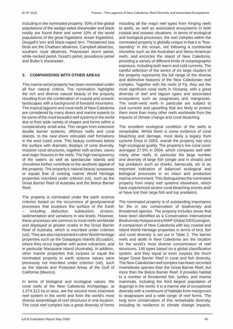
IUCN Evaluation Report May 2008 45
ID Nº 1115 France - The Lagoons of New Caledonia: Reef Diversity and Associated Ecosystems
including in the nominated property: 50% of the global populations of the wedge-tailed shearwater and black noddy are found there and some 10% of the world populations of the great frigatebird, lesser frigatebird, Dougall’s tern and black-naped tern. Threatened sea birds are the Chatham albatross, Campbell albatross, southern royal albatross, Polynesian storm petrel, white-necked petrel, Gould’s petrel, providence petrel and Buller’s shearwater.
3. COMPARISONS WITH OTHER AREAS
This marine serial property has been nominated under all four natural criteria. The nomination highlights the rich and diverse natural beauty of the property resulting from the combination of coastal and oceanic landscapes with a background of forested mountains. The tropical lagoons and coral reefs of New Caledonia are considered by many divers and marine experts to be some of the most beautiful reef systems in the world due to their wide variety of shapes and forms within a comparatively small area. This ranges from extensive double barrier systems, offshore reefs and coral islands, to the near-shore reticulate reef formations in the west coast zone. This beauty continues below the surface with dramatic displays of coral diversity, massive coral structures, together with arches, caves and major fi ssures in the reefs. The high transparency of the waters as well as spectacular islands and shorelines further contribute to the aesthetic appeal of the property. The property’s natural beauty surpasses or equals that of existing marine World Heritage properties inscribed under criterion (vii), such as the Great Barrier Reef of Australia and the Belize Barrier Reef.
The property is nominated under the earth science criterion based on the occurrence of geodynamical processes that sculpture the surface of the Earth – including obduction, subduction, erosion, sedimentation and variations in sea levels. However, these processes are common to most reefs worldwide and displayed at greater scales in the Great Barrier Reef of Australia, which is inscribed under criterion (viii). They are also represented in other World Heritage properties such as the Galapagos Islands (Ecuador), where they occur together with active volcanism, and in particular Macquarie Island (Australia). In addition, other marine properties that surpass or equal the nominated property in earth science values were previously not inscribed under criterion (viii), such as the Islands and Protected Areas of the Gulf of California (Mexico).
In terms of biological and ecological values, the coral reefs of the New Caledonia Archipelago, at 1,574,313 ha in area, are the second most extensive reef system in the world and form the world’s most diverse assemblage of reef structures in one location. The coral reef complex has a great diversity of forms
including all the major reef types from fringing reefs to atolls, as well as associated ecosystems in both coastal and oceanic situations. In terms of ecological and biological processes, the reef complex within the nominated property is globally unique in that it is “free-standing” in the ocean, not following a continental shoreline such as the Australian and Meso-American reefs, and encircles the island of New Caledonia, providing a variety of different kinds of oceanographic exposure, including both warm and cold currents. The careful selection of the series of six large clusters of the property represents the full range of the diverse and distinctive features of the New Caledonian reef complex. Together with the reefs of Fiji, they are the most signifi cant coral reefs in Oceania, with a great diversity of reef and lagoon types and associated ecosystems such as seagrasses and mangroves. The south-west reefs in particular are subject to cool currents and upwelling that are likely to protect them more than many other reefs worldwide from the impacts of climate change and coral bleaching.
The excellent ecological condition of the reefs is remarkable. Whilst there is some evidence of coral bleaching and damage, most likely a legacy from cyclone Erica in 2003, overall the property has very high ecological quality. The property’s live coral cover averaged 27.5% in 2004, which compares well with many other reefs. In particular the large number and diversity of large fi sh (single and in shoals) and top predators such as sharks, barracuda, etc is an important indication of balanced ecological and biological processes in an intact and productive marine environment. This distinguishes the nominated property from many reef systems elsewhere, which have experienced severe coral bleaching events and/or have lost their large fi sh and top predators.
The nominated property is of outstanding importance for the in situ conservation of biodiversity and threatened species. The property includes areas that have been identifi ed as a Conservation International Biodiversity Hotspot and a WWF Global 200 Ecoregion. A comparison of New Caledonia with key coastal and island World Heritage properties in terms of bird, fi sh and coral diversity is set out in Table 2. The barrier reefs and atolls in New Caledonia are the location for the world’s most diverse concentration of reef structures, 146 types based on a global classifi cation system, and they equal or even surpass the much larger Great Barrier Reef in coral and fi sh diversity. The New Caledonian reef complex has fewer recorded invertebrate species than the Great Barrier Reef, but more than the Belize Barrier Reef. It provides habitat to a number of threatened fi sh, turtles, and marine mammals, including the third largest population of dugongs in the world. It is a marine site of exceptional diversity with a continuum of habitats from mangroves to seagrasses and a wide range of reef forms. The long term conservation of this remarkable diversity, including its resilience to climate change impacts,
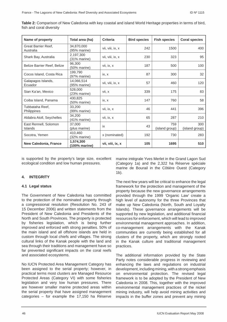
46 IUCN Evaluation Report May 2008
France - The Lagoons of New Caledonia: Reef Diversity and Associated Ecosystems ID Nº 1115
is supported by the property’s large size, excellent ecological condition and low human pressures.
4. INTEGRITY
4.1 Legal status
The Government of New Caledonia has committed to the protection of the nominated property through a congressional resolution (Resolution No. 243 of 15 December 2006) and written statements from the President of New Caledonia and Presidents of the North and South Provinces. The property is protected by fi sheries legislation, which is being further improved and enforced with strong penalties. 50% of the main island and all offshore islands are held in custom through local chiefs and villages. The strong cultural links of the Kanak people with the land and sea through their traditions and management have so far prevented signifi cant impacts on the coral reefs and associated ecosystems.
No IUCN Protected Area Management Category has been assigned to the serial property; however, in practical terms most clusters are Managed Resource Protected Areas (Category VI) with some fi sheries legislation and very low human pressures. There are however smaller marine protected areas within the serial property that have assigned management categories – for example the 17,150 ha Réserve
Table 2: Comparison of New Caledonia with key coastal and island World Heritage properties in terms of bird, fi sh and coral diversity
Name of property Total area (ha) Criteria Bird species Fish species Coral species
Great Barrier Reef, Australia
34,870,000(95% marine) vii, viii, ix, x 242 1500 400
Shark Bay, Australia 2,197,300(31% marine) vii, viii, ix, x 230 323 95
Belize Barrier Reef, Belize 96,300(50% marine) vii, ix, x 187 500 100
Cocos Island, Costa Rica 199,790(97% marine) ix, x 87 300 32
Galapagos Islands, Ecuador
14,066,514(95% marine) vii, viii, ix, x 57 460 120
Sian Ka’an, Mexico 528,000(23% marine) vii, x 339 175 83
Coiba Island, Panama 430,825(50% marine) ix, x 147 760 58
Tubbataha Reef, Philippines
33,200(99% marine) vii, ix, x 46 441 396
Aldabra Atoll, Seychelles 34,200(41% marine) vii, ix, x 65 287 210
East Rennell, Solomon Islands
37,000(plus marine) ix 43 759
(island group)300
(island group)
Socotra, Yemen 410,460(32% marine) x (nominated) 192 730 283
New Caledonia, France 1,574,300(100% marine) vii, viii, ix, x 105 1695 510
marine intégrale Yves Merlet in the Grand Lagon Sud (Category 1a) and the 2,322 ha Réserve spéciale marine de Bourail in the Côtière Ouest (Category 1b).
The next few years will be critical to enhance the legal framework for the protection and management of the property because the new governance arrangements provided through the 1999 ‘Organic Law’ create a high level of autonomy for the three Provinces that make up New Caledonia (North, South and Loyalty Islands). These governance arrangements will be supported by new legislation, and additional fi nancial resources for enforcement, which will lead to improved environmental management approaches. In addition, co-management arrangements with the Kanak communities are currently being established for all clusters of the property, which are strongly rooted in the Kanak culture and traditional management practices.
The additional information provided by the State Party notes considerable progress in reviewing and enhancing the laws and regulations on industrial development, including mining, with a strong emphasis on environmental protection. The revised legal framework is to be adopted by the President of New Caledonia in 2008. This, together with the improved environmental management practices of the nickel mining industry, will help avoid mining activities and impacts in the buffer zones and prevent any mining

IUCN Evaluation Report May 2008 47
ID Nº 1115 France - The Lagoons of New Caledonia: Reef Diversity and Associated Ecosystems
impacts on the core areas.
4.2 Boundaries
The boundaries of the serial property are well set out in the nomination, can be readily recognised, and are understood and supported by the local communities. The general rationale for boundary delineation is the 100 fathom line at sea, and the highest foreshore and the intersection of mangroves for transversal limits on land. The property includes all the key areas that are essential for maintaining its natural beauty and the long term conservation of its remarkable reef diversity, and the individual clusters are of suffi cient size to maintain the natural processes necessary for the long-term ecological viability of the property’s coral reefs and associated ecosystems.
However, following discussions with the State Party during the fi eld visit, IUCN proposed changes to the boundaries of the core zone and buffer zones of the Grand Lagon Sud. IUCN recommended including the Réserve de l’aiguille de Prony as a core area in the Grand Lagon Sud cluster, as it protects unique hydrothermal vents in very shallow waters, and extending the marine and terrestrial buffer zones of the Grand Lagon Sud to the main island. The State Party accepted these proposed changes and provided in its additional information a revised map showing these changes (see Map 3 annexed to this report). IUCN thus considers that the boundaries of the core areas and buffer zones are suffi cient to maintain the values and integrity of the property.
4.3 Management
The nominated property is managed by the three Provinces (North, South and Loyalty Islands) and the Government for the Atolls d’Entrecasteaux in the far north. All offshore islands and 50% of the main island are held in custom through local chiefs and villages, with individual land ownership on the main island most prevalent in the south around the capital of Nouméa. An overall management framework for the nominated property has been developed and agreed by the Federal and Provincial Governments. This framework was developed through a participatory process and with full involvement of local stakeholders and respect of customary rights. The implementation of the management framework is supported by specifi c legislation on fi sheries, land/water use planning, urban development and mining. Legislation on fi sheries and mining are currently being reviewed to strengthen their environmental components. The overall management framework will be complemented by specifi c management plans for each of the six clusters of the property which are under preparation with full involvement of local stakeholders and respect of customary rights.
Seventy staff support management and conservation
activities in the core areas. The operational budget for the nominated property is about € 1.1 million/year (US$ 1,702,668). Additional support is available from the Institute for Research and Development, the University of New Caledonia, the South Pacifi c Community, the Centre for the Environment, L’Aquarium des Lagons, Operation Whale, WWF and regional organisations. Over a fi ve year period € 548,890 (US$ 849,616) will be contributed by CRISP, IFRECOR, PROE and WWF. BirdLife International and Conservation International are presently fundraising to obtain additional support for the nominated property.
State support for surveillance of the property is provided by the army (Gendarmerie and navy). The Gendarmerie has at its disposal 20 vessels including 2 ships, 1 boat, and 17 smaller vessels for the small units spread over the territory. The navy has two patrol ships and a smaller vessel. Three vessels are available for monitoring and research, and a further boat is being built. Surveillance is also supported by local communities through customary means.
4.4 Threats and human use
Human population density is low in New Caledonia, with around 74% of the 250,000-300,000 inhabitants living in the Nouméa region, resulting in low pressures on the coral reefs and associated ecosystems. There are however a number of existing and potential threats to the values and integrity of the property that need careful monitoring and management.
Mining
Direct and indirect impact from mining is by far the most signifi cant threat to the nominated property. New Caledonia has a long history of nickel mining and this industry is the major employer and source of revenue. Past mining has scarred the landscape and left a legacy of signifi cant environmental degradation. However, the industry is currently undergoing considerable change in both legislation and environmental management practices. The nominated property includes core areas that have not been impacted by mining and have adjacent watersheds with minimal mining activity. The priority management issue is to avoid mining activities and impacts in the buffer zones and to prevent any mining impacts on the core areas.
As part of the transformation underway in New Caledonia, new mining legislation is being drafted to strengthen the environmental component and establish strict environmental standards. The new legislation, which should come into force in 2008, will include comprehensive laws and regulations for mining activities, including post mining rehabilitation requirements and a sliding scale of penalties on the industry if they fail to comply. Thus, overall management of mining will be radically improved, and current schemes are already required to meet the new

48 IUCN Evaluation Report May 2008
France - The Lagoons of New Caledonia: Reef Diversity and Associated Ecosystems ID Nº 1115
standards in advance of the new legislation coming into force. Major companies like SLN Nickel and Goro Nickel are already promoting more environmentally friendly approaches based on new technologies to extract the mineral.
A major development by Goro Nickel is underway adjacent to the Grand Lagon Sud cluster. This proposal is at public enquiry stage with fi nal permits yet to be signed. To conserve the values and integrity of the nominated property, this development project will need to ensure that the warm water discharge and its chemical composition into the Canal de Havannah do not affect the fragile coastal and marine ecosystems associated to this area. In the north, further major expansion of mining activities will occur with potential impacts on the Zone Côtière Nord et Est. SLN Nickel has expressed interest to exploit licences in future, some within the buffer zone of the Grand Lagon Nord. However, it is important to note that in New Caledonia a licence in itself does not entitle the licence holder to exploit mineral reserves, but merely to ask for the permission to exploit.
The additional information provided by the State Party confi rms the position of the President of New Caledonia and the Presidents of the North and South Provinces, that no mining activities will be permitted which impact on the values and integrity of the nominated property. Given the new legislation and written statements from the Presidents, mining is not considered an imminent threat to the nominated property at this point in time, but remains a high risk. Therefore, IUCN considers a follow-up mission is required in 2010 to assess the implementation of the new mining legislation and the environmental performance and impact of mining activities.
Fishing
Fishing pressure on the coral reefs and associated ecosystems in the nominated property is low and generally seen to not be having signifi cant impacts on the quality of the resource at the moment – although some species are considered to perhaps be less numerous than a few years back. Professional fi shers exist in very low numbers. It is unclear what additional pressure illegal or unreported fi shing is having on the fi sh stocks, but the presence of a large number and diversity of large fi sh, including top predators, indicates that fi shing pressure is generally low. The additional information provided by the State Party notes that fi sheries legislation has already been reviewed and enhanced in the North Province and is in the process of review in the South Province, with enhanced legislation to be adopted in 2008. It is also proposed to prohibit fi shing of the napoleon wrasse in 2008 as this species, as all other herbivorous fi sh species, is important in the face of climate change to maintain reef health and ensure the most rapid recovery from bleaching events. IUCN therefore
recommends that full protection should also be given to all other herbivorous fi sh species.
Tourism
New Caledonia is relatively isolated in the Pacifi c and outside the capital of Nouméa, is expensive to visit and has very limited tourist facilities. This has so far prevented the development of mass tourism. Tourism is currently small scale with about 170,000 tourists per each year. However, some confl icts are already occurring, notably in relation to whale watching in the Grand Lagon Sud. Other risks arise from the increasing number of visiting cruise ships, which require careful planning and management. A recent study recommended that New Caledonia should aim for a small-scale ecotourism market, but opening up the Grand Lagon Sud to increasing tourist pressure remains a high risk given its adjacent location to Nouméa. Tourism is likely to increase in the future and needs to be well planned and managed.
Aquaculture
Aquaculture in New Caledonia is geographically constrained to the west coast due to a lack of suitable coastal areas elsewhere. As a result mass expansion of the industry is unlikely. It is subsidised by the Government and represents the second largest export industry after nickel mining. However, so far it is small scale and low intensity, with shrimp farms located behind the mangroves, and has minimal impacts on the coral reefs and associated ecosystems. As reef resilience to climate change impacts decreases with increasing nutrient loads from aquaculture (and agriculture), careful monitoring and management of this industry is required.
Climate change
Climate change impacts on the nominated property include a rise in sea temperature and sea level, ocean acidifi cation, and possibly an increased intensity and frequency of cyclones. The latter is of concern given that in 2003 cyclone Erica destroyed 10-80% of live coral cover. Coral bleaching is also a severe threat given that the reefs suffered bleaching events in 1997, 2000 and 2002. Recent studies show that reefs with intact populations of herbivores (especially fi sh) may recover up to fi ve times faster from coral bleaching than those where these species have been fi shed out. A key management issue will therefore be to rigorously protect the herbivorous fi sh biomass on the reefs to maintain reef resilience. Strong and proactive fi sheries management is required to achieve this.
In summary IUCN considers that the property meets the necessary conditions of integrity as set out in the Operational Guidelines. However, in light of the rapidly evolving nature of the governance and legislative framework for New Caledonia and

IUCN Evaluation Report May 2008 49
ID Nº 1115 France - The Lagoons of New Caledonia: Reef Diversity and Associated Ecosystems
the potentially high risk of mining impacts, IUCN recommends that a mission to the property be invited by the State Party in 2010 to assess progress with the implementation of community-based management plans, the enforcement of newly adopted fi sheries regulations and the environmental performance and impact of mining activities in the buffer zones of the serial property.
5. ADDITIONAL COMMENTS
5.1 Justifi cation for serial approach
When IUCN evaluates a serial nomination it asks the following questions:
a) What is the justifi cation for the serial approach?
The nominated property contains representative examples of the highest diversity of coral reef formations and associated habitats and species within a given area in the world. The serial approach is justifi ed by the rationale of scientifi cally selecting representative areas that contain the main diversity of coral reefs and associated ecosystems, are intact and have adjacent watersheds with minimal mining activity. The selection of the present series of six large clusters thus provides the greatest opportunity to maintain the values and integrity of the nominated property.
b) Are the separate components of the property functionally linked?
The six marine clusters of the serial property are part of the larger reef and lagoon system that surrounds New Caledonia. As part of the overall reef system, the clusters are linked by the oceanographic conditions around the archipelago. More specifi c functional links include the seasonal movements of fi sh species between the different clusters and the movements of humpback whales between the north and south lagoons. Other large vertebrates such as dugongs are also thought to display some movement between the clusters, but this is less well documented.
c) Is there an overall management framework for all the components?
An overall management framework has been developed and implemented in all the core areas of the serial property. A full participatory management approach was used to develop this management framework. Priorities for conservation and sustainable development activities, identifi ed through community planning processes, are guiding the implementation process.
IUCN concludes that the serial approach put forward
is justifi ed in this case.
5.2 Cultural values
Although this nomination is focused on natural values, IUCN notes the important cultural values that are strongly associated with the nominated property. The strong cultural links of the Kanak people with the land and sea and their traditional management of natural resources have maintained the good quality of marine resources. These strong cultural links and their importance for safeguarding the values and integrity of the nominated property merit special mention.
6. APPLICATION OF CRITERIA
The property has been nominated under all four natural criteria. IUCN considers that the nominated property meets criteria (vii), (ix) and (x) based on the following assessment:
Criterion (vii): Superlative natural phenomena or natural beauty
The tropical lagoons and coral reefs of New Caledonia are considered to be some of the most beautiful reef systems in the world due to their wide variety of shapes and forms within a comparatively small area. This ranges from extensive double barrier systems, offshore reefs and coral islands, to the near-shore reticulate reef formations in the west coast zone. The richness and diversity of landscapes and coastal backdrops gives a distinctive aesthetic appeal of exceptional quality. This beauty continues below the surface with dramatic displays of coral diversity, massive coral structures, together with arches, caves and major fi ssures in the reefs.
IUCN considers the nominated property meets this criterion.
Criterion (ix): Ecological and biological processes
The reef complex within this serial property is globally unique in that it is “free-standing” in the ocean and encircles the island of New Caledonia, providing a variety of different kinds of oceanographic exposure, including both warm and cold currents. The coral reef complex has a great diversity of forms including all the major reef types from fringing reefs to atolls, as well as associated ecosystems in both coastal and oceanic situations. Extending over important oceanic gradients, it is one of the planet’s best examples of the ecological and biological processes underlying tropical lagoon and coral reef ecosystems, themselves one of the most ancient and complex ecosystem types.
IUCN considers the nominated property meets this criterion.

50 IUCN Evaluation Report May 2008
France - The Lagoons of New Caledonia: Reef Diversity and Associated Ecosystems ID Nº 1115
Criterion (x): Biodiversity and threatened species
The property is a marine site of exceptional diversity with a continuum of habitats from mangroves to seagrasses and a wide range of reef forms. The barrier reefs and atolls in New Caledonia form one of the three most extensive reef systems in the world, and together with the reefs of Fiji, are the most signifi cant coral reefs in Oceania. They are the location for the world’s most diverse concentration of reef structures, 146 types based on a global classifi cation system, and they equal or even surpass the much larger Great Barrier Reef in coral and fi sh diversity. They provide habitat to a number of threatened fi sh, turtles, and marine mammals, including the third largest population of dugongs in the world.
IUCN considers the nominated property meets this criterion.
IUCN considers, however, that the nominated property does not meet criterion (viii) based on the following assessment:
Criterion (viii): Earth’s history, geological and geomorphic features and processes
The property is nominated under the earth science criterion based on the occurrence of geodynamical processes that sculpture the surface of the Earth – including obduction, subduction, erosion, sedimentation and variations in sea levels. However, these processes are common to most reefs worldwide and displayed at greater scales in the Great Barrier Reef of Australia, which is inscribed under criterion (viii). They are also represented in other World Heritage properties such as the Galapagos Islands (Ecuador), where they occur together with active volcanism, and in particular Macquarie Island (Australia). In addition, other marine properties that surpass or equal the nominated property in earth science values were previously not inscribed under criterion (viii), such as the Islands and Protected Areas of the Gulf of California (Mexico).
IUCN considers the nominated property does not meet this criterion.
7. RECOMMENDATIONS AND STATEMENT OF OUTSTANDING UNIVERSAL VALUE
IUCN recommends that the World Heritage Committee adopt the following decision:
The World Heritage Committee,
1. Having examined Documents WHC-08/32.COM/8B and WHC-08/32.COM/INF.8B2,
2. Inscribes The Lagoons of New Caledonia:
Reef Diversity and Associated Ecosystems, France, on the World Heritage List on the basis of criteria (vii), (ix) and (x);
3. Adopts the following Statement of Outstanding Universal Value:
Values The tropical lagoons and coral reefs of New
Caledonia are an outstanding example of high diversity coral reef ecosystems and form one of the three most extensive reef systems in the world. They are the location for the world’s most diverse concentration of reef structures, with an exceptional diversity of coral and fi sh species and a continuum of habitats from mangroves to seagrasses and a wide range of reef forms, extending over important oceanic gradients. They still display intact ecosystems, with healthy populations of top predators, and a large number and diversity of large fi sh. They are of exceptional natural beauty, and contain diverse reefs of varying age from living reefs through to ancient fossil reefs, providing an important source of information on the natural history of Oceania.
Criterion (vii) – Superlative natural phenomena or natural beauty: The tropical lagoons and coral reefs of New Caledonia are considered to be some of the most beautiful reef systems in the world due to their wide variety of shapes and forms within a comparatively small area. This ranges from extensive double barrier systems, offshore reefs and coral islands, to the near-shore reticulate reef formations in the west coast zone. The richness and diversity of landscapes and coastal backdrops gives a distinctive aesthetic appeal of exceptional quality. This beauty continues below the surface with dramatic displays of coral diversity, massive coral structures, together with arches, caves and major fi ssures in the reefs.
Criterion (ix) – Ongoing biological and ecological processes: The reef complex within this serial property is globally unique in that it is “free-standing” in the ocean and encircles the island of New Caledonia, providing a variety of different kinds of oceanographic exposure, including both warm and cold currents. The coral reef complex has a great diversity of forms including all the major reef types from fringing reefs to atolls, as well as associated ecosystems in both coastal and oceanic situations. Extending over important oceanic gradients, it is one of the planet’s best examples of the ecological and biological processes underlying tropical lagoon and coral reef ecosystems, themselves one of the most ancient and complex ecosystem types.
Criterion (x) – Biological diversity and threatened species: The property is a marine site of exceptional diversity with a continuum of habitats

IUCN Evaluation Report May 2008 51
ID Nº 1115 France - The Lagoons of New Caledonia: Reef Diversity and Associated Ecosystems
from mangroves to seagrasses and a wide range of reef forms. The barrier reefs and atolls in New Caledonia form one of the three most extensive reef systems in the world, and together with the reefs of Fiji, are the most signifi cant coral reefs in Oceania. They are the location for the world’s most diverse concentration of reef structures, 146 types based on a global classifi cation system, and they equal or even surpass the much larger Great Barrier Reef in coral and fi sh diversity. They provide habitat to a number of threatened fi sh, turtles, and marine mammals, including the third largest population of dugongs in the world.
Integrity The serial property comprises six marine clusters
which are also protected by marine and terrestrial buffer zones that are not part of the inscribed property. It includes all the key areas that are essential for maintaining its natural beauty and the long term conservation of its remarkable reef diversity, and it is of suffi cient size to maintain associated biological and ecological processes. The property still displays intact ecosystems with top predators, and a large number and diversity of large fi sh.
Requirements for Protection and Management
The property is currently protected by fi sheries legislation, which is being further improved, and co-management arrangements with the Kanak communities are currently being established for all clusters. Management plans are currently being prepared for all clusters with full involvement of stakeholders. Continued efforts to protect and manage the property and its surroundings are required to maintain the present intactness of the coral reef ecosystems. Protecting and managing large areas in the form of no-take zones and proactive management of water quality and fi sheries regulations will help maintain reef resilience in the face of climate change. Enhanced surveillance and monitoring are required to address potential impacts from fi shing and mining and, to a lesser extent, from agriculture and aquaculture. Tourism is likely to increase in the future and needs to be well planned and managed. Sustainable fi nancing strategies are required to ensure the necessary equipment, human and fi nancial resources for the long term management of the property.
4. Commends the State Party, and especially the North and South Provinces and the Kanak community of New Caledonia, for their outstanding work towards establishing community-based management plans using traditional knowledge and good practices in land and sea management, backed by regulatory controls as well as for their strong commitment in establishing a regulatory
framework for mining activities outside the property aiming to avoid negative environmental impacts on the property;
5. Requests the State Party to address the following points for effective protection and management of the property:
a) Develop and implement, as part of proposed co-management arrangements, an action plan for enhancing surveillance and monitoring which should involve actions and support from the State, Government, Provinces and local communities, and to allocate adequate equipment, human and fi nancial resources for its effective implementation;
b) Ensure that the management planning process consider the effective implementation of actions to maintain reef resilience, including strong proactive management of water quality and fi sheries regulations. Full protection should be given, in particular, to all herbivorous fi sh species as these species are critical in the face of climate change to maintain reef health and ensure the most rapid recovery from bleaching events; and
c) Develop and implement a zoning scheme for the property to ensure that regulations are made easy to understand for sea users and that large areas are managed for reef resilience in the form of no-take zones, appropriately linked to existing marine protected areas and traditional Kanak taboo areas;
6. Further requests the State Party, in light of the rapidly evolving nature of the governance and legislative framework for New Caledonia, to invite a mission to the property in 2010 to assess progress with the implementation of community-based management plans, the enforcement of newly adopted fi sheries regulations and the environmental performance and impact of mining activities in the buffer zones of the serial property.
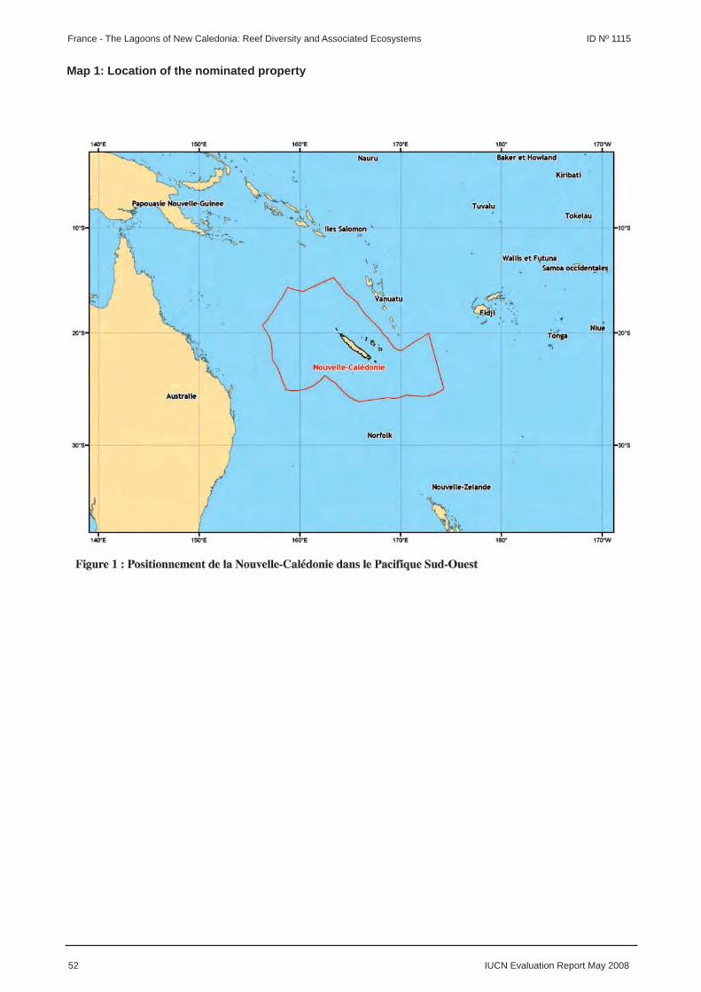
52 IUCN Evaluation Report May 2008
France - The Lagoons of New Caledonia: Reef Diversity and Associated Ecosystems ID Nº 1115
Map 1: Location of the nominated property

IUCN Evaluation Report May 2008 53
ID Nº 1115 France - The Lagoons of New Caledonia: Reef Diversity and Associated Ecosystems
Map 2: Boundaries of the nominated property

54 IUCN Evaluation Report May 2008
France - The Lagoons of New Caledonia: Reef Diversity and Associated Ecosystems ID Nº 1115
Map 3: Revised boundaries of the Grand Lagon Sud

EUROPE / NORTH AMERICA
SURTSEY
ICELAND
IUCN Evaluation Report May 2008 55
WORLD HERITAGE NOMINATION – IUCN TECHNICAL EVALUATION
SURTSEY (ICELAND) – ID No. 1267
1. DOCUMENTATION
i) Date nomination received by IUCN: April 2007
ii) Additional information offi cially requested from and provided by the State Party: IUCN requested supplementary information on 7 August 2007 before the fi eld visit, on 31 August 2007 after the fi eld visit and on 19 December 2007 after the fi rst IUCN World Heritage Panel meeting. The fi rst State Party response was offi cially received by the World Heritage Centre on 5 December 2007, followed by one letter from the State Party to IUCN dated 26 February 2008.
iii) UNEP-WCMC Data Sheet: 11 references (including nomination document)
iv) Additional literature consulted: Dingwall, P., Weighell, T. and Badman, T. (2005) Geological World Heritage: A Global Framework Strategy. IUCN, Gland, Switzerland; New, T. (ed.) (2007) Island Colonisation: The Origin and Development of Island Communities. Cambridge University Press, 302 p.; Thorarinsson, S. (1967) Surtsey: The New Island in the North Atlantic. Viking Press Inc., New York, 115 p.; Thornton, I.W.B. (2000) The ecology of volcanoes: recovery and reassembly of living communities. In: Sigurdsson, H. (ed.) Encyclopedia of Volcanoes. Published by Academic Press, New York, pp.1057-1081; Vespermann, D. and Schmincke, H.-U. (2000) Scoria cones and tuff rings. In: Sigurdsson, H. (ed.) Encyclopedia of Volcanoes. Published by Academic Press, New York, pp.683-694; White, J.D.L. and Houghton, B.F. (2000) Surtseyan and related phreatomagmatic eruptions. In: Sigurdsson, H. (ed.) Encyclopedia of Volcanoes. Published by Academic Press, New York, pp.495-511.
v) Consultations: 12 external reviewers. Extensive consultations were undertaken during the fi eld visit with: the Icelandic Minister and the Secretary General of the Ministry of the Environment, other staff from the Nature Conservation Division of that Ministry and from the Environment and Food Agency and the Ministry of Education, Sciences and Culture; the Mayor of Vestmannaeyjar municipality and local stakeholders; and scientists from the Surtsey Research Society, the Icelandic Institute of Natural History and the Marine Research Institute.
vi) Field visit: Chris Wood, August 2007
vii) Date of IUCN approval of this report: April 2008
2. SUMMARY OF NATURAL VALUES
Surtsey is a volcanic island located in the North Atlantic, approximately 32 km from the south coast of Iceland. It is the newest and second largest island in the Vestmannaeyjar Archipelago, which is one of 44 volcanic systems that have been active in Iceland during the last 11,500 years. The island of Surtsey represents the top of the Surtsey Volcano, which forms a submarine ridge approximately 5.8 km long and up to 2.9 km wide. Surtsey was active between 1963 and 1967. By the end of the eruption, the island had a surface area of 265 ha and the total volume of erupted material was estimated to be 1.1 km³. The shape and size of the island has changed considerably since 1967 due to marine erosion and
deposition, and Surtsey now has a surface area of 141 ha and dimensions of 1.33 km W-E and 1.8 km N-S. The highest point of the island is 155 m above sea level, and the volcano rises 285 m above the ocean fl oor.
Iceland is volcanically active because it sits astride the Mid-Atlantic Ridge (MAR), one of the world’s most active tectonic boundaries, marking the line of separation of the North American and Eurasian crustal plates. The boundary crosses Iceland from the south-west to the north-east, but its southern part has two branches, the western volcanic zone coinciding with the Reykjanes peninsula, and the eastern volcanic zone traversing the middle-south of the island. Topographically the boundary is represented

56 IUCN Evaluation Report May 2008
Iceland - Surtsey ID Nº 1267
by a shallow rift, refl ecting tectonic forces which are pulling Iceland apart at a rate of about 2 cm per year. The Vestmannaeyjar volcanic system is located at the southern end of the eastern volcanic zone.
Surtsey has scientifi c importance because of the detailed records that were kept of the eruption, of the island’s subsequent modifi cations by later geological and geomorphic processes, and of its ongoing colonisation by plants and animals. It is notable as the reference site for colonisation of isolated, sterile ground, continuing ecological and biological development of coastal and marine ecosystems, the dispersion and succession of plants, the colonisation by animals and the interactions between the two. It also gives its name to a particular style of phreatomagmatic eruption (‘Surtseyan’), a term now adopted by the international geological community.
Monitoring of the colonisation of the island by plants and animals started in 1964. The fi rst pioneers were seeds carried by ocean currents. Icelandic scientists have identifi ed distinct stages in the slow colonisation of the island. From 1965-1974 the barren lava and tephra deposits were colonised by coastal species adapted to nutrient poor soils and harsh conditions. Moulds, bacteria and fungi were the fi rst life recorded, followed in 1965 by the fi rst vascular plant, sea rocket Cakile arctica. By the end of the fi rst decade 12 species of vascular plants had been recorded, 10 of which became established. From 1975-84, several new plant species were discovered, but only one became established. The period 1985-94 saw a further increase in colonists, largely linked to the development of a seagull colony near the south end of the island, where the soils were enriched with guano. Vigorous vegetation succession and improved survival occurred around the colony. By 2004, a total of 60 vascular plants had been recorded, together with 75 bryophytes, 71 lichens and 24 fungi, within four different vegetation communities.
To date 89 species of birds have been recorded on Surtsey (45 seabirds, 44 land birds), of which 12 have bred on the island and 2 have nested. 57 of these bird species breed elsewhere in Iceland, the rest are winter visitors, migrants and vagrants, mainly from Europe. There are also records of 335 species of invertebrates, of which 174 arrived in the fi rst ten years, and many were contributed subsequently by the seagull colony. A point of reference in the developing ecology of Surtsey has been the success of the snow bunting, an insect eater, and the fi rst land bird to breed on the island.
Monitoring of the marine life around Surtsey also began in 1964. Along the shore algae have 60% coverage, but other species are restricted due to the harsh conditions. To date the rocky littoral and hard-bottom sub-littoral zones have revealed 80 species of macroalgae mostly at depths up to 15 m, and 180
benthic animal species mostly below 15 m depth. With respect to mammals, grey seals began breeding in 1983, and it is considered that common seals may also breed on the island. Killer whales (in pods of 3-70 animals), minke whales, harbour porpoises and dolphins are all regularly seen offshore.
3. COMPARISONS WITH OTHER AREAS
There are currently 34 World Heritage properties with evidence of ancient or contemporary (Holocene) volcanism. 20 of these properties contain or are on small islands, of which 10 have been inscribed for their geological values, while the others have been inscribed for their biological or cultural values. IUCN is currently in the process of developing a theme study on volcanoes and volcanic landscapes in response to the need for further guidance in view of the relatively large number of volcanic World Heritage properties.
Surtsey is a monogenetic basaltic volcano that, if it erupted on dry land, would probably have formed a small lava shield surmounted by a scoria (clinker) cone, the most common type of volcanic cone on land. However, because Surtsey formed initially under water, interaction between the magma and the seawater caused the production and explosive expansion of steam, producing a mildly ‘phreatomagmatic’ or ‘hydromagmatic’ eruption and a tephra cone. The 1963-67 eruption of Surtsey is important because it drew the attention of the scientifi c community to the explosive infl uence of water on the eruption style of otherwise effusive or only mildly explosive eruptions. While other volcanoes in the world are now closely monitored by staff of volcano observatories (e.g., Asama Volcano Observatory, Hawaii Volcano Observatory and Montserrat Volcano Observatory), in all these cases monitoring is primarily focussed on understanding the hazards posed by an existing (large-scale, long-lived) volcano, and none has tracked the evolution of a volcano from its birth. The only other documented record of the birth of a new volcano is of the 1943-52 eruption of Paricutin, Mexico. In general, there are however many examples of volcanoes of different classes and styles which have and are being closely studied.
The eruption style of Surtsey is known internationally as ‘Surtseyan’ type; however, this is known to be just one style of phreatomagmatic eruptions, which differ in intensity, depending on their geotectonic location and magma chemistry. The type of composite structure that the Surtsey eruption built is known as a tuya, comparable with the table mountains of Iceland and British Columbia, Canada, which are thought to have been built by eruptions from beneath the Pleistocene ice sheet. At the world scale, there are many other Surtseyan-type tephra cones in the geological record, but the eruption sequence, lithology and stratigraphy of the volcanic sediments of only a handful of these

IUCN Evaluation Report May 2008 57
ID Nº 1267 Iceland - Surtsey
has been examined and compared in any detail (for example, tuff cones and rings such as Seongsan Ilchulbong and Songaksan in the littoral zone of Jeju Island, Korea, or along the west coast of Lanzarote, Canary Islands, Spain). A global review of comparable recent phreatomagmatic eruptions observed in recent history notes 21 Surtseyan-related phreatomagmatic eruptions, of which six involved seawater although Surtsey is noted as the largest.
There have also been innumerable submarine eruptions which have built islands that were subsequently destroyed by the sea (e.g., previous eruptions off the Reykjanes Peninsula, Iceland, in 1211, 1422 and 1783; the 1831 eruption that formed the Graham Shoal, south of Sicily, Italy; and the 1969 eruption that formed the Metis Shoal, Tonga Islands), while there have been other submarine eruptions where the volcanic cone has not broken the surface of the sea (e.g., Kavachi, Solomon Islands; Kick’em Jenny, between Grenada and St Lucia; Loihi seamount, south of Hawaii Island; Fukutoku-Okanoba, near Izu Island, Japan). Nevertheless, none of these have been so meticulously observed and recorded as the Surtsey eruption, which remains a classic in the geological literature.
Beyond the above analysis, comparison with Surtsey is diffi cult because of questions of scientifi c defi nition, scale and poor information. Many of the larger island and/or volcanic World Heritage properties are composite structures, built over a long period of time, and may contain many different volcanic forms, including calderas, pit craters, rift zones, lava tubes caves, maars, scoria and tephra cones. In any description of a larger oceanic volcano (e.g., Fernandina, Galapagos; Kilauea, Hawaii; Las Cañadas, Tenerife), subsidiary tuff cones are not usually included, even though they are likely to be present in the littoral zone. The description of Jeju Island (Korea) is an exception, however, where Seongsan Ilchulbong represents one of 13 other littoral tuff cones or tuff rings.
Thus, although it has been particularly closely studied, it is clear that as a volcanic property Surtsey is certainly not unique and that properties with comparable geological values are widely distributed and are well represented on the World Heritage List. It is also noted that Surtsey is a small site (less than 2 km across) and is an ephemeral geological feature, whose extent has been reduced considerably by natural processes since the creation of the Island. It is anticipated that in 120 years only the palagonite core of the island will remain, i.e. about 30% of its current size.
Surtsey has a more distinctive signifi cance because the process of its biological colonisation has been closely monitored from its birth to the present day. This has not occurred so comprehensively on any other volcano in the world. Evidence from new sterile habitats such as lava and tephra deposits from emergent
volcanoes such as Surtsey have been particularly important in providing evidence of how new land is colonised by life. A global review of the development of new biotas on emergent volcanic islands describes just three cases, including Surtsey, as scientifi cally signifi cant. The other two being Motmot, Long Island, Papua New Guinea and Anak Krakatau, Indonesia - part of the Ujung Kulon National Park World Heritage property. Along with Surtsey, Anak Krakatau is the most intensely studied emergent volcanic island in the world. It was colonised by plants and animals, probably largely from the neighbouring older islands 1-3 km away, themselves in the process of recovery from the 1883 eruption. An initial biota was eradicated by eruptions in 1952-53, and newer colonisation has constantly been set back by repeated eruptions, including lavas from the 1960s onward. Lava now covers about half of the island. Renewed volcanic activity in the 1990s again set back the colonisation process and its monitoring for some years. However, the level of protection from human infl uence has not been as complete and consistent as that for Surtsey. Hence, Surtsey has been providing a unique scientifi c record of the process of colonisation of land by plants, animals and marine organisms. It provides the world with a pristine natural laboratory, free from human interference, and will continue to provide invaluable data on biological colonisation long into the future. No other area of emergent new and sterile land has been so well protected and monitored as a living laboratory.
In conclusion, IUCN considers that the natural values of Surtsey are certainly of international importance; however, the claim for Outstanding Universal Value is much stronger in relation to the demonstration of ecological and biological processes than in relation to the demonstration of volcanic values, which are already well represented on the World Heritage List.
4. INTEGRITY
4.1 Legal status
The nominated property is owned by the Icelandic State and is protected as a Nature Reserve under the Act No. 44/1999 on Nature Conservation. This superseded a previous Act No. 48/1956 on Nature Conservation, according to which Surtsey was gazetted on 19 May 1965, and a subsequently revised Act No. 47/1971 on Nature Conservation. The Municipality of Vestmannaeyjar is the planning authority for the area.
Surtsey falls within the IUCN Protected Area Management Category 1a (Strict Nature Reserve). In January 2006, the boundary of the Surtsey Nature Reserve was expanded to its current position and a revised Declaration of Surtsey Nature Reserve was issued in order to ensure protection of the entire

58 IUCN Evaluation Report May 2008
Iceland - Surtsey ID Nº 1267
Surtsey volcanic system above the surface of the sea and underwater, including the craters Jólnir, Syrtlingur and Surtla, together with a surrounding marine area. There are further restrictions in place in relation to fi shing and other resource use.
At the larger scale, a large part of the Vestmannaeyjar Archipelago, including Surtsey, is scheduled for protection in Iceland’s Nature Conservation Strategy 2004-2008. The reasons for including Vestmannaeyjar are its outstanding seabird populations, together with the archipelago’s landscape values and geomorphological features. In addition, the Municipal Plan for Vestmannaeyjar, principally the local development plan, confi rms the government’s intentions to protect the entire archipelago as a managed nature reserve, while allowing sustainable use of its resources.
4.2 Boundaries
The nominated property includes the whole island (141 ha) and a surrounding marine area (3,230 ha), together representing the strictly protected area of the Surtsey Nature Reserve, and these boundaries are clearly defi ned and understood. The remaining 3,190 ha of the Surtsey Nature Reserve provide a relatively small but functional marine buffer zone to the nominated property.
4.3 Management
From its creation, Surtsey has been strictly protected and the present state of management is excellent. The supervision of the nature reserve is the responsibility of the Environment and Food Agency through a six member advisory panel which includes representatives from the Agency, the Surtsey Research Society, the Icelandic Institute of Natural History, the Marine Research Institute, and the Municipality of Vestmannaeyjar. By special agreement of the Ministry of Environment, the Surtsey Research Society co-ordinates all research on the island and advises on other activities.
A draft Surtsey Nature Reserve Management Plan covering the period 2007-2017 has been produced and provides a long term vision for management of the Reserve, along with a series of detailed goals and objectives that include the necessary measures for integrated conservation, research, monitoring and interpretation. The Surtsey Research Society receives a small annual sum from the State and in kind support from a range of institutions, although its work is mostly voluntary.
The purpose of strictly prohibiting visits to Surtsey is to ensure that colonisation by plants and animals, biotic succession and the shaping of geological formations will be as natural as possible and that human disruption will be minimised. It is prohibited
to go ashore or dive by the island, to disturb natural features, introduce organisms, minerals and soils or leave waste on the island. Any planned construction on or extraction from the nominated property must have the approval of the Environment and Food Agency and Vestmannaeyjar Municipal Council, on advice from the Surtsey Research Society, although maintenance of the existing helicopter pad and the research society’s hut (Palsbaer) is permitted. In addition to these latter two structures, the only other man-made construction on the island is a concrete blockhouse which is the remains of an abandoned lighthouse on the summit of Austerbunki. There are plans to remove this from the island in the near future. In 2006, bottom-towed net fi shing was banned in the nominated property, although such fi shing is allowed in the buffer zone. Fishing with gill nets, lines and traps are not considered to be a threat and thus are allowed within the nominated property.
The Vestmannaeyjar community also has considerable interest in Surtsey, including as a part of its tourism development programme. Aerial sightseeing and boat tours are available, and Surtsey is also passed by cruise liners en route for Reykjavik. A new Surtsey visitor centre on Heimaey is planned for 2008 and will also provide a base for a new post of permanent Warden for the archipelago.
4.4 Threats and human use
Surtsey is a highly controlled, isolated environment and threats are very limited. Marine debris is an issue that is diffi cult to control; however, the principal threat is from a possible maritime pollution incident. The main sailing routes between Iceland and Europe pass in the vicinity of the Surtsey Nature Reserve, although larger ships do not usually come close to the island because of diffi cult sea conditions and limited water depth. The Surtsey Nature Reserve is included within the Icelandic contingency plan for oil pollution incidents and equipment to combat oil pollution is kept at the town of Vestmannaeyjar, with back-up in Reykjavik. By law, ship-wrecks on beaches must be removed by the owner and the Environment and Food Agency can order removal of sunken ships.
In summary IUCN considers that the property meets the necessary conditions of integrity as set out in the Operational Guidelines.
5. APPLICATION OF CRITERIA
The property has been nominated under criteria (viii) and (ix). IUCN considers that the nominated property meets criterion (ix) based on the following assessment:

IUCN Evaluation Report May 2008 59
ID Nº 1267 Iceland - Surtsey
Criterion (ix): Ecological and biological processes
Surtsey was born as a new volcanic island in 1963-67 and since that time has played a major role in studies of succession and colonisation. It has been the site of one of the few long term studies worldwide on primary succession, providing a unique scientifi c record of the process of colonisation of land by plants, animals and marine organisms. Not only is it geographically isolated, but it has been legally protected from its birth, providing the world with a pristine natural laboratory, free from human interference. Above all, because of its continuing protection, Surtsey will continue to provide invaluable data on biological colonisation long into the future.
IUCN considers the nominated property meets this criterion.
IUCN considers, however, that the nominated property does not meet criterion (viii) based on the following assessment:
Criterion (viii): Earth’s history, geological and geomorphic features and processes
Surtsey is a well known global volcanic site and is one of a small number of volcanoes that has been studied since its creation. However, it is an example of a common phenomenon and there are many comparable sites to Surtsey including properties already inscribed on the World Heritage List. It is also noted that Surtsey is a small site (less than 2 km across) and is an ephemeral geological feature, whose extent has been reduced considerably by natural processes since the creation of the island. It is anticipated that in 120 years only the palagonite core of the island will remain, i.e. about 30% of its current size. Thus its value as a volcanological site is primarily related to its history of study, and taken alone is not suffi cient to support a claim of Outstanding Universal Value.
IUCN considers the nominated property does not meet this criterion.
IUCN notes that, in relation to volcanic values, Iceland has a series of other important volcanic sites. Þingvellir is currently inscribed as a cultural property, but also has signifi cant volcanic values, and there are three other volcanic sites on Iceland’s Tentative List (Skaftafells, Myvatn-Laxa, and Herdubreidarlindar and Askja) that are located in the country’s neovolcanic zone and have associations with the Mid-Atlantic Ridge. IUCN notes that Surtsey might therefore provide an important element in a serial nomination of Icelandic volcanic sites which could be considered further in relation to the application of criterion (viii). Iceland has also been a leading country in the ongoing discussion of the potential for the development of a serial transnational nomination of sites representative
of the signifi cant values of the Mid-Atlantic Ridge, and the values of Surtsey and other Icelandic sites might also be further considered in this context.
6. RECOMMENDATIONS AND STATEMENT OF OUTSTANDING UNIVERSAL VALUE
IUCN recommends that the World Heritage Committee adopt the following decision:
The World Heritage Committee,
1. Having examined Documents WHC-08/32.COM/8B and WHC-08/32.COM/INF.8B2,
2. Inscribes Surtsey, Iceland, on the World Heritage List on the basis of criterion (ix);
3. Adopts the following Statement of Outstanding Universal Value:
ValuesSurtsey is a new island formed by volcanic eruptions in 1963-67. It has been legally protected from its birth and provides the world with a pristine natural laboratory. Free from human interference, Surtsey has produced long-term information on the colonisation process of new land by plant and animal life.
Criterion (ix) – Ongoing biological and ecological processes: Surtsey was born as a new volcanic island in 1963-67 and since that time has played a major role in studies of succession and colonisation. It has been the site of one of the few long term studies worldwide on primary succession, providing a unique scientifi c record of the process of colonisation of land by plants, animals and marine organisms. Not only is it geographically isolated, but it has been legally protected from its birth, providing the world with a pristine natural laboratory, free from human interference. Above all, because of its continuing protection, Surtsey will continue to provide invaluable data on biological colonisation long into the future.
IntegrityThe property includes the whole island and an adequate surrounding marine area, and thus all the areas that are essential for the long term conservation of the ecological processes on Surtsey. There is also a relatively small but functional marine buffer zone that is not part of the inscribed property. It is noted that part of the evolution of Surtsey is the process of coastal erosion which has already halved the area of the island and over time is predicted to remove another two thirds leaving only the most resistant core.
60 IUCN Evaluation Report May 2008
Iceland - Surtsey ID Nº 1267
Requirements for Protection and ManagementSurtsey is a highly controlled, isolated environment and so threats are very limited. The purpose of strictly prohibiting visits to Surtsey is to ensure that colonisation by plants and animals, biotic succession and the shaping of geological formations will be as natural as possible and that human disruption will be minimised. It is prohibited to go ashore or dive by the island, to disturb the natural features, introduce organisms, minerals and soils or leave waste on the island. Nearby construction is also strictly controlled. The most signifi cant management issue will be to retain the level of control and protection from human infl uence that has characterised the protective history of Surtsey. It is noted that, as an island ecosystem, there is the potential for human disturbance and pollution from a very wide area. Contingency planning, for example for oil spills, is required for the property and its wider surroundings. Given the lack of access a creative and positive approach to presenting the property will be required to ensure that visitors are able to appreciate, but not disturb, its values.
4. Recommends the State Party to give consideration to a serial re-nomination and extension of Surtsey in relation to its geological values (criterion viii) to include a suite of sites that represents the great variety of unique geological features that are characteristic of tectonic plate margin separation. This could potentially be developed in the context of a serial nomination related to the Mid-Atlantic Ridge, or as a serial nomination within Iceland which might include volcanic properties on Iceland’s Tentative List, and the potential recognition of the signifi cant geological values of Þingvellir National Park, a World Heritage property currently recognised only for its cultural values.

IUCN Evaluation Report May 2008 61
ID Nº 1267 Iceland - Surtsey
Map 1: Location of the nominated property
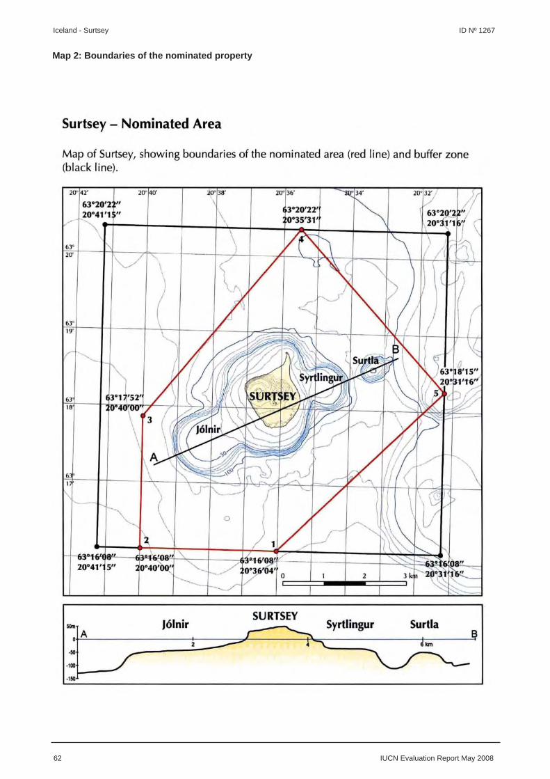
62 IUCN Evaluation Report May 2008
Iceland - Surtsey ID Nº 1267
Map 2: Boundaries of the nominated property
EUROPE / NORTH AMERICA
BRADYSEISM IN PHLEGRAEAN AREA
ITALY

IUCN Evaluation Report May 2008 63
WORLD HERITAGE NOMINATION – IUCN TECHNICAL EVALUATION
BRADYSEISM IN PHLEGRAEAN AREA (ITALY) – ID No. 1288
1. DOCUMENTATION
i) Date nomination received by IUCN: April 2007
ii) Additional information offi cially requested from and provided by the State Party: IUCN requested supplementary information on 15 October 2007 before the fi eld visit and on 14 November 2007 after the fi eld visit. The State Party response was offi cially received by the World Heritage Centre on 18 January 2008.
iii) UNEP-WCMC Data Sheet: 2 references (including nomination)
iv) Additional literature consulted: Civetta, L., Orsi, G. and Patella, G. (eds) (2004) The Neapolitan volcanoes: Vesuvius, Campi Flegrei and Ischia. Special issue of Journal of Volcanology and Geothermal Research, pp. 1-393; Davidde, B. (2002) Underwater archaeological parks: a new perspective and a challenge for conservation—the Italian panorama. Journal of Nautical Archaeology, 31: 83-88; Gaeta, F. S. et al. (2003) A physical appraisal of a new aspect of bradyseism: The miniuplifts. Journal of Geophysical Research, 108 (B8): 2363; Orsi, G., Civetta, L. and Valentine, G. A. (eds) (1999) Volcanism in the Campi Flegrei. Special issue of Journal of Volcanology and Geothermal Research, pp. 121-472; Orsi, G., Di Vito, M. and Isaia, R. (1998) Volcanic hazards and risk in the Parthenopean Megacity. Guidebook to International Meeting on ‘Cities on Volcanoes’. Published by Osservatorio Vesuviano, Naples; Orsi, G., Di Vito, M. and Isaia, R. (2004) Volcanic hazard assessment at the restless Campi Flegrei caldera. Bull. Volcanol., 66: 514-530; Orsi, G., Gallo, G. and Zanchi, A. (1991) Simple-shearing block resurgence in caldera depressions. A model from Pantelleria and Ischia. Journal of Volcanology and Geothermal Research, 47: 1-11; Orsi, G., D’Antonio, M., de Viya, S. and Gallo, G. (1992) The Neapolitan Yellow Tuff, a large-magnitude trachytic phreatoplinian eruption: eruptive dynamics, magma withdrawal and caldera collapse. Journal of Volcanology and Geothermal Research, 53: 275-287; Paoletti, V. et al. (2005) Magnetic survey at the submerged archaeological site of Baia, Naples, southern Italy. Archaeological Prospection, 12: 51-59; Pirazzoli, P.A. (1987) Sea level changes in the Mediterranean. In: Sea Level Changes. Published by Basil Blackwell, Oxford, pp.152-181; Pirazzoli, P.A. et al. (1991) World Atlas of Holocene Sea-level changes. Elsevier, London, 300 p.; Global Volcanism Program at the Smithsonian Museum (www.volcano.si.edu); World Heritage Centre (2002) Cultural Landscapes: the Challenges of Conservation. Proceedings of Conference on Shared Legacy, Common Responsibility, Ferrara, November 2002, UNESCO World Heritage Centre, Paris.
v) Consultations: 8 external reviewers. Extensive consultations were undertaken during the fi eld visit with: State Party representatives including the President of the Campania Region; a wide range of stakeholders including the Superintendency for Archaeological Heritage, environmental NGOs, wider stakeholder groups representing local women, educational interests and the local hospitality industry, and the different archaeological complexes that comprise the property.
vi) Field visit: Bernard Smith, October 2007
vii) Date of IUCN approval of this report: April 2008
2. SUMMARY OF NATURAL VALUES
The nominated property, Bradyseism in Phlegraean Area (Bradisismo dei Campi Flegrei), is located in Campania Province, Italy. The nominated property comprises three core zones totalling 218.92 ha plus buffer zone of 236.86 ha. The
three areas comprise sites with a range of signifi cant archaeological remains as follows:
1) The Baia Submarine Park (176.6 ha) has a 0.75 x 2.75 km core area with submerged Roman ruins along the northwest coast of the gulf between Baia and Pozzuoli. The foundations
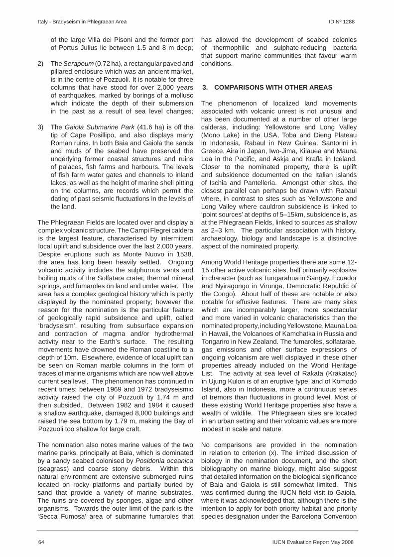
64 IUCN Evaluation Report May 2008
Italy - Bradyseism in Phlegraean Area ID Nº 1288
of the large Villa dei Pisoni and the former port of Portus Julius lie between 1.5 and 8 m deep;
2) The Serapeum (0.72 ha), a rectangular paved and pillared enclosure which was an ancient market, is in the centre of Pozzuoli. It is notable for three columns that have stood for over 2,000 years of earthquakes, marked by borings of a mollusc which indicate the depth of their submersion in the past as a result of sea level changes;
3) The Gaiola Submarine Park (41.6 ha) is off the tip of Cape Posillipo, and also displays many Roman ruins. In both Baia and Gaiola the sands and muds of the seabed have preserved the underlying former coastal structures and ruins of palaces, fi sh farms and harbours. The levels of fi sh farm water gates and channels to inland lakes, as well as the height of marine shell pitting on the columns, are records which permit the dating of past seismic fl uctuations in the levels of the land.
The Phlegraean Fields are located over and display a complex volcanic structure. The Campi Flegrei caldera is the largest feature, characterised by intermittent local uplift and subsidence over the last 2,000 years. Despite eruptions such as Monte Nuovo in 1538, the area has long been heavily settled. Ongoing volcanic activity includes the sulphurous vents and boiling muds of the Solfatara crater, thermal mineral springs, and fumaroles on land and under water. The area has a complex geological history which is partly displayed by the nominated property; however the reason for the nomination is the particular feature of geologically rapid subsidence and uplift, called ‘bradyseism’, resulting from subsurface expansion and contraction of magma and/or hydrothermal activity near to the Earth’s surface. The resulting movements have drowned the Roman coastline to a depth of 10m. Elsewhere, evidence of local uplift can be seen on Roman marble columns in the form of traces of marine organisms which are now well above current sea level. The phenomenon has continued in recent times: between 1969 and 1972 bradyseismic activity raised the city of Pozzuoli by 1.74 m and then subsided. Between 1982 and 1984 it caused a shallow earthquake, damaged 8,000 buildings and raised the sea bottom by 1.79 m, making the Bay of Pozzuoli too shallow for large craft.
The nomination also notes marine values of the two marine parks, principally at Baia, which is dominated by a sandy seabed colonised by Posidonia oceanica (seagrass) and coarse stony debris. Within this natural environment are extensive submerged ruins located on rocky platforms and partially buried by sand that provide a variety of marine substrates. The ruins are covered by sponges, algae and other organisms. Towards the outer limit of the park is the ‘Secca Fumosa’ area of submarine fumaroles that
has allowed the development of seabed colonies of thermophilic and sulphate-reducing bacteria that support marine communities that favour warm conditions.
3. COMPARISONS WITH OTHER AREAS
The phenomenon of localized land movements associated with volcanic unrest is not unusual and has been documented at a number of other large calderas, including: Yellowstone and Long Valley (Mono Lake) in the USA, Toba and Dieng Plateau in Indonesia, Rabaul in New Guinea, Santorini in Greece, Aira in Japan, Iwo-Jima, Kilauea and Mauna Loa in the Pacifi c, and Askja and Krafl a in Iceland. Closer to the nominated property, there is uplift and subsidence documented on the Italian islands of Ischia and Pantelleria. Amongst other sites, the closest parallel can perhaps be drawn with Rabaul where, in contrast to sites such as Yellowstone and Long Valley where cauldron subsidence is linked to ‘point sources’ at depths of 5–15km, subsidence is, as at the Phlegraean Fields, linked to sources as shallow as 2–3 km. The particular association with history, archaeology, biology and landscape is a distinctive aspect of the nominated property.
Among World Heritage properties there are some 12-15 other active volcanic sites, half primarily explosive in character (such as Tungarahua in Sangay, Ecuador and Nyiragongo in Virunga, Democratic Republic of the Congo). About half of these are notable or also notable for effusive features. There are many sites which are incomparably larger, more spectacular and more varied in volcanic characteristics than the nominated property, including Yellowstone, Mauna Loa in Hawaii, the Volcanoes of Kamchatka in Russia and Tongariro in New Zealand. The fumaroles, solfatarae, gas emissions and other surface expressions of ongoing volcanism are well displayed in these other properties already included on the World Heritage List. The activity at sea level of Rakata (Krakatao) in Ujung Kulon is of an eruptive type, and of Komodo Island, also in Indonesia, more a continuous series of tremors than fl uctuations in ground level. Most of these existing World Heritage properties also have a wealth of wildlife. The Phlegraean sites are located in an urban setting and their volcanic values are more modest in scale and nature.
No comparisons are provided in the nomination in relation to criterion (x). The limited discussion of biology in the nomination document, and the short bibliography on marine biology, might also suggest that detailed information on the biological signifi cance of Baia and Gaiola is still somewhat limited. This was confi rmed during the IUCN fi eld visit to Gaiola, where it was acknowledged that, although there is the intention to apply for both priority habitat and priority species designation under the Barcelona Convention
IUCN Evaluation Report May 2008 65
ID Nº 1288 Italy - Bradyseism in Phlegraean Area
of 1995, this had not yet been carried out. There was a similar acknowledgement that, whereas there are strong indications that there may be species unique to the environments of the two parks, studies had not been running for long enough to confi rm this.
4. INTEGRITY
4.1 Legal status
All three nominated sites are state owned and are protected under protective legislation related to the site’s cultural heritage. The nominated sites lie within the Campi Flegrei Regional Park established in 2007. A protocol was signed by members of the key stakeholder groups during the IUCN fi eld visit which passes the management of the three nominated sites to the Campi Flegrei Regional Park. IUCN considers that the level of protection of the property appears suffi cient in relation to its essentially cultural values.
4.2 Boundaries
The Serapeum is an urban archaeological site that is defi ned by a surrounding wall and railings. The submarine sites are defi ned on their seaward margins by a series of somewhat arbitrary straight boundaries and the landward margin of both submarine parks is set by the coastline. A seaward buffer zone is identifi ed at Gaiola and Baia within a larger coastal marine reserve. No landward buffer zones are identifi ed. The properties present evidence for the physical manifestation of bradyseism in the form of relative changes in sea level. Within all three sites the evidence presented as representative of the natural process of bradyseism is essentially archaeological. They cannot be seen as representative of the volcanic processes responsible for bradyseism.
The nomination and reviewers’ comments concentrate on the importance of the volcanism associated with the twin calderas of the Phlegraean Fields as the driving force behind the process and the explanation for the features observed at the three sites. Prominent within these explanations is acknowledgement of the importance of the most recent eruption of Monte Nuovo, Lake Averno and its associated crater, tuff and fl uctuating water level, the gas and vapour emissions and associated landscape of Solfatara and the uplifted marine terrace and relict sea-cliffs of La Starza between Monte Nuovo and Monte Olibano. None of these areas is included within the nominated property, although in supplementary information the State Party proposed adding some of these within a future nomination of the property. In relation to the marine values, the areas proposed are relatively limited and do not encompass the substantial areas normally expected to protect marine ecological values.
The aesthetic values of the nominated property draw
on description of the setting of the property and not the nominated areas. Even within this wider setting the case for exceptional beauty appears to have been based on a very selective view of the landscape. In particular, the long history of unchecked urbanization that has been so important for providing the record of environmental change has done little for the natural beauty of the coastline. For example, La Starza has been so overwhelmed by urban and now-derelict industrial development that it is impossible to access those important scientifi c sites that have survived. Similarly, the coastal plain to the west of Gaiola is currently being re-developed following the demise of iron, steel and cement works. Within Baia, the eye is drawn to prominent features such as the castle at the western end of the bay, but also to the marina, dock and boatyard that line much of the inner bay and the modern developments along the shoreline that now only permit glimpses of archaeological highlights such as the Temple of Mercury.
IUCN considers that the boundaries do not meet the relevant conditions of integrity for natural properties as set out in the Operational Guidelines.
4.3 Management
Since 2002 the three nominated sites have been under the temporary management of the Superintendency for Archaeological Heritage of the Province of Napoli and Caserta. Transfer of management responsibilities to the Campi Flegrei Regional Park took place in October 2007 and the three sites will be incorporated into the management structure of the Park. This will maintain the existing levels of protection, whilst adding additional levels of management, control and protection linked to their Park status. Clearly these new management arrangements will take some time to become fully established, and at present the necessary management planning is not in place. IUCN notes that the degree of stakeholder involvement within the Campi Flegrei Regional Park is impressive as evidenced by the positive engagement of many stakeholders in meetings during the fi eld visit.
The staff of the Archaeological Superintendency of Naples are at present available to protect the three sites. In time, the staff of the Campi Flegrei Regional Park will be responsible for coordinating the management, conservation and improvement of the sites. The Park will allocate three of its staff to the management of the property and they will be joined by nine additional staff seconded from the municipalities of Bacoli, Naples and Pozzuoli. Specialist staff on short-term contracts and staff employed on specifi c structural projects funded from a variety of sources including the EU will also support these permanent staff.
IUCN considers the management system that is being established appears to promise effective management

66 IUCN Evaluation Report May 2008
Italy - Bradyseism in Phlegraean Area ID Nº 1288
for the nominated property as part of the Campi Flegrei Regional Park, however due to its very recent establishment not all of the necessary requirements are fully met.
4.4 Threats and human use
The nominated sites are adjacent to heavily populated areas and a range of potential and actual threats exist although it appears that the majority of these could be managed. Air pollution is an issue in relation to the conservation of the Serapeum and requires ongoing monitoring. Water pollution has been reduced signifi cantly through investment in sewage treatment and other improvement schemes, but pollution from leisure craft could be a local issue in Baia. Because the Bay of Naples is a busy maritime crossroads there is the potential for a major pollution incident linked, for example, to a large oil spill. Contingency planning for such an eventuality has taken place and Baia was a pilot project for the mapping of environmental sensitivity to oil spills on the Italian coastlines.
There is a signifi cant risk of natural disasters linked to the volcanic and associated seismic activity, which are the subject of the nomination. An extensive regional monitoring system for volcanic activity and extensive civil defence plans are in place, including a 1984 volcanic emergency plan for the Campi Flegrei caldera.
Baia is a major recreational area for people of the region, especially during the summer months, with over 900 boats moored in the general area. It is also a major area for bathing with numerous privately owned boats. These activities should be closely monitored and the Park authorities should limit these activities in the most sensitive areas. Risks to the sites can be partly offset through education and the provision of visitor facilities. At present, the only operating facility is the visitor centre at Gaiola. IUCN’s fi eld visit also noted that there has been a dramatic decline in commercial fi shing which is attributed to overfi shing.
IUCN considers that the geological values of the property are not currently subject to signifi cant threats, except the unpredictable potential for natural disaster or major marine pollution incident; however, the limited marine biological values of the property have been signifi cantly impacted by human activities.
In summary IUCN considers that the property does not meet the necessary conditions of integrity as set out in the Operational Guidelines.
5. ADDITIONAL COMMENTS
5.1 Justifi cation for serial approach
When IUCN evaluates a serial nomination it asks the
following questions:
a) What is the justifi cation for the serial approach?
The justifi cation for a serial approach is not clear in the case of the nominated property, and the selected sites do not provide a coherent property with a complete and coherent set of unifying values.
b) Are the separate components of the property functionally linked?
Whilst the two marine parks could be argued to have some degree of functional linkage, the three taken together with the small terrestrial site of the Serapeum have no functional linkage as a serial natural site.
c) Is there an overall management framework for all the components?
The very new Campi Flegrei Regional Park potentially provides a management framework for all of the components as part of a wider protected area; however, the necessary elements of the management framework are not all in place.
IUCN concludes that the serial approach put forward is not justifi ed in this case.
5.2 Cultural values including comments of ICOMOS
The nomination puts forward sites which, whilst providing indirect evidence of a natural process, are clearly cultural sites. IUCN has therefore sought the input from ICOMOS on the values of the nominated property. ICOMOS has noted that the nomination ignores signifi cant cultural values that might warrant, in combination with other remains, consideration for inscription as a cultural World Heritage property under cultural criterion (iii).
IUCN also notes that there are important values in the wider area noted by reviewers in relation to the history of science. The sustained record of uplift and subsidence dates back 2000 years and encompasses observations of authors such as Strabo, Seneca, Martial and Boccaccio. The region also contains the site of the world’s oldest seismological and volcanological institute (The Osservatorio Vesuviano, 1841) and is an important training location for volcanology. The clearest demonstration of this educational role was the inclusion by Lyell of a drawing of the columns of the Serapeum as a frontispiece to his seminal 1847 text on the Principles of Geology. There are a number of literary associations with volcanic sites in the wider areas outside the nominated property including descriptions in Homer’s Odyssey and Virgil’s Aeneid.
It is also relevant to note that there are already four
IUCN Evaluation Report May 2008 67
ID Nº 1288 Italy - Bradyseism in Phlegraean Area
cultural World Heritage properties within 5-45 km of the nominated property. There appears to be overlap in the values of the nominated property and these nearby properties, which include a collection of historic sites in Naples, a coastal property, and the site of Pompeii and Herculaneum. It is therefore possible that some values noted within the nomination could be complementary to existing World Heritage properties.
6. APPLICATION OF CRITERIA
The property has been nominated under criteria (vii), (viii) and (x). IUCN considers that the nominated property does not meet any of these criteria based on the following assessment:
Criterion (vii): Superlative natural phenomena or natural beauty
The three nominated sites are archaeological features and not natural areas. Of the three nominated sites, the only one that can be widely seen and appreciated is entirely man-made and located completely within an urban setting. The other two also focus primarily on man-made structures that are underwater. The arguments presented for natural beauty refer almost entirely to the setting of the sites and to areas not within the nominated area. There is no basis for consideration of inscription of the nominated property under criterion (vii).
IUCN considers the nominated property does not meet this criterion.
Criterion (viii): Earth’s history, geological and geomorphic features and processes
The Phlegraean Fields are an important locality in relation to the history of geological understanding. This is best exemplifi ed by the Serapeum, where the observation that the coastline had been submerged was instrumental in widespread acceptance of the geological concept of uniformitarianism. The Phlegraean Fields as a whole also provide one of the longest continuous records of observations on volcanic phenomena and are a well known locality for the display of bradyseism in the scientifi c literature. IUCN considers that these values are too specialized to provide the basis for World Heritage listing. IUCN also notes that the nomination does not seek recognition for the Phlegraean Fields, but only three, discrete, largely cultural sites that epitomize the end product of bradyseism without linking it directly to the forces that drive it. The nominated property therefore does not provide either the values or integrity required for World Heritage listing.
IUCN considers the nominated property does not meet this criterion.
Criterion (x): Biodiversity and threatened species
Only two of the three nominated sites have any important biodiversity values: the marine biology of Baia and Gaiola refl ects the fauna and fl ora of the Bay of Naples as a whole and is interesting due to the peculiar mixture of species found in close proximity, which results in part from the infl uence of volcanism. Although of regional interest in terms of habitat complexity, the sites do not present signifi cant international values for marine species. The level of ongoing human activities within Baia is a signifi cant diminution of the integrity of this component. Overall IUCN considers that the marine values are of signifi cance at the national level within Italy, and thus do not provide any basis to consider application of criterion (x).
IUCN considers the nominated property does not meet this criterion.
7. RECOMMENDATIONS
IUCN recommends that the World Heritage Committee adopt the following decision:
The World Heritage Committee,
1. Having examined Documents WHC-08/32.COM/8B and WHC-08/32.COM/INF.8B2,
2. Decides not to inscribe the Bradyseism in Phlegraean Area, Italy, on the World Heritage List on the basis of natural criteria;
3. Commends the State Party for its investment in conservation of the Regional Park of Campi Flegrei including the Underwater Parks of Baia and Gaiola;
4. Notes the remarks of ICOMOS that the property may have potential to be included, in combination with other features in the region, in a future nomination of a serial cultural property. Such a nomination, if pursued, could include recognition of the history of science values of the property that have been noted in the IUCN evaluation of the nomination.

68 IU
CN
Evaluation R
eport May 2008
Italy - Bradyseism
in Phlegraean A
rea ID
Nº 1288
Map 1: Location and boundaries of the nom
inated property
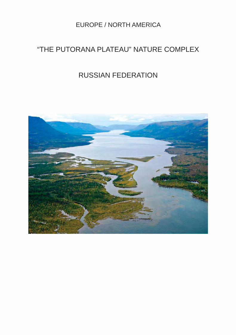
EUROPE / NORTH AMERICA
“THE PUTORANA PLATEAU” NATURE COMPLEX
RUSSIAN FEDERATION

IUCN Evaluation Report May 2008 69
WORLD HERITAGE NOMINATION – IUCN TECHNICAL EVALUATION
“THE PUTORANA PLATEAU” NATURE COMPLEX (RUSSIAN FEDERATION) – ID No. 1234
1. DOCUMENTATION
i) Date nomination received by IUCN: April 2007
ii) Additional information offi cially requested from and provided by the State Party: IUCN requested supplementary information on 17 August 2007 before the fi eld visit, on 13 November 2007 after the fi eld visit and on 20 December 2007 after the fi rst IUCN World Heritage Panel meeting. The State Party responses were received by email on 30 November 2007 and 11 February 2008.
iii) UNEP-WCMC Data Sheet: 7 references (including nomination)
iv) Additional literature consulted: Dingwall, P., Weighell, T. and Badman, T. (2005) Geological World Heritage: A Global Framework Strategy. IUCN, Gland, Switzerland; Greenpeace Russia (2006) Russian Natural Heritage. Moscow, 175 p.; Magin, C. and Chape, S. (2004) Review of the World Heritage Network: Biogeography, Habitats and Biodiversity. UNEP-WCMC and IUCN, Cambridge, UK; Romanov, A.A. (2003) Avifauna of Lake Hollows in the Western Putorana Plateau. Moscow, 143 p.; Romanov, A.A. (2006) Bird and Animal Communities of the Putorana Plateau: Studies and Conservation. Moscow, 275 p.; Romanov, A.A. (2006) Plateau Putorana: “Pearl” of the Russian Arctic. Moscow, 40 p.; Thorsell, J. and Hamilton, L. (2002) A Global Overview of Mountain Protected Areas on the World Heritage List. IUCN, Gland, Switzerland; Thorsell, J. and Sigaty, T. (1997) A Global Overview of Forest Protected Areas on the World Heritage List. IUCN, Gland, Switzerland.
v) Consultations: 4 external reviewers. Extensive consultations were undertaken during the fi eld visit with representatives of the Ministry of Natural Resources of the Russian Federation; the head and staff of the Putoransky Zapovednik; and representatives of national NGOs, the Institute for Agriculture of the Far North in Norilsk and the mining company Norilsk Nickel.
vi) Field visit: Harald Plachter, August-September 2007
vii) Date of IUCN approval of this report: April 2008
2. SUMMARY OF NATURAL VALUES
The nominated property, the Putoransky State Nature Reserve, lies in the central part of the Putorana Plateau in northern Central Siberia. It is situated some hundred kilometres north of the Polar Circle and almost 200 km south-east of Norilsk, the next town. It comprises an area of 1,887,251 ha and has been a State Nature Reserve (Zapovednik) since 1987. It altitude ranges between 800-1500 m. The area has been exposed for millennia to an arctic climate due to the high latitude. Permafrost covers the major part of the plateau, but there are no major glaciers.
The Putorana Plateau originates from a Permian-Triassic mantle plume, which is an immense up-welling of magma, resulting in extended tectonic movements and powerful volcanism. This created an almost even basalt and tuff plateau in which rivers and streams carved valleys and canyons over millions of years.
The typical character of the Putorana Plateau is the stepped line of its slopes and thalwegs, distinguished by alternation of hard weathering basalt, diabase, dolerite with easily eroded tuff and sandstone tuff.
The arctic climate of the Putorana Plateau is very continental: the average July temperature is 14.2ºC, the average January temperature is -27.5 ºC, and the average annual air temperature is -9.7ºC. The Putorana Plateau is one of the most signifi cant watersheds of northern Eurasia due to relatively high precipitation (453 mm). Water erosion and sedimentation, together with tectonic uplift of the plateau, have created spectacular landforms in the permafrost environment. Numerous rivers and streams originate in the area, and there is a complex and ever changing network of lakes. Today, fjord-like lakes, up to 150 km long and 420 m deep, surround the central parts of the plateau. In total there are more than 100 lakes with a surface

70 IUCN Evaluation Report May 2008
Russian Federation - “The Putorana Plateau” Nature Complex ID Nº 1234
area larger than 100 ha and more than 18,000 lakes with a smaller surface area. These lakes form the second largest water reservoir in Russia after Lake Baikal. The plateau’s regular alternation of smooth and hard rocks has also resulted in a large number of waterfalls up to 108 m high.
The vegetation ranges from sparse arctic lichen formations to various types of northern coniferous taiga forests. These vegetation types occur in diverse and dynamic patterns and often vary over a very small distance. 398 species of vascular plants are reported in the nominated property, including rare and endemic species such as Trollius asiaticus, Rhodiola rosea, Papaver variegatum and Juncus longirostris. Forests and woodland vegetation comprise birch, common aspen, Siberian spruce, Siberian larch and Dahurian larch. Two plant species (Caltha serotina and Euphrasia putoranica) are endemic to the area. Five plant species (Draba sambuckii, Festuca auriculata var. pilosa, Juncus longirostris, Oxytropis putoranica and Papaver variegatum) have their centre of distribution within the nominated property but also occur in small populations in other parts of Northern Siberia.
A complete spectrum of arctic wildlife occurs with brown bear (more than 760 individuals), wolf (840 individuals in 2001), arctic fox, lynx, glutton, otter (at some locations), sable, elk, reindeer, Russian fl ying squirrel (at one location) and blue hare. Except for reindeer and arctic fox, all species are permanent inhabitants of the plateau. One of the major reindeer migration routes in Eurasia crosses the nominated property. Twice a year between 150,000 and 250,000 wild reindeers from Taymir peninsula migrate along the valleys of the plateau to their winter habitats in the south. This is one of the last migration routes in Central Siberia not blocked or fragmented by pipelines. The nominated property is also an important stopover point for migrating arctic birds. In total 34 species of mammals, 140 bird species and 25 fi sh species have been recorded in the nominated property. At least four fi sh species are endemic to the area (Salvelinus boganidae, Salvelinus drjagini, Salvelinus taimyricus and Salvelinus tolmachoffi ).
The nominated property protects a signifi cant part of the population of the endemic Putorana snow sheep (listed as Vulnerable in the IUCN Red List of Threatened Species), one of the four subspecies of the Siberian snow sheep, which live totally isolated from each other in different parts of Siberia. By the early 1960s, the Putorana snow sheep remained only in the most remote parts of the plateau, due to hunting and poaching. Following the establishment of the State Nature Reserve, the population recovered to about 1,400 individuals, now occurring throughout the nominated property.
3. COMPARISONS WITH OTHER AREAS
The Putorana Plateau has been nominated under all four natural criteria. In relation to criterion (vii), the natural beauty of the plateau’s landscapes is spectacular and comparable with existing World Heritage properties. This derives from the untouched arctic and boreal landscape elements which are enhanced by an enormous variation in the relief of the area, fjord-like lakes, hundreds of waterfalls and dozens of canyons more than 500 m deep. These canyons are comparable with canyons such as those in the Grand Canyon National Park (USA) and the Tara River Gorge in the Durmitor National Park (Montenegro). Kanda waterfall (108 m), the highest waterfall within the nominated property, is one of the ten highest waterfalls in Russia. However, there are a number of World Heritage properties with higher or more impressive waterfalls, including Iguazu/Iguaçu (Argentina/Brazil), Mosi-oa-Tunya/Victoria Falls (Zambia/Zimbabwe) and Yosemite (USA). However, a key aesthetic feature of the nominated property is the high concentration of waterfalls. In this regard, the plateau can be favourably compared with World Heritage properties known for their numerous waterfalls, such as Plitvice Lakes (Croatia), Te Wahipounamu – South West New Zealand, Gondwana Rainforests of Australia, Noel Kempff Mercado (Bolivia), Atlantic Forest South-East Reserves (Brazil) and Canaima (Venezuela). The Putorana Plateau is the only area with such a high density of waterfalls in an arctic climate.
In relation to criterion (viii), the claim for Outstanding Universal Value is based on the presence of a vast mantle plume and basalt plateau, which has been shaped over millions of years under arctic climate conditions. However, mantle plumes are a common geological feature, and the geomorphologic features associated with them are very common around the world. Mantle plumes occur in Central and South-Eastern America, parts of India and major parts of the Indian Ocean, and in the whole Pacifi c. Many mantle plumes have resulted in small oceanic islands. A number of World Heritage properties include signifi cant and characteristic geological and geomorphologic features associated with mantle plumes, including Iguazu/Iguaçu (Argentina/Brazil), Lord Howe Islands (Australia), Rapa Nui (Chile), Simien (Ethiopia), Þingvellir (Iceland), Coiba (Panama), Pitons (Saint Lucia), Vallée de Mai (Seychelles), Hawaii and Olympic (USA). As a basalt plateau, the Putorana Plateau is comparable to the Deccan Plateau in India, the Paraná Plateau in Brazil and the Ethiopian Plateau in eastern Africa. The Ethiopian Plateau, represented on the World Heritage List by Simien National Park, has also been formed under the infl uence of ancient volcanism accompanied by an immense up-welling of magma, tectonic uplift and subsequent erosion. The Ethiopian Plateau has a comparable thickness of basalt (up to 1500-2000 m) to the Putorana Plateau,

IUCN Evaluation Report May 2008 71
ID Nº 1234 Russian Federation - “The Putorana Plateau” Nature Complex
but it rises signifi cantly higher – with an average height between 2000-3000 m, with the highest mountain (Ras Dashen) reaching 4620 m. The Ethiopian Plateau is also characterised by a sharply pronounced step-like relief with deep canyons and plateau-like mountains.
In relation to criterion (ix) it is important to note that ecological and biological processes occur naturally in the nominated property without any human intervention. The property features a wide and distinct spectrum of ecological and biological processes because of the specifi c combination of geological and climatic conditions. Distinct soils and microclimates occur on the plateau-like mountains and on the slopes of the valleys and canyons formed in this permafrost environment. These are complemented by a wide spectrum of water-shaped habitats, ranging from arctic stone desert to temperate mountain wetlands; thus resulting in a remarkably diverse and dynamic pattern of vegetation types. The presence of endemic plant species is also associated with the variety of extreme environmental conditions. The level of endemism in the property is lower than in temperate or tropical regions of the world, but could be signifi cant when compared to other areas with arctic climate conditions.
The nominated property features a typical set of boreal and arctic ecosystems and species. Similar ecosystems and species can be found in World Heritage properties of the same climate zones in the northern hemisphere, such as Kluane / Wrangell-St Elias / Glacier Bay / Tatshenshini-Alsek (Canada / USA), Nahanni and Wood Buffalo (Canada), Virgin Komi Forests and Wrangel Island (Russian Federation), and the Laponian Area (Sweden). This is due to the fact that these areas were at least temporarily linked by land bridges during the Ice Age. However, the Putorana Plateau harbours a complete set of such ecosystems in an isolated arctic mountain range: untouched taiga, tundra and arctic desert systems as well as untouched cold-water lake and river systems. Thus, the nominated property could address some of the gaps identifi ed in relation to arctic ecosystems in the 2004 Review of the World Heritage Network prepared by UNEP-WCMC and IUCN.
In relation to criterion (x), the claim for Outstanding Universal Value is based on the importance of the Putorana Plateau for the survival of the existing fl ora and fauna. However, many of the key species recorded in the nominated property are also present in a number of other World Heritage properties and protected areas in the Arctic. In addition, many bird and large mammal species of the Arctic (such as the reindeer) are migratory, and their survival depends on a number of areas along their migratory routes. The importance of the nominated property for biodiversity conservation needs to be compared with other comparable World Heritage properties within the Arctic. Such a comparison in terms of key species groups is summarized in Table 1.
The nominated property ranks lower in terms of key species groups than other World Heritage properties within the Arctic. The nominated property has a higher number of mammal species than Wrangel Island, but this is a refl ection of the insular nature of Wrangel. However, Wrangel has the largest sea-bird colonies on the Chukchi Sea, provides the northernmost nesting grounds for over 100 migratory bird species including several that are endangered, has signifi cant populations of resident tundra bird species interspersed with migratory Arctic and non-Arctic species, and has the world’s highest density of ancestral polar bear dens. In addition, Wrangel includes a considerable marine area, with associated marine ecosystems and species. This applies also to the other World Heritage property within the Arctic inscribed under criterion (x), Kluane / Wrangell-St Elias / Glacier Bay / Tatshenshini-Alsek, which is also fi ve times larger than the nominated property.
Whilst IUCN considers that the nominated property has the potential to meet criteria (vii) and (ix), it is important to note that the comparative analysis provided in the nomination document is not suffi cient to justify inscription under natural World Heritage criteria. This is further complicated by the fact that the justifi cation and description provided in the nomination document does not differentiate between the values and features located within the nominated property and those located within the buffer zone.
Table 1: Comparison of Putorana with selected natural World Heritage properties in the Arctic in terms of key species groups
Name of property Criteria Vascular plant species
Mammal species
Bird species
Fish species
Kluane / Wrangell-St Elias / Glacier Bay / Tatshenshini-Alsek, Canada and USA vii, viii, ix, x 887+ 53 239 237
Nahanni National Park, Canada vii, viii 700 42 180 16Virgin Komi Forests, Russian Federation vii, ix 350+ 43 204 16
Wrangel Island Reserve, Russian Federation ix, x 417 11 169 ?
Putorana Plateau, Russian Federation vii, viii, ix, x 398 34 140 25

72 IUCN Evaluation Report May 2008
Russian Federation - “The Putorana Plateau” Nature Complex ID Nº 1234
Therefore, IUCN cannot objectively conclude at this stage whether or not the property meets criteria (vii) and (ix). It is therefore essential that the State Party prepares an enhanced global comparative analysis, which is focused on the nominated property’s values and features in relation to criteria (vii) and (ix) and compares these to other World Heritage properties and protected areas within the Arctic. In this context, it is also important to note that the International Expert Meeting on World Heritage and the Arctic held in Narvik, Norway, from 30 November to 1 December 2007, has recommended the preparation of thematic studies on natural and cultural heritage in the Arctic to enable better evaluation of properties of potential Outstanding Universal Value within the Arctic.
4. INTEGRITY
4.1 Legal status
The nominated property was declared a State Nature Reserve (Zapovednik; equivalent to IUCN Protected Area Management Category Ia) under the jurisdiction of the federal government in 1987. No land uses are allowed other than scientifi c research and monitoring. A number of other federal and regional laws and regulations on nature conservation, land use planning, scientifi c research and monitoring, and environmental education apply to the nominated property.
4.2 Boundaries
The boundaries of the nominated property coincide with those of the Putoransky State Nature Reserve. The property of 1,887,251 ha is surrounded by an extensive buffer zone of 1,773,300 ha, established in 1987 by a decision of the Krasnoyarsky Krai regional government and further extended in 1993 by a decree of the Taimyr Autonomous District. The management of the buffer zone is under the jurisdiction of the State Nature Reserve, but different land ownership and land use arrangements present a challenge to the effective management of the buffer zone. Some important natural features, such as lakes and waterfalls, mentioned in the nomination document are located within the buffer zone. Only one of the ten largest lakes in the area, Lake Ayan, lies completely within the nominated property. However, IUCN considers that the nominated property includes the key areas that are essential for maintaining the property’s natural beauty. The property is also of suffi cient size and contains the necessary elements to demonstrate the key aspects of ecological and biological processes that are essential for the long term conservation of the property’s ecosystems and biological diversity.
4.3 Management
The nominated property is only accessible by helicopter from an airport near to Norilsk, located about 200 km
north-west from its western border, or by boat along the lakes, but navigation is diffi cult. Access to the property is limited and requires a special permit from the reserve administration and its scientifi c board. This limited access facilitates the protection and patrolling of the nominated property. There are no roads within the nominated property and large parts of the buffer zone.
The management of the reserve is carried out according to the Regulations of the Putoransky State Nature Reserve adopted by the Federal Ministry of Nature Resources in March 2005. These rather general regulations are revised every fi ve years and implemented through annual workplans. However, there is no management plan that specifi es how the potential Outstanding Universal Value of the nominated property will be protected in the long term, as required under paragraph 108 of the Operational Guidelines. In the additional information provided, the State Party notes that a draft management plan for the property is in the process of preparation; however, no information was provided on the timelines for the completion and approval of this management plan.
The staff working in the nominated property comprise 33 persons, including 6 scientists and 12 rangers; however, more than half of the staff conduct ranger tasks such as fi shing and hunting inspections and forestry supervision. IUCN considers that the existing number of staff is insuffi cient to effectively patrol the vast property, particularly in light of increasing tourism in the buffer zone, which could lead to unauthorised access to the nominated property. However, the additional information provided by the State Party notes that the number of staff will be increased by 50% in case of the inscription of the property in the World Heritage List.
The federal funding allocated to the conservation and management of the nominated property in 2007 was 6,044,200 Russian Rouble (around US$ 255,000); however, 73% of this funding was dedicated to salaries and only 12% was dedicated to management and conservation activities. The additional information provided by the State Party notes that in 2008 the federal funding allocated to the nominated property will be increased, but only to adjust for infl ation. The nomination document notes that the current level of funding is insuffi cient and that at least 8,300,000 Russian Rouble (around US$ 350,000) would be required. IUCN concurs that the current level of funding is insuffi cient for the effective management and conservation of a potential World Heritage property of this size. However, in the absence of a management plan is diffi cult to objectively assess the funding requirements for the management and conservation of the property.

IUCN Evaluation Report May 2008 73
ID Nº 1234 Russian Federation - “The Putorana Plateau” Nature Complex
4.4 Threats and human use
There are no roads, settlements or human activities, other than scientifi c research and monitoring, within the nominated property. The property was never permanently settled by humans. Even indigenous peoples entered the area in the past only sporadically, e.g. for reindeer herding or hunting. The only permanent settlement located on the Putorana Plateau, but outside the borders of the nominated property, is the Khantaisky village with about 500 inhabitants, 350 of which are indigenous people (Dolgan, Evenk). Traditional occupation is reindeer herding, hunting and fi shing.
Uncontrolled hunting in the 1960s to 1980s resulted in a sharp decline in some of the key species, such as the endemic Putorana snow sheep. Today, hunting is totally prohibited within the nominated property. Fishing is allowed for visitors to the area, but they are urged to catch and release fi sh. There is no evidence how far this is respected, but even if the catch was used for personal supply this would be of minimal impact.
Access to the reserve is only possible by special permission of the reserve administration and its scientifi c board. About six small ensembles of wooden huts, all without any additional infrastructure such as electric power or water supply, accommodate visitors in the buffer zone. In 2005, 437 people visited the reserve, including 30 tourist groups, 170 individuals and 3 scientifi c researchers. The impact of visitors on the natural values and integrity of the reserve is minimal; however, the principles for approving visitation are unclear. Helicopters provide the only feasible access to the area, resulting in some visual and acoustic impacts, including on wildlife. As these impacts increase with the number of fl ights, fl ights should be restricted to a minimum.
Tourism in the buffer zone, especially in its western part, is rapidly growing. There are no exact numbers on visitation but it is estimated that several thousand tourists visit the buffer zone per year. Tourism is a promising economic activity for the area, and tourism development has resulted in the construction of a number of buildings. However, these buildings are neither integrated properly into the natural landscape nor follow traditional architectural principles and practices. The additional information provided by the State Party notes that due to the vast area of the buffer zone it is impossible to fully control the development of new buildings. This is of concern considering the growing pressure for tourism development, as it could lead to unauthorised access to the nominated property by land and water routes.
Tourism development and associated infrastructure development is also of concern for another important reason. One of the most important inter-regional
reindeer migration routes crosses the nominated property. This route has gained importance over time due to the fact that other important routes are now blocked by traversing oil and gas pipelines. However, as the continuation of this natural phenomenon depends strongly on the natural conditions of the areas within and outside the nominated property, effective legal and management systems are required to ensure that further tourism development does not adversely affect the necessary natural conditions. These systems include hunting regulations and monitoring of the reindeer population.
Mining is also a potential threat to the integrity of the nominated property. The Norilsk mining and smelting complex, located about 200 km north-west from its western border, was developed to exploit the important mineral resources of the region. Today, the mining and smelting company Norilsk Nickel is the world’s leading producer of nickel. Vast areas east and south-east of Norilsk suffer from forest dieback caused by acid emissions from the metallurgical process. According to current data, the closest areas affected by air pollution are more than 100 km away from the nominated property, but air pollution is already affecting the western part of the buffer zone. Based on geological information, mining could potentially be extended to areas close to the nominated property, but Norilsk Nickel confi rmed in discussions during the IUCN fi eld mission that there are no plans to mine within the nominated property. The additional information provided by State Party also notes that the Federal Law on Specially Protected Natural Areas does not allow mining within the nominated property.
Considering the lack of a management plan for the nominated property, as required under paragraph 108 of the Operational Guidelines, and the limited human and fi nancial resources currently available for the protection and management of the nominated property, IUCN considers that the property does not currently meet the necessary conditions of integrity as set out in the Operational Guidelines.
5. APPLICATION OF CRITERIA
The property has been nominated under all four natural criteria. IUCN considers that the nominated property has the potential to meet criteria (vii) and (ix) based on the following assessment:
Criterion (vii): Superlative natural phenomena or natural beauty
The natural beauty of the Putorana Plateau is spectacular and comparable with existing World Heritage properties. This derives from the untouched arctic and boreal landscape elements which are enhanced by an enormous variation in the relief of the area, fjord-like lakes, hundreds of waterfalls and

74 IUCN Evaluation Report May 2008
Russian Federation - “The Putorana Plateau” Nature Complex ID Nº 1234
dozens of canyons more than 500 m deep. The visual impression is underlined by the almost complete absence of humans and human activity within the vast property. The spectacular reindeer migration across the property could be considered a superlative natural phenomenon and adds to the property’s claim for Outstanding Universal Value under this criterion. However, an enhanced global comparative analysis is required to confi rm the nominated property’s potential Outstanding Universal Value under criterion (vii).
IUCN considers that the nominated property has the potential to meet this criterion.
Criterion (ix): Ecological and biological processes
The Putorana Plateau features a wide and distinct spectrum of ecological and biological processes because of the specifi c combination of geological and climatic conditions. These processes occur naturally without any human intervention in a remarkably complete set of ecosystems in an isolated arctic mountain range: untouched taiga, tundra and arctic desert systems as well as untouched cold-water lake and river systems. These arctic ecosystems are currently underrepresented on the World Heritage List. The level of endemism in the property is lower than in temperate or tropical regions of the world, but could be signifi cant when compared to other areas with arctic climate conditions. However, an enhanced global comparative analysis is required to confi rm the nominated property’s potential Outstanding Universal Value under criterion (ix).
IUCN considers that the nominated property has the potential to meet this criterion.
IUCN considers, however, that the nominated property does not meet criteria (viii) and (x) based on the following assessment:
Criterion (viii): Earth’s history, geological and geomorphic features and processes
The geology and geomorphology of the Putorana Plateau is signifi cant at the regional, but not at the global level. Mantle plumes and basalt plateaus are common geological features and a number of more signifi cant examples than the Putorana Plateau are already inscribed on the World Heritage List. The scenic landscape values associated with the geology and geomorphology of the Putorana Plateau, including the step-like relief with deep canyons and plateau-like mountains, are also more relevant in relation to criterion (vii) than (viii). Comparative analysis does therefore not show a compelling case for the application of criterion (viii).
IUCN considers the nominated property does not meet this criterion.
Criterion (x): Biodiversity and threatened species
The Putorana Plateau’s importance for the in situ conservation of biological diversity and threatened species is signifi cant at the regional, but not at the global level. Many of the key species recorded in the nominated property are also present in a number of other World Heritage properties and protected areas in the Arctic. In addition, some of the property’s bird and large mammal species (such as the reindeer) are migratory, and their survival depends on a number of areas along their migratory routes outside the property. The nominated property ranks lower in terms of key species groups than other World Heritage properties within the Arctic, such as Wrangel Island (Russian Federation) or Kluane / Wrangell-St Elias / Glacier Bay / Tatshenshini-Alsek (Canada / USA).
IUCN considers the nominated property does not meet this criterion.
6. RECOMMENDATIONS
IUCN recommends that the World Heritage Committee adopt the following decision:
The World Heritage Committee,
1. Having examined Documents WHC-08/32.COM/8B and WHC-08/32.COM/INF.8B2,
2. Defers the examination of the nomination of the “The Putorana Plateau” Nature Complex, Russian Federation, to the World Heritage List on the basis of criteria (vii) and (ix) to allow the State Party to refocus the nomination and address issues related to the management of the nominated property;
3. Recommends the State Party to:
a) Refocus the nomination on the values and features within the Putorana State Nature Reserve in relation to criteria (vii) and (ix), supported by an enhanced global comparative analyses in relation to other World Heritage properties and protected areas within the Arctic;
b) Provide a clear statement of support from the government that demonstrates its commitment to ensuring effective long term management, including the necessary human and fi nancial resources, of the nominated property; and
c) Develop and implement a management plan that specifi es how the potential Outstanding Universal Value of the nominated property will be protected in the long term;

IUCN Evaluation Report May 2008 75
ID Nº 1234 Russian Federation - “The Putorana Plateau” Nature Complex
4. Requests the Advisory Bodies to prepare thematic studies on natural and cultural heritage in the Arctic, as suggested at the International Expert Meeting on World Heritage and the Arctic held in Narvik, Norway from 30 November to 1 December 2007, as these studies would enable better evaluation of properties of potential Outstanding Universal Value within the Arctic.

76 IUCN Evaluation Report May 2008
Russian Federation - “The Putorana Plateau” Nature Complex ID Nº 1234
Map 1: Location of the nominated property

IUCN Evaluation Report May 2008 77
ID Nº 1234 Russian Federation - “The Putorana Plateau” Nature Complex
Map 2: Boundaries of the nominated property
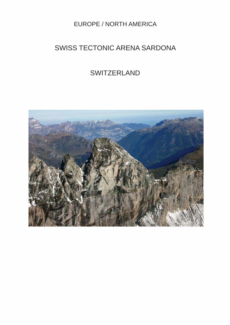
EUROPE / NORTH AMERICA
SWISS TECTONIC ARENA SARDONA
SWITZERLAND

IUCN Evaluation Report May 2008 79
WORLD HERITAGE NOMINATION – IUCN TECHNICAL EVALUATION
SWISS TECTONIC ARENA SARDONA (SWITZERLAND) – ID No. 1179
Background note: This nomination was previously submitted under the name “Glarus Overthrust” for consideration at the 29th session of the World Heritage Committee (Durban, 2005), but was not recommended for inscription by IUCN and was withdrawn for further consideration by the State Party (Decision 29 COM 8B.3). This nomination was also originally submitted as “Glarus Overthrust”, but the State Party proposed to change this name to “Swiss Tectonic Arena Sardona” during the evaluation process.
1. DOCUMENTATION
i) Date nomination received by IUCN: April 2007
ii) Additional information offi cially requested from and provided by the State Party: IUCN requested supplementary information on 2 November 2007 after the fi eld visit. The State Party response was offi cially received by the World Heritage Centre on 28 February 2008.
iii) UNEP-WCMC Data Sheet: 5 references (including nomination)
iv) Additional literature consulted: BUWAL/SAEFL (2001) Legislation on the Protection of Nature and Cultural Heritage in Switzerland; Dingwall, P., Weighell, T. and Badman, T. (2005) Geological World Heritage: A Global Framework Strategy. IUCN, Gland, Switzerland, 51 p.; Furrer, H. (2003) Die Glarner Fossilien vom Landesplattenberg Engi. Chapter 4 in Weidert, W.K. (ed.) Klassische Fundstellen der Paläontologie. Goldschneck-Verlag, Korb; Imper, D. (2004) Der Geopark Sarganserland-Walensee-Glarnerland. Separatum aus: Berichte der St. Gallischen Naturwissenschaftlichen Gesellschaft, pp. 101-136; Imper, D. (2004) Die Glarner Hauptübersschiebung - Kandidatur als UNESCO-Weltnaturerbe. Separatum aus: Berichte der St. Gallischen Naturwissenschaftlichen Gesellschaft, pp. 137-152; Imper, D. and Feldmann, M. (2004) GeoPark Information 2004. GeoPark Geschäftsstelle, 48 p.; Moores, E.M. and Twiss, R.J. (1995) Tectonics. WH Freeman & Co., New York; Pfi ffner, A. (1992) Alpine Orogeny. Chapter 6 in Blundell, D.J. et al. (eds) A Continent Revealed: The European Geotraverse, Structure and Dynamic Evolution. Cambridge University Press; Schwitter, R. et al. (2004) Graue Hörner: Entstehung, Natur, Nutzung. Alpenland Verlag AG, Schaan; Van der Pluijm, B. and Marshak, S. (1996) Earth Structure: An Introduction to Structural Geology and Tectonics. WCB/McGraw-Hill, New York.
v) Consultations: 6 external reviewers. Extensive consultations were undertaken during the fi eld visit with: representatives of the Department of the Environment, Transport, Energy and Communications of the Federal Offi ce for the Environment (FOEN), Swiss National Commission for UNESCO, cantonal environmental planners, political and community representatives of the three cantons involved (St. Gallen, Glarus and Graubünden), geological scientists, GeoPark representatives, representatives from the Universities of Basel, Bern and Zürich, as well as representatives from the tourist industry and other private entrepreneurs.
vi) Field visit: James Powell and Pedro Rosabal, September 2007
vii) Date of IUCN approval of this report: April 2008
2. SUMMARY OF NATURAL VALUES
The nominated property is located in the Glarus Alps, north-east Switzerland, and is bounded by the valleys of the rivers Rhine (to the south and east), Sernf/Linth (to the west) and Walensee/Seez (to the north). The area of the property is 32,850 ha. The property
straddles the watersheds that form the borders of the cantons of St. Gallen, Glarus and Graubünden, embracing a number of mountain groups, including seven peaks that rise above 3,000 m.
The nominated property displays excellent geological sections through a tectonic thrust, and it is this feature

80 IUCN Evaluation Report May 2008
Switzerland - Swiss Tectonic Arena Sardona ID Nº 1179
that is the basis of its nomination for World Heritage status. Thrusting is the process whereby older, deeper rocks are carried onto younger, shallower rocks and is widely recognised as being a main component of mountain building. It is generally accompanied by the formation of nappes, which are geological folds with near-horizontal axes.
The Glarus Overthrust displays very clear evidence of the major tectonic processes and structures that created the whole of the Alps, and typifi es fold-mountain belts around the world. Vast sheets of old sedimentary rocks were thrust northward for a considerable distance along the gently undulating fault plane of the Glarus thrust. The rock succession ranges in ages from the Verrucano group of Permian age (300-250 million years old) to Tertiary (50-35 million years old). However, thrusting has resulted in the older Permian rocks being transported over the younger rocks, so that they now cap the highest mountains in the nominated property and in different parts of the property may overlie younger Upper Jurassic, Cretaceous or Tertiary strata.
The stratigraphic sequence and structure of the Glarus Overthrust are very clearly visible throughout the region because the rock sequence is deeply cut by glacial valleys. The thrust is a very evident feature to non-specialists and can be easily observed by visitors within an area stretching approximately 30 km east-west and 20 km north-south. As a result it is possible to trace the thrusted block of the Helvetic nappes over a distance of approximately 50 km, from its origin in the Surselva in the south to its front on the Säntis in the north. These clear exposures have enabled geologists to reconstruct with high accuracy the architectural detail of this part of the Alpine mountain range, informing concepts of mountain building world-wide. Detailed mapping has shown that the overthrust rocks may have been up to 3 km thick, 50 km long and 100 km wide, and were displaced northward by at least 35 km.
The nominated property is also an important site for the history of geological ideas: it was one of the fi rst (and certainly the best known) places where the phenomenon of thrusting was recognised. It was on the basis of evidence from this area that the idea was fi rst conceived that fold mountain ranges consist of sheets of rock piled one on top of the other. The earliest observations in the Swiss Tectonic Arena Sardona are attributed to Hans Conrad Escher (1767-1823) who was thought to be the fi rst to draw attention to the unusual rock succession in the Glarus Alps, although it was his son, Arnold Escher, who fi rst alluded to the concept of an overthrust in 1845. Arnold Escher’s ideas were further developed by others, although it was not until the turn of the century that the theory of overthrusting was generally accepted by the leading scientists of the day. By the end of the nineteenth century the Glarus Overthrust had become
a well-known international geological site and it has continued to stimulate ongoing studies in tectonics up to the present day. Research on the property has provided new scientifi c revelations, with the most recent contributions providing insights, in particular through study of the Lochseiten limestone, into the role of mylonites (which is a fi ne-grained, compact rock produced by dynamic crystallization of rock layers along faults) in facilitating thrust movement.
In addition to the geological values that are the basis of its nomination, the property has associated natural values. In physical terms the Glarus Alps are high, glaciated mountains, rising dramatically above the enclosing narrow river valleys. Previous glaciations have left an impressive alpine landscape. Sedimentation in corries and glaciated valleys above rock steps has created alluvial plains which hold important areas of raised bogs and mires. The landscape has also been formed by landslides and as a result exhibits scars, debris fi elds and fallen rock masses. Indeed, the source of the largest post-glacial landslide in the Central Alpine region lies within the nominated property, above the village of Flims.
The nominated property contains an interesting fauna and fl ora. With decreasing elevation the high, un-vegetated zone gives way to mountain pasture, transforming into scrub and Alpine mountain forest. The natural tree line is between 1700 m and 2000 m above sea level; but where livestock has been pastured this has been lowered by 100-200 m through forest clearance. Above the tree line, mountain pastures and dwarf birch heath predominate up to an altitude of 2200 m. Overall the property contains some 800 plant species, of which 50 species are protected at the national level.
In addition, the property contains locally signifi cant populations of mammals, including several colonies of Alpine ibex (reintroduced to the area in 1911), chamois, mountain hare and alpine marmot, while red and roe deer are found mainly in the forested area. The property features 80-90 species of breeding birds, including capercaillie, black grouse, ptarmigan, snow fi nch, wall creeper and golden eagle, and has regionally important reptile populations and some 90 species of butterfl ies. The property is also of regional importance for other sub-alpine and alpine insect species.
3. COMPARISONS WITH OTHER AREAS
The property has been nominated under natural criteria (vii) and (viii). The State Party has provided comprehensive global comparative analyses, which have been further enhanced during the evaluation process, supported by a number of geological maps and geological cross-sections, graphics and photos that illustrate and support the studies.
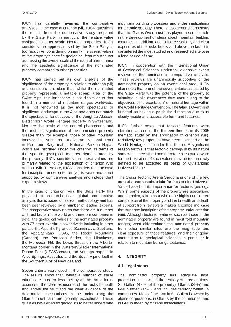
IUCN Evaluation Report May 2008 81
ID Nº 1179 Switzerland - Swiss Tectonic Arena Sardona
IUCN has carefully reviewed the comparative analyses. In the case of criterion (vii), IUCN questions the results from the comparative study prepared by the State Party, in particular the relative value assigned to other World Heritage properties. IUCN considers the approach used by the State Party is too reductive, considering primarily the scenic values of the property’s specifi c geological features and not addressing the overall scale of the natural phenomena and the aesthetic signifi cance of the nominated property compared to other properties.
IUCN has carried out its own analysis of the signifi cance of the property in relation to criterion (vii) and considers it is clear that, whilst the nominated property represents a notable scenic area of the Swiss Alps, this landscape is not dissimilar to that found in a number of mountain ranges worldwide. It is not renowned as the most spectacular or signifi cant landscape in the Alps and does not match the spectacular landscapes of the Jungfrau-Aletsch-Bietschhorn World Heritage property in Switzerland. Nor are the scale of the natural phenomena and the aesthetic signifi cance of the nominated property greater than, for example, those of other mountain landscapes, such as Huascaran National Park in Peru and Sagarmatha National Park in Nepal, which are inscribed under this criterion. In terms of the specifi c geological features demonstrated by the property, IUCN considers that these values are primarily related to the application of criterion (viii) and not (vii). Therefore, IUCN considers that the case for inscription under criterion (vii) is weak and is not supported by comparative analysis and independent expert reviews.
In the case of criterion (viii), the State Party has provided a comprehensive global comparative analysis that is based on a clear methodology and has been peer reviewed by a number of leading experts. The comparative study notes that there are a number of thrust faults in the world and therefore compares in detail the geological values of the nominated property with 27 other overthrusts worldwide including in other parts of the Alps, the Pyrenees, Scandinavia, Scotland, the Appalachians (USA), the Rocky Mountains (Canada), the Peruvian Andes, the Himalayas, the Moroccan Rif, the Lewis thrust on the Alberta-Montana border in the Waterton/Glacier International Peace Park (USA/Canada), the Aritunga nappes in Alice Springs, Australia; and the South Alpine fault in the Southern Alps of New Zealand.
Seven criteria were used in the comparative study. The results show that, whilst a number of these criteria are more or less met by all the thrust faults assessed, the clear exposures of the rocks beneath and above the fault and the clear evidence of the deformation mechanisms in the rocks along the Glarus thrust fault are globally exceptional. These qualities have enabled geologists to better understand
mountain building processes and wider implications for tectonic geology. There is also general consensus that the Glarus Overthrust has played a seminal role in the development of ideas about mountain building tectonics. In addition, due to its accessibility and clear exposures of the rocks below and above the fault it is considered the most studied and researched site over a long period of time.
IUCN, in cooperation with the International Union of Geological Sciences, undertook extensive expert reviews of the nomination’s comparative analysis. These reviews are unanimously supportive of the nominated property as an exceptional area. IUCN also notes that one of the seven criteria assessed by the State Party was the potential of the property to stimulate public awareness thus contributing to the objectives of “presentation” of natural heritage within the World Heritage Convention. The Glarus Overthrust is noted as having a particular distinction due to its clearly visible and accessible form and features.
IUCN further notes that tectonic features were identifi ed as one of the thirteen themes in its 2005 thematic study on the application of criterion (viii). Relatively few properties have been inscribed on the World Heritage List under this theme. A signifi cant reason for this is that tectonic geology is by its nature somewhat specialised and therefore sites put forward for the illustration of such values may be too narrowly defi ned to be accepted as being of Outstanding Universal Value.
The Swiss Tectonic Arena Sardona is one of the few areas that can sustain a claim for Outstanding Universal Value based on its importance for tectonic geology. Whilst some aspects of the property are specialised and complex, taken as a whole the highly considered comparison of the property and the breadth and depth of support from reviewers makes a compelling case that supports inscription of the property under criterion (viii). Although tectonic features such as those in the nominated property are found in most fold mountain ranges, what differentiates the nominated property from other similar sites are the magnitude and clear exposure of these features, and their ongoing contribution to geological sciences in particular in relation to mountain buildings tectonics.
4. INTEGRITY
4.1 Legal status
The nominated property has adequate legal protection. It lies within the territory of three cantons: St. Gallen (47 % of the property), Glarus (39%) and Graubünden (14%), and includes territory within 19 communes. Most of the land in St. Gallen is owned by alpine corporations, in Glarus by the communes, and in Graubünden by citizens associations.

82 IUCN Evaluation Report May 2008
Switzerland - Swiss Tectonic Arena Sardona ID Nº 1179
The property does not have a single legal status, but is protected by a mixture of federal, cantonal and communal measures. Under Swiss law, sites of national importance are entered onto the Federal Inventory of Landscapes and Natural Monuments of National Importance, although responsibility for the management of these sites lies with the cantonal authorities. These authorities are mainly responsible for protection, maintenance and enhancement measures, while technical support is provided by the federal authority, which also bears a large part of the costs.
A federal inventory of geological sites (geotopes) of national importance has yet to gain legal status; however, at the cantonal level, a geotope inventory was adopted in St. Gallen in 2002, while a similar inventory was in the process of adoption in Glarus at the time of the IUCN fi eld visit. In Graubünden, geotopes have been included in the cantonal natural and cultural heritage protection inventory, and a special inventory of geological sites within the nominated property has been compiled. At the communal level, these geotope protection provisions are included in inventories, ordinances or land use plans, if they are binding on landowners. A series of such geotopes protect the key geological features of the property.
4.2 Boundaries
The nominated property has adequate boundaries that encompasses the most important exposures of the Glarus overthrust and associated geological features. The boundary was confi rmed as part of the agreement between all of the stakeholders on the establishment and management of the area for conservation, and it is marked on the commonly agreed Development Plan. It generally follows topographic features and often coincides with the boundaries of existing protected areas, thus facilitating control and patrolling. The boundary encloses the high mountains on the meeting place of the three cantons, centred on the Piz Sardona. It generally lies above 1500 m, but descends to below 600 m in two places to enclose the important geological sites at Vättis and Lochsite. The particular geography of the property, the topographically restricted access to it, and the fact that land use activities around the property are compatible with its conservation objectives, mean that there is no requirement for a buffer zone.
4.3 Management
In each of the three cantons, a master plan provides the basis for protection of the property in terms of spatial planning. The master plan, issued by the cantonal government and approved by the Federal Council, is binding on all authorities. It lists nature and landscape priority areas, many of which have also been designated as sites of national importance by the federal authorities. The cantonal plans have all
been subject to review, adoption and implementation within the last 5-6 years.
The various parties with interests in the property, including federal, cantonal and communal levels of government, have signed an agreement to establish a Management Committee which manages the property and ensures coordination between the different parties. The agreement also sets out other governance arrangements and established a Scientifi c Advisory Committee.
A Regional Management Plan was concluded in 2003 and is under implementation. The plan includes a binding Development Plan and a list of acceptable and unacceptable uses of the property. It also covers organisational, fi nancial and legal aspects which provide an essential basis for the implementation of agreed measures for the conservation of the property. The Management Committee provides guidance, training and support to rangers, foresters and gamekeepers working in the area.
The provision of effective interpretation and education for visitors is regarded as a key priority by IUCN. While the Regional Management Plan outlines initiatives to further develop interpretive and educational materials and programmes, a substantial amount of public education about the nominated property already takes place through a national “Geopark Programme”. A range of materials already exist, while future plans include training programmes for the tourism sector, guides and others. It is also planned that the management authority for the property, under the guidance of the Scientifi c Advisory Committee, will establish a documentation centre with modern web-based search facilities to make existing information more accessible.
The funding for protecting and managing existing protected areas within the nominated property is provided by federal, cantonal and communal authorities. In addition, an annual budget of CHF 160,000 (some US$ 151,500) will be made available from federal and cantonal budgets to support the implementation of projects protecting the values and integrity of the property if it is inscribed on the World Heritage List. An additional CHF 150,000 (some US$ 142,000) will be provided by the Sarganserland-Walensee-Glarnerland GeoPark Association and the tourism organizations operating in the nominated property. It is anticipated that the total funding required for the effective management of the property will be CHF 1,000,000 (some US$ 946,000), of which it is anticipated that 75% will be covered by public funding and 25% from private funding.
4.4 Threats and human use
There are very few impacts from human use in the nominated property, and the property’s geological
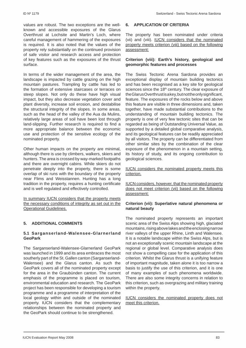
IUCN Evaluation Report May 2008 83
ID Nº 1179 Switzerland - Swiss Tectonic Arena Sardona
values are robust. The two exceptions are the well-known and accessible exposures of the Glarus Overthrust at Lochsite and Martin’s Loch, where careful management of hammering of the exposures is required. It is also noted that the values of the property rely substantially on the continued provision of safe visitor and research access and protection of key features such as the exposures of the thrust surface.
In terms of the wider management of the area, the landscape is impacted by cattle grazing on the high mountain pastures. Trampling by cattle has led to the formation of extensive staircases or terraces on steep slopes. Not only do these have high visual impact, but they also decrease vegetation cover and plant diversity, increase soil erosion, and destabilise the structural integrity of the slopes. In some areas, such as the head of the valley of the Aua da Mulins, relatively large areas of soil have been lost through land-slipping. Further research is required to fi nd a more appropriate balance between the economic use and protection of the sensitive ecology of the nominated property.
Other human impacts on the property are minimal, although there is use by climbers, walkers, skiers and hunters. The area is crossed by way-marked footpaths and there are overnight cabins. While skiers do not penetrate deeply into the property, there is some overlap of ski runs with the boundary of the property near Flims and Weisstannen. Hunting has a long tradition in the property, requires a hunting certifi cate and is well regulated and effectively controlled.
In summary IUCN considers that the property meets the necessary conditions of integrity as set out in the Operational Guidelines.
5. ADDITIONAL COMMENTS
5.1 Sarganserland-Walensee-Glarner land GeoPark
The Sarganserland-Walensee-Glarnerland GeoPark was launched in 1999 and its area embraces the most southerly part of the St. Gallen canton (Sarganserland-Walensee) and the Glarus canton. As such the GeoPark covers all of the nominated property except for the area in the Graubünden canton. The current emphasis of the programme is placed on tourism, environmental education and research. The GeoPark project has been responsible for developing a tourism programme and a programme of interpretation of the local geology within and outside of the nominated property. IUCN considers that the complementary relationships between the nominated property and the GeoPark should continue to be strengthened.
6. APPLICATION OF CRITERIA
The property has been nominated under criteria (vii) and (viii). IUCN considers that the nominated property meets criterion (viii) based on the following assessment:
Criterion (viii): Earth’s history, geological and geomorphic features and processes
The Swiss Tectonic Arena Sardona provides an exceptional display of mountain building tectonics and has been recognised as a key site for geological sciences since the 18th century. The clear exposure of the Glarus Overthrust is a key, but not the only signifi cant, feature. The exposures of the rocks below and above this feature are visible in three dimensions and, taken together, have made substantial contributions to the understanding of mountain building tectonics. The property is one of very few tectonic sites that can be regarded as being of Outstanding Universal Value, as supported by a detailed global comparative analysis, and its geological features can be readily appreciated by all visitors. The property can be differentiated from other similar sites by the combination of the clear exposure of the phenomenon in a mountain setting, its history of study, and its ongoing contribution to geological sciences.
IUCN considers the nominated property meets this criterion.
IUCN considers, however, that the nominated property does not meet criterion (vii) based on the following assessment:
Criterion (vii): Superlative natural phenomena or natural beauty
The nominated property represents an important scenic area of the Swiss Alps showing high, glaciated mountains, rising above lakes and the enclosing narrow river valleys of the upper Rhine, Linth and Walensee. It is a notable landscape within the Swiss Alps, but is not an exceptionally scenic mountain landscape at the regional or global level. Comparative analysis does not show a compelling case for the application of this criterion. Whilst the Glarus thrust is a unifying feature of important magnitude, taken alone it is too narrow a basis to justify the use of this criterion, and it is one of many examples of such phenomena worldwide. There are also some integrity concerns in relation to this criterion, such as overgrazing and military training within the property.
IUCN considers the nominated property does not meet this criterion.

84 IUCN Evaluation Report May 2008
Switzerland - Swiss Tectonic Arena Sardona ID Nº 1179
7. RECOMMENDATIONS AND STATEMENT OF OUTSTANDING UNIVERSAL VALUE
IUCN recommends that the World Heritage Committee adopt the following decision:
The World Heritage Committee,
1. Having examined Documents WHC-08/32.COM/8B and WHC-08/32.COM/INF.8B2,
2. Inscribes the Swiss Tectonic Arena Sardona, Switzerland, on the World Heritage List on the basis of criterion (viii), noting the revision of the name originally proposed by the State Party;
3. Adopts the following Statement of Outstanding Universal Value:
Values The Swiss Tectonic Arena Sardona presents an
exceptional and dramatic display of mountain building through continental collision. The property is distinguished by the clear three-dimensional exposure of the structures and processes that characterise this phenomenon in a mountain setting, its history of study, and its ongoing contribution to geological sciences. It is one of the few sites illustrating tectonic processes that can be regarded as being of Outstanding Universal Value.
Criterion (viii) – Earth’s history, geological and geomorphic features and processes: The Swiss Tectonic Arena Sardona provides an exceptional display of mountain building tectonics and has been recognised as a key site for geological sciences since the 18th century. The clear exposure of the Glarus Overthrust is a key, but not the only signifi cant, feature. The exposures of the rocks below and above this feature are visible in three dimensions and, taken together, have made substantial contributions to the understanding of mountain building tectonics. The property is one of very few tectonic sites that can be regarded as being of Outstanding Universal Value, as supported by a detailed global comparative analysis, and its geological features can be readily appreciated by all visitors. The property can be differentiated from other similar sites by the combination of the clear exposure of the phenomenon in a mountain setting, its history of study, and its ongoing contribution to geological sciences.
Integrity The property contains the full range of tectonic
features necessary to display the phenomenon of mountain building. Key attributes of the site include the Glarus Overthrust and the associated folded and faulted geological exposures above
and below it. Other key attributes of the property are the accessibility of the features in three dimensions, and access to the thrust surface of the Glarus Overthrust. Associated intangible values relate to the importance of the property as a formative site for the geological sciences; and the features that were part of these studies remain visible and in good condition in the present day.
Requirements for Protection and ManagementThe major exposures of the geological features are within protected areas and are substantially unthreatened. The primary management issue is to allow the natural processes of slope erosion to continue. Other key management issues relate to the continued provision of safe visitor and research access and protection of key features such as the exposures of the thrust surface. The communication of the key values of the property is also an important priority and continued investment and enhancement of visitor interpretation and education strategies are required.
4. Commends the State Party for its signifi cant efforts in developing the nomination and enhancing the recognition of the values of the property following IUCN’s evaluation of the original nomination submitted in 2004; and notes the quality of the comparative analysis carried out in relation to the geological values of the property;
5. Further notes that the inscription of the property makes a signifi cant contribution to the recognition of tectonic sites on the World Heritage List and that the nomination sets a high standard for the quality of argument required to support inscription of any further tectonic sites as well as for geological nominations in general; and emphasises that the numbers of tectonic sites suitable for inscription on the World Heritage List is likely to be very small.
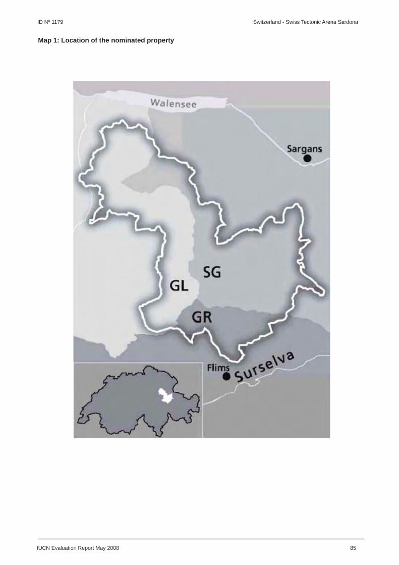
IUCN Evaluation Report May 2008 85
ID Nº 1179 Switzerland - Swiss Tectonic Arena Sardona
Map 1: Location of the nominated property

86 IUCN Evaluation Report May 2008
Switzerland - Swiss Tectonic Arena Sardona ID Nº 1179
Map 2: Boundaries of the nominated property

LATIN AMERICA / CARIBBEAN
QUARRY OF THE FABRICA NACIONAL DECEMENTOS S.A. (FANCESA), CAL ORCK’O,
SUCRE, DEPARTAMENTO CHUQUISACA
BOLIVIA
IUCN Evaluation Report May 2008 87
WORLD HERITAGE NOMINATION – IUCN TECHNICAL EVALUATION
QUARRY OF THE FABRICA NACIONAL DE CEMENTOS S.A. (FANCESA), CAL ORCK’O, SUCRE, DEPARTAMENTO CHUQUISACA (BOLIVIA) – ID No. 1284
1. DOCUMENTATION
i) Date nomination received by IUCN: April 2007
ii) Additional information offi cially requested from and provided by the State Party: IUCN requested supplementary information on 20 September 2007 before the fi eld visit, on 16 November 2007 after the fi eld visit and on 14 December 2007 after the fi rst IUCN World Heritage Panel meeting. The State Party response was offi cially received by the World Heritage Centre on 2 January 2008.
iii) UNEP-WCMC Data Sheet: 12 references (including nomination)
iv) Additional literature consulted: Dingwall, P., Weighell, T. and Badman, T. (2005) Geological World Heritage: A Global Framework Strategy. IUCN, Gland, Switzerland, 51 p.; Gillette, D. and Lockley, M. (1989) Dinosaur Tracks and Traces. Cambridge University Press, 480 p.; Lockley, M. (1991) Tracking Dinosaurs. Cambridge University Press, 252 p.; Lockley, M. and Hunt, A. (1995) Dinosaur Tracks and Other Fossil Footprints of the Western United States. Columbia University Press, New York, 336 p.; Lockley, M. and Meyer, C. (2000) Dinosaur Tracks and Other Fossil Footprints in Europe. Columbia University Press, New York, 323 p.; Lockley, M., Schulp, A., Meyer, C., Leonardi, G. and Kerumba Mamani, D. (2002) Titanosauroid tracks from the Upper Cretaceous of Bolivia: evidence for large manus wide gauge locomotion and gregarious behaviour. Cretaceous Research, 23: 393 – 400; State Party of Spain (2005) Dinosaur Ichnite Sites in the Iberian Peninsula. World Heritage nomination dossier, Spain; Wells, R.T. (1996) Earth’s Geological History: A Contextual Framework for Assessment of World Heritage Fossil Site Nominations. IUCN, Gland, Switzerland, 43 p.
v) Consultations: 7 external reviewers. Extensive consultations were undertaken during the fi eld visit with representatives of the State Party and City Government of Sucre including the Mayor and members of the City Council; Fabrica Nacional de Cementos S.A. (FANCESA); University of San Francisco Xavier of Chuquisaca, Scientifi c Society of Paleontology (SOCIUPA), Institute for Geological Research and National Museum of Natural History.
vi) Field visit: Patrick McKeever, October 2007
vii) Date of IUCN approval of this report: April 2008
2. SUMMARY OF NATURAL VALUES
The nominated property (Cal Orck’O) is within an active quarry owned and operated by the Fabrica Nacional de Cementos S.A. (FANCESA). The quarry is located 4.4 km north-east of Sucre in Bolivia, its southern boundary is the main Sucre – Cochabamba road and its northern boundary is a small tributary of the Rio Gallego. It is characterised by karstifi ed limestones with sparse vegetation and red sandstones covered with eucalyptus forests.
Cal Orck’O is located in a north-south orientated syncline within the El Molino Formation, which is of Upper Cretaceous age. This group of rocks is composed of sandy limestones and mudstones.
The limestones are often oolitic and bear fossils including ostracods, characeans (fresh-water algae) and fresh-water stromatolites as well as seven layers with dinosaur trackways. Some remains of aquatic turtles and crocodiles as well as the isolated remains of freshwater fi sh indicate a lake environment with episodic desiccation features that formed under a semi-arid climate.
The main trackway-bearing wall comprises a rock surface of approximately 65,000 m2 which dips steeply at 72°. The wall is 1,500 m long and has a maximum elevation of 130 m. The dinosaur trackways are numerous and diverse. They include large (more than 35 cm long) to very small (less than 10 cm long) three-toed footprints attributed to theropods; large oval
88 IUCN Evaluation Report May 2008
Bolivia - Quarry of the Fabrica Nacional de Cementos S.A. (FANCESA), Cal Orck’O, Sucre ID Nº 1284
shaped prints up to 70 cm length attributed to large sauropods; blunt three-toed prints of lengths between 15-30 cm attributed to ornithopods; and ellipsoid rake-like prints attributed to ankylosauroids. In total, 5055 single imprints have been documented and 462 trackways can be followed over a distance of several metres or more. They include one trackway made by a small theropod that can be followed for more than 580 m making it currently the longest recorded single trackway. Cal Orck’O includes a record of the main groups of dinosaurs that were present in South America at a time close to the major extinction event that ended the dinosaurs reign on Earth some 65 million years ago.
Cal Orck’O is still an active quarry and it is anticipated that by 2016, when quarrying operations are due to cease, an additional 25,000 m2 of rock surface may be exposed. This may yield an additional 2500 individual tracks and a further 200 trackways which could further enhance the scientifi c interest of the site as a whole.
3. COMPARISONS WITH OTHER AREAS
IUCN’s framework for the assessment of World Heritage fossil site nominations (Wells 1996) provides a framework for assessing the values of fossil sites and has provided the basis for the establishment of case law in relation to the inscription of fossil sites on the World Heritage List. Most notable is the case of Miguasha, where the World Heritage Committee insisted on a rigorous global comparative analysis to identify the site that best conveyed the values of the so called “Age of the Fishes”, and this analysis remains a model in objectively assessing the Outstanding Universal Value of fossil sites in relation to the requirements of the World Heritage Convention. The principles established have subsequently served as benchmarks for the inscription of fossil sites such as Ischigualasto-Talampaya (Argentina), Wadi Al-Hitan (Egypt) and Monte San Giorgio (Switzerland) and the rejection of three fossil sites: the Permian exposures of Jixian (China), the petrifi ed forest on Lesbos (Greece), and the fossil fi ndings of Ipolytarnoc (Hungary).
Trace fossils (or “ichnites”) as demonstrated by the nominated property are sedimentary structures made by living animals. As such they illustrate the behaviour of living animals and give us insight into how they lived, but do not record the form of the whole animal. IUCN notes that the same animal or indeed the same foot can be represented by various types of trackways and footprints.
The approach to the evaluation of fossil footprint sites has also been the subject of past discussion by the World Heritage Committee, notably in the decision to defer consideration of the nomination of the Dinosaur Ichnites of the Iberian Peninsula (Spain) in 2005. In that decision the Committee noted the importance
of considering footprint site values in relation to the values of fossil sites as a whole, and not only other footprint sites.
IUCN has therefore evaluated the nominated property against the standard set of ten questions that has been used as the basis for assessing the values of fossil sites since 1996 (see Annex A). This analysis shows that the values of the nominated property are relatively narrow and that inscription of the site on the basis of trackways alone would represent a very signifi cant narrowing of the basis for inscription of fossil sites.
Three sites already inscribed on the World Heritage List include dinosaur trackways, although none of these were inscribed on the basis of trackways alone. The Ischigualasto-Talampaya in Argentina was inscribed because it contains a complete sequence of fossil bearing continental sediments representing the entire Triassic Period (45 million years) of geological history. The site includes evidence of the earliest dinosaurs as they made their transition from the archosaurs. Moreover, it also records the contemporaneous evolution of mammals. The Dinosaur Provincial Park in Canada has yielded over 150 complete dinosaur skeletons as well as additional disorganised concentrations of bones dating from 75 million years ago in the late Cretaceous. The Dorset and East Devon Coast records rocks from the Mesozoic and includes one of the most outstanding marine sequences of Jurassic strata from anywhere in the world. However, terrestrial sediments are rarer and dinosaur trackways here are limited to a short period of time at the Jurassic – Cretaceous boundary.
In terms of comparisons, the Lark Quarry site in Australia includes 3,000 dinosaur footprints and is considered to record a stampede of small dinosaurs some 95 million years ago. At Geoseong, Republic of Korea, trackways belonging to theropods, sauropods and ornithopods are recorded from mid-Cretaceous times. Sites across Colorado, New Mexico, Texas and Utah in the USA record many other types of dinosaur behaviour including evidence of herding. Across Spain and Portugal numerous sites yield trackways that demonstrate a wide variety of dinosaur behaviour and span the entire age of the dinosaurs from the Triassic through to their extinction at the end of the Cretaceous.
IUCN notes that there are, coincidentally, three different proposals related to dinosaur trace fossils currently being put forward for consideration as potential World Heritage properties: the present nomination, the previously deferred Dinosaur Ichnites of the Iberian Peninsula nomination (re-submitted by Spain and Portugal in early 2008 but regarded as incomplete) and the Korean Cretaceous Dinosaur Coast nomination accepted for evaluation in 2008-2009. IUCN considers it is unfortunate to have three
IUCN Evaluation Report May 2008 89
ID Nº 1284 Bolivia - Quarry of the Fabrica Nacional de Cementos S.A. (FANCESA), Cal Orck’O, Sucre
such specialised proposals under consideration at the same time. Considering the previous evaluation of trace fossil sites above, which already noted the narrowness of the argument, IUCN considers that sites nominated on the basis of trackways alone are too narrowly focussed to be included in the World Heritage List. IUCN also notes that the comparative analyses provided for the three different proposals appear to lack consistency, but that it is diffi cult to reach a conclusive position on their relative merits until all three proposals are evaluated. However, in absolute terms IUCN considers that, amongst the three proposals, the one from Bolivia appears to have the smallest potential to meet the requirements of the Convention.
4. INTEGRITY
4.1 Legal status
The nominated property was declared a national monument by the government of Bolivia in 1998. This gives the site full legal protection under Bolivian law and should automatically instigate the development of a management plan. It also places an onus on the national government to invest fi nancially in the site to ensure its continuing protection and conservation. In 2006, a new law was passed by the Bolivian National Congress to conserve the palaeontological heritage of Cal Orck’O as a national priority.
IUCN considers that ownership of the property is not clear. According to the nomination dossier, the trackway-bearing wall belongs jointly to FANCESA, the City Government of Sucre, the University of San Francisco Xavier and SOBOCE (a private partner). However, information received during the fi eld visit suggests that the owner is FANCESA.
4.2 Boundaries
The boundaries of the property are clearly defi ned and include an area subject to active quarrying. IUCN considers that the inclusion of an active quarry within the boundaries of a natural World Heritage property is inappropriate, and that the boundaries of the nominated property do not therefore meet the required conditions of integrity.
4.3 Management
There is no management plan in place for the nominated property. The City Government of Sucre has fi nanced and built an on-site visitor centre called the Cretaceous Park (Parque Cretácio) and has fi nanced, with international assistance, the conservation of the trackway-bearing wall. An agreement was signed in 2006 between FANCESA, the City Government of Sucre and the University of San Francisco Xavier to establish and fi nance a Palaeontological Foundation.
The Foundation was expected to start its work in January 2008 and will draft the management plan for the site and develop protection, conservation and supporting development activities. IUCN considers that the nominated property does not meet all of the necessary requirements for effective management due to the very recent establishment of the Foundation and the lack of a management plan.
4.4 Threats and human use
The rock face that is the key feature of the nominated property is fragile. A series of management interventions have maintained the stability of the quarry face that displays the footprints, but the site remains located in an active quarry, and this is of concern. There is varying information regarding the potential cessation of quarrying. According to the nomination dossier, the remaining portions of the existing quarry fl oor adjacent to the south-eastern side of the trackway-bearing wall will be subject to active quarrying until 2016. According to discussions during the fi eld visit, however, quarrying might cease in 2011 or 2012. In any case the nominated property is within an active quarry that will remain an extractive site for between 3-8 years. IUCN therefore considers that the whole site should be closely monitored to ensure the continuing quarrying operations do not damage the trackway-bearing wall.
Tourism is limited to the Cretaceous Park. Although tourists were formerly allowed access to the base of the wall this is now prevented. The risk of removal of tracks by collectors exists but does not represent a real threat at the moment.
IUCN considers that the nomination of an active quarry as a natural World Heritage property is inappropriate and that the level of threats and human use is unacceptable at present.
In summary IUCN considers that the property does not meet the necessary conditions of integrity as set out in the Operational Guidelines.
5. APPLICATION OF CRITERIA
The property was originally nominated under all four natural criteria; however, the State Party has confi rmed during the evaluation process that the property should only be considered in relation to criterion (viii). IUCN considers that the nominated property does not meet this criterion based on the following assessment:
Criterion (viii): Earth’s history, geological and geomorphic features and processes
The Cal Orck’O trackways and associated fossils provide a snapshot of the record of life from the late Cretaceous including traces of the main groups of

90 IUCN Evaluation Report May 2008
Bolivia - Quarry of the Fabrica Nacional de Cementos S.A. (FANCESA), Cal Orck’O, Sucre ID Nº 1284
dinosaurs that existed in South America at that time. However, the trackways do not tell us anything unique about dinosaurs that cannot be seen elsewhere. The property has national and regional signifi cance but does not demonstrate values at the level required for inscription on the World Heritage List. Furthermore, as an active quarry, the property does not meet the conditions of integrity.
IUCN considers the nominated property does not meet this criterion.
6. RECOMMENDATIONS
IUCN recommends that the World Heritage Committee adopt the following decision:
The World Heritage Committee,
1. Having examined Documents WHC-08/32.COM/8B and WHC-08/32.COM/INF.8B2,
2. Decides not to inscribe the Quarry of the Fabrica Nacional de Cementos S.A. (FANCESA), Cal Orck’O, Sucre, Departamento Chuquisaca, Bolivia, on the World Heritage List on the basis of natural criteria;
3. Commends the State Party for its investment in conservation of the dinosaur footprints within the property;
4. Recommends the State Party to continue its efforts to conserve and present this national monument alongside the current quarrying activity and after quarrying ceases.

IUCN Evaluation Report May 2008 91
ID Nº 1284 Bolivia - Quarry of the Fabrica Nacional de Cementos S.A. (FANCESA), Cal Orck’O, Sucre
Annex A: IUCN Checklist for the Evaluation of Fossil Sites
1. Does the site provide fossils which cover an ex-tended period of geological time (i.e. how wide is the geological window)?
The geological window of the property is ex-tremely narrow, possibly less than 10-15 years. It represents a snapshot of geological time that is rich in terms of the footprint record portrayed.
2. Does the site provide specimens of a limited number of species or whole biotic assemblages (i.e. how rich is the site in species diversity)?
The species diversity is diffi cult to determine as footprints can only rarely be confi dently assigned to defi nitive species, and there are a range of footprint types that can be produced by the same species (as well as many footprints that can be produced by a single individual). The property contains a diverse assemblage of dinosaur foot-prints, but does not provide evidence of whole biotic assemblages at a particularly rich level.
3. How unique is the site in yielding fossil speci-mens for that particular period of geological time (i.e. would this be the type locality for study or are there other similar areas that are alternatives)?
The site’s unique claim is the concentration of fossil specimens, but all of the footprints found here are found in many other localities, although in smaller numbers and not with the same number of individual footprints or trackways. The site is not the type locality for footprint study although is one of a number of sites.
4. Are there comparable sites elsewhere that con-tribute to the understanding of the total “story” of that point in time/space (i.e. is a single site nomi-nation suffi cient or should a serial nomination be considered)?
There are comparable sites elsewhere, upwards of 33 sites are included in the comparative analy-sis based on footprints alone, however if dino-saur fossil sites are considered the number would grow further.
5. Is the site the only or main location where major scientifi c advances were (or are being) made that have made a substantial contribution to the un-derstanding of life on earth?
This site is neither the only nor main location where major scientifi c advances in footprint or
dinosaur studies have been made, although it has an international reputation amongst dinosaur footprint specialists.
6. What are the prospects for on-going discoveries at the site?
The prospects of ongoing discoveries are good, but are dependant on the continuation and man-agement of active quarrying operations.
7. How international is the level of interest in the site?
The property is of international interest to dino-saur footprint science, but the same can be said of many other properties.
8. Are there other features of natural values (e.g. scenery, landform, vegetation) associated with the site (i.e. does there exist in the adjacent area modern geological or biological processes that relate to the fossil resource)?
There are very limited associated natural features within the property which is limited to a large sin-gle rock face in an active quarry.
9. What is the state of preservation of specimens yielded from the site?
The state of preservation of specimens is good in situ, although ongoing quarrying and weathering result in continued degradation of the footprints and trackways.
10. Do the fossils yielded provide an understanding of the conservation status of contemporary taxa and/or communities (i.e. how relevant is the site in documenting the consequences to modern biota of gradual change through time)?
The fossils of the nominated property have lim-ited relevance in relation to this criterion due to their age.

92 IUCN Evaluation Report May 2008
Bolivia - Quarry of the Fabrica Nacional de Cementos S.A. (FANCESA), Cal Orck’O, Sucre ID Nº 1284
Map 1: Location of the nominated property
Map 2: Boundaries of the nominated property
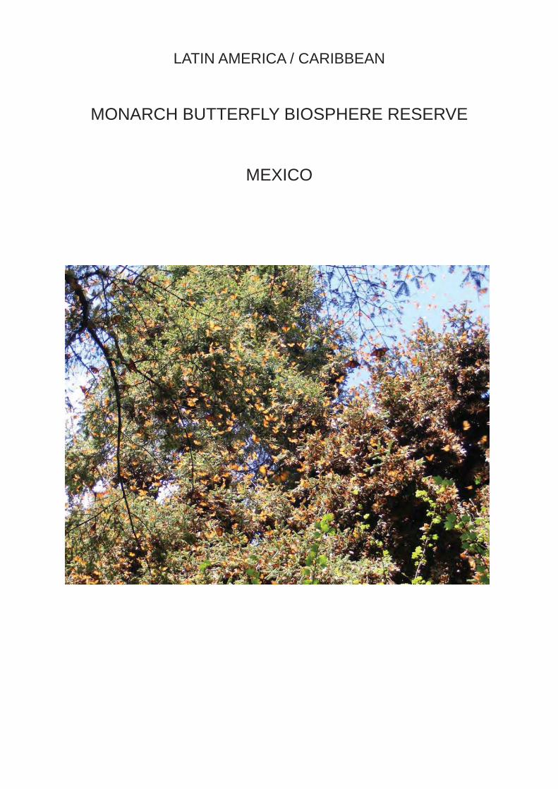
LATIN AMERICA / CARIBBEAN
MONARCH BUTTERFLY BIOSPHERE RESERVE
MEXICO

IUCN Evaluation Report May 2008 93
WORLD HERITAGE NOMINATION – IUCN TECHNICAL EVALUATION
MONARCH BUTTERFLY BIOSPHERE RESERVE (MEXICO) – ID No. 1290
1. DOCUMENTATION
i) Date nomination received by IUCN: April 2007
ii) Additional information offi cially requested from and provided by the State Party: IUCN requested supplementary information on 8 November 2007 before the fi eld visit and on 20 December 2007 after the fi rst IUCN World Heritage Panel meeting. The State Party response was offi cially received by the World Heritage Centre on 12 February 2008.
iii) UNEP-WCMC Data Sheet: 13 references (including nomination)
iv) Additional literature consulted: Brower, L. (2000) Suggested Guidelines for more Effective Enforcement and Management of the Core and Buffer Areas in the Monarch Butterfl y Biosphere Reserve; Galindo-Leal, C. and Rendón-Salinas, E. (2005) Danaidas: Las Maravillosas Mariposas Monarca. Publicación Especial No. 1, WWF México-Telcel, México D.F.; Hilton-Taylor, C. (compiler) (2006) IUCN Red List of Threatened Species. IUCN, Gland, Switzerland; Magin, C. and Chape, S. (2004) Review of the World Heritage Network: Biogeography, Habitats and Biodiversity. UNEP-WCMC and IUCN, Cambridge, UK; Rendón, E. et al. (eds) (2005) Memorias del Primer Foro Mariposa Monarca, 2004; Rendón, E. et al. (eds) (2007) Memorias del Tercer Foro Mariposa Monarca, 2006; SEMARNAT-CONANP (2001) Programa de Manejo Reserva de la Biosfera Mariposa Monarca, México. Ministry of the Environment and Natural Resources, Mexico; Thorsell, J. and Hamilton, L. (2002) A Global Overview of Mountain Protected Areas on the World Heritage List. IUCN, Gland, Switzerland; Thorsell, J. and Sigaty, T. (1997) A Global Overview of Forest Protected Areas on the World Heritage List. IUCN, Gland, Switzerland; Tipping, C. (1995) The Longest Migration. Chapter 11 in the University of Florida Book of Insect Records, Gainesville, Florida; Urquhart, F. (1976) Found at last: the monarch’s winter home. National Geographic Magazine, 150: 161-173.
v) Consultations: 7 external reviewers. Extensive consultations were undertaken during the fi eld visit with: the Directors and staff of the Mexican National Commission for Natural Protected Areas (CONANP); the Director of the Monarca Fund; Mayors of towns and villages in the buffer zone; representatives of rural cooperatives in the buffer zone; NGO representatives; representatives of the tourism sector and fi sh farmers.
vi) Field visit: Allen Putney, November 2007
vii) Date of IUCN approval of this report: April 2008
2. SUMMARY OF NATURAL VALUES
The 56,259 ha Monarch Butterfl y Biosphere Reserve is located in the Transvolcanic Mountain Range within the Mexican States of Michoacán and México, about 100 km west and northwest of Mexico City, and was listed by UNESCO as a Biosphere Reserve in 2006. The additional information provided by the State Party confi rms that only the three separate core zones of the Biosphere Reserve are nominated for World Heritage status, thus representing a serial nomination. The three core zones cover 13,552 ha in total area and are surrounded by two buffer zones covering 42,707 ha, as shown in Table 1.
The nominated property is covered by oyamel fi r forest on the crest of a north-south ridge, which forms part of the wide belt of mountains known as the Transvolcanic Range, which runs east-west across the centre of Mexico. The variations in aspect and altitude in the mountains create a range of microclimates. Biogeographically the Transvolcanic Range forms the southern limit of the Mexican Plateau and is near the southern limit of the Nearctic ecozone. The Biosphere Reserve has 493 vascular plant species and 49 fungus species. These include the endemic Mexican box elder and martin pine. On the high ridges the dominant vegetation is coniferous forest, the most important tree in which is the Mexican or oyamel fi r.

94 IUCN Evaluation Report May 2008
Mexico - Monarch Butterfl y Biosphere Reserve ID Nº 1290
Within the Biosphere Reserve, 198 vertebrates are recorded, including the endemic Mexican vole. There are 132 bird species and at least three endemic salamander species; however, the monarch butterfl y is the “fl agship” species of the nominated property.
Monarch butterfl ies are found especially in the latitude of the American Great Lakes but also in the northern Middle West, Texas and California, where their sole food plant, milkweed is abundant. There are some 100 species of milkweed, the common milkweed being the most widespread, but 27 others are known to be eaten by the butterfl y larvae. An egg becomes a caterpillar in three to eight days; nine to sixteen days later it pupates for a week before metamorphosis. The butterfl y’s normal life cycle is from two to six weeks and there are usually four to fi ve generations a year, only the last of which leaves the country to hibernate abroad. The eastern population of the monarch butterfl y is remarkable for its 3,500 to over 4,500 km annual autumn migration from the northeast to their overwintering sites in central Mexico (the far smaller western or Californian population of the monarch butterfl y migrates and hibernates locally). During this migration, the butterfl ies travel an average of 129 km a day, fi rst fl ying south-southwest until over the Sierra Madre in northern Mexico where they turn south-southeast to reach the oyamel forests. They migrate in the last week of August and fi rst week of September, triggered by the shortening of daylight and lowering temperatures. They store fat for the journey, but feed on nectar on the way and roost at night and in bad weather. They also travel in a sexually immature state termed reproductive diapause which enables them to live between six to ten weeks and in the torpor of hibernation for seven to ten months.
Millions, perhaps a billion butterfl ies from wide areas of North America, cluster densely on small areas of forest, turning the trees orange. They are susceptible to wet and cold conditions and millions die either on site or on the return, providing food for the two species of bird and fi ve species of mice which can eat them without being repelled by toxins ingested from the milkweed. As with other species, their toxicity is advertised by the bright coloration of both caterpillar and butterfl y. After fi ve months, at the end of March, the butterfl ies move down the watershed, mate, and return some 1,500 km to the Gulf of California, to lay their eggs and die. The next generation continues the
cycle, returning north, thus no butterfl y survives the return.
Between November and April, the cool and cloudy humid climate of the dense oyamel forests provides the most suitable environment for the overwintering monarch butterfl ies. The remaining oyamel forests represent the last 2% of a once extensive range. Where the tracts are large and dense enough (larger than 1,000 ha and at least about 400 trees per hectare) and above about 2,900 m, they provide the conditions needed by the overwintering monarch butterfl ies: sheltered from rain but humid enough to prevent desiccation and forest fi res, cool enough to maintain their torpor but not so cold as to kill them and not so warm as to prompt premature maturation. Freedom from disturbance is essential to the survival of the oyamel forests, but during the last quarter of the 20th century, logging and agricultural encroachment have diminished the largest tracts of this rare habitat by four-fi fths. As a result, it now remains as islands of thinned woodland more easily invaded by rain, frost and disease.
3. COMPARISONS WITH OTHER AREAS
The core zones of the Monarch Butterfl y Biosphere Reserve have been nominated under criteria (vii) and (ix). In relation to criterion (vii), the nominated property is compared with other World Heritage properties and protected areas where species migration represents a superlative natural phenomenon. A comparison of the nominated property with key World Heritage properties with notable species migrations is summarised in Table 2. As shown in this table, the application of criterion (vii) to a number of World Heritage properties is linked to the phenomenon of species migrations, particularly of birds and large mammals.
Insect migration is a phenomenon displayed by many species and can be broadly classifi ed in two types: dynamic migration and homeostatic migration. Dynamic migration is directed movement controlled by tides or wind, with navigational abilities not essential. The desert locust, found in Africa, is a good example of this type of migration, and the majority of migratory insects fall into this category. Homeostatic migrations are two-way migrations with migrants or offspring returning to breeding areas, hence the need for
Table 1: Core areas of the nominated property and their buffer zones
Name of the areaSize (ha)
Core areas Buffer zonesCerro Altamirano 589 UnknownChincua-Campanario-Chivati-Huacal 9,234
UnknownCerro Pélon 3,729Total 13,552 42,707

IUCN Evaluation Report May 2008 95
ID Nº 1290 Mexico - Monarch Butterfl y Biosphere Reserve
navigational abilities. The monarch butterfl y migration is considered the classic example of this type of insect migration, involves millions of individuals, and is as long as or longer than that reported for the desert locus. As part of this migration, perhaps a billion monarch butterfl ies land in close-packed clusters within 14 overwintering colonies in the oyamel fi r forests of central Mexico, 8 of which are included in the nominated property.
The millions of monarch butterfl ies bend tree branches by their weight, fi ll the sky when they take fl ight, and make a sound like light rain with the beating of their wings. Witnessing this unique phenomenon is an exceptional experience of nature. Of many insect migrations none compares with that of the monarch butterfl y in terms of length, regularity, singularity and visibility on site. The overwintering concentration of the monarch butterfl y is a superlative natural phenomenon.
In relation to criterion (x), the claim for Outstanding Universal Value is based on the values of the monarch butterfl y migration for science and conservation. The nomination argues that this is supported by the 1983 IUCN Invertebrate Red Data Book which designated the overwintering sites of the monarch butterfl y in Mexico as a “threatened phenomena”. However,
neither this assessment nor the IUCN Red List of Threatened Species classifi es the monarch butterfl y as a threatened species. The World Heritage Committee has also previously noted that criterion (x) should not be used in relation to a single species. In addition, the nominated property alone does not encompass the monarch butterfl y migration, which involves other overwintering colonies in Mexico and a wide range of breeding areas in the USA and Canada (see also Section 4.2 below).
In response to IUCN’s request to expand the justifi cation in relation to criterion (x), the State Party has provided additional information comparing the nominated property with 26 comparable forest World Heritage properties. On the basis of these comparisons, the nominated property does not rank highly in terms of plant and animal species richness and endemism. In addition, the nominated property has not been identifi ed as an area which may merit consideration for World Heritage listing in IUCN’s thematic studies on forest protected areas, mountain protected areas and biodiversity values. In conclusion, at the global level, the nominated property is not one of the most important and signifi cant areas for the in situ conservation of biodiversity and threatened species.
Table 2: Comparison of the Monarch Butterfl y Biosphere Reserve with key World Heritage properties with notable species migrations
Name of property Criteria Main species Migration routeNumber of migrating individuals
Two-way distance (km)
Banc d’Arguin, Mauritania ix, x Wading and
waterbirds East Atlantic fl yway 7 million 8,000-30,000
El Vizcaino, Mexico x Grey whale Northern Pacifi c to western Mexico 26,000 16,000-22,000
Sub-Antarctic Islands, New Zealand ix, x Seabirds
Southwest of New Zealand to Chile and Korea
20 million (sooty shearwater)
18,000 (sooty shearwater)
Danube Delta, Romania vii, x Waterbirds East Europe-Africa fl yway ? millions 6,000-12,000
Laponian Area, Sweden iii, v, vii, viii, ix Reindeer
Across northern Sweden, Finland and Norway
30,000-35,000 (herded) 300-400
Serengeti, Tanzania vii, xWildebeest, zebra, gazelles
East African savannah 1.5-2.5 million 1,500-1,600
Gough and Inaccessible Islands, UK vii, x Seabirds Circumpolar feeding
route 10 million 16,000-25,000
Monarch Butterfl y Biosphere Reserve, Mexico
vii, x Monarch butterfl y
Eastern North America to central Mexico
400 million to 1 billion
3,500 to over 4,500

96 IUCN Evaluation Report May 2008
Mexico - Monarch Butterfl y Biosphere Reserve ID Nº 1290
4. INTEGRITY
4.1 Legal status
The overwintering phenomenon of the monarch butterfl y was fi rst discovered by scientists in 1975, but it was not until 1980 that a Presidential Decree proclaimed all overwintering sites as a Wildlife Reserve and Refuge Zone, without specifying its boundaries. A Presidential Decree of 1986 established an area of 16,110 ha with specifi c boundaries. A Presidential Decree of 2000 established the Mariposa Monarca National Biosphere Reserve in its present boundaries with three core zones and two buffer zones. The large central Chincua-Campanario-Chivati-Huacal core zone is fl anked by the Cerro Pelón core zone 6-14 km to the south and by the Cerro Altmirano core zone 23-26 km to the north. The core zones are divided into two sub-zones: protection sub-zone (12,623 ha) and restricted use sub-zone (934 ha). The core zones comprise land of rural cooperatives (6,534 ha), communal land (4,792 ha), small private properties (932 ha), national land (707 ha) and other land (427 ha).
A human population of well over 100,000 people lives in over 100 agrarian centres and 55 villages within the buffer zones. The buffer zones comprise land of rural cooperatives (20,603 ha), communal land (11,209 ha), small private properties (1,432 ha), national land (7 ha) and other land (9,616 ha). These lands fall within 15 municipalities in the State of Michoacán and 12 municipalities in the State of México. This highly complex pattern of land ownership creates a challenge for the protection and management of the Biosphere Reserve and nominated property.
4.2 Boundaries
The boundaries of the nominated property are clearly delineated by coordinates in the Presidential Decree of 2000 and include three core zones which are surrounded by two buffer zones. The boundaries were set to include the main overwintering sites of the monarch butterfl y. The three core zones include 8 of the 14 overwintering colonies of the eastern population of the monarch butterfl y and 70% of its total overwintering population. The remaining 30% overwinter in colonies outside the nominated property, three of them to the southwest of the Biosphere Reserve, two to the northwest, and one to the northeast. The boundaries of the core zones of the Biosphere Reserve are not demarcated on the ground. This represents a signifi cant problem for the protection and management of the core zones. The boundaries of the nominated property are adequate for the protection of 70% of the overwintering population of the monarch butterfl y, but the 6 overwintering colonies outside the nominated property could be considered as a potential serial extension in the future.
Since the nominated property features a migrating insect population, it raises the question whether other sites of importance to the life cycle of the eastern population of the monarch butterfl y should be included in the nomination. However, after leaving the overwintering colonies in and around the Monarch Butterfl y Biosphere Reserve, the monarch butterfl ies disperse into 2.6 million square kilometres of habitat in northern Mexico, the USA and Canada east of the Rocky Mountains, without following specifi c fl yways. So far, scientists have not been able to locate any other areas where the eastern population of the species concentrates outside its overwintering colonies in Mexico, and thus no additional sites for potential inclusion in the nomination have been identifi ed. What has been developed is a network of Monarch Butterfl y Sister Protected Areas in an ongoing trilateral effort between Mexico, the USA and Canada to protect the whole life cycle of the monarch butterfl y. IUCN therefore considers the protection of the monarch butterfl ies outside their overwintering colonies does not require a transnational serial nomination because of the wide range of breeding areas in the USA and Canada, which also provides for the integrity of the remainder of the butterfl y’s life cycle.
4.3 Management
The Monarch Butterfl y Biosphere Reserve is managed by the National Commission for Natural Protected Areas (CONANP) assisted directly by 46 federal and state agencies. In addition, 13 NGOs and academic institutions and the Monarch Butterfl y Trust Fund provide input to the management. Management is guided by a Management Programme that was adopted in 2001. The Management Programme is a general document that lays out policies on sustainable development, wildlife management, public use, scientifi c research and monitoring, operations and law enforcement, rather than specifi c prescriptions for management. The document forms the basis for the Annual Operational Plans that are used to guide the day-to-day management activities of the many organisations involved.
An Advisory Council, made up of 21 representatives of rural cooperatives, communities and NGOs, has been established to assist CONANP in implementing the Management Programme and Annual Operational Plans. At a broader scale, a Regional Committee has been established to integrate the efforts of the States of Michoacán and México and 27 municipalities in developing and implementing a regional land use plan. The work of the Advisory Council and Regional Committee is complemented by Annual Regional Fora, large meetings that include all interested stakeholders and serve to coordinate activities and inform the Annual Operational Plans.
A total of 137 staff from six organisations work directly in the Biosphere Reserve, including 9 senior

IUCN Evaluation Report May 2008 97
ID Nº 1290 Mexico - Monarch Butterfl y Biosphere Reserve
professionals from CONANP and over 100 federal and state forest police offi cers and agents. Law enforcement is an ongoing problem despite the large number of offi cers and agents involved in the different federal and state law enforcement agencies. Reviewers have noted that this problem is mainly the result of lack of coordination. The lack of adequate tourism planning and management paired with rapidly growing tourism infrastructure are problems that require the immediate development and implementation of a detailed public use plan for the Biosphere Reserve.
The Monarch Butterfl y Trust Fund was set up when the Biosphere Reserve was established, and has been used to purchase the logging rights in the core zones which were granted to communities before the establishment of the Biosphere Reserve. No business plan has been developed for the Biosphere Reserve, but Government commitment is strong enough that increasing levels of investment are likely. The President of Mexico visited the Biosphere Reserve in November 2007 and pledged an additional US$ 4.6 million for investment in tourism infrastructure and job creation within the Biosphere Reserve.
According to the additional information provided by the State Party, the total budget for implementing the Operational Plan for the Biosphere Reserve in 2007 was 5,514,900 Mexican Pesos (around US$ 531,105). The nomination document indicates that both the existing level of staffi ng and funding is inadequate. Based on the consultations during the IUCN fi eld visit and a number of reviews, IUCN concurs that the current level of funding is insuffi cient for the effective management and conservation of the potential World Heritage property in light of the threats it faces. In addition, it is of utmost concern that only 0.3% of the 2007 budget was dedicated directly or indirectly to address the key threat of continuing and signifi cant forest loss in the Biosphere Reserve.
4.4 Threats and human use
The major threats facing the Monarch Butterfl y Biosphere Reserve are human population growth, logging, agricultural encroachment, expansion of human settlements, grazing, forest fi res, pests, and tourism. During the past decade, the population in the municipalities in which the Monarch Butterfl y Biosphere Reserve is located grew from around 500,000 to 780,000. The population is essentially rural and widely dispersed. With over half of the human settlements with less than 100 people, the cost of providing adequate services or to develop alternative livelihoods is high.
Forest loss due to logging is the main direct threat to the Monarch Butterfl y Biosphere Reserve. From 1971 to 2005, almost 4,000 ha of forest have been degraded (logged or disturbed) in the Biosphere Reserve. The nomination document notes that “due to
human pressures, despite the important efforts done by CONANP, the forest is under signifi cant stress and the ecosystem is in danger”. It further notes that due to the marked human population growth, the forested area shows “a permanent decline in total forested area, and simultaneously, an increasing rate of exploitation of the forest ecosystem”. Despite the efforts of agencies and local communities, 510 ha were degraded from 2000 to 2003 and a further 479 ha from 2003 to 2005, mostly due to illegal logging. While illegal logging has been decreasing, it is still a major problem, as confi rmed by recent satellite images that document continued and signifi cant forest loss. This can be attributed to both loggers coming from outside the Biosphere Reserve as well as to fi rewood gathering by local communities. Agricultural encroachment and the expansion of human settlements are another signifi cant cause of the forest loss. Widespread grazing of cattle, sheep and horses further degrades the forest ecosystem. Forest fi res and pests are an ever present threat to the forest ecosystem. In 2006, 73 fi res were detected within the Monarch Butterfl y Biosphere Reserve, which burned 186 ha. Many of these fi res are a consequence of land clearing for agriculture.
No environmental impact studies have yet been undertaken on the direct effects of tourism on the overwintering colonies of the monarch butterfl y. CONANP has worked effectively with local communities to ensure that tourists visit only the smaller peripheral butterfl y colonies and observe them from an appropriate distance. It would appear that the indirect effects of tourism that could cause the greatest alterations to the forest ecosystem are soil compaction, erosion, and depletion of water supplies. Current tourism impacts relate not so much to the butterfl y colonies, but rather to the area’s natural beauty. Most of the existing tourism infrastructure has been developed by local communities without considering visual or environmental impacts, and this detracts in a major way from the visual integrity of the sites that are visited by tourists.
Overall there is strong local support for the conservation of the property, although illegal activities of individuals from within and outside the Biosphere Reserve continue to occur. The site managers are convinced that the most effective conservation agents for the property are the local communities that rely on it for their livelihoods, and indeed these communities have been involved in halting illegal logging. However, the local communities expect the government to follow up promises of alternative livelihoods and payments for environmental services, and if these are not forthcoming it is expected that illegal activities will increase again.
A study of potential climate change impacts indicates that temperatures are unlikely to change signifi cantly in the areas of the butterfl y colonies, but that increased
98 IUCN Evaluation Report May 2008
Mexico - Monarch Butterfl y Biosphere Reserve ID Nº 1290
rainfall is likely. However, this is projected to occur during summer, thus not affecting the overwintering of the monarch butterfl ies. It is even possible that the increased summer rainfall will be benefi cial to the forest ecosystem. Therefore, in contrast to the continuing and signifi cant forest loss, climate change impacts are not considered a major threat to the nominated property.
The level of effort by the State Party to address the existing threats has been increased recently with emphasis on a number of objectives. However, based on the consultations during the IUCN fi eld visit and a number of reviews, IUCN considers that these increased efforts of the State Party are still insuffi cient for the effective management and conservation of the potential World Heritage property in light of the threats it faces. The high commitment of CONANP and other agencies and organisations involved in the protection and management of the property is not matched by the human and fi nancial resources currently available. This is also recognized in the nomination document.
IUCN therefore considers that the property does not currently meet the necessary conditions of integrity as set out in the Operational Guidelines.
5. ADDITIONAL COMMENTS
5.1 Justifi cation for serial approach
When IUCN evaluates a serial nomination it asks the following questions:
a) What is the justifi cation for the serial approach?
The serial approach is justifi ed because of the disjunctive nature of the major overwintering colonies of the monarch butterfl y. These colonies occur only in large and dense tracts of oyamel fi r forest that are restricted to the higher mountains of the Transvolcanic Range. Some of these colonies are separated by lower mountains and valleys that are heavily populated and retain limited natural habitats.
b) Are the separate components of the property functionally linked?
The superlative natural phenomenon of the overwintering concentration of the monarch butterfl y in the remaining oyamel fi r forest tracts provides the thematic framework for the serial approach. Although the descendants of the individuals of each colony apparently return to that same colony, the colonies in the three separate components of the nominated property are functionally linked in that they jointly provide the majority of the overwintering habitat that is essential to the eastern population of the monarch butterfl y. Two of the three components are further
linked through a joint buffer zone.
c) Is there an overall management framework for all the components?
The three separate components of the nominated property are part of the Monarch Butterfl y Biosphere Reserve and share the same administrative and management framework including the Biosphere Reserve’s Management Programme and Annual Operational Plans. If additional areas were to be added in the future, it might be necessary to integrate them into the Biosphere Reserve’s management framework, or otherwise harmonize management.
IUCN concludes that the serial approach put forward is justifi ed in this case.
6. APPLICATION OF CRITERIA
The property has been nominated under criteria (vii) and (x). IUCN considers that the nominated property meets criterion (vii) based on the following assessment:
Criterion (vii): Superlative natural phenomena or natural beauty
The overwintering concentration of the monarch butterfl y in the nominated property is a superlative natural phenomenon. The monarch butterfl y migration is considered the classic example of two-way insect migration, involves millions of individuals, and is as long as or longer than that any other insect migration. Of many insect migrations none compares with that of the monarch butterfl y in terms of length, regularity, singularity and visibility on site: Perhaps a billion monarch butterfl ies land in close-packed clusters within 14 overwintering colonies in the oyamel fi r forests of central Mexico. The nominated property protects 8 of these colonies and thus 70% of the total overwintering population of the eastern population of the monarch butterfl y. The millions of monarch butterfl ies bend tree branches by their weight, fi ll the sky when they take fl ight, and make a sound like light rain with the beating of their wings. Witnessing this unique phenomenon is an exceptional experience of nature.
IUCN considers that the nominated property meets this criterion but that a number of issues related to the integrity of the property need to be urgently addressed.
IUCN considers, however, that the nominated property does not meet criterion (x) based on the following assessment:
Criterion (x): Biodiversity and threatened species

IUCN Evaluation Report May 2008 99
ID Nº 1290 Mexico - Monarch Butterfl y Biosphere Reserve
The importance of the nominated property for the in situ conservation of biological diversity and threatened species is signifi cant at the regional, but not at the global level. The property ranks lower in terms of plant and animal species richness and endemism than other comparable forest World Heritage properties. The “fl agship” species of the property, the monarch butterfl y, has not been classifi ed as a globally threatened species. The World Heritage Committee has also previously noted that criterion (x) should not be used in relation to a single species. In addition, the nominated property alone does not encompass the monarch butterfl y migration, which involves other overwintering colonies in Mexico and a wide range of breeding areas in the USA and Canada. In conclusion, at the global level, the nominated property is not one of the most important and signifi cant areas for the in situ conservation of biodiversity and threatened species.
IUCN considers the nominated property does not meet this criterion.
7. RECOMMENDATIONS
IUCN recommends that the World Heritage Committee adopt the following decision:
The World Heritage Committee,
1. Having examined Documents WHC-08/32.COM/8B and WHC-08/32.COM/INF.8B2,
2. Defers the examination of the nomination of the Monarch Butterfl y Biosphere Reserve, Mexico, to the World Heritage List on the basis of criterion (vii) to allow the State Party to address a number of issues related to the integrity of the nominated property;
3. Recommends the State Party to:
a) Refocus as a matter of urgency the existing Management Programme, and the Annual Operational Plans and Budget for its implementation, to give the highest priority on actions aiming to halt illegal logging in the core zones of the nominated property. Particular attention should be given to: (1) working with local communities on environmental protection and alternative livelihoods to logging and (2) explore options for a major new investment in development and implementation of a coordinated plan to halt illegal logging involving all federal, state and local agencies;
b) Accelerate investment and actions oriented to clearly demarcating on the ground the core zones of the nominated property in
order to facilitate control and policing actions particularly on halting illegal logging; and
c) Develop and implement, in the context of the 2007 Agreement of Collaboration between SECTUR and CONANP on the Development of Nature-based Tourism, a detailed plan for sustainable public use of the nominated property and an effective benefi t-sharing mechanism for local communities as an incentive to enhance their support on the conservation of the nominated property;
4. Commends the State Party and its partners for their demonstrated commitment to, and active collaboration in, the conservation and management of the Monarch Butterfl y Biosphere Reserve.

100 IUCN Evaluation Report May 2008
Mexico - Monarch Butterfl y Biosphere Reserve ID Nº 1290
Map 1: Location and boundaries of the nominated property

A. Natural Properties
A2. Deferred Nominations of Natural Properties

ASIA / PACIFIC
SARYARKA – STEPPE AND LAKES OFNORTHERN KAZAKHSTAN
KAZAKHSTAN

IUCN Evaluation Report May 2008 101
WORLD HERITAGE NOMINATION – IUCN TECHNICAL EVALUATION
SARYARKA - STEPPE AND LAKES OF NORTHERN KAZAKHSTAN (KAZAKHSTAN) – ID No. 1102 Rev
Background note: This nomination was previously submitted under all four natural criteria for consideration at the 27th session of the World Heritage Committee (Paris, 2003). It was put forward as a serial nomination of three sites: Naurzum State Nature Reserve (87,700 ha), Sarykopa Wildlife Reserve (82,500 ha), and Korgalzhin State Nature Reserve (258,947 ha). Following IUCN’s recommendation, the World Heritage Committee decided to defer the nomination (Decision 27 COM 8C.6) and at the same time requested IUCN to undertake a thematic study for Central Asia, which was completed in 2005. The revised nomination has been submitted under criteria (ix) and (x) only and includes two of the three components previously nominated, excluding Sarykopa (and adopting a different spelling, Korgalzhyn, for one of the other components).
1. DOCUMENTATION
i) Date nomination received by IUCN: April 2007
ii) Additional information offi cially requested from and provided by the State Party: IUCN requested supplementary information on 15 November 2007 after the fi eld visit. The State Party response was received by email on 30 November 2007.
iii) UNEP-WCMC Data Sheet: 9 references (including nomination)
iv) Additional literature consulted: Aitzhanov, M. (1998) Creating a Biosphere Reserve: Opportunities for the Tengiz Lakes, Kazakhstan. In: Dömpke, S. and Succow, M. (eds.) Cultural Landscapes and Nature Conservation in Northern Eurasia, NABU, Bonn, pp.261-264; Dugan, P. et al. (eds) (1993) Wetlands in Danger: A Mitchell Beazley World Conservation Atlas. Mitchell Beazley and IUCN, London; Forestry and Hunting Committee (2006) Management Plan of Korgalzhyn State Nature Reserve. Ministry of Agriculture of the Republic of Kazakhstan; IUCN-WCPA (2000) Proceedings of the Seminar on the Protection and Conservation of Grasslands in East Asia. Grasslands Task Force, IUCN-WCPA, Gland, Switzerland; Kovshar, A.F. (ed.) (2000) The Key Wetlands of the North Kazakhstan. Tethys, Almaty; Krever, V. et al. (eds) (1998) Biodiversity Conservation in Central Asia: An Analysis of Biodiversity and Current Threats and Initial Investment Portfolio. WWF, Moscow; Magin, C. (2005) World Heritage Thematic Study for Central Asia: A Regional Overview. IUCN, Gland, Switzerland; Magin, C. and Chape, S. (2004) Review of the World Heritage Network: Biogeography, Habitats and Biodiversity. UNEP-WCMC and IUCN, Cambridge, UK; Schielzeth, H. et al. (2008) Waterbird population estimates for a key staging site in Kazakhstan: a contribution to wetland conservation on the Central Asian fl yway. Bird Conservation International, 18: 71-86; Tolvanen, P., Aarvak, T. and Bragina, T. (2001) Conservation work for the wetlands and monitoring the autumn staging of Lesser White-fronted Goose in the Kustanay region, north-west Kazakhstan. WWF Finland Report, 13: 30-33; Vlasov, A. (2002) Preserving the steppes of Russia, Ukraine and Kazakhstan. Russian Conservation News, 29: 20-21; Yerokhov, S. (2001) Overview of Undertaken Measures on Migratory Waterfowls Conservation in Kazakhstan. In: Issue 3/4 of the Northeast and East Central Asia National Biodiversity Strategies and Action Plans Newsletter, Biodiversity Planning Support Programme UNEP/UNDP.
v) Consultations: 6 external reviewers. Extensive consultations were undertaken during the fi eld visit with local experts and relevant offi cials from national and local governments, conservation project staff, and fi eld experts from a range of national and international conservation organisations.
vi) Field visit: Chris Magin, September-October 2007
vii) Date of IUCN approval of this report: April 2008

102 IUCN Evaluation Report May 2008
Kazakhstan - Saryarka - Steppe and Lakes of Northern Kazakhstan ID Nº 1102 Rev
2. SUMMARY OF NATURAL VALUES
Saryarka - Steppe and Lakes of Northern Kazakhstan is a serial property comprising two protected areas: Naurzum State Nature Reserve and Korgalzhyn State Nature Reserve. The total area of the proposed property is 450,344 ha, composed of a cluster of three areas which are the core areas of Naurzum and a single area of Korgalzhyn, as shown in Table 1. The nomination also specifi es buffer zones for all the elements of the nominated property which are in total 211,147.5 ha and include an eco-corridor linking the three elements of Naurzum. The buffer zones are not part of the nominated property but contribute to the effective protection and management of its values and integrity.
Naurzum and Korgalzhyn include two groups of fresh and salt water lakes which lie on a watershed between rivers fl owing north to the Arctic and south into the Aral-Irtysh basin. They lie within a temperate Eurasian steppe grassland extending from the Black Sea to the border of China; a huge area of more than 3,000 km from west to east and more than 500 km from north to south. The Eurasian steppe extends over the northern half of Kazakhstan, bounded by coniferous taiga forests to the north and semi-deserts to the south. The climate of the reserves is strongly continental, with hot dry summers and cold winters with relatively small amounts of snow.
Naurzum lies at an altitude between 200-350 m and is located about 220 km south of the city Kostanay in the Turgai depression, a 25-30 km wide valley. The fl oor of the depression consists of former river and lake terraces, now dotted with an intricate chain of winter-fl ooded lakes. The Naurzum State Nature Reserve consists of three strictly protected core areas, surrounded by buffer zones and linked together by an ecological corridor. The largest part, the Naurzum–Karagay cluster, surrounds the Naurzum
Table 1: Core areas of the nominated property and their buffer zones
wetland complex of over a dozen named lakes with a total wetland area of 40,000 ha. About 30 km to the northwest is an area of steppe with patches of forest and striking outcrops of red, yellow and white clay hills (the Tersek-Karagay cluster), and about 20 km to the west is another area of high quality steppe (the Sypsyn–Aebu cluster). In some extreme years many of the lakes dry out, allowing the algae and many of the mineral nutrients to blow away into the surrounding steppe, forcing the whole aquatic ecosystem to re-establish itself again with the commencement of the next wetting phase of the cycle.
Korgalzhyn lies at an altitude between 300-400 m and is located about 120 km south-west of the capital Astana. It is 350 km to the east of Naurzum and lies in a former lake-bottom depression in the Kazakh Rolling Hills. The Korgalzhyn State Nature Reserve consists of the vast Korgalzhyn-Tengiz lake system, an inward-draining complex of marshes, and freshwater and saltwater lakes of fl uctuating water level, fed by the permanent Nura and intermittent Kulanuptes rivers. The total wetland area in the nature reserve is an estimated 200,000 ha, surrounded by steppe. Lake Tengiz is the largest lake at 159,000 ha, but can shrink to 113,000 ha after drought. It is saline with a thick silt lake bottom and surrounded by wide mudfl ats. The Nura River delta, when fl ooded, becomes a huge shallow lake - Lake Korgalzhyn (47,100 ha), a labyrinth of myriad channels lined with Phragmites reeds. Most of the watercourses and lakes are shallow, saline and seasonal. The groundwater is also saline but there are some freshwater springs. The diverse fl ora and fauna of the wetlands has evolved in phase with wetting/drying cycles.
The wetlands of Saryarka are an important crossroads of Central Asian migratory fl yways. Waterfowl from as far away as Italy and Finland in the west to Yakutia in the east, and from the Arctic in the north and Australia to the south, rely on wetlands in Kazakhstan for nesting,
Name of the area ProvinceSize (ha)
Core areas Buffer zones
Naurzum State Nature Reserve –Naurzum–Karagay Cluster Kostanai 139,714 36,287.7
Naurzum State Nature Reserve –Sypsyn–Aebu Cluster Kostanai 38,720 11,624
Naurzum State Nature Reserve –Tersek-Karagay Cluster Kostanai 12,947 37,655.8
Naurzum State Nature Reserve –Eco-corridor linking the above clusters Kostanai - 31,159
Korgalzhyn State Nature Reserve Akmolinsk and Karaganda 258,963 94,421
Total 450,344 211,147.5

IUCN Evaluation Report May 2008 103
ID Nº 1102 Rev Kazakhstan - Saryarka - Steppe and Lakes of Northern Kazakhstan
moulting and feeding habitat during the migration seasons. The lakes of Korgalzhyn provide feeding grounds for up to 15-16 million birds, including fl ocks of up to 2.5 million geese. After rains, these lakes support 350,000 nesting waterfowl, while the Naurzum lakes support up to 500,000 nesting waterfowl. In total, 351 bird species have been recorded (112 breeding and 239 migratory) within the nature reserves. Lake Tengiz is the world’s most northerly breeding site for greater fl amingo, numbering up to 10,000 pairs.
Globally threatened species that occur in Saryarka include the Siberian white crane (three birds were observed in 2001, one bird at Naurzum in 2007), slender-billed curlew (historical records) and white-headed duck (which nests in the area), lesser white-fronted goose, red-breasted goose, Dalmatian pelican, Pallas’s fi sh eagle, greater spotted eagle and Eastern imperial eagle, lesser kestrel, corncrake, great bustard and sociable lapwing. Migrating birds including widgeon, mallard, pochard, red-crested pochard, ruff, and coot pass through in huge numbers. Korgalzhyn is the largest inland staging site of the red-necked phalarope in the world, and several hundred thousand may be present.
Saryarka also contains signifi cant areas of steppe: 120,000 ha of which is reported as unploughed or “virgin” steppe - especially in the western part of Naurzum. The nominated property has nearly 770 species of plants, a third of Kazakhstan’s plant species and over half of the region’s steppe fl ora. Naurzum is the most botanically diverse part of the nomination, with approximately 600 plant species. It is a zone of ecological transition where the northern Pinus sylvestris forest reaches its southernmost limit and meets the semi-arid desert fl ora at its northernmost extent. Naurzum also contains a variety of steppe types including feather-grass dominated dry steppe and sandy scrub steppe with almond, cherry, and juniper shrubs. The discontinuous forest/steppe edge is a very important habitat for raptors, many of which nest in the pine trees, close to plentiful prey in the steppe landscape. The property contains 70% of the Falconidae order in Kazakhstan, 28 species in total, with 18 species (including Eastern imperial eagle, golden eagle, white-tailed eagle and steppe eagle) nesting within the site. It also contains one of the few stable populations of saker falcon in Kazakhstan.
Many of the 53 mammal species in the nominated property are steppe rodents such as Bobak marmot, sousliks, ground squirrel, lemmings and the vulnerable steppe pika. Larger mammals include carnivores such as lynx, wolf, red fox, corsac fox, badger and Siberian polecat. Ungulates are represented by moose, roe deer, wild boar and small numbers of the critically endangered Saiga antelope. The property also contains 10 reptile and amphibian species, 16 fi sh species and over 1,000 invertebrate species.
3. COMPARISONS WITH OTHER AREAS
Saryarka is located towards the eastern edge of the Pontian Steppe Biogeographical Province which covers some 1.9 million km2. The Mongolian-Manchurian Steppe lies to the east of the Pontian Steppe and extends from Mongolia into northern China. The landscape is very similar to the Pontian Steppe, but ecologically it is quite distinct, and is often referred to as the “Eastern Steppes”. These come under the infl uence of the Asian monsoon rainfall in summer, whereas Saryarka is in the “Western Steppes” infl uenced by the Atlantic Ocean.
There are a number of other notable steppe and wetland protected areas within and neighbouring this region; however, little information is available on many of the region’s protected areas. IUCN carried out its comparative analysis based on its 2005 Thematic Study for Central Asia, considering both the steppe and wetland values for which Saryarka is nominated.
Saryarka’s steppe values are compared with other key sites in Table 2. The nominated property contains over 200,000 ha of Central Asian steppe, more than half of which is pristine, and which is part of the temperate grassland biome that is currently poorly represented on the World Heritage List. No other steppe reserves of comparable size to Saryarka exist in Kazakhstan or elsewhere in the “Western Steppes”. The few reserves that do include substantial areas of natural steppe, including the larger Uvs Nuur Basin World Heritage property, lie further east in the “Eastern Steppes”, a different biogeographic province. Saryarka’s steppe areas provide a valuable refuge for over half the species of the region’s steppe fl ora, a number of threatened bird species and the critically endangered Saiga antelope, a once abundant species now much reduced across its range by poaching pressure.
Saryarka’s wetland values are compared with other key sites in Table 3. In terms of bird diversity, the nominated property harbours a similar number of species to other areas in the wider region, including similar species of threatened waterfowl and raptors. However, Saryarka differs in the vast numbers of birds it supports, and also in terms of its high level of integrity. Saryarka’s wetland areas are of outstanding importance for migratory waterbirds, including substantial populations of globally threatened species, as they are key stopover points and crossroads on the Central Asian fl yways. Reviews of the present and previous nomination indicate that Saryarka can be considered as including the most important wetland areas in Central Asia.

104 IUCN Evaluation Report May 2008
Kazakhstan - Saryarka - Steppe and Lakes of Northern Kazakhstan ID Nº 1102 Rev
4. INTEGRITY
4.1 Legal status
Korgalzhyn and Naurzum State Nature Reserves have benefi ted from long-term legal protection as strict nature reserves (IUCN Protected Area Management Category Ia). Naurzum was created in 1931 and enlarged in 1998 and 2004. In the last enlargement, a 2 km buffer zone and an ecological corridor was established to connect the three strictly protected areas of the reserve. Korgalzhyn was created in 1968. Soon afterwards, all settlements and farms were moved beyond the reserve’s boundaries, and a reed factory was closed. From 1974 the fi shing industry was closed and a 2 km buffer zone was established. Originally, the area of the reserve was 177,200 ha, including 147,600 ha of lakes, but the reserve was enlarged twice to a total area of 258,963 ha.
Table 2: Key similarities and differences between Saryarka and other steppe sites
Name of the area Details
Tian Shan Zhongbu Gongnaisi Grassland Nature Reserve (China)
Mongolian-Manchurian Steppe. Steppe grassland protected area (66,667 ha). Different biogeographic province to Saryarka.
Xilinguole Grassland Nature Reserve (China)
Mongolian-Manchurian Steppe. Large steppe grassland protected area (1,078,600 ha) which encompasses two salt lake systems. Different biogeographic province to Saryarka.
Hortobágy National Park - the Puszta (Hungary)
Pannonian Steppe. Cultural landscape World Heritage property (74,820 ha) that includes seasonal salt marshes along the fl ood plains of ancient rivers. Conservation importance for some threatened species that also occur in the Kazakh steppe. However, it is a man-made or secondary steppe and therefore not comparable to the natural steppe and wetlands of Saryarka. Different biogeographic province to Saryarka.
Eastern Mongolian Steppe (Mongolia)
Mongolian-Manchurian Steppe. Designated as a Strict Protected Area (IUCN Protected Area Management Category Ib) in 1992 (570,374 ha). Different biogeographic province to Saryarka.
Nomrog Strict Protected Area (Mongolia)
Mongolian-Manchurian Steppe. Grassy steppe in a different biogeographic province to Saryarka and much further east. With 31,205 ha also much smaller than Saryarka.
Uvs Nuur Basin (Mongolia, Russian Federation)
Mongolian-Manchurian Steppe. Natural World Heritage property (1,068,853 ha) that is made up of twelve protected areas representing the major biomes of eastern Eurasia including desert, steppe, forest, mountain and wetland ecosystems One of the best remaining natural steppe landscapes of Eurasia, but in a different biogeographic province to Saryarka.
Orenburgsky State Nature Reserve (Russian Federation)
Pontian Steppe. Forest protected area (21,653 ha) with some steppe; however, the area is relatively small and fragmented and large herbivores are lacking.
Central Chernozem State Biosphere Reserve (Russian Federation)
Pontian Steppe. Meadow steppes with a high fl oristic diversity. Protects some of the last remaining undisturbed steppe remnants in Europe surrounded by intensive agricultural land. With 6,287 ha core area (including 3,300 ha undisturbed steppes in fi ve separate sections) much smaller than Saryarka.
Askaniya Nova Biosphere Reserve (Ukraine)
Pontian Steppe. Feather grass steppe. With 33,307 ha (11,054 ha core area) much smaller than Saryarka.
Chernomorskiy Biosphere Reserve (Ukraine)
Pontian Steppe. Located on the coast of the Black Sea. Includes three Ramsar sites. Coastal and forest steppe in contrast to the open grass steppe of Saryarka. With 70,509 ha core area (of which 56,361 ha is marine) smaller than Saryarka.
Luganskiy State Nature Reserve (Ukraine)
Pontian Steppe. Very small and fragmented at only 1,607 ha in area and split into three separate parts.
All land in the core areas of Korgalzhyn and Naurzum is state owned and no permanent settlements are allowed. No uses of wild animals and plants are allowed and there is limited visitor access to the property. The land in the buffer zones is mostly state property and consists of agricultural and reserve lands. The agricultural lands are partly used by local farmers. Any actions to cause substantial changes of the natural conditions are prohibited within the buffer zones, which are controlled by the reserve administrations. In the buffer zones (including the Naurzum eco-corridor) hunting is forbidden throughout the year and the only agricultural activities allowed are herding and hay cutting. The latter is only permitted outside the breeding season of ground-nesting species such as black and white-tailed larks, but in any case is usually done in wetter basins of long grass which are not areas suitable for nesting birds. Ploughing is not permitted. Ranger stations situated in both Korgalzhyn

IUCN Evaluation Report May 2008 105
ID Nº 1102 Rev Kazakhstan - Saryarka - Steppe and Lakes of Northern Kazakhstan
Table 3: Key similarities and differences between Saryarka and other wetland sites
Name of the area Details
Lakes of the Lower Turgay and Irgiz (Kazakhstan)
Large group of lakes. Good example of wetland on the edge of an arid zone (the Kyzyl-Kum Desert). Very important moulting place for many species of waterfowl. Up to 1.5 million migrating waterfowl and waders have been recorded in favourable years. Placed on the Ramsar Convention’s Montreux Record of priority sites for conservation action in 1993 due to barrages upstream which cut water supply.
Ural River Delta (Kazakhstan)
Little information on the area is available. Has been estimated to support up to 25 million migratory birds. Has no national protected area status and is not a Ramsar site.
Uvs Nuur Basin (Mongolia, Russian Federation)
Inscribed on the World Heritage List in 2003 (1,068,853 ha). Includes three wetland sites and Uvs Nuur Lake itself - the largest saline lake in the western Mongolian steppe (335,000 ha). 368 bird species recorded, including a number of internationally important species. Although Uvs Nuur Lake is larger than Lake Tengiz (Saryarka), it is less important for migrating wildfowl and has simpler hydrology.
Danube Delta (Romania)
Inscribed on the World Heritage List in 1991 (547,000 ha). Only natural World Heritage property in the Pontian Steppe - is larger than the wetland area of Saryarka but is comparable in terms of bird diversity (312 species recorded). In winter, Danube Delta supports large numbers of waterfowl comparable to Saryarka, but waterbird numbers are now only a fraction of what they once were. Natural integrity compromised since beginning of 20th century, mainly through conversion to agricultural land, engineering works and pollution.
Chany Lakes (Russian Federation)
Ramsar site. 364,848 ha of lacustrine systems characteristic of the western Siberian forest-steppe. Supports large breeding and migrating populations of waterbirds, often numbering more than 20,000 birds, including globally threatened species.
Tobol-Ishim Forest-Steppe (Russian Federation)
Ramsar site. 1,217,000 ha of the forest-steppe zone of the Western Siberian Plain in the West Eurasian Taiga biogeographic province. Important for migrating and breeding populations of birds. Mosaic of wetlands within the forest-steppe supports a rich and signifi cant diversity of habitats and species, including globally threatened birds.
Volga River Delta (Russian Federation)
Ramsar site. 66,816 ha of the 650,000 ha are strictly protected as a State Nature Reserve. Very important wildlife habitat with high natural integrity, supporting 5-7 million birds during the spring and autumn migration.
and Naurzum are allowed to use the vicinity of their station to have a garden, keep a working horse and some cattle for subsistence.
4.2 Boundaries
The nominated property contains high quality steppe and lake habitats that are essential for the long term conservation of its biological diversity and each of its two component areas is of suffi cient size to maintain associated biological and ecological processes. All access points into the core areas are signposted and major routes are guarded by fi xed ranger posts. The State Party plans to extend the core area of Korgalzhyn by the end of 2008. The expanded area will include additional steppe and wetland areas.
The buffer zones have been delimited by ploughing a strip of steppe a few metres wide, which acts as a visual and physical barrier and a fi rebreak. The buffer zones are by law a minimum of 2 km in width, but can be larger where necessary. Planning is under way to extend the buffer zone around Korgalzhyn by 211,700 ha, as a basis for establishing a UNESCO Biosphere Reserve. In addition, there is interest in gaining protected area status for a further one million hectares of the area known in Kazakhstan as the “hunger steppe” - semi-desert steppe to the southwest
of Lake Tengiz (around Lakes Kipshak and Kirey) in Karagandinski oblast, an area which historically has been a signifi cant Saiga antelope habitat. IUCN notes that this extension is important to threatened species such as the Saiga antelope and great bustard, which require large areas of steppe to maintain viable populations.
4.3 Management
The staffi ng levels at Korgalzhyn and Naurzum are excellent and give both sites high levels of protection and law enforcement. The armed rangers use motor vehicles, motorbikes, boats and horses to carry out patrols, and incidents of poaching are extremely rare. The nominated property benefi ts from international support, including from UNDP, GEF, RSPB and WWF, and has a high level of political backing. In the past the reserves suffered from under-funding, but budgets have been increased ten-fold in the past fi ve years, and levels of equipment and motivation are high. A comprehensive management plan for Korgalzhyn was developed in 2006, with input from international experts, and a management plan for Naurzum was approved in November 2007.
At present there are few visitors to the property but tourism is likely to increase in the future and needs
106 IUCN Evaluation Report May 2008
Kazakhstan - Saryarka - Steppe and Lakes of Northern Kazakhstan ID Nº 1102 Rev
to be well planned and managed. Small-scale accommodation facilities are being developed within Korgalzhyn but there are no facilities in Naurzum. A large section of the Korgalzhyn administrative centre is being re-developed as an environmental education and interpretation centre.
The wetlands of the Sarykopa Wildlife Reserve (Sary-Kopinskiy State Nature Protection Area) lie about 100 km south of Naurzum. They are not included in the present nomination, but the area is currently treated as part of the Naurzum State Nature Reserve for management purposes, and its international signifi cance is recognized. The State Party plans to upgrade Sarykopa by 2008 into a State Nature Reserve, as previously recommended by IUCN in 2003, with a core area of about 300,000 ha. Sarykopa was included in the original nomination and has potential as a future extension to the presently nominated property.
4.4 Threats and human use
Economic transition over the last decade has had a huge impact on agriculture in Kazakhstan as a whole. The Naurzum region was previously a large producer of grain and livestock but the area under wheat is now less than 50% of a decade ago and livestock numbers are less than 10% of former levels. The region is one of the poorest in Kazakhstan, with high unemployment. There are currently no plans for the economic development of the region and depopulation is likely to increase. This is likely to decrease human pressures on the nominated property.
The continued viability of the Lake Tengiz ecosystem depends upon the maintenance of the hydrological regime, primarily the infl ows from the Nura River. A canal was built in 1974 to divert water from the Nura to the Ishim River. This was closed in 1977 because of fears of mercury pollution from discharges into the Nura from chemical plants at Temirtau. Since 1990 the water quality of the Nura has improved signifi cantly, due to the decline of industrial production and irrigated agriculture, and emission of mercury has stopped completely. The Government of Kazakhstan in cooperation with the World Bank is implementing a US $40 million project to clean up mercury from the Nura (2003-2009). An improved enforcement of existing environmental regulations is likely to lead to the reduction of other pollutants. The State Party also extended the remit of the Nura River Basin Management Authority in 2003, and the Korgalzhyn State Nature Reserve is now represented on its Board.
A limited number of alien species have become established in Saryarka. Muskrat became established in 1944 but is not considered a threat to the ecology of the wetlands. Common carp, carp-bream and pike-perch have also been introduced to the lakes but have
not had a signifi cant adverse effect on the native fi sh species.
The critically endangered Saiga antelope is a key species for steppe ecosystems in Central Asia, and its grazing previously had a key role in maintaining the ecosystems. The population collapsed by 95% in only 15 years due to uncontrolled poaching across its range. There does not currently appear to be any potential for a single Central Asian protected area to secure the future of the Saiga because it undertakes seasonal migrations over huge distances. However, Saryarka protects some habitat and calving grounds that are regularly used by the most threatened population of Saiga, which is at the northern limit of its range. Since 2003 the State Party has already extended the core area of Naurzum to include an additional 103,681 ha of steppe, and is in the process of adding another large amount of pristine steppe to the western side of Korgalzhyn. Both Korgalzhyn and Naurzum will constitute core protected zones within the new Altyn Dala (Golden Steppe) Conservation Initiative which aims to restore the Betpak-Dala Saiga population and conserve steppe and semi-desert habitats in Central Kazakhstan covering 3-4 million ha.
In summary IUCN considers that the property meets the necessary conditions of integrity as set out in the Operational Guidelines.
5. ADDITIONAL COMMENTS
5.1 Justifi cation for serial approach
When IUCN evaluates a serial nomination it asks the following questions:
a) What is the justifi cation for the serial approach?
Korgalzhyn and Naurzum State Nature Reserves lie in the same biogeographic province and protect high quality steppe and lake habitats. They contain outstanding wetlands within the Eurasian region and are key stopover points and crossroads on the Central Asian fl yways. The serial approach is justifi ed by the signifi cant complementary nature conservation values of the two reserves.
b) Are the separate components of the property functionally linked?
The primary functional linkage relates to the extensive complementary protection they provide to high quality steppe and lake habitats within the same biogeographic province. The specifi c ecological linkages between Naurzum and Korgalzhyn are not strong due to the distance between them (350 km), although some birds probably do migrate between the two reserves.

IUCN Evaluation Report May 2008 107
ID Nº 1102 Rev Kazakhstan - Saryarka - Steppe and Lakes of Northern Kazakhstan
c) Is there an overall management framework for all the components?
An Integrated Management Plan for the entire nominated property has been developed and submitted to the Ministry of Natural Resources and Environmental Protection for adoption. The government has also committed resources for its effective implementation.
IUCN concludes that the serial approach put forward is justifi ed in this case.
6. APPLICATION OF CRITERIA
The property has been nominated under criteria (ix) and (x). IUCN considers that the nominated property meets criteria (ix) and (x) based on the following assessment:
Criterion (ix): Ecological and biological processes
The property contains substantial areas of steppe and lakes with largely undisturbed associated biological and ecological processes. The seasonal dynamics of the hydrology, chemistry and biology of the lakes, with the diverse fl ora and fauna of the wetlands have evolved through complex wetting and drying cycles, and are of global signifi cance and scientifi c interest. The wetlands of Korgalzhyn and Naurzum State Nature Reserves are key stopover points and crossroads on the Central Asian migratory bird fl yways and are of outstanding importance for migratory waterbirds on their way from Africa, Europe and South Asia to their breeding places in Western and Eastern Siberia. The property also contains over 200,000 ha of Central Asian steppe, more than half of which is pristine, and which is part of the temperate grassland biome that is currently poorly represented on the World Heritage List.
IUCN considers the nominated property meets this criterion.
Criterion (x): Biodiversity and threatened species
Korgalzhyn and Naurzum State Nature Reserves protect large areas of natural steppe and lake habitats that sustain a diverse range of Central Asian fl ora and fauna and support vast numbers of migratory birds, including substantial populations of many globally threatened species. The Korgalzhyn-Tengiz lakes provide feeding grounds for up to 15-16 million birds, including fl ocks of up to 2.5 million geese. They also support up to 350,000 nesting waterfowl, while the Naurzum lakes support up to 500,000 nesting waterfowl. The property’s steppe areas provide a valuable refuge for over half the species of the region’s steppe fl ora, a number of threatened bird species and the critically endangered Saiga antelope, a once
abundant species much reduced across its range by poaching pressure.
IUCN considers the nominated property meets this criterion.
7. RECOMMENDATIONS AND STATEMENT OF OUTSTANDING UNIVERSAL VALUE
IUCN recommends that the World Heritage Committee adopt the following decision:
The World Heritage Committee,
1. Having examined Documents WHC-08/32.COM/8B and WHC-08/32.COM/INF.8B2,
2. Inscribes Saryarka - Steppe and Lakes of Northern Kazakhstan, Kazakhstan, on the World Heritage List on the basis of criteria (ix) and (x);
3. Adopts the following Statement of Outstanding Universal Value:
ValuesSaryarka - Steppe and Lakes of Northern Kazakhstan protects substantial, largely undisturbed areas of Central Asian steppe and lakes in the Korgalzhyn and Naurzum State Nature Reserves. The property’s wetland areas are of outstanding importance for migratory waterbirds, including substantial populations of globally threatened species, as they are key stopover points and crossroads on the Central Asian fl yways. The property’s steppe areas provide a valuable refuge for over half the species of the region’s steppe fl ora, a number of threatened bird species and the critically endangered Saiga antelope.
Criterion (ix) – Ongoing biological and ecological processes: The property contains substantial areas of steppe and lakes with largely undisturbed associated biological and ecological processes. The seasonal dynamics of the hydrology, chemistry and biology of the lakes, with the diverse fl ora and fauna of the wetlands have evolved through complex wetting and drying cycles, and are of global signifi cance and scientifi c interest. The wetlands of Korgalzhyn and Naurzum State Nature Reserves are key stopover points and crossroads on the Central Asian migratory bird fl yways and are of outstanding importance for migratory waterbirds on their way from Africa, Europe and South Asia to their breeding places in Western and Eastern Siberia. The property also contains over 200,000 ha of Central Asian steppe, more than half of which is pristine, and which is part of the temperate grassland biome

108 IUCN Evaluation Report May 2008
Kazakhstan - Saryarka - Steppe and Lakes of Northern Kazakhstan ID Nº 1102 Rev
that is currently poorly represented on the World Heritage List.
Criterion (x) – Biological diversity and threatened species: Korgalzhyn and Naurzum State Nature Reserves protect large areas of natural steppe and lake habitats that sustain a diverse range of Central Asian fl ora and fauna and support vast numbers of migratory birds, including substantial populations of many globally threatened species. The Korgalzhyn-Tengiz lakes provide feeding grounds for up to 15-16 million birds, including fl ocks of up to 2.5 million geese. They also support up to 350,000 nesting waterfowl, while the Naurzum lakes support up to 500,000 nesting waterfowl. The property’s steppe areas provide a valuable refuge for over half the species of the region’s steppe fl ora, a number of threatened bird species and the critically endangered Saiga antelope, a once abundant species much reduced across its range by poaching pressure.
IntegrityThe property contains high quality steppe and lake habitats that are essential for the long term conservation of the region’s biological diversity and each of its two component areas is of suffi cient size to maintain associated biological and ecological processes. Korgalzhyn and Naurzum State Nature Reserves have benefi ted from long-term legal protection as strict nature reserves. Korgalzhyn is completely surrounded by a buffer zone, while Naurzum consists of three strictly protected areas, each surrounded by a buffer zone and linked together by an ecological corridor. The reserves are complementary in their values despite the 350 km distance between them. The property’s core zones and buffer zones, which are not part of the inscribed property, are adequately demarcated in the fi eld.
Requirements for Protection and ManagementThe property has effective legal protection, is currently well managed and benefi ts from strong support and funding from the government and international partners. An integrated management plan has been developed for the property and the government has committed human and fi nancial resources for its effective implementation. All land in the reserves is state owned and no permanent settlements are allowed. No uses of wild animals and plants are allowed and there is limited visitor access to the property. At present there are only few visitors to the property but tourism is likely to increase in the future and needs to be well planned and managed. Another key management priority is the maintenance of the hydrological regimes on which the viability of the property’s wetland ecosystems depend, in the case of Lake Tengiz primarily the infl ows from the Nura River.
4. Commends the State Party and its national and international partners for their work in extending the Naurzum State Nature Reserve and also addressing the other issues raised in IUCN’s evaluation of the original nomination submitted in 2002;
5. Further commends the State Party and its international partners for their initiatives to secure habitat for the critically endangered Saiga antelope, in particular through the Altyn Dala Conservation Initiative; and encourages the State Party to consider further extensions of the World Heritage property to contribute toward enhanced protection of this fl agship steppe species and related steppe values;
6. Further encourages the State Party, given the extent and dynamics of the Central Asian Steppe ecosystem, to expedite planned extensions of the property including the additional area of Korgalzhyn State Nature Reserve and an upgraded Sarykopa Wildlife Reserve as they would add considerable value and increase the functional linkages of the serial property;
7. Recommends the State Party dismantle and remove as soon as possible disused and dilapidated equipment and structures from Naurzum State Nature Reserve to improve its aesthetic appeal, particularly around Naurzum village.

IUCN Evaluation Report May 2008 109
ID Nº 1102 Rev Kazakhstan - Saryarka - Steppe and Lakes of Northern Kazakhstan
Map 1: Location and boundaries of the nominated property: Korgalzhyn State Nature Reserve
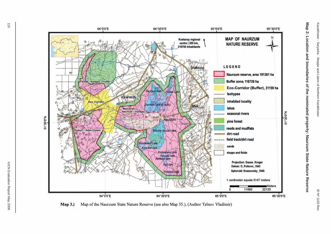
110 IU
CN
Evaluation R
eport May 2008
Kazakhstan - S
aryarka - Steppe and Lakes of N
orthern Kazakhstan
ID N
º 1102 Rev
Map 2: Location and boundaries of the nom
inated property: Naurzum
State Nature R
eserve

A. Natural Properties
A3. Extensions of Natural Properties

EUROPE / NORTH AMERICA
PIRIN NATIONAL PARK
BULGARIA

IUCN Evaluation Report May 2008 111
WORLD HERITAGE NOMINATION – IUCN TECHNICAL EVALUATION
PIRIN NATIONAL PARK (BULGARIA) – ID No. 225 Bis
Background note: The existing World Heritage property, Pirin National Park, was inscribed on the World Heritage List in 1983 under criteria (vii), (viii) and (ix) (numbered natural criteria (i), (ii) and (iii) at that time). The original IUCN evaluation noted the mountain scenery, glacial geomorphology, and the continuing evolution of the fl ora, as evidenced by a number of endemic and relict species, as key features of the Outstanding Universal Value of the property. The proposed extension of Pirin National Park has been nominated under criteria (vii), (ix) and (x).
Since 2002, the property has been the subject of repeated concern by the World Heritage Committee regarding threats to the values and integrity of the property from ski development in the Bansko ski zone and Dobrinishte ski zone (see Decisions 26 COM 21B.2, 27 COM 7B.15, 28 COM 15B.21, 29 COM 7B.23 and 31 COM 7B.27). Two joint World Heritage Centre / IUCN monitoring missions were carried out in 2002 and 2004, and the Committee noted in 2002 the possible inclusion of the property in the List of World Heritage in Danger.
In line with previous recommendations, the State Party submitted a proposal for the extension of the existing property in 2006, in which it also proposed to exclude the Bansko ski zone and Dobrinishte ski zone from the property and to include them in a new buffer zone. This proposal was incomplete and not evaluated by IUCN. In the revised proposal submitted in 2007, which is the subject of this evaluation, the State Party did not propose to exclude these ski zones from the property, nor to include them in a new buffer zone.
1. DOCUMENTATION
i) Date nomination received by IUCN: April 2007
ii) Additional information offi cially requested from and provided by the State Party: IUCN requested supplementary information on 28 August 2007 before the fi eld visit, on 14 November 2007 after the fi eld visit and on 20 December 2007 after the fi rst IUCN World Heritage Panel meeting. The State Party responses were received by email on 30 November 2007 and 28 January 2008.
iii) UNEP-WCMC Data Sheet: 22 references (including nomination)
iv) Additional literature consulted: Burmester, A. et al. (2005) World Natural Heritage and Cultural Landscapes in Europe. Report of the Workshop at the International Academy for Nature Conservation, Isle of Vilm, Germany, 18-21 June 2005. German Federal Agency for Nature Conservation, Bonn; Milne, R. and Heiss, G. (2002) Report of the International Mission to Pirin National Park, Bulgaria, 11-16 February 2002. UNESCO, Paris; Ministry of the Environment and Water (2004) Pirin National Park Management Plan 2004-2013. Ministry of the Environment and Water, Sofi a; Rössler, M. and Zupancic-Vicar, M. (2004) Report on the UNESCO-IUCN Mission to Bulgaria, 3-6 February 2004. UNESCO, Paris. Save Pirin NGO Coalition (2006) Bansko Ski Zone – Crime against: UNESCO Site, Potential Natura 2000 Site. Save Pirin NGO Coalition, Sofi a; Strid, A. (1980) Flora of Mount Olympus. Goulandris Museum of Natural History, Athens. Thorsell, J. and Hamilton, L. (2002) A Global Overview of Mountain Protected Areas on the World Heritage List. IUCN, Gland, Switzerland; Thorsell, J. and Sigaty, T. (1997) A Global Overview of Forest Protected Areas on the World Heritage List. IUCN, Gland, Switzerland.
v) Consultations: 7 external reviewers. Extensive consultations were undertaken during the fi eld visit with representatives of the Ministry of the Environment and Water; Bulgarian National Commission for UNESCO; the Director and staff of Pirin National Park; the team that prepared the park’s management plan; Mayors of towns; representatives of national NGOs; representatives of the tourism sector; and scientists.
vi) Field visit: Gerhard Heiss, September 2007
vii) Date of IUCN approval of this report: April 2008

112 IUCN Evaluation Report May 2008
Bulgaria - Pirin National Park ID Nº 225 Bis
2. SUMMARY OF NATURAL VALUES
The existing World Heritage property covers an area of 27,442.9 ha in the Pirin Mountains, southwest Bulgaria. It comprises diverse limestone mountain landscapes with 70 glacial lakes and other glacial landforms, waterfalls, caves and pine forests. The property includes a range of endemic and relict species representative of the Balkan Pleistocene fl ora.
The existing property includes only the lower altitude, forested parts of the 40,356 ha Pirin National Park. The proposed extension areas cover 12,913.5 ha and connect the existing elements of the property to form a single ecological unit. The existing property does not have a buffer zone and no buffer zone has been proposed with the proposed extension to the property.
The dominant part of the proposed extension is high mountain territory over 2,000 m altitude, covered mostly by alpine meadows, rocky screes and summits. The fl ora of Pirin National Park includes 1,315 species of vascular plants, of which 18 are considered as local endemics, found mainly on the rock and meadow communities of the sup-alpine and alpine zone in the proposed extension. The fl ora of lichens (367 species) and mosses (329 species) represents about half of the total lichen and moss fl ora in Bulgaria. The fl ora also includes 165 species of algae and 375 species of fungi. The fauna of Pirin National Park includes 45 mammal species and 159 bird species. These include notable species such as snow vole, Gunter’s vole, chamois, Tengmalm’s owl, white-backed woodpecker and three-toed woodpecker. Pirin is also home to eight species of amphibians, eleven species of reptiles and six fi sh species. The inventory of invertebrates is far from being completed: 3,400 species have been recorded up to now. There are no fi gures available for the species values of the proposed extension relative to the existing property; however, due to the altitudinal difference between the two, the proposed extension certainly adds high altitude species to the existing property and also improves the habitat connectivity within the property for a number of other species.
The property is located in an area which has been the subject of rapid tourism development, notably in relation to the development of ski resorts within the existing property, but not in the proposed extension. This development has had a signifi cant impact on the values and integrity of the property.
3. COMPARISONS WITH OTHER AREAS
The existing World Heritage property was inscribed under criteria (vii), (viii) and (ix) because of its mountain scenery, glacial geomorphology, and the continuing evolution of the fl ora, as evidenced by a number of endemic and relict species. The proposed extension
would strengthen the integrity and management of the existing property and thereby contribute to the long term conservation of its values under these criteria. However, as the extended property has also been nominated under the additional criterion (x), it is necessary to compare the values of Pirin National Park for the conservation of biodiversity and threatened species with other comparable World Heritage properties and protected areas in the region and globally.
Pirin National Park is part of the biogeographical province of Balkan Highlands. Other World Heritage properties in the region include Plitvice Lakes National Park (Croatia) and Durmitor National Park (Montenegro). Plitvice Lakes National Park is mainly a forest area which was inscribed for its outstanding travertine formations. Durmitor National Park is a high mountain area like Pirin and includes the Tara gorge and pine forests. Other comparable mountain areas in the region include the following: Sutjeska National Park (Bosnia and Herzegovina); Rila National Park (Bulgaria); Galičica National Park and Pelister National Park (Former Yugoslav Republic of Macedonia); Mount Olympus Mountain and Mount Tymphi (Greece); Sara National Park (Serbia); and the planned Prokletje National Park (Montenegro).
In terms of biodiversity and threatened species, the values of Pirin National Park are comparable to a number of these other areas in the region. For example, Mount Olympus has 1,700 vascular plant species (23 endemics) and Prokletje National Park 1,609 (20 endemics), compared to 1,315 (18 endemics) for Pirin National Park. The fl oral and faunal diversity of Pirin National Park, although important at the national level, does therefore not stand out when compared with other mountain areas in the region.
At the global level, Pirin National Park ranks far lower in terms of biodiversity and threatened species when compared with many mountain areas. It is much smaller and features far less species and habitats than other mountain World Heritage properties such as the Canadian Rocky Mountain Parks (Canada), Western Caucasus, Golden Mountains of Altai and Central Sikhote-Alin (Russian Federation), and the Great Smoky Mountains National Park (USA).
4. INTEGRITY
4.1 Legal status
The existing World Heritage property and proposed extension are State owned and designated as a national park under Bulgarian Law. This status provides a legal basis for the protection of the values of the property; however, the development of ski facilities and extension of tourism zones within the national park, which have repeatedly and signifi cantly
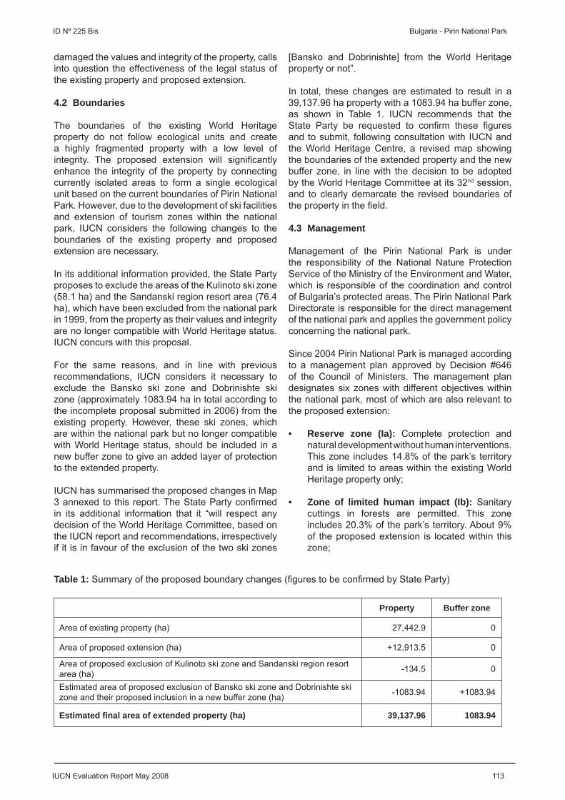
IUCN Evaluation Report May 2008 113
ID Nº 225 Bis Bulgaria - Pirin National Park
damaged the values and integrity of the property, calls into question the effectiveness of the legal status of the existing property and proposed extension.
4.2 Boundaries
The boundaries of the existing World Heritage property do not follow ecological units and create a highly fragmented property with a low level of integrity. The proposed extension will signifi cantly enhance the integrity of the property by connecting currently isolated areas to form a single ecological unit based on the current boundaries of Pirin National Park. However, due to the development of ski facilities and extension of tourism zones within the national park, IUCN considers the following changes to the boundaries of the existing property and proposed extension are necessary.
In its additional information provided, the State Party proposes to exclude the areas of the Kulinoto ski zone (58.1 ha) and the Sandanski region resort area (76.4 ha), which have been excluded from the national park in 1999, from the property as their values and integrity are no longer compatible with World Heritage status. IUCN concurs with this proposal.
For the same reasons, and in line with previous recommendations, IUCN considers it necessary to exclude the Bansko ski zone and Dobrinishte ski zone (approximately 1083.94 ha in total according to the incomplete proposal submitted in 2006) from the existing property. However, these ski zones, which are within the national park but no longer compatible with World Heritage status, should be included in a new buffer zone to give an added layer of protection to the extended property.
IUCN has summarised the proposed changes in Map 3 annexed to this report. The State Party confi rmed in its additional information that it “will respect any decision of the World Heritage Committee, based on the IUCN report and recommendations, irrespectively if it is in favour of the exclusion of the two ski zones
[Bansko and Dobrinishte] from the World Heritage property or not”.
In total, these changes are estimated to result in a 39,137.96 ha property with a 1083.94 ha buffer zone, as shown in Table 1. IUCN recommends that the State Party be requested to confi rm these fi gures and to submit, following consultation with IUCN and the World Heritage Centre, a revised map showing the boundaries of the extended property and the new buffer zone, in line with the decision to be adopted by the World Heritage Committee at its 32nd session, and to clearly demarcate the revised boundaries of the property in the fi eld.
4.3 Management
Management of the Pirin National Park is under the responsibility of the National Nature Protection Service of the Ministry of the Environment and Water, which is responsible of the coordination and control of Bulgaria’s protected areas. The Pirin National Park Directorate is responsible for the direct management of the national park and applies the government policy concerning the national park.
Since 2004 Pirin National Park is managed according to a management plan approved by Decision #646 of the Council of Ministers. The management plan designates six zones with different objectives within the national park, most of which are also relevant to the proposed extension:
• Reserve zone (Ia): Complete protection and natural development without human interventions. This zone includes 14.8% of the park’s territory and is limited to areas within the existing World Heritage property only;
• Zone of limited human impact (Ib): Sanitary cuttings in forests are permitted. This zone includes 20.3% of the park’s territory. About 9% of the proposed extension is located within this zone;
Table 1: Summary of the proposed boundary changes (fi gures to be confi rmed by State Party)
Property Buffer zone
Area of existing property (ha) 27,442.9 0
Area of proposed extension (ha) +12,913.5 0
Area of proposed exclusion of Kulinoto ski zone and Sandanski region resort area (ha) -134.5 0
Estimated area of proposed exclusion of Bansko ski zone and Dobrinishte ski zone and their proposed inclusion in a new buffer zone (ha) -1083.94 +1083.94
Estimated fi nal area of extended property (ha) 39,137.96 1083.94

114 IUCN Evaluation Report May 2008
Bulgaria - Pirin National Park ID Nº 225 Bis
• Zone for conservation of forest ecosystems and recreation (IIa): Maintenance and restoration activities in forests are permitted as well as the culling of certain animal species. This zone includes 45.2% of the park’s territory. About 42% of the proposed extension is located within this zone;
• Zone for sustainable use of open areas and recreation (IIb): This zone is mainly reserved for traditional grazing activities. It includes 16.9% of the park’s territory. About 49% of the proposed extension is located within this zone;
• Tourist zone (III): This zone includes 2.2% of the park’s territory. The ski resorts of Bansko and Dobrinishte, located within the existing World Heritage property, are designated as tourist zone. According to the approved management plan, no construction of ski facilities and ski runs is permitted outside this zone, and it is not permitted to extend the designated tourist zone in order to preserve the national park’s status as a World Heritage property. The proposed extension does not include areas within this zone; and
• Zone of buildings and facilities (IV): This zone includes 0.6% of the park’s territory. All constructions except for the ski facilities belong to this zone. Less than 1% of this zone is located within the proposed extension.
Although an approved management plan exists, the infl uence of the responsible authorities on the development of the existing ski zones appears to be very limited, given the repeated unauthorised expansion and modifi cation of ski facilities and ski runs within the existing property. IUCN notes that the proposed extension has not been affected by these developments. IUCN considers it imperative, however, that the responsible authorities exert effective control over Pirin National Park to prevent any developments that would further damage the values and integrity of the World Heritage property (see also Section 5.1 below).
4.4 Threats and human use
The World Heritage property has long been subject to tourism pressure, largely caused by the development of ski facilities and ski runs. Shortly after the inscription of Pirin National Park on the World Heritage List, the development of a ski zone at Bansko started, which was authorized by the State Party on an area of 818 ha according to the operative Forest Management Plan. About 100 ha of this area were damaged or disturbed through ski runs and facilities, access roads, parking, equipment and waste water problems. Smaller ski zones were developed at Dobrinishte and Kulinoto in the following years. In 1999, the World Heritage Centre was informed by the State Party about a modifi cation
of the existing ski zone at Bansko. Although the construction of new and expansion of existing ski runs and facilities is prohibited according to the park’s management plan, skiing facilities have been moved and the area of ski runs has been more than doubled in relation to the originally authorised plans. This has not only damaged or disturbed the areas within the designated tourist zone of the national park, but also affected areas of the national park outside this zone.
A boom phase of construction took place in the period from 2002 to 2007 and Bansko has become one of the most rapidly developing towns in Bulgaria. In the town of Razlog, seven new golf courses with adjoined apartment blocks and 50 km of public roads are under construction close to the boundaries of the national park, with potentially serious adverse effects on the natural water regimes and other natural resources of the park. New settlements have been developed along the northern boundary of the national park and plans for the development of new ski zones exist in several municipalities around the national park. In conclusion, tourism development within and around the national park is not effectively controlled, and it is not clear whether the State Party is able to protect the values and integrity of the extended World Heritage property, although the proposed extension has not yet been affected by these developments.
Illegal logging and grazing still occur on the territory of the existing property and the proposed extension. While illegal logging concerns mostly the existing property, illegal grazing concerns mainly the proposed extension. However, illegal grazing has signifi cantly decreased in the period from 1993 to 2007. In conclusion, illegal grazing and logging is currently not a serious threat in the proposed extension. Limited poaching occurs but is neither a serious threat to the integrity of the proposed extension nor the existing property. These issues require however continued management by the national park authorities.
In summary IUCN considers that the proposed extension meets the necessary conditions of integrity as set out in the Operational Guidelines and will strengthen the integrity and management of the World Heritage property.
5. ADDITIONAL COMMENTS
5.1 Values and integrity of the existing World Heritage property
IUCN considers that the values and integrity of the property have been repeatedly and signifi cantly compromised by the development of ski facilities and extension of tourism zones, to the extent that the property could be considered for inscription on the List of World Heritage in Danger. Extending the property, removing the compromised areas from the property,

IUCN Evaluation Report May 2008 115
ID Nº 225 Bis Bulgaria - Pirin National Park
and minimising or mitigating the adverse effects provides a means to redress this situation. However, IUCN considers that the World Heritage Committee should clearly indicate that further development of ski facilities or extension of the tourism zones that compromises the values and integrity of the property is incompatible with its World Heritage status and would result in the inscription of the property on the List of World Heritage in Danger. IUCN is also of the view that the outcome of further damage to the property from ski development could be the deletion of the property from the World Heritage List.
IUCN considers that the lack of effective action to protect this World Heritage property and the resulting damage to its values and integrity provide a case study with a number of lessons for the future operation of the World Heritage Convention. In addition to the clear issues regarding the responsibilities of States Parties, it indicates the need for stronger and more effective monitoring of World Heritage properties and the need for a more effective process of follow through to be put in place by the World Heritage Committee, supported by the World Heritage Centre and the Advisory Bodies, with adequate resources provided for this work.
IUCN notes that its recommendations in this report apply to the particular and problematic circumstances of the Pirin National Park World Heritage property and do not represent an appropriate solution for other World Heritage properties.
6. APPLICATION OF CRITERIA
The extended property has been nominated under criteria (vii), (ix) and (x), although the existing World Heritage property was inscribed under criteria (vii), (viii) and (ix). IUCN considers that the proposed extension should be approved under the original criteria, in order to strengthen the integrity and management of the property in relation to these criteria, but that the extended property does not meet criterion (x) based on the following assessment:
Criterion (x): Biodiversity and threatened species
The importance of Pirin National Park for the in situ conservation of biological diversity and threatened species is not signifi cant at the global level. Its values are typical of several mountain ranges within the Balkan Peninsula. Similar species and habitats are found in a number of other protected areas of the Balkan Highlands. The fl oral and faunal diversity of Pirin National Park, although important at the national level, does not stand out when compared with other mountain areas in the region. At the global level, Pirin National Park ranks far lower in terms of biodiversity and threatened species when compared with many mountain areas. It is much smaller and features far
less species and habitats than a number of other mountain World Heritage properties.
IUCN considers that the extended property does not meet this criterion.
7. RECOMMENDATIONS
IUCN recommends that the World Heritage Committee adopt the following decision:
The World Heritage Committee,
1. Having examined Documents WHC-08/32.COM/8B and WHC-08/32.COM/INF.8B2,
2. Recalling Decisions 28 COM 15B.21, 29 COM 7B.23 and 31 COM 7B.27, adopted at its 28th (Suzhou, 2004), 29th (Durban, 2005) and 31st (Christchurch, 2007) sessions respectively,
3. Approves the extension of the Pirin National Park, Bulgaria, inscribed under criteria (vii), (viii) and (ix), in order to strengthen the integrity and management of the World Heritage property; but excludes in line with previous recommendations the Bansko ski zone and Dobrinishte ski zone (approximately 1083.94 ha in total) from the inscribed property as their values and integrity are no longer compatible with World Heritage status; and includes these areas, which are within the national park, in a new buffer zone to give an added layer of protection to the property;
4. Accepts the proposal of the State Party to exclude the areas of the Kulinoto ski zone (58.1 ha) and the Sandanski region resort area (76.4 ha), which have been excluded from the national park in 1999, from the property as their values and integrity are no longer compatible with World Heritage status;
5. Requests the State Party to submit, following consultation with IUCN and the World Heritage Centre, a revised map showing the boundaries of the extended property and the new buffer zone, as outlined above, and to clearly demarcate the revised boundaries of the property in the fi eld;
6. Considers that the Outstanding Universal Value and integrity of the property have been repeatedly and signifi cantly compromised by the development of ski facilities and extension of tourism zones, to the extent that the property could be considered for inscription on the List of World Heritage in Danger;
7. Requests the State Party therefore to ensure that the adverse effects of the development of ski facilities and extension of tourism zones are

116 IUCN Evaluation Report May 2008
Bulgaria - Pirin National Park ID Nº 225 Bis
minimised or mitigated to the extent possible and that no further development of ski facilities or extension of the tourism zones is allowed within the revised boundaries of the extended property;
8. Decides that any further development of ski facilities or extension of the tourism zones within the revised boundaries of the extended property, or any further developments outside the extended property that would adversely affect the Outstanding Universal Value and integrity of the property, would result in the inscription of the property on the List of World Heritage in Danger; and
9. Requests the State Party to keep the World Heritage Centre informed of any developments, including in the new buffer zone, which may affect the Outstanding Universal Value or integrity of the property, as per paragraph 172 of the Operational Guidelines, and to submit to the World Heritage Centre by 1 February 2009 an updated report on the state of conservation of the property for examination by the World Heritage Committee at its 33rd session in 2009.
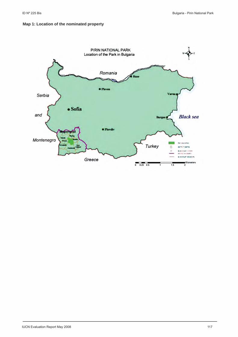
IUCN Evaluation Report May 2008 117
ID Nº 225 Bis Bulgaria - Pirin National Park
Map 1: Location of the nominated property
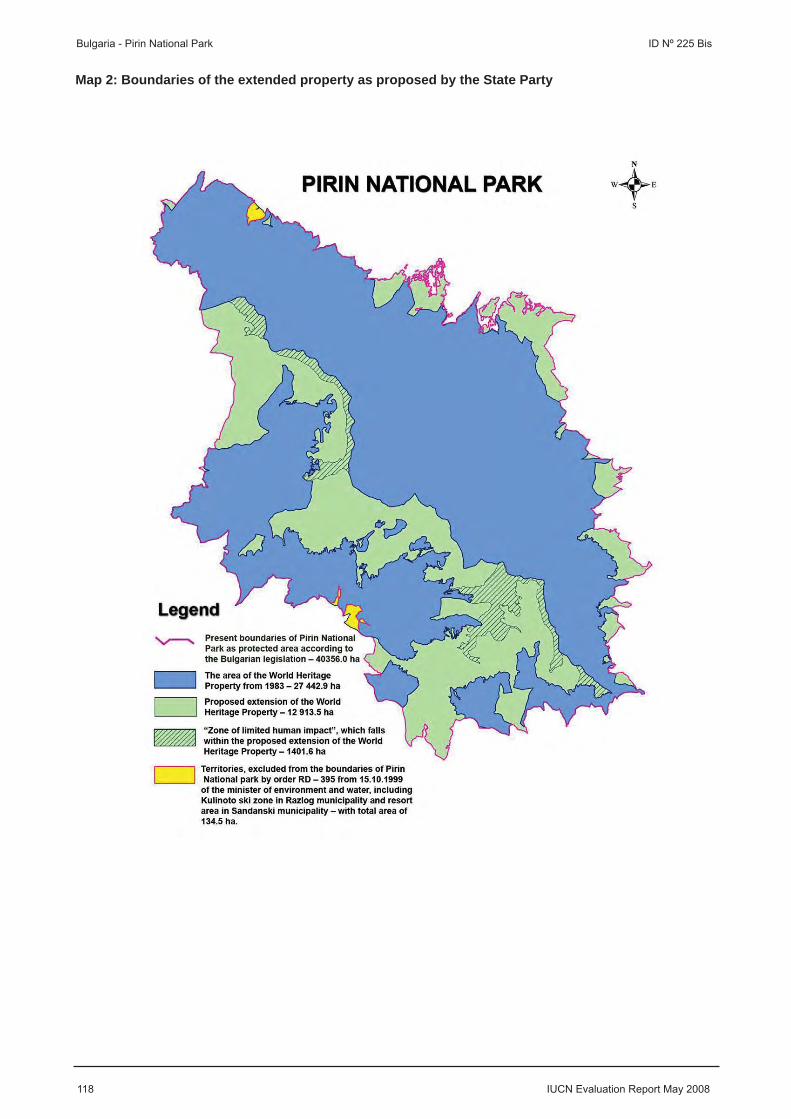
118 IUCN Evaluation Report May 2008
Bulgaria - Pirin National Park ID Nº 225 Bis
Map 2: Boundaries of the extended property as proposed by the State Party
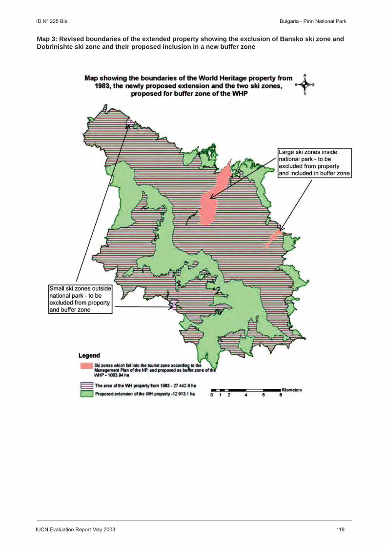
IUCN Evaluation Report May 2008 119
ID Nº 225 Bis Bulgaria - Pirin National Park
Map 3: Revised boundaries of the extended property showing the exclusion of Bansko ski zone and Dobrinishte ski zone and their proposed inclusion in a new buffer zone

A. Natural Properties
A4. Boundary Modifi cations of Natural Properties

EUROPE / NORTH AMERICA
SREBARNA NATURE RESERVE
BULGARIA

IUCN Evaluation Report May 2008 121
WORLD HERITAGE NOMINATION – IUCN TECHNICAL EVALUATION
SREBARNA NATURE RESERVE (BULGARIA) – ID No. 219
IUCN carried out a desk review of the proposed creation of a buffer zone for the Srebarna Nature Reserve, Bulgaria, taking into consideration comments from three external reviewers.
prevent and reduce negative human impacts on the reserve. The buffer zone is subject to prohibitions relating to the introduction of non-local plant or animal species, pollution from domestic, industrial or other types of waste, hunting during bird nesting and breeding periods, burning of reeds without approval of the Ministry of Environment and Waters, and other activities that could disturb the nesting and breeding bird colonies.
3. IMPLICATIONS FOR OUTSTANDING UNIVERSAL VALUE AND INTEGRITY
The proposed creation of a buffer zone for the World Heritage property will help to protect the Outstanding Universal Value and integrity of the property by preventing and reducing negative human impacts. The proposed buffer zone is as large as the property itself and entirely encircles the property with the exception of short sections in the southwest (around the village of Srebarna) and southeast of the property. The size and shape of the buffer zone therefore appear to be adequate.
In conclusion, IUCN considers that the proposed creation of a buffer zone should be approved.
4. RECOMMENDATIONS
IUCN recommends that the World Heritage Committee adopt the following decision:
The World Heritage Committee,
1. Having examined Documents WHC-08/32.COM/8B and WHC-08/32.COM/INF.8B2,
2. Approves the proposed creation of a 673 ha buffer zone for the 638 ha Srebarna Nature Reserve, Bulgaria, in order to strengthen the integrity of the World Heritage property.
1. BACKGROUND INFORMATION
Srebarna Nature Reserve was inscribed on the World Heritage List with an area of 600 ha in 1983 on the basis of criterion (x). No buffer zone was identifi ed at that time. In response to the Retrospective Inventory and the Periodic Reporting follow up, the World Heritage Centre received on 26 October 2007 a proposal from the State Party for creation of a buffer zone, which was transmitted to IUCN on 2 November 2007 for review.
With its proposal the State Party submitted a suffi ciently scaled topographic map clearly showing the boundaries of the World Heritage property and the proposed buffer zone. The State Party notes that, following more precise measurements, the area of the World Heritage property is now considered to be 638 ha rather than 600 ha. The State Party further notes that the protected area category of the World Heritage property was changed from “nature reserve” to “managed reserve” under the Bulgarian Protected Areas Act of 1998.
2. SHORT SUMMARY OF PROPOSAL
The State Party proposes to create a 673 ha buffer zone for the 638 ha World Heritage property. The buffer zone for the World Heritage property would consist of two components:
1) The portion of the Srebarna Nature Reserve (254 ha) that is protected according to Bulgarian legislation but is not part of the World Heritage property as it consists of areas that do not meet the requirements of the World Heritage Convention. These areas include agricultural lands and poplar plantations as well as the Danube river banks, the water area between the river banks and Devnja island, and natural forests on the island.
2) The buffer zone (419 ha) surrounding the Srebarna Nature Reserve, as protected according to Bulgarian legislation, which was determined by Order No. 1 of 3 January 1983 of the Environment Preservation Committee (the institution in charge of protected areas at that time). The aim of this buffer zone is to
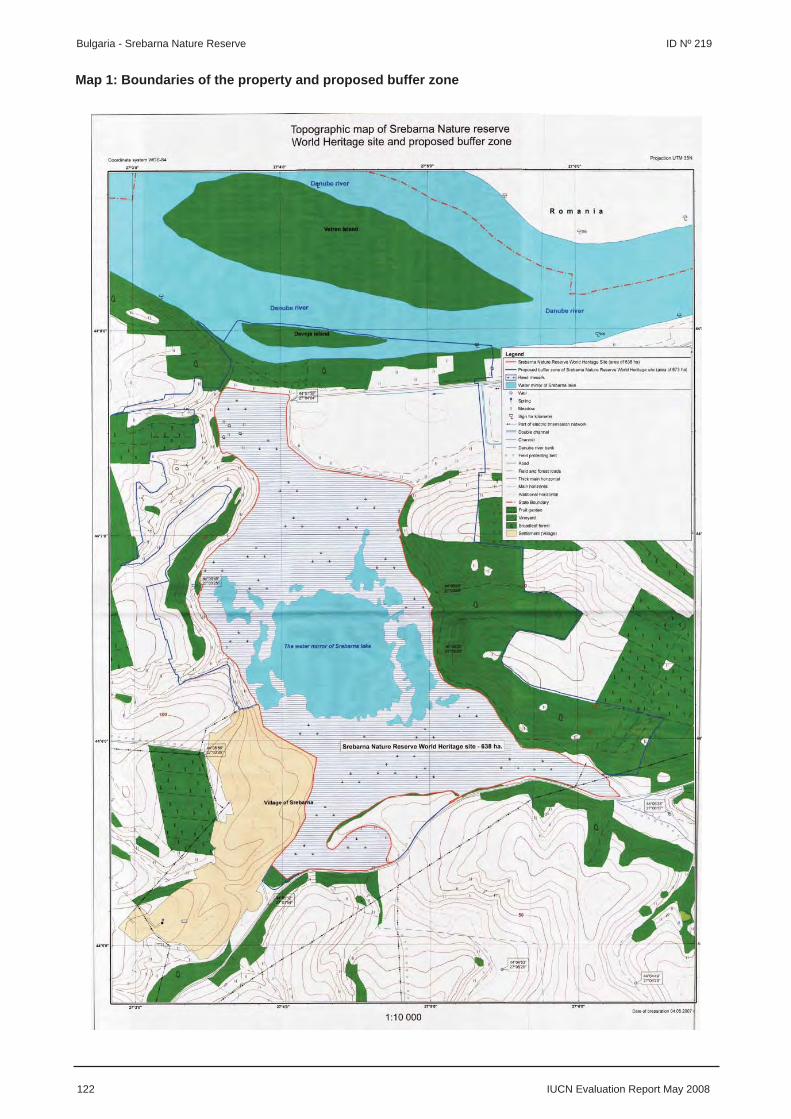
122 IUCN Evaluation Report May 2008
Bulgaria - Srebarna Nature Reserve ID Nº 219
Map 1: Boundaries of the property and proposed buffer zone

EUROPE / NORTH AMERICA
CAVES OF AGGTELEK KARST AND SLOVAK KARST
HUNGARY / SLOVAKIA

IUCN Evaluation Report May 2008 123
WORLD HERITAGE NOMINATION – IUCN TECHNICAL EVALUATION
CAVES OF AGGTELEK KARST AND SLOVAK KARST (HUNGARY / SLOVAKIA) – ID No. 725 Bis
IUCN carried out a desk review of the proposed modifi cations to the boundaries and buffer zones of the Caves of Aggtelek Karst and Slovak Karst, Hungary / Slovakia, taking into consideration comments from eight external reviewers.
1. BACKGROUND INFORMATION
The transnational property was inscribed on the World Heritage List in 1995 under natural criterion (viii). A buffer zone was identifi ed at that time in Slovakia only. The property was extended in 2000 by adding Dobšinská ice cave in Slovakia and identifying a surrounding buffer zone. In response to the Retrospective Inventory, the World Heritage Centre received on 28 January 2008 a proposal from the States Parties for a number of modifi cations to the boundaries and buffer zones of the property, which was transmitted to IUCN on 14 February 2008 for review.
With their proposal the States Parties submitted topographic maps clearly showing the boundaries of the World Heritage property and the proposed modifi cations. The States Parties also provided information on the surface area of the World Heritage property as inscribed and as proposed to be modifi ed. The States Parties note that the World Heritage property currently comprises three components with a total surface area of 19,797.2 ha in Hungary and four components with a total surface area of 36,765.57 ha in Slovakia. Two buffer zones with a total surface area of 58,097.33 ha exist in Slovakia, which are not part of the World Heritage property.
2. SHORT SUMMARY OF PROPOSAL
On the Hungarian side of the property it is proposed to extend the surface area of the Esztramos Hill component from 107.2 ha to 195 ha to strengthen the integrity of the component. This extension has become possible due to changes in tenure: ownership of the extension area has been transferred to the Hungarian State, following cessation of quarrying activities in this area, and the Aggtelek National Park Directorate is now in charge of managing the extension area. The area provides access to additional caves and associated values. It is also proposed to create a 28,000 ha buffer zone on the Hungarian side of the property to help to protect the natural values and integrity of the property by preventing and reducing negative human impacts on the delicate cave systems.
On the Slovakian side of the property it is proposed to reduce the total surface area of the property from 36,765.57 ha to 35,109.8 ha and to reduce the total surface area of the buffer zones from 58,097.33 ha to 12,070.53 ha. As a result the number of components of the property in Slovakia would rise from four to fi ve. The State Party explains that the Slovak Karst protected landscape area became a national park in 2002, with certain changes to the delimitation of the protected area, and the proposed boundary modifi cations refl ect these changes. The substantial reduction in the Dobšinská ice cave component (17% reduction) and its buffer zone (98.7% reduction) is justifi ed by management experience that shows a much smaller area is adequate to protect this component.
3. IMPLICATIONS FOR OUTSTANDING UNIVERSAL VALUE AND INTEGRITY
Given that the Outstanding Universal Value and integrity of the delicate cave systems within the property are highly sensitive to changes in their environment, any changes in the protection and management of their environment need to be carefully assessed. This applies also to the proposed modifi cations to the boundaries and buffer zones of the property, in particular within Slovakia, where substantial reductions are proposed in the total surface area of the property and buffer zones.
IUCN considers that the extension of the Esztramos Hill component from 107.2 ha to 195 ha strengthens the integrity of the component through improved protection of caves and associated values. The creation of a 28,000 ha buffer zone that encompasses all the components on the Hungarian side of the property will also help to protect the natural values and integrity of the property by preventing and reducing negative human impacts on the delicate cave systems. Protection is afforded to the caves in the buffer zone by Hungarian Law LIII of 1996 On the Protection of Nature and the Aggtelek National Park Directorate has administrative authority over all activities that may affect the integrity of these caves.
IUCN considers that the proposed modifi cations on the Hungarian side of the property are minor and
124 IUCN Evaluation Report May 2008
Hungary / Slovakia - Caves of Aggtelek Karst and Slovak Karst ID Nº 725 Bis
strengthen the integrity of the World Heritage property, and should therefore be approved.
IUCN considers, however, that it is not possible, based on the information provided, to adequately assess the implications of the proposed reductions in the surface area of the property and buffer zones in Slovakia for the Outstanding Universal Value and integrity of the property. More detailed information on the proposed reductions, including large scale topographic, geological, and in the case of Dobšinská and Ochtinská caves also hydrogeological maps, and their implications for the Outstanding Universal Value and integrity of the property is required. Based on this information IUCN will consider whether the proposed modifi cations can be accepted as minor modifi cations or will require a full re-nomination including a fi eld evaluation. At this stage IUCN considers that, given their scale, the proposed reductions are unlikely to represent a minor modifi cation.
IUCN considers that, based on the information provided, the proposed modifi cations on the Slovakian side of the property appear to be signifi cant and should not be approved at this stage.
4. RECOMMENDATIONS
IUCN recommends that the World Heritage Committee adopt the following decision:
The World Heritage Committee,
1. Having examined Documents WHC-08/32.COM/8B and WHC-08/32.COM/INF.8B2,
2. Approves the proposed extension of the Esztramos Hill component from 107.2 ha to 195 ha and the proposed creation of a 28,000 ha buffer zone on the Hungarian side of the Caves of Aggtelek Karst and Slovak Karst, Hungary / Slovakia, in order to strengthen the integrity of the World Heritage property;
3. Refers the proposed reductions in the surface area of the property and buffer zones on the Slovakian side of the Caves of Aggtelek Karst and Slovak Karst, Hungary / Slovakia, back to the State Party of Slovakia to provide further justifi cation and information;
4. Requests the State Party of Slovakia to provide more detailed information on the proposed reductions, including large scale topographic, geological, and in the case of Dobšinská and Ochtinská caves also hydrogeological maps, and their implications for the Outstanding Universal Value and integrity of the property. Based on review of this information, IUCN will recommend whether the proposed modifi cations can be
accepted as minor modifi cations or will require a full re-nomination including a fi eld evaluation.

IUCN Evaluation Report May 2008 125
ID Nº 725 Bis Hungary / Slovakia - Caves of Aggtelek Karst and Slovak Karst
Map 1: Boundaries of the property and buffer zones and proposed modifi cations

B. Mixed Properties
B1. Boundary Modifi cations of Mixed Properties

EUROPE / NORTH AMERICA
NATURAL AND CULTURAL HERITAGE OF THE OHRID REGION
FORMER YUGOSLAV REPUBLIC OF MACEDONIA

IUCN Evaluation Report May 2008 127
WORLD HERITAGE NOMINATION – IUCN TECHNICAL EVALUATION
NATURAL AND CULTURAL HERITAGE OF THE OHRID REGION (FORMER YUGOSLAV REPUBLIC OF MACEDONIA) – ID No. 99
IUCN carried out a desk review of the proposed modifi cation to the boundary of the Natural and Cultural Heritage of the Ohrid Region, Former Yugoslav Republic of Macedonia, taking into consideration comments from three external reviewers.
1. BACKGROUND INFORMATION
The property was inscribed on the World Heritage List in 1979 under natural criterion (vii). The property was extended in 1980 and cultural criteria (i), (iii) and (iv) were added. No buffer zone was identifi ed at that time. In response to the Periodic Reporting follow up, the World Heritage Centre received on 7 February 2008 a proposal from the State Party for a reduction in the surface area of the property, which was transmitted to IUCN on 29 February 2008 for review.
With its proposal the State Party submitted a topographic map showing the boundaries of the World Heritage property and the proposed modifi cation. The map does not include a scale as required and the coordinates on the map are not labelled. No information was provided on the surface area of the World Heritage property as inscribed nor as proposed to be modifi ed.
2. SHORT SUMMARY OF PROPOSAL
The State Party proposes to reduce the terrestrial surface area of the property along the northern, north-western and north-eastern boundary of the property (total change in the order of less than 10%; however, no exact fi gures are available as neither the present nor the proposed extent of the property is known). Small extensions are proposed along the south-eastern boundary of the property which cuts through the middle of the Galičica National Park. No changes are proposed to the section of the boundary that cuts through the middle of Lake Ohrid and coincides with the border between the Former Yugoslav Republic of Macedonia and Albania.
The State Party notes that an Inter-Ministerial Expert Commission, through team and fi eld work, has recognised the need for the proposed modifi cation to the boundary. The State Party also notes that the boundary modifi cation would not affect the natural heritage of the property given that the State Party’s part of Lake Ohrid and the nine terrestrial sites of natural value within the property, all along or in close proximity to the lakeshore, will not be affected by the boundary modifi cation.
3. IMPLICATIONS FOR OUTSTANDING UNIVERSAL VALUE AND INTEGRITY
In its technical evaluation of the property in 1979, IUCN noted concerns that the original boundary of the property does not meet the conditions of integrity required of natural World Heritage properties, as only the Macedonian (former Yugoslav) part of Lake Ohrid and a small part of its watershed are included. IUCN is concerned that the proposed boundary is equally insuffi cient in this regard and does not meet the conditions of integrity. IUCN notes the following additional concerns:
• The State Party has neither provided a justifi cation for why the modifi cation is needed nor any information on the values and integrity of the areas to be excluded or included;
• Neither the original boundary nor the proposed boundary of the property appears to follow topographic or other features recognisable in the fi eld;
• Both the original boundary and the proposed boundary cut through the middle of the Galičica National Park. This was already noted in the report of the joint 1998 UNESCO / ICOMOS / IUCN monitoring mission to the property;
• There is no existing buffer zone and no buffer zone proposed in this proposed modifi cation. IUCN notes an appropriate buffer zone would help protect the natural values and integrity of the property by preventing and reducing negative human impacts on Lake Ohrid and its watershed.
IUCN considers the State Party should reconsider the proposed modifi cation. IUCN recommends realigning the boundary of the property, preferably along topographic or other features recognisable in the fi eld, to include all of Galičica National Park and other critical areas, and creating an appropriate buffer zone to protect the catchment of Lake Ohrid.
IUCN understands that an agreement was concluded on 17 June 2004 between the Council of Ministers of the Republic of Albania and the Government of the Former Yugoslav Republic of Macedonia for the protection and sustainable development of Lake Ohrid
128 IUCN Evaluation Report May 2008
Former Yugoslav Republic of Macedonia - Natural and Cultural Heritage of the Ohrid Region ID Nº 99
and its watershed. Considering this agreement and the above points, IUCN encourages the States Parties of the Former Yugoslav Republic of Macedonia and Albania to consider a transboundary re-nomination of the property to include the Albanian part of Lake Ohrid and its watershed to strengthen the values and integrity of the property.
In summary, IUCN does not consider that the proposed modifi cation addresses the long standing issues relating to the natural values and integrity of the property.
4. RECOMMENDATIONS
IUCN recommends that the World Heritage Committee adopt the following decision:
The World Heritage Committee,
1. Having examined Documents WHC-08/32.COM/8B and WHC-08/32.COM/INF.8B2,
2. Refers the proposed modifi cation to the boundary of the Natural and Cultural Heritage of the Ohrid Region, Former Yugoslav Republic of Macedonia, back to the State Party for reconsideration;
3. Requests the State Party to consider realigning the boundary of the property, preferably along topographic or other features recognisable in the fi eld, to include all of Galičica National Park and other critical areas, and creating an appropriate buffer zone to protect the catchment of Lake Ohrid;
4. Encourages the States Parties of the Former Yugoslav Republic of Macedonia and Albania to consider a transboundary re-nomination of the property to include the Albanian part of Lake Ohrid and its watershed to strengthen the values and integrity of the property.

IUCN Evaluation Report May 2008 129
ID Nº 99 Former Yugoslav Republic of Macedonia - Natural and Cultural Heritage of the Ohrid Region
Map 1: Boundaries of the property and proposed modifi cation

C. Cultural Properties
C1. New Nominations of Cultural Landscapes

AFRICA
LE MORNE CULTURAL LANDSCAPE
MAURITIUS

IUCN Evaluation Report May 2008 131
WORLD HERITAGE NOMINATION – IUCN TECHNICAL EVALUATION
LE MORNE CULTURAL LANDSCAPE (MAURITIUS) – ID No. 1259
IUCN carried out a desk review of this cultural landscape nominated under cultural criteria (iii), (iv) and (vi), and provided the following comments to ICOMOS as an input to the evaluation process. IUCN’s comments are included here for the information of the World Heritage Committee.
1. COMBINED WORK OF MAN AND NATURE
While the property is nominated as a cultural landscape, and the cultural and terrestrial natural values are detailed in the nomination document, there is no defi nition of how these values interact to present a “combined work of man and nature” which is of Outstanding Universal Value. Indeed, the management plan for the natural values of the area is oriented to restoring the native vegetation and eradicating the introduced species that are a product of the interaction of humans and the environment. This brings into question the objectives of management. If the property is to be managed as a cultural landscape, the “combined work of man and nature” needs to be defi ned, preserved, presented and interpreted for the visiting public.
2. MANAGEMENT
More than half of the buffer zone that surrounds the nominated property is located in the marine environment and yet there is no description of the marine components or prescription for their management and monitoring in the nomination document.
3. RECOMMENDATIONS
The property is nominated as a cultural landscape under cultural criteria only and it is the responsibility of ICOMOS in this case to assess whether or not the nominated property is of Outstanding Universal Value. On the basis of its review of the nomination, IUCN recommends ICOMOS consider referral as the preferred option for this nomination to allow the State Party to address the points outlined above.
4. ADDITIONAL COMMENTS: NATURAL CRITERION (VII)
IUCN notes that ICOMOS remarks the possibility of inscription of the property under natural criterion (vii) – i.e. superlative natural phenomena or areas of exceptional natural beauty and aesthetic importance.
From the nomination document it is clear, however, that the State Party has not nominated the property under natural criteria, and therefore no evaluation of the natural values of the property has been carried out by IUCN, the responsible Advisory Body on natural heritage, as per paragraphs 144-146 of the Operational Guidelines.
Based on the information provided in the nomination document and the scale of the property relative to comparable natural World Heritage properties, IUCN considers that the natural values of the nominated property appear unlikely to warrant inscription on the World Heritage List as a natural property (i.e. under the natural criteria (vii) to (x)) in their own right.
Noting that the scenic values of the property appear to be already affected by various developments, IUCN also considers that the nominated property appears unlikely to meet the conditions of integrity required of a natural property in relation to criteria (vii) as per paragraphs 90-92 of the Operational Guidelines. However, IUCN would of course carry out a full evaluation if the State Party were to re-nominate the property for its natural values.
IUCN notes that the supplementary information provided by the State Party clearly emphasises that “the essence of the nomination is intangible heritage that is closely associated with the core of the mountain”, and therefore the application by ICOMOS of criterion (vi), rather than criterion (vii), appears more relevant in relation to the nominated property.
IUCN also notes that ICOMOS remarks that “a study of the implications of the use of criterion (vii) for a cultural property is needed before making any proposal in that sense. ICOMOS is currently working on this issue.” IUCN considers, however, that there is already an appropriate, very clear and very well established means of dealing with situations where the potential is identifi ed for additional criteria to be considered that are not included in the nomination: this is through a re-nomination of the property under additional criteria as per paragraph 166 of the Operational Guidelines, which would allow for evaluation by IUCN. In addition, any study on the application of criterion (vii) should be led by IUCN as the responsible Advisory Body on natural heritage.

132 IUCN Evaluation Report May 2008
Mauritius - Le Morne Cultural Landscape ID Nº 1259
IUCN also notes that it has made proposals to enhance cooperation and coordination with ICOMOS regarding the evaluation of cultural landscape nominations since 2005 and would be pleased to receive observations on these from ICOMOS and discuss them further.

ASIA / PACIFIC
CULTURAL LANDSCAPE OF BALI PROVINCE
INDONESIA
IUCN Evaluation Report May 2008 133
WORLD HERITAGE NOMINATION – IUCN TECHNICAL EVALUATION
CULTURAL LANDSCAPE OF BALI PROVINCE (INDONESIA) – ID No. 1194
IUCN carried out a desk review of this cultural landscape nominated under cultural criteria (ii), (iii), (v) and (vi), taking into consideration comments from two external reviewers, and provided the following comments to ICOMOS as an input to the evaluation process. IUCN’s comments are included here for the information of the World Heritage Committee.
1. COMBINED WORK OF MAN AND NATURE
While the Bali Province is an internationally renowned cultural landscape, the nomination document does not clearly lay out the case for how this property represents a “combined work of man and nature”. However, IUCN considers that this property has potential for manifesting the central concept of cultural landscapes as the “combined work of man and nature”. Indeed the Tri Hata Karana philosophy that has inspired this cultural landscape is built around the harmonious relationship between God, humans and nature. This needs clear articulation and justifi cation under the appropriate World Heritage criteria. Furthermore, the nomination document does not provide a suitably detailed comparison of the proposed property with existing World Heritage cultural landscapes and other cultural landscapes worldwide and especially within Indonesia and South East Asia. Without this comparison it is diffi cult to objectively assess the property’s potential to be regarded as being of Outstanding Universal Value.
2. BOUNDARIES
The nomination document does not explain the criteria that were used to select the elements to be included in the nomination, and these need to be made explicit. As the nomination document notes, it is the Tri Hata Karana philosophy “that has long been the driving principle for Balinese to organically create the picturesque landscape of the rice terraces with their various subak-temples and environmentally friendly irrigation works.” IUCN would submit, however, that this is an incomplete landscape unless it includes the upper watersheds that feed the irrigation systems. Not only are they functionally interdependent elements of a single physical system, they are also non-separable components within the context of the Tri Hata Karana philosophy, and are also important to the visual integrity of the area. This integral philosophy is clearly refl ected in the proposed Statement of Outstanding Universal Value that indicates the following: “The forested slopes of the volcanoes were scraped by deep erosion, forming ravines with rushing rivers. The fertile lands are beautifully cultivated to create extravagant rice-fi eld terraces. Combined with the wonderful temples and settlements, this has created an extraordinary cultural landscape”. Thus, IUCN believes that the
cultural landscape is incomplete unless it includes all of the principal elements – the forested slopes, rice terraces, temples, and settlements. In this case, this integral approach would mean the inclusion of the forest areas of Mt. Batukara in the nomination, which would also enhance substantially the natural and scenic values of the nominated area and contribute to maintaining its integrity.
3. MANAGEMENT
The nomination document lacks a satisfactory discussion on the proposed management of the property. Of particular concern are the potential impacts of tourism on the authenticity of the property itself and on Balinese culture. While the document mentions this threat, it does not indicate how it will be dealt with. IUCN also has concerns about the coordinating body that is to manage the property, especially noting that the communities have played a strong role in the past in managing these sites, and that this should continue, perhaps with some adjustments to respond to national and international interests as required.
4. RECOMMENDATIONS
The property is nominated as a cultural landscape under cultural criteria only and it is the responsibility of ICOMOS in this case to assess whether or not the nominated property is of Outstanding Universal Value. On the basis of its review of the nomination, IUCN recommends ICOMOS may wish to consider deferral of this nomination to allow the State Party to address the points outlined above.

ASIA / PACIFIC
THE KUK EARLY AGRICULTURAL SITE
PAPUA NEW GUINEA

IUCN Evaluation Report May 2008 135
WORLD HERITAGE NOMINATION – IUCN TECHNICAL EVALUATION
THE KUK EARLY AGRICULTURAL SITE (PAPUA NEW GUINEA) – ID No. 887
IUCN carried out a desk review of this cultural landscape nominated under cultural criteria (iii), (iv) and (v), taking into consideration comments from one external reviewer, and provided the following comments to ICOMOS as an input to the evaluation process. IUCN’s comments are included here for the information of the World Heritage Committee.
1. COMBINED WORK OF MAN AND NATURE
IUCN considers that this nomination lays out a convincing rationale for nomination of the property as a “combined work of man and nature” by showing how the development of agriculture changed both natural and cultural systems through evolving interactive processes. However, IUCN notes that there are many sites in the Pacifi c and worldwide which would demonstrate this interaction. Thus an enhanced global comparative analysis is required for an objective assessment of the property’s potential Outstanding Universal Value.
2. BOUNDARIES
The proposed boundaries of the nominated property are not well justifi ed. The nominated Kuk site is restricted to the area that has been intensively studied to understand the early and independent development of agriculture in the Pacifi c. Yet the nomination document notes that the development of agriculture in this area evolved from undisturbed lower montane rainforest to a disturbed mosaic of secondary forest, grassland and garden sites; and fi nally to grasslands and cultivated landscapes. It would seem appropriate, therefore, that the area nominated for World Heritage status include sites that are representative of each of these different phases, perhaps as serial sites. The currently nominated Kuk site represents the latest phase of grasslands and cultivated landscapes, but additional sites might be included in the nomination that represent (1) the baseline of undisturbed lower montane rainforest, and (2) the intermediate mosaic phase. Including each of these three representative areas would enhance the potential of this property to fully present and interpret early and independent development of Pacifi c agriculture.
3. MANAGEMENT
IUCN commends the development of appropriate engagement with the current occupants and managers of the property, integrating local indigenous governance structures with the requirements for management of a World Heritage property. IUCN notes, however, that
the Government of Papua New Guinea has neither completed declaration of a Conservation Area for the property nor the formalization of management through an Organic Law, and urges the Government to do so. The nomination document notes potential sources of funding for management of the property, but longer term fi nancing issues have not been adequately addressed.
4. RECOMMENDATIONS
The property is nominated as a cultural landscape under cultural criteria only and it is the responsibility of ICOMOS in this case to assess whether or not the nominated property is of Outstanding Universal Value. On the basis of its review of the nomination, IUCN recommends ICOMOS consider deferral as the preferred option for this nomination to allow the State Party to:
a) Give consideration to expanding the nomination to include an area of undisturbed lower montane rainforest and an area that is representative of the disturbed mosaic phase of secondary forest, grassland and garden sites; and
b) Formalize appropriate protection and management of the nominated sites.

ASIA / PACIFIC
CHIEF ROI MATA’S DOMAIN
VANUATU

IUCN Evaluation Report May 2008 137
WORLD HERITAGE NOMINATION – IUCN TECHNICAL EVALUATION
CHIEF ROI MATA’S DOMAIN (VANUATU) – ID No. 1280
IUCN carried out a desk review of this cultural landscape nominated under cultural criteria (iii), (iv) and (vi), taking into consideration comments from three external reviewers, and provided the following comments to ICOMOS as an input to the evaluation process. IUCN’s comments are included here for the information of the World Heritage Committee.
1. COMBINED WORK OF MAN AND NATURE
The nomination document provides a clear and convincing rationale for nomination as a “combined work of man and nature”. It is particularly good in showing the living connection between Pacifi c people and their environment, and the natural values of this property that have been preserved because of the taboos associated with the area.
2. MANAGEMENT
A major portion of the proposed core and buffer zones are located in the marine environment and yet there is relatively little description of the marine components or prescription for their monitoring and management in the nomination document.
As noted in the nomination document, the resources available for funding the management of the property are inadequate at present, and a number of fi nancing issues need to be addressed. Also, inscription of the property on the World Heritage List would most likely result in increased tourism and associated challenges for management, and these challenges need to be addressed through adequate management and tourism planning.
3. RECOMMENDATIONS
The property is nominated as a cultural landscape under cultural criteria only and it is the responsibility of ICOMOS in this case to assess whether or not the nominated property is of Outstanding Universal Value. On the basis of its review of the nomination, IUCN recommends ICOMOS may wish to consider deferral of this nomination to allow the State Party to address the points outlined above.
IUCN considers that the nominated property appears to have the potential for recognition as a World Heritage cultural landscape, although it does not appear to meet the conditions of integrity required as per the Operational Guidelines at this stage, and the World Heritage Committee may wish to note the justifi cation of this cultural landscape as a “combined work of man and nature” as a model.
4. ADDITIONAL COMMENTS: SUPPLEMENTARY INFORMATION
IUCN notes that the supplementary information provided by the State Party in response to ICOMOS addresses recent developments concerning the marine resources of the property; however, in IUCN’s view, the available information is still inadequate to assess how the natural values of this property will be monitored and managed.

C. Cultural Properties
C2. Referred Nominations of Cultural Landscapes

AFRICA
THE SACRED MIJIKENDA KAYA FORESTS
KENYA

IUCN Evaluation Report May 2008 139
WORLD HERITAGE NOMINATION – IUCN TECHNICAL EVALUATION
THE SACRED MIJIKENDA KAYA FORESTS (KENYA) – ID No. 1231 Rev
Background note: At its 31st session (Christchurch, 2007), the World Heritage Committee referred this cultural landscape nomination back to the State Party with a number of specifi c recommendations (Decision 31 COM 8B.21). The State Party of Kenya submitted in January 2008 a revised nomination under cultural criteria (iii), (v) and (vi).
IUCN carried out a desk review of the revised nomination, taking into consideration comments from four external reviewers, and provided the following comments to ICOMOS as an input to the evaluation process. IUCN’s comments are included here for the information of the World Heritage Committee and update IUCN’s previous evaluation of this nomination in Document WHC-07/31.COM/INF.8B2.
1. COMBINED WORK OF MAN AND NATURE
According to the revised nomination, the nominated serial property comprises eight individual sites covering a combined area of 1,538 ha and spanning an area of 150 km along the Kenyan coast and its immediate hinterland. Two of the eight sites include two Kayas each from the original nomination. There is no buffer zone proposed; however, those forest areas that were proposed as buffer zones in the original nomination are now included in the eight individual sites of the nominated property. The property is now nominated under criteria (iii), (v) and (vi).
IUCN noted in its previous evaluation of this nomination that Kayas are an important example of the relationship between man and nature in two ways: (a) by being “protective thickets” for the Mijikenda villages, and (b) by being the sites of a continuing presence of the Mijikenda mythical reality – Kayas are like a womb for the Mijikenda, places of origin, protection, and reconfi rmation of their identity. IUCN also noted that a 1996 ethnobotanical survey of the Kaya Complex in Kwale District has shown that the Mijikenda are both aware of the plant biodiversity in their region (as testifi ed by the existence of local plant names) and use them for a wide range of purposes. Thus, the interaction of the Mijikenda people with their environment, including its biodiversity, is well-established.
However, IUCN notes that the comparative analysis of the revised nomination has not been changed compared to the original nomination. Therefore, IUCN’s previous suggestion to prepare an enhanced global comparative analysis remains valid, particularly considering that a number of Kayas and their cultural and natural elements have been excluded from the nomination.
IUCN considers that, as far as the integrity of the nominated property is concerned, it was wise to reduce the number of Kayas included in the nomination by
excluding those Kayas which experience the biggest threats and/or have the biggest management problems (e.g. Kayas Chitsanze, Diani and Waa). However, the exclusion of a large number of Kayas from the nomination has also resulted in the exclusion of some natural values of the nominated property (e.g. Kaya Waa, including one of only two stands worldwide of Cynommetra greenwayi, a globally threatened endemic tree).
In the event of inscription, IUCN would therefore encourage the State Party to consider the future extension of the property to include further Kayas once they meet the conditions of integrity as required by the Operational Guidelines and their management has addressed the existing threats.
2. BOUNDARIES
The revised nomination includes maps clearly showing all eight Mijikenda Kayas at a 1:50,000 scale. IUCN notes, however, that maps at a fi ner scale, ideally 1:10,000, would be a better basis for the management of the Kayas. IUCN still recommends mapping and demarcating the boundaries of all the Kayas in a participatory manner (ideally through community-based GIS mapping with Nature Kenya).
3. LEGAL PROTECTION AND LAND OWNERSHIP
Out of the eight Mijikenda Kayas included in the revised nomination, fi ve have the legal status of a National Monument under the National Museums and Heritage Act and the remaining three have the legal status of a Forest Reserve under the Forest Act. The statutory management bodies under those two Acts are the National Museums of Kenya and the Kenya Forest Service.
Land ownership of the eight Mijikenda Kayas included in the revised nomination falls in two different land
140 IUCN Evaluation Report May 2008
Kenya - The Sacred Mijikenda Kaya Forests ID Nº 1231 Rev
categories. The fi ve National Monuments are Local Authority Land, which is held in trust for local people for various land uses, while the three Forest Reserves are Government Forest Land.
4. MANAGEMENT PLAN
A management strategy and plan for all the Kayas, including the eight individual sites nominated, has been developed and seeks to address the management of both the natural and cultural aspects of the heritage of the Kayas over the next 5 years. According to the State Party, funding for the activities under the plan will mostly be budgeted for by the National Museums of Kenya but local and international partners will be invited to contribute through individual projects.
IUCN considers the strategy and plan to be a useful overall framework for the management and conservation of the Kayas and strongly encourages the State Party to secure the resources for the implementation of the plan for its 5 years time span and beyond.
IUCN also encourages the State Party to make further progress on strengthening the customary and traditional institutions that govern and manage the Kayas, for example through government recognition of the customary and traditional system of local Elders’ Councils, which in fact protect the forests. This could be achieved by legally binding agreements between the local Elders’ Councils and the statutory management bodies. IUCN understands that there is a legal framework available now under the Forest Act for registering “Community Forest Associations” which can be used to form the basis of such agreements.
IUCN considers that transferring real authority, including institutionalized rights and responsibilities, to empower the local Elders’ Councils and setting aside a small fund for their operational needs would signifi cantly strengthen the management of the Kayas and support the local Elders’ Councils in their efforts.
5. THREATS
The State Party has provided additional information on protective measures and a management strategy and plan for all the Kayas (see above), which are expected to help the statutory management bodies and the local Elders’ Councils to address the threats experienced by the Kayas.
6. CONCLUSIONS AND RECOMMENDATIONS
The property is nominated as a cultural landscape under cultural criteria only and it is the responsibility of ICOMOS in this case to assess whether or not the
nominated property is of Outstanding Universal Value. On the basis of its review of the revised nomination, IUCN recommends ICOMOS consider deferral as the preferred option for this nomination to allow the State Party to:
a) Prepare an enhanced global comparative analysis;
b) Enter into legal agreements with the local Elders’ Councils to establish them as the responsible guardians of the Kayas;
c) Ensure practical and effective protection of the sites from cutting fi rewood, grazing livestock and dumping waste through building human and fi nancial capacity of the Elders’ Councils;
d) Secure the resources for the implementation of the management strategy and plan for all the Kayas for its 5 years time span and beyond;
e) Map and demarcate the boundaries of all the Kayas in a participatory manner (for example through community-based GIS mapping with Nature Kenya); and
f) In the event of inscription, consider the future extension of the property to include further Kayas once they meet the conditions of integrity as required by the Operational Guidelines and their management has addressed the existing threats.
ASIA / PACIFIC
RIVER ISLAND OF MAJULI IN MIDSTREAMOF BRAHMAPUTRA RIVER IN ASSAM
INDIA
IUCN Evaluation Report May 2008 141
WORLD HERITAGE NOMINATION – IUCN TECHNICAL EVALUATION
RIVER ISLAND OF MAJULI IN MIDSTREAM OF BRAHMAPUTRA RIVER IN ASSAM (INDIA) – ID No. 1206 Rev
Preparation of guidelines, based on lessons learnt from traditional management practices, on landscape use and conservation;Inventory of endangered species and assessment of threats affecting them in order to identify and implement long-term conservation measures;Inventory and associated database of plant species, including an assessment of their availability and demand for local use, in order to better guide their conservation and sustainable use;Research on the conservation and use of wetlands and marshy areas. Outcomes of this research will be used in developing environmental education programmes for local people;Development of a zoning system for forest plantations including the establishment of special buffer zones to enhance the protection of endangered or unique plant species; andDevelopment and implementation of an awareness programme on landscape use and conservation and the conservation of endangered species.
Whilst no information has been provided on the status of implementation of these studies or on the timeframe for their completion, IUCN believes that their outcomes would substantially contribute to enhancing the conservation and management of the nominated property and they should be used in the review and updating of the existing management plan for the nominated property.
3. MANAGING THE INTERRELATIONSHIP BETWEEN PEOPLE AND NATURE
Additional information provided on this issue enhances and expands what was included in the original nomination. A number of management practices have been documented clearly showing the interrelationship between people and nature:
•
•
•
•
•
•
1. LEGAL PROTECTION
The additional information provided by the State Party notes the approval of the Assam Act No. VII of 27 July 2006 legally establishing the Majuli Cultural Landscape Region. This Act clearly defi nes the conservation objectives for Majuli and proposes a number of regulations concerning its management. It also established the Majuli Cultural Landscape Management Authority, comprising key stakeholders dealing with the planning and management of the nominated property. An Executive Advisory Group was also created to support the work of the Management Authority. IUCN considers that the enactment of this Act addresses previous concerns on the legal status of the nominated property and represents a good basis to govern its planning, conservation and management.
2. MANAGEMENT PLAN
The majority of the additional information provided on this issue is placing emphasis on the conservation and management of buildings and other cultural components of the nominated property, thus requiring expert assessment from ICOMOS.
In relation to the management of the landscape and associated natural values, the information provided recognises that, whilst there is an informal community management system in place, this system should be formalized and strengthened. Information provided on the management of plants, wetlands and grasslands stresses the use of traditional practices that are supportive of the conservation of existing ecosystems and associated natural values. In order to enhance these traditional management practices the government has commissioned a number of studies on the use of Majuli’s landscapes and its potential impact on biodiversity. These studies include:
Background note: At its 30th session (Vilnius, 2006), the World Heritage Committee referred this cultural landscape nomination, nominated under cultural criteria (ii), (iii), (v) and (vi), back to the State Party with a number of specifi c recommendations (Decision 30 COM 8B.40). The State Party of India submitted in January 2008 additional information addressing these recommendations.
IUCN carried out a desk review of the additional information, taking into consideration comments from one external reviewer, and provided the following comments to ICOMOS as an input to the evaluation process. IUCN’s comments are included here for the information of the World Heritage Committee and specifi cally address the recommendations in Decision 30 COM 8B.40.
142 IUCN Evaluation Report May 2008
India - River Island of Majuli in Midstream of Brahmaputra River in Assam ID Nº 1206 Rev
Farming practices follow the natural water regimes system and are mostly based on the use of native species and supported by the application of bio-fertilizers using wetland algae and other organics materials. Agro-forestry practices are also in place to complement farming activities;Management of water resources include the periodic maintenance of water bodies, channels and vegetation cover in order to maintain water fl ows;Overall maintenance of vegetation coverage to achieve a balance between natural regeneration and consumption by local people. A number of plant nurseries have been developed in cooperation with the government to support local consumption without affecting natural vegetation;Enforcement of traditional fi shing regulations, combined with the use of traditional aquaculture practices, has contributed to maintain sustainable fi sheries;Large areas of wetlands and grasslands are left open to attract a variety of birds, including migratory birds, which also helps maintaining the ecological and aesthetic balance across the landscape; andTraditional architectural and construction practices are respectful of the island’s landforms and dynamics.
These activities are all supportive of sustainable development and implemented in a traditional and culturally sensitive way. At present there is a balance between activities of local people and the environment, and the State Party will also initiate a process of documenting traditional management of natural resources as the basis to train younger generations on how to maintain this balance.
4. CULTURAL TOURISM STRATEGY
The Assam Act No. VII of 27 July 2006 that legally established the Majuli Cultural Landscape Region encourages the development of culturally and environmentally sensitive tourism and endorses a number of measures to control visitation to the island. The State Party proposes the development of a Cultural Tourism Strategy that is responsive to local values and culture. This task will be implemented by the Majuli Cultural Landscape Management Authority; however, no information has been provided on the status of implementation of this task or on the timeframe for its completion.
5. POTENTIAL IMPACT OF CLIMATE CHANGE
The study on the potential impact of climate change has not yet been conducted due to the limited time available and the complexity of this task. However, it is anticipated that existing studies and data used for preparing the Master Plan for the Brahmaputra
•
•
•
•
•
•
River Basin will provide good resource material for conducting the climate change study requested by the World Heritage Committee.
6. RISK PREPAREDNESS STRATEGY
The State Party has already identifi ed the key factors to be considered in the preparation of this strategy, the process by which this strategy will be prepared, and the key stakeholders at all relevant government levels to be involved in the study’s preparation and further implementation.
The Assam State Disaster Management Authority has been recently constituted and disaster management plans are being drafted for each of the State’s districts. A number of Emergency Preparedness Measures and a Prevention and Mitigation Plan (PMP), including anti-erosion control, have been identifi ed and the State Party started implementing a number of them. A training programme to enhance the involvement of local people in the implementation of these measures has also started. Funding for the implementation of these measures was approved by the Federal Ministry of Water Resources which is supporting the implementation of PMP’s Phase 1, which commenced in April 2005 and is expected to be completed by the end of 2008. It is anticipated that Phases 2 and 3 will be implemented during 2009.
The implementation of these measures will be reviewed on a systematic basis to assess their effectiveness, and it is anticipated that these measures will help to reduce erosion on the island, thus enhancing then long-term integrity of the island.
7. INVENTORY OF FLORA AND FAUNA
This task has been fully implemented and inventories of fl ora and fauna have been included in the additional information provided by the State Party. These inventories include information on medicinal plants and endangered plant and animal species. Comprehensive data sheets are provided for key species living in the area, and these data sheets are a valuable tool to guide conservation and management practices as well as for environmental education.
8. CONCLUSIONS AND RECOMMENDATIONS
The property is nominated as a cultural landscape under cultural criteria only and it is the responsibility of ICOMOS in this case to assess whether or not the nominated property is of Outstanding Universal Value.
Based on the additional information provided by the State Party, IUCN considers that the recent

IUCN Evaluation Report May 2008 143
ID Nº 1206 Rev India - River Island of Majuli in Midstream of Brahmaputra River in Assam
measures and actions adopted or initiated by the State Party have addressed previous concerns on the legal status of the nominated property and the institutional mechanisms for its effective planning and management. The implementation of the Emergency Preparedness Measures and a Prevention and Mitigation Plan should help to ensure or enhance the survival of the island.
IUCN is satisfi ed that previous points regarding the integrity and management relevant to the natural elements of the nominated property have been given appropriate consideration. IUCN notes, however, that ICOMOS recommends deferral of this nomination and considers the primary basis for this will be in relation to the cultural elements of the nominated property.
In the event of inscription, IUCN recommends that a mission should be implemented to the property 3 years after inscription, to assess progress on the review and updating of the existing management plan, the development and implementation of the Cultural Tourism Strategy, the study on the potential impact of climate change, and the further implementation of Emergency Preparedness Measures and the Prevention and Mitigation Plan.