
WFM 6202: Remote Sensing and GIS in Water Management
17
WFM 6202: Remote Sensing and GIS in Water Management © Dr. Akm Saiful Islam WFM 6202: Remote Sensing and GIS in Water Management Dr. Akm Saiful Islam [Part-B: Geographic Information System (GIS)] Lecture-1: Introduction to GIS November, 2007 Institute of Water and Flood Management (IWFM) Bangladesh University of Engineering and Technology (BUET)
-
Upload
marcia-stephenson -
Category
Documents
-
view
25 -
download
0
description
Dr. Akm Saiful Islam. WFM 6202: Remote Sensing and GIS in Water Management. [Part-B: Geographic Information System (GIS)]. Lecture-1: Introduction to GIS. Institute of Water and Flood Management (IWFM) Bangladesh University of Engineering and Technology (BUET). November, 2007. - PowerPoint PPT Presentation
Transcript of WFM 6202: Remote Sensing and GIS in Water Management

WF
M 6
20
2:
Re
mo
te S
en
sin
g a
nd
GIS
in W
ate
r M
an
ag
em
en
t © D
r. A
km S
aifu
l Isl
am WFM 6202: Remote Sensing and GIS in Water
Management
Dr. Akm Saiful Islam
[Part-B: Geographic Information System (GIS)]
Lecture-1: Introduction to GIS
November, 2007
Institute of Water and Flood Management (IWFM)Bangladesh University of Engineering and Technology (BUET)
WF
M 6
20
2:
Re
mo
te S
en
sin
g a
nd
GIS
in W
ate
r M
an
ag
em
en
t © D
r. A
km S
aifu
l Isl
am
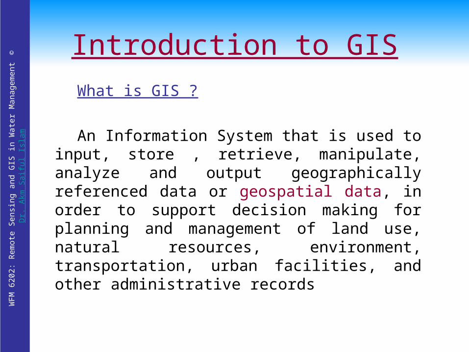
Introduction to GIS
What is GIS ?
An Information System that is used to input, store , retrieve, manipulate, analyze and output geographically referenced data or geospatial data, in order to support decision making for planning and management of land use, natural resources, environment, transportation, urban facilities, and other administrative records

WF
M 6
20
2:
Re
mo
te S
en
sin
g a
nd
GIS
in W
ate
r M
an
ag
em
en
t © D
r. A
km S
aifu
l Isl
am
Components of GIS
• Key components of GIS are:– Computer system,
geospatial data, and users
• Sources of geospatial data are:– Digitized maps, aerial
photographs, satellite images, statistical tables, and other related documents
ComputerSystem
GeospatialData
Users
Figure: Key components of GIS

WF
M 6
20
2:
Re
mo
te S
en
sin
g a
nd
GIS
in W
ate
r M
an
ag
em
en
t © D
r. A
km S
aifu
l Isl
am
WF
M 6
20
2:
Re
mo
te S
en
sin
g a
nd
GIS
in W
ate
r M
an
ag
em
en
t © D
r. A
km S
aifu
l Isl
am
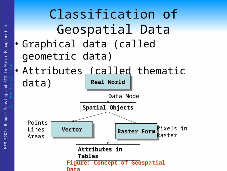
Classification of Geospatial Data
• Graphical data (called geometric data)
• Attributes (called thematic data)
Figure: Concept of Geospatial Data
Real WorldReal WorldReal WorldReal World
VectorVectorVectorVectorRaster FormRaster FormRaster FormRaster Form
Spatial ObjectsSpatial Objects
Attributes in TablesAttributes in Tables
Pixels in Raster
PointsLinesAreas
Data Model

WF
M 6
20
2:
Re
mo
te S
en
sin
g a
nd
GIS
in W
ate
r M
an
ag
em
en
t © D
r. A
km S
aifu
l Isl
am

WF
M 6
20
2:
Re
mo
te S
en
sin
g a
nd
GIS
in W
ate
r M
an
ag
em
en
t © D
r. A
km S
aifu
l Isl
am
Why GIS is needed ?
Common problems of handing geospatial information:
Geospatial data are poorly maintained.Maps and statistics are out of date.Data and information are inaccurate.There is no data retrieval service.There is no data sharing.

WF
M 6
20
2:
Re
mo
te S
en
sin
g a
nd
GIS
in W
ate
r M
an
ag
em
en
t © D
r. A
km S
aifu
l Isl
am Benefits once GIS is implemented
Geospatial data are better maintained in a standard format.
Revision and updating are easier.
Geospatial data and information are easier to search, analysis and represent.
More value added product.
Geospatial data can be shared and exchanged freely.
Productivity of the staff improved and more efficient.
Time and money are saved.
Better decision can be made.
WF
M 6
20
2:
Re
mo
te S
en
sin
g a
nd
GIS
in W
ate
r M
an
ag
em
en
t © D
r. A
km S
aifu
l Isl
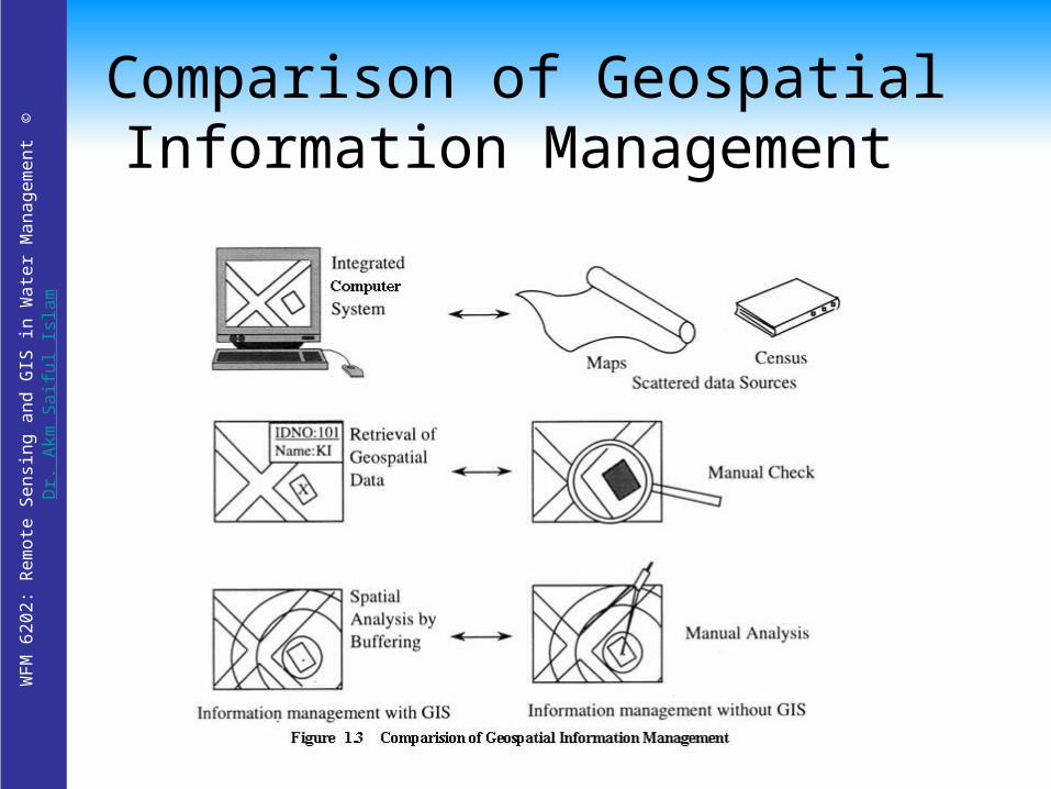
am Comparison of Geospatial
Information Management
WF
M 6
20
2:
Re
mo
te S
en
sin
g a
nd
GIS
in W
ate
r M
an
ag
em
en
t © D
r. A
km S
aifu
l Isl
am
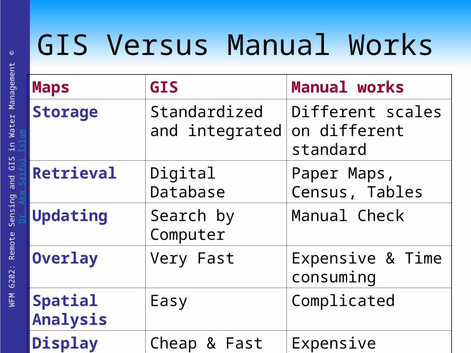
GIS Versus Manual WorksMaps GIS Manual works
Storage Standardized and integrated
Different scales on different standard
Retrieval Digital Database Paper Maps, Census, Tables
Updating Search by Computer
Manual Check
Overlay Very Fast Expensive & Time consuming
Spatial Analysis
Easy Complicated
Display Cheap & Fast Expensive

WF
M 6
20
2:
Re
mo
te S
en
sin
g a
nd
GIS
in W
ate
r M
an
ag
em
en
t © D
r. A
km S
aifu
l Isl
am
Basic Functions of GIS
Functions Sub-functionsData Acquisition
and prepossessing
Digitizing, Editing , Topology Building, Projection Transformation, Format Conversion etc.
Database Management and Retrieval
Data Archival, Hierarchical Modeling , Network Modeling, Relational Modeling, Attribute Query, Object-oriented Database etc.
Spatial Measurement and Analysis
Measurement operations, Buffering, Overlay operations, connectivity Operations etc.
Graphic output and Visualization
Scale Transformation, Generalization, Topological Map, Statistical Map etc.

WF
M 6
20
2:
Re
mo
te S
en
sin
g a
nd
GIS
in W
ate
r M
an
ag
em
en
t © D
r. A
km S
aifu
l Isl
am
Computer System for GIS
• Hardware System– Central Processing Unit (CPU)– Memory (RAM) > 64 MB– I/O Device
• Plotters, printers, mouse, digitizers, scanners, digital camera
• Software System– Operating System
• DOS, Windows
– Compiler• C++, Pascal, Fortran, BASIC
– Application Programs• ArcGIS, MGE, Geo/SQL, GFIS, IDRISI*, GRASS*
– * public domain software

WF
M 6
20
2:
Re
mo
te S
en
sin
g a
nd
GIS
in W
ate
r M
an
ag
em
en
t © D
r. A
km S
aifu
l Isl
am
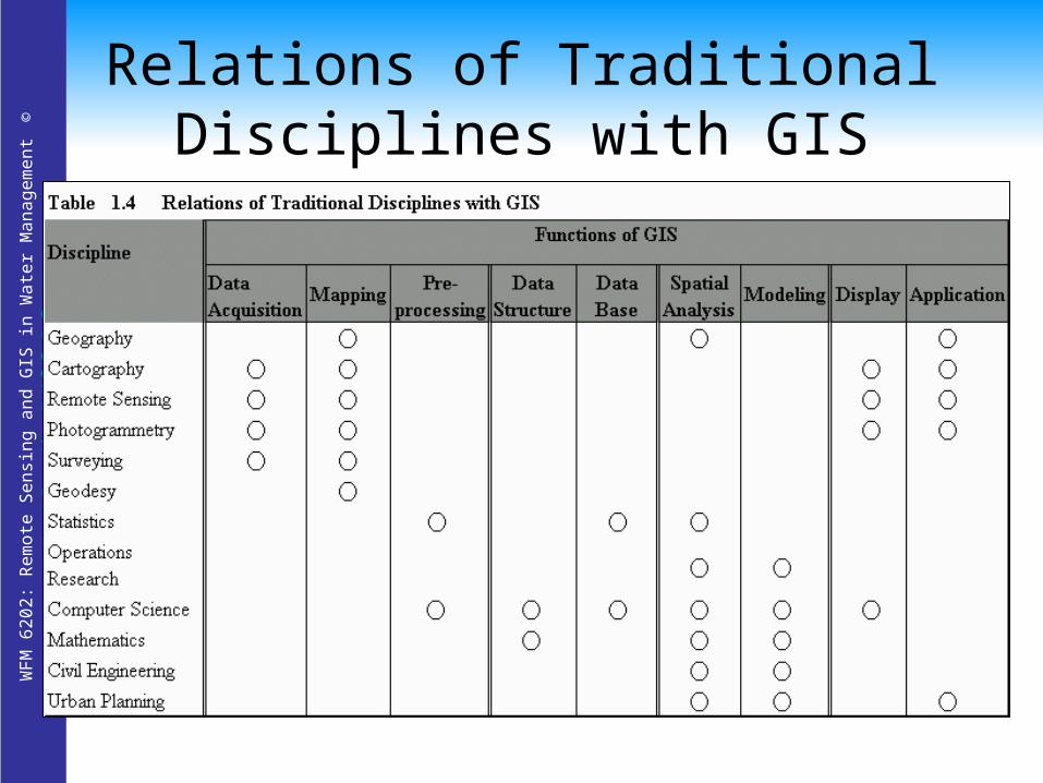
GIS as Multidisciplinary Science
Geography Cartography Remote Sensing Photogrammetry Surveying Geodesy
Statistics Operations
Research Computer Science Mathematics Civil Engineering Urban Planning
WF
M 6
20
2:
Re
mo
te S
en
sin
g a
nd
GIS
in W
ate
r M
an
ag
em
en
t © D
r. A
km S
aifu
l Isl
am Relations of Traditional Disciplines
with GIS

WF
M 6
20
2:
Re
mo
te S
en
sin
g a
nd
GIS
in W
ate
r M
an
ag
em
en
t © D
r. A
km S
aifu
l Isl
am
Area of GIS ApplicationsArea GIS Applications
Facilities Management
Locating underground pipes & cables, planning facility maintenance, telecommunication network services
Environmental and Natural Resources Management
Environmental impact analysis, disaster management and mitigation
Street Network Locating houses and streets, car navigation, transportation planning
Planning and Engineering
Urban planning, regional planning, development of public facilities
Land Information Taxation, zoning of land use, land acquisition

WF
M 6
20
2:
Re
mo
te S
en
sin
g a
nd
GIS
in W
ate
r M
an
ag
em
en
t © D
r. A
km S
aifu
l Isl
am
GIS Information Infrastructure
Social Infrastructure
Social Infrastructure
Urban Infrastructure
Urban Infrastructure
GIS Information
Infrastructure
GIS Information
Infrastructure
EnvironmentalInfrastructure
EnvironmentalInfrastructure
EconomicInfrastructure
EconomicInfrastructure
EducationalInfrastructure
EducationalInfrastructure
PopulationLand UseCadastre etc.
Natural ResourcesPollutionDisaster etc.
MarketingBankingCar Navigations etc.
Police and FireCable and PipeTransportations
Basic knowledgeComputer assisted education
WF
M 6
20
2:
Re
mo
te S
en
sin
g a
nd
GIS
in W
ate
r M
an
ag
em
en
t © D
r. A
km S
aifu
l Isl
am
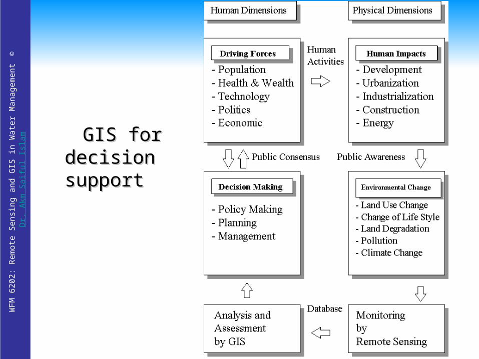
GIS for GIS for decision decision supportsupport