Wetlands in a Village Environment: A Case from...
11
Wetlands in a Village Environment: A Case from Brahmaputra Floodplain, Assam Nityananda Deka and A.K.Bhagabati, Guwahati, Assam Abstract This is an attempt to investigate the pattern of distribution of different types of wetlands and their utility in a village located in the floodplain of the Brahmaputra, Assam. Popularly known as ‘khal-beel’ among the villagers, the wetlands comprising natural beels and ponds, dead channel, marshes, water loggings, man-made ponds, etc. provide aquatic resources highly diverse in nature, occurrence and use. The wetlands of various types and sizes cover an area of 21.44 ha accounting for 7.33 percent of the total operational area of the village. The wetlands act as one of the components of the livelihood support system by providing scope for fishing, collecting edible plants and flowers, bathing, washing and irrigating the agricultural fields and water and fodder for the cattle. They also function as micro-habitats for a variety of aquatic flora and fauna within the agroecological setting of the village. The study is based on an intensive field work carried out during 2006-2008 with a survey schedule covering all the 408 households of the village. The nature and distribution of different types of wetlands have been mapped and analysed on the basis of the updated cadastral map (dag map) of the village and the ground survey made at household level. A study of this kind is found to be very important in formulating strategies for sustainable use and conservation of the micro-ecosystems within the human habitats in the context of growing scarcity of fresh water and loss of aquatic biodiversity. Keywords: Wetland, Micro-habitat, Livelihood support system, Aquatic Biodiversity. Introduction The wetlands distributed in the rural areas of Assam form biologically the most productive aquatic ecosystems directly and indirectly providing services to the people around. The rural landscape of the state is endowed with wetlands of various types identifiable on the basis of their micro- geomorphic characteristics and associated human response and perception. Although the typology and utility of the wetlands appear to be more or less uniform throughout the state, some variations are discernable with respect to their origin, location, size and shape, depth, seasonal fluctuation of water area and aquatic resources. The pattern of their utility also varies according to the social background, tradition and economic condition of the people around. It is, however, important to note that the rural lives in Assam are intrinsically linked mainly with the subsistence mode of farming, livestock rearing and traditional fishing closely connected with the wetlands. Trans.Inst.Indian Geographers ISSN 0970-9851
-
Upload
phungthuan -
Category
Documents
-
view
215 -
download
1
Transcript of Wetlands in a Village Environment: A Case from...

Wetlands in a Village Environment: A Case from Brahmaputra Floodplain, Assam
Nityananda Deka and A.K.Bhagabati, Guwahati, Assam
AbstractThis is an attempt to investigate the pattern of distribution of different types of wetlands and their utility in a village located in the floodplain of the Brahmaputra, Assam. Popularly known as ‘khal-beel’ among the villagers, the wetlands comprising natural beels and ponds, dead channel, marshes, water loggings, man-made ponds, etc. provide aquatic resources highly diverse in nature, occurrence and use. The wetlands of various types and sizes cover an area of 21.44 ha accounting for 7.33 percent of the total operational area of the village. The wetlands act as one of the components of the livelihood support system by providing scope for fishing, collecting edible plants and flowers, bathing, washing and irrigating the agricultural fields and water and fodder for the cattle. They also function as micro-habitats for a variety of aquatic flora and fauna within the agroecological setting of the village.
The study is based on an intensive field work carried out during 2006-2008 with a survey schedule covering all the 408 households of the village. The nature and distribution of different types of wetlands have been mapped and analysed on the basis of the updated cadastral map (dag map) of the village and the ground survey made at household level. A study of this kind is found to be very important in formulating strategies for sustainable use and conservation of the micro-ecosystems within the human habitats in the context of growing scarcity of fresh water and loss of aquatic biodiversity.
Keywords: Wetland, Micro-habitat, Livelihood support system, Aquatic Biodiversity.
IntroductionThe wetlands distributed in the rural areas of Assam form biologically the most productive aquatic ecosystems directly and indirectly providing services to the people around. The rural landscape of the state is endowed with wetlands of various types identifiable on the basis of their micro-geomorphic characteristics and associated human response and perception. Although the typology and utility of the wetlands appear to be more or less uniform throughout
the state, some variations are discernable with respect to their origin, location, size and shape, depth, seasonal fluctuation of water area and aquatic resources. The pattern of their utility also varies according to the social background, tradition and economic condition of the people around.
It is, however, important to note that the rural lives in Assam are intrinsically linked mainly with the subsistence mode of farming, livestock rearing and traditional fishing closely connected with the wetlands.
Trans.Inst.Indian GeographersISSN 0970-9851
36 | Transactions | Vol. 37, No. 1, 2015
The rural settlements, especially those in the floodplain environment, had originated and got spatially organized around the wetlands due to the variety services provided by them to the nearby communities.
Wetlands and their resources are considered as integral parts of the social and cultural ethos of human societies (Gopal and Sah, 1995). However, with the modernization of society, particularly during the last few decades, the traditional use of wetlands has experienced remarkable change. The overexploitation of wetland resources, irrational mode of fishing, invasion by weeds, siltation, and pollution caused by agro-chemicals have posed serious threats to the wetland ecosystems leading to partial or complete loss of the wetland habitats (Bhagabati, 2008, 2012). In addition, the continued poverty among the villagers, their ignorance and indifferent attitude towards the wetlands and unsustainable ownership pattern have also adversely affected the village wetland ecosystems. Moreover, lack of proper attention to the rural situations, defective development plans, particularly those based on macro-regional considerations and profit-maximization approaches, have significantly impaired the natural resource base of the wetlands.
Most of the studies on wetlands in Assam are mainly confined to individual wetlands or their overall regional scenario. The works of Bora (1991), Saikia (1991), Sarma (1993), Bora and Barman (1998), Roy (2001), Kalita (2005), Sahariah (2009), Bhagabati (2008, 2012) which dealt with the geomorphological and ecological characteristics, and socio-economic importance of the wetlands at the district or regional level are worth
mentioning. Detailed study on the type and utility pattern of wetlands at micro-human habitat level (village), for instance, has not been attempted so far. This kind of study in the rural context holds great significance in formulating strategies and action plans for sustainable use and conservation of aquatic resources within the geographical framework of human habitats.
This paper is an attempt to study the nature and type of wetlands, their change in terms of area, ownership and utility within the framework of a village called Muktapur in the lower Brahmaputra floodplain, Assam.
MethodologyA comprehensive field survey covering all the 408 households of the selected village was conducted during 2006-2008 through a purposively designed schedule to acquire the required data and information for the study. The data on the distribution, size, type, status, use, ownership and management of different types of wetlands thus obtained have been tabulated and analysed. Moreover, with the help of participatory rural appraisal (PRA) and interview with the villagers individually and in group, the wetlands have been classified and mapped according to their type and utility. Besides, oral discourses with some elderly and experienced persons were made in order to know the change in the availability and use of the wetland resources in the village.
The updated cadastral map (dag map) of the village collected from the Revenue Circle Office at Goreswar, Assam is taken as the base map to depict the distribution of different types of wetlands. Dags are the smallest land revenue units of the village

Transactions | Vol. 37, No. 1, 2015 | 37
Fig 1: Location of Muktapur village in Kamrup District, Assam
landscape which are generally demarcated by the village surveyors (Mandals) using some numbers systematically. The location of different types of wetland has been identified with reference to the dags in consultation with the owners practically in the field. In order to understand the
topographical sequence of the wetlands in the local agro-ecological settings a transect chart or toposequence has been prepared following the PRA method. Tools and software such as GPS, ArcGIS 9.2 were used in preparing the land use map of the village including the distribution of wetlands.

38 | Transactions | Vol. 37, No. 1, 2015
Background of the VillageThe name of the village- Muktapur has great significance. From the chronology of the families of the village it is evident that this village originated and flourished by the side of a dead river channel called Punai. The term Muktapur stems form two local words: mukta (pearl) and pur (abundance). The plethora of resources that endowed the village is mainly the gift of the Punai dead channel. This channel served as the axis of the life and livelihoods of the villagers as it provided abundant fish, water, aquatic vegetables and also fertile alluvium for growing crops. It is noteworthy that before 1980s, there was no tubewell or any other modern sources of drinking water and the villagers had to depend solely on the natural or man-made water bodies distributed in the village.
Muktapur village is located in Goreswar Revenue Circle of Rangia Sub-division, Kamrup (rural) district, Assam (Fig 1). This is a typical village inhabited by indigenous non-tribal Assamese people. It is located in the north bank floodplain of the lower
Brahmaputra at a distance of nearly 35 km from Guwahati city and 40 km south from the Bhutan Himalayan foothills. Muktapur covers an area of 3.67 sq km with a population of 2080 as per the household survey carried out in 2006. The total number of households in the village is 408 which are distributed in 11different hamlets (chuburi).
Status of Wetlands in the VillageGenerally known as khal-beel among the villagers, the wetlands of the village include man-made ponds (pukhuri), natural ponds (khal), dead channel (mora nadi), marshes (pitoni), water loggings (hola) and canal (khawai). Except for the man-made ponds, all other types of wetland such as khal, pitoni, hola, khawai are natural in origin. There are as many as 471 wetlands of different types and sizes in the village with a total area of 21.44 ha accounting for 7.33 percent of the total operational area of the village (Table 1). Many of the households in the village possess both man-made and natural wetlands.
Table 1: Status of wetlands in the village, 2006-2007
Type
Number and area of wetlands possessed by householdsNumber Area (in ha) Number of households
possessing wetlandNumber of wetland per household (average)
Man-made pond (Pukhuri)
218(46.28)
14(65.29)
186(45.58)#
1.17
Natural pond (Khal)
207(43.95)
4.84(22.57)
194(47.55)#
1.07
Marshes (Pitoni) 15(3.18)
1.24(5.78)
13(3.19)#
1.15
Water logging (Hola)
19(4.03)
0.98(4.57)
19(4.66)#
1
Canal (Khawai) 12(2.55)
0.38(1.77)
10(2.45)#
1.2
Total 471 21.44 257* 1.83
Source: Field survey, 2006-07

Transactions | Vol. 37, No. 1, 2015 | 39
Note: Figures in the parentheses indicate the percentage to the total; # indicates the percentage to the total households (408); * total households of the village having some type of wetlands. Of the total 408 households of the
village, 63 percent possess wetlands, the number of wetlands per household being 1.83. Out of the total households possessing wetland, 72.37 percent have man-made ponds (pukhuri), 75.49 percent have natural ponds (khal), 5.06 percent have ownership over the marshes (pitoni) and 7.39 percent have small canal (khawai). It is evident from Table 1 that the man-made ponds with an area of 14 ha constitute the highest proportion of wetland area in the village.
The number and area of man-made ponds have increased significantly during the period 1980-2006 (Table 2). Their number has increased with the coming up of new households in the village. Usually
after separation from a joint family system, the new family has to construct its own houses in a piece of land allotted to it for the purpose. Generally, in the ecological context of the Brahmaputra floodplain earth filling is required particularly for raising the homestead. Thus the newly created families have to dig ponds preferably within or close to their homesteads. The number and area of the natural wetlands on the other hand have gradually declined. The overdependence on wetland resources, excessive siltation by surface run-off, alarming growth of weeds like Panibhotora (Ipomea aquatica), Meteka (Eichhornia cressipes), and Nagarbera and transformation of the wetland margins into paddy fields are the main factors responsible for the rapid degradation of the natural wetlands within the village. Again, the fragmentation of the natural wetland areas for different uses and also for accommodating the individual’s share has rendered them increasingly vulnerable to degradation.
Table 2: Change in number and area of wetlands
Type of wetlandNumber Area (in ha)
1980 2006 Change in %
1980 2006 Change in %
Man-made pond (pukhuri) 163 218 + 33.74 9.46 14 +48Natural pond (khal) 217 207 - 4.61 5.07 4.84 - 4.54
Source: Field survey, 2006-2007
Indigenous Typology of WetlandsThere has been no scientific attempt so far to systematically classify the wetlands distributed in the micro-environmental settings that characterize the floodplains of Assam. The rural people, whose livelihoods are intimately associated with the wetlands around, have traditionally developed the
practice of classifying wetlands on the basis of their perception, experience and benefits derived through generations.
The people of Muktapur have through their experience and to their advantage evolved a classification of the water bodies present in and around their village. Accordingly, seven categories of wetlands may be identified in

40 | Transactions | Vol. 37, No. 1, 2015
the village: (i) man-made pond, (ii) natural pond, (iii) dead channel, (iv) marshes, (v) water-logged area, and (vi) canal. These wetlands have their own characteristics and roles in providing ecological and economic services to the people.
Man-made pond: This is a type of artificially created fresh water body. Ponds are usually located within or near the homesteads, their average distance being 75 metres from the owner’s residence. Unlike the natural ponds (khals), fish are reared here for home consumption as well as for selling. Usually such ponds are dug for rearing fish. On the banks of the ponds a variety of economic plants like coconut, banana, bamboo are grown. Interestingly, the diversity of aquatic flora and fauna in these man-made ponds is relatively less. Besides pisciculture, these are used for bathing, washing of clothes and utensils, soaking seeds and jutes. Woods and bambooes for domestic use are also soaked in water to enhance their durability. The average depth of the ponds in the village remains around 2 metres and 1.5 metres during summer and winter respectively. It is found that 89 percent of the ponds were created at different times when the villagers had newly raised their homesteads (gharveti) and home gardens (basti). As these ponds are bounded by sufficiently raised banks flood water does not engulf them during summer and thus they maintain their identity throughout the year.
Natural pond: Locally called khal, these are naturally formed water bodies. In the village under study, the Punai dead channel has provided scope for the formation of several natural ponds in its long bed. These natural ponds are rich in aquatic flora and fauna. These are regularly inundated and get
connected with open sheet of flood water during summer. However, most of these ponds dry up during winter. The khals in the village are usually located relatively away from the homesteads, the average distance being 400 metres.
Dead channel: A segment of the abandoned course of a stream called Punai is there in the village. It lies along the boundary of the village measuring a length of about 700 metres. The dead channel (mora nadi) usually gets flooded during the summer. In winter, the water level of the channel goes down considerably. This dead channel forms suitable habitat for a variety of fish and other animals and plants.
Marshes: Marshes (pitonis) with saturated soil favour the growth of a large number of herbaceous vegetations like reeds, sedges and grasses. They constitute the biologically most diverse and productive aquatic ecosystems providing habitats for insects, reptiles and birds. The villagers collect necessary fodders for their cattle mainly from these marshes.
Water logged area: These are small depressions inundated in summer and dried up in winter. They usually remain covered by stagnant or slow moving water and get connected with the dead channel. When the water goes down in winter only the deeper parts of the depressions contain some water. They act as the last winter resort for the small fish and other minor aquatic fauna which normally move around the nearby paddy fields during the summer. Locally called holas, these are used by the villagers as common fishing grounds.
Canal: These are the shallow elongated depressions saturated by surface run-off
Transactions | Vol. 37, No. 1, 2015 | 41
or seepage of water from the adjacent interfluves and remain wet during summer and become dry in winter. The villagers use these as sources of irrigation by diverting their flow to the paddy fields. Like other natural water bodies, these wetlands constitute good habitats for small fish species like Darikona (Esomus dandricus), Mowa (Amblypharyangodon mola), Cheng (Channa orientalis), Garai (Chenna punctata), Magur (Clarias batrachus), Singi (Heteropneustes), Tora (Mastacembelus), Chanda (Chanda nama).
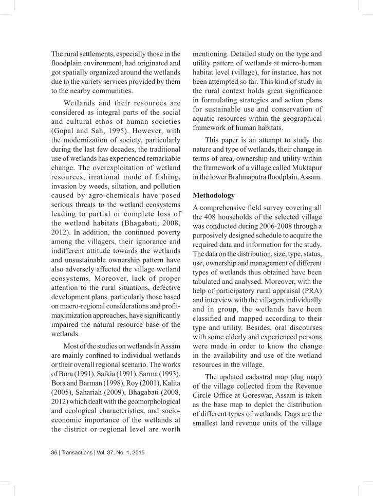
Size and DistributionThe wetlands of the village are mostly of small size and scattered all over the village area (Fig. 2 See page 45). The fragmentation of landholding resulting from the law
of inheritance and transfer of ownership affect the size and spatial distribution of the wetlands. The wetlands, specially the natural ones, show remarkable variation in terms of size and scattering (Table 3). The small size and scattering have a negative impact on the wetland biota as most of the aquatic species require a minimum path size as well as composition of wetlands in order to make the habitat suitable (Jacques et al., 2007). Most of the natural wetlands (79.84 percent) are of less than 0.04 ha size and cover a total area of 4.15 ha. On the other hand, 64.22 percent of the man-made ponds are of below 0.04 ha size and cover 50.36 percent of the total pond area. It is observed that the size of the natural wetlands lies within the range of 0.04 - 0.16 ha, while the size of the man-made ponds remains above 0.24 ha. Only two ponds have the size of 0.54 ha each.
Table 3: Number of natural and man-made wetlands in different size classes
Size class (in ha)
Natural wetlands (khal, pitoni, hola ,khawai) Man-made ponds (pukhuri)
Number Area (in ha) Number Area (in ha)
< 0.04 202(79.84)
4.15(55.78)
140(64.22)
7.05(50.36)
0.04-0.08 46(18.18)
2.70(36.29)
49(22.48)
2.93(20.93)
0.08-0.12 3(1.19)
0.31(4.17)
14(6.42)
1.44(10.29)
0.12- 0.16 2(0.79)
0.28(3.76)
8(3.67)
1.11(7.93)
0.16-0.20 0 0 4(1.83)
0.72(5.14)
0.20- 0.24 0 0 1(0.46)
0.21(1.5)

42 | Transactions | Vol. 37, No. 1, 2015
>0.24 0 0 2(0.92)
0.54(3.86)
Total 253 7.44 218 14.00
Source: Field survey, 2007-2008
Note: Figures in the parentheses indicate the percentage to the total
The distribution of the wetlands in the village represents a peculiar relation of the people with the topography which they have created through modification of the natural landscape as per their convenience. The man-made ponds are mostly located near the homesteads as these are used frequently and need special care for their maintenance, while the natural ones are located in the low-laying areas at some distance from the homesteads. Thus the distribution of the wetlands in the traditionally evolved agro-ecological landscape reflects the careful adaptation of the people to the micro-ecological settings of the area (Fig. 3 See page 45).
Use of Wetland ResourcesWetlands act as an important component of the livelihood support system of the rural communities. As has been already
mentioned, they play a notable role in the life and living of the rural people by providing grounds for fishing, drinking water, edible plants and flowers, facilities for bathing and washing, irrigating agricultural fields and fodder for the cattle. The people have thus developed a spontaneous relation with the wetland resources made available locally by nature.
So far the use of natural wetlands is concerned, 76 percent of the households use them for fishing, 73 percent for irrigation purpose, 24 percent for collecting aquatic vegetables, 74 percent for providing drinking water to their cattle, and 11 percent for bathing and washing purposes (Table 4). The villagers generally collect the wetland resources for domestic use. However, a small proportion of these is sold by some of the villagers for cash.
Table 4: Use of the natural wetlands
Type of useNumber of house-holds involved
Purpose
Domestic use (Number of households involved)
Selling (Number of households involved)
Fishing 312 (76) 283 (91) 29 (9)
Irrigating fields 298 (73) 298 (0) -
Collecting edible plants 97 (24) 90 (93) 7 (7)
Drinking water for cattle 302 (74) - -
Bathing and washing 47 (11) - -
Source: Field survey, 2006-07.Note: Figures in the parentheses indicate the percentage to the total households.
Transactions | Vol. 37, No. 1, 2015 | 43
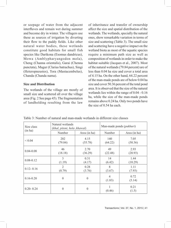
The income generated from ponds and consumption of fish among the villagers present an interesting pattern (Table 5). The difference between the man-made and natural ponds in this regard is quite revealing. The farmers and wage labourers, whose economic condition is relatively week, depend more on the natural ponds. As the natural ponds are open for all, the weaker section of the people tries their best to exploit maximum possible fish resources from the ponds mainly for domestic consumption. They also sell some amount of fish in the local markets primarily by the end of
summer when the fish populations attain their maturity. On the other hand, the people engaged in business and services have their own pond fisheries and also ownership on some natural ponds. They, however, rarely go for fishing in the natural ponds and therefore their fish consumption from the natural ponds is the lowest. In sum, it can be said that the villagers, particularly the weaker section, are greatly benefited both economically and nutritionally from the fish and other aquatic resources available in the wetlands.
Table 5: Income from ponds and fish consumption pattern
Occupational categories
From man-made ponds From natural pondsAnnual income per household(Rs)
Yearly fish consumption in money value per household (Rs)
Annual income per household(Rs)
Yearly fish consumption in money value per household (Rs)
Farmers 572.16 1200.00Wage labourers 0 350.00Businessmen 954.55 1336.36Service holders 1020.00 1848.00
Source: Field survey, 2006-07
So far the ownership of the wetlands is concerned, there is a peculiar system in practice traditionally in the village. The natural wetlands, owned in some cases by individuals, are open for fishing to all during the summer season. This helps the poorer section of the people, who do not have their own wetlands, to collect fish and other resources for home consumption and sell as well. However, the poor people having no wetland of their own suffer from scarcity of fish during the winter.
ConclusionThe foregoing discussion presents the scenario of distribution and use of various types of wetlands in a floodplain village of Assam. It is noteworthy that the smaller wetlands scattered in the village landscapes of Assam are no less insignificant in so far as conservation of the aquatic biodiversity in the state is concerned. As micro-ecosystems, the wetlands contribute directly to the local environment and the rural economy. However, most of the rural development

44 | Transactions | Vol. 37, No. 1, 2015
plans and programmes followed in the country and state as well do not pay due attention to the status and problems of the wetland ecosystems. Again, most of the programmes adopted for conservation and development of wetlands do not bear expected fruits because of the indifferent attitudes towards the needs and aspirations of the people sharing the micro-ecological settings. The traditional management practices developed through long-continued trial and error methods need to be examined and integrated into the development plans meant for the rural areas. Measures for protecting the wetlands have to be better integrated to ecological needs and benefits of the local people (Junk, 2002).
Proper attention should be given to the problem of inequality of ownership of wetlands and to eradicate the poverty of the rural people by providing alternative opportunity before implementing the wetland conservation plans and programmes. Again, the perception of the villagers, their traditional systems of classification and knowledge on wetlands, preferences for resource use should be given due weight and accordingly separate strategy to conserve and manage each type of wetlands should be evolved and implemented.
ReferenceBhagabati, A.K. (2008): Environmental
Problems in India’s North-East: Some Observation. In S. Deka (ed), North-East India:Geo-environmental Issues, Guwahati: EBH Publishers (India).
Bhagabati, A.K.(2012): Wetlands in Assam. In Baroowa et al. (ed), Aspects of Land Pol icy in Assam: Cont inui ty and Change. Guwahati: Vivekananda Kendra Institute of Culture, pp.197-213.
Bora, A.K. (1991): Jia Bharali River Basin: A Study in Fluvial Geomorphology. Unpublished Ph.D. thesis, Gauhati University, Guwahati.
Bora, A.K. and Barman, B. (1998): A Geo-Ecological Study of the Wetlands of Barpeta District, Assam. North Eastern Geographer, Vol. 29, No. 1 and 2.
Gopal, B. and Sah, M. (1995): Inventory and Classification of Wetlands in India, Vegetatio, Belgium: Kluwer Academic Publishers, pp. 39-47.
Jacques, K., Congalton, R.G. and Babbitt, K. (2007): Effects of Urbanization on the Spatial Distribution and Size of Wetlands in New Hampshire. Florida: ASPRS, Annual Conference.
Kalita, H. C.( 2005): Wetlands of Goalpara District, Assam: A Study of their Physical and Economic Characteristics. Unpublished Ph.D. thesis, Gauhati University, Guwahati.
Roy, L. (2001): A Study of Basin Geomorphology and Flow Characteristics of the Gabharu River, North East India. Unpublished Ph.D. thesis, Gauhati University, Guwahati.
Saharia, D. (2009): Wetlands of the Brahmaputra Floodplain in Darrang District, Assam: A Fluvio-Geomorphic Study. Unpublished Ph.D. thesis, Gauhati University, Guwahati.
Saikia, R. (1991): Geomorphology of Kapili Basin, North East India. Unpublished Ph.D. thesis, Gauhati University, Guwahati.
Sarma, P. (1993): Geo-Ecological Study of Beels and Swamps in Nagaon and Marigaon District, Assam. Unpublished Ph.D. thesis, Gauhati University, Guwahati.
Nityananda DekaA.K.Bhagabati
Department of Geography,Gauhati University,
Guwahati, Assam -781-014, India

Transactions | Vol. 37, No. 1, 2015 | 45
Fig 2 [See page 41 for the text] : Distribution of wetlands in Muktapur village
Fig 3 [See page 42 for the text] : Distribution of wetlands in the agro-ecological settings of the village