Westminster Walking Strategy
65
Westminster City Council Westminster City Hall 64 Victoria Street London SW1E 6QP westminster.gov.uk
Transcript of Westminster Walking Strategy

Westminster City Council Westminster City Hall 64 Victoria Street London SW1E 6QP
westminster.gov.uk

2
Westminster Walking Strategy Consultation Draft
Foreword
I am very pleased to be putting our revised Walking Strategy out for consultation. The previous Westminster Walking Strategy was adopted in 2004. There have been huge changes since then and Westminster has made improvements in its public realm to enhance the walking environment over the last 10 years.
Future growth in central London, the implementation of major transport projects such as Crossrail 1 and potentially Crossrail 2, mean that the timing is opportune to set out a vision for walking in Westminster. The aim is to have a coherent strategy outlining how to improve conditions for pedestrians (particularly in the context of extra footfall) as well as encouraging more people to walk for more journeys.
Walking is good for health on an individual level. Through a modal shift, walking can also help improve air quality.
I would like to thank all the stakeholders who have already contributed in discussions for developing this draft Strategy – from landowners, BIDs, residents, lobbying and specialist interest groups and the Sustainable Transport Task Group of Westminster Councillors. We now need you all to comment on this draft, come forward with new ideas and work with us to make walking the preferred mode of travel across our city.
Councillor Heather Acton
Cabinet Member for Sustainability & Parking

3
Westminster Walking Strategy Consultation Draft
This Report
The City of Westminster has supported walking through policy and strategy for many years. The Council’s first Walking Strategy was adopted in 2004 and sought to encourage walking by co-ordinating a range of initiatives and measures. An updated Walking Strategy aims to set out how the Council can deliver improvements that will enhance the City’s walking environment and promote more walking
Steer Davies Gleave has been commissioned by Westminster City Council to assist with the drafting of an updated Walking Strategy. The scope of the work was to:
• engage with City of Westminster officers and key stakeholders;
• undertake a policy context review;
• review statistical evidence base to understand current situation;
• review statistical evidence base to understand future demand; and
• prepare draft strategy document.
The advice of Steer Davies Gleave provided here on an updated Walking Strategy is therefore based on desktop research and experience and access to existing data sets.
In undertaking this work we met with the following stakeholders:
• 20s Plenty for Us
• British Land
• Church Commissioners (Hyde Park Estate and other areas)
• Derwent London
• Great Portland Estates
• Grosvenor Estate
• Living Streets
• London Cycling Campaign
• Shaftesbury
• Stow Securities
• The Crown Estate
• The Howard de Walden Estate
• The Portman Estate
• Transport for London
• Vision Zero
• Westminster Amenity Societies Forum
• Westminster Business Improvement Districts
• Westminster City Council highways, planning, public health and environmental teams
• Westminster’s Environment & Customer Services Policy & Scrutiny Committee Sustainable Travel Task Group
• Westminster Property Association

4
Westminster Walking Strategy Consultation Draft
Executive Summary
Context
Westminster City Council has supported and encouraged walking through policy, strategy and investment for many years. The Council’s first walking strategy was adopted in 2004 and sought to encourage walking by coordinating a range of committed initiatives and measures. This strategy covers the period to 2033, in which time Crossrail 1 and 2 will become operational; this combined with growth in housing and jobs will bring more pedestrians to Westminster’s streets. This strategy sets out how the Council can deliver improvements that will enhance Westminster’s walking environment and promote more walking.
The strategy complements existing council strategies covering transport, public health, air quality and public realm:
• Greener City Action Plan 2015-2025.
• Joint Health and Wellbeing Strategy 2013-2016.
• Sustainable Modes of Travel Strategy 2015.
• Air Quality Action Plan 2013-2018.
• Active Westminster 2008-2013.
• Westminster Way, Public Realm Strategy (adopted 2011).
Nationally, the remit for public health moved to local authorities in 2013, placing greater responsibility on councils than ever before to address issues such as sedentary lifestyles and childhood obesity. Encouraging more walking has a role to play here in addition to contributing towards better transport
outcomes including reduced congestion and improved air quality. Within London, walking is promoted at a strategic level through the London Plan and the Mayor’s Transport Strategy. In particular, Policy 6.10 of the London Plan calls for significant increases in walking to be delivered through improvements to pedestrian and street environments and by ensuring new development delivers high quality public realm.
Walking in Westminster in numbers
The City of Westminster is home to over 230,000 people – forecast to reach 280,000 by 2032.
• More than 50% of residents also work in Westminster.
• 47% of residents’ journeys are made on foot as the main mode and 21% of journeys to work are walked.
• During the day, Westminster’s population increases to over one million people, including around 600,000 workers and 260,000 tourists. An estimated 750,000 people will work in Westminster by 2036.
5
Westminster Walking Strategy Consultation Draft
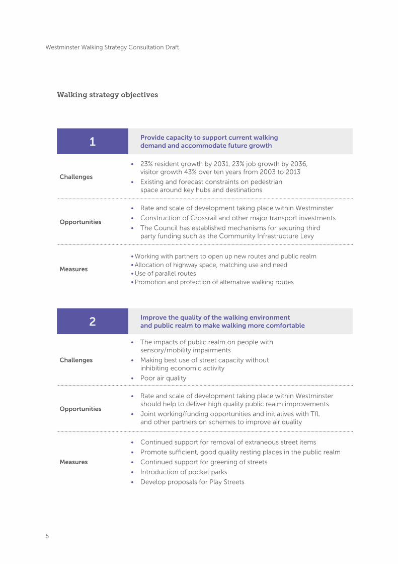
1 Provide capacity to support current walking demand and accommodate future growth
Challenges
• 23% resident growth by 2031, 23% job growth by 2036, visitor growth 43% over ten years from 2003 to 2013
• Existing and forecast constraints on pedestrian space around key hubs and destinations
Opportunities
• Rate and scale of development taking place within Westminster
• Construction of Crossrail and other major transport investments
• The Council has established mechanisms for securing third party funding such as the Community Infrastructure Levy
Measures
• Working with partners to open up new routes and public realm• Allocation of highway space, matching use and need• Use of parallel routes • Promotion and protection of alternative walking routes
2 Improve the quality of the walking environment and public realm to make walking more comfortable
Challenges
• The impacts of public realm on people with sensory/mobility impairments
• Making best use of street capacity without inhibiting economic activity
• Poor air quality
Opportunities
• Rate and scale of development taking place within Westminster should help to deliver high quality public realm improvements
• Joint working/funding opportunities and initiatives with TfL and other partners on schemes to improve air quality
Measures
• Continued support for removal of extraneous street items
• Promote sufficient, good quality resting places in the public realm
• Continued support for greening of streets
• Introduction of pocket parks
• Develop proposals for Play Streets
Walking strategy objectives

6
Westminster Walking Strategy Consultation Draft
3 Make walking more intuitive by increasing legibility and permeability
Challenges
• Large numbers of people unfamiliar with Westminster’s best walking routes
• Main roads tend to be the most obvious routes but often have poor air quality
Opportunities
• Increase awareness and understanding of routes and distances
• ‘Opening up the streets’ surrounding and parallel to the major thoroughfares and locations
Measures
• Continue roll-out of signage and wayfinding with Legible London and others
• Improving walking routes around utilities and construction works
4 Ensure walking is a safe option for everyone
Challenges
• Potential walking trips not made due to real and perceived safety risk, especially children
• Tourists particularly at risk of being injured as pedestrians in London
Opportunities
• Making walking safer to reduce the rate of traffic collisions
• Walking has positive economic, health and air quality outcomes
• Improving safety among tourists, improves safety perception in London
Measures
• Attempting to reduce vehicle speeds through a pilot 20mph zone trial
• Continued support for Delivery and Servicing Plans and waste and delivery consolidation
• Continued collaboration with TfL on steps to reduce vehicles congestion in intensely walked areas
• Continued monitoring and maintaining of footway conditions
• Continued considerate cycle training and working with stakeholders to address cycling on the footway

7
Westminster Walking Strategy Consultation Draft
5 Make the pedestrian environment more accessible for all users
Challenges
• Balancing the needs of different footway users
• Design beneficial to public realm can conflict with mobility needs
• Improving interchanges between street and Underground/rail stations
Opportunities
• Rate and scale of development taking place within Westminster
• Build on Council and BIDs management of footways and public realm
• Construction of Crossrail and other major transport investments
Measures
• Continue installation of dropped kerbs, tactile paving at junctions
• Involvement of mobility groups in public realm design
• Improving street lighting in locations where there are personal safety and security concerns
• Using public planting and vegetation to reduce encroachment in to pedestrian routes
6 Enable behaviour change to realise the potential of walking
Challenges• Availability of residential car parking making car use attractive
• Inactive population and high levels of obesity
Opportunities
• Reduced-car or permit-free development
• Promoting more walking through public health
• Existing structures (such as BIDs) to champion and cascade information
Measures
• More travel planning with large employers and BIDs
• Continue and expand pedestrian safety training programme to children
• 100% of schools to have an active travel plan in place
• Continue and expand walking and road safety initiatives for residents
• Work with UK and international tourist organisations to provide information for visitors about walking and road safety

8
Westminster Walking Strategy Consultation Draft
1. Introduction
Our vision is a world-class walking environment to transform the walking experience for all users, and to enhance the quality of life and wellbeing of our residents, workers and visitors.
network is unrivalled with four mainline railway termini at Charing Cross, Marylebone, Paddington and Victoria (and close proximity to Euston, St Pancras, King’s Cross and Waterloo), 31 London Underground stations, access to all but one of the London Underground lines, local, national and international bus routes, River Bus services and the central London cycle hire scheme.
1.4 Westminster City Council has supported and encouraged walking through policy, strategy and investment for many years. The Council’s first walking strategy was adopted in 2004 and sought to encourage walking by coordinating a range of committed initiatives and measures. The Council remains committed to walking, and active travel more widely, in line with its overall vision for Westminster to be a vibrant city with a great quality of life, strong, united communities and excellent services.
1.5 This strategy aims to set out how the Council can deliver improvements that will enhance Westminster’s walking environment and promote more walking. There are already very high numbers of people walking in Westminster and therefore this strategy is not just about creating an environment in which more people can walk for more or longer journeys, but also making the existing walking conditions better. This strategy covers the period to 2033, in which time both Crossrail 1 and Crossrail 2 will have opened.
The need for this strategy
1.1 The City of Westminster (Westminster) is a truly unique borough at the heart of a world class city. Westminster is home to London’s most prestigious landmarks and world famous institutions, from the United Kingdom’s Crown and Parliament, to the West End, Theatreland, national museums and galleries, broadcasters and multinational corporate headquarters. For many UK and international visitors, a trip to London will almost certainly involve spending time in the City of Westminster.
1.2 The City has an estimated resident population of over 230,000 people1, reaching from Queen’s Park and Maida Vale in the north, through Paddington, Marylebone and the West End, Covent Garden to Belgravia and Pimlico in the south. Like other central London boroughs Westminster comprises very affluent neighbourhoods alongside some of London’s most deprived areas. Westminster has a high population density although it benefits from a number of green spaces and large Royal Parks including Hyde Park, Regent’s Park and St. James’s Park.
1.3 The density and scope of the transport
1. ONS Mid-Year Estimates, 2014

9
Westminster Walking Strategy Consultation Draft
1.6 The structure of this strategy document is:
• The strategic context is described in chapter 2.
• Chapter 3 sets out the challenges and opportunities for walking in Westminster.
• Chapter 4 introduces the measures that form the strategy.
• Chapter 5 discusses the potential funding sources.
Principles of this strategy
1.7 The overarching principles for the development and implementation of this strategy are to:
• Invest in walking as a main mode of transport;
• Improve the attractiveness and safety of Westminster’s streets;
• Encourage walking in Westminster in balance with all users of our public space and roads; and
• Make any changes with the support of the community.
Objectives
1.8 Six objectives have been developed for the walking strategy to:
1. Provide the capacity to support current walking demand and to accommodate future growth.
2. Improve the quality of the walking environment and public realm to make walking more comfortable.
3. Make walking more intuitive by increasing the legibility and permeability of walking options.
4. Ensure walking is a safe option for everyone.
5. Make the pedestrian environment more accessible for all users.
6. Enable behaviour change to realise the potential of walking.


12
Westminster Walking Strategy Consultation Draft
National
2.1 The National Planning Policy Framework (NPPF) places a requirement on authorities to support a pattern of development that facilitates the use of sustainable modes of transport. Development should also give priority to pedestrian and cycle movements and have access to high quality public transport services. Development should minimise the potential for conflict between motor vehicles and pedestrians or cyclists and where possible avoid street clutter.
2.2 Nationally consideration is also given to the role of walking (and active travel more generally) in public health. Specifically, walking, as part of physically active lifestyles, is seen as part of a solution to public health issues such as childhood and adult obesity and increasingly sedentary lifestyles.
2.3 In 2013, public health was formally transferred from the NHS to local government and Public Health England. This significant shift in power has given local councils greater control over public health interventions, such as promoting and supporting walking and cycling, than was previously possible.
2.4 In 2014 the Department for Transport (DfT) published a Draft Cycling Delivery Plan, a 10 year plan for cycling in England, designed to communicate the Government’s “vision for cycling and walking and the role everyone – government, the wider public sector, stakeholders, business and individuals – has to play in the vision”.
The Draft Cycling Delivery Plan includes actions that must be taken in order to achieve the vision of “walking and cycling becoming the natural choice for shorter journeys – or as part of a longer journey – regardless of age, gender, fitness level or income.”
2.5 In March 2016 the Government published, for public consultation, its draft Cycling and Walking Investment Strategy (CWIS) for England. This sets out a long-term vision for walking and cycling to 2040. At the heart of the CWIS is a desire for walking and cycling to become the norm for short journeys or as part of a longer journey. The Government intend that the CWIS will be progressed through a series of shorter term, five-year strategies. Public consultation closes in May 2016 and the CWIS will be finalised in due course.
London The London Plan, Greater London Authority, 2011
2.6 The London Plan (published by the Greater London Authority in 2011, and in 2015 with further alterations) is the strategic development plan for London, identifying how and where London should develop over the period to 2031. All London boroughs local plans must reflect and be in general conformity with the vision, objectives and growth parameters as outlined in the London Plan.
2. Strategic Context

13
Westminster Walking Strategy Consultation Draft
2.7 Policy 6.10 in the London Plan sets out specific policy statements for encouraging walking and improving the pedestrian environment as part of new developments, with the specific aim of considering walking as part of an efficient transport system . Policy 6.10 says that:
• The Mayor will work with all relevant partners to bring about a significant increase in walking in London, by emphasising the quality of the pedestrian and street environment, including the use of shared space principles – promoting simplified streetscape, decluttering and access for all.
• Development proposals should ensure high quality pedestrian environments and emphasise the quality of the pedestrian and street space by referring to Transport for London’s Pedestrian Design Guidance.
2.8 Policy 6.10 also sets out the responsibilities of London boroughs with respect to encouraging walking – specifically, that local planning policies developed by the borough should:
• Maintain and promote the relevant sections of the Walk London Network, as well as borough routes.
• Identify and implement accessible, safe and convenient direct routes to town centres, transport nodes and other key uses.
• Promote the ‘Legible London’ programme to improve pedestrian wayfinding.
• Provide for the undertaking of audits to ensure that the existing pedestrian
infrastructure is suitable for its proposed use and that new development improves pedestrian amenity.
• Encourage a higher quality pedestrian and street environment, including the use of shared space principles, such as simplified streetscape, decluttering and access for all.
The Mayor’s Transport Strategy, Greater London Authority, 2010
2.9 The Mayor’s Transport Strategy (2010) sets out the Mayor’s vision for transport in London over the next 20 years. The vision and associated objectives set out how London’s transport system should develop to meet London’s growth and development needs during the lifetime of the London Plan. All London boroughs have a responsibility to reflect the aspirations and objectives of the Mayor’s Transport Strategy in their own short, medium and longer-term plans.

14
Westminster Walking Strategy Consultation Draft
2.10 The Mayor’s Transport Strategy has six goals that set out the direction and priorities for the strategy as a whole. Increased levels of walking have a role to play in supporting progress to all six of the goals, but most significantly towards the second, fourth and fifth goals:
1. Supporting economic development and population growth.
2. Enhance the quality of life for all Londoners.
3. Improve the safety and security for all Londoners.
4. Improve transport opportunities for all Londoners.
5. Reduced transport’s contribution to climate change and improve its resilience.
6. Support delivery of the London 2012 Olympic and Paralympic Games and its legacy.
Other strategic plans and guidance
2.11 This strategy is also developed and will be implemented within the following London-wide policy context:
• Roads Task Force and Transport for London (TfL) response – the Roads Task Force, an independent body set up by the Mayor in 2012, published its long term vision and strategy for London’s streets in 2013. It introduced nine street types intended to guide planning and urban design approaches. The task force recommended setting ambition targets for walking if the city is to deal effectively with the level of growth forecast in future years. TfL’s response to the report recognises
the need to prioritise walking and commits to encouraging more walking journeys by expanding the Legible London programme, better managing and enforcing commercial activity on footways and engaging with schools to promote walking. TfL’s response also included a recognition that people will only walk more if they feel safe and comfortable doing so and therefore made a commitment to improving road crossing conditions, widening footways and enhancing the public realm.
• Safe Streets for London: The Road Safety Action Plan for London 2020 (2013) – through partnership working and a doubling in funding, the plan sets out how TfL and partners will reduce killed or seriously injured casualties by 40% by 2020. The plan includes actions to deliver safer roads through infrastructure improvements, safer vehicles through lobbying and working with vehicle manufacturers and safer people through better marketing, education and enforcement.
• Pedestrian Safety Action Plan (2014) – a daughter document of Safer Streets for London, this plan includes commitment to deliver London’s first pedestrian design guidance, improvements to pedestrian crossings including a new ‘gold standard’ of countdown timers and more crossing time, and continued lobbying of central government about changes to the Highway Code to give more priority to pedestrians.

15
Westminster Walking Strategy Consultation Draft
• Improving the Health of Londoners: Transport Action Plan (2014) – sets out the positive and negative impacts of transport on health in London covering physical activity (which has the biggest impact), air quality, road traffic collisions, noise, access and severance. The plan calls for the creation of ‘healthy streets’ to reduce health risks and improve the positive impacts of travel.
• Central London Sub-regional Transport Plan (2010 and 2014 update) – this is a joint TfL/Central London Forward/Cross River Partnership borough initiative, the purpose of which is to guide the development of borough LIPs and TfL’s own planning. A number of the challenges identified in the plan relate to walking, including: the need to improve air quality, reduce public transport overcrowding, ensure efficient onward distribution from rail stations, improve the urban realm and promote walking and manage the different demands on streets.
City of Westminster Westminster City Plan
2.12 The Westminster City Plan’s strategic policies are used in determining planning decisions in the City. Several of these policies are of relevance to walking:
• Policy S29 Health, Safety and Wellbeing – developments should maximise opportunities to contribute to health and wellbeing. The Council will resist any proposals that result in unacceptable reduction in residential amenity. Developments should aim to improve residential environment.
• Policy S31 Air Quality – developments will minimise air pollution including that from related transport sources.
• Policy S37 Blue Ribbon Network (including access for pedestrians) – the Blue Ribbon Network comprises rivers, canals and waterways in London. In Westminster, the River Thames, Grand Union Canal and Regents Canal form part of the network. Part of the measures to improve the network will be improving access for pedestrians and cyclists.
• Policy S41 Pedestrian Movement and Sustainable Transport – all developments will prioritise pedestrian movement and the creation of a safe pedestrian environment, particularly where pedestrian volumes or peaks are high.
• Policy S42 Servicing and Deliveries – developments must minimise the adverse impacts of the deliveries and servicing. This could include off-site consolidation centres, shared delivery arrangements, restrictions on timings of deliveries especially where quality of public realm, local pollution and network reliability are important.
• Policy S43 Major Transport Infrastructure – development should improve the attractiveness and connectivity of the City’s linear walking routes. Improving wayfinding and legibility around Westminster to facilitate pedestrian movement. Improvements to the public realm focusing on the needs of disabled people and vulnerable people, and enable people and business to make more sustainable choices.
16
Westminster Walking Strategy Consultation Draft
Westminster Local Implementation Plan
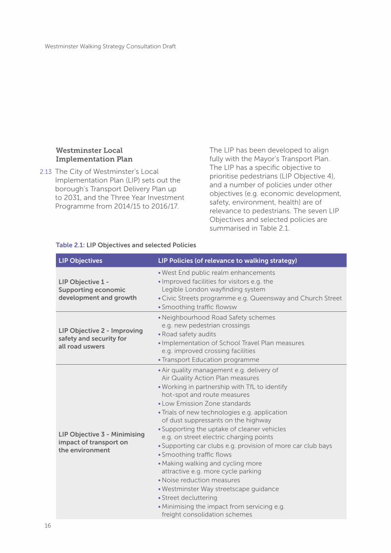
2.13 The City of Westminster’s Local Implementation Plan (LIP) sets out the borough’s Transport Delivery Plan up to 2031, and the Three Year Investment Programme from 2014/15 to 2016/17.
The LIP has been developed to align fully with the Mayor’s Transport Plan. The LIP has a specific objective to prioritise pedestrians (LIP Objective 4), and a number of policies under other objectives (e.g. economic development, safety, environment, health) are of relevance to pedestrians. The seven LIP Objectives and selected policies are summarised in Table 2.1.
LIP Objectives LIP Policies (of relevance to walking strategy)
LIP Objective 1 - Supporting economic development and growth
• West End public realm enhancements • Improved facilities for visitors e.g. the
Legible London wayfinding system• Civic Streets programme e.g. Queensway and Church Street• Smoothing traffic flowsw
LIP Objective 2 - Improving safety and security for all road uswers
• Neighbourhood Road Safety schemes e.g. new pedestrian crossings
• Road safety audits• Implementation of School Travel Plan measures
e.g. improved crossing facilities• Transport Education programme
LIP Objective 3 - Minimising impact of transport on the environment
• Air quality management e.g. delivery of Air Quality Action Plan measures
• Working in partnership with TfL to identify hot-spot and route measures
• Low Emission Zone standards • Trials of new technologies e.g. application
of dust suppressants on the highway• Supporting the uptake of cleaner vehicles
e.g. on street electric charging points• Supporting car clubs e.g. provision of more car club bays• Smoothing traffic flows• Making walking and cycling more
attractive e.g. more cycle parking• Noise reduction measures• Westminster Way streetscape guidance• Street decluttering• Minimising the impact from servicing e.g.
freight consolidation schemes
Table 2.1: LIP Objectives and selected Policies

17
Westminster Walking Strategy Consultation Draft
LIP Objectives LIP Policies (of relevance to walking strategy)
LIP Objective 4 - Prioritising pedestrians and effectively managing allocation of highway space
• Prioritising pedestrians in the development of new schemes e.g. provision of new pedestrian crossings and the Legible London wayfinding system
• Efficient allocation of highway space
LIP Objective 5 - Promoting healthier lifestyles and ensuring inclusivity
• Making walking and cycling more attractive e.g. .more Barclays cycle hire stations,
• Legible London, public realm improvements • Supporting step free access
LIP Objective 6 - Improving efficiency and attractiveness of sustainable transport
• Improving bus journey time reliability and passenger information e.g. Oxford Street
LIP Objective 7 - Pay for your impact principle
• Securing contributions from development • Development and rollout of an innovative
public realm credit system• Development of a carbon offset fund.
Table 2.1 (continued): LIP Objectives and selected Policies

18
Westminster Walking Strategy Consultation Draft
2.14 The City of Westminster has a number of complementary policies and strategies that support this walking strategy.
• Joint Health and Wellbeing Strategy 2013-2016 – the strategy guides the work of the Health and Wellbeing Board and sets out priorities for improving the health and wellbeing of people in the City. This includes the aim of enabling more people to live healthily for longer, of which physical activity and the delivery of an environment that promotes this are integral.
• Greener City Action Plan 2015-2025 – sets out the actions to deliver the City Council’s ambition of creating an environment befitting of Westminster’s world-class city status. The plan includes actions for sustainable transport and air quality, among the its nine policy priorities.
• Sustainable Modes of Travel Strategy 2015 – sets out how local school communities will be encouraged to choose safer, healthier and more environmentally friendly modes of travel.
• Air Quality Action Plan 2013-2018 – tackling emissions from transport is one of the main priorities of the plan. Doing so will benefit existing pedestrians, and encouraging more walking part of the strategy to reduce transport emissions.
• Active Westminster 2008-2013 – aims to improve levels of physical activity among those who live and work in the borough. Key themes include place and partnership working, in which the borough aims to increase the range of active spaces available and pursue joint programmes with stakeholders to deliver the overall aim of the strategy. In 2015 the Active Westminster Board was reformed to lead on development of a new Active Westminster Sport and Physical strategy. Discussion at the Children, Sport and Customer Services Policy & Scrutiny Committee meeting on 30th March 2015 noted the importance of promoting walking to both children and adults as part of leading a healthy lifestyle.
• Westminster Way Public Realm Strategy (adopted 2011) – this strategy is a Supplementary Planning Document and focuses on the need to put pedestrians first when designing and managing the public realm. The strategy recognises that most journeys in the borough start and end with a walking segment and therefore pedestrians should be prioritised. Section 4 of the strategy sets out the Westminster Code, 10 governing principles that must be applied to public realm interventions in the borough – the rules for delivering high quality streets. The strategy includes detailed guidance on managing and reducing street clutter and sets out how street commerce will be managed.
19
Westminster Walking Strategy Consultation Draft
3. Walking in the City of Westminster
3.1 This chapter sets out the current situation and future challenges for walking in Westminster, organised according to the strategy objectives.
Objective 1: to provide the capacity to support current walking demand and to accommodate future growth
The current situation
3.2 Westminster is home to an estimated 230,000 residents2, over 50% of whom also work in the borough. 47% of residents walk as their main mode of travel, and car ownership is relatively low, with 63%3 of households not owning a car or van as compared to 42% of households average across London.
3.3 Just over one fifth (21%) of Westminster residents travel to work on foot. This is more than double the London-wide average of 9%.
3.4 During the day, it is estimated that the population of Westminster increases to around one million as workers and visitors travel into the City. This is estimated to include approximately 600,000 workers and 260,000 tourists.
3.5 In addition to those undertaking journeys within and into the City of Westminster by walking all the way, all those making journeys into and around Westminster by other modes must complete at least the final leg of their journey on foot as they walk from a station or bus stop to their destination. Understanding the total volume of walk journeys, and where, why and when those walk journeys are made is therefore difficult, with any one source of data likely to underrepresent the total demand for walking.
3.6 TfL’s Central London Rail Termini report considers onward journeys from rail termini finding that on average, across all stations, 36% of onward journeys are made on foot4. Within Westminster, this varies from 55% for Charing Cross, to just 12% at Paddington and 18% at Marylebone, and one third of onward journeys by foot from Victoria.
3.7 Onward walking trips from mainline rail termini, as well as Westminster’s busiest Underground stations, therefore have to be considered when trying to provide capacity to safely and comfortably accommodate and manage all pedestrian movements.
2. ONS Mid-Year Estimates, 2014 3. ONS Census 2011
4. TfL (2011) Central London Rail Termini: Analysing passengers’ onward travel patterns.

20
Westminster Walking Strategy Consultation Draft
TerminusDaily number of walk journeys
Walking mode share for station
As a proportion of all walking journeys from termini
Victoria 43,900 33% 12%
Charing Cross 35,700 55% 9%
Paddington 7,800 12% 2%
Marylebone 4,300 18% 1%
Challenges
3.8 The number of people travelling into, through and to Westminster is set to increase substantially over the next decade, making the provision of sufficient capacity for sustainable, comfortable and safe movement a significant challenge for the City of Westminster.
3.9 The number of jobs in Westminster is forecast to increase to 750,000 by 20365
from a baseline of 610,0006, while the resident population in Westminster is forecast to increase to around 280,000 by 20317. This will further enhance Westminster’s role at the heart of the London and UK economy, but also presents significant transport challenges in terms of providing capacity that at least keeps pace with demand.
3.10 Crossrail will substantially increase the number of people arriving on the streets of the West End and making onward journeys either on foot or in the vicinity of the stations connecting with local bus services, taxis or cycle hire. In addition Marylebone Station is also expected to have significantly more passengers with upgrades to services on the Chiltern mainline. TfL forecasts11 for AM peak (07.00 to 10.00) exits from Crossrail stations in Westminster total 41,400 people:
• Paddington – 10,600
• Bond Street (east and west exits) – 14,350
• Tottenham Court Road (east and west exits) – 16,450
5. http://data.london.gov.uk/dataset/gla-employment-projections
6. West End Partnership (2015) The West End Delivery Plan 2015-2030.
7. http://files.datapress.io/london/dataset/2014-round-population-projections/update-03-2015-2014rnd-trend-proj-results.pdf
11. Transport for London (2015) Crossrail passenger demand addendum 1
Table 3.1: Walking from the mainline rail termini
21
Westminster Walking Strategy Consultation Draft
3.11 Tube upgrade work will also deliver more people to the streets of Westminster. Planned improvements include12:
• Victoria line – up to 36 trains per hour by 2016;
• Jubilee line – up to 36 trains per hour by 2020;
• Circle, District, Hammersmith & City and Metropolitan lines – capacity increase of 33% by 2018, resulting in up to 17,500 additional passengers per hour;
• Northern line – up to 30 trains and 18,000 more passengers per hour by 2022;
• Piccadilly line – 60% increase in capacity by 2025; and
• Bakerloo and Central lines – 25% increase in capacity on both lines in the later 2020s.
3.12 Crossrail 2 is planned to have stations in Westminster at Victoria and Tottenham Court Road, providing direct links through central London between south west and north east London and Surrey and Hertfordshire. Crossrail 2 is still in the early stages of planning and consultation. The final alignments and station stops are to be finalised and line opening is anticipated for 2030.
Opportunities
3.13 The City of Westminster is at the heart of London’s forecast growth and the unprecedented growth in jobs, resident population and visitor numbers undoubtedly represents very real challenges in transport terms. Encouraging more people to walk, or to walk further while in Westminster, represents one of the most sustainable ways in which the travel demand generated by this growth can be accommodated.
3.14 More specifically, the rate and scale of development taking place within Westminster is such that extensive reconfiguration of the built environment is inevitable in certain districts and neighbourhoods as development and redevelopment of sites and buildings takes place. This reconfiguration represents an opportunity to reimagine the pedestrian environment in those areas from first principles, delivering a word-class walking experience without the constraints of ‘legacy environments’.
3.15 The construction of Crossrail offers a major opportunity to reconfigure the transport network in and around the West End, and specifically to enhance the pedestrian environment and public realm on key streets. The stations will have more exits which will have been designed to accommodate forecast demand – this will make the dispersal of trips more efficient and effective, but also create new pedestrian nodes and allow for new routing opportunities.
12. Transport for London (2014) Fit for the Future: Our Plan for Modernising London Underground, London Overground, Trams and the DLR

22
Westminster Walking Strategy Consultation Draft
3.16 The additional capacity and connectivity provided by Crossrail offers the potential to reduce the volume of buses that currently run along Oxford Street, and also to reconfigure taxi routes and ranks. The changes allow for the opportunity to review and significantly enhance its attractiveness as a world-class retail destination. This includes looking at the potential to transform the pedestrian environment in Oxford Street; a project currently being developed by the West End Partnership (WEP).
3.17 In addition, the mechanisms for securing funding from developers are established. Section 106, Section 278 and Community Infrastructure Levy funding secured from developers can be used to fund improvements to the pedestrian environment.
Objective 2: to improve the quality of the walking environment and public realm to make walking more comfortable
The current situation
3.18 The City of Westminster has long recognised the role of good quality public realm in facilitating, managing and encouraging pedestrian movements and has a published public realm strategy to guide deliver this.
3.19 In recent years there have been significant efforts made to improve the management of pedestrian movements in Westminster’s busiest locations. At Oxford Circus this involved the removal of street clutter, removal of guardrails and a complete reconfiguration of pedestrian crossings to make better use of the space for pedestrians, and ease overcrowding issues. On Regent Street and Piccadilly footways have been widened significantly. On Edgware Road, guardrails have been removed and pedestrian crossings reviewed and, more recently, a pedestrian underpass (‘Wonderpass’) under Marylebone Road has been upgraded with private and public sector funding.
3.20 Westminster continues to identify opportunities to make real improvements to the pedestrian environment in order to make walking more comfortable and appealing, but challenges remain.
Westminster Walking Strategy Consultation Draft
23
Wonderpass
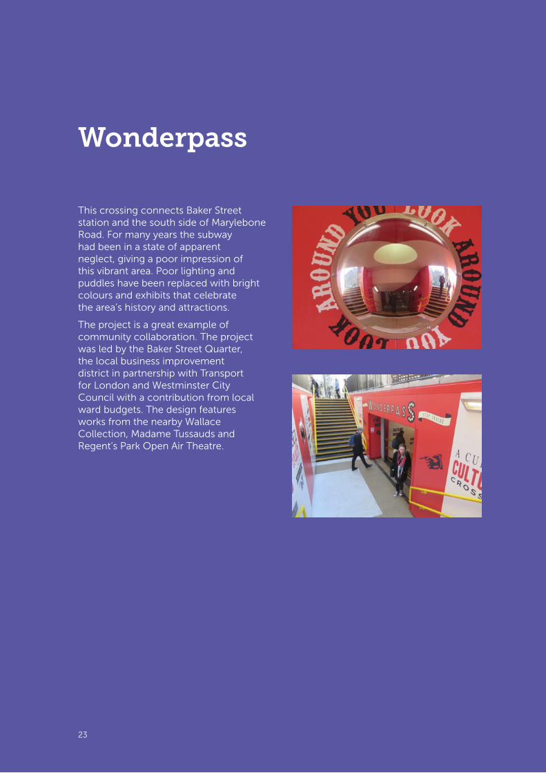
This crossing connects Baker Street station and the south side of Marylebone Road. For many years the subway had been in a state of apparent neglect, giving a poor impression of this vibrant area. Poor lighting and puddles have been replaced with bright colours and exhibits that celebrate the area’s history and attractions.
The project is a great example of community collaboration. The project was led by the Baker Street Quarter, the local business improvement district in partnership with Transport for London and Westminster City Council with a contribution from local ward budgets. The design features works from the nearby Wallace Collection, Madame Tussauds and Regent’s Park Open Air Theatre.

24
Westminster Walking Strategy Consultation Draft
Challenges Ensuring public realm improvements are to the benefit of all users
3.21 While public realm can make an area more attractive and encourage people to spend more time and money13, poorly designed public realm can pose a challenge for people with sensory and mobility impairments. For example, shared space schemes must be well implemented in suitable locations to ensure that pedestrians do not feel vulnerable.
Balancing the needs of local businesses with the need to declutter the street environment
3.22 A further challenge lies in making best use of the available capacity on the pedestrian network without inhibiting economic activity on the streets. Across the City the economic activities of businesses are supported through licensing of on-street items such as ‘A’ boards, isolated street trading kiosks and tables and chairs. Such items can both help businesses to thrive and contribute to a vibrant and attractive street scene; however, at certain times and places these items can encroach on the footway, limiting the available space for walking and causing obstructions. This can be particularly hazardous and difficult for blind or partially sighted people, people with mobility impairment, or those with young children and pushchairs.
Poor air quality can influence the decision to walk and spend time outdoors
3.23 Poor air quality spoils the environment for walking and can deter people from walking more. A poll by London Councils14 found that 19% of Londoners interviewed said that less air pollution would encourage them to walk more. Poor air quality that impacts on people’s health is primarily driven by particulates (e.g. PM2.5 and PM10) and oxides of nitrogen (NOx). The Mayor’s Air Quality Strategy15 states that the majority of particulate emissions in central London are from road transport. Local road transport accounts for a lower proportion of NOx emissions than particulates, although still almost half of emissions and the Mayor’s strategy states that very large reductions in NOx are needed in order to meet legal targets.
3.24 In Greater London it is estimated that in 2008 there were 4,267 ’deaths brought forward’ attributable to long-term exposure to small particles16, this amounts to between 6 per cent and 9 per cent of all deaths, varying by borough. The concentrations of particulate matter will be much greater than average in some parts of Westminster, as shown in Figure 3.1. Among the roads where air quality is notably poor, such as Marylebone Road, the City Council will need to work together with TfL to address the issue as these roads are managed by TfL.
13. https://toolkit.urban-realm.co.uk/ 14. http://intranet.londoncouncils.gov.uk/policylobbying/transport/Publications/default.htm
15. Greater London Authority (2010) Cleaning the Air – The Mayor’s Air Quality Strategy.
16. Miller, B (2010) Report on estimation of mortality impacts of particulate air pollution in London. Report to the Greater London Authority.

25
Westminster Walking Strategy Consultation Draft
Opportunities
Improving the quality of the public realm
3.26 As with many of the other challenges noted in this section, the scale and pace of development within Westminster represents an opportunity to address the challenges discussed. There are opportunities to reimagine the public realm and ensure the pedestrian environment is fit for purpose as new developments are brought forward.
3.27 Other funding sources such as the Mayor’s High Street Fund also enable opportunities for local streetscape improvements. The City Council has previously benefited from High Street Fund for projects in Soho and on the Harrow Road.
3.25 The greatest burden of air pollution usually falls on the most vulnerable in the population, in particular the young and elderly, and those with existing respiratory problems and chronic illnesses.
Figure 3.1: Central London locations identified as at risk of not meeting the EU limit value for PM10 in 2011 (source: Mayor’s Air Quality Strategy, Consultation Draft, 2009)

26
Westminster Walking Strategy Consultation Draft
Improving local air quality
3.28 A 2010 study for the RAC Foundation reported on research by Kings College in which air pollution exposure monitors were fitted to research participants. Those walking along less-trafficked routes were found to have significantly lowered their exposure to airborne pollutants compared to those using routes with higher levels of traffic. Other research17, using health impact assessment techniques, has found that decreasing particulate exposure long term could add almost two years of life expectancy to people aged 30 and over. The same research also suggested that living near busy roads could account for 15-30% of all new asthma cases among children and chronic pulmonary and coronary illnesses in adults. In this case ‘busy roads’ are qualified as those carrying 10,000 or more vehicles per day.
3.29 There are a number of Mayoral and TfL initiatives that seek to improve air quality, including the Low Emission Zone for lorries and large goods vehicles, introduction of low emission buses, the forthcoming Ultra Low Emission Zone and the Low Emission Neighbourhoods programme. These present opportunities for the City Council to work jointly with TfL, the GLA and other partners on schemes to improve air quality. One such initiative is the funding bid for a Low Emission Neighbourhood (LEN) for Marylebone that Westminster and local stakeholders submitted in April 2016.
17. Aphekom (2011) Aphekom Summary Report 2008-11.

27
Westminster Walking Strategy Consultation Draft
27
In Town Without My Car (car free day)
In Town Without My Car (car free day) is held in September every year and is part of an approach aimed at reclaiming cities, raising the awareness of the effects of private cars, and sharing streets with other users.
Over 2,000 towns and cities around the world take part. Westminster City Council first joined this event in 2007.
2007: Event at Prince of Wales junction including local community groups who produced artwork which was later displayed at some libraries.
2008: Chancery Lane, a joint venture with LB Camden who closed the street to traffic. WCC provided marquees, displays on walking, a Dr Bike surgery, giant displays and more.
2013: WCC gave schools a trundle wheel, stopwatch, 20m tape and legible London maps with lesson plans and ideas for activities to promote active travel. These resources are still being used.
28
Westminster Walking Strategy Consultation Draft
Objective 3: to make walking more intuitive by increasing the legibility and permeability of walking options
The current situation
3.30 TfL’s analysis of trips made by Londoners that could be walked all the way18
showed that in central London 84% of trips that could be walked were being walked. The analysis shows that very few London residents make trips by tube or rail if they could be walked and it is likely that the short public transport trips made are by visitors to London, who are less confident in finding their way on foot.
3.31 The roll-out of Legible London wayfinding provides pedestrians with better information on the location of nearby destinations, and threshold walking times. Similarly, information at underground stations in central London encourages tourists in particular to
walk between nearby attractions (e.g. Covent Garden and Leicester Square), rather than taking the Underground.
3.32 Monitoring of Legible London19 has shown that the signs are used by a significant number of pedestrians, up to 300 per hour. In central London, at weekends, one in twenty people passing by the signs use them. Figure 3.2 shows how people’s rating of signage has improved in central London since the introduction of Legible London wayfinding.
3.33 In the City of Westminster, footfall on the main roads can be considerable but the parallel roads have a relatively low footfall. With pedestrians largely following the same routes, issues with crowding at peak times often arise.
100%
Helping to find way round area
Helping to find shortest route
Confidence to explore
90%
80%
70%
60%
50%
40%
30%
20%
10%
0%
2009-pre pilot 2010 2011
18. Transport for London (2012) Walking Good Practice. 19. Steer Davies Gleave (2014) Legible London Evaluation 2013-14. Report to TfL.
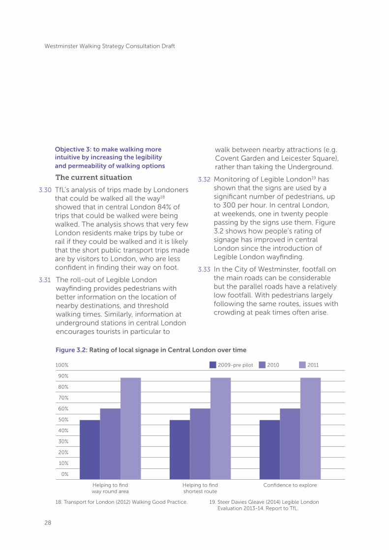
Figure 3.2: Rating of local signage in Central London over time

29
Westminster Walking Strategy Consultation Draft
Challenges
3.34 A high proportion of people who come to the City of Westminster are visitors and, while Legible London wayfinding has improved pedestrians’ confidence in navigating around Westminster by foot, there remains a challenge to encourage more visitors to walk short journeys rather than rely on public transport, taxis and private hire vehicles or unregulated vehicles such as pedicabs.
3.35 The City of Westminster is characterised by a dense network of streets and, while there is a high level of permeability in the network, travelling through Westminster on foot poses a challenge for people less familiar with the area. While Legible London maps and directional signage exists for key destinations more could still be done to highlight key walking routes between popular destinations and areas.
3.36 People who do choose to walk mostly use the main roads, as these tend to be the most obvious routes. There is a challenge to make quieter, parallel routes more visible and to encourage more people to use them in order to spread demand and reduce crowding.
3.37 Providing more wayfinding information to encourage people to walk short distances and use the full breadth of the network raises other challenges in making information available without further complicating the urban environment and adding clutter to the footways. Another challenge is providing wayfinding information that is intuitive to use and accessible to all.
Opportunities
3.38 The new Crossrail stations at Bond Street, Paddington and Tottenham Court Road will provide further Legible London signage and wayfinding at the start of visitors’ trips to the City of Westminster along with revisions at Victoria and Aldwych. Further promotion, targeted at visitors in particular, of existing Legible London signage and its coverage should be explored to ensure the wayfinding system is being used by people less familiar with the City and that the full breadth of the network is being used by pedestrians. TfL should be encouraged to improve signage within stations when upgrading stations: as has been discussed with TfL for Marble Arch and Edgware Road stations.
3.39 By encouraging people to walk on other roads there is an opportunity to reduce crowding on the busiest streets and to boost and spread the economic benefits associated with increased footfall, thereby sustaining business is less prominent locations.
3.40 Various official and unofficial resources are becoming available that help people improve their awareness and understanding of walking distances across the City, and London as a whole. One example is the ‘London tubemap’ website20, which aims to bridge the gap between the Underground network and the street level network. A series of different Underground maps is available on the website including a map of the station locations displayed geographically that helps people
20. http://www.london-tubemap.com/
30
Westminster Walking Strategy Consultation Draft
to understand the distance between stations, particularly stations on different lines, and a map showing the walk times between stations that highlights time it would take to walk between stations that may be perceived as far apart.
3.41 More generally, improving access and legibility of the streets surrounding the major thoroughfares and better known retail locations has the potential to increase the amount of economic activity in and around these areas. For example, in the West End, encouraging pedestrians to explore the network of smaller streets around Oxford Street,
Bond Street, Regent Street, Soho, Tottenham Court Road and towards Covent Garden has the potential to increase economic activity on economically quieter streets by driving up footfall. The West End Partnership is already leading the delivery of schemes such as the Leicester Square side streets project as part of its Place Programme as set out in the West End Delivery Plan 2015-30, due for delivery in 2020.
3.42 Westminster’s waterways including the River Thames and the canals are an opportunity both to provide additional walking route capacity and to connect with river transport.
Walking times between stations
2
22
2
2
1
2
3
3
3
1
1
1
3
3
2/3
River Thames
Regent’s Park
GoodgeStreetBayswater
Warren Street
Aldgate
Farringdon
Barbican
RussellSquare
High Street Kensington
Old Street
Green Park
BakerStreet
NottingHill Gate
Mansion House
Temple
OxfordCircus
BondStreet
TowerHill
Westminster
PiccadillyCircus
CharingCross
Holborn
Tower Gateway
Monument
Moorgate
Leicester SquareSt. Paul’s
Hyde Park Corner
Knightsbridge
Angel
Queensway
Marble Arch
SouthKensington
SloaneSquare
Covent Garden
LiverpoolStreet
Great PortlandStreet
Bank
Chancery Lane
LancasterGateHolland
Park
Cannon Street
Fenchurch Street
GloucesterRoad St. James’s
Park
EustonSquareEdgware
Road
Edgware Road
Embankment
Blackfriars
TottenhamCourt Road
King’s CrossSt. Pancras
MarylebonePaddington
Kensal Green
Queen’s Park
Bethnal Green
Cambridge Heath
London Fields
Willesden Junction
Kilburn Park
WarwickAvenue
Maida ValeEuston
Imperial Wharf
ClaphamJunction
Wapping
Denmark Hill
Whitechapel
WandsworthRoad
Rotherhithe
ShoreditchHigh Street
Haggerston
Hoxton
Shepherd’sBush
Shadwell
CanadaWater
Fulham Broadway
West Brompton
Parsons Green
Putney Bridge
East Putney
Kensington(Olympia)
AldgateEast
BethnalGreen Mile End
Dalston Kingsland
HackneyWick
Homerton
HackneyCentral
RectoryRoad
HackneyDowns
Dalston Junction
Canonbury
StepneyGreen
Highbury &Islington
Clapton
StokeNewington
Upper HollowayGospel
Oak
Island Gardens
Greenwich
Deptford Bridge
South Quay
Crossharbour
Mudchute
Heron Quays
Elverson Road
Cutty Sark for Maritime Greenwich
Lewisham
Limehouse
Manor House
FinsburyPark
Arsenal
KentishTown West
Holloway Road
Caledonian Road
Hampstead
Belsize Park
Chalk Farm
Camden Town
Archway
Tufnell Park
Kentish Town
MorningtonCrescent
CamdenRoad
CaledonianRoad &
Barnsbury
Willesden Green
Swiss Cottage
Kilburn
West Hampstead
Finchley Road
St. John’s Wood
TurnhamGreen
StamfordBrook
RavenscourtPark
WestKensington
BaronsCourt
Earl’sCourt
Shepherd’sBush Market
Goldhawk Road
Hammersmith
Wood Lane
WhiteCity
Finchley Road& Frognal
KensalRise
BrondesburyPark
Brondesbury
KilburnHigh Road
SouthHampstead
NorthActon
EastActon
Southwark
Waterloo
London Bridge Bermondsey
Vauxhall
Lambeth NorthPimlico
Stockwell
Brixton
Elephant & Castle
Oval
Kennington
Borough
Clapham North
Clapham High Street
Clapham Common
Clapham South
Latimer Road
Ladbroke Grove
Royal Oak
Westbourne Park
HampsteadHeath
BowChurch
BowRoad
Bromley-by-Bow
West IndiaQuay
Devons Road
Langdon Park
All Saints
Canary Wharf
Westferry Blackwall
Poplar
NorthGreenwich
PuddingMill Lane
Stratford High Street
Stratford
WestHam
CanningTown
EastIndia
StratfordInternational
Star Lane
Abbey Road
Victoria
NewCross Gate
Brockley
New Cross
Queens RoadPeckham
Peckham Rye
Surrey Quays
Key to symbolsNational Rail
Riverboat services
Victoria Coach Station
Interchange stations
Approximate times, in minutes, based on a moderate walking speed
Step-free access from street to platform
Step-free access from street to train
Key to lines
Metropolitan
Victoria
Circle
Central
Bakerloo
DLR
London Overground
Piccadilly
Waterloo & City
Jubilee
Hammersmith & City
Northern
District
District open weekends and on some public holidays
Transport for London
18
17
22
10
16
14
13
9
14
13
13
17
8
6
15
18
8
15
11
12
21
251815
3616
21
16
20
13
3
7
7
7
3
8
8
12
9
8
11
8
6
9
19
9
12
17
11
18
10
8
8
31
18
31
44
15
9
6
9
4
7
2
9
7
9
7
12
13
104
22
242443
13
15
16
99
6
9
17
18
11
18
12
12
6
10
17
16
15
714
1818
17
13
1112
1314
16
10
15
8
14
26
44
8
10
12
21
11
10 16
24 12
13 15 53
12 8
7
28
19 29
25
1210 10 14 7 16
24
30 2117
7
12
10
11
8
45
30
910
10
29
18
10
15 11
11
11
11
7
10
2615
1013
28 144 7616
10
9
12
6
9
6 11
15
9
16
13
21 10
9
19
18
15
10
16
8
11
17
25
22
38
18
14
11
7
10
13
919
33
10
19
13
27
10
2029
35
10
4
4
810
20
1612
7
33
25
16
8
15
1010 13
2513
13 15
14
16
10 15
12 8
12 8
17 13 11
5
2016
12 7 17
11 8
7 10
8
24
11
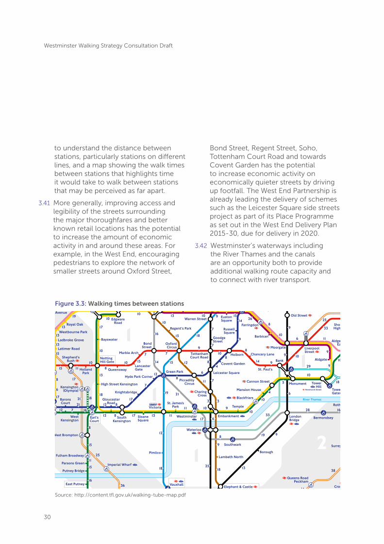
Source: http://content.tfl.gov.uk/walking-tube-map.pdf
Figure 3.3: Walking times between stations

31
Westminster Walking Strategy Consultation Draft
West End Partnership Place Programme (as set out in the West End Delivery Plan 2015-2030)

32
Westminster Walking Strategy Consultation Draft
Objective 4: to ensure walking is a safe option for everyone
The current situation Road traffic collisions
3.43 TfL’s Safe Streets for London Road Safety Plan to 2020, launched in 2013, reported that across London in 2011, walking accounted for 21% of daily journeys but 35% of killed or seriously injured casualties21. There were 1,732 casualties from road traffic collisions in Westminster in 2013. Of these 466 involved pedestrians. These collisions have direct impacts in terms of police, healthcare and insurance costs, and the lost productivity of people who are injured or killed. The impacts on families and friends suffering the effects of bereavement or dealing with long-term injuries are greater still.
3.44 Moreover, the impact of road traffic collisions on vulnerable users is disproportionate, resulting in large health inequalities. Road traffic injury is the leading cause of death among children aged 5-14 years, and children’s awareness of traffic risks is much lower than adults, so making them more vulnerable. Similarly, the elderly are more vulnerable to traffic accidents, and the effects can be greater and can result in loss in mobility and greater isolation.
Considerate cycling
3.45 Pedestrians, particularly the vulnerable, such as the elderly, or those with young children, are concerned about inconsiderate cyclist behaviour, particularly fast cycling on the pavement. Concern for their safety can deter people from walking on pavements or shared space.
Traffic Speed
3.46 The relationship between vehicle speed and the severity of injuries in collisions is well established. Analysis by the Department for Transport22 shows that pedestrian risk of fatality increases slowly until impact speeds of 30mph, after which risk increases substantially, with the risk of fatality at 40mph impact speed 3.5 to 5.5 times higher than at 30mph. This view is supported by academic research which concludes that the fatality risk at 30mph is twice that at 20mph23.
21. Transport for London (2013) Safe Streets for London22. Department for Transport (2010) Relationship
between speed and risk of fatal injury: pedestrians and car occupants
23. Rosen, E and Sander, U. (2009) Pedestrian fatality risk as a function of car impact speed, Accident Analysis and Prevention, 41, 536-542.

33
Westminster Walking Strategy Consultation Draft
Child Pedestrian Training
The aim of the scheme is to equip children at the kerbside with the necessary skills and knowledge that they will need to enable them to use roads safely. Research shows that children benefit more from practical real life situations and this allows them to talk through their ideas about crossing roads in a safe environment. Participating parents as volunteers also get reminded of the rules and their responsibilities which is an added bonus. The LIP - Delivery Plan 2014/15 to 2016/17 will fully support the re-introduction of this project.
33

34
Westminster Walking Strategy Consultation Draft
Challenges Road traffic collisions
3.47 Many potential walking trips are made by other modes, or not made at all, due to the negative impact of road traffic on the experience of walking, and because of the real and perceived risk of collisions. This is especially true of children, where the perceived danger of traffic collisions means that fewer children walk – nationally there has been a decline in the number of primary
school children allowed to walk to school alone from 86 per cent in the early 1970s, to less than 35 per cent in 1990, and 25 per cent in 201026 although in Westminster 39 per cent of children walk to school in 2014-1527.
3.48 Figure 3.3 shows the junctions and roads within Westminster and neighbouring boroughs with a high number of collisions involving pedestrians, as well as cyclists and motorcyclists.
26. Shaw, B, Watson, B, Frauendienst, B, Redecker, A, Jones, T with Hillman, M. (2013) Children’s independent mobility: a comparative study in England and Germany (1971-2010), London: Policy Studies Institute.
27. Westminster City Council (2015) Sustainable Modes of Travel Strategy.Source: Central London Sub-regional Transport Plan 2014 Update
Figure 3.3: Junctions and roads with higher numbers of collisions involving injuries to pedestrians, cyclists or motorcyclists

35
Westminster Walking Strategy Consultation Draft
20mph speed limits
3.49 A paper by the London School of Hygiene and Tropical Medicine28 for TfL reviewed the effects of 20mph zones on road safety in London. Their analysis found that recent 20mph zones appear to be less effective in reducing casualty figures but the authors suggest this is not surprising since the first zones were likely to have been implemented on roads with the greatest number of collisions and thus the most scope for benefit. More recent examples were still found to have had a 23% reduction in all casualties over five years in the context of a background reduction in casualties of 1.7% each year across London. The paper also found that 20mph are marginally more effective at reducing casualties in more affluent areas compared to deprived areas.
3.50 Recent research29 to inform 20mph zone policy in London concluded:
• The evidence is clear that reducing vehicle speeds results in fewer and less severe collisions, particularly for vulnerable road users.
• Historically, 20mph zones have been particularly successful at reducing speeds by using physical traffic calming measures. Limited resources and relaxed regulations mean that signed-only 20mph limits are now preferred; however, these tend to achieve smaller decreases in vehicle speeds and can add to street clutter.
• The challenge is to find ways to achieve reductions in vehicle speeds in signed-only 20mph limits, so that safety benefits are still realised, traffic can move at a steady pace and air quality is not worsened. Enforcement is only a partial solution, with the key to achieving sustained reductions in vehicle speeds being changed driver attitudes so that 20mph is seen as the appropriate speed in urban areas. This suggests that supporting measures that foster cultural change need to be an integral part of all 20mph schemes.
28. Grundy C, Steinbach R, Edwards P, Wilkinson P and Green J. (2008) 20 mph Zones and Road Safety in London: A report to the London Road Safety Unit. London: LSHTM.
29. Steer Davies Gleave (2014) Research into the impacts of 20mph speed limits and zones. Report for London Borough of Merton on behalf of LEDNet.

36
Westminster Walking Strategy Consultation Draft
Tourist road safety awareness
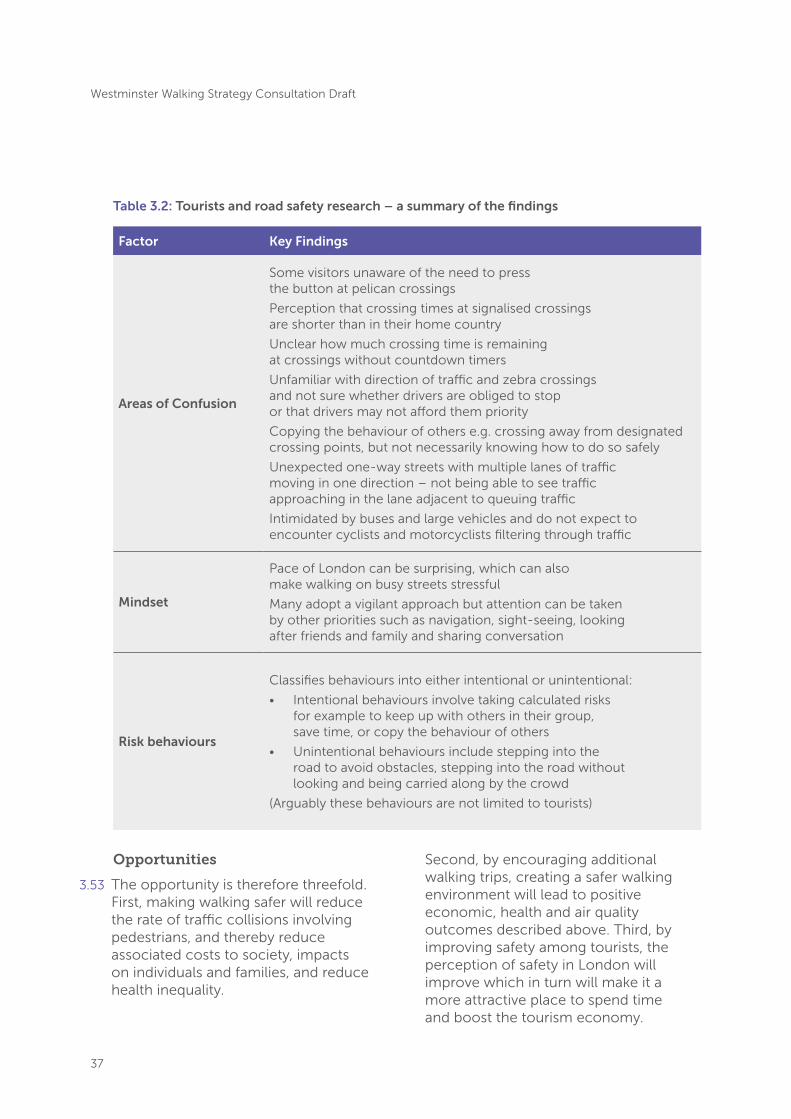
3.51 Transport for London’s Road Safety Unit has identified tourists as being particularly at risk of being injured as pedestrians in London. This is the product of a number of factors, explored by researchers in 201030. Firstly, different countries have differing road regulations, attitudes and conventions and visitors may not fully adapt to these when travelling. Secondly tourists may be unfamiliar with UK roads, including pedestrian crossing times and the fact that cars are driven on the left of the road. Tourists reported not being prepared for the speed of traffic on London’s roads and were unsure of how to use different types of pedestrian crossing. Thirdly, simply being on holiday can be a distraction as people take in the sights and enjoy all that London has to offer. This is not to blame the victim, but an acknowledgement that more should be done to help visitors stay safe while visiting. Tourists may benefit from specific and targeted interventions, in the same way for example, that other at-risk groups such as children or new drivers are supported. Table 3.2 summarises the main findings of the research into why tourists are at risk.
3.52 The City of Westminster’s Unitary Development Plan highlights the growth in London’s annual visitor numbers and the fact that most visitors to London will spend time in Westminster. The Office for National Statistics reports that there were 16.8 million overseas visitors in 2013, up from 11.7 million in 200331. Thirty-six per cent of London’s hotel bed spaces are located in the City. This goes to show the scale of visitor numbers on Westminster’s streets.
30. Transport for London (2010) Visitor Road Safety 31. http://www.ons.gov.uk/ons/rel/ott/travel-trends/2013/info-london.html accessed 21/08/2015
37
Westminster Walking Strategy Consultation Draft
Factor Key Findings
Areas of Confusion
Some visitors unaware of the need to press the button at pelican crossings
Perception that crossing times at signalised crossings are shorter than in their home country
Unclear how much crossing time is remaining at crossings without countdown timers
Unfamiliar with direction of traffic and zebra crossings and not sure whether drivers are obliged to stop or that drivers may not afford them priority
Copying the behaviour of others e.g. crossing away from designated crossing points, but not necessarily knowing how to do so safely
Unexpected one-way streets with multiple lanes of traffic moving in one direction – not being able to see traffic approaching in the lane adjacent to queuing traffic
Intimidated by buses and large vehicles and do not expect to encounter cyclists and motorcyclists filtering through traffic
Mindset
Pace of London can be surprising, which can also make walking on busy streets stressful
Many adopt a vigilant approach but attention can be taken by other priorities such as navigation, sight-seeing, looking after friends and family and sharing conversation
Risk behaviours
Classifies behaviours into either intentional or unintentional:
• Intentional behaviours involve taking calculated risks for example to keep up with others in their group, save time, or copy the behaviour of others
• Unintentional behaviours include stepping into the road to avoid obstacles, stepping into the road without looking and being carried along by the crowd
(Arguably these behaviours are not limited to tourists)
Opportunities
3.53 The opportunity is therefore threefold. First, making walking safer will reduce the rate of traffic collisions involving pedestrians, and thereby reduce associated costs to society, impacts on individuals and families, and reduce health inequality.
Second, by encouraging additional walking trips, creating a safer walking environment will lead to positive economic, health and air quality outcomes described above. Third, by improving safety among tourists, the perception of safety in London will improve which in turn will make it a more attractive place to spend time and boost the tourism economy.
Table 3.2: Tourists and road safety research – a summary of the findings
38
Westminster Walking Strategy Consultation Draft
38
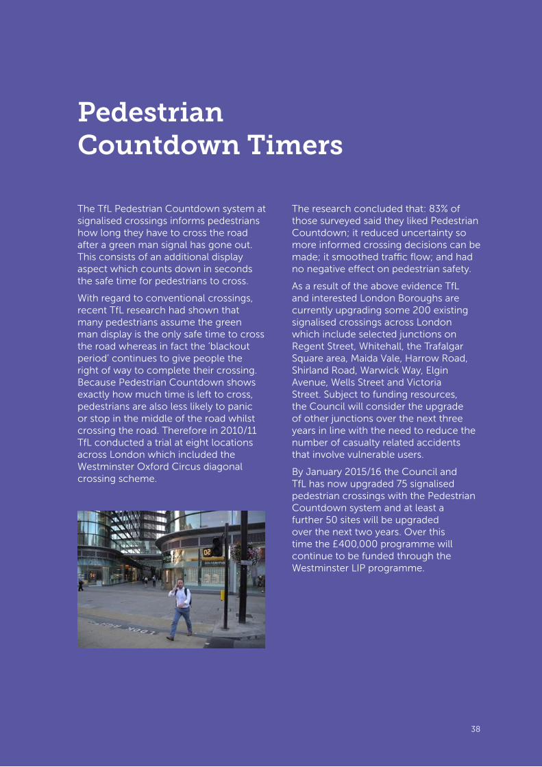
Pedestrian Countdown Timers
The TfL Pedestrian Countdown system at signalised crossings informs pedestrians how long they have to cross the road after a green man signal has gone out. This consists of an additional display aspect which counts down in seconds the safe time for pedestrians to cross.
With regard to conventional crossings, recent TfL research had shown that many pedestrians assume the green man display is the only safe time to cross the road whereas in fact the ‘blackout period’ continues to give people the right of way to complete their crossing. Because Pedestrian Countdown shows exactly how much time is left to cross, pedestrians are also less likely to panic or stop in the middle of the road whilst crossing the road. Therefore in 2010/11 TfL conducted a trial at eight locations across London which included the Westminster Oxford Circus diagonal crossing scheme.
The research concluded that: 83% of those surveyed said they liked Pedestrian Countdown; it reduced uncertainty so more informed crossing decisions can be made; it smoothed traffic flow; and had no negative effect on pedestrian safety.
As a result of the above evidence TfL and interested London Boroughs are currently upgrading some 200 existing signalised crossings across London which include selected junctions on Regent Street, Whitehall, the Trafalgar Square area, Maida Vale, Harrow Road, Shirland Road, Warwick Way, Elgin Avenue, Wells Street and Victoria Street. Subject to funding resources, the Council will consider the upgrade of other junctions over the next three years in line with the need to reduce the number of casualty related accidents that involve vulnerable users.
By January 2015/16 the Council and TfL has now upgraded 75 signalised pedestrian crossings with the Pedestrian Countdown system and at least a further 50 sites will be upgraded over the next two years. Over this time the £400,000 programme will continue to be funded through the Westminster LIP programme.

39
Westminster Walking Strategy Consultation Draft
Objective 5: to make the pedestrian environment more accessible for all users
Current situation
3.54 Not unique to the City of Westminster is the challenge faced by disabled, frail, elderly or older people moving through pedestrian environments and interchanging between different modes of transport. Problems such as changing surface levels and crossing roads are faced by people with mobility and sensory impairments. The elderly, in particular, are vulnerable to footways with unstable pavement slabs, trip hazards from raised paving stones or other faults and the perception of poor quality pavements can also deter people from walking.
3.55 Westminster has installed measures such as dropped kerbs, tactile paving and the use of rotating cones at signalised pedestrian crossings to help disabled people. With an ageing population, more susceptible to health problems affecting mobility, hearing and sight, the issue of designing an inclusive built environment and transport system is more important than ever.
3.56 Accessibility related problems affect the able bodied too. People can be encumbered in a number of ways, including carrying luggage or travelling with a pushchair, and design measures that reduce obstacles, such as street furniture, advertising boards and road works intruding on footway space, benefit a wide range of pedestrians. Increasingly more people are seen to be using scooters and Segway-style or ‘hoverboard’ electric two-wheelers on the footway, which can create problems for other footway users particularly in congested areas.
3.57 In 2006, the Department for Transport launched the Access for All Programme which provided funding over a nine year period to 2015 for providing obstacle free, accessible routes to and between platforms at a number of stations across the country. Research into the Benefit of the Access for All Programme shows that it has led to an increase in demand among people with mobility impairments and encumbered passengers, but also among unencumbered passengers, indicating that by designing with vulnerable users in mind the result is beneficial for all user groups.

40
Westminster Walking Strategy Consultation Draft
Challenges
3.58 Balancing the needs of different footway users is a challenge for the City of Westminster: tourists and visitors require wayfinding information; people interchanging between modes of transport require bus stops, taxi ranks and Underground station entrances; businesses use space on footways for seating and advertising boards and delivery access across the footway; and elderly people and leisure visitors may require use of street furniture such as seating. These important uses need to be balanced with the need for accessible footway space.
3.59 Designing pedestrian environments that suit the needs of a variety of users, undertaking a variety of activities is challenging, particularly when considering the needs of more vulnerable road users. While wheelchair users may prefer uncluttered street environments with level crossings and limited use of tactile paving, people with visual impairments are likely to prefer a difference in level between the footway and the carriageway and tactile pavements at crossings to provide physical clues about their surroundings.
3.60 Use of design features such as shared space in urban planning is becoming increasingly popular, with benefits including improved ease of pedestrian movement and reduced vehicle speeds33. Shared space schemes put a higher priority on the function of place and help create environments where people want to spend time, which in turn has economic benefits; however they can be difficult for disabled people to use and can have a negative effect on perceptions of safety.
3.61 Improving interchanges between street level and Underground and rail stations is an ongoing challenge. A number of Underground stations in the City of Westminster do not have step-free access which is a factor limiting their use by disabled people, particularly mobility impairments. The design and age of Underground stations poses a significant challenge, as building in step-free access would be costly and challenging in engineering terms. In 2011, step free access was installed at Green Park station, an integral part of a £48 million upgrade.
33. Department for Transport (2011) Local Transport Note 1/11 – Shared Space.

41
Westminster Walking Strategy Consultation Draft
Opportunities
3.62 The Council and, within their areas, the BIDs already undertake regular inspections of footways and the public realm in the City. These inspections are also an opportunity to identify outdated signage that could be removed or consolidated to help minimise street clutter. Identifying ways for businesses to advertise without cluttering the street environment is another opportunity, particularly on narrower side roads where footway space is relatively limited.
3.63 Where necessary and where possible to do so, footways should be widened and street cluttered removed to help address pinch points and provide more space for walking.
3.64 When designing urban environments, the requirements of different users’ needs to be balanced. The scale of development planned in the City presents a unique opportunity to review existing urban environments and rethink the design of public realm for large scale projects, such as the opening of Crossrail stations and the redesign of Bond Street, ensuring it is accessible for all users. TfL has recently consulted on new Streetscape Design Guidance34, which is due to be published in 2016. The guidance sets out best practice design principles encouraging a robust approach to designing, building and maintaining high quality public realm.
The guidance stresses the importance of prioritising the safety of vulnerable road users by slowing traffic speeds, maintaining good visibility at crossings and reducing the likelihood of collisions. Independent accessibility advice and audits should take place at each stage of scheme designs to ensure measures promoting accessibility for all are not designed out at the more detailed design stages.
3.65 In August 2015, TfL published Station Public Realm Guidance35 which sets out an approach for how the space outside stations should be designed to ensure easy access and interchange between modes, including for onward walk journeys. The guidance advises simple, direct, clutter free, legible and step-free routes to ensure stations and interchange routes are accessible for all.
34. Transport for London (2015) Streetscape Guidance – Consultation Draft.
35. Transport for London (undated) Station Public Realm Design Guidance.

42
Westminster Walking Strategy Consultation Draft
42
Leicester Square to Covent Garden walking corridor
The walking corridor scheme created an improved, step free, more comfortable and legible walking route between Leicester Square and Covent Garden in order to encourage more people to walk between these two close destinations (400m apart) instead of taking the tube. The route crosses two major junctions so improving safety was a key element of the project, and despite their close proximity, legibility was also a barrier.
The project was delivered in four phases between 2007 and 2012 and involved footway widening (50% more footway space provided in Long Acre, at St Martin’s Lane and on Cranbourn Street) and resurfacing, improved pedestrian crossing facilities, decluttering, a new contraflow cycle lane and a review of parking and loading arrangements. Local feedback tells us that the scheme has made a positive contribution to the conservation area by but not compromising the traditional street layout. Good quality materials have enhanced its appeal to visitors, and therefore perceptions of it as a pleasant place to be.
Pedestrian volumes on Long Acre increase by 3.4% between 2005 and 2008 and by 17.6% by 2011. Pedestrian perception of crowding, personal security, cleanliness and the number and speed of vehicles were all more positive on Long Acre across all factors between 2005 and 2008. Mode of access - since the works had finished, the number of people getting to Long Acre from Leicester Square tube station and then walking the remainder of the way had increased (19% in 2005 to 27% in 2008).
The scheme was selected as an example of best practice at the National Institute for Health and Care Excellence (NICE) Shared Learning Awards at the NICE Annual Conference 2013.
Before After

43
Westminster Walking Strategy Consultation Draft
Objective 6: Enable behaviour change to realise the potential of walking
The current situation
3.66 TfL’s Walking Good Practice guidance states that 84% of walkable trips within the central London sub-region are walked. There is therefore still some unrealised potential for walking trips within Westminster; 16% of all walkable trips are being made by other modes. Of those other modes, there is greatest potential for a shift from trips made by bus and by car to walking, rather than by Tube or rail.
Challenges Residential parking
3.67 Despite almost two thirds of households in Westminster being car free, the tendency within Westminster has been to protect residential car parking and to ensure that sufficient car parking is provided for residents with all new developments. More restrictive car parking approaches are the norm in other central London boroughs, and can be helpful in reducing car travel and encouraging greater use of other modes.
Inactive population
3.68 Obesity is a critical issue for Westminster. Only six out of ten London children are a healthy weight when they start secondary school and London has the highest rates of childhood obesity in the country. In Westminster in 2012-13, nearly a quarter of children in Year 6 (aged 10-11) and 12 per cent of children in reception year were considered obese36. For adults 60 per cent of men
and 53 per cent of women in London are either overweight or obese.
3.69 The impacts of poor health are significant. An obese Londoner can expect to die eight to ten years earlier than their non-obese neighbour. Physical inactivity costs society in terms of poor health, absence from work, lower productivity, healthcare and social care costs.
The walking environment
3.70 All of the challenges discussed within this section relating to the quality of the walking environment can put people off walking and suppress the potential for a shift from other modes to walking. Realisation of the opportunities relating to a reimagining of the pedestrian environment, improving local air quality and providing capacity for current and future pedestrian movements will contribute to making walking a more realistic and appealing choice for those who live, work and visit Westminster.
Opportunities Reduced-car or permit-free development
3.71 Low car or car free development combined with public realm improvements, secured through Section 106 agreements, can support more walking, cycling, public transport use and car clubs. Such schemes also potentially enable higher density development without a negative transport impact. Westminster has an excellent public transport network, access to car club vehicles and is very walkable making it ideal for low or reduced car development.
36. Tri-Borough Public Health Service (2014) Child obesity prevention and health family weight services’ review.
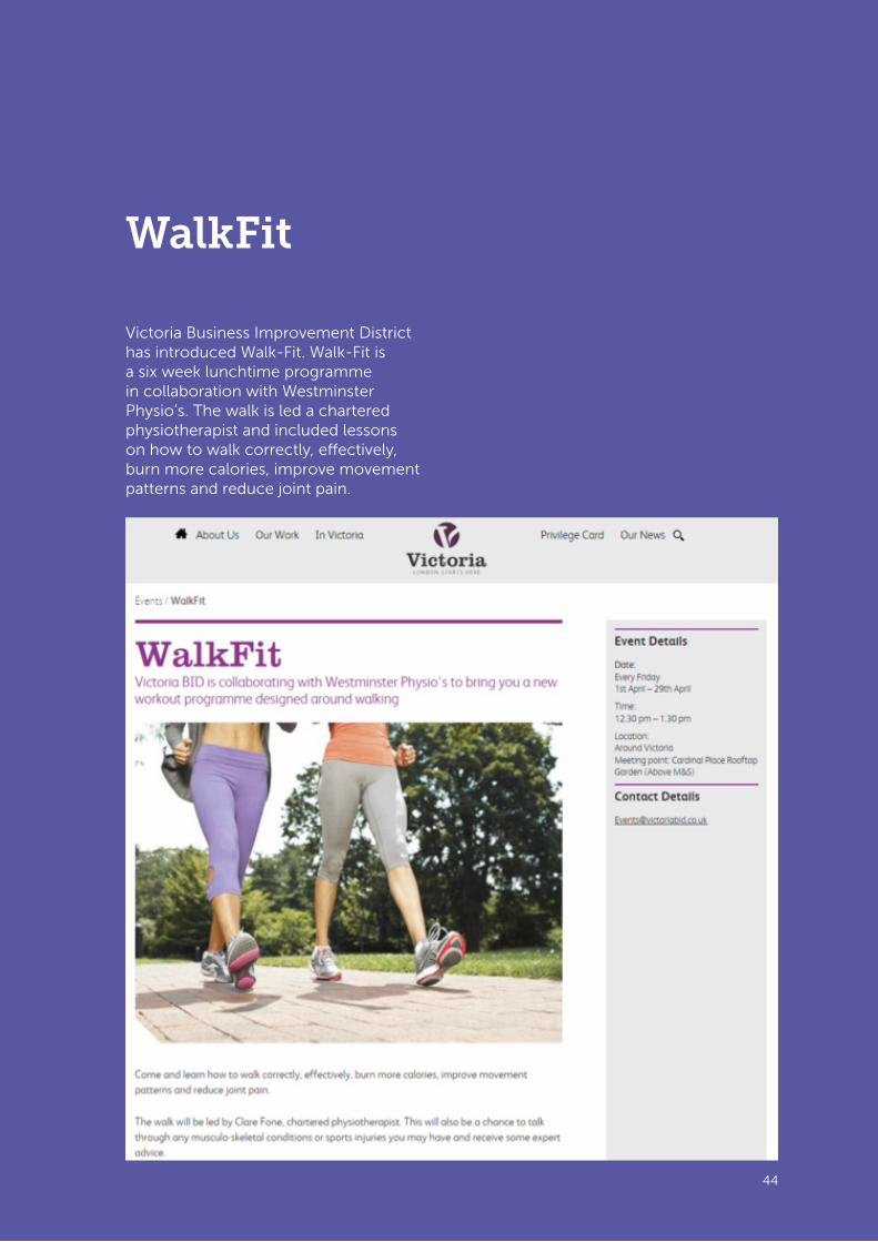
44
Westminster Walking Strategy Consultation Draft
44
WalkFit
Victoria Business Improvement District has introduced Walk-Fit. Walk-Fit is a six week lunchtime programme in collaboration with Westminster Physio’s. The walk is led a chartered physiotherapist and included lessons on how to walk correctly, effectively, burn more calories, improve movement patterns and reduce joint pain.

45
Westminster Walking Strategy Consultation Draft
Promoting the health benefits of walking
3.72 Addressing health issues related to lack of physical activity and obesity is a priority for Westminster. People who are physically active reduce their risks of dying prematurely and developing a range of chronic diseases including diabetes, dementia, depression and the two biggest killers in London - heart disease and cancer37. As an illustration, regular cyclists have the fitness of someone at least 10 years younger, they have a reduced risk of heart disease, are 27 per cent less likely to have a stroke, and will live, on average, over 2 years longer38.
3.73 The impact of transport on health was outlined in a 2014 report published by the Mayor of London39 which set out the potential health benefits of encouraging more walking and cycling. The threshold level at which adults get sufficient exercise is a minimum of 150 minutes of moderate intensity physical activity (e.g. brisk walking) in periods of 10 minutes or more each week for health40. Currently it is estimated that 25% of adults in London achieve this minimum through walking and cycling alone (i.e. through the course of travelling).
3.74 The potential for further improvement is significant. At the London-wide level is estimated that 60% of people could achieve the 150 minute exercise threshold by walking or cycling for short trips that are readily transferable (compared to the 25% who do so now). In terms of obesity, each additional kilometre walked per day is associated with a 4.8 per cent reduction in obesity risk.
3.75 Increasing levels for walking can therefore improve the health and welfare of individuals, reduce the social and healthcare costs associated with poor health, and improve the economic productivity of individuals and the economy as a whole.
Working with employers to encourage behaviour change
3.76 Business Improvement Districts (BIDs) represent an excellent opportunity to cascade information to groups of businesses and employees from the centre. There are already seven BIDs in Westminster doing excellent work in partnership with the City Council. There are opportunities to work with the BIDs to target employees with behaviour change messages.
37. Transport for London (undated) Roads Task Force Technical Note 20 – What are the main health impacts of roads in London?
38. CTC (2015) Cycling and Health Briefing Paper.39. Transport And Health In London - The
Main Impacts Of London Road Transport On Health, Mayor of London, 2014.
40. Department of Health (2011) Start active, stay active.

46
Westminster Walking Strategy Consultation Draft
4. The Strategy
4.1 This chapter sets out the measures that will help to realise the vision and achieve the objectives of this walking strategy. This includes actions and proven measures already being delivered by Westminster City Council and partners as well as new approaches to be undertaken. Measures are organised into six sections within this chapter, aligned to the six objectives of the strategy:
• Providing capacity
• Improving the quality of the walking environment
• Intuitive walking routes
• Making the walking environment more accessible
• Making walking safer
• Enabling behaviour change
4.2 While measures have been allocated to one of the six sections, delivery of certain measures will help to achieve multiple objectives. For brevity such measures are not repeated in subsequent sections. Appendix A provides a summary of measures and how these achieve strategy objectives.
Providing capacity Working with partners to open up new routes and public realm
4.3 Every major new development in the borough represents an opportunity to improve the walking environment in both the immediate vicinity of the development and beyond. Westminster’s development and highways procedures must continue to be used to secure improvements to the walking environment where
required. Additional capacity can be secured by working with developers to identify where footway widths could be increased, and by encouraging developers to create permeable spaces which people can move through easily, along desire lines. The City Council should continue to work with the private sector, building on the efforts to date of land owners and developers to open up new public spaces and routes as part of new developments. Through the planning process Westminster will promote and encourage walking by ensuring new development delivers a positive contribution to public realm, opens up new routes wherever possible and improves accessibility.
4.4 The Council has a good track record of working with land owners to improve the quality of the public realm, for example, working with the Portman Estate to improve the north-south route between Marylebone station and Marble Arch by widening footways and installing zebra crossings at Seymour Street, Upper Berkeley Street and George Street and with the Crown Estate on Oxford Street East. It is vital that this strategy operates borough-wide and that opportunities are taken to link up potential improvements between developments for improved public realm and pedestrian environments.
4.5 Through the development of this strategy, landowners and developers have indicated they are willing to consider permitting public access through developments when so requested. This should be considered by the Council’s development planners through the planning process.

47
Westminster Walking Strategy Consultation Draft
Allocation of highway space
4.6 Typically, pedestrianisation is an opportunity to increase the capacity of the walking environment, and the creation of traffic-free environments in order to accommodate walking movements. The case and need for pedestrianisation is undoubtedly greater in areas of high footfall, and locations where pedestrianisation may be appropriate should be identified on this basis. It should be noted, however, that Westminster’s unique set of circumstances and challenges require a more nuanced approach. This might mean that full pedestrianisation of major routes and thoroughfares is not possible or desirable as the complete reallocation of road space for pedestrian movements and a blanket ban on vehicle movements would not be practical. There are, however, different ways in which the concept can be applied so that the better accommodation of pedestrians does not have a significant adverse impact on other road users. Where ‘full’ pedestrianisation is not appropriate, other solutions to provide additional capacity may include:
• Widening of footways in order to create more circulation space for pedestrians around hotspot locations (for example, outside station entrances, where people meet and congregate).
• Smaller side and link streets that could be part pedestrianised at certain times of the day when activity is at its peak.
• Removal of excess street furniture, decluttering and rationalising commercial use of the footway.
• Public realm enhancements to include the creation of well-designed shared spaces in appropriate locations.
Better use of existing capacity
4.7 In addition to providing additional physical capacity, there is the opportunity to make better use of the existing capacity in order to provide a better quality, more comfortable walking environment.
4.8 Use of parallel routes should be encouraged in order to alleviate congestion in the busiest, highest footfall areas. For example, Margaret Street, Henrietta Place and Wigmore Street all provide parallel routes to Oxford Street and these routes should be promoted as alternatives to facilitate faster, less congested walking journeys.
4.9 The Council must continue its work with land owners and the Westminster Amenity Societies to identify and promote alternative walking routes. People working on or adjacent to these routes and regular visitors to the busiest areas will be a prime target for this promotion but visitors could also be encouraged to adopt alternative routes. The Council should work with land owners, the Business Improvement Districts and Legible London on the production of walking maps for use by local businesses and visitors to the City. For example, the local mapping work already undertaken by the Crown Estate and Victoria BID for their areas could be expanded.
48
Westminster Walking Strategy Consultation Draft
4.10 In addition, use of alternative routes (or the ‘secondary pedestrian network’) should be promoted as a standard response to high-levels of demand on the network; for example, on-street travel advisors could be trained and deployed to encourage use of alternative routes to shops on Oxford Street during the busiest trading periods. Oxford Street in the run-up to Christmas should be considered as an ‘event’ in the context of travel demand management, and Westminster should work with Transport for London to deploy London 2012-style travel demand management measures in order to ensure best use of the network at this time. This should also build on the successful Summer Streets traffic free days on Regent Street.
4.11 Alternative pedestrian routes should be protected so that it provides sufficient capacity for redirected pedestrian flows in the event of disruption on the usual route. In the same way that special provisions are made for redirecting traffic flows when utilities or major scheme work takes place, the impact of works or route closures on pedestrians must be considered. For example, in the event that pedestrians need to be re-routed in an area of very high footfall, temporary parking restrictions could be an appropriate solution for ensuring alternative routes provide sufficient capacity and priority.
Improving the quality of the walking environment
Integrating walking (and cycling) within overall transport and planning strategy
4.12 The Council should ensure that walking and cycling are fully supported and promoted wherever possible within other Council policies and strategies. This should include at least through wider transport, development planning strategy and public health strategy.
Decluttering
4.13 In many parts of Westminster footways are disrupted and the quality of the public realm reduced by excessive street furniture such as signage, redundant phone boxes and A-boards. The Council should support the removal of these items wherever possible.
4.14 Where there is a need for new signage, the Council should look to accommodate this on existing sign posts and infrastructure.
49
Westminster Walking Strategy Consultation Draft
Quality of footway
4.15 The Council has a highways and footways repair team and the public can report issues online or by telephone. This service should be promoted to help ensure people are aware of the importance that Westminster places on maintaining high quality footways to keep pedestrians safe.
Resting places
4.16 The Council should ensure there are sufficient good quality resting places in the public realm. Benches can be particularly helpful to older people and those with impaired mobility.
4.17 The Council should continue working with partners to providing resting places around major thoroughfares and retail districts to provide places for workers, shoppers and visitors to take a break, eat lunch or otherwise pause in Westminster. The West End Partnership’s Delivery Plan 2015-30 includes the creation of ‘oasis’ spaces on main roads and side streets around the West End.
Planting
4.18 The Council must continue to support the greening of our streets to create more attractive walking routes. This should include tree planting and where sustainable, planted containers. Tree varieties should be those with roots that are least likely to damage the footway or otherwise cause disruption or narrowing of the available footway space.
Pocket parks or parklets
4.19 Pocket parks are part of the Mayor’s London’s Great Outdoors, a programme to improve streets and public open spaces across London. Pocket parks are mini parks accessible to the public and can be used to transform otherwise redundant or neglected space. The Council must support the introduction of pocket parks working with residents’ groups and other stakeholders to identify locations and develop proposals where space and cost feasibility permits.
Play Streets
4.20 The Council should continue to work with residents to develop proposals for Play Streets, whereby residential streets are closed to traffic for a period of time each week or month to allow children to play together in the street close to their homes. The Play Streets are secured via Traffic Regulation Orders (TROs) so would be consulted upon, though resident and neighbour discussion prior to submission of nominations for Play Streets helps to ensure the choice is appropriate.
4.21 Play Streets can make a positive contribution towards more walking by encouraging children and families to spend more time being active in their neighbourhood. Outdoor play also promotes physical activity helping to achieve our wider public health objectives such as reducing obesity among children.

50
Westminster Walking Strategy Consultation Draft
The Council must support both initiatives and it plans to trial further Play Streets within the Marylebone Low Emission Neighbourhood, including providing cycle training for young children and families.
Intuitive walking routes Signage and wayfinding
4.22 The Council must work with Legible London and local partners such as the BIDs and land owners to continue the roll-out of signage and wayfinding. Other BIDs and land owners should follow the lead of the Victoria BID and the Crown Estate in developing local paper versions of the Legible London mapping for businesses to use. This should include establishing better and more obvious links to the River Thames and Westminster’s waterways.
Improving walking routes around utilities and construction works
4.23 Construction and maintenance works should not be undertaken to the detriment of the walking network. Developers and utilities companies should submit detailed proposals for how they will mitigate any impact of their works on the walking environment, including minimising the need for footway closures and diversions and where these cannot be avoided providing clearly signed alternative routes. Any damage must be made good by the developer and meet Westminster’s high standards.
Making the walking environment more accessible Dropped kerbs and tactile paving
4.24 The Council must aim to provide safe and accessible routes for all people by installing dropped kerbs and suitable tactile paving at signalised junctions where these are currently missing. The Council should also work to provide accessible crossing points away from signalised junctions where a need has been identified and these can be safely accommodated.
4.25 Maintenance is an important issue with dropped kerbs and the Council must ensure that associated drainage is well maintained to prevent water collecting around crossing points. This should include, where possible, the introduction of permeable surfaces to speed up the rate at which water drains.
More pedestrian phases at signalised junctions
4.26 There remain a number of signalised junctions in Westminster without a pedestrian phase and these should be reviewed, working with TfL as necessary, to assess the level of pedestrian demand, understand the need for a pedestrian phase from a safety and accessibility perspective and estimate the potential impact on other road users. Phasing should consider the need to provide smooth and quick crossings for pedestrians.
51
Westminster Walking Strategy Consultation Draft
Public realm improvement schemes
4.27 Major schemes and new developments offer opportunities to improve the quality of the public realm and ensure it is accessible and usable by both disabled and non-disabled people. The Council is aware that certain approaches to public realm improvement pose concerns for disabled people, for example where footways are indistinguishable from the carriageway. The Council must work with stakeholders to ensure schemes are designed with consideration of the needs of disabled people.
Personal safety and security
4.28 The Council recognises that concerns about personal safety and security can be a deterrent to people walking in certain places and at certain times of the day. The Council should continue to take steps to reduce these concerns by:
• Improving street lighting in locations where residents and pedestrians have raised concerns about personal safety and security.
• Maintaining public planting and vegetation to reduce encroachment on footways and improve visibility.
Making walking safer Reducing vehicle speeds to improve road safety
4.29 As discussed earlier in this document, research shows that 20mph zones have the potential to play a positive role in improving interactions between pedestrians and drivers and in improving road safety outcomes. There are continuing opportunities to learn from the implementation of 20mph zones and speed limits in neighbouring and other London boroughs in order to identify how they could be applied within Westminster and the TLRN. The Council should keep this under review and consider the potential for a pilot 20mph zone, which could be carefully monitored and the impacts analysed.
Promoting considerate cycling
4.30 Westminster must continue to promote considerate cycling behaviour, both generally and through its cycle training programme. Through Operation Safeway, which is conducted jointly with the Police and TfL, considerate and safe behavioural practices for all modes should be promoted.

52
Westminster Walking Strategy Consultation Draft
School crossing patrols
4.31 There are currently ten school crossing patrols in place in the borough. Two are based near schools close to large development sites, which are fully funded by the developers. They will be removed once the developments are complete. There have been no requests by schools for a crossing patrol officer in the last twelve months, which suggests those who are currently in place are located at the right crossing points from the schools’ perspective.
Reducing the number of delivery and servicing vehicles on our streets
4.32 Westminster’s highway network must accommodate a high number of vehicle movements, but there are undoubtedly opportunities to facilitate an overall reduction in the total number of vehicle movements within the City, and to make essential vehicle movements ‘cleaner’. Reducing the number of vehicle movements makes streets safer because there are fewer delivery vehicles to come into conflict with vulnerable road users including pedestrians. Fewer and cleaner vehicles also reduces people’s exposure to vehicular emissions damaging to health.
• Delivery and Servicing Plans – DSPs are an effective tool in the management of freight movements and can cover a single occupier, or multiple occupiers within one street or a single major development. They contain a plan for the effective management of deliveries and servicing movements, and can be required through the development
control process, or produced on a voluntary basis. Groups of businesses within Westminster should be encouraged to prepare DSPs on a street- or area-wide basis with the express aim of mitigating their collective impact on the environment. Support must be provided by the Council and the Cross River Partnership to facilitate the development of DSPs.
• Consolidating deliveries – Westminster already has a strong track record of consolidating deliveries thanks to the work of the BIDs and the participation of local businesses in these schemes. The Council must continue to work with and support the BIDs and businesses on consolidation efforts.
• Waste collection consolidation – the BIDs and local businesses are also leading the way on reducing waste collection movements by jointly purchasing waste collection services.
Enabling behaviour change
4.33 Changes to the physical walking infrastructure should be complemented by ‘softer’, marketing and communications-led campaigns to encourage more people to walk for shorter journeys.

53
Westminster Walking Strategy Consultation Draft
Workplaces
4.34 The Council supports travel planning activities by businesses based in Westminster and more travel planning should be encouraged through direct engagement with large employers and through the BIDs in order to reach smaller employers and develop area-wide travel plans.
Schools
4.35 At present around 75% of schools in Westminster have an active school travel plan in place. School travel plans aim to encourage more sustainable travel behaviour by delivering a range of measures and activities to promote and facilitate walking, cycling and public transport use. The Council’s ambition is for 100% of schools in Westminster to be covered by an active travel plan by December 2016.
4.36 The Council already delivers a programme of pedestrian safety training to children in school years two and six, providing three sessions per child. Sessions are delivered with the assistance of volunteer elderly residents, which is also helping to raise road safety awareness among older people. In secondary schools the Council is also piloting an arts-based children’s road safety initiative in which mime artists go into secondary schools and work with children to create a storyline mime around road safety. Younger children benefit from the Children’s Traffic Club scheme.
4.37 Although not specifically a schools project, the Council has also recently secured funding for Beat the Street, an initiative that aims to encourage walking and cycling by engaging the whole community in a physical activity game over a period of six weeks. Participants compete for points by walking or cycling around the local area and scanning smart cards onto sensors known as ‘Beat Boxes’ to record their journeys.
4.38 Around 60,000 Beat the Streets Westminster fobs and cards will be provided, including 12,000 key fobs for primary school children. Public engagement for the project is expected to begin in spring 2016.
Residents
4.39 The Council runs road safety coffee morning sessions with older residents at senior citizens clubs. Officers deliver road safety guidance and take on board the concerns of the attendees about road safety in the City. One concern that is regularly raised, for example, is footway quality and the Council should ensure this feedback is captured and passed onto the appropriate colleagues within the organisation for action.

54
Westminster Walking Strategy Consultation Draft
4.40 As part of the road safety guidance, the Council provides residents with an online reporting system and telephone number to report any issues. For example, poor footway quality, uneven kerb heights and steep curb drops. The elderly have also particularly expressed concern about their safety when people are using scooters on the footway and the Council should investigate the value of targeted public communication identifying the potential anti-social nature of scooter use.
4.41 The Council commissions the delivery of led walks in Westminster, including walks around the Royal Parks in the borough. The initiative is similar to led cycle rides and led runs which are also popular. The City also hosts the end of the London Marathon and the Bupa Westminster Mile; an annual event which aims to promote physical activity and takes place in St. James’s Park each year. The mile can be walked or run.
4.42 The Council is also developing an app aimed at boosting cycling and walking in Westminster. The app requires participants to complete three bursts of physical activity each day (each of 10 minutes) in order to be entered into a prize draw. The project is part funded by Public Health.
Visitors
4.43 The Council along with TfL and London & Partners should work with UK and international tourist organisations to provide information for visitors about walking and road safety on their visit to Westminster. This should include information in international visitor guide books, printed material and websites.

55
Westminster Walking Strategy Consultation Draft
5. Funding & Delivery
5.1 Funding for schemes to deliver the vision for walking will need to come from a range of sources. With limited capital and revenue budgets the Council will need to be proactive in seeking funding partners and sources. This chapter considers the primary sources and opportunities for funding delivery of the strategy.
Central Government
5.2 Central government is unlikely to be a major source of funding. However, Westminster has previously benefited from Defra Air Quality grants and the potential remains given the public health issue of poor air quality in central London.
Mayoral and Transport for London Local Implementation Plan
5.3 TfL allocates funding to boroughs for the delivery of their transport Local Implementation Plan (LIP), the programme of schemes and initiatives developed on a three-year cycle in line with the Mayor’s Transport Strategy. Westminster’s annual allocation is approximately £5 million covering firstly corridors, neighbourhoods and supporting measures, secondly road maintenance and bridges and thirdly local transport. The current LIP funding cycle ends in March 2016.
Major schemes programme
5.4 Boroughs can apply to TfL for a proportion of the required funding for improvements from the Major Schemes Programme, covering schemes costing more than £1 million. For schemes with a total project cost above £2 million, a business case must also be submitted and a design review carried out. Westminster has previously used Major Schemes funding to deliver other significant public realm improvements, for example at Leicester Square and the Piccadilly Two-way scheme. Examples of Major Schemes currently being progressed in the City of Westminster include Baker Street Two-way and Piccadilly Phase 2.
Mayor’s Vision for Cycling
5.5 The Mayor’s Vision for Cycling will deliver streetscape improvements through the introduction of the Central London Grid and the Cycle Superhighways. These improvements will have benefits for all road users including pedestrians and will improve the quality of the public realm.
5.6 This funding is additional to that allocated within the LIP and will include enhancements to TfL roads in Westminster e.g. Victoria Embankment on the East-West Cycle Superhighway.

56
Westminster Walking Strategy Consultation Draft
Mayor’s Air Quality Fund
5.7 The Mayor’s Air Quality Fund (MAQF) commits £20m funding towards air quality improvement schemes across London in the 10 years from 2010. The first round of funding was allocated to boroughs in 2010; applications for round two funding will be decided in 2016. The Council was successful in obtaining seed funding from TfL to develop a Low Emission Neighbourhood for Marylebone as part of the latest round of the MAQF. The Marylebone LEN bid seeks to develop innovative solutions to improve local air quality and contains a range of initiatives covering behaviour change and public realm interventions.
Transport for London Future Streets Incubator
5.8 The Future Streets Incubator allocates funding to boroughs, BIDs and community groups for small scale schemes to improve London’s streets. The fund places emphasis on innovation and transformation. In Westminster, Incubator funding has previously supported a pilot for improving disabled vehicle accessibility.
Private Sector
5.9 Contributions are sought from developers to help mitigate the transport impact of new development. Historically these have been secured through Section 106 and Section 278 of the Town and Country Planning Act, legally obligating developers to fund improvements in the immediate vicinity of new developments. Increasingly these contributions will be secured through the Community Infrastructure Levy (CIL), which can be used to fund improvements across Westminster in addition to the immediate surroundings of the contributing development. Westminster adopted its CIL in May 2016.
5.10 Private sector partners also contribute through directly funding and delivering public realm and street improvements such as the works delivered by Grosvenor Estates in Mount Street. The Council should continue to work with private sector partners to encourage development by the estates and businesses of high quality streetscape and promote the benefit of such activity to the local environment and economy.

57
Westminster Walking Strategy Consultation Draft
Appendix
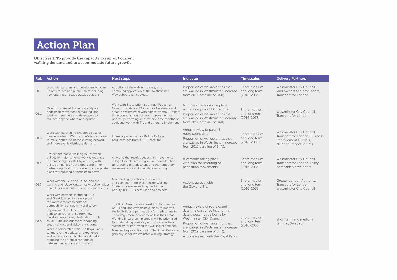
Ref. Action Next steps Indicator Timescales Delivery Partners
O1.1Work with partners and developers to open up new routes and public realm including new orientation space outside stations.
Adoption of the walking strategy and continued application of the Westminster Way public realm strategy.
Proportion of walkable trips that are walked in Westminster (increase from 2012 baseline of 84%).
Short, medium and long term (2016-2033)
Westminster City Council, land owners and developers, Transport for London
O1.2
Monitor where additional capacity for pedestrian movement is required, and work with partners and developers to reallocate space where appropriate.
Work with TfL to prioritise annual Pedestrian Comfort Guidance (PCG) audits for streets and areas in Westminster with highest footfall. Prepare time-bound action plan for improvement of poorest performing areas within three months of audit and work with TfL and others to implement.
Number of actions completed within one year of PCG audits.
Proportion of walkable trips that are walked in Westminster (increase from 2012 baseline of 84%).
Short, medium and long term (2016-2033)
Westminster City Council, Transport for London
O1.3
Work with partners to encourage use of parallel routes in Westminster’s busiest areas, to make better use of the existing network and more evenly distribute demand.
Increase pedestrian footfall by 15% on parallel routes from a 2016 baseline.
Annual review of parallel route count data.
Proportion of walkable trips that are walked in Westminster (increase from 2012 baseline of 84%).
Short, medium and long term (2016-2033)
Westminster City Council, Transport for London, Business Improvement Districts, Neighbourhood Forums
O1.4
Protect alternative walking routes when utilities or major scheme work takes place in areas of high footfall by working with utility companies / developers and other partner organisations to develop appropriate plans for rerouting of pedestrian flows.
All works that restrict pedestrian movements in high footfall areas to give due consideration to rerouting of pedestrians and the temporary measures required to facilitate rerouting.
% of works taking place with plan for rerouting of pedestrian movements
Short, medium and long term (2016-2033)
Westminster City Council, Transport for London, utility companies/developers
O1.5Work with the GLA and TfL to increase walking and ‘place’ outcomes to deliver wider benefits for residents, businesses and visitors.
Meet and agree actions for GLA and TfL and gain buy-in for Westminster Walking Strategy to ensure walking has higher priority in TfL Business Plan and projects.
Actions agreed with the GLA and TfL.
Short, medium and long term (2016-2033)
Greater London Authority, Transport for London, Westminster City Council
O1.6
Work with partners, including BIDs and Great Estates, to develop plans for improvements to enhance permeability, connectivity and safety.
Improvements will include new pedestrian routes, links from new developments to key destinations such as rail, Tube and bus stops, shopping areas, schools and visitor attractions.
Work in partnership with The Royal Parks to improve the pedestrian experience and access points into the Royal Parks, reducing the potential for conflict between pedestrians and cyclists.
The BIDS, Great Estates, West End Partnership (WEP) and land owners have plans to improve the legibility and permeability for pedestrians to encourage more people to walk in their areas. Working in partnership streets will be prioritised for undertaking feasibility work to assess their suitability for improving the walking experience.
Meet and agree actions with The Royal Parks and gain buy-in for Westminster Walking Strategy.
Annual review of route count data (the cost of collecting this data should not be borne by Westminster City Council).
Proportion of walkable trips that are walked in Westminster (increase from 2012 baseline of 84%).
Actions agreed with the Royal Parks
Short, medium and long term (2016-2033)
Short term and medium term (2016-2026)
Objective 1: To provide the capacity to support current walking demand and to accommodate future growth
Action Plan

Ref. Action Next steps Indicator Timescales Delivery Partners
O2.1Increase support for and activity of street decluttering, including the removal of extraneous street items.
The identification of extraneous street items and / or locations that would benefit from more comprehensive street decluttering could be led by BIDs and other partners. An appropriate mechanism for bringing items and locations to the Council’s attention should be established.
Number of extraneous street items removed and number of locations decluttered in total, per year.
Proportion of walkable trips that are walked in Westminster (increase from 2012 baseline of 84%).
Appropriate mechanism established for identifying extraneous items.
Short term and medium term (2016-2026)
Westminster City Council, land owners and developers, Transport for London
O2.2Promote sufficient, good quality resting places in the public realm.
Develop and deliver audit programme to identify need and timescales.
Number of additional formal and informal resting places delivered per year.
Proportion of walkable trips that are walked in Westminster (increase from 2012 baseline of 84%).
Short term (2016-2020)
Westminster City Council, Transport for London
O2.3
Continue to support the greening of streets where appropriate and continued application of WCC’s Tree Strategy, Open Spaces Strategy and Westminster Way public realm strategy
Develop and deliver audit programme to identify need and timescales.
Number of greening interventions delivered per year.
Proportion of walkable trips that are walked in Westminster (increase from 2012 baseline of 84%).This underestimates the utility/cost/issue
Short term and medium term (2016-2026)
Westminster City Council, Transport for London, Business Improvement Districts, Neighbourhood Forums
O2.4 Introduce pocket parks where appropriate.Identify opportunities for pocket parks in appropriate locations where they will be of benefit and not adversely impede pedestrian flow.
Actions agreed with delivery partners.
Short term and medium term (2016-2026)
Westminster City Council, Transport for London, utility companies/developers
O2.5 Develop proposals for Play Streets.Develop proposals and implementation plan for Play Streets.
Number of Play Street proposals developed per year.
Short term (2016-2020)
Greater London Authority, Transport for London, Westminster City Council
Objective 2: To improve the quality of the walking environment and public realm to make walking more comfortable
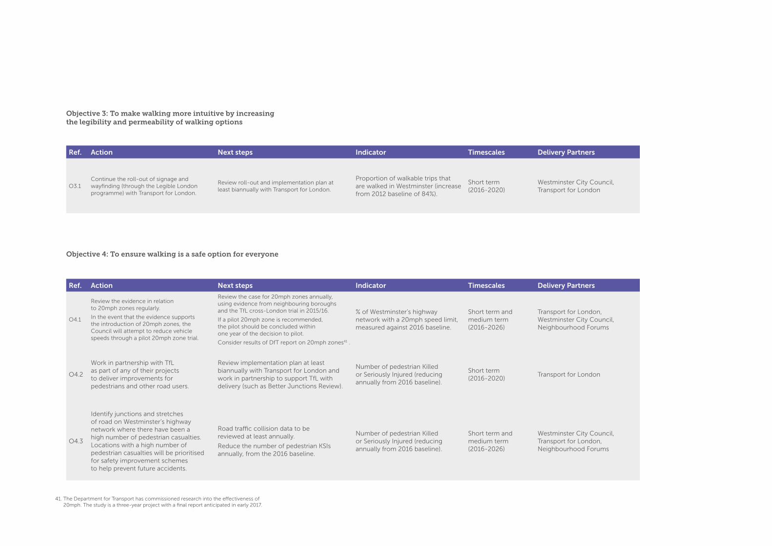
Ref. Action Next steps Indicator Timescales Delivery Partners
O3.1Continue the roll-out of signage and wayfinding (through the Legible London programme) with Transport for London.
Review roll-out and implementation plan at least biannually with Transport for London.
Proportion of walkable trips that are walked in Westminster (increase from 2012 baseline of 84%).
Short term (2016-2020)
Westminster City Council, Transport for London
Objective 3: To make walking more intuitive by increasing the legibility and permeability of walking options
Objective 4: To ensure walking is a safe option for everyone
41. The Department for Transport has commissioned research into the effectiveness of 20mph. The study is a three-year project with a final report anticipated in early 2017.
Ref. Action Next steps Indicator Timescales Delivery Partners
O4.1
Review the evidence in relation to 20mph zones regularly.
In the event that the evidence supports the introduction of 20mph zones, the Council will attempt to reduce vehicle speeds through a pilot 20mph zone trial.
Review the case for 20mph zones annually, using evidence from neighbouring boroughs and the TfL cross-London trial in 2015/16.
If a pilot 20mph zone is recommended, the pilot should be concluded within one year of the decision to pilot.
Consider results of DfT report on 20mph zones41 .
% of Westminster’s highway network with a 20mph speed limit, measured against 2016 baseline.
Short term and medium term (2016-2026)
Transport for London, Westminster City Council, Neighbourhood Forums
O4.2
Work in partnership with TfL as part of any of their projects to deliver improvements for pedestrians and other road users.
Review implementation plan at least biannually with Transport for London and work in partnership to support TfL with delivery (such as Better Junctions Review).
Number of pedestrian Killed or Seriously Injured (reducing annually from 2016 baseline).
Short term (2016-2020)
Transport for London
O4.3
Identify junctions and stretches of road on Westminster’s highway network where there have been a high number of pedestrian casualties. Locations with a high number of pedestrian casualties will be prioritised for safety improvement schemes to help prevent future accidents.
Road traffic collision data to be reviewed at least annually.
Reduce the number of pedestrian KSIs annually, from the 2016 baseline.
Number of pedestrian Killed or Seriously Injured (reducing annually from 2016 baseline).
Short term and medium term (2016-2026)
Westminster City Council, Transport for London, Neighbourhood Forums
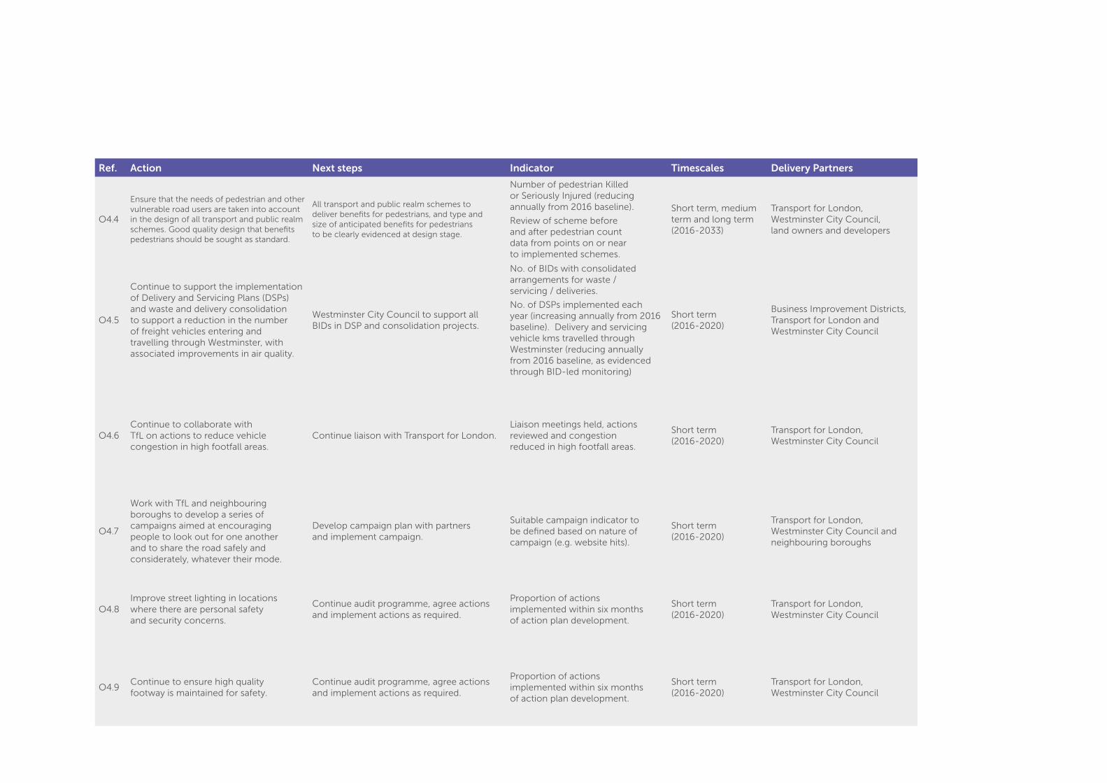
Ref. Action Next steps Indicator Timescales Delivery Partners
O4.4
Ensure that the needs of pedestrian and other vulnerable road users are taken into account in the design of all transport and public realm schemes. Good quality design that benefits pedestrians should be sought as standard.
All transport and public realm schemes to deliver benefits for pedestrians, and type and size of anticipated benefits for pedestrians to be clearly evidenced at design stage.
Number of pedestrian Killed or Seriously Injured (reducing annually from 2016 baseline).
Review of scheme before and after pedestrian count data from points on or near to implemented schemes.
Short term, medium term and long term (2016-2033)
Transport for London, Westminster City Council, land owners and developers
O4.5
Continue to support the implementation of Delivery and Servicing Plans (DSPs) and waste and delivery consolidation to support a reduction in the number of freight vehicles entering and travelling through Westminster, with associated improvements in air quality.
Westminster City Council to support all BIDs in DSP and consolidation projects.
No. of BIDs with consolidated arrangements for waste / servicing / deliveries.
No. of DSPs implemented each year (increasing annually from 2016 baseline). Delivery and servicing vehicle kms travelled through Westminster (reducing annually from 2016 baseline, as evidenced through BID-led monitoring)
Short term (2016-2020)
Business Improvement Districts, Transport for London and Westminster City Council
O4.6Continue to collaborate with TfL on actions to reduce vehicle congestion in high footfall areas.
Continue liaison with Transport for London.Liaison meetings held, actions reviewed and congestion reduced in high footfall areas.
Short term (2016-2020)
Transport for London, Westminster City Council
O4.7
Work with TfL and neighbouring boroughs to develop a series of campaigns aimed at encouraging people to look out for one another and to share the road safely and considerately, whatever their mode.
Develop campaign plan with partners and implement campaign.
Suitable campaign indicator to be defined based on nature of campaign (e.g. website hits).
Short term (2016-2020)
Transport for London, Westminster City Council and neighbouring boroughs
O4.8Improve street lighting in locations where there are personal safety and security concerns.
Continue audit programme, agree actions and implement actions as required.
Proportion of actions implemented within six months of action plan development.
Short term (2016-2020)
Transport for London, Westminster City Council
O4.9Continue to ensure high quality footway is maintained for safety.
Continue audit programme, agree actions and implement actions as required.
Proportion of actions implemented within six months of action plan development.
Short term (2016-2020)
Transport for London, Westminster City Council
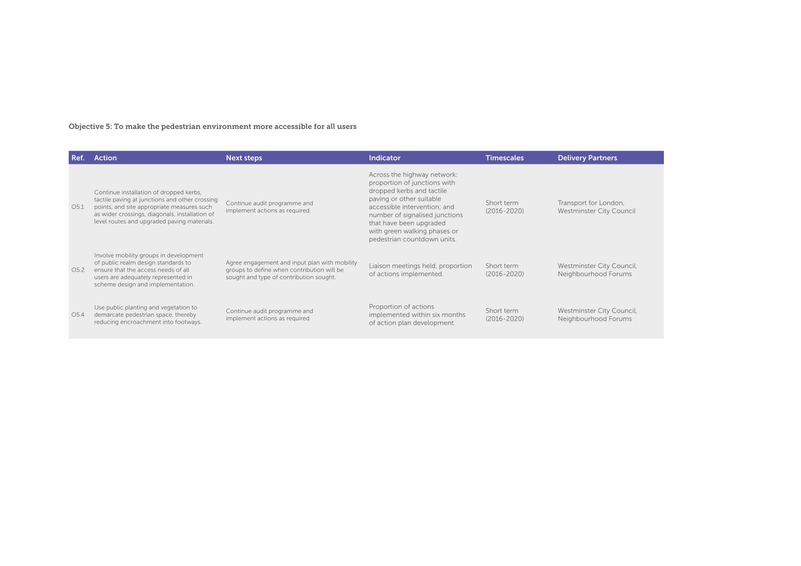
Ref. Action Next steps Indicator Timescales Delivery Partners
O5.1
Continue installation of dropped kerbs, tactile paving at junctions and other crossing points, and site appropriate measures such as wider crossings, diagonals, installation of level routes and upgraded paving materials.
Continue audit programme and implement actions as required.
Across the highway network: proportion of junctions with dropped kerbs and tactile paving or other suitable accessible intervention; and number of signalised junctions that have been upgraded with green walking phases or pedestrian countdown units.
Short term (2016-2020)
Transport for London, Westminster City Council
O5.2
Involve mobility groups in development of public realm design standards to ensure that the access needs of all users are adequately represented in scheme design and implementation.
Agree engagement and input plan with mobility groups to define when contribution will be sought and type of contribution sought.
Liaison meetings held, proportion of actions implemented.
Short term (2016-2020)
Westminster City Council, Neighbourhood Forums
O5.4Use public planting and vegetation to demarcate pedestrian space, thereby reducing encroachment into footways.
Continue audit programme and implement actions as required.
Proportion of actions implemented within six months of action plan development.
Short term (2016-2020)
Westminster City Council, Neighbourhood Forums
Objective 5: To make the pedestrian environment more accessible for all users
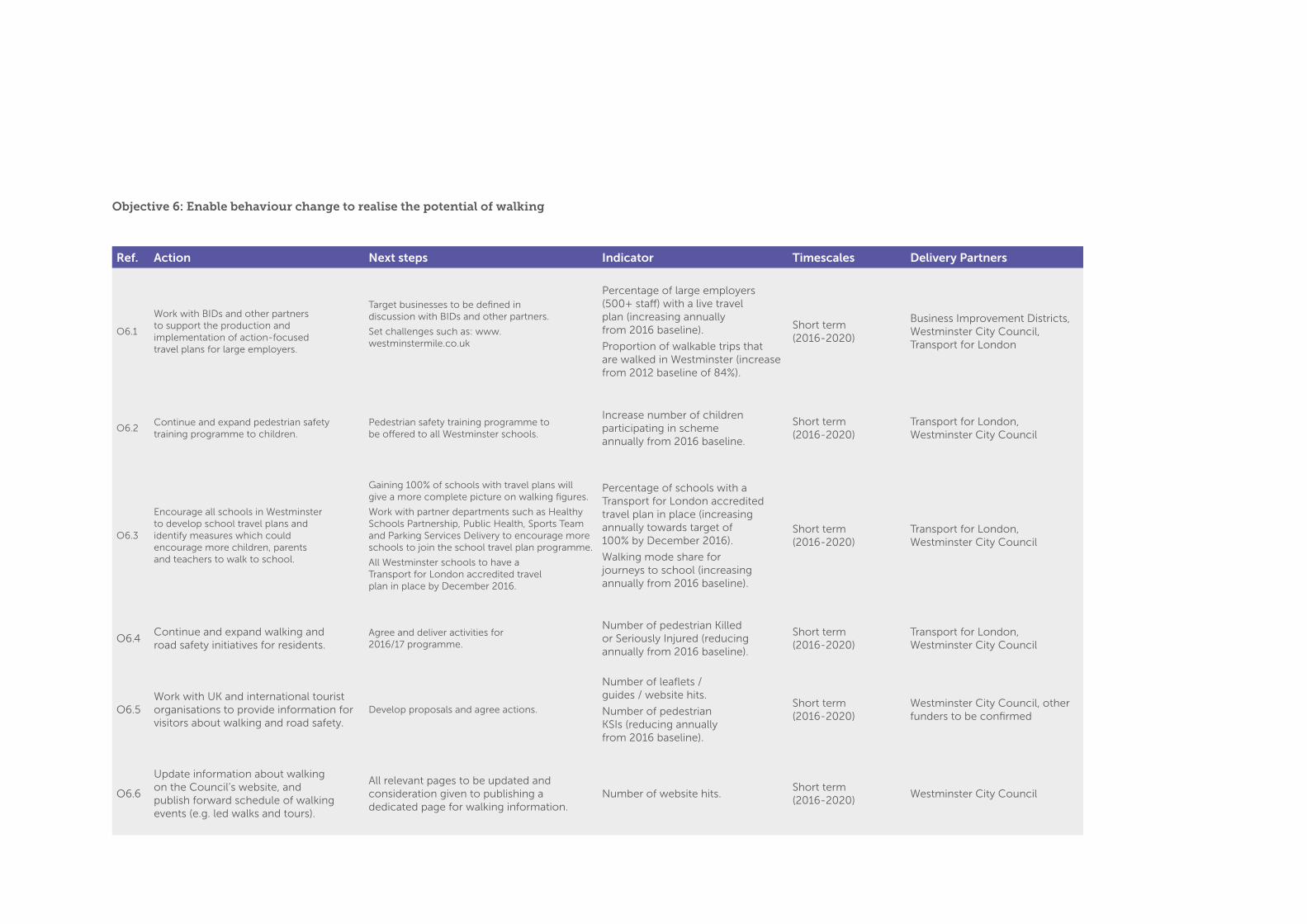
Ref. Action Next steps Indicator Timescales Delivery Partners
O6.1
Work with BIDs and other partners to support the production and implementation of action-focused travel plans for large employers.
Target businesses to be defined in discussion with BIDs and other partners.
Set challenges such as: www.westminstermile.co.uk
Percentage of large employers (500+ staff) with a live travel plan (increasing annually from 2016 baseline).
Proportion of walkable trips that are walked in Westminster (increase from 2012 baseline of 84%).
Short term (2016-2020)
Business Improvement Districts, Westminster City Council, Transport for London
O6.2Continue and expand pedestrian safety training programme to children.
Pedestrian safety training programme to be offered to all Westminster schools.
Increase number of children participating in scheme annually from 2016 baseline.
Short term (2016-2020)
Transport for London, Westminster City Council
O6.3
Encourage all schools in Westminster to develop school travel plans and identify measures which could encourage more children, parents and teachers to walk to school.
Gaining 100% of schools with travel plans will give a more complete picture on walking figures.
Work with partner departments such as Healthy Schools Partnership, Public Health, Sports Team and Parking Services Delivery to encourage more schools to join the school travel plan programme.
All Westminster schools to have a Transport for London accredited travel plan in place by December 2016.
Percentage of schools with a Transport for London accredited travel plan in place (increasing annually towards target of 100% by December 2016).
Walking mode share for journeys to school (increasing annually from 2016 baseline).
Short term (2016-2020)
Transport for London, Westminster City Council
O6.4Continue and expand walking and road safety initiatives for residents.
Agree and deliver activities for 2016/17 programme.
Number of pedestrian Killed or Seriously Injured (reducing annually from 2016 baseline).
Short term (2016-2020)
Transport for London, Westminster City Council
O6.5Work with UK and international tourist organisations to provide information for visitors about walking and road safety.
Develop proposals and agree actions.
Number of leaflets / guides / website hits.
Number of pedestrian KSIs (reducing annually from 2016 baseline).
Short term (2016-2020)
Westminster City Council, other funders to be confirmed
O6.6
Update information about walking on the Council’s website, and publish forward schedule of walking events (e.g. led walks and tours).
All relevant pages to be updated and consideration given to publishing a dedicated page for walking information.
Number of website hits. Short term (2016-2020)
Westminster City Council
Objective 6: Enable behaviour change to realise the potential of walking

Ref. Action Next steps Indicator Timescales Delivery Partners
O6.8Organise regular led walks for residents and visitors and ensure that a range of abilities and target groups are included.
Review booking and confirmation procedures to reduce fall-off rate and consider charging for this not as a service but an event to keep bookings stable.
Number of led walks per year, number of participants (increasing annually from 2016 baseline).
Short term (2016-2020)
Westminster City Council
O6.9Develop a business engagement programme to encourage walking, to complement those run by Transport for London.
Seek meeting with TfL to discuss appropriate engagement programme and develop action plan for short term implementation.
Not applicableShort term (2016-2020)
Westminster City Council
O6.10
EWork in partnership with the Council’s public health and sports and leisure units, to establish a network of ‘Physical Activity Champions’ through the ‘Active Communities’ programme. Physical Activity Champions can assess and refer individuals to appropriate activity programmes (such as walking or cycling).
Meet with partner departments and agree action plan.
Number of Physical Activity Champions recruited.
Short term (2016-2020)
Westminster City Council