Western Canyon and Owyhee County Corridor Studies Welcome
12
Welcome Thank you for your interest in the Western Canyon and Owyhee County Corridor Studies. The purpose of today’s meeting is to gather input on locations for future improvements to: • U.S. 95, Oregon State Line to Jct. U.S. 20/26 (Nyssa Junction) • U.S. 20/26, Oregon State Line to I-84 (Caldwell) • ID-19, Oregon State Line to Cleveland Blvd (Caldwell) US 20/26 and Roswell Road In Parma US 20/26 Facing East Western Canyon and Owyhee County Corridor Studies
Transcript of Western Canyon and Owyhee County Corridor Studies Welcome
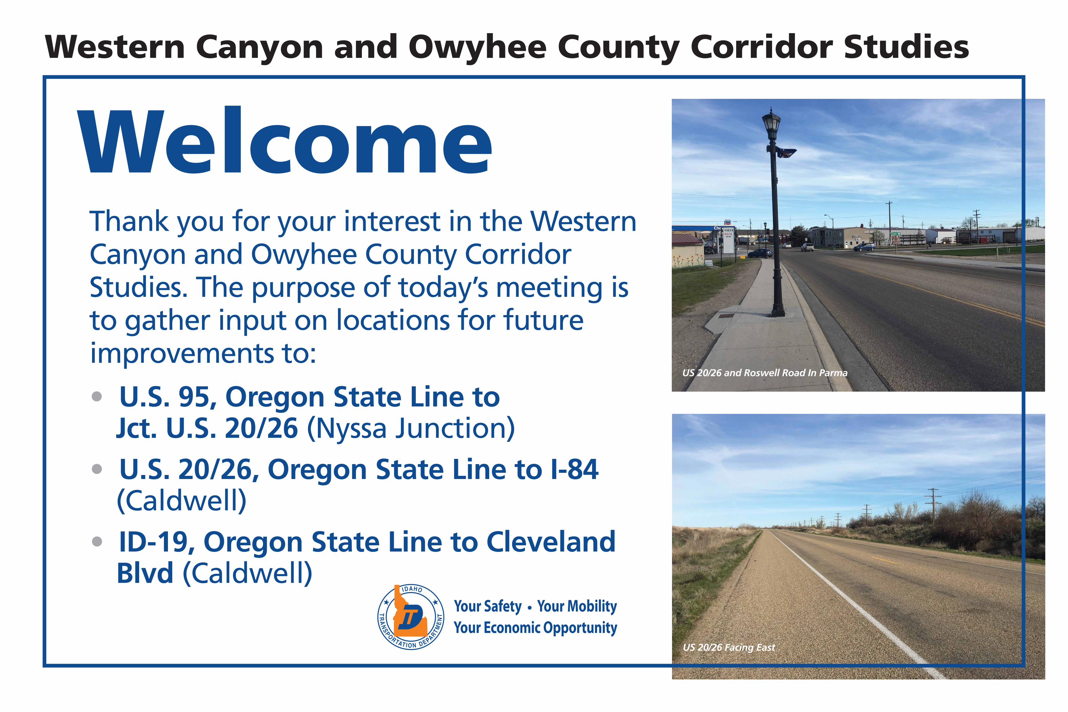
WelcomeThank you for your interest in the Western Canyon and Owyhee County Corridor Studies. The purpose of today’s meeting is to gather input on locations for future improvements to:
• U.S. 95, Oregon State Line to Jct. U.S. 20/26 (Nyssa Junction)
• U.S. 20/26, Oregon State Line to I-84 (Caldwell)
• ID-19, Oregon State Line to Cleveland Blvd (Caldwell)
US 20/26 and Roswell Road In Parma
US 20/26 Facing East
Western Canyon and Owyhee County Corridor Studies
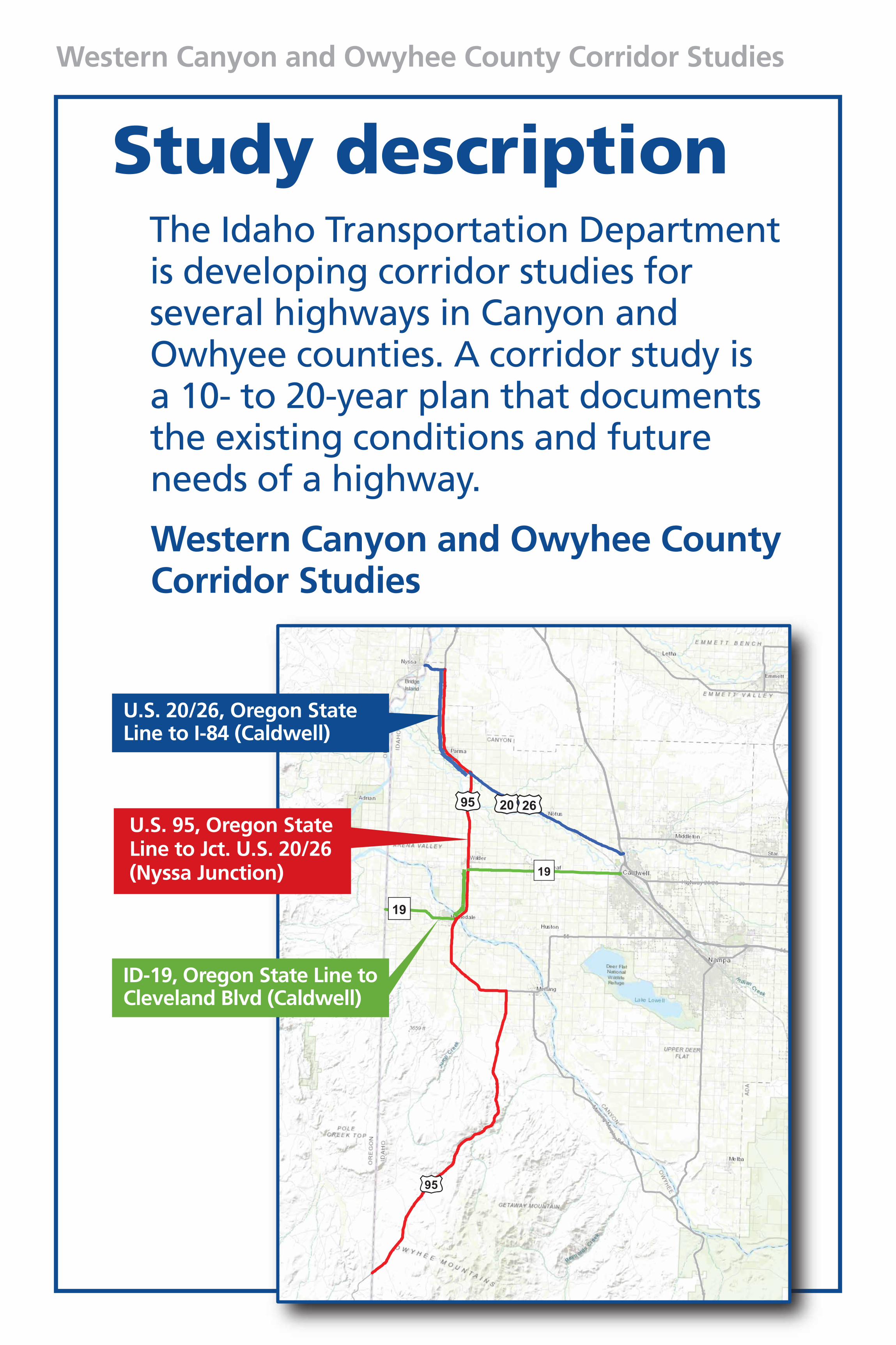
Study descriptionThe Idaho Transportation Department is developing corridor studies for several highways in Canyon and Owhyee counties. A corridor study is a 10- to 20-year plan that documents the existing conditions and future needs of a highway.
Western Canyon and Owyhee County Corridor Studies
U.S. 20/26, Oregon State Line to I-84 (Caldwell)
U.S. 95, Oregon State Line to Jct. U.S. 20/26 (Nyssa Junction)
ID-19, Oregon State Line to Cleveland Blvd (Caldwell)
Western Canyon and Owyhee County Corridor Studies
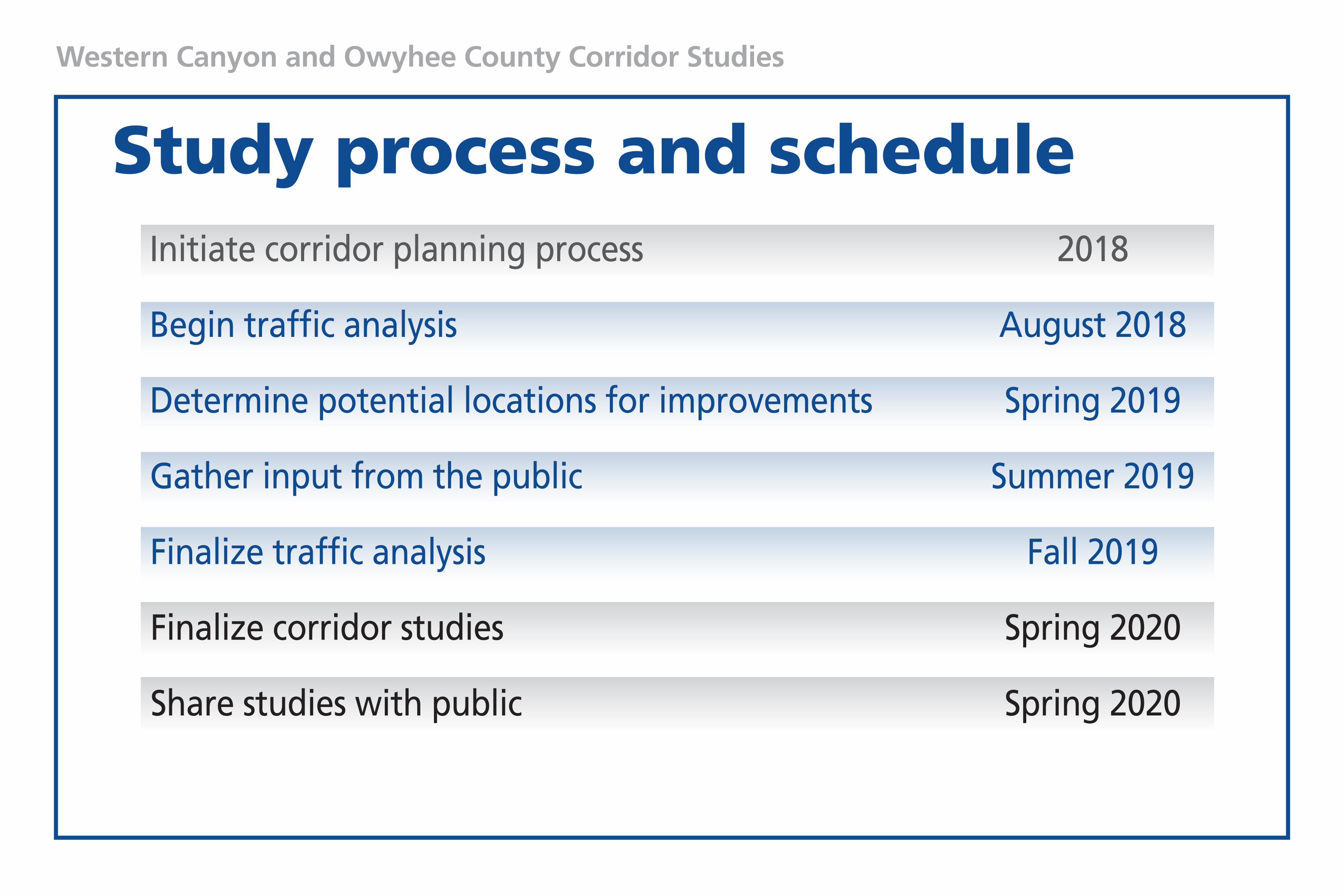
Study process and scheduleInitiate corridor planning process 2018
Begin traffic analysis August 2018
Determine potential locations for improvements Spring 2019
Gather input from the public Summer 2019
Finalize traffic analysis Fall 2019
Finalize corridor studies Spring 2020
Share studies with public Spring 2020
Western Canyon and Owyhee County Corridor Studies
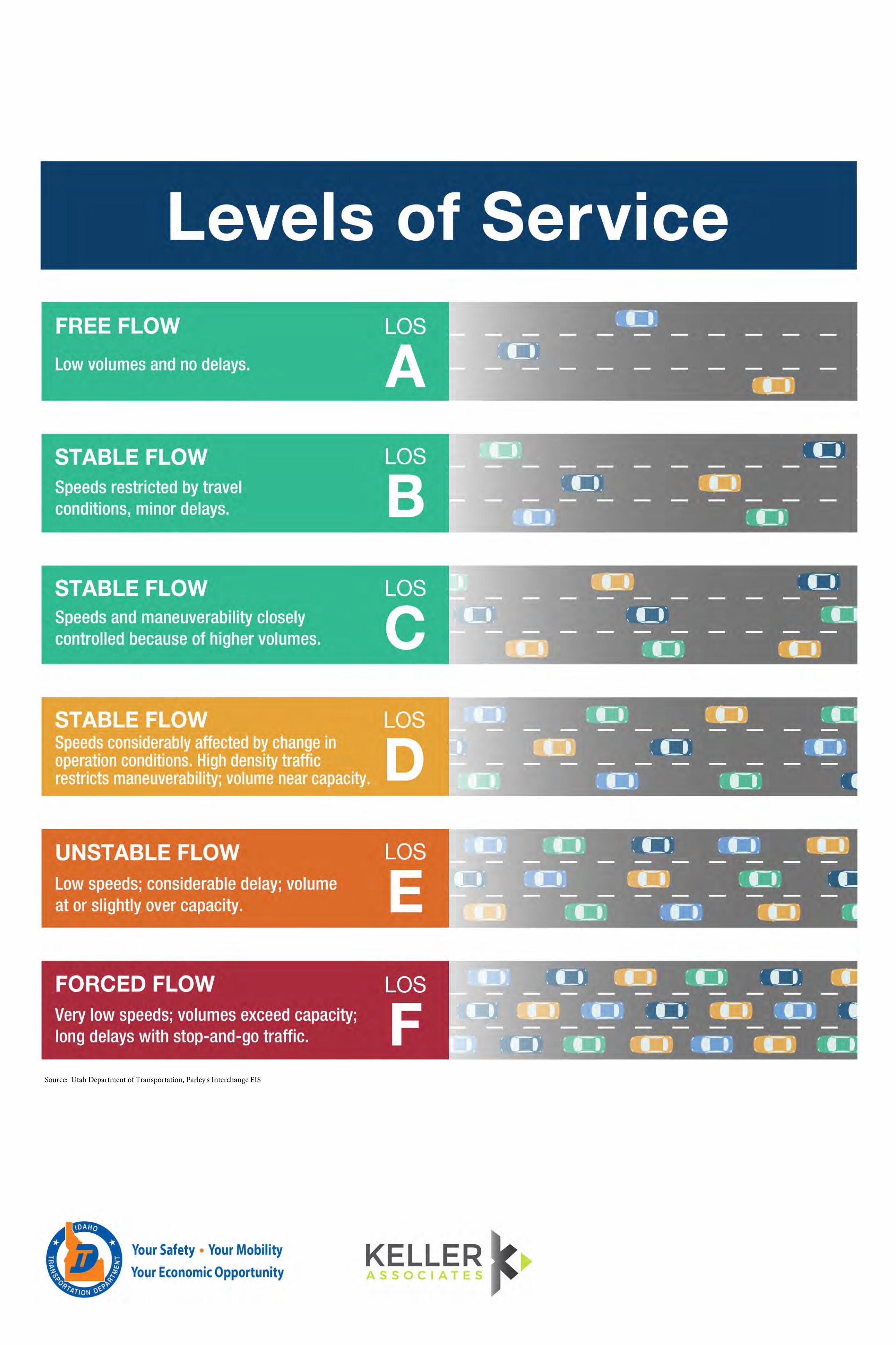
Source: Utah Department of Transportation, Parley's Interchange EIS
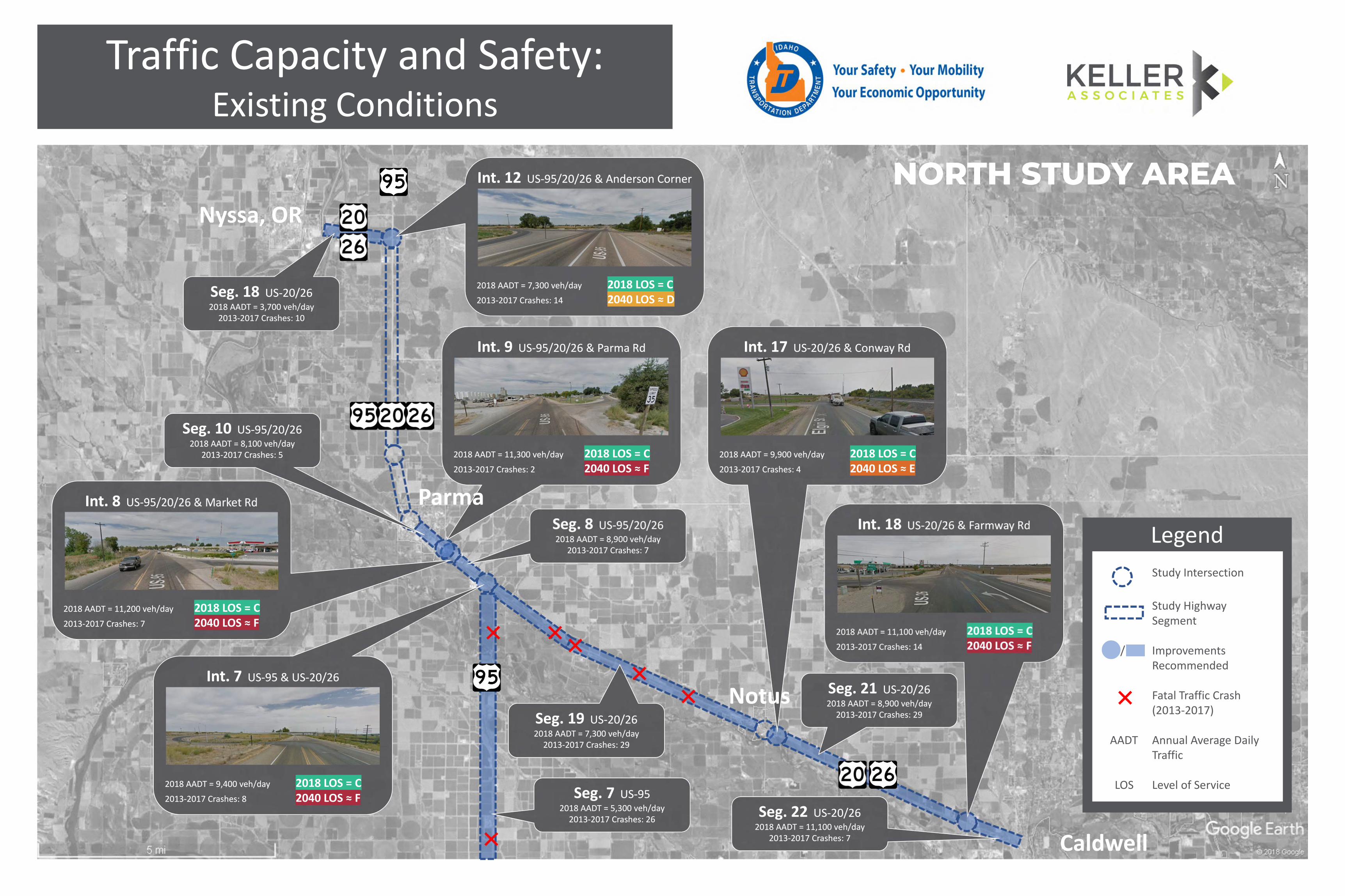
Traffic Capacity and Safety:Existing Conditions
Legend
Study Intersection
Study HighwaySegment
/ ImprovementsRecommended
Fatal Traffic Crash(2013-2017)
AADT Annual Average DailyTraffic
LOS Level of Service
Int. 7 US-95 & US-20/26
2018 AADT = 9,400 veh/day 2018 LOS = C2013-2017 Crashes: 8 2040 LOS ≈ F
Int. 7 US-95 & US-20/26
2018 AADT = 9,400 veh/day 2018 LOS = C2013-2017 Crashes: 8 2040 LOS ≈ F
Int. 8 US-95/20/26 & Market Rd
2018 AADT = 11,200 veh/day 2018 LOS = C2013-2017 Crashes: 7 2040 LOS ≈ F
Int. 8 US-95/20/26 & Market Rd
2018 AADT = 11,200 veh/day 2018 LOS = C2013-2017 Crashes: 7 2040 LOS ≈ F
Int. 12 US-95/20/26 & Anderson Corner
2018 AADT = 7,300 veh/day 2018 LOS = C2013-2017 Crashes: 14 2040 LOS ≈ D
Int. 12 US-95/20/26 & Anderson Corner
2018 AADT = 7,300 veh/day 2018 LOS = C2013-2017 Crashes: 14 2040 LOS ≈ D
Int. 18 US-20/26 & Farmway Rd
2018 AADT = 11,100 veh/day 2018 LOS = C2013-2017 Crashes: 14 2040 LOS ≈ F
Int. 18 US-20/26 & Farmway Rd
2018 AADT = 11,100 veh/day 2018 LOS = C2013-2017 Crashes: 14 2040 LOS ≈ F
Seg. 7 US-952018 AADT = 5,300 veh/day
2013-2017 Crashes: 26
Seg. 7 US-952018 AADT = 5,300 veh/day
2013-2017 Crashes: 26
Seg. 8 US-95/20/262018 AADT = 8,900 veh/day
2013-2017 Crashes: 7
Seg. 8 US-95/20/262018 AADT = 8,900 veh/day
2013-2017 Crashes: 7
Seg. 19 US-20/262018 AADT = 7,300 veh/day
2013-2017 Crashes: 29
Seg. 19 US-20/262018 AADT = 7,300 veh/day
2013-2017 Crashes: 29
Int. 17 US-20/26 & Conway Rd
2018 AADT = 9,900 veh/day 2018 LOS = C2013-2017 Crashes: 4 2040 LOS ≈ E
Int. 17 US-20/26 & Conway Rd
2018 AADT = 9,900 veh/day 2018 LOS = C2013-2017 Crashes: 4 2040 LOS ≈ E
Int. 9 US-95/20/26 & Parma Rd
2018 AADT = 11,300 veh/day 2018 LOS = C2013-2017 Crashes: 2 2040 LOS ≈ F
Int. 9 US-95/20/26 & Parma Rd
2018 AADT = 11,300 veh/day 2018 LOS = C2013-2017 Crashes: 2 2040 LOS ≈ F
Parma
Notus
Caldwell
Nyssa, OR
Seg. 10 US-95/20/262018 AADT = 8,100 veh/day
2013-2017 Crashes: 5
Seg. 10 US-95/20/262018 AADT = 8,100 veh/day
2013-2017 Crashes: 5
Seg. 18 US-20/262018 AADT = 3,700 veh/day
2013-2017 Crashes: 10
Seg. 18 US-20/262018 AADT = 3,700 veh/day
2013-2017 Crashes: 10
Seg. 22 US-20/262018 AADT = 11,100 veh/day
2013-2017 Crashes: 7
Seg. 22 US-20/262018 AADT = 11,100 veh/day
2013-2017 Crashes: 7
Seg. 21 US-20/262018 AADT = 8,900 veh/day
2013-2017 Crashes: 29
Seg. 21 US-20/262018 AADT = 8,900 veh/day
2013-2017 Crashes: 29
NORTH STUDY AREA
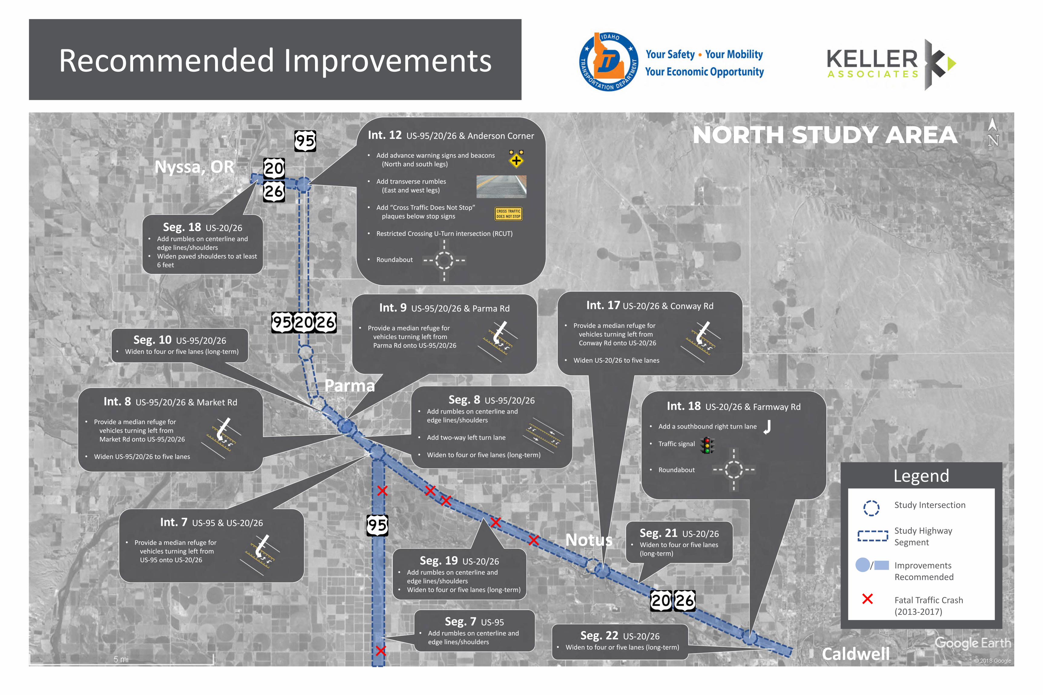
Recommended Improvements
Legend
Study Intersection
Study HighwaySegment
/ ImprovementsRecommended
Fatal Traffic Crash(2013-2017)
Seg. 7 US-95• Add rumbles on centerline and
edge lines/shoulders
Seg. 7 US-95• Add rumbles on centerline and
edge lines/shoulders
Seg. 18 US-20/26• Add rumbles on centerline and
edge lines/shoulders• Widen paved shoulders to at least
6 feet
Seg. 18 US-20/26• Add rumbles on centerline and
edge lines/shoulders• Widen paved shoulders to at least
6 feet
Seg. 19 US-20/26• Add rumbles on centerline and
edge lines/shoulders• Widen to four or five lanes (long-term)
Seg. 19 US-20/26• Add rumbles on centerline and
edge lines/shoulders• Widen to four or five lanes (long-term)
Caldwell
Nyssa, OR
Seg. 8 US-95/20/26• Add rumbles on centerline and
edge lines/shoulders
• Add two-way left turn lane
• Widen to four or five lanes (long-term)
Seg. 8 US-95/20/26• Add rumbles on centerline and
edge lines/shoulders
• Add two-way left turn lane
• Widen to four or five lanes (long-term)
Int. 7 US-95 & US-20/26
• Provide a median refuge forvehicles turning left fromUS-95 onto US-20/26
Int. 7 US-95 & US-20/26
• Provide a median refuge forvehicles turning left fromUS-95 onto US-20/26
Int. 8 US-95/20/26 & Market Rd
• Provide a median refuge forvehicles turning left fromMarket Rd onto US-95/20/26
• Widen US-95/20/26 to five lanes
Int. 8 US-95/20/26 & Market Rd
• Provide a median refuge forvehicles turning left fromMarket Rd onto US-95/20/26
• Widen US-95/20/26 to five lanes
Int. 9 US-95/20/26 & Parma Rd
• Provide a median refuge forvehicles turning left fromParma Rd onto US-95/20/26
Int. 9 US-95/20/26 & Parma Rd
• Provide a median refuge forvehicles turning left fromParma Rd onto US-95/20/26
Parma
Int. 12 US-95/20/26 & Anderson Corner
• Add advance warning signs and beacons(North and south legs)
• Add transverse rumbles(East and west legs)
• Add “Cross Traffic Does Not Stop”plaques below stop signs
• Restricted Crossing U-Turn intersection (RCUT)
• Roundabout
Int. 12 US-95/20/26 & Anderson Corner
• Add advance warning signs and beacons(North and south legs)
• Add transverse rumbles(East and west legs)
• Add “Cross Traffic Does Not Stop”plaques below stop signs
• Restricted Crossing U-Turn intersection (RCUT)
• Roundabout
Int. 17 US-20/26 & Conway Rd
• Provide a median refuge forvehicles turning left fromConway Rd onto US-20/26
• Widen US-20/26 to five lanes
Int. 17 US-20/26 & Conway Rd
• Provide a median refuge forvehicles turning left fromConway Rd onto US-20/26
• Widen US-20/26 to five lanes
Notus
Int. 18 US-20/26 & Farmway Rd
• Add a southbound right turn lane
• Traffic signal
• Roundabout
Int. 18 US-20/26 & Farmway Rd
• Add a southbound right turn lane
• Traffic signal
• Roundabout
Seg. 10 US-95/20/26• Widen to four or five lanes (long-term)
Seg. 10 US-95/20/26• Widen to four or five lanes (long-term)
Seg. 22 US-20/26• Widen to four or five lanes (long-term)
Seg. 22 US-20/26• Widen to four or five lanes (long-term)
Seg. 21 US-20/26• Widen to four or five lanes
(long-term)
Seg. 21 US-20/26• Widen to four or five lanes
(long-term)
NORTH STUDY AREA
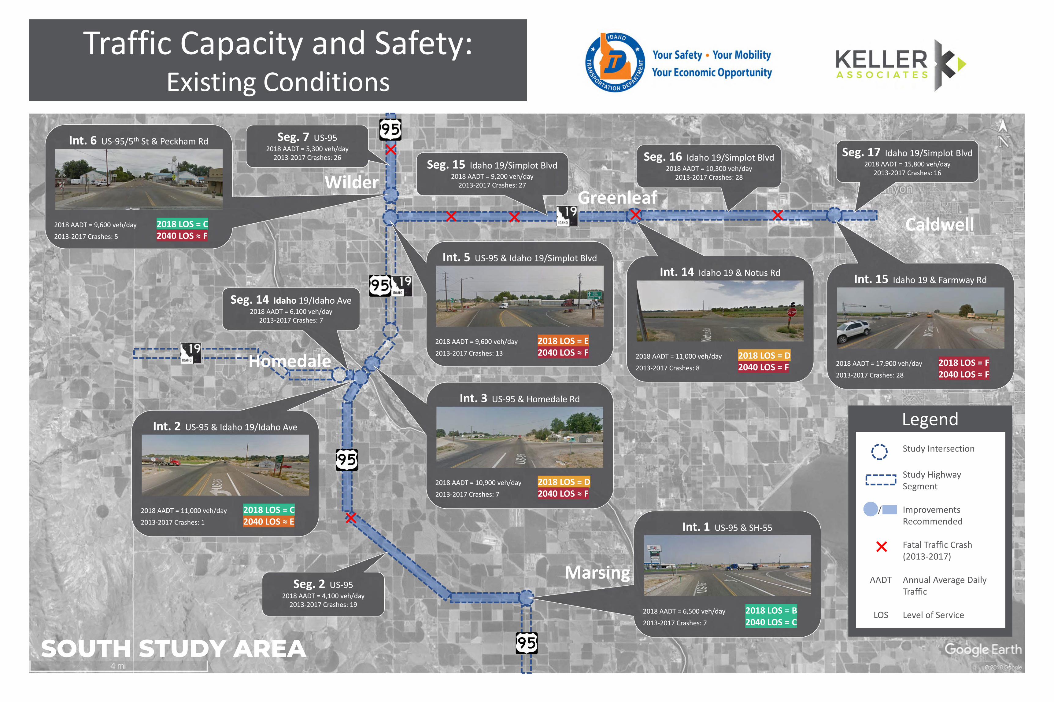
Int. 1 US-95 & SH-55
2018 AADT = 6,500 veh/day 2018 LOS = B2013-2017 Crashes: 7 2040 LOS ≈ C
Int. 1 US-95 & SH-55
2018 AADT = 6,500 veh/day 2018 LOS = B2013-2017 Crashes: 7 2040 LOS ≈ C
Int. 2 US-95 & Idaho 19/Idaho Ave
2018 AADT = 11,000 veh/day 2018 LOS = C2013-2017 Crashes: 1 2040 LOS ≈ E
Int. 2 US-95 & Idaho 19/Idaho Ave
2018 AADT = 11,000 veh/day 2018 LOS = C2013-2017 Crashes: 1 2040 LOS ≈ E
Int. 15 Idaho 19 & Farmway Rd
2018 AADT = 17,900 veh/day 2018 LOS = F2013-2017 Crashes: 28 2040 LOS ≈ F
Int. 15 Idaho 19 & Farmway Rd
2018 AADT = 17,900 veh/day 2018 LOS = F2013-2017 Crashes: 28 2040 LOS ≈ F
Int. 6 US-95/5th St & Peckham Rd
2018 AADT = 9,600 veh/day 2018 LOS = C2013-2017 Crashes: 5 2040 LOS ≈ F
Int. 6 US-95/5th St & Peckham Rd
2018 AADT = 9,600 veh/day 2018 LOS = C2013-2017 Crashes: 5 2040 LOS ≈ F
Seg. 14 Idaho 19/Idaho Ave2018 AADT = 6,100 veh/day
2013-2017 Crashes: 7
Seg. 14 Idaho 19/Idaho Ave2018 AADT = 6,100 veh/day
2013-2017 Crashes: 7
Seg. 2 US-952018 AADT = 4,100 veh/day
2013-2017 Crashes: 19
Seg. 2 US-952018 AADT = 4,100 veh/day
2013-2017 Crashes: 19
Seg. 15 Idaho 19/Simplot Blvd2018 AADT = 9,200 veh/day
2013-2017 Crashes: 27
Seg. 15 Idaho 19/Simplot Blvd2018 AADT = 9,200 veh/day
2013-2017 Crashes: 27
Seg. 16 Idaho 19/Simplot Blvd2018 AADT = 10,300 veh/day
2013-2017 Crashes: 28
Seg. 16 Idaho 19/Simplot Blvd2018 AADT = 10,300 veh/day
2013-2017 Crashes: 28
Seg. 17 Idaho 19/Simplot Blvd2018 AADT = 15,800 veh/day
2013-2017 Crashes: 16
Seg. 17 Idaho 19/Simplot Blvd2018 AADT = 15,800 veh/day
2013-2017 Crashes: 16
Seg. 7 US-952018 AADT = 5,300 veh/day
2013-2017 Crashes: 26
Seg. 7 US-952018 AADT = 5,300 veh/day
2013-2017 Crashes: 26
Traffic Capacity and Safety:Existing Conditions
Int. 14 Idaho 19 & Notus Rd
2018 AADT = 11,000 veh/day 2018 LOS = D2013-2017 Crashes: 8 2040 LOS ≈ F
Int. 14 Idaho 19 & Notus Rd
2018 AADT = 11,000 veh/day 2018 LOS = D2013-2017 Crashes: 8 2040 LOS ≈ F
Int. 5 US-95 & Idaho 19/Simplot Blvd
2018 AADT = 9,600 veh/day 2018 LOS = E2013-2017 Crashes: 13 2040 LOS ≈ F
Int. 5 US-95 & Idaho 19/Simplot Blvd
2018 AADT = 9,600 veh/day 2018 LOS = E2013-2017 Crashes: 13 2040 LOS ≈ F
Int. 3 US-95 & Homedale Rd
2018 AADT = 10,900 veh/day 2018 LOS = D2013-2017 Crashes: 7 2040 LOS ≈ F
Int. 3 US-95 & Homedale Rd
2018 AADT = 10,900 veh/day 2018 LOS = D2013-2017 Crashes: 7 2040 LOS ≈ F
Homedale
Marsing
Caldwell
GreenleafWilder
Legend
Study Intersection
Study HighwaySegment
/ ImprovementsRecommended
Fatal Traffic Crash(2013-2017)
AADT Annual Average DailyTraffic
LOS Level of Service
SOUTH STUDY AREA
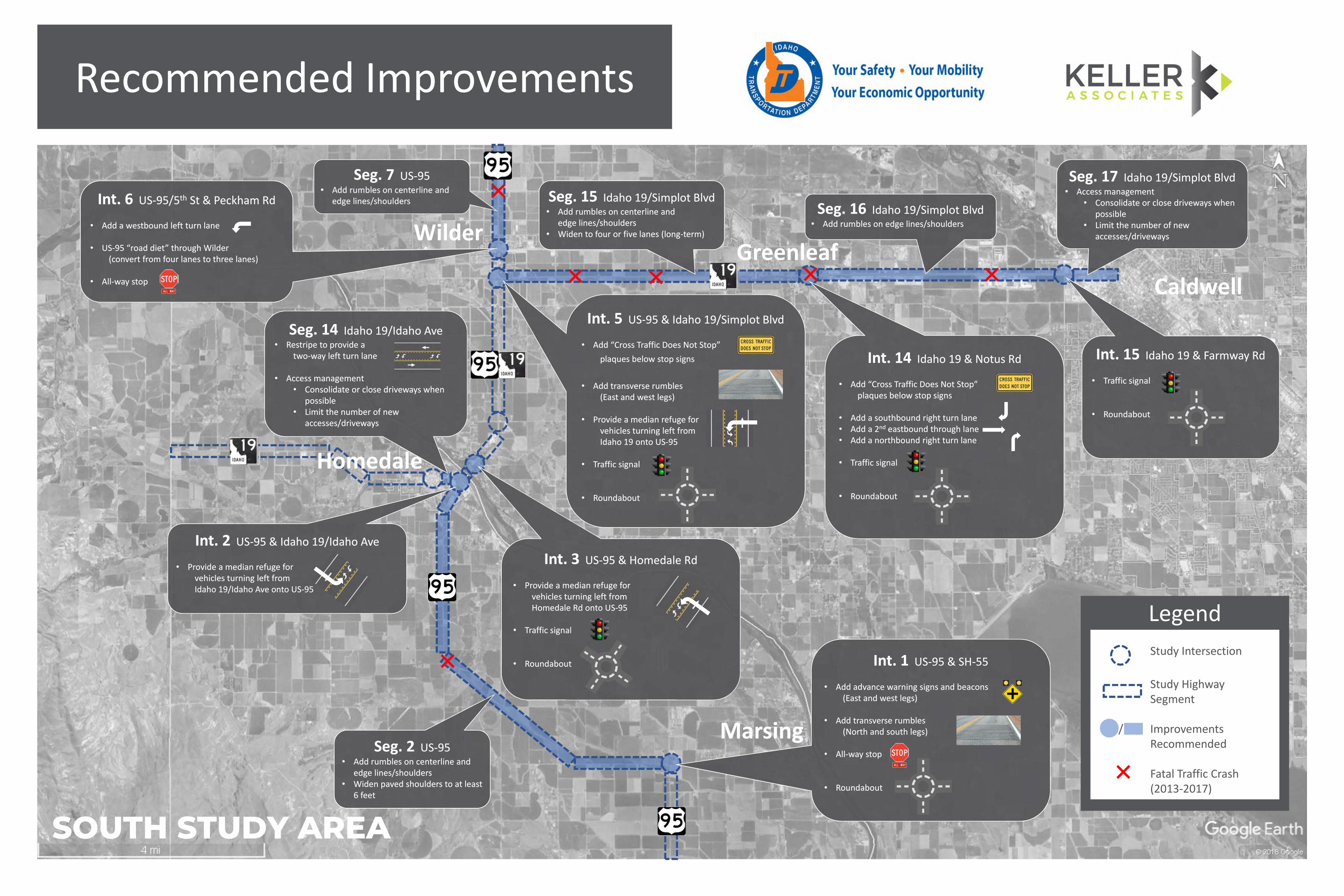
Seg. 2 US-95• Add rumbles on centerline and
edge lines/shoulders• Widen paved shoulders to at least
6 feet
Seg. 2 US-95• Add rumbles on centerline and
edge lines/shoulders• Widen paved shoulders to at least
6 feet
Seg. 15 Idaho 19/Simplot Blvd• Add rumbles on centerline and
edge lines/shoulders• Widen to four or five lanes (long-term)
Seg. 15 Idaho 19/Simplot Blvd• Add rumbles on centerline and
edge lines/shoulders• Widen to four or five lanes (long-term)
Seg. 16 Idaho 19/Simplot Blvd• Add rumbles on edge lines/shoulders
Seg. 16 Idaho 19/Simplot Blvd• Add rumbles on edge lines/shoulders
Seg. 17 Idaho 19/Simplot Blvd• Access management
• Consolidate or close driveways when possible
• Limit the number of new accesses/driveways
Seg. 17 Idaho 19/Simplot Blvd• Access management
• Consolidate or close driveways when possible
• Limit the number of new accesses/driveways
Seg. 7 US-95• Add rumbles on centerline and
edge lines/shoulders
Seg. 7 US-95• Add rumbles on centerline and
edge lines/shoulders
Recommended Improvements
Legend
Study Intersection
Study HighwaySegment
/ ImprovementsRecommended
Fatal Traffic Crash(2013-2017)
Int. 6 US-95/5th St & Peckham Rd
• Add a westbound left turn lane
• US-95 “road diet” through Wilder(convert from four lanes to three lanes)
• All-way stop
Int. 6 US-95/5th St & Peckham Rd
• Add a westbound left turn lane
• US-95 “road diet” through Wilder(convert from four lanes to three lanes)
• All-way stop
Int. 2 US-95 & Idaho 19/Idaho Ave
• Provide a median refuge forvehicles turning left fromIdaho 19/Idaho Ave onto US-95
Int. 2 US-95 & Idaho 19/Idaho Ave
• Provide a median refuge forvehicles turning left fromIdaho 19/Idaho Ave onto US-95
Int. 3 US-95 & Homedale Rd
• Provide a median refuge forvehicles turning left fromHomedale Rd onto US-95
• Traffic signal
• Roundabout
Int. 3 US-95 & Homedale Rd
• Provide a median refuge forvehicles turning left fromHomedale Rd onto US-95
• Traffic signal
• Roundabout Int. 1 US-95 & SH-55
• Add advance warning signs and beacons(East and west legs)
• Add transverse rumbles(North and south legs)
• All-way stop
• Roundabout
Int. 1 US-95 & SH-55
• Add advance warning signs and beacons(East and west legs)
• Add transverse rumbles(North and south legs)
• All-way stop
• Roundabout
Int. 5 US-95 & Idaho 19/Simplot Blvd
• Add “Cross Traffic Does Not Stop”
plaques below stop signs
• Add transverse rumbles(East and west legs)
• Provide a median refuge forvehicles turning left fromIdaho 19 onto US-95
• Traffic signal
• Roundabout
Int. 5 US-95 & Idaho 19/Simplot Blvd
• Add “Cross Traffic Does Not Stop”
plaques below stop signs
• Add transverse rumbles(East and west legs)
• Provide a median refuge forvehicles turning left fromIdaho 19 onto US-95
• Traffic signal
• Roundabout
Int. 14 Idaho 19 & Notus Rd
• Add “Cross Traffic Does Not Stop”plaques below stop signs
• Add a southbound right turn lane• Add a 2nd eastbound through lane• Add a northbound right turn lane
• Traffic signal
• Roundabout
Int. 14 Idaho 19 & Notus Rd
• Add “Cross Traffic Does Not Stop”plaques below stop signs
• Add a southbound right turn lane• Add a 2nd eastbound through lane• Add a northbound right turn lane
• Traffic signal
• Roundabout
Int. 15 Idaho 19 & Farmway Rd
• Traffic signal
• Roundabout
Int. 15 Idaho 19 & Farmway Rd
• Traffic signal
• Roundabout
Seg. 14 Idaho 19/Idaho Ave• Restripe to provide a
two-way left turn lane
• Access management• Consolidate or close driveways when
possible• Limit the number of new
accesses/driveways
Seg. 14 Idaho 19/Idaho Ave• Restripe to provide a
two-way left turn lane
• Access management• Consolidate or close driveways when
possible• Limit the number of new
accesses/driveways
Homedale
Marsing
Caldwell
GreenleafWilder
SOUTH STUDY AREA
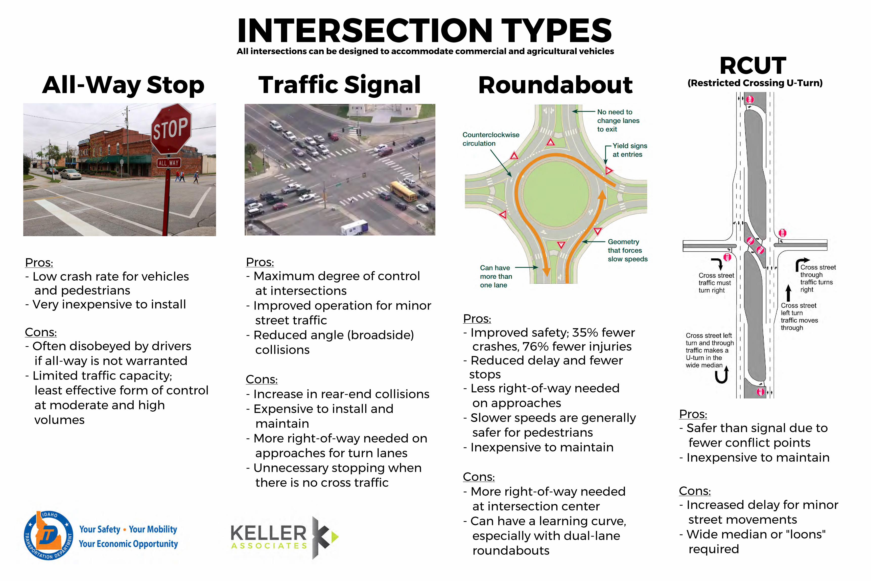
Roundabout
(Restricted Crossing U-Turn)RCUT
there is no cross traffic- Unnecessary stopping when
approaches for turn lanes- More right-of-way needed on
maintain- Expensive to install and- Increase in rear-end collisionsCons:
collisions- Reduced angle (broadside)
street traffic- Improved operation for minor
at intersections- Maximum degree of controlPros:
AAllll W- aW yay StS ot pop Traffic Signal All intersections can be designed to accommodate commercial and agricultural vehiclesINTERSECTION TYPES
required- Wide median or "loons"
street movements- Increased delay for minorCons:
- Inexpensive to maintain fewer conflict points
- Safer than signal due toPros:
roundabouts especially with dual-lane
- Can have a learning curve, at intersection center
- More right-of-way neededCons:
- Inexpensive to maintain safer for pedestrians
- Slower speeds are generally on approaches
- Less right-of-way needed stops
- Reduced delay and fewer crashes, 76% fewer injuries
- Improved safety; 35% fewerPros:
volumesat moderate and high least effective form of control
- Limited traffic capacity; if all-way is not warranted
- Often disobeyed by driversCons:
- Very inexpensive to install and pedestrians
- Low crash rate for vehiclesPros:
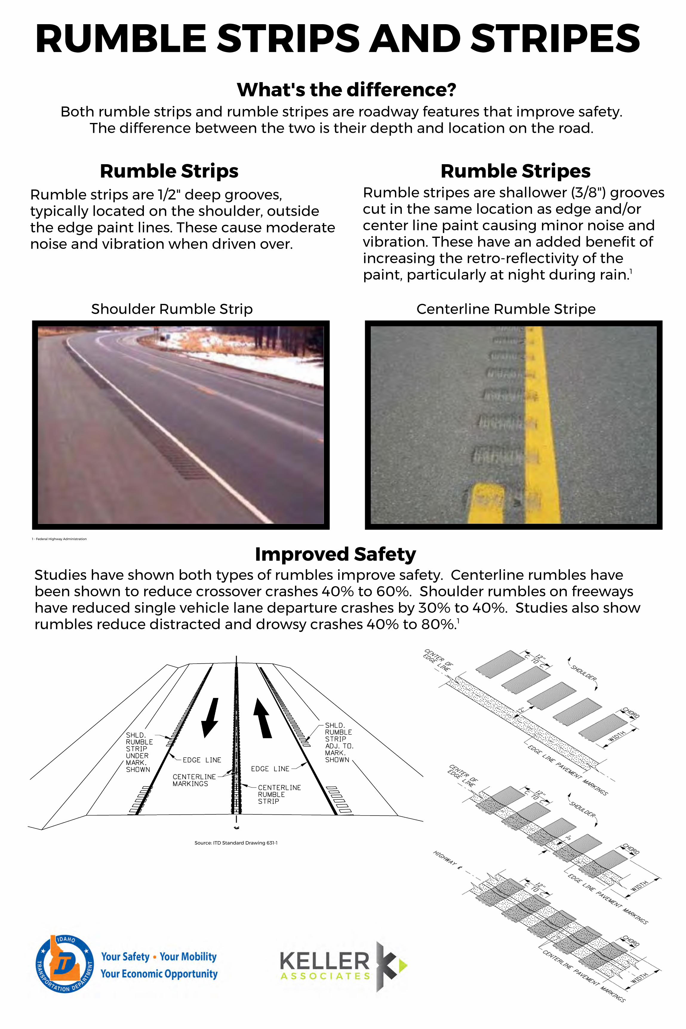
Rumble strips are 1/2" deep grooves,typically located on the shoulder, outsidethe edge paint lines. These cause moderatenoise and vibration when driven over.
Rumble StripsRumble stripes are shallower (3/8") groovescut in the same location as edge and/orcenter line paint causing minor noise andvibration. These have an added benefit ofincreasing the retro-reflectivity of thepaint, particularly at night during rain.1
Rumble Stripes
Centerline Rumble Stripe
Improved Safety1 - Federal Highway Administration
Source: ITD Standard Drawing 631-1
Shoulder Rumble Strip
The difference between the two is their depth and location on the road.
Both rumble strips and rumble stripes are roadway features that improve safety.What's the difference?
RUMBLE STRIPS AND STRIPES
rumbles reduce distracted and drowsy crashes 40% to 80%.1hhaavvee rreedduucceedd ssiinnggllee vveehhiiccllee llaannee ddeeppaarrttuurree ccrraasshheess bbyy 3300%% ttoo 4400%%.. S tS ut du idei se sa lasl os os hs oh wow been shown to reduce crossover crashes 40% to 60%. Shoulder rumbles on freeways Studies have shown both types of rumbles improve safety. Centerline rumbles have
1 - Rosales, J., Road Diet Handbook: Setting Trends for Livable Streets, Institute of Transportation Engineers, Washington, DC, 2006.2 - Federal Highway Administration, Road Diet Policies
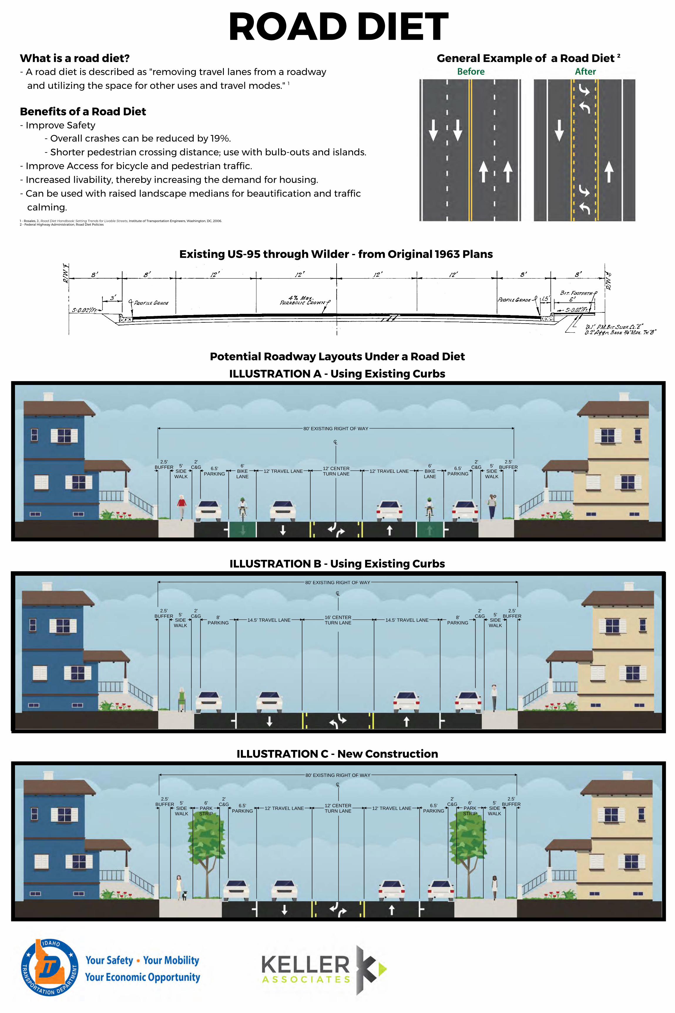
ROAD DIET
2.5'BUFFER 5'
SIDEWALK
6.5'PARKING
6'BIKELANE
12' TRAVEL LANE 12' CENTERTURN LANE 12' TRAVEL LANE
6'BIKELANE
6.5'PARKING
5'SIDEWALK
2.5'BUFFER
2'C&G
2'C&G
80' EXISTING RIGHT OF WAY
CL
2.5'BUFFER 5'
SIDEWALK
2'C&G 8'
PARKING 15' TRAVEL LANE 15' CENTERTURN LANE 15' TRAVEL LANE 8'
PARKING
2'C&G 5'
SIDEWALK
CL
80' EXISTING RIGHT OF WAY
2.5'BUFFER 5'
SIDEWALK
6'PARKSTRIP
2'C&G 6.5'
PARKING 12' TRAVEL LANE 12' CENTERTURN LANE 12' TRAVEL LANE 6.5'
PARKING
2'C&G 6'
PARKSTRIP
5'SIDEWALK
2.5'BUFFER
CL
80' EXISTING RIGHT OF WAY
2.5'BUFFER
General Example of a Road Diet 2
calming.- Can be used with raised landscape medians for beautification and traffic- Increased livability, thereby increasing the demand for housing.- Improve Access for bicycle and pedestrian traffic.
- Shorter pedestrian crossing distance; use with bulb-outs and islands.- Overall crashes can be reduced by 19%.
- Improve SafetyBenefits of a Road Diet
What is a road diet?
Existing US-95 through Wilder - from Original 1963 Plans
ILLUSTRATION B - Using Existing Curbs
ILLUSTRATION C - New Construction
ILLUSTRATION A - Using Existing CurbsPotential Roadway Layouts Under a Road Diet
2.5'BUFFER 5'
SIDEWALK
2'C&G 8'
PARKING 14.5' TRAVEL LANE 16' CENTERTURN LANE 14.5' TRAVEL LANE 8'
PARKING
2'C&G 5'
SIDEWALK
2.5'BUFFER
80' EXISTING RIGHT OF WAY
CL
and utilizing the space for other uses and travel modes." 1
- A road diet is described as "removing travel lanes from a roadway
Thank you for attending today’s meeting. The Idaho Transportation Department appreciates your input. Comments on the corridor study are being accepted through Sept. 20, 2019. Comments can be sent to:• [email protected] or• Idaho Transportation Department, Att. Adam Rush
3311W. State St., Boise, ID 83703
Once the corridor studies are completed, ITD will determine how best to proceed with making the improvements to US 95, US 20/26 and Idaho 19 in Canyon and Owyhee counties.
To stay informed go to:ITDprojects.org/WesternCanyonOwyheeStudy
Thank you and what’s next
Western Canyon and Owyhee County Corridor Studies