Westchester RiverWalk Design Guidelines
100
GUIDELINES MANUAL Andrew J. Spano, Westchester County Executive County Board of Legislators a Greenway Trail Westchester RiverWalk
Transcript of Westchester RiverWalk Design Guidelines
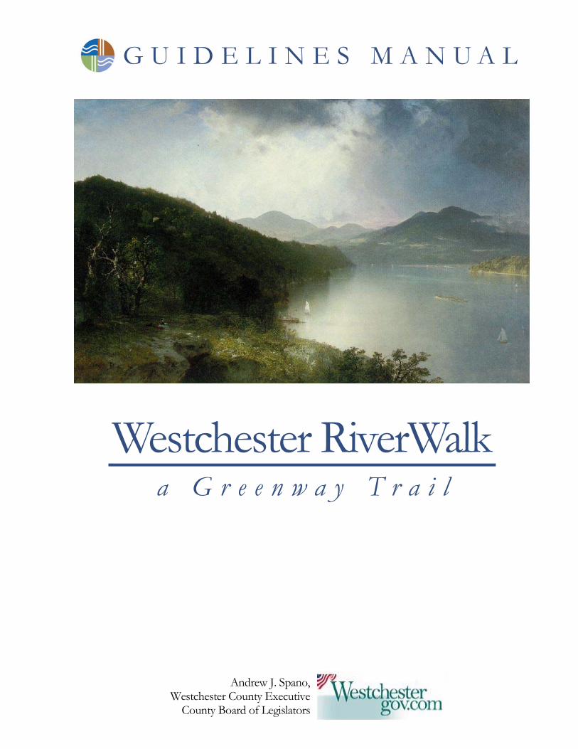
G U I D E L I N E S M A N U A L
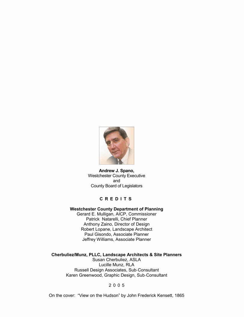
Andrew J. Spano, Westchester County Executive
County Board of Legislators
a G r e e n w a y T r a i l Westchester RiverWalk
Federal Disclaimer The preparation of this report has been financed in part through the U.S. Department of Transportation’s Federal Highway Administration under U.S.C. Title 23, and the Federal Transit Administration, under the Transportation Equity Act for the 21st Century. This document is disseminated under the sponsorship of the Westchester County Department of Transportation in the interest of information exchange. The contents of this report reflect the views of the author who is responsible for the facts and accuracy of the data presented herein. The contents do not necessarily reflect the official views or policies of the Federal Transit Administration, the Federal Highway Administration or the State of New York. This report does not constitute a standard, specification or regulation. This project was funded through matching grants from the Federal Highway Administration under PT 2720914 and PT2721915, and Federal Transit Administration under PT272180Z.
C R E D I T S
Westchester County Department of Planning Gerard E. Mulligan, AICP, Commissioner
Patrick Natarelli, Chief Planner Anthony Zaino, Director of Design
Robert Lopane, Landscape Architect Paul Gisondo, Associate Planner
Jeffrey Williams, Associate Planner
Cherbuliez/Munz, PLLC, Landscape Architects & Site Planners Susan Cherbuliez, ASLA
Lucille Munz, RLA Russell Design Associates, Sub-Consultant
Karen Greenwood, Graphic Design, Sub-Consultant
2 0 0 5
On the cover: “View on the Hudson” by John Frederick Kensett, 1865
Andrew J. Spano, Westchester County Executive
and County Board of Legislators
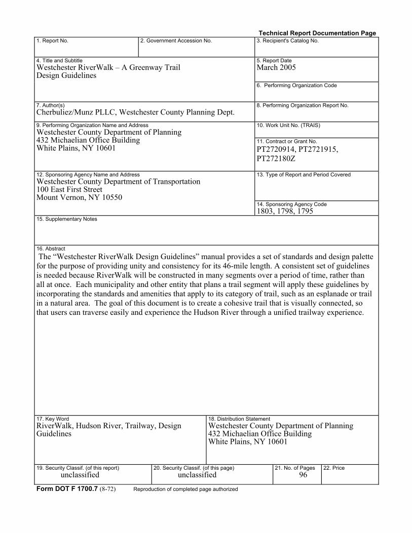
Technical Report Documentation Page 1. Report No.
2. Government Accession No.
3. Recipient's Catalog No. 5. Report Date March 2005
4. Title and Subtitle Westchester RiverWalk – A Greenway Trail Design Guidelines
6. Performing Organization Code
7. Author(s) Cherbuliez/Munz PLLC, Westchester County Planning Dept.
8. Performing Organization Report No. 10. Work Unit No. (TRAIS)
9. Performing Organization Name and Address Westchester County Department of Planning 432 Michaelian Office Building White Plains, NY 10601
11. Contract or Grant No. PT2720914, PT2721915, PT272180Z 13. Type of Report and Period Covered
12. Sponsoring Agency Name and Address Westchester County Department of Transportation 100 East First Street Mount Vernon, NY 10550
14. Sponsoring Agency Code 1803, 1798, 1795
15. Supplementary Notes
16. Abstract The “Westchester RiverWalk Design Guidelines” manual provides a set of standards and design palette for the purpose of providing unity and consistency for its 46-mile length. A consistent set of guidelines is needed because RiverWalk will be constructed in many segments over a period of time, rather than all at once. Each municipality and other entity that plans a trail segment will apply these guidelines by incorporating the standards and amenities that apply to its category of trail, such as an esplanade or trail in a natural area. The goal of this document is to create a cohesive trail that is visually connected, so that users can traverse easily and experience the Hudson River through a unified trailway experience.
17. Key Word RiverWalk, Hudson River, Trailway, Design Guidelines
18. Distribution Statement Westchester County Department of Planning 432 Michaelian Office Building White Plains, NY 10601
19. Security Classif. (of this report) unclassified
20. Security Classif. (of this page) unclassified
21. No. of Pages 96
22. Price
Form DOT F 1700.7 (8-72) Reproduction of completed page authorized
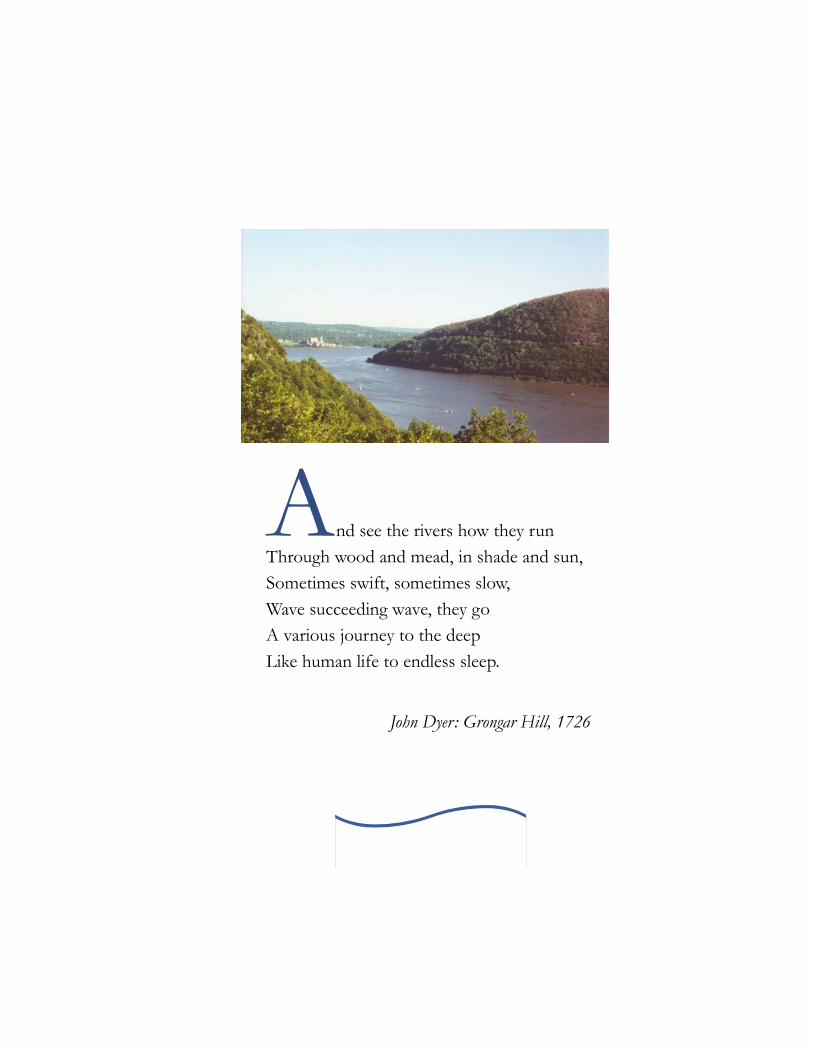
A nd see the rivers how they run Through wood and mead, in shade and sun, Sometimes swift, sometimes slow, Wave succeeding wave, they go A various journey to the deep Like human life to endless sleep.
John Dyer: Grongar Hill, 1726
table of Contents
2 T A B L E O F C O N T E N T S
Introduction How to Use This Manual Categories of Trails Multi-Use Trail - Table A Multi-Use Trail Along Roads or in Parking Lots - Table B Pedestrian Trails - Table C-1: In Constrained Area - Table C-2: In Natural Area Bicycle Trail on Road - Table D Trail Adjacent to Railroad - Table E Trail Where Existing Land Area is Limited - Table F Esplanade - Table G
3
2
1 5
9
13
14 15
16 17
18 1920
21
22 23
24 25
26 27
T A B L E O F C O N T E N T S 3
Amenities Standard Amenities - Signage - Surface Materials - Seating - Bicycle Racks & Trash Receptacles - Lighting - Bollards - Railing & Fencing - Planting Suggested Amenities - Structures - Bridges - River Access/Edge Treatments - Miscellaneous Typical Scenarios A: Trail Through an Existing Parking Area B: Trail Adjacent to Railroad C: Tributary Treatment with Access to Water from Trail D: Trail with Limited Land Area E: Esplanades in Industrial Areas F: Linkages on Existing Sidewalks Linkages, Parking, & Traffic Control Resources
60
4
5
6
7
29
30
64 65 66 67 69 72
81 8384 85
87
87 88
88 89 90 91
93
95
table of Contents
N E W J E R S E Y
N E W Y O R K
Tuck
ahoe
Pelham
Ardsley
Bronxville
VERNON
SleepyHollow
Eastview
PocanticoHills
EA
STC
HE
STE
R
YORKTOWN
CASTLE
NEW
P U T N A M C O U N T Y
R O C K L A N D
C O U N T Y
287
87
Cross County
Pkwy
Saw
Pkw
ySp
rain
Broo
k
Par
kway
Cen
tral
Ave.
New Croton R
es.
Tac
onic
Stat
e
Par
kway
HRTW Study Area / Rockland Villages
County & State Parks
Nature Preserves
Institutions
Palisades
Parkw
ay
Map produced by theWestchester County Planning Department
updated August 2004
Jerry Mulligan, AICP, CommissionerPaul Gisondo, Associate Planner/Cartographer
Major Industrial Areas
Rockefeller State ParkPreserve
CrotonPoint
CountyPark
OscawanaCountyPark
Georges IslandCounty Park
Blue Mountain
Reservation
County Park
Depew
Park
Charles Pt.Park
Croton Gorge
County Park
Briarcliff
Peekskill
Trailway
Old Croton AqueductTrailway
Old
Croton
Aqueduct
Trailway
Nor
th
Coun
ty
Trai
lway
Sout
h
Cou
nty
Trailw
ay
Old
Cro
ton
Aqu
educ
tTr
ail.
Mountain
Parkway
Bear MountainBridge
87
Railroad Stations
Putnam
R.O
.W.
RiverfrontGreenPark
SteamboatRiverfront
Park
Kingsland Point County Park
Kykuit
Lyndhurst
Sunnyside
Nyack
NewCity
CLARKSTOWN
Haverstraw
ORANGETOWNPiermont
Tappan Zee Bridge
MOUNT
PLEASANT
Elms-ford
G R E E N B U R G H
MOUNT
Yonkers Pier
Waterfront IndustrialRedevelopment Opportunities
Alexander St.Waterfront
Project
Hudson Park Dev.
Beczak Center
MacEachon Park
Waterfront Park
MatthiessenPark
Pierson Park
LoseePark
Sparta Park
EngelPark
CrawbuckiePreserve
Senasqua Park
TeatownReservation
GeneralMotors Site
Indian PointFacility
35202
6
6
202
129
9A
134
9
117
9
9
9
100
100
22
100
133
CrotonLanding Park
KolpingSociety
MontrosePt. ParkNYSDEC
County, State and other Regional Trails
RiverWalk RouteOn publicly accessible landsand road rights-of-way: 34 miles
PEEKSKILL
99A
Ossining
Hudsonon
Hastings
Riv
er
Dobbs Ferry
Y O N K E R S
Mill
GettySquare
9
Landing Park
NYS MilitaryReservationCamp Smith
VerplanckBuchanan
MontroseCORTLANDT
Rockefeller State Park
PreserveRockwood Hall
PhelpsHospital
County Waterfront Park
Mariandale
Horseman'sTrail
RiverWalkat VA Hospital
CrossiningRt. 9 Bike Path
9
Old
Cro
ton
Aqu
educ
t
Trai
lway
LenoirCountyPreserve
Hudson River Museum
JKF Marina
Local Parks
6
35 202
129
ScenicHudson
Park
Anaconda
Tarrytown
YonkersWastewater Treatment
Plant
GrahamSchool
Hillside Woo
ds T
rail
Camp
Smith
Trail
Toll HouseVisitor Center
Cortla
ndt
Shor
elin
e Tra
il
2
4
9
10
11
12
13
Approved for FundingPotential
Yonkers WaterfrontCounty Park
UntermyerPark
Furnace
Dock R
d.
SingSing
Crotonon
Hudson
6
7
Harbor Square
Briarcliff Manor
8
Irvington
War
burt
onA
ve.
Riv
erda
leA
ve.
Trevor Park
Bear
Havers traw
-Ossining
Ferry
County Asphalt
Broa
dway
DiscoveryCove at
Half MoonBay
RESCO
Ardsley-on-Hudson Sta.
Glenwood Sta.
Scarborough Sta.
HudsonHighlandsState Park
Main St.
Half Moon Bay Br.
Cro
ton
Pt. Ave.
OSSINING
No.
Highland
Ave.
5
Scarborough
Station Rd.
Main St.
MercyCollege
WalnutSt.
WickersCreekX-ing
9
ZinsserBridge
LouisaSt.
Kings FerryRd.
Bear Mtn Bridge / Hook Rd.
AnnsvilleBridge
SummitLanding
U/C.
Main St.
Greystone Sta. OdellAve.
Yonkers NorthHudson
Promenade
Hook
Mountain
-N
yackBeach
Greenw
ayT
rail
Nyack Beach StatePark
1
3
Hudson River Access Points(Hudson River Access Study 9/00 - Westch. Co)
9W
9W
9W
9W
304
303
303
59
340
Long Path
Long Path
LongPath
Long
Path
202
202
202
9W
9W
STONYPOINT
28787NYS Thruway
UpperNyack
Tallman
Mtn.
State
Park
BlauveltStatePark
HookMtn.StatePark
High TorState Park
Bear Mountain
State Park
Hudson Highlands State Park
9A
9A
Greenway Designated Trails
Greenway Designated Trails (RiverWalk Rte)
Westchester County Land Use
C I T Y O F N E W Y O R K
0 2
Scale in Miles
1
Appalachian
RiverWalk RouteRestricted/limited access: 12 miles
Marinello Cove
9
GlenwoodAve.
Rav
ine
Ave
Babcock Pl.
PauldingAve
Clinton Av.
Riv
ersi
de D
r.
PeabodyField
Pokahoe
PhilipsburgManor
DeVriesPark
Country Club Lane
Riv
er R
d.K
emey
's A
ve.
BatteryPlace
M
ontrose Pt Rd
Sunset Rd.
VAHospital
Riverview Av.
Lents Cove Park
Travis Cove
Annsville Preserve
John
Wal
shB
lvd.
Pemart Av.
Lake
Mea
hagh
BrintonBrook
Sanctuary
GraffSanc.
Haw
thor
ne A
v.B
uena
Vis
ta A
v.
Fern
broo
kSt
.
Ludlow Sta.
Hastings Sta.
Irvington Sta.
Yonkers Sta.
KraftFoodsSite
Kendall Development
Philipse Manor Sta.
Croton Harmon
Sta.
Cortlandt Sta.
PeekskillSta.
Railroad 1Area
Trail
Anthony'sNose
900' elevation
Cortlandt
St.
Crugers Bridge
9
9A
OssiningSta.
HunterSt.
Spr
ing
St.
Snow
den
Ave.
Water S
t.
1
2
3
4
5
6
7
8
9
1010
1111
12121313
1414
1515
1616
1818
1919
2020
2121
2222
2323
2424
2525
2626
2727
2828
2929
1717
5 RiverWalk Segment Number
Yonkers Esplande Park
Rowley's BrookTrail
RiverWalk at VA Hospital, Montrose
Steamboat Riverfront Park, Verplanck
‘Crossining’ Greenway Bike/Ped Pathalong Route 9 over Croton River
RiverWalk at Croton Landing ParkVillage of Croton-on-Hudson
Old Croton Aqueduct Trailway, Ossining
RiverWalk at Scenic Hudson ParkVillage of Irvington
Hudson Park, Yonkers Waterfront
Path on Annsville Bridge, Peekskill
Riverfront Green Park, Peekskill
Kings Ferry Road Path alongLake Meahagh, Montrose
View of Oscawana Island County Park
Old Croton Aqueduct Trail, Dobbs Ferry
A Hudson R ive r Tr a i l s pann ing 46 mi l e s in Wes t ches t e r
Kingsland Point Co. Park, Sleepy Hollow
Rockefeller State ParkRockwood Hall area
AAnnddrreeww JJ SSppaannoo,, WWeessttcchheesstteerr CCoouunnttyy EExxeeccuuttiivveeWWeessttcchheesstteerr CCoouunnttyy BBooaarrdd ooff LLeeggiissllaattoorrss
L
N
M
A
B
D
C
E
F
G
H
I
J
K
A
B
C
D
E
F
G
H
I
J
K
L
M
N
T he goal of the Guidelines for Westchester RiverWalk is to create a cohesive trail that is visually
connected, so that users can traverse easily in an attractive setting, and can experience the Hudson River through a unified trail way experience. The Guidelines will serve as a set of standards and a design palette that will unify the trail and establish a consistent approach for construction. These Guidelines are a vital tool because RiverWalk will be constructed in segments, over a period of time, rather than all at once. The ultimate goal is to connect all segments, either physically or through signage and other markers, in order to create a 46-mile trail. Each municipality and other entity that plans a trail segment can apply these Guidelines by
it a reality. A plan, “Westchester RiverWalk: Hudson River Trailway Plan,” was prepared by the Department and released in
September 2003. The plan showed how the concept co uld be realized – one segment at a time – through partnerships of local, county and st ate governments, agencies, l a n d o w n e r s a n d developers. The key element was partnership.
This report shows how the physical aspects of RiverWalk can be coordinated to create a continuous trail. This trail will be the result of many projects by many participants in the wide variety of situations encountered in each riverfront municipality.
T he Westchester RiverWalk will be a cont inuous t ra i l para l le l ing Westchester County’s 46 miles of
Hudson River shoreline between New York City and Putnam County. Offering a variety of experiences and serving m a n y f u n c t i o n s , RiverWalk will link the Hudson River villages, historic sites, parks and river access points via a connection of trails, e s p l a n a d e s a n d boardwalks. Westchester County Executive Andrew Spano initiated the concept of RiverWalk by drawing a line on a map. He then challenged the County Department of Planning to make
I N T R O D U C T I O N 5
G o a l o f G u i d e l i n e s
Introduction 1 SEC T IO N
O v e r v i e w
incorporating the standards and amenities that apply to its category of trail, such as an Esplanade or a Trail in a Natural Area. These Guidelines will serve to meet the needs of all users in varying conditions. The manual describes how to accommodate pedestrians and bicyclists along with other users, in most environments, but cannot address all possible situations. It does, however, provide a foundation upon which each segment can be developed to incorporate specific individual needs and conditions. The guidelines noted within this manual represent a thorough and organized effort to provide sound design principles in order to attain a cohesive RiverWalk trail experience.
(continued on page 6)
be selected to tolerate these conditions. Other considerations will have to respond to the specific River environment of each trail segment. Limited or Difficult Accessibility for Construction and Maintenance Some areas will be difficult to access. Material may need to be barged in by boat or brought in small loads to the site. Since repair and maintenance may be difficult, an initial investment in high-grade material is necessary. Anticipated Heavy Usage Because of the anticipated heavy usage, material for RiverWalk must be durable, strong, stable and tolerant of heavy wear.
I n t r o d u c t i o n c o n t i n u e d . . .
6 I N T R O D U C T I O N
P e r m i t t i n g & E n g i n e e r i n g S e r v i c e s
G U I D E L I N E S M A N U A L
S i t e C o n d i t i o n s
The conditions that must be considered during planning, design and construction include:
Soil Conditions Including Fill Some locations designated for RiverWalk are composed of wet or unstable soils while other locations will be in areas of fill. Therefore, footings and paving materials must account for the varied soil conditions to achieve stability and longevity. Geotextile material may be needed, for the trail itself, in selected soil conditions. Waterfront Conditions The unique waterfront environment must be considered when constructing along the Hudson River. The freeze/thaw conditions in the winter necessitate careful location and construction of piers, breakwaters and other amenities in or at the water. Wind and brackish water requires that plant material
D epending on the site conditions and the anticipated scope of work, it is possible that Federal and State
permits may be required. It will be advisable to have the municipal engineer, or a consulting engineer, review the scope of the project during the initial design process to
determine if and what permits may be required. Engineering and environmental services may also be needed to address specific site conditions, such as soil conditions, rock and wetlands.
other areas with constraints that could limit the usage because of conditions such as steep grades or limited space for a wide enough trail to accommodate different users. Signage and maps will designate where the trail is specifically limited to pedestrians and where there are other special conditions for use. (continued on page 8)
G U I D E L I N E S M A N U A L
I N T R O D U C T I O N 7
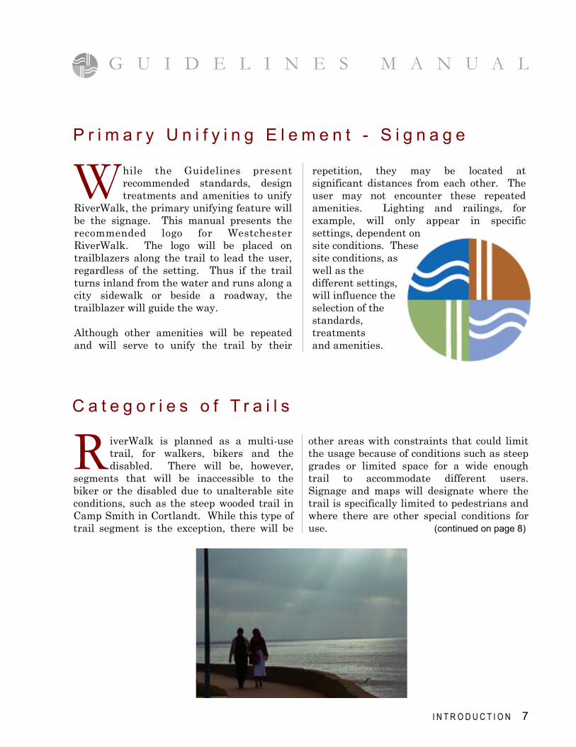
P r i m a r y U n i f y i n g E l e m e n t - S i g n a g e
W hile the Guidelines present recommended standards, design treatments and amenities to unify
RiverWalk, the primary unifying feature will be the signage. This manual presents the recommended logo for Westchester RiverWalk. The logo will be placed on trailblazers along the trail to lead the user, regardless of the setting. Thus if the trail turns inland from the water and runs along a city sidewalk or beside a roadway, the trailblazer will guide the way. Although other amenities will be repeated and will serve to unify the trail by their
repetition, they may be located at significant distances from each other. The user may not encounter these repeated amenities. Lighting and railings, for example, will only appear in specific settings, dependent on site conditions. These site conditions, as well as the different settings, will influence the selection of the standards, treatments and amenities.
C a t e g o r i e s o f T r a i l s
R iverWalk is planned as a multi-use trail, for walkers, bikers and the disabled. There will be, however,
segments that will be inaccessible to the biker or the disabled due to unalterable site conditions, such as the steep wooded trail in Camp Smith in Cortlandt. While this type of trail segment is the exception, there will be
G U I D E L I N E S M A N U A L
8 I N T R O D U C T I O N
( s e e R e s o u r c e s : p a g e 9 5 , f o r c o n t a c t i n f o r m a t i o n )
I n t r o d u c t i o n c o n t i n u e d . . .
W hile the Guidelines have been deve loped spec i f i ca l ly f or RiverWalk, they are based on the
current state of the practice and reflect the judgment of professionals experienced in accommodating pedestrians, bicyclists and other potential trail users. Where possible, ADA Accessibility Guidelines have been adhered to in this manual. Where Federal and State funding is provided, certain standards may be required. These other standards and guidelines include AASHTO standards, NYS DOT regulations and ADA requirements. They are referred to in this manual where appropriate. See Section 7: Resources which identifies the specific sources. When the trail is in design, the municipal engineer or a consulting engineer will have to
assist and make recommendations regarding the need to adhere to AASHTO standards, NYS DOT regulations and ADA requirements. ADA: If ADA Accessibility Guidelines are to be adhered to, the components, which must be evaluated for compliance, include the longitudinal slope, railings, the need for ramps with railings, drainage structure grates and signage. AASHTO: In specific conditions, such as where the trail intersects with a state or municipal road, AASHTO standards may be required. NYSDOT: In specific locations, NYSDOT regulations may have to be followed.
C a t e g o r i e s o f T r a i l s
H O W T O U S E T H I S M A N U A L 9
“How do we get ideas for design of the trail
in special settings?”
Check Section 5: Typical Scenarios for ideas and guidance in developing the design of your trail in special settings.
“What if the only place
we can provide part of our trail is on our sidewalks?”
Linkages or Trails on Existing Sidewalks: You may use existing sidewalks when conditions do not allow space to develop a trail. The
municipality can then use their existing sidewalks as the trail and the linkage to other trail segments. Here the logo or trailblazer will play an important role. See Section 4 on Amenities: Signage. Also see Section 6: Linkages.
Step 5
Step 4
This Manual how to use
Municipalities or other entities will use the Guidelines in the layout and design of their trail segment. The municipality may create
a Citizens RiverWalk Committee to work with the municipal officials on the development of the Trail segment. When private entities are developing
a Trail segment, the municipality where the Trail will be located, will work closely with the developer to insure that the Guidelines are followed.
“Where do we begin?”
The first step is to identify how much width you have to layout the trail and the type of trail you want. The available space and intended
use will determine the category of your trail.
“What category is our trail?”
Based on the physical features (width and length available, slope, adjacent constraints, etc.) and the types of uses to be encouraged
(heavy usage, limited usage, multi-use, varied activities on the trail), determine the category of trail, selecting from the different categories listed in Section 3. You may want to review the example of typical scenarios for the RiverWalk, illustrated in Section 5, for further clarification.
“After we identify our category,
what do we do next?”
Apply the Standards in Section 3 for your selected category, read the discussion and look at the sketches.
Step 1
Step 2
Step 3
2 SEC T IO N
for your trail (also see Step Eight). Any other site study costs, such as soil investigation, archeology and/or construction supervision costs should be part of the proposed budget. “How do we get our trail built?”
If you are a municipality, you will prepare construction documents for bidding purposes, done either in house or by a consultant, based on
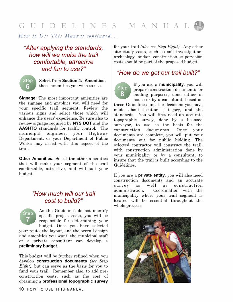
these Guidelines and the decisions you have made about location, category, and the standards. You will first need an accurate topographic survey, done by a licensed surveyor, to use as the basis for the construction documents. Once your documents are complete, you will put your documents out for public bidding. The selected contractor will construct the trail, with construction administration done by your municipality or by a consultant, to insure that the trail is built according to the Guidelines. If you are a private entity, you will also need construction documents and an accurate survey as well as construction administration. Coordination with the municipality where your trail segment is located will be essential throughout the whole process.
“After applying the standards, how will we make the trail
comfortable, attractive and fun to use?”
Select from Section 4: Amenities, those amenities you wish to use.
Signage: The most important amenities are the signage and graphics you will need for your specific trail segment. Review the various signs and select those which will enhance the users’ experience. Be sure also to review signage required by NYS DOT and the AASHTO standards for traffic control. The municipal engineer, your Highway Department, or your Department of Public Works may assist with this aspect of the trail. Other Amenities: Select the other amenities that will make your segment of the trail comfortable, attractive, and will suit your budget.
10 H O W T O U S E T H I S M A N U A L
“How much will our trail cost to build?”
As the Guidelines do not identify specific project costs, you will be responsible for determining your budget. Once you have selected
your route, the layout, and the overall design and amenities you want, the municipal staff or a private consultant can develop a preliminary budget. This budget will be further refined when you develop construction documents (see Step Eight), but can serve as the basis for you to fund your trail. Remember also, to add pre-construction costs, such as the cost of obtaining a professional topographic survey
Step 6
Step 7
Step 8
G U I D E L I N E S M A N U A L H o w t o U s e T h i s M a n u a l c o n t i n u e d . . .
G U I D E L I N E S M A N U A L
H O W T O U S E T H I S M A N U A L 11
“How can the trail help the community?”
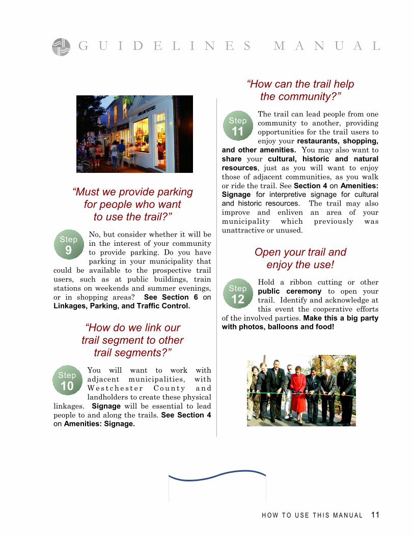
The trail can lead people from one community to another, providing opportunities for the trail users to enjoy your restaurants, shopping,
and other amenities. You may also want to share your cultural, historic and natural resources, just as you will want to enjoy those of adjacent communities, as you walk or ride the trail. See Section 4 on Amenities: Signage for interpretive signage for cultural and historic resources. The trail may also improve and enliven an area of your municipality which previously was unattractive or unused.
Open your trail and enjoy the use!
Hold a ribbon cutting or other public ceremony to open your trail. Identify and acknowledge at this event the cooperative efforts
of the involved parties. Make this a big party with photos, balloons and food!
“Must we provide parking for people who want
to use the trail?”
No, but consider whether it will be in the interest of your community to provide parking. Do you have parking in your municipality that
could be available to the prospective trail users, such as at public buildings, train stations on weekends and summer evenings, or in shopping areas? See Section 6 on Linkages, Parking, and Traffic Control.
“How do we link our trail segment to other
trail segments?”
You will want to work with adjacent municipalities, with W e s t c h e s t e r C o u n t y a n d landholders to create these physical
linkages. Signage will be essential to lead people to and along the trails. See Section 4 on Amenities: Signage.
Step 10
Step 9
Step 11
Step 12
C A T E G O R I E S O F T R A I L S 13
Categories of Trails I n t r o d u c t i o n
T he standards for the categories of trails are prepared for municipalities and other entities that will design
and construct segments of RiverWalk. The walk is to adhere to the Guidelines of the Americans with Disabilities Act (ADA), where feasible and practical. W e s t c h e s t e r RiverWalk is planned as a multi-use trail adjacent to the Hudson River. At times, the trail will have to detour off the waterfront, such as through municipal settings, using the existing sidewalks as the linkage between the RiverWalk segments. In some situations, existing trails such as the Croton Aqueduct, will be used as the linkage. In still other situations, the trail will be located along a road or in a parking lot. Because of site conditions, the type of trail developed will vary. In some cases, the
trail’s use will be limited to pedestrians, or may not be suitable for those with disabilities or on bicycles. Different categories of trails have been identified to represent the different settings
which wil l be e nco unte red a s R i v e r W a l k i s developed. The accompanying Tables p r o v i d e t h e standards for each category of trail. Signage will play a majo r ro le in identifying the uses of the trail, any limitations, and
directing users to the linkages. See Section 4 on Amenities: Signage for details of the sign standards. An overview of each of the trail categories is provided along with an illustration and accompanying chart.
A: Multi-Use Trail B: Multi-Use Trail On Roads & In Parking Lots C: Pedestrian Trail c-1 - In Constrained Area c-2 - In Natural Area
L I S T O F C A T E G O R I E S
D: Bicycle Trail On Road E: Trail Adjacent To Railroad F: Trail With Limited Land Area G: Esplanade
3 SEC T IO N
G U I D E L I N E S M A N U A L
14 C A T E G O R I E S O F T R A I L S
Multi-Use Trail A
MULTI-USE TRAIL
D i s c u s s i o n
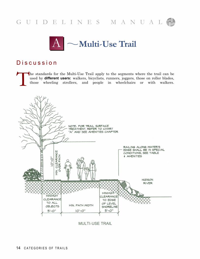
T he standards for the Multi-Use Trail apply to the segments where the trail can be used by different users: walkers, bicyclists, runners, joggers, those on roller blades, those wheeling strollers, and people in wheelchairs or with walkers.
C A T E G O R I E S O F T R A I L S 15
R I V E R W A L K S T A N D A R D S F O R C A T E G O R I E S O F T R A I L S
f e a t u r e s t a n d a r d s c o m m e n t s
Trail Width
10' min - 16' wide
• Trails with anticipated high volume or length greater
than a 1/2 mile shall be 12'-16'
Width Clearance
Min. 5'- 0" from outside edge of trail
to any object
• Clearance to all fixed objects, such as fences, poles, signs, benches, parked cars & top of slope at water's edge
Special Width
Clearances
On a case by case basis, based on various site constraints
• Site constraints include steep slopes, distance from railroad, proximity to water's edge & situations where barriers are not feasible or desired
Height Clearance
10'-0" Ht. clearance from finished grade of trail
• Clearance to all overhead elements such as tree limbs, signs, lighting etc.
Cross-slope
Pitch
2% Min. & Max. Cross-pitch slope
• If trail is to be crowned for grading and drainage purposes, the max. & min. slope shall be
2% from centerline of trail
Longitudinal
Slope
5% Maximum
• If land adjacent to the trail is sloped greater than 5%, the trail may be aligned in a curved manner to achieve 5% maximum longitudinal slope.
Surface Material
Impervious material: asphalt concrete, concrete
or asphalt pavers, flagstone or granite
• See Amenities Section - also for special conditions over water or in limited land mass
Railing (for protection or
as barrier)
See pg 70 - Railing along Waterfront
Railing or other barriers are provided in specific
situations of need
• Adjacent slope or shoreline more than 1:3 slope • Adjacent road and or parking if less than 5' distance • Adjacent railroad • Unattractive or potentially unsafe condition
Curbing
There shall be no curbing along the edge of the trail unless an
adjacent slope warrants curbing
• The trail is to be flush with adjacent land with no trip hazard between trail and adjacent land.
• Curbing shall be used only to stabilize adjacent slopes.
Trail Border
or Edge
Trail edging shall be optional
and must be flush with trail surface
• Edging materials: brick, precast concrete pavers, flagstone, granite. Wood edging may be used
with asphalt. • Passage area must be 10' minimum not including
border or edging
Lighting
Height and distance between poles to be established on
case by case basis
• See Amenites Section
Miscellaneous
Benches, waste containers, planters, etc. to be located
on a case by case basis
• See Amenities Section
Multi-Use Trail A
T A B L E
G U I D E L I N E S M A N U A L
D i s c u s s i o n
T he standards for the Multi-Use Trail along roads and in parking lots are based primarily on creating a safe and
visually pleasing experience for the user. The standards correspond in large part to those for A. Multi-Use Trail, described on page 14. If there is a limited area along the roadway or
G U I D E L I N E S M A N U A L
16 C A T E G O R I E S O F T R A I L S
in the parking lot, making a trail of 10’-0” impossible to construct, the trail will become a Pedestrian Trail, as noted in the two Pedestrian Trails, C.1. and C.2. Signage is to be provided indicating the trail’s use as being limited to people on foot, with no bicyclists allowed.
Multi-Use Trail On Roads & In Parking Lots
B
MULTI-USE TRAIL ON ROADS & IN PARKING LOTS
N O T E :
Designers of RiverWalk are advised to meet with their municipal DOT and to review the NYS Highway Design Manual, chapter 18 -
Facilities for Pedestrians and Bicyclist. (see section 7– Resources), to insure safety for both trail users and vehicles.
G U I D E L I N E S M A N U A L
R I V E R W A L K S T A N D A R D S F O R C A T E G O R I E S O F T R A I L S
f e a t u r e s t a n d a r d c o m m e n t s
Trail Width
10' min - 16' wide
• Where limited space, a pedestrian trail of 6'- 0" minimum can be built, signing it for Pedestrians Only
Width
Clearance
Min. 5'- 0" from outside edge
of trail to any object
• Clearance to all fixed objects, such as fences, poles, signs, benches, parked cars & top of slope at water's edge
Special Width
Clearances
On a case by case basis,
based on various site constraints
• Constraints may include steep slopes, distance from railroad, proximity to water's edge & situations where barriers are not feasible or desired
Height Clearance
10'-0" Ht. clearance from finished grade
• Clearance to all overhead elements such as tree limbs, signs, lighting etc.
Cross-slope
Pitch
2% Min. & Max. Cross-pitch slope
• Where trail is to be crowned for grading and drainage purposes, the max. & min. slope
shall be 2% from centerline of trail
Longitudinal Slope
5% Maximum
• If the land adjacent to the trail is sloped greater than 5%, the trail may be aligned
in a curved manner to achieve 5% maximum longitudinal slope
Surface Material
Impervious material: asphalt, concrete, concrete pavers, bluestone, or granite
• See Amenities Section
Railing
Wood guiderail per NYS DOT, installed in paved area, in addition
to 6' or 10' trail width
• As separation of Trail from road and/or parking lot
Fencing & other
Barriers
On a case by case basis,
where physical separation advisable
• Adjacent slope or water level more than 1:3 slope • Adjacent railroad • Unattractive or potentially unsafe condition
Curbing
There shall be no curbing along
edge of trail unless an adjacent slope warrants curbing
• The trail is to be flush with adjacent land with no trip hazard between the trail and adjacent land. • Curbing shall be used only where necessary to stabilize adjacent slopes.
Trail Border or Edge
Trail edging shall optional and must be flush with trail surface.
• Edging materials: brick, precast concrete pavers, flagstone, granite. Wood edging may be used w/asphalt.
• Passage area must be 10' minimum not including border or edging
Lighting
Height & distance between poles to be established on case by case basis
• See Amenities Section
Miscellaneous
Benches, wast containers, planters, etc. to be located
on a case by case basis
• See Amenities Section
Multi-Use Trail On Roads & In Parking Lots
C A T E G O R I E S O F T R A I L S 17
B T A B L E
A segment of RiverWalk in a natural area is best exemplified by the trail in Camp Smith, where steep slopes, and heavy woods create a limited access trail, more similar to a hiking trail than a walking trail. If other segments have similar characteristics, most of the standards will have to be determined on a case by case basis generally. Those standards on the chart do apply.
G U I D E L I N E S M A N U A L
18 C A T E G O R I E S O F T R A I L S
D i s c u s s i o n
T wo types of Pedestrian Trails have been identified for development in constrained areas: C-1: Pedestrian
Trail in Constrained Area, and C-2: Pedestrian Trail in Natural Area.
Pedestrian Trail C
C-2 : PEDESTRIAN TRAIL IN NATURAL AREA
C-1: PEDESTRIAN TRAIL IN CONSTRAINED
AREAS
G U I D E L I N E S M A N U A L
C A T E G O R I E S O F T R A I L S 19
R I V E R W A L K S T A N D A R D S F O R C A T E G O R I E S O F T R A I L S
Pedestrian Trail In Constrained Area (not adjacent to road or parking)
f e a t u r e s t a n d a r d c o m m e n t
Trail Width
6'-0" minimum width
• This pedestrian trail is in areas where there are physical barrier & site constraints that limit the ability to develop a wider trail.
Width Clearance
Min. 2'- 0" from outside edge of trail
to any object
• Clearance to all fixed objects, such as fences, poles, signs, benches, parked cars & top of slope at water's edge
Special Width Clearances
On a case by case basis,
based on various site constraints
• Constraints may include steep slopes, distance from railroad, proximity to water's edge & situations
where barriers are not feasible or desired
Height Clearance
10'-0" Ht. clearance from finished grade
• Clearance to all overhead elements such as tree limbs, signs, lighting etc.
Cross-slope Pitch
2% Min. & Max.
Cross-pitch slope
• Where trail is to be crowned for grading and drainage purposes, the max. & min. slope shall be 2% from centerline of trail
Longitudinal Slope
5% Maximum
Surface Material
Impervious material: asphalt, concrete, concrete pavers,
bluestone, or granite
• See Amenities Section
Railing, Fencing & other Barriers
On a case by case basis, where physical
separation advisable
• Adjacent slope or water level more than 1:3 slope • Adjacent railroad • Unattractive or potentially unsafe condition
Curbing
There shall be no
curbing along edge of trail unless an adjacent
slope warrants curbing
• The trail is to be flush with adjacent land. • There shall be no trip hazard between the trail and adjacent land. • Curbing shall be used only where necessary to
stabilize adjacent slopes
Trail Border or Edge
No border or edging shall be provided except if surface
material is asphalt
• Edging material may be brick, precast concrete pavers, flagstone or granite.
• Overall width of the path may not increase by more than 1'-0" on either side; asphalt must be 4'-0" min.
Miscellaneous
• If there is the ability to cantilever the trail over the water to make a wider trail, see Chart F. , Limited Land Mass
C-1 T A B L E
G U I D E L I N E S M A N U A L
20 C A T E G O R I E S O F T R A I L S
R I V E R W A L K S T A N D A R D S F O R C A T E G O R I E S O F T R A I L S
f e a t u r e s t a n d a r d c o m m e n t
Trail Width
5'-0" minimum width
• This trail for natural areas with emphasis on minimal site disturbance
Width Clearance
Min. 2'- 0" from outside edge of trail
to any object
• Clearance to all fixed objects, such as trees, rocks, etc.
Special Width Clearances
On a case by case basis, based on various site
constraints
• Constraints may include steep slopes where more width clearance is needed, or rock outcroppings were no clearance is possible
Height Clearance
10'-0" Ht. clearance from finished
grade
• Clearance to all overhead elements such as tree limbs, signs, etc.
Cross-slope Pitch
On a case by case basis, based on various site constraints
Longitudinal Slope
On a case by case basis, based on various site constraints
Surface Material
Compacted stone dust, stabilized crushed
stone paving, chipped or
shredded harwood
• See Amenities Section
• When slope is over 5%, consider use of water logs to slow drainage
Handrails
On a case by case basis, based on various site constraints
• Handrails are required for all steps or step ramp areas
Steps or
step ramps
Use 6"-8" round locust or cedar posts,
5' length, anchored into grade by
15" long iron rods
Trail Border or Edge
No border or edging shall normally be providing
• In rugged and steep terrain, cedar logs or stone borders may help to reduce erosion
Pedestrian Trail In Natural Area C-2 T A B L E
G U I D E L I N E S M A N U A L
C A T E G O R I E S O F T R A I L S 21
D i s c u s s i o n
F or a Bicycle Trail On Road, the AASHTO standards (Guide for the Development of Bicycle Facilities) and the NYS DOT, Highway Design Manual, Chapter 18 – Facilities for Pedestrians and Bicyclists (See Section 7. Resources) shall be consulted.
Bicycle Trail On Road D
BICYCLE TRAIL ON ROAD WITH/WITHOUT CURB
R I V E R W A L K S T A N D A R D S F O R C A T E G O R I E S O F T R A I L S
f e a t u r e s t a n d a r d c o m m e n t s
Trail Width
With curb: 1.5 m. min. per NYS DOT (4.92')
Without curb: 1.2 min.
per NYS DOT (3.94')
• Signage indicating bike lane as well as "Share the Road" is required.
Miscellaneous
Striping is to be provided
on roadway indicating Bike Lane,
per NYS DOT
Bicycle Trail On Road (with or without curb)
D T A B L E
G U I D E L I N E S M A N U A L
22 C A T E G O R I E S O F T R A I L S
Trail Adjacent To Railroad E D i s c u s s i o n
T rails Adjacent to the Railroad will vary in width, material and methods of construction, type of use, and budget, depending on site conditions and the type of trail the community wishes to construct.
All plans must be submitted to Metro North for review and comment, prior to the finalization of plans and before the commencement of any construction activity.
TRAIL ADJACENT TO RAILROAD
G U I D E L I N E S M A N U A L
C A T E G O R I E S O F T R A I L S 23
R I V E R W A L K S T A N D A R D S F O R C A T E G O R I E S O F T R A I L S
f e a t u r e s t a n d a r d c o m m e n t s
Trail Width
Multi-use Trail: 10' min.
Ped. Trail : 6' min. Esplanade: 16' min.
• Use of trail will be determined by available width based on site conditions
Width
Clearance
Min. 5'- 0" from outside edge
of trail to any object
• Clearance to all fixed objects, such as fences, poles, signs, benches, parked cars & top of slope at water's edge
Special Width
Clearances
15' min. clearance between closest rail track and barrier
with fencing
• Or, as per rail carrier requirements
Height Clearance
10'-0" Ht. clearance from finished grade
• Clearance to all overhead elements such as tree limbs, signs, lighting, wires, etc.
Cross-slope
Pitch
2% Min. & Max.
Cross-pitch slope
• If trail is to be crowned for grading and drainage purposes, the max. & min. slope shall be 2% from centerline of trail
Longitudinal
Slope
5% Maximum
• If the slope adjacent to the trail is greater than 5%, the trail may be aligned in a curved manner to achieve 5% max. slope
Surface Material
Shall be an impervious
material, asphalt, concrete, concrete or asphalt pavers
• See Amenities Section
Barriers
Provide Jersey Barrier
with 6'-0" ht. galvanized fence on top
• See Amenities Section for fencing requirements
Curbing
There shall be no curbing along the edge of the trail unless an adjacent slope
warrants curbing
• The trail is to be flush with adjacent land. There shall be no trip hazard between the trail and adjacent land. • Curbing shall be used only to stabilize adjacent slopes
Trail Border
or Edge
• Edging material may be brick, precast concrete pavers, flagstone or granite. • Passage area must be 10' minimum not including border or edging
Trail Adjacent To Railroad
E T A B L E
G U I D E L I N E S M A N U A L
Trail With Limited Land Area F
24 C A T E G O R I E S O F T R A I L S
D i s c u s s i o n
T rails in areas with Limited Land Area will vary in width, material and methods of construction, and type of use, dependent on site conditions, budget, and the type of trail the community wishes to construct. Some trails may take the form of 6’ wide
boardwalks for pedestrians only where space is very limited, while others may become wide multi-use esplanades, cantilevered over riprap or sandy beach areas. See page 28: Special Situations for further information on special situations.
TRAIL WITH LIMITED LAND AREA
N O T E :
For this trail, there are different options,
depending on site conditions.
A cantilevered trail or a deck with piers for
support are two options. The designer is advised to consult an engineer to evaluate the options.
R I V E R W A L K S T A N D A R D S F O R C A T E G O R I E S O F T R A I L S
f e a t u r e s t a n d a r d c o m m e n t s
Trail Width
Ped. Trail: 6' min. Multi-use Trail : 10' min.
Esplanade: 16' min.
• Use of trail will be determined by available width based on site conditions, engineering, and cost evaluations
Width Clearance
Varies depending on type of trail, site conditions and
adjacent uses
Height Clearance
10'-0" Ht. clearance from finished grade
• Clearance to all overhead elements such as tree limbs, signs, lighting, wires, etc.
Cross-slope
Pitch
2% Min. & Max. Cross-pitch slope
for any material
• If trail is to be crowned for grading and drainage purposes, the max. & min. slope shall be 2% from centerline of trail
Longitudinal Slope
5% Maximum
Surface Material
Shall be an impervious material, or decking of wood, synthetic material
or steel grating
• See Amenities Section
Barriers
Railing to be provided if trail is more than 18" above grade
• See Amenities Section
Curbing
Curbing of wood, synthetic material, or steel is to be provided per ADA if railing needed
Lighting
Height and distance between poles to be established on a case by case basis
Miscellaneous
Benches, waste containers, planters, etc. to be located on
a case by case basis
Trail With Limited Land Area F
T A B L E
G U I D E L I N E S M A N U A L
C A T E G O R I E S O F T R A I L S 25
G U I D E L I N E S M A N U A L
26 C A T E G O R I E S O F T R A I L S
Esplanade G D i s c u s s i o n What is an Esplanade?
F or RiverWalk, an Esplanade (a promenade along the waterfront) is a segment of the trail where a large
number of users is anticipated or where the municipality or other entity wishes to encourage heavy use. Esplanades will be located in primarily urban areas, where existing facilities/features support heavy use. Esplanades promote use of RiverWalk by large numbers of people who will walk, bike, and gather at a special trail feature, thereby necessitating a more expansive area than a 10’-0” trail can provide. One esplanade already exists in Westchester, at the downtown Yonkers Waterfront.
Gathering Places or Mixed-Use Areas:
E splanades will often lead into or actually be situated in mixed-use areas, where shops and restaurants
are located and afford these enterprises the opportunity to display goods or provide for outdoor eating. Seating and other amenities may be provided on an esplanade, and, in most cases, lighting is recommended if nighttime use is desired and anticipated. These mixed use areas become mini-parks in their own right, and may be developed in locations where such amenities as boat landings exist, or where certain activities are desired, such as performances and vendors. Railings may be needed on some esplanades. The standard for railings is addressed in Section 4: Amenities.
ESPLANADE
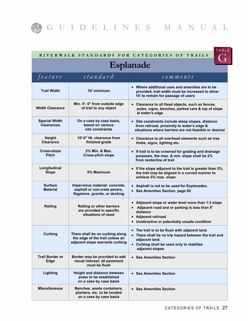
R I V E R W A L K S T A N D A R D S F O R C A T E G O R I E S O F T R A I L S
f e a t u r e s t a n d a r d c o m m e n t s
Trail Width
16' minimum
• Where additional uses and amenities are to be provided, trail width must be increased to allow
16' to remain for passage of users
Width Clearance
Min. 5'- 0" from outside edge of trail to any object
• Clearance to all fixed objects, such as fences, poles, signs, benches, parked cars & top of slope at water's edge
Special Width Clearances
On a case by case basis, based on various site constraints
• Site constraints include steep slopes, distance from railroad, proximity to water's edge & situations where barriers are not feasible or desired
Height Clearance
10'-0" Ht. clearance from finished grade
• Clearance to all overhead elements such as tree limbs, signs, lighting etc.
Cross-slope Pitch
2% Min. & Max. Cross-pitch slope
• If trail is to be crowned for grading and drainage purposes, the max. & min. slope shall be 2% from centerline of trail
Longitudinal Slope
5% Maximum
• If the slope adjacent to the trail is greater than 5%, the trail may be aligned in a curved manner to achieve 5% max. slope
Surface Material
Impervious material: concrete, asphalt or con-crete pavers,
flagstone, granite, or decking
• Asphalt is not to be used for Esplanades. • See Amenities Section, page 60
Railing
Railing or other barriers are provided in specific
situations of need
• Adjacent slope or water level more than 1:3 slope • Adjacent road and or parking is less than 5'
distance • Adjacent railroad • Unattractive or potentially unsafe condition
Curbing
There shall be no curbing along the edge of the trail unless an
adjacent slope warrants curbing
• The trail is to be flush with adjacent land. • There shall be no trip hazard between the trail and
adjacent land. • Curbing shall be used only to stabilize adjacent slopes
Trail Border or Edge
Border may be provided to add visual interest; all pavement
must be flush
• See Amenities Section
Lighting
Height and distance between poles to be established on a case by case basis
• See Amenities Section
Miscellaneous
Benches, waste containers, planters, etc. to be located
on a case by case basis
• See Amenities Section
Esplanade G
T A B L E
G U I D E L I N E S M A N U A L
C A T E G O R I E S O F T R A I L S 27
S p e c i a l S i t u a t i o n s
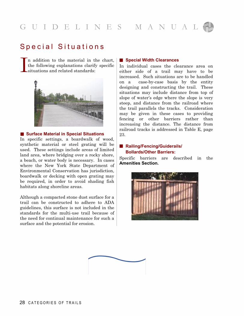
I n addition to the material in the chart, the following explanations clarify specific situations and related standards:
Surface Material in Special Situations In specific settings, a boardwalk of wood, synthetic material or steel grating will be used. These settings include areas of limited land area, where bridging over a rocky shore, a beach, or water body is necessary. In cases where the New York State Department of Environmental Conservation has jurisdiction, boardwalk or decking with open grating may be required, in order to avoid shading fish habitats along shoreline areas. Although a compacted stone dust surface for a trail can be constructed to adhere to ADA guidelines, this surface is not included in the standards for the multi-use trail because of the need for continual maintenance for such a surface and the potential for erosion.
Special Width Clearances In individual cases the clearance area on either side of a trail may have to be increased. Such situations are to be handled on a case-by-case basis by the entity designing and constructing the trail. These situations may include distance from top of slope of water’s edge where the slope is very steep, and distance from the railroad where the trail parallels the tracks. Consideration may be given in these cases to providing fencing or other barriers rather than increasing the distance. The distance from railroad tracks is addressed in Table E, page 23. Railing/Fencing/Guiderails/ Bollards/Other Barriers: Specific barriers are described in the Amenities Section.
28 C A T E G O R I E S O F T R A I L S
G U I D E L I N E S M A N U A L
Amenities 4 SECT IO N
I n t r o d u c t i o n
T he Guidelines provide the designers of the RiverWalk segments with a choice for most amenities, based on the
category of trail, as well as on site conditions, design and budget. These amenities correspond to a higher standard than might normally be required for a municipal project, due to specific site conditions and comprehensive quality standards mandated by the County of Westchester.
S t a n d a r d A m e n i t i e s
J ust as standards have been set for widths, setbacks and other dimensions for RiverWalk, standard amenities have been
selected, in order to develop a unified trail. Within the standard amenities there are choices that can be made, dependent on the trail category as well as its setting and surroundings. Thus, one of the benches and one of the bike racks may be selected for an
esplanade, while a different bench may be chosen for a pedestrian trail. Signage, with the logo, is the required amenity. Choices are provided with the palette of signs so that one segment of trail may use only the logo as a Trailblazer, while another may include regulatory, directional and interpretive signage.
S u g g e s t e d A m e n i t i e s
S T A N D A R D A M E N I T I E S
- Signage - Surface Materials - Seating - Bicycle Racks & Trash Receptacles - Lighting - Bollards - Railing & Fencing - Planting
S U G G E S T E D A M E N I T I E S
- Structures - Bridges - River Access/Edge Treatments - Miscellaneous
D ifferent amenities are suggested for use along the trail. The amenities suggest here will also serve as ideas
for designers of trail segments, to make the trail more interesting with structures,
playgrounds, or facilities for fishing where suitable to the site, or with other improvements which enhance the users’ experience.
A M E N I T I E S 29
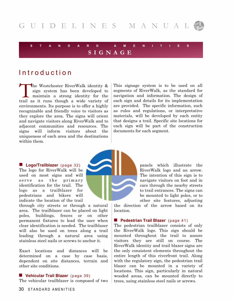
Logo/Trailblazer (page 32)
The logo for RiverWalk will be used on most signs and will s e r v e a s t he p r i m a r y identification for the trail. The logo as a trailblazer for pedestrians and bikers will indicate the location of the trail through city streets or through a natural area. The trailblazer can be placed on light poles, buildings, fences or on other permanent fixtures to lead the user when clear identification is needed. The trailblazer will also be used on trees along a trail leading through a natural area using stainless steel nails or screws to anchor it. Exact locations and distances will be determined on a case by case basis, dependent on site distances, terrain and other site conditions.
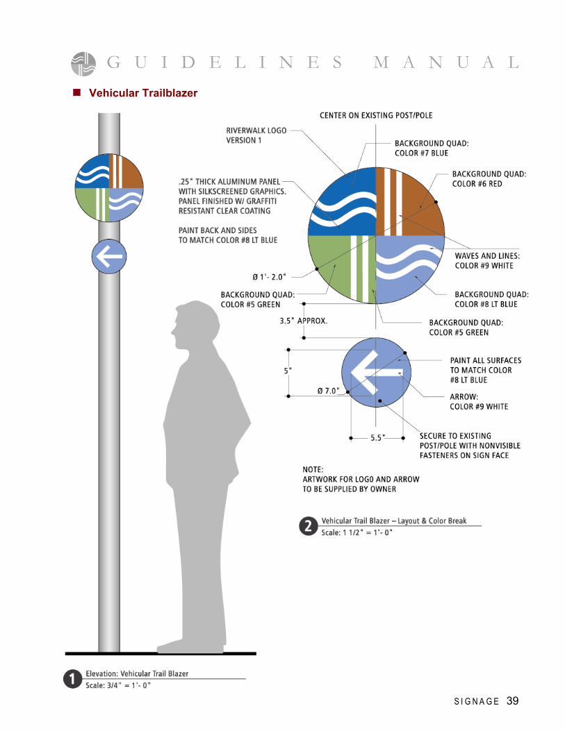
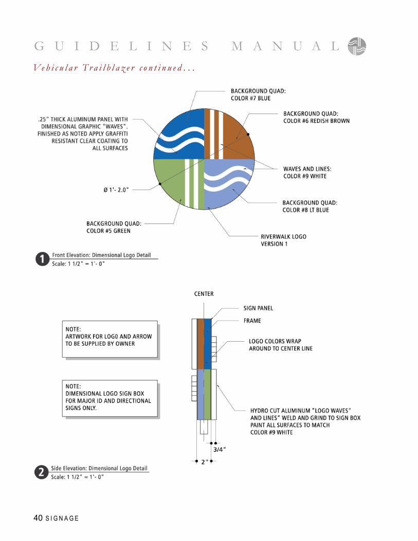
Vehicular Trail Blazer (page 39)
The vehicular trailblazer is composed of two
T he Westchester RiverWalk identity & sign system has been developed to maintain a strong identity for the
trail as it runs though a wide variety of environments. Its purpose is to offer a highly recognizable and friendly voice to visitors as they explore the area. The signs will orient and navigate visitors along RiverWalk and to adjacent communities and resources. The signs will inform visitors about the uniqueness of each area and the destinations within them.
panels which illustrate the RiverWalk logo and an arrow. The intention of this sign is to navigate visitors on foot and in cars through the nearby streets to trail entrances. The signs can be mounted to light poles, or to other site features, adjusting
the direction of the arrow based on its location.
Pedestrian Trail Blazer (page 41)
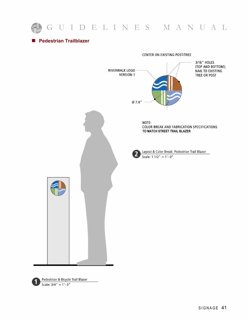
The pedestrian trailblazer consists of only the RiverWalk logo. This sign should be mounted throughout the trail to assure visitors they are still on course. The RiverWalk identity and trail blazer signs are the only consistent elements throughout the entire length of this riverfront trail. Along with the regulatory sign, the pedestrian trail blazer can be mounted in a variety of locations. This sign, particularly in natural wooded areas, can be mounted directly to trees, using stainless steel nails or screws.
This signage system is to be used on all segments of RiverWalk, as the standard for navigation and information. The design of each sign and details for its implementation are provided. The specific information, such as rules and regulations, or interpretative materials, will be developed by each entity that designs a trail. Specific site locations for each sign will be part of the construction documents for each segment.
I n t r o d u c t i o n
S T A N D A R D A M E N I T I E S
S I G N A G E
30 S T A N D A R D A M E N I T I E S
G U I D E L I N E S M A N U A L
Major Identification and Maps (page 46) The major identification sign should be located at the northern and southern most entrances of each municipality along the trail. This double sided sign identifies the trail, identifies the municipality name and includes detailed information about the area. A welcome statement offers a brief history of the municipality including where its name originated. Trail hours and a list of the rules are conveyed underneath the welcome statement. The major identification also conveys directional information, guiding visitors toward the municipality just north and south
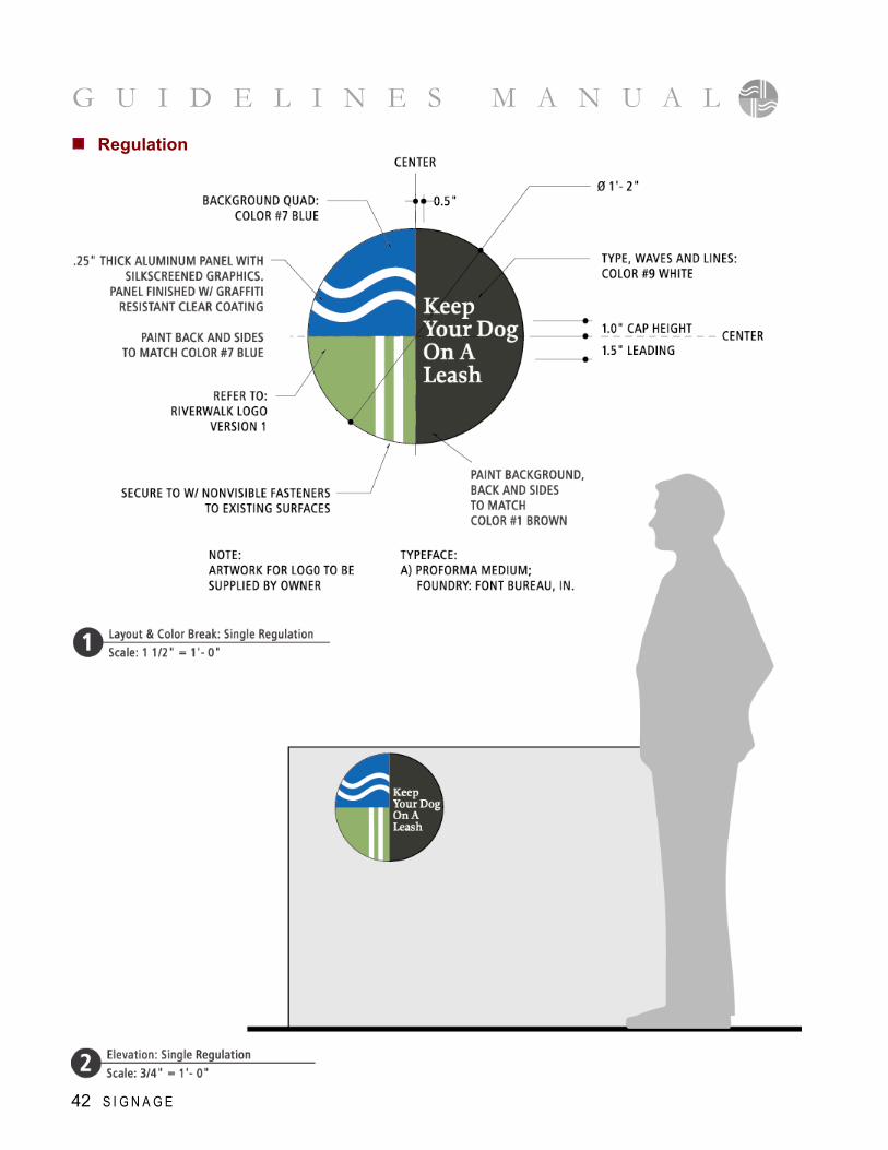
Regulation (page 42) The regulatory sign conveys trail rules and safety information. The sign has been designed in a simple manner allowing it to be mounted in a variety of locations. The layout, which incorporates elements of the RiverWalk logo, reinforces the the trail's identity while conveying the necessary information. Directional (page 43) The pedestrian directional is a double sided sign that should be located at each trail entrance not signed with the major identification. It should also be located at major decision points along the trail, to navigate visitors to nearby points of interest. This sign has been designed in a similar way to the major identification to reinforce the trail identity.
of their current location. In addition to directional information, the signs will, in the future, include two maps of the trail. The first map will illustrate the entire length of the RiverWalk trail, highlighting waterfront towns and identifying points of interest along the way. The second map will illustrate the municipality in detail, offering visitors information about local points of interest and amenities. The maps will be developed later in the project, as more segments of RiverWalk are completed. Interpretive (page 52) Each municipality or private entity that develops a segment of RiverWalk will identify which resources, natural or cultural for instance, of their riverfront they wish to interpret to the public. The interpretive signage can be mounted horizontally on a railing or can be mounted vertically, in the area of the feature to be interpreted. This signage may be integrated into the design of seating areas, or as part of a structure where people will gather.
G U I D E L I N E S M A N U A L
S T A N D A R D A M E N I T I E S 31
G U I D E L I N E S M A N U A L
G U I D E L I N E S M A N U A L
32 S I G N A G E
Logo/Trailblazer
G U I D E L I N E S M A N U A L
S I G N A G E 33
G U I D E L I N E S M A N U A L L o g o / T r a i l b l a z e r c o n t i n u e d . . .
34 S I G N A G E
G U I D E L I N E S M A N U A L
S I G N A G E 35
G U I D E L I N E S M A N U A L
36 S I G N A G E
L o g o / T r a i l b l a z e r c o n t i n u e d . . .
G U I D E L I N E S M A N U A L
S I G N A G E 37
38 S I G N A G E
G U I D E L I N E S M A N U A L L o g o / T r a i l b l a z e r c o n t i n u e d . . .
S I G N A G E 39
G U I D E L I N E S M A N U A L Vehicular Trailblazer
G U I D E L I N E S M A N U A L
40 S I G N A G E
Ve h i c u l a r T r a i l b l a z e r c o n t i n u e d . . .
G U I D E L I N E S M A N U A L
S I G N A G E 41
Pedestrian Trailblazer
TO MATCH STREET TRAIL BLAZER
G U I D E L I N E S M A N U A L
42 S I G N A G E
Regulation
G U I D E L I N E S M A N U A L
S I G N A G E 43
Directional
G U I D E L I N E S M A N U A L D i r e c t i o n a l c o n t i n u e d . . .
44 S I G N A G E
G U I D E L I N E S M A N U A L
S I G N A G E 45
G U I D E L I N E S M A N U A L
46 S I G N A G E
Major Identification and Maps
G U I D E L I N E S M A N U A L
S I G N A G E 47
48 S I G N A G E
G U I D E L I N E S M A N U A L M a j o r I d e n t i f i c a t i o n a n d M a p s c o n t i n u e d . . .
S I G N A G E 49
G U I D E L I N E S M A N U A L
G U I D E L I N E S M A N U A L
50 S I G N A G E
M a j o r I d e n t i f i c a t i o n a n d M a p s c o n t i n u e d . . .
G U I D E L I N E S M A N U A L
S I G N A G E 51
G U I D E L I N E S M A N U A L
52 S I G N A G E
Interpretive
G U I D E L I N E S M A N U A L
S I G N A G E 53
G U I D E L I N E S M A N U A L I n t e r p r e t i v e c o n t i n u e d . . .
54 S I G N A G E
G U I D E L I N E S M A N U A L
S I G N A G E 55
G U I D E L I N E S M A N U A L
56 S I G N A G E
I n t e r p r e t i v e c o n t i n u e d . . .
G U I D E L I N E S M A N U A L
S I G N A G E 57
58 S I G N A G E
G U I D E L I N E S M A N U A L I n t e r p r e t i v e c o n t i n u e d . . .
S I G N A G E 59
G U I D E L I N E S M A N U A L
G U I D E L I N E S M A N U A L
Asphalt Pavement
Asphalt top course shall be 1 1/2" depth and type 6 (F) Item 403.7-1 as specified in Table 401-1 "Composition of Bituminous Plant Mixtures" of the NYSDOT Standard Specifications dated January 1990 and any subsequent addenda. The base course material used shall be 3" depth Base Course Type 3 Item no. 403.13 as specified in table 401-1 “Composition of Bituminous Plant Mixtures" of the NYSDOT Specifications and any subsequent addenda. Tack coat shall be NYSDOT Item 702.30, material designation RS-1. The crushed stone subbase shall be 6" depth and conform in every respect to the requirements contained in these specifications and those set forth for "Bases and Subbase", Section 300 of the NYSDOT Standard Specifications of January 2, 1990, and any subsequent addenda. Use of geo-textile may be required in areas of poor subgrade.
S T A N D A R D A M E N I T I E S
S U R F A C E M A T E R I A L S
60 S T A N D A R D A M E N I T I E S
Concrete Pavers
Concrete Pavers shall be Hanover Prest Pavers model no. M # 1064 Tudor Finish in a 1'-0" X 2'-0" X 2" nominal dimension as manufactured by Hanover Architectural Pavers - Hanover~ PA or approved equal. Pavers shall be installed as per manufacturer's recommendations. Subbase shall be NYSDOT item 4 and shall be 8" minimum depth. Depending on drainage and soil borings, sub-surface drainage material, such as geotextile fabric, may be required.
Granite Pavers
Granite Pavers shall be grey-black modeled as manufactured by Hanover Architectural Products, or an acceptable equal. Pavers shall be 1'-0" X 2'-0" X 1-1/2". Surface of granite shall be thermal finished for "slip resistance", Granite pavers shall be installed on a 1" asphalt setting bed, and depending on soil borings the setting bed shall be on 8" compacted item 4 and or a concrete subbase.
G U I D E L I N E S M A N U A L
S T A N D A R D A M E N I T I E S 61
G U I D E L I N E S M A N U A L
62 S T A N D A R D A M E N I T I E S
Ipe Wood or Mahogany Decking
Pressure treated lumber is unacceptable for decking and railings. Mahogany and Ipe wood are to be used for decking materials.
Bluestone Pavers
Bluestone pavers shall be NY State bluestone, cleft free and shall be 1 1/2" thick. Pavers shall be 1 ' x 1' min.; pattern shall be on a case-by-case basis. Subbase and setting bed materials shall be as per engineer's recommendation.
S u r f a c e M a t e r i a l s c o n t i n u e d . . .
Concrete/Granite Blend Paver
Concrete granite blend paver shall be type 2 Granitex (direct wash surface) paver Model #GTX2108 in 1’- 0 x 1’ Or 1’– 0 x 2’ – 0” nominal dimension as manufactured by Wausau Tile or approved equal. Pavers shall be installed as per manufacturer’s recommendations.
Subbase shall be NYSDOT item 4 and shall be 8” minimum depth. Depending on drainage and soil borings, sub-surface drainage material, such as Geotextile fabric may be required.
G U I D E L I N E S M A N U A L
S T A N D A R D A M E N I T I E S 63
Stabilized Gravel
Native stone shall be used for gravel. Stabilizer shall be a natural, non-toxic, non-staining, odorless, environmentally safe Powder consisting of 95% psylllurn with a 70% mucilliod contact. The powder shall be "StabilizerTM” as manufactured by Stabilizer, Inc. or an approved equal. Contact rep. Ralph Crosby: (914) 476-8773
Steel Grating
Steel grating shall be galvanized heavy-duty bar grating welded steel with series grating in accordance with NAAMM Heavy-Duty Bar Grating Manual. Grating size to be calculated by an engineer.
Wood Mulch Path
Wood mulch path shall be shredded bark mulch path; 3" depth on a 4" crushed gravel subbase.
Composite Decking
An acceptable alternative to Mahogany or Ipe wood is composite material, such as TrexTM.
G U I D E L I N E S M A N U A L
64 S T A N D A R D A M E N I T I E S
Wood & Metal Bench
Wood & Metal Bench model "Arcata" in-ground "Ipe" wood. Metal shall be Blue Spruce Powder Coat and manufacturer shall be Landscape Forms or approved equal. Bench may be used with or without back depending on site conditions and design considerations. Landscape Forms: (800) 521-2546
S T A N D A R D A M E N I T I E S
S E A T I N G
L ocation of benches will be determined on a case-by-case basis. They should be placed approximately 500’ to 1000’ apart, depending on the design of each segment. Consideration should be given to allowing rest areas for the elderly, disabled,
children, and others who need or wish to stop. Respite areas may also be created with several benches grouped with plantings, especially where such areas provide views of the river. Seating may also be desirable near access points to RiverWalk. The designer may not want to locate benches in isolated areas due to security concerns.
Metal Bench
Shall be model #160 6’ length in Black Powder Coat finish as manufactured by DuMor Site Furnishings or approved equal. (585) 964-2731
G U I D E L I N E S M A N U A L
S T A N D A R D A M E N I T I E S 65
Metal Trash Receptacle
Metal Trash receptacle shall be 36-gallon open top surface mount, with insert and shall be “Chase Park” model in Blue Spruce Powder Coat as manufactured by Landscapes Forms or approved equal. (800) 521-2546
Metal Bike Hitch
Metal Bike Hitch in Blue Spruce Powder Coat as Manufactured by American Bicycle Security Company or approved equal. (800) 245-3723
Metal Rolling Style
Metal Rolling Style or Ribbon Style Bike Rack in Blue Spruce Powder Coat as manufactured by American Bicycle Security Company or approved equal. (800) 245-3723
S T A N D A R D A M E N I T I E S
B I C Y C L E R A C K S & T R A S H R E C E P T A C L E S
66 S T A N D A R D A M E N I T I E S
G U I D E L I N E S M A N U A L
Pedestrian Lighting Pole Lighting The lighting selected is primarily for high use areas, such as on an esplanade, or on a trail which passes through a parking lot for security. RiverWalk is not intended for night time use except in these special areas. This is pedestrian lighting, with the total height of the fixture and pole at 14’. It has been selected to minimize light pollution, thus preserving night skies. Circumstances will determine the spacing and foot candles. The light shall be metal Halide, 175 watt max. Light Bollards Two different light bollards have been selected, and may be used in parking areas, or in areas where a low level of light is needed to lead people to RiverWalk.
Visionaire Lighting Newcastle with APA-05-S1
Mounting Arm and DCB-13 Decorative Pole
S T A N D A R D A M E N I T I E S
L I G H T I N G
S T A N D A R D A M E N I T I E S 67
G U I D E L I N E S M A N U A L
S T A N D A R D A M E N I T I E S
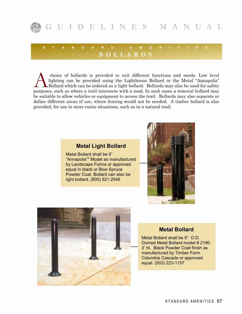
B O L L A R D S
Metal Light Bollard
Metal Bollard shall be 6” ”Annapolis”" Model as manufactured by Landscape Forms or approved equal in black or Blue Spruce Powder Coat. Bollard can also be light bollard. (800) 521-2546
Metal Bollard
Metal Bollard shall be 5” O.D. Domed Metal Bollard model # 2190 3’ ht. Black Powder Coat finish as manufactured by Timber Form Columbia Cascade or approved equal. (503) 223-1157
A choice of bollards is provided to suit different functions and needs. Low level lighting can be provided using the Lighthouse Bollard or the Metal “Annapolis” Bollard which can be ordered as a light bollard. Bollards may also be used for safety
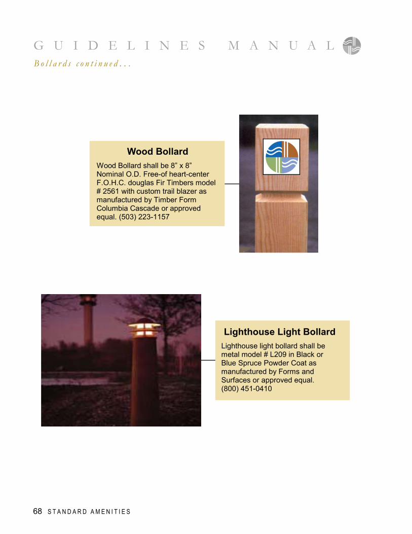
purposes, such as where a trail intersects with a road. In such cases a removal bollard may be suitable to allow vehicles or equipment to access the trail. Bollards may also separate or define different areas of use, where fencing would not be needed. A timber bollard is also provided, for use in more rustic situations, such as in a natural trail.
68 S T A N D A R D A M E N I T I E S
G U I D E L I N E S M A N U A L B o l l a r d s c o n t i n u e d . . .
Lighthouse Light Bollard
Lighthouse light bollard shall be metal model # L209 in Black or Blue Spruce Powder Coat as manufactured by Forms and Surfaces or approved equal. (800) 451-0410
Wood Bollard
Wood Bollard shall be 8” x 8” Nominal O.D. Free-of heart-center F.O.H.C. douglas Fir Timbers model # 2561 with custom trail blazer as manufactured by Timber Form Columbia Cascade or approved equal. (503) 223-1157
S T A N D A R D A M E N I T I E S 69
G U I D E L I N E S M A N U A L
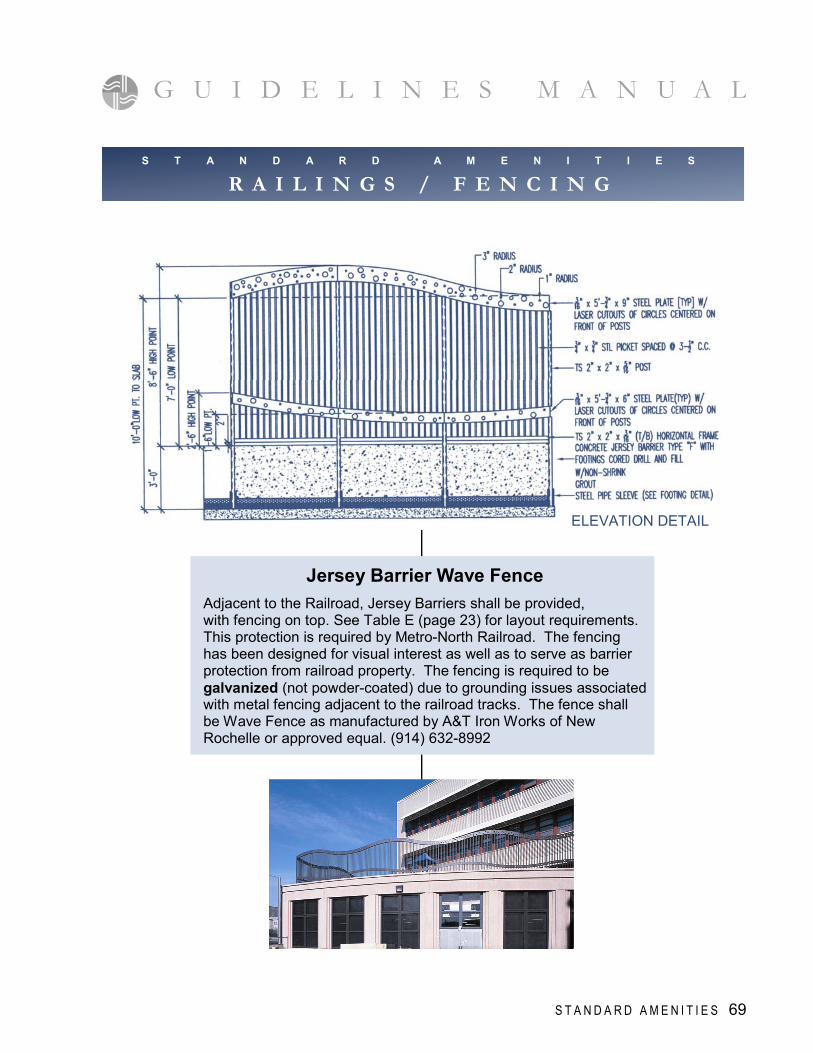
Jersey Barrier Wave Fence
Adjacent to the Railroad, Jersey Barriers shall be provided, with fencing on top. See Table E (page 23) for layout requirements. This protection is required by Metro-North Railroad. The fencing has been designed for visual interest as well as to serve as barrier protection from railroad property. The fencing is required to be galvanized (not powder-coated) due to grounding issues associated with metal fencing adjacent to the railroad tracks. The fence shall be Wave Fence as manufactured by A&T Iron Works of New Rochelle or approved equal. (914) 632-8992
S T A N D A R D A M E N I T I E S
R A I L I N G S / F E N C I N G
ELEVATION DETAIL
G U I D E L I N E S M A N U A L
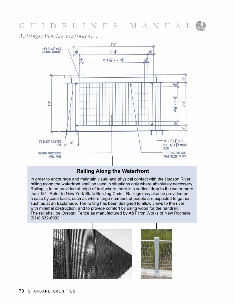
Railing Along the Waterfront
In order to encourage and maintain visual and physical contact with the Hudson River, railing along the waterfront shall be used in situations only where absolutely necessary. Railing is to be provided at edge of trail where there is a vertical drop to the water more than 18”. Refer to New York State Building Code. Railings may also be provided on a case by case basis, such as where large numbers of people are expected to gather, such as at an Esplanade. The railing has been designed to allow views to the river with minimal obstruction, and to provide comfort by using wood for the handrail. The rail shall be Orsogril Fence as manufactured by A&T Iron Works of New Rochelle. (914) 632-8992
R a i l i n g s / Fe n c i n g c o n t i n u e d . . .
70 S T A N D A R D A M E N I T I E S
S T A N D A R D A M E N I T I E S 71
Horizontal Concrete Cedar Style Fence
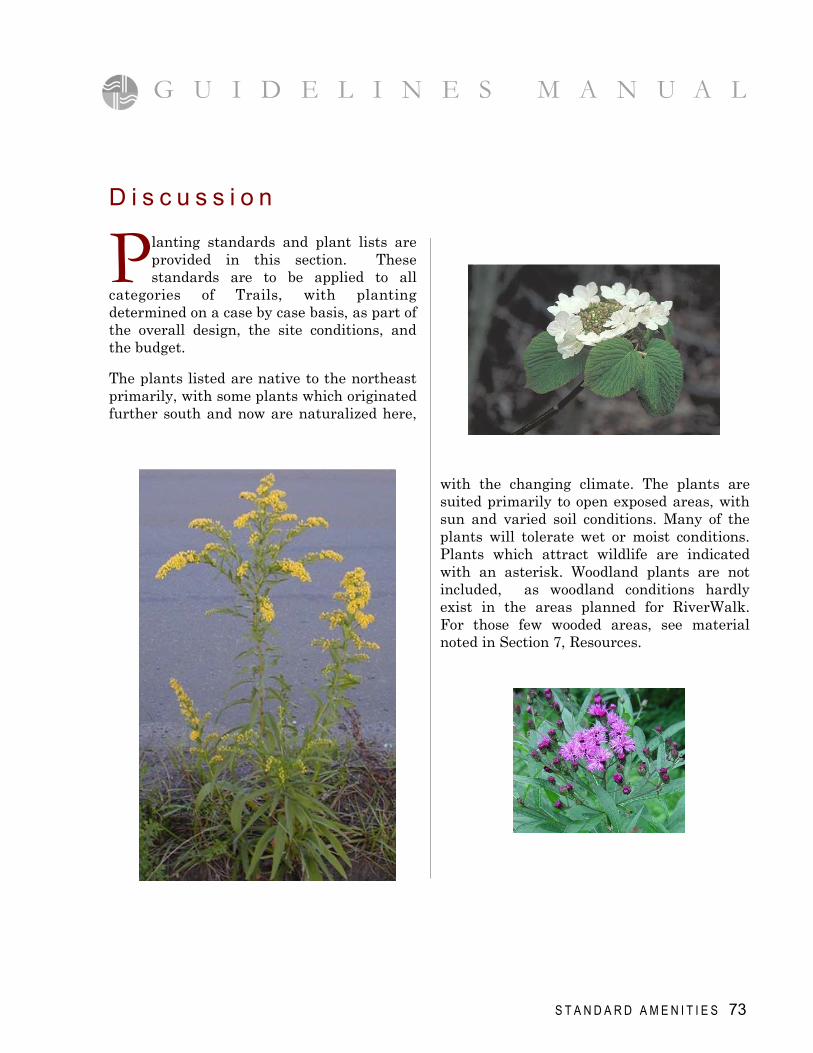
Horizontal Concrete Cedar Style fence shall be 6'-8' ht. Grey-brown color mix as manufactured by American Technocrete or approved equal. Product shall be manufactured in a factory that is certified by the National Precast Concrete Association. (818) 990-3362
Vertical Concrete Wood Style Fence
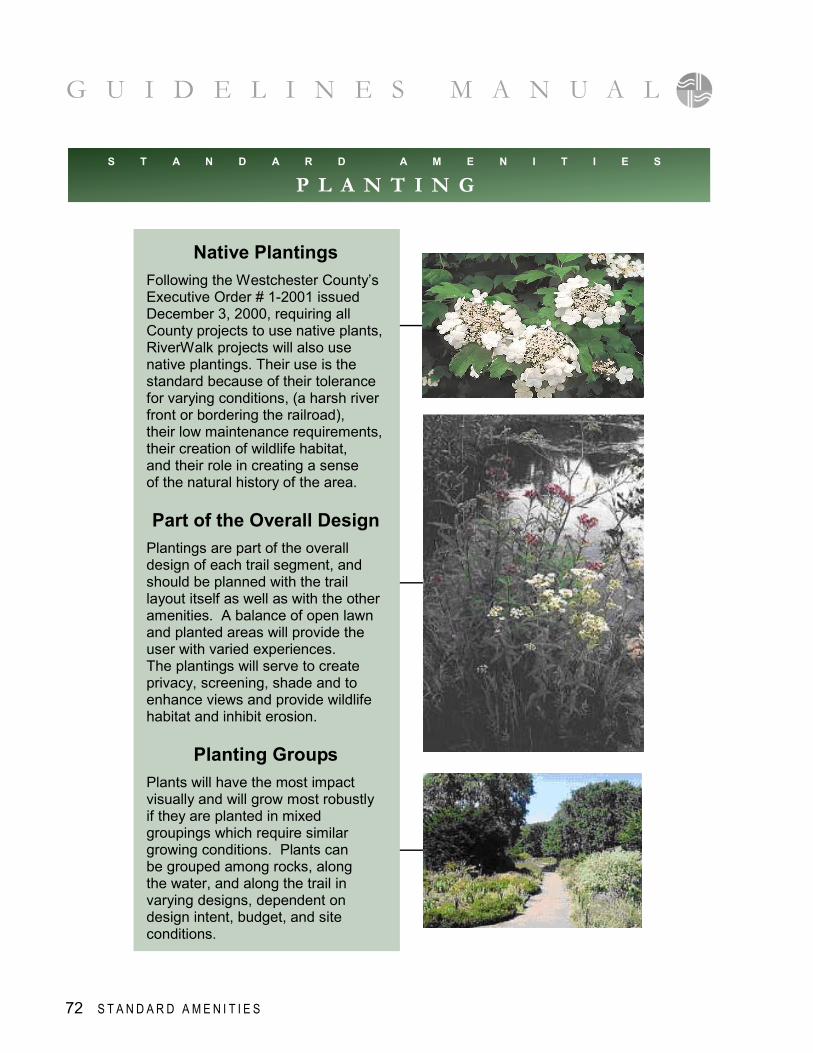
Vertical Concrete Wood Style fence shall be 6'-8' ht, Grey-brown color mix as manufactured by American Technocrete or approved equal. Product shall be manufactured in a factory that is certified by the National Precast Concrete Association. (818) 990-3362
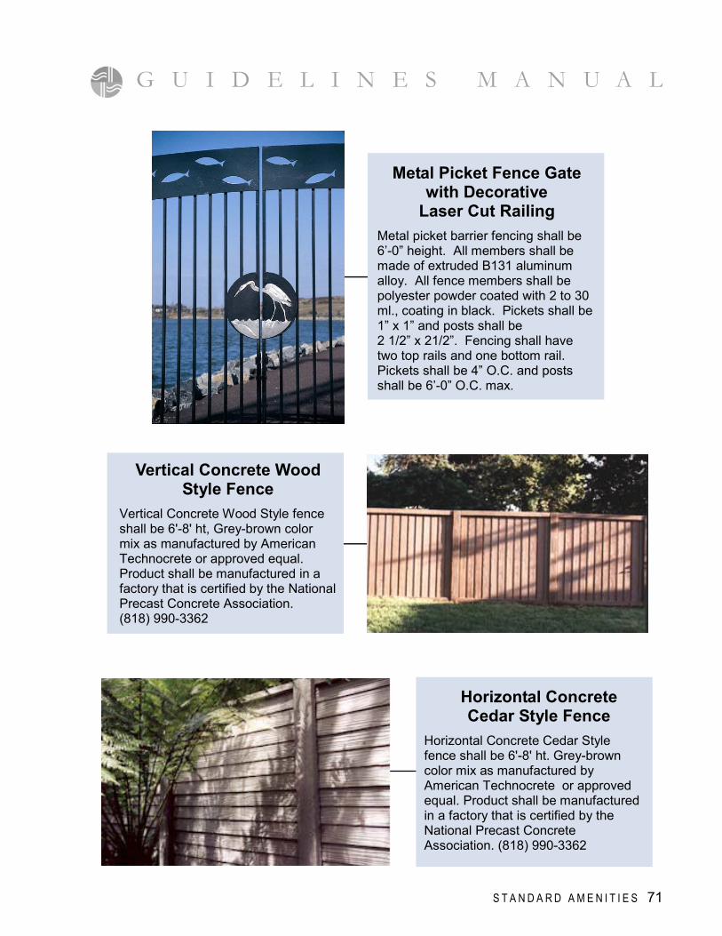
Metal Picket Fence Gate with Decorative
Laser Cut Railing
Metal picket barrier fencing shall be 6’-0” height. All members shall be made of extruded B131 aluminum alloy. All fence members shall be polyester powder coated with 2 to 30 ml., coating in black. Pickets shall be 1” x 1” and posts shall be 2 1/2” x 21/2”. Fencing shall have two top rails and one bottom rail. Pickets shall be 4” O.C. and posts shall be 6’-0” O.C. max.
G U I D E L I N E S M A N U A L
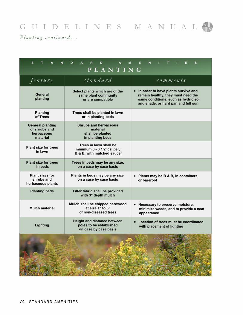
Native Plantings
Following the Westchester County’s Executive Order # 1-2001 issued December 3, 2000, requiring all County projects to use native plants, RiverWalk projects will also use native plantings. Their use is the standard because of their tolerance for varying conditions, (a harsh river front or bordering the railroad), their low maintenance requirements, their creation of wildlife habitat, and their role in creating a sense of the natural history of the area. Part of the Overall Design
Plantings are part of the overall design of each trail segment, and should be planned with the trail layout itself as well as with the other amenities. A balance of open lawn and planted areas will provide the user with varied experiences. The plantings will serve to create privacy, screening, shade and to enhance views and provide wildlife habitat and inhibit erosion.
Planting Groups
Plants will have the most impact visually and will grow most robustly if they are planted in mixed groupings which require similar growing conditions. Plants can be grouped among rocks, along the water, and along the trail in varying designs, dependent on design intent, budget, and site conditions.
S T A N D A R D A M E N I T I E S
P L A N T I N G
G U I D E L I N E S M A N U A L
72 S T A N D A R D A M E N I T I E S
D i s c u s s i o n
P lanting standards and plant lists are provided in this section. These standards are to be applied to all
categories of Trails, with planting determined on a case by case basis, as part of the overall design, the site conditions, and the budget.
The plants listed are native to the northeast primarily, with some plants which originated further south and now are naturalized here,
with the changing climate. The plants are suited primarily to open exposed areas, with sun and varied soil conditions. Many of the plants will tolerate wet or moist conditions. Plants which attract wildlife are indicated with an asterisk. Woodland plants are not included, as woodland conditions hardly exist in the areas planned for RiverWalk. For those few wooded areas, see material noted in Section 7, Resources.
G U I D E L I N E S M A N U A L
S T A N D A R D A M E N I T I E S 73
G U I D E L I N E S M A N U A L
74 S T A N D A R D A M E N I T I E S
P l a n t i n g c o n t i n u e d . . .
S T A N D A R D A M E N I T I E S
P L A N T I N G
f e a t u r e
s t a n d a r d
c o m m e n t s
General planting
Select plants which are of the same plant community
or are compatible
• In order to have plants survive and remain healthy, they must need the same conditions, such as hydric soil and shade, or hard pan and full sun
Planting of Trees
Trees shall be planted in lawn or in planting beds
General planting of shrubs and herbaceous
material
Shrubs and herbaceous material
shall be planted in planting beds
Plant size for trees
in lawn
Trees in lawn shall be minimum 3'- 3 1/2' caliper,
B & B, with mulched saucer
Plant size for trees in beds
Trees in beds may be any size, on a case by case basis
Plant sizes for shrubs and
herbaceous plants
Plants in beds may be any size, on a case by case basis
• Plants may be B & B, in containers, or bareroot
Planting beds
Filter fabric shall be provided with 3" depth mulch
Mulch material
Mulch shall be chipped hardwood at size 1" to 3"
of non-diseased trees
• Necessary to preserve moisture, minimize weeds, and to provide a neat appearance
Lighting
Height and distance between poles to be established on case by case basis
• Location of trees must be coordinated with placement of lighting
S T A N D A R D A M E N I T I E S
P L A N T I N G
( * plant is also valuable to wildlife, often to insects, butterflies, & birds )
P L A N T L I S T botanical name common name comments
M A J O R T R E E S ( ultimate heights noted ) Acer rubrum Red Maple • 40'-50', good fall color, tolerates wet conditions * Acer saccharum Sugar Maple • 40'-50', good fall color Carya ovata Shagbark Hickory • 75'-100'; good nuts for wildlife * Celtis occidentalis Hackberry • 40'-50' ht. tolerates tough conditions Gleditsia triacanthos
Honeylocust • 25'-50', moist to dry, sun, variety "inermis" has no thorns, provides light shade, somewhat over used
Gymnocladus dioicus
Kentucky Coffeetree • 60'-75', moist to dry, sun, hardy, flowers attractive to insects, leather pods on female plants, good bark *
Liquidambar styraciflua
Sweet Gum • 50'-60', good fall color, prickly fruit, won’t tolerate pollution
Nyssa sylvatica Black Tupelo • 40'-70', likes moisture, great fall color Quercus alba White Oak • 60'-80', moist to dry; slow growing * Quercus bicolor Swamp White Oak • 60'-80', moist to wet; can grow in poor soil * Quercus phellos Willow Oak • 40'-50', fine narrow leaves * Quercus rubra Northery Red Oak • 75'-100', shade tolerant, very hardy *
M I N O R T R E E S ( understory, some flowering; ultimate heights noted ) Amelanchier arborea Serviceberry • 20'-30', white flowers, fruit, good bark, & fall color Amelanchier canadensis
Shadblow • 10'-20', similar to above, multi-stem
Amelanchier laevis Allegheny Serviceberry • 25'-40', beautiful new growth, delicious fruits Betula nigra River Birch • 50'-60', moist to dry, pink bark, disease free Carpinus caroliniana American Hornbeam • 25'-30', tolerates dry conditions, spring catkins,
good fall color, winged nuts Cercis canadensis Eastern Redbud • 20'-30', rose flowers on branches early Spring
before leaves; yellow fall leaves Cornus alternifolia Pagoda Dogwood • 15'-20', Light shade, moist acid soil, horizontal
branches, bright fruit, handsome bark Cornus florida White Flowering Dogwood • 15'-30', needs good air circulation Crataegus phaenopyrum
Washington Hawthorne • 25'-30' , well drained soil, disease resistant, red fruits, thorns
Crataegus viridis Green Hawthorne • 20'-35', similar to above, but wider tree, nice bark Hamamelis vernalis Spring Witch Hazel • 8'-12', moist, part sun to shade, flowers in Feb. Hamamelis virginiana Common Witch Hazel • 10'-30', sun or shade; small yellow flowers in Fall Ostrya virginiana American Hop Hornbeam • 30'-50', very hardy; spring catkins; white fruit clusters Sassafras albidum Sassafras • 30'-60', sun, moist to moderately dry, good fall color
Ilex opaca American Holly • 15'-40', likes good drainage, fruit, sun to light shade * Juniperus virginiana Eastern Red Cedar • 15'-35', moist to dry, berries and shelter for wildlife * Pinus strobus Easter White Pine • 60'-90', acidic soil, cones, looses bottom branches
as ages, needs sun * Thuja occidentalis Arborvitae,Northern White Cedar • 20'-40', sun to light shade, attractive to deer * Tsuga canadensis Eastern Hemlock • 50'-60', sun to shade, moist to dry, some disease,
good for wildlife *
E V E R G R E E N T R E E S ( ultimate height noted )
G U I D E L I N E S M A N U A L
S T A N D A R D A M E N I T I E S 75
P L A N T L I S T
P L A N T L I S T botanical Name common name comments
E V E R G R E E N S H R U B S Ilex glabra Inkberry • wet to dry; sun to part sun, sandy soil, black fruits * Juniperus horizontalis Creeping Juniper • well drained, sun, low ground cover Kalmia latifolia Mountain Laurel • 4'-15' ht. sun to light shade, acidic soil, flowers Leucothoe axillaris Coast Leucothoe • 3'-4', moist to moderately dry, acidic, sun & shade, white
flowers, bronze new leaf growth, Leucothoe fontanesiana Dog Hobble • 3'-6', same as above but larger Rhododendron catawbiense
Catawba Rhododendron • 4'-10' ht. needs acidic well drained soil; violet flowers
Rhododendron maximum
Rosebay • 6'-20' ht, needs some shade, can be lanky, good for screening, flower insignificant
Taxus canadensis Canada Yew • 2'-3', moist, cool, acidic, shade, groundcover, attractive to deer
D E C I D U O U S S H R U B S Aesculus parviflora Bottlebrush Buckeye • Moist, well drained, high organic soil; good flowers *
Aronia arbutifolia Red Chokeberry • Suckering, sun & shade, white flowers, good fall color, winter fruit, disease & pest free, good for wildlife *
Aronia melanocarpa Black Chokeberry • Same as above, with black fruit, less conspicuous * Callicarpa americana American Beautyberry • Good drainage, sun to light shade, purple fruit, Calyanthus floridus Carolina Allspice • Very adaptable, pest free, unusual deep red flower Clethra alnifolia Summersweet • Sun to part shade; moist acidic soil best, summer
fragrant blooms; good for insects, fall color good * Cornus amomum Silky Dogwood • To 10' ht. Wet soil, blue fruit, for naturalizing & wildlife * Cornus sericea Red Osier Dogwood • To 10' ht. Tolerates dryness, for naturalizing & wildlife * Diervilla lonicera Dwarf Bush-honeysuckle • 2'-4' ht, sun to light shade, for naturalizing in masses Fothergilla gardenii Dwarf Witch-alder • 2'-5' ht, moist to wet soil, compact plant, fall color * Hydrangea arborescens Smooth Hydrangea • Light shade, well-drained moist soil, white large flowers Hydrangea quercifolia Oakleaf Hydrangea • Same as above, tolerates quite heavy shade, fall color Hypericum prolificum Shrubby St. John's Wort • 3'-6', moist to dry, well drained, yellow flowers in
summer, adaptable, disease free Ilex verticillata Winterberry • 6'-10', sun to light shade, moist, acidic, strong fruits, wildlife* Itea virginica Virginia Sweetspire • 3'-6', prefers wet, tolerates dry, white blooms early
summer, red twigs, good fall color * Myrica pensylvanica Northern Bayberry • 3'-10', thrives in poor dry or wet soil, problem-free,
good naturalizer, colonizes Potentilla fruiticosa Bush Cinquefoil • 1'-3', thrives in infertile sunny dry sites, long flowering Rhododendron arborescens
Sweet Azalea • 5'-10', moist acidic soil, sun to light shade, ragrant white flowers early summer *
Rhodo. calendulaceum Flame Azalea • 8'-15', moist to dry acidic, sun to light shade, orange • large yellow flowers spring; not fragrant
Rhodo. Canadense Rhodora • 2'-4', moist to wet, cool, acidic, partial sun, purple to lavender to white flowers early spring
Rhodo. periclymenoides Pinxterbloom Azalea • 3'-8', moist acidic, sun to light shade, light to dark pink flowers in Spring, delicate fragrance, woodland plant *
Rhodo. prinophyllum Rose Shell Azalea • Same as Pinxterbloom, bluer leaves, dark pink fragrant flowers in spring *
Amorpha fruticosa False Indigo • 4’-5’ adaptable, on riverbanks, tolerates poor dry soil, small purple flowers
P l a n t i n g c o n t i n u e d . . .
G U I D E L I N E S M A N U A L
76 S T A N D A R D A M E N I T I E S
P L A N T L I S T
( * plant is also valuable to wildlife, often to insects, butterflies, & birds )
G U I D E L I N E S M A N U A L
S T A N D A R D A M E N I T I E S 77 ( * plant is also valuable to wildlife, often to insects, butterflies, & birds )
P L A N T L I S T
botanical name
common name
comments
D E C I D U O U S S H R U B S ( continued ) Rhodo. Vaseyi Pinkshell Azalea • 4'-8', moist to somewhat dry, sun to light shade, pink
bloom early Spring, good Fall color* Rhodo. Viscosum Swamp Azalea • 4'-10', sun to light shade, moist to wet, white to pink
very fragrant summer bloom. Attracts wildlife* Rhus aromatica Fragrant Sumac • 4'-8' full, dense, most to dry, sun, thrives in poor soil,
suckering, yellow flowers, good fall color, red fruits* Rhus aromatica ‘Grow-Low’
Grow-Low Fragrant Sumac
• 2'-3' , same as above but low, groundcover or to stabilize
Rhus copallinum Shining Sumac • 5'-15', sun, moist to dry, red fall color, suckers & spreads Rosa blanda Meadow or Smooth Rose • 2'-6', sun, moist to dry, pink to dark pink flowers
summer, thorns, rapid spreader forming dense thickets* Rosa carolina Pasture Rose • 2'-3', light to dark pink summer, thorns, not too spreading Rosa nitida New England Rose • 1'-3', wet, for marshes and river banks, pink flowers* Rosa palustris Swamp Rose • 5'-10', moist to moderately dry, sun, soft pink large single
in summer, red orange fruits, good for birds* Rose virginiana Virginia Rose • 2'-6', moist to dry, sun, light pink summer bloom, most
common wild rose on east coast, red fall leaves & canes* Salix discolor Pussy Willow • 6'-15', moist to wet in swamps, sun, seeds freely Sambucus canadensis Common Elderberry • 5'-10', sun to light shade, moist to wet, fast growing
stoloniferous, White flowers, fruit valued by wildlife*
Spirea latifolia Meadowsweet • 2'-5', moist, suckering, white to pink flowers, butterflies* Spirea tomentosa Steeplebush • 2'-5', moist to somewhat dry, pink flowers mid summer * Symphoricarpos albus Snowberry • 2'-3', moist to dry, white-pink flowers, fruits for wildlife,
grows well in difficult sites, stabilizes slopes, some shade
Symphoricarpos orbiculatus
Indian Currant, Coralberry • 3'-4', same as above, with large coral red fruits, for birds
Vaccinium angustifolium Lowbush Blueberry • 6"-24", well-drained, moist to dry, acidic, low groundcover, fruits only in sun, brilliant red fall color in sun
Vaccinium corymbosum Highbush Blueberry • 3'-10', wet to moderately dry, acidic, white flowers, red fall color, red twigs
Note: All viburnums are excellent for wildlife and for naturalizing, as well as for shrub groupings
Viburnum acerifolium Mapleleaf Viburnum • 3'-6', moist to dry, sun & shade, creamy white flowers spring, will grow in understory of dry upland woods, blue black fruits
Viburnum alnifolium Hobblebush • 3'-10', shade, moist, cool, white flowers early Spring, leaves turn varied colors in fall as do fruits
Viburnum dentatum Arrowwood • 6'-12', moist to dry, sun to light shade, creamy white flowers late Spring, blue-black fruits fall
Viburnum lentago Nannyberry • 8'-15', moist to dry, sun to light shade, creamy white flowers late Spring, berries red to black, tough
adaptable large shrub Viburnum nudum Witherod, Possum Haw • 6'-12', wet to moderately dry, sun to light shade, creamy
white flowers late spring, beautiful fruits in many colors, outstanding fall color, very good habit
Viburnum opulus var. americanum (trilobum)
American Cranberrybush • 5'-15', moist to wet, sun, white flowers early summer, red fruits, maple shape leaves, fast growing, suckering shrub
P L A N T L I S T
G U I D E L I N E S M A N U A L
78 S T A N D A R D A M E N I T I E S
P L A N T L I S T
botanical name
common name
comments
D E C I D U O U S S H R U B S ( continued ) Viburnum prunifolium
Black Haw
• 8'-15', moist to dry, sun to light shade, creamy white flowers early spring, suckers, varied color fruits,
deep red fall color
Xanthorhiza simplicissima Yellowroot • 12'-18', moist to dry, sun to shade, lacey foliage, bronze in fall, very adaptable, good as groundcover
H E R B A C E O U S P L A N T S Amsonia tabernaemontana
Common Bluestar • 3' ht. full plant, blue flowers spring, yellow fall color
Aruncus dioicus Goatsbeard • 3'-5', part sun, shade, moist, white flowers * Asclepias incarnata Swamp Milkweed • 2'-4', moist to wet, pink flowers in summer, clumping, * Asclepias purpurescens Purple Milkweed • 2'-4', moist to dry, rose purple in summer, * Ascelpias syriaca Common Milkweed • 2'-4', moist to dry, sun or some shade, colonizes heavily * Ascelpias tuberosa Butterfly Weed • 1'-3', sun, part sun, striking orange flower in summer, * Aster concolor Eastern Silver Aster • 1'-3', sun, dry, well drained soil, violet flowers fall * Aster cordifolius Blue Wood Aster • 2'-3', grows in shade, violet flower fall, seeds heavily * Aster divaricatus White Wood Aster • 1'-2', sun to shade, moist to dry, white flowers fall,
seeds heavily * Aster laevis Smooth Aster • 1'-3', sun, part sun, moist to dry, violet flower fall,
adaptable, neat * Aster novae-angliae New England Aster • 2'-6', sun, part sun, moist, violet to purple flowers fall, showy * Baptisia australis Blue False Indigo • 3'-4', sun, part sun, moist to dry, violet blue flowers Spring Boltonia asteroides False Aster • 2'-4', sun, part sun, wet to dry, white to pink flowers
fall, hardy * Coreopsis tripteris Tall Tickseed • 3'-6', sun, part sun, moist, light yellow summer,
seeds heavily * Coreopsis verticillata
Threadleaf Tickseed
• 1'-2', sun, part sun, moist to mod. dry, yellow flowers summer, hybrids such as 'Moonbeam' and cultivars available and good *
Ecinacea purpureum Purple Coneflower • 2'-3 1/2 ;sun, moist to somewhat dry, rose color flowers summer *
Eupatorium coelestinum Hardy Ageratum • 2'-3', sun to light shade, moist, blue flowers summer, spreads *
Eupatorium fistulosum Joe Pye Weed • 3'-8', sun, part sun, moist to wet, mauve-red purple late summer, Species E. maculatum & E. purpureum have good cultivars *
Eupatorium perfoliatum Boneset • 2'-5', sun, part sun, moist, white flowers summer * Flowering Spurge • 2'-3', sun, part sun, dry, masses of long blooming white
flowers summer to fall, heat and drought tolerant, very hardy Filipendula rubra Queen of the Prairie • 3'-7', wet, sun, part sun, pink flowers in summer, tall
astilbe-like
Helianthus giganteus Swamp Sunflower • 6'-10', moist to wet, yellow flowers fall, good cultivars available *
Euphorbia corollata
Helianthus microcephalus Small-headed Sunflower
• 3'-6', sun to light shade, moist, yellow flowers in late summer, tolerates drought *
( * plant is also valuable to wildlife, often to insects, butterflies, & birds )
P l a n t i n g c o n t i n u e d . . .
P L A N T L I S T
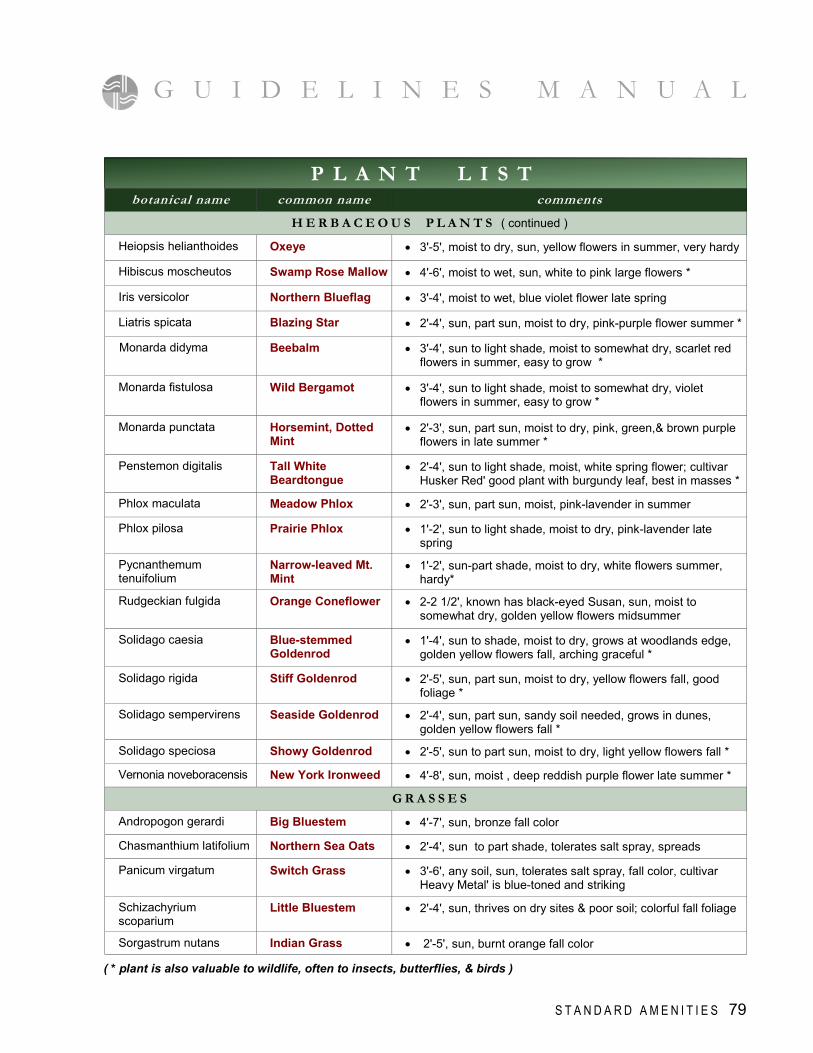
( * plant is also valuable to wildlife, often to insects, butterflies, & birds )
G U I D E L I N E S M A N U A L
S T A N D A R D A M E N I T I E S 79
P L A N T L I S T botanical name common name comments
H E R B A C E O U S P L A N T S ( continued )
Heiopsis helianthoides Oxeye • 3'-5', moist to dry, sun, yellow flowers in summer, very hardy
Hibiscus moscheutos Swamp Rose Mallow • 4'-6', moist to wet, sun, white to pink large flowers *
Iris versicolor Northern Blueflag • 3'-4', moist to wet, blue violet flower late spring
Liatris spicata Blazing Star • 2'-4', sun, part sun, moist to dry, pink-purple flower summer *
Monarda didyma Beebalm • 3'-4', sun to light shade, moist to somewhat dry, scarlet red flowers in summer, easy to grow *
Monarda fistulosa Wild Bergamot • 3'-4', sun to light shade, moist to somewhat dry, violet flowers in summer, easy to grow *
Monarda punctata Horsemint, Dotted Mint
• 2'-3', sun, part sun, moist to dry, pink, green,& brown purple flowers in late summer *
Penstemon digitalis Tall White Beardtongue
• 2'-4', sun to light shade, moist, white spring flower; cultivar Husker Red' good plant with burgundy leaf, best in masses *
Phlox maculata Meadow Phlox • 2'-3', sun, part sun, moist, pink-lavender in summer
Phlox pilosa Prairie Phlox • 1'-2', sun to light shade, moist to dry, pink-lavender late spring
Pycnanthemum tenuifolium
Narrow-leaved Mt. Mint
• 1'-2', sun-part shade, moist to dry, white flowers summer, hardy*
Rudgeckian fulgida Orange Coneflower • 2-2 1/2', known has black-eyed Susan, sun, moist to somewhat dry, golden yellow flowers midsummer
Solidago caesia Blue-stemmed Goldenrod
• 1'-4', sun to shade, moist to dry, grows at woodlands edge, golden yellow flowers fall, arching graceful *
Solidago rigida Stiff Goldenrod • 2'-5', sun, part sun, moist to dry, yellow flowers fall, good foliage *
Solidago sempervirens Seaside Goldenrod • 2'-4', sun, part sun, sandy soil needed, grows in dunes, golden yellow flowers fall *
Solidago speciosa Showy Goldenrod • 2'-5', sun to part sun, moist to dry, light yellow flowers fall *
Vernonia noveboracensis New York Ironweed • 4'-8', sun, moist , deep reddish purple flower late summer *
G R A S S E S
Andropogon gerardi Big Bluestem • 4'-7', sun, bronze fall color
Chasmanthium latifolium Northern Sea Oats • 2'-4', sun to part shade, tolerates salt spray, spreads
Switch Grass • 3'-6', any soil, sun, tolerates salt spray, fall color, cultivar Heavy Metal' is blue-toned and striking
Schizachyrium scoparium
Little Bluestem • 2'-4', sun, thrives on dry sites & poor soil; colorful fall foliage
Sorgastrum nutans Indian Grass • 2'-5', sun, burnt orange fall color
Panicum virgatum
P L A N T L I S T
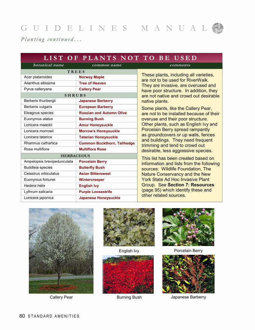
G U I D E L I N E S M A N U A L P l a n t i n g c o n t i n u e d . . .
botanical name common name comments
T R E E S Acer platanoides Norway Maple Ailanthus altissima Tree of Heaven Pyrus calleryana Callery Pear
S H R U B S Berberis thunbergii Japanese Barberry Berberis vulgaris European Barberry Eleagnus species Russian and Autumn Olive Euonymus alatus Burning Bush Lonicera maackii Amur Honeysuckle Lonicera morrowii Morrow's Honeysuckle Lonicera tatarica Tatarian Honeysuckle Rhamnus cathartica Common Buckthorn, Tallhedge Rosa multiflora Multiflora Rose
HERBACEOUS Ampelopsis brevipedunculata Porcelain Berry Buddleia species Butterfly Bush Celastrus orbiculatus Asian Bittersweet Euonymus fortunei Wintercreeper Hedera helix English Ivy Lythrum salicaria Purple Loosestrife Lonicera japonica Japanese Honeysuckle
L I S T O F P L A N T S N O T T O B E U S E D
These plants, including all varieties, are not to be used for RiverWalk. They are invasive, are overused and have poor structure. In addition, they are not native and crowd out desirable native plants.
Some plants, like the Callery Pear, are not to be installed because of their overuse and their poor structure. Other plants, such as English Ivy and Porcelain Berry spread rampantly as groundcovers or up walls, fences and buildings. They need frequent trimming and tend to crowd out desirable, less aggressive species.
This list has been created based on information and lists from the following sources: Wildlife Foundation, The Nature Conservancy and the New York State Ad Hoc Invasive Plant Group. See Section 7: Resources (page 95) which identify these and other related sources.
80 S T A N D A R D A M E N I T I E S
English Ivy
Burning Bush Callery Pear
Porcelain Berry
Japanese Barberry
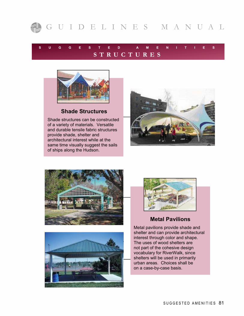
G U I D E L I N E S M A N U A L
S U G G E S T E D A M E N I T I E S 81
Shade Structures
Shade structures can be constructed of a variety of materials. Versatile and durable tensile fabric structures provide shade, shelter and architectural interest while at the same time visually suggest the sails of ships along the Hudson.
Metal Pavilions
Metal pavilions provide shade and shelter and can provide architectural interest through color and shape. The uses of wood shelters are not part of the cohesive design vocabulary for RiverWalk, since shelters will be used in primarily urban areas. Choices shall be on a case-by-case basis.
S U G G E S T E D A M E N I T I E S
S T R U C T U R E S
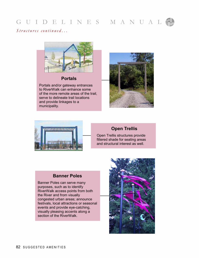
G U I D E L I N E S M A N U A L
82 S U G G E S T E D A M E N I T I E S
S t r u c t u r e s c o n t i n u e d . . .
Open Trellis
Open Trellis structures provide filtered shade for seating areas and structural interest as well.
Portals
Portals and/or gateway entrances to RiverWalk can enhance some of the more remote areas of the trail, serve to delineate trail locations and provide linkages to a municipality.
Banner Poles
Banner Poles can serve many purposes, such as to identify RiverWalk access points from both the River and from visually congested urban areas; announce festivals, local attractions or seasonal events and provide eye-catching, visually pleasing accents along a section of the RiverWalk.
G U I D E L I N E S M A N U A L
S U G G E S T E D A M E N I T I E S 83
Bridge Styles
Bridges should have a simple style and not be “rustic” or “Adirondack” style. They can also be more inventive and even fun like the photo below, playing up the RiverWalk water focus. Bridges should compliment the chosen site amenities such as benches and lighting.
S U G G E S T E D A M E N I T I E S
B R I D G E S
G U I D E L I N E S M A N U A L
84 S U G G E S T E D A M E N I T I E S
Boat Ramps
Where conditions allow, public boat ramps should be considered in planning trail improvements at the waterfront, including canoe/kayak launching areas, especially if a ramp is not currently available in the community.
Disability Access
Design of areas for fishing must also include provisions for people with disabilities. This includes fishing piers and all other areas with railings. Refer to ADA Guidelines.
Piers
Piers that allow for a variety of river craft docking and offloading should be considered when designing a pier or river access area. Where conditions allow, boat docking facilities should be provided.
S U G G E S T E D A M E N I T I E S
R I V E R A C C E S S / E D G E T R E A T M E N T S
G U I D E L I N E S M A N U A L
S U G G E S T E D A M E N I T I E S 85
Let-downs
Where practical and desirable “let-downs” to the water should be incorporated into the trail design, for pedestrians to experience the waterfront, as well as for boaters to access the trail.
Riprap
In areas where riprap is necessary, it should be incompliance with U.S. Army Corps of Engineer standards. The color of the riprap shall be of a natural indigenous rock with a tan-brown and grey range of color (schist and/or granite). Size will be determined by the site conditions and as per the engineer’s recommendations.
Playgrounds
Municipalities may choose to construct additional amenities such as playgrounds. Playgrounds along the riverfront should have components that celebrate the river. It may be a water theme, boating theme, and/or cultural theme, further enhancing and reinforcing the importance and beauty of the Hudson River.
S U G G E S T E D A M E N I T I E S
M I S C E L L A N E O U S
G U I D E L I N E S M A N U A L
Telescopes
Many areas along the Hudson River present wonderful opportunities for viewing watercraft as well as wildlife such as birds, fish and marsh life. Telescopes should be considered in several areas along the trail to involve trail use more interactively with the River’s scenic resources.
Re-use
Re-use of existing old quarried stone or other stable architectural features from pre-existing structures along the waterfront front, should be considered for re-use to create an historic context as well as cultural enhancements on various sites.
Etched Paving
To help orient visitors to the trail and or mark important locations along the trail, names of streets, people and/or events can be etched the paving materials.
86 S U G G E S T E D A M E N I T I E S
S t r u c t u r e s c o n t i n u e d . . .
I n t r o d u c t i o n
T he purpose of the following Scenarios are to illustrate how RiverWalk may appear in different situations. They are provided for inspiration and ideas, and based on existing settings proposed for RiverWalk. While each setting is unique, the Scenarios presented
show an attractive and functional solution to a specific setting and a response to different site constraints.
Scenarios 5 SECT IO N
T Y P I C A L S C E N A R I O S 87
B e f o r e
Trail Through an Existing Parking Area
A f t e r
A
typical
T y p i c a l S c e n a r i o s c o n t i n u e d . . .
88 T Y P I C A L S C E N E R I O S
G U I D E L I N E S M A N U A L
Trail Adjacent to Railroad
Tributary Treatment with Access to Water from Trail
B
C
P h o t o g r a p h i c E x a m p l e
G U I D E L I N E S M A N U A L
Trail with Limited Land Area
T Y P I C A L S C E N A R I O S 89
D
90 T Y P I C A L S C E N E R I O S
T y p i c a l S c e n a r i o s c o n t i n u e d . . .
G U I D E L I N E S M A N U A L
Esplanade in Industrial Areas
E
B e f o r e
A f t e r
Former Railroad Power Stat ion in Yonkers
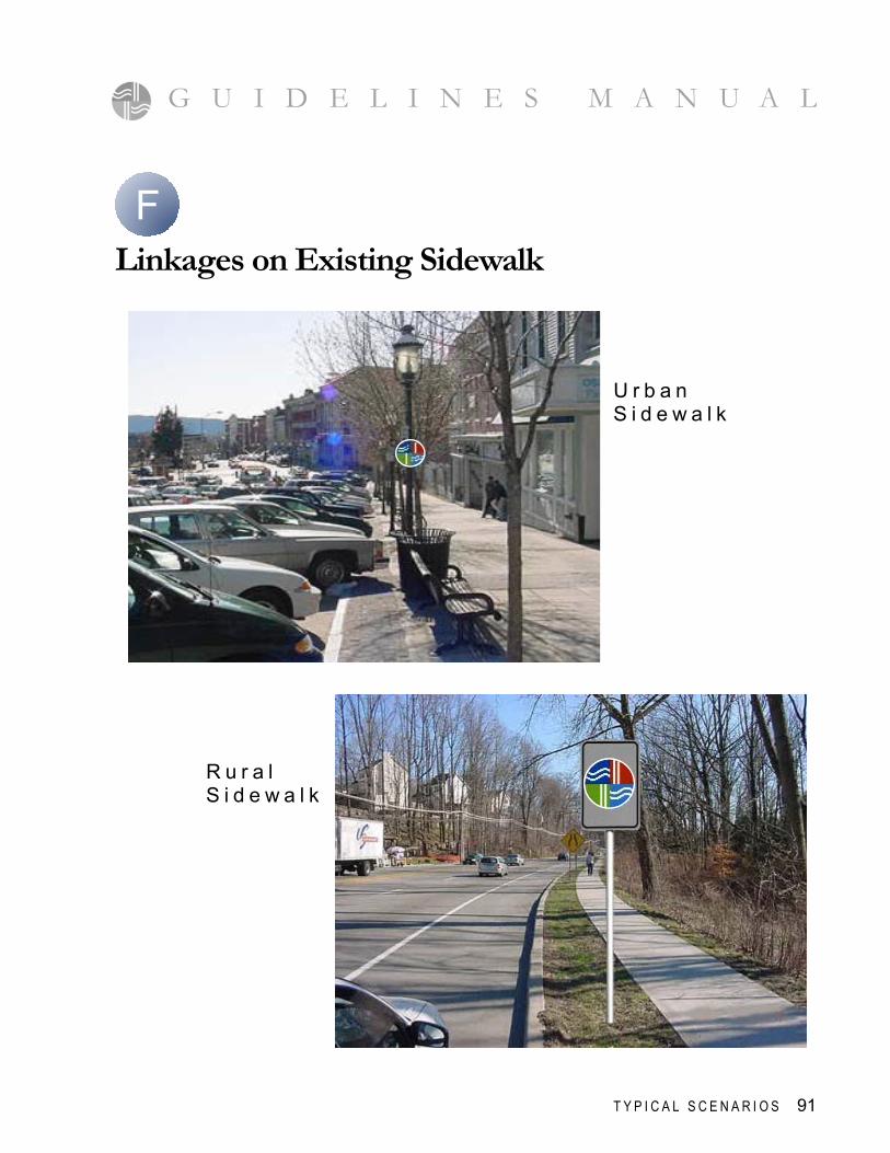
T Y P I C A L S C E N A R I O S 91
G U I D E L I N E S M A N U A L
Linkages on Existing Sidewalk
R u r a l S i d e w a l k
U r b a n S i d e w a l k
F
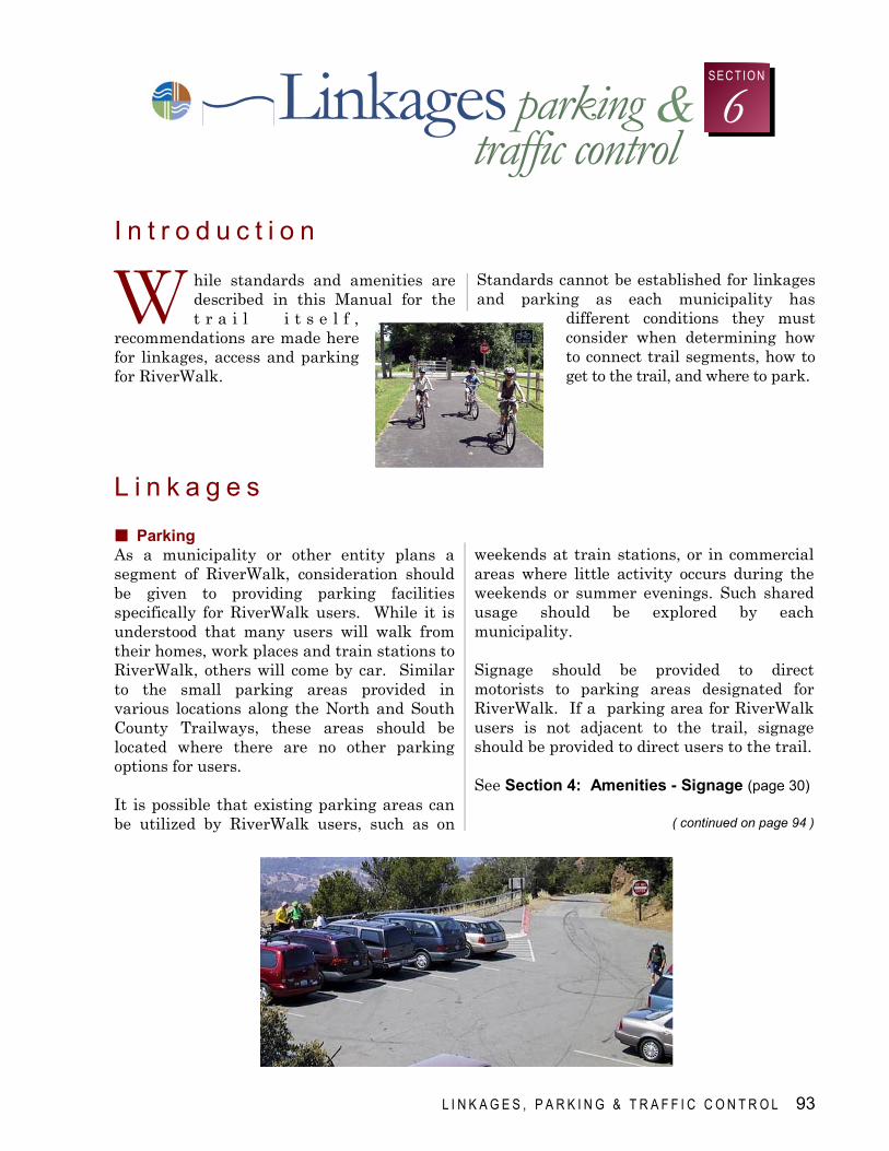
& parking
L I N K A G E S , P A R K I N G & T R A F F I C C O N T R O L 93
traffic control Linkages 6
SEC TIO N
I n t r o d u c t i o n
W hile standards and amenities are described in this Manual for the t r a i l i t s e l f ,
recommendations are made here for linkages, access and parking for RiverWalk.
Standards cannot be established for linkages and parking as each municipality has
different conditions they must consider when determining how to connect trail segments, how to get to the trail, and where to park.
L i n k a g e s Parking As a municipality or other entity plans a segment of RiverWalk, consideration should be given to providing parking facilities specifically for RiverWalk users. While it is understood that many users will walk from their homes, work places and train stations to RiverWalk, others will come by car. Similar to the small parking areas provided in various locations along the North and South County Trailways, these areas should be located where there are no other parking options for users. It is possible that existing parking areas can be utilized by RiverWalk users, such as on
weekends at train stations, or in commercial areas where little activity occurs during the weekends or summer evenings. Such shared usage should be explored by each municipality. Signage should be provided to direct motorists to parking areas designated for RiverWalk. If a parking area for RiverWalk users is not adjacent to the trail, signage should be provided to direct users to the trail. See Section 4: Amenities - Signage (page 30)
( continued on page 94 )
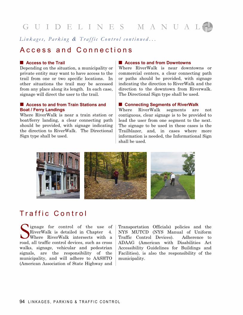
A c c e s s a n d C o n n e c t i o n s L i n k a g e s , P a r k i n g & T r a f f i c C o n t r o l c o n t i n u e d . . .
G U I D E L I N E S M A N U A L
Access to the Trail Depending on the situation, a municipality or private entity may want to have access to the trail from one or two specific locations. In other situations the trail may be accessed from any place along its length. In each case, signage will direct the user to the trail. Access to and from Train Stations and Boat / Ferry Landings Where RiverWalk is near a train station or boat/ferry landing, a clear connecting path should be provided, with signage indicating the direction to RiverWalk. The Directional Sign type shall be used.
Access to and from Downtowns Where RiverWalk is near downtowns or commercial centers, a clear connecting path or paths should be provided, with signage indicating the direction to RiverWalk and the direction to the downtown from Riverwalk. The Directional Sign type shall be used. Connecting Segments of RiverWalk Where RiverWalk segments are not contiguous, clear signage is to be provided to lead the user from one segment to the next. The signage to be used in these cases is the Trailblazer, and, in cases where more information is needed, the Informational Sign shall be used.
T r a f f i c C o n t r o l
S ignage for control of the use of RiverWalk is detailed in Chapter 4. Where RiverWalk intersects with a
road, all traffic control devices, such as cross walks, signage, vehicular and pedestrian signals, are the responsibility of the municipality, and will adhere to AASHTO (American Association of State Highway and
Transportation Officials) policies and the NYS MUTCD (NYS Manual of Uniform Traffic Control Devices). Adherence to ADAAG (American with Disabilities Act Accessibility Guidelines for Buildings and Facilities), is also the responsibility of the municipality.
94 L I N K A G E S , P A R K I N G & T R A F F I C C O N T R O L
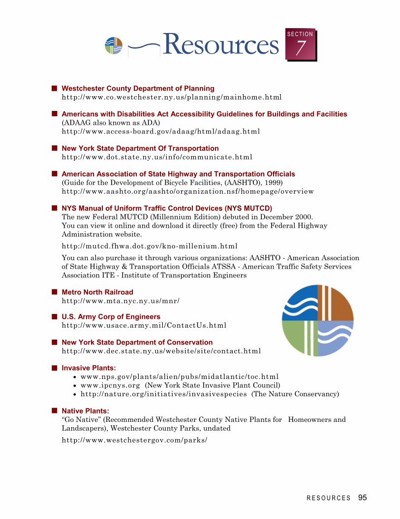
R E S O U R C E S 95
Resources 7 SEC TIO N
Westchester County Department of Planning http://www.co.westchester.ny.us/planning/mainhome.html Americans with Disabilities Act Accessibility Guidelines for Buildings and Facilities (ADAAG also known as ADA) http://www.access-board.gov/adaag/html/adaag.html New York State Department Of Transportation http://www.dot.state.ny.us/info/communicate.html American Association of State Highway and Transportation Officials (Guide for the Development of Bicycle Facilities, (AASHTO), 1999) http://www.aashto.org/aashto/organization.nsf/homepage/overview NYS Manual of Uniform Traffic Control Devices (NYS MUTCD) The new Federal MUTCD (Millennium Edition) debuted in December 2000. You can view it online and download it directly (free) from the Federal Highway Administration website.
http://mutcd.fhwa.dot.gov/kno-millenium.html
You can also purchase it through various organizations: AASHTO - American Association of State Highway & Transportation Officials ATSSA - American Traffic Safety Services Association ITE - Institute of Transportation Engineers Metro North Railroad http://www.mta.nyc.ny.us/mnr/ U.S. Army Corp of Engineers http://www.usace.army.mil/ContactUs.html New York State Department of Conservation http://www.dec.state.ny.us/website/site/contact.html Invasive Plants:
• www.nps.gov/plants/alien/pubs/midatlantic/toc.html • www.ipcnys.org (New York State Invasive Plant Council) • http://nature.org/initiatives/invasivespecies (The Nature Conservancy)
Native Plants: “Go Native” (Recommended Westchester County Native Plants for Homeowners and Landscapers), Westchester County Parks, undated
http://www.westchestergov.com/parks/

I stand by the river and I know that it has been here yesterday and will be here tomorrow and that therefore, since I am part of its pattern today, I also belong to all its yesterdays and will be a part of all its tomorrows.
This is a kind of earthly immortality, a kinship with rivers and hills and rocks, with all things and all creatures that have ever lived or ever will live or have their being on the earth. It is my assurance of an orderly continuity in the great design of the universe. Virginia S. Eifert