WEST VIRGINIA Box SECRETARY OF STATE · THE ABOVE RULE IS HEREBY ADOPTED AND FILED WITH TIHE...
24
WEST VIRGINIA SECRETARY OF STATE NATALIE E. TENNANT ADMINISTRATIVE LAW DIVISION Form #5 fmdo%? $#k'fn!&is Box NOTICE OF AGENCY ADOPTION OF A PROCEDURAL OF INTERPRETIVE RULE OR A LEGISLATIVE RULE EXEMPT FROM LEGISLATIVE REVIEW AGENCY: Propertv Valuation and Procedures Commission TITLE NUMBER: 1 89 CITE AUTHORITY W. Va. Code 9 1 1 - 1 C-4(d) RULE TYPE: PROCEDURAL X INTERPRETIVE EXEMPT LEGISLA?'IVE RULE CITE STATUTE (s) GRANTING EXEMPTION FROM LEGISLATlVE REVIEW . . . AMENDMENT TO AN EXISTING RULE: YES X NO IF YES, SERIES NUMBER OF RULE BEING AMENDED: 3 TITLE OF RULE BEING AMENDED: StatewideProcedures For The Maintenance And Publishing;Of Surface Tax Mavs IF NO, SERIES NUMBER OF NEW RULE BEING ADOPTED: TITLE OF RULE BEING ADOPTED: THE ABOVE RULE IS HEREBY ADOPTED AND FILED WITH TIHE SECRETARY OF STATE.. THE EFFECTIVE DATE OF THIS RULE IS Februarv 27.2009 Cabinet ~ecre&of the Department of Revenue
Transcript of WEST VIRGINIA Box SECRETARY OF STATE · THE ABOVE RULE IS HEREBY ADOPTED AND FILED WITH TIHE...

WEST VIRGINIA SECRETARY OF STATE
NATALIE E. TENNANT
ADMINISTRATIVE LAW DIVISION Form #5
fmdo%? $#k'fn!&is Box
NOTICE OF AGENCY ADOPTION OF A PROCEDURAL OF INTERPRETIVE RULE OR A LEGISLATIVE RULE EXEMPT FROM LEGISLATIVE REVIEW
AGENCY: Propertv Valuation and Procedures Commission TITLE NUMBER: 1 89
CITE AUTHORITY W. Va. Code 9 1 1 - 1 C-4(d)
RULE TYPE: PROCEDURAL X INTERPRETIVE
EXEMPT LEGISLA?'IVE RULE
CITE STATUTE (s) GRANTING EXEMPTION FROM LEGISLATlVE REVIEW . . .
AMENDMENT TO AN EXISTING RULE: YES X NO
IF YES, SERIES NUMBER OF RULE BEING AMENDED: 3
TITLE OF RULE BEING AMENDED: Statewide Procedures For The Maintenance And
Publishing; Of Surface Tax Mavs
IF NO, SERIES NUMBER OF NEW RULE BEING ADOPTED:
TITLE OF RULE BEING ADOPTED:
THE ABOVE RULE IS HEREBY ADOPTED AND FILED WITH TIHE SECRETARY OF STATE.. THE
EFFECTIVE DATE OF THIS RULE IS Februarv 27.2009
Cabinet ~ecre&of the Department of Revenue

TITLE 189 PROCEDURAL RULE
PROPERTY VALUATION TRAINING AND PROCEDURES SSION 2 J PR l:M
SERIES 3 STATEWIDE PROCEDURES % r ' - x l --- I ' ii'-,, L-~LL , L ; g;rlb!pd[4 '- ',f - i* y ,
FOR THE MAINTENANCE AND PUBLISHING S c ~ h c l i d I 1 OF STATE OF SURFACE TAX MAPS
1 .l. Scope. -- This regulation establishes statewide procedures for the maintenance and publishing of surface tax maps by either manual or automated methods.
1.2. Authority. -- W. Va. Code $1 1-1C-4(d). The Property Valuation Training and Procedures Commission has the power to make such rules as it deems necessary to establish and carry out uniform, statewide procedures for the maintenance and use of surface tax maps.
1.3. Filing Date. -- January 27,2009
1.4. Effective Date. -- February 27,2009
1.5. Repeal of Former Rules. -- This procedural rule repeals and replaces the following rules filed September 27, 1990 and effective September 27, 1990.
1.5.a. WV 189CSR3 "Guidelines for the Neat Drafting of Surface Tax Maps"
1.5.b. WV 189CSR4 "~Gtewide Procedures for the Manual Maintenance o f ' Surface Tax Maps"
1.6. Duties.
1.6.a. Assessors. -- County Assessors, along with their mapping s m , shall maintain the tax maps in accordance with the instructions and guidelines provided by the Department of Revenue and the Property Valuation Training and Procedures Commission. County assessors are authorized to contract with independent vendors in order to develop and maintain mapping systems, provided that such vendors adhere to these standards and guidelines and be bound by the requirements herein.
1.6.b. Department of Tax and Revenue. -- The State Tax Department is the property tax supervisory agency and the principal agent of the Property Valuation and Procedures Commission's monitoring efforts to ensure that county assessors are in compliance with statewide tax mapping procedures. The State Tax Department shall provide limited technical assistance to counties that are upgrading their cadastral mapping systems.
1.6.c. WV GIs Technical Center. -- The Technical Center shall provide assistance with mapping standards and shall serve as a clearinghouse for publicly available geospatial data.

1.6.d. Professional Surveyors. -- where possible, licensed land surveyors shall collaborate with assessors to transfer existing surveyed data to county tax mapping systems.
5189-3-2. Purpose. Tax maps are fundamental to the appraisal (valuation) of real estate. They help to determine the location of property, indicate the size and shape of each parcel, and illustrate its relation to features that affect value. It is, therefore, necessary that the tax maps and assessment system records accurately represent what is actually owned by the taxpayer. Although tax maps serve as a general reference to property locations, they are not a substitute for official survey plats.
5189-3-3. History. County tax maps were originally created on linen or mylar sheets in the 1960's by the Department of Revenue to aid the assessor in the location and assessment of real estate. Legislation in 1990 created an eleven-member Property Valuation Training and Procedures Commission whose duties included establishing standardized mapping procedures for the county assessors. Later that same year the commission approved procedural rules for the manual maintenance of surface tax maps. In 1995, as part of the Mineral Parcel Mapping Project, the Department of Revenue began the digital compilation of surface parcel boundaries to create mineral parcel maps for all coal bearing lands. Consequently, some county assessors utilized the surface tax parcels fiom this project to transition their county fiom a manual to computerized tax mapping system. By 2007, over half of the counties in West Virginia had transitioned to a computerized mapping system, with several counties utilizing geographic information systems to link parcel geometry to assessment databases. During the past decade, three counties chose to re-map their respective counties and create a new parcel identification system to resolve problems arising from extensive development.
5189-3-4. Map Elements. A manual or automated mapping system for assessment purposes includes the following elements: geodetic network, mapping layers, parcel identifiers and attributes.
4.1. Geodetic Network. -- The geodetic control layer provides a common reference system for establishing coordinate positions of all geographic data. This is coordinated and managed by the National Geodetic Survey and provides a consistent and uniform definition of coordinate systems, datums and monumented points across a jurisdiction.
4.1 .a. Datums. -- The horizontal datum shall be the North American Datum of 1983 (NAD83) and successive adjustments; the vertical datum shall be the North American Vertical Datum of 1988 (NAVD 88).
4.1 .b. Coordinate Systems. -- The State Plane Coordinate System (map units in feet) is recommended for the input, storage, and exchange of map data. Counties shall map in the correct "South Zone" or 'Worth Zone" of the State Plane Coordinate System as prescribed in W.Va. Code $30-13A-17. The Universal Transverse Mercator Coordinate System (map units in meters), Geographic Coordinates System (map units in decimal degrees), and other coordinate systems and projections may be used to satisfl special requirements.
4.2. Map Layers. -- The base map layers provide a physical framework upon which non- physical parcel information can be displayed. A full multipurpose cadastre will have additional map layers. Index layers provide a geographic reference to the individual tax map sheets.

4.2.a. Base Map Layers. -- Base map layers, such as aerial photography, boundaries, roads and streams, are the typical foundation layers of a cadastral mapping system. Base layers are tied to the geodetic control and are usually derived photogrammetrically from aerial photographs.
4.2.a.l. Horizontal Accuracy. -- All new or revised base map layers of physical features shall meet or exceed a horizontal accuracy scale of 1 :4800, or + or - 13.33 feet, in accordance with National Map Accuracy Standards.
4.2.a.2. Scale Mixing. -- The mixing of digital map data of widely divergent scales into a common database shall be avoided, as the positional accuracy of the aggregate database is considered to be no better than that of the smallest scale. If digital map layers are derived from different sources, then efforts shall be employed to improve the compatibility of map layers with one another, including the spatial adjustments of specific layers to a more accurate base map.
4.2.a.3. Existing Digital Data. -- Before creating new base map layers, the availability and suitability of existing digital data from the State Geospatial Data Clearinghouse or other sources should be checked.
4.2.a.4. Official Boundaries. -- The official county boundaries (W.Va. Code 57-2-6) and tax district boundaries (W.Va. Code 5 1 1-3-la) are derived from the 1 :24,000-scale U.S. Geological Survey's topographic maps and are digitally available from the State Geospatial Data Clearinghouse. The official corporation boundaries originate from partnership efforts of the municipalities and U.S. Census Bureau.
4.2.b. Cadastral Map Layers. -- Cadastral mapping layers are the property and lot lines, set forth dimensions andfor areas, and other parcel-related geometry that assessors are required by state law to collect and maintain. Parcels and related layers may be compiled by digitizing scanned tax maps, coordinate geometry, or by other reliable sources.
4.2.c. Additional Map Layers. -- Additional map layers such as zoning, flood hazard areas, soil type, and other layers may be obtained and utilized from other offices or entities to extend the value of the mapping system.
4.2.d. Index Map Layers. -- Index map layers show the location and boundaries of the individual tax map sheets in relation to major features (major highways, populated places, etc.) within the jurisdiction. Index layers shall be used to prepare index reference maps of the entire county and other subdivisions (e.g., tax district, corporation, or map blocks), showing specifically the area covered by each tax map sheet and its geographic relationship to the other individual tax map sheets.
4.3. Parcel Identifiers. -- Each parcel shall have assigned to it a unique identification number that links each parcel boundary with the assessment database. Details on parcel identification systems are in section 9.
4.4. Parcel Attributes. -- It is recommended that parcel geometry be linked or cross- referenced to ownership and assessment information centrally stored in the Integrated Assessment

System.
5189-3-5. Finished Tax Maps. Finished surface tax maps show the property and lot lines, set forth dimensions andlor areas, and other cadastral and cultural features that assessors are required by state law to maintain and publish for the public. These scaled tax maps are created by either manual or automated methods in accordance with the cartographic design, map content and layout specifications mandated by the Property Valuation Training and Procedures Commission.
5189-3-6. Map Content.
6.1. Basic Information. -- Finished tax maps shall display the following:
6.1 .a. Parcel identifiers.
6.1 .b. Parcel boundaries.
6.1 .c. Parcel dimensions or acreage.
6.1 .d. Lot boundaries, lot numbers and subdivision block identifiers.
6.1 .e. Municipal and tax district boundaries.
6.1 .f. Location and names of streets, highways, alleys, railroads, rivers, lakes, etc.
6.1 .g. Contextual information including the map number, date map was prepared, scale, legend, north arrow, disclaimer, and key to adjoining maps.
6.2. Supplemental Information. -- Supplemental information may be added to improve the detail or use of the map. Commonly collected supplemental information may include but not be limited to the following:
6.2.a. Addressable structures.
6.2.b. Assessment values.
6.2.c. Flood hazards.
6.2.d. Mineral layers.
6.2.e. Right-of-way boundaries or easements.
6.2.f. Soils.
6.2.g. Utility lines.
6.2.h. Voting precincts.

6.2.i. Zoning information.
9189-3-7. Map Design. The manual or automated creation of finished tax maps shall follow standard cartographic design principles to ensure maps are legible, easily interpreted, visually appealing, and communicate effectively the cadastral information to the map reader.
7.1. Map Sheet Size. -- The final map size for finished maps shall depend on the scale and coverage of the maps; however, finished tax maps shall not exceed a page size of 36" x 36".
7.2. Map Scales. -- Unless original tax maps permit other scales, all revised and new tax maps shall be prepared according to the following map scales.
7.2.a. Urban areas, Corporations, and Insert Maps: -- 1 : 1200 (1 " = 100').
7.2.b. Rural areas: -- 1:4800 (1" = 400') or 1 : 1200 (1" = 100').
7.3. Map Material. -- All new master maps created manually shall be drawn on stable base film of at least 0.004" thickness. Computer-generated maps may be printed on either film or paper.
7.4. Map Color. -- All tax maps shall be designed so they can be interpreted when scanned or printed in black and white. Consequently, instead of depending on multiple colors to contrast line features, map producers shall use variations in line thicknesses, line styles, and other unique symbols to distinguish line features like parcel boundaries, lot lines, streams, roads, and boundaries.
7.5. Symbols. -- Throughout the finished tax maps, the symbol sets shall be consistent, conforming to the standard mapping symbols and cartographic specifications shown in the Appendix of the Standard on Manual Cadastral Maps and Parcel IdentiJiers (IAAO 2004). Computerized mapping systems shall follow a similar cartographic standard.
7.5.a. Parcels. -- Boundaries of individual parcels shall be delineated by solid lines. In a geographic information system, parcel polygons shall have validated topology; that is, all parcel lines shall form closed polygons with no overlapping or sliver polygons, and the line work shall have no dangles, overshoots, or undershoots.
7.5.b. Lots. -- Interior tracts or lots within parcels shall be delineated by dashed or broken lines.
7.5.c. Streams. -- Single-line streams shall be delineated by a line pattern consisting of a long dash and three dots. Doubled-line streams and water bodies may contain a fill pattern.
7.5.d. Roads. -- Roads shall be delineated by solid double line or road casing. Where possible, it is recommended that the edge-of-pavement or roadway be shown on maps with a dashed line or fill pattern.
7.5.e. Railroads. -- Railroads shall be displayed by the typical solid line and hachure pattern, with the hachure lines displayed at the appropriate length and spacing.

7.5.f. Political and Tax District Boundaries. -- Line styles for political boundaries and tax district boundaries shall be greater in width than parcel lines.
7.5.g. Right-of-way Boundaries or Easements. -- Right-of-way boundaries for streets, alleys, roads, and utilities may be indicated by dashed or solid lines.
7.5.h. Structures. -- The symbol set of the U.S. Geological Survey's topographic maps is recommended for dwellings, schools, churches, hospitals, airports, and other man-made features. Improved structures may be represented by a small circle or rectangle.
7.6. Annotation. -- Annotation is the text or labels plotted graphically on a map. Map producers shall ensure that the arrangement, style, or general appearance of text is legible and interpreted easily.
7.6.a. Annotated Features. -- All the basic map features listed in subsection 6.1 of this rule shall be labeled. Unless otherwise denoted in these specifications, all lettering on fished cadastral maps shall conform to the character height and orientation shown in the Appendix of the Standard on Manual Cadastral Maps and Parcel Identifiers (MA0 2004). Computerized mapping systems shall follow a similar cartographic standard.
7.6.b. Text Placement Ranking. -- Priorities for assessment labels to be placed within a small parcel of land where space is limited shall be (1) parcel identifier, (2) dimensions, and then (3) lot number and block numbers.
7.6.c. Parcel Identifier. -- Parcel identifiers shall be oriented in the same direction for readability, unless there is not enough space within a parcel boundary in which case the identifier may be rotated. A circle or oval shall be drawn around each parcel identifier. Parcel identifier numbers shall be placed inside the parcel as long as the identifiers are legible. Parcel identifiers outside of the parcel shall have a leader, a line drawn fiom the encircled parcel identifier to the appropriate parcel. The leader may be angled or curved to avoid another parcel.
7.6.d. Lot Number. -- Numbers of all recorded subdivision lots and where applicable, numbers of lots in "unrecorded subdivisions," shall be enclosed in parenthesis.
7.6.e. Dimensions and Acreage. -- Each parcel shall be annotated with dimensions andlor acreages.
7.6.e. 1. Dimensions. -- Parcels within municipal limits less than one (1) acre shall show deeded dimensions in feet. Distance values shall be centered and placed parallel to the relevant parcel boundary line. Calculated dimensions shall be enclosed in parenthesis or annotated with "(c)" after the number. Deeded dimensions shall take precedence over calculated dimensions.
7.6.e.2. Acreage. -- Parcels one (1) acre or larger shall show acreage. Parcels in m a l areas less than one acre may be shown as fractions of an acre or dimensions in feet. Acreage should not exceed two (2) places beyond the decimal point. A decimal point and zeros are unnecessary for whole acreages. The abbreviation "Ac." shall follow the acreage value. If the deeded acreage does not match the calculated acreage, then the deeded acreage shall take precedence.
If both deeded and calculated acreages are annotated on the same map, then the deeded and calculated acreages shall be identified by "(d)" and "(c)" respectively.
7.6.f. Divided Parcels. -- A parcel of land divided by a highway, river, etc. or map sheet shall be properly annotated.
7.6.f.l. Part of Parcel. -- Divided parcels shall be annotated by "plo parcel" (part of parcel).
7.6.f.2. Land Hook. -- A land hook graphic shall be used on divided parcels too small to denote the plo reference.
7.6.g. Right of Way. -- Right of way dimensions may be annotated with "W (e.g., 60' R/W).
7.7. Computer System Guidelines for Annotation.
7.7.a. Transferability. -- It is recommended that computer mapping systems store labels or annotation in a separate layer file or database and not in the map document file. This practice allows for an easier exchange of textual information between different software programs or versions.
7.7.b. Typography. -- Text shall be legible and placed logically on the map. Uppercase lettering shall be used sparingly (water bodies, or widely spaced lettering) since lowercase (or proper case) is easier to read. Maps should use at most two font styles. Sans-serif fonts (Arial, Verdana) generally are recommended for terrestrial features, such as geographic regions (counties and states), roads, utilities, etc., and for smaller text. Serif fonts (Times New Roman) are recommended to label lakes and rivers and italicized to give the indication of flow. Boldfaced text may be used to emphasize features. Refer to literature on typography and cartography for more information regarding the arrangement, style, or general appearance of textual information.
7.8. Map Layout. -- Throughout the finished maps the layout shall be standardized. The following map layout specifications shall be utilized when producing finished tax maps:
7.8.a. Framing of Data and Map. -- All maps shall contain both neatlines and borders. A neatline demarks the limit of the mapped area and frames the data. Borders provide a frame for the map graphic and are usually outside the neatline but may overlay it (meaning that the neatline and border form the same line).
7.8.b. Margins. -- It is recommended that each tax map carry a one-inch margin on top and right side; a two-inch margin on the bottom side; and a three-inch margin on the left side for binding and annotation when required. Property lines may extend into the margin on the right side and top of a map sheet but shall not extend into the title block portion of the map sheet.
7.8.c. Contextual Items / Title Block. -- The two-inch margin at the bottom shall show contextual elements that include the title (county and districtdcorporation name, map number), map scale, legend, north arrow, publication date, map producer, revision blockldate, key to adjoining

maps, and disclaimer. It is also recommended that a limited-use restrictions notice be shown on the finished tax maps.
7.8.c.l. Map Name. -- Map identification information shall be placed in the lower right hand comer of the margin.
7.8.c.l.A. Tax Parcel Map. -- Each surface tax parcel map shall include the state and county names, district or corporation name and identifier, and map reference number.
7.8.c. 1 .B. Index Map. -- Each index map shall include the label "Index Map" and the name of the county, district, or corporation (municipality) for which the index map represents.
7.8.c.2. Map Scale. -- It is recommended that map scales be expressed as ratios such as 1 : 1200 (1" = 100') or 1 :4800 (1" = 400'). A bar scale expressed in feet may be used instead of ratios or may supplement the ratio map scale.
7.8.c.3. North Arrow. -- An arrow-like symbol indicating the north direction on the map shall be located within the map image area or margin.
7.8.c.4. Legend. -- The legend information shall be ~ ~ c i e n t to understand the map and the legend symbols shall appear similar to those in the map fiame. A properly constructed legend does not need to be framed by a neatline, nor does it require the word "legend" in its title.
7.8.c.5. Disclaimer. -- Disclaimers are used to limit and define the map author's responsibility for the content, accuracy, and currency of a map. Tax maps may display the standard disclaimer "For Tax Purposes Only" or a specialized disclaimer such as: "The tax map was compiled for purposes of taxation fiom available record evidence and has not been field verified. This map is not a valid survey plat and the data on this map does not imply any official status to such data. The State of West Virginia and county assessor's office assume no liability that might result fiom the use of this map."
7.8.c.6. Restriction. -- Published tax maps are restricted in their use and shall not be reproduced, copied, or sold without consent fiom the county assessor fiom which it was created. A suggested restriction statement is as follows: "All finished tax maps created under the provisions of legislation are the property of the county assessors who created them and the reproduction, copying, distribution, sale, or lease of such tax maps or copies thereof without the written permission of the respective county assessors is prohibited by law." The State Department of Revenue is hereby designated as an agent for all counties for the purpose of sale, reproduction and distribution of tax maps.
9189-3-8. Computer Mapping Systems. Computerization of the map and parcel data enhances the county assessors' capabilities to manage, analyze, summarize, and display geographically referenced information. Digital cadastral map layers and parcel data are easily shared, allowing various users to manipulate and selectively retrieve layers of parcel and other information and to produce composite
maps with only the data needed by each. Such sharing also reduces the duplication of effort inherent in separate, possibly incompatible, map systems. See Standard on Digital Cadastral Maps and Parcel Identifiers (IAAO 2003).
8.1. Geographic Information Systems (GIs). -- The preferred automated mapping system for maintaining and publishing digital map and parcel data is a geographic information system. It is recommended that a successfully deployed cadastral geographic information system meet the following requirements:
8.1.a. Geo-referenced. -- All mapping layers are geo-referenced to a common coordinate system.
8.1 .b. Edge-matched. -- Parcel polygons are seamless across all jurisdictions and tax district boundaries for the entire county.
8.1 .c. Parcels Linkable to Databases. -- Parcel boundary polygons are topologically validated and linkable to external assessment databases via unique property identification numbers.
8.1 .d. Computer-Generated Maps. -- Finished tax maps are digitally produced and published in accordance with map design and layout rules set forth in this regulation.
8.1 .e. Continual Maintenance. -- Tax maps are continually maintained in a digital environment.
5189-3-9. Parcel Identification Systems. A parcel identification system provides a method for referencing land parcels, or data associated with parcels, using a number or code instead of a complete legal description. The correlation of maps and individual property records requires that all parcel files be indexed using a uniform parcel identifier. Parcel identifiers shall be unique and permanent, changing only when the boundaries of the parcel change, and a new parcel is created.
9.1. Map Based Systems. -- The map-based system is the primary system of parcel identification in West Virginia. Under a map-based system, the assessment map itself is incorporated into the parcel identifier. The parcel identifier consists of the concatenated county, district number, map number, parcel number and suffix number (for example 0 1-0 1-000 1-000 1.000 I), which serves to reduce legal descriptions to a uniform and more manageable size and is as defensible as the original descriptions. Map based identifiers do, to some extent, reference a geographic area and are convenient in the field. Problems may arise in this system where extensive development is occurring, requiring re-mapping and the assignment of new parcel identifiers. However, in stable areas, this system may be satisfactory.
9.2. Geographic Coordinate Systems. -- The geographic coordinate system uses a direct geographic reference to identifl the x and y coordinates of a parcel centroid. This geographic parcel identifier (GPIN) may be automatically or manually generated using computer software. Parcel identification systems using the geographic coordinate system shall be based upon the West Virginia State Plane Coordinate System as it relates to the aerial photo index grid established by the Statewide Addressing and Mapping Board in 2002.
5189-3-10. County Map Sheet Reference Systems. In the 1960's, engineering f m s arbitrarily created map sheet reference schemes (or county map layout index) for each county in West Virginia by dividing larger areas into smaller tiles or rectangular grids. A typical tiling scheme was established by subdividing each county into tax districts for rural areas and corporations for municipalities, which were then further subdivided into primary map sheets with its own number system (1 to n), usually at 1" = 400' scale. The different types of map sheet reference systems are identified by the following elements: map orientation, uniform tile size, the correlation of the 1'' = 400' and 1" = 100' scale index grids, and whether the primary map sheet boundaries 1 tiling numbering system are delimited by the district or county boundary.
10.1. Types of County Map Sheet Reference Systems and their Characteristics.
1 0.1 .a. Random Grid. -- Random orientation of tiles; variable tile size; map sheet index grids do not correlate; district boundary defines the limits of the primary map sheet boundaries I tiling numbering system.
10.1 .b. Modified Grid. -- Tiles oriented true north; variable tile size; map sheet index grids do not correlate; district boundary defines the limits of the primary map sheet boundaries 1 tiling numbering system.
10.1 .c. True Grid. -- Tiles oriented true north; uniform tile size; map sheet index grids do not correlate. Other variations: district boundary or county boundary defines the limits of the primary map sheet boundaries I tiling numbering system; map identifiers either numeric or alpha- numeric; map number system from 1 to n for each district or unique map numbers for the entire county; length and width dimensions of tiles varies from county to county.
10.1 .d. Subset Grid. -- Tiles oriented true north; uniform tile size; map sheet index grids correlate; county boundary defines the limits of the primary map sheet boundaries I tiling numbering system; map numbers unique for the entire county.
5189-3-1 1. Map Maintenance. Map maintenance involves recorded or parcel boundary description changes, making map corrections, and notifling map users of the changes on a regular basis. Maintenance also includes the constant correction and improvement of the maps fiom new and more accurate survey data. There should also be a plan for re-mapping areas at as large a scale as necessary, to more clearly depict new subdivisions and areas of rapid development and growth.
11.1. Parcel Splits. -- Parcel numbers are changed whenever parcels (alias names: parcel prefix or parent parcel) are split into sub-parcels (alias names: parcel suffix, child parcel, parcel split number).
1 1.1 .a. Parcel Split Number. -- If a parcel of land is split into sub-parcels or lots, then the new identification number shall be created by using:
1 1.1 .a. 1. Original parcel number.
1 1.1 .a.2. Decimal point.

1 1.1 .a.3. Split number - 1 through last number required.
1 1.1 .b. Leading Zeros. -- A zero preceding the split number shall not be used. If a mapper discovers a zero preceding the split number, then the zero shall be removed.
1 1.1 .c. Further Splits. -- When a split is made from a split, the next consecutive suffix number shall be used.
1 1.1 .d. Part of Parcel. -- When a split is made from a plo portion of a tract that is identified on a sheet other than the one the parcel number of that tract is on, then the split shall be given the next highest parcel number on the sheet on which it is located.
1 1.1 .e. Adjoining Map Sheets. -- Adjoining map sheets shall be checked for matching purposes after splits or changes of any kind are made. The mapper shall take the time necessary to see that all map sheets afTected by the changes have been checked for completeness. When the maps are matched to one another, the property lines, roads, etc. must agree with each other in all respects.
11.1 .f. Annexes. -- When an annex or de-annex results in a new corporation boundary, then all relevant parcels and index maps shall be revised.
1 1.1 .g. Manual System. -- All revisions made on work maps shall be either red for additions or green for deletions. Drafters shall use hard lead pencils only.
1 1.1 .h. Geographic Coordinate System. -- In the case of a parcel split, a geographic parcel identification number is calculated from the centroid location of the new parcel.
11.2. Combining Parcels. -- Combining two (2) or more parcels together to be mapped as one (1) parcel is not recommended. Combining accounts, keeping each parcel with a unique identifier, can allow the taxpayer to receive one (1) tax ticket rather than several. This procedure is far more practical than changing the maps.
1 1.3. Unidentified Parcel Locations. -- Where a parcel cannot be located with reasonable confidence, the mapper shall reconcile the mapping problem by considering one or more of the following guidelines:
11.3.a. Annotate "Location" within the parent parcel along with the deed acreage. The parent parcel acreage shall also be amended appropriately to reflect the change.
1 1.3 .b. All parcels that cannot be specifically placed on the maps shall be placed on the Integrated Assessment System with parcel identifiers (Map OOOX, Parcel 0001.0000 etc.) in alphabetical sequential order as they appear in the assessor's land book. It is recommended that all helpful remarks relevant to the location of these properties be added to the "NOTE" section of the Integrated Assessment System.
1 1.4. Inserts. -- Accuracy, legibility and neatness are important elements of an effective and communicative tax map. Larger-scale inserts shall be plotted on new map sheets at 1 " = 100' scale to correct areas that are too congested for smaller-scale 1" = 400' maps. As a general rule, 1" = 100'

insert maps should be created when a 1 " = 400' map has (3) digit numbers or contains one hundred (1 00) or more parcels. The type of map sheet reference system shall determine how insert maps are created for congested areas.
1 1.4.a. Insert Maps for True Grid, Modified Grid, and Random Grid Systems. -- All new insert sheets shall be plotted at 1 " = 100' scale, except where the original permitted other scales. Inserts shall be identified by the map number it is taken from and a letter assigned in alphabetical order. Letters used shall be fi-om "A" to "Z", omitting "I", "0" and "Q" as they could be confused with a map number.
1 1.4.b. Insert Maps for Subset Grid System. -- In the subset grid system sixteen (1 6) larger-scale (1" = 100') maps correlate to each smaller-scale (1" = 400') map. A larger-scale, individual map sheet is activated from the pre-configured, larger-scale index grid (1" = 100') when a portion of the smaller-scale (1" = 400') map must be enlarged.
1 1.5. Insets. -- It is recommended that map producers not use inset maps in which a portion of a map is enlarged in scale and shown on the same map.
1 1.6. Re-Mapping. -- If a county or part of a county is being re-mapped, then the map sheet reference system and parcel identification system shall be revised. When a major updating and re- mapping program is undertaken, consideration shall be given to whether the project shall be conducted in-house or contracted to an appropriate vendor.
11.6.a. Subset Grid. -- The county assessor shall adopt a "subset grid" reference system, where the 1'' = 100' index is a subset of the 1" = 400' index. The subset grid reference system shall be based on the West Virginia State Plane Coordinate System and integrate with the statewide geographic parcel identifier (GPIN) system described in subsection 9.2 of this rule.
11.6.b. Parcel Identification System. -- The county assessor shall ensure that the newly created parcel identifiers are cross-indexed to the original identifiers. Secondary identifiers shall be cross-indexed to the primary map-based identifier to allow for multiple uses of the data.
1 1.7. Contracting for Maintenance Services through the State Tax Department or Vendor. -- The State Department of Revenue, Property Tax Division, shall serve as a central receiving location for any county that desires "manual" maintenance services performed by a vendor under contract with the Property Tax Division. The Property Tax Division shall not provide intermediary contracting services for the "digital" maintenance of surface tax maps; instead, assessors shall contract directly with qualified vendors for digital maintenance services.
11.7.a. Manual Maintenance Guidelines. -- County assessors who choose to use the Property Tax Division Maintenance Vendor Option shall forward full size map work copies to the Division office. The Division will perform a pre-draft edit, and forward the map work copies and master maps to the Division drafting vendor. Upon completion of the drafting work by the vendor, the Division will perform a post-edit of the vendor's final drafting work and provide an updated copy of the master map to the county assessor. The counties shall be billed on a per parcel basis for only those services rendered by the vendor. The Property Tax Division involvement shall be at State expense to include the storage of the master maps for county assessors who use the Property Tax

Division Maintenance Vendor Option.
1 1.7.b. Digital Maintenance Guidelines. -- Since the Property Valuation Training and Procedures Commission monitors the maintenance of surface tax maps, county assessors who choose to use an independent vendor to maintain digital maps shall submit a copy of the vendor's contract to the Property Tax Division in advance to ensure proper procedures are followed. See paragraph 1.6a.
1 1.8. Revised Map Copies Provided to Department of Revenue. -- In order to provide current map copies to the general public, each assessor shall provide, fiee of charge, one reproducible copy of each revised map sheet to the Department of Revenue.
1 1.8 .a. Submission Time Requirement. -- Transfers occurring between July I st and the following June 30 shall be reflected in the maps and submitted to the Department of Revenue no later than February 1 of the subsequent calendar year.
11.8.b. Format Submission. -- Revised finished maps shall be submitted as a hardcopy or print-ready digital image. Submission and map exchange specifications shall be overseen by the Property Tax Division.
11.8.c. Quality Assurance. -- The Property Tax Division shall perform quality assurance checks to ensure that all manual or computer-generated finished tax maps are submitted in accordance with the specified map content, layout, and design set forth in this regulation.
s189-3-12. Cooperative Agreements. County assessors are encouraged and hereby authorized to enter into cooperative agreements with other county assessors for the purpose of providing mapping services.
$189-3-13. Request for Proposals and Contractor Selection. When contracting for the development of mapping services, the assessor shall develop a request for proposals (RFP) that embodies the technical and cartographic specifications set forth in this regulation. See Standard on Contracting for Assessment Services (IAAO 2002). The assessors may request sample RFP's fiom the Property Tax Division, Department of Revenue.
81893-14. Map Security. Tax maps are fundamental to the appraisal process of real estate because the maps help determine the location of property, indicate the size and shape of each parcel, and reveal its relations to pertinent features that affect value. Therefore, in order to ensure the continued updating, safekeeping and availability of tax maps, the county assessors, and their agents, shall adhere to the following:
14.1. Provide appropriate storage for the protection of the maps and computerized data. As insurance against loss or damage, and as assurance of an adequate historical record of ownership, it is recommended that at least one reproducible set of maps and computerized map data be stored in a fireproof environment at a location different from the place where the originals are stored or used. The computerized map data should consist of the full data set that data producers use in their daily business operations. The Department of Revenue is authorized to be a repository for this information, provided that such information shall not be copied, sold or distributed without the authorization fiom the assessor of the county fiom which the information was created.

14.2. Make a copy at least once a year.
14.3. Should a master set of maps become lost, destroyed or damaged, the county assessor is responsible for replacing the master maps.
$189-3-15. Statewide Digital Parcel Boundary File. Once a year, as part of the State Parcel Management Program, a state parcel boundary file with minimum attributes shall be standardized across jurisdictional boundaries to meet statewide business needs including emergency response and economic development. To fulfill this annual requirement, during the month of April, all county assessors who maintain automated systems shall submit their digital parcel boundary files and associated metadata to the State Tax Department in accordance with prescribed submission guidelines. It is recommended that digital parcel files be geo-referenced, seamless, topologically validated, and linkable to the Integrated Assessment System. The State Tax Department may provide this information to any federal, state, or local government agency for their limited use. The further reproduction and distribution shall be in accordance with paragraph 7.8.c.6 of this rule.
$189-3-16. County Monitoring. In accordance with guidelines prescribed in the County Monitoring Plan, the State Tax Department shall periodically audit county assessors to ensure that their surface tax maps are in compliance with this regulation. The completed report shall be submitted to the State Tax Commissioner and Property Valuation and Procedures Commission for review and subsequent action.
8189-3-17. References.
17.1. International Association of Assessing Officers (IAAO). 2002. Standard on Contracting for Assessment Services. Website: http://www.iaao.orgl.
17.2. International Association of Assessing Officers (IAAO). 2003. Standard on Digital Cadastral Maps and Parcel Identifiers. Website: http://www.iaao.orgl
17.3. International Association of Assessing Officers (IAAO). 2004. Standard on Manual Cadastral Maps and Parcel Identifiers. Website: http://www.iaao.orgl
17.4. Federal Geographic Data Committee's (FGDC) Cadastral Data Subcommittee. 2006. Cadastral NSDI Reference Document. Website: http://www.nationalcad.orgl
$189-3-18. Glossary of Terms. All terms are defined in the context of this regulation.
1 8.1. Annotation. -- Text or labels placed on a map and usually tied to a particular graphic element. It is one of the most time-consuming tasks in constructing tax maps.
18.2. Attribute. -- A single element of non-graphic information (name of owner, property area, property value, etc.) stored in a database field and associated with a single map property parcel. Attributes may be attached to a point, line, or polygon feature and may be used to query features or create annotation.

18.3. Base Map. -- A map portraying basic reference features such as roads, lakes and streams onto which other thematic spatial information such as property or parcel outlines, easements, rights of way or other special features are placed.
18.4. Boundaries.
18.4.a. Tax District Boundary. -- Tax district boundaries are defined as the rural tax district bouqlaries adopted by the WV Legislature in 1978. The boundaries were drawn from 1 :24,000-scale USGS topographic maps in 1978 and coincide with county magisterial districts as of July 1,1973. Unlike magisterial districts that are realigned every ten years following the census, the tax district boundaries do not follow equal representation requirements and do not change over time. (W.Va. Code $87-2-7 and 11-3-la).
18.4.b. Assessment Tax Boundary. -- Unlike the official tax district boundaries derived from county magisterial districts in 1978, an "assessment tax boundary" changes over time and can consist of individual tax parcels that lie in more than one tax district or county (W.Va. Code $ $1 1 -4- 14,ll-4- 1 5, and 1 1 -4- 1 6). The peripheral property line of all the parcels within each district delineates the assessment tax boundaries.
18.4.c. Corporation Tax Boundary. -- The corporation tax boundary coincides with the incorporated municipality boundaries which are cooperatively produced by local governments and the U.S. Census Bureau.
18.4.d. County Boundary. -- The official county boundaries are derived from the 1 :24,000-scale U.S. Geological Survey's topographic maps (W.Va. Code $7-2-6). Disputed county boundary lines are reviewed by the circuit court (W.Va. Code $7-2-1).
18.5. Cadastral. -- Refers to maps and records showing boundaries, ownerships, and attributes of property, usually created for taxation purposes.
18.6. Computer Aided Drafting (CAD). -- Computer software for drawing points, lines, polygons, and text, with features organized by layers within the drawing; CAD has the ability to trace-digitize lines and often has powerfd three-dimensional display ability. Traditionally it has had a limited ability to attach attributes to features.
18.7. Coordinate Geometry (COGO). -- The process of defining the geographic extent of a land parcel with a series of survey distances and bearings.
18.8. Computer Assisted Mass Appraisal (CAMA). -- The process of using a computer to assist in property tax appraisal and equity evaluation. A CAMA system will include one or more relational databases and may also have a GIs component. The CAMA system for West Virginia is called the Integrated Assessment System (IAS).
18.9. Deed. -- The historic record of conveyance for property ownership and the primary legal record defining the property and its boundaries.
1 8.1 0. Digital Parcel Polygons. -- An electronic file format of the parcel boundaries which is

typically geo-referenced, edge-matched, topologically validated, and linkable to the Integrated Assessment System.
1 8.1 1. Easement or Right-of-way. -- An easement or right-of-way is an agreement that confers on an individual, company or municipality the right to use a landowner's property in some way. Easements and rights-of-way are usually registered on the certificate of title to the property, and remain with the land and are automatically transferred fiom one owner to another as the land is sold. Often an easement is referred to as a "right-of-way," and this term is particularly used for energy and municipal-related easements. A road right-of-way includes the roadway (edge of pavement) and the area between the sidewalk and the curb.
18.12. Finished Tax Maps. -- Finished surface tax maps show the property and lot lines, set forth dimensions or areas, and other cadastral and cultural features that assessors are required by state law to maintain and publish for the public. These scaled tax maps are created by either manual or automated methods and in accordance with the cartographic design, map content and layout specifications mandated by the Property Valuation Training and Procedures Commission.
1 8.13. Geodetic. -- Relates to surveying and mapping, which take into account the curvature of the earth. This is in contrast to plane surveying, which focuses on small areas and assumes the earth is flat.
1 8.14. Geographic Information Systems (GIs). -- A collection of computer hardware and software tools used to enter, store, manipulate and display geographically referenced information. It integrates a wide variety of raster (image) and vector (point, line, and polygon) data and allows for sophisticated overlay and proximity analysis.
1 8.15. Geographic Parcel Identification Number (GPIN). -- A unique number used to define a parcel centroid by its location on the surface of the earth.
18.16. Georeference. -- The registration of a map, map layer or map feature to a real world coordinate system such as the West Virginia State Plane Coordinate System. This process is usually completed by referencing known coordinate locations on the ground to points on the map in the digital image or vector line map layer.
18.17. Global Positioning Systems (GPS). -- A network of satellites that transmit signals allowing accurate location on the face of the Earth. The better the GPS receiver, the longer the time it occupies a position, and the more intensively data are processed and the more precisely the location is determined.
1 8.1 8. Image File. -- A digital image, sometimes referred to as a raster file or raster image, consists of gridded columns and rows of cells called pixels. Types of gridded data include digital aerial photographs and satellite images. This data type contrasts with vector data, which is coordinate-based and describes points, lines, and areas. Example file formats: JPEG, TIFF, and MrSid.
18.19. Index Map. -- A map of smaller scale on which are depicted the location and boundaries of the individual finished tax maps sheets in relation to major features (major highways,

populated places, etc.) within the jurisdiction.
18.20. Inset. -- A portion of a map that is enlarged in scale and shown on the same map.
18.21. Insert. -- A portion of a map that is enlarged in scale and plotted on a new sheet.
18.22. Integrated Assessment System (IAS). -- The CAMA system for West Virginia. It is an Oracle relational database maintained by the State Department of Revenue which centrally stores the statewide property tax appraisal and equity evaluation information.
18.23. Legal Description. -- The abstract or shortened version of a more lengthy (as in a "metes and bounds" description) and often complex description within a conveyance document such as a deed. A legal description succinctly describes the property owner's parcel on the land book (tax roll). Examples of legal descriptions in a condensed fashion on the land book would be "Lot 10 Smith Addition" or " 1.5 1 Acres Smith Mountain." Both examples would be more particularly shown on tax maps with parcel identifiers.
18.24. Lot. -- A closed polygon feature representing a distinct portion or plot of land taxed under unique ownership.
18.25. Metadata. -- Specific information about the mapping data including sources, scale, accuracy, currentness etc. usually collected in a separate document or record@) attached to and supporting a digital data set or data set package.
18.26. Metes and Bounds Descriptions. -- A legal description of a parcel of land which is a statement of a beginning point (an object on the ground or a known point of public record), directions (bearings), and lengths (distances) of the exterior boundaries of a parcel of land. It is the traverse used by surveyors in making a field survey of a parcel of land and is the only practical method of describing irregular parcels where no official map is officially recorded. Example: Beginning at a point in the southeast corner of the intersection of U.S. Route 1 19 and country road 20, thence along the south right-of-way line of country road 20 N. 70" 35' E. 208.71 feet to a point in the south right-of-way line of country road 20, thence S. 19" 25' E. 208.71 feet to a point, thence S. 70" 35' W. to a point in the east right-of-way line of U.S. Route 119, thence N. 19" 25' W. 208.71 to the beginning.
18.27. Monument. -- A permanent physical structure marking the location of a survey point or boundary line. Common types of monuments are inscribed metal tablets set in concrete post, solid rock or parts of buildings; distinctive tone posts; and metal rods driven in the ground.
18.28. National Map Accuracy Standards (NMAS). -- The level of allowable error of maps, as applied by National Map Accuracy Standards, is determined by comparing the positions of well- defined points whose locations or elevations are shown on the map with corresponding positions as determined by surveys of a higher accuracy.
18.29. Orthophotographs. -- Aerial photos in which distortions such as terrain variations (hills and valleys) have been removed.

18.30. Parcel. -- A contiguous area of land described in a single description in a deed. If more than one tract is described in a deed each separately described tract can be a parcel. Each separately described parcel should have a unique parcel identifier.
18.3 1. Parcel Identification System. -- A parcel identification system provides a method for referencing land parcels, or data associated with parcels, using a number or code instead of a complete legal description. In West Virginia, two systems of location identifiers are utilized: map- based identifiers and geographic coordinate identifiers. A map-based system incorporates the map name (county, district, and map numbers) into the parcel identifier while the geographic coordinate system consists of x and y coordinates that correspond to the parcel centroid.
18.32. Parcel Identifier. -- In West Virginia, the primary method for identifying unique parcels is by concatenating the county number, district number, map number, parcel number and suffix number, (for example 01 01 0001 0001.0001) which serves to reduce legal descriptions to a uniform and more manageable size and is as defensible as the original descriptions. Parcel identifiers make possible an efficient, coordinated property record system (such as the Integrated Assessment System) for office and field use.
18.33. Parcel Centroid. -- The geographic center of a parcel used to uniquely identifjr a parcels map location. Many GIs software applications can automatically calculate a parcel centroid using the mathematical average of the minimum and maximum latitude (northing) and longitude (easting) of the vertices defining a parcel.
18.34. Photogrammetry. -- The art and science of making measurements from aerial photographs; using stereo images, photogrammetrists can accurately trace elevation contours, roads, streams, and building footprints.
18.35. Plat (Recorded Map) Descriptions. -- A picture of one or more parcels of land showing bearings and distances and ties to established points. Describing a parcel with a reference to a plat is more satisfactory for practical use than a narrative description. A narrative description must be plotted before it can be placed or incorporated into an existing map system. A recorded plat can be changed to the appropriate scale photographically or be traced easily allowing little chance for error and can be placed with ease in an existing map system. Parcels within recorded subdivision plats also allows for brief legal descriptions to be used on the land book (i.e. Lot 10 Smith Addition). One must view the map however for the particulars of the parcel (configuration, dimensions, area).
18.36. Polygon. -- A representation of an areal feature, such as a parcel or a county.
18.37. Projection. -- A mathematical formula that converts spherical coordinates of latitude and longitude to planar coordinates on a map. Map projections distort one or more of these spatial properties: distance, area, shape, direction.
18.38. Property. -- A feature representing real property with a record in an assessor's database.
18.39. Map Sheet Reference System. -- The map tiling scheme utilized by counties to reference finished tax map sheets. Typically county areas are subdivided into tax districts which in
turn are subdivided into rectangular tiles. A number of arbitrary tiling schemes exist in West Virginia and are categorized as True Grid, Modified Grid, Random Grid, and Subset Grid. These different types of map sheet reference systems are identified by the various characteristics: map orientation, uniform tile size, and whether 1" = 400' and 1" = 100' scale index grids correlate with one another.
18.40. Scan. -- The process of converting a hard copy document into a digital image file useable in a computer system. A scanned image can be registered to a geographic location on the ground through an additional process (georeferencing) for use in a GIs.
18.41. Split. -- The division of a single parcel into multiple parcels. This can involve dividing two parcels into three, and so on.
18.42. State Plane Coordinate Systems. -- A series of grid coordinate systems prepared by the National Geodetic Survey for the entire United States, with a separate system for each state. West Virginia's system is divided into a 'Worth Zone" and a "South Zone" (W.Va. Code $30-13A- 17). The grid coordinates for each zone are based on, and mathematically adjusted to, a map projection.
18.42.a. North Zone. -- The following counties constitute the North Zone: Barbour, Berkeley, Brooke, Doddridge, Grant, Hampshire, Hancock, Hardy, Harrison, Jefferson, Marion, Marshall, Mineral, Monongalia, Morgan, Ohio, Pleasants, Preston, Ritchie, Taylor, Tucker, Tyler, Wetzel, Wirt and Wood.
18.42.b. South Zone. -- The following counties constitute the South Zone: Boone, Braxton, Cabell, Calhoun, Clay, Fayette, Gilrner, Greenbrier, Jackson, Kanawha, Lewis, Lincoln, Logan, McDowell, Mason, Mercer, Mingo, Monroe, Nicholas, Pendleton, Pocahontas, Putnam, Raleigh, Randolph, Roane, Summers, Upshur, Wayne, Webster and Wyoming.
1 8.43. Topographic Maps. -- U.S. Geological Survey topographic quadrangle maps, showing elevations with contours. These are also called "topo maps" or "quad maps."
18.44. Topology. -- Topology describes how geometric figures are related to each other. Topologically-structured GIs data have a considerable advantage over conventional CAD systems in that the parcels, for example, can be linked to external assessment databases, allowing the efficient and accurate analysis of parcel, ownership, and assessment information, as well analyze relationships of selected parcels to other cadastral and geographic features. In a geographic information system, parcel polygons shall have validated topology; that is, all parcel lines shall form closed polygons with no overlapping or sliver polygons, and the line work shall have no dangles, overshoots, or undershoots.
18.45. Vector Files. -- Digital files of spatial data consisting of points, lines or polygons. Examples: ESRI Shapefiles or AutoCad DXF files.

COMMENTS AND RESPONSES 189C.S.R.3
PROPERTY VALUATION TRAINING AND PROCEDURES COMMISSION STATEWIDE PROCEDURES FOR THE MAINTENANCE
AND PUBLISHING OF SURFACE TAX MAPS
Following are the comments received to proposed Procedural Rule 189CSR3, Property Valuation Training and Procedures Commission - Statewide Procedures For The Maintenance and Publishing of Surface Tax maps, and the responses to those comments.
Comment: Sections 189-3-6.2.e and 189-3-7.5.g should be from "Right of ways" to "Right of way boundaries".
Response: This recommended change has been made to the Rule.
Comment: Sections 189-3-6.1 .g and 189-3-7.8 should contain the term "disclaimer". A map disclaimer is required on tax maps. Most assessors already place the disclaimer on the map. As stated in Section 189-3-2, tax maps serve as a general reference to property locations and are not a substitute for official survey plats, the authoritative source.
Response: This recommended change has been made to the Rule.
Comment: Section 189-3-7.6.e.1 should be modified to provide that "calculated", rather than "scaled", dimensions shall be enclosed in parenthesis or annotated. Further, this section should provide that deeded dimensions shall take precedence over calculated dimensions (as provided for in Section 189-3-7.6.e.2.).
Response: These recommended changes have been made to the Rule.
Comment: The title in Section 189-3-9.0 should be corrected to state "Parcel Identification Systems" rather than "Partial Identification Systems".
Response: This recommended change has been made to the Rule.
Comment: Section 189-3-11.7 should be modified to clarify that the Property Tax Division will only serve as an intermediary for "manual" maintenance, while Assessor's are authorized to directly contract with vendors for "digital" maintenance, provided proper procedures are followed.
Response: This recommended change has been made to the Rule.
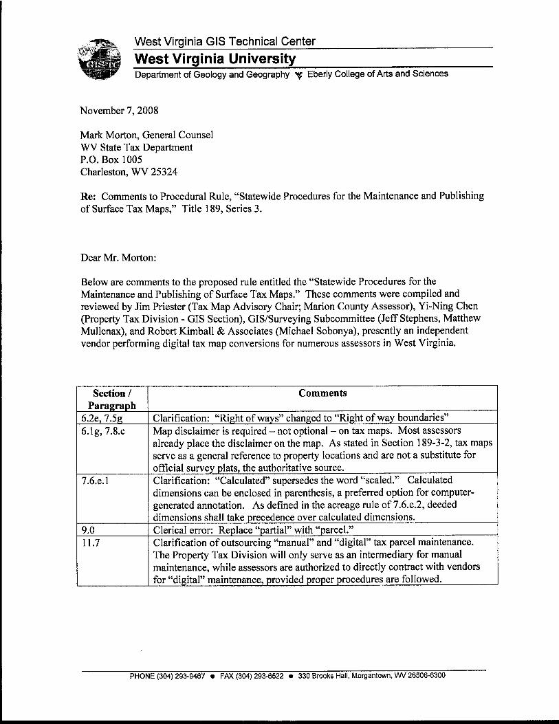
West Virginia GIs Technical Center
West Virginia University Department of Geology and Geography y Eberly College of Arts and Sciences
November 7,2008
Mark Morton, General Counsel WV State Tax Department P.O. Box 1005 Charleston, WV 25324
Re: Comments to Procedural Rule, "Statewide Procedures for the Maintenance and Publishing of Surface Tax Maps," Title 189, Series 3.
Dear Mr. Morton:
Below are comments to the proposed rule entitled the "Statewide Procedures for the Maintenance and Publishing of Surface Tax Maps." These comments were compiled and reviewed by Jim Priester (Tax Map Advisory Chair; Marion County Assessor), Yi-Ning Chen (Property Tax Division - GIs Section), GISfSurveying Subcommittee (Jeff Stephens, Matthew Mullenax), and Robert Kimball & Associates (Michael Sobonya), presently an independent vendor performing digital tax map conversions for numerous assessors in West Virginia.
PHONE (304) 293-9467 FAX (304) 293-6522 330 Brooks Hall, Morgantown, WV 26506-6300
Section 1 Paragraph
6.2e, 7.5g 6.lg, 7.8.c
7.6.e.l
9.0 11.7
Comments
Clarification: "Right of ways" changed to "Right of way boundaries" Map disclaimer is required - not optional - on tax maps. Most assessors already place the disclaimer on the map. As stated in Section 189-3-2, tax maps serve as a general reference to property locations and are not a substitute for official survey plats, the authoritative source. Clarification: "Calculated" supersedes the word "scaled." Calculated dimensions can be enclosed in parenthesis, a preferred option for computer- generated annotation. As defined in the acreage rule of 7.6.e.2, deeded dimensions shall take precedence over calculated dimensions. Clerical error: Replace "partial" with "parcel." Clarification of outsourcing "manual" and "digital" tax parcel maintenance. The Property Tax Division will only serve as an intermediary for manual maintenance, while assessors are authorized to directly contract with vendors for "digital" maintenance, provided proper procedures are followed.

As a drafter of this rule Valuation Training and that they be included in Commission for review
for the Tax Map Advisory Subcommittee and member of the Property Procedures Commission, I concur with these comments and recommend the final filing. I request that these comments be forwarded to the and adoption when the Commission meets in January 2009.
Please contact me if you have any questions.
Sincerely,
Mr. Kurt Donaldson Manager WV GIs Technical Center West Virginia University 330 Brooks Hall Morgantown, WV 26506-6300 phone: (304) 293-9467 e-mail [email protected]
CC: Jeffrey Amburgey, Chairman, Property Value Training and Procedures Commission
I Page 2

JOE MANCHIN 1II GOVERNOR
VIRGIL T. HELTON CABLNET SECRETARY
CONSENT TO PROPOSAL OF RULE
To Whom It May Concern:
Pursuant to West Virginia Code $j 5F-2-2(a)(12), the undersigned hereby grants
consent for the following (procedural) rule as amended by the State Tax Department of
the State of West Virginia: Title 189, Series 3, relating to Statewide Procedures for the
Maintenance and Publishing of Surface Tax Maps..
Dated this 26th day of Januaw ,2009.
Cabinet ~6cretary/bepartment of Revenue
WEST WING, ROOM 300 P.O. BOX 963 CAARLESTON, WEST VIRGINIA 25324 TELEPHONE 3041 558-021 1 FACSIMILE 3041558-2324