West of Horsham Transport Package - · PDF fileThe Great Daux Roundabout and Robin Hood...
62
141125_SUPPORTING DOCUMENT_WOFH_FINAL DRAFT.DOCX [486426.HA.02] COPYRIGHT 2014 BY CH2M HILL • COMPANY CONFIDENTIAL Coast to Capital Local Transport Body Application Supporting Document West of Horsham Transport Package Prepared for West Sussex County Council November 2014 Elms House 43 Brook Green London W6 7EF
-
Upload
truongkhanh -
Category
Documents
-
view
214 -
download
1
Transcript of West of Horsham Transport Package - · PDF fileThe Great Daux Roundabout and Robin Hood...

141125_SUPPORTING DOCUMENT_WOFH_FINAL DRAFT.DOCX [486426.HA.02]
COPYRIGHT 2014 BY CH2M HILL • COMPANY CONFIDENTIAL
Coas t to Cap i t a l Loca l T ranspo r t Body App l i ca t i on Suppo r t i ng Document
West of Horsham Transport Package
Prepared for
West Sussex County Council
November 2014
Elms House
43 Brook Green
London W6 7EF


141125_SUPPORTING DOCUMENT_WOFH_FINAL DRAFT.DOCX [486426.HA.02] III
COPYRIGHT 2014 BY CH2M HILL • COMPANY CONFIDENTIAL
Version No Version Name Prepared by Reviewed by Approved by Date
1 Draft Richard Clarke/ Maria
Naumchenko/ Fiona Mann
Philip Rust / Joanna Walker
Chris Weedon 20/11/2014
2 Final Draft Richard Clarke/ Maria
Naumchenko/ Fiona Mann
Philip Rust / Joanna Walker
Chris Weedon 25/11/2014

141125_SUPPORTING DOCUMENT_WOFH_FINAL DRAFT.DOCX [486426.HA.02] IV
COPYRIGHT 2014 BY CH2M HILL • COMPANY CONFIDENTIAL

141125_SUPPORTING DOCUMENT_WOFH_FINAL DRAFT.DOCX [486426.HA.02] III
COPYRIGHT 2014 BY CH2M HILL • COMPANY CONFIDENTIAL
Contents
Section Page
Acronyms and Abbreviations .................................................................................................................. 5
1. Executive Summary of West of Horsham Package and Benefits ................................................. 6
West of Horsham Transport Package .............................................................................................................. 6 Transport benefits ........................................................................................................................................... 8 Economic benefits ......................................................................................................................................... 10 Social benefits ............................................................................................................................................... 10 Environmental benefits ................................................................................................................................. 11
2. Introduction ............................................................................................................................. 12
3. Policy Background .................................................................................................................... 13
The C2C LEP Strategic Economic Plan............................................................................................................ 13 Land West of Horsham Masterplan .............................................................................................................. 15 North of Horsham Strategic Development .................................................................................................... 16
4. Method .................................................................................................................................... 17
Transport benefits ......................................................................................................................................... 17 Economic transport benefits ........................................................................................................... 17 Contribution to transport objectives .............................................................................................. 19
Economic ....................................................................................................................................................... 19 Social Benefits ............................................................................................................................................... 21 Environmental benefits ................................................................................................................................. 23
5. Connectivity Schemes .............................................................................................................. 24
Farthings Hill Interchange ............................................................................................................................. 24 Transport benefits ........................................................................................................................... 25 Benefit to Cost Ratio ....................................................................................................................... 26 Contribution to policy objectives .................................................................................................... 26
Five Oaks Roundabout (including traffic management and speed reduction measures within Broadbridge
Heath and to the north on the Warnham Lanes) ............................................................................ 27 Transport benefits ........................................................................................................................... 28 Benefit to Cost Ratio ....................................................................................................................... 29 Contribution to policy objectives .................................................................................................... 30
Combined Economic Social & Environment benefits .................................................................................... 31 Economic benefits ........................................................................................................................... 31 Social Benefits ................................................................................................................................. 34 Environment benefits...................................................................................................................... 38
6. Capacity Schemes ..................................................................................................................... 39
Great Daux Roundabout ................................................................................................................................ 39 Transport benefits ........................................................................................................................... 39 Benefit to Cost Ratio ....................................................................................................................... 40 Contribution to policy objectives .................................................................................................... 41
Robin Hood Roundabout ............................................................................................................................... 42 Transport benefits ........................................................................................................................... 42 Benefit to Cost Ratio ....................................................................................................................... 43 Contribution to policy objectives .................................................................................................... 44
Combined Economic Social & Environment benefits .................................................................................... 45 Economic benefits ........................................................................................................................... 45 Social benefits ................................................................................................................................. 48 Environmental benefits ................................................................................................................... 50

141125_SUPPORTING DOCUMENT_WOFH_FINAL DRAFT.DOCX [486426.HA.02] IV
COPYRIGHT 2014 BY CH2M HILL • COMPANY CONFIDENTIAL

141125_SUPPORTING DOCUMENT_WOFH_FINAL DRAFT.DOCX [486426.HA.02] 5
COPYRIGHT 2014 BY CH2M HILL • COMPANY CONFIDENTIAL
Acronyms and Abbreviations
BRES Business Register Employment Survey
CBA
CBR
C2C LEP
C2C LTB
Cost Benefit Analysis
Cost Benefit Ratio
Coast to Capital Local Enterprise Partnership
Coast to Capital Local Transport Body
DfT
EAST
Department for Transport
Early Assessment and Sifting Tool
FUR
GIS
Functional Urban Regions
Geographic Information Systems
GVA Gross Value Added
IMD Index of Multiple Deprivation
LSOA Lower Super Output Area
O&M
ONS
PCU
PM10
Operation and Maintenance
Office for National Statistics
Passenger Car Unit
Particulates
PT
PVB
PVC
RFC
Public Transport
Present Value Benefits
Present Value Costs
Ratio of Flow to Capacity
SDG
SEP
SNCI
Steer Davies Gleave
Strategic Economic Plan
Site of Nature Conservation Importance
TEMPro
WebTAG
Trip End Model Presentation Program
Web Transport Analysis Guidance
WSCC West Sussex County Council

141125_SUPPORTING DOCUMENT_WOFH_FINAL DRAFT.DOCX [486426.HA.02] 6
COPYRIGHT 2014 BY CH2M HILL • COMPANY CONFIDENTIAL
�. Executive Summary of West of Horsham Package and Benefits
This report is a supporting technical annex for a funding application to the Coast to Capital Local
Transport Body (C2C LTB) for the West of Horsham Transport Package. It sets out the policy context and
the benefits and costs associated with the schemes that make up the package. The key points from the
report are summarised below:
West of Horsham Transport Package
The West of Horsham Transport Package is identified in the Coast to Capital Local Enterprise Partnership
(C2C LEP) Strategic Economic Plan (SEP) as a key package of schemes to support the housing and
economic development. Funds have been secured for the Package in the SEP. There are four schemes
that make up the package (see Figure 1):
• Farthings Hill Interchange
• Five Oaks Roundabout (including traffic management and speed reduction measures within
Broadbridge Heath & to the north on the Warnham Lanes)
• Great Daux Roundabout
• Robin Hood Roundabout
Figure 1 - West of Horsham Transport Package

SECTION 6: EXECUTIVE SUMMARY OF WEST OF HORSHAM PACKAGE AND BENEFITS
141125_SUPPORTING DOCUMENT_WOFH_FINAL DRAFT.DOCX/ [486426.HA.02] 7
COPYRIGHT 2014 BY CH2M HILL • COMPANY CONFIDENTIAL
The Farthings Hill Interchange and Five Oaks schemes are linked to the wider delivery of the 2,000
homes West of Horsham development. Construction of a new grade-separated junction on the A24, the
Broadbridge Heath Relief Road and replacement footbridge is currently underway, due to be completed
in late 2015. The new infrastructure provides an opportunity to address connectivity and severance
issues between Broadbridge Heath and Horsham, especially for pedestrians and cyclists.
At Farthings Hill Interchange, this will be achieved by providing Toucan crossings and shared use paths
which will improve connectivity of the existing footway/cycleway through the interchange.
At Five Oaks Roundabout, the existing A264 Broadbridge Heath Bypass will be declassified into a local
distributor road and the northern arm C192 Billingshurst Road will be removed from the roundabout and
relocated to a new junction off the declassified part of the A264. As an additional measure to discourage
through traffic using Broadbridge Heath as a shortcut between the A281 Guildford Road and the A24.
Traffic calming will be put in place on the junctions of C192 Warnham Road and Guildford Road with
Billingshurst Road.
The Great Daux Roundabout and Robin Hood Roundabout schemes are linked to the delivery of the
2,500 home North of Horsham development. Both junctions are located on the strategic A24 and both
currently experience congestion and delay. The Horsham District Transport Study1 which assessed the
impact of forecast strategic development and background traffic growth up to 2031 concluded that both
junctions would require mitigation.
At Great Daux, additional entry lanes and signal control on all approaches are proposed whilst at Robin
Hood, two additional entry lanes and signal control are on the A24 and Warnham Road approaches.
Table 1 provides a summary of the costs associated with each scheme. WSCC are seeking 75% funding
from the C2C Local Transport Board with the remaining 25% match funded through S106 contributions.
Table 1 West of Horsham Transport Package – Cost and Funding Summary
Scheme Cost Details Costs C2C LEP S106
Farthings Hill Base cost in 2014 prices (includes 15% optimism bias) £ 1,416,765 £ 1,062,574 £ 354,191
Five Oaks Base cost in 2014 prices (includes 15% optimism bias) £ 842,062 £ 631,547 £ 210,515
Broadbridge Heath
Traffic Calming
Base cost in 2014 prices (includes 35% optimism bias) £ 270,000 £ 202,500 £ 67,500
Warnham Lanes
Traffic Calming
Base cost in 2014 prices (includes 35% optimism bias) £ 148,500 £ 111,375 £ 37,125
Great Daux Base cost in 2014 prices (includes 20% optimism bias) £ 870,800 £ 653,100 £ 217,700
Robin Hood Base cost in 2014 prices (includes 20% optimism bias) £ 640,376 £ 480,282 £ 160,094
Package costs in 2014 prices £ 4,188,503 £3,141,378 £ 1,047,125
1 Horsham District Transport Study (WSCC, 2014)

141125_SUPPORTING DOCUMENT_WOFH_FINAL DRAFT.DOCX/[486426.HA.02] 8
COPYRIGHT 2014 BY CH2M HILL • COMPANY CONFIDENTIAL
Transport benefits
Combined Transport Package Benefit Cost Ratio
Table 2 provides a summary of transport outputs from the transport benefits appraisal for the four
schemes that make up the Horsham Transport Package. Please note that for appraisal purposes, the
Present Value Costs (PVCs) presented have been discounted to 2010 prices.
Table 2 - West of Horsham Benefit Cost Analysis summary
Scheme PVB PVC BCR
Farthings Hill -£15,371,225 £1,029,559 -14.9
Five Oaks + Traffic
Calming
-£3,570,116 £916,047 -3.9
Great Daux £320,566,507 £632,808 506.6
Robin Hood £322,653,586 £465,359 693.3
Package Total £624,278,752 £3,043,774 205.1
Contribution to C2C SEP
Table 3 provides a summary of linkage between the five transport themes in the C2C LEP SEP and the
proposed four schemes that make up the Horsham Transport Package:
Table 3 – Horsham Transport Package – Policy linkage summary
C2C LEP SEP
Transport
Themes
Farthings Hill
Roundabout
Five Oaks
Roundabout +
Traffic Calming
Great Daux
Roundabout
Robin Hood
Roundabout
Connectivity � � �
Reliability � � �
Capacity � �
Quality � � � �
Resilience � �
Farthings Hill Interchange
The monetisation of the journey time benefits generates a PVB of -£16,009,768 (over a 60 year period).
The proposed signalisation of Farthings Hill will reduce the average cost per accident by £6,650. Over
the 60 year analysis period this equates to a PVB of £635,544.
The BCR for the Farthings Hill scheme has been calculated to be -14.9:1. The negative BCR is explained
by the delay introduced to the junction through signalisation and the limitations of the modelling
approach.
The proposed scheme will provide significant benefits to pedestrians and cyclists by increasing safety and
reducing the considerable severance between Broadbridge Heath and Horsham caused by the current
junction arrangement.
SECTION 6: EXECUTIVE SUMMARY OF WEST OF HORSHAM PACKAGE AND BENEFITS
141125_SUPPORTING DOCUMENT_WOFH_FINAL DRAFT.DOCX/ [486426.HA.02] 9
COPYRIGHT 2014 BY CH2M HILL • COMPANY CONFIDENTIAL
The safety issues form a considerable barrier to residents of Broadbridge Heath walking and cycling to
access Horsham and vice versa. A safer junction would encourage more trips using sustainable modes for
commuting, school, retail, and leisure purposes.
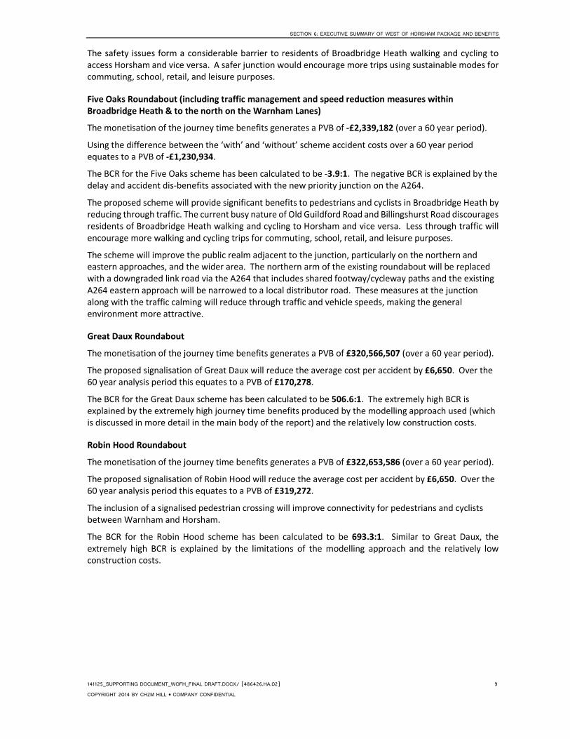
Five Oaks Roundabout (including traffic management and speed reduction measures within
Broadbridge Heath & to the north on the Warnham Lanes)
The monetisation of the journey time benefits generates a PVB of -£2,339,182 (over a 60 year period).
Using the difference between the ‘with’ and ‘without’ scheme accident costs over a 60 year period
equates to a PVB of -£1,230,934.
The BCR for the Five Oaks scheme has been calculated to be -3.9:1. The negative BCR is explained by the
delay and accident dis-benefits associated with the new priority junction on the A264.
The proposed scheme will provide significant benefits to pedestrians and cyclists in Broadbridge Heath by
reducing through traffic. The current busy nature of Old Guildford Road and Billingshurst Road discourages
residents of Broadbridge Heath walking and cycling to Horsham and vice versa. Less through traffic will
encourage more walking and cycling trips for commuting, school, retail, and leisure purposes.
The scheme will improve the public realm adjacent to the junction, particularly on the northern and
eastern approaches, and the wider area. The northern arm of the existing roundabout will be replaced
with a downgraded link road via the A264 that includes shared footway/cycleway paths and the existing
A264 eastern approach will be narrowed to a local distributor road. These measures at the junction
along with the traffic calming will reduce through traffic and vehicle speeds, making the general
environment more attractive.
Great Daux Roundabout
The monetisation of the journey time benefits generates a PVB of £320,566,507 (over a 60 year period).
The proposed signalisation of Great Daux will reduce the average cost per accident by £6,650. Over the
60 year analysis period this equates to a PVB of £170,278.
The BCR for the Great Daux scheme has been calculated to be 506.6:1. The extremely high BCR is
explained by the extremely high journey time benefits produced by the modelling approach used (which
is discussed in more detail in the main body of the report) and the relatively low construction costs.
Robin Hood Roundabout
The monetisation of the journey time benefits generates a PVB of £322,653,586 (over a 60 year period).
The proposed signalisation of Robin Hood will reduce the average cost per accident by £6,650. Over the
60 year analysis period this equates to a PVB of £319,272.
The inclusion of a signalised pedestrian crossing will improve connectivity for pedestrians and cyclists
between Warnham and Horsham.
The BCR for the Robin Hood scheme has been calculated to be 693.3:1. Similar to Great Daux, the
extremely high BCR is explained by the limitations of the modelling approach and the relatively low
construction costs.

141125_SUPPORTING DOCUMENT_WOFH_FINAL DRAFT.DOCX/[486426.HA.02] 10
COPYRIGHT 2014 BY CH2M HILL • COMPANY CONFIDENTIAL
Economic benefits
The four schemes together will lead to significant economic benefits for the Horsham District area as
well as for the wider region. The main economic benefits during the construction stage are temporary
employment and Gross Value Added (GVA). It is estimated that approximately 29 temporary jobs will be
created during the construction stage for all of the schemes combined. A total of £2.17 million in GVA is
also forecast to be generated during the construction stage. The West of Horsham package of schemes
will have a significant positive impact on accessibility and connectivity of the local area which is likely to
attract businesses and visitors and increase local business turnover and rateable values. As a result,
positive impacts on long term GVA and employment in the area are also expected.
Table 4 West of Horsham Transport Package - Economic Benefits Summary
Economic Benefits Farthings Hill
Five Oaks
Roundabout +
traffic
calming Great Daux Robin Hood
Temporary Employment from Construction � � � �
Temporary GVA from Construction � � � �
Business Turnover and Rateable values Marginal Marginal � �
Long Term Employment and GVA � � � �
Social benefits
The social impacts have been assessed in terms of journey quality, accessibility and connectivity,
severance, agglomeration, regeneration, improved perception of the area and improved wellbeing.
The Horsham package of schemes will have a significant positive impact on accessibility and connectivity
of the local area. The Farthings Hill and the Five Oaks schemes will help reduce severance, increase
accessibility for pedestrians and cyclists and encourage greater use of sustainable transport modes.
Accessibility for motorised transport users will be increased as a result of capacity improvements at
Great Daux and Robin Hood junctions.
The package will have a significant impact on journey quality for all mode users. The construction and
realignment of a footways and cycleways at Farthings Hill and Five Oaks will provide a better
environment for walking and cycling and will reduce travellers’ stress and fear of accidents. The journey
quality of vehicle users will be improved as a result of the journey time savings and reduced congestion
at Great Daux and Robin Hood interchanges.
As a result of the schemes there will be an increase in physical activity and associated improvement in
health and wellbeing benefits. The package will also contribute towards creating a more positive
perception of the local area attracting businesses and inward investment which could have a positive
agglomeration impact.
The Horsham District performs well economically and has low unemployment and low deprivation.
Therefore, we expect that the package will only have a marginal impact on regeneration in the area.

SECTION 6: EXECUTIVE SUMMARY OF WEST OF HORSHAM PACKAGE AND BENEFITS
141125_SUPPORTING DOCUMENT_WOFH_FINAL DRAFT.DOCX/ [486426.HA.02] 11
COPYRIGHT 2014 BY CH2M HILL • COMPANY CONFIDENTIAL
Table 5 West of Horsham Transport Package - Social Benefits Summary
Social Benefits Farthings Hill
Five Oaks
Roundabout +
traffic calming Great Daux Robin Hood
Improved Journey Quality � � � �
Improved Accessibility and Connectivity � � � �
Severance � �
Agglomeration Marginal Marginal � �
Regeneration Marginal Marginal Marginal Marginal
Increase in Physical Activity � �
Improved Perception of the Area � � � �
Improved Wellbeing � �
Environmental benefits
Taken as a whole, these projects have the potential to result in significant beneficial impacts on vehicle
travellers, pedestrians, cyclists and the local community through improved road layouts, increased road
capacities, signalisation, crossing facilities and widened footways and cycleways.
The Farthings Hill and Five Oaks schemes will improve safety for pedestrians and cyclists and encourage
sustainable modes of travel. The Great Daux Interchange and Robin Hood Roundabout proposals will
reduce journey times and slow moving traffic, resulting in reduced vehicle emissions and improved air
quality.
Whilst some temporary impacts such as noise and vibration, dust and visual intrusion are inevitable
during construction, no long term adverse impacts are envisaged provided that appropriate mitigation is
put in place.
Further assessment work is required to ensure no adverse impact on bats, great crested newts, breeding
birds and reptiles. Robin Hood roundabout in particular is located within 500m of several ponds which
may support GCNs. The requirement for replacement planting also needs further consideration.
The Great Daux and Robin Hood roundabouts are located in minor aquifer intermediate Groundwater
Vulnerability Zones and Secondary Aquifers. Groundwater impacts are likely to arise from the proposed
works and so mitigation should be put in place to avoid any risk of pollution or contamination to
groundwater.

141125_SUPPORTING DOCUMENT_WOFH_FINAL DRAFT.DOCX/[486426.HA.02] 12
COPYRIGHT 2014 BY CH2M HILL • COMPANY CONFIDENTIAL
#. Introduction
This report is a technical document supporting the funding application to the C2C LTB for the West of
Horsham Transport Package. It should be read in conjunction with the completed C2C LTB Funding
Application Form.
The report presents the policy context for the funding application with particular focus on the C2C LEP
SEP which commits to funding the schemes that make up the West of Horsham Transport Package.
It sets out the methodology used to assess each of the benefits and costs of the schemes, drawing on
the Department for Transport’s (DfT) Early Assessment and Sifting Tool (EAST), and Web Transport
Analysis Guidance (WebTAG).
It then presents the transport, economic, social and environmental benefits and costs of each of the four
schemes that are included in the package, in line with the requirements of the C2C LTB Funding
Application Form. The report is structured into the following sections:
Section 3: Policy Background
Section 4: Method
Section 5: Connectivity Schemes
Farthings Hill Roundabout
Five Oaks Roundabout (including traffic management and speed reduction measures
within Broadbridge Heath & to the north on the Warnham Lanes)
Section 6: Capacity Schemes
Great Daux Roundabout
Robin Hood Roundabout

SECTION 6: POLICY BACKGROUND
141125_SUPPORTING DOCUMENT_WOFH_FINAL DRAFT.DOCX/ [486426.HA.02] 13
COPYRIGHT 2014 BY CH2M HILL • COMPANY CONFIDENTIAL
%. Policy Background
This section presents an overview of the policy context for the West of Horsham Transport Package. In
line with the C2C LTB Funding Application Form this section focuses on the C2C LEP SEP2 and justifies
how the package will support its key transport themes.
The C#C LEP Strategic Economic Plan
The C2C LEP’s vision is “that Coast to Capital will deliver exceptional growth and productivity gains to
deliver economic performance to rival the best in Europe and the rest of the World”. Six strategic
priorities are outlined in the Plan:
• Successful Growth Locations, including transport investment;
• Successful Businesses;
• Building Competitive Advantage;
• Skills and Workforce;
• Growth is Digital; and
• Housing and infrastructure.
Successful Growth Locations
The SEP identified nine areas where growth will be delivered, comprising a mix of strategic corridors or
areas, cities/towns, strategic sites/locations and Enterprise Zones:
• Burgess Hill
• Croydon
• Heart of the Gatwick Diamond
• East Surrey M25 Strategic Corridor
• Brighton and Hove
• Coastal Corridor
• Enterprise Bognor Regis Enterprise Zone
• Newhaven Enterprise Zone
• Shoreham Harbour and Airport
Heart of the Gatwick Diamond
Right at the heart of the Gatwick Diamond are the towns of Crawley and Horsham. Both are important
business locations performing unique economic functions. The SEP wants to focus on enhancing and
protecting them, while also taking steps to ensure there is supply of housing for a growing workforce.
Transport is identified in the SEP as a key priority underpinning the success of the sub-region as an
enabler and driver of growth. It is the largest element of the C2C LEP Growth Deal.
2 Coast to Capital Local Enterprise Partnership (2014) Strategic Economic Plan

141125_SUPPORTING DOCUMENT_WOFH_FINAL DRAFT.DOCX/[486426.HA.02] 14
COPYRIGHT 2014 BY CH2M HILL • COMPANY CONFIDENTIAL
Transport Objectives
There are five key over-arching themes that aim to tackle the area’s transport issues. The themes have
been informed by business needs across the area:
• Connectivity: “Can I get where I want to go?”
• Reliability: “Will I arrive when I expect?”
• Capacity: “Will I get a seat, a parking space, a clear road?”
• Quality: “Will my journey be healthy, safe, clean, sustainable and enjoyable?”
• Resilience: “Will transport be there when I need it – 24/7?”
These C2C LEP SEP transport objectives are being delivered through two programmes:
1. Improvements to national networks
2. The Coast to Capital Transport Programme
The Coast to Capital Transport Programme comprises of Local Transport Body schemes and those
related to connectivity and capacity, sustainable transport packages, and resilience. Schemes will be
implemented across the LEP geography with particular focus on the Successful Growth Locations.
Connectivity and Capacity schemes
The SEP identifies 20 schemes (including the LTB schemes) aimed directly at unlocking new housing, jobs
and/or employment floor space. These schemes provide the transport capacity or connectivity needed
for one or more new developments to be viable. In many cases, these schemes would tackle problems
that cause severance and delay.
In West Sussex, the C2C SEP states a Local Growth Fund contribution of £4.763 million for West of
Horsham and A24 junction improvements, to unlock 2,000 new homes and 1,600 new jobs.
The connectivity and capacity schemes included in the West of Horsham funding application together
comprise of proposals at Farthings Hill Roundabout, Five Oaks Roundabout (and associated traffic
calming), Great Daux Roundabout, and Robin Hood Roundabout.
The C2C SEP states that the West of Horsham schemes will commence in 2016/17 with estimated
phased delivery in 2018/19.
Local Indicators
Key performance indicators set by the C2C LEP in the C2C SEP are as follows:
• Increase net private sector jobs;
• Increase GVA total (£billion) to reduce the gap with the South East; and
• Increase the percentage of companies that are regularly exporting.
The targets are summarised in Table 6. The West of Horsham Transport Package will contribute to both
increasing private sector employment and GVA.

SECTION 6: POLICY BACKGROUND
141125_SUPPORTING DOCUMENT_WOFH_FINAL DRAFT.DOCX/ [486426.HA.02] 15
COPYRIGHT 2014 BY CH2M HILL • COMPANY CONFIDENTIAL
Table 6 Key Performance Indicators and Targets for the C2C LEP
Top line Priorities 2010 Baseline Coast to
Capital
2010 Baseline South
East Region
2020 Target
Net Private Jobs 652,200 Not applicable 140,000 net additional
jobs
Private Jobs Share 81% 81% Continue to match SE
level
Public Jobs Share 19% 19% Continue to match SE
level
GVA Total £billion £38.9bn Not applicable £55bn
GVA Per Head Working
Age Population
£31,800 £35,100 Reduce gap with SE
Percentage of
Companies Regularly
Exporting
16% Not available 1% increase year on year
– double by 2035
Source: CC LEP (2014) C2C SEP
Land West of Horsham Masterplan
The Land West of Horsham Masterplan SPD was adopted by the Council on 31 October 2008 and forms
part of the Local Development Framework.
The Council identified land west of Horsham and south of Broadbridge Heath as a location suitable for a
mixed-use development of 2,000 homes plus the necessary infrastructure, facilities and services under
Policy CP7 of the Core Strategy (see Figure 2).
The Core Strategy was considered by independent Inspectors who approved the identification of this
land for development subject to it meeting the criteria set out in the policy.
The construction of key highway infrastructure associated with the West of Horsham developments is
currently underway, due to be completed in late 2015. The works involve the creation of new grade-
separated junction on the A24, the Broadbridge Heath Relief Road and a replacement footbridge (see
Figure 2).
Once complete, the Broadbridge Heath Relief Road will connect to the recently constructed roundabout
on Five Oaks Road (A264), taking traffic pressure away from Broadbridge Heath and the Farthings Hill
Interchange.
Figure 2 - Land West of Horsham

141125_SUPPORTING DOCUMENT_WOFH_FINAL DRAFT.DOCX/[486426.HA.02] 16
COPYRIGHT 2014 BY CH2M HILL • COMPANY CONFIDENTIAL
North of Horsham Strategic Development
The North of Horsham Strategic Development is proposed within Horsham District Council’s Planning
Framework 2014 (Policy SD1), which was submitted to the Secretary of State on Friday 8 August 2014 for
independent examination. The Inspector is holding a series of public hearing sessions in November.
The development, that is expected to be completed by 2031, will provide 2,500 new homes, a new high
quality business park and a parkway station that includes a park and ride facility and sustainable
transport links to Horsham town and Horsham train station. The location of the development is shown
by the orange shaded area in Figure 3.
Figure 3 - North of Horsham

SECTION 6: METHOD
141125_SUPPORTING DOCUMENT_WOFH_FINAL DRAFT.DOCX/ [486426.HA.02] 17
COPYRIGHT 2014 BY CH2M HILL • COMPANY CONFIDENTIAL
*. Method
The C2C LTB Funding Application covers four business case criteria; Transport, Economic, Social
Distributional, and Environmental.
Where possible, the benefits have been quantified. Where this is not possible, a qualitative assessment
has been undertaken. The approach has drawn on both the DfT’s EAST sifting tool to help identify
potential benefits, and WebTAG to formulate the method for each indicator. The following paragraphs
describe the method used for assessing each indicator.
For the appraisal of benefits, the schemes have been split into two groups: Connectivity and Capacity.
Connectivity Schemes
The ‘Connectivity’ schemes form part of the wider delivery of the Land West of Horsham Masterplan and
will support the Council’s wider objectives to promote the use of sustainable transport and integration of
the local communities.
Capacity Schemes
The ‘Capacity’ schemes are located on the strategic A24 and are primarily associated with the delivery of
the North of Horsham development and the mitigation of development impact on existing travel patterns.
Table 7 – West of Horsham scheme classification
Transport
appraisal group
Farthings Hill
Interchange
Five Oaks
Roundabout +
Traffic Calming
Great Daux
Roundabout
Robin Hood
Roundabout
Connectivity � �
Capacity � �
The transport benefits of each scheme have been assessed individually whereas the economic, social, and
environmental impacts of the Connectivity and Capacity schemes have been considered collectively. The
following text provides a summary of how the benefits were assessed:
Transport benefits
The appraisal considers their economic transport benefits and their contribution to the C2C SEP
transport policy objectives.
Economic transport benefits
The economic transport benefits associated with each group have been assessed based on criteria set
out in the C2C LTB Funding Application Form:
• Value for money (including Benefit Cost Ratio);
• Expected impact on journey times;
• Expected impact on road safety casualties;
• Encouraging sustainable travel;
• Valuing the public realm; and
• Other transport benefits.

141125_SUPPORTING DOCUMENT_WOFH_FINAL DRAFT.DOCX/[486426.HA.02] 18
COPYRIGHT 2014 BY CH2M HILL • COMPANY CONFIDENTIAL
Value for Money / Benefit Cost Ratio
For each individual scheme and for the overall scheme package, Benefit to Cost Ratios (BCRs) have been
calculated by combining monetised journey time and accident impacts with the predicted scheme costs.
Expected impact on journey times
In the absence of a strategic transport model, journey time benefits for the West of Horsham schemes
have been assessed using outputs from junction models. Monetised time impacts have been generated
(over a 60 year period) using the difference in total network delay between the ‘base’ and ‘with scheme’
models.
A number of key assumptions in this process are set out below:
• Annualisation has been factored in line with WebTAG guidance. Delay savings derived from modelling
results for the peak hours were expanded to three hour periods (0700-1000 and 1600-1900). The
factors used to achieve this are based on DfT car distribution by time of day data3. The period delay
savings were then combined and multiplied by 253 to cover all time periods in a year;
• User benefits have been projected over a 60-year appraisal period from the opening year of the
scheme. Savings beyond the opening year have been assumed to remain unchanged and therefore
gradually reduce in real terms when discounted to the same price base year (2010);
• Values of Time are based on the average weekday car and other appraisal parameters follow the
information in the standard DfT WebTAG Data Book4;
• All benefit and cost streams were discounted to the same price base year 2010, with a 3.5% discount
rate from year 0 to 30 and 3.0% discount rate from year 31 to 60 from the current year.
It should be noted that using outputs from a junction model, as opposed to a strategic model, will
overestimate journey time impacts because it is unable to account for traffic reassignment. In reality, a
change to a junction is likely to either induce extra traffic to use it or divert traffic away depending on the
nature of the scheme, thus diluting the predicted journey time impact.
The dilution effect, however, will be offset by the economic, social, and environmental benefits that have
not been included in the transport appraisal. On this basis, the proposed methodology is considered to
be robust.
Expected impact on road safety casualties
The impact of the schemes on road casualties has been assessed using the Valuation of Accidents
methodology set out in the DfT’s COBA manual5. The approach uses the average number of accidents
occurring in the last five years and determines whether or not the proposal would reduce the average cost
per accident based on standard values for various junction types6. The average cost of accident at
signalised roundabout, for example, is less than one that occurs at a non-signalised roundabout, due to
average severity rates of accidents at the respective types of junctions.
Where no accident data is available, where a new junction is proposed for example, COBA’s Cross Product
Model has been used. The model uses AADT flows and junction type coefficients to predict the annual
3 https://www.gov.uk/government/statistical-data-sets/tra03-motor-vehicle-flow - Table TRA0308
4 https://www.gov.uk/government/publications/WebTAG-tag-data-book-may-2014
5 Part 2: The valuation of costs and benefits in COBA (revised June 2006)
6 https://www.gov.uk/government/publications/coba-11-user-manual - Table 5/3

SECTION 6: METHOD
141125_SUPPORTING DOCUMENT_WOFH_FINAL DRAFT.DOCX/ [486426.HA.02] 19
COPYRIGHT 2014 BY CH2M HILL • COMPANY CONFIDENTIAL
accident rate. AADTs on each link of a junction were generated by summing the peak hour flows and
multiplying them by a factor generated using the DfT car distribution by time of day data3.
The net monetised impact on accidents have then been incorporated into the BCR calculations.
Encouraging sustainable travel
For each scheme, the benefits associated with encouraging sustainable travel and modal shift (where
appropriate) have been assessed qualitatively.
Valuing the public realm
If the scheme has any impact on the public realm, it has been assessed qualitatively.
Other transport benefits
Where relevant, any other transport benefits associated with the schemes have been noted.
Contribution to transport objectives
The funding application form also requires that a scheme or package of schemes is scored for its
contribution to the C2C LEP SEP’s transport objectives. A summary has therefore been provided for each
scheme. Table 8 provides details of how each objective has been incorporated into the transport
appraisal:
Table 8 – C2C LEP SEP transport objectives
C2C LEP SEP Transport Objectives Approach to assessing SEP transport themes through
WebTAG
Connectivity: “Can I get where I want to go?” Factored into the appraisal of social benefits (accessibility)
Reliability: “Will I arrive when I expect?” Factored into the transport appraisal through journey time
savings. In a larger scale appraisal, reliability can be measured
by assessing expected variances in journey times
Capacity: “Will I get a seat, a parking space, a clear road?” Factored into the transport appraisal through journey time
savings
Quality: “Will my journey be healthy, safe, clean, sustainable
and enjoyable?”
Factored into the appraisal of social benefits (journey quality)
Resilience: “Will transport be there when I need it – 24/7?” In a larger scale appraisal this would be assessed through
cancelations and delays and fed into time savings. It has been
assessed qualitatively in this study
Economic
Temporary Construction Employment
Temporary employment that will be generated during the construction of the schemes has been derived
from the construction activities and cost estimates. A ratio of construction jobs per pound of investment
has been estimated based on a review of existing civil works schemes, and then applied to the total
estimated cost for each of the West of Horsham schemes. A ratio of one new job for every £143,750 in
construction costs was identified.
The resulting number of jobs created has then been split between construction and professional and
technical sector using a 2:1 ratio previously derived by CH2M HILL for similar studies, in order to provide
an indication of the types of jobs that will be created. For schemes that cost under £1m, we have
assumed that the 2:1 relationship between construction and professional will not provide an appropriate
level of accuracy, therefore, we have only reported on the total temporary jobs that could be created.
The figures should be treated with caution and are designed to provide a high level estimate of a
possible scale of the impacts on employment. In reality, the impact will depend on a multitude of factors
and may vary considerably between schemes.

141125_SUPPORTING DOCUMENT_WOFH_FINAL DRAFT.DOCX/[486426.HA.02] 20
COPYRIGHT 2014 BY CH2M HILL • COMPANY CONFIDENTIAL
In addition to temporary direct construction jobs, it is expected that the West of Horsham package will
also help generate some indirect jobs in the supply chain and induced jobs due to additional spending of
employee wages. Given the scale of the schemes the indirect and induced impacts are likely to be
limited and have not been quantified in this study.
Temporary Construction Gross Value Added
GVA will be generated during the construction phase. This has been calculated for each scheme using
the construction employment and industry-specific GVA/employment ratios derived from the Office for
National Statistics (ONS) regional GVA figures and the ONS Business Register Employment Survey (BRES)
dataset. We estimated an appropriate ratio for construction GVA/employment. For every construction
employee there is £81,760 generated in construction GVA in the South East. A second ratio was
prepared for professional & technical GVA/employment for construction. For every professional and
technical employee there is £49,925 generated in sector GVA regionally. Applying these ratios to the
total expected number of construction and professional jobs generated during construction provides an
approximation of the potential GVA impact at the construction stage. The ratio of construction
GVA/employment has been applied to estimate the GVA impact for smaller schemes with values below
£1m. In a similar vein to construction employment, the GVA figures are broad level estimates provided
to inform the analysis of the potential scale of GVA impacts of schemes.
Rateable Values
It is expected that the West of Horsham schemes could have an impact on the overall attractiveness of
the core impact areas as well as the surrounding area. Implementing these schemes is likely to have an
impact on business and residential demand and consequently the rental values of commercial and
residential properties. The impact on rateable values is expected to be marginal and has been assessed
qualitatively.
Business Turnover
In addition to the potential growth in rateable values, improvements in the areas’ attractiveness could
also increase the number of visitors leading to higher retail footfall and local business turnover. In a
similar vein to the rateble values, the impacts on business turnover are likely to be marginal and have
been assessed qualitatively.
Long Term Employment and GVAIn addition to temporary construction related employment and GVA,
longer term growth in employment and GVA can be expected as a result of the schemes to varying
degrees. The following types of jobs are typically created as a result of transport schemes:
• jobs associated with operating and maintenance of new assets;
• jobs arising as a result of the improved travel conditions delivered by the scheme; and
• new jobs that have become accessible to the residents of the impact area because of the
scheme.
A qualitative assessment has been used to report on potential employment and GVA impacts for
Horsham.

SECTION 6: METHOD
141125_SUPPORTING DOCUMENT_WOFH_FINAL DRAFT.DOCX/ [486426.HA.02] 21
COPYRIGHT 2014 BY CH2M HILL • COMPANY CONFIDENTIAL
Social Benefits
Journey Quality
According to WebTAG, journey quality is an import factor that influences the travel choices made by
individuals. It is defined as a measure of the real and perceived physical and social environment
experience while travelling and includes factors such as traveller care (cleanliness, facilities, information,
and environment), travellers' views (presence of barriers that may obstruct view) and traveller stress
(frustration, fear of potential accidents, route uncertainty).
Journey quality impacts of a transport scheme would normally be assessed using bespoke stated
preference surveys and would be included in the appraisal and modelling work. In the absence of such
research and the limited scope of this study, the journey quality assessment for this study was
performed qualitatively following the framework set out in WebTAG.
Using professional judgement and experience with similar schemes, impacts on each of the key journey
quality factors have been analysed and reported in TAG Journey Quality Assessment table, the full
version of which can be found in Annex 1. For simplicity, journey quality factors that are likely to be
unaffected or where the impacts were considered to be minimal have been excluded from this report.
Accessibility and Connectivity
The recommended method for assessing accessibility impacts of a transport scheme are presented in
WebTAG Unit A4.2 on Distributional Impacts. It identifies two assessments, the strategic accessibility
assessment and the accessibility audit. The former assesses the impact in changes to the transport
network and is based on the production of contour maps in Geographic Information Systems (GIS)
showing accessibility to sites. The latter is a more qualitative process where the analyst assesses the
various ways in which the scheme affects accessibility for different users. Considering the scale of the
schemes, the accessibility analysis has been scaled down to be proportionate and relevant to the
schemes. A desk top qualitative analysis of the accessibility impacts has been carried out as part of this
study.
Severance
WebTAG defines community severance as the separation of residents from facilities and services they
use within their community caused by transport infrastructure or traffic flows. It is mostly concerned
with non-motorised transport mode users such as pedestrians and cyclists.
A positive impact on severance from a transport scheme may be observed if the scheme acts to remove
the physical barrier or the heavy traffic flow that restricts pedestrian and cycle movements. Often the
impacts of severance on pedestrians and cyclists are expected to be different and, therefore, should be
assessed separately. The impact of a project on severance is normally assessed for the with-scheme and
without-scheme scenarios at a number of locations across the network. The impacts for this study have
been assessed qualitatively drawing on our assessment of the existing level of severance in the local
area.
Agglomeration
Agglomeration provides a measure of the mass of economic activity across the impact area. It measures
accessibility of firms and workers to each other and, therefore, is a function of generalised cost for
business and commuting travel. A scheme that reduces cost of journeys could, therefore, have an
agglomeration benefit provided that it helps businesses to access a larger pool of labour and workers to
access a wider range of jobs. Although linked to regeneration, this is assessed separately in WebTAG.
A transport scheme that increases accessibility in an area in close proximity to an economic centre or
large employment centre is likely to have an impact on agglomeration. There are specific areas in
England where agglomeration impact of a transport scheme is expected to be significant. These are
called Functional Urban Regions (FURs) and are listed in the WebTAG FURs database. The areas in the

141125_SUPPORTING DOCUMENT_WOFH_FINAL DRAFT.DOCX/[486426.HA.02] 22
COPYRIGHT 2014 BY CH2M HILL • COMPANY CONFIDENTIAL
database are split between the core areas and hinterlands. FUR cores are defined as collections of
contiguous 2001 Census Area Statistical (CAS) wards, with each ward having at least 7 jobs per hectare
and a minimum total job count of 60,000 for the core as a whole. FUR hinterlands are adjacent to a core
area, with each hinterland ward having that local core as it top commuting destination, and with at least
10% of the working population from each hinterland ward commuting to that core.7
As part of this assessment, agglomeration impacts of schemes have been assessed qualitatively. The
impact areas have been compared against the FUR database to identify whether these contain core or
hinterland FURs, thus, commenting on whether the expected agglomeration impact is likely to be
significant.
Regeneration
Improvements to infrastructure including transport and urban realm schemes are likely to contribute to
the regeneration of the local area. This can be assessed in terms of house prices, levels of deprivation,
reduced unemployment and improved wellbeing. All of these impacts have been assessed qualitatively.
The analysis of the possible impacts on regeneration will involve assessing the baseline deprivation levels
in the local area. This will involve using the Index of Multiple Deprivation (IMD) data to report on area’s
current level of deprivation compared to the country’s average. The IMD provides a relative measure of
deprivation in small areas across England and is constructed using a combination of seven domains and
38 separate indicators, each of which reflects a different aspect of deprivation. The seven domains are
Income, Employment, Health and disability, Education skills and training, Barriers to housing and
services, Crime, and Living environment.
In addition to the IMD levels, the rate of unemployment can be assessed to provide an indication of the
socioeconomic situation of the area. The base line has been assessed using the ONS 2011 Census dataset
and the ONS Labour Profile for the Horsham District.
Physical Activity
Cycling and walking schemes lead to an increase in physical activity which has significant health and
wellbeing impacts on people. Studies have shown that physical activity is a primary contributor to a
broad range of chronic diseases including heart disease, stroke and diabetes. Increase in physical activity
is also known to play an important role in preventing obesity and improving mental health and
wellbeing.8
The overall impacts of a scheme on physical activity will depend on the change in the number of
pedestrians and cycle users, as well the change in average time travelled by active mode. Quantifying
these impacts would require traffic model analysis to forecast the shift to active transport mode
following the scheme completion. In the absence of the modal shift forecast, the impact of the West of
Horsham transport package on physical activity has be assessed qualitatively as part of this study.
Improved Perception of the Area
The West of Horsham transport package of schemes is expected to contribute towards creating a more
positive perception of the local area. This impact has been assessed qualitatively drawing on case study
examples and the current baseline environment where appropriate.
Improved Wellbeing
7 Functional Urban Region Look up sheet, WebTAG, DfT
8 TAG Unit A4.1 – Social Impact appraisal, WebTAG, DfT

SECTION 6: METHOD
141125_SUPPORTING DOCUMENT_WOFH_FINAL DRAFT.DOCX/ [486426.HA.02] 23
COPYRIGHT 2014 BY CH2M HILL • COMPANY CONFIDENTIAL
Studies have shown that positive impacts on physical activity thorough greater use of active transport
modes leads to better health and wellbeing for local communities. A qualitative assessment of West of
Horsham schemes’ impact on wellbeing has been provided in support of this application.
Environmental benefits
A high level appraisal of potential environmental effects associated with the West of Horsham works has
been undertaken. The appraisal has been based on a desk study comprising a review of readily available
data to identify and consider the environmental risks exist at each site. The following data sources were
used to inform the environmental appraisal:
• http://www.natureonthemap.naturalengland.org.uk
• http://www.britishlistedbuildings.co.uk
• http://www.heritagegateway.org.uk
• http://maps.environment-agency.gov.uk/wiyby
• http://www.westsussex.gov.uk
• http://www.horsham.gov.uk
Each component project has been considered in turn, followed by an assessment of the cumulative
effects of the package as a whole.
Environmental issues covered as part of the appraisal comprise archaeology and cultural heritage, air
quality, ecology, water, landscape and townscape, geology and ground conditions, noise and vibration,
and effects on vehicle travellers, pedestrians, cyclists and the local community.
A summary of the key conclusions is provided for each scheme. Detailed results of the appraisal are
presented in a Technical Memorandum, presented in Annex 10.

141125_SUPPORTING DOCUMENT_WOFH_FINAL DRAFT.DOCX/[486426.HA.02] 24
COPYRIGHT 2014 BY CH2M HILL • COMPANY CONFIDENTIAL
,. Connectivity Schemes
Farthings Hill Interchange
Farthings Hill Interchange, located to the west of Horsham on the A24, provides strategic links with the
A264 Broadbridge Heath Bypass, A281 Guildford Road.
The Interchange is located immediately to the north of the new grade-separated junction on the A24,
proposed as part of the West of Horsham housing developments, due to be completed in late 2015.
The new junction provides an opportunity, at Farthings Hill, to address existing severance issues
between Broadbridge Heath and Horsham, especially for sustainable forms of transport.
Scheme description
The proposed scheme widens the A24 approaches, improves connectivity of the existing
footway/cycleway through the interchange and enhances the safety of pedestrians and cyclists. A
summary of the proposed works is provided below (see Annex 2 for scheme drawing):
• Widening of the A24 northbound off slip road;
• Widening of the A24 southbound off slip road;
• Partial widening of circulatory Lanes;
• Signalisation of the roundabout;
• Provision of Toucan crossings and footway widening; and
• Drainage improvement works.
Construction costs and funding
The estimated cost of the Farthings Hill Interchange scheme is £1,416,765. This includes construction and
design costs, along with a 15% optimism bias.
£1,062,574 (75%) of the funds required for the scheme is being sort from the C2C LEP via the C2C LTB. The
remaining £354,191 (25%) will be provided through Section 106 developer contributions.
Maintenance costs
Detailed maintenance and operational costs of the scheme have not been assessed. Due to the
introduction of traffic signals, the costs associated with maintaining the proposed scheme will be greater
than what is currently spent but is not considered to be significant.
Timeframe
The final time frame for scheme delivery has yet to be confirmed but detailed design is scheduled for
2014/2015 with works to be completed in 2017.

SECTION 6: CONNECTIVITY SCHEMES
141125_SUPPORTING DOCUMENT_WOFH_FINAL DRAFT.DOCX/ [486426.HA.02] 25
COPYRIGHT 2014 BY CH2M HILL • COMPANY CONFIDENTIAL
Transport benefits
Modelling approach
Traffic modelling was undertaken using traffic flows and junction models provided by WSCC.
The traffic flows used to form the opening year results were obtained from the West of Horsham Traffic
Model most recently developed by WSP. The proposed scheme at Farthings Hill will be in place after the
completion of the committed infrastructure associated with the West of Horsham development (new
A24 junction and Broadbridge Heath Relief Road). The traffic flows from the model that most closely
replicated this situation was their 2023 Do Something scenario.
The traffic flows were applied to a base ARCADY model that was developed by WSCC to test the
performance of Farthings Hill prior to the West of Horsham infrastructure being in place. The ‘with
scheme’ LinSig model was used for the Preliminary Design Report for the Farthings HIll scheme.
The difference in highway network performance between the base model and the ‘with scheme’ models
forms the basis of the Cost Benefit Analysis (CBA).
The LinSig model assumed the Toucan crossings would be called in every cycle, thus representing a very
robust assessment of junction performance. It is fair to assume that the crossing facilities would not in
reality be called in every cycle, so for the purposes of this assessment the average of the delay outputs
with the Toucan’s running in every cycle and not at all have been used.
Expected impact on journey times
The monetisation of the scheme benefits, using the difference in total network delay (pcuhrs) between
the base and ‘with scheme’ models, generates a PVB of -£16,009,768 (over a 60 year period). Full details
of the calculation steps used can be found in Annex 3.
The significant journey time dis-benefit is a result of traffic reassignment following the completion of the
West of Horsham infrastructure and the introduction of the Toucan crossings. The new A24 junction and
Broadbridge Heath Relief Road take a significant volume of traffic away from Farthings Hill so the delay
in the base model is minimal. The ‘with scheme’ model outputs show that junction will operate within
capacity but the introduction of four signalised crossing points generates delay.
The forecast dis-benefits to motorised vehicles may be significant but some of it will be offset by the
unquantified benefits to pedestrians and cyclists (discussed in more detail below). It is also worth
reiterating that the use of a junction model will overestimate journey time impacts because it is unable
to account for traffic reassignment.
The scheme is in reality helping to deliver the environmental benefits that are offered by the
introduction of a new link road and the modelling of a fixed trip matrix is a technical approach that does
not reflect the desired outcome of the scheme.
Expected impact on road safety casualties
Based on COBA guidance, the proposed signalisation of Farthings Hill will reduce the average cost per
accident by £6,650. Over the 60 year analysis period, which takes into account the current accident rate
(5 per year) and the general reduction in accident rates over time, this equates to a PVB of £635,544.
Full details of the calculation steps used can be found in Annex 3.
Encouraging sustainable travel
The proposed scheme will provide significant benefits to pedestrians and cyclists by increasing safety
and reducing the considerable severance between Broadbridge Heath and Horsham caused by the
current junction arrangement.
Seven of the thirty accidents at Farthings Hill involved pedestrians (1) or cyclists (6). Most accidents
involved conflicts at either entries or exits to the roundabout. The introduction of signalised crossings

141125_SUPPORTING DOCUMENT_WOFH_FINAL DRAFT.DOCX/[486426.HA.02] 26
COPYRIGHT 2014 BY CH2M HILL • COMPANY CONFIDENTIAL
will help to reduce these types of accidents and alleviate the perception of the junction as unsafe to
cycle on.
The safety issues form a considerable barrier to residents of Broadbridge Heath using sustainable travel
options to access Horsham and vice versa. A safer junction would encourage more trips using sustainable
modes for commuting purposes (via the train stations) or for leisure trips.
It has not, however, been possible to quantify these benefits. Accordingly, they have not been
considered as part of the BCR appraisal.
Valuing the public realm
The impact of the scheme will improve the public realm both in terms of environment and perceived
safety. The introduction of signalised crossing points and widened footways will reduce the current
conflict between vulnerable users and motorised vehicles, creating a more equitable use of space
between transport modes.
Further assessment of the urban realm has been addressed in the Social impact section.
Other transport benefits
There are not considered to be any further transport benefits associated with the proposed scheme.
Benefit to Cost Ratio
The BCR for the Farthings Hill scheme has been calculated to be -15.9:1. The negative BCR is explained by
the significant journey time dis-benefits and limitations of the modelling approach noted previously.
The BCR was calculated by combining the journey time PVB and dividing it by the PVC associated with the
scheme. The steps taken to calculate the PVC of the scheme can be found in Annex 3.
Contribution to policy objectives
Table 9 below provides a summary of how the scheme contributes to the C2C LEP SEP’s transport
objectives:
Table 9 – Farthings Hill contribution to policy objectives
C2C LEP SEP Transport Themes Contribution to policy objectives
Connectivity: “Can I get where I want to go?” For pedestrians and cyclists, the scheme will significantly
improve connectivity and reduce severance between
Broadbridge Heath and Horsham. The existing junction forms
a significant barrier to non-motorised users
Reliability: “Will I arrive when I expect?” The scheme will provide journey time reliability benefits to
sustainable travel modes by providing dedicated crossing
facilities
Capacity: “Will I get a seat, a parking space, a clear road?” The improved facilities for pedestrian and cyclist comes at the
expense of increased journey times for motorised vehicles
Quality: “Will my journey be healthy, safe, clean, sustainable
and enjoyable?”
The quality of the journey for sustainable modes will be
greatly enhanced by the proposed scheme. The junction will
be safer and more enjoyable to navigate. The increase of
sustainable travel will also provide health benefits and
improve air quality
Resilience: “Will transport be there when I need it – 24/7?” The scheme will have limited impact on resilience

SECTION 6: CONNECTIVITY SCHEMES
141125_SUPPORTING DOCUMENT_WOFH_FINAL DRAFT.DOCX/ [486426.HA.02] 27
COPYRIGHT 2014 BY CH2M HILL • COMPANY CONFIDENTIAL
Five Oaks Roundabout (including traffic management and speed reduction measures within Broadbridge Heath and to the north on the Warnham Lanes)
Five Oaks Roundabout is located on the south western boundary of Broadbridge Heath, approximately
1.3 km west of A24 Farthings Hill Interchange. The existing Five Oaks roundabout provides links with the
A24 northbound and southbound through the A264 Broadbridge Heath Bypass and Old Guilford Road.
Scheme Description
The objective of the Five Oaks Roundabout and associated traffic calming is to improve awareness of
Broadbridge Heath as a village, not a through road. This will be achieved by declassify the existing A264
Broadbridge Heath Bypass into a local distributor road, providing village gateway signage and
implementing a variety of traffic calming measures. A summary of the proposed works is provided
below. A drawing for the roundabout scheme is provided in Annex 4. Scheme drawings for the traffic
calming schemes are not currently available.
Five Oaks Roundabout:
• A new connector road to Billinghurst Road (via a new priority junction);
• Removal of Billinghurst road direct link to the roundabout;
• Narrowing of the existing A 264 carriageway to local distributor road;
• Providing new shared footway/cycleway paths.
Broadbridge Heath traffic calming:
• 2 x enhanced gateways to the village (on declassified A264 Broadbridge Heath Bypass + Old
Guildford Road)
• 20mph limit around the village triangle (TRO)
• Improvements to existing Zebra crossings (on Old Guildford Road + Billingshurst Road)
• Surface treatment changes outside village Post Office + speed reduction measures
• Potential vehicle activated signs at entrances to the village
Warnham Lanes traffic calming:
• To introduce 40mph speed limit on Broadbridge Heath Road
• Byfleet Lane passing bays and verge protection
• A281 Guildford Road/ Stroods Lane improvement
Construction costs and funding
The estimated cost of the Five Oaks scheme is £1,260,562. This includes construction and design costs
and optimism bias (based on work undertaken on each element, 15% for roundabout and 35% for traffic
calming).
£945,422 (75%) of the funds required for the scheme is being sort from the C2C LEP via the C2C LTB. The
remaining £315,140 (25%) will be provided through Section 106 developer contributions.
Maintenance costs
Detailed maintenance and operational costs of the scheme have not been assessed. The difference
between current maintenance expenditure and the costs associated with the proposed scheme are not
expected to be significantly different.

141125_SUPPORTING DOCUMENT_WOFH_FINAL DRAFT.DOCX/[486426.HA.02] 28
COPYRIGHT 2014 BY CH2M HILL • COMPANY CONFIDENTIAL
Timeframe
The final time frame for scheme delivery has yet to be confirmed but detailed design is scheduled for
2014/2015 with works to be completed in 2016.
Transport benefits
Modelling approach
The approach taken to the traffic modelling was very similar to that used for Farthings Hill. As before,
the base ARCADY model was developed by WSCC to test the performance of Five Oaks prior to the West
of Horsham infrastructure being in place.
However, in this case, the ‘with scheme’ models were created by CH2M Hill, an ARCADY model for the
three-arm roundabout and a PICADY model for the local access to Billinghurst Road from the A264.
The traffic flows used to form the opening year results were also taken from the West of Horsham Traffic
Model and, as before, the proposed scheme at Five Oaks will be in place after the completion of the
committed infrastructure associated with the West of Horsham development so 2023 Do Something
flows were used.
The outputs from the strategic model, which modelled the existing four-arm roundabout had to be
manually re-assigned to take into account the removal of the northern arm and replacement priority
junction access to the east, on the A264.
The difference in highway network performance between the base model and the ‘with scheme’ models
forms the basis of the Cost Benefit Analysis (CBA).
Expected impact on journey times
The monetisation of the scheme benefits, using the difference in total network delay (pcuhrs) between
the base and ‘with scheme’ models, generates a PVB of -£2,339,182 (over a 60 year period). Full details
of the calculation steps used can be found in Annex 5.
The journey time dis-benefit is a result of the introduction of the new priority junction on the A264.
Vehicles who would normally approach the northern arm of the existing roundabout (Billingshurst Road)
and turn right or go straight on, now have to negotiate two junctions. It is also more difficult for vehicles
to turn right out of the priority junction than it is to turn right or go straight from the existing
roundabout.
This, however, is not unexpected and is the purpose of the new priority junction and traffic calming. The
additional delay will discourage drivers from using Broadbridge Heath as a through route via Old
Guildford Road and Billingshurst Road. Some (if not all) of the relatively small forecast dis-benefit to
motorised vehicles will be offset by the unquantified benefits to the public realm, pedestrians, and
cyclists in (discussed in more detail below).
Expected impact on road safety casualties
Based on the 5-year accident data from WSCC, the current accident rate at the existing four-arm
roundabout is 1 per year. To cater for the conversion of the roundabout to three-arms, the COBA Cross
Product Model methodology was used to generate an accident rate reduction factor. Based on the
manually reassigned traffic flows, the accident rate at the three-arm roundabout was calculated to be
30% lower. The average cost per accident for a three-arm roundabout £54,470.

SECTION 6: CONNECTIVITY SCHEMES
141125_SUPPORTING DOCUMENT_WOFH_FINAL DRAFT.DOCX/ [486426.HA.02] 29
COPYRIGHT 2014 BY CH2M HILL • COMPANY CONFIDENTIAL
For the new priority junction, the COBA Cross Product Model was and the manually assigned traffic flows
generated an accident rate of 0.89 per year. The cost of the average accident at a priority junction is
£101,550.
Using the difference between the ‘with’ and ‘without’ scheme accident costs over a 60 year period
(taking into account the general reduction in accident rates over time) equates to a PVB of -£1,230,934.
Full details of the calculation steps used can be found in Annex 5.
The accident dis-benefit is primary a result of the new priority junction and the limitations of the
modelling approach. The average cost of an accident at a priority junction is almost twice that of a three
or four arm roundabout. The accident rate, however, is likely to have been overestimated because
traffic reassignment has not been taken into account. One of the main aims of the scheme is reduce
through traffic via Old Guildford Road by introducing junction delay and traffic calming.
The traffic calming will also provide some additional unquantified benefits through the speed reduction
measures and improvements to pedestrian crossings.
Encouraging sustainable travel
The proposed scheme will provide significant benefits to pedestrians and cyclists in Broadbridge Heath
by reducing through traffic.
The current busy nature of Old Guildford Road and Billingshurst Road discourages residents of
Broadbridge Heath using sustainable travel options to access Horsham and vice versa. Less through
traffic would encourage more trips using sustainable modes for commuting, retail, and leisure purposes.
It has not, however, been possible to quantify these benefits. Accordingly, they have not been
considered as part of the BCR appraisal.
Valuing the public realm
The scheme will improve the public realm adjacent to the junction and the wider area. The northern
arm of the existing roundabout will be replaced with a downgraded link road via the A264 that includes
shared footway/cycleway paths and the existing A264 eastern approach will be narrowed to a local
distributor road. The traffic calming measures will include two new enhanced gateways to the village
(on the declassified A264 Broadbridge Heath Bypass and Old Guildford Road) providing drivers with a
strong message that they are now entering a village.
Further assessment of the urban realm has been addressed in the Social impact section.
Other transport benefits
There are not considered to be any further transport benefits associated with the proposed scheme.
Benefit to Cost Ratio
The BCR for the Five Oaks scheme has been calculated to be -3.9:1. The negative BCR is explained by the
journey time dis-benefits and increase in accidents caused by the introduction of the new priority
junction.
The BCR was calculated by combining the journey time PVB and dividing it by the PVC associated with
the scheme. The steps taken to calculate the PVC of the scheme can be found in Annex 5.

141125_SUPPORTING DOCUMENT_WOFH_FINAL DRAFT.DOCX/[486426.HA.02] 30
COPYRIGHT 2014 BY CH2M HILL • COMPANY CONFIDENTIAL
Contribution to policy objectives
Table 10 below provides a summary of how the scheme contributes to the C2C LEP SEP’s transport
objectives:
Table 10 – Five Oaks Roundabout contribution to policy objectives
C2C LEP SEP Transport Themes Contribution to policy objectives
Connectivity: “Can I get where I want to go?” Enhanced footways and crossing facilities will connect
pedestrians and cyclists from the new development to
Broadbridge Heath and Horsham whilst the traffic calming
measures will enhance their journey
Reliability: “Will I arrive when I expect?” The scheme will have limited impact on reliability
Capacity: “Will I get a seat, a parking space, a clear road?” The improved facilities for pedestrian and cyclist comes at the
expense of increased journey times for motorised vehicles
Quality: “Will my journey be healthy, safe, clean, sustainable
and enjoyable?”
The quality of the journey for pedestrians and cyclist will be
greatly enhanced by the proposed scheme. The junction will
be safer and more enjoyable to navigate. The increase of
sustainable travel will also provide health benefits and
improve air quality
Resilience: “Will transport be there when I need it – 24/7?” The scheme will have limited impact on resilience

SECTION 6: CONNECTIVITY SCHEMES
141125_SUPPORTING DOCUMENT_WOFH_FINAL DRAFT.DOCX/ [486426.HA.02] 31
COPYRIGHT 2014 BY CH2M HILL • COMPANY CONFIDENTIAL
Combined Economic Social & Environment benefits
Economic benefits
Impact Area
The economic and social impacts from the scheme have been assessed within a core impact area.
Provided that most ONS datasets collect and report data at the Lower Super Output Area (LSOA level),
the impact area for the Farthings Hill and Five Oaks junction improvement schemes has been
approximated by a combination of LSOAs as shown in Figure 4. The area covers physical location of the
proposed junction improvements, as well as the surrounding areas of Broadbridge Heath and west of
Denne Neighbourhood which are likely to accrue most of the benefits generated by the schemes.
Figure 4: Impact Area, Farthings Hill Roundabout
Source: Nomis/ONS (2014) Business Register Employment Survey, LSOA map
Baseline
Population & Unemployment
The total resident population of the impact area has been estimated at 6,500 in 20119. The total
working age population has been estimated at approximately 4,700, of which 76% are considered
economically active. The LSOA that lies to the south east of the Farthings Hill roundabout (area D) has
the highest number of residents and the highest unemployment rate of 4%. The average unemployment
rate across the four LSOAs is equal to 3.4% which is below the 4.6 % in Horsham and 5.9% in the South
East in the corresponding year.10
Local Business Sector
The more recent figures from BRES show that the total employment in the area in 2013 was estimated at
approximately 2,000. The data shows that the majority of jobs in that year were generated by wholesale
9 2011 Census: Key Statistics; Usual Resident Population dataset, Nomis ONS
10 2011 Census: Key Statistics, Economic Activity by Sex dataset, Nomis/ONS

141125_SUPPORTING DOCUMENT_WOFH_FINAL DRAFT.DOCX/[486426.HA.02] 32
COPYRIGHT 2014 BY CH2M HILL • COMPANY CONFIDENTIAL
and retail trade (48%) and education (10%) sectors.11 The area has a range of large retailers including
Homebase, Halfords and Tesco supermarket.
House Prices
We have used average house prices in Broadbridge Heath as an approximation for the average price in
the impact area. This year’s estimate of the average property price in Broadbridge Heath, as reported by
Rightmove, was £347,502 which is higher than nearby Warnham (£295,850) and Horsham (£306,590).
The prices grew by 16% on the year before and by 51% on 2010.12
Deprivation
The three out of four LSOAs (areas A-C) currently rank in the bottom 30% of the most deprived LSOAs
suggesting lower than average level of deprivation in the impact area.13 The LSOA that lies to the south
east of Farthings Hill roundabout (area D) falls just above the median and is in the top 47% of the most
deprived areas in the country. The IMD rankings for the four areas are summarised in Table 11.
Table 11 Farthings Hill Roundabout Improvement Scheme Impact Area - LSOAs and IMD Rank
LSOA Rank of IMD Score (1=Most
deprived; 32,382=least deprived)
National ranking
Area A 30290 Top 17% least deprived
Area B 23696 Top 27% least deprived
Area C 32171 Top 1% least deprived
Area D 15233 Top 53% least deprived
Construction Stage
During the construction stage temporary employment and GVA will be generated.
Temporary Construction Employment
The total required investment to deliver the Farthings Hill scheme has been estimated at £1.41 million at
2014 prices. Applying an estimated job ratio of one temporary construction job to every £143,750 in
construction costs to the costs of the Farthings Hill roundabout scheme indicates that the scheme is
likely to generate up to 10 temporary jobs. It has been assumed that approximately two thirds of these
jobs (7 jobs) are likely to be construction jobs and one third (3 jobs) are likely to be professional and
technical jobs.
In similar vein, it is expected that the total £1.26m investment to improve the Five Oaks interchange and
introduce traffic calming at Broadbridge Heath and Warham Lanes is likely to generate up to 9
temporary jobs during construction of which 6 are likely to be construction jobs and 3 are likely to be
professional and technical jobs.
11 Business Register Employment Survey, Nomis/ONS
12 Data provided by Rightmove.com
13 The English Indices of Deprivation 2010, Oxford Consultants for Social Inclusion (OCSI) for the Department for Communities and Local
Government

SECTION 6: CONNECTIVITY SCHEMES
141125_SUPPORTING DOCUMENT_WOFH_FINAL DRAFT.DOCX/ [486426.HA.02] 33
COPYRIGHT 2014 BY CH2M HILL • COMPANY CONFIDENTIAL
Temporary Construction GVA
In order to estimate GVA at the construction stage, the total annual construction GVA in the South East
(£13.5 billion) and total professional and technical industry GVA (£15.1 billion) were divided by the
corresponding construction jobs (165,069) and professional & technical jobs (303,255) in the region to
creating GVA/employment ratios for both industries. The ratios were then applied to the number of
temporary jobs that will be created during the construction of Farthings Hill and Five Oaks interchange
improvement schemes. The estimated GVA impacts of the schemes are £711,000 and £640,000
respectively.
Operational Stage
Business Turnover and Rateable Values
The two schemes may have a marginal impact on local business turnover and rateable values.
The Farthings Hill and the Five Oaks schemes will help improve the overall perception and connectivity of
the area which can create an attractive and welcoming environment for visitors and local residents leading
to an increase in local footfall and local business turnover.
In addition, the expected growth in resident population resulting from new developments and improved
accessibility of the local transport network could create attractive retail opportunities for new businesses
serving the local communities. This will increase demand from retailers leading an increase in the rental
values of properties. An increase in the total rental values for the area may occur to the existing properties
and to new developments that could follow as a result of an improvement in the area’s commercial vitality.
Both impacts, however, are expected to be marginal due to the potential dis-benefits in a form of negative
journey time savings and congestion which are analysed in more detail in the Transport Benefits section
of this report.
Longer term employment and GVA
The rise in local commercial activity may create some additional jobs and GVA in the local area generating
tax revenue for local and national governments.

141125_SUPPORTING DOCUMENT_WOFH_FINAL DRAFT.DOCX/[486426.HA.02] 34
COPYRIGHT 2014 BY CH2M HILL • COMPANY CONFIDENTIAL
Social Benefits
Improved Journey Quality
Both the Five Oaks and the Farthings Hill schemes have the potential to deliver significant improvements
in journey quality to active mode users by providing better quality pedestrian and cycle facilities,
improving journey environment and reducing travellers’ stress. The impacts on journey quality for
motorised transport users are likely to be negative due to the expected increase in journey times and
congestion at the junctions. Some positive impacts on journey quality of vehicle users, however, may be
derived from reduced fear of accidents resulting from wider carriageways and signalisation of junctions.
The potential impacts of the schemes on the main journey quality factors are summarised in Table 12 and
Table 13
Table 12 WebTAG Journey Quality Impact Assessment, Farthings Hill Roundabout
FACTOR SUB-FACTOR IMPACT
TRAVELLER CARE Facilities The scheme will deliver better facilities for cyclists and
pedestrians by providing new footpaths and new pedestrian
crossing facilities, as well as realigning the existing footpaths
to optimise pedestrian and cycle movements.
The scheme will provide lay by facilities for service vehicles.
Environment The scheme will provide a better environment for
pedestrians and cyclists resulting from new, more efficient
and more accessible routes.
TRAVELLER STRESS Frustration The scheme is likely to have a positive impact on reducing
frustrations for pedestrians and cyclists associated with
inability/difficulty in completing the cross over due to heavy
traffic.
Fear of potential accidents The scheme is expected to reduce the fear of potential
accidents for all road users due to wider carriageways,
signalisation of the junction arms and reconfiguration of
pedestrian and cycle routes to improve safety.
CH2M HILL adaptation of DfT (2014) WebTAG Journey Quality Table

SECTION 6: CONNECTIVITY SCHEMES
141125_SUPPORTING DOCUMENT_WOFH_FINAL DRAFT.DOCX/ [486426.HA.02] 35
COPYRIGHT 2014 BY CH2M HILL • COMPANY CONFIDENTIAL
Table 13 WebTAG Journey Quality Impact Assessment, Five Oaks Roundabout
FACTOR SUB-FACTOR IMPACT
TRAVELLER CARE Facilities Construction of a new connecting road; new screening
facility, new footpaths and cycle paths
Environment Declassification of the road into a local distributer road may
lead to a reduction in noise and local air quality for the local
residents.
An increase in the use if active modes for short distance
journeys may have a positive impacts on the capacity of the
existing parking facilities around key location such as the
local supermarket and the local leisure centre.
TRAVELLER STRESS Frustration Reduced frustration for pedestrians, cyclists and local
residents as a result of reduced severance and improved
connectivity of the transport network.
Fear of potential accidents Declassification of the A264 bypass may reduce average
speeds improving residents’ perception of safety. It will also
improve safety for the commuting pedestrians and cyclists.
CH2M HILL adaptation of DfT (2014) WebTAG Journey Quality Table
Improved Accessibility and Connectivity
Provision of attractive and safe pedestrian and cycle routes will improve accessibility to the local road
network encouraging sustainable travel and reducing dependency on private car use.
One of the objectives of the Farthings Hill scheme is to construct, widen and realign footways and
cycleways at the junction to improve safety and efficiency of existing network, thus, making it more
accessible to the more vulnerable groups of the local community. Often it is the oldest and the youngest
members of the community who might not have access to a vehicle and may rely on pedestrian and
cycle networks to make short distance trips. Accessibility for wheelchair users will also be improved as a
result of the scheme.
Improvements in accessibility for pedestrians and cyclists are also expected as a result of the Five Oaks
scheme. The accessibility at Five Oaks will be improved through the provision of wider footways as well
as the construction of additional pedestrian crossing improving connectivity between Broadbridge Heath
and the new West of Horsham development. The reduction in traffic on the declassified A264 bypass
and the Billinghurst Road and the improved accessibility and connectivity of the local pedestrian and
cycle network are likely to encourage greater use of sustainable transport.
Severance
Both schemes are likely to have a positive impact on severance.
The current design of Farthings Hill junction favours motorised traffic which acts to create an obstacle
for pedestrian and cycle movement. This is a major hindrance which may reduce the communities’
interaction with each other and with the local businesses. Severance is also known to inhibit business
development and restrain economic growth. An analysis of comparator schemes shows that similar
interventions are likely to have a significant impact on reducing severance. For instance, the business
case prepared for the Coppid Beech Junction Improvement scheme in West Wokingham, which involved
provision of additional lanes, signalisation of junction arms and improving walk and cycle facilities,
showed that the scheme’s impacts on community severance were expected to be significant.14
14 Wokingham: Coppid Beech Junction Improvement LPPF Submission, Supporting Business Case Information,
http://www.wokingham.gov.uk/EasySiteWeb/GatewayLink.aspx?alId=233122

141125_SUPPORTING DOCUMENT_WOFH_FINAL DRAFT.DOCX/[486426.HA.02] 36
COPYRIGHT 2014 BY CH2M HILL • COMPANY CONFIDENTIAL
The Five Oaks scheme is also expected to reduce severance by redirecting the through traffic from the
A264 Broadbridge Heath Bypass to the new east-west link and providing additional pedestrian crossings
to facilitate pedestrian movement between Broadbridge Heath and the new development. The
reduction in severance will play an important role in creating an attractive community space and
improving wellbeing of the local residents.
Agglomeration
It is expected that the schemes’ overall impact on agglomeration is likely to be marginal. The schemes
are expected to increase the cost of business travel which could have some negative impact on
agglomeration by reducing competitiveness of the local area.
We do, however, expect some positive impacts on business creation and productivity on a small scale to
be delivered as a result of the future growth of the local residential communities, which will be partially
supported and facilitated through the improved connectivity of the local transport network.
The Impact Area is listed as one of the hinterland FURs. Improving accessibility of a hinterland area is
likely to facilitate economic interaction between the core and the hinterlands, which suggests that the
area is more likely to benefit from the agglomeration of business if transport improvements are made.15
Regeneration
The baseline assessment of the impact area shows that the local levels of deprivation and
unemployment are significantly lower than the national average (see baseline), which shows that it is
not necessarily in need of regeneration. It is expected that the schemes’ direct impacts on jobs and
house prices will be marginal, which also indicates limited regeneration potential.
However, the schemes are being implemented in conjunction with the new West of Horsham residential
development, which has been forecast to create approximately 1,600 new jobs and is likely to deliver
wider benefits to the local retail sector and the local economy. To deliver the full scale of benefits, the
development will need to be complemented with the transport investment package that acts to improve
area’s overall attractiveness and attract residents and businesses. The Farthings Hill and the Five Oaks
schemes are expected to deliver these benefits, and are, therefore, a good fit to support the
development and the local transport strategy.
Increase in physical activity and associated health benefits
As a result of the improvements to the cycling and pedestrian networks at the junctions, we anticipate
that there will be an increase in the number of pedestrian and cycle trips and/or an increase in the
average time spent cycling or walking which is likely to have a positive impact in physical activity.
Physical activity has important health and wellbeing benefit to the community. Studies have shown that
transport schemes that focus on providing convenient and save environment for walking and cycling are
likely to facilitate an increase in the use of active transport modes and have a positive impact on physical
activity. Greater level of physical activity leads better health, reduced absenteeism and as a result higher
productivity which have a positive impact on economy and personal wellbeing.16
An analysis of literature physical activity and health has shown that the lack of physical activity is a
significant problem in the UK costing the NHS approximately £8-10 billion a year. According to the NHS,
only 40% of men and 28% of women are achieving minimum required levels of physical activity. Evidence
15 Functional Urban Regions in England: Lookup Sheet, TAG Unit A2.1 – Wider Impacts, Department for Transport
16 WebTAG: TAG Unit A4.1 – Social Impact Appraisal

SECTION 6: CONNECTIVITY SCHEMES
141125_SUPPORTING DOCUMENT_WOFH_FINAL DRAFT.DOCX/ [486426.HA.02] 37
COPYRIGHT 2014 BY CH2M HILL • COMPANY CONFIDENTIAL
suggests that even low interventions to promote active travel can have significant impacts on physical
and mental health, stress reduction and quality of life.17
Improved Perception of the Area and Improved Wellbeing
The schemes are likely to have a positive impact on community wellbeing as a result of the improved
accessibility and reduced severance, as well as the increase in physical activity of the local population.
Both schemes will improve interaction within the community by improving access to local retail, leisure
and other facilities, which should lead to better integration and wellbeing.
Traffic calming measures and the declassification of the A264 is likely to reduce the through traffic and
rat-running on the local roads. This will reduce noise and emissions and improve safety. Studies have
found that traffic calming schemes can have a positive impact on the local environment and the local
communities. A study of 10 traffic-calming schemes in Scotland shows that a reduction in average speed
had translated into improved perception of safety for cyclists and pedestrians and had led to children
being allowed to play out and walk to school and adults making more walking and cycle trips.18
17 Active Travel, Related Academic Evidence;Sustrains (2011)
http://www.sustrans.org.uk/sites/default/files/images/files/Summary%20of%20active%20travel%20projects%282%29.pdf
18 Community Impact of Traffic Calming Schemes – Research Findings Summary, The Scottish Government (1999);
http://www.scotland.gov.uk/Publications/1999/10/38560fea-6e19-4098-95cd-37be45958aa8

141125_SUPPORTING DOCUMENT_WOFH_FINAL DRAFT.DOCX/[486426.HA.02] 38
COPYRIGHT 2014 BY CH2M HILL • COMPANY CONFIDENTIAL
Environment benefits
The environmental appraisal of the Farthings Hill Roundabout and Five Oaks Roundabout schemes
concluded that:
• The proposed schemes will result in no significant adverse impacts on known archaeology and
cultural heritage, water quality and flood risk or geology;
• The proposed traffic calming measures and the declassification of the A264 will result in local
improvements in air quality and noise;
• There is potential for temporary adverse impacts on air quality, noise and vibration during
construction, but it is envisaged that these can be adequately mitigated by the adoption of
appropriate construction methods and standards;
• The proposed works are likely to affect a small number of mature trees (either directly through
removal or indirectly through impact on their roots) within the area of works and potentially
within deciduous woodland BAP habitat areas. This may require further discussions with
Horsham District Council. Appropriate protection measures should be adopted during
construction to ensure other trees and their roots are not detrimentally affected by construction
machinery. Further consideration will also need to be given to potential impacts on bats, great
crested newts, breeding birds, reptiles;
• During construction, there will be a change to the local landscape due to construction plant,
equipment and materials being stored on site. However, this will be a temporary impact, which
will not be significantly out of character with the urban setting of the site and will not result in
significant impacts on views;
• There is potential for significant temporary disruption to vehicle and footway users during
construction. However, it is envisaged that appropriate traffic management measures will be
implemented. The provision of a toucan crossing, widened footways and cycleways and
signalisation of the roundabout will significantly improve safety for pedestrians and cyclists.
Improved connectivity of footways and cycleways through the roundabout will also encourage
sustainable transport use in the local community; and
• A PRoW through the northern extent of Five Oaks roundabout will be affected by the proposed
works. Liaison with the Horsham District Council’s PRoW Officer should therefore be undertaken
to confirm whether a temporary closure or diversion of the adjacent PRoW will be required
during the construction period. In the long term, the provision of widened footways and
cycleways and traffic calming on the C192 Billingshurst Road will significantly improve safety for
pedestrians and cyclists. Improved connectivity of footways and cycleways through the
roundabout will also encourage sustainable transport use in the local community; and
• Increased sustainable transport use is envisaged to reduce reliance on the car, thus lower fuel
consumption and reduce vehicle emissions. This will result in long term beneficial impacts on
overall and local air quality, with associated reductions in carbon emissions.
Full details of the environmental assessment can be found in Annex 10.

SECTION 6: CAPACITY SCHEMES
141125_SUPPORTING DOCUMENT_WOFH_FINAL DRAFT.DOCX/ [486426.HA.02] 39
COPYRIGHT 2014 BY CH2M HILL • COMPANY CONFIDENTIAL
4. Capacity Schemes
Great Daux Roundabout
The three arm Great Daux roundabout is located to the north west of Horsham, approximately 1km
north of the Robin Hood Roundabout. It forms the junction of the A24 and the A264.
The western A24 Dorking Road approach is a single carriageway, with a 50mph speed limit that flares to
a two lane entry. Both the A24 (south) and A264 approaches are national speed limit dual carriageways
with two lane entries.
Scheme description
The scheme proposes to provide additional entry lanes and signal control on all approaches (see Annex 6
for scheme drawing).
Construction costs and funding
The estimated cost of the Great Daux scheme is £870,800. This includes construction and design costs,
along with a 20% optimism bias.
£653,100 (75%) of the funds required for the scheme is being sort from the C2C LEP via the C2C LTB. The
remaining £217,700 (25%) will be provided through Section 106 developer contributions.
Maintenance costs
Detailed maintenance and operational costs of the scheme have not been assessed. Due to the
introduction of traffic signals, the costs associated with maintaining the proposed scheme will be greater
than current annual expenditure but is not considered to be significant.
Timeframe
The final time frame for scheme delivery has yet to be confirmed but detailed design is scheduled for
2015/2016 with works to be completed in 2017.
Transport benefits
Modelling approach
Traffic modelling was undertaken using traffic flows and junction models provided by WSCC.
The traffic flows used to form the opening year results were, again, obtained from the West of Horsham
Traffic Model. The proposed scheme at Great Daux is also scheduled to be in place after the completion
of the committed infrastructure associated with the West of Horsham development so flows from their
2023 Do Something scenario were used.
In addition to the 2023 traffic flows, WSCC manually developed 2029 traffic flows for Great Daux and
Robin Hood roundabouts that incorporated the North of Horsham development19.
The 2023 and 2029 traffic flows were applied to a base ARCADY and a ‘with scheme’ LinSig models which
were both created for WSCC as part of a project to develop the proposed mitigation scheme.
Using the opening year 2023 and forecast year 2029 traffic flows, the difference in highway network
performance between the base model and the ‘with scheme’ models forms the basis of the Cost Benefit
Analysis (CBA).
19 A24 Broadbridge Heath Junction Assessment (Paul Eagle, 2013)

141125_SUPPORTING DOCUMENT_WOFH_FINAL DRAFT.DOCX/[486426.HA.02] 40
COPYRIGHT 2014 BY CH2M HILL • COMPANY CONFIDENTIAL
Expected impact on journey times
The monetisation of the scheme benefits using the difference in total network delay (pcuhrs) between
the base and ‘with scheme’ models generates a PVB of £320,566,507 (over a 60 year period). Full details
of the calculation steps used can be found in Annex 7.
The extremely high journey time benefit is a result of the significant delay predicted by the base model,
especially in the 2029 forecast year when the manually assigned North of Horsham development flows
are included. In the AM peak, the A264 and A24 south approaches are operating well above theoretical
capacity, 138% and 155% Ratio of Flow to Capacity (RFC) respectively. In the PM peak, all three
approaches are predicted to operate above capacity, the A264 at 134%, the A24 South at 112% and A24
West at 168%.
The ‘with scheme’ model predicts the junction will operate well within capacity when signals and
additional entry lanes are added.
In reality, the delay predicted by the junction models would not occur due to traffic reassignment and
peak spreading (people choosing to start their journeys earlier of later, outside of the peak hours). This,
in addition to the manually assigned 2029 traffic flows means the journey time benefits of implementing
the scheme would not be as high as predicted. It should also be noted that the junction modelling
software will not be providing reliable analysis of journey delays once significantly over capacity.
Expected impact on road safety casualties
Based on COBA guidance, the proposed signalisation of Great Daux will reduce the average cost per
accident by £6,650. Over the 60 year analysis period, which takes into account the current accident rate
(1.3 per year) and the general reduction in accident rates over time, this equates to a PVB of £170,278.
Full details of the calculation steps used can be found in Annex 7.
Encouraging sustainable travel
The proposed scheme is on the strategic road network and is primarily aimed at providing journey time
benefits to motorised vehicles, there are no sustainable transport benefits. Accordingly, they have not
been considered as part of the BCR appraisal.
Valuing the public realm
The proposed scheme does not offer any public realm benefits so it has not been considered as part of
the BCR appraisal.
Further assessment of the urban realm has been addressed in the Social impact section.
Other transport benefits
There are not considered to be any further transport benefits associated with the proposed scheme.
Benefit to Cost Ratio
The BCR for the Great Daux scheme has been calculated to be 506.6:1. The extremely high BCR is
explained by the extremely high journey time benefits and relatively low construction costs.
The BCR was calculated by combining the journey time PVB and dividing it by the PVC associated with the
scheme. The steps taken to calculate the PVC of the scheme can be found in Annex 7.

SECTION 6: CAPACITY SCHEMES
141125_SUPPORTING DOCUMENT_WOFH_FINAL DRAFT.DOCX/ [486426.HA.02] 41
COPYRIGHT 2014 BY CH2M HILL • COMPANY CONFIDENTIAL
Contribution to policy objectives
Table 14 below provides a summary of how the scheme contributes to the C2C LEP SEP’s transport
objectives:
Table 14 – Great Daux contribution to policy objectives
C2C LEP SEP Transport Themes Contribution to policy objectives
Connectivity: “Can I get where I want to go?” Connectivity on a strategic level will be improved by increased
capacity offered by the scheme. Great Daux forms an
important intersection between the A24 (a strategic
north/south truck road and the A264 which provides access
to and from Crawley and the M23.
Reliability: “Will I arrive when I expect?” Reliability will be improved with reduced journey times and
congestion. Users will be able plan their journeys with less
chance of delays affecting their journey.
Capacity: “Will I get a seat, a parking space, a clear road?” The capacity of the junction will be significantly enhanced by
the proposed scheme, reducing congestion and delays. The
existing junction is predicted to be unable to cope with
forecast traffic flows, especially those associated with the
North of Horsham development.
Quality: “Will my journey be healthy, safe, clean, sustainable
and enjoyable?”
The quality of the journey will be improved with reduced
delays, and the associated driver’s stress and frustration.
Reduced congestion will also lower CO2 emissions, improving
air quality, providing indirect health benefits.
Resilience: “Will transport be there when I need it – 24/7?” The scheme will lead to ‘round the clock’ improvements to the
junction.

141125_SUPPORTING DOCUMENT_WOFH_FINAL DRAFT.DOCX/[486426.HA.02] 42
COPYRIGHT 2014 BY CH2M HILL • COMPANY CONFIDENTIAL
Robin Hood Roundabout
The junction is situated to the north west of Horsham, approximately 1.5km north of Farthings Hill
Interchange and 1km south Great Daux Roundabout. It forms the junction between the A24 and B2237
Warnham Road.
The A24 approaches are dual carriageways operating at national speed limit. The B2237 is a single
carriageway with a two lane entry to the junction.
Scheme description
The scheme proposes to provide to provide two additional entry lanes and signal control on the A24 and
Warnham Road approaches (see Annex 8 for scheme drawing).
Construction costs and funding
The estimated cost of the Robin Hood scheme is £640,376. This includes construction and design costs,
along with a 20% optimism bias.
£480,281 (75%) of the funds required for the scheme is being sort from the C2C LEP via the C2C LTB. The
remaining £160,093 (25%) will be provided through Section 106 developer contributions.
Maintenance costs
Detailed maintenance and operational costs of the scheme have not been assessed. Due to the
introduction of traffic signals, the costs associated with maintaining the proposed scheme will be greater
than what is currently spent but is not considered to be significant.
Timeframe
The final time frame for scheme delivery has yet to be confirmed but detailed design is scheduled for
2015/2016 with works to be completed in 2017.
Transport benefits
Modelling approach
Traffic modelling was undertaken using the same broad approach as that outlined for Great Daux
Roundabout.
The 2023 and 2029 traffic flows were applied to a base ARCADY and a ‘with scheme’ LinSig models which
were both created for WSCC as part of a project to develop the proposed mitigation scheme.
Using the opening year 2023 and forecast year 2029 traffic flows, the difference in highway network
performance between the base model and the ‘with scheme’ models forms the basis of the Cost Benefit
Analysis (CBA).
Expected impact on journey times
The monetisation of the scheme benefits using the difference in total network delay (pcuhrs) between
the base and ‘with scheme’ models generates a PVB of £322,653,586 (over a 60 year period). Full details
of the calculation steps used can be found in Annex 9.
As with Great Daux, the extremely high journey time benefit is a result of the significant delay predicted
by the base model in both forecast years. In 2029 the A24 North (115%), Warnham Road (104%), and
A24 south (149%) are predicted to operate above theoretical capacity in the AM peak. In the PM peak
capacity is further exceeded, the A24 North is at 165%, Warnham Road 140%, and A24 South 117%.

SECTION 6: CAPACITY SCHEMES
141125_SUPPORTING DOCUMENT_WOFH_FINAL DRAFT.DOCX/ [486426.HA.02] 43
COPYRIGHT 2014 BY CH2M HILL • COMPANY CONFIDENTIAL
The ‘with scheme’ model predicts the junction will operate within capacity when signals and additional
entry lanes are added.
In reality, the delay predicted by the junction model would not occur due to the same level because of
traffic reassignment and peak spreading. This, in addition to the manually assigned 2029 traffic flows
means the journey time benefits of implementing the scheme would not be as high as predicted.
Expected impact on road safety casualties
Based on COBA guidance, the proposed signalisation of Robin Hood will reduce the average cost per
accident by £6,650. Over the 60 year analysis period, which takes into account the current accident rate
(2.5 per year) and the general reduction in accident rates over time, this equates to a PVB of £319,272.
Full details of the calculation steps used can be found in Annex 9.
Encouraging sustainable travel
The proposed scheme is on the strategic road network and is primarily aimed at providing journey time
benefits to motorised vehicles, however, the inclusion of a signalised pedestrian crossing will improve
connectivity for pedestrians and cyclists between Warnham and Horsham. These benefits have not be
quantified so have not been considered as part of the BCR appraisal.
Valuing the public realm
The proposed scheme does not offer any public realm benefits so it has not been considered as part of
the BCR appraisal.
Further assessment of the urban realm has been addressed in the Social impact section.
Other transport benefits
There are not considered to be any further transport benefits associated with the proposed scheme.
Benefit to Cost Ratio
The BCR for the Robin Hood scheme has been calculated to be 693.3:1. Similar to Great Daux, the
extremely high BCR is explained by the significant journey time benefits when compared to the ‘without
scheme’ base model and the relatively low construction costs. The same limitations of the junction
modelling outputs also apply.
The BCR was calculated by combining the journey time PVB and dividing it by the PVC associated with
the scheme. The steps taken to calculate the PVC of the scheme can be found in Annex 9.

141125_SUPPORTING DOCUMENT_WOFH_FINAL DRAFT.DOCX/[486426.HA.02] 44
COPYRIGHT 2014 BY CH2M HILL • COMPANY CONFIDENTIAL
Contribution to policy objectives
Table 15 below provides a summary of how the scheme contributes to the C2C LEP SEP’s transport
objectives:
Table 15 – Robin Hood contribution to policy objectives
C2C LEP SEP Transport Themes Contribution to policy objectives
Connectivity: “Can I get where I want to go?” The inclusion of a signalised pedestrian crossing will improve
connectivity for pedestrians and cyclists between Warnham
and Horsham.
Reliability: “Will I arrive when I expect?” Reliability will be improved with reduced journey times and
congestion. Users will be able plan their journeys with less
chance of delays affecting their journey.
Capacity: “Will I get a seat, a parking space, a clear road?” The capacity of the junction will be significantly enhanced by
the proposed scheme, reducing congestion and delays. The
existing junction is predicted to be unable to cope with
forecast traffic flows, especially those associated with the
North of Horsham development.
Quality: “Will my journey be healthy, safe, clean, sustainable
and enjoyable?”
The quality of the journey will be improved with reduced
delays, and the associated driver’s stress and frustration.
Reduced congestion will also lower CO2 emissions, improving
air quality, providing indirect health benefits.
Resilience: “Will transport be there when I need it – 24/7?” The scheme will lead to ‘round the clock’ improvements to the
junction.

SECTION 6: CAPACITY SCHEMES
141125_SUPPORTING DOCUMENT_WOFH_FINAL DRAFT.DOCX/ [486426.HA.02] 45
COPYRIGHT 2014 BY CH2M HILL • COMPANY CONFIDENTIAL
Combined Economic Social & Environment benefits
Economic benefits
The Great Daux and the Robin Hood roundabout schemes are expected to increase the overall capacity
of the transport network and, therefore, have the potential to have significant economic and social
impacts on the areas around the improved junctions, as well a slightly wider area that will also benefit
from the improved accessibility and time savings resulting from the schemes. To account for the likely
wider impacts, the impact area for these two schemes has been approximated using the geographical
boundaries of the Horsham District Council. It is also possible that some residual benefits may be
observed in the adjacent boroughs of Mole Valley and Crawley. An assessment of the potential scale of
these impacts would require a detailed traffic study which lies outside of the scope of this assessment.
The core impact area (the Horsham District) and the adjacent areas, where some benefits may be
expected, are illustrated in Figure 5.
Figure 5: Impact Area, Horsham District

141125_SUPPORTING DOCUMENT_WOFH_FINAL DRAFT.DOCX/[486426.HA.02] 46
COPYRIGHT 2014 BY CH2M HILL • COMPANY CONFIDENTIAL
Baseline
Population and Employment
The total resident population estimate for the Horsham District was 132,900 in 2013. The total number of
economically active residents was estimated at 69,000 of which approximately 4.2% were registered as
unemployed. This figure is below the 5% unemployment rate in the South East and the 6.8% rate for the
UK average.20
Local Businesses and Local Economy
The area shows signs of good economic performance and a. According to BRES dataset, the total
employment in the area in 2013 was estimated at approximately 52,000. The data shows that the
majority of jobs in that year were generated by retail trade (12%), education (10%) and health (9%)
sectors.21
The number of active enterprises in 2012 stood at 6,860, which is one of the highest in the West Sussex
County. The number of enterprise births and deaths in the same year was approximately 670 and 625
respectively which shows an increase in the total number of businesses in the area.22
According to the latest UK Business Counts data, approximately 90% of the local enterprises are micro
businesses with the average number of employees between 0 and 9. The proportion of medium and
large enterprises with the number of employees equal to 50 and above is only 2.2% of the total
enterprises in the area. These figures are in line with what is observed at regional and national level.23
The impact area has good availability of high level skills which is also reflected in higher than average
earnings. The Horsham district has a higher proportion of working age population educated at the level
of NVQ4 and above (41.8%) compared to 38% in the South East and 35% the UK as a whole. The average
residents’ hourly pay in the area is also 9.5% higher than the regional average and approximately 20%
higher than the national average. 24
House Prices
We have used average house prices in Horsham as an approximation for the average price in the impact
area. The average price in Horsham this year, as reported by Rightmove, was £306,590 which is
somewhat higher than in nearby Warnham (£295,850) but significantly lower than in Broadbridge Heath
(£347,502) and in Mannings Heath (£470,743). The prices grew by 5% on the year before and by 10% on
2010.25
20 Horsham, Labour Market Profile, Nomis/ONS
21 Busines Register Employment Survey, Nomis/ONS
22 Business Demography 2012, ONS
23 Horsham, Labour Market Profile, Nomis/ONS
24 Ibid.
25 Data provided by Rightmove.com (2014)

SECTION 6: CAPACITY SCHEMES
141125_SUPPORTING DOCUMENT_WOFH_FINAL DRAFT.DOCX/ [486426.HA.02] 47
COPYRIGHT 2014 BY CH2M HILL • COMPANY CONFIDENTIAL
Deprivation
The local authority on average scored extremely low on deprivation. According to the IMD data, only 1
out of 81 LSOAs in Horsham fall within the top 40% most deprived areas in England. All LSOAs in the
Horsham district are below the 20% most deprived mark.26
Construction Stage
During the construction stage temporary employment and GVA will be generated.
Temporary Construction Employment
Applying the estimated average investment per job ratio of £143,750 (see Section 4 for method) shows
that the Great Daux Roundabout improvement scheme is likely to generate up to 6 temporary jobs
during construction. The Robin Hood Roundabout scheme is expected to generate up to 4 temporary
jobs during construction.
Due to the size of the schemes we assume that the 1:2 relationship between construction and
professional jobs is not appropriate, therefore, we have only reported on the total temporary jobs that
could be created.
Temporary Construction GVA
The total GVA that could be generated during the construction stage of the Great Daux Roundabout
scheme has been estimated at approximately £490,500.
The Robin Hood Roundabout scheme is expected to generate £327,000 of GVA during the construction
period.
Operational Stage
Business Turnover and Rateable Values
The schemes are likely to have a positive impact on business turnover and rateable values in the impact
area.
Removing congestion at the junctions and optimising traffic flow is likely to reduce journey times and
fuel consumption, lowering travel costs for residents, businesses and visitors. This may encourage users
to make more journeys and repeat journeys to the area, which may lead to an increase in footfall and
growth in business turnover.
Following the successful completion of the North of Horsham Strategic Development, the area is likely to
see an increase in the number of new business entrants. The proposed improvements of the Great Daux
and the Robin Hood interchanges will play a significant role in facilitating the development of the new
business cluster by offering lower cost of journeys and helping to create an attractive and vibrant
commercial district. Increased demand from businesses will have a positive impact on rateable values of
the business units with a gradual increase in rents and associated business rates generating GVA and
government revenues.
Longer term employment and GVA
Through improving the transport infrastructure in the area making it more attractive for business and
inward investment, there is potential for the creation of longer term employment opportunities and
GVA.
26 The English Indices of Deprivation 2010, Oxford Consultants for Social Inclusion (OCSI) for the Department for Communities and Local
Government

141125_SUPPORTING DOCUMENT_WOFH_FINAL DRAFT.DOCX/[486426.HA.02] 48
COPYRIGHT 2014 BY CH2M HILL • COMPANY CONFIDENTIAL
Social benefits
Improved Journey Quality
An improvement in core junction performance is likely to positively affect journey quality by improving
the highway environment and reducing travellers’ stress and frustration associated with road congestion
and journey time uncertainty. The key impacts of the scheme on journey quality are summarised in Table
16.
Table 16: TAG Journey Quality Impact Assessment, Great Daux and Robin Hood Junctions
FACTOR SUB-FACTOR IMPACT
TRAVELLER CARE Facilities The schemes will improve the capacity of the highway
facilities specifically for the motorised transport users by
providing additional lanes and wider entry points to the
roundabouts.
Environment The schemes will reduce congestion, which is expected to
have a positive impact on highway environment.
TRAVELLER STRESS Frustration Improvement in journey time savings and journey time
reliability will reduce drivers’ frustration and stress and will
help to deliver more pleasant journeys.
Fear of potential accidents An improvement in the capacity of the roundabout and
reduced congestion is likely to reduce fear of potential
accidents and improve journey quality.
CH2M HILL adaptation of DfT (2014) WebTAG Journey Quality Table
Improved Accessibility and Connectivity
The combined effect of the A24 junction improvement schemes will be to reduce congestion and,
therefore, it will improve the accessibility within the core impact area. The schemes could potentially
also improve connectivity between the impact area and other destination in the surrounding areas
connected via the A24.
Severance
Severance is not expected to occur as a result of these schemes.
Agglomeration
The schemes are likely to positively affect agglomeration in the impact area. Studies have shown that
improvements in road transport generally bring firms closer to each other and firms closer to workers in
terms of travel times and costs.27 The schemes will help deliver better accessibility and connectivity of
the local area facilitating closer economic integration. This is likely to result in more competition and
improvements in productivity and knowledge sharing which establishes an attractive environment for
business creation and improves the basis for agglomeration.
The WebTAG FUR lookup table suggests that 16 out of 22 CASs that form the local authority of Horsham
were identified as hinterland FURs, which means these are commuting areas to a core region. Improving
27 Productivity and employment impacts of agglomeration: evidence from transport improvements, Gibbons et al, London School of Economics
& Spatial Economics Research Centre,http://personal.lse.ac.uk/gibbons/Papers/Draft_nov10_UEAM.pdf

SECTION 6: CAPACITY SCHEMES
141125_SUPPORTING DOCUMENT_WOFH_FINAL DRAFT.DOCX/ [486426.HA.02] 49
COPYRIGHT 2014 BY CH2M HILL • COMPANY CONFIDENTIAL
accessibility of the hinterland area is likely to facilitate economic interaction between the core and the
hinterlands, which suggests greater potential for agglomeration impacts.
Regeneration
The schemes will have small positive impact on area regeneration.
Congested road networks discourage investment and new employment and cause retention difficulties
for existing employment and businesses moving out of area. A reduction in travel costs can help to
improve commercial vitality of the area by attracting more businesses and employment to the local area.
The increase in commercial activity is likely to attract inward investment and facilitate new
developments leading to increased demand and prices of residential and commercial properties and
economic growth and regeneration of the local area.
The impacts of the proposed schemes on regeneration, however, are expected to be marginal. The
impact area performs well economically and has higher than average hourly earnings and low
unemployment (see Baseline). In addition, the area’s deprivation score was found to be low, which
suggests that regeneration impacts of the schemes is likely to be limited.
The proposed junction improvements, however, are likely to be necessary in order to maintain the high
level of economic performance and area’s attractiveness given the anticipated future housing
developments. Without further improvements the congestion currently observed at peak hours may
become exacerbated by future traffic growth serving to discourage new investment and hinder business
growth.
Improved Perception of the Area
Improvements in journey times and connectivity and reduced congestion on the A24 may lead to an
improvement in the overall perception of the area by the local residents, visitors and the local business
community.

141125_SUPPORTING DOCUMENT_WOFH_FINAL DRAFT.DOCX/[486426.HA.02] 50
COPYRIGHT 2014 BY CH2M HILL • COMPANY CONFIDENTIAL
Environmental benefits
The environmental appraisal of the Great Daux and Robin Hood roundabout schemes concluded that:
• The proposed project will result in no significant adverse impacts on known archaeology,
flood risk or geology;
• Given the proximity of the Great Daux Grade II Listed Building to the area of works, care
should be taken to minimise any adverse impacts during construction that may affect the
building directly or indirectly such as noise and vibration, dust, air pollution and visual
impacts. These effects are, however, likely to be temporary and localised, and can be
mitigated by the application of suitable controls during construction;
• Given the proximity of the South East Lodges of Warnham Court School Grade II* Listed
Building to the area of works, care should be taken to minimise any adverse impacts during
construction that may affect the building directly or indirectly such as noise and vibration,
dust, air pollution and visual impacts. These effects are, however, likely to be temporary
and localised, and can be mitigated by the application of suitable controls during
construction;
• There is potential for temporary adverse impacts on air quality, noise and vibration during
construction, but it is envisaged that these can be adequately mitigated by the adoption of
appropriate construction methods and standards;
• The proposed works are likely to require the removal of trees (including trimming of
branches to facilitate access, or works within the root protection zone) within the area of
works and potentially within deciduous woodland BAP habitat areas. This may require
further discussions with Horsham District Council. Appropriate protection measures should
be adopted during construction to ensure other trees and their roots are not detrimentally
affected by construction machinery. Further consideration will also need to be given to
potential impacts on bats, great crested newts, breeding birds, reptiles. Given that there are
several ponds within 500m of the Five Oaks site, there is likely to be potential for GCNs.
Further protected species surveys are therefore recommended;
• The site is located in a minor aquifer intermediate Groundwater Vulnerability Zone and
Secondary A aquifer. Mitigation should be put in place to avoid any risk of pollution or
contamination to groundwater;
• During construction, there will be a change to the local landscape due to construction plant,
equipment and materials being stored on site. However, this will be a temporary impact,
which will not be significantly out of character with the setting of the site and will not result
in significant impacts on views; and
• There is potential for significant temporary disruption to vehicle users during construction.
However, it is envisaged that appropriate traffic management measures will be
implemented. In the long term, the works to increase junction capacity. This will reduce
journey times, slow moving traffic, driver stress, frustration and accidents, and will result in
a significant improvement for vehicle users. These improvements will also result in reduced
vehicle emissions, which will result in beneficial impacts on overall and local air quality, with
associated reductions in carbon emissions. At Robin Hood Roundabout, the new crossing
facilities will improve safety for pedestrians and cyclists.
Full details of the environmental assessment can be found in Annex 10.

Annex �: WebTAG Journey Quality Factors
FACTOR SUB-FACTOR DEFINITION
TRAVELLER CARE Cleanliness Internal and external cleanliness and graffiti; the
condition of the seats; tables; brightness of
internal lighting.
Facilities Types of seats, handles, luggage racks and storage,
toilets, buffet/restaurant facilities and level of staff
customer service, presence of service stations and
facilities for motorists.
Information Audibility, frequency and usefulness of on-board
PA announcements; the provision of general travel
information and customer magazines; and the
condition of advertising posters.
Environment Extent of overcrowding, ventilation; temperature;
noise; overall condition and smoothness of ride,
motor vehicle condition and driver capability.
TRAVELLERS’ VIEWS - Depth of cuttings or natural/ artificial barriers, the
presence of which may block views of the
surrounding countryside or townscape.
TRAVELLER STRESS Frustration Road layout and geometry; condition of the road
network; ability to make good progress along a
route.
Fear of potential accidents Presence of other vehicles, inadequate sight
distances, possibility of pedestrians stepping into
the road, presence of central reservation or safety
barriers (or not); inadequate lighting; the width of
the road/ carriageway/lane; presence of
roadworks; the absence of lane markings, cats eyes,
and hard shoulders.
Route Uncertainty Timetables and network maps (e.g. available in
public places, or on the Internet), provision of in-
vehicle route signs. (NB actual time savings through
better information should be assessed as a TEE
benefit).

141125_SUPPORTING DOCUMENT_WOFH_FINAL DRAFT.DOCX/[486426.HA.02] 2
COPYRIGHT 2014 BY CH2M HILL • COMPANY CONFIDENTIAL
Annex #: Farthings Hill Interchange Scheme

Annex %: Farthings Hill Interchange BCR analysis

141125_SUPPORTING DOCUMENT_WOFH_FINAL DRAFT.DOCX/[486426.HA.02] 4
COPYRIGHT 2014 BY CH2M HILL • COMPANY CONFIDENTIAL
Annex *: Five Oaks Roundabout Scheme

Annex ,: Five Oaks Roundabout and Traffic Calming BCR analysis

141125_SUPPORTING DOCUMENT_WOFH_FINAL DRAFT.DOCX/[486426.HA.02] 6
COPYRIGHT 2014 BY CH2M HILL • COMPANY CONFIDENTIAL
Annex 4: Great Daux Roundabout Scheme

Annex 9: Great Daux Roundabout BCR analysis

141125_SUPPORTING DOCUMENT_WOFH_FINAL DRAFT.DOCX/[486426.HA.02] 8
COPYRIGHT 2014 BY CH2M HILL • COMPANY CONFIDENTIAL
Annex :: Robin Hood Roundabout Scheme

Annex ;: Robin Hood Roundabout BCR analysis

141125_SUPPORTING DOCUMENT_WOFH_FINAL DRAFT.DOCX/[486426.HA.02] 10
COPYRIGHT 2014 BY CH2M HILL • COMPANY CONFIDENTIAL
Annex �<: Environment Technical Memorandum