West of Ardara/Maas Road SAC (site code 197) Conservation … of... · West of Ardara/Maas Road is...
128
West of Ardara/Maas Road SAC (site code 197) Conservation objectives supporting document -coastal habitats NPWS Version 1 July 2015
Transcript of West of Ardara/Maas Road SAC (site code 197) Conservation … of... · West of Ardara/Maas Road is...

West of Ardara/Maas Road SAC (site code 197) Conservation objectives supporting document
-coastal habitats
NPWS
Version 1
July 2015

1
Table of Contents
Page No. 1 Introduction 3 2 Conservation objectives 7 3 Saltmarsh habitats 7
3.1 Overall objectives 8 3.2 Area 8
3.2.1 Habitat extent 8 3.3 Range 9
3.3.1 Habitat distribution 9 3.4 Structure and Functions 9
3.4.1 Physical structure: sediment supply 10 3.4.2 Physical structure: creeks and pans 10 3.4.3 Physical structure: flooding regime 11 3.4.4 Vegetation structure: zonation 11 3.4.5 Vegetation structure: vegetation height 12 3.4.6 Vegetation structure: vegetation cover 12 3.4.7 Vegetation composition: typical species & sub-communities 13 3.4.8 Vegetation composition: negative indicator species 14
4 Sand dune habitats 14 4.1 Overall objectives 17 4.2 Area 18
4.2.1 Habitat extent 18 4.3 Range 20
4.3.1 Habitat distribution 20 4.4 Structure and Functions 21
4.4.1 Physical structure: functionality and sediment supply 21 4.4.2 Physical structure: hydrological & flooding regime 22 4.4.3 Vegetation structure: zonation 24 4.4.4 Vegetation structure: bare ground 24 4.4.5 Vegetation composition: plant health of dune grasses 25 4.4.6 Vegetation structure: vegetation height 25 4.4.7 Vegetation structure: vegetation cover 26 4.4.8 Vegetation composition: typical species & sub-communities 26 4.4.9 Vegetation composition: negative indicator species 27 4.4.10 Vegetation composition: bryophytes 28 4.4.11 Vegetation composition: scrub/trees 28
5 References 29 Appendix I: Distribution map of saltmarsh habitats within West of
Ardara/Maas Road SAC 31

2
Appendix II: Distribution map of sand dune habitats within West of Ardara/Maas Road SAC
32
Appendix III: Sheskinmore-Beagh site report and habitat map from the Saltmarsh Monitoring Project (McCorry & Ryle, 2009)
33
Appendix IV: Roshin Point site report and habitat map from the Saltmarsh Monitoring Project (McCorry & Ryle, 2009)
48
Appendix V Clooney site report and habitat map from the Coastal Monitoring Project (Ryle et al., 2009)
60
Appendix VI Roshin Point site report and habitat map from the Coastal Monitoring Project (Ryle et al., 2009)
82
Appendix VII Lettermacaward site report and habitat map from the Coastal Monitoring Project (Ryle et al., 2009)
98
Appendix VIII Sheskinmore site report and habitat map from the Sand Dunes Monitoring Project (Delaney et al., 2013)
115
Please note that the opinions expressed in the site reports from the Saltmarsh Monitoring Project (SMP), the Coastal Monitoring Project (CMP) and the Sand Dunes Monitoring Project (SDM) are those of the authors and do not necessarily reflect the opinion or policy of NPWS. Please note that this document should be read in conjunction with the following report: NPWS (2015). Conservation Objectives: West of Ardara/Maas Road SAC 000197. Version 1.0. National Parks and Wildlife Service, Department of Arts, Heritage and the Gaeltacht.

3
1 Introduction Achieving Favourable Conservation Status (FCS) is the overall objective to be reached for all
Annex I habitat types and Annex II species of European Community interest listed in the
Habitats Directive 92/43/EEC (Commission of the European Communities, 2007). It is defined
in positive terms, such that a habitat type or species must be prospering and have good
prospects of continuing to do so.
West of Ardara/Maas Road SAC is an extensive site that occupies the area of coast
immediately north of Ardara in south west Donegal. From there, it continues northwards
around the coast, and then up the Gweebara River to Doocharry. Most of the coastal parts
are underlain by metamorphic rocks, in particular Loughros Group and Upper Falcarragh
Pelites and Falcarragh limestone. This SAC exhibits a highly diverse range of both coastal
and terrestrial habitats which is of great scientific value. The estuaries of the Gweebarra,
Owenstocker and Owenea Rivers merge with shallow marine waters. Onshore sand dunes
and machair have formed in a number of locations. The areas of machair in this site are noted
for their species richness and for the interesting vegetation transitions which are present.
Land use is varied across the SAC. Part of the Sheskinmore area is a BirdWatch Ireland
Reserve, while another section is owned by National Parks and Wildlife Service (NPWS). Part
of the area is protected by a management agreement between NPWS and local farmers.
A good population of the Annex II mollusc, Vertigo geyeri was recorded in dune slacks and
flushed fen habitats in the vicinity of Sheskinmore Lough by Moorkens (1998). This is the
most northerly population for this species and is considered to be one of the most important
molluscan sites in the country (Moorkens, 1998). The Annex II plant species, Petallophyllum
ralfsii also occurs within the SAC.
West of Ardara/Maas Road SAC (site code: 197) is designated for a range of coastal habitats
including vegetated saltmarsh and sand dunes. The following nine coastal habitats are
included in the list of qualifying interests for the site (* denotes a priority habitat):
• Atlantic salt meadows (Glauco-Puccinetalia maritimae) (1330) (ASM)
• Mediterranean salt meadows (Juncetalia maritimi) (1410) (MSM)
• Shifting dunes along the shoreline with Ammophila arenaria (2120)
• Fixed coastal dunes with herbaceous vegetation (grey dunes) (2130)*
• Decalcified fixed dunes with Empetrum nigrum (2140)*
• Atlantic decalcified fixed dunes (Calluno-Ulicetea) (2150)*
• Dunes with Salix repens ssp. argentea (Salix arenariae) (2170)
• Humid dune slacks (2190)
• Machair (21A0)*

4
The first two habitats are saltmarsh habitats; the last seven are associated with sand dune
systems. All nine of these habitats are usually found in close association with each other.
Other Annex I habitats that were recorded at the site by the Saltmarsh Monitoring Project
SMP (McCorry& Ryle, 2009; Ryle et al., 2009) and the Coastal Monitoring Project (CMP) but
that are not listed as qualifying interests include Perennial vegetation of stony banks,
Salicornia flats, Annual vegetation of driftlines and Embryonic dunes
The distribution of saltmarsh habitats within West of Ardara/Maas Road SAC is presented in
Appendix I. The distribution of sand dune habtiats is presented in Appendix II.
This backing document sets out the conservation objectives for the nine coastal habitats listed
above in West of Ardara/Maas Road SAC, which is defined by a list of parameters, attributes
and targets. The main parameters are (a) Range (b) Area and (c) Structure and Functions,
the last of which is broken down into a number of attributes, including physical structure,
vegetation structure and vegetation composition.
The targets set for the saltmarsh habitats are based primarily on the results of the Saltmarsh
Monitoring Project (SMP) (McCorry & Ryle, 2009) and this document should be read in
conjunction with that report. The SMP surveyed two saltmarsh sites within West of
Ardara/Maas Road SAC (McCorry & Ryle, 2009):
1. Sheskinmore-Beagh
2. Roshin Point
Sheskinmore is located in west Donegal, midway between Ardara and Portnoo and is a large
coastal site supporting a range of habitats. The saltmarsh which is associated with the sand
dune system occurs towards the southern boundary of the site and is approximately 3km
north-west of Ardara. The saltmarsh is confined to low-lying ground around the Bellanagoal
River and a second unnamed river entering the intertidal zone to the north Derryness
townland. Some saltmarsh also extends up the Bellanagoal River (McCorry & Ryle, 2009).
Roshin Point is a rocky headland that is connected to the mainland by a sandy isthmus. The
site is located along the southern side of Gweebara Bay. The saltmarsh is mainly situated
along the eastern side of the isthmus at Roshin Point and extends southwards towards the
townland of Clashagh. Most of the saltmarsh is located within the Bay although a small area
is located on the southern side of a local road (R261) that crosses along part of the southern
shoreline of the bay. The substrate is largely sandy, although the ground gets wetter in the
upper limits and the soils are replaced by a mixture of peats or gleys (McCorry & Ryle, 2009).

5
Sheskinmore-Beagh and Roshin Point are two of four saltmarsh systems within West of
Ardara/Maas Road SAC, Curtis and Sheehy Skeffington (1998) also recorded the presence of
saltmarsh at the following sites:
1. Lettermacaward
2. Loughros More Bay-Ardara
The conservation objectives for the saltmarsh habitats in this SAC are based primarily on the
findings from the Saltmarsh Monitoring Project (SMP) (McCorry & Ryle, 2009), as well as a
combination of sources including NPWS internal files and the Coastal Monitoring Project
(Ryle et al., 2009).
The targets set for the sand dune habitats are based primarily on the results of the Coastal
Monitoring Project (CMP) (Ryle et al., 2009) and the Sand Dunes Monitoring Project (SDM)
(Delaney et al., 2013). This document should be read in conjunction with those reports.
Crawford et al. (1996) and Gaynor (2006, 2008) provide additional information on machair in
Ireland. The distribution of sand dune habitats within West of Ardara/Maas Road SAC is
presented in Appendix II.
The CMP was a comprehensive national baseline survey of all known sand dune systems in
Ireland. A total of four sub-sites were surveyed, mapped and assessed within West of
Ardara/Maas Road SAC. The sub-sites are:
1. Clooney
2. Roshin Point
3. Lettermacaward/Dooey Point
4. Sheskinmore
As part of the Coastal Monitoring Project (CMP) detailed individual reports and habitat maps
were produced for all sub-sites and those compiled for Clooney, Roshin Point and
Lettermacaward/Dooey Point are included in a set of Appendices to this document
(Appendices V to VII).
The SDM subsequently reviewed and modified the methodology used during the CMP to map
and assess the conservation status of dune habitats. A subset of 40 sites (including
Sheskinmore) was selected as a representative sample of the national dune resource for the
SDM survey.
As part of the SDM, detailed individual reports and habitat maps (a revised baseline habitat
map and an updated habitat map) were produced for each sub-site and the relevant ones for
Sheskinmore are included in Appendix VIII.

6
Sheskinmore sand dune system and machair is located in the southern part of the cSAC and
stretches from the townland of Mullyvea southwards to the townland of Derryness. It is a vast
dune system on the north side of a drowned estuary. A series of high fixed dune ridges flank
Trawmore (in the west) and Ballineavy strand (in the east) and are bounded by two rocky
headlands. Numerous dune slacks and small water bodies lie between the fixed dune ridges.
Clooney encompasses three large sandy beaches and the sand dune system includes the
priority habitats machair and fixed dune. Some of the habitats have been affected by the
presence of an 18-hole giolf course (Naran and Portnoo Golf Course) and a caravan park
(Gaynor & Browne, 1999). At the time of the CMP survey the site at Clooney was part of a
LIFE funded project ‘Integrated Coastal Zone Management of Beach and Dune systems in
Donegal’ which was carried out by Donegal County Council and the University of Coleraine.
The project aims to produce management plans for beaches and dunes in Donegal.
Roshin Point sand dunes are situated in Gweebarra Bay, close to the towns of Maas and
Clooney. The site is adjacent to Clooney and Lettermacaward sand dunes. Roshin Point is a
tomobolo composed of a shingle bar, connecting the island to the mainland. The shingle
developed in front of a rocky outcrop and has over time been overlain with sand. This has
allowed a wide variety of vegetation types to develop. The site has an interesting and varied
geological structure which accounts for much of the ecological variation (Ryle et al., 2009).
The conservation objectives for the sand dune habitats (including machair) in West of
Ardara/Maas Road SAC are based on the findings of the individual reports for each of these
sites from both the CMP (Ryle et al., 2009) and the SDM (Delaney et al., 2013), combined
with the results of Gaynor (2008). It is thought that the four sub-sites as surveyed by the CMP
and SDM represent the total area of sand dunes within West of Ardara/Maas Road SAC.

7
2 Conservation Objectives A conservation objective aims to define the favourable conservation condition of a habitat or
species at a particular site. Implementation of the objective will help to ensure that the habitat
or species achieves favourable conservation status at a national level.
3 Saltmarsh habitats Saltmarshes are stands of vegetation that occur along sheltered coasts, mainly on mud or
sand, and are flooded periodically by the sea. They are restricted to the area between mid
neap tide level and high water spring tide level. In Ireland, there are four saltmarsh habitats
listed under Annex I of the EU Habitats Directive (92/43/EEC):
• Salicornia and other annuals colonising mud and sand (1310)
• Atlantic salt meadows (Glauco-Puccinellietalia maritimae) (1330) (ASM)
• Mediterranean salt meadows (Juncetalia maritimi) (1410) (MSM)
• Mediterranean and thermo-Atlantic Halophilous scrubs (Sarcocornetea fruticosi)
The second two habitats (in bold) are listed as Qualifying Interests for West of Ardara/Maas
Road SAC. The last habitat is restricted in its distribution to sites in the southeast of the
country. A small area of Salicornia flats was recorded at Sheskinmore-Beagh by the SMP
(McCorry & Ryle, 2009), but this habitat is not a qualifying interest for this SAC.
Curtis and Sheehy Skeffington (1998) recorded the presence of saltmarsh at the following
sites:
1. Lettermacaward
2. Roshin Point
3. Sheskinmore-Beagh
4. Loughros More Bay-Ardara
The sub-sites, Lettermacaward and Sheskinmore-Beagh support sand flats-type saltmarsh
that is mostly underlain by a sand and sand/peat substrate, while Roshin Point is a bay type
with a sand/peat substrate and Loughros More Bay- Ardara is a fringe type with a mud/cut-
over peat substrate (Curtis & Sheehy Skeffington, 1998).

8
3.1 Overall Objectives The overall objective for ‘Atlantic salt meadows’ in West of Ardara/Maas Road SAC is to
‘restore the favourable conservation condition’.
The overall objective for ‘Mediterranean salt meadows’ in West of Ardara/Maas Road SAC is
to ‘maintain the favourable conservation condition’.
This objective is based on an assessment of the recorded condition of each habitat under a
range of attributes and targets. The assessment is divided into three main headings (a) Area
(b) Range and (c) Structure and Functions.
3.2 Area
3.2.1 Habitat extent
Habitat extent is a basic attribute to be assessed when determining the condition of a
particular habitat. The target is no decrease in extent from the baseline which was established
by McCorry and Ryle (2009). Bearing in mind that coastal systems are naturally dynamic and
subject to change, this target is assessed subject to natural processes, including erosion and
succession.
Baseline habitat maps were produced for the saltmarsh in West of Ardara/Maas Road during
the SMP. These maps are included with the individual site reports in an Appendix at the end
of this document. A total of 48.03ha of saltmarsh habitat was mapped by the SMP within the
SAC at the two sub-sites and an additional 31.34ha of potential saltmarsh habitat was
identified using aerial photographs, to give a total estimated area of 79.37ha for the SAC.
The following rules were applied when calculating the areas for habitat mosaics for the site’s
conservation objectives:
1. Where a polygon was identified as a mosaic of an Annex I habitat and a non-
Annex I habitat, then the entire area was counted as the Annex I habitat.
2. Where a polygon was identified as a mosaic of two Annex I habitats, the area
was divided 50:50 for each habitat.
The total areas of each potential saltmarsh habitat within the SAC as estimated and mapped
by the SMP are presented in the following table.

9
Sub-site Total area (ha) of ASM (excluding mosaics) from
SMP
Total area (ha) of ASM within SAC boundary (including mosaics)
Sheskinmore-Beagh 15.90 13.48 Roshin Point 2.18 1.69 Potential habitat 16.84 16.84 Total 34.92 32.01
Sub-site Total area (ha) of MSM (excluding mosaics) from
SMP
Total area (ha) of MSM within SAC boundary (including mosaics)
Sheskinmore-Beagh 28.97 28.67 Roshin Point 4.76 4.34 Potential habitat 14.39 14.39 Total 48.12 47.41
For all of the saltmarsh habitats, the target is that the area should be stable or increasing,
subject to natural processes, including erosion and succession.
3.3 Range 3.3.1 Habitat distribution
Saltmarsh is currently known to display a wide distribution throughout the site with the most
important areas at Sheskinmore-Beagh, Roshin Point as well as at Lettermacaward and
Loughros More Bay-Ardara (McCorry & Ryle, 2009; Curtis & Sheehy Skeffington, 1998). The
distribution of saltmarsh habitats within the SAC is presented in Appendix I.
At Sheskinmore-Beagh, MSM accounts for more than 60% of the total saltmarsh area that
was mapped by the SMP, whilst ASM occupies most of the remaining land.
The target is that there should be no decline or change in the distribution of these saltmarsh
habitats, unless it is the result of natural processes, including erosion, accretion and
succession.
3.4 Structure and Functions The location, character and dynamic behaviour of saltmarshes are governed by sediment
supply, tidal regime, wind-wave climate and sea level change. The slope of the saltmarsh
allows the development of several ecological gradients such as tidal submergence and

10
salinity, and this influences the development of distinctive zones of halophytic and salt
tolerant plant communities. Maintaining the favourable conservation condition of the
saltmarsh habitat in West of Ardara/Maas Road SAC in terms of its structure and functions
depends on a range of attributes for which targets have been set as outlined below.
3.4.1 Physical structure: sediment supply
Accretion and erosion are natural elements of saltmarsh systems. Maintaining the sediment
supply is vital for the continued development and natural functioning of a saltmarsh system.
Interruption to the sediment circulation through physical structures can starve the system and
lead to accelerated erosion rates.
The target is to maintain and where possible restore the natural circulation of sediment and
organic matter, without any physical obstructions.
3.4.2 Physical structure: creeks and pans
Saltmarshes can contain a distinctive topography with an intricate network of creeks and pans
occurring on medium to large-sized sites. Creek density is influenced by vegetation cover,
sediment supply and tidal influence. Creeks absorb tidal energy and assist with delivery of
sediment into the saltmarsh. The efficiency of this process depends on creek pattern. Creeks
allow pioneer vegetation to become established along their banks higher up into the
saltmarsh system. Major erosion of saltmarsh is indicated by internal dissection and
enlargement of the drainage network, ultimately leading to the creation of mud basins.
At Sheskinmore, some sections of the ASM display excellent examples of salt pan and
natural creek drainage. The MSM at this site is in good condition and exhibit many
characteristic features that might be expected from this habitat (McCorry & Ryle, 2009).
At Roshin Point, although the ASM is not extensive, most of the habitat is in adequate
condition and only isolated areas of habitat is damaged. The MSM at this site has a
favourable habitat structure though the structure of one section has been significantly
modified in the past from peat cutting (McCorry & Ryle, 2009).
The target is to maintain creek and pan networks where they exist and to restore areas that
have been altered.

11
3.4.3 Physical structure: flooding regime
The regular ebb and flow of the tide brings salinity, but also nutrients, organic matter and
sediment, which are central to the development, growth and indeed survival of saltmarshes.
Saltmarsh vegetation consists of a limited number of halophytic (salt-tolerant) species that are
adapted to regular immersion by the tides. Species in the lowest part of the saltmarsh require
regular inundation, while those higher up on the marsh can only tolerate occasional
inundation.
The target is to maintain a flooding regime whereby the lowest levels of the saltmarsh are
flooded daily, while the upper levels are flooded occasionally (e.g. highest spring tides).
3.4.4 Vegetation structure: zonation
Saltmarshes are naturally dynamic coastal systems. Unlike the majority of Irish saltmarshes,
MSM is the dominant saltmarsh habitat at West of Ardara/Maas road where it occurs in a
mosaic with other saltmarsh habitats, including ‘Atlantic salt meadows’. In order to ensure the
ecological functioning of all of the saltmarsh habitats it is vital to maintain the zonations and
transitions to other habitats, including intertidal, shingle and sand dune habitats.
At Sheskinmore-Beagh, the ASM is one part of a larger coastal ecosystem and there are
natural transitions to other habitats including MSM and machair. At this site the SMP noted
evidence of zonation in the ASM throughout the site, ranging from low to mid and upper
marsh.
The MSM at Sheskinmore is extensive and highly diverse, with a number of transitions
evident throughout the site. The large peaty plains dominated by MSM, still retain relics of the
blanket bog origins and there are still relatively large stands of peat that have not been
harvested throughout the site, increasing the structural heterogeneity and vegetation
complexity of the saltmarsh system. Transitional vegetation is a feature of the MSM at
Sheskinmore, especially at the back of the marsh, where the low-lying ground starts to climb
on to the rocky headland. The MSM grades into transitional MSM and transitional wet
grasslands where the freshwater influence draining off the surrounding hilly ground dilutes the
impact of the saline waters (McCorry & Ryle, 2009).
At Roshin Point, the ASM forms part of a larger coastal ecosystem and there are natural
transitions to other habitats along the isthmus and rock headland including fixed dune,
machair, wet grassland and MSM. Whilst there is greater differentiation in zonation, from
lower to upper ASM communities than the MSM, they are rarely extensive and confined to

12
narrow bands. Also at this site there is some transitional vegetation present where MSM is
intermixed with modified blanket bog vegetation on the deeper peat (McCorry & Ryle, 2009).
The target is to maintain the range of coastal habitats, including transitional zones, subject to
natural processes including erosion and succession.
3.4.5 Vegetation structure: vegetation height
A varied vegetation structure is important for maintaining species diversity and is particularly
important for invertebrates and birds. Grazing is often used as a tool for maintaining structural
diversity in the sward but stocking levels need to be appropriate. Overgrazing can lead to loss
of species and destruction of the vegetation cover, while undergrazing can lead to a loss of
plant diversity due to competitive exclusion.
At Sheskinmore, the level of grazing in general noted by the SMP is rarely excessive. Cattle
and sheep are allowed to graze but their range is sometimes limited by the network of rivers
and drainage channels which bisect the site. There are also some areas where excessive
grazing occurs and damage evident (McCorry & Ryle, 2009).
At Roshin Point, grazing intensity varies from area to area. Most of the ASM recorded from
this subsite and some of the MSM is grazed moderately, particularly that recorded on the
southern side of the road. Some sections are fenced off and are not grazed. Some sections
are heavily poached and overgrazed. Elsewhere, livestock are occasionally brought across
the intertidal sands to the fields on the eastern side of the site and cattle are sometimes
allowed to roam freely during low tide causing damage to the fringing ASM mostly from
poaching along access points to fields (McCorry & Ryle, 2009).
The target is to maintain structural variation within the sward. A general guideline is that there
should be a sward ratio of 30% tall:70% short across the entire saltmarsh. 3.4.6 Vegetation structure: vegetation cover
Vegetation cover can have a major effect on saltmarsh development by reducing the velocity
of the tide and thereby enhancing the deposition of sediment. Excessive bare mud, however,
is often a sign of overuse by livestock or humans and can lead to destabilisation and
accelerated erosion of the system.
At Sheskinmore, trails were occasionally encountered by the SMP although they were
associated with livestock rather than recreational visitors. The trails were also observed in the

13
MSM where it was possible to see the impacts of trampling through the taller vegetation
(McCorry & Ryle, 2009).
The target is to maintain 90% of the area outside of the creeks vegetated.
3.4.7 Vegetation composition: typical species & sub-communities
Saltmarshes contain several distinct zones that are related to elevation and frequency of
flooding. The lowest part along the tidal zone is generally dominated by the most halophytic
(salt-tolerant) species including common saltmarsh-grass (Puccinellia maritima) and species
more usually associated with Salicornia muds. The mid-marsh zone is generally characterised
by sea thrift (Armeria maritima), sea plantain (Plantago maritima) and sea aster (Aster
tripolium). This mid-zone vegetation generally grades into an herbaceous community in the
upper marsh, dominated by red fescue (Festuca rubra), sea milkwort (Glaux maritima) and
saltmarsh rush (Juncus gerardii).
The target for this attribute is to ensure that a typical flora of saltmarshes is maintained, as
are the range of sub-communities within the different zones. Below are lists of typical species
for the different saltmarsh zones, although some of these species have a restricted
distribution nationally and may not occur in the West of Ardara/Maas Road area.
Typical species Lower marsh Low-mid marsh Mid-upper marsh Salicornia spp. Suaeda maritima Puccinellia maritima Aster tripolium
Puccinellia maritima Triglochin maritima Plantago maritima Atriplex portulacoides Aster tripolium Spergularia sp. Suaeda maritima Salicornia spp. Glaux maritima Turf fucoids
Festuca rubra Juncus gerardii Armeria maritima Agrostis stolonifera Limonium humile Glaux maritima Seriphidium maritimum Plantago maritima Aster tripolium Juncus maritimus Triglochin maritima Blysmus rufus Eleocharis uniglumis Leontodon autumnalis Carex flacca Carex extensa Turf fucoids

14
3.4.8 Vegetation structure: negative indicator species
The only invasive and non-native species recorded on saltmarshes during the SMP was
common cordgrass (Spartina anglica). This species was not recorded in West of Ardara/Maas
Road SAC by the SMP (McCorry & Ryle, 2009) nor has it been recorded in the surrounding
area (Preston et al., 2002).
The aim is that negative indicators such as Spartina should be absent or under control. The
current target for this particular site is that the species should not be introduced..
4 Sand dune habitats
Sand dunes are hills of wind-blown sand that have become progressively more stabilised by a
cover of vegetation. In general, most sites display a progression through strandline,
foredunes, mobile dunes and fixed dunes. Where the sandy substrate is decalcified, fixed
dunes may give way to dune heath. Wet hollows, or dune slacks, occur where the dunes have
been eroded down to the level of the water table. Transitional communities can occur
between dune habitats and they may also form mosaics with each other. Dune systems are in
a constant state of change and maintaining this natural dynamism is essential to ensure that
all of the habitats present at a site achieve favourable conservation condition.
In Ireland, there are nine sand dune habitats (including annual vegetation of drift lines) listed
under Annex I of the EU Habitats Directive (92/43/EEC) (* denotes a priority habitat):
• Annual vegetation of drift lines (1210)
• Embryonic shifting dunes (2110)
• Shifting dunes along the shoreline with Ammophila arenaria (2120)
• Fixed coastal dunes with herbaceous vegetation (grey dunes) (2130) *
• Decalcified dunes with Empetrum nigrum (2140) *
• Decalcified dune heath Atlantic decalcified fixed dunes (Calluno-Ulicetea) (2150)*
• Dunes with Salix repens (2170)
• Humid dune slacks (2190)
• Machair (21AO) *
Ten dune habitats were recorded by Ryle et al. (2009) but only the seven habitats indicated in
bold above are listed as Qualifying Interests for West of Ardara/ Maas Road SAC. These
habitats include mobile areas at the front as well as more stabilised parts of dune systems.

15
Annual vegetation of drift lines was recorded at Clooney; Embryo dunes at Sheskinmore and
Perennial vegetation of stony banks at Clooney (Ryle et al., 2009; Delaney et al., 2013).
Annual vegetation of drift lines is found on beaches along the high tide mark, where tidal litter
accumulates. It is dominated by a small number of annual species (i.e. plants that complete
their life-cycle within a single season). Tidal litter contains the remains of marine algal and
faunal material, as well as a quantity of seeds. Decaying detritus in the tidal litter releases
nutrients into what would otherwise be a nutrient-poor environment. The habitat is often
represented as patchy, fragmented stands of vegetation that are short-lived and subject to
frequent re-working of the sediment. The vegetation is limited to a small number of highly
specialised species that are capable of coping with salinity, wind exposure, an unstable
substrate and lack of soil moisture. Typical species include spear-leaved orache (Atriplex
prostrata), frosted orache (A. laciniata), sea rocket (Cakile maritima), sea sandwort
(Honckenya peploides) and prickly saltwort (Salsola kali).
Embryonic dunes are low accumulations of sand that form above the strandline. They are
sometimes referred to as foredunes, pioneer dunes or embryo dunes, as they can represent
the primary stage of dune formation. They are characterised by the presence of the salt-
tolerant dune grasses sand couch (Elytrigia juncea) and lyme grass (Leymus arenarius),
which act as an impediment to airborne sand. Strandline species can remain a persistent
element of the vegetation.
Where sand accumulation is more rapid, marram grass (Ammophila arenaria) invades,
initiating the transition to mobile dunes (Shifting dunes along the shoreline with Ammophila
arenaria). Marram growth is actively stimulated by sand accumulation. These unstable and
mobile areas are sometimes referred to as ‘yellow dunes’ (or white dunes in some European
countries), owing to the areas of bare sand visible between the tussocks of marram.
Fixed dunes refers to the more stabilised area of dune systems, generally located in the
shelter of the mobile dune ridges, where the wind speed is reduced and the vegetation is
removed from the influence of tidal inundation and salt spray. This leads to the development
of a more or less closed or ‘fixed’ carpet of vegetation dominated by a range of sand-binding
species (Gaynor, 2008).
At the older landward edge of the fixed dunes, leaching of basic minerals and nutrients can
lower the pH over time and create conditions suitable for colonisation by heath species. As
these decalcified or acidic conditions can only form on the older, landward extremes of dune
systems, they are often vulnerable to housing or other developments. Well-developed dune
heath communities containing the classic dwarf ericoid shrubs, such as Calluna vulgaris

16
(Heather), and Erica spp., that are generally regarded as characterising the habit, are not well
represented in Ireland.
Decalcified Empetrum dune habitat is also generally found on the landward edge of dune
systems where the surface layers of sand have been leached of their calcium content, or
where sand has blown up over rock that is siliceous (silica-rich) in nature. It is characterised
by the presence of crowberry (Empetrum nigrum) which differentiates it from the other dune
heath habitat. This heath-like habitat does not appear to be well developed in Ireland and is
thought to be restricted to a small number of sites along the north-west coast.
Humid dune slacks are wet or moist depressions between dune ridges. They are
characterised by the occurrence of a water table that is maintained by a combination of
groundwater (which may or may not be slightly saline), precipitation and an impermeable
layer in the soil. In the winter, the water table normally rises above the soil surface and
inundation occurs. In spring and summer, the water table drops, but the top layer of the soil
remains wet. Proximity of the water table to the surface is evidenced in the vegetation, in
which rushes, sedges and moisture-loving herbs such as marsh pennywort (Hydrocotyle
vulgaris), bog pimpernel (Anagallis tenella), grass of Parnassus (Parnassia palustris),
common marsh-bedstraw (Galium palustre) and marsh helleborine (Epipactis palustris) are
obvious features. The frequency and duration of flooding, as well as the level of salinity,
determines the vegetation composition. In addition, nutrient-enrichment can occur as a result
of leaching from the surrounding dune ridges (Gaynor, 2008).
Dunes with creeping willow (Salix repens) occur where this shrub forms a dense ground cover
and are found in close association with dune slacks. The distinguishing feature is the
proximity of the water-table to the surface, which in the case of dunes with S. repens is below
a level where it exerts an influence on the vegetation. As a result, the moisture-loving plants
generally associated with dune slacks are noticeably reduced or absent. Dunes with S.
repens are often found on sandy hummocks within slacks, or on the sides of dune ridges
adjacent to slacks.
Machair (21A0) is a highly specialised and complex dune habitat that is confined globally to
the north-west coasts of Ireland and Scotland. It comprises a flat or gently undulating sandy
plain that develops in an oceanic location with a cool moist climate. Machair systems are
highly calcareous, the sediments usually containing a high percentage of shell fragments and
having pH values in excess of 7. The vegetation is herbaceous, with low frequency of sand-
binding species (Gaynor, 2006). Irish machair is a priority habitat under the EU Habitats
Directive.

17
In 1996, the Biomar Machair Survey surveyed all sand dune sites at which machair formed a
significant element (Crawford et al., 1996). Comparison of the CMP with this 1996 survey
revealed considerable degradation of machair habitat, which could be attributed to changes in
farming practices that has seen many machair commonages being fenced (stripped) resulting
in greater concentration of livestock in confined areas, overgrazing, supplementary feeding
and poaching of the land (Ryle et al., 2009).
All of the dune habitats indicated above occur as a complex mosaic of constantly changing
and evolving vegetation communities. They are inextricably linked in terms of their ecological
functioning and should be regarded as single geomorphological units. As such, no dune
habitat should be considered in isolation from the other dune habitats present at a site, or the
adjoining semi-natural habitats with which they often form important transitional communities.
The CMP surveyed four sub-sites within West of Ardara/Maas Road SAC:
1. Clooney
2. Roshin Point
3. Lettermacaward/Dooey Point
4. Sheskinmore
As part of the Coastal Monitoring Project (CMP) detailed individual reports and habitat maps
were produced for all sub-sites and those compiled for Clooney, Roshin Point and
Lettermacaward/Dooey Point are included in Appendices V to VII. The updated site reports
and habitat maps for Sheskinmore from the Sand Dunes Monitoring Project (SDM) are
included in Appendix VIII.
The combined data from the CMP for the sub-sites at Clooney, Roshin Point and
Lettermacaward/Dooey Point, along with the data from the SDM for the sub-site at
Sheskinmore is presented in Appendix II.
4.1 Overall objectives
The overall objective for ‘Shifting dunes along the shoreline with Ammophila arenaria (white
dune)’ in West of Ardara/Maas Road SAC is to ‘maintain the favourable conservation
condition’.
The overall objective for ‘Fixed coastal dunes with herbaceous vegetation’ in West of
Ardara/Maas Road SAC is to ‘restore the favourable conservation condition’.

18
The overall objective for ‘Decalcified fixed dunes with Empetrum nigrum’ in West of
Aradara/Maas Road SAC is to ‘maintain the favourable conservation condition’.
The overall objective for ‘Atlantic decalcified fixed dunes (Calluno-Ulicetea)’ in West of
Ardara/Maas Road SAC is to ‘maintain the favourable conservation condition’.
The overall objective for ‘Dunes with Salix repens ssp argentea’ in West of Ardara/Maas Road
SAC is to ‘maintain the favourable conservation condition’.
The overall objective for ‘Humid dune slacks’ in West of Ardara/Maas Road SAC is to
‘maintain the favourable conservation condition’.
The overall objective for ‘Machair’ in West of Ardara/Maas Road SAC is to ‘restore the
favourable conservation condition’.
These objectives are based on an assessment of the recorded condition of each habitat
under a range of attributes and targets. The assessment is divided into three main headings
(a) Area (b) Range and (c) Structure and Functions.
4.2 Area
4.2.1 Habitat extent
Habitat extent is a basic attribute to be assessed when determining the condition of a
particular habitat. A baseline habitat map was produced for the sand dune habitats at each
sub-site in West of Ardara/Maas Road SAC during the Coastal Monitoring Project (CMP)
(Ryle et al., 2009). The maps are included with the individual site reports for Clooney, Roshin
Point and Lettermacaward/Dooey Point in the Appendices at the end of this document. The
baseline habitat maps for Sheskinmore were reviewed and updated during the Sand Dunes
Monitoring Project (SDM) (Delaney et al., 2013) and these updated maps are included with
the individual site report in Appendix VIII at the end of this document. The data from the CMP
and SDM has been combined to the produce the habitat map presented in Appendix II.
The total areas of each sand dune habitat within the SAC are presented in the final column of
the following tables.

19
2120 Shifting dunes along the shoreline with Ammophila arenaria
Sub-site Data source used Total area within SAC boundary (ha)
Clooney CMP 2.73 Roshin Point CMP 0.39 Lettermacaward/Dooey Point CMP 7.35 Sheskinmore SDM 9.15 Total 19.62 2130* Fixed dunes with herbaceous vegetation
Sub-site Data source used Total area within SAC boundary (ha)
Clooney CMP 41.29 Roshin Point CMP 3.59 Lettermacaward/Dooey Point CMP 112.08 Sheskinmore SDM 251.68 Total 408.64
2140* Decalcified fixed dunes with Empetrum nigrum
Sub-site Data source used Total area within SAC boundary (ha)
Clooney CMP - Roshin Point CMP - Lettermacaward/Dooey Point CMP - Sheskinmore CMP* (not SDM) 0.75 Total 0.75
2150* Atlantic decalcified fixed dunes (Calluno-Ulicetea)
Sub-site Data source used Total area within SAC boundary (ha)
Clooney CMP - Roshin Point CMP - Lettermacaward/Dooey Point CMP - Sheskinmore SDM 10.20 Total 10.20
2170 Dunes with Salix repens ssp. argentea (Salix arenariae)
Sub-site Data source used Total area within SAC boundary (ha)
Clooney CMP - Roshin Point CMP - Lettermacaward/Dooey Point CMP - Sheskinmore SDM 2.50 Total 2.50

20
2190 Humid dune slacks
Sub-site Data source used Total area within SAC boundary (ha)
Clooney CMP - Roshin Point CMP - Lettermacaward/Dooey Point CMP - Sheskinmore SDM 12.31 Total 12.31
21A0* Machair
Sub-site Data source used Total area within SAC boundary (ha)
Clooney CMP 8.82 Roshin Point CMP 5.19 Lettermacaward/Dooey Point CMP 53.29 Sheskinmore SDM 21.28 Total 88.55
The general target for this attribute in the case of each habitat is that the area should be
stable, or increasing. Bearing in mind that coastal systems are naturally dynamic and subject
to change, this target is always assessed subject to natural processes, including erosion and
succession.
4.3 Range
4.3.1 Habitat distribution
The distribution of sand dune habitats as mapped by Ryle et al. (2009) and Delaney et al.
(2013) is presented in Appendix II.
Marram dunes, fixed dunes and machair occur at all sub-sites. All seven qualifying interest
habitats occur at the Sheskinmore sub-site (Ryle et al. 2009; Delaney et al., 2013).
The target is that there should be no decline or change in the distribution of these sand dune
habitats, unless it is the result of natural processes, including erosion, accretion and
succession.

21
4.4 Structure and Functions
The location, character and dynamic behaviour of sand dunes are governed by a combination
of geographic, climatic, edaphic and anthropogenic factors. Sand dunes are highly complex,
dynamic systems, where the habitats occur in a complex and constantly evolving and changing
mosaic. They function as systems in terms of geomorphology and hydrology and maintaining
the favourable conservation condition of the habitats present depends on allowing these
processes to continue unhindered. Maintaining the favourable conservation condition of all of
the sand dune habitats in West of Ardara/Maas Road SAC in terms of structure and functions
depends on a range of attributes for which targets have been set as outlined below.
4.4.1 Physical structure: functionality and sediment supply
Coastlines naturally undergo a constant cycle of erosion and accretion. There are two main
causes of erosion: (a) those resulting from natural causes and (b) those resulting from human
interference. Natural causes include the continual tendency towards a state of equilibrium
between coasts and environmental forces, climatic change (particularly an increase in the
frequency of storms or a shift in storm tracks), relative sea level rise and natural changes in
the sediment supply. Human interference is usually associated with changes in the sediment
budget, either directly, through the removal of beach or inshore sediment, or indirectly, by
impeding or altering sediment movement. It is important to recognise that the process of
coastal erosion is part of a natural tendency towards equilibrium. Natural shorelines attempt
to absorb the energy entering the coastal zone by redistributing sediment.
Dunes are naturally dynamic systems that require continuous supply and circulation of sand.
Sediment supply is especially important in the embryonic dunes and mobile dunes, as well as
the strandline communities where accumulation of organic matter in tidal litter is essential for
trapping sand and initiating dune formation. The construction of physical barriers such as sea
defences can interrupt longshore drift, leading to beach starvation and increased rates of
erosion. Sediment circulation and erosion also has a role to play in the more stabilised dune
habitats. Cycles of erosion and stabilisation are part of a naturally functioning dune system,
where the creation of new bare areas allows pioneer species and vegetation communities to
develop, increasing biodiversity. The construction of physical barriers can interfere with the
sediment circulation by cutting the dunes off from the beach resulting in fossilisation or over-
stabilisation of dunes.
At Lettermacaward, the CMP noted accretion of sand at the most northerly part of the beach,
where there is good development if mobile dunes fronting a previously eroded fixed dune
face, however, the mobile dune habitat at this site is under threat from erosion especially

22
where the affects of natural erosion have been exacerbated by tracks created by pedestrian
traffic (Ryle et al., 2009).
At Roshin Point, the CMP noted that recent accretion has facilitated the re-development of
fore-dunes and strandline at this sub-site (Ryle et al., 2009).
At Clooney, the mobile dunes had eroded naturally in the past which had been exacerbated
by overuse and trampling and walking on the top of dunes (Ryle et al., 2009).
At Sheskinmore, wide bands of freshly accreting mobile dunes were noted at Trawmore and
Ballinreavy Strand (Ryle et al., 2009; Delaney et al., 2013).
The target for this attribute is to maintain and where possible restore the natural circulation of
sediment and organic matter throughout the entire dune system, without any physical
obstructions.
4.4.2 Physical structure: hydrological and flooding regime
The conservation of dune slacks and dunes with S. repens is inextricably linked with the local
hydrological regime. Dune slacks are characterised by the proximity of a groundwater table
that is maintained by the combination of an impermeable layer in the soil, or deeper salt water
and precipitation. Dunes with S. repens are closely associated with dune slacks but are
distinguished from them by a water table that is at a depth that no longer exerts an influence
on the vegetation. Most dune slacks are fed by a range of water sources, including
precipitation, surface water or groundwater. The latter two sources are usually somewhat
calcareous while the former is acid.
The most important influence on the nature and vegetation of a dune slack is the groundwater
table, which can fluctuate considerably throughout the year. The frequency and duration of
periods of flooding or inundation determines the vegetation composition. The water table
depth has been identified as the primary determining factor in vegetation variation, followed
by weak trends in calcium and sodium availability. Other contributing factors include stage of
development, precipitation, distance from the sea, the grazing regime, recreational pressure,
nature of the sediment, soil pH and the porosity of the sediment.
Dune slack habitats should never be considered in isolation, but as part of the larger dune
system that functions as an eco-hydrological unit. Dune slacks are highly sensitive to human
influences on their hydrology, either through water abstraction or drainage works. Most dune
slacks are fed by a range of water sources, including precipitation water, surface water or
groundwater. Generally, the maintenance of a naturally functioning dune slack depends on

23
both the amount of (a) precipitation and (b) groundwater discharge. Water abstraction
interferes with the local hydrology, potentially having serious implications for the plant and
animal communities of slacks. Abstraction can lower the level of the groundwater-table,
causing the slacks to dry out. It can also lead to saline infiltration in slacks formed close to the
front of a dune system and particularly where the underlying substrate is highly permeable
(e.g. shingle).
Dune slack and dunes with Salix repens were recorded at the Sheskinmore sub-site by the
CMP and SDM. Dune slacks were recorded in fixed dunes backing Trawmore strand and
along the east of the central headland at Magheramore. Some of these slacks are deep and
contain standing water or marsh vegetation (Ryle et al., 2009; Delaney et al., 2013).
There is a small area of ‘Dunes with Salix repens’ edging an old dry dune slack in the fixed
dunes at Sandfield within the Sheskinmore subsite. A larger area (1.6ha) occurs in the fixed
dune edging the western side of the river outlet and another area occurs in transition with
machair/wet grassland west of Sheskinmore Lough (Ryle et al., 2009; Delaney et al., 2013).
Typically the true machair plain represents the area where wind erosion has eroded a dune
system to a level just above the water table, where the wet consistency of the sand prevents
further erosion. In general, the degree of flatness depends on the age of the system, as well
as the underlying topography, geology, outcropping of local rocks and historical management.
Machair plains can be terminated on the landward side by a lake or associated marsh/fen
(Gaynor, 2006). Consequently, the condition and conservation of the machair habitat can be
inextricably linked to the local hydrology.
Wet machair can essentially be compared to humid dune slacks due to the periodic
fluctuations and the proximity of the groundwater table to the surface throughout the year.
The frequency and duration of periods of flooding or inundation determines the vegetation
composition. The water table depth has been identified as the primary determining factor in
vegetation variation, followed by weak trends in calcium and sodium availability. Other
contributing factors include stage of development, precipitation, distance from the sea, the
grazing regime, recreational pressure, nature of the sediment, soil pH and the porosity of the
sediment.
Like dune slacks, machair is highly sensitive to human influences on hydrology, either through
water abstraction, drainage works or increased nutrient inputs. Water abstraction interferes
with the local hydrology, potentially having serious implications for the plant and animal
communities of wet machair communities.

24
The target is to ensure that the hydrological regime continues to function naturally and that
there are no increased nutrient inputs in the groundwater.
4.4.3 Vegetation structure: zonation
The range of vegetation zones on a dune system should be maintained. Gaynor (2008)
highlights the highly transitional nature of much of the vegetation; therefore, it is important that
the transitional communities are also conserved, including those to the saltmarsh
communities.
At Sheskinmore, the vast dune system supports a variety of habitats occurring in close
association. At Trawmore a series of high fixed dune ridges flank Trawmore (in the west) and
Ballinreavy strand (in the east), and are bounded by two rocky headlands. Numerous dune
slacks and small water bodies lie between fixed dune ridges. At Mullyvea, an area of dunes
dominated by juniper (Juniperus communis) sweeps over a gently sloping rocky ridge. Small
patches of dune heath (Decalcified fixed dunes with Empetrum nigrum and Atlantic
decalcified fixed dunes (Calluna-Ulicetea) edge the exposed rock at Magheramore, on the
central rocky headland. The fixed dune grades in to a lower plain of machair, wet grassland
and fen eastward towards Sheskinmore Lough (Ryle et al., 2009; Delaney et al., 2013).
The target is to maintain the range of coastal habitats, including transitional zones, subject to
natural processes, including erosion and succession.
4.4.4 Vegetation structure: bare ground
This target applies to fixed dunes, dunes with S. repens and dune slacks. It does not apply to
the other habitats present where high levels of bare sand are a natural component of the
habitat. In the fixed and slack areas some degree of instability is vital. Constant cycles of
erosion and stabilisation provide the necessary conditions for the establishment of pioneer
species and species that favour open conditions such as petalwort (Petalophyllum ralfsii) and
a range of invertebrates, helping to increase biodiversity.
The target is to achieve up to 10% bare sand, with the exception of pioneer slacks which can
have up to 20% bare sand. This target is assessed subject to natural processes.

25
4.4.5 Vegetation composition: plant health of dune grasses
The health of the dune grasses (particularly Ammophila arenaria and Elytrigia juncea) are
assessed by the plant parts above the ground (they should be green) and the presence of
flowering heads. This gives a clear indication of the status of the supply of blown sand, which
is required for these species to thrive.
The target for this attribute is that more than 95% of the dune grasses should be healthy.
4.4.6 Vegetation structure: vegetation height
This attribute applies to the more fixed habitats (machair, fixed dunes, dune heath, dunes with
S. repens and dune slacks). A varied vegetation structure is important for maintaining species
diversity and is particularly important for invertebrates and birds. The ecological benefits of
moderate levels of grazing on dunes have been well documented (Gaynor, 2008). Moderate
grazing regimes lead to the development of a species-rich vegetation cover. The animals
increase biodiversity by creating micro-habitats through their grazing, dunging and trampling
activities. Grazing slows down successional processes and in some cases reverses them,
helping to achieve a diverse and dynamic landscape. The effects of trampling assist the
internal movement of sand through the development of small-scale blowouts, while dunging
can eutrophicate those dune habitats whose nutrient-poor status is crucial for the survival of
certain vegetation types. Many species, from plants to invertebrates, benefit immensely from
the open and diverse system created by a sustainable grazing regime. Many dune species
are small in size and have relatively low competitive ability. Consequently, the maintenance of
high species diversity on a dune system is dependent on the existence of some control to limit
the growth of rank coarse vegetation (Gaynor, 2008).
At Clooney the machair habitat is lightly grazed but in places is undergrazed. The fixed dunes
at this sub-site are grazed by cattle, sheep, horses and rabbits but are not heavily grazed.
(Ryle et al., 2009)
At Lettermacaward sub-site, the fixed dunes are grazed by sheep and rabbits and
overgrazing has occurred in places (Ryle et al., 2009).
The machair and fixed dune at Roshin Point are grazed lightly by cattle and this level of
grazing is having a positive influence. The CMP noted that some areas in this sub-site were
also undergrazed (Ryle et al., 2009).
At Sheskinmore, winter grazing is having a positive influence on the fixed dunes resulting in a
high species diversity. The grazing regime is part of a conservation management plan for the

26
site between NPWS and local farmers. At Trawmore the fixed dunes are largely ungrazed. All
areas of dune heath, dune slack and dunes with Salix repens were noted by the CMP to be
lightly grazed (Ryle et al., 2009; Delaney et al., 2013).
The target for this attribute is to maintain structural variation within the sward.
4.4.7 Vegetation structure: vegetation cover
The only habitat where this is a specific attribute is humid dune slacks where that target is to
maintain less than 40% cover of S. repens. This species forms a natural component of many
dune slack communities in Ireland. However, high covers of this shrub can lower the level of
water table causing the slacks to dry out. It can also form a dense canopy that shades out
slack species leading to a reduction in biodiversity.
The target is therefore to keep the cover of S. repens below 40%. 4.4.8 Vegetation composition: typical species & sub-communities
Species diversity and plant distribution in dunes is strongly controlled by a range of factors,
including mobility of the substrate, grazing intensities, moisture gradients, nutrient gradients
and human disturbance. In the younger, more mobile dunes, marram (Ammophila arenaria) is
common, while groundsel (Senecio vulgaris), sea rocket (Cakile maritima) and dandelion
(Taraxacum sp.) are also present. The fixed, more stable dune vegetation includes lady’s
bedstraw (Galium verum), common birdsfoot trefoil (Lotus corniculatus), wild thyme (Thymus
praecox), kidney vetch (Anthyllis vulneraria), wild pansy (Viola tricolor) and biting stonecrop
(Sedum acre).
The Annex II plant species Petallophylum ralfsii was recorded at Shekinmore on fixed dune
slopes at Magheramore (south west of Sheskinmore Lough) (Lockhart, 1998).
At Mullyvea in the Sheskinmore sub-site, an area of dunes dominated by Juniper communis
occurs on a gently sloping rocky ridge. Small patches of dune heath, i.e., Decalcified fixed
dunes with Empetrum nigrum and Atlantic decalcified fixed dunes (Calluna Ulicetea), edge
the exposed rock at Magheramore on the central rocky headland (Ryle et al., 2009).
At Clooney sub-site the Red Data Book species hoary whitlow grass (Draba incana) was
recorded in the fixed dunes by the CMP (Ryle et al., 2009).
At Lettermacaward, the dunes are species-rich and the CMP noted an abundance of orchids
such as pyramidal orchid (Anacamptis pyrimidalis) and fragrant orchid (Gymnadenia
conopsea).

27
The vegetation of machair is often composed of both wet and dry communities and although
there is generally an obvious distinction between the dry and wet types, transitional
communities are common (Gaynor, 2006). No suite of species is unique to machair and the
vegetation can best be described as a mosaic of calcareous fixed dune, mesotrophic
grassland and dune slack communities (Gaynor, 2006).
The following table lists the dominant species listed in dry and wet Irish machair from Gaynor
(2006). Differences in the dominant species between the two types of machair plain are
indicated by *.
Dry machair Wet machair
Festuca rubra Trifolium repens Plantago lanceolata Agrostis stolonifera Trifolium repens Calliergonella cuspidata Lotus corniculatus Festuca rubra Bellis perennis Bellis perennis Galium verum* Plantago lanceolata Carex arenaria Carex arenaria Rhytidiadelphus squarrosus* Potentilla anserina Leontodon taraxacoides* Hydrocotyle vulgaris Poa pratensis (subcaerulea)* Lotus corniculatus Homalothecium lutescens* Prunella vulgaris
Other species typically recorded on Irish machair include common yarrow (Achillea
millefolium), early hair grass (Aira praecox), common mouse-ear (Cerastium fontanum),
smooth hawksbeard (Crepis capillaris), common storksbill (Erodium cicutarium), eyebright
(Euphrasia officinalis), common flax (Linum catharticum), red bartsia (Odontites verna), yellow
rattle (Rhinanthus minor), biting stonecrop (Sedum acre), wild thyme (Thymus poytrichus) and
violets (Viola spp.) (Ryle et al., 2009). The calcareous nature of the substrate can be reflected
by the presence of thyme-leaved sandwort (Arenaria serpyllifolia), crested hair grass
(Koeleria macrantha), ox-eye daisy (Leucanthemum vulgare) and squinancywort (Asperula
cynanchica).
The target for this attribute is to maintain a typical flora for the particular sand dune habitat.
4.4.9 Vegetation composition: negative indicator species
Negative indicators include non-native species (e.g. Hippophae rhamnoides), species
indicative of changes in nutrient status (e.g. Urtica dioica) and species not considered
characteristic of the habitat. Sea-buckthorn (Hippophae rhamnoides) should be absent or
effectively controlled.

28
The main invasive species identified in Gaynor (2008) were bracken (Pteridium aquilinum)
and sea buckthorn (Hippophae rhamnoides). The invasion of non-native species
compromises the typical plant community structure. Bracken (Pteridium aquilinum) is
becoming increasingly dominant, particularly where sites have been abandoned or where
grazing levels have been significantly reduced. The vegetation retains many elements of the
original vegetation cover, but there is a reduction in biodiversity. As the canopy becomes
taller and ranker, many of the low-growing species disappear. In this case, the vegetation is
treated as a sub-community of the original community that was invaded. This is always the
case unless the original vegetation cover has been completely destroyed, as can happen with
H. rhamnoides, which can form dense impenetrable thickets.
At Clooney, the CMP noted a stand of Hippophae rhamnoides towards the front of the fixed
dunes near the car park. In parts of the fixed dunes at this sub-site bracken (Pteridium
aquilinum) dominated (Ryle et al., 2009).
At Roshin Point, bracken (Pteridium aquilinum) is present in a large clump at the northern end
of the fixed dune (Ryle et al. 2009).
The target is that negative indicators (including non-native species) such as Hippophae
should make up less than 5% of the vegetation cover.
4.4.10 Vegetation composition: bryophytes
This attribute applies to machair. Bryophytes are an important element of the machair flora.
Moss cover is well developed within the machair habitat at this SAC and typically attains 90%
cover. Frequently occurring species include Campylium stellatum, Drepanocladus revolvens,
Ctenidium molluscum and Philontis fontana, most of which are indicative of wet, base-rich
conditions.
The target for this attribute therefore is that the cover of bryophytes should and should always
be at least an occasional component of the vegetation (Ryle et al., 2009).
4.4.11 Vegetation composition: scrub/trees
This attribute only applies to the fixed dunes, dune slacks and machair. Scrub encroachment
leads to reduction in dune biodiversity and needs to be controlled. The presence of scrub and
trees which have deep roots can also lower the groundwater table which can have significant
impacts on the slack communities.

29
Sycamore (Acer pseudoplatanus), blackthorn (Prunus spinosa) and Burnet rose (Rosa
pimpinellifolia) was recorded in the fixed dune at Clooney by the CMP (Ryle et al., 2009).
At Lettermacaward, some scrub encroachment was noted by the CMP in the southeastern
part of the intact machair (Ryle et al., 2009)
The target for this attribute therefore is that the cover of scrub and tree species should be
under control, or make up less than 5% of the vegetation cover.
5 References
Commission of the European Communities (2007). Interpretation Manual of European Union
Habitats – EUR 27. DG Environment-Nature and Biodiversity, Brussels.
Crawford, I., Bleasdale, A., and Conaghan, J. (1996). Biomar survey of Irish Machair Sites.
Unpublished report to the National Parks and Wildlife Service, Dublin.
Curtis, T.G.F. & Sheehy Skeffington, M. J. (1998). The saltmarshes of Ireland: an inventory
and account of their geographical variation. Biology and Environment, Proceedings of the
Royal Irish Academy 98B: 87-104.
Delaney, A., Devaney, F.M., Martin, J.R. and Barron, D.J. (2013). Monitoring survey of
Annex I sand dune habitats in Ireland. Irish Wildlife Manuals, No. 75. National Parks and
Wildlife Service, Department of Arts, Heritage and the Gaeltacht, Dublin, Ireland.
Gaynor, K. (2006). The vegetation of Irish machair. Biology and Environment: Proceedings of
the Royal Irish Academy, Vol. 106B, No. 3, 311-321.
Gaynor, K. (2008). The phytosociology and conservation value of Irish sand dunes. Ph.D.
Thesis, National University of Ireland, Dublin.
Lockhart, N., Hodgetts, N. and Holyoak, D. (2012). Rare and threatened Bryopytes of Ireland.
National Museums Northern Ireland.
McCorry, M. and Ryle, T. (2009). Saltmarsh Monitoring Project 2007-2008. Unpublished
report to the National Parks and Wildlife Service, Dublin.

30
Moorkens, E.A. (1998). An Inventory of Mollusca in potential SAC sites. Unpublished report to
the National Parks and Wildlife Service.
Preston, C.D., Pearman, A. and Dines, D. (2002). New Atlas of the British and Irish Flora.
Oxford University Press.
Ryle, T., Murray, A., Connolly, K. and Swann, M. (2009). Coastal Monitoring Project 2004-
2006. Unpublished report to the National Parks and Wildlife Service, Dublin.

31
Appendix I: Distribution map of known saltmarsh sites within West of Ardara/Maas Road SAC

32
Appendix II – Distribution map of sand dune habitats within West of Ardara/Maas Road SAC.

33
Appendix III – Sheskinmore-Beagh site report and habitat map from the SMP (McCorry & Ryle, 2009)
1 SITE DETAILS SMP site name: Sheskinmore-Beagh SMP site code: 0127 Dates of site visit: 18 and 19 September 2008 CMP site code: 148 SM inventory site name: Sheskinmore-Beagh SM inventory site code: 23 NPWS Site Name: West of Ardara/Mass Road NPWS designation cSAC: 197 MPSU Plan: Old Format – Draft 2: Consultation pNHA: 197 SPA: 4090 County: Donegal Discovery Map: 10 Grid Ref: 171110, 393735
Aerial photos (2000 series): O 0390-D; O 0416-B,D; O 0417-A 6 inch Map No: Dg073
Annex I habitats currently listed as qualifying interests for West of Ardara/Maas Road cSAC: H1330 Atlantic salt meadows (Glauco-Puccinellietalia maritimae) H1410 Mediterranean salt meadows (Juncetalia maritimi) Other SMP sites within this SAC/NHA: Roshin Point Saltmarsh type: Sand flats Substrate type: Sand:peat
2 SITE DESCRIPTION
Sheskinmore is located on the west Donegal, midway between Ardara and Portnoo off the
R261 road. It is a large coastal site that is situated near the northern entrance to Loughros
More Bay. It is located in a largely rural setting where the housing is mostly dispersed and the
available land is given over to agriculture. Sheskinmore is notable for its extensive machair
system (Ryle et al. 2009) in which a number of freshwater lagoons and loughs are found.
Sheskinmore Lough is the largest and most impressive. It is an internationally important
wetland, renowned for its wintering Greenland White-Fronted and Barnacle Geese (Birdwatch
Ireland, 2007).
The saltmarsh, which is associated with the sand dune system, occurs towards the southern
boundary of the site and is approximately 3 kilometres north-west of Ardara. The saltmarsh is
located in three adjacent townlands, namely Murvaghveagh, Beagh and Derryness. It is
confined to low-lying ground around the Bellanagoal River crossing under Beagh Bridge and
a second unnamed river entering the intertidal zone to the north of Derryness Townland. A
small section of the site is bisected by the R261 at Beagh Bridge, where there was some
saltmarsh extending further upstream along the Bellanagoal River.
Sheskinmore-Beagh is one of four saltmarsh systems within the the West of Ardara/Maas
Road candidate Special Area of Conservation (cSAC) that are listed in the national inventory
(Curtis and Sheehy-Skeffington 1998). The others include Lettermacaward, Roshin Point and

34
Loughros More Bay-Ardara, although only Roshin Point was visited as part of this survey. The
cSAC covers an extensive area across south-west Donegal. The region is topographically
variable and is characterised by its extensive hard rock landscape, which shapes the
distribution of many of the habitats. A comprehensive list of 23 habitats has been selected as
qualifying interests for the site, most of which cover the intertidal, coastal and blanket bog
communities. A number of the habitats including machair, fixed grey dunes, decalcified dune
heath, decalcified Empetrum dunes, Blanket Bog and orchid-rich calcareous grassland are
priority habitats. In terms of the listed saltmarsh habitats, both Atlantic salt meadows - H1330
(ASM) and Mediterranean salt meadows H1410 (MSM) are recorded at Sheskinmore. A
number of Annex II plant and animal species have been listed for the site, but none are
specifically associated with saltmarsh habitats. Notable species, however, that were recorded
at this site included Saltmarsh Flat Sedge (Blysmus rufus) which was generally associated
with the upper saltmarsh boundary and Tasselweed (Ruppia spp.), a submerged aquatic that
was found in a number of drains in the MSM and Blanket bog transitions.
This is a large site and it is possible to access it at a number of locations, although most
involve crossing private land to reach the saltmarsh. A large part of the coastal system at
Sheskinmore has been designated as a nature reserve and some of the land is owned by the
state and is managed for conservation purposes by the NPWS. However most of the site is
privately owned. A public right of way onto the machair exists at Murvaghveagh, near the
football pitch. Elsewhere several landowners were identified and permission sought from all to
carry out the survey on private land.
3 SALTMARSH HABITATS
3.1 General description
Sheskinmore-Beagh is a large site that is found along the southern extent of the Sheskinmore
machair complex. The saltmarsh has developed along the north-eastern side of the Loughros
More Bay and is associated with two river plains on either side of a rocky headland in the
townland of Beagh. The saltmarsh is contiguous however and the two river plains are
connected by a band of saltmarsh that extended around the low-lying parts of the headland.
In the national inventory (Curtis and Sheehy-Skeffington 1998), the saltmarsh type is listed as
sandflats, and the substrate is sand and peat. It is intimately associated with the sand dune
system at Sheskinmore, which was characterised during the Coastal Monitoring Project
survey, as a large and complex sand dune system (Ryle et al 2009).
Three Annex I habitats were recorded at Sheskinmore-Beagh. These included Salicornia and
other annuals colonizing mud and sand – H1310 (Salicornia flats), Atlantic salt meadows -

35
H1330 (ASM) and Mediterranean salt meadows – H1410 (MSM). There was no development
of Common Cordgrass (Spartina anglica) swards at the site. The total area of the individual
habitats is listed in Table 3.1, although a further breakdown into the various mosaics that
were recorded is listed in Appendix 1.
It should be noted that not all of the saltmarsh vegetation that occurred in Loughros More Bay
was surveyed. Further south of Derryness, a large extent of almost contiguous saltmarsh
vegetation was observed to extend towards Ranny Point North. It is separated from the
saltmarsh at Sheskinmore-Beagh by a small gap in the vegetation around Derryness Isle.
This saltmarsh, which is listed in Curtis and Sheehy-Skeffington’s (1998) National Inventory is
known as Loughros More Bay-Ardara.
The MSM at Sheskinmore accounts for approximately 64% of the total saltmarsh area that is
mapped, whilst the ASM occupies most of the remaining land. The Salicornia flats are mostly
negligible (<0.001%) and occur as a single small patch only. In general, the ASM is typically
located towards the seaward side of the marsh plain, where it extensively occurs on a low
sandy plain. However, small outliers of ASM vegetation can occur some considerable
distance from the intertidal zone, where it is mostly found along creeks and regularly flooded
depressions within the MSM-dominated saltmarsh along the Bellanagoal River. There are tall
saltmarsh cliffs along this river channel where peat is exposed. For the most part, however,
the ASM is naturally low and is in most parts grazed. Where it does not grade into MSM, there
are transitions to machair/fixed dune grassland as well as wet grassland along with minor
patches of Reeds (Phragmites australis). These stands have been classified and mapped as
CM2 or other Non-Annex saltmarsh vegetation in accordance with the SMP project
classification.
The MSM dominates the landward side of the marsh and displays a greater structural
heterogeneity than the ASM, which is in part related to the topography, but also the previous
land management of the area. There is a greater diversity in vegetation communities and
transitions between the MSM and other habitat types are not uncommon. Much of the
landward side of the saltmarsh occurs over extensive blanket peat, which has in areas
historically been extracted for domestic use. Sometimes there is a clear distinction between
the MSM and the blanket bog, such as where the cut-face of the bog is still identifiable.
However, in most cases, the MSM grades into the blanket bog or other wet grassland
vegetation and there is a subtle difference between these two habitats that is difficult to map,
especially in areas where they form complicated mosaics due to the variable underlying
topography. In parts of the MSM, patches of Reeds and Common Sea-Rush (Bolboschoenus
maritimus) or Grey Sea-Rush (Schoenoplectus lacustris spp. tabernaemontani) occurred.
These stands have been classified and mapped as CM2 or other Non-Annex saltmarsh
vegetation in accordance with the SMP project classification. These were often in wetter

36
situations, along creeks or drains where the freshwater influence flushing over the landscape
overwhelmed any saline influence.
Most of the saltmarsh habitat that is mapped at this site is located within the cSAC boundary.
The relatively insignificant patches of both ASM and MSM that were recorded outside of the
boundary merely reflect inaccuracies between what is marked on the OSI 2nd edition 6inch
map and that which is encountered on the ground.
Table 3.1. Area of saltmarsh habitats mapped at Sheskinmore-Beagh.
EU Code Habitat Area (ha) H1310 Salicornia and other annuals colonizing mud and sand 0.0001 H1330 Atlantic salt meadows (Glauco-Puccinellietalia maritimae) 15.90 H1410 Mediterranean salt meadows (Juncetalia maritimi) 28.97 Total 44.87 *note that saltmarsh habitat may continue outside the mapped area.
3.2 Salicornia and other annuals colonizing mud and sand (H1310)
A single, negligible patch of Salicornia-dominated vegetation was recorded at Sheskinmore
(Table 3.1). It was located in a salt pan where the upper boundary of ASM meets the MSM. It
is not extensive and there was no indication that the vegetation occurred on the intertidal
sandflats elsewhere in the site.
The habitat was typified by the presence of the eponymously-named species, although other
species include Annual Sea-Blite (Suaeda maritima), Common Sea-spurrey (Spergularia
media) along with a small amount of Common Saltmarsh-grass (Puccinellia maritima), which
commonly extended discontinuously around the frontline of the saltmarsh and further across
the lower ASM vegetation.
3.3 Atlantic salt meadows (H1330)
The majority of the 15.8ha of ASM habitat that was recorded at Sheskinmore occurred within
the cSAC boundary and only a small number of patches measuring in total, 0.054ha, were
recorded outside the cSAC. Most of the ASM was recorded along the front of the saltmarsh
and occupied a relatively large expanse, although smaller patches were recorded further
inland along creeks throughout the MSM-dominated mosaic.
Throughout the ASM habitat, there was some differentiation within the vegetation and
discernible zonation was evident. Apart from pure ASM vegetation, a small area of ASM/MSM
mosaic was recorded. It was not extensive and accounted for less than 0.1ha (Table 8.1).
Pioneer vegetation is found at this site and was only occasionally recorded on accretional
ramps. The saltmarsh south of Derryness Point is currently accreting and a pioneer

37
community is found along the seaward side of this saltmarsh. Common Saltmarsh Grass is
the main species that is recorded although Sea Milkwort (Glaux maritima) was locally
abundant and in one monitoring stop accounted for over 75% of the total ground cover.
Another infrequently recorded species includes Glasswort (Salicornia spp.).
There is a greater abundance of lower marsh vegetation at Sheskinmore compared to other
sites but it is nonetheless rarely extensive. The vegetation is often characterised by abundant
Common Saltmarsh Grass but differed from pioneer vegetation in that in additional species
such as Thrift (Armeria maritima), Sea Aster (Aster tripolium) and Sea Plantain (Plantago
maritima) were present and the sward was closed with close to 100% vegetation cover.
Occasionally, minor amounts of Glasswort were recorded, but these were often associated
with subtle depressions or runnels in the marsh topography.
Unlike the earlier ASM zones, the mid marsh is very much more extensive and occurs along
large stretches of the seaward part of this site. The vegetation is characterised by a naturally
low sward which is often homogenously vegetated by Thrift, Sea Milkwort and Sea Plantain
along with Sea Aster and occasional Common Scurvy Grass (Cochlearia officinalis). Other
species that are locally abundant include Common Saltmarsh Grass and Saltmarsh Rush
(Juncus gerardii). The saltmarsh structure in this zone is moderately well-developed along the
site and this zone contains some well developed pans, particularly along the Bellanagoal
River channel.
A greater diversity of species is encountered in the upper marsh, which occupies the greatest
area of the ASM vegetation that was recorded at Sheskinmore-Beagh. This community is
dominated by Red Fescue (Festuca rubra) and also contains small amounts of Autumn
Hawksbill (Leontodon autumnalis), Sea Plantain, Sea Arrow Grass (Triglochin maritimum),
Creeping Bent (Agrostis stolonifera) and Saltmarsh Rush. The latter two species may be
occasionally more abundant in places.

38
3.4 Mediterranean salt meadows (H1410)
The MSM is largely distinguished from the ASM by the presence of dense Sea Rush (Juncus
maritimus), which is characteristically taller than much of the surrounding saltmarsh
vegetation. In total, 28.7 ha of MSM habitat was recorded at Sheskinmore, the majority of
which 28.605ha occurred inside the cSAC boundary (Table 3.1). It is largely confined to the
upper stretches of the saltmarsh, where it is characterised as upper marsh. Occasionally,
small patches of MSM were recorded along the frontline, particularly around the rocky
headland south of the intertidal zone at the Bellanagoal River. Rarely, however, does the
vegetation occur on the sandflats except where there has been some slumping along the river
bank.
Asides from the occurrence of Sea Rush, grasses accounted for a significant proportion of the
MSM and species such as Red Fescue and Creeping Bent were ubiquitously recorded, a fact
reflected by its presence in almost all of the monitoring stops, where they typically accounted
for 10-40% of ground cover, but on occasion was as high as 75%. Uncharacteristically for
MSM habitat in Ireland, the vegetation is somewhat more diverse than seen at other sites.
This is as a result of the complex vegetation mosaic that was recorded at Sheskinmore-
Beagh. Sea Plantain, White Clover (Trifolium repens), Common Scurvy Grass, Sea Milkwort
and Autumn Hawksbit were all common associates. Infrequently recorded species included
Thrift, Brookweed (Samolus valerandi), Sea Aster, and Sea Arrow Grass as well as Distant
and Long-bracted Sedges (Carex distans & C. extensa). Interestingly, Saltmarsh Rush was
not a common component of the MSM, and where recorded was usually associated with
transitional MSM or ASM/MSM vegetation. The MSM located in the northern section at
Murvaghveagh adjacent to the machair grassland also contained small amounts of other
species more typical of wet Machair such as Glaucous Sedge (Carex flacca). Much of the
Sea Rush dominated sward along the upper boundary of the MSM contained this species,
which became frequent in some of the sward and represented an upper transition to terrestrial
grassland. The abundance of this species was used in places to map the upper saltmarsh
boundary and where it was dominant the habitat was marked as wet grassland.
The MSM is extensive and highly diverse, with a number of transitions evident throughout the
site. The large peaty plains dominated by MSM, still retain relics of the blanket bog origins
and there are still relatively large stands of peat that have not been harvested throughout the
site, increasing the structural heterogeneity and vegetation complexity of the saltmarsh
system. In most parts the MSM and blanket bog habitats are easily separated, although many
small individual relic mounds are not uncommon within the MSM. Elsewhere the distinction
between MSM and blanket bog vegetation is less clear and the vegetation is very much more
transitional with some Purple Moor Grass (Molinia caerulea), Black-bog Rush (Schoenus
nigricans), Ling (Calluna vulgaris) or even Deer Grass (Trichophorum caespitosum) present in
Sea Rush dominated sward.

39
Transitional vegetation is very much a feature of the MSM, especially at the back of the
marsh, where the low-lying ground starts to climb onto the rocky headland. The MSM grades
into transitional MSM and transitional wet grasslands where the freshwater influence draining
off the surrounding hilly ground dilutes the impact of saline waters. The upper boundaries of
the habitat were sometimes difficult to map due to the complicated mosaics that developed
due to the underlying topography. Other transitions include relatively small patches of Reeds
or Sea Club-Rush, both of which rarely occur together. Not surprisingly, the greatest
occurrence of reed/MSM transition or pure stands of reeds is found at the eastern side of the
Beagh Bridge. There is a dramatic decrease in the area of saltmarsh vegetation here which
indicates the upper limit of the saline influence along the river as well as the land use. Many
of the fields in the low-lying ground along this section of the river are mostly derelict as the
ground is regularly flooded.
4 IMPACTS AND ACTIVITIES
The list of all impacts and activities that were recognised at the site are included in Table 4.1.
This is largely a rural site, and unlike elsewhere in the Sheskinmore machair system, access
onto the saltmarsh areas is limited. Much of the land is where the saltmarsh occurs is under
agricultural management, which is rarely intensive. The list of current activities from within
and outside of the site is not extensive and reflects the different activities that are recognised
in having an impact on the extent and condition of the saltmarsh habitats.
Much of the saltmarsh is modified and still retains evidence of its former attempts at
management. Parts of the saltmarsh have undoubtedly been lost to agricultural improvement
such as draining. There is still evidence of minor amounts of saltmarsh vegetation occurring
inland along small drains. Elsewhere, larger drains were created to drain the extensively
waterlogged ground. This improved access and enabled in places, a better quality of grazing
land to be developed. It also facilitated the harvesting of peat for domestic use. Other
changes which have resulted in the modification of the saltmarsh include the construction of
the Beagh Bridge as part of the scheme to link Ardara with Portnoo. These changes have
been in place for some considerable time as it is shown on the 2nd edition 6 inch map. None
of these impacts are assessed as they occurred outside of the current monitoring period.
Much of the saltmarsh is under the ownership of a small number of people. A large
percentage of the saltmarsh is enclosed, and although used for grazing purposes, is still
largely derelict in that the ground conditions make it unfeasible to drain and improve. Rough
Grazing (140) is the main agricultural activity in the area although some limited cutting of
grass (102) was noted in the Murvaghveagh area, some of which included transitional
saltmarsh vegetation. In general, the level of grazing is rarely excessive. It is evident that
cattle and some sheep are allowed to graze, but their range is sometimes limited by the

40
network of rivers and drainage channels which bisect the site. There are some areas where
excessive grazing occurs and where damage (143) was evident. Trampling was observed,
particularly at crossing points or in wetter depressions among saltmarsh/other habitat
mosaics.
Trails (501) were occasionally encountered, although they were associated with livestock
rather than recreational visitors. The trails were more readily observed in the MSM, where it
was possible to see the impacts of trampling through the taller vegetation.
A community football pitch was created on the sandy machair plain in the past, at the northern
tip of the saltmarsh (607). It is not well marked and cars are often parked around it. This
activity has had some impact of the surrounding saltmarsh, especially, when unsocial
activities, which were anecdotally reported, occur, with frequent wheel-ruts in the saltmarsh
(622).
Erosion (900) is a natural feature of the saltmarsh, although it is often difficult to measure its
impact. There is no discernible difference in the extent of most the saltmarsh vegetation. The
limited evidence included slumping along the lower banks of the Bellanagoal River, which
appeared to have affected the ASM vegetation. However, the slumping was not extensive and
is typical of bank cutting along a river channel. No measurable loss of habitat could not be
seen when the year 2000 and series 2005 aerial photographs were compared. And although
the Salicornia flats were insignificant in extent, recent damage to the ASM frontline had
resulted in flooding and erosion of the Salicornia pan. Erosion is assessed as having a
neutral impact on a small portion of the saltmarsh and is being more than being compensated
by accretion at the site.
There are also some signs of fairly significant natural habitat change (990) at this site when
the OSI 2nd edition 6 inch map is compared to the current aerial photos. The most significant
change is that the 6 inch map marks the point at which the highest tides flow along the
Bellanagoal River as quite far downstream of the current point east of Beagh Bridge. If this
was correct on the 6 inch map it would mean that there was much less saltmarsh
development at this site compared to now. However, this trend of saltmarsh retreating
significantly landward has not been seen at other sites so it may possibly be due to a
mapping error. A similar trend can be seen in the smaller stream to the south of the
Bellanagoal River. There are more obvious changes in the profile of the shoreline during
these period where have mainly affected the machair plain at the seaward side of the
saltmarsh at Murvaghveagh. The small ridge at Derryness Point is mapped as being covered
by spring tides (an indication of saltmarsh) but there is now a sandy ridge (sand hills
somewhat improved to agricultural grassland). These changes indicate that this part of
Loughros More Bay is quite dynamic and subject to change due to geomorphological
processes. These impacts are not assessed as they mainly occurred outside the current
monitoring period.

41
The accretion and build-up of new sediment (910) along the intertidal frontline of this site is
difficult to quantify with any certainty. Some measurable accretion of ASM vegetation, clearly
occurred however, and is evident when the year 2000 and series 2005 aerial photographs are
examined. An area of approximately 3ha of lower ASM is mapped developing on a gently
sloped accretional ramp on the sandflats to the south of Derryness point.
The ecological value of the saltmarsh at Sheskinmore is enhanced due to the range and
pattern of the transitional vegetation that is recorded at the site. However, some of the land is
largely derelict and in places all agricultural management has been abandoned, to the
possible detriment of the saltmarsh vegetation. Although there are no comparable vegetation
maps with which to compare the extent of the reeds, it would appear that Reeds are in places
spreading (954). It is not a serious problem and is mainly associated with the small area of
saltmarsh that is found on the eastern side of the Beagh Bridge.
Outside of the cSAC boundary, the list of impacts is even smaller. Most are continuations of
activities that have been recorded inside the saltmarsh including grazing levels, the
abandonment of land from formal agricultural management and the spread of species at the
expense of other habitats. Another impact for which a limited impact might be suggested is in
the construction of individual houses (403) that is adding to the number of houses that are
already scattered around the peripheral areas of the saltmarsh.
Table 4.1. Intensity of various activities on saltmarsh habitats at Sheskinmore-Beagh.
EU Habitat Code Activity code Intensity Impact Area affected
(ha) Location of
activity
H1310 910 C +1 0.0001 Inside H1330 140 B 0 12.0 Inside H1330 143 B -1 1.2 Inside H1330 501 C 0 0.1 Inside H1330 607 C 0 0.25 Inside H1330 622 C -1 0.25 Inside H1330 900 C -1 0.05 Inside H1330 910 B +1 0.5 Inside H1410 102 C -1 0.75 Inside H1410 140 C 0 18.0 Inside H1410 143 B -1 7.0 Inside H1410 501 C 0 0.05 Inside H1410 900 C 0 1.5 Inside H1410 954 C -1 0.2 Inside
1 EU codes as per Interpretation Manual. 2 Description of activity codes are found in Appendix III, Summary Report 2007-2008. 3 Intensity of the influence of an activity is rated as A = high, B = medium, C = low influence and D unknown. 4 Impact is rated as –2 = irreparable negative influence, -1 = reparable negative influence, 0 = neutral, +1= natural positive influence and +2 = strongly managed positive influence. 5 Location of activity: Inside = activities recorded within and directly impacting the saltmarsh habitat, outside = activities recorded outside but adjacent to saltmarsh habitat that are impacting the saltmarsh habitat.

42
5 CONSERVATION STATUS 5.1 Overall Conservation Status
The conservation status of a site is assessed on the condition of the site and on baseline
information. The main source of baseline information for this site is the NHA survey, the
1995, 2000 and 2005 OSI aerial photo series. The baseline information from the NHA survey
is generally limited to some descriptions of saltmarsh habitat and does not record the specific
condition of the saltmarsh during the survey at this site. There is little other detailed
information for this site.
The presence of saltmarsh vegetation is well known from Sheskinmore. Early OSI maps, such
as the 6inch map indicates that the tidal influence extended a considerable distance inland
along both of the river channels at Sheskinmore. Its presence has more recently been noted
in previous NPWS documents such as the pNHA and NATURA 2000 files.
Sheskinmore-Beagh saltmarsh is a large site that has several features of notable
conservation interest. The saltmarsh is part of a diverse coastal ecosystem and there are
natural transitions to other habitats such as machair grassland and blanket bog. While the site
is classified as a Sandflats type site much of the saltmarsh in the southern section could be
classified as ‘Fringe’ as it has developed on blanket peat. The presence of these two types
increases the overall structural and habitat diversity of the saltmarsh. There is also some
significant development of transitional habitats along the landward boundary of the MSM,
mainly with wet grassland and with blanket bog. As the site is relatively large and there are
gentle gradients present, these transitional habitats are well represented and add to the
diversity of the site. The saltmarsh contains good examples of most typical saltmarsh zones
and there is some active accretion in one section, with some pioneer vegetation.
The conservation assessment of the individual saltmarsh habitats that were recorded at
Sheskinmore-Beagh is shown in Table 5.1. Overall, the conservation status of the site is
assessed as unfavourable-inadequate. This assessment suggests that the condition and
future prospects of the saltmarsh vegetation are not ideal and without some remedy in the
current land use regime, will not improve. However, most of the saltmarsh habitat is good
condition. The main damaging impact is overgrazing that is causing some localised damage
including poaching. There are some other negative impacts but these are having a limited
impact.
This site is located within the West of Ardara/Maas Road cSAC. A old format management
plan is available for this cSAC but it is now out of date.

43
Table 5.1. Conservation status of Annex I saltmarsh habitats at Sheskinmore-Beagh.
Habitat EU Conservation Status Assessment
Favourable Unfavourable - Inadequate
Unfavourable - Bad
Overall EU conservation
status assessment
Salicornia flats (H1310)
Extent Structure and functions Future prospects
Favourable
Atlantic salt meadows (H1330)
Extent
Structure and functions Future prospects
Unfavourable - Inadequate
Mediterranean salt meadows (H1410)
Extent
Structure and functions Future prospects
Unfavourable - Inadequate
5.2 Salicornia and other annuals colonizing mud and sand (H1310)
5.2.1 Extent Despite the presence of an extensive intertidal zone, a limited area of Salicornia-dominated
vegetation was recorded at Sheskinmore. There is no previous information as to its extent at
this site, unlike the ASM or MSM vegetation. It is difficult to state with any certainty whether
the limited extent of annual vegetation is persistent or ephemeral in nature. Thus its extent in
this first monitoring period is tentatively assessed as favourable (Table 5.1).
5.2.2 Habitat structure and functions
The determination of structure and functions is based solely on a visual assessment of the
habitat, as monitoring stops were not deemed necessary given the limited extent of the
annual vegetation that was recorded at Sheskinmore. The assessment is favourable, as the
vegetation, where recorded had a typical species assemblage for the habitat and was
functioning as expected.
5.2.3 Future prospects The future prospects of the Salicornia flats are rated as favourable. Notwithstanding the
limited extent of this habitat, and apart from natural shifts in sediment along the front of the
site, which can limit the development of the annual vegetation, there are few impacts and
activities that threaten its persistence.
5.3 Atlantic salt meadows (H1330)
5.3.1 Extent The extent of the ASM is rated as favourable. There are no indications of any significant loss
of habitat due to land-use changes or erosion within the current monitoring period. An

44
analysis of the aerial photographs year 2000 and 2005 series, however, does reveal a
measurable increase of approximately 3.0ha of vegetation along the southern shore of
Derryness Point headland.
5.3.2 Habitat structure and functions The structure and functions attribute is assessed as unfavourable-inadequate. A total of
sixteen monitoring stops were carried out across the site. Three of the stops failed, primarily
due to the levels of grazing that were recorded and the damage to the ASM from poaching.
Most of the ASM habitat is in good condition.
There was clear evidence of zonation throughout the site, ranging from low to mid and upper
ASM marsh. There are typical examples of all these zones present. The presence of an
accretional ramp along one section where saltmarsh is expanding over sand flats increases
the diversity of the habitat. Some sections of ASM display excellent examples of salt pan and
natural creek drainage. The ASM is just one part of a larger coastal ecosystem and there are
natural transitions to other habitats including MSM and machair grassland.
5.3.3 Future prospects The future prospects for the site are unfavourable-inadequate. The assessment assumes that
there will be no significant change in the current land use or management regime at the site.
There is some localised damage to the ASM, mainly from grazing and poaching. This is likely
to continue in the near future. However, it is positive that the site is widely recognised by local
farmers as a nature reserve and that grazing levels are not excessive overall or creating
damage within the much of the commonage ASM. Accretion at the site is also a positive
feature and there are indications of saltmarsh expansion in one section. However, this site is
quite dynamic so there may be other changes in extent and possibly losses of habitat in the
longer term.
5.4 Mediterranean salt meadows (H1410)
5.4.1 Extent
The MSM is well represented at Sheskinmore. It is widespread in its distribution and forms
extensive swards in places. While there is little reliable information with which to compare its
previous extent, there was little sign of erosion or land-use changes within the MSM-
dominated vegetation. Therefore the extent is assessed as favourable (Table 5.1).
5.4.2 Habitat structure and functions The structure and functions of this habitat are assessed as unfavourable-inadequate (Table
5.1). In general, the MSM was in relatively good condition and exhibited many of the
characteristic features that might be expected from this habitat. Historical attempts at
modifying the site to improve the drainage conditions have largely been abandoned or are not
well maintained. Presently, much of the MSM is freely grazed and although not excessively
so, is showing some localised signs of damage. This was reflected in two of the fifteen

45
monitoring stops that were carried out in this habitat failing. They failed, primarily due to level
of damage caused by livestock on the saturated substrates. All of the other attributes required
for favourable conservation status reached their targets. There are some notable transitions
to transitional wet grassland and blanket bog.
5.4.3 Future prospects The future prospects of this habitat are assessed as unfavourable-inadequate. The
assessment assumes that the activities and the levels of current impacts do not change in the
foreseeable future. There is some localised grazing damage to this habitat that is likely to
continue into the near future, particularly without strict grazing management. There are few
other activities that are negatively affecting this habitat.
6 MANAGEMENT RECOMMENDATIONS
Sheskinmore-Beagh is an important site in terms of its ecological interest and a number of
overlapping conservation designation applies to parts, if not all of the site. Currently the draft
management plan for the site is outdated. Although the importance of the site is widely known
about in the locale, an updated management agreement should be formalised to ensure the
continued success of this ecologically sensitive and important site. The main recommendation
is to more strictly control grazing levels. Small reductions in grazing pressure are required.
7 REFERENCES
Birdwatch Ireland (2007) Sheskinmore Lough, Co. Donegal Site Details
Curtis, T.G.F.C. and Sheehy-Skeffington, M.J. (1998). The salt marshes of Ireland: An
inventory and account of their geographical variation. Biology and Environment: Proceedings
of the Royal Irish Academy 98B, 87-104.
Ryle, T., Connolly, K., Murray, A. and Swann, M. (2009) Coastal Monitoring Project 2004-
2006. Report to National Parks and Wildlife Service, Dublin.

46
8 APPENDIX I Table 8.1. Areas of SMP habitats mapped using GIS.
SM Habitat code
SM habitat description Mapped Area (ha)
Area (ha)
H1310 H1330 H1410 H1420 Spartina swards
1 1310 Salicornia flats
2 Spartina swards
3 1330 Atlantic salt meadow 15.852 15.852
4 1410 Mediterranean salt meadow 28.700 28.700
5 ASM/MSM mosaic (50/50) 0.098 0.0454 0.0454
6 ASM/Spartina mosaic
7 1330/other SM (CM2) mosaic
8 1330/coastal grassland mosaic
9 Other (non saltmarsh) 18.520
10 Spartina clump/mudflat mosaic (50/50)
11 Isolated Spartina clumps on mud (5%)
12 pioneer 1330/1310/Spartina mosaic
13 1410/other SM (CM2) mosaic 0.456 0.228
14 Spartina sward dominated, with some ASM
15 1310/Spartina mosaic
16 ASM dominated with some Spartina
17 1330/sand dune mosaic
18 Other SM (CM2) 0.219
19 1330/rocky shore mosaic
20 1420 Mediterranean scrub
21 1310/1330 mosaic
Total 63.845 15.897 28.973

47

48
Appendix IV – Roshin Point site report and habitat map from the SMP (McCorry & Ryle, 2009)
1 SITE DETAILS SMP site name: Roshin Point SMP site code: 0128 Dates of site visit: 18 September 2008 CMP site code: 150 SM inventory site name: Roshin Point SM inventory site code: 22 NPWS Site Name: West of Ardara/ Maas Road NPWS designation cSAC: 197 MPSU Plan: Old Format – Draft 2: Consultation pNHA: 197 SPA: N/A County: Donegal Discovery Map: 10 Grid Ref: 176090, 398870
Aerial photos (2000 series): O 0366-B,D; O 0367-A,C 6 inch Map No: Dg 065
Annex I habitats currently listed as qualifying interests for West of Ardara/Maas Road cSAC: H1330 Atlantic salt meadows (Glauco-Puccinellietalia maritimae) H1410 Mediterranean salt meadows (Juncetalia maritimi) Other SMP sites within this SAC/NHA: Sheskinmore-Beagh Saltmarsh type: Bay Substrate type: Sand:peat
2 SITE DESCRIPTION
Roshin Point is a rocky headland that is connected to the mainland by a sandy isthmus. The
site is located along the southern side of Gweebarra Bay, a short distance north of Maas
Road Bridge. The saltmarsh is mainly situated along the eastern side of the isthmus. Although
located in a rural setting, the small street-village of Clooney lies approximately 2 kilometres to
the west of the site and the popular holiday destination of Portnoo is a further 4 kilometres
west of that.
The saltmarsh is largely confined to the eastern side of Roshin Point and extends southwards
towards the townland of Clashagh. Most of the saltmarsh is located within the Bay, although a
small area is located on the southern side of a local road (R261) that crosses along part of the
southern shoreline of the bay. The substrate is largely sandy, although the ground gets wetter
in the upper limits and the soils are replaced by a mixture of peats or gleys.
A large expanse of intertidal sand flats called Black Strand is located in the sheltered area
east of Roshin Point and is situated adjacent to the saltmarsh. Roshin Point also contains one
of the smaller dune systems in the area, all of which have previously been described as part
of the Coastal Monitoring Project 2004-2006 (Ryle et al. 2009). That survey mapped fixed
dune and some machair grassland along the sheltered side of the isthmus and the rocky
headland of Roshin Point.

49
Roshin Point forms a small part of a much greater West of Ardara/Maas Road candidate
Special Area of Conservation (cSAC). This large composite site supports a number of
habitats and species of note. In terms of saltmarsh ecology, both Atlantic salt meadows -
1330 (ASM) and Mediterranean salt meadows 1410 (MSM) occur. Both of these habitats are
listed as qualifying interests for this cSAC. Saltmarsh Flat Sedge (Blysmus rufus) was
recorded as an occasional component of the vegetation, particularly towards its upper limit.
This is one species of local distinctiveness that is found on the site. Turf fucoids are a second
feature of local distinctiveness that was recorded.
It is one of two saltmarsh systems, the other being Sheskinmore-Beagh which occur within
the West of Ardara Road/Maas Road cSAC. Both of these saltmarshes have been surveyed
for this project. The majority of the saltmarsh recorded at Roshin Point is located within the
cSAC. Small patches have been mapped outside of the designated area, which is merely a
reflection that the boundary is based on the OSI 6inch map which has not been updated in
many years.
Access to a large part of the site involved crossing agricultural land that is in the ownership of
Roshin House. The owners do not reside at the site and locals indicated that it was
permissible to cross a field to access the land around the point. Another public right of way
onto the foreshore was identified at the eastern extent of the site.
3 SALTMARSH HABITATS 3.1 General description
Roshin Point is not a large site relative to Sheskinmore-Beagh, which is also found in this
cSAC. It is a small bay type saltmarsh that occurs on a headland (Curtis and Sheehy-
Skeffington 1998). It is largely confined to the inner fringe of the intertidal area around the
townlands of Clashagh and the Back strand. The saltmarsh has developed on mixed
sediment - mostly sand, along with some shingle or rock. Large deposits of peat occur in the
inner parts of the saltmarsh, at Clashagh.
Two Annex I saltmarsh habitats were recorded at Roshin Point, namely ASM and MSM
vegetation. The total area mapped for each of the habitats is shown in Table 3.1. By far the
greatest proportion of saltmarsh is occupied by MSM vegetation. At Ballyriston House, the
saltmarsh extends along a narrow corridor up a river beyond the upper limit of the cSAC. The
remaining small patches of saltmarsh vegetation that were recorded outside the boundary are
due in part to the boundary following the old 6inch field boundaries rather than intentionally
mapping exclusions. For this survey the entire area of saltmarsh was mapped and assessed.

50
The most extensive MSM area is located around the sheltered inlet of Clashagh towards the
road. There is also some saline influence on a small area south of the main road with MSM
present. There was little MSM vegetation recorded in the open, intertidal zone of the Black
Strand, towards the northern side of the site, except on the rockier substrates towards the tip
of Roshin Point.
Unlike the MSM, the ASM is more fragmented and widespread in its distribution and extended
from the northern-most tip of Roshin Point to the most sheltered inlet at Ballyriston Bridge.
The vegetation was typically narrow and with little topographical definition other than the sub-
surface landscape. The largest section has developed adjacent to the narrow sand dune
system that links the mainland to the rocky headland. There is also a small amount of ASM
habitat located south of the main road and connected to the outer bay by a drain under the
road.
It should be noted that not all of the saltmarsh vegetation was pure ASM or MSM and that
some of this total comprises mosaics with other communities such as brackish marsh (CM2)
with Reeds (Phragmites australis) or Sea Club-Rush (Bolboschoenus maritimus). These
stands have been classified and mapped as CM2 or other Non-Annex saltmarsh vegetation in
accordance with the SMP project classification. Much of the MSM close to Ballyriston House
has developed adjacent to modified blanket bog vegetation and some scrub along the upper
boundary. This section has been cut for peat in the past. This area was difficult to map as the
upper boundary was quite undulating with saltmarsh habitat extending into many of the
cutover sections of former blanket bog. Table 8.1 lists the full breakdown of the various
mosaics and other habitats that were mapped occurring alongside the saltmarsh in this
survey.
Table 3.1. Area of saltmarsh habitats mapped at Roshin Point.
EU Code Habitat Area (ha) H1330 Atlantic salt meadows (Glauco-Puccinellietalia maritimae) 2.18 H1410 Mediterranean salt meadows (Juncetalia maritimi) 4.76 Total 6.94 *note that saltmarsh habitat may continue outside the mapped area.
3.2 Atlantic salt meadows (H1330)
2.18ha of ASM were mapped at Roshin Point, which accounts for a little under 30% of the
total saltmarsh habitat that was mapped at this site. Unlike the MSM, it is patchily distributed
throughout the site. While Salicornia flats or pioneer ASM vegetation were not recorded from
at the site, a full range of zones from low to upper marsh was recorded. The zonation,

51
however, was rarely found in a complete sequence, rather as individual units with some
overlap in places, particularly along the eastern side of the headland at Roshin Point.
The lower marsh vegetation largely consisted of Thrift (Armeria maritima), Sea Milkwort
(Glaux maritima), Sea Plantain (Plantago maritima) and Common Saltmarsh Grass
(Puccinellia maritima), which sometimes formed dense tangled swards. In general, the habitat
was confined to a narrow band, rarely more than a few metres wide.
The mid marsh often supported the same species as the lower marsh, but was recognised
due to the presence of additional species such as Sea Aster (Aster tripolium), Sea Lavender
(Limonium humile), Sea Arrow Grass (Triglochin maritima), and minor amounts of Greater
Sea-Spurrey (Spergularia media). Other species such as Red Fescue (Festuca rubra) and
Saltmarsh Rush (Juncus gerardii) make an occasional appearance in this mid marsh zone,
but are more abundant in the upper marsh.
Most of the ASM vegetation that was recorded at Roshin Point is ascribed to the upper marsh
zone. The vegetation is dominated by grasses, namely Red Fescue and Creeping Bent
(Agrostis stolonifera), the latter of which was common throughout the wetter parts of the site.
Some species such as Thrift and Sea Lavender were replaced by White Clover (Trifolium
repens), Distant Sedge (Carex distans), Common Scurvy Grass (Cochlearia officinalis) and
Autumn Hawksbill (Leontodon autumnalis). Of note was the presence of Saltmarsh Flat
Sedge in a number of locations around the site.
The occasional freshwater influence was recognised within the ASM by the small patches of
Common Reed (Phragmites australis) or Sea Club-Rush (Bolboschoenus maritimus).
Typically, these were confined to sloping ground at the back of the saltmarsh, or flushes,
where surface-water flowed across the marsh.
Another notable feature of this site was the presence of turf fucoids. They were occasionally
observed in the southern part of the site, which was underlain by considerable peat deposits.
The occurrence of the distinctive fucoids however, was not abundant.
3.3 Mediterranean salt meadows (H1410)
The MSM occupies the bulk of the saltmarsh vegetation recorded from Roshin Point. Much of
the surrounding land is given over to agricultural use and except for a number of trails, cattle
tend to avoid the rush-dominated vegetation where possible, as it is not as palatable as other
vegetation. For this reason, the MSM is largely rank in nature and has a dense sward.

52
The MSM occurs as small and narrow bands along the mixed sediment shoreline around
Roshin Point. Occasionally, the MSM was bounded on its seaward side by fringing patches of
ASM or had discrete patches of ASM within. But more often than not, it generally occured as
an extensive sward, particularly in the sheltered south western part of the site.
The vegetation was characterised by the presence of Sea Rush (Juncus maritimus) which
forms large tussocks. It varies in the cover of other species, but is mainly dominated by
graminoid species. Other frequent, although less obvious, contributors to ground cover
include Red Fescue, Creeping Bent and Sea Milkwort. In addition, Saltmarsh Rush, Sea
Aster, Common Scurvy Grass, Sea Plantain and Autumn Hawksbill were recorded but were
not abundant.
There is some zonation along the small number of creeks/drainage channels, in which
patches of ASM occur. The upper reaches of the MSM are characterised by wet ground that
is typically characterised by acid grassland/blanket bog mosaic. In wetter situations, such as
towards Ballyriston House, or the south-eastern corner of the site, stands of Reeds or Sea
Club-Rush can be far-reaching and may in places be expanding their territory at the expense
of the MSM. Species such as Purple Moor-grass (Molinia caerulea) and Black Bog-rush
(Schoenus nigricans) are found in the transitional zone between the MSM and the modified
blanket bog. Some higher haggs out of reach of the tide contain Gorse (Ulex europaeus) and
Heather (Calluna vulgaris).
4 IMPACTS AND ACTIVITIES
The majority of land at Roshin Point is in the private ownership of a single landowner. The
remaining fringing marsh around the eastern and south-eastern corner of the site is either in
commonage or in state ownership. The area is not readily accessible to members of the
public or recreational users, so only a few damaging impacts and activities were noted, a list
of which is shown in Table 4.1.
Much of the land is of poor quality, being located on wet and impoverished soils. Historically,
peat was harvested from some areas, although the only remnants of this former operation are
the relic mounds and old face banks that are patchily distributed in the MSM and in the
adjacent cut-over blanket bog. While the historical land use has had a significant residual
impact on the structure of the saltmarsh habitat, the impacts are not assessed, as they
occurred outside of the current monitoring period.
The main impact affecting the site is grazing (140). Most of the land currently classified as
saltmarsh is given over to agricultural management, consisting solely of livestock grazing –
mostly cattle but also some sheep. The grazing intensity varies from area to area. Most of the

53
ASM that was recorded from Roshin Point and some of the MSM, particularly that recorded
on the southern side of the road is grazed moderately (140). Some sections are fenced off
and are not grazed at present. Some sections are heavily poached and overgrazed (143).
Elsewhere livestock are occasionally brought across the intertidal sands to the fields on the
eastern side of the site. The gates aren’t always closed, allowing the livestock to roam freely
during low tide and there was some damage to the fringing ASM, mostly poaching along
access points to fields.
Notwithstanding this damage, the absence of grazing (149) elsewhere in large parts of the
saltmarsh has resulted in a rank sward that may be somewhat lower in diversity. Much of the
land running along the northern side of the road lies derelict and is there is some evidence of
the spread of Common Reeds, which will over time result in a gradual diminution of MSM
habitat. Reeds may be spreading due to the lack of grazing.
Although the majority of the saltmarsh is found in relative shelter, along the leeward side of
Roshin Point, the intertidal zone is prone to considerable tidal fluctuations. Incoming tides,
particularly during stormy conditions can result in considerable amounts of water moving
along ever changing channels in the sand, which can result in localised erosion (900). Signs
of the natural erosion included isolated tufts of saltmarsh vegetation or undercutting of the
larger terraces. Notwithstanding this fact, the level of erosion did not appear to be more
pronounced than might be expected. In addition there are some signs of accretion (910)
which likely negates most of the small-scale erosion. An accretion ramp was noted along the
seaward side of the saltmarsh in the central section, along the isthmus. A comparison of the
2nd edition 6 inch map with the 2005 series aerial photograph shows that the saltmarsh has
grown in size at several locations during this period (about 0.25ha). However, there has been
no measurable accretion during the current monitoring period. Erosion is assessed as having
a neutral impact on a small portion of the saltmarsh and is being compensated by accretion
elsewhere at the site.

54
Table 4.1. Intensity of various activities on saltmarsh habitats at Roshin Point.
EU Habitat Code Activity code Intensity Impact Area affected
(ha) Location of
activity
H1330 140 B 0 1.0 Inside H1330 143 B -1 0.3 Inside H1330 900 C 0 0.2 Inside H1330 910 C +1 0.4 Inside H1330 140 C 0 2.5 Inside H1410 143 C -1 0.1 Inside H1410 149 C -1 0.2 Inside H1410 900 C 0 0.5 Inside
1 EU codes as per Interpretation Manual. 2 Description of activity codes are found in Appendix III, Summary Report 2007-2008. 3 Intensity of the influence of an activity is rated as A = high, B = medium, C = low influence and D unknown. 4 Impact is rated as –2 = irreparable negative influence, -1 = reparable negative influence, 0 = neutral, +1= natural positive influence and +2 = strongly managed positive influence. 5 Location of activity: Inside = activities recorded within and directly impacting the saltmarsh habitat, outside = activities recorded outside but adjacent to saltmarsh habitat that are impacting the saltmarsh habitat.
Outside of the saltmarsh, there is some dispersed habitation (403) with a number of small
farm holdings. Most of these households are not considered to have any great impact on the
saltmarsh. There was some small-scale dumping (421) of household rubbish and garden
waste along the access point at the south-eastern end of the site. A regional road is located
along the southern side of the bay (502). These impacts have no measurable impact on the
saltmarsh habitat.
5 CONSERVATION STATUS 5.1 Overall Conservation Status
The conservation status of a site is assessed on the condition of the site and on baseline
information. The main source of baseline information for this site is the NHA survey, the
1995, 2000 and 2005 OSI aerial photo series. The baseline information from the NHA survey
is generally limited to some descriptions of saltmarsh habitat and did not record the specific
condition of the saltmarsh during the survey at this site. There is little other detailed
information for this site.
The overall conservation status of this site is unfavourable-inadequate. The assessment is
made on the understanding that there is a paucity of suitable baseline information with which
to compare the current extent and condition of the saltmarsh vegetation. Apart from indicating
the limit of land covered by high spring tides, the OSI 6 inch map from over a century ago

55
does not show the presence of saltmarsh at this site. Rather it shows a shoreline composed
of mixed sediment that is very similar with that which was mapped in this survey.
In excess of 60% of the site is dominated by MSM, while the remainder is ASM vegetation or
brackish marsh. Most of the site is not impacted to any great degree by serious or damaging
activities. Historically the site has been modified through the removal of peat, mostly from the
southern end of Roshin Point itself. Currently, most of the land is under agricultural
management with grazing cattle allowed to roam freely. The grazing intensity and associated
damage is low in some parts, which is reflected in the rank MSM vegetation owing to the
unpalatable nature of the Sea Rush. In the ASM however, the grazing intensity and damage
from poaching is negatively impacting some of this habitat.
This site is located within the West of Ardara, Maas Road cSAC. An old format management
plan is available for this cSAC, but it is now out of date.
Table 5.1. Conservation status of Annex I saltmarsh habitats at Roshin Point.
Habitat EU Conservation Status Assessment
Favourable Unfavourable - Inadequate
Unfavourable - Bad
Overall EU conservation
status assessment
Atlantic salt meadows (H1330)
Extent
Structure and functions Future prospects
Unfavourable -
Inadequate
Mediterranean salt meadows (H1410)
Extent Structure and functions Future prospects
Favourable
5.2 Atlantic salt meadows (H1330) 5.2.1 Extent
Although the ASM is not extensive at this site, and is in places highly disturbed, it is a
tentatively given a favourable conservation assessment (Table 5.1). There is little comparable
data with which to ascertain its previous extent. There is no indication on early OSI maps that
saltmarsh occurred at this site along the sheltered side of Roshin Point, although some is
likely to have been present. The ASM saltmarsh is likely to have grown somewhat since these
maps were drawn. Current trends indicate some ongoing accretion in places, but at low rates.
There was no measurable loss or gain of ASM during the current monitoring period.

56
5.2.2 Habitat structure and functions
The structure and functions of the habitat are assessed as unfavourable-inadequate (Table
5.1). One of the seven monitoring stops that were carried out in this habitat failed due in part
to the level of grazing. Most of the habitat is in adequate condition and only isolated areas of
the habitat is damaged. Several ASM communities were recorded at the site. The ASM forms
part of a larger coastal ecosystem and there are natural transitions to other habitats along the
isthmus and rocky headland including fixed dune, machair, wet grassland and MSM. Whilst
there is greater differentiation in zonation - from lower to upper ASM communities than the
MSM, they were rarely extensive and were confined to narrow bands. All of this made them
prone to damaging impacts such as erosion, or more particularly grazing. Much of the ASM
vegetation around the site was freely accessible to livestock and showed some signs of
damage and poaching was common, particularly in the saltmarsh on the south western side
of the road.
5.2.3 Future prospects
The future prospects are assessed as unfavourable-inadequate. This assessment assumes
that there will be no significant change in the management regime at Roshin Point. It is
doubtful if there will be any significant overall increase in the amount of ASM at this site from
accretion. The damage to the current habitat from overgrazing is likely to continue and
grazing and poaching levels are unlikely to change.
5.3 Mediterranean salt meadows (H1410) 5.3.1 Extent
The extent of the MSM habitat is assessed as favourable (Table 5.1). There are no
indications of any significant loss of habitat during the current monitoring period. Whilst there
is some signs of erosion, such as minor slumping or undercutting of high terraces, but in
general this does not appear to be significant. Accretion has not affected this habitat to the
same extent compared to the ASM.
5.3.2 Habitat structure and functions
The habitat structure and functions are assessed as favourable. Six monitoring stops were
carried out, all of which passed. All of the attributes required for the structure and functions of
this habitat reached their targets. The structure of one section of this habitat has been
significantly modified in the past from peat cutting. Some of the saltmarsh has also been
isolated on the south side of the road. There is some structural difference in the quality or
composition of the vegetation. Lower or mid marsh zones are virtually absent except in the

57
northern part of the site and most of it the MSM is classified as upper zone. There is also
some transitional vegetation present where MSM is intermixed with modified blanket bog
vegetation on the deeper peat. There are few activities acting on this habitat apart from
grazing. Indeed unlike the ASM, this habitat might benefit from an increase in the numbers of
cattle that trample the vegetation thus opening it up and reducing the overly rank and species
poor nature of much of the habitat.
5.3.3 Future prospects
Given that there is unlikely to be any great change in the land use or management regime
that is carried out at saltmarsh at Roshin Point, the future prospects are rated as favourable.
The assessment assumes that the current management strategy does not change and that
the levels of grazing continue at the current levels.
6 MANAGEMENT RECOMMENDATIONS
There are no specific management recommendations for the saltmarsh habitats at Roshin
Point.
7 REFERENCES
Curtis, T.G.F.C. and Sheehy-Skeffington, M.J. (1998). The salt marshes of Ireland: An
inventory and account of their geographical variation. Biology and Environment: Proceedings
of the Royal Irish Academy 98B, 87-104.
MPSU, Dublin.
Ryle, T., Connolly, K., Murray, A. and Swann, M. (2009). Coastal Monitoring Project 2004-
2006. Report to National Parks and Wildlife Service, Dublin.

58
8 APPENDIX I
Table 8.1. Areas of SMP habitats mapped using GIS.
SM Habitat code
SM habitat description Mapped Area (ha)
Area (ha)
H1310 H1330 H1410 H1420 Spartina swards
1 1310 Salicornia flats
2 Spartina swards
3 1330 Atlantic salt meadow 2.171 2.171
4 1410 Mediterranean salt meadow 4.741 4.741
5 ASM/MSM mosaic (50/50)
6 ASM/Spartina mosaic
7 1330/other SM (CM2) mosaic 0.002 0.001
8 1330/coastal grassland mosaic
9 Other (non saltmarsh) 1.959
10 Spartina clump/mudflat mosaic (50/50)
11 Isolated Spartina clumps on mud (5%)
12 pioneer 1330/1310/Spartina mosaic
13 1410/other SM (CM2) mosaic 0.046 0.023
14 Spartina sward dominated, with some ASM
15 1310/Spartina mosaic
16 ASM dominated with some Spartina
17 1330/sand dune mosaic
18 Other SM (CM2) 1.083
19 1330/rocky shore mosaic 0.015 0.0075
20 1420 Mediterranean scrub
21 1310/1330 mosaic
Total 10.02 2.18 4.76

59

60
Appendix V – Clooney site report and habitat map from the CMP (Ryle et al., 2009)
SITE DETAILS CMP06 site name: Clooney CMP06 site code: 149 CMP Map No.: 146
County:Donegal Discovery map: 10 Grid Reference: B/G 735 005
6 inch Map No.: Dg 064 & 065
Aerial photographs (2000 series): O 0341-C, D; O 0365-B; O 0366-A.
NPWS Site Name: West of Ardara/Maas Road
NPWS designation: pNHA: 197 cSAC: 197 SPA 4116
Other designation: Blue Flag – Tramore Bay
Ranger Area: West
MPSU Plan: Yes
Report Author: Melinda Swann
SITE DESCRIPTION
Clooney is part of cSAC 197 - West of Ardara/Maas Road, which covers a large area
of coast immediately north of Ardara in southwest County Donegal. The cSAC
continues northwards around the coast, and then up the Gweebarra River to
Doocharry. The coastal areas of the cSAC are generally underlain by metamorphic
rocks, which have been covered by blown sand over time.
The overall cSAC is designated as a result of the presence of a number of habitats
including estuaries, sandflats, saltmarsh, lowland blanket bogs, a variety of heaths,
lowland hay meadows, orchid-rich calcareous grassland, Molinia meadows, juniper
scrub, deciduous woodland, sand dunes and machair plains. There are twenty-three
habitats listed under Annex I of the EU Habitats Directive present, six of which have
priority status. This cSAC is of considerable conservation value on account of the
presence of important populations of rare and threatened habitats, plants, animals and
breeding and wintering birds.
Important Red Data Book plant species, which have been recorded in the cSAC
include Najas flexilis (Slender naiad), also an Annex II species, Draba incana (Hoary

61
whitlowgrass), Neotinea maculata (Dense-flowered orchid), Drepanocladus
vernicosus (Slender green-feather moss) and Omalotheca sylvatica (Heath cudweed).
The Annex II butterfly Euphydryas aurinia (Marsh fritillary) also occurs in the cSAC.
Many bird species frequent the estuaries, especially during the winter months. Annex
I species that occur in the cSAC include Branta leucopsis (Barnacle Geese)
(internationally important numbers occur), Anser albifrons flavirostris (Greenland
White-fronted Goose), (nationally important numbers occur), Somateria mollissima
(Eider) (nationally important flock winters within the cSAC), Cygnus columbianus
(Bewick's Swan), Cygnus cygnus (Whooper Swan), Circus cyaneus (Hen Harrier),
Falco peregrinus (Peregrine), Pyrrhocorax pyrrhocorax (Chough), Crex crex
(Corncrake) and Falco columbarius (Merlin). Other Annex I species such as Gavia
stellata (Red-throated Diver), Sterna sandvicensis (Sandwich Tern), Sterna hirundo
(Common Tern) and Sterna paradisaea (Arctic Tern) also use the area for breeding
during the summer.
The cSAC also supports populations of Phoca vitulina (Common seal), Margaritifera
margaritifera (Freshwater Pearl-mussel), Salmo salar (Salmon), Lutra lutra (Otter),
Euphydryas aurinia (Marsh Fritillary), Meles meles (Badger) and the rare mollusc
Vertigo geyerii, all species listed on Annex II of the EU Habitats Directive.
The rare liverwort Petalophyllum ralfsii (Petalwort) has also been found at a number
of sites within the cSAC, although not at Clooney.

62
Clooney encompasses three large sandy beaches and a number of important habitats
occur beside them including the priority habitats machair and fixed dunes. Some of
the habitats have been affected by the presence of an 18-hole golf course (Naran and
Portnoo Golf Course) and a caravan park. The golf course was established in 1930
and is intensively managed. There are no significant rough areas between holes
although there are still relatively large areas of semi-fixed dunes at the seaward side
that have not yet been fully developed (Gaynor & Brown 1999). However their
ecological value has diminished as it was noted during the current survey that tees and
greens have now been placed on some of the higher dunes. Both the caravan park and
the golf course have been removed from the cSAC. The site is a popular holiday
destination and with the towns of Naran and Portnoo nearby considerable recreational
pressure occurs here. The Beach at Tramore Bay is especially popular and has blue
Flag status, while the other two beaches north of Castlegoland House and Cashelgolan
Hill (See Discovery Map) are inaccessible to tourists and are therefore relatively
undisturbed. Agricultural pressure has also had an affect on the site, especially north
of Cashelgolan Hill, where stock feeding and improvement have led to a decline in
some areas of the habitats. Other activities such as sand extraction have also had an
affect on the fixed dune habitat. The site is noteworthy as the Red Data Book species
Draba incana (Hoary whitlowgrass) was found during the current survey.
Currently the site at Clooney is part of the LIFE – funded Project - Integrated Coastal
Zone management of Beach and Dune systems in Donegal, which is being carried out
by Donegal County Council and the University of Ulster (Coleraine). The project
aims to produce management plans for beaches and dunes in Donegal. It is a 3-year
project co-funded by the European Community under the LIFE programme and is

63
designed to demonstrate the practice of integrated coastal zone management by
developing and implementing sustainable uses of dunes systems.
The current survey concentrates on Annex I sand dune habitats found at Clooney and
include machair, fixed dunes, mobile dunes, embryonic dunes, perennial vegetation of
stony banks and annual strandline. The areas of Annex I sand dune habitats recorded
at Clooney are shown in Table 149A.
Table 149A Areas of EU Annex I habitats mapped at Clooney EU Code EU Habitat
Area (ha)
H21AO Machair 8.8 H2130 Fixed Dunes 43.6* H2120 Shifting dunes along the shoreline with Ammophila arenaria 3.5 H2110 Embryonic Dunes 3 H1220 Perennial vegetation of stony banks 0.07 H1210 Annual Strandline 1.5 Total Sand dune area excluding developments/modifications** 60.5 Sandy substrate area including developments/modifications 121.7 *Includes sand extraction area (0.461ha) and blowout (0.072ha). **Developments/modifications in this case include golf course (49.7ha) and caravan park (11.5ha). Note: the golf course total includes 0.584ha of fixed dunes that was in cSAC at northern end of Tramore beach i.e. golf course has expanded.
Machair (H21AO)
The machair habitat comprises 8.8ha (approximately 14.5%) of the total sand dune
habitat at Clooney (Table 149A). The machair at this site has been fragmented as
result of the presence of the golf course, which has been constructed on a previous,
extensive machair plain. There is a small area of the habitat east of the golf course but
is declining in quality, as it is affected by the agricultural activities in the nearby fixed
dune habitat. The machair has been affected by the spread of agricultural weeds and
furthermore is undergrazed. The machair therefore does not have the characteristic
species-rich, well-grazed short sward usually found in an intact habitat. Therefore it is
more characteristic of a transitional vegetation that grades into a marsh area to the
south. The machair is fenced in some areas and cattle, sheep and horses lightly graze
the habitat. A bull was noted on the day of survey and made it difficult to carry out
extensive monitoring of the habitat. It is possible that a more species-rich sward

64
would be associated with the areas of livestock grazing. Further study of the area is
therefore recommended.
The typical species found in the machair include Galium verum (Lady’s bedstraw),
Agrostis stolonifera (Creeping bent), Bellis perennis (Daisy), Trifolium repens (White
clover), Plantago lanceolata (Ribwort plantain), Cerastium fontanum (Common
mouse-ear), Potentilla anserina (Silverweed), Rhinanthus minor (Yellow-rattle),
Dactylorhiza spp. (Marsh-orchid spp.) and Prunella vulgaris (Selfheal).
Other species found in the machair include Veronica chamaedrys (Germander
speedwell), Festuca rubra (Red fescue), Taraxacum agg. (Dandelion), Ranunculus
repens (Creeping buttercup), Plantago major (Greater plantain), Rumex acetosella
(Sheep’s sorrel), Trifolium pratense (Red clover), and Cynosurus cristatus (Crested
dog’s-tail).
The moss cover was extremely low and the only species of note found in the machair
habitat on the survey day was Rhytidiadelphus squarrosus.
The negative indicator species recorded include a high abundance of Lolium perenne
(Perennial rye-grass), (30% cover of one monitoring stop), Senecio jacobaea
(Common ragwort), Cirsium arvense (Creeping thistle) and Dactylis glomerata
(Cock’s-foot), which accounted for 20% cover of some of the monitored areas within
the machair habitat.
Fixed Dunes (H2130) The fixed dune habitat comprises 43.6ha (approximately 72%) of the total sand dune
habitat at Clooney (Table 149A). Clooney is interesting as it has two sandy spits that
have formed within 2 kilometres of each other. The first spit has formed at the end of
Tramore Bay and connects a small rocky outcrop to the mainland. The second spit is
located further east and also connects a rocky outcrop to the mainland. Both spits
have a fixed dune sward connecting beaches, which are back to back on either side.

65
The spit to the east has a more developed example of this. Both of these formations
can be referred to as tombolos and are a notable feature of the site.
The fixed dunes in the western part of the site have been affected by the presence of a
golf course and a caravan park. Here the dunes have mostly been taken over by these
two activities and are now outside the boundary of the cSAC. There is little chance
that they will be recovered, however there is still a species-rich sward within the
caravan park and in some areas of the golf course. The caravans have been placed
amongst the hollows of the fixed dunes and there has been very little development of
gardens and tarmacadamed roadways. There was one road through the caravan park
but the full array of fixed dune species was noted, along with an abundance of orchid
species and one specimen of Juniperus communis (Common juniper) was also found.
Towards the front of the fixed dunes near the car park is a stand of the invasive
species - Hippophae rhamnoides (Sea buckthorn) as well as some sycamore trees
(Acer pseudoplatanus). The H. rhamnoides may have been planted here to prevent
erosion in this part of the beach. There are also many tracks through the fixed dunes
on the seaward side, which have been caused by walkers accessing the beach from the
caravan park. There was previously a small, intact area of fixed dunes at the northern
end of Tramore Bay, which is still within the boundary of the cSAC, however the golf
course seems to have expanded into this area also. There was sand trapping, green
netting to the front of this area within the mobile dunes to prevent erosion.
This beach is also a feature of local distinctiveness as it is made up of foraminiferal
sands and is one of only two examples of this type of sandy beach found in the whole
of Ireland. The other beach is found at Dog’s Bay in County Galway and both
examples are very important, as this type of sandy beach is very rare on a global scale.
The fixed dunes that are still within the boundary of the cSAC at Clooney, lie to the
east of the golf course and are located on the sandy spit and behind the two sandy
beaches north of Castlegoland House and Cashelgolan Hill (See Discovery Map). The
sandy spit is composed of short sward dune grassland interspersed with undulating
taller dunes, which are dominated by Ammophila arenaria (Marram grass). Cattle and
a few sheep graze the dunes and there was also evidence of grazing by horses. The

66
front slope of the fixed dunes is quite tall in this part of the site and reaches heights of
20m or more in places. A fence runs along the front of the dunes and other parts of the
dunes are also fenced. There were some areas that were dominated by species such as
Rosa pimpinellifolia (Burnet rose) and Pteridium aquilinum (Bracken), indicating that
the dunes are quite old in this area of the site and may be indicative of a more de-
calcified system. There was an abundance of orchids throughout the higher fixed
dunes and a specimen of the Red Data Book species Draba incana (Hoary
whitlowgrass) was found in one area of the fixed dunes. A colony of Riparia riparia
(Sand martin) were noted nesting in the exposed sand to the front of the fixed dunes
and a badger’s sett was also located and one badger was seen on the day of survey.
The common frog (Rana temporaria) was also noted at the site.
The high dunes grade into a flat plain landward and beyond this are improved fields.
The flatter fixed dune grassland has been affected by agricultural activities and is
somewhat damaged as a result. Some areas were quite improved with a lack of fixed
dune species and there were a number of ring feeders, with weeds and poached areas
nearby. There were also signs of storage of silage bales as there was plastic scattered
in places. There was some dumping noted and a small animal shelter is located on the
habitat. An area of Blackthorn scrub (Prunus spinosa) covers a small area in the south
of the habitat. A sand extraction site was also noted and the fixed dunes around the
edge of this bare area were slumped, thus increasing the size of the damaged area. It
was not clear whether sand extraction was still occurring. The flat fixed dune
grassland grades into a small area of machair, to the west and into rushy wet
marshland beyond this to the south.
The typical species found in the fixed dune include Cerastium fontanum (Common
mouse-ear), Centaurium erythraea (Common centaury), Trifolium repens (White
clover), Rhinanthus minor (Yellow-rattle), Galium verum (Lady’s bedstraw),
Euphrasia officinalis agg. (Eyebright), Plantago lanceolata (Ribwort plantain),
Festuca rubra (Red fescue), Veronica chamaedrys (Germander speedwell), Luzula
campestris (Field wood-rush), Linum catharticum (Fairy flax), Thymus polytrichus
(Wild thyme), Crepis capillaris (Smooth hawk’s beard), Odontites verna (Red
bartsia), Poa pratensis (Smooth meadow-grass), Polygala vulgaris (Common
milkwort), Prunella vulgaris (Selfheal), Lotus corniculatus (Common bird’s-foot
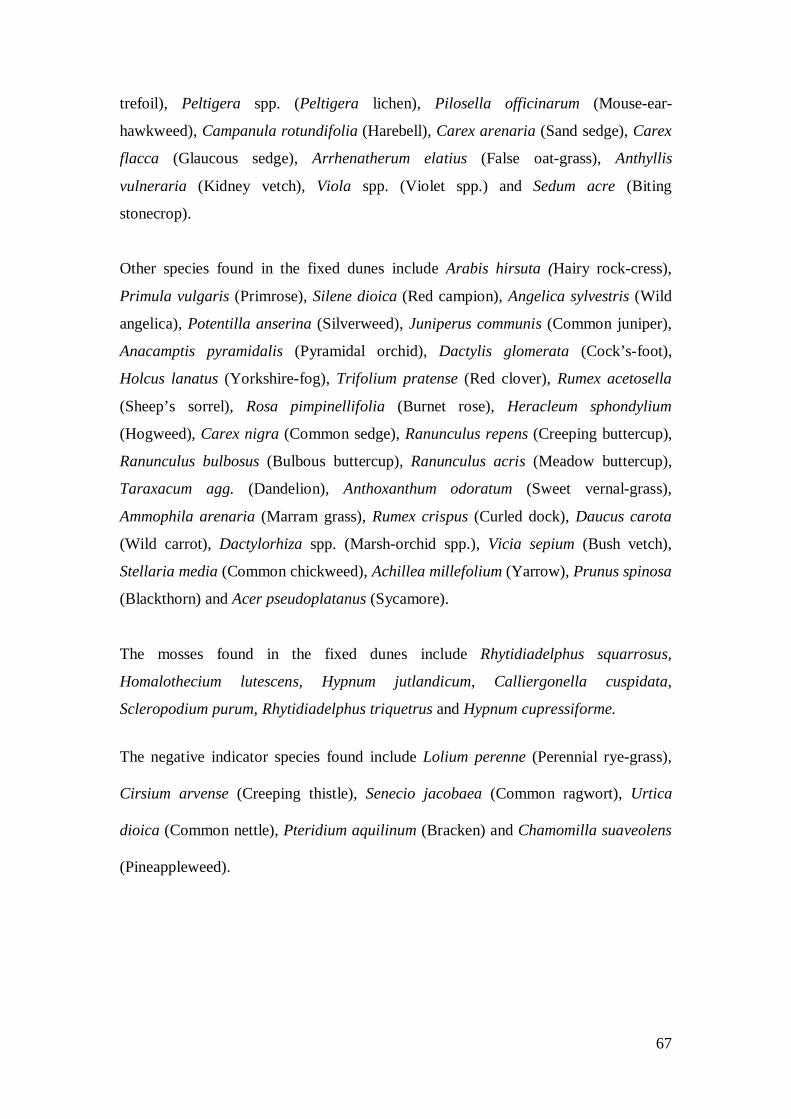
67
trefoil), Peltigera spp. (Peltigera lichen), Pilosella officinarum (Mouse-ear-
hawkweed), Campanula rotundifolia (Harebell), Carex arenaria (Sand sedge), Carex
flacca (Glaucous sedge), Arrhenatherum elatius (False oat-grass), Anthyllis
vulneraria (Kidney vetch), Viola spp. (Violet spp.) and Sedum acre (Biting
stonecrop).
Other species found in the fixed dunes include Arabis hirsuta (Hairy rock-cress),
Primula vulgaris (Primrose), Silene dioica (Red campion), Angelica sylvestris (Wild
angelica), Potentilla anserina (Silverweed), Juniperus communis (Common juniper),
Anacamptis pyramidalis (Pyramidal orchid), Dactylis glomerata (Cock’s-foot),
Holcus lanatus (Yorkshire-fog), Trifolium pratense (Red clover), Rumex acetosella
(Sheep’s sorrel), Rosa pimpinellifolia (Burnet rose), Heracleum sphondylium
(Hogweed), Carex nigra (Common sedge), Ranunculus repens (Creeping buttercup),
Ranunculus bulbosus (Bulbous buttercup), Ranunculus acris (Meadow buttercup),
Taraxacum agg. (Dandelion), Anthoxanthum odoratum (Sweet vernal-grass),
Ammophila arenaria (Marram grass), Rumex crispus (Curled dock), Daucus carota
(Wild carrot), Dactylorhiza spp. (Marsh-orchid spp.), Vicia sepium (Bush vetch),
Stellaria media (Common chickweed), Achillea millefolium (Yarrow), Prunus spinosa
(Blackthorn) and Acer pseudoplatanus (Sycamore).
The mosses found in the fixed dunes include Rhytidiadelphus squarrosus,
Homalothecium lutescens, Hypnum jutlandicum, Calliergonella cuspidata,
Scleropodium purum, Rhytidiadelphus triquetrus and Hypnum cupressiforme.
The negative indicator species found include Lolium perenne (Perennial rye-grass),
Cirsium arvense (Creeping thistle), Senecio jacobaea (Common ragwort), Urtica
dioica (Common nettle), Pteridium aquilinum (Bracken) and Chamomilla suaveolens
(Pineappleweed).

68
Mobile Dunes (H2120)
The mobile dune habitat comprises 3.5ha (approximately 5.7%) of the total sand dune
habitat at Clooney (Table 149A). The mobile dunes are somewhat discontinuous
along Tramore Beach as this beach has been subject to recent erosion. There is a steep
mobile dune ridge most of the way along the beach which is recovering in places. In
areas where sand is accreting Ammophila arenaria (Marram grass) dominated dunes
are re-building. There is some slumped vegetation and there is a blowout, which
extends into the fixed dunes. This blowout however is re-vegetating and there are
small embryonic dunes building in front of the areas of slumped mobile face. There
are sand trapping nets located towards the north end of the beach, which have been
erected to prevent further erosion in this area.
The mobile dunes on the beach in the northeast of the site are more intact as the bay is
more sheltered and are best developed where sand accretion is occurring at the tip of
the sandy spit. However, on the beach in the far east of the site, the habitat is quite
discontinuous. Here there is a mixture of intact areas and slumped vegetation. This
beach is more affected by animal trampling, especially by horses, which has added to
natural erosion.
The mobile dunes are composed of the typical species Ammophila arenaria (Marram
grass), with other species such as Elytrigia juncea (Sand couch), Festuca rubra (Red
fescue), Ranunculus acris (Meadow buttercup), Cakile maritima (Sea rocket), Rumex
crispus (Curled dock), Crepis capillaris (Smooth hawk’s beard), Daucus carota (Wild
carrot), Cerastium fontanum (Common mouse-ear), Trifolium repens (White clover),
Taraxacum agg. (Dandelion), Equisetum spp. (Horsetail), Calystegia soldanella (Sea
bindweed), Holcus lanatus (Yorkshire-fog), Potentilla anserina (Silverweed),
Dactylorhiza spp. (Marsh-orchid spp.) and Tussilago farfara (Colt’s-foot) also noted
in the habitat.

69
The negative indicator species Senecio jacobaea (Common ragwort) and Cirsium
arvense (Creeping thistle) were recorded in the habitat and the invasive species
Hippophae rhamnoides (Sea buckthorn) is located near the car park at Tramore Bay.
Embryonic Dunes (H2110)
The embryonic dune habitat comprises 3ha (approximately 5%) of the total sand dune
habitat at Clooney (Table 149A). Embryonic dunes are found along the three beaches
at Clooney. At Tramore Bay the habitat is discontinuous as a result of past natural
erosion. However, the habitat is re-building in places where sand accretion is
occurring and seems to be recovering overall. There is high recreational pressure on
this beach as a result of the caravan park and golf course. There is a car park located
at the main access point, which further attracts tourists to the area. However the
trampling of this habitat (and the mobile dunes) is mainly confined to the area in front
of the car park and in the foredunes to the front of the caravan park. Further along the
beach is relatively undisturbed except by natural erosion. The beach in the northeast
of the site has good development of embryonic dunes, especially at the accreting tip
although it is also discontinuous in places, further west. This beach is inaccessible to
walkers and is not disturbed by recreation. The beach further to the east is more
affected by natural erosion compounded by trampling by horses. Therefore the habitat
is more damaged and there are many places where it is absent and there is a slumped
fixed dune face instead.
The typical species of the embryonic dunes include Elytrigia juncea (Sand couch) and
Leymus arenarius (Lyme grass).

70
Other species found in the embryonic dunes include Atriplex prostrata (Spear-leaved
orache), Tussilago farfara (Colt’s-foot), Ammophila arenaria (Marram grass) and
Taraxacum agg. (Dandelion).
There were no negative indicators recorded in the habitat.
Perennial Vegetation of Stony Banks (H1220)
The perennial vegetation habitat comprises 0.07ha (approximately 0.11%) of the total
sand dune habitat at Clooney (Table 149A). There is a small area of perennial
vegetation on shingle located at the western end of the beach north of Tramore Bay.
The habitat is quite small but is intact and is undisturbed. The typical species found in
the habitat include Rumex crispus (Curled dock) with other species such as Atriplex
prostrata (Spear-leaved orache), Cakile maritima (Sea rocket) and Daucus carota
(Wild carrot). There were no negative indicators recorded in the habitat.
Annual Strandline (H1210)
The annual strandline habitat comprises 1.5ha (approximately 2.5%) of the total sand
dune habitat at Clooney (Table 149A). Annual Strandline is mostly absent along the
beach at Tramore Bay, but it is well developed along the beach in the northern part of
the site. The absence of the habitat at Tramore Bay may be due to recent erosion, but
may also be due to the fact that the beach has Blue Flag status and the beach may be
regularly cleaned. There were a number of Charadrius hiaticula (Ringed plover)
nesting in the strandline on this undisturbed beach. There are also patches of the
habitat located along the beach in the eastern part of the site, where it is intermingled
with embryonic dunes.

71
The strandline habitat is composed of the typical species Atriplex prostrata (Spear-
leaved orache), Honckenya peploides (Sea sandwort) and Cakile maritima (Sea
rocket).
Other species recorded in the habitat are Elymus pycnanthus (Sea couch), Elytrigia
juncea (Sand couch), Matricaria maritima (Sea mayweed) and Rumex crispus (Curled
dock).
Impacts The machair habitat is lightly grazed (Code 140) but in places it is undergrazed
(Code149). There is a high cover of agricultural weeds (Code 971) in the habitat and
it has been improved (Code 103) in the eastern part of the site. There are a number of
ring feeders (Code 171) in the habitat and there is a lack of dune species in these
areas. The habitat is fragmented as a result of the presence of a golf course. The
habitat is also fenced in places (Code 150).
The fixed dunes are affected by the presence of the golf course (Code 601) (outside
cSAC). It has altered the structure of the habitat in places and constructed greens and
tees on some of the more intact areas that had been previously less managed. There is
a caravan site (Code 608) situated in the southwestern part of the fixed dunes.
Although it is also outside the boundary of the cSAC it has impacted on the extent of
the fixed dunes. Although there are a high number of caravans present they have not
altered the overall structure of the habitat and the area still has good species diversity.
There is a large patch of Hippophae rhamnoides (Sea buckthorn) (Code 954) near to
the main access point to Tramore Bay and there are also trees and bindweed in the
vicinity. Trampling (Code 720) and walking (Code 622) at the front of the habitat is
also very obvious. Some burning (Code 690), probably due to barbeques was noted in
the fixed dunes to the front.
The fixed dunes in the eastern part of the site have been affected by some
improvement (Code 103). They are grazed by cattle, sheep, horses and rabbits (Code
140), but are not heavily grazed. They are fenced and some areas contain ring feeders
(Code 171) and a high percentage cover of agricultural weeds (Code 971). There is

72
some sand extraction (Code 300) being carried out in this area also, but the extraction
site is not currently being heavily used. There is also some natural erosion of the
habitat (Code 900) and some dumping was noted in places (Code 421).
The mobile dunes have been severely naturally eroded (Code 900) in the past, which
was probably exacerbated by overuse and trampling (Code 720) and walking (Code
622) on the tops of the dunes, as there are sandy tracks evident in front of the caravan
site in particular. There are some sand trapping nets (Code 871) in the habitat at the
northern end of the beach, which may help to restore the habitat but they need to be
maintained. There is trampling by horses in the eastern part of the site and this area
seems to have been grazed by rabbits and horses (Code 140).
The embryonic dunes and strandline are affected by walking (Code 622), trampling
(Code 720) and natural erosion (Code 900).
The perennial vegetation of stony banks is undisturbed.
Table 149B Intensity and impact of various activities on sand dune habitats at Clooney
EU Habitat Code1
Activity Code2
Intensity3
Impact4
Area affected/ha
Location of
Activity5 H21A0 103 B -1 4 Inside H21A0 140 B +2 8.8 Inside H21A0 149 B -1 2 Inside H21A0 150 B -1 8.8 Inside H21A0 971 B -1 4 Inside H2130 103 B -1 Unknown Inside H2130 140 B +2 35 Inside H2130 171 B -1 1 Inside H2130 300 A -2 0.461 Inside H2130 601 A -2 49.7 *Outside H2130 608 A -2 11.5 *Outside H2130 622 A -1 0.5 *Outside H2130 690 B -1 0.1 *Outside H2130 720 A -1 1 Inside H2130 900 B 0 Unknown Inside H2130 954 A -1 Unknown Outside H2120 140 C -1 0.1 Inside H2120 622 A -1 0.1 Inside H2120 720 A -1 2 Inside

73
H2120 871 A -1 Unknown Inside H2120 900 A 0 Unknown Inside H2110 622 B -1 Unknown Inside H2110 720 B -1 Unknown Inside H2110 900 C 0 Unknown Inside H1210 622 B -1 Unknown Inside H1210 720 B -1 Unknown Inside H1210 900 C 0 Unknown Inside
1EU Codes as per Interpretation Manual. Code 21BB is an additional code used to signify the entire dune habitat. 2 Description of activity codes are found in Appendix 3 3 Intensity of the influence of an activity is rated as: A= high, B = medium, C = low influence and D = unknown. 4 Impact is rated as: -2 = irreparable negative influence, -1 = repairable negative influence, 0 = neutral, +1 = natural positive influence and +2 = strongly managed positive influence 5 Location of activity: Inside = activities recorded within the cSAC and directly impacting the sand dune habitat. *Outside = activities recorded outside the cSAC but adjacent to sand dune habitat that may be impacting the sand dune habitat
Conservation Status
The conservation status of a site is assessed on the condition of the site with regards to
extent, structure & functions and future prospects (Table 149C). This is based on the
condition of the site at the time of survey but where possible, baseline information is
also consulted, although it must be noted that in certain cases this information may be
superceded. The baseline information for this site came from the National ASI Survey
(1994), the Natura 2000 survey (1995), the Biomar Survey (1996) and the MPSU
management plan (2000).

74
Table 149C Conservation status of Annex I sand dune habitats at Clooney
HABITAT1
EU CONSERVATION STATUS ASSESSMENT
Favourable Unfavourable - Inadequate
Unfavourable – Bad
Overall EU conservation
status assessment
Proposed Irish conservation
status system2
MACHAIR (H21AO)
Extent
Future Prospects
Structure & functions
Unfavourable - Bad
Unfavourable - Declining
FIXED DUNE (H2130)
Extent Structure & functions Future Prospects
Unfavourable - Inadequate
Unfavourable - Declining
MOBILE DUNES (H2120)
Extent Future Prospects
Structure & functions
Unfavourable - Bad
Unfavourable - Recovering
EMBRYONIC DUNES (H2110)
Extent Structure & functions
Future Prospects
Unfavourable - Inadequate
Unfavourable - Unchanged
PERENNIAL VEGETATION OF STONY BANKS (H1220)
Extent Structure & functions Future Prospects
Favourable Favourable-Maintained
ANNUAL
STRANDLINE (H1210)
Structure & functions
Extent Future Prospects
Unfavourable - Inadequate
Unfavourable - Unchanged
1EU Codes as per Interpretation Manual 2Ratings are Favourable (Enhanced, Maintained, Recovered, Declining), Unfavourable (Recovering, Unchanged, Declining) and Destroyed (Partially destroyed, Completely destroyed and Unknown) Details of the numbers and pass/failure rates of monitoring stops used to assess habitat structure & functions at Clooney are shown in Table 149D.
Machair (H21AO)
The machair habitat is now relatively small in area at this site, as it has been
fragmented as a result of the presence of the golf course, which has been constructed
on previous machair habitat. However as this is a baseline study and the golf course
has been in existence since 1930 and has not expanded into the remaining machair the
extent of the habitat is rated as favourable. The NATURA 2000 assessment is good
representativity.

75
The structure and functions parameter is rated as unfavourable-bad. A total of two
monitoring stops were placed in the machair habitat, both failed their targets (Table
149D). There was a high cover of agricultural weeds due to past improvement and
bryophyte cover was low in one stop while the other stop failed also on sward height.
Quadrats taken from the Biomar machair survey have also been used to compare past
and present condition of the site. The closest quadrats to the 2006 monitoring stops
are used for comparison and this provides a good indicator of any change in species
composition as well as sward height. The criteria used during the current survey
(2006) are applied to quadrats in the machair survey (1996). Two monitoring stops
were compared to two quadrats taken in 1996. One of the 1996 quadrats passed the
current criteria, although it failed the negative indicator target of <5%. The other
quadrat failed outright on sward height and negative indicators. As mentioned both
monitoring stops in the current survey failed overall as a result of a combination of
sward height, bryophyte cover and negative indicator species. There has therefore
been some decline in condition of the machair since 1996, although 2 stops is a
relatively small sample size. The NATURA 2000 assessment is average or partially
degraded structure.
Table 149D Pass/fail results of Annex I sand dune habitats at Clooney
Monitoring stops Habitat Pass Fail Conservation status Machair (H21A0)
0 2 Unfavourable- Bad
Fixed Dunes (H2130)
6 2 Unfavourable- Inadequate
Mobile dunes (H2120)
5 5 Unfavourable- Bad
Embryonic Dunes (H2110)
9 0 Favourable
Perennial vegetation of stony banks
1 0 Favourable

76
Annual Strandline (H1210)
4 0 Favourable
The future prospects of the machair at Clooney are rated as unfavourable-inadequate.
The habitat is declining in condition as it has been improved in the past and is now
fragmented. The objective of the MPSU management plan for the site is to enhance
the ecological value of the priority habitats within the site. The strategies set out in
order to fulfil this objective are to implement grazing management strategies and
encourage sustainable agricultural practices on the sand dune habitats. This plan
should therefore be adhered to where possible. The NATURA 2000 assessment is
average to unfavourable prospects.
An overall EU conservation status of unfavourable-bad is assigned to the machair
(Table 149C).
The overall Irish conservation status is unfavourable-declining.
Fixed Dunes (H2130)
The extent of the fixed dunes is rated as unfavourable-inadequate. The golf course
seems to have expanded into the last remaining area of habitat that was outside the
cSAC, in the far north of Tramore Bay (Note the fixed dunes in the golf course are not
part of this assessment as they are outside the cSAC). The rest of the fixed dunes to
the east are mainly intact although there has also been some loss of extent as a result
of sand extraction and some natural erosion. The NATURA 2000 assessment is
excellent representativity.
The structure and functions parameter is rated as unfavourable-inadequate. A total of
eight monitoring stops were placed in the fixed dunes. Six passed their targets and

77
two failed (Table 155D). The monitoring stops failed as a result of high percentage
cover of agricultural weeds and a tall sward. The NATURA 2000 assessment for fixed
dune is excellent structure.
The future prospects of the fixed dune at Clooney are rated as unfavourable-
inadequate as there seems to be a high degree of disturbance in the eastern part of the
site with agricultural practices threatening the condition of the habitat. There is also
an area where sand extraction may continue to be carried out, which will affect the
structure of the habitat in this area and deplete the sand. The objectives set out in the
MPSU management plan are to improve the ecological value of the priority habitats at
this site by implementing strategies such as grazing management and sustainable
agricultural management practices. The plan should therefore be implemented in
order to conserve the fixed dune habitat, especially as there is the rare species Draba
incana (Hoary whitlowgrass) present in the habitat. This is a feature of local
distinctiveness for the site. The NATURA 2000 assessment is excellent future
prospects.
An overall EU conservation status of unfavourable-inadequate is assigned to the fixed
dune (Table 149C). This is attributable to the unfavourable-inadequate extent,
structure and functions and future prospects of the habitat as a whole at this site.
The overall Irish conservation status is unfavourable-declining.
Mobile Dunes (H2120)
The extent of the mobile dunes at the site is considered to be unfavourable-
inadequate. Severe erosion has occurred at the western side of the site that is
compounded by recreational pressure. There is also some natural erosion at the
eastern beach, compounded by trampling by horses. The NATURA 2000 assessment
is excellent representativity.
The conservation assessment for structure and functions is rated as unfavourable-bad.
A total of twelve monitoring stops were placed in the habitat and six passed and six
failed. This accounts for 50% of the habitat that is in decline. The stops failed because

78
there was a high cover of dead or dying A. arenaria and some areas were heavily
trampled with no flowering or fruiting. The NATURA 2000 assessment for the
mobile dunes is good structure.
The habitat seems to be recovering at Tramore Bay as there is accretion and a band of
embryonic dunes has formed to the front. The County Council have also placed sand-
trapping nets along much of the habitat, which may help the habitat to recover further.
However on the beach in the eastern part of the site there seems to be a problem with
trampling by horses and therefore, the habitat will not be able to recover well here.
The high recreational pressure on Tramore Bay may also have an affect on the
recovery of the mobile dunes here. Therefore the future prospects of the habitat are
rated as unfavourable-inadequate. The NATURA 2000 assessment is good future
prospects.
The overall EU assessment is rated as unfavourable-bad as a result of unfavourable-
bad structure and functions of the habitat. The overall Irish assessment is
unfavourable-declining.
Embryonic dunes (H2110)
There is good development of the embryonic dunes habitat at this site. There is a
mainly intact band of embryonic dunes on Tramore Bay and wide bands are also
present on the two other beaches at the site. Therefore the extent of the habitat is rated
as favourable for the habitat as a whole. There is no mention of embryonic dunes in
the NATURA 2000 report.
A total of nine monitoring stops were placed in the habitat. All nine stops passed and
therefore the structure and functions is rated as favourable. Healthy Elytrigia juncea
(Sand couch) was present with plenty of flowering and fruiting and no negative
indicators were recorded.
The future prospects for the embryonic dunes at this site are mainly good, as there
seems to be windblown sand entering the system. There may be some decline on the
western side of the site near the car park as there is high recreational pressure and the

79
horse trampling on the eastern side of the site may also pose a threat. Therefore the
future prospects for the habitat are rated as unfavourable-inadequate at present.
The overall EU conservation assessment is rated as unfavourable-inadequate, while
the Irish conservation assessment is unfavourable-unchanged.
Perennial vegetation of stony banks (H1220)
The extent of the shingle habitat is quite small but as it is present and there is nothing
to indicate that there has been any decline, the extent is rated as favourable. There is
no mention of perennial vegetation of stony banks in the NATURA 2000 report.
Only one monitoring stop was placed in the habitat as the area was minimal in size
and it passed the monitoring criteria. The structure and functions of the habitat are
therefore rated as favourable.
The future prospects for the habitat are rated as favourable as there is very little
disturbance in this part of the site.
The overall EU conservation assessment is rated as favourable, while the Irish
conservation assessment is favourable-maintained.
Annual Strandline (H1210)
Annual strandline is quite extensive at this site in the more sheltered bays, which are
inaccessible for most visitors. However the habitat is absent from Tramore bay
altogether, probably as a result of the high recreational pressure at the site and
possible beach cleaning. The overall assessment for extent is given as unfavourable-
inadequate. There is no mention of annual strandline in the NATURA 2000 report.
Four monitoring stops were carried out in the habitat. The monitoring stops passed all
criteria, indicating structure and functions of the habitat are favourable. No negative
indicators were recorded in the habitat.
The future prospects for the strandline are rated as unfavourable-inadequate for the
site as a whole. Although there are a number of large patches, which are intact at the

80
eastern and northern beaches, there is no development of the habitat on Tramore Bay.
This beach is prone to high levels of trampling as it has blue flag status and some
areas may be cleaned, removing the seed base for the habitat.
The overall EU conservation assessment is rated as unfavourable-inadequate, while
the Irish conservation status is unfavourable-unchanged.

81

82
Appendix VI – Roshin Point site report and habitat map from the CMP (Ryle et al., 2009) SITE DETAILS CMP06 site name: Roshin Point CMP06 site code: 150 CMP Map No.: 147
County: Donegal Discovery map: 10 Grid Reference: B 760 995
6 inch Map No.: Dg 064 & 065
Aerial photographs (2000 series): O 0366-B; O 0367-A
NPWS Site Name: West of Ardara / Maas Road
NPWS designation: pNHA: 197 cSAC: 197
Ranger Area: Donegal
MPSU Plan: Draft 2 Consultation 2000
Report Author: Melinda Swann
Site Description Roshin Point sand dunes are situated in Gweebarra Bay, close to the towns of Maas and
Clooney. They are part of cSAC 197 West of Ardara / Maas Road, which covers a large area
of coast immediately north of Ardara in southwest Donegal. The site is adjacent to Clooney
sand dunes and Lettermacaward sand dunes, which are discussed elsewhere in this report.
The overall cSAC is designated for a number of habitats including estuaries, sandflats,
saltmarsh, lowland blanket bogs, a variety of heaths, lowland hay meadows, orchid-rich
calcareous grassland, Molinia meadows, juniper scrub, deciduous woodland (Maas-
Lettermacaward area) sand dunes and machair plains, all of which support a diverse range of
plant and animal species. In total there are twenty-three habitats listed under Annex I of the
EU Habitats Directive present, six of which have priority status.
Furthermore, the surrounding estuaries support high numbers of wintering waterfowl as well
as a number of other Annex I bird species. The sandbanks, west of Roshin Point, support a
population of Phoca vitulina (Common seal) and Lutra lutra (Otter) are also present at the site
(both noted during the current survey). The two species are listed as Annex II in the EU
Habitats Directive and therefore the cSAC offers an important habitat for both species. The

83
presence of both Otter and Common Seal was part of the reason for selection of this site as a
cSAC and the seal colony accounts for 4.8% of the national total population (NATURA 2000
Report, 2004).
The Annex I sand dune habitats for which Roshin Point is designated are, machair, fixed
dunes and mobile dunes. Roshin Point is a peninsula composed of a shingle bar, connecting an
island to the mainland. The shingle developed in front of a rocky outcrop and has, over time
been overlain by sand. This has allowed a wide variety of vegetation types to develop. The
whole formation is referred to as a tombolo. The site has an interesting and varied geological
structure (Sheppard, undated), which accounts for much of this ecological variation.
Access to the site involves crossing agricultural land, although there are rights of way further
down the coast towards Clooney. Cattle graze the island and there was a bull present in the
herd on the day of the site visit. There is also some fencing across the machair, which divides
the wet areas from the drier machair. As access is difficult recreational pressure is very low
and the site is reasonably undisturbed.
The current survey concentrates on the Annex I sand dune habitats and includes annual
strandline, perennial vegetation of stony banks, embryonic dunes, mobile dunes, fixed dunes
and machair. The areas of Annex I sand dune habitats recorded at Roshin Point are shown in
Table 147A.
Table 147A Areas of EU Annex I habitats mapped at Roshin Point EU Code EU Habitat
Area (ha) H21A0 Machair 5.305 H2130 Fixed coastal dunes with herbaceous vegetation 3.613 H2120 Shifting dunes along the shoreline with Ammophila arenaria 0.389 H2110 Embryonic shifting dunes 0.374 H1220 Perennial vegetation of stony banks 0.259 H1210 Annual vegetation of driftlines 0.181 8.1.1 Total Sand dune 10.121

84
Machair (H21A0) The machair habitat comprises 5.305ha (approximately 52.4%) of the total sand dune habitat
at Roshin Point (Table 147A). There is an area of dry machair grading into wetter type
machair vegetation, which has developed behind the fixed dune habitat. The machair then
grades into freshwater marsh vegetation to the south and east. Beyond this, in the most
easterly part of the site there is a mosaic of rocky outcrops, dry-humid acid grassland, marsh,
and fen areas. There is a high proportion of Pteridium aquilinum (Bracken) covering this
eastern part of the site and dry heath species, such as Calluna vulgaris (Ling heather) are
found on the rocks. The machair in the north of the site has a characteristic short sward
appearance and is relatively species-rich. The rest of the machair has a generally tall sward
and has been somewhat improved in places. There are areas, which are Festuca (Fescue)
dominated with a high proportion of agricultural grasses present. These areas are ungrazed, as
there is a fence running through the site, which prevents the cattle entering.
Another area of dry machair is located on the mainland southwest of the shingle bar. It grades
into freshwater marsh vegetation, which is fronted by saltmarsh. There is bracken on the
higher areas with a mix of Cirsium spp. (Thistle) and Heracleum sphondylium (Hogweed).
This area is more species-rich, but again has a high proportion of agricultural grasses present,
indicating improvement.
The typical species of machair found at Roshin Point are: Lotus corniculatus (Common bird’s-
foot-trefoil), Bellis perennis (Daisy), Carex arenaria (Sand sedge), Galium verum (Lady’s
bedstraw), Plantago lanceolata (Ribwort plantain), Carex flacca (Glaucous sedge), Carex
nigra (Common sedge), Prunella vulgaris (Selfheal), Trifolium repens (White clover), Thymus
polytrichus (Wild thyme), Linum catharticum (Fairy flax), Cerastium fontanum (Common
mouse-ear), Rhinanthus minor (Yellow-rattle), Odontites verna (Red bartsia) and Euphrasia
officinalis agg. (Eyebright).
Other species include Trifolium pratense (Red clover), Ranunculus repens (Creeping
buttercup), Pilosella officinarum (Mouse-ear-hawkweed), Luzula campestris (Field wood-

85
rush), Poa pratensis (Smooth meadow grass), Poa spp. (Meadow grass), Succisa pratensis
(Devil’s-bit Scabious), Rumex acetosella (Sheep’s sorrel), Parnassia palustris (Grass-of-
parnassus), Centaurea nigra (Common knapweed), Cochlearia spp. (Scurvygrass),
Ranunculus bulbosus (Bulbous buttercup) Ranunculus spp. (Buttercup), Leontodon
autumnalis (Autumn hawkbit), Campanula rotundifolia (Harebell) and Equisetum spp.
(Horsestail), as well as the grasses Festuca rubra (Red fescue), Anthoxanthum odoratum
(Sweet vernal-grass) and Briza media (Quaking-grass).
Bryophytes noted are Rhytidiadelphus squarrosus, Homalothecium lutescens, Scleropodium
purum and Calliergonella cuspidata.
The negative indicators include Holcus lanatus (Yorkshire fog), Cynosurus cristatus (Crested
dog’s-tail), Senecio jacobaea (Common ragwort), Lolium perenne (Perennial rye-grass),
Cirsium arvense (Creeping thistle), Dactylis glomerata (Cock’s-foot) and Poa trivialis (Rough
meadow-grass) were all noted during the survey.
Fixed Dunes (H2130)
The priority habitat fixed dune comprises 3.613ha (approximately 35.7%) of the total sand
dune habitat at Roshin Point (Table147A). The fixed dune is a relatively small area at this site.
The predominant vegetation of the stabilised dunes is that of calcareous dune grassland which
grades into machair at the landward side. The fixed dunes are mainly species-rich and in
places there is an abundance of Anacamptis pyramidalis (Pyramidal orchid), as well as high
numbers of primrose plants (Primula vulgaris) present. The majority of the fixed dunes have a
good, typical short turf appearance, intermingled with some Ammophila arenaria (Marram
grass). However, in the north of the site the fixed dune is, in places, covered with bracken.
Some agricultural improvement also seems to have occurred, as there is a high proportion of
agricultural species present in parts of the habitat. There is a water trough towards the back of
the fixed dune and there are localised clumps of agricultural grasses and weeds nearby. The
herd of cattle is free to roam over the northern half of the fixed dune. There is a fence running
through the fixed dune and the machair in an east west direction, which stops cattle entering
some areas. There is also a fence running in front of the fixed dune, which prevents the cattle
accessing the mobile dunes and the beach. There are a number of Crataegus monogyna
(Hawthorn) bushes scattered throughout the fixed dune, which is quite unusual.

86
Typical species recorded in the fixed dune are Poa pratensis (Smooth meadow grass), Lotus
corniculatus (Common bird’s-foot trefoil), Galium verum (Lady’s bedstraw), Plantago
lanceolata (Ribwort plantain), Carex arenaria (Sand sedge), Thymus polytrichus (Wild
thyme), Euphrasia officinalis agg. (Eyebright), Trifolium repens (White clover), Festuca
rubra (Red fescue), Luzula campestris (Field wood-rush), Hypochaeris radicata (Cat’s-ear),
Pilosella officinarum (Mouse-ear-hawkweed), Crepis capillaris (Smooth hawk’s-beard),
Prunella vulgaris (Selfheal), Rhinanthus minor (Yellow-rattle), Taraxacum agg. (Dandelion)
and Cerastium fontanum (Common mouse-ear).
Mosses found are Rhytidiadelphus squarrosus and Homalothecium lutescens.
Other fixed dune species found are Primula vulgaris (Primrose), Anacamptis pyramidalis
(Pyramidal orchid), Ammophila arenaria (Marram grass), Bellis perennis (Daisy), Ranunculus
bulbosus (Bulbous buttercup), Rumex acetosella (Sheep’s sorrel), Centaurea nigra (Common
knapweed), Trifolium pratense (Red clover), Dactylis glomerata (Cock’s-foot), Holcus
lanatus (Yorkshire-fog) and Crataegus monogyna (Hawthorn).
Some clumps of Iris pseudacorus (Yellow iris), although not a typical fixed dune species but
an indicator of damp conditions, were scattered towards the back of the habitat in the north of
the site.
The negative indicator species Senecio jacobaea (Common ragwort) and Lolium perenne
(Perennial rye-grass) are found throughout the habitat and Pteridium aquilinum (Bracken) is
present in a large clump at the northern end of the fixed dune.
Mobile Dunes (H2120) The mobile dune habitat comprises 0.389 ha (approximately 3.8%) of the total sand dune
habitat at Roshin Point (Table147A). The mobile dunes form a relatively high, narrow ridge,
which is fronted by embryonic dunes. The mobile dunes are composed of the typical species
Ammophila arenaria (Marram grass) and are relatively well developed. They are quite steep
87
and this may indicate erosion in the past. There is one gap in the habitat towards the southern
end of the beach, which seems to have been breached in the past by the sea or by some
anthropogenic activities. This area is now recovering and there is a smaller ridge of
Ammophila arenaria (Marram grass), which has built up towards the back of the breach. In
general there is good development of this habitat as this part of the site is undisturbed by both
grazers and recreational activities. However, there seem to be some areas of the habitat that
are in poor condition as the monitoring process showed some unhealthy Ammophila arenaria
(Marram grass) present. However the dunes may simply be recovering from natural erosion, as
there are now embryonic dunes to the front.
Typical species found are Ammophila arenaria (Marram grass) along with, some Elytrigia
juncea (Sand Couch). Also found in some of the monitoring stops are Agrostis capillaris
(Common bent), Taraxacum agg. (Dandelion), Tussilago farfara (Colt’s foot), Cerastium
fontanum (Common mouse-ear), Festuca rubra (Red fescue), Lotus corniculatus (Common
bird’s-foot Trefoil), Anacamptis pyramidalis (Pyramidal orchid), Trifolium repens (White
clover), Rumex acetosella (Sheep’s sorrel) and Carex arenaria (Sand sedge).
The negative indicators, Senecio jacobea (Common ragwort) and Cirsium arvense (Creeping
thistle) appear through the habitat.
Embryonic Dunes (H2110)
Embryonic dunes account for 0.374ha (approximately 3.7%) of the total sand dune habitat at
Roshin Point (Table147A). The embryonic dune is quite well developed and there is a
relatively wide band with a well-defined gradation pattern from mobile to embryonic. The
habitat is fronted by strandline vegetation. The dominant species found in the embryonic
dunes is Elytrigia juncea (Sand couch), while some Ammophila arenaria (Marram grass) is
interspersed, in places. Other species found include Festuca rubra (Red fescue) and Potentilla
anserina (Silverweed). Strandline species were also found in some places and include
Honckenya peploides (Sea sandwort) and Atriplex spp. (Orache spp.). The monitoring of this
habitat indicates that there is healthy growth of Elytrigia juncea (Sand couch). The only
negative indicator species present is Cirsium arvense (Creeping thistle), but is relatively rare.

88
Perennial Vegetation of Stony Banks (H1220)
Perennial vegetation of stony banks accounts for 0.259ha (approximately 2.6%) of the total
sand dune habitat at Roshin Point. The habitat is situated in the south of the site on the western
side of the shingle bar. The shingle bar itself has a more stable fixed dune type vegetation,
with some more perennial vegetation on the exposed shingle, on the eastern side. This side is
fronted by a salt marsh, which extends northwards towards the freshwater marsh area.
The typical species present include Honckenya peploides (Sea sandwort), Atriplex spp.
(Orache spp.), Tripleurospermum maritimum (Sea mayweed), Galium aparine (Cleavers), and
Rumex crispus (Curled dock).
Other species present are Carex arenaria (Sand sedge) and Elytrigia juncea (Sand couch). No
negative indicators were recorded during the monitoring process.
STRANDLINE (H1210)
The strandline habitat constitutes 0.181ha (approximately 1.8%) of the total sand dune habitat
at Roshin Point. Strandline habitat is well developed at the site with a relatively wide band
occurring at the back of the beach. It is mainly composed of the typical species Honckenya
peploides (Sea sandwort) and Atriplex spp. (Orache spp.) with some other species such as
Elytrigia juncea (Sand couch) scattered in places throughout the habitat. The habitat grades
into perennial vegetation of stony banks towards the south as it approaches the shingle bar.
No negative indicator species were found during the monitoring process. There is a high
amount of seaweed present on the beach, which is very important for the early stages of
development of a strandline habitat.
IMPACTS The main impacts on the sand dune habitat at Roshin Point are given in Table 147B. The
machair habitat is grazed (Code 140) by cattle, but this is a positive influence. However there
are areas that are also under-grazed (Code 149). Fencing (Code 150) has been placed in an
east to west direction and divides the northern section of machair from the more wet, southern

89
section, as well as from the fresh water marsh. This means that the sward is much taller in the
southern part of the site. The fencing is therefore, negatively impacting the machair by not
allowing grazing to occur. Some agricultural improvement (Code 103) such as re-seeding and
fertiliser (Code 120) application seems to have occurred.
The fixed dune is also grazed (Code 140). This is a positive impact as it keeps the species
diversity high. Some of the fixed dune is under-grazed (Code 149) and is covered in Pteridium
aquilinum (Bracken) (Code 954), especially in the north of the site. There is also a water
trough (Code 171) present, with poached areas surrounding it.
The mobile dune is affected by natural erosion (Code 900) and was previously eroded in one
section in particular. This area is now regenerating and a ridge of Ammophila arenaria
(Marram grass) has built up. There are also some embryonic dunes re-developing in front of
this area.
The embryonic dune, perennial vegetation and strandline are prone to natural erosion (Code
900) but this is not very apparent at present. It is difficult to assess the area affected by natural
erosion, as there is no previous data available and therefore appears as unknown in table 147B.
Access to the site is via the shingle bar therefore some walking (Code 622) and movement of
cattle may affect the vegetation in this area, but at a low level.

90
Table 147B Intensity and impact of various activities on sand dune habitats at Roshin Point
EU Habitat Code1 Activity Code2 Intensity3
Impact4
Area affected/ha
Location of
Activity5 H21A0 103 C -1 0.5 Inside H21A0 120 C -1 Unknown Inside H21A0 140 B +2 2.6 Inside H21A0 149 A -1 2.6 Inside H21A0 150 A -1 2.6 Inside H2130 140 B +2 2.8 Inside H2130 149 B -1 0.7 Inside H2130 171 C -1 0.01 Inside H2130 954 B -1 0.2 Inside H2120 900 B 0 Unknown Inside H2110 900 B 0 Unknown Inside H1220 622 C -1 Unknown Inside H1220 900 B 0 Unknown Inside H1210 900 B 0 Unknown Inside
1EU Codes as per Interpretation Manual. Code 21BB is an additional code used to signify the entire dune habitat. 2 Description of activity codes are found in Appendix 3 3 Intensity of the influence of an activity is rated as: A= high, B = medium, C = low influence and D = unknown. 4 Impact is rated as: -2 = irreparable negative influence, -1 = repairable negative influence, 0 = neutral, +1 = natural positive influence and +2 = strongly managed positive influence 5 Location of activity: Inside = activities recorded within and directly impacting the sand dune habitat. Outside = activities recorded outside but adjacent to sand dune habitat that are impacting the sand dune habitat
CONSERVATION STATUS
The conservation status of a site is assessed on the condition of the site and on baseline
information. The main source of baseline information for this site was from the ASI survey,
the NATURA 2000 report and the MPSU management plan. There is no mention of annual
strandline or perennial vegetation of stony banks either in the NATURA 2000 form or in the
MPSU management plan. Therefore the assessment of these habitats is based on best scientific
judgement and the site condition during the current survey.

91
Table 147C Conservation status of Annex I sand dune habitats at Roshin Point
HABITAT1
EU CONSERVATION STATUS ASSESSMENT
FAVOURABLE
Unfavourable - Inadequate
Unfavourable – Bad
Overall EU conservatio
n status assessment
Proposed Irish conservation
status system2
MACHAIR (H21AO)
Extent Future Prospects
Structure & functions
Unfavourable -bad
Unfavourable - Declining
FIXED DUNES (H2130)
Extent Future Prospects
Structure & functions
Unfavourable -bad
Unfavourable - Declining
MOBILE DUNES (H2120)
Extent Future Prospects
Structure & functions
Unfavourable -
Inadequate
Unfavourable - Recovering
EMBRYONIC DUNES (H2110)
Extent Structure & functions Future Prospects
Favourable Favourable-Maintained
PERENNIAL VEGETATION OF STONY BANKS (H1220)
Extent Structure & functions Future Prospects
Favourable Favourable-Maintained
ANNUAL STRANDLINE (H1210)
Extent Structure & functions Future Prospects
Favourable Favourable-Maintained
1EU Codes as per Interpretation Manual 2Ratings are Favourable (Enhanced, Maintained, Recovered, Declining), Unfavourable (Recovering, Unchanged, Declining) and Destroyed (Partially destroyed, Completely destroyed and Unknown)
Details of the numbers and pass/failure rates of monitoring stops used to assess habitat
structure & functions at Roshin Point are shown in Table 147D.

92
Machair (H21A0)
The habitat is relatively small in area at this site as it is situated on an island. The extent of the
machair is considered favourable as there is nothing to indicate that there has been any decline
in the overall area of the habitat.
The structure and functions parameter is rated as unfavourable-bad. Two monitoring stops
passed their targets and two failed (Table 147D). The two monitoring stops that failed were
due to sward height being greater than the target height. One of the stops also failed on species
diversity while the other stop also had a high cover of agricultural weeds present. This
indicates changes in grazing management as well as some agricultural improvement at the site.
Quadrats taken from the Biomar machair survey have also been used to compare past and
present condition of the site. The closest quadrats to the 2006 monitoring stops are used for
comparison and this provides a good indicator of any change in species composition as well as
sward height. The criteria used during the current survey (2006) are applied to quadrats in the
machair survey (1996). Two monitoring stops were compared to two quadrats taken in 1996
although they were not directly comparable. Both of the 1996 quadrats failed the current
criteria, for sward height and negative indicators. This would indicate that the machair habitat
has not changed too much between surveys and therefore has been undergrazed for the last ten
years. The NATURA 2000 assessment is average or partially degraded structure.
Table 147D Monitoring stop totals and pass/failure rates of Annex I sand dune habitats at Roshin Point Monitoring stops Habitat Pass Fail Conservation status Machair (H21A0)
2 2 UNFAVOURABLE- BAD
Fixed dunes (H2130)
2 2 UNFAVOURABLE- BAD
Mobile dunes (H2120)
2 2 UNFAVOURABLE- BAD
Embryonic dunes (H2110)
4 0 FAVOURABLE
Perennial vegetation of stony banks (H1220)
1 0 FAVOURABLE
Strandline (H1210)
3 0 FAVOURABLE

93
The future prospects of the machair at Roshin Point are rated as unfavourable-inadequate. A
fence down the middle has altered the grazing regime on the machair and so there are areas
that are undergrazed. This means that the typical appearance of short sward grassland has
changed to a taller sward. There has also been some improvement as, in places there is a high
cover of agricultural grasses. The natural functioning of the machair system is therefore no
longer occurring. There is currently no development and current recreational activities are
very low, and do not appear to be impacting the habitat. This assessment corresponds to the
assessment made in the NATURA 2000 form of average to reduced conservation value.
The MPSU management plan states that one of the main objectives of management is to
maintain and where possible enhance the ecological value of the priority habitats on the site.
This should therefore be implemented, as without an introduction of appropriate management
the machair will continue to degrade and alter in species diversity within the ungrazed area. A
removal of fencing and a return to an open grazing regime would be beneficial to the future of
the machair habitat at this site.
An overall EU conservation status of unfavourable-bad is assigned to the machair (Table
147C). This is attributable to the unfavourable-bad structure and functions of this habitat and
therefore the poor future prospects at the site.
The overall Irish conservation status is unfavourable-declining.
Fixed dunes (H2130)
The extent of the fixed dune is rated as favourable as there is no development on the site and
there is no obvious decline in area.
The structure and functions of the fixed dune are rated as unfavourable-bad. This is as a result
of two of the four monitoring stops failing. In both cases the monitoring stops failed as a result
of sward height, which was well above the target. As a result of this, one of the stops also
failed on species diversity, while the other had a high cover of agricultural weeds present.
The future prospects for the fixed dune are rated as unfavourable-inadequate. The fence,
which has been placed in the middle of the site, through both the machair and fixed dune, has

94
altered the grazing pattern of the site. The lack of large grazers in some areas of the fixed
dunes means that there is undergrazing occurring. In the north of the site there is also an area
covered in Pteridium aquilinum (Bracken). This accounts for less than 1% of the site but
without management may spread, further affecting the structure and functions of the habitat.
There is also a high proportion of the higher ground, in the eastern part of the site, which is
covered in bracken and this may also encroach on the habitat in the future.
According to the NATURA 2000 form the fixed dune in the overall cSAC is of excellent
conservation status. Based on the three criteria discussed above, the current survey carried out
at Roshin Point assesses the fixed dune as in unfavourable conservation status. The MPSU
management plan aims to enhance the ecological value of the priority habitats by carrying out
strategies such as grazing management schemes and sustainable agricultural management
practices. Where it is feasible this plan should be implemented in order to conserve the fixed
dune habitat.
The overall EU conservation assessment is rated as unfavourable-bad as a result of the
unfavourable-bad structure and functions and inadequate future prospects of the habitat at the
site. The overall Irish rating is unfavourable-declining.
Mobile Dunes (H2120)
The extent of the mobile dunes at Roshin Point is considered to be favourable. There is good
development of the habitat at the site and it is undisturbed by animal activity as well as being
adequately isolated from anthropogenic activities.
The structure and functions of the habitat are rated as unfavourable-inadequate. This is based
on best scientific judgement. Although two out of the four monitoring stops failed, the cover
of unhealthy Ammophila arenaria (Marram grass) was patchy and the overall habitat is intact.
The steep mobile dune ridge indicates that there may have been natural erosion in the past
with a removal of the front of the mobile dunes. Recent accretion however, has allowed re-
development of fore-dunes and strandline habitats.

95
The future prospects of the habitat are rated as favourable as the site is undisturbed. This
corresponds to the NATURA 2000 assessment, which rates the mobile dunes as of good
conservation value for the cSAC as a whole.
The overall EU assessment is rated as unfavourable-inadequate as a result of the structure and
functions parameter. The overall Irish assessment is unfavourable -recovering.
Embryonic dunes (H2110)
There is a well-defined band of embryonic dunes present at Roshin Point. The extent is
therefore rated as favourable.
The monitoring stops placed along the habitat passed all the criteria, with little or no unhealthy
Elytrigia juncea (Sand couch) present. Therefore the structure and functions parameter is rated
as favourable.
The future prospects for the embryonic dunes are considered to be favourable for the site.
The overall EU conservation assessment is rated as favourable, while the Irish conservation
assessment is favourable- maintained.
Perennial Vegetation of Stony Banks (H1220)
There is no baseline information on this habitat at Roshin Point. The habitat is found at the
front of the cobble bank, as well as on the other side of the cobble ridge. The extent of the
perennial vegetation is therefore rated as favourable (Table 147C).
The structure and functions parameter is rated as favourable as the monitoring stop taken in
the vegetated shingle passed (Table 147D). Crossing this shingle ridge accesses the site and
some trampling by cattle may affect the habitat. However, at present this seems to be minimal
as there were no signs of degradation recorded and no negative indicators were present.
The future prospects of this habitat are considered favourable.

96
The overall EU conservation status is rated as favourable for the shingle habitat (Table 147C).
The overall Irish conservation status is favourable-maintained.
Strandline (H1210)
As the site has very little disturbance and is within a sheltered estuary, strandline vegetation
has been able to develop. There is no mention of this habitat in the ASI report or in the
NATURA 2000 survey therefore the assessment is based on best scientific judgement. The
extent of the strandline habitat is rated as favourable.
The structure and functions of the habitat is also rated as favourable based on three monitoring
stops. Typical species were present and there were no negative indicators recorded.
The above three habitats are affected by natural erosion from time to time. At present the
strandline is intact at Roshin Point and so the future prospects for the habitat is rated as
favourable.
The overall EU conservation assessment is rated as favourable, while the Irish conservation
status is favourable-maintained.

97

98
Appendix VII – Lettermacaward/Dooey site report and habitat map from the CMP (Ryle et al., 2009) SITE DETAILS CMP06 site name: Lettermacaward/Dooey Point CMP06 site code: 151
CMP Map No.: 148
County: Donegal Discovery map: 10 Grid Reference: B750 020
6 inch Map No.: Dg 065 (& 057)
Aerial photographs (2000 series): O 0317-D; O 0341-B, C, D; O 0342-A, C, D
NPWS Site Name: West of Ardara / Maas Road
NPWS designation: pNHA: 197 pSAC: 197
Ranger Area: Donegal
MPSU Plan: Draft 2 Consultation 2000
Report Author: Melinda Swann
SITE DESCRIPTION
Lettermacaward/Dooey Point is part of cSAC 197 West of Ardara/Maas Road, which covers a
large area of coast immediately north of Ardara in southwest County Donegal. The cSAC
continues northwards around the coast, and then up the Gweebarra River to Doocharry. Most of
the coastal parts of the cSAC are underlain by metamorphic rocks, which have been covered by
blown sand over time.
The overall cSAC is designated for a number of habitats including estuaries, sandflats, saltmarsh,
lowland blanket bogs, a variety of heaths, lowland hay meadows, orchid-rich calcareous grassland,
Molinia meadows, juniper scrub, deciduous woodland (Maas-Lettermacaward area), sand dunes
and machair plains, all of which support a diverse range of plant and animal species. In total there
are twenty-three habitats listed under Annex I of the EU Habitats Directive present, six of which
have priority status. The priority sand dune habitats include ‘Machair’ and ‘Fixed dunes with
herbaceous vegetation (Grey dunes)’. This cSAC is of considerable conservation value on account
of the presence of important populations of rare and threatened habitats, plants and animals,
including breeding and wintering birds.

99
Waterfowl frequent the estuaries, especially during the winter months. Barnacle Geese (Branta
leucopsis) feed on Inishkeel and at Sheskinmore, reaching numbers of 800-1,000 birds (1993).
This renders this cSAC of international importance for the species. A nationally important flock of
Anser albifrons flavirostris (Greenland White-fronted Goose) feeds at Sheskinmore and on the
bogs in the designated area. These birds are listed on Annex I of the EU Birds Directive and the
Irish Red Data Book. Other Annex I bird species winter here, including Cygnus columbianus
(Bewick's Swan), Cygnus cygnus (Whooper Swan), Circus cyaneus (Hen Harrier) and Falco
columbarius (Merlin). Other Annex I species also use the area for breeding during the summer,
namely Gavia stellata (Red-throated Diver), Falco peregrinus (Peregrine), Crex crex (Corncrake),
Sterna sandvicensis (Sandwich Tern), Sterna hirundo (Common Tern), Sterna paradisaea (Arctic
Tern) and Pyrrhocorax pyrrhocorax (Chough). A nationally important flock of Somateria
mollissima (Eider) winters around Inishkeel.
The cSAC also supports populations of Phoca vitulina (Common seal), Margaritifera
margaritifera (Freshwater Pearl-mussel), Salmo salar (Salmon), Lutra lutra (Otter), Euphydryas
aurinia (Marsh Fritillary), and the rare mollusc Vertigo geyerii, all species listed on Annex II of
the EU Habitats Directive.
The rare liverwort Petalophyllum ralfsii (Petalwort) has also been found at a number of sites
within the cSAC. It was last recorded at Lettermacaward in 2002, where it was seen on the
machair, north of the football pitch (Holyoak, 2002).
During the current survey, a seal population was noted on the sand bar in the south of the site and
an otter was seen in the inlet between Lettermacaward and the north of Roshin Point.
The current survey concentrates on Annex I sand dune habitats found at Lettermacaward/Dooey
point and include machair, fixed dunes, mobile dunes, embryonic dunes and strandline. The areas
of Annex I sand dune habitats recorded at Lettermacaward/Dooey point are shown in Table 151A.

100
Table 151A Areas of EU Annex I habitats mapped at Lettermacaward/Dooey Point EU Code EU Habitat
Area (ha) H21A0 Machair 59.395* H2130 Fixed coastal dunes with herbaceous vegetation 139.895** H2120 Shifting dunes along the shoreline with Ammophila arenaria 7.349 H2110 Embryonic dunes 1.962 H1210 Strandline 2.518 8.1.2 Total Sand dune 211.119 * Including a fenced sports pitch ** Including bare sand which accounts for 11.4ha
Machair (H21A0) The machair habitat comprises 59.395 ha (approximately 28.1%) of the total sand dune habitat at
Lettermacaward (Table 151A). The overall machair habitat, at this site is fragmented in
appearance. However, two patches of relatively intact machair are present. The first area is wet
machair and is located in the north of the site, above the football pitch. The second area is drier
machair and is located in the southwest of the site, above the salt marsh. The wet machair is
species-rich, with Platanthera bifolia (Butterfly orchid) and Coeloglossum viride (Frog orchid)
recorded. In places, Salix repens (Creeping willow) dominates. It was mentioned in the MPSU
management plan (2000) that the site contains dune slack. The wet machair in the north of the site
may be the area which, has been previously classed as dune slack, but this would need further
investigation in order to map the area. There are drainage ditches present on the wet machair.
The area of machair located in the southeast is edging a salt marsh and there is a rushy area nearby.
Here a transition from dry machair into salt marsh species is evident. A patch of Ulex europaeus
(Gorse) is present at the back of the machair beside the road and is quite extensive.
The rest of the machair, to the northeast, has been altered into agricultural holdings and each
holding is managed individually. The fields are used for either hay, silage, crops or grazing on a
rotational basis and are very improved. It was mentioned in the MPSU plant that this area was
previously a Corncrake breeding site. These fields are presently in the cSAC while the rest of the
low-lying land to the south and east is outside the boundary. It stretches to the base of the rocky
hill and is most probably reclaimed machair as it has a sandy substrate. This land may have been
open machair in the past and is 72.45ha in size.

101
The typical species found in the machair at Lettermacaward are Lotus corniculatus (Common
bird’s-foot-trefoil), Bellis perennis (Daisy), Carex arenaria (Sand sedge), Galium verum (Lady’s
bedstraw), Plantago lanceolata (Ribwort plantain), Carex flacca (Glaucous sedge), Carex nigra
(Common sedge), Viola spp. (Violet), Prunella vulgaris (Selfheal), Trifolium repens (White
clover), Thymus polytrichus (Wild Thyme), Hydrocotyle vulgaris (Marsh pennywort), Linum
catharticum (Fairy flax), Cerastium fontanum (Common mouse-ear), Potentilla anserina
(Silverweed), Euphrasia officinalis agg. (Eyebright), Anacamptis pyramidalis (Pyramidal orchid),
Platanthera bifolia (Butterfly orchid), Coeloglossum viride (Frog orchid), Mentha aquatica (Water
mint) and Achillea millefolium (Yarrow).
Other species include Trifolium pratense (Red clover), Leontodon saxatilis (Lesser hawkbit),
Taraxacum agg. (Dandelion), Ranunculus repens (Creeping buttercup), Pilosella officinarum
(Mouse-ear-hawkweed), Luzula campestris (Field wood-rush), Salix repens (Creeping willow),
Vicia cracca (Tufted vetch), Plantago maritima (Sea plantain), Succisa pratensis (Devil’s-bit
scabious), Polygala vulgaris (Common Milkwort), Campanula rotundifolia (Harebell), Rumex
acetosella (Sheep’s sorrel), Parnassia palustris (Grass-of-parnassus), Ammophila arenaria
(Marram grass), Veronica chamaedrys (Germander speedwell), Daucus carota (Wild carrot),
Centaurium erythraea (Common centaury), and Vicia sepium (Bush Vetch). Grasses found include
Festuca rubra (Red fescue), Poa pratensis (Smooth meadow grass), Cynosurus cristatus (Crested
Dog’s-tail), and Poa spp. (Meadow grass). Furthermore, Epipactus palustris (Marsh helleborine),
Iris pseudacorus (Yellow Iris), Lythrum salicaria (Purple loosestrife), Filipendula ulmaria
(Meadow sweet), Odontites verna (Red bartsia) and Danthonia decumbens (Heath-grass) can be
found in some of the drainage ditches running through the wet machair.
Bryophytes noted include Rhytidiadelphus squarrosus, Rhytidiadelphus triquetrus,
Homalothecium spp., Climacium dendroides. The typical moss Calliergonella cuspidata was noted
in the wet machair.
Negative indicators include Holcus lanatus (Yorkshire Fog), Senecio jacobaea (Common
ragwort), Lolium perenne (Perennial rye-grass), Cirsium arvense (Creeping Thistle), Bromus spp.
(Brome spp.), Urtica dioica (Common nettle), Rumex crispus (Curled dock) and Cirsium vulgare

102
(Spear thistle). All of these negative indicators were noted on the machair habitat in both the
northern and southern parts of the site, but occur occasionally.
Fixed Dunes (H2130)
The priority habitat fixed dune comprises 139.895 ha (approximately 66.3%) of the total sand dune
habitat at Lettermacaward (Table151A). The fixed dunes are quite extensive at this site, undulating
in formation and particularly high in the south of the site. There are numerous blowouts scattered
in the fixed dunes and in particular, there is a large one situated in the south, which is beside a very
tall mound of building sand. This is popular with walkers as it is gives good views of the
surrounding areas. Although blowouts are a natural part of a fixed dune system, overuse as a result
of high recreational pressures, rabbit and cattle grazing has led, in the past, to an increase in
erosion at this site. However during the current survey it has been noted that a number of the
blowouts are re-colonising and decreasing in size. Therefore the overall area of blowouts at the site
is 11.4ha or approximately 8.8% of the overall fixed dune habitat. The predominant vegetation of
the stabilised dunes is that of calcareous dune grassland which grades into machair at the landward
side. The dunes are species-rich and in places there is an abundance of orchids, such as
Anacamptis pyramidalis (Pyramidal Orchid) and Gymnadenia conopsea (Fragrant orchid). Carline
thistles (Carlina vulgaris) are found as well as lichens (Peltigera spp.) indicating that the fixed
dunes are quite old at this site. The majority of the fixed dunes have a good, typical short turf
appearance intermingled with Ammophila arenaria (Marram grass) clumps. However, there is
some agricultural improvement and overgrazing towards the back of the dunes, where cattle and
sheep are present in individual fields. These areas of fixed dune are now excluded along with the
machair from the cSAC as a result of this overgrazing and damage by stock.
A fox was seen feeding in the fixed dune and hares and rabbits are present throughout the system.
Towards the south of the site there is a much greater abundance of Ammophila arenaria (Marram
grass) hummocks interspersed with a shorter sward.
The typical species recorded include Poa pratensis (Smooth Meadow grass) Lotus corniculatus
(Common bird’s-foot trefoil), Galium Verum (Lady’s bedstraw), Veronica chamaedrys
(Germander speedwell), Plantago lanceolata (Ribwort plantain), Carex arenaria (Sand sedge),
Thymus polytrichus (Wild thyme), Euphrasia officinalis agg. (Eyebright), Trifolium repens (White
clover), Festuca rubra (Red fescue), Luzula campestris (Field wood-rush), Hypochaeris radicata
(Cat’s-ear), Polygala vulgaris (Common milkwort), Prunella vulgaris (Selfheal), Campanula

103
rotundifolia (Harebell), Linum catharticum (Fairy flax), Sedum acre (Biting stonecrop), Cerastium
fontanum (Common mouse-ear), Peltigera spp. (Peltigera spp.) and Viola spp. (Violet spp.).
Typical mosses found include Rhytidiadelphus squarrosus, Rhytidiadelphus triquestrus and
Tortula ruraliformis.
Other fixed dune species found are Primula vulgaris (Primrose), Ammophila arenaria (Marram
grass), Bellis perennis (Daisy), Taraxacum agg. (Dandelion), Ranunculus repens (Creeping
buttercup), Ranunculus acris (Meadow buttercup), Poa spp. (Meadow grass spp.), Rumex
acetosella (Sheep’s sorrel), Dactyloriza spp. (Orchid spp.), Rosa pimpinellifolia (Burnet rose),
Achillea millefolium (Yarrow), Cynosurus cristatus (Crested Dog’s Tail), Phleum arenaria (Sand
cat’s-tail), Holcus lanatus (Yorkshire-fog), and Trifolium pratense (Red clover). The moss
Rhytidiadelphus loreus is also present.
Negative indicators include Cirsium arvense (Creeping thistle), Senecio jacobaea (Common
ragwort) and Lolium perenne (Perennial rye-grass).
Mobile Dunes (H2120) The mobile dune habitat comprises 7.349 ha (approximately 3.5%) of the total sand dune habitat at
Lettermacaward (Table151A). The strand at Lettermacaward is about three kilometres long before
it reaches a tip and continues around into the estuary, north of Roshin point. Shifting dunes along
the shoreline with Ammophila arenaria are referred to as white dunes. This habitat is quite
apparent at Lettermacaward, especially towards the southern end of the site where there is a wide
band situated around the growing tip. In the northern part of the beach the mobile dune is absent in
places, for example at the main access point to the beach. This is most probably due to the high
volumes of people trampling the area. There is however, accretion of sand at the most northerly
part of the beach, above the car park, and here there is good development of mobile dunes fronting
a previously eroded fixed dune face. The width of the habitat increases as it moves towards the
south of the beach. There is no mobile dune on the leeward side of the growing tip but begins
again towards the inner part of the estuary.
104
Ammophila arenaria (Marram grass) dominates the mobile dune habitat along with Elytrigia
juncea (Sand couch) in places. Also found in the habitat are Tussilago farfara (Colt’s foot),
Cerastium fontanum (Common mouse-ear), Festuca rubra (Red fescue) and Lotus corniculatus
(Common bird’s-foot Trefoil). The monitoring process indicates the habitat is healthy overall,
however in the southern part of the site the Ammophila arenaria (Marram grass) is older in
appearance.
The only negative indicator found in the habitat is Senecio jacobaea (Common ragwort).
Embryonic Dunes (H2110)
Embryonic dunes are very ephemeral in nature and patchy in distribution along the coastline at
Lettermacaward, where they account for 1.962ha (approximately 0.92%). The embryonic dune is
often ill defined as Elytrigia juncea (Sand couch) is in places intermingled with mobile or
strandline species. This makes it difficult to discern boundaries between habitats and therefore
difficult to map accurately. There are high numbers of blowouts along the beach which extend into
the fixed dune and so embryonic dunes and mobile dunes are mainly absent in these areas.
However, where reworking of sand has occurred over previously eroded tracks, embryonic and
mobile dunes have formed. The main areas of embryonic dunes are found in the southern parts of
the beach and around the tip. Here sand accretion has occurred allowing the development of a
relatively wide band of embryonic dunes. In time the tip may develop into a sandy spit. The
dominant species found in the embryonic dunes is Elytrigia juncea (Sand couch), while some
Ammophila arenaria (Marram grass) is present. The monitoring of this habitat indicates that there
is healthy growth of Elytrigia juncea (Sand couch) and there were no negative indicators found.
STRANDLINE H1210
Strandline habitat covers much of the seaward side of Lettermacaward. In addition there are small
patches located at the southern tip. A small section is also located in front of the machair in the
southeastern part of the site. The habitat accounts for 2.518ha (approximately 1.2%) of the total
sand dune habitat at Lettermacaward.

105
The typical species found in the strandline at Lettermacaward include Cakile maritima (Sea
rocket), Atriplex laciniata (Frosted orache) and Honckenya peploides (Sea sandwort). The
dominant species in most cases is Cakile maritima (Sea rocket).
Elytrigia juncea (Sand couch) was also recorded in the habitat. No negative indicator species were
found during the monitoring process.
IMPACTS
The main activities impacting the sand dunes at Lettermacaward are given in Table 151B. The
machair is affected by grazing by cattle (Code 140) as well as fencing (Code 150) and agricultural
improvement (Code 103). The majority of the machair, within the cSAC boundary has been
detrimentally altered into individual fields. They are all strip fenced in a north south direction and
are each approximately 1ha in size. There are approximately 27 separate units (estimated from
aerial photograph), with 80% used for silage and 20% used for haymaking (approximate estimate).
The majority of the fields are re-seeded and fertilised (Code 120). The remaining area of intact,
open machair, in the north is under threat from the spread of agricultural grasses and weeds.
Drainage ditches (Code 810) are also present on this part of the machair and there is a football
pitch (Code 607), which has a fence surrounding it. There is also a small changing facility (Code
600) built beside the pitch. The southeastern section of the machair which, is above the salt marsh
is affected by the spread of agricultural weeds and some grasses as a result of the presence of
cattle. There is also a sizeable patch of Ulex europaeus (Gorse) near the road, which is
encroaching on the habitat (Code 954). Overall the machair is extremely fragmented and not
functioning as an intact system.
Recreational impacts are quite high on the fixed dune, especially in the northern part and on the
high sand ridge in the south. Large numbers of walkers (Code 622) climb the sand ridge to enjoy
the view. The beach is a popular surfing spot and there are many visitors frequenting the beach.
High numbers of cars can be found in the public car park, as was the case on the day of survey. It
was noted that parking also occurs on the fixed dune itself at the back of the car park. There are
temporary toilet facilities located nearby and some camping (Code 608) occurs near to the car
park.

106
One of the main problems in the fixed dune, near to this main access point is overuse and
trampling (Code 720) by visitors. There are many tracks entering the beach from the car park.
Visitors jump from the high, eroded face, down into the sand below to enter the beach, causing
further erosion at this point. There are numerous blowouts present throughout the seaward side of
the fixed dune, which are naturally eroding features and in some cases are regenerating. However,
the high numbers of walkers, who trample across the dunes, helps to contribute to the loss of
vegetation at a faster rate.
Sheep and rabbit grazing (Code 140) occur in the fixed dunes and there is overgrazing (Code 142)
in places. The fixed dunes are mostly fenced (Code 150) but are more open in appearance towards
the southern end. There is some agricultural improvement (Code 103) towards the back of the
fixed dune. This area is also affected by poaching by stock and there are silage bales stored nearby.
Agricultural weeds such as Senecio jacobaea (Common ragwort) are scattered throughout the
habitat. There is also a field in the eastern part of the fixed dune that has been levelled and sown
with Brassica spp. (Code 100).
Some areas show an abundance of agricultural grasses as a result of supplementary feeding sites.
In the southeastern part of the fixed dune there are a number of ring feeders (Code 171) and water
troughs, with weeds such as Chamomilla suaveolens (Pineapple weed) and Rumex crispus (Curled
Dock) occurring nearby. There is also erosion of some of the dune ridges here, which may be due
to sand extraction (Code 300). The erosion may also be helped by the presence of the cattle
trampling the ridges. Near to here, there is a small amount of dumping (Code 700). Rusty, old cars
are scattered on a relatively flat area of fixed dune, but seem to have been there for a long time, as
they have nearly disintegrated.
The mobile dune is under threat from natural erosion (Code 900) especially where tracks have
developed as a result of pedestrian traffic (Code 622). However, this habitat seems to be relatively
intact overall and the development of embryonic dunes and a strandline indicates the system is, at
present accreting rather than eroding.
The embryonic dune is prone to natural erosion (Code 900), but at present at a relatively low level.
Overuse and trampling (Code 720) when walkers access the fixed dune also poses a threat.

107
Walkers (Code 622) and natural erosion (Code 900) may impact the strandline. However, as
strandline is present this indicates little disturbance in the area.
Cattle grazing (Code 140) may impact the mobile and embryonic dunes as well as the strandline
but this is difficult to quantify. According to the management plan for the site, pony trekking occurred in the past and dune
buggies have also been previously seen on the strand. Neither pursuit was recorded during the
current survey.
Table 151B Intensity and impact of various activities on sand dune habitats at Lettermacaward/Dooey Point
EU Habitat Code1
Activity Code2
Intensity3
Impact4
Area affected/ha
8.1.3 Location of
Activity5 H21A0 103 A -1 31.2 Inside H21A0 120 A -1 31.2 Inside H21A0 140 B +2 25.2 Inside H21A0 150 A -1 31.2 Inside H21A0 600 A -1 Unknown Inside H21A0 607 B -1 1 Inside H21A0 810 A -1 37.6 Inside H21A0 954 B -1 0.4 Inside H2130 100 A -1 0.5 Inside H2130 103 B -1 2 Inside H2130 140 B +2 10 Inside H2130 142 B -1 2 Inside H2130 150 B -1 Unknown Inside H2130 171 B -1 Unknown Inside H2130 300 B -1 Unknown Inside H2130 608 C -1 Unknown Inside H2130 622 B -1 15 Inside H2130 700 C -1 Unknown Inside H2130 720 A -1 10 Inside H2120 622 B -1 0.1 Inside H2120 720 A -1 0.1 Inside H2120 900 B 0 0.3 Inside H2110 720 C -1 0.1 Inside H2110 900 B 0 0.1 Inside H1210 622 C -1 Unknown Inside H1210 900 C -1 Unknown Inside H2120 & H2110 & H1210 140 C 0 Unknown Inside
1EU Codes as per Interpretation Manual. Code 21BB is an additional code used to signify the entire dune habitat. 2 Description of activity codes are found in Appendix 3 3 Intensity of the influence of an activity is rated as: A= high, B = medium, C = low influence and D = unknown. 4 Impact is rated as: -2 = irreparable negative influence, -1 = repairable negative influence, 0 = neutral, +1 = natural positive influence and +2 = strongly managed positive influence 5 Location of activity: Inside = activities recorded within and directly impacting the sand dune habitat. Outside = activities recorded outside but adjacent to sand dune habitat that are impacting the sand dune habitat

108
CONSERVATION STATUS
The conservation status of a site is based on extent, structure & functions and future prospects.
This is based on the condition of the site at the time of survey but where possible, baseline
information is also consulted, although it must be noted that in certain cases this information may
be superceded. The baseline information for this site came from the National ASI Survey (1994),
the Natura 2000 survey (1995), the Biomar Survey (1996) and the MPSU management plan
(2000).
TABLE 151C CONSERVATION STATUS OF ANNEX I SAND DUNE HABITATS AT LETTERMACAWARD/DOOEY POINT
HABITAT1
EU Conservation Status Assessment
Favourable Unfavourable - Inadequate
Unfavourable – Bad
Overall EU conservation
status assessment
Proposed Irish
conservation status
system2
MACHAIR (H21A0)
Extent Structure & Functions
Future Prospects
Unfavourable - Bad
Partially Destroyed
FIXED DUNES (H2130)
Extent
Structure & Functions
Future Prospects
Unfavourable - Inadequate
Unfavourable-declining
MOBILE DUNES (H2120)
Extent
Structure & Functions Future Prospects
Favourable Favourable-maintained
EMBRYONIC DUNES (H2110)
Structure & Functions
Extent Future
Prospects
Unfavourable - Inadequate
Unfavourable-unchanged
STRANDLINE (H1210)
Extent Structure & Functions
Future Prospects
Favourable Favourable-maintained
1EU Codes as per Interpretation Manual 2 Ratings are Favourable (Enhanced, Maintained, Recovered, Declining), Unfavourable (Recovering, Unchanged, Declining) and Destroyed (Partially destroyed, Completely destroyed and Unknown)

109
TABLE 151D PASS/FAIL RESULTS OF MONITORING STOPS FOR ANNEX I SAND DUNE HABITATS AT LETTERMACAWARD/ DOOEY POINT
Monitoring stops
HABITAT Pass Fail Conservation
status
Machair (H21A0) 7 1 Unfavourable-
inadequate
FIXED DUNES (H2130)
11 1 Unfavourable-
inadequate
MOBILE DUNES (H2120)
8 0 Favourable
EMBRYONIC DUNES (H21A0)
4 0 Favourable
ANNUAL STRANDLINE (H1210)
5 0 Favourable
Machair (H21A0)
The extent of the machair habitat is rated as unfavourable-inadequate. There are some sheds
present on the machair in the north of the site as well as scrub encroachment in the southeastern
part of the intact machair. There is also a small amount of bare sand, also in the northern section,
which may be as a result of sand extraction. Poaching by grazers may also have led to this erosion.
The NATURA 2000 assessment is good representativity.
Eight monitoring stops were carried out in the more intact, open machair. Seven passed and one
failed. This therefore rates the structure and functions parameter as unfavourable-inadequate.
There is good species diversity in both areas with an abundance of Coeloglossum viride (Frog
Orchid) especially in the northern part. However, there is a high degree of agricultural grasses and
weeds, which seem to be spreading.
Of the four Monitoring stops taken in the patch of machair in the north of the site, two are wet and
are dominated by Salix repens (Creeping willow). One of the monitoring stops fails, as it is quite
grassy in appearance with an abundance of Trifolium pratense as well as agricultural weeds. This
stop is quite close to the agriculturally improved machair fields and would explain the dominance
of these grasses.

110
The machair in the most southwesterly part of the site grades into a transitional zone of reeds and
then upper and lower saltmarsh. There was a high number of species noted on the machair here
with good flowering and fruiting occurring.
Four monitoring stops were placed in the machair in the south of the site and all passed.
Quadrats taken from the Biomar machair survey have also been used to compare past and present
condition of the site. The closest quadrats to the 2006 monitoring stops are used for comparison
and this provides a good indicator of any change in species composition as well as sward height.
The criteria used during the current survey (2006) are applied to quadrats in the machair survey
(1996). Four monitoring stops were compared to three quadrats taken in 1996. All the 1996
quadrats passed the current criteria, although the sward height was taller than the target height.
One of the monitoring stops in the current survey has failed both on sward height and negative
indicator species showing a decline in condition in some areas of the machair since 1996.
According to the MPSU management plan the restoration possibilities for the machair at
Lettermacaward/Dooey Point as a whole are very low. Much of the damage to the machair is
considered to be irreversible or only recoverable with a large amount of effort. However the
objectives set out in the plan aim to enhance the ecological value of the priority habitats, by
decreasing stocking rates and liasing with landowners with regards to agricultural improvement
and where possible implement REPS or DAHGI schemes. The NATURA 2000 assessment is
average or partially degraded structure.
Unless some action is taken quickly at Lettermacaward much of the remaining habitat may be lost
in the near future. The strategies set out in the MPSU management plan should therefore be
implemented where possible. As a result of the above, the future prospects for the machair habitat
are rated as unfavourable-bad. The loss of the habitat would be detrimental to the local features of
distinctiveness for the site, such as P. ralfsii (Petalwort) as well as the aforementioned orchid
species. The NATURA 2000 assessment is average to unfavourable prospects.
The overall EU rating is unfavourable-bad. The Irish rating is partially destroyed.

111
Fixed Dunes (H2130)
The extent of fixed dunes is rated as favourable (Table 151C). Although there are some large
blowouts present they account for <10% of the overall area of the fixed dune habitat. The Natura
2000 assessment is excellent representativity.
Structure & Functions of the monitoring stops taken at Lettermacaward are rated as unfavourable-
inadequate as one of the monitoring stops failed on the basis of sward height (~30cm in places)
and negative indicators (>30% cover). The majority of the fixed dune showed good species
diversity. However, there was some improvement to the eastern side of the habitat. There was a
high degree of agricultural grasses present in the monitoring stop taken in this area. Grazers are
also having an affect on the height of the sward. In the eastern part, where high numbers of sheep
are present there is an overgrazed area. Furthermore, one of the monitoring stops situated on the
southern tip failed on sward height. The Festuca rubra (Red fescue) was at a height of greater than
20cm indicating more rank vegetation. There was also a high abundance of Senecio jacobaea
(Common ragwort) in this stop with a cover of approximately 30%. Some of the fixed dune has
been damaged from agricultural practices, such as sand extraction, stock feeding and improvement.
Furthermore the fixed dune, which is outside the cSAC boundary, has been detrimentally altered in
some parts for cultivation purposes. The NATURA 2000 assessment for fixed dune is excellent
structure.
The future prospects for the fixed dune at Lettermacaward are rated as unfavourable-inadequate as
a result of the adverse effects of the agricultural practices towards the back of the habitat.
Furthermore the high recreational pressures at the site pose a threat to the integrity of the habitat,
encouraging accelerated natural erosion. In order to maintain species diversity and the abundance
of orchids (a feature of local distinctiveness), it is important to manage and protect the fixed dune
habitat. The objectives set out in the MPSU management plan are to improve the ecological value
of the priority habitats at this site by implementing strategies such as grazing management and
sustainable agricultural management practices. The plan should therefore be implemented in order
to conserve the fixed dune habitat. The NATURA 2000 assessment is excellent future prospects.
An overall EU assessment of unfavourable-inadequate is given for the fixed dune habitat. This is
based on the future threat posed by agriculture at the back of the habitat as well as high
recreational pressures on the habitat. The overall Irish rating is unfavourable-declining.

112
Mobile Dunes (H2120)
The extent of the mobile dunes is rated as favourable at the site (Table 151C). The habitat although
patchy, in some areas of the site is well distributed along the coastline. The NATURA 2000
assessment is excellent representativity.
A total of eight monitoring stops were carried out along the mobile dune habitat at
Lettermacaward, all of which passed (Table 151D). There were no negative indicators recorded
and the Ammophila arenaria (Marram grass) is mostly healthy and fresh growing. The structure
and functions parameter is therefore, rated as favourable. The NATURA 2000 assessment for the
mobile dunes is good structure.
The mobile dunes are quite intact at Lettermacaward. Some areas may be susceptible to increasing
natural erosion exacerbated by overuse by walkers, but at present are moderately undamaged. The
future prospects for the mobile dune habitat at this site are therefore considered favourable. The
NATURA 2000 assessment is good future prospects.
The overall EU conservation status of mobile dunes is favourable (Table 151C), while the Irish
conservation status is rated as favourable-maintained.
Embryonic Dunes (H2110)
Embryonic dunes are patchy in distribution at this site. Therefore the extent of the habitat is rated
as unfavourable-inadequate. There is no mention of embryonic dunes in the NATURA 2000
report.
The Structure and functions are rated as favourable as all four monitoring stops passed.
The future prospects for the habitat are rated as unfavourable-inadequate. The area of the habitat
only covers a relatively small proportion of the site and is affected by natural erosion compounded
by high recreational activities.

113
The overall EU conservation status of embryonic dunes is unfavourable-inadequate (Table 151C),
while the Irish conservation status is rated as unfavourable-unchanged.
STRANDLINE H1210
The extent of the strandline habitat is rated as favourable. There is no baseline information for this
site so the assessment is based on current condition of the habitat. The habitat covers a good
proportion of the strand at Lettermacaward. This indicates that the system is accreting and little
disturbance is occurring on this habitat. There is no mention of annual strandline in the NATURA
2000 report.
The structure and functions of the habitat are rated as favourable. Five monitoring stops were
placed along the strandline at Lettermacaward, all of which passed. Elytrigia juncea (Sand couch)
was found in two of the monitoring stops, but covered less than 1% of the stops.
The future prospects for the habitat are rated as favourable.
The overall EU conservation status for strandline at the site is favourable (Table 151C), while the
Irish conservation status is rated as favourable-maintained.

114

115
Appendix VIII – Sheskinmore site report and habitat maps from the Sand Dunes Monitoring Project (Delaney et al., 2013)
SITE 148 SHESKINMORE
The following individual site report should be read in conjunction with the main report (Delaney et al., 2013). Please note that CMP refers to the Coastal Monitoring Project (Ryle et al., 2009) and SDM refers to the Sand Dunes Monitoring Project (Delaney et al., 2013). Unless otherwise stated, the baseline maps refer to the habitat maps produced during the CMP. These baseline maps were revised, to account for discrepancies in the original survey, before comparisons were made with the habitat maps produced during the SDM (see section 2.3 in SDM main report). These revised maps are referred to as the revised baseline maps in the following text.
1 SITE DESCRIPTION
Sheskinmore is a large site located close to the town of Ardara in Co. Donegal and is included in the West of Ardara/Maas Road SAC 000197. During the CMP, eight Annex I sand dune habitats (* indicates a priority habitat) were recorded from the site: 2110 Embryonic shifting dunes, 2120 Marram dunes (white dunes), *2130 Fixed dunes (grey dunes), 2170 Dunes with creeping willow, 2190 Humid dune slacks, *2140 Decalcified Empetrum dunes, *2150 Decalcified dune heath and *21A0 Machairs. A further annex I habitat, 5130 Juniperus communis formations on heaths or calcareous grasslands, was recorded during the SDM. The importance of the site is increased as it exists within a network of habitats of high nature value including the Annex I habitats 4030 European dry heaths, 7230 Alkaline fens, 4010 Northern Atlantic wet heaths with Erica tetralix, 3110 Oligotrophic waters containing very few minerals of sandy plains (Littorelletalia uniflorae), 1130 Estuaries, 1140 Mudflats and sandflats not covered by seawater at low tide, 1160 Large shallow inlets and bays and Atlantic salt meadows (Glauco-Puccinellietalia maritimae) among others. Species of interest associated with the site include petalwort (Petalophyllum ralfsii), Whorl snail (Vertigo geyeri), Marsh fritillary butterfly (Euphydryas aurinia) and Otter (Lutra lutra). Dactylorhiza fuchsii var. okelli was found during the survey in 2012. An unusual aspect of the site is that the water table is very high, and there are permanent ponds in the bottom of several of the dune slacks.
Much of the site is owned by the state and managed for conservation purposes by NPWS. Parts of the site are privately owned and are used as pasture for cattle. There is a campsite near Trawmore which results in the dunes being subjected to some amenity use.

116
During the CMP, site 212 Derryness was surveyed as a subsite of Sheskinmore. When the site was surveyed in 2012, a large herd of cattle and a bull were roaming freely in that area and it was not included in the survey.
2 CONSERVATION ASSESSMENTS
2.1 Overview
The survey of Sheskinmore took place on the 19th, 20th and 21st of June 2012. Of the eight habitats recorded on the site during the baseline survey, six were assessed during the SDM. Assessment of two habitats, *2140 Decalcified Empetrum dunes and *2150 Decalcified dune heath was not within the remit of this project. The results of the conservation assessments are presented in Table 1. *2130 Fixed dunes (grey dunes) and 2190 Humid dune slacks were assessed as Unfavourable-Inadequate, while 2110 Embryonic shifting dunes, 2120 Marram dunes (white dunes), 2170 Dunes with creeping willow and *21A0 Machairs were assessed as Favourable.
Table 1. Conservation assessment results for all Annex I dune habitats surveyed at Sheskinmore, Co. Donegal.
Habitat Area Structure & Functions
Future Prospects
Overall result
2110 Embryonic shifting dunes Favourable (stable)
Favourable (stable)
Favourable (stable)
Favourable (stable)
2120 Marram dunes (white dunes) Favourable (improving)
Favourable (improving)
Favourable (improving)
Favourable (improving)
*2130 Fixed dunes (grey dunes) Favourable (stable)
Unfavourable-Inadequate (stable)
Unfavourable-Inadequate (stable)
Unfavourable-Inadequate (stable)
2170 Dunes with creeping willow Favourable (stable)
Favourable (stable)
Favourable (stable)
Favourable (stable)
2190 Humid dune slacks Favourable (stable)
Unfavourable-Inadequate (stable)
Favourable (improving)
Unfavourable-Inadequate (improving)
*21A0 Machairs Favourable (stable)
Favourable (improving)
Favourable (stable)
Favourable (improving)
2.1.1 Area
The area of each habitat according to the baseline maps, the revised baseline maps and the Sand Dunes Monitoring Project are presented in Table 2. The baseline areas of seven Annex I habitats present at Sheskinmore were altered after the site was visited in 2012. The CMP maps indicated that there was a large polygon of *2150 Decalcified dune heath in the northwest of Sheskinmore, at Mullyvea. When the site was visited, it was found that the large *2150 Decalcified dune heath polygon was formed of a complex mosaic of 5130 Juniper scrub, *2130 Fixed dunes (grey dunes), 2170 dunes with creeping willow, flush, dense bracken, scrub, heath and exposed rock. The main acidic influence appeared to be the underlying rock, so it was not clear how much, if any, of the *2150 Decalcified dune heath conformed to the Annex I interpretation manual description of the habitat. Because of the

117
large area which had to be remapped and the unanticipated degree of complexity in the habitat, much of the area was mapped as polygons formed of a mosaic of several different habitats. The CMP individual site report for Sheskinmore refers to the presence of dunes dominated by Juniper scrub at Mullyvea. Part of this polygon could not be accessed because of the presence of a bull, and this has been left unchanged and marked as unsurveyed in the SDM mapping GIS project. This unsurveyed area is not shown in Table 2 for the SDM area or revised baseline area.
Elsewhere, the area of *2130 Fixed dunes (grey dunes) at the site was reduced as additional *2190 Humid dune slacks were found and the area classified as *21A0 Machairs was increased. Greater areas of 2170 Dunes with creeping willow were mapped than previously, and they were sufficiently mature to suggest that they had been present during the baseline survey. Part of the 2120 Marram dunes (white dunes) mapped during the CMP at Trawmore were reclassified as 2190 Humid dune slacks. The vegetation classification in this part of the site is complex, as upwelling and seepage occurs at the edge of the larger dune ridges and forms a wetland habitat. It was described during the Biomar project as SDX1 (Crawford et al., 1996); a wetland community with both freshwater and saline influences. By 2005, dune ridges had grown up seaward of the wetland, cutting off the main saline influence according to the CMP map. Aerial photographs show a wet area to the rear of the building dune ridge which was not differentiated from the 2120 Marram dunes (white dunes) at that time. In 2007, a Masters project at Sheskinmore described the habitat as "duneslack/wetland" (Barrett-Mold, 2007). Although the development of the wetland has not been typical of dune slack development, it constitutes a part of the beach with a strong groundwater influence which has been cut off by a dune ridge, and it was decided to classify it as 2190 Humid dune slacks under the SDM methodology. *2140 Decalcified Empetrum dunes were recorded as a point feature in 2012 as they occupied an area of less than 400m2. Because it was not possible to visit some parts of the site, only those areas which were surveyed directly or could be viewed easily from adjacent land are given in Table 2.
Table 2. Areas of Annex I dune habitats originally mapped at Sheskinmore during the baseline survey (Coastal Monitoring Project), the revised baseline areas and areas mapped during the Sand Dune Monitoring Project in 2012.
Habitat Baseline survey (ha)
Revised baseline (ha)
Sand Dunes Monitoring Project (ha)
2110 Embryonic shifting dunes 8.48 8.48 10.17 2120 Marram dunes (white dunes) 17.25 14.77 8.30 *2130 Fixed dunes (grey dunes) 224.37 224.69 228.47 *2140 Decalcified Empetrum dunes 0.76 0.63 <0.04 *2150 Decalcified dune heath 40.35 2.06 2.70 2170 Dunes with creeping willow 2.26 2.50 2.50 2190 Humid dune slacks 4.36 7.57 12.85 *21A0 Machairs 16.54
24.25 21.28
Total 314.37 284.95 286.27

118
2.1.2 Structure and Functions
Structure and Functions were assessed for six Annex I sand dune habitats mapped at Sheskinmore. Table 3 shows the number of monitoring stops carried out in each habitat, number of criteria assessed and how many criteria failed the assessment. The Structure and Functions of 2110 Embryonic shifting dunes, 2120 Marram dunes, 2170 Dunes with creeping willow and *21A0 Machairs were assessed as Favourable. Structure and Functions of *2130 Fixed dunes (grey dunes) and 2190 Humid dune slacks were assessed as Unfavourable-Inadequate, failing on one and two criteria respectively.
Table 3. Annex I sand dune habitats at Sheskinmore for which Structure and Functions were assessed, with the number of monitoring stops, assessment criteria and the number of criteria that failed.
Habitat No. monitoring stops
Total no. assessment criteria
No. failed criteria
2110 Embryonic shifting dunes 8 7 0 2120 Marram dunes (white dunes) 8 7 0 *2130 Fixed dunes (grey dunes) 16 11 1 2170 Dunes with creeping willow 8 10 0 2190 Humid dune slacks 8 11 2 *21A0 Machairs 8 10 0
2.1.3 Future Prospects
The impacts and activities recorded in sand dune habitats at Sheskinmore are shown in Table 4. Impact codes are assigned according to Ssymank (2010). Much of the site is maintained by non-intensive grazing of horses and cattle, which has a positive effect. Negative impacts affect small areas in the site, and are associated with agriculture and recreation. One negative impact, crop planting, may be associated with bird conservation.
Table 4. Impacts recorded in Annex I sand dune habitats at Sheskinmore in 2012. Source refers to whether the impact being scored originates inside or outside the Annex I habitat being assessed.
Habitat code
Impact code
Impact description Intensity Effect Percent of
habitat
Source
2110 G01.02 Walking, horse riding Low Neutral 75 Inside 2110 G02.08 Caravan park Low Negative 1 Outside 2110 G05 Campfires Low Neutral 1 Inside 2120 G01.02 Walking Low Neutral 1 Inside *2130 A02.03 Crop planting Medium Negative 1 Inside *2130 A04.01.01 Intensive cattle grazing Medium Negative 1 Inside *2130 A04.02.01 Non-intensive cattle grazing Low Positive 90 Inside *2130 A04.02.03 Non-intensive horse grazing Low Positive 90 Inside *2130 A04.03 Undergrazing Medium Negative 10 Inside *2130 D01.01 Paths and tracks Medium Negative 1 Inside *2130 G01.02 Walking Low Neutral 10 Inside *2130 G01.03.02 Off-road driving Medium Negative 1 Inside *2130 G02.08 Caravan park Low Negative 5 Outside *2130 G02.09 Bird hide Low Neutral 1 Inside *2130 G05 Campfires High Negative 1 Inside

119
*2130 G05.09 Fencing Medium Positive 1 Inside *2130 H05.01 Dumping Medium Negative 1 Inside *2130 I02 Pteridium aquilinum
encroachment Medium Negative 5 Inside
2140 X No impacts - - 100 - 2150 A04.02.01 Non-intensive cattle grazing Low Neutral 100 Inside 2150 G01.02 Walking Low Neutral 5 Inside 2170 A04.02.01 Non-intensive cattle grazing Medium Positive 75 Inside 2170 G01.02 Walking Low Neutral 5 Inside 2190 A04.02.01 Non-intensive cattle grazing Low Positive 100 Inside 2190 A04.02.03 Non-intensive horse grazing Low Positive 100 Inside 2190 D01.01 Paths and tracks High Negative 1 Inside 2190 G01.02 Walking Low Neutral 1 Inside 2190 H05.01 Dumping Medium Negative 1 Inside *21A0 A04.02.01 Non-intensive cattle grazing Medium Positive 85 Inside *21A0 A04.02.03 Non-intensive horse grazing Medium Positive 10 Inside *21A0 A04.03 Undergrazing Medium Neutral 5 Inside *21A0 G01.02 Walking Low Neutral 1 Inside *21A0 G01.03.02 Off-road driving Medium Negative 1 Inside *21A0 G05.09 Fencing Medium Neutral 1 Inside *21A0 I02 Pteridium aquilinum
encroachment Medium Negative 1 Inside
2.2 Annex I habitat assessments
The conservation status of the Annex I habitats at Sheskinmore is discussed below. The present conservation status in 2012 is compared with the baseline status and if a habitat is not in Favourable status, the main reasons for the Unfavourable assessment are given. Areas recorded in 2012 are compared with the revised baseline areas. It should be borne in mind that natural processes such as erosion, deposition and succession are primary drivers of change on coastal habitats.
2.2.1 2110 Embryonic shifting dunes
This habitat is found at Ballireavy Strand and Trawmore Strand. The 2110 Embryonic shifting dunes at Ballinreavy Strand are in a very dynamic zone and are likely to be part of a cycle of erosion and deposition, while dune building appears to be in progress at Trawmore, where succession and accretion appear to have occurred since the CMP survey was carried out.
Area
The area of 2110 Embryonic shifting dunes at Sheskinmore has increased from 8.48 ha during the CMP to 10.17 ha in 2012. There was no evidence of loss due to anthropogenic activities. Area was assessed as Favourable during the CMP. During the SDM, Area was assessed as Favourable (stable).

120
Structure and Functions
All of the citeria passed in the Structure and Functions assessment. During the CMP, Structure and Functions were assessed as Favourable. Structure and Functions were assessed as Favourable (stable) during the SDM.
Future Prospects
The presence of the caravan park increased visitor pressure at Sheskinmore, but this was not considered to have a significant negative impact on the 2110 Embryonic shifting dunes. No other negative impacts were recorded for the habitat. Future Prospects were assessed as Favourable during the CMP. During the SDM, Future Prospects were assessed as Favourable (stable).
Conservation assessment
All three parameters were assessed as Favourable both during the CMP and the SDM. The Conservation Status of 2110 Embryonic shifting dunes was assessed as Favourable (stable).
2.2.2 2120 Marram dunes (white dunes)
The main area of 2120 Marram dunes (white dunes) is located at the eastern end of Ballinreavy Strand, where large mobile ridges have formed almost perpendicular to the shore, following the path of the prevailing wind. Smaller patches also occur to the north and south of Trawmore Strand.
Area
The area of 2120 Marram dunes (white dunes) decreased from 14.77 ha during the CMP to 8.30 ha during the SDM. This was the result of succession and erosion, and there was no sign of anthropogenic loss. Area was assessed as Unfavourable-Inadequate during the CMP because of erosion caused by visitors staying at the caravan park. In 2012, there was no indication of damage or erosion related to recreational use, and Area was assessed as Favourable (improving).
Structure and Functions
All of the criteria passed in the Structure and Functions assessment. During the CMP, Ammophila arenaria at Trawmore was unhealthy as a result of trampling, and Structure and Functions were assessed as Unfavourable-Inadequate. Structure and Functions were assessed as Favourable (improving) during the SDM.
Future Prospects
Walking was recorded as a neutral impact at Sheskinmore in 2012, and no negative impacts were noted. During the CMP, Future Prospects were assessed as Unfavourable-Inadequate because of the threat of recreational pressures. The habitat appeared to benefit from appropriate management in 2012, and Future Prospects were assessed as Favourable (improving).

121
Conservation assessment
All of the parameters were assessed as Favourable during the SDM. During the CMP, all of the parameters were assessed as Unfavourable-Inadequate because of pressures associated with recreation. The conservation status of 2120 Marram dunes (white dunes) was assessed as Favourable (improving) during the SDM.
2.2.3 *2130 Fixed dunes (grey dunes)
This is the habitat with the greatest area at Sheskinmore. The dunes are well-developed, with large dune ridges over 20 m high in places. The dunes continue up-slope to Mullyvea where they become transitional with flush, dense bracken, scrub and heath. Juniperus communis is common in this part of the site, and 5130 Juniper scrub is present in a mosaic with *2130 Fixed dunes (grey dunes).
Area
*2130 Fixed dunes (grey dunes) has increased from 224.69 ha during the CMP to 228.47 ha during the SDM as a result of succession. No anthropogenic loss was recorded. Area was assessed as Unfavourable-Inadequate due to loss related to natural erosion and disturbance during the CMP. The type of erosion described in the CMP site report would not have resulted in an Unfavourable assessment under the current methodology. Area was assessed as Favourable (stable) during the SDM.
Structure and Functions
One of the criteria failed in the Structure and Functions assessment, and this assessed the presence of negative indicator species. Senecio jacobaea was present in ten of the sixteen monitoring stops, but with low cover values in each case. The presence of Senecio jacobaea can be related inappropriate winter grazing, but as overgrazing was not a problem for most of the site, it may indicate that the habitat is in a process of recovery after past overgrazing. Part of the habitat is undergrazed, and there was a very high scrub content in one stop. During the CMP, the habitat was assessed as Favourable despite one monitoring stop having failed due to disturbance and the presence of agricultural weeds. The disturbance which caused the habitat to fail the area assessment during the CMP would have been assessed under the Structure and Functions according to the current methodology. Structure and Functions were assessed as Unfavourable-Inadequate (stable) during the SDM.
Future Prospects
Undergrazing, intensive cattle grazing, paths and tracks, dumping, off road driving, a caravan park, campfires, crop planting and Pteridium aquilinum were recorded as negative impacts. Several of these impacts affected a very limited area and Future Prospects were assessed as Unfavourable-Inadequate. During the CMP, Future Prospects were assessed as Unfavourable-Inadequate. Future Prospects were assessed as Unfavourable-Inadequate (stable) during the SDM.

122
Conservation assessment
The results of the conservation assessment in 2012 were the same as they were during the CMP. The conservation status of *2130 Fixed dunes (grey dunes) was assessed as Unfavourable-Inadequate (stable) in 2012.
2.2.4 *2140 Decalcified Empetrum dunes
No assessment was carried out for this habitat, as the assessment of this habitat was not part of the remit of the SDM, and additionally, the area of *2140 Decalcified Empetrum dunes was below the minimum monitoring area. No impacts were recorded for this habitat in 2012.
2.2.5 *2150 Decalcified dune heath
This habitat was not assessed as part of this project, and no monitoring stops were carried out. There was no indication that any habitat loss had occurred due to human activities and no negative impacts were recorded.
2.2.6 2170 Dunes with creeping willow
2170 Dunes with creeping willow occur in four separate locations at Sheskinmore. They are found at the base of former dune slacks which have now dried out and no longer contain plant communities of humid conditions.
Area
The area of 2170 Dunes with creeping willow was assessed as Favourable during the CMP. Area has remained stable since the baseline survey at 2.5 ha, and there is no indication of anthropogenic loss. Area was assessed as Favourable (stable) during the SDM.
Structure and Functions
All of the criteria passed in the Structure and Functions assessment. During the CMP, Structure and Functions were assessed as Favourable. Structure and Functions were assessed as Favourable (stable) during the SDM.
Future Prospects
No negative impacts were recorded from this habitat in 2012. Future Prospects were assessed as Favourable during the baseline survey. During the SDM, Future Prospects were assessed as Favourable (stable).
Conservation assessment
All three parameters were assessed as Favourable during the SDM, as they were during the CMP. The conservation status of 2170 Dunes with creeping willow was assessed as Favourable (stable) during the SDM.
2.2.7 2190 Humid dune slacks
2190 Humid dune slacks were under-recorded during the CMP, and several additional slacks were mapped during the SDM. These were mainly located in the eastern portion of the site

123
near Sandfield and Beagh. The slacks here are very typical in their vegetation community and morphology, consisting of wet grassland which is seasonally flooded in winter. In the west, the slacks are quite unusual in an Irish context. The water table is high here, and many of the slacks contain pools all year round. Some of the slacks support communities typical of acidic conditions. Because of the height of the dunes, it is possible that further slacks have gone unrecorded between Magheramore and Mullyvea. The number, variety and unspoilt nature of the 2190 Humid dune slacks makes Sheskinmore an important site for this habitat.
Area
Area has increased from 7.57 ha during the CMP to 12.85 ha during the SDM. This is due to the development of a fore-dune ridge which has cut off part of the beach at Trawmore Strand, leaving a large early-stage dune slack between the low fore dunes and the *2130 Fixed dunes (grey dunes). This area already contained a marshy community associated with the seepage zone at the top of the beach, and the brackish influence has now decreased because of the new dune ridges. The community is well developed for such an early stage in dune slack formation, but still contains areas of bare sand as well as vegetation. The water level at Sheskinmore is high, and standing water was present at the time of survey in June 2012. There was no evidence of anthropogenic loss. Area was assessed as Favourable during the CMP. During the SDM, Area was assessed as Favourable (stable).
Structure and Functions
Two of the criteria failed in the Structure and Functions assessment, and these assessed the proportion of broadleaved herbs and the amount of bare sand in the habitat. Most of the dune slacks at Sheskinmore are in good condition, but one of the stops in the Sandhills area was in poor condition, and this caused the habitat to be assessed as Unfavourable-Inadequate. 2190 Humid dune slacks were assessed as Favourable during the CMP, but the dune slacks at Sandhills were not mapped or assessed at that time. Aerial photographs suggest that the habitat is recovering from past disturbance in this part of the site, and there are signs of disturbance dating to 2005. Structure and Functions were assessed as Unfavourable-Inadequate (stable) during the SDM.
Future Prospects
Two negative impacts were recorded in 2190 Humid dune slacks. Paths and tracks negatively impacted on approximately 1% of the habitat. Dumping was occurring in one slack, and had caused a limited amount of disturbance. However, this affected less than 1% of the habitat, and about 99% of the habitat is managed appropriately. Under the current management, the recovery of previously disturbed slacks is likely to continue, and the habitat is expected to be assessed as Favourable in the next 6 to 12 years. Assuming no increase in dumping or paths and tracks, Future Prospects are assessed as Favourable (improving).
Conservation assessment
Area and Future Prospects were assessed Favourable and Structure and Functions were assessed as Unfavourable-Inadequate during the SDM. This habitat was assessed as Favourable during the CMP; however, the part of the site that was damaged was not

124
identified as part of the 2190 Humid dune slacks at that time. In 2012, the habitat was assessed as Unfavourable-Inadequate (improving).
2.2.8 *21A0 Machairs
*21A0 Machair is found in the vicinity of Sheskinmore Lough, grading into wet grassland and fen in parts. In the past, the land around the lake was drained and a sluice has been put in place in the outflow stream to regulate the surface level of the lake (NPWS, n.d.).
Area
Area of *21A0 Machairs has decreased from 24.25 ha during the CMP to 21.28 during the SDM, and this appears to be related to a rise in the surface level of Sheskinmore Lough. The loss is not considered to be anthropogenic. During the CMP, Area was assessed as Unfavourable-Inadequate because of changes in hydrology. Under the current methodology Area would have been assessed as Favourable. Area was assessed as Favourable (stable) during the SDM.
Structure and Functions
All of the criteria passed in the Structure and Functions assessment. During the CMP, three of the stops failed because they were lacking in diversity. The bryophyte cover was a little low in some stops, but none of the stops was so lacking in diversity that the habitat failed the assessment. Structure and Functions were assessed as Favourable (improving) during the SDM.
Future Prospects
Off-road driving and Pteridium aquilinum were recorded as negative impacts at Sheskinmore, but neither affected more than 1% of the habitat. The habitat is generally appropriately managed. During the CMP, Future Prospects were assessed as Favourable. Future Prospects were assessed as Favourable (stable) during the SDM.
Conservation assessment
All three of the parameters were assessed as Favourable in 2012. During the CMP, Area and Structure and Functions were assessed as Unfavourable-Inadequate because part of the site was species poor and the water level seemed to be rising at that time. Lack of species diversity was not noted in 2012 and the change in the water level was not considered to be the result of anthropogenic interference, but a return to a more natural hydrological regime. The conservation status of *21A0 Machairs was assessed as Favourable (improving) during the SDM.
3 DISCUSSION
3.1 Hydrology
The 2190 Humid dune slacks at Sheskinmore are of particular interest from the point of view of hydrology. The presence of pools in dune slacks all year round in Ireland in unusual, and as well as having an impact on the vegetation communities, they are likely to support

125
different invertebrate communities from dune slacks with temporary water bodies. Alterations to the drainage regime at Sheskinmore Lough may be affecting the *21A0 Machairs, and this should be monitored over time.
3.2 Undergrazing
Parts of the site are undergrazed, and this has allowed rank vegetation to develop. Pteridium aquilinum was also present, although there were indications that attempts to control its spread had been successful in parts. Undergrazing can result in a reduction in the diversity of flowering plants and can allow scrub encroachment.
4 REFERENCES
Barrett-Mold, C. (2007) The influence of morphological evolution on coastal dune plant species composition and succession. MSc thesis, University College London.
Crawford, I., Bleasdale, A. and Conaghan, J. (1996) Biomar survey of Irish machair sites. Irish Wildlife Manuals, No. 3. National Parks and Wildlife Service, Department of the Environment, Heritage and Local Government, Dublin.
Delaney, A., Devaney, F.M, Martin, J.R. and Barron, S.J. (2013) Monitoring survey of Annex I sand dune habitats in Ireland. Irish Wildlife Manuals, No. XX. National Parks and Wildlife Service, Department of Arts, Heritage and the Gaeltacht, Dublin.
NPWS (n.d.) http://www.npws.ie/naturereserves/donegal/. Accessed 9th May 2013.
NPWS (1995) Natura 2000 Standard Data Form, Site 000197. National Parks and Wildlife Service, Department of Arts, Heritage and the Gaeltacht, Dublin. http://www.npws.ie/media/npwsie/content/images/protectedsites/natura2000/NF000197.pdf. Accessed March 2013.
Ryle, T., Murray, A., Connolly, K. and Swann, M. (2009) Coastal Monitoring Project 2004-2006. A report submitted to the National Parks and Wildlife Service, Dublin.
Ssymank, A. (2010) Reference list threats, pressures and activities (final version). http://circa.europa.eu/Public/irc/env/monnat/library?l=/expert_reporting/work-package_ revision/sub-group_papers/pressures-threats(vm=detailed&sb=Title. Accessed March 2011.

126

127