West Coast Region Consolidated Management Documents · West Coast Region Consolidated Management...
100
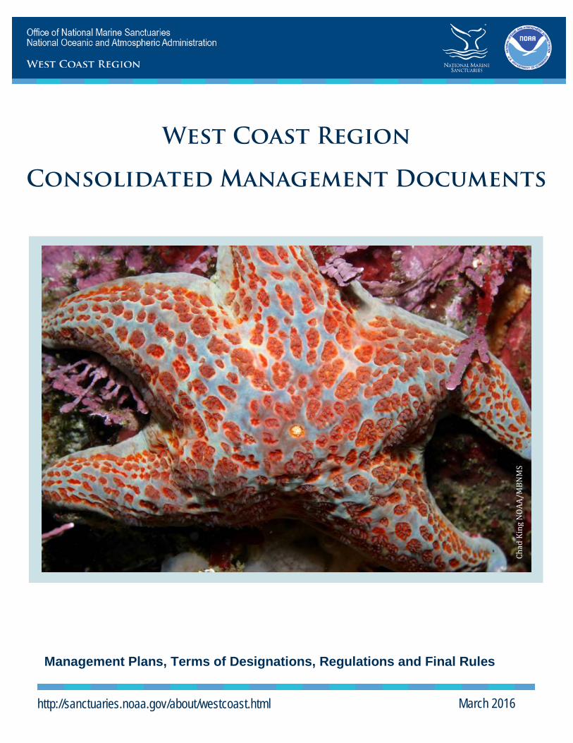
West Coast Region Consolidated Management Documents Management Plans, Terms of Designations, Regulations and Final Rules http://sanctuaries.noaa.gov/about/westcoast.html March 2016 Chad King NOAA/MBNMS
Transcript of West Coast Region Consolidated Management Documents · West Coast Region Consolidated Management...
West Coast Region
Consolidated Management Documents
Management Plans, Terms of Designations, Regulations and Final Rules
http://sanctuaries.noaa.gov/about/westcoast.html March 2016
Chad
Kin
g N
OAA/
MBN
MS
Table of Contents National Marine Sanctuaries Act .................................................. 1 Management Plans and Environmental Impact Statements ....... 1 Terms of Designation .................................................................... 2
Olympic Coast NMS........................................................................................ 3 Cordell Bank NMS .......................................................................................... 7 Greater Farallones NMS ............................................................................... 11 Monterey Bay NMS ....................................................................................... 15 Channel Islands NMS ................................................................................... 20
Regulations .................................................................................. 25 Olympic Coast NMS...................................................................................... 26 Cordell Bank NMS ........................................................................................ 33 Greater Farallones NMS ............................................................................... 40 Monterey Bay NMS ....................................................................................... 62 Channel Islands NMS ................................................................................... 76
Relevant Final Rules from Federal Register……………………...91
Olympic Coast NMS...................................................................................... 92 Cordell Bank NMS ........................................................................................ 92 Greater Farallones NMS ............................................................................... 93 Monterey Bay NMS ....................................................................................... 95 Channel Islands NMS ................................................................................... 97
1 3/21/16
National Marine Sanctuaries Act
As amended by Public Law 106-513, November 2000
Management Plans and Final EIS Olympic Coast NMS Management Plan and Environmental Assessment (September 2011) (EA starts on page 113) Cordell Bank NMS Management Plan (December 2014) Greater Farallones NMS Management Plan (December 2014) Joint Cordell Bank NMS and Greater Farallones NMS Final EIS (December 2014) Monterey Bay NMS Management Plan (October 2008) Joint Cordell Bank, Greater Farallones, and Monterey Bay NMS Final EIS (September 2008) Channel Islands NMS Management Plan (January 2009) Channel Islands Final EIS (November 2008)
2 3/21/16
Terms of Designation
3 3/21/16
TERMS OF DESIGNATION FOR OLYMPIC COAST NATIONAL MARINE SANCTUARY Excerpt from the Notice of National Marine Sanctuary Designation; final rule; and summary of final Management Plan published on May 11, 1994 (59 FR 24586)
Under the authority of Title III of the Marine Protection, Research, and Sanctuaries Act of 1972, as amended (the ``Act''), 16 U.S.C. 1431 et seq., the waters off the Olympic Coast of Washington State including the U.S. portion of the Strait of Juan de Fuca west of Koitlah Point, and the submerged lands thereunder, as described in Article II, are hereby designated as the Olympic Coast National Marine Sanctuary for the purposes of protecting and managing the conservation, ecological, recreational, research, educational, historical and aesthetic resources and qualities of the area.
Article I. Effect of Designation
The Act authorizes the issuance of such final regulations as are necessary and reasonable to implement the designation, including managing and protecting the conservation, recreational, ecological, historical, research, educational, and aesthetic resources and qualities of the Olympic Coast National Marine Sanctuary. Section 1 of Article IV of this Designation Document lists activities that either will be regulated on the effective date of designation or may have to be regulated at some later date in order to protect Sanctuary resources and qualities. Listing does not necessarily mean that a type of activity will be regulated; however, if an activity is not listed, it may not be regulated, except on an emergency basis, unless section 1 of Article IV is amended to include the type of activity by the same procedures by which the original designation was made.
Article II. Description of the Sanctuary Area
The Olympic Coast National Marine Sanctuary boundary encompasses approximately 2500 square nautical miles (approximately 8577 sq. kilometers) of coastal and ocean waters, and the submerged lands thereunder, off the central and northern coast of the State of Washington. The Sanctuary boundary extends from Koitlah Point due north to the United States/Canada international boundary seaward to the 100 fathom isobath. The seaward boundary of the Sanctuary approximates the 100 fathom isobath in a southerly direction from the U.S./Canada international boundary to a point due west of the Copalis River, cutting across the heads of Nitnat, Juan de Fuca, and Quinault Canyons.
The shoreward boundary of the Sanctuary is the mean lower low water line when adjacent to Indian reservations and State and county lands. When adjacent to Federally managed lands, the coastal boundary extends to the mean higher high water line. The coastal boundary cuts across the mouths of all rivers and streams. The precise boundary of the Sanctuary is set forth in Appendix A of this Designation Document.
Article III. Characteristics of the Sanctuary Area That Give It Particular Value
The Sanctuary is a highly productive, nearly pristine ocean and coastal
4 3/21/16
environment that is important to the continued survival of several ecologically and commercially important species of fish, seabirds, and marine mammals. Its rugged and undeveloped coastline makes the region one of the more dramatic natural wonders of the coastal United States, paralleling the majestic splendor of such terrestrial counterparts as Yosemite National Park and the Grand Tetons. The region's high biological productivity is fueled by seasonal enhanced upwelling along the edge of the continental shelf, especially at submarine canyons, during periods of high solar radiation.
The diversity of habitats that make up the Sanctuary support a great variety of biological communities. This unusually large range of habitat types include: Offshore islands and rocks; some of the most diverse kelp beds in the world; intertidal pools; erosional features such as rocky headlands, seastacks, and arches; interspersed exposed beaches and protected bays; submarine canyons and ridges; the continental shelf, including a broad shallow plateau extending from the mouth of the Juan de Fuca canyon; and continental slope environments. The numerous seastacks and rocky outcrops along the Sanctuary shoreline, coupled with a large tidal range and wave splash zone, support some of the most diverse and complex intertidal zones in the United States.
The Sanctuary provides an essential habitat for a wide variety of marine mammals and birds, and is of particular interest due to the presence of endangered and threatened species that live or migrate through the region. Twenty seven species of marine mammals are reported to breed, rest within, or migrate offshore of the Olympic Peninsula. Of particular interest is the migration route of the endangered California gray whale, the threatened northern sea lion, the occasional presence of the endangered right, fin, sei, blue, humpback, and sperm whales, and the reintroduced resident population of sea otters.
In addition, the seabird colonies of Washington's outer coast are among the largest in the continental United States and include a number of species listed as endangered or threatened including the short-tailed albatross, peregrine falcon, brown pelican, Aleutian Canada goose, marbled murrelet, and one of the largest populations of bald eagles in the continental United States.
The high biological productivity of the coastal and offshore waters in the Sanctuary support valuable fisheries that contribute significantly to the State and tribal economies. The commercially important species of fish include five species of salmon, groundfish, and shellfish.
In addition to the Sanctuary's value with respect to its biological resources, the region encompasses significant historical resources including Indian village sites, ancient canoe runs, petroglyphs, Indian artifacts, and numerous shipwrecks.
The diversity and richness of marine resources suggests that the marine sanctuary designations will provide exceptional opportunities for scientific research in the areas of species interactions, population dynamics, physiological ecology, linkages between terrestrial and aquatic ecosystems, and marine anthropology. The scientific researchencouraged by the Sanctuary management plan will, in turn, help support an intensive public education and awareness program that will address the diverse, complex,
5 3/21/16
and sensitive ecosystems in Washington's coastal and oceanic environments.
Article IV. Scope of Regulations
Section 1. Activities Subject to Regulation
The following activities are subject to regulation, including prohibition, to the extent necessary and reasonable to ensure the protection and management of the conservation, ecological, recreational, research, educational, historical and aesthetic resources and qualities of the area:
a. Exploring for, developing, or producing oil, gas or minerals (e.g., clay, stone, sand, metalliferous ores, gravel, non-metalliferous ores or any other solid material or other solid matter of commercial value) within the Sanctuary;
b. Discharging or depositing from within the boundary of the Sanctuary, any material or other matter;
c. Discharging or depositing, from beyond the boundary of the Sanctuary, any material or other matter;
d. Taking, removing, moving, catching, collecting, harvesting, feeding, injuring, destroying or causing the loss of, or attempting to take, remove, move, catch, collect, harvest, feed, injure, destroy or cause the loss of, a marine mammal, sea turtle, seabird, historical resource or other Sanctuary resource;
e. Drilling into, dredging, or otherwise altering the seabed of the Sanctuary; or constructing, placing, or abandoning any structure, material or other matter on the seabed of the Sanctuary;
f. Possessing within the Sanctuary a Sanctuary resource or any other resource, regardless of where taken, removed, moved, caught, collected or harvested, that, if it had been found within the Sanctuary, would be a Sanctuary resource;
g. Flying a motorized aircraft above the Sanctuary; h. Operating a vessel (i.e., watercraft of any description in the Sanctuary; i. Interfacing with, obstructing, delaying or preventing an investigation,
search, seizure or disposition of seized property in connection with enforcement of the Act or any regulation or permit issued under the Act.
Section 2. Emergencies
Where necessary to prevent or minimize the destruction of, loss of, or injury to a Sanctuary resource or quality, or minimize the imminent risk of such destruction, loss or injury, any and all activities, including those not listed in Section 1 of this Article, are subject to immediate temporary regulation, including prohibition.
Article V. Effect on Leases, Permits, Licenses, and Rights
Pursuant to section 304(c)(1) of the Act, 16 U.S.C. 1434(c)(1), no valid lease, permit, license, or other authorization issued by any Federal, State, or local authority of competent jurisdiction, or any right of subsistence use of access, may be terminated by the Secretary of Commerce or designee as a result of this designation. The Secretary of
6 3/21/16
Commerce or designee, however, may regulate the exercise (including, but not limited to, the imposition of terms and conditions) of such authorization or right consistent with the purposes for which the Sanctuary is designated.
In no event may the Secretary or designee issue a permit authorizing, or otherwise approve: (1) Exploration for, development or production of oil, gas or minerals within the Sanctuary; (2) the discharge of primary treated sewage (except for regulation, pursuant to section 304(c)(2) of the Act, of the exercise of valid authorizations in existence on the effective date of Sanctuary designation and issued by other authorities of competent jurisdiction); (3) the disposal of dredged material within the Sanctuary other than in connection with beach nourishment projects related to harbor maintenance activities; or (4) bombing activities within the Sanctuary. Any purported authorizations issued by other authorities after the effective date of Sanctuary designation for any of these activities within the Sanctuary shall be invalid.
Article VI. Alteration of This Designation
The terms of designation, as defined under Section 304(a) of the Act, may be modified only by the same procedures by which the original designation is made, including public hearings consultation with interested Federal, State, and local agencies, review by the appropriate Congressional committees and the Governor of the State of Washington, and approval by the Secretary of Commerce or designee.
[END OF DESIGNATION DOCUMENT]
7 3/21/16
REVISED TERMS OF DESIGNATION FOR CORDELL BANK NATIONAL MARINE SANCTUARY Federal Register/Vol. 80, No. 48/Thursday, March 12, 2015 – 15 CFR PART 922 Preamble
Under the authority of Title III of the Marine Protection, Research, and Sanctuaries Act of 1972, as amended, 16 U.S.C. 1431 et seq. (the ‘‘Act’’), Cordell Bank, Bodega Canyon, and their surrounding waters and submerged lands offshore northern California, as described in Article II, are hereby designated as Cordell Bank National Marine Sanctuary (the Sanctuary) for the purpose of protecting and conserving that special, discrete, highly productive marine area and ensuring the continued availability of the conservation, ecological, research, educational, aesthetic, historical, and recreational resources therein.
Article I. Effect of Designation
The Sanctuary was designated on May 24, 1989 (54 FR 22417). Section 308 of the National Marine Sanctuaries Act, 16 U.S.C. 1431 et seq. (NMSA), authorizes the issuance of such regulations as are necessary to implement the designation, including managing, protecting and conserving the conservation, recreational, ecological, historical, cultural, archeological, scientific, educational, and aesthetic resources and qualities of the Sanctuary. Section 1 of Article IV of these Terms of Designation lists activities of the types that are either to be regulated on the effective date of final rulemaking or may have to be regulated at some later date in order to protect Sanctuary resources and qualities. Listing does not necessarily mean that a type of activity will be regulated; however, if a type of activity is not listed it may not be regulated, except on an emergency basis, unless Section 1 of Article IV is amended to include the type of activity by the same procedures by which the original designation was made. Article II. Description of the Area
The Sanctuary consists of an approximately 971 square nautical mile (sq. nmi) area of marine waters and the submerged lands thereunder encompassed by a northern boundary that begins approximately 6 nmi west of Bodega Head in Sonoma County, California and extends west approximately 38 nmi, coterminous with the boundary of the Gulf of the Farallones National Marine Sanctuary (GFNMS). From that point, the western boundary of the Sanctuary extends south approximately 34 nmi. From that point, the southern boundary of the Sanctuary continues east 15 nmi, where it intersects the GFNMS boundary. The eastern boundary of the Sanctuary is coterminous with the GFNMS boundary, and is a series of straight lines connecting in sequence, back to the beginning point. The precise boundaries are set forth in the regulations.
8 3/21/16
Article III. Characteristics of the Area That Give It Particular Value
Cordell Bank (Bank) and Bodega Canyon are characterized by a combination of oceanic conditions and undersea topography that provides for a highly productive environment in a discrete, well-defined area. The Sanctuary may contain historical resources of national significance. The Bank consists of a series of steep-sided ridges and narrow pinnacles rising from the edge of the continental shelf. The Bank is 300–400 feet (91–122 meters) deep at the base and ascends to within 115 feet (35 meters) of the surface at its shallowest point. Bodega Canyon is about 12 miles (10.8 nmi) long and is over 5,000 feet (1,524 m) deep. The seasonal upwelling of nutrient-rich bottom waters and wide depth ranges in the vicinity have led to a unique association of subtidal and oceanic species. The vigorous biological community flourishing at Cordell Bank and Bodega Canyon includes an exceptional assortment of invertebrates, fishes, marine mammals and seabirds. Predators travel from thousands of miles away to feed in these productive waters. Article IV. Scope of Regulation Section 1. Activities Subject to Regulation
The following activities are subject to regulation, including prohibition, as may be necessary to ensure the management, protection, and preservation of the conservation, recreational, ecological, historical, cultural, archeological, scientific, educational, and aesthetic resources and qualities of this area:
a. Depositing or discharging any material or substance; b. Removing, taking, or injuring or attempting to remove, take, or injure benthic
invertebrates or algae located on the Bank or on or within the line representing the 50 fathom isobath surrounding the Bank;
c. Exploring for, developing or producing oil, gas or minerals within the Sanctuary;
d. Anchoring on the Bank or on or within the line representing the 50 fathom contour surrounding the Bank;
e. Taking, removing, moving, collecting, possessing, injuring or causing the loss of, or attempting to take, remove, move, collect, injure or cause the loss of a cultural or historical resource;
f. Drilling into, dredging, or otherwise altering the submerged lands of the Sanctuary; or constructing, placing, or abandoning any structure, material, or other matter on or in the submerged lands of the Sanctuary;
g. Taking or possessing any marine mammal, marine reptile, or bird except as permitted under the Marine Mammal Protection Act, Endangered Species Act or Migratory Bird Treaty Act;
h. Introducing or otherwise releasing from within or into the Sanctuary an introduced species; and
i. Interfering with an investigation, search, seizure, or disposition of seized property in connection with enforcement of the Act or Sanctuary regulations.
9 3/21/16
Section 2. Consistency With International Law
The regulations governing activities listed in Section 1 of this Article shall apply to foreign flag vessels and foreign persons only to the extent consistent with generally recognized principles of international law, and in accordance with treaties, conventions, and other agreements to which the United States is a party. Section 3. Emergency Regulations
Where necessary to prevent or minimize the destruction of, loss of, or injury to a Sanctuary resource or quality, or minimize the imminent risk of such destruction, loss, or injury, any and all activities, including those not listed in Section 1 of this Article, are subject to immediate temporary regulation, including prohibition, within the limits of the Act on an emergency basis for a period not to exceed 120 days. Article V. Relation to Other Regulatory Programs Section 1. Fishing
The regulation of fishing is not authorized under Article IV. All regulatory programs pertaining to fishing, including Fishery Management Plans promulgated under the Magnuson-Stevens Fishery Conservation and Management Act, 16 U.S.C. 1801 et seq. (‘‘Magnuson-Stevens Act’’), shall remain in effect. All permits, licenses, approvals, and other authorizations issued pursuant to the Magnuson-Stevens Act shall be valid within the Sanctuary. However, all fishing vessels are subject to regulation under Article IV with respect to discharges and anchoring. Section 2. Defense Activities
The regulation of activities listed in Article IV shall not prohibit any Department of Defense (DOD) activities that are necessary for national defense. All such activities being carried out by DOD within the Sanctuary on the effective date of designation shall be exempt from any prohibitions contained in the Sanctuary regulations. Additional DOD activities initiated after the effective date of designation that are necessary for national defense will be exempted after consultation between the Department of Commerce and DOD. DOD activities not necessary for national defense, such as routine exercises and vessel operations, shall be subject to all prohibitions contained in the Sanctuary regulations.
Section 3. Other Programs
All applicable regulatory programs shall remain in effect, and all permits, licenses, approvals, and other authorizations issued after July 31, 1989, with respect to activities conducted within the original Sanctuary boundary and after the effective date of the expansion of the Sanctuary with respect to activities conducted within the expansion area
10 3/21/16
pursuant to those programs shall be valid unless prohibited by regulations implementing Article IV. In addition, the Secretary may not under any circumstances issue a permit or authorization for exploring for, developing or producing oil, gas, or minerals within the Sanctuary.
Article VI. Alterations to This Designation
The terms of designation, as defined under section 304(a) of the Act, may be modified only by the same procedures by which the original designation is made, including public hearings, consultation with interested Federal, State, and local agencies, review by the appropriate Congressional committees, and approval by the Secretary of Commerce or designee. [END OF DESIGNATION DOCUMENT]
11 3/21/16
REVISED TERMS OF DESIGNATION FOR GREATER FARALLONES NATIONAL MARINE SANCTUARY Federal Register/Vol. 80, No. 48/Thursday, March 12, 2015 – 15 CFR PART 922 Preamble
Under the authority of Title III of the Marine Protection, Research and
Sanctuaries Act of 1972, Public Law 92–532 (the Act), the waters and submerged lands along the Coast of California to the 39th parallel, between Manchester Beach in Mendocino County and Rocky Point in Marin County and surrounding the Farallon Islands and Noonday Rock along the northern coast of California, are hereby designated a National Marine Sanctuary for the purposes of preserving and protecting this unique and fragile ecological community. Article I. Effect of Designation
Within the area described in Article II, the Act authorizes the promulgation of
such regulations as are reasonable and necessary to protect the values of Greater Farallones National Marine Sanctuary (the Sanctuary). Section 1 of Article IV of these Terms of Designation lists activities of the types that are either to be regulated on the effective date of final rulemaking or may have to be regulated at some later date in order to protect Sanctuary resources and qualities. Listing does not necessarily mean that a type of activity will be regulated; however, if a type of activity is not listed it may not be regulated, except on an emergency basis, unless section 1 of Article IV is amended to include the type of activity by the same procedures by which the original designation was made. Article II. Description of the Area
The Sanctuary consists of an area of the waters and the submerged lands thereunder adjacent to the coast of California of approximately 2,488 square nautical miles (sq. nmi). The boundary extends seaward to a distance of 30 nmi west from the mainland at Manchester Beach and extends south approximately 45 nmi to the northwestern corner of Cordell Bank National Marine Sanctuary (CBNMS), and extends approximately 38 nmi east along the northern boundary of CBNMS, approximately 6 nmi west of Bodega Head. The boundary extends from Bodega Bay to Point Reyes and 12 nmi west from the Farallon Islands and Noonday Rock, and includes the intervening waters and submerged lands. The Sanctuary includes Bolinas Lagoon, Tomales Bay, Estero de San Antonio (to the tide gate at Valley Ford-Franklin School Road) and Estero Americano (to the bridge at Valley Ford-Estero Road), as well as Bodega Bay, but does not include Bodega Harbor, the Salmon Creek Estuary, the Russian River Estuary, the Gualala River Estuary, Arena Cove or the Garcia River Estuary. The precise boundaries are defined by regulation.
12 3/21/16
Article III. Characteristics of the Area That Give It Particular Value
The Sanctuary encompasses a globally significant coastal upwelling center that includes a rich and diverse marine ecosystem and a wide variety of marine habitats, including habitat for over 36 species of marine mammals. Rookeries for over half of California’s nesting marine bird populations and nesting areas for at least 12 of 16 known U.S. nesting marine bird species are found within the boundaries. Abundant populations of fish and shellfish are also found within the Sanctuary. The Sanctuary also has one of the largest seasonal concentrations of adult white sharks (Carcharodon carcharias) in the world. The area adjacent to and offshore of Point Arena, due to seasonal winds, currents and oceanography, drives one of the most prominent and persistent upwelling centers in the world, supporting the productivity of the sanctuary. The nutrient-rich water carried down coast by currents promotes thriving nearshore kelp forests, productive commercial and recreational fisheries, and diverse wildlife assemblages. Large predators, such as white sharks, sea lions, killer whales, and baleen whales, travel from thousands of miles away to feed in these productive waters. Rocky shores along the Marin, Sonoma and Mendocino County coastlines are largely undisturbed, and teem with crustaceans, algae, fish and birds. Article IV. Scope of Regulation Section 1. Activities Subject to Regulation
The following activities are subject to regulation, including prohibition, as may be necessary to ensure the management, protection, and preservation of the conservation, recreational, ecological, historical, cultural, archeological, scientific, educational, and aesthetic resources and qualities of this area:
a. Exploring for, developing or producing oil, gas, or minerals within the
Sanctuary; b. Discharging or depositing any substance within or from beyond the boundary
of the Sanctuary; c. Drilling into, dredging, or otherwise altering the submerged lands of the
Sanctuary; or constructing, placing, or abandoning any structure, material, or other matter on or in the submerged lands of the Sanctuary;
d. Taking, removing, moving, collecting, possessing, injuring, destroying or causing the loss of, or attempting to take, remove, move, injure, destroy or cause the loss of a cultural or historical resources;
e. Introducing or otherwise releasing from within or into the Sanctuary an introduced species;
f. Taking or possessing any marine mammal, marine reptile, or bird within or above the Sanctuary except as permitted by the Marine Mammal Protection Act, Endangered Species Act, and Migratory Bird Treaty Act;
g. Attracting or approaching any animal; h. Operating a vessel (i.e., watercraft of any description) within the Sanctuary;
and
13 3/21/16
i. Interfering with an investigation, search, seizure, or disposition of seized property in connection with enforcement of the Act or Sanctuary regulations. Section 2. Consistency With International Law
The regulations governing the activities listed in section 1 of this Article will apply to foreign flag vessels and persons not citizens of the United States only to the extent consistent with recognized principles of international law, including treaties and international agreements to which the United States is signatory. Section 3. Emergency Regulations
Where necessary to prevent or minimize the destruction of, loss of, or injury to a Sanctuary resource or quality, or minimize the imminent risk of such destruction, loss, or injury, any and all activities, including those not listed in section 1 of this Article, are subject to immediate temporary regulation, including prohibition.
Article V. Relation to Other Regulatory Programs Section 1. Fishing and Waterfowl Hunting
The regulation of fishing, including fishing for shellfish and invertebrates, and waterfowl hunting, is not authorized under Article IV. However, fishing vessels may be regulated with respect to vessel operations in accordance with Article IV, section 1, paragraphs (b) and (h), and aquaculture activities involving alterations of or construction on the submerged lands, or introduction or release of introduced species by aquaculture activities, can be regulated in accordance with Article IV, section 1, paragraph (c) and (e). All regulatory programs pertaining to fishing, and to waterfowl hunting, including regulations promulgated under the California Fish and Game Code and Fishery Management Plans promulgated under the Magnuson-Stevens Fishery Conservation and Management Act, 16 U.S.C. 1801 et seq., will remain in effect, and all permits, licenses, and other authorizations issued pursuant thereto will be valid within the Sanctuary unless authorizing any activity prohibited by any regulation implementing Article IV.
The term ‘‘fishing’’ as used in this Article includes aquaculture.
Section 2. Defense Activities
The regulation of activities listed in Article IV shall not prohibit any Department of Defense activity that is essential for national defense or because of emergency. Such activities shall be consistent with the regulations to the maximum extent practicable.
Section 3. Other Programs
All applicable regulatory programs will remain in effect, and all permits, licenses,
approvals, and other authorizations issued after January 16, 1981, with respect to
14 3/21/16
activities conducted within the original Sanctuary boundary and after the effective date of the expansion of the Sanctuary with respect to activities conducted within the expansion area will be valid within the Sanctuary unless authorizing any activity prohibited by any regulation implementing Article IV. No valid lease, permit, license, approval or other authorization for activities in the expansion area of the Sanctuary issued by any federal, State, or local authority of competent jurisdiction and in effect on the effective date of the expansion may be terminated by the Secretary of Commerce or by his or her designee, provided the holder of such authorization complies with the certification procedures established by Sanctuary regulations. In addition, the Secretary may not under any circumstances issue a permit or authorization for exploring for, developing or producing oil, gas, or minerals within the Sanctuary. Article VI. Alterations to This Designation
The terms of designation, as defined under section 304(a) of the Act, may be modified only by the same procedures by which the original designation is made, including public hearings, consultation with interested Federal, State, and local agencies, review by the appropriate Congressional committees and Governor of the State of California, and approval by the Secretary of Commerce or designee. [END OF DESIGNATION DOCUMENT]
15 3/21/16
REVISED TERMS OF DESIGNATION DOCUMENT FOR MONTEREY BAY NATIONAL MARINE SANCTUARY Federal Register/Vol. 73, No. 225/Thursday, November 20, 2008 – 15 CFR PART 922 Preamble
Under the authority of Title III of the Marine Protection, Research, and Sanctuaries Act of 1972, as amended (the ‘‘Act’’), 16 U.S.C. 1431 et seq., Monterey Bay and the Davidson Seamount, and their surrounding waters offshore of central California, and the submerged lands under Monterey Bay and its surrounding waters, as described in Article II, and the Davidson Seamount Management Zone, as described in Article II, are hereby designated as the Monterey Bay National Marine Sanctuary (the Sanctuary) for the purposes of protecting and managing the conservation, ecological, recreational, research, educational, historical, and esthetic resources and qualities of the area. Article I. Effect of Designation
The Act authorizes the issuance of such regulations as are necessary and reasonable to implement the designation, including managing and protecting the conservation, recreational, ecological, historical, research, educational, and esthetic resources and qualities of the Sanctuary. Section 1 of Article IV of this Designation Document lists activities of the types that either are to be regulated on the effective date of designation or may have to be regulated at some later date in order to protect Sanctuary resources and qualities. Listing does not necessarily mean that a type of activity will be regulated; however, if a type of activity is not listed it may not be regulated, except on an emergency basis, unless section 1 of Article IV is amended to include the type of activity by the same procedures by which the original designation was made. Article II. Description of the Area
The Sanctuary consists of two separate areas. (a) The first area consists of an area of approximately 4017 square nautical miles (nmi) of coastal and ocean waters, and submerged lands thereunder, in and surrounding Monterey Bay off the central coast of California. The northern terminus of the Sanctuary boundary is located along the southern boundary of the Greater Farallones National Marine Sanctuary (GFNMS) beginning at Rocky Point just south of Stinson Beach in Marin County. The Sanctuary boundary follows the GFNMS boundary westward to a point approximately 29 nmi offshore from Moss Beach in San Mateo County. The Sanctuary boundary then extends southward in a series of arcs, which generally follow the 500 fathom isobath, to a point approximately 27 nmi offshore of Cambria, in San Luis Obispo County. The Sanctuary boundary then extends eastward towards shore until it intersects the Mean High Water Line (MHWL) along the coast near Cambria. The Sanctuary boundary then follows the MHWL northward to the northern terminus at Rocky Point. The shoreward Sanctuary boundary excludes a small area between Point Bonita and Point San Pedro. Pillar Point Harbor, Santa Cruz Harbor, Monterey Harbor, and Moss Landing Harbor are all excluded
16 3/21/16
from the Sanctuary shoreward from the points listed in Appendix A of the site regulations except for Moss Landing Harbor, where all of Elkhorn Slough east of the Highway One bridge, and west of the tide gate at Elkhorn Road and toward the center channel from the MHWL is included within the Sanctuary, excluding areas within the Elkhorn Slough National Estuarine Research Reserve. Exact coordinates for the seaward boundary and harbor exclusions are provided in Appendix A of the site regulations.
(b) The Davidson Seamount Management Zone (DSMZ) is also part of the
Sanctuary. This area, bounded by geodetic lines connecting a rectangle centered on the top of the Davidson Seamount, consists of approximately 585 square nmi of ocean waters and the submerged lands thereunder. The shoreward boundary of this portion of the Sanctuary is located approximately 65 nmi off the coast of San Simeon in San Luis Obispo County. Exact coordinates for the DSMZ boundary are provided in Appendix F of the site regulations. Article III. Characteristics of the Area That Give It Particular Value
The Monterey Bay area is characterized by a combination of oceanic conditions
and undersea topography that provides for a highly productive ecosystem and a wide variety of marine habitat. The area is characterized by a narrow continental shelf fringed by a variety of coastal types. The Monterey Submarine Canyon is unique in its size, configuration, and proximity to shore. This canyon system provides habitat for pelagic communities and, along with other distinct bathymetric features, may modify currents and act to enrich local waters through strong seasonal upwelling. Monterey Bay itself is a rare geological feature, as it is one of the few large embayments along the Pacific coast.
The Monterey Bay area has a highly diverse floral and faunal component. Algal
diversity is extremely high and the concentrations of pinnipeds, whales, otters and some seabird species are outstanding. The fish populations, particularly in Monterey Bay, are generally abundant and the variety of crustaceans and other invertebrates is high.
In addition there are many direct and indirect human uses of the area. The most
important economic activity directly dependent on the resources is commercial fishing, which has played an important role in the history of Monterey Bay and continues to be of great economic value.
The diverse resources of the Monterey Bay area are enjoyed by the residents of
this area as well as numerous visitors. The population of Monterey and Santa Cruz counties is rapidly expanding and is based in large part on the attractiveness of the area’s natural beauty. The high water quality and the resulting variety of biota and their proximity to shore is one of the prime reasons for the international renown of the area as a prime tourist location. The quality and abundance of the natural resources have attracted human beings from the earliest prehistoric times to the present and as a result the area contains significant historical, e.g., archaeological and paleontological, resources, such as Costanoan Indian midden deposits, aboriginal remains, and sunken ships and aircraft.
17 3/21/16
The biological and physical characteristics of the Monterey Bay area combine to provide outstanding opportunities for scientific research on many aspects of marine ecosystems. The diverse habitats are readily accessible to researchers. These research institutions are exceptional resources with a long history of research and large databases possessing a considerable amount of baseline information on the Bay and its resources, providing interpretive exhibits of the marine environment, docent programs serving the public and marine related programs for school groups and teachers.
The Davidson Seamount located offshore of California, 70 nmi southwest of
Monterey, due west of San Simeon, and is one of the largest known seamounts in U.S. waters. Davidson Seamount is twenty-six statute miles long and eight statute miles wide. From base to crest, Davidson Seamount is 7,480 feet (2,280 meters) tall; yet still 4,101 feet (1,250 meters) below the sea surface. Davidson Seamount has an atypical seamount shape, having northeast-trending ridges created by a type of volcanism only recently described. It last erupted about 12 million years ago. This large geographic feature was the first underwater formation to be characterized as a ‘‘seamount’’ and was named after the Coast and Geodetic Survey (forerunner to the National Ocean Service) scientist George Davidson. Davidson Seamount’s geographical importance is due to its location in the California Current, which likely provides a larger flux of carbon (food) to the sessile organisms on the seamount surface relative to a majority of other seamounts in the Pacific and may have unique links to the nearby Partington and Monterey submarine canyons.
The surface water habitat of the Davidson Seamount hosts a variety of seabirds,
marine mammals, and pelagic fishes, e.g., albatrosses, shearwaters, sperm whales, killer whales, albacore tuna, and ocean sunfish. Organisms in the midwater habitat have a patchy distribution, e.g., jellies and swimming worms, with marine snow, organic matter that continually ‘‘rains’’ down from the sea surface, providing an important food source for deep-sea animals. The seamount crest habitat is the most diverse of habitats in the Davidson Seamount area, including large gorgonian coral (e.g., Paragorgia sp.) forests, vast sponge fields (many undescribed species), crabs, deep-sea fishes, shrimp, and basket stars. The seamount slope habitat is composed of cobble and rocky areas interspersed with areas of ash and sediment, and hosts a diverse assemblage of sessile invertebrates and rare deep-sea fishes. The seamount base habitat is the interface between rocky outcrops and the flat, deep soft bottom habitat.
Davidson Seamount is home to previously undiscovered species and species
assemblages, such as large patches of corals and sponges, where there is an opportunity to discover unique associations between species and other ecological processes. The high biological diversity of these assemblages has not been found on other California seamounts. Davidson Seamount’s importance for conservation revolves around the endemism of seamount species, potential future harvest damage to coral and sponge assemblages, and the low resilience of these species. Abundant and large, fragile species (e.g., corals greater than eight feet tall, and at least 200 years old, as well as vast fields of sponges) and a physically undisturbed seafloor appear relatively pristine.
18 3/21/16
The final environmental impact statements (1992 and 2008) provide more detail on the characteristics of the Monterey Bay and Davidson Seamount area that give it particular value. Article IV. Scope of Regulations Section 1. Activities Subject to Regulation
The following activities are subject to regulation, including prohibition, to the extent necessary and reasonable to ensure the protection and management of the conservation, ecological, recreational, research, educational, historical, and esthetic resources and qualities of the Sanctuary:
a. Exploring for, developing, or producing oil, gas, or minerals (e.g., clay, stone,
sand, metalliferous ores, gravel, non-metalliferous ores, or any other solid material or other matter of commercial value) within the Sanctuary;
b. Discharging or depositing, from within the boundary of the Sanctuary, any material or other matter, except dredged material deposited at disposal sites authorized prior to the effective date of Sanctuary designation, as described in Appendix C to the regulations, provided that the activity is pursuant to, and complies with the terms and conditions of, a valid Federal permit or approval existing on the effective date of Sanctuary designation;
c. Discharging or depositing, from beyond the boundary of the Sanctuary, any material or other matter, except dredged material deposited at the authorized disposal sites described in Appendix D to the site regulations, provided that the activity is pursuant to, and complies with the terms and conditions of, a valid Federal permit or approval;
d. Taking, removing, moving, catching, collecting, harvesting, feeding, injuring, destroying, or causing the loss of, or attempting to take, remove, move, catch, collect, harvest, feed, injure, destroy, or cause the loss of, a marine mammal, sea turtle, seabird, historical resource, or other Sanctuary resource;
e. Drilling into, dredging, or otherwise altering the submerged lands of the Sanctuary; or constructing, placing, or abandoning any structure, material, or other matter on or in the submerged lands of the Sanctuary;
f. Possessing within the Sanctuary a Sanctuary resource or any other resource, regardless of where taken, removed, moved, caught, collected, or harvested, that, if it had been found within the Sanctuary, would be a Sanctuary resource;
g. Possessing any Sanctuary historical resource; h. Flying a motorized aircraft above the Sanctuary; i. Operating a vessel (i.e., water craft of any description) within the Sanctuary; j. Aquaculture or kelp harvesting within the Sanctuary; k. Interfering with, obstructing, delaying, or preventing an investigation, search,
seizure, or disposition of seized property in connection with enforcement of the Act or any regulation or permit issued under the Act; and
l. Introducing or otherwise releasing from within or into the Sanctuary an introduced species.
19 3/21/16
Section 2. Emergencies
Where necessary to prevent or minimize the destruction of, loss of, or injury to a Sanctuary resource or quality, or minimize the imminent risk of such destruction, loss, or injury, any and all activities, including those not listed in section 1 of this Article, are subject to immediate temporary regulation, including prohibition. Article V. Effect on Leases, Permits, Licenses, and Rights
Pursuant to section 304(c)(1) of the Act, 16 U.S.C. 1434(c)(1), no valid lease, permit, license, approval, or other authorization issued by any Federal, State or local authority of competent jurisdiction, or any right of subsistence use or access, may be terminated by the Secretary of Commerce or designee as a result of this designation or as a result of any Sanctuary regulation if such authorization or right was in existence on the effective date of this designation. The Secretary of Commerce or designee, however, may regulate the exercise (including, but not limited to, the imposition of terms and conditions) of such authorization or right consistent with the purposes for which the Sanctuary is designated.
In no event may the Secretary or designee issue a permit authorizing, or otherwise
approve: (1) The exploration for, development of or production of oil, gas, or minerals within the Sanctuary except for limited, small-scale jade collection in the Jade Cove area of the Sanctuary [defined as the area bounded by the 35.92222 N latitude parallel (coastal reference point: beach access stairway at South Sand Dollar Beach), the 35.88889 N latitude parallel (coastal reference point: westernmost tip of Cape San Martin), and the mean high tide line seaward to the 90 foot isobath (depth line)]; (2) the discharge of primary- treated sewage (except for regulation, pursuant to section 304(c)(1) of the Act, of the exercise of valid authorizations in existence on the effective date of Sanctuary designation and issued by other authorities of competent jurisdiction); or (3) the disposal of dredged material within the Sanctuary other than at sites authorized by the U.S. Environmental Protection Agency (in consultation with the U.S. Army Corps of Engineers) prior to the effective date of designation. Any purported authorizations issued by other authorities after the effective date of Sanctuary designation for any of these activities within the Sanctuary shall be invalid. Article VI. Alterations to This Designation
The terms of designation, as defined under section 304(a) of the Act, may be modified only by the same procedures by which the original designation is made, including public hearings, consultation with interested Federal, State, and local agencies, review by the appropriate Congressional committees and Governor of the State of California, and approval by the Secretary of Commerce or designee. [END OF DESIGNATION DOCUMENT]
20 3/21/16
REVISED TERMS OF DESIGNATION FOR CHANNEL ISLANDS NATIONAL MARINE SANCTUARY Federal Register/Vol. 74, No. 11/Friday, January 16, 2009 Article I. Effect of Designation
The Channel Islands National Marine Sanctuary was designated on October 2, 1980 (45 FR 65200). Section 308 of the National Marine Sanctuaries Act, 16 U.S.C. 1431 et seq., (NMSA) authorizes the issuance of such regulations as may be necessary to implement the designation, including managing, protecting and preserving the conservation, recreational, ecological, historical, cultural, archeological, scientific, educational, and esthetic resources and qualities of the Channel Islands National Marine Sanctuary (Sanctuary). Section 1 of Article IV of this Designation Document lists activities of the types that are to be regulated on the effective date of designation or may be regulated at some later date in order to protect Sanctuary resources and qualities. Listing does not necessarily mean that a type of activity will be regulated; however, if a type of activity is not listed it may not be regulated, except on an emergency basis, unless Section 1 of Article IV is amended to include the type of activity by the same procedures by which the original designation was made. Article II. Description of the Area
The Sanctuary consists of an area of approximately 1,110 square nautical miles (nmi) of coastal and ocean waters, and the submerged lands thereunder, off the southern coast of California. The Sanctuary boundary begins at the Mean High Water Line of and extends seaward to a distance of approximately six nmi from the following islands and offshore rocks: San Miguel Island, Santa Cruz Island, Santa Rosa Island, Anacapa Island, Santa Barbara Island, Richardson Rock, and Castle Rock (the Islands). The seaward boundary coordinates are listed in an Appendix to 15 CFR 922 subpart G. Article III. Characteristics of the Area That Give It Particular Value
The Islands and surrounding ecosystems are unique and highly valued, as demonstrated by, for example, several national and international designations. The Islands and surrounding ecosystems are characterized by a unique combination of features including: Complex oceanography, varied bathymetry, diverse habitats, remarkable biodiversity, rich maritime heritage, remote yet accessible location, and relative lack of development. These features yield high existence values as well as human use values for research, education, recreation, and commerce.
The Islands are located within a 300- mile long oceanographic region known as
the Continental Borderland, a unique region of the continental shelf characterized by basins and elevated ridges. Within this region, the confluence of the cool California Current and warm Southern California Countercurrent creates two distinct bioregions in and around the Sanctuary: The cold Oregonian bioregion and the warm Californian bioregion. There is also a transition zone between the two regions. The overlap of these
21 3/21/16
bioregions results in a unique and highly diverse array of marine life within the Sanctuary, including cold water species at the southern end of their range and warm water species at the northern end of their range. In addition, the Sanctuary is located offshore from Point Conception, the southernmost major upwelling center on the west coast of the United States. Upwelling yields increased primary productivity essential to the marine food web.
Diverse bathymetry and habitats are also important and unique characteristics of
the Islands and surrounding ecosystems. The Sanctuary contains many important and varied physical and geological features including a complex of plateaus, continental slope, gyres, banks, subsea canyons, and rocky reefs. The diversity of accentuated bottom relief, abrupt change in depth, and varied substrate provide a spectrum of marine habitats. Some of the key marine habitats are sandy beach, rocky intertidal, kelp forest, rocky reef, and sandy bottom.
The Sanctuary’s oceanographic and physical features support a great diversity of
marine species, many of which are extremely rare and afforded special protection by federal and state law. At least 33 species of cetaceans are found within the Sanctuary, including blue, gray, and humpback whales and numerous dolphin species. While seven species of pinnipeds have been found historically throughout or in certain areas of the Sanctuary, at least four species maintain important rookery and/or haul out sites on the Islands. Following the 1987 to 1990 translocation of southern sea otters to San Nicolas Island, rare sea otter sightings have been reported in the Sanctuary. Over 60 species of seabird occur within the Sanctuary, eleven of which utilize breeding habitat at the Islands. In addition, over 400 species of fish and more than 5,000 species of invertebrates are found in the Sanctuary. Stranding data indicate that green, loggerhead, olive Ridley, and leatherback sea turtles may also be found within the Sanctuary. Finally, numerous marine algae and plant species occur within the Sanctuary, the most notable among these being giant kelp and eelgrass.
The quality and abundance of natural resources at the Islands and surrounding
waters have attracted man from the earliest prehistoric times to the present. As a result, the Sanctuary contains significant prehistoric and historic maritime heritage resources. Prehistoric maritime heritage resources include submerged Native American Chumash sites, the significance of which is underscored by a terrestrial Island site with human remains dated to 13,000 years ago. Historic maritime heritage resources date back as far as 1542 and include over 140 historic shipwreck and aircraft sites. These wrecks reveal the diverse range of activities and nationalities that have traversed the Santa Barbara Channel. Following the mission era, human occupation of the Islands transitioned from significant Chumash Native American villages, to land grant and ranching settlements, and finally to joint public-private ownership and management aimed at resource conservation and compatible public use. Today’s Chumash people continue to value and enjoy the Islands and surrounding Sanctuary waters, working to keep and revitalize their ancient Chumash maritime heritage. Despite this long history of human presence on the Islands, they remain remote yet accessible, and undeveloped relative to the burgeoning populations of nearby mainland southern California.
22 3/21/16
The physical, biological, and cultural characteristics of the Sanctuary combine to provide outstanding opportunities for appropriate scientific research, education, recreation, commerce, and natural and maritime heritage resource protection, preservation, and management. The Islands and surrounding Sanctuary are the subject of extensive research, primarily in the following categories: Physical and biological science research; socioeconomic, cultural, and historic research; and political science research. Since its designation in 1980, the Sanctuary has played an important role in marine science education for all ages on a local, regional, national, and international scale. Popular Sanctuary recreation activities include wildlife viewing, boating, sailing, kayaking, diving, and sportfishing. Commercial activities within the Sanctuary include maritime shipping, oil and gas activities (three leases units pre-date the Sanctuary), kelp harvesting, and commercial fishing. Some of the state’s most valuable commercial fisheries occur within the Sanctuary. County, state, and federal agencies manage the resources of the Islands and surrounding area and human uses thereof.
Several special designations recognize the Islands’ and surrounding ecosystems’
unique value. In 1980, the United States designated both the Channel Islands National Marine Sanctuary, as well as the islands of Anacapa, San Miguel, Santa Barbara, Santa Cruz, and Santa Rosa and 125,000 acres of submerged lands surrounding them as the Channel Islands National Park. In addition, the United Nations Educational, Scientific and Cultural Organization’s (UNESCO) Man and the Biosphere Program designated the Sanctuary as a Biosphere Reserve in 1986. Article IV. Scope of Regulations Section 1. Activities Subject to Regulation
The following activities are subject to regulation, including prohibition, as may be necessary to ensure the management, protection, and preservation of the conservation, recreational, ecological, historical, cultural, archeological, scientific, educational, and esthetic resources and qualities of this area:
a. Exploring for, developing, or producing hydrocarbons or minerals within the
Sanctuary; b. Discharging or depositing from within or into the Sanctuary any material or
other matter; c. Discharging or depositing from beyond the boundary of the Sanctuary any
material or other matter that subsequently enters the Sanctuary and injures a Sanctuary resource or quality;
d. Drilling into, dredging, or otherwise altering the submerged lands of the Sanctuary; or constructing, placing, or abandoning any structure, material, or other matter on or in the submerged lands of the Sanctuary;
e. Operating a vessel (i.e., watercraft of any description) within the Sanctuary except fishing vessels or vessels traveling within a Vessel Traffic Separation Scheme or Port Access Route designated by the Coast Guard outside of 1 nmi from any Island;
f. Disturbing a marine mammal or seabird by an overflight below 1000 feet;
23 3/21/16
g. Within a marine reserve, marine park, or marine conservation area, harvesting, removing, taking, injuring, destroying, possessing, collecting, moving, or causing the loss of any Sanctuary resource, including living or dead organisms or historical resources, or attempting any of these activities;
h. Within a marine reserve, marine park, or marine conservation area, possessing fishing gear;
i. Moving, removing, injuring, possessing, or attempting to move, remove, injure, or possess a Sanctuary historical resource;
j. Taking any marine mammal, sea turtle, or seabird within or above the Sanctuary;
k. Possessing within the Sanctuary (regardless of where taken from, moved, or removed from) any marine mammal, sea turtle, or seabird;
l. Marking, defacing, damaging, moving, removing, or tampering with any sign, notice, or placard, whether temporary or permanent, or any monument, stake, post, or other boundary marker related to the Sanctuary;
m. Introducing or otherwise releasing from within or into the Sanctuary an introduced species. Section 2. Consistency With International Law
The regulations governing the activities listed in Section 1 of this article shall be applied in accordance with generally recognized principles of international law, and in accordance with treaties, conventions, and other agreements to which the United States is a party. No regulation shall apply to or be enforced against a person who is not a citizen, national, or resident alien of the United States, unless in accordance with: Generally recognized principles of international law; an agreement between the United States and the foreign state of which the person is a citizen; or an agreement between the United States and the flag state of a foreign vessel, if the person is a crewmember of the vessel. Section 3. Emergency Regulations
Where necessary to prevent or minimize the destruction of, loss of, or injury to a Sanctuary resource or quality, or minimize the imminent risk of such destruction, loss, or injury, any and all activities, including those not listed in section 1 of this Article, are subject to immediate temporary regulation, including prohibition, consistent with the Administrative Procedure Act. Article V. Relation to Other Regulatory Programs Section 1. Fishing
The regulation of fishing is not authorized under Article IV, except within portions of the Sanctuary designated as marine reserves, marine parks, or marine conservation areas established pursuant to the goals and objectives of the Sanctuary and within the scope of the State of California’s Final Environmental Document ‘‘Marine Protected Areas in NOAA’s Channel Islands National Marine Sanctuary’’ (California
24 3/21/16
Department of Fish and Game, October 2002), certified by the California Fish and Game Commission. However, fishing vessels may be regulated with respect to discharges in accordance with Article IV, Section 1, paragraphs (b) and (c), and aircraft conducting kelp bed surveys below 1000 feet can be regulated in accordance with Article IV, Section 1, paragraph (f). All regulatory programs pertaining to fishing, including particularly regulations promulgated under the California Fish and Game Code and Fishery Management Plans promulgated under the Magnuson-Stevens Fishery Conservation and Management Act, 16 U.S.C. 1801 et seq., shall remain in effect. All permits, licenses and other authorizations issued pursuant thereto shall be valid within the Sanctuary unless authorizing any activity prohibited by any regulation implementing Article IV. Fishing as used in this article and in Article IV includes kelp harvesting. Section 2. Defense Activities
The regulation of those activities listed in Article IV shall not prohibit any activity
conducted by the Department of Defense that is essential for national defense or because of an emergency. Such activities shall be consistent with the regulations to the maximum extent practicable. Section 3. Effect on Leases, Permits, Licenses, and Rights
Pursuant to section 304(c) of the NMSA, 16 U.S.C. 1434(c), no valid lease, permit, license, approval, or other authorization issued by any federal, state, or local authority of competent jurisdiction, or any right of subsistence use or access, may be terminated by the Secretary of Commerce or designee as a result of this designation or as a result of any Sanctuary regulation if such authorization or right was in existence on the effective date of this designation. The Secretary of Commerce, or designee, however, may regulate the exercise (including, but not limited to, the imposition of terms and conditions) of such authorization or right consistent with the purposes for which the Sanctuary is designated. Article VI. Alterations to This Designation
The terms of designation, as defined under section 304(a) of the NMSA, may be modified only by the same procedures by which the original designation is made, including public hearings, consultation with interested federal and state agencies and the Pacific Fishery Management Council, approval by the Secretary of Commerce or designee, and after the close of a review period of forty-five days of continuous session of Congress. III. Summary of the Regulatory Amendments This section describes the changes NOAA is making to the CINMS regulations. [END TERMS OF DESIGNATION]
25 3/21/16
Regulations
26 3/21/16
Olympic Coast National Marine Sanctuary Regulations Title 15: Commerce and Foreign Trade Part 922 – National Marine Sanctuary Program Regulations Subpart O – Olympic Coast National Marine Sanctuary § 922.150 Boundary.
(a) The Olympic Coast National Marine Sanctuary (Sanctuary) consists of an area of approximately 2,408 square nautical miles (nmi) of coastal and ocean waters, and the submerged lands thereunder, off the central and northern coast of the State of Washington.
(b) The Sanctuary boundary extends from Koitlah Point due north to the United States/Canada international boundary. The Sanctuary boundary then follows the U.S./Canada international boundary seaward to the 100 fathom isobath. The seaward boundary of the Sanctuary approximates the 100 fathom isobath in a southerly direction from the U.S./Canada international boundary to a point due west of the mouth of the Copalis River cutting across the heads of Nitnat, Juan de Fuca and Quinault Canyons. The coastal boundary of the Sanctuary is the mean higher high water line when adjacent to Federally managed lands cutting across the mouths of all rivers and streams, except where adjacent to Indian reservations, State and county owned lands; in such case, the coastal boundary is the mean lower low water line. La Push harbor is excluded from the Sanctuary boundary shoreward of the International Collision at Sea regulation (Colreg.) demarcation lines. The boundary coordinates are listed in appendix A to this subpart.
[60 FR 66877, Dec. 27, 1995, as amended at 76 FR 67360, Nov. 1, 2011]
§ 922.151 Definitions. In addition to those definitions found at § 922.3, the following definitions apply to
this subpart:
Clean means not containing detectable levels of harmful matter.
Cruise ship means a vessel with 250 or more passenger berths for hire.
Harmful matter means any substance, or combination of substances, that because of its quantity, concentration, or physical, chemical, or infectious characteristics may pose a present or potential threat to Sanctuary resources or qualities, including but not limited to: Fishing nets, fishing line, hooks, fuel, oil, and those contaminants (regardless of quantity) listed pursuant to 42 U.S.C. 101(14) of the Comprehensive Environmental Response, Compensation and Liability Act at 40 CFR 302.4.
Indian reservation means a tract of land set aside by the Federal Government for use by a federally recognized American Indian tribe and includes, but is not limited to, the Makah, Quileute, Hoh, and Quinault Reservations.
27 3/21/16
Lawful fishing means fishing authorized by a tribal, State or Federal entity with jurisdiction over the activity.
Treaty means a formal agreement between the United States Government and an Indian tribe.
[76 FR 67360, Nov. 1, 2011]
§ 922.152 Prohibited or otherwise regulated activities. (a) Except as specified in paragraphs (b) through (g) of this section, the following
activities are prohibited and thus are unlawful for any person to conduct or to cause to be conducted:
(1) Exploring for, developing or producing oil, gas or minerals within the Sanctuary.
(2)(i) Discharging or depositing, from within or into the Sanctuary, other than from a cruise ship, any material or other matter except:
(A) Fish, fish parts, chumming materials or bait used in or resulting from lawful fishing operations in the Sanctuary;
(B) Biodegradable effluent incidental to vessel use and generated by marine sanitation devices approved in accordance with section 312 of the Federal Water Pollution Control Act, as amended, (FWPCA), 33 U.S.C. 1322 et seq.;
(C) Water generated by routine vessel operations (e.g., cooling water, deck wash down, and graywater as defined by section 312 of the FWPCA) excluding oily wastes from bilge pumping;
(D) Engine exhaust; or
(E) Dredge spoil in connection with beach nourishment projects related to the Quillayute River Navigation Project.
(ii) Discharging or depositing, from beyond the boundary of the Sanctuary, any material or other matter, except those listed in paragraphs (a)(2)(i)(A) through (E) of this section, that subsequently enters the Sanctuary and injures a Sanctuary resource or quality.
(3) Discharging or depositing, from within or into the Sanctuary, any materials or other matter from a cruise ship except clean vessel engine cooling water, clean vessel generator cooling water, clean bilge water, engine exhaust, or anchor wash.
(4) Moving, removing or injuring, or attempting to move, remove or injure, a Sanctuary historical resource. This prohibition does not apply to moving, removing or injury resulting incidentally from lawful fishing operations.
28 3/21/16
(5) Drilling into, dredging or otherwise altering the submerged lands of the Sanctuary; or constructing, placing or abandoning any structure, material or other matter on the submerged lands of the Sanctuary, except as an incidental result of:
(i) Anchoring vessels;
(ii) Lawful fishing operations;
(iii) Installation of navigation aids;
(iv) Harbor maintenance in the areas necessarily associated with the Quillayute River Navigation Project, including dredging of entrance channels and repair, replacement or rehabilitation of breakwaters and jetties, and related beach nourishment;
(v) Construction, repair, replacement or rehabilitation of boat launches, docks or piers, and associated breakwaters and jetties; or
(vi) Beach nourishment projects related to harbor maintenance activities.
(6) Taking any marine mammal, sea turtle or seabird in or above the Sanctuary, except as authorized by the Marine Mammal Protection Act, as amended, (MMPA), 16 U.S.C. 1361 et seq., the Endangered Species Act, as amended, (ESA), 16 U.S.C. 1531 et seq., and the Migratory Bird Treaty Act, as amended, (MBTA), 16 U.S.C. 703 et seq., or pursuant to any Indian treaty with an Indian tribe to which the United States is a party, provided that the Indian treaty right is exercised in accordance with the MMPA, ESA, and MBTA, to the extent that they apply.
(7) Disturbing marine mammals or seabirds by flying motorized aircraft at less than 2,000 feet over the waters within one nautical mile of the Flattery Rocks, Quillayute Needles, or Copalis National Wildlife Refuges or within one nautical mile seaward from the coastal boundary of the Sanctuary, except for activities related to tribal timber operations conducted on reservation lands, or to transport persons or supplies to or from reservation lands as authorized by a governing body of an Indian tribe. Failure to maintain a minimum altitude of 2,000 feet above ground level over any such waters is presumed to disturb marine mammals or seabirds.
(8) Possessing within the Sanctuary (regardless of where taken, moved or removed from) any historical resource, or any marine mammal, sea turtle, or seabird taken in violation of the MMPA, ESA, or MBTA, to the extent that they apply.
(9) Interfering with, obstructing, delaying or preventing an investigation, search, seizure or disposition of seized property in connection with enforcement of the Act or any regulation or permit issued under the Act.
(b) The prohibitions in paragraph (a)(2) through (5), (7), and (8) of this section do not apply to activities necessary to respond to emergencies threatening life, property, or the environment.
29 3/21/16
(c) The prohibitions in paragraphs (a)(2) through (5), (7), and (8) of this section do not apply to activities necessary for valid law enforcement purposes.
(d)(1) All Department of Defense military activities shall be carried out in a manner that avoids to the maximum extent practicable any adverse impacts on Sanctuary resources and qualities.
(i) Except as provided in paragraph (d)(2) of this section, the prohibitions in paragraphs (a)(2) through (8) of this section do not apply to the following military activities performed by the Department of Defense in W-237A, W-237B, and Military Operating Areas Olympic A and B in the Sanctuary:
(A) Hull integrity tests and other deep water tests;
(B) Live firing of guns, missiles, torpedoes, and chaff;
(C) Activities associated with the Quinault Range including the in-water testing of non-explosive torpedoes; and
(D) Anti-submarine warfare operations.
(ii) New activities may be exempted from the prohibitions in paragraphs (a)(2) through (8) of this section by the Director after consultation between the Director and the Department of Defense. If it is determined that an activity may be carried out such activity shall be carried out in a manner that avoids to the maximum extent practicable any adverse impact on Sanctuary resources and qualities. Civil engineering and other civil works projects conducted by the U.S. Army Corps of Engineers are excluded from the scope of this paragraph (d).
(2) The Department of Defense is prohibited from conducting bombing activities within the Sanctuary.
(3) In the event of threatened or actual destruction of, loss of, or injury to a Sanctuary resource or quality resulting from an untoward incident, including but not limited to spills and groundings caused by the Department of Defense, the Department of Defense shall promptly coordinate with the Director for the purpose of taking appropriate actions to respond to and mitigate the harm and, if possible, restore or replace the Sanctuary resource or quality.
(e) The prohibitions in paragraphs (a)(2) through (8) of this section do not apply to any activity executed in accordance with the scope, purpose, terms and conditions of a National Marine Sanctuary permit issued pursuant to §§ 922.48 and 922.153 or a Special Use permit issued pursuant to section 310 of the Act.
(f) Members of a federally recognized Indian tribe may exercise aboriginal and treaty-secured rights, subject to the requirements of other applicable law, without regard to the requirements of this part. The Director may consult with the governing body of a
30 3/21/16
tribe regarding ways the tribe may exercise such rights consistent with the purposes of the Sanctuary.
(g) The prohibitions in paragraphs (a)(2) through (8) of this section do not apply to any activity authorized by any lease, permit, license, or other authorization issued after July 22, 1994, and issued by any Federal, State or local authority of competent jurisdiction, provided that the applicant complies with § 922.49, the Director notifies the applicant and authorizing agency that he or she does not object to issuance of the authorization, and the applicant complies with any terms and conditions the Director deems necessary to protect Sanctuary resources and qualities. Amendments, renewals and extensions of authorizations in existence on the effective date of designation constitute authorizations issued after the effective date.
(h) Notwithstanding paragraphs (e) and (g) of this section, in no event may the Director issue a National Marine Sanctuary permit under §§ 922.48 and 922.153 or a Special Use permit under section 310 of the Act authorizing, or otherwise approve: The exploration for, development or production of oil, gas or minerals within the Sanctuary; the discharge of primary-treated sewage within the Sanctuary; the disposal of dredged material within the Sanctuary other than in connection with beach nourishment projects related to the Quillayute River Navigation Project; or bombing activities within the Sanctuary. Any purported authorizations issued by other authorities after July 22, 1994 for any of these activities within the Sanctuary shall be invalid.
[76 FR 67360, Nov. 1, 2011, as amended at 77 FR 3922, Jan. 26, 2012]
§ 922.153 Permit procedures and criteria. (a) A person may conduct an activity prohibited by § 922.152(a)(2) through (8) if
conducted in accordance with the scope, purpose, terms and conditions of a permit issued under this section and § 922.48.
(b) Applications for such permits should be addressed to the Director, Office of National Marine Sanctuaries; Attn: Superintendent, Olympic Coast National Marine Sanctuary, 115 East Railroad Avenue, Suite 301, Port Angeles, WA 98362-2925.
(c) The Director, at his or her discretion, may issue a permit, subject to such terms and conditions as he or she deems appropriate, to conduct an activity prohibited by § 922.152(a)(2) through (8), if the Director finds that the activity will not substantially injure Sanctuary resources and qualities and will: Further research related to Sanctuary resources and qualities; further the educational, natural or historical resource value of the Sanctuary; further salvage or recovery operations in or near the Sanctuary in connection with a recent air or marine casualty; assist in managing the Sanctuary; further salvage or recovery operations in connections with an abandoned shipwreck in the Sanctuary title to which is held by the State of Washington; or be issued to an American Indian tribe adjacent to the Sanctuary, and/or its designee as certified by the governing body of the tribe, to promote or enhance tribal self-determination, tribal government functions, the exercise of treaty rights, the economic development of the tribe, subsistence, ceremonial
31 3/21/16
and spiritual activities, or the education or training of tribal members. For the purpose of this part, American Indian tribes adjacent to the sanctuary mean the Hoh, Makah, and Quileute Indian Tribes and the Quinault Indian Nation. In deciding whether to issue a permit, the Director may consider such factors as: The professional qualifications and financial ability of the applicant as related to the proposed activity; the duration of the activity and the duration of its effects; the appropriateness of the methods and procedures proposed by the applicant for the conduct of the activity; the extent to which the conduct of the activity may diminish or enhance Sanctuary resources and qualities; the cumulative effects of the activity; the end value of the activity; and the impacts of the activity on adjacent American Indian tribes. Where the issuance or denial of a permit is requested by the governing body of an American Indian tribe, the Director shall consider and protect the interests of the tribe to the fullest extent practicable in keeping with the purposes of the Sanctuary and his or her fiduciary duties to the tribe. The Director may also deny a permit application pursuant to this section, in whole or in part, if it is determined that the permittee or applicant has acted in violation of the terms or conditions of a permit or of these regulations. In addition, the Director may consider such other factors as he or she deems appropriate.
[76 FR 67361, Nov. 1, 2011]
§ 922.154 Consultation with the State of Washington, affected Indian tribes, and adjacent county governments.
(a) The Director shall regularly consult with the State of Washington, the governing bodies of tribes with reservations adjacent to the Sanctuary, and adjacent county governments regarding areas of mutual concern, including Sanctuary programs, permitting, activities, development, and threats to Sanctuary resources.
(b) The Director shall, when requested by such governments, enter into a memorandum of understanding regarding such consultations.
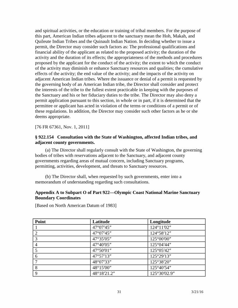
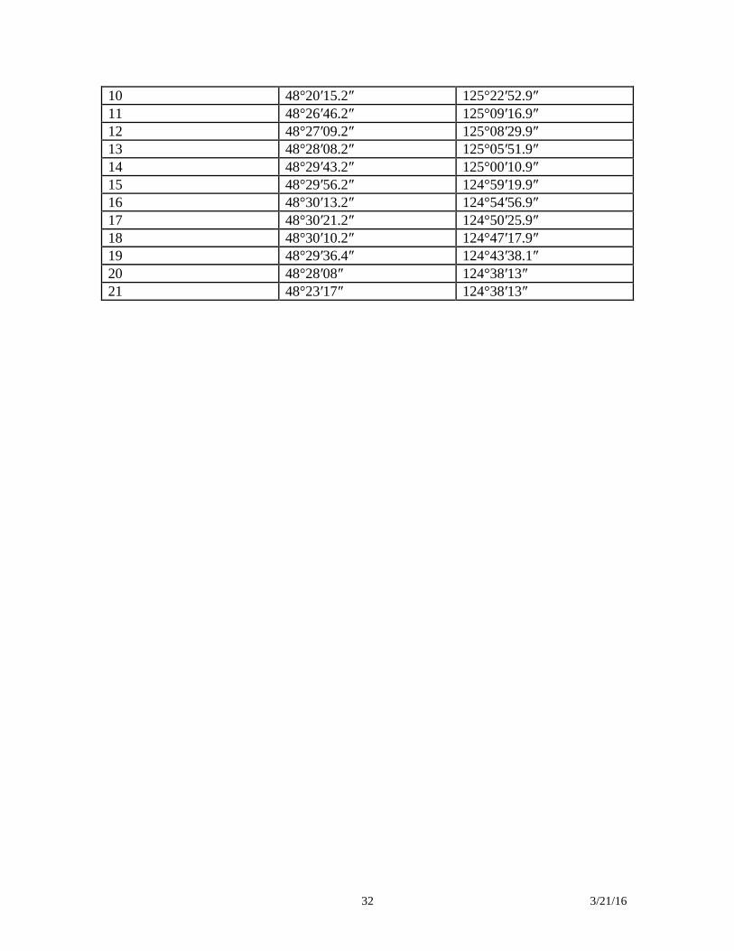
Appendix A to Subpart O of Part 922—Olympic Coast National Marine Sanctuary Boundary Coordinates [Based on North American Datum of 1983]
Point Latitude Longitude 1 47°07′45″ 124°11′02″ 2 47°07′45″ 124°58′12″ 3 47°35′05″ 125°00′00″ 4 47°40′05″ 125°04′44″ 5 47°50′01″ 125°05′42″ 6 47°57′13″ 125°29′13″ 7 48°07′33″ 125°38′20″ 8 48°15′00″ 125°40′54″ 9 48°18′21.2″ 125°30′02.9″
32 3/21/16
10 48°20′15.2″ 125°22′52.9″ 11 48°26′46.2″ 125°09′16.9″ 12 48°27′09.2″ 125°08′29.9″ 13 48°28′08.2″ 125°05′51.9″ 14 48°29′43.2″ 125°00′10.9″ 15 48°29′56.2″ 124°59′19.9″ 16 48°30′13.2″ 124°54′56.9″ 17 48°30′21.2″ 124°50′25.9″ 18 48°30′10.2″ 124°47′17.9″ 19 48°29′36.4″ 124°43′38.1″ 20 48°28′08″ 124°38′13″ 21 48°23′17″ 124°38′13″
33 3/21/16
Cordell Bank National Marine Sanctuary Regulations Title 15: Commerce and Foreign Trade Part 922 – National Marine Sanctuary Program Regulations Subpart K—Cordell Bank National Marine Sanctuary §922.110 Boundary.
The Cordell Bank National Marine Sanctuary (Sanctuary) boundary encompasses a total area of approximately 971 square nautical miles (1,286 square miles) of offshore ocean waters, and submerged lands thereunder, surrounding the submarine plateau known as Cordell Bank along the northern coast of California, approximately 45 nautical miles west northwest of San Francisco, California. The precise boundary coordinates are listed in appendix A to this subpart. The northern boundary of the Sanctuary is a rhumb line that begins approximately 6 nautical miles (7 miles) west of Bodega Head in Sonoma County, California at Point 1 and extends west approximately 38 nautical miles (44 miles) to Point 2. This line is part of a shared boundary between the Sanctuary and Farallones National Marine Sanctuary (FNMS). The western boundary of the Sanctuary extends south from Point 2 approximately 34 nautical miles (39 miles) to Point 3. From Point 3 the Sanctuary boundary continues east 15 nautical miles (17 miles) to Point 4 where it intersects the FNMS boundary again. The line from Point 3 to Point 4 forms the southernmost boundary of the Sanctuary. The eastern boundary of the Sanctuary is a series of straight lines connecting Points 4 through 20 in numerical sequence. The Sanctuary is coterminous with FNMS along both its (the Sanctuary’s) eastern and northern boundaries. §922.111 Definitions. In addition to the definitions found in § 922.3, the following definitions apply to this subpart:
Clean means not containing detectable levels of harmful matter. Cruise ship means a vessel with 250 or more passenger berths for hire. Harmful matter means any substance, or combination of substances, that because
of its quantity, concentration, or physical, chemical, or infectious characteristics may pose a present or potential threat to Sanctuary resources or qualities, including but not limited to: fishing nets, fishing line, hooks, fuel, oil, and those contaminants (regardless of quantity) listed pursuant to title 42 of the United States Code.
Introduced species means any species (including, but not limited to, any of its
biological matter capable of propagation) that is non-native to the ecosystems of the Sanctuary; or any organism into which altered genetic matter, or genetic matter from
34 3/21/16
another species, has been transferred in order that the host organism acquires the genetic traits of the transferred genes. §922.112 Prohibited or otherwise regulated activities.
(a) The following activities are prohibited and thus are unlawful for any person to conduct or to cause to be conducted within the Sanctuary:
(1) Exploring for, developing, or producing oil, gas, or minerals. (2)(i) Discharging or depositing from within or into the Sanctuary, other than
from a cruise ship, any material or other matter except: (A) Fish, fish parts, chumming materials, or bait used in or resulting from lawful
fishing activities within the Sanctuary, provided that such discharge or deposit is during the conduct of lawful fishing activity within the Sanctuary;
(B) For a vessel less than 300 gross registered tons (GRT), or a vessel 300 GRT
or greater without sufficient holding tank capacity to hold sewage while within the Sanctuary, clean effluent generated incidental to vessel use and generated by an operable Type I or II marine sanitation device (U.S. Coast Guard classification) approved in accordance with section 312 of the Federal Water Pollution Control Act, as amended, (FWPCA), 33 U.S.C. 1322. Vessel operators must lock all marine sanitation devices in a manner that prevents discharge or deposit of untreated sewage;
(C) Clean vessel deck wash down, clean vessel engine cooling water, clean vessel
generator cooling water, clean bilge water, or anchor wash; (D) For a vessel less than 300 GRT or a vessel 300 GRT or greater without
sufficient holding capacity to hold graywater while within the Sanctuary, clean graywater as defined by section 312 of the FWPCA; or
(E) Vessel engine or generator exhaust. (ii) Discharging or depositing from within or into the Sanctuary any material or
other matter from a cruise ship except clean vessel engine cooling water, clean vessel generator cooling water, vessel engine or generator exhaust, clean bilge water, or anchor wash.
(iii) Discharging or depositing, from beyond the boundary of the Sanctuary, any
material or other matter that subsequently enters the Sanctuary and injures a Sanctuary resource or quality, except as listed in paragraphs (a)(2)(i) and (ii) of this section.
(3) On or within the line representing the 50-fathom isobath surrounding Cordell
Bank, removing, taking, or injuring or attempting to remove, take, or injure benthic invertebrates or algae located on Cordell Bank. This prohibition does not apply to use of
35 3/21/16
bottom contact gear used during fishing activities, which is prohibited pursuant to 50 CFR part 660 (Fisheries off West Coast States). The coordinates for the line representing the 50-fathom isobath are listed in appendix B to this subpart, and the 50-fathom isobath is approximated by connecting these coordinates with straight line arcs in numerical sequence from Point 1 to Point 15. There is a rebuttable presumption that any such resource found in the possession of a person within the Sanctuary was taken or removed by that person.
(4)(i) On or within the line representing the 50-fathom isobath surrounding
Cordell Bank, drilling into, dredging, or otherwise altering the submerged lands; or constructing, placing, or abandoning any structure, material or other matter on or in the submerged lands. This prohibition does not apply to use of bottom contact gear used during fishing activities, which is prohibited pursuant to 50 CFR part 660 (Fisheries off West Coast States). The coordinates for the line representing the 50-fathom isobath are listed in appendix B to this subpart, and the 50-fathom isobath is approximated by connecting these coordinates with straight line arcs in numerical sequence from Point 1 to Point 15.
(ii) In the Sanctuary beyond the line representing the 50-fathom isobath
surrounding Cordell Bank, drilling into, dredging, or otherwise altering the submerged lands; or constructing, placing, or abandoning any structure, material or matter on the submerged lands except as incidental and necessary for anchoring any vessel or lawful use of any fishing gear during normal fishing activities. The coordinates for the line representing the 50-fathom isobath are listed in Appendix B to this subpart, and the 50-fathom isobath is approximated by connecting these coordinates with straight line arcs in numerical sequence from Point 1 to Point 15.
(5) Taking any marine mammal, sea turtle, or bird within or above the Sanctuary,
except as authorized by the Marine Mammal Protection Act, as amended, (MMPA), 16 U.S.C. 1361 et seq., Endangered Species Act, as amended, (ESA), 16 U.S.C. 1531 et seq., Migratory Bird Treaty Act, as amended, (MBTA), 16 U.S.C. 703 et seq., or any regulation, as amended, promulgated under the MMPA, ESA, or MBTA.
(6) Possessing within the Sanctuary (regardless of where taken, moved or
removed from), any marine mammal, sea turtle or bird taken, except as authorized by the MMPA, ESA, MBTA, by any regulation, as amended, promulgated under the MMPA, ESA, or MBTA, or as necessary for valid law enforcement purposes.
(7) Possessing, moving, removing, or injuring, or attempting to possess, move,
remove or injure, a Sanctuary historical resource. (8) Introducing or otherwise releasing from within or into the Sanctuary an
introduced species, except striped bass (Morone saxatilis) released during catch and release fishing activity.
36 3/21/16
(9) Interfering with, obstructing, delaying, or preventing an investigation, search, seizure, or disposition of seized property in connection with enforcement of the Act or any regulation or permit issued under the Act.
(b) The prohibitions in paragraph (a) of this section do not apply to activities
necessary to respond to an emergency threatening life, property or the environment. (c) All activities being carried out by the Department of Defense (DOD)
within the Sanctuary on the effective date of designation or expansion of the Sanctuary that are necessary for national defense are exempt from the prohibitions contained in the regulations in this subpart. Additional DOD activities initiated after the effective date of designation or expansion that are necessary for national defense will be exempted by the Director after consultation between the Department of Commerce and DOD. DOD activities not necessary for national defense, such as routine exercises and vessel operations, are subject to all prohibitions contained in the regulations in this subpart.
(d) The prohibitions in paragraphs (a)(2) through (7) of this section do not
apply to any activity executed in accordance with the scope, purpose, terms, and conditions of a National Marine Sanctuary permit issued pursuant to §§ 922.48 and 922.113 or a Special Use permit issued pursuant to section 310 of the Act.
(e) Where necessary to prevent immediate, serious, and irreversible damage
to a Sanctuary resource, any activity may be regulated within the limits of the Act on an emergency basis for no more than 120 days. §922.113 Permit procedures and issuance criteria.
(a) A person may conduct an activity prohibited by § 922.112(a)(2) through (7),
if such activity is specifically authorized by, and conducted in accordance with the scope, purpose, terms and conditions of, a permit issued under § 922.48 and this section.
(b) The Director, at his or her discretion, may issue a national marine sanctuary
permit under this section, subject to terms and conditions, as he or she deems appropriate, if the Director finds that the activity will:
(1) Further research or monitoring related to Sanctuary resources and qualities; (2) Further the educational value of the Sanctuary; (3) Further salvage or recovery operations in or near the Sanctuary in connection
with a recent air or marine casualty; or (4) Assist in managing the Sanctuary.
37 3/21/16
(c) In deciding whether to issue a permit, the Director shall consider such factors as:
(1) The applicant is qualified to conduct and complete the proposed activity; (2) The applicant has adequate financial resources available to conduct and
complete the proposed activity; (3) The methods and procedures proposed by the applicant are appropriate to
achieve the goals of the proposed activity, especially in relation to the potential effects of the proposed activity on Sanctuary resources and qualities;
(4) The proposed activity will be conducted in a manner compatible with the
primary objective of protection of Sanctuary resources and qualities, considering the extent to which the conduct of the activity may diminish or enhance Sanctuary resources and qualities, any potential indirect, secondary or cumulative effects of the activity, and the duration of such effects;
(5) The proposed activity will be conducted in a manner compatible with the
value of the Sanctuary, considering the extent to which the conduct of the activity may result in conflicts between different users of the Sanctuary, and the duration of such effects;
(6) It is necessary to conduct the proposed activity within the Sanctuary; (7) The reasonably expected end value of the proposed activity to the furtherance
of Sanctuary goals and purposes outweighs any potential adverse effects on Sanctuary resources and qualities from the conduct of the activity; and
(8) The Director may consider additional factors as he or she deems appropriate. (d) Applications. (1) Applications for permits should be addressed to the Director,
Office of National Marine Sanctuaries; ATTN: Superintendent, Cordell Bank National Marine Sanctuary, P.O. Box 159, Olema, CA 94950.
(2) In addition to the information listed in § 922.48(b), all applications must
include information to be considered by the Director in paragraph (b) and (c) of this section.
(e) The permittee must agree to hold the United States harmless against any
claims arising out of the conduct of the permitted activities. Appendix A to Subpart K of Part 922— Cordell Bank National Marine Sanctuary Boundary Coordinates
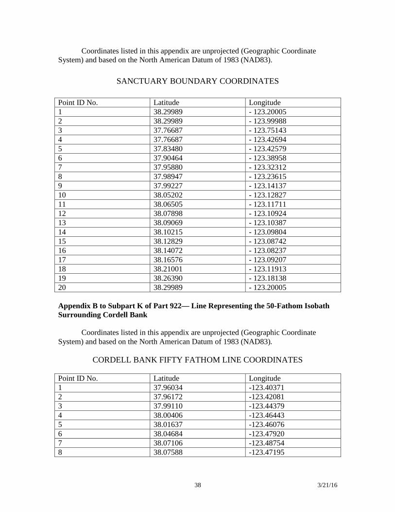
38 3/21/16
Coordinates listed in this appendix are unprojected (Geographic Coordinate System) and based on the North American Datum of 1983 (NAD83).
SANCTUARY BOUNDARY COORDINATES Point ID No. Latitude Longitude 1 38.29989 - 123.20005 2 38.29989 - 123.99988 3 37.76687 - 123.75143 4 37.76687 - 123.42694 5 37.83480 - 123.42579 6 37.90464 - 123.38958 7 37.95880 - 123.32312 8 37.98947 - 123.23615 9 37.99227 - 123.14137 10 38.05202 - 123.12827 11 38.06505 - 123.11711 12 38.07898 - 123.10924 13 38.09069 - 123.10387 14 38.10215 - 123.09804 15 38.12829 - 123.08742 16 38.14072 - 123.08237 17 38.16576 - 123.09207 18 38.21001 - 123.11913 19 38.26390 - 123.18138 20 38.29989 - 123.20005 Appendix B to Subpart K of Part 922— Line Representing the 50-Fathom Isobath Surrounding Cordell Bank
Coordinates listed in this appendix are unprojected (Geographic Coordinate System) and based on the North American Datum of 1983 (NAD83).
CORDELL BANK FIFTY FATHOM LINE COORDINATES
Point ID No. Latitude Longitude 1 37.96034 -123.40371 2 37.96172 -123.42081 3 37.99110 -123.44379 4 38.00406 -123.46443 5 38.01637 -123.46076 6 38.04684 -123.47920 7 38.07106 -123.48754 8 38.07588 -123.47195
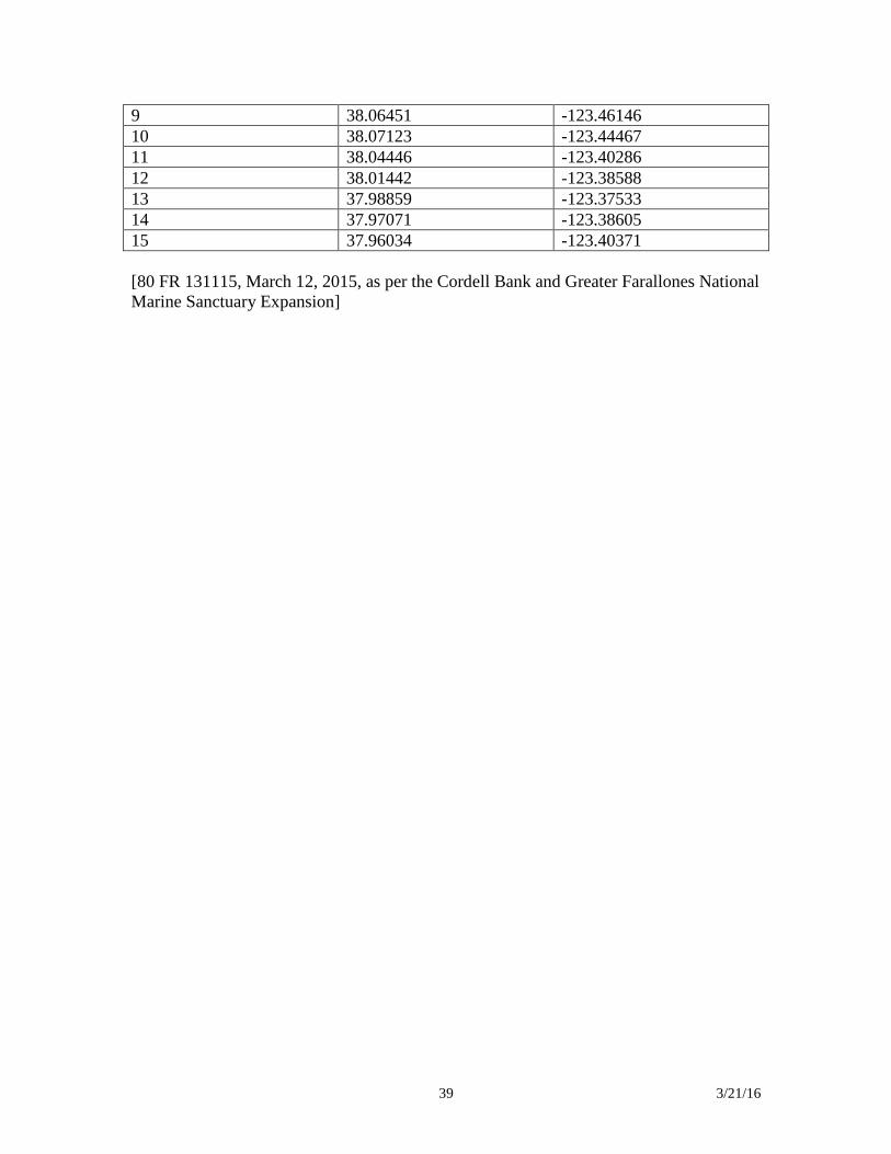
39 3/21/16
9 38.06451 -123.46146 10 38.07123 -123.44467 11 38.04446 -123.40286 12 38.01442 -123.38588 13 37.98859 -123.37533 14 37.97071 -123.38605 15 37.96034 -123.40371 [80 FR 131115, March 12, 2015, as per the Cordell Bank and Greater Farallones National Marine Sanctuary Expansion]
40 3/21/16
Greater Farallones National Marine Sanctuary Regulations Title 15: Commerce and Foreign Trade Part 922 – National Marine Sanctuary Program Regulations Subpart H—Farallones National Marine Sanctuary § 922.80 Boundary.
(a) Farallones National Marine Sanctuary (Sanctuary) encompasses an area of approximately 2,488 square nautical miles (3,295 square miles) of coastal and ocean waters, and submerged lands thereunder, surrounding the Farallon Islands and Noonday Rock along the northern coast of California. The precise boundary coordinates are listed in appendix A to this subpart.
(b) The western boundary of the Sanctuary extends south from Point 1 approximately 45 nautical miles (52 miles) to Point 2, which is the northwestern corner of Cordell Bank National Marine Sanctuary (CBNMS). The Sanctuary boundary then extends from Point 2 approximately 38 nautical miles (43 miles) east along the northern boundary of CBNMS to Point 3, which is approximately 6 nautical miles (7 miles) west of Bodega Head. From Point 3 the Sanctuary boundary continues south and west to Points 4 through 19 (in numerical sequence) and is coterminous with the eastern boundary of CBNMS. From Point 19 the Sanctuary boundary continues south and east to Points 20 through 25 (in numerical sequence) until it intersects the boundary for Monterey Bay National Marine Sanctuary (MBNMS) at Point 26. From Point 26 the Sanctuary boundary extends eastward and northward, coterminous with MBNMS, to Points 27 through 33 (in numerical sequence). From Point 33 the boundary proceeds along a straight line arc towards Point 34 until it intersects the Mean High Water Line at Rocky Point, California. From this intersection the Sanctuary boundary follows the Mean High Water Line northward until it intersects the boundary for Point Reyes National Seashore approximately 0.7 nautical miles (0.8 miles) south and east of Bolinas Point in Marin County, California. The Sanctuary boundary then approximates the boundary for Point Reyes National Seashore, as established at the time of designation of the Sanctuary, to the intersection of the Point Reyes National Seashore boundary and the Mean High Water Line approximately 0.13 nautical miles (0.15 miles) south and east of Duck Cove in Tomales Bay. The Sanctuary boundary then follows the Mean High Water Line along Tomales Bay and up Lagunitas Creek to the U.S. Highway 1 Bridge. Here the Sanctuary boundary crosses Lagunitas Creek and follows the Mean High Water Line north to the Estero de San Antonio and up the Estero to the tide gate at Valley Ford-Franklin School Road. Here the Sanctuary boundary crosses the Estero de San Antonio and proceeds west and north following the Mean High Water Line to the Estero Americano and up the Estero to the bridge at Valley Ford-Estero Road. Here the Sanctuary boundary crosses the Estero Americano and proceeds west and north following the Mean High Water Line towards Salmon Creek. Approaching Salmon Creek the boundary continues along the Mean High Water Line until it intersects a straight line arc that passes through Points 35 and 36. From that intersection the boundary extends across the creek along the straight line arc towards Point 36 until it again intersects the Mean High Water Line. From this
41 3/21/16
intersection the boundary follows the Mean High Water Line north towards the Russian River. Approaching the Russian River the boundary continues along the Mean High Water Line until it intersects a straight line arc that passes through Points 37 and Point 38. At that intersection the boundary extends across the river along the straight line arc towards Point 38 until it again intersects the Mean High Water Line. From this intersection the boundary follows the Mean High Water Line north towards the Gualala River. Approaching the Gualala River the boundary continues along the Mean High Water Line until it intersects a straight line arc that passes through Points 39 and Point 40. At that intersection the boundary extends across the river along the straight line arc towards Point 40 until it again intersects the Mean High Water Line. From this intersection the boundary follows the Mean High Water Line north to Arena Cove in Mendocino County. Approaching Arena Cove the boundary continues along the Mean High Water Line until it intersects a straight line arc that passes through Points 41 and Point 42. At that intersection the boundary extends across the cove along the straight line arc towards Point 42 until it again intersects the Mean High Water Line. From this intersection the boundary follows the Mean High Water Line north towards the Garcia River. Approaching the Garcia River the boundary continues along the Mean High Water Line until it intersects a straight line arc that passes through Points 43 and Point 44. At that intersection the boundary extends across the river along the straight line arc towards Point 44 until it intersects the Mean High Water Line. The Sanctuary boundary then continues north following the Mean High Water Line until it intersects the rhumb line connecting Point 45 and Point 46. From this intersection the Sanctuary boundary continues west along its northernmost extent to Point 46. The Sanctuary includes Bolinas Lagoon, Estero de San Antonio (to the tide gate at Valley Ford-Franklin School Road) and Estero Americano (to the bridge at Valley Ford-Estero Road), as well as Bodega Bay, but does not include Bodega Harbor, the Salmon Creek Estuary, the Russian River Estuary, the Gualala River Estuary, Arena Cove, or the Garcia River Estuary. Unless otherwise specified, where the Sanctuary boundary crosses a waterway, the Sanctuary excludes this waterway upstream of the crossing.
§ 922.81 Definitions.
In addition to those definitions found at § 922.3, the following definitions apply to this subpart:
Attract or attracting means the conduct of any activity that lures or may lure any animal in the Sanctuary by using food, bait, chum, dyes, decoys (e.g., surfboards or body boards used as decoys), acoustics or any other means, except the mere presence of human beings (e.g., swimmers, divers, boaters, kayakers, surfers).
Clean means not containing detectable levels of harmful matter.
Cruise ship means a vessel with 250 or more passenger berths for hire.
Deserting means leaving a vessel aground or adrift without notification to the Director of the vessel going aground or becoming adrift within 12 hours of its discovery and developing and presenting to the Director a preliminary salvage plan within 24 hours
42 3/21/16
of such notification, after expressing or otherwise manifesting intention not to undertake or to cease salvage efforts, or when the owner/operator cannot after reasonable efforts by the Director be reached within 12 hours of the vessel’s condition being reported to authorities; or leaving a vessel at anchor when its condition creates potential for a grounding, discharge, or deposit and the owner/operator fails to secure the vessel in a timely manner.
Harmful matter means any substance, or combination of substances, that because of its quantity, concentration, or physical, chemical, or infectious characteristics may pose a present or potential threat to Sanctuary resources or qualities, including but not limited to: Fishing nets, fishing line, hooks, fuel, oil, and those contaminants (regardless of quantity) listed pursuant to 42 U.S.C. 101(14) of the Comprehensive Environmental Response, Compensation and Liability Act at 40 CFR 302.4.
Introduced species means any species (including, but not limited to, any of its biological matter capable of propagation) that is non-native to the ecosystems of the Sanctuary; or any organism into which altered genetic matter, or genetic matter from another species, has been transferred in order that the host organism acquires the genetic traits of the transferred genes.
Motorized personal watercraft means a vessel which uses an inboard motor powering a water jet pump as its primary source of motive power and which is designed to be operated by a person sitting, standing, or kneeling on the vessel, rather than the conventional manner of sitting or standing inside the vessel.
Routine maintenance means customary and standard procedures for maintaining docks or piers.
Seagrass means any species of marine angiosperms (flowering plants) that inhabit portions of the submerged lands in the Sanctuary. Those species include, but are not limited to: Zostera asiatica and Zostera marina.
Special Wildlife Protection Zones are areas surrounding or adjacent to high abundance of white sharks, breeding pinnipeds (seals and sea lions) or high abundance and high biological diversity of breeding birds that are susceptible to human caused disturbance, including federally listed and specially protected species. Coordinates for Special Wildlife Protection Zones are found in appendix C of this Subpart.
§ 922.82 Prohibited or otherwise regulated activities.
(a) The following activities are prohibited and thus are unlawful for any person to conduct or to cause to be conducted within the Sanctuary:
(1) Exploring for, developing, or producing oil, gas or minerals.
(2) Discharging or depositing from within or into the Sanctuary, other than from a cruise ship, any material or other matter except:
43 3/21/16
(i) Fish, fish parts, chumming materials or bait used in or resulting from lawful fishing activities within the Sanctuary, provided that such discharge or deposit is during the conduct of lawful fishing activity within the Sanctuary;
(ii) For a vessel less than 300 gross registered tons (GRT), or a vessel 300 GRT or greater without sufficient holding tank capacity to hold sewage while within the Sanctuary, clean effluent generated incidental to vessel use by an operable Type I or II marine sanitation device (U.S. Coast Guard classification) that is approved in accordance with section 312 of the Federal Water Pollution Control Act, as amended (FWPCA), 33 U.S.C. 1322. Vessel operators must lock all marine sanitation devices in a manner that prevents discharge or deposit of untreated sewage;
(iii) Clean vessel deck wash down, clean vessel engine cooling water, clean vessel generator cooling water, clean bilge water, or anchor wash;
(iv) For a vessel less than 300 GRT or a vessel 300 GRT or greater without sufficient holding capacity to hold graywater while within the Sanctuary, clean graywater as defined by section 312 of the FWPCA; or
(v) Vessel engine or generator exhaust.
(3) Discharging or depositing from within or into the Sanctuary any material or other matter from a cruise ship except clean vessel engine cooling water, clean vessel generator cooling water, vessel engine or generator exhaust, clean bilge water, or anchor wash.
(4) Discharging or depositing, from beyond the boundary of the Sanctuary, any material or other matter that subsequently enters the Sanctuary and injures a Sanctuary resource or quality, except for the material or other matter excepted in paragraphs (a)(2)(i) through (v) and (a)(3) of this section.
(5) Constructing any structure other than a navigation aid on or in the submerged lands of the Sanctuary; placing or abandoning any structure on or in the submerged lands of the Sanctuary; or drilling into, dredging, or otherwise altering the submerged lands of the Sanctuary in any way, except:
(i) By anchoring vessels (in a manner not otherwise prohibited by this part (see paragraph (a)(16) of this section);
(ii) While conducting lawful fishing activities;
(iii) Routine maintenance and construction of docks and piers on Tomales Bay; or
(iv) Aquaculture activities conducted pursuant to a valid lease, permit, license or other authorization issued by the State of California.
(6) Operating motorized personal watercraft (MPWC) anywhere in Bodega Bay and anywhere in the Sanctuary south of 38.29800 degrees North Latitude (the
44 3/21/16
southernmost tip of Bodega Head), except for emergency search and rescue missions or law enforcement operations (other than routine training activities) carried out by the National Park Service, U.S. Coast Guard, Fire or Police Departments or other Federal, State or local jurisdictions.
(7) Taking any marine mammal, sea turtle, or bird within or above the Sanctuary, except as authorized by the Marine Mammal Protection Act, as amended, (MMPA), 16 U.S.C. 1361 et seq., Endangered Species Act (ESA), as amended, 16 U.S.C. 1531 et seq., Migratory Bird Treaty Act, as amended, (MBTA), 16 U.S.C. 703 et seq., or any regulation, as amended, promulgated under the MMPA, ESA, or MBTA.
(8) Possessing within the Sanctuary (regardless of where taken, moved or removed from), any marine mammal, sea turtle, or bird taken, except as authorized by the MMPA, ESA, MBTA, by any regulation, as amended, promulgated under the MMPA, ESA, or MBTA, or as necessary for valid law enforcement purposes.
(9) Possessing, moving, removing, or injuring, or attempting to possess, move, remove or injure, a Sanctuary historical resource.
(10) Introducing or otherwise releasing from within or into the Sanctuary an introduced species, except:
(i) Striped bass (Morone saxatilis) released during catch and release fishing activity; or
(ii) Species cultivated by commercial shellfish aquaculture activities in Tomales Bay pursuant to a valid lease, permit, license or other authorization issued by the State of California. Tomales Bay is defined in § 922.80. The coordinates for the northern terminus of Tomales Bay are listed in appendix C to this subpart.
(11) Disturbing marine mammals or seabirds by flying motorized aircraft at less than 1,000 feet over the waters within any of the seven designated Special Wildlife Protection Zones described in appendix D to this subpart, except transiting Zone 6 to transport persons or supplies to or from Southeast Farallon Island authorized by the U.S. Fish and Wildlife Service, Farallon National Wildlife Refuge, or for enforcement purposes. Failure to maintain a minimum altitude of 1,000 feet above ground level over such waters is presumed to disturb marine mammals or seabirds.
(12) Operating any vessel engaged in the trade of carrying cargo within any area designated Special Wildlife Protection Zone or within one nautical mile from these zones. The coordinates are listed in appendix E to this subpart. This includes but is not limited to tankers and other bulk carriers and barges, or any vessel engaged in the trade of servicing offshore installations, except to transport persons or supplies to or from the Farallon Islands. In no event shall this section be construed to limit access for fishing, recreational or research vessels.
(13) Attracting a white shark anywhere in the Sanctuary; or approaching within 50 meters of any white shark within Special Wildlife Protection Zone 6 and 7 or within
45 3/21/16
one nautical mile from these zones. The coordinates are listed in appendix F to this subpart. (14) Deserting a vessel aground, at anchor, or adrift in the Sanctuary.
(15) Leaving harmful matter aboard a grounded or deserted vessel in the Sanctuary.
(16) Anchoring a vessel in a designated seagrass protection zone in Tomales Bay, except as necessary for aquaculture operations conducted pursuant to a valid lease, permit or license. The coordinates for the no anchoring seagrass protection zones are listed in Appendix B to this subpart.
(17) Interfering with, obstructing, delaying, or preventing an investigation, search, seizure, or disposition of seized property in connection with enforcement of the Act or any regulation or permit issued under the Act.
(b) All activities currently carried out by the Department of Defense within the Sanctuary are essential for the national defense and, therefore, not subject to the prohibitions in this section. The exemption of additional activities shall be determined in consultation between the Director and the Department of Defense.
(c) The prohibitions in paragraph (a) of this section do not apply to activities necessary to respond to an emergency threatening life, property, or the environment.
(d) The prohibitions in paragraphs (a)(2) through (9) and (a)(11) through (16) of this section do not apply to any activity executed in accordance with the scope, purpose, terms, and conditions of a National Marine Sanctuary permit issued pursuant to §§ 922.48 and 922.83 or a Special Use permit issued pursuant to section 310 of the Act.
§ 922.83 Permit procedures and issuance criteria.
(a) A person may conduct an activity prohibited by § 922.82(a)(2) through (9) and (a)(11) through (16) if such activity is specifically authorized by, and conducted in accordance with the scope, purpose, terms and conditions of, a permit issued under § 922.48 and this section.
(b) The Director, at his or her discretion, may issue a National Marine Sanctuary permit under this section, subject to terms and conditions as he or she deems appropriate, if the Director finds that the activity will:
(1) Further research or monitoring related to Sanctuary resources and qualities;
(2) Further the educational value of the Sanctuary;
(3) Further salvage or recovery operations; or
(4) Assist in managing the Sanctuary.
(c) In deciding whether to issue a permit, the Director shall consider factors such
46 3/21/16
as:
(1) The applicant is qualified to conduct and complete the proposed activity;
(2) The applicant has adequate financial resources available to conduct and complete the proposed activity;
(3) The methods and procedures proposed by the applicant are appropriate to achieve the goals of the proposed activity, especially in relation to the potential effects of the proposed activity on Sanctuary resources and qualities;
(4) The proposed activity will be conducted in a manner compatible with the primary objective of protection of Sanctuary resources and qualities, considering the extent to which the conduct of the activity may diminish or enhance Sanctuary resources and qualities, any potential indirect, secondary or cumulative effects of the activity, and the duration of such effects;
(5) The proposed activity will be conducted in a manner compatible with the value of the Sanctuary, considering the extent to which the conduct of the activity may result in conflicts between different users of the Sanctuary, and the duration of such effects;
(6) It is necessary to conduct the proposed activity within the Sanctuary;
(7) The reasonably expected end value of the proposed activity to the furtherance of Sanctuary goals and purposes outweighs any potential adverse effects on Sanctuary resources and qualities from the conduct of the activity; and
(8) Any other factors as the Director deems appropriate.
(d) Applications. (1) Applications for permits should be addressed to the Director, Office of National Marine Sanctuaries; ATTN: Superintendent, Farallones National Marine Sanctuary, 991 Marine Dr., The Presidio, San Francisco, CA 94129.
(2) In addition to the information listed in § 922.48(b), all applications must include information to be considered by the Director in paragraph (b) and (c) of this section.
(e) The permittee must agree to hold the United States harmless against any claims arising out of the conduct of the permitted activities.
§ 922.84 Certification of preexisting leases, licenses, permits, approvals, other authorizations, or rights to conduct a prohibited activity.
(a) A person may conduct an activity prohibited by § 922.82(a)(1) through (17) if such activity is specifically authorized by a valid Federal, State, or local lease, permit, license, approval, or other authorization in existence prior to the effective date of sanctuary expansion and within the sanctuary expansion area and complies with § 922.47
47 3/21/16
and provided that the holder of the lease, permit, license, approval, or other authorization complies with the requirements of paragraph (e) of this section.
(b) In considering whether to make the certifications called for in this section, the Director may seek and consider the views of any other person or entity, within or outside the Federal government, and may hold a public hearing as deemed appropriate.
(c) The Director may amend, suspend, or revoke any certification made under this section whenever continued operation would otherwise be inconsistent with any terms or conditions of the certification. Any such action shall be forwarded in writing to both the holder of the certified permit, license, or other authorization and the issuing agency and shall set forth reason(s) for the action taken.
(d) Requests for findings or certifications should be addressed to the Director, Office of National Marine Sanctuaries; ATTN: Sanctuary Superintendent, Farallones National Marine Sanctuary, 991 Marine Drive, The Presidio, San Francisco, CA 94129. A copy of the lease, permit, license, approval, or other authorization must accompany the request.
(e) For an activity described in paragraph (a) of this section, the holder of the authorization or right may conduct the activity prohibited by § 922.82 (a)(1) through (17) provided that:
(1) The holder of such authorization or right notifies the Director, in writing, within 90 days of the effective date of Sanctuary designation, of the existence of such authorization or right and requests certification of such authorization or right;
(2) The holder complies with the other provisions of this section; and
(3) The holder complies with any terms and conditions on the exercise of such authorization or right imposed as a condition of certification, by the Director, to achieve the purposes for which the Sanctuary was designated.
(f) The holder of an authorization or right described in paragraph (a) of this section authorizing an activity prohibited by § 922.82 may conduct the activity without being in violation of applicable provisions of § 922.82, pending final agency action on his or her certification request, provided the holder is otherwise in compliance with this section.
(g) The Director may request additional information from the certification requester as he or she deems reasonably necessary to condition appropriately the exercise of the certified authorization or right to achieve the purposes for which the Sanctuary was designated. The Director must receive the information requested within 45 days of the postmark date of the request. The Director may seek the views of any persons on the certification request.
(h) The Director may amend any certification made under this section whenever additional information becomes available that he determines justifies such an amendment.
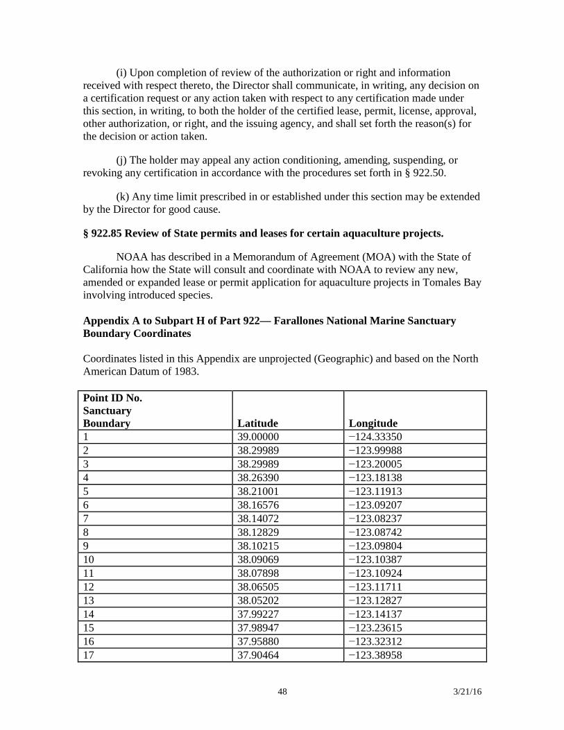
48 3/21/16
(i) Upon completion of review of the authorization or right and information received with respect thereto, the Director shall communicate, in writing, any decision on a certification request or any action taken with respect to any certification made under this section, in writing, to both the holder of the certified lease, permit, license, approval, other authorization, or right, and the issuing agency, and shall set forth the reason(s) for the decision or action taken.
(j) The holder may appeal any action conditioning, amending, suspending, or revoking any certification in accordance with the procedures set forth in § 922.50.
(k) Any time limit prescribed in or established under this section may be extended by the Director for good cause.
§ 922.85 Review of State permits and leases for certain aquaculture projects.
NOAA has described in a Memorandum of Agreement (MOA) with the State of California how the State will consult and coordinate with NOAA to review any new, amended or expanded lease or permit application for aquaculture projects in Tomales Bay involving introduced species. Appendix A to Subpart H of Part 922— Farallones National Marine Sanctuary Boundary Coordinates Coordinates listed in this Appendix are unprojected (Geographic) and based on the North American Datum of 1983. Point ID No. Sanctuary Boundary Latitude Longitude 1 39.00000 −124.33350 2 38.29989 −123.99988 3 38.29989 −123.20005 4 38.26390 −123.18138 5 38.21001 −123.11913 6 38.16576 −123.09207 7 38.14072 −123.08237 8 38.12829 −123.08742 9 38.10215 −123.09804 10 38.09069 −123.10387 11 38.07898 −123.10924 12 38.06505 −123.11711 13 38.05202 −123.12827 14 37.99227 −123.14137 15 37.98947 −123.23615 16 37.95880 −123.32312 17 37.90464 −123.38958
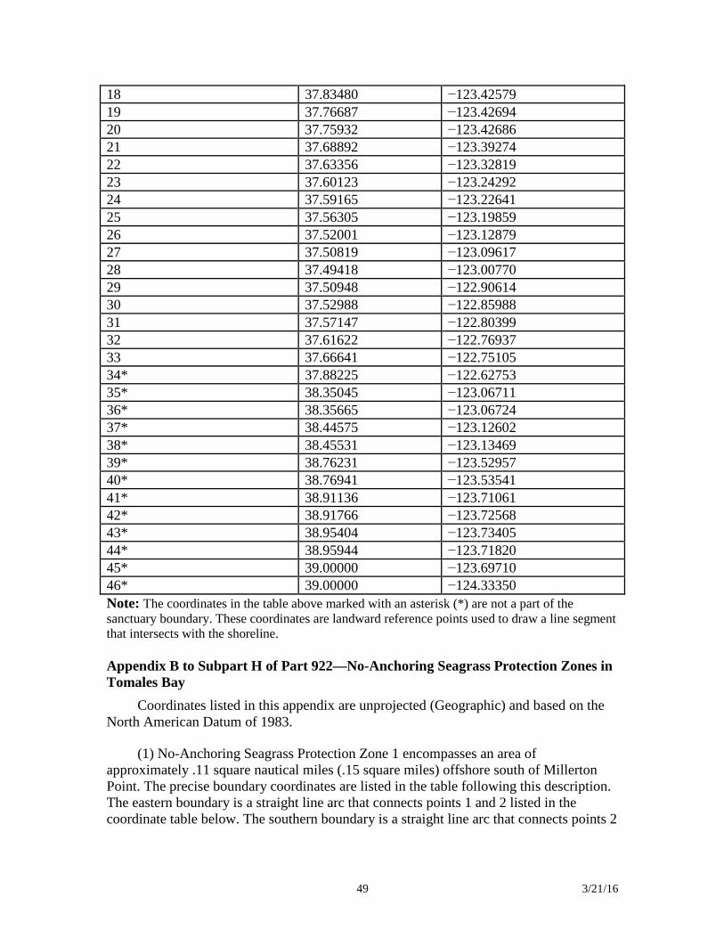
49 3/21/16
18 37.83480 −123.42579 19 37.76687 −123.42694 20 37.75932 −123.42686 21 37.68892 −123.39274 22 37.63356 −123.32819 23 37.60123 −123.24292 24 37.59165 −123.22641 25 37.56305 −123.19859 26 37.52001 −123.12879 27 37.50819 −123.09617 28 37.49418 −123.00770 29 37.50948 −122.90614 30 37.52988 −122.85988 31 37.57147 −122.80399 32 37.61622 −122.76937 33 37.66641 −122.75105 34* 37.88225 −122.62753 35* 38.35045 −123.06711 36* 38.35665 −123.06724 37* 38.44575 −123.12602 38* 38.45531 −123.13469 39* 38.76231 −123.52957 40* 38.76941 −123.53541 41* 38.91136 −123.71061 42* 38.91766 −123.72568 43* 38.95404 −123.73405 44* 38.95944 −123.71820 45* 39.00000 −123.69710 46* 39.00000 −124.33350 Note: The coordinates in the table above marked with an asterisk (*) are not a part of the sanctuary boundary. These coordinates are landward reference points used to draw a line segment that intersects with the shoreline. Appendix B to Subpart H of Part 922—No-Anchoring Seagrass Protection Zones in Tomales Bay
Coordinates listed in this appendix are unprojected (Geographic) and based on the North American Datum of 1983.
(1) No-Anchoring Seagrass Protection Zone 1 encompasses an area of approximately .11 square nautical miles (.15 square miles) offshore south of Millerton Point. The precise boundary coordinates are listed in the table following this description. The eastern boundary is a straight line arc that connects points 1 and 2 listed in the coordinate table below. The southern boundary is a straight line arc that connects points 2
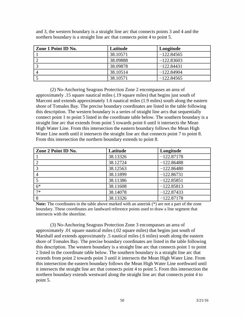
50 3/21/16
and 3, the western boundary is a straight line arc that connects points 3 and 4 and the northern boundary is a straight line arc that connects point 4 to point 5. Zone 1 Point ID No. Latitude Longitude 1 38.10571 −122.84565 2 38.09888 −122.83603 3 38.09878 −122.84431 4 38.10514 −122.84904 5 38.10571 −122.84565
(2) No-Anchoring Seagrass Protection Zone 2 encompasses an area of approximately .15 square nautical miles (.19 square miles) that begins just south of Marconi and extends approximately 1.6 nautical miles (1.9 miles) south along the eastern shore of Tomales Bay. The precise boundary coordinates are listed in the table following this description. The western boundary is a series of straight line arcs that sequentially connect point 1 to point 5 listed in the coordinate table below. The southern boundary is a straight line arc that extends from point 5 towards point 6 until it intersects the Mean High Water Line. From this intersection the eastern boundary follows the Mean High Water Line north until it intersects the straight line arc that connects point 7 to point 8. From this intersection the northern boundary extends to point 8.
Zone 2 Point ID No. Latitude Longitude 1 38.13326 −122.87178 2 38.12724 −122.86488 3 38.12563 −122.86480 4 38.11899 −122.86731 5 38.11386 −122.85851 6* 38.11608 −122.85813 7* 38.14078 −122.87433 8 38.13326 −122.87178 Note: The coordinates in the table above marked with an asterisk (*) are not a part of the zone boundary. These coordinates are landward reference points used to draw a line segment that intersects with the shoreline.
(3) No-Anchoring Seagrass Protection Zone 3 encompasses an area of
approximately .01 square nautical miles (.02 square miles) that begins just south of Marshall and extends approximately .5 nautical miles (.6 miles) south along the eastern shore of Tomales Bay. The precise boundary coordinates are listed in the table following this description. The western boundary is a straight line arc that connects point 1 to point 2 listed in the coordinate table below. The southern boundary is a straight line arc that extends from point 2 towards point 3 until it intersects the Mean High Water Line. From this intersection the eastern boundary follows the Mean High Water Line northward until it intersects the straight line arc that connects point 4 to point 5. From this intersection the northern boundary extends westward along the straight line arc that connects point 4 to point 5.
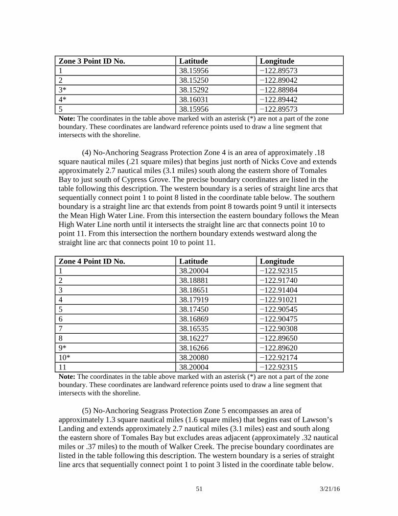
51 3/21/16
Zone 3 Point ID No. Latitude Longitude 1 38.15956 −122.89573 2 38.15250 −122.89042 3* 38.15292 −122.88984 4* 38.16031 −122.89442 5 38.15956 −122.89573 Note: The coordinates in the table above marked with an asterisk (*) are not a part of the zone boundary. These coordinates are landward reference points used to draw a line segment that intersects with the shoreline.
(4) No-Anchoring Seagrass Protection Zone 4 is an area of approximately .18
square nautical miles (.21 square miles) that begins just north of Nicks Cove and extends approximately 2.7 nautical miles (3.1 miles) south along the eastern shore of Tomales Bay to just south of Cypress Grove. The precise boundary coordinates are listed in the table following this description. The western boundary is a series of straight line arcs that sequentially connect point 1 to point 8 listed in the coordinate table below. The southern boundary is a straight line arc that extends from point 8 towards point 9 until it intersects the Mean High Water Line. From this intersection the eastern boundary follows the Mean High Water Line north until it intersects the straight line arc that connects point 10 to point 11. From this intersection the northern boundary extends westward along the straight line arc that connects point 10 to point 11.
Zone 4 Point ID No. Latitude Longitude 1 38.20004 −122.92315 2 38.18881 −122.91740 3 38.18651 −122.91404 4 38.17919 −122.91021 5 38.17450 −122.90545 6 38.16869 −122.90475 7 38.16535 −122.90308 8 38.16227 −122.89650 9* 38.16266 −122.89620 10* 38.20080 −122.92174 11 38.20004 −122.92315 Note: The coordinates in the table above marked with an asterisk (*) are not a part of the zone boundary. These coordinates are landward reference points used to draw a line segment that intersects with the shoreline.
(5) No-Anchoring Seagrass Protection Zone 5 encompasses an area of
approximately 1.3 square nautical miles (1.6 square miles) that begins east of Lawson’s Landing and extends approximately 2.7 nautical miles (3.1 miles) east and south along the eastern shore of Tomales Bay but excludes areas adjacent (approximately .32 nautical miles or .37 miles) to the mouth of Walker Creek. The precise boundary coordinates are listed in the table following this description. The western boundary is a series of straight line arcs that sequentially connect point 1 to point 3 listed in the coordinate table below.
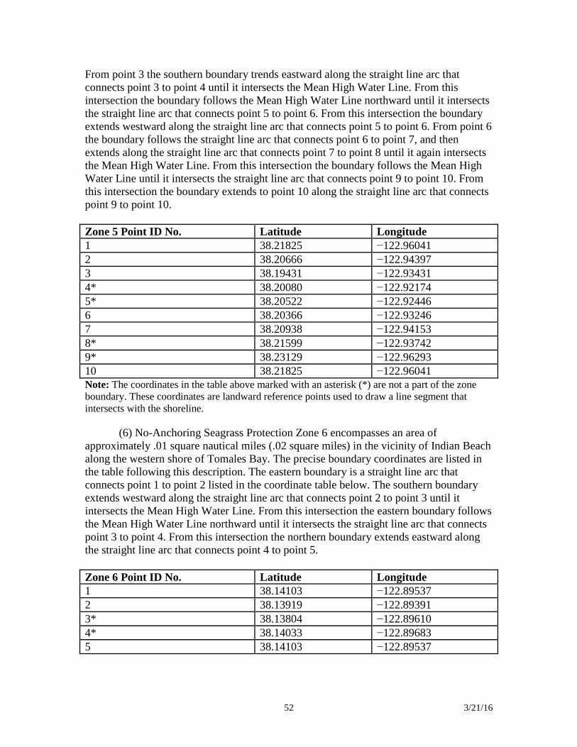
52 3/21/16
From point 3 the southern boundary trends eastward along the straight line arc that connects point 3 to point 4 until it intersects the Mean High Water Line. From this intersection the boundary follows the Mean High Water Line northward until it intersects the straight line arc that connects point 5 to point 6. From this intersection the boundary extends westward along the straight line arc that connects point 5 to point 6. From point 6 the boundary follows the straight line arc that connects point 6 to point 7, and then extends along the straight line arc that connects point 7 to point 8 until it again intersects the Mean High Water Line. From this intersection the boundary follows the Mean High Water Line until it intersects the straight line arc that connects point 9 to point 10. From this intersection the boundary extends to point 10 along the straight line arc that connects point 9 to point 10. Zone 5 Point ID No. Latitude Longitude 1 38.21825 −122.96041 2 38.20666 −122.94397 3 38.19431 −122.93431 4* 38.20080 −122.92174 5* 38.20522 −122.92446 6 38.20366 −122.93246 7 38.20938 −122.94153 8* 38.21599 −122.93742 9* 38.23129 −122.96293 10 38.21825 −122.96041 Note: The coordinates in the table above marked with an asterisk (*) are not a part of the zone boundary. These coordinates are landward reference points used to draw a line segment that intersects with the shoreline.
(6) No-Anchoring Seagrass Protection Zone 6 encompasses an area of approximately .01 square nautical miles (.02 square miles) in the vicinity of Indian Beach along the western shore of Tomales Bay. The precise boundary coordinates are listed in the table following this description. The eastern boundary is a straight line arc that connects point 1 to point 2 listed in the coordinate table below. The southern boundary extends westward along the straight line arc that connects point 2 to point 3 until it intersects the Mean High Water Line. From this intersection the eastern boundary follows the Mean High Water Line northward until it intersects the straight line arc that connects point 3 to point 4. From this intersection the northern boundary extends eastward along the straight line arc that connects point 4 to point 5. Zone 6 Point ID No. Latitude Longitude 1 38.14103 −122.89537 2 38.13919 −122.89391 3* 38.13804 −122.89610 4* 38.14033 −122.89683 5 38.14103 −122.89537
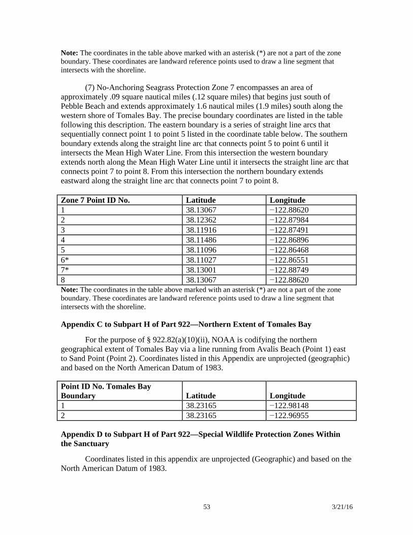
53 3/21/16
Note: The coordinates in the table above marked with an asterisk (*) are not a part of the zone boundary. These coordinates are landward reference points used to draw a line segment that intersects with the shoreline.
(7) No-Anchoring Seagrass Protection Zone 7 encompasses an area of approximately .09 square nautical miles (.12 square miles) that begins just south of Pebble Beach and extends approximately 1.6 nautical miles (1.9 miles) south along the western shore of Tomales Bay. The precise boundary coordinates are listed in the table following this description. The eastern boundary is a series of straight line arcs that sequentially connect point 1 to point 5 listed in the coordinate table below. The southern boundary extends along the straight line arc that connects point 5 to point 6 until it intersects the Mean High Water Line. From this intersection the western boundary extends north along the Mean High Water Line until it intersects the straight line arc that connects point 7 to point 8. From this intersection the northern boundary extends eastward along the straight line arc that connects point 7 to point 8. Zone 7 Point ID No. Latitude Longitude 1 38.13067 −122.88620 2 38.12362 −122.87984 3 38.11916 −122.87491 4 38.11486 −122.86896 5 38.11096 −122.86468 6* 38.11027 −122.86551 7* 38.13001 −122.88749 8 38.13067 −122.88620 Note: The coordinates in the table above marked with an asterisk (*) are not a part of the zone boundary. These coordinates are landward reference points used to draw a line segment that intersects with the shoreline. Appendix C to Subpart H of Part 922—Northern Extent of Tomales Bay
For the purpose of § 922.82(a)(10)(ii), NOAA is codifying the northern geographical extent of Tomales Bay via a line running from Avalis Beach (Point 1) east to Sand Point (Point 2). Coordinates listed in this Appendix are unprojected (geographic) and based on the North American Datum of 1983. Point ID No. Tomales Bay Boundary Latitude Longitude 1 38.23165 −122.98148 2 38.23165 −122.96955 Appendix D to Subpart H of Part 922—Special Wildlife Protection Zones Within the Sanctuary
Coordinates listed in this appendix are unprojected (Geographic) and based on the North American Datum of 1983.
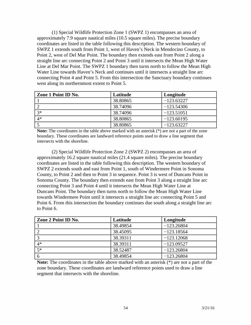
54 3/21/16
(1) Special Wildlife Protection Zone 1 (SWPZ 1) encompasses an area of approximately 7.9 square nautical miles (10.5 square miles). The precise boundary coordinates are listed in the table following this description. The western boundary of SWPZ 1 extends south from Point 1, west of Haven’s Neck in Mendocino County, to Point 2, west of Del Mar Point. The boundary then extends east from Point 2 along a straight line arc connecting Point 2 and Point 3 until it intersects the Mean High Water Line at Del Mar Point. The SWPZ 1 boundary then turns north to follow the Mean High Water Line towards Haven’s Neck and continues until it intersects a straight line arc connecting Point 4 and Point 5. From this intersection the Sanctuary boundary continues west along its northernmost extent to Point 5. Zone 1 Point ID No. Latitude Longitude 1 38.80865 −123.63227 2 38.74096 −123.54306 3* 38.74096 −123.51051 4* 38.80865 −123.60195 5 38.80865 −123.63227 Note: The coordinates in the table above marked with an asterisk (*) are not a part of the zone boundary. These coordinates are landward reference points used to draw a line segment that intersects with the shoreline.
(2) Special Wildlife Protection Zone 2 (SWPZ 2) encompasses an area of approximately 16.2 square nautical miles (21.4 square miles). The precise boundary coordinates are listed in the table following this description. The western boundary of SWPZ 2 extends south and east from Point 1, south of Windermere Point in Sonoma County, to Point 2 and then to Point 3 in sequence. Point 3 is west of Duncans Point in Sonoma County. The boundary then extends east from Point 3 along a straight line arc connecting Point 3 and Point 4 until it intersects the Mean High Water Line at Duncans Point. The boundary then turns north to follow the Mean High Water Line towards Windermere Point until it intersects a straight line arc connecting Point 5 and Point 6. From this intersection the boundary continues due south along a straight line arc to Point 6. Zone 2 Point ID No. Latitude Longitude 1 38.49854 −123.26804 2 38.45095 −123.18564 3 38.39311 −123.12068 4* 38.39311 −123.09527 5* 38.52487 −123.26804 6 38.49854 −123.26804 Note: The coordinates in the table above marked with an asterisk (*) are not a part of the zone boundary. These coordinates are landward reference points used to draw a line segment that intersects with the shoreline.
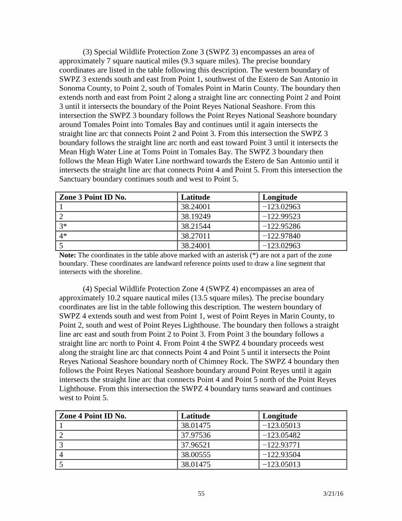
55 3/21/16
(3) Special Wildlife Protection Zone 3 (SWPZ 3) encompasses an area of approximately 7 square nautical miles (9.3 square miles). The precise boundary coordinates are listed in the table following this description. The western boundary of SWPZ 3 extends south and east from Point 1, southwest of the Estero de San Antonio in Sonoma County, to Point 2, south of Tomales Point in Marin County. The boundary then extends north and east from Point 2 along a straight line arc connecting Point 2 and Point 3 until it intersects the boundary of the Point Reyes National Seashore. From this intersection the SWPZ 3 boundary follows the Point Reyes National Seashore boundary around Tomales Point into Tomales Bay and continues until it again intersects the straight line arc that connects Point 2 and Point 3. From this intersection the SWPZ 3 boundary follows the straight line arc north and east toward Point 3 until it intersects the Mean High Water Line at Toms Point in Tomales Bay. The SWPZ 3 boundary then follows the Mean High Water Line northward towards the Estero de San Antonio until it intersects the straight line arc that connects Point 4 and Point 5. From this intersection the Sanctuary boundary continues south and west to Point 5. Zone 3 Point ID No. Latitude Longitude 1 38.24001 −123.02963 2 38.19249 −122.99523 3* 38.21544 −122.95286 4* 38.27011 −122.97840 5 38.24001 −123.02963 Note: The coordinates in the table above marked with an asterisk (*) are not a part of the zone boundary. These coordinates are landward reference points used to draw a line segment that intersects with the shoreline.
(4) Special Wildlife Protection Zone 4 (SWPZ 4) encompasses an area of approximately 10.2 square nautical miles (13.5 square miles). The precise boundary coordinates are list in the table following this description. The western boundary of SWPZ 4 extends south and west from Point 1, west of Point Reyes in Marin County, to Point 2, south and west of Point Reyes Lighthouse. The boundary then follows a straight line arc east and south from Point 2 to Point 3. From Point 3 the boundary follows a straight line arc north to Point 4. From Point 4 the SWPZ 4 boundary proceeds west along the straight line arc that connects Point 4 and Point 5 until it intersects the Point Reyes National Seashore boundary north of Chimney Rock. The SWPZ 4 boundary then follows the Point Reyes National Seashore boundary around Point Reyes until it again intersects the straight line arc that connects Point 4 and Point 5 north of the Point Reyes Lighthouse. From this intersection the SWPZ 4 boundary turns seaward and continues west to Point 5. Zone 4 Point ID No. Latitude Longitude 1 38.01475 −123.05013 2 37.97536 −123.05482 3 37.96521 −122.93771 4 38.00555 −122.93504 5 38.01475 −123.05013
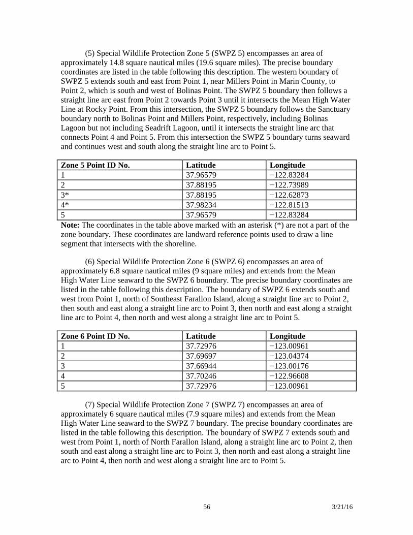
56 3/21/16
(5) Special Wildlife Protection Zone 5 (SWPZ 5) encompasses an area of approximately 14.8 square nautical miles (19.6 square miles). The precise boundary coordinates are listed in the table following this description. The western boundary of SWPZ 5 extends south and east from Point 1, near Millers Point in Marin County, to Point 2, which is south and west of Bolinas Point. The SWPZ 5 boundary then follows a straight line arc east from Point 2 towards Point 3 until it intersects the Mean High Water Line at Rocky Point. From this intersection, the SWPZ 5 boundary follows the Sanctuary boundary north to Bolinas Point and Millers Point, respectively, including Bolinas Lagoon but not including Seadrift Lagoon, until it intersects the straight line arc that connects Point 4 and Point 5. From this intersection the SWPZ 5 boundary turns seaward and continues west and south along the straight line arc to Point 5. Zone 5 Point ID No. Latitude Longitude 1 37.96579 −122.83284 2 37.88195 −122.73989 3* 37.88195 −122.62873 4* 37.98234 −122.81513 5 37.96579 −122.83284 Note: The coordinates in the table above marked with an asterisk (*) are not a part of the zone boundary. These coordinates are landward reference points used to draw a line segment that intersects with the shoreline.
(6) Special Wildlife Protection Zone 6 (SWPZ 6) encompasses an area of approximately 6.8 square nautical miles (9 square miles) and extends from the Mean High Water Line seaward to the SWPZ 6 boundary. The precise boundary coordinates are listed in the table following this description. The boundary of SWPZ 6 extends south and west from Point 1, north of Southeast Farallon Island, along a straight line arc to Point 2, then south and east along a straight line arc to Point 3, then north and east along a straight line arc to Point 4, then north and west along a straight line arc to Point 5. Zone 6 Point ID No. Latitude Longitude 1 37.72976 −123.00961 2 37.69697 −123.04374 3 37.66944 −123.00176 4 37.70246 −122.96608 5 37.72976 −123.00961
(7) Special Wildlife Protection Zone 7 (SWPZ 7) encompasses an area of approximately 6 square nautical miles (7.9 square miles) and extends from the Mean High Water Line seaward to the SWPZ 7 boundary. The precise boundary coordinates are listed in the table following this description. The boundary of SWPZ 7 extends south and west from Point 1, north of North Farallon Island, along a straight line arc to Point 2, then south and east along a straight line arc to Point 3, then north and east along a straight line arc to Point 4, then north and west along a straight line arc to Point 5.
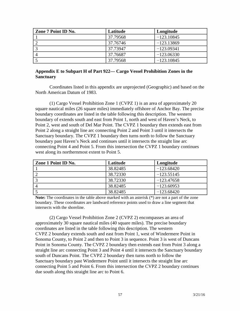
57 3/21/16
Zone 7 Point ID No. Latitude Longitude 1 37.79568 −123.10845 2 37.76746 −123.13869 3 37.73947 −123.09341 4 37.76687 −123.06330 5 37.79568 −123.10845 Appendix E to Subpart H of Part 922— Cargo Vessel Prohibition Zones in the Sanctuary
Coordinates listed in this appendix are unprojected (Geographic) and based on the North American Datum of 1983.
(1) Cargo Vessel Prohibition Zone 1 (CVPZ 1) is an area of approximately 20 square nautical miles (26 square miles) immediately offshore of Anchor Bay. The precise boundary coordinates are listed in the table following this description. The western boundary of extends south and east from Point 1, north and west of Haven’s Neck, to Point 2, west and south of Del Mar Point. The CVPZ 1 boundary then extends east from Point 2 along a straight line arc connecting Point 2 and Point 3 until it intersects the Sanctuary boundary. The CVPZ 1 boundary then turns north to follow the Sanctuary boundary past Haven’s Neck and continues until it intersects the straight line arc connecting Point 4 and Point 5. From this intersection the CVPZ 1 boundary continues west along its northernmost extent to Point 5. Zone 1 Point ID No. Latitude Longitude 1 38.82485 −123.68420 2 38.72330 −123.55145 3 38.72330 −123.47658 4 38.82485 −123.60953 5 38.82485 −123.68420 Note: The coordinates in the table above marked with an asterisk (*) are not a part of the zone boundary. These coordinates are landward reference points used to draw a line segment that intersects with the shoreline.
(2) Cargo Vessel Prohibition Zone 2 (CVPZ 2) encompasses an area of approximately 30 square nautical miles (40 square miles). The precise boundary coordinates are listed in the table following this description. The western CVPZ 2 boundary extends south and east from Point 1, west of Windermere Point in Sonoma County, to Point 2 and then to Point 3 in sequence. Point 3 is west of Duncans Point in Sonoma County. The CVPZ 2 boundary then extends east from Point 3 along a straight line arc connecting Point 3 and Point 4 until it intersects the Sanctuary boundary south of Duncans Point. The CVPZ 2 boundary then turns north to follow the Sanctuary boundary past Windermere Point until it intersects the straight line arc connecting Point 5 and Point 6. From this intersection the CVPZ 2 boundary continues due south along this straight line arc to Point 6.
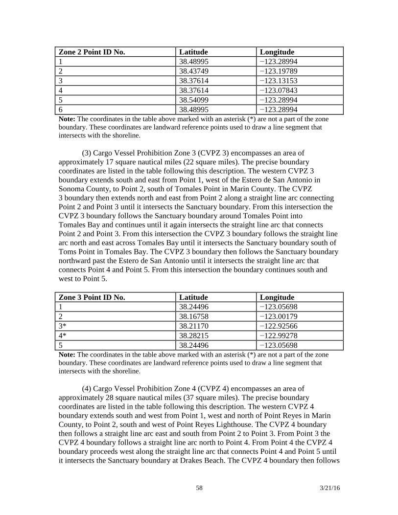
58 3/21/16
Zone 2 Point ID No. Latitude Longitude 1 38.48995 −123.28994 2 38.43749 −123.19789 3 38.37614 −123.13153 4 38.37614 −123.07843 5 38.54099 −123.28994 6 38.48995 −123.28994 Note: The coordinates in the table above marked with an asterisk (*) are not a part of the zone boundary. These coordinates are landward reference points used to draw a line segment that intersects with the shoreline.
(3) Cargo Vessel Prohibition Zone 3 (CVPZ 3) encompasses an area of approximately 17 square nautical miles (22 square miles). The precise boundary coordinates are listed in the table following this description. The western CVPZ 3 boundary extends south and east from Point 1, west of the Estero de San Antonio in Sonoma County, to Point 2, south of Tomales Point in Marin County. The CVPZ 3 boundary then extends north and east from Point 2 along a straight line arc connecting Point 2 and Point 3 until it intersects the Sanctuary boundary. From this intersection the CVPZ 3 boundary follows the Sanctuary boundary around Tomales Point into Tomales Bay and continues until it again intersects the straight line arc that connects Point 2 and Point 3. From this intersection the CVPZ 3 boundary follows the straight line arc north and east across Tomales Bay until it intersects the Sanctuary boundary south of Toms Point in Tomales Bay. The CVPZ 3 boundary then follows the Sanctuary boundary northward past the Estero de San Antonio until it intersects the straight line arc that connects Point 4 and Point 5. From this intersection the boundary continues south and west to Point 5. Zone 3 Point ID No. Latitude Longitude 1 38.24496 −123.05698 2 38.16758 −123.00179 3* 38.21170 −122.92566 4* 38.28215 −122.99278 5 38.24496 −123.05698 Note: The coordinates in the table above marked with an asterisk (*) are not a part of the zone boundary. These coordinates are landward reference points used to draw a line segment that intersects with the shoreline.
(4) Cargo Vessel Prohibition Zone 4 (CVPZ 4) encompasses an area of approximately 28 square nautical miles (37 square miles). The precise boundary coordinates are listed in the table following this description. The western CVPZ 4 boundary extends south and west from Point 1, west and north of Point Reyes in Marin County, to Point 2, south and west of Point Reyes Lighthouse. The CVPZ 4 boundary then follows a straight line arc east and south from Point 2 to Point 3. From Point 3 the CVPZ 4 boundary follows a straight line arc north to Point 4. From Point 4 the CVPZ 4 boundary proceeds west along the straight line arc that connects Point 4 and Point 5 until it intersects the Sanctuary boundary at Drakes Beach. The CVPZ 4 boundary then follows
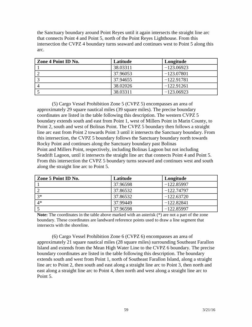
59 3/21/16
the Sanctuary boundary around Point Reyes until it again intersects the straight line arc that connects Point 4 and Point 5, north of the Point Reyes Lighthouse. From this intersection the CVPZ 4 boundary turns seaward and continues west to Point 5 along this arc. Zone 4 Point ID No. Latitude Longitude 1 38.03311 −123.06923 2 37.96053 −123.07801 3 37.94655 −122.91781 4 38.02026 −122.91261 5 38.03311 −123.06923
(5) Cargo Vessel Prohibition Zone 5 (CVPZ 5) encompasses an area of approximately 29 square nautical miles (39 square miles). The precise boundary coordinates are listed in the table following this description. The western CVPZ 5 boundary extends south and east from Point 1, west of Millers Point in Marin County, to Point 2, south and west of Bolinas Point. The CVPZ 5 boundary then follows a straight line arc east from Point 2 towards Point 3 until it intersects the Sanctuary boundary. From this intersection, the CVPZ 5 boundary follows the Sanctuary boundary north towards Rocky Point and continues along the Sanctuary boundary past Bolinas Point and Millers Point, respectively, including Bolinas Lagoon but not including Seadrift Lagoon, until it intersects the straight line arc that connects Point 4 and Point 5. From this intersection the CVPZ 5 boundary turns seaward and continues west and south along the straight line arc to Point 5. Zone 5 Point ID No. Latitude Longitude 1 37.96598 −122.85997 2 37.86532 −122.74797 3* 37.86532 −122.63720 4* 37.99449 −122.82841 5 37.96598 −122.85997 Note: The coordinates in the table above marked with an asterisk (*) are not a part of the zone boundary. These coordinates are landward reference points used to draw a line segment that intersects with the shoreline.
(6) Cargo Vessel Prohibition Zone 6 (CVPZ 6) encompasses an area of approximately 21 square nautical miles (28 square miles) surrounding Southeast Farallon Island and extends from the Mean High Water Line to the CVPZ 6 boundary. The precise boundary coordinates are listed in the table following this description. The boundary extends south and west from Point 1, north of Southeast Farallon Island, along a straight line arc to Point 2, then south and east along a straight line arc to Point 3, then north and east along a straight line arc to Point 4, then north and west along a straight line arc to Point 5.

60 3/21/16
Zone 6 Point ID No. Latitude Longitude 1 37.75264 −123.01175 2 37.69461 −123.07333 3 37.64621 −122.99867 4 37.70538 −122.93567 5 37.75264 −123.01175
(7) Cargo Vessel Prohibition Zone 7 (CVPZ 7) encompasses an area of approximately 20 square nautical miles (26 square miles) surrounding the North Farallon Islands and extends from the Mean High Water Line to the CVPZ 7 boundary. The precise boundary coordinates are listed in the table following this description. The boundary extends south and west from Point 1, north of North Farallon Island, along a straight line arc to Point 2, then south and east along a straight line arc to Point 3, then north and east along a straight line arc to Point 4, then north and west along a straight line arc to Point 5. Zone 7 Point ID No. Latitude Longitude 1 37.81914 −123.11155 2 37.76497 −123.16939 3 37.71623 −123.09089 4 37.76872 −123.03359 5 37.81914 −123.11155 Appendix F to Subpart H of Part 922— White Shark Approach Prohibition Zones in the Sanctuary
Coordinates listed in this appendix are unprojected (Geographic) and based on the North American Datum of 1983.
(1) White Shark Approach Prohibition Zone 1 (WSAPZ 1) encompasses an area of approximately 21 square nautical miles (28 square miles) surrounding Southeast Farallon Island and extends from the Mean High Water Line to the WSAPZ 1 boundary. The precise boundary coordinates are listed in the table following this description. The boundary extends south and west from Point 1, north of Southeast Farallon Island, along a straight line arc to Point 2, then south and east along a straight line arc to Point 3, then north and east along a straight line arc to Point 4, then north and west along a straight line arc to Point 5. Zone 1 Point ID No. Latitude Longitude 1 37.75264 −123.01175 2 37.69461 −123.07333 3 37.64621 −122.99867 4 37.70538 −122.93567 5 37.75264 −123.01175
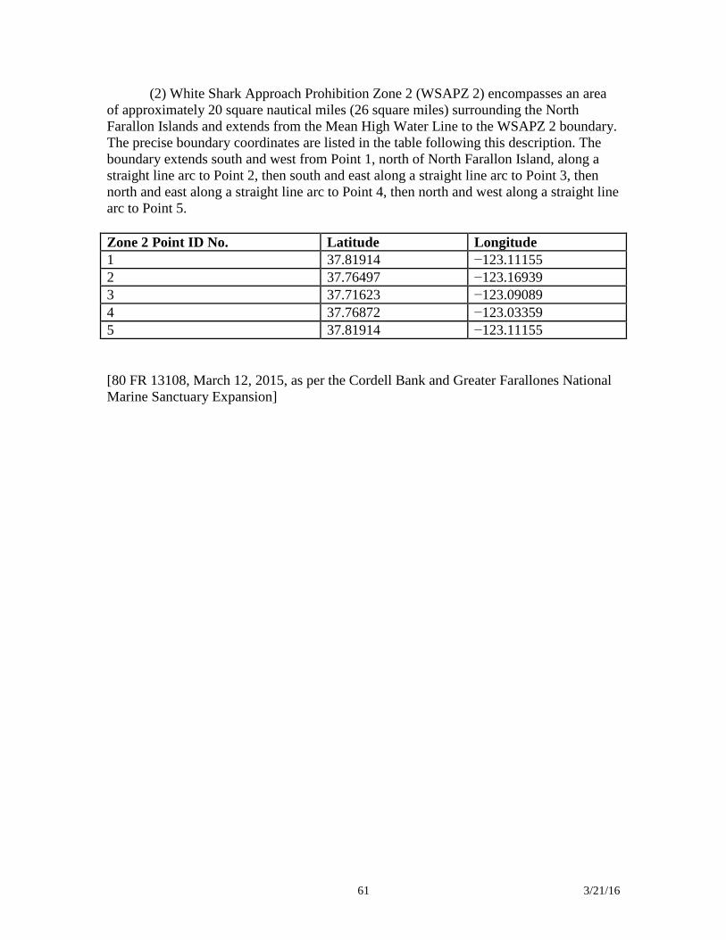
61 3/21/16
(2) White Shark Approach Prohibition Zone 2 (WSAPZ 2) encompasses an area of approximately 20 square nautical miles (26 square miles) surrounding the North Farallon Islands and extends from the Mean High Water Line to the WSAPZ 2 boundary. The precise boundary coordinates are listed in the table following this description. The boundary extends south and west from Point 1, north of North Farallon Island, along a straight line arc to Point 2, then south and east along a straight line arc to Point 3, then north and east along a straight line arc to Point 4, then north and west along a straight line arc to Point 5. Zone 2 Point ID No. Latitude Longitude 1 37.81914 −123.11155 2 37.76497 −123.16939 3 37.71623 −123.09089 4 37.76872 −123.03359 5 37.81914 −123.11155 [80 FR 13108, March 12, 2015, as per the Cordell Bank and Greater Farallones National Marine Sanctuary Expansion]
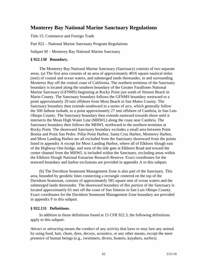
62 3/21/16
Monterey Bay National Marine Sanctuary Regulations Title 15: Commerce and Foreign Trade Part 922 – National Marine Sanctuary Program Regulations Subpart M – Monterey Bay National Marine Sanctuary § 922.130 Boundary.
The Monterey Bay National Marine Sanctuary (Sanctuary) consists of two separate areas. (a) The first area consists of an area of approximately 4016 square nautical miles (nmi) of coastal and ocean waters, and submerged lands thereunder, in and surrounding Monterey Bay off the central coast of California. The northern terminus of the Sanctuary boundary is located along the southern boundary of the Greater Farallones National Marine Sanctuary (GFNMS) beginning at Rocky Point just south of Stinson Beach in Marin County. The Sanctuary boundary follows the GFNMS boundary westward to a point approximately 29 nmi offshore from Moss Beach in San Mateo County. The Sanctuary boundary then extends southward in a series of arcs, which generally follow the 500 fathom isobath, to a point approximately 27 nmi offshore of Cambria, in San Luis Obispo County. The Sanctuary boundary then extends eastward towards shore until it intersects the Mean High Water Line (MHWL) along the coast near Cambria. The Sanctuary boundary then follows the MHWL northward to the northern terminus at Rocky Point. The shoreward Sanctuary boundary excludes a small area between Point Bonita and Point San Pedro. Pillar Point Harbor, Santa Cruz Harbor, Monterey Harbor, and Moss Landing Harbor are all excluded from the Sanctuary shoreward from the points listed in appendix A except for Moss Landing Harbor, where all of Elkhorn Slough east of the Highway One bridge, and west of the tide gate at Elkhorn Road and toward the center channel from the MHWL is included within the Sanctuary, excluding areas within the Elkhorn Slough National Estuarine Research Reserve. Exact coordinates for the seaward boundary and harbor exclusions are provided in appendix A to this subpart.
(b) The Davidson Seamount Management Zone is also part of the Sanctuary. This area, bounded by geodetic lines connecting a rectangle centered on the top of the Davidson Seamount, consists of approximately 585 square nmi of ocean waters and the submerged lands thereunder. The shoreward boundary of this portion of the Sanctuary is located approximately 65 nmi off the coast of San Simeon in San Luis Obispo County. Exact coordinates for the Davidson Seamount Management Zone boundary are provided in appendix F to this subpart.
§ 922.131 Definitions. In addition to those definitions found at 15 CFR 922.3, the following definitions
apply to this subpart:
Attract or attracting means the conduct of any activity that lures or may lure any animal by using food, bait, chum, dyes, decoys, acoustics, or any other means, except the mere presence of human beings (e.g., swimmers, divers, boaters, kayakers, surfers).
63 3/21/16
Clean means not containing detectable levels of harmful matter.
Cruise ship means a vessel with 250 or more passenger berths for hire.
Davidson Seamount Management Zone means the area bounded by geodetic lines connecting a rectangle centered on the top of the Davidson Seamount, and consists of approximately 585 square nmi of ocean waters and the submerged lands thereunder. The shoreward boundary of this portion of the Sanctuary is located approximately 65 nmi off the coast of San Simeon in San Luis Obispo County. Exact coordinates for the Davidson Seamount Management Zone boundary are provided in appendix F to this subpart.
Deserting means leaving a vessel aground or adrift without notification to the Director of the vessel going aground or becoming adrift within 12 hours of its discovery and developing and presenting to the Director a preliminary salvage plan within 24 hours of such notification, after expressing or otherwise manifesting intention not to undertake or to cease salvage efforts, or when the owner/operator cannot after reasonable efforts by the Director be reached within 12 hours of the vessel's condition being reported to authorities; or leaving a vessel at anchor when its condition creates potential for a grounding, discharge, or deposit and the owner/operator fails to secure the vessel in a timely manner.
Federal Project means any water resources development project conducted by the U.S. Army Corps of Engineers or operating under a permit or other authorization issued by the Corps of Engineers and authorized by Federal law.
Hand tool means a hand-held implement, utilized for the collection of jade pursuant to 15 CFR 922.132(a)(1), that is no greater than 36 inches in length and has no moving parts (e.g., dive knife, pry bar, or abalone iron). Pneumatic, mechanical, electrical, hydraulic, or explosive tools are, therefore, examples of what does not meet this definition.
Harmful matter means any substance, or combination of substances, that because of its quantity, concentration, or physical, chemical, or infectious characteristics may pose a present or potential threat to Sanctuary resources or qualities, including but not limited to: Fishing nets, fishing line, hooks, fuel, oil, and those contaminants (regardless of quantity) listed pursuant to 42 U.S.C. 9601(14) of the Comprehensive Environmental Response, Compensation and Liability Act at 40 CFR 302.4.
Introduced species means: Any species (including but not limited to any of its biological matter capable of propagation) that is non-native to the ecosystems of the Sanctuary; or any organism into which altered genetic matter, or genetic matter from another species, has been transferred in order that the host organism acquires the genetic traits of the transferred genes.
Motorized personal watercraft (MPWC) means any vessel, propelled by machinery, that is designed to be operated by standing, sitting, or kneeling on, astride, or behind the vessel, in contrast to the conventional manner, where the operator stands or sits inside the vessel; any vessel less than 20 feet in length overall as manufactured and propelled by
64 3/21/16
machinery and that has been exempted from compliance with the U.S. Coast Guard's Maximum Capacities Marking for Load Capacity regulation found at 33 CFR Parts 181 and 183, except submarines; or any other vessel that is less than 20 feet in length overall as manufactured, and is propelled by a water jet pump or drive.
§ 922.132 Prohibited or otherwise regulated activities. (a) Except as specified in paragraphs (b) through (e) of this section, the following
activities are prohibited and thus are unlawful for any person to conduct or to cause to be conducted:
(1) Exploring for, developing, or producing oil, gas, or minerals within the Sanctuary, except: Jade may be collected (meaning removed) from the area bounded by the 35.92222 N latitude parallel (coastal reference point: Beach access stairway at south Sand Dollar Beach), the 35.88889 N latitude parallel (coastal reference point: Westernmost tip of Cape San Martin), and from the mean high tide line seaward to the 90-foot isobath (depth line) (the “authorized area”) provided that:
(i) Only jade already loose from the submerged lands of the Sanctuary may be collected;
(ii) No tool may be used to collect jade except:
(A) A hand tool (as defined at 15 CFR 922.131) to maneuver or lift the jade or scratch the surface of a stone as necessary to determine if it is jade;
(B) A lift bag or multiple lift bags with a combined lift capacity of no more than two hundred pounds; or
(C) A vessel (except for motorized personal watercraft) (see paragraph (a)(7) of this section) to provide access to the authorized area;
(iii) Each person may collect only what that person individually carries; and
(iv) For any loose piece of jade that cannot be collected under paragraphs (a)(1) (ii) and (iii) of this section, any person may apply for a permit to collect such a loose piece by following the procedures in 15 CFR 922.133.
(2)(i) Discharging or depositing from within or into the Sanctuary, other than from a cruise ship, any material or other matter, except:
(A) Fish, fish parts, chumming materials, or bait used in or resulting from lawful fishing activities within the Sanctuary, provided that such discharge or deposit is during the conduct of lawful fishing activities within the Sanctuary;
(B) For a vessel less than 300 gross registered tons (GRT), or a vessel 300 GRT or greater without sufficient holding tank capacity to hold sewage while within the Sanctuary, clean effluent generated incidental to vessel use by an operable Type I or II
65 3/21/16
marine sanitation device (U.S. Coast Guard classification) approved in accordance with section 312 of the Federal Water Pollution Control Act, as amended (FWPCA), 33 U.S.C. 1322. Vessel operators must lock all marine sanitation devices in a manner that prevents discharge or deposit of untreated sewage;
(C) Clean vessel deck wash down, clean vessel engine cooling water, clean vessel generator cooling water, clean bilge water, or anchor wash;
(D) For a vessel less than 300 gross registered tons (GRT), or a vessel 300 GRT or greater without sufficient holding capacity to hold graywater while within the Sanctuary, clean graywater as defined by section 312 of the FWPCA;
(E) Vessel engine or generator exhaust; or
(F) Dredged material deposited at disposal sites authorized by the U.S. Environmental Protection Agency (EPA) (in consultation with the U.S. Army Corps of Engineers (COE)) prior to the effective date of Sanctuary designation (January 1, 1993), provided that the activity is pursuant to, and complies with the terms and conditions of, a valid Federal permit or approval existing on January 1, 1993. Authorized disposal sites within the Sanctuary are described in appendix C to this subpart.
(ii) Discharging or depositing from within or into the Sanctuary any material or other matter from a cruise ship except clean vessel engine cooling water, clean vessel generator cooling water, vessel engine or generator exhaust, clean bilge water, or anchor wash.
(iii) Discharging or depositing from beyond the boundary of the Sanctuary any material or other matter that subsequently enters the Sanctuary and injures a Sanctuary resource or quality, except those listed in paragraphs (a)(2)(i)(A) through (E) and (a)(2)(ii) of this section and dredged material deposited at the authorized disposal sites described in appendix D to this subpart, provided that the dredged material disposal is pursuant to, and complies with the terms and conditions of, a valid Federal permit or approval.
(3) Possessing, moving, removing, or injuring, or attempting to possess, move, remove, or injure, a Sanctuary historical resource. This prohibition does not apply to, moving, removing, or injury resulting incidentally from kelp harvesting, aquaculture, or lawful fishing activities.
(4) Drilling into, dredging, or otherwise altering the submerged lands of the Sanctuary; or constructing, placing, or abandoning any structure, material, or other matter on or in the submerged lands of the Sanctuary, except as incidental and necessary to:
(i) Conduct lawful fishing activities;
(ii) Anchor a vessel;
66 3/21/16
(iii) Conduct aquaculture or kelp harvesting;
(iv) Install an authorized navigational aid;
(v) Conduct harbor maintenance in an area necessarily associated with a Federal Project in existence on January 1, 1993, including dredging of entrance channels and repair, replacement, or rehabilitation of breakwaters and jetties;
(vi) Construct, repair, replace, or rehabilitate a dock or pier; or
(vii) Collect jade pursuant to paragraph (a)(1) of this section, provided that there is no constructing, placing, or abandoning any structure, material, or other matter on or in the submerged lands of the Sanctuary, other than temporary placement of an authorized hand tool as provided in paragraph (a)(1) of this section. The exceptions listed in paragraphs (a)(4)(ii) through (a)(4)(vii) of this section do not apply within the Davidson Seamount Management Zone.
(5) Taking any marine mammal, sea turtle, or bird within or above the Sanctuary, except as authorized by the Marine Mammal Protection Act, as amended, (MMPA), 16 U.S.C. 1361 et seq. , Endangered Species Act, as amended, (ESA), 16 U.S.C. 1531 et seq. , Migratory Bird Treaty Act, as amended, (MBTA), 16 U.S.C. 703 et seq. , or any regulation, as amended, promulgated under the MMPA, ESA, or MBTA.
(6) Disturbing marine mammals or seabirds by flying motorized aircraft, except as necessary for valid law enforcement purposes, at less than 1,000 feet above any of the four zones within the Sanctuary described in Appendix B to this subpart. Failure to maintain a minimum altitude of 1,000 feet above ground level above any such zone is presumed to disturb marine mammals or seabirds.
(7) Operating motorized personal watercraft within the Sanctuary except within the five designated zones and access routes within the Sanctuary described in appendix E to this subpart. Zone Five (at Pillar Point) exists only when a High Surf Warning has been issued by the National Weather Service and is in effect for San Mateo County, and only during December, January, and February.
(8) Possessing within the Sanctuary (regardless of where taken, moved, or removed from), any marine mammal, sea turtle, or bird, except as authorized by the MMPA, ESA, MBTA, by any regulation, as amended, promulgated under the MMPA, ESA, or MBTA, or as necessary for valid law enforcement purposes.
(9) Deserting a vessel aground, at anchor, or adrift in the Sanctuary.
(10) Leaving harmful matter aboard a grounded or deserted vessel in the Sanctuary.
(11)(i) Moving, removing, taking, collecting, catching, harvesting, disturbing, breaking, cutting, or otherwise injuring, or attempting to move, remove, take, collect, catch, harvest, disturb, break, cut, or otherwise injure, any Sanctuary resource located
67 3/21/16
more that 3,000 feet below the sea surface within the Davidson Seamount Management Zone. This prohibition does not apply to fishing below 3000 feet within the Davidson Seamount Management Zone, which is prohibited pursuant to 50 CFR part 660 (Fisheries off West Coast States).
(ii) Possessing any Sanctuary resource the source of which is more than 3,000 feet below the sea surface within the Davidson Seamount Management Zone. This prohibition does not apply to possession of fish resulting from fishing below 3000 feet within the Davidson Seamount Management Zone, which is prohibited pursuant to 50 CFR part 660 (Fisheries off West Coast States).
(12) Introducing or otherwise releasing from within or into the Sanctuary an introduced species, except striped bass ( Morone saxatilis ) released during catch and release fishing activity.
(13) Attracting any white shark within the Sanctuary.
(14) Interfering with, obstructing, delaying, or preventing an investigation, search, seizure, or disposition of seized property in connection with enforcement of the Act or any regulation or permit issued under the Act.
(b) The prohibitions in paragraphs (a)(2) through (11) of this section do not apply to an activity necessary to respond to an emergency threatening life, property, or the environment.
(c)(1) All Department of Defense activities must be carried out in a manner that avoids to the maximum extent practicable any adverse impacts on Sanctuary resources and qualities. The prohibitions in paragraphs (a)(2) through (12) of this section do not apply to existing military activities carried out by the Department of Defense, as specifically identified in the Final Environmental Impact Statement and Management Plan for the Proposed Monterey Bay National Marine Sanctuary (NOAA, 1992). (Copies of the FEIS/MP are available from the Monterey Bay National Marine Sanctuary, 299 Foam Street, Monterey, CA 93940.) For purposes of the Davidson Seamount Management Zone, these activities are listed in the 2008 Final Environmental Impact Statement. New activities may be exempted from the prohibitions in paragraphs (a)(2) through (12) of this section by the Director after consultation between the Director and the Department of Defense.
(2) In the event of destruction of, loss of, or injury to a Sanctuary resource or quality resulting from an incident, including but not limited to discharges, deposits, and groundings, caused by a Department of Defense activity, the Department of Defense, in coordination with the Director, must promptly prevent and mitigate further damage and must restore or replace the Sanctuary resource or quality in a manner approved by the Director.
(d) The prohibitions in paragraph (a)(1) of this section as it pertains to jade collection in the Sanctuary, and paragraphs (a)(2) through (11) and (a)(13) of this section,
68 3/21/16
do not apply to any activity conducted under and in accordance with the scope, purpose, terms, and conditions of a National Marine Sanctuary permit issued pursuant to 15 CFR 922.48 and 922.133 or a Special Use permit issued pursuant to section 310 of the Act.
(e) The prohibitions in paragraphs (a)(2) through (a)(8) of this section do not apply to any activity authorized by any lease, permit, license, approval, or other authorization issued after the effective date of Sanctuary designation (January 1, 1993) and issued by any Federal, State, or local authority of competent jurisdiction, provided that the applicant complies with 15 CFR 922.49, the Director notifies the applicant and authorizing agency that he or she does not object to issuance of the authorization, and the applicant complies with any terms and conditions the Director deems necessary to protect Sanctuary resources and qualities. Amendments, renewals, and extensions of authorizations in existence on the effective date of designation constitute authorizations issued after the effective date of Sanctuary designation.
(f) Notwithstanding paragraphs (d) and (e) of this section, in no event may the Director issue a National Marine Sanctuary permit under 15 CFR 922.48 and 922.133 or a Special Use permit under section 310 of the Act authorizing, or otherwise approve: the exploration for, development, or production of oil, gas, or minerals within the Sanctuary, except for the collection of jade pursuant to paragraph (a)(1) of this section; the discharge of primary-treated sewage within the Sanctuary (except by certification, pursuant to 15 CFR 922.47, of valid authorizations in existence on January 1, 1993 and issued by other authorities of competent jurisdiction); or the disposal of dredged material within the Sanctuary other than at sites authorized by EPA (in consultation with COE) prior to January 1, 1993. Any purported authorizations issued by other authorities within the Sanctuary shall be invalid.
[73 FR 70535, Nov. 20, 2008, as amended at 75 FR 53571, Sept. 1, 2010; 77 FR 3922, Jan. 26, 2012]
§ 922.133 Permit procedures and criteria. (a) A person may conduct an activity prohibited by § 922.132(a)(1) as it pertains to
jade collection in the Sanctuary, § 922.132(a)(2) through (11), and § 922.132(a)(13), if such activity is specifically authorized by, and conducted in accordance with the scope, purpose, terms, and conditions of, a permit issued under this section and 15 CFR 922.48.
(b) The Director, at his or her sole discretion, may issue a permit, subject to terms and conditions as he or she deems appropriate, to conduct an activity prohibited by § 922.132(a)(1) as it pertains to jade collection in the Sanctuary, § 922.132(a)(2) through (11), and § 922.132(a)(13), if the Director finds that the activity will have at most short-term and negligible adverse effects on Sanctuary resources and qualities and:
(1) Is research designed to further understanding of Sanctuary resources and qualities;
(2) Will further the educational, natural, or historical value of the Sanctuary;
69 3/21/16
(3) Will further salvage or recovery operations within or near the Sanctuary in connection with a recent air or marine casualty;
(4) Will assist in managing the Sanctuary;
(5) Will further salvage or recovery operations in connection with an abandoned shipwreck in the Sanctuary title to which is held by the State of California; or
(6) Will allow the removal, without the use of pneumatic, mechanical, electrical, hydraulic or explosive tools, of loose jade from the Jade Cove area under § 922.132(a)(1)(iv).
(c) In deciding whether to issue a permit, the Director shall consider such factors as:
(1) Will the activity be conducted by an applicant that is professionally qualified to conduct and complete the activity;
(2) Will the activity be conducted by an applicant with adequate financial resources available to conduct and complete the activity;
(3) Is the activity proposed for no longer than necessary to achieve its stated purpose;
(4) Must the activity be conducted within the Sanctuary;
(5) Will the activity be conducted using methods and procedures that are appropriate to achieve the goals of the proposed activity, especially in relation to the potential effects of the proposed activity on Sanctuary resources and qualities;
(6) Will the activity be conducted in a manner compatible with the primary objective of protection of Sanctuary resources and qualities, considering the extent to which the conduct of the activity may diminish or enhance Sanctuary resources and qualities, any potential indirect, secondary, or cumulative effects of the activity, and the duration of such effects;
(7) Will the activity be conducted in a manner compatible with the value of the Sanctuary as a source of recreation and as a source of educational and scientific information, considering the extent to which the conduct of the activity may result in conflicts between different users of the Sanctuary and the duration of such effects; and
(8) Does the reasonably expected end value of the activity to the furtherance of the Sanctuary goals and objectives outweigh any potential adverse effects on Sanctuary resources and qualities from the conduct of the activity.
(d) For jade collection, preference will be given for applications proposing to collect loose pieces of jade for research or educational purposes.
70 3/21/16
(e) The Director may consider such other factors as he or she deems appropriate.
(f) Applications. (1) Applications for permits should be addressed to the Director, Office of National Marine Sanctuaries; ATTN: Superintendent, Monterey Bay National Marine Sanctuary, 299 Foam Street, Monterey, CA 93940.
(2) In addition to the information listed in 15 CFR 922.48(b), all applications must include information the Director needs to make the findings in paragraph (b) of this section and information to be considered by the Director pursuant to paragraph (c) of this section.
(g) In addition to any other terms and conditions that the Director deems appropriate, a permit issued pursuant to this section must require that the permittee agree to hold the United States harmless against any claims arising out of the conduct of the permitted activities.
§ 922.134 Notification and review. (a) [Reserved]
(b)(1) NOAA has entered into a Memorandum of Agreement (MOA) with the State of California, EPA, and the Association of Monterey Bay Area Governments regarding the Sanctuary regulations relating to water quality within State waters within the Sanctuary.
With regard to permits, the MOA encompasses:
(i) National Pollutant Discharge Elimination System (NPDES) permits issued by the State of California under section 13377 of the California Water Code; and
(ii) Waste Discharge Requirements issued by the State of California under section 13263 of the California Water Code.
(2) The MOA specifies how the process of 15 CFR 922.49 will be administered within State waters within the Sanctuary in coordination with the State permit program.
Appendix A to Subpart M of Part 922—Monterey Bay National Marine Sanctuary Boundary Coordinates
Coordinates listed in this Appendix are unprojected (Geographic) and based on the North American Datum of 1983.
Point ID No. Latitude Longitude Seaward Boundary
1 37.88225 −122.62753 2 37.66641 −122.75105 3 37.61622 −122.76937 4 37.57147 −122.80399
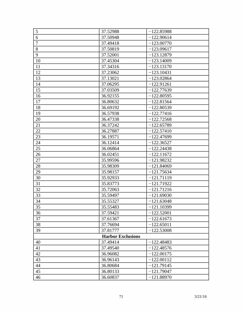
71 3/21/16
5 37.52988 −122.85988 6 37.50948 −122.90614 7 37.49418 −123.00770 8 37.50819 −123.09617 9 37.52001 −123.12879 10 37.45304 −123.14009 11 37.34316 −123.13170 12 37.23062 −123.10431 13 37.13021 −123.02864 14 37.06295 −122.91261 15 37.03509 −122.77639 16 36.92155 −122.80595 17 36.80632 −122.81564 18 36.69192 −122.80539 19 36.57938 −122.77416 20 36.47338 −122.72568 21 36.37242 −122.65789 22 36.27887 −122.57410 23 36.19571 −122.47699 24 36.12414 −122.36527 25 36.06864 −122.24438 26 36.02451 −122.11672 27 35.99596 −121.98232 28 35.98309 −121.84069 29 35.98157 −121.75634 30 35.92933 −121.71119 31 35.83773 −121.71922 32 35.72063 −121.71216 33 35.59497 −121.69030 34 35.55327 −121.63048 35 35.55483 −121.10399 36 37.59421 −122.52001 37 37.61367 −122.61673 38 37.76694 −122.65011 39 37.81777 −122.53008
Harbor Exclusions 40 37.49414 −122.48483 41 37.49540 −122.48576 42 36.96082 −122.00175 43 36.96143 −122.00112 44 36.80684 −121.79145 45 36.80133 −121.79047 46 36.60837 −121.88970
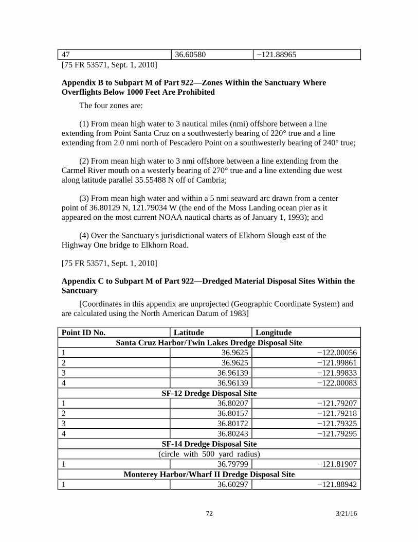
72 3/21/16
47 36.60580 −121.88965 [75 FR 53571, Sept. 1, 2010]
Appendix B to Subpart M of Part 922—Zones Within the Sanctuary Where Overflights Below 1000 Feet Are Prohibited
The four zones are:
(1) From mean high water to 3 nautical miles (nmi) offshore between a line extending from Point Santa Cruz on a southwesterly bearing of 220° true and a line extending from 2.0 nmi north of Pescadero Point on a southwesterly bearing of 240° true;
(2) From mean high water to 3 nmi offshore between a line extending from the Carmel River mouth on a westerly bearing of 270° true and a line extending due west along latitude parallel 35.55488 N off of Cambria;
(3) From mean high water and within a 5 nmi seaward arc drawn from a center point of 36.80129 N, 121.79034 W (the end of the Moss Landing ocean pier as it appeared on the most current NOAA nautical charts as of January 1, 1993); and
(4) Over the Sanctuary's jurisdictional waters of Elkhorn Slough east of the Highway One bridge to Elkhorn Road.
[75 FR 53571, Sept. 1, 2010]
Appendix C to Subpart M of Part 922—Dredged Material Disposal Sites Within the Sanctuary
[Coordinates in this appendix are unprojected (Geographic Coordinate System) and are calculated using the North American Datum of 1983]
Point ID No. Latitude Longitude Santa Cruz Harbor/Twin Lakes Dredge Disposal Site
1 36.9625 −122.00056 2 36.9625 −121.99861 3 36.96139 −121.99833 4 36.96139 −122.00083
SF-12 Dredge Disposal Site 1 36.80207 −121.79207 2 36.80157 −121.79218 3 36.80172 −121.79325 4 36.80243 −121.79295
SF-14 Dredge Disposal Site (circle with 500 yard radius)
1 36.79799 −121.81907 Monterey Harbor/Wharf II Dredge Disposal Site
1 36.60297 −121.88942
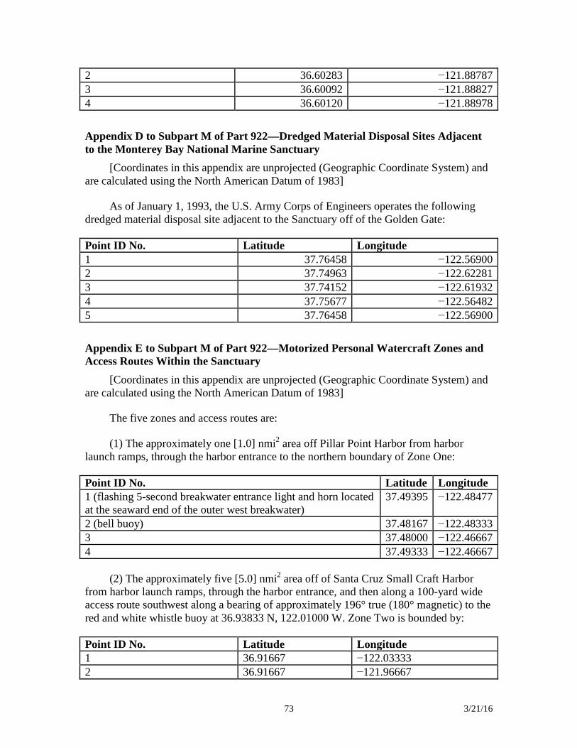
73 3/21/16
2 36.60283 −121.88787 3 36.60092 −121.88827 4 36.60120 −121.88978 Appendix D to Subpart M of Part 922—Dredged Material Disposal Sites Adjacent to the Monterey Bay National Marine Sanctuary
[Coordinates in this appendix are unprojected (Geographic Coordinate System) and are calculated using the North American Datum of 1983]
As of January 1, 1993, the U.S. Army Corps of Engineers operates the following dredged material disposal site adjacent to the Sanctuary off of the Golden Gate:
Point ID No. Latitude Longitude 1 37.76458 −122.56900 2 37.74963 −122.62281 3 37.74152 −122.61932 4 37.75677 −122.56482 5 37.76458 −122.56900 Appendix E to Subpart M of Part 922—Motorized Personal Watercraft Zones and Access Routes Within the Sanctuary
[Coordinates in this appendix are unprojected (Geographic Coordinate System) and are calculated using the North American Datum of 1983]
The five zones and access routes are:
(1) The approximately one [1.0] nmi2 area off Pillar Point Harbor from harbor launch ramps, through the harbor entrance to the northern boundary of Zone One:
Point ID No. Latitude Longitude 1 (flashing 5-second breakwater entrance light and horn located at the seaward end of the outer west breakwater)
37.49395 −122.48477
2 (bell buoy) 37.48167 −122.48333 3 37.48000 −122.46667 4 37.49333 −122.46667
(2) The approximately five [5.0] nmi2 area off of Santa Cruz Small Craft Harbor
from harbor launch ramps, through the harbor entrance, and then along a 100-yard wide access route southwest along a bearing of approximately 196° true (180° magnetic) to the red and white whistle buoy at 36.93833 N, 122.01000 W. Zone Two is bounded by:
Point ID No. Latitude Longitude 1 36.91667 −122.03333 2 36.91667 −121.96667
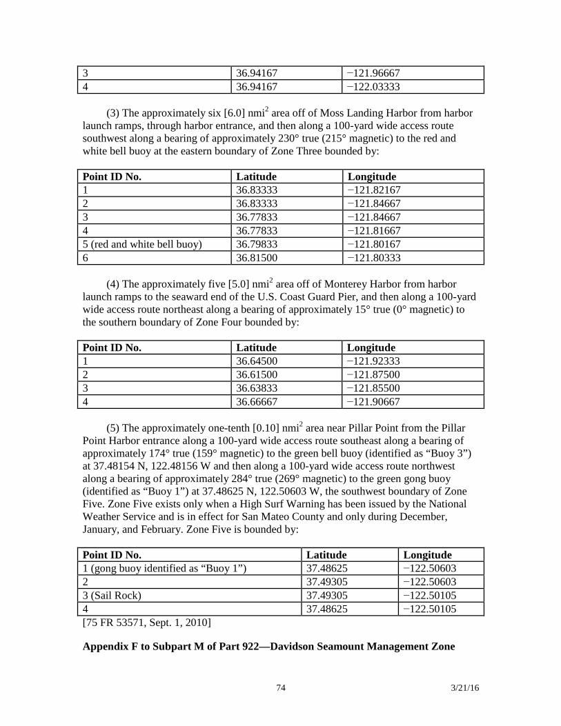
74 3/21/16
3 36.94167 −121.96667 4 36.94167 −122.03333
(3) The approximately six [6.0] nmi2 area off of Moss Landing Harbor from harbor
launch ramps, through harbor entrance, and then along a 100-yard wide access route southwest along a bearing of approximately 230° true (215° magnetic) to the red and white bell buoy at the eastern boundary of Zone Three bounded by:
Point ID No. Latitude Longitude 1 36.83333 −121.82167 2 36.83333 −121.84667 3 36.77833 −121.84667 4 36.77833 −121.81667 5 (red and white bell buoy) 36.79833 −121.80167 6 36.81500 −121.80333
(4) The approximately five [5.0] nmi2 area off of Monterey Harbor from harbor
launch ramps to the seaward end of the U.S. Coast Guard Pier, and then along a 100-yard wide access route northeast along a bearing of approximately 15° true (0° magnetic) to the southern boundary of Zone Four bounded by:
Point ID No. Latitude Longitude 1 36.64500 −121.92333 2 36.61500 −121.87500 3 36.63833 −121.85500 4 36.66667 −121.90667
(5) The approximately one-tenth [0.10] nmi2 area near Pillar Point from the Pillar
Point Harbor entrance along a 100-yard wide access route southeast along a bearing of approximately 174° true (159° magnetic) to the green bell buoy (identified as “Buoy 3”) at 37.48154 N, 122.48156 W and then along a 100-yard wide access route northwest along a bearing of approximately 284° true (269° magnetic) to the green gong buoy (identified as “Buoy 1”) at 37.48625 N, 122.50603 W, the southwest boundary of Zone Five. Zone Five exists only when a High Surf Warning has been issued by the National Weather Service and is in effect for San Mateo County and only during December, January, and February. Zone Five is bounded by:
Point ID No. Latitude Longitude 1 (gong buoy identified as “Buoy 1”) 37.48625 −122.50603 2 37.49305 −122.50603 3 (Sail Rock) 37.49305 −122.50105 4 37.48625 −122.50105 [75 FR 53571, Sept. 1, 2010]
Appendix F to Subpart M of Part 922—Davidson Seamount Management Zone
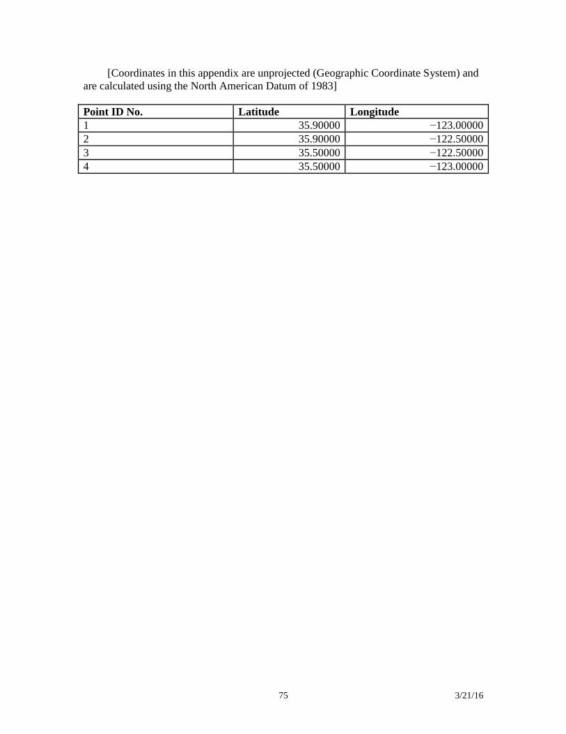
75 3/21/16
[Coordinates in this appendix are unprojected (Geographic Coordinate System) and are calculated using the North American Datum of 1983]
Point ID No. Latitude Longitude 1 35.90000 −123.00000 2 35.90000 −122.50000 3 35.50000 −122.50000 4 35.50000 −123.00000
76 3/21/16
Channel Islands National Marine Sanctuary Regulations Title 15: Commerce and Foreign Trade Part 922 – National Marine Sanctuary Program Regulations § 922.70 Boundary.
The Channel Islands National Marine Sanctuary (Sanctuary) consists of an area of approximately 1,110 square nautical miles (nmi) of coastal and ocean waters, and the submerged lands thereunder, off the southern coast of California. The Sanctuary boundary begins at the Mean High Water Line of and extends seaward to a distance of approximately six nmi from the following islands and offshore rocks: San Miguel Island, Santa Cruz Island, Santa Rosa Island, Anacapa Island, Santa Barbara Island, Richardson Rock, and Castle Rock (the Islands). The seaward boundary coordinates are listed in Appendix A to this subpart.
§ 922.71 Definitions.
In addition to those definitions found at 15 CFR 922.3, the following definitions apply to this subpart:
Cruise ship means a vessel with 250 or more passenger berths for hire.
Graywater means galley, bath, or shower water.
Introduced species means any species (including but not limited to any of its biological matter capable of propagation) that is non-native to the ecosystems of the Sanctuary; or any organism into which altered genetic matter, or genetic matter from another species, has been transferred in order that the host organism acquires the genetic traits of the transferred genes.
Motorized personal watercraft means a vessel, usually less than 16 feet in length, which uses an inboard, internal combustion engine powering a water jet pump as its primary source of propulsion. The vessel is intended to be operated by a person or persons sitting, standing or kneeling on the vessel, rather than within the confines of the hull. The length is measured from end to end over the deck excluding sheer, meaning a straight line measurement of the overall length from the foremost part of the vessel to the aftermost part of the vessel, measured parallel to the centerline. Bow sprits, bumpkins, rudders, outboard motor brackets, and similar fittings or attachments, are not included in the measurement. Length is stated in feet and inches.
Oceangoing ship means a private, commercial, government, or military vessel of 300 gross registered tons or more, not including cruise ships.
Pelagic finfish are defined as: Northern anchovy (Engraulis mordax), barracudas
77 3/21/16
(Sphyraena spp.), billfishes (family Istiophoridae), dolphinfish (Coryphaena hippurus), Pacific herring (Clupea pallasi), jack mackerel (Trachurus symmetricus), Pacific mackerel (Scomber japonicus), salmon (Oncorhynchus spp.), Pacific sardine (Sardinops sagax), blue shark (Prionace glauca), salmon shark (Lamna ditropis), shortfin mako shark (Isurus oxyrinchus), thresher sharks (Alopias spp.), swordfish (Xiphias gladius), tunas (family Scombridae), and yellowtail (Seriola lalandi).
Stowed and not available for immediate use means not readily accessible for immediate use, e.g., by being securely covered and lashed to a deck or bulkhead, tied down, unbaited, unloaded, or partially disassembled (such as spear shafts being kept separate from spear guns)
§ 922.72 Prohibited or otherwise regulated activities—Sanctuary-wide.
(a) Except as specified in paragraphs (b) through (e) of this section, the following activities are prohibited and thus unlawful for any person to conduct or cause to be conducted:
(1) Exploring for, developing, or producing hydrocarbons within the Sanctuary, except pursuant to leases executed prior to March 30, 1981, and except the laying of pipeline pursuant to exploring for, developing, or producing hydrocarbons.
(2) Exploring for, developing, or producing minerals within the Sanctuary, except producing byproducts incidental to hydrocarbon production allowed by paragraph (a)(1) of this section.
(3)(i) Discharging or depositing from within or into the Sanctuary any material or other matter except:
(A) Fish, fish parts, or chumming materials (bait) used in or resulting from lawful fishing activity within the Sanctuary, provided that such discharge or deposit is during the conduct of lawful fishing activity within the Sanctuary;
(B) For a vessel less than 300 gross registered tons (GRT), or an oceangoing ship without sufficient holding tank capacity to hold sewage while within the Sanctuary, biodegradable effluent generated incidental to vessel use by an operable Type I or II marine sanitation device (U.S. Coast Guard classification) approved in accordance with section 312 of the Federal Water Pollution Control Act, as amended, (FWPCA), 33 U.S.C. 1321 et seq. Vessel operators must lock all marine sanitation devices in a manner that prevents discharge or deposit of untreated sewage;
(C) Biodegradable matter from:
(1) Vessel deck wash down;
78 3/21/16
(2) Vessel engine cooling water;
(3) Graywater from a vessel less than 300 gross registered tons;
(4) Graywater from an oceangoing ship without sufficient holding tank capacity to hold graywater while within the Sanctuary;
(D) Vessel engine or generator exhaust;
(E) Effluent routinely and necessarily discharged or deposited incidental to hydrocarbon exploration, development, or production allowed by paragraph (a)(1) of this section; or
(F) Discharge allowed under section 312(n) of the FWPCA.
(ii) Discharging or depositing from beyond the boundary of the Sanctuary any material or other matter that subsequently enters the Sanctuary and injures a Sanctuary resource or quality, except those listed in paragraphs (a)(3)(i)(B) through (F) of this section and fish, fish parts, or chumming materials (bait) used in or resulting from lawful fishing activity beyond the boundary of the Sanctuary, provided that such discharge or deposit is during the conduct of lawful fishing activity there.
(4) Drilling into, dredging, or otherwise altering the submerged lands of the Sanctuary; or constructing or placing any structure, material, or other matter on or in the submerged lands of the Sanctuary, except as incidental to and necessary to:
(i) Anchor a vessel;
(ii) Install an authorized navigational aid;
(iii) Conduct lawful fishing activity;
(iv) Lay pipeline pursuant to exploring for, developing, or producing hydrocarbons; or
(v) Explore for, develop, or produce hydrocarbons as allowed by paragraph (a)(1) of this section.
(5) Abandoning any structure, material, or other matter on or in the submerged lands of the Sanctuary.
(6) Except to transport persons or supplies to or from any Island, operating within one nmi of any Island any vessel engaged in the trade of carrying cargo, including, but not limited to, tankers and other bulk carriers and barges, any vessel engaged in the trade
79 3/21/16
of servicing offshore installations, or any vessel of three hundred gross registered tons or more, except fishing or kelp harvesting vessels.
(7) Disturbing a seabird or marine mammal by flying a motorized aircraft at less than 1,000 feet over the waters within one nautical mile of any Island, except (if allowed under paragraph (a)(9) of this section):
(i) to engage in kelp bed surveys; or
(ii) to transport persons or supplies to or from an Island.
(8) Moving, removing, injuring, or possessing, or attempting to move, remove, injure, or possess a Sanctuary historical resource.
(9) Taking any marine mammal, sea turtle, or seabird within or above the Sanctuary, except as authorized by the Marine Mammal Protection Act, as amended, (MMPA), 16 U.S.C. 1361 et seq., Endangered Species Act, as amended, (ESA), 16 U.S.C. 1531 et seq., Migratory Bird Treaty Act, as amended, (MBTA), 16 U.S.C. 703 et seq., or any regulation, as amended, promulgated under the MMPA, ESA, or MBTA.
(10) Possessing within the Sanctuary (regardless of where taken from, moved, or removed from) any marine mammal, sea turtle, or seabird, except as authorized by the MMPA, ESA, MBTA, or any regulation, as amended, promulgated under the MMPA, ESA, or MBTA.
(11) Marking, defacing, damaging, moving, removing, or tampering with any sign, notice, or placard, whether temporary or permanent, or any monument, stake, post, or other boundary marker related to the Sanctuary.
(12) Introducing or otherwise releasing from within or into the Sanctuary an introduced species, except striped bass (Morone saxatilis) released during catch and release fishing activity.
(13) Operating a motorized personal watercraft within waters of the Sanctuary that are coextensive with the Channel Islands National Park, established by 16 U.S.C. 410(ff).
(b) (1) The prohibitions in paragraphs (a)(3) through (13) of this section and in § 922.73 do not apply to military activities carried out by DOD as of the effective date of these regulations and specifically identified in section 3.5.9 (Department of Defense Activities) of the Final Channel Islands National Marine Sanctuary Management Plan/Final Environmental Impact Statement (FMP/FEIS), Volume II: Environmental Impact Statement, 2008, authored and published by NOAA (‘‘pre-existing activities’’). Copies of the document are available from the Channel Islands National Marine Sanctuary, 113 Harbor Way, Santa Barbara, CA 93109. Other military activities carried
80 3/21/16
out by DOD may be exempted by the Director after consultation between the Director and DOD.
(2) A military activity carried out by DOD as of the effective date of these regulations and specifically identified in the section entitled ‘‘Department of Defense Activities’’ of the FMP/FEIS is not considered a pre-existing activity if:
(i) It is modified in such a way that requires the preparation of an environmental assessment or environmental impact statement under the National Environmental Policy Act, 42 U.S.C. 4321 et seq., relevant to a Sanctuary resource or quality;
(ii) It is modified, including but not limited to changes in location or frequency, in such a way that its possible adverse effects on Sanctuary resources or qualities are significantly greater than previously considered for the unmodified activity;
(iii) It is modified, including but not limited to changes in location or frequency, in such a way that its possible adverse effects on Sanctuary resources or qualities are significantly different in manner than previously considered for the unmodified activity; or
(iv) There are new circumstances or information relevant to a Sanctuary resource or quality that were not addressed in the FMP/FEIS.
(3) In the event of destruction of, loss of, or injury to a Sanctuary resource or quality resulting from an incident, including, but not limited to, discharges, deposits, and groundings, caused by a DOD activity, DOD, in coordination with the Director, must promptly prevent and mitigate further damage and must restore or replace the Sanctuary resource or quality in a manner approved by the Director.
(4) All DOD activities must be carried out in a manner that avoids to the maximum extent practicable any adverse impacts on Sanctuary resources and qualities.
(c) The prohibitions in paragraphs (a)(3) through (10), (a)(12), and (a)(13) of this section and in § 922.73 do not apply to any activity conducted under and in accordance with the scope, purpose, terms, and conditions of a National Marine Sanctuary permit issued pursuant to 15 CFR 922.48 and 922.74.
(d) The prohibitions in paragraphs (a)(3) through (11) and (a)(13) of this section and in § 922.73 do not apply to any activity necessary to respond to an emergency threatening life, property, or the environment.
(e) The prohibitions in paragraphs (a)(3) through (11) and (a)(13) of this section and in § 922.73 do not apply to any activity necessary for valid law enforcement purposes in the Sanctuary.
81 3/21/16
§ 922.73 Additional prohibited or otherwise regulated activities—marine reserves and marine conservation area.
(a) Marine reserves. Unless prohibited by 50 CFR part 660 (Fisheries off West Coast States), the following activities are prohibited and thus unlawful for any person to conduct or cause to be conducted within a marine reserve described in Appendix B to this subpart, except as specified in paragraphs (b) through (e) of § 922.72:
(1) Harvesting, removing, taking, injuring, destroying, collecting, moving, or causing the loss of any Sanctuary resource, or attempting any of these activities.
(2) Possessing fishing gear on board a vessel unless such gear is stowed and not available for immediate use.
(3) Possessing any Sanctuary resource, except legally harvested fish on board a vessel at anchor or in transit.
(b) Marine conservation area. Unless prohibited by 50 CFR part 660 (Fisheries off West Coast States), the following activities are prohibited and thus unlawful for any person to conduct or cause to be conducted within the marine conservation area described in Appendix C to this subpart, except as specified in paragraphs (b) through (e) of § 922.72:
(1) Harvesting, removing, taking, injuring, destroying, collecting, moving, or causing the loss of any Sanctuary resource, or attempting any of these activities, except:
(i) Recreational fishing for pelagic finfish; or
(ii) Commercial and recreational fishing for lobster.
(2) Possessing fishing gear on board a vessel, except legal fishing gear used to fish for lobster or pelagic finfish, unless such gear is stowed and not available for immediate use.
(3) Possessing any Sanctuary resource, except legally harvested fish.
§ 922.74 Permit procedures and issuance criteria.
(a) A person may conduct an activity prohibited by § 922.72(a)(3) through (10), (a)(12), and (a)(13), and § 922.73, if such activity is specifically authorized by, and conducted in accordance with the scope, purpose, terms, and conditions of, a permit issued under § 922.48 and this section.
(b) The Director, at his or her sole discretion, may issue a permit, subject to terms
and conditions as he or she deems appropriate, to conduct an activity prohibited by §
82 3/21/16
922.72(a)(3) through (10), (a)(12), and (a)(13), and § 922.73, if the Director finds that the activity:
(1) Is appropriate research designed to further understanding of Sanctuary
resources and qualities; (2) Will further the educational value of the Sanctuary; (3) Will further salvage or recovery operations in or near the Sanctuary in
connection with a recent air or marine casualty; (4) Will assist in managing the Sanctuary; or (5) Will further salvage or recovery operations in connection with an abandoned
shipwreck in the Sanctuary title to which is held by the State of California. (c) The Director may not issue a permit under § 922.48 and this section unless the
Director also finds that: (1) The proposed activity will have at most short-term and negligible adverse
effects on Sanctuary resources and qualities; (2) The applicant is professionally qualified to conduct and complete the proposed
activity; (3) The applicant has adequate financial resources available to conduct and
complete the proposed activity; (4) The duration of the proposed activity is no longer than necessary to achieve its
stated purpose; (5) The methods and procedures proposed by the applicant are appropriate to
achieve the goals of the proposed activity, especially in relation to the potential effects of the proposed activity on Sanctuary resources and qualities;
(6) The proposed activity will be conducted in a manner compatible with the
primary objective of protection of Sanctuary resources and qualities, considering the extent to which the conduct of the activity may diminish or enhance Sanctuary resources and qualities, any potential indirect, secondary, or cumulative effects of the activity, and the duration of such effects;
(7) The proposed activity will be conducted in a manner compatible with the
value of the Sanctuary as a source of recreation and as a source of educational and scientific information, considering the extent to which the conduct of the activity may result in conflicts between different users of the Sanctuary and the duration of such effects;
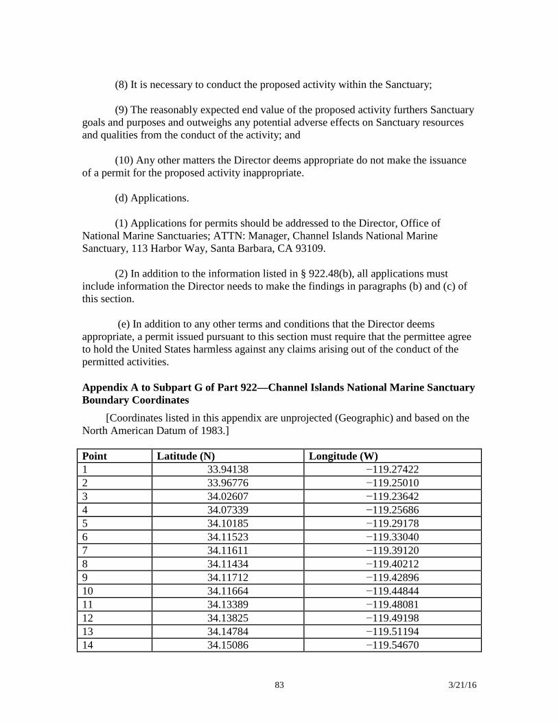
83 3/21/16
(8) It is necessary to conduct the proposed activity within the Sanctuary; (9) The reasonably expected end value of the proposed activity furthers Sanctuary
goals and purposes and outweighs any potential adverse effects on Sanctuary resources and qualities from the conduct of the activity; and
(10) Any other matters the Director deems appropriate do not make the issuance
of a permit for the proposed activity inappropriate. (d) Applications. (1) Applications for permits should be addressed to the Director, Office of
National Marine Sanctuaries; ATTN: Manager, Channel Islands National Marine Sanctuary, 113 Harbor Way, Santa Barbara, CA 93109.
(2) In addition to the information listed in § 922.48(b), all applications must
include information the Director needs to make the findings in paragraphs (b) and (c) of this section.
(e) In addition to any other terms and conditions that the Director deems
appropriate, a permit issued pursuant to this section must require that the permittee agree to hold the United States harmless against any claims arising out of the conduct of the permitted activities. Appendix A to Subpart G of Part 922—Channel Islands National Marine Sanctuary Boundary Coordinates
[Coordinates listed in this appendix are unprojected (Geographic) and based on the North American Datum of 1983.]
Point Latitude (N) Longitude (W) 1 33.94138 −119.27422 2 33.96776 −119.25010 3 34.02607 −119.23642 4 34.07339 −119.25686 5 34.10185 −119.29178 6 34.11523 −119.33040 7 34.11611 −119.39120 8 34.11434 −119.40212 9 34.11712 −119.42896 10 34.11664 −119.44844 11 34.13389 −119.48081 12 34.13825 −119.49198 13 34.14784 −119.51194 14 34.15086 −119.54670
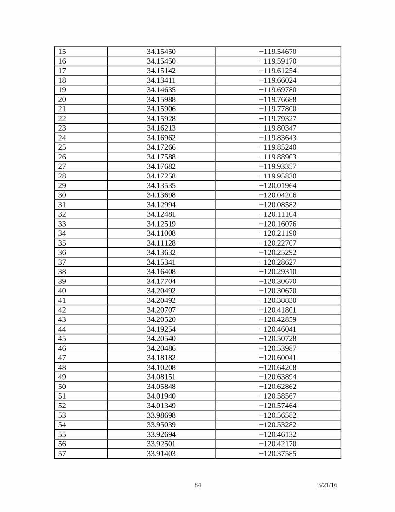
84 3/21/16
15 34.15450 −119.54670 16 34.15450 −119.59170 17 34.15142 −119.61254 18 34.13411 −119.66024 19 34.14635 −119.69780 20 34.15988 −119.76688 21 34.15906 −119.77800 22 34.15928 −119.79327 23 34.16213 −119.80347 24 34.16962 −119.83643 25 34.17266 −119.85240 26 34.17588 −119.88903 27 34.17682 −119.93357 28 34.17258 −119.95830 29 34.13535 −120.01964 30 34.13698 −120.04206 31 34.12994 −120.08582 32 34.12481 −120.11104 33 34.12519 −120.16076 34 34.11008 −120.21190 35 34.11128 −120.22707 36 34.13632 −120.25292 37 34.15341 −120.28627 38 34.16408 −120.29310 39 34.17704 −120.30670 40 34.20492 −120.30670 41 34.20492 −120.38830 42 34.20707 −120.41801 43 34.20520 −120.42859 44 34.19254 −120.46041 45 34.20540 −120.50728 46 34.20486 −120.53987 47 34.18182 −120.60041 48 34.10208 −120.64208 49 34.08151 −120.63894 50 34.05848 −120.62862 51 34.01940 −120.58567 52 34.01349 −120.57464 53 33.98698 −120.56582 54 33.95039 −120.53282 55 33.92694 −120.46132 56 33.92501 −120.42170 57 33.91403 −120.37585
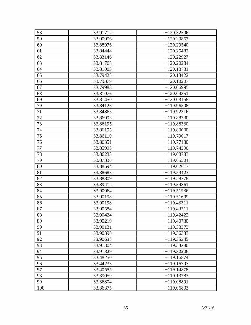
85 3/21/16
58 33.91712 −120.32506 59 33.90956 −120.30857 60 33.88976 −120.29540 61 33.84444 −120.25482 62 33.83146 −120.22927 63 33.81763 −120.20284 64 33.81003 −120.18731 65 33.79425 −120.13422 66 33.79379 −120.10207 67 33.79983 −120.06995 68 33.81076 −120.04351 69 33.81450 −120.03158 70 33.84125 −119.96508 71 33.84865 −119.92316 72 33.86993 −119.88330 73 33.86195 −119.88330 74 33.86195 −119.80000 75 33.86110 −119.79017 76 33.86351 −119.77130 77 33.85995 −119.74390 78 33.86233 −119.68783 79 33.87330 −119.65504 80 33.88594 −119.62617 81 33.88688 −119.59423 82 33.88809 −119.58278 83 33.89414 −119.54861 84 33.90064 −119.51936 85 33.90198 −119.51609 86 33.90198 −119.43311 87 33.90584 −119.43311 88 33.90424 −119.42422 89 33.90219 −119.40730 90 33.90131 −119.38373 91 33.90398 −119.36333 92 33.90635 −119.35345 93 33.91304 −119.33280 94 33.91829 −119.32206 95 33.48250 −119.16874 96 33.44235 −119.16797 97 33.40555 −119.14878 98 33.39059 −119.13283 99 33.36804 −119.08891 100 33.36375 −119.06803
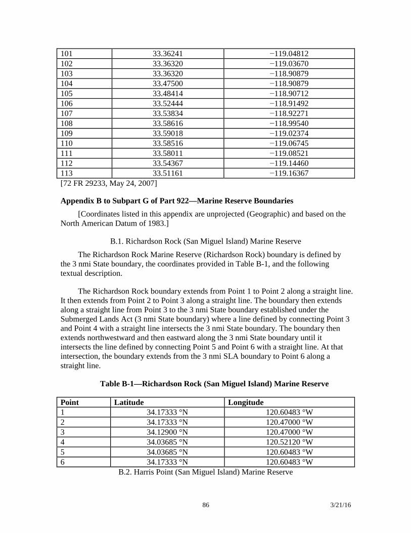
86 3/21/16
101 33.36241 −119.04812 102 33.36320 −119.03670 103 33.36320 −118.90879 104 33.47500 −118.90879 105 33.48414 −118.90712 106 33.52444 −118.91492 107 33.53834 −118.92271 108 33.58616 −118.99540 109 33.59018 −119.02374 110 33.58516 −119.06745 111 33.58011 −119.08521 112 33.54367 −119.14460 113 33.51161 −119.16367 [72 FR 29233, May 24, 2007]
Appendix B to Subpart G of Part 922—Marine Reserve Boundaries [Coordinates listed in this appendix are unprojected (Geographic) and based on the
North American Datum of 1983.]
B.1. Richardson Rock (San Miguel Island) Marine Reserve
The Richardson Rock Marine Reserve (Richardson Rock) boundary is defined by the 3 nmi State boundary, the coordinates provided in Table B-1, and the following textual description.
The Richardson Rock boundary extends from Point 1 to Point 2 along a straight line. It then extends from Point 2 to Point 3 along a straight line. The boundary then extends along a straight line from Point 3 to the 3 nmi State boundary established under the Submerged Lands Act (3 nmi State boundary) where a line defined by connecting Point 3 and Point 4 with a straight line intersects the 3 nmi State boundary. The boundary then extends northwestward and then eastward along the 3 nmi State boundary until it intersects the line defined by connecting Point 5 and Point 6 with a straight line. At that intersection, the boundary extends from the 3 nmi SLA boundary to Point 6 along a straight line.
Table B-1—Richardson Rock (San Miguel Island) Marine Reserve
Point Latitude Longitude 1 34.17333 °N 120.60483 °W 2 34.17333 °N 120.47000 °W 3 34.12900 °N 120.47000 °W 4 34.03685 °N 120.52120 °W 5 34.03685 °N 120.60483 °W 6 34.17333 °N 120.60483 °W
B.2. Harris Point (San Miguel Island) Marine Reserve
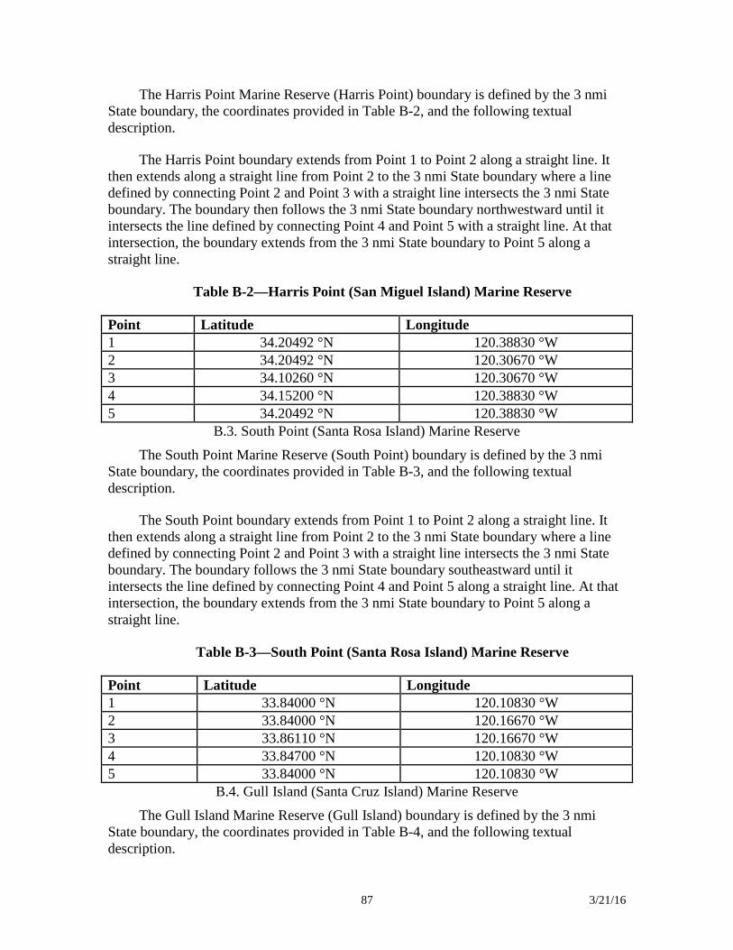
87 3/21/16
The Harris Point Marine Reserve (Harris Point) boundary is defined by the 3 nmi State boundary, the coordinates provided in Table B-2, and the following textual description.
The Harris Point boundary extends from Point 1 to Point 2 along a straight line. It then extends along a straight line from Point 2 to the 3 nmi State boundary where a line defined by connecting Point 2 and Point 3 with a straight line intersects the 3 nmi State boundary. The boundary then follows the 3 nmi State boundary northwestward until it intersects the line defined by connecting Point 4 and Point 5 with a straight line. At that intersection, the boundary extends from the 3 nmi State boundary to Point 5 along a straight line.
Table B-2—Harris Point (San Miguel Island) Marine Reserve
Point Latitude Longitude 1 34.20492 °N 120.38830 °W 2 34.20492 °N 120.30670 °W 3 34.10260 °N 120.30670 °W 4 34.15200 °N 120.38830 °W 5 34.20492 °N 120.38830 °W
B.3. South Point (Santa Rosa Island) Marine Reserve
The South Point Marine Reserve (South Point) boundary is defined by the 3 nmi State boundary, the coordinates provided in Table B-3, and the following textual description.
The South Point boundary extends from Point 1 to Point 2 along a straight line. It then extends along a straight line from Point 2 to the 3 nmi State boundary where a line defined by connecting Point 2 and Point 3 with a straight line intersects the 3 nmi State boundary. The boundary follows the 3 nmi State boundary southeastward until it intersects the line defined by connecting Point 4 and Point 5 along a straight line. At that intersection, the boundary extends from the 3 nmi State boundary to Point 5 along a straight line.
Table B-3—South Point (Santa Rosa Island) Marine Reserve
Point Latitude Longitude 1 33.84000 °N 120.10830 °W 2 33.84000 °N 120.16670 °W 3 33.86110 °N 120.16670 °W 4 33.84700 °N 120.10830 °W 5 33.84000 °N 120.10830 °W
B.4. Gull Island (Santa Cruz Island) Marine Reserve
The Gull Island Marine Reserve (Gull Island) boundary is defined by the 3 nmi State boundary, the coordinates provided in Table B-4, and the following textual description.
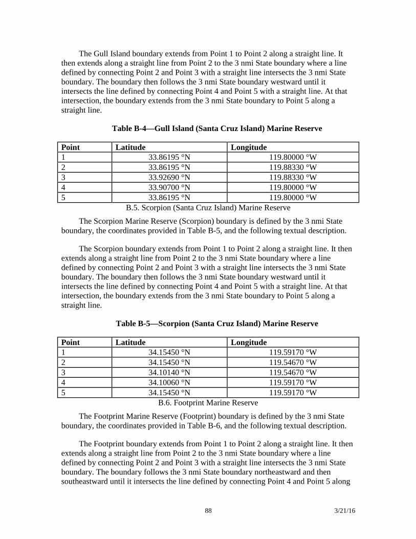
88 3/21/16
The Gull Island boundary extends from Point 1 to Point 2 along a straight line. It then extends along a straight line from Point 2 to the 3 nmi State boundary where a line defined by connecting Point 2 and Point 3 with a straight line intersects the 3 nmi State boundary. The boundary then follows the 3 nmi State boundary westward until it intersects the line defined by connecting Point 4 and Point 5 with a straight line. At that intersection, the boundary extends from the 3 nmi State boundary to Point 5 along a straight line.
Table B-4—Gull Island (Santa Cruz Island) Marine Reserve
Point Latitude Longitude 1 33.86195 °N 119.80000 °W 2 33.86195 °N 119.88330 °W 3 33.92690 °N 119.88330 °W 4 33.90700 °N 119.80000 °W 5 33.86195 °N 119.80000 °W
B.5. Scorpion (Santa Cruz Island) Marine Reserve
The Scorpion Marine Reserve (Scorpion) boundary is defined by the 3 nmi State boundary, the coordinates provided in Table B-5, and the following textual description.
The Scorpion boundary extends from Point 1 to Point 2 along a straight line. It then extends along a straight line from Point 2 to the 3 nmi State boundary where a line defined by connecting Point 2 and Point 3 with a straight line intersects the 3 nmi State boundary. The boundary then follows the 3 nmi State boundary westward until it intersects the line defined by connecting Point 4 and Point 5 with a straight line. At that intersection, the boundary extends from the 3 nmi State boundary to Point 5 along a straight line.
Table B-5—Scorpion (Santa Cruz Island) Marine Reserve
Point Latitude Longitude 1 34.15450 °N 119.59170 °W 2 34.15450 °N 119.54670 °W 3 34.10140 °N 119.54670 °W 4 34.10060 °N 119.59170 °W 5 34.15450 °N 119.59170 °W
B.6. Footprint Marine Reserve
The Footprint Marine Reserve (Footprint) boundary is defined by the 3 nmi State boundary, the coordinates provided in Table B-6, and the following textual description.
The Footprint boundary extends from Point 1 to Point 2 along a straight line. It then extends along a straight line from Point 2 to the 3 nmi State boundary where a line defined by connecting Point 2 and Point 3 with a straight line intersects the 3 nmi State boundary. The boundary follows the 3 nmi State boundary northeastward and then southeastward until it intersects the line defined by connecting Point 4 and Point 5 along
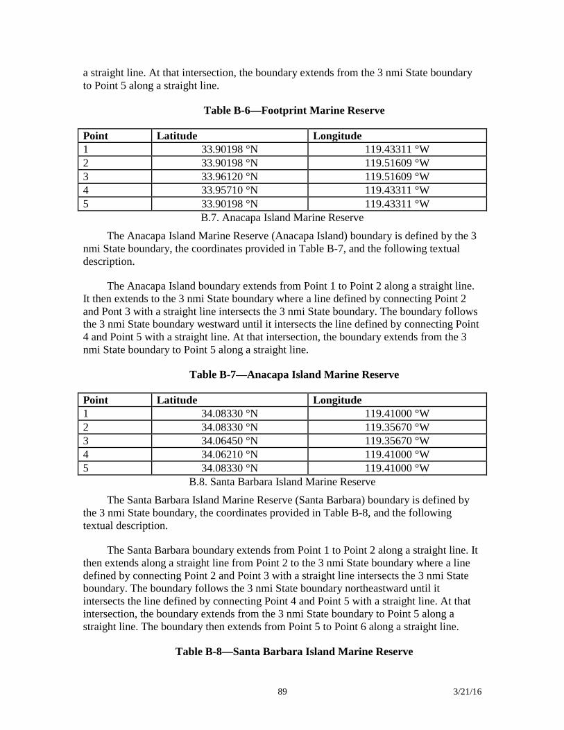
89 3/21/16
a straight line. At that intersection, the boundary extends from the 3 nmi State boundary to Point 5 along a straight line.
Table B-6—Footprint Marine Reserve
Point Latitude Longitude 1 33.90198 °N 119.43311 °W 2 33.90198 °N 119.51609 °W 3 33.96120 °N 119.51609 °W 4 33.95710 °N 119.43311 °W 5 33.90198 °N 119.43311 °W
B.7. Anacapa Island Marine Reserve
The Anacapa Island Marine Reserve (Anacapa Island) boundary is defined by the 3 nmi State boundary, the coordinates provided in Table B-7, and the following textual description.
The Anacapa Island boundary extends from Point 1 to Point 2 along a straight line. It then extends to the 3 nmi State boundary where a line defined by connecting Point 2 and Pont 3 with a straight line intersects the 3 nmi State boundary. The boundary follows the 3 nmi State boundary westward until it intersects the line defined by connecting Point 4 and Point 5 with a straight line. At that intersection, the boundary extends from the 3 nmi State boundary to Point 5 along a straight line.
Table B-7—Anacapa Island Marine Reserve
Point Latitude Longitude 1 34.08330 °N 119.41000 °W 2 34.08330 °N 119.35670 °W 3 34.06450 °N 119.35670 °W 4 34.06210 °N 119.41000 °W 5 34.08330 °N 119.41000 °W
B.8. Santa Barbara Island Marine Reserve
The Santa Barbara Island Marine Reserve (Santa Barbara) boundary is defined by the 3 nmi State boundary, the coordinates provided in Table B-8, and the following textual description.
The Santa Barbara boundary extends from Point 1 to Point 2 along a straight line. It then extends along a straight line from Point 2 to the 3 nmi State boundary where a line defined by connecting Point 2 and Point 3 with a straight line intersects the 3 nmi State boundary. The boundary follows the 3 nmi State boundary northeastward until it intersects the line defined by connecting Point 4 and Point 5 with a straight line. At that intersection, the boundary extends from the 3 nmi State boundary to Point 5 along a straight line. The boundary then extends from Point 5 to Point 6 along a straight line.
Table B-8—Santa Barbara Island Marine Reserve
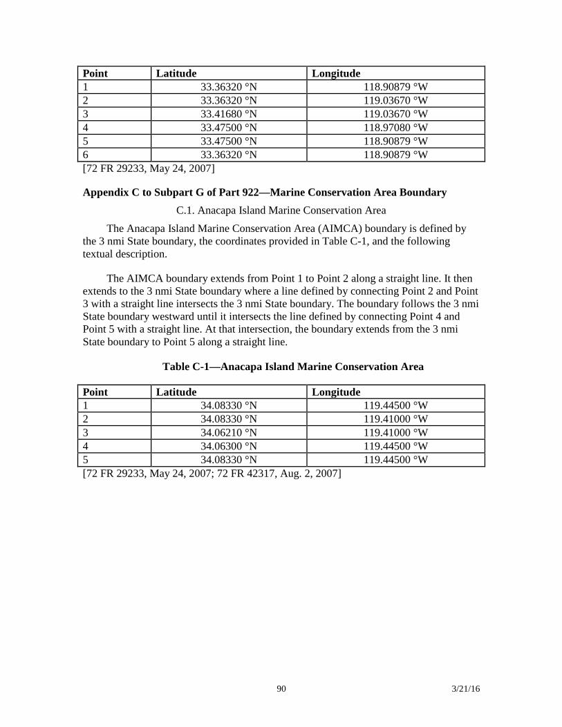
90 3/21/16
Point Latitude Longitude 1 33.36320 °N 118.90879 °W 2 33.36320 °N 119.03670 °W 3 33.41680 °N 119.03670 °W 4 33.47500 °N 118.97080 °W 5 33.47500 °N 118.90879 °W 6 33.36320 °N 118.90879 °W [72 FR 29233, May 24, 2007]
Appendix C to Subpart G of Part 922—Marine Conservation Area Boundary C.1. Anacapa Island Marine Conservation Area
The Anacapa Island Marine Conservation Area (AIMCA) boundary is defined by the 3 nmi State boundary, the coordinates provided in Table C-1, and the following textual description.
The AIMCA boundary extends from Point 1 to Point 2 along a straight line. It then extends to the 3 nmi State boundary where a line defined by connecting Point 2 and Point 3 with a straight line intersects the 3 nmi State boundary. The boundary follows the 3 nmi State boundary westward until it intersects the line defined by connecting Point 4 and Point 5 with a straight line. At that intersection, the boundary extends from the 3 nmi State boundary to Point 5 along a straight line.
Table C-1—Anacapa Island Marine Conservation Area
Point Latitude Longitude 1 34.08330 °N 119.44500 °W 2 34.08330 °N 119.41000 °W 3 34.06210 °N 119.41000 °W 4 34.06300 °N 119.44500 °W 5 34.08330 °N 119.44500 °W [72 FR 29233, May 24, 2007; 72 FR 42317, Aug. 2, 2007]
91 3/21/16
Relevant Final Rules from Federal Register
92 3/21/16
Olympic Coast National Marine Sanctuary Designates Olympic Coast NMS and issues final implementing regulations.
http://sanctuaries.noaa.gov/management/fr/59_fr_24586.pdf (05/11/1994) * Provides notice of the effective date for the regulations for Olympic Coast NMS as July 22, 1994.
http://sanctuaries.noaa.gov/management/fr/59_fr_51104.pdf (10/07/1994) Corrects the boundary coordinates published in Appendix A to the regulations for Olympic Coast NMS.
http://sanctuaries.noaa.gov/management/fr/60_fr_9294.pdf (02/17/1995) Amends the existing Area to be Avoided off the Washington Coast to include all vessels of 1,600 gross tons and above solely in transit in accordance with the IMO’s adoption of MSC 75/24, para 6.7.4 on May 29, 2002.
http://sanctuaries.noaa.gov/management/fr/67_fr_70933.pdf (11/27/2002) NOAA published a final rule and a final revised management plan for Olympic Coast National Marine Sanctuary.
http://sanctuaries.noaa.gov/management/fr/76_fr_67348.pdf (11/01/2011) Revised regulations for Channel Islands, Monterey Bay, Gulf of the Farallones, and Olympic Coast National Marine Sanctuaries, requiring motorized aircraft maintain certain minimum altitudes above specified locations within the boundaries of the listed sanctuaries.
http://sanctuaries.noaa.gov/management/fr/77fr3919.pdf (01/26/2012) Olympic Coast National Marine Sanctuary Final Rule correcting permitting regulations from 2011. http://sanctuaries.noaa.gov/management/fr/80fr11111.pdf (03/02/2015) Cordell Bank National Marine Sanctuary Issues final designation and regulations for Cordell Bank NMS.
http://sanctuaries.noaa.gov/management/fr/54_fr_22417.pdf (05/24/1989) * Revises the regulations for Cordell Bank NMS prohibit oil, gas, and minerals exploration/development throughout the sanctuary.
http://sanctuaries.noaa.gov/management/fr/54_fr_52342.pdf (12/21/1989) Clarifies the effective date of the regulations for Cordell Bank NMS as July 31, 1989.
http://sanctuaries.noaa.gov/management/fr/55_fr_49994.pdf (12/04/1990) Corrects the boundary coordinates for Cordell Bank NMS.
http://sanctuaries.noaa.gov/management/fr/61_fr_51577.pdf (10/03/1996)
93 3/21/16
Final rule as part of the JMPR for Cordell Bank, Gulf of the Farallones, and Monterey Bay National Marine Sanctuaries.
http://sanctuaries.noaa.gov/management/fr/73_fr_70488.pdf (11/02/2008)
Effective date for revised regulations for Gulf of the Farallones, Monterey Bay, and Cordell Bank national marine sanctuaries on November 20, 2008 (73 FR 70488).
http://sanctuaries.noaa.gov/management/fr/74_fr_12088.pdf (03/23/2009) Notice of Intent to Prepare a DEIS for Expansion of Gulf of the Farallones and Cordell Bank National Marine Sanctuaries.
http://sanctuaries.noaa.gov/management/fr/77fr75601.pdf (12/21/2012) Correction to Notice of Intent to Prepare a DEIS for Expansion of Gulf of the Farallones and Cordell Bank National Marine Sanctuaries. http://sanctuaries.noaa.gov/management/fr/78fr1778.pdf (01/09/2013) Proposed Rule for Expansion of Gulf of the Farallones and Cordell Bank National Marine Sanctuaries.
http://sanctuaries.noaa.gov/management/fr/79fr20982.pdf (04/14/2014) Final Environmental Impact Statement for Cordell Bank and Gulf of the Farallones National Marine Sanctuaries Expansion. http://www.gpo.gov/fdsys/pkg/FR-2014-12-19/pdf/2014-29784.pdf (12/19/14) Expansion of Gulf of the Farallones and Cordell Bank National Marine Sanctuaries, and Regulatory Changes; Final Rule. http://sanctuaries.noaa.gov/management/fr/80fr13078.pdf (03/12/2015) Expansion of Gulf of the Farallones and Cordell Bank National Marine Sanctuaries, and Regulatory Changes; Name Change. http://sanctuaries.noaa.gov/management/fr/80fr34047.pdf (06/15/2015) Greater Farallones National Marine Sanctuary Announces final designation date of Point Reyes-Farallon Islands NMS as January 16, 1981 and issues final regulations to implement the designation.
http://sanctuaries.noaa.gov/management/fr/46_fr_7936.pdf (01/26/1981) * Provides the effective date for regulations on oil and gas activities for Point Reyes-Farallon Islands and Channel Islands NMSs as March 30, 1982.
http://sanctuaries.noaa.gov/management/fr/47_fr_18588.pdf (04/30/1982) Changes the official name of Point Reyes/Farallon Islands NMS to the Gulf of the Farallones NMS.
94 3/21/16
http://sanctuaries.noaa.gov/management/fr/62_fr_3788.pdf (01/27/1997) Amends the notice changing the name of Point Reyes/Farallon Islands NMS to Gulf of the Farallones NMS and to change the acronym from PRNMS to GFNMS.
http://sanctuaries.noaa.gov/management/fr/62_fr_67723.pdf (12/30/1997)
Final rule banning the use of motorized personal watercraft in Gulf of the Farallones NMS.
http://sanctuaries.noaa.gov/management/fr/66_fr_46942.pdf (09/10/2001) Final rule as part of the JMPR for Cordell Bank, Gulf of the Farallones, and Monterey Bay National Marine Sanctuaries.
http://sanctuaries.noaa.gov/management/fr/73_fr_70488.pdf (11/02/2008) Effective date for revised regulations for Gulf of the Farallones, Monterey Bay, and Cordell Bank national marine sanctuaries on November 20, 2008 (73 FR 70488).
http://sanctuaries.noaa.gov/management/fr/74_fr_12088.pdf (03/23/2009) Gulf of the Farallones, Monterey Bay and Cordell Bank national marine sanctuaries Technical Corrections.
http://sanctuaries.noaa.gov/management/fr/75_fr_53567.pdf (09/01/2010) Revised regulations for Channel Islands, Monterey Bay, Gulf of the Farallones, and Olympic Coast National Marine Sanctuaries, requiring motorized aircraft maintain certain minimum altitudes above specified locations within the boundaries of the listed sanctuaries.
http://sanctuaries.noaa.gov/management/fr/77fr3919.pdf (01/26/2012) Notice of Intent to Prepare a DEIS for Expansion of Gulf of the Farallones and Cordell Bank National Marine Sanctuaries.
http://sanctuaries.noaa.gov/management/fr/77fr75601.pdf (12/21/2012) Correction to Notice of Intent to Prepare a DEIS for Expansion of Gulf of the Farallones and Cordell Bank National Marine Sanctuaries. http://sanctuaries.noaa.gov/management/fr/78fr1778.pdf (01/09/2013) Notice of Proposed Rulemaking. Gulf of the Farallones and Monterey Bay National Marine Sanctuaries Regulations on Introduced Species.
http://sanctuaries.noaa.gov/management/fr/78fr16622.pdf (03/08/2013) Notice of Proposed Rulemaking: Withdrawal. Gulf of the Farallones and Monterey Bay National Marine Sanctuaries Regulations on Introduced Species.
http://sanctuaries.noaa.gov/management/fr/78fr16628.pdf (03/18/2013)
95 3/21/16
Draft Programmatic Environmental Assessment of Potential White Shark Research and Education Projects in the Gulf of the Farallones and Monterey Bay National Marine Sanctuaries.
http://sanctuaries.noaa.gov/management/fr/79fr15960.pdf (03/24/2014) Gulf of the Farallones and Monterey Bay National Marine Sanctuaries Regulations on Introduced Species.
http://sanctuaries.noaa.gov/management/fr/79fr17073.pdf (03/27/2014) Proposed Rule for Expansion of Gulf of the Farallones and Cordell Bank National Marine Sanctuaries.
http://sanctuaries.noaa.gov/management/fr/79fr20982.pdf (04/14/2014) Gulf of the Farallones and Monterey Bay National Marine Sanctuaries Regulations on Introduced Species.
http://sanctuaries.noaa.gov/management/fr/79fr21658.pdf (04/17/2014) Final Environmental Impact Statement for Cordell Bank and Gulf of the Farallones National Marine Sanctuaries Expansion. http://www.gpo.gov/fdsys/pkg/FR-2014-12-19/pdf/2014-29784.pdf (12/19/14) Gulf of the Farallones and Monterey Bay National Marine Sanctuaries Regulations on Introduced Species. http://sanctuaries.noaa.gov/management/fr/80fr8778.pdf (02/19/2015) Expansion of Gulf of the Farallones and Cordell Bank National Marine Sanctuaries, and Regulatory Changes; Final Rule. http://sanctuaries.noaa.gov/management/fr/80fr13078.pdf (03/12/2015) GFNMS and MBNMS Regulations on Introduced Species; Notification of Effective Date. http://sanctuaries.noaa.gov/management/fr/80fr30614.pdf (05/29/2015) Expansion of Gulf of the Farallones and Cordell Bank National Marine Sanctuaries, and Regulatory Changes; Name Change. http://sanctuaries.noaa.gov/management/fr/80fr34047.pdf (06/15/2015) Monterey Bay National Marine Sanctuary Designates Monterey Bay NMS and issues final implementing regulations.
http://sanctuaries.noaa.gov/management/fr/57_fr_43309.pdf (09/18/1992) * Provides notice of the effective date of the regulations for Monterey Bay NMS as January 1, 1993.
http://sanctuaries.noaa.gov/management/fr/57_fr_55444.pdf (11/25/1992)
96 3/21/16
Clarifies and modifies the boundary of the motorized personal watercraft (jet ski) zones and access routes in Monterey Bay NMS.
http://sanctuaries.noaa.gov/management/fr/61_fr_14963.pdf (04/04/1996) Issues new regulation to prohibit the attraction of white sharks within 3 miles of shore in Monterey Bay NMS.
http://sanctuaries.noaa.gov/management/fr/61_fr_66913.pdf (12/19/1996) Amends the regulations for Monterey Bay NMS to allow the delegation of authority to object to or impose terms or conditions on the exercise of any valid lease, permit, license, approval or other authorization issued after January 1, 1993 (the effective date of the MBNMS designation) to other Federal officials below the Director's level.
http://sanctuaries.noaa.gov/management/fr/62_fr_62693.pdf (11/25/1997) Issues a final regulation allowing for limited collection of jade within Monterey Bay NMS.
http://sanctuaries.noaa.gov/management/fr/63_fr_15083.pdf (03/30/1998) Provides notice of July 6, 1998 effective date for jade collection rule.
http://sanctuaries.noaa.gov/management/fr/63_fr_36339.pdf (07/06/1998) Final rule as part of the JMPR for Cordell Bank, Gulf of the Farallones, and Monterey Bay National Marine Sanctuaries.
http://sanctuaries.noaa.gov/management/fr/73_fr_70488.pdf (11/02/2008) Effective date for revised regulations for Gulf of the Farallones, Monterey Bay, and Cordell Bank national marine sanctuaries on November 20, 2008 (73 FR 70488).
http://sanctuaries.noaa.gov/management/fr/74_fr_12088.pdf (03/23/2009) Gulf of the Farallones, Monterey Bay and Cordell Bank national marine sanctuaries Technical Corrections.
http://sanctuaries.noaa.gov/management/fr/75_fr_53567.pdf (09/01/2010) Revised regulations for Channel Islands, Monterey Bay, Gulf of the Farallones, and Olympic Coast National Marine Sanctuaries, requiring motorized aircraft maintain certain minimum altitudes above specified locations within the boundaries of the listed sanctuaries.
http://sanctuaries.noaa.gov/management/fr/77fr3919.pdf (01/26/2012) Notice of Intent to Prepare a DEIS for Expansion of Monterey Bay National Marine Sanctuary.
http://sanctuaries.noaa.gov/management/fr/77fr46985.pdf (08/07/2012) Notice of Proposed Rulemaking. Gulf of the Farallones and Monterey Bay National Marine Sanctuaries Regulations on Introduced Species.
http://sanctuaries.noaa.gov/management/fr/78fr16622.pdf (03/08/2013)
97 3/21/16
Notice of Proposed Rulemaking: Withdrawal. Gulf of the Farallones and Monterey Bay National Marine Sanctuaries Regulations on Introduced Species.
http://sanctuaries.noaa.gov/management/fr/78fr16628.pdf (03/18/2013) Draft Programmatic Environmental Assessment of Potential White Shark Research and Education Projects in the Gulf of the Farallones and Monterey Bay National Marine Sanctuaries.
http://sanctuaries.noaa.gov/management/fr/79fr15960.pdf (03/24/2014) Gulf of the Farallones and Monterey Bay National Marine Sanctuaries Regulations on Introduced Species.
http://sanctuaries.noaa.gov/management/fr/79fr17073.pdf (03/27/2014) Gulf of the Farallones and Monterey Bay National Marine Sanctuaries Regulations on Introduced Species.
http://sanctuaries.noaa.gov/management/fr/79fr21658.pdf (04/17/2014) Gulf of the Farallones and Monterey Bay National Marine Sanctuaries Regulations on Introduced Species. http://sanctuaries.noaa.gov/management/fr/80fr8778.pdf (02/19/2015) GFNMS and MBNMS Regulations on Introduced Species; Notification of Effective Date. http://sanctuaries.noaa.gov/management/fr/80fr30614.pdf (05/29/2015) Proposed Monterey Bay Regional Water Project Desalination Facility; Intent To Prepare a Draft Environmental Impact Statement; Scoping Meeting. http://sanctuaries.noaa.gov/management/fr/80fr31022.pdf (06/01/2015) Proposed Monterey Peninsula Water Supply Project; Intent To Prepare a Draft Environmental Impact Statement; Scoping Meeting. http://sanctuaries.noaa.gov/management/fr/80fr51787.pdf (08/26/2015) Initiation of Review of Management Plan and Regulations of the Monterey Bay National Marine Sanctuary; Intent to Conduct Scoping and Prepare Draft Environmental Impact Statement and Management Plan. http://sanctuaries.noaa.gov/management/fr/80fr51973.pdf (08/27/2015) Channel Islands National Marine Sanctuary Announces final designation date of Channel Islands NMS as September 22, 1980 and issues final regulations to implement the designation.
http://sanctuaries.noaa.gov/management/fr/45_fr_65198.pdf (10/02/1980) * Provides the effective date for regulations on oil and gas activities for Point Reyes-Farallon Islands and Channel Islands NMSs as March 30, 1982.
98 3/21/16
http://sanctuaries.noaa.gov/management/fr/47_fr_18588.pdf (04/30/1982) Issues final regulations to establish marine reserves and a marine conservation area in Channel Islands National Marine Sanctuary.
http://sanctuaries.noaa.gov/management/fr/72_fr_29208.pdf (05/24/2007) Announcement confirms the effective date of the final rule for this conservation area, published on May 24, 2007 (72 FR 29208), took effect on July 29, 2007.
http://sanctuaries.noaa.gov/management/fr/72_fr_45320.pdf (08/14/2007) This Channel Islands NMS final rule revises the regulations to implement several new prohibitions, makes additional changes to the grammar and wording of several sections of the regulations to ensure clarity, and publishes the sanctuary's revised terms of designation.
http://sanctuaries.noaa.gov/management/fr/74_fr_3216.pdf (01/16/2009) NOAA published a final revised management plan and revised regulations for Channel Islands NMS January 16, 2009 (74 FR 3216). This document provides notice of the effective date, March 19, 2009.
http://sanctuaries.noaa.gov/management/fr/74_fr_12087.pdf (03/23/2009) Revised regulations for Channel Islands, Monterey Bay, Gulf of the Farallones, and Olympic Coast National Marine Sanctuaries, requiring motorized aircraft maintain certain minimum altitudes above specified locations within the boundaries of the listed sanctuaries.
http://sanctuaries.noaa.gov/management/fr/77fr3919.pdf (01/26/2012) * sanctuary designation