WENHAM RECONNAISSANCE REPORT
22
WENHAM RECONNAISSANCE REPORT ESSEX COUNTY LANDSCAPE INVENTORY MASSACHUSETTS HERITAGE LANDSCAPE INVENTORY PROGRAM Massachusetts Department of Conservation and Recreation Essex National Heritage Commission
Transcript of WENHAM RECONNAISSANCE REPORT
WENHAM RECONNAISSANCE REPORT
ESSEX COUNTY LANDSCAPE INVENTORY
MASSACHUSETTS HERITAGE LANDSCAPE INVENTORY PROGRAM
Massachusetts Department of Conservation and Recreation
Essex National Heritage Commission
PROJECT TEAM Massachusetts Department of Conservation and Recreation Jessica Rowcroft, Preservation Planner Division of Planning and Engineering Essex National Heritage Commission Bill Steelman, Director of Heritage Preservation Project Consultants Shary Page Berg Gretchen G. Schuler Virginia Adams, PAL Local Project Coordinator Jim Howard Al Klebe Local Heritage Landscape Participants Albie Dodge Lucy Sprague Frederiksen Peter Hersee Jim Howard Al Klebe Oscar Martin Katherine McMillan Virginia Rogers May 2005
Massachusetts Heritage Landscape Inventory Program Wenham Reconnaissance Report
1
INTRODUCTION Essex County is known for its unusually rich and varied landscapes, which are represented in each of its 34 municipalities. Heritage landscapes are places that are created by human interaction with the natural environment. They are dynamic and evolving; they reflect the history of the community and provide a sense of place; they show the natural ecology that influenced land use patterns; and they often have scenic qualities. This wealth of landscapes is central to each community’s character; yet heritage landscapes are vulnerable and ever changing. For this reason it is important to take the first steps towards their preservation by identifying those landscapes that are particularly valued by the community – a favorite local farm, a distinctive neighborhood or mill village, a unique natural feature, an inland river corridor or the rocky coast. To this end, the Massachusetts Department of Conservation and Recreation (DCR) and the Essex National Heritage Commission (ENHC) have collaborated to bring the Heritage Landscape Inventory program (HLI) to communities in Essex County. The primary goal of the program is to help communities identify a wide range of landscape resources, particularly those that are significant and unprotected. The focus is on landscapes that have not been identified in previous survey efforts in a given community. Another important goal of the program is to provide communities with strategies for preserving heritage landscapes. The methodology for the Heritage Landscape Inventory program was developed in a Pilot Project conducted in southeast Massachusetts. It is outlined in the DCR publication Reading the Land which has provided guidance for the program in Essex County. In short, each participating community appoints a Local Project Coordinator (LPC) to assist the DCR-ENHC consulting team. The LPC organizes a heritage landscape identification meeting at which interested residents and town officials offer community input by identifying potential heritage landscapes. This meeting is followed by a fieldwork session including the consulting team and the LPC, usually accompanied by other community members. This group visits the priority landscapes identified in the meeting and gathers information about the community. The final product is the Reconnaissance Report, prepared for each participating community. It outlines the history of the community; identifies the resources and documentation that provide background information; provides a short description of the priority heritage landscapes visited; discusses planning issues identified by the community; and concludes with a brief discussion of survey and planning recommendations. A list of all of the heritage landscapes identified by the community is included in the Appendix. WENHAM HISTORY
Wenham's inland location and its distinctive landscape features — hills, lakes, swamps and river corridors — were instrumental in shaping the history of the community from the earliest Native American use of the land to the present day.
Massachusetts Heritage Landscape Inventory Program Wenham Reconnaissance Report
2
Prior to European settlement, Native Americans probably inhabited the area around Wenham Lake and Wenham Swamp but no Native American sites have been positively identified in Wenham to date. English colonists arrived in Wenham around 1635. The area was initially part of Salem but was incorporated as an independent town in 1643. The first meetinghouse was built in 1641. Wenham remained primarily agricultural through the 19th century, although there were small shoe shops in town that did piece work for factories in Danvers and Lynn. Arrival of the railroad in 1838 changed the character of the community, causing a period of rapid growth. A leather industry was established and major building took place in the vicinity of the common and along Main Street (Route 1A) where commercial activities began to cluster. Agriculture was supplemented by shoe manufacture and ice cutting from Wenham Lake, which continued into the 20th century. Arrival of the streetcar in 1887 actually detracted from Wenham's economy by making larger commercial centers in adjacent communities more accessible. In the late 19th century, wealthy families, drawn by the town's rural character and its proximity to Boston, converted large farms to country estates with carriage roads and equestrian trails. Growth during the 20th century was slow until the 1940s when construction of Route 128 spurred residential development throughout southern Essex County. The number of residents has increased substantially in the past 50 years to a current population of roughly 4,400, but Wenham remains predominantly residential, with little industry and business in town. Most residents value the rural small-town feeling of the community and wish to see it preserved.
Massachusetts Heritage Landscape Inventory Program Wenham Reconnaissance Report
3
RESOURCES AND DOCUMENTATION
This section of the Reconnaissance Report identifies planning documents and tools that provide information relevant to the Heritage Landscape Inventory program. Inventory of Historic Assets The Massachusetts Historical Commission’s (MHC) Inventory of Historic and Archaeological Assets is a statewide list that identifies significant historic resources throughout the Commonwealth. In order to be included in the inventory, a property must be documented on an MHC inventory form, which is then entered into the MHC database. This searchable database, known as MACRIS, is now available on line at http://www.sec.state.ma.us/mhc. Wenham’s MHC inventory, one of the smallest among Essex County communities, documents 118 properties date from 1658 to 1970. It includes primarily residential properties located along Main Street and focuses on buildings constructed prior to the mid-19th century. Most of the inventory forms were completed in the early 1970s and do not meet current standards for documentation of historic resources. State and National Registers of Historic Places The National Register of Historic Places is the official federal list of districts, sites, buildings, structures and objects that have been determined significant in American history, architecture, archaeology, engineering and culture. The Wenham Historic District, which is listed in the National Register of Historic Places, was established in 1973 with 101 resources. It extends along Main Street (Route 1A) from the Beverly line on the south to the Hamilton line on the north. Seven buildings including the Claflin-Richards house (Wenham Museum) at 132 Main Street are also individually listed in the National Register. The other six are part of a statewide thematic listing of First Period buildings. All National Register listings are also included in the State Register. Local Historic District Local historic districts, which are administered at the municipal level, are special areas within a community where the distinctive characteristics of buildings and places are preserved and protected by a local historic district commission. The Wenham Historic District, established in 1973 with 101 resources, extends along Main Street (Route 1A) from the Beverly line on the south to the Hamilton line on the north. It has the same boundaries as the National Register district of the same name. Properties within local historic districts are automatically listed in the State Register of Historic Places, even if not part of a National Register district.
Massachusetts Heritage Landscape Inventory Program Wenham Reconnaissance Report
4
Planning Documents Wenham's Open Space and Recreation Plan was last updated in 2001. Many of the resources listed in this Heritage Landscape report also are addressed in the plan. These include landscapes such as scenic roads and views; resources identified for potential protection such as rock outcrops, farms and open meadows; cultural resources, especially the Wenham Historic District; and areas of critical environmental concern such as watersheds and aquifers. The plan indicates that Wenham has approximately 1,200 acres of permanently protected conservation land and 262 acres of land under permanent conservation restriction on six estates, with additional acreage pending. It also identifies important unprotected open space parcels and promotes growth management strategies to preserve key parcels, including parcels that connect areas that have already been preserved. Planning Bylaws and Other Tools While most of the community is zoned for single family residential lots, cluster subdivisions with permanent open space are required for all subdivisions of three or more lots. In the early 1990s the town also adopted a residential open space community (ROSC) amendment to the zoning bylaw which permits smaller lot sizes and reduced frontage in exchange for preservation of separate open space lots within a subdivision. Three ROSC subdivisions with a total of 71 new lots and about 65 acres of open space have been approved to date. Cedar Street, Cherry Street, Larch Row and Walnut Road have been designated scenic roads under Massachusetts General Laws Ch. 40, sec. 15C. The town also placed a scenic easement on town lands that abut Route 128 to preserve the view of forested land from the highway.
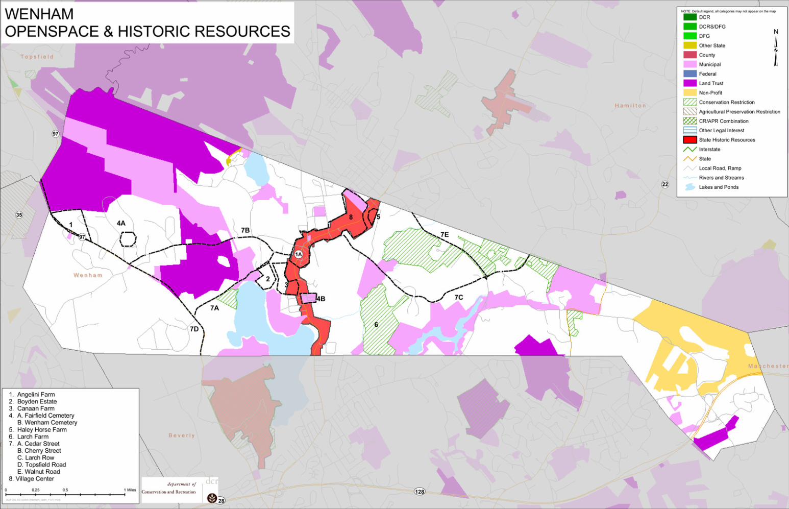
PRIORITY HERITAGE LANDSCAPES Wenham's Heritage Landscape Identification meeting, attended by approximately eight residents, some representing town boards and local non-profit organizations, was held on June 3, 2004. During the meeting residents compiled a lengthy list of the town's heritage landscapes, which is included in the Appendix. Once the comprehensive list was created, attendees were asked to articulate the value of each landscape and the issues relating to its preservation. Based on the information gathered, community members identified a group of priority heritage landscapes to be visited by the consulting team during the fieldwork. Each of the priority landscapes is highly valued, contributes to community character and is not permanently protected or preserved. This section describes the priority landscapes that are the focus of the reconnaissance work in Wenham. In most instances intensive survey work will be needed to fully document the physical characteristics and the historical development of the landscape. These heritage landscapes, which are listed alphabetically, represent a range of scales and types, from individual sites to scenic roads that are found throughout the community.
Massachusetts Heritage Landscape Inventory Program Wenham Reconnaissance Report
5
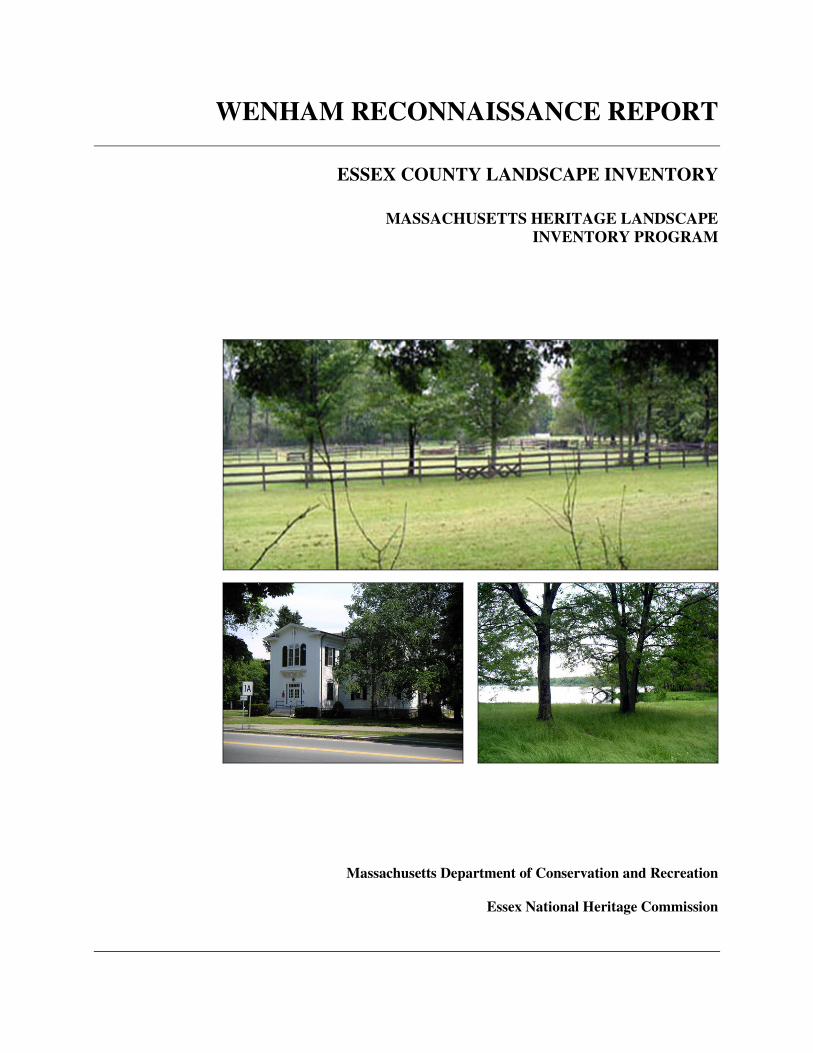
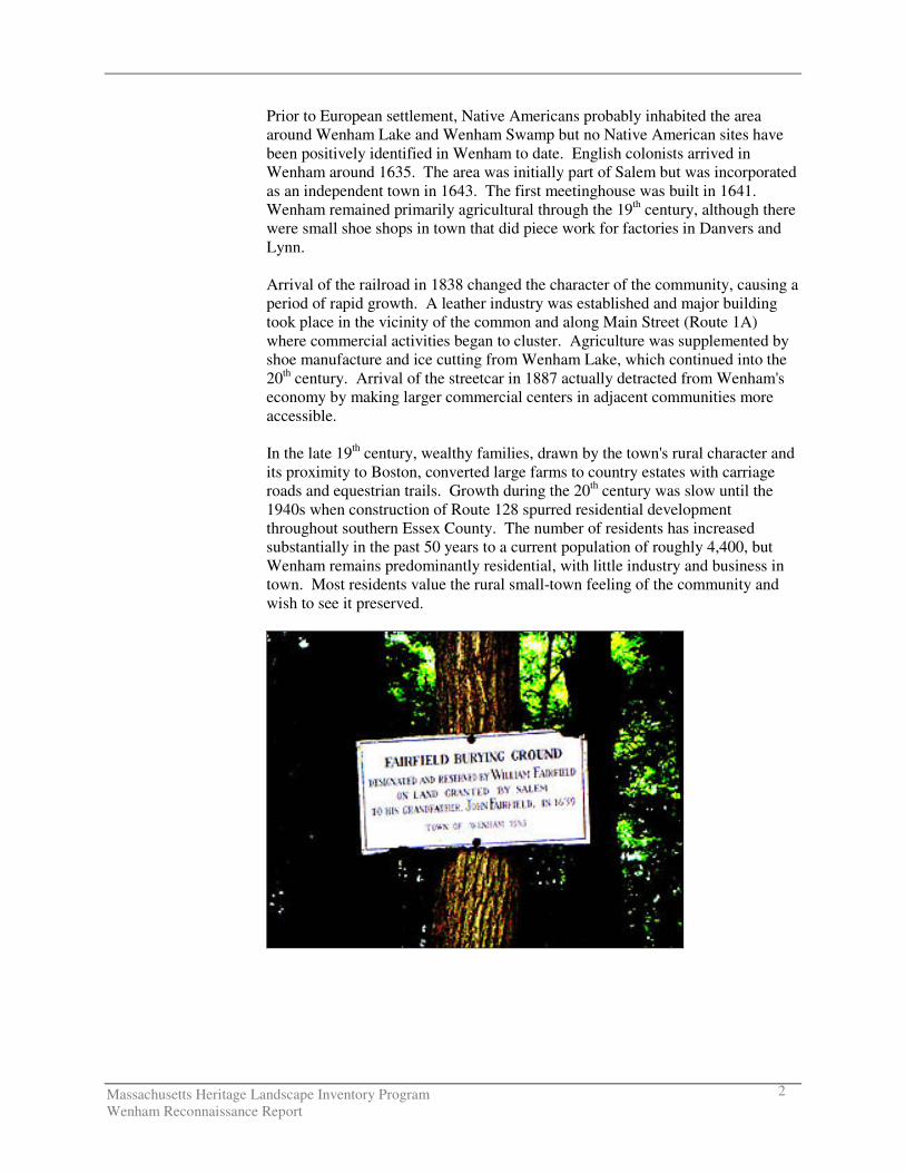
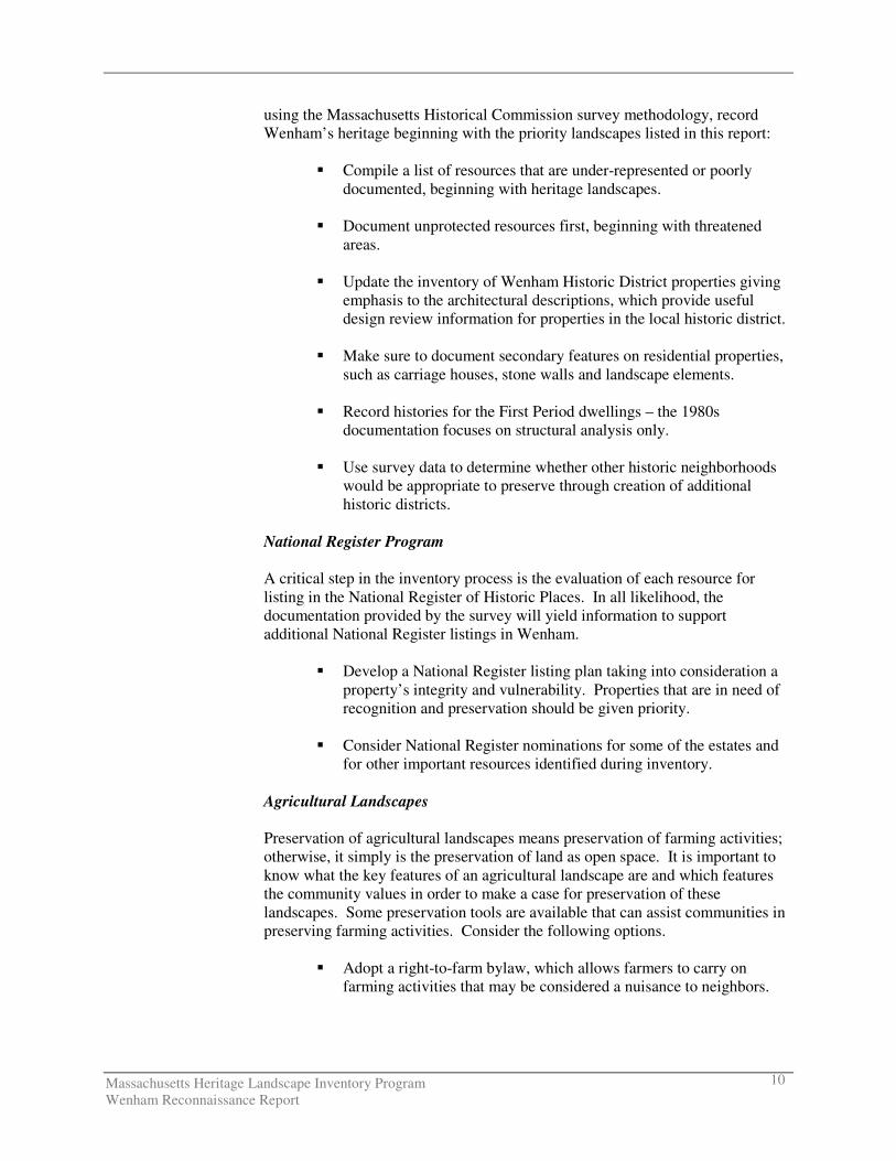
Angelini Farm The Angelini Farm, located on Topsfield Road (Route 97) in the western part of Wenham, is prominently sited on a hill overlooking Wenham Swamp. The farm is 18.6 acres, 12 of which are in Ch. 61A (agricultural use). The property includes a farmhouse and adjacent barn complex. The Angelinis grow primarily raspberries, corn and tomatoes, which are mostly sold to specialty markets in Boston. In the past the Angelinis also had a farm stand. The farm is one of the few in Wenham that remains in active agricultural use; it is prominently sited on a major road; it has panoramic views; and it lies adjacent to a major wetland and conservation area. Boyden Estate The Boyden estate on Cherry Street is a lakefront property with extensive frontage on the north shore of Wenham Lake. The estate landscape includes open lawns with mature specimen trees, rhododendrons, forested areas, carriage drives and farm fields. There is an early 20th century Georgian brick house at the end of a tree-lined drive. The property also includes a 12.7-acre field leased to Canaan Farm that is under a conservation restriction held by Essex County Greenbelt Association. The Boyden estate, which has recently been sold by its long-term owners, is significant to the community as one of the few remaining estates in Wenham; as an area with extensive lake frontage; and as a key property near the center of town. Canaan Farm Canaan Farm, prominently located on Main Street (Route 1A) a short distance south of the village center, is an active truck farm with fields and greenhouses. It sells vegetables, herbs, shrubs, bakery products, and also has a small convenience store. The farm includes 12.7 acres of leased fields that were formerly part of the Boyden estate and are now under a conservation restriction. Buildings associated with Canaan Farm include a late 19th century house, a large barn and several greenhouses. Canaan Farm is located in the Wenham Historic District. It is highly valued because it is the most visible and active farm in Wenham and because of its prominent location along Main Street near the town center. Fairfield Cemetery, Slave Burying Grounds, Wenham Cemetery Wenham's burial grounds are all considered priority heritage landscapes. The oldest is Wenham Cemetery on Main Street, which was established in 1681 and remains the community's primary burying ground today. The burial monuments found here reflect over 300 years of local history. Wenham Cemetery is listed on the National Register as part of the Wenham Historic District. The Fairfield Cemetery on William Fairfield Drive was established in 1691. It is a one-acre town-owned burial ground surrounded by private property. The site is wooded and receives limited maintenance. There are also two slave burial sites in Wenham. One is reportedly located on Dodges Row. The other is reportedly at the end of Boulder Lane near Gordon College where graves were moved in the 1920s. The town burial agent knows the exact locations.
Massachusetts Heritage Landscape Inventory Program Wenham Reconnaissance Report
6
Haley Horse Farm The Haley Horse Farm is located on Main Street (Route 1A) at the northern end of town opposite Pingree Field. It includes a seven-horse barn and scenic, highly visible fields with stone walls, post and rail fences and horse jumps. It is an important component of the equestrian activities centered in Wenham and adjacent Hamilton. It also functions as the northern anchor of the Wenham Historic District but is zoned commercial and lies adjacent to the Hamilton business district. Larch Farm Larch Farm at 33 Larch Row was the home of Colonel Timothy Pickering during the Colonial period. It includes a First Period dwelling listed on the National Register, as well as other residential and agricultural buildings that contribute to the overall character of the property. There are also significant landscape features that include wetlands, moraine, farm fields, hedge rows, a stone wall along Larch Row, and a distinctive planting of larch trees that commemorate the 13 colonies (11 of the 13 trees remain). The property, now owned by the Wilson family, still clearly reflects its long history as a farm and rural retreat. Portions have been given to the town as conservation land, some of which is now leased to a farmer who is growing corn on it. Scenic Roads Wenham's narrow, meandering tree-lined roads were mentioned by many residents as scenic and historic assets that contribute much to the character of the community. Cedar Street, Cherry Street, Larch Row and Walnut Road have been designated as scenic roads. Mature trees along roadways, some of which were originally part of estate plantings, contribute significantly to the character of the roads. Stone walls, especially the Burnham wall along Topsfield Road, built ca. 1912 as part of a former estate and the double stone wall on Larch Row, are considered particularly important to the town. Topsfield Road (Route 97) is scenic but cannot be designated a scenic road under Chapter 40-15C as it is a numbered route. Village Center and Wenham Historic District Wenham's Village Center extends along Main Street (Route 1A) from Cherry Street on the south to the Hamilton line on the north. Key features of the village center include Town Hall, the Wenham Museum, the common with Civil War monument, the Wenham Congregational Church, residences along Main Street, and Pingree Field and Haley Horse Farm at the northern end. The village center is included in the Wenham Historic District, a local and National Register District that also extends south along Route 1A to the Beverly line, incorporating the two golf courses, Wenham Cemetery, Canaan Farm, Wenham Lake and additional residential properties.
Massachusetts Heritage Landscape Inventory Program Wenham Reconnaissance Report
7
PLANNING
Preservation Strategies Wenham's rich and varied natural features played a critical role in the settlement and historical development of the community and remain among the town's most important assets. Wenham is also fortunate to have a rich collection of historic resources. The town has already taken important steps to preserve its most significant buildings and natural areas. Wenham is now looking beyond these resources to the other natural and cultural assets that define the overall fabric of the community. Like most Essex County municipalities, Wenham is under intense pressure for development. Special places such as farms, scenic roads, vistas and the historic village center that were once taken for granted are now more vulnerable than ever to change. Planning Issues In addition to the priority landscapes listed in the previous section, residents identified general issues related to heritage landscapes and community character. These issues are listed in alphabetical order. Community members also expressed interest in learning about preservation tools and strategies that have been effective in other Massachusetts communities and in identifying sources for preservation funding.
Agricultural Land and Subdivision of Estates The list of priority landscapes includes five agricultural and large residential properties. Many of Wenham's former farms and estates have already been subdivided or converted to institutional use. Large properties that remain are highly valued by the community, especially those that retain active agricultural use, have significant historic structures or are visible from public right of ways. Wenham's two most active farms are the Angelini Farm and the Canaan Farm.
Massachusetts Heritage Landscape Inventory Program Wenham Reconnaissance Report
8
Several farms along Larch Row and Maple Street produce smaller amounts of farm products for local sale. There are also two horse farms, Haley and Ledyard, which are visually important to the community and support active equestrian use in the area. Most other Wenham farms and estates are no longer in active cultivation but retain their rural and agricultural character to varying degrees. Loss of agricultural land and sub-division of large properties are two important concerns of the community. Burial Grounds and Cemeteries Wenham Cemetery has been expanded over the years and is still in active use, although a new cemetery is proposed. The cemetery is generally in good condition although there are stone conservation issues associated with older burial markers. The town's smaller burial areas are less well documented and receive less care. Fairfield Cemetery, a small burial ground that is no longer active, was documented on an MHC inventory form in the early 1970s. The area is overgrown and most of the burial markers are in poor condition. There are also reportedly two slave burials that were relocated in the 20th century. These are poorly documented and are not protected. Historic Trees Wenham has many distinctive older and memorial trees located throughout town, especially in the village center and along scenic roads. Former town arborist Al Dodge identified a number of significant trees in the Town Hall area.
� Tree in front of Museum � Japanese Lilac – in Memory of Mr. Higginson � Buismann Elm (special elm tree resistant to Dutch elm disease) � Pear tree at the corner of Friends Court in Memory of Arthur Trout � Large oak in memory of A. C. Fuller � Copper beech given by the Tarr Family � Pear tree in Memory of Dr. David Scott � Tree near the Post Office in Memory of Dean E. Cogswell
Scenic Roads Nearly all of Wenham's roads, especially the non-numbered routes, retain scenic qualities such as narrow road width, meandering alignment, stone walls along the roadway, mature trees, and scenic vistas of rural landscapes and historic homesteads. In many cases these qualities are being compromised either by changes to the road right-of-way itself through widening, straightening or increased curb cuts or by changes to adjacent features such as breaks in stone walls or loss of scenic vistas or trees. Detrimental impacts of traffic, particularly along Main Street, were also mentioned as a concern.
Massachusetts Heritage Landscape Inventory Program Wenham Reconnaissance Report
9
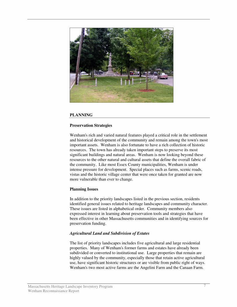
Village Center and Wenham Historic District Wenham residents are particularly proud of their village center and concerned about potential changes. One of the most critical issues identified by community members was possible demolition of the Town Hall to accommodate a new town hall on that site. The new building would be significantly larger and would substantially alter the character of the town center. Community members also expressed concern about the condition of the town common and Civil War monument, the impacts of traffic and parking on Main Street and the impacts of changes outside the town center (such as construction of wireless communication towers) on the center and the historic district. PLANNING RECOMMENDATIONS Preservation planning is a three-step process: identification, evaluation and protection. Four useful documents to consult before beginning to implement preservation strategies are the Massachusetts Historical Commission’s Survey Manual and Preservation through Bylaws and Ordinances; the Department of Conservation and Recreation’s Reading the Land; and the Essex National Heritage Commission’s Essex National Heritage Area Plan. Each publication provides necessary information for the identification, evaluation and protection of the rich cultural heritage of Massachusetts communities. General recommendations are listed first, followed by more specific recommendations.
Each community will have to determine the best way to implement the recommendations discussed below. One approach that might help Wenham begin the process is to form a Heritage Landscape Committee, as described in Reading the Land. General Recommendations Recommendations that apply to a broad range of resources are discussed below. The general recommendations are listed in the order in which they are most logically addressed when applying the three-step preservation planning process described above. Thus the goal will be to: (1) identify, (2) evaluate and (3) protect. Inventory of Heritage Landscapes and Other Historic Assets The vital first step in developing preservation strategies for heritage landscapes is to record information about the resources on MHC inventory forms. One cannot advocate for something unless one knows precisely what it is – the physical characteristics and the historical development. Plan to document all resources including those that have been recorded in the past, particularly those documented in the early 1970s because survey methodology has changed substantially since that time. New procedures are more comprehensive and link properties in a more coherent way than in the past. Furthermore, many of the areas for which documentation is appropriate may be considered as heritage landscapes, particularly farms, estates and residential neighborhoods. Thus,
Massachusetts Heritage Landscape Inventory Program Wenham Reconnaissance Report
10
using the Massachusetts Historical Commission survey methodology, record Wenham’s heritage beginning with the priority landscapes listed in this report:
� Compile a list of resources that are under-represented or poorly documented, beginning with heritage landscapes.
� Document unprotected resources first, beginning with threatened
areas.
� Update the inventory of Wenham Historic District properties giving emphasis to the architectural descriptions, which provide useful design review information for properties in the local historic district.
� Make sure to document secondary features on residential properties,
such as carriage houses, stone walls and landscape elements.
� Record histories for the First Period dwellings – the 1980s documentation focuses on structural analysis only.
� Use survey data to determine whether other historic neighborhoods
would be appropriate to preserve through creation of additional historic districts.
National Register Program A critical step in the inventory process is the evaluation of each resource for listing in the National Register of Historic Places. In all likelihood, the documentation provided by the survey will yield information to support additional National Register listings in Wenham.
� Develop a National Register listing plan taking into consideration a property’s integrity and vulnerability. Properties that are in need of recognition and preservation should be given priority.
� Consider National Register nominations for some of the estates and
for other important resources identified during inventory. Agricultural Landscapes Preservation of agricultural landscapes means preservation of farming activities; otherwise, it simply is the preservation of land as open space. It is important to know what the key features of an agricultural landscape are and which features the community values in order to make a case for preservation of these landscapes. Some preservation tools are available that can assist communities in preserving farming activities. Consider the following options.
� Adopt a right-to-farm bylaw, which allows farmers to carry on farming activities that may be considered a nuisance to neighbors.
Massachusetts Heritage Landscape Inventory Program Wenham Reconnaissance Report
11
� Adopt a cluster bylaw that requires a buffer between development and farmland.
� Use the Community Preservation Act as a source of funds to
purchase development rights on farms or to assist a farmer in the restoration of historic farm buildings.
� Continue public-private partnerships to preserve farmland through
purchase, conservation restrictions or agricultural preservation restrictions.
Burial Grounds and Cemeteries Wenham has several burial areas for which the town is responsible. The documentation and preservation needs vary for each site. The DCR publication Preservation Guidelines for Municipally Owned Historic Burial Grounds and Cemeteries provides guidance on developing preservation plans for burial grounds, including identification and evaluation of the resources as well as preservation strategies. Using this guide Wenham should:
� Update existing inventory forms for Wenham and Fairfield Cemeteries. Prepare inventory forms for slave burials.
� List eligible burial grounds and cemeteries in the National Register
of Historic Places. (Wenham Cemetery is already listed as part of the Wenham Historic District.)
� Develop a preservation and management plan for each burial ground.
Heritage Trees Wenham has a strong tradition of arboriculture, which is represented by a number of memorial trees (described above), many mature specimen trees along the town's roadways and distinctive plantings associated with particular estates. These are highly valued by the community.
� Document large trees or trees with special significance.
Massachusetts Heritage Landscape Inventory Program Wenham Reconnaissance Report
12
� Establish a tree preservation bylaw. � Pursue some of the grant programs offered for tree stewardship and
care through DCR's Urban and Community Forestry Program, which can be found through their website: http://www.mass/gov/dcr/stewardship/forestry/urban/index.htm.
Scenic Roads Scenic roads are an integral feature of the historic fabric of the community. They are highly valued by Wenham residents and visitors alike. Yet roads must also accommodate modern transportation needs and decisions regarding roadways are often made with travel requirements as the only consideration. The Scenic Roads Act (MGL Chapter 40-15C) only addresses removal of trees and stone walls that are within the public right-of-way. Yet, in addition to roadway issues, much of what we value about scenic roads — privately owned stone walls, views across open fields — is not within the public right-of-way. This is an important distinction and requires more than one approach. Also, numbered routes cannot be designated as scenic roads under Chapter 40-15C.
� Review list of designated scenic roads. Identify other roads in the community that should be considered as potential scenic roads. Develop a list of possible additions with descriptions and photo documentation. Use this as the basis for designation of additional scenic roads, particularly those in rural/agricultural areas.
� Amend Scenic Roads Bylaw to include design criteria to be
considered when approving removal of trees and stone walls. Add other design criteria such as a provision allowing only one driveway cut per property on scenic roads. Coordinate procedures between Highway Department and Planning Board.
� Modify ROSC overlay to reinforce preservation of important views
by establishing a no-disturb buffer on private property bordering on scenic roads or adopting flexible zoning standards to protect certain views. Such bylaws could be written to apply to the numbered routes also, which are not protected under the Scenic Roads Bylaw.
� Develop policies and implementation standards for road maintenance
and reconstruction, including bridge reconstructions, which address the scenic and historic characteristics while also addressing safety. This is an important public process in which the community may have to accept responsibility for certain costs to implement standards that are not acceptable to projects funded by Mass. Highway Department. Such standards should have a section addressing the way in which the local Highway Department maintains roads, for example requiring a public hearing if any additional pavement is to be added to a town road during reconstruction or repair. Policies can be adopted by local boards having jurisdiction over roads, or can be adopted at Town Meeting through a bylaw. In developing policies
Massachusetts Heritage Landscape Inventory Program Wenham Reconnaissance Report
13
consider factors such as road width, clearing of shoulders, walking paths and posted speeds. A delicate balance is required.
Funding of Preservation Projects Funding for preservation projects is an important aspect of implementing preservation strategies. In recent years, the ENHC has maintained a small grants program for Essex County communities. In addition, both the MHC and the DCR have had funding programs to assist communities in preservation related issues including:
� Survey and Planning Grants administered by the MHC support survey, National Register and preservation planning work.
� The Massachusetts Preservation Projects Fund (MPPF) administered
by the MHC funds restoration and rehabilitation projects.
� The Historic Landscape Preservation Grant Program (HLPGP) administered by DCR funds planning, rehabilitation, education and stewardship projects focused on historic landscapes, including cemeteries.
Funding for state programs varies from year to year. When planning Wenham’s heritage landscape inventory program, contact relevant agencies to determine whether funding is available. Towns that have adopted the Community Preservation Act (CPA) find it to be an excellent funding source for many heritage landscape projects; however Wenham first would have to adopt the Act. While tricky to pass in lean economic times, the number and types of projects that are benefiting across the Commonwealth is worthy of consideration. The CPA establishes a mechanism by which towns can develop a fund dedicated to historic preservation, open space and affordable housing. Funds are collected through a .5% to 3% surcharge on each annual real estate tax bill. The Commonwealth has established a dedicated fund which is used to match the municipality’s collections under the CPA. Adoption of the Community Preservation Act, by a majority vote on a ballot question, fosters partnerships among historic preservationists, conservationists and affordable housing advocates. At least 10% of the funds must be used to preserve historic resources; at least 10% must be used to protect open space; and at least 10% must be used to advance affordable housing. The remaining 70% must be used for one of these three uses as well as recreational needs and can be distributed in varying proportions depending upon the projects that the town believes are appropriate and beneficial to the municipality. Information about the CPA can be found at www.communitypreservation.org. Towns, like Wenham, which have a local historic district bylaw, may apply for Certified Local Government (CLG) status which is granted by the National Park Service through the MHC. After the town completes an application and is accepted as a CLG, it files a report yearly on the status of applications, meetings
Massachusetts Heritage Landscape Inventory Program Wenham Reconnaissance Report
14
and decisions. In return the town is eligible for federal funding that is distributed by the MHC. The matching funds are competitive; however the MHC must pass along a proportion of its federally allocated annual funding to CLGs through its Survey and Planning Grant program. Specific Recommendations Town Hall Wenham's Town Hall is a significant feature of the village center. It sets the stage architecturally in terms of size, scale, building type and style. Its relationship to the common and the church is highly significant in creating community character. Demolition of the Town Hall would have a substantial and irreversible negative impact on the village center and the Wenham Historic District. If the town decides to pursue this option, it would need to make a foolproof case to the Historic District Commission as such a decision would open them up to challenge.
� Conduct needs assessment and feasibility study for reuse of Town Hall and other town-owned historic buildings including Center School currently being used for temporary town offices. If Town Hall can not be modified to meet current needs as a municipal building, adaptively use an existing building or build a new town hall in a less sensitive site and explore other uses that would preserve the appearance and character of current town hall.
Village Center and Wenham Historic District The Wenham Historic District was established over 30 years ago. While it has been a valuable tool for the community, there are ways to strengthen the effectiveness of the historic district.
� Develop design review guidelines for the local historic district. Review bylaw to be sure that the Historic District Commission can and does review fences and walls, driveways, terraces and walkways. Consider expanding district to include entire parcels of land, particularly if visible from the public way, rather than just frontage along street.
� Develop a preservation restriction program with the local historical
society or other non-profit group that is willing to accept this challenge. Develop a step-by-step guide on how to donate or sell a preservation restriction including a sample restriction. State the benefits to the property owner and to the community. Contact the Community Preservation Coalition to learn how other communities are using preservation restrictions to protect certain properties.
Massachusetts Heritage Landscape Inventory Program Wenham Reconnaissance Report
15
� Review the zoning bylaw and subdivision regulations to determine whether there are incentives to preserve historic structures. Often the opposite is the case – such regulations generally are more easily followed if one gets rid of the historic structure. Consider flexible zoning bylaw to address important natural features and historic properties.
CONCLUSION The Wenham Reconnaissance Report is a critical tool in starting to identify the rich and diverse heritage landscapes in Wenham and in beginning to think about preservation strategies. However, it is only the first step in the planning process. Landscapes identified in this report, especially the priority landscapes, will typically need further documentation on MHC inventory forms. The documentation in turn can be used in publicity efforts to build consensus and gather public support for their preservation. Implementation of recommendations will require a concerted effort of and partnerships with municipal boards and agencies, local non-profits, and state agencies and commissions. Distribution of this Reconnaissance Report to town land use boards and commissions will assist in making this one of the planning documents that guides Wenham in preserving important features of the community’s character. The tasks that are recommended will require cooperation and coordination among boards and commissions, particularly Wenham's Historic District Commission, Planning Board and Conservation Commission. It also is advisable to present this information to the Board of Selectmen, the applicant to the Heritage Landscape Inventory Program on behalf of the town. Finally distribution of the report to the Historical Society, neighborhood associations, and any other preservation minded organizations will broaden the audience and assist in gathering interest and support for Wenham's heritage landscapes.
Massachusetts Heritage Landscape Inventory Program Wenham Reconnaissance Report
16
APPENDIX: HERITAGE LANDSCAPES IDENTIFIED BY COMMUNITY This list is a summary of all landscapes discussed at the Heritage Landscape Identification meeting held in Wenham on June 2 and follow-up fieldwork on June 7, 2004. This is a working list and can be updated by the community. There may be other heritage landscapes that were not identified at the HLI meeting noted above. The chart has two columns – the name and location of the resource are in the first, notes about the resource are in the second. Landscapes are grouped by land use category. Abbreviations used are listed below. APR = Agricultural Preservation Restriction CR = Conservation Restriction LHD = Local Historic District NR = National Register PR = Preservation Restriction * = Priority Landscape TTOR = The Trustees of Reservations All LHD listings refer to the Wenham Historic District.
Agriculture
Angelini Farm * Topsfield Road
18.6 acre working farm, 12 acres in Ch. 61A. Top of hill, great views towards Wenham Swamp, adjacent to Audubon land, clayey soil. Crops: raspberries, corn and tomatoes. In “Chicken Hill” area where there were once many poultry farms.
Burnett Farm Maple Street
24.63 acres in Ch. 61 (forestry), 28.68 acres in Ch. 61A (agriculture). No longer actively farmed.
Canaan Farm * Main Street
NR District, LHD. 14.9-acre active truck farm with fields, farmhouse, barn, greenhouses and small convenience store. Sells vegetables, herbs, shrubs and bakery products. Some land leased from Boyden Estate.
Dodge Farm Larch Row
No longer an active farm. Conservation restriction on 76.85 acres. Adjacent to land owned by Salem/Beverly Water Commission.
Haley Horse Farm * Main Street
NR District, LHD. Zoned commercial. Scenic, highly visible parcel opposite Pingree Field, includes seven-horse barn and fields.
Ledyard Farm 82-88 Walnut Street
CR on most of farm. Includes 32-horse barn, pastures, paddocks and combined training-cross country courses. U.S. Equestrian Team trains here. Original main house demolished, northern part of former farm now occupied by private residences on Sias Lane. Bounded by Miles River on northwest and part of southwest. Current owner is grandson of original owner. Sledding hill on western end of property is used by local children.
Old Farm 9 Maple Street
House is NR IND and TRA. 150 acres, 100 acres in 61B (recreational), front is wet, includes First Period house, remnants of Ellen Shipman garden and some ornamental plantings. Owned by Streeter family. Some fields planted by caretaker. Acreage with house is 18.3 acres, with 17.3 acres in Ch. 61A (agriculture).
Wm Fairfield Lots Wm. Fairfield Drive & Topsfield Road
Five-acre open field on site of former chicken farm. Temporary restriction placed on field when adjacent area was developed, now nearly expired?

Massachusetts Heritage Landscape Inventory Program Wenham Reconnaissance Report
17
Burial Grounds and Cemeteries
Fairfield Cemetery * Wm. Fairfield Drive
Established 1691. One-acre town-owned burial ground surrounded by private property. Burial place of William Fairfield. Site is wooded, receives limited maintenance.
Slave Burying * Grounds
One slave burial area is reportedly on Dodges Row. The other is reportedly at end of Boulder Lane near Gordon College where graves were moved in the 1920s. Burial agent knows exact locations.
Wenham Cemetery * Main Street
NR District, LHD. Established 1681. Active, although a new cemetery is proposed. Oldest section shows some monument conservation issues. New sections generally well cared for.
Civic
Village Center * NR District, LHD. Traditional New England town center. Focal points are common,
town hall, Congregational Church, Wenham Museum (including adjacent shoe shop) and Tea House. Historic District includes town center and also extends along Main Street including part of Wenham Lake, part of Canaan Farm, portions of the two golf courses, Wenham Cemetery, Pingree Field and portions of the Haley Horse farm.
Natural Features
Historic Trees Distinctive older and memorial trees located throughout town, especially in village center
and along scenic roads, are poorly documented.
Historic Woodlots Scattered throughout the town. Some are part of estates, others are located in Wenham Swamp. Town has acquired many and is considering what to do with them.
Longham Reservoir/ Miles River
40-acre man-made reservoir owned by Salem-Beverly Water Commission. Beavers, invasive vegetation, no longer dredged. Remnants of mill on Miles River at Dodges Row.
Pleasant Pond Pleasant Street
Near Batchelder Park, includes town beach. Partly in Hamilton, perimeter largely developed, Great Pond.
Salem-Beverly Waterway Canal
Built 1917 to provide water supply to Salem and Beverly, re-dug 1960. Salem-Beverly Water Commission owns land along it. Trails along edges. Still functions as water supply. Well maintained, some concern about dog waste.
Wenham Great Swamp
Large swamp located in northwestern part of Wenham and adjacent communities. Mostly owned by Salem-Beverly Water Commission and conservation organizations, including TTOR. 50 private owners of islands.
Wenham Lake Deep spring-fed kettle hole used for ice harvest into 20th century (no ice houses remain in Wenham), later dammed to make larger pond. Now part of Salem-Beverly water supply. Some lakefront property is municipal, other land owned by Phillips family and Hamilton-Wenham Trust. No boats allowed. Pipe from Wenham Lake to the canal was laid in 1917. In early 20th century there used to be a hotel and amusement park on northern edge of lake.
Massachusetts Heritage Landscape Inventory Program Wenham Reconnaissance Report
18
Open Space
Iron Rail Grapevine Road
Purchased by philanthropist Helen Clay Frick as a vacation spot for mill girls, later used by the Girls Club of America. Former Thompson house on property near entrance was moved to Beverly. The New England barn on fieldstone foundation existed when Frick purchased property and is currently leased to the Boy Scouts. Large brick building was built to house girls who came for two-week vacations. Property, consisting of 78-acres, was purchased by the town and is now used by recreational and non-profit groups, several health clubs and the town DPW. Stone wall along road frontage.
J.C. Phillips Nature Conserve
CR. Conservation land west side of Wenham Lake, mostly in Beverly, administered by Beverly Conservation Commission.
Lakeview Golf Course Main Street
NR District, LHD. Established 1929, 29.82 acres, all in Ch. 61B (recreation).
Pingree Field/Park Main Street
NR District, LHD. Established 1862 as training field for soldiers during Civil War, donated to town as a park in 1916. WPA made improvements in 1930s including stone wall along Main Street. Currently used as playground, soccer field and baseball field, with trees around perimeter.
Wenham Country Club Main Street
NR District, LHD. Established 1898. Was Tarr Farm, still owned by Tarrs. 63.05 acres, all in Ch. 61B (recreation). Active private club. Historic District line extends 150 feet back from the road.
Residential / Estates
Beals Estate Has been cut up, remnants still exist at Four Corners.
Boyden Estate * Cherry Street
Lakefront property on Wenham Lake. Recently sold, conservation restriction on 12.7-acre field leased to Canaan Farm. Early 20th century brick house and estate landscape.
Larch Farm * 33 Larch Row
Originally Pickering estate. Once had fine dairy herd. Large house and farm compound with wetlands and moraine includes First Period buildings, as well as stone wall lining driveway.
Long Hill Essex Street
Former Sedgwick estate on Wenham/Beverly border with house and extensive gardens, now owned by TTOR.
Nightingale Estate Grapevine Road
House remains but is under new ownership. Part of former estate is now owned by Mass Audubon. Willow trees reportedly from Napoleon's tomb.
Prince Estate Grapevine Road
Former Prince estate is now Gordon College, some estate buildings remain. Part of main house designed to resemble a ruin. At one time estate was reportedly 1,500 acres and included parts of Wenham, Hamilton, Manchester, Beverly Farms and Essex.
Remington Estate Pleasant Street
Limited access has prevented development to date. Great trails, some public access off Arbor, Juniper.
Massachusetts Heritage Landscape Inventory Program Wenham Reconnaissance Report
19
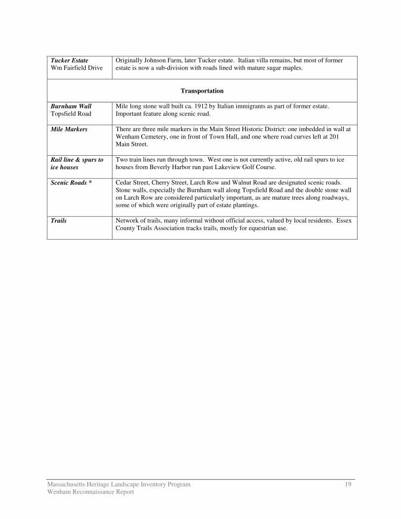
Tucker Estate Wm Fairfield Drive
Originally Johnson Farm, later Tucker estate. Italian villa remains, but most of former estate is now a sub-division with roads lined with mature sugar maples.
Transportation
Burnham Wall Topsfield Road
Mile long stone wall built ca. 1912 by Italian immigrants as part of former estate. Important feature along scenic road.
Mile Markers There are three mile markers in the Main Street Historic District: one imbedded in wall at Wenham Cemetery, one in front of Town Hall, and one where road curves left at 201 Main Street.
Rail line & spurs to ice houses
Two train lines run through town. West one is not currently active, old rail spurs to ice houses from Beverly Harbor run past Lakeview Golf Course.
Scenic Roads *
Cedar Street, Cherry Street, Larch Row and Walnut Road are designated scenic roads. Stone walls, especially the Burnham wall along Topsfield Road and the double stone wall on Larch Row are considered particularly important, as are mature trees along roadways, some of which were originally part of estate plantings.
Trails Network of trails, many informal without official access, valued by local residents. Essex County Trails Association tracks trails, mostly for equestrian use.