WELCOMING THE WATER - Boston Society of Architects · In post-Katrina Louisiana, the Army Corps and...
4
WELCOMING Climate mitigation is all about carbon, climate adaptation is all about water; the two become connected when plants and soils capture carbon and manage water. For years, we’ve been handling water irresponsibly — displacing it, misusing it — and in the process, we’ve caused most of our own water-based problems. With scientists generally agreeing that it’s too late to avoid the impact of climate change, and with increasing coastal flood risks posing the greatest threats to cities, architects and engineers can step up to help raise awareness of what changes are possible — and, more important, smart. Given that the built environment is a major contributor to greenhouse gas emissions and vulnerable to climate-change impacts, designers have interests and responsibilities related to the topic. They also have options when figuring out how to respond to rainfall 38 ArchitectureBoston Hardscape and green measures offer solutions by Wendi Goldsmith THE WATER
Transcript of WELCOMING THE WATER - Boston Society of Architects · In post-Katrina Louisiana, the Army Corps and...

WELCOMING
Climate mitigation is all about carbon, climate adaptation is all about water; the two become connected when plants and soils capture carbon and manage water. For years, we’ve been handling water irresponsibly — displacing it, misusing it — and in the process, we’ve caused most of our own water-based problems. With scientists generally agreeing that it’s too late to avoid the impact of climate change, and with increasing coastal flood risks posing the greatest threats to cities, architects and engineers can step up to help raise awareness of what changes are possible — and, more important, smart.
Given that the built environment is a major contributor to greenhouse gas emissions and vulnerable to climate-change impacts, designers have interests and responsibilities related to the topic. They also have options when figuring out how to respond to rainfall
38 ArchitectureBoston
Hardscape and green measures offer solutions
by Wendi Goldsmith
THE WATER
WELCOMING THE WATER
that overwhelms drainage systems as well as to flooding by coastal storm surges. Green infrastructure — ecologically functional measures designed to handle stormwater, including green roofs, bioswale systems, rain gardens, created wetlands, and elements that include vegetation combined with hard structures — can absorb and store rainfall, can shield community investments, and helps make us safer. Picture swaths of green space threaded through urban areas, connecting waterfronts, neighborhoods, parks, plazas, street margins, and rooftops. These elements not only make cities more attractive and livable, but also can reduce flood risk by absorbing water, wave energy, and even carbon.
In essence, the difference involves keeping water in contact with plants as early and often as possible, not dropping it out sight, out of mind, and out of reach of
the root zone. When plants are able to interact with water, they go about their normal business of using the sun’s energy to photosynthesize and convert carbon dioxide in the air, accumulating biomass as plants grow and soils enrich organic matter. Simultaneously, green infrastructure provides the mechanisms for temporary storage and processing of water, relying on vegetation and soil’s biogeochemistry to cleanse pollutants common in runoff, and also prevent peak water flows that cause flooding. The challenge is to make changes early in design to allow the most cost-effective and beneficial solutions for the site. Small changes to constructed sites can provide benefits on a large scale. The following projects, for which Bioengineering Group designed measures that use green infrastructure, have achieved measurable and cost-effective flood risk reduction while harnessing solar radiation and
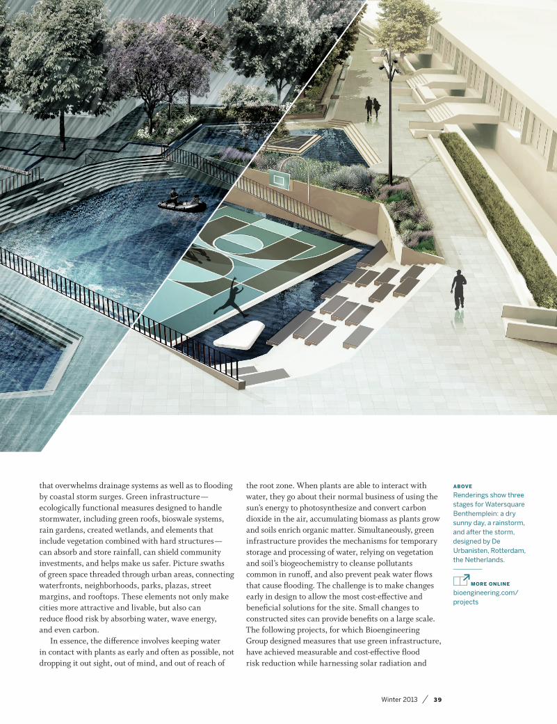
ABOVE
Renderings show three stages for Watersquare Benthemplein: a dry sunny day, a rainstorm, and after the storm, designed by De Urbanisten, Rotterdam, the Netherlands.
MORE ONLINE
bioengineering.com/projects
Winter 2013 39

40 ArchitectureBoston
natural processes, mitigating the problems associated with carbon and water.
In post-Katrina Louisiana, the Army Corps and stakeholders came to recognize that hard infrastructure could perform better when surrounded by healthy coastal wetlands and protective landforms, such as barrier islands. The Greater New Orleans Hurricane and Storm Damage Risk Reduction System is the nation’s first regional-scale infrastructure system that factored in trends and uncertainties surrounding future climate change and extreme land subsidence. Wetlands, beaches, and dunes were constructed using dredged sediments, often with reinforcement by
“hard” materials. Levees, flood walls, and the world’s largest surge barrier serve to keep damaging salt water
away from communities and sensitive vegetation. The seamless integration of green and hard elements blurs the boundary between natural and built. It also harnesses natural processes to support and maintain the coastal region, and to best adapt to future changes and impacts. Together, natural landforms, healthy ecosystems, and built structures are capable of mitigating storm damage based on multiple lines of defense, delivering sustainable infrastructure solutions that many cities facing the need for climate-change adaptation can emulate.
Two Massachusetts communities serve as paradigms for creative solutions to water management. Lexington took on the problem of stormwater management while increasing its use of green infrastructure. In 2009, the Department of Public Works completed a project to manage stormwater on site, thereby avoiding problems related to flooding not only new public buildings but also surrounding areas. Designers replicated predevelopment hydrology by deploying an array of measures: Green roof and porous asphalt were used for runoff minimization; roof runoff was harvested and reused for street-sweeping vehicles; and rain gardens, bioswales, and created wetlands allowed water to harmlessly evaporate or replenish aquifers. Rather than conventional piped stormwater systems that shunt runoff somewhere else, the site stewards water resourcefully, supporting ecosystems and storing water for extremely large storms (up to the 100-year event).
In 2001, officials in Cambridge accepted a creative proposal from designers for a solution to stormwater overflow pipes within Olmsted’s Emerald Necklace park and greenway system. Considered the crown jewel
Green infrastructure is fast becoming a
standard for considering how to invest
in reducing risk and improving quality of life.
of the Boston Harbor cleanup project, the integrated solution modified traditional piping and added wetlands plus other habitat features and public amenities. By rerouting runoff into an ecologically engineered basin in the Alewife Reservation, stormwater is effectively separated, stored, treated, and released with flow patterns that address chronic local flooding as well as water-quality requirements. This natural approach is expected to store carbon and educate park-goers for generations to come.
To account for worsening storms, sea-level rise, and a shifting landscape, the New Jersey Department of Transportation tackled replacement of an aging bridge and causeway connecting the barrier island community of Ocean City to the mainland. The Jersey Shore community sits on the front lines of coastal impacts and lacked suitable infrastructure for evacuation or emergency services during past storms, let alone future scenarios. From securing bridge foundations to elevating the entire roadway, stabilizing and restoring associated wetlands, the engineering team evaluated trends, risks, and potential solutions to optimize design. Bikeways and an integrated visitor center promote public access and help tell the story of the project and its many values. Completed in 2012 shortly before Superstorm Sandy struck the region, the project withstood impacts and has become a model to guide others.
In the future, green infrastructure will be applied in a scale greater than previously seen to address the challenges of climate change. It is already fast becoming a standard for communities considering how to invest in reducing risks and improving quality of life because it attractively combines conventional structural measures with green solutions. This joint approach is both necessary and also desirable for reducing vulnerability related to sea-level rise, land subsidence, increased storm intensity, aging infrastructure, and other threats. In the microcosm, green infrastructure can soften the effects of direct exposure to destructive and erosive forces of oceans and rivers, buffering structures unable to withstand full impacts. At the macrocosm level, large-scale natural systems such as wetlands, oyster reefs, and dunes are crucial for the stability of fragile or dynamic landforms, which in turn support ecosystems as well as human communities.
As we face the future, these systems will help keep threats at bay, both outside our cities as well as within them. From Dutch “watersquares” that offer public gathering zones capable of flood storage to Mayor Michael Bloomberg’s proposed multipurpose levees along New York City’s new Seaport City waterfront, novel approaches will reduce hazards while increasing awareness about the ever-closer relationships between people, infrastructure, and rising tides. ■

Winter 2013 41Winter 2013 41
Boston’s waterfront was built to withstand
all but the worst storm flooding. Yet with
sea levels expected to rise up to 6 feet by
2100, children alive today may well live
to see the ocean breach historical seawalls
twice a day, every day, at high tide. Flood
control has historically consisted of
building higher and higher seawalls and
levees to keep water out. What if, instead,
we incorporate the rising ocean into
a manageable component of our urban
landscape?
The city’s design community has an
extraordinary opportunity to partner with
civil engineers and emergency-response
experts to preserve our access to the
waterfront while preventing catastrophic
flood damage to our neighborhoods and
infrastructure. An analogy is our response
to the September 11th attacks. Early
security barriers were effective in
protecting buildings but were ugly and
socially alienating. Over time, these
concrete barriers were replaced by
equally effective bollards that served as
seats or even public art.
The concept of “living with water”
combines excellent urban design with flood
control to maintain livable cities. It hinges on:
• Focusing on “resilience” over “resistance”
where possible. Resilience emphasizes
strategies to recover quickly and
relatively inexpensively from flooding.
• Creating a varied surface topography
within Boston’s low-lying neighborhoods.
Below-grade “floodable zones” could
serve other purposes such as great
social spaces during dry periods.
• Setting building codes and capital
investment strategies to maintain
vibrant cities in the short- to mid-term
while planning for managed retreat
to higher ground, whether inland or
above street level.
Cities around the globe have embraced
design solutions that channel water in
effective, creative — even delightful — ways.
Just north of Tokyo, for example, an
underground flood-diversion facility
prevents overflow of major waterways and
rivers during rainy seasons; its main
containment tank is also a tourist draw
because it resembles a temple and has
been used in movies and TV shows. Could
Boston’s design community come up
with its own multipurpose solutions?
For example, is there a side street or two
in the Innovation District that could
become a Venice-like canal one day to
keep the rest of the neighborhood
dry? Could the below-grade East Boston
Greenway be extended westward to
keep Central Square businesses from
flooding while providing additional
green space for the neighborhood?
Could the 40-mile HarborWalk be a more
effective — and beautiful — first line of
defense against coastal flooding?
Let’s hope these concepts become
part of the vernacular of resiliency
planning so panic doesn’t dictate design
and ruin Boston’s urban vitality.
Julie Wormser is the executive director of The Boston Harbor Association, a nonprofit focused on economic develop- ment, public access, and sea-level-rise adaptation.
MORE ONLINE
Preparing for the Rising Tide, co-written by Julie Wormser, is available for download at www.tbha.org/work
VENICE ON THE CHARLES? by Julie Wormser
Could the HarborWalk (shown here along Fort Point Channel) be part of a first line of defense against coastal flooding? Courtesy the Boston Harbor Association.