
WELCOME TO THE PUBLIC INFORMATION...
26
Saskatoon North Partnership for Growth Regional Plan www.partnershipforgrowth.ca The municipalities of Corman Park, Saskatoon, Martensville, Warman, and Osler have worked together to create a draft Regional Plan. The new P4G Regional Plan will guide future growth by establishing a coordinated approach to land use, development, and infrastructure, and includes Strategies for regional governance and servicing coordination. We encourage you to review this information and submit your questions about the Plan. Please fill out the provided postcards and we will answer these questions during the Moderated Q&A. The draft Regional Plan is also available on the project website at: www.partnershipforgrowth.ca WELCOME TO THE PUBLIC INFORMATION SESSION JUNE 27, 2017 Open House 4–6:30 PM Public Presentation 6:30–7 PM Moderated Q&A 7–8 PM
Transcript of WELCOME TO THE PUBLIC INFORMATION...

Saskatoon North Partnership for Growth Regional Plan www.partnershipforgrowth.ca
The municipalities of Corman Park, Saskatoon, Martensville,
Warman, and Osler have worked together to create a draft
Regional Plan. The new P4G Regional Plan will guide future growth
by establishing a coordinated approach to land use, development,
and infrastructure, and includes Strategies for regional governance
and servicing coordination.
We encourage you to review this information and submit your
questions about the Plan. Please fill out the provided postcards
and we will answer these questions during the Moderated Q&A.
The draft Regional Plan is also available on the project website at:
www.partnershipforgrowth.ca
WELCOME TO THEPUBLIC INFORMATION SESSION
JUNE 27, 2017
Open House 4–6:30 PM Public Presentation 6:30–7 PM
Moderated Q&A 7–8 PM

Saskatoon North Partnership for Growth Regional Plan www.partnershipforgrowth.ca
The P4G includes:
• RM of Corman Park
• City of Saskatoon
• City of Warman
• City of Martensville
• Town of Osler
• Saskatoon Regional Economic
Development Authority (SREDA)
(advisory representation)
Regional Oversight Committee
REEVE JUDY HARWOOD • Corman ParkCOUNCILLOR BAS FROESE-KOOIJENGA • Corman ParkCOUNCILLOR RANDY ROOKE • Corman Park MAYOR CHARLIE CLARK • SaskatoonCOUNCILLOR RANDY DONAUER • SaskatoonCOUNCILLOR ZACH JEFFRIES • SaskatoonMAYOR SHERYL SPENCE • WarmanCOUNCILLOR RICHARD BECK • WarmanCOUNCILLOR GARY PHILIPCHUK • WarmanMAYOR KENT MUENCH • MartensvilleCOUNCILLOR BOB BLACKWELL • MartensvilleCOUNCILLOR TYSON CHILLOG • MartensvilleMAYOR ABE QUIRING • OslerCOUNCILLOR SUSAN BRAUN • OslerCOUNCILLOR ADAM HUMENUIK • OslerINDEPENDENT ROC CHAIR ALEX FALLON • SREDA
Planning + Administration Committee
REBECCA ROW • Corman ParkKELBY UNSETH • Corman ParkLAURA HARTNEY • SaskatoonDANA KRIPKI • SaskatoonBRAD TOTH • WarmanJOE DOXEY • MartensvilleBONNIE GORELITZA • MartensvilleSANDRA MACARTHUR • OslerKRISTEN JOHANNESSON • SREDA
Project Manager
CHRISTINE GUTMANN
The region’s population could reach 500,000
in the next 20 years and could grow to
1,000,000 in the next 60 years.
In the long term, we need to be ready for
growth to:
• sustain economic prosperity,
• support a high quality of life, and
• protect the region’s natural beauty,
ecology, and heritage.
The Regional Plan will guide future growth by
establishing a coordinated approach to land
use, development, and servicing.
WHO IS THE SASKATOON NORTH PARTNERSHIP FOR GROWTH (P4G)?
WHY A REGIONAL PLAN?
WanuskewinHeritage Park
OSLER
MARTENSVILLE
SASKATOON
WARMAN
RM OFCORMANPARK
Yellow Quill
Little Pine
Cowessess
English River
Reserve
MoosominMoosomin
Saulteaux
Muskoday16
12
11
41
5
16
14
7
16
11
5
219
684
305
Sout
h Saskatchewa
n Ri
ver
0 2 41 km
Saskatoon North Partnership for Growth Study Area

Saskatoon North Partnership for Growth Regional Plan www.partnershipforgrowth.ca
Land Use and Development
We used data and maps from a range of sources to understand the factors that support and influence growth in the region.
We began by establishing the Regional Vision, Guiding Principles, and Strategic Directions to set the ground rules for future planning.
Next, we considered how much growth the region might expect and what type of growth this would be. We also had to think about existing plans, bylaws, and policies.
We learned from people who know the region best: you. We wanted to understand your aspirations for the region and continued to receive input as the project moved forward.
The Regional Land Use Map represents a future concept for a region with a population of 1 million that balances growth, infrastructure, conservation, and drainage concerns.
We showed the draft map to the public in February 2016 and January 2017 and have revised it based on the feedback received.
Natural Environment and Drainage
Existing and Proposed Land Use
First Nations
Transportation
Potable Water
Wastewater
Parks + Open Spaces
Stormwater
Mining
Agriculture
Regional Infrastucture
Public
Municipalities
First Nations
Stakeholders
How Much?
Future Regional Population:1,000,000
What Type?
Residential, Employment, Open Space...
What Else?
Existing Plans, Bylaws, and
Policies
REGIONAL LAND USE MAP
We developed a series of policies across the five municipalities to meet the needs created by expected Regional growth. These policies include:
• Land use policies to set fair and clear ground rules for regional growth patterns
• A Servicing Strategy and associated policies to show how the five municipalities can collaborate on regional infrastructure and services
• A Governance and Implementation Strategy to guide decision-making and oversight by the five municipalities, and build the management capacity to enact the Plan
REGIONAL LAND USE PLAN
FIRST STEPS
UNDERSTANDING THE REGION
PLANNING FOR GROWTH
YOUR INPUT
How We Got Here

Saskatoon North Partnership for Growth Regional Plan www.partnershipforgrowth.ca
Overview of the Draft Regional Plan
The Regional Plan includes the following:
The Regional Vision provides the statement of intent for the
Plan and describes the Principles and Strategic Directions
used to develop and manage the Plan.
The General Policies section outlines policies for the Region,
including policies about topics such as water resources,
economic development, and natural hazards.
The Land Use section outlines major land-use policies related
to the Regional Land Use Map and regional development.
This includes all land use categories on the Regional Land
Use Map, as well as other uses such as recreation and waste
management.
The Servicing section outlines regional policies related to
the construction and management of infrastructure and the
delivery of regional services through P4G, including regional
potable water, wastewater, and transportation.
The Governance and Implementation section describes
the processes for administering and carrying out the Plan,
including building capacity for ongoing management.
Two additional documents also support the ongoing activities
of P4G:
• The Regional Governance and Implementation Strategy
details the ongoing management of the Regional Plan
• The Regional Servicing Strategy provides guidance on
long-term actions on regional infrastructure and services

Saskatoon North Partnership for Growth Regional Plan www.partnershipforgrowth.ca
Guiding Principles
Regional Vision StatementOur vision for the future is a vibrant, prosperous, and internationally-competitive region. We are known for
a high quality of life; a thriving and diverse economy; healthy and connected ecosystems; and efficient
infrastructure supporting sustainable growth and development.
The five municipalities of the Region - Osler, Martensville, Warman, Saskatoon, and the RM of
Corman Park - provide a rich range of opportunities and lifestyle choices for residents and newcomers.
The aesthetic beauty and ecological values of the South Saskatchewan River and prairie landscapes
are key components to our quality of life. We work in partnership on issues of common interest through
integrated, coordinated efforts that support our success while respecting the individual aspirations of all
partners.
Developing and carrying out the Regional Plan is not simply the work of one organization. Achieving the vision for the future will be based upon ongoing collaboration and partnerships between the members of P4G, as well as the Province, First Nations, other organizations in the community, and the broader public. Integrated, coordinated approaches to managing regional opportunities and challenges will be adopted.
PARTNERSHIP
A sustainable approach to planning will consider economic, social, and environmental implications in an integrated manner. Actions will support economic vitality and complete communities and ensure the needs of the present are met while preserving the welfare of future generations. Natural resources and environmental processes essential to the regional ecological health and productivity will be maintained and conserved.
SUSTAINABILITY
The Regional Plan is committed to ensuring that costs and benefits will be equitably distributed amongst the communities in the Region. Regional planning and cooperation will be transparent and consistent, and must work to build consensus-based solutions to incorporate the varying needs and perspectives of all stakeholders. All communities involved will have an equal voice and opportunity to be involved in the process.
EQUITY + INCLUSIVENESS
A primary aim is to increase efficiencies in the provision of regional infrastructure and services, both for current development and new growth. Regional initiatives will work to reduce costs as well as to increase the quality of services through coordination between partners, alignment of land use and infrastructure strategies, planning toward common goals and standards, and reduction of service overlaps.
EFFICIENCY
The Regional Plan will work to provide a diverse, vibrant regional economy and a high quality of life that provides opportunities for all. Regional investments will be fairly and strategically distributed, recognizing the varying needs of municipalities. Planning will provide direction, consistency, and stability to attract and support strategic investment and economic development in the Region.
OPPORTUNITY
Long-term success will depend upon the ability of the Region to evolve when faced with a changing environment. The Regional Plan must accommodate change through adaptive, flexible approaches and incorporate innovation and creativity to address unexpected events.
FLEXIBILITY + RESILIENCE
Saskatoon North Partnership for Growth Regional Plan www.partnershipforgrowth.ca
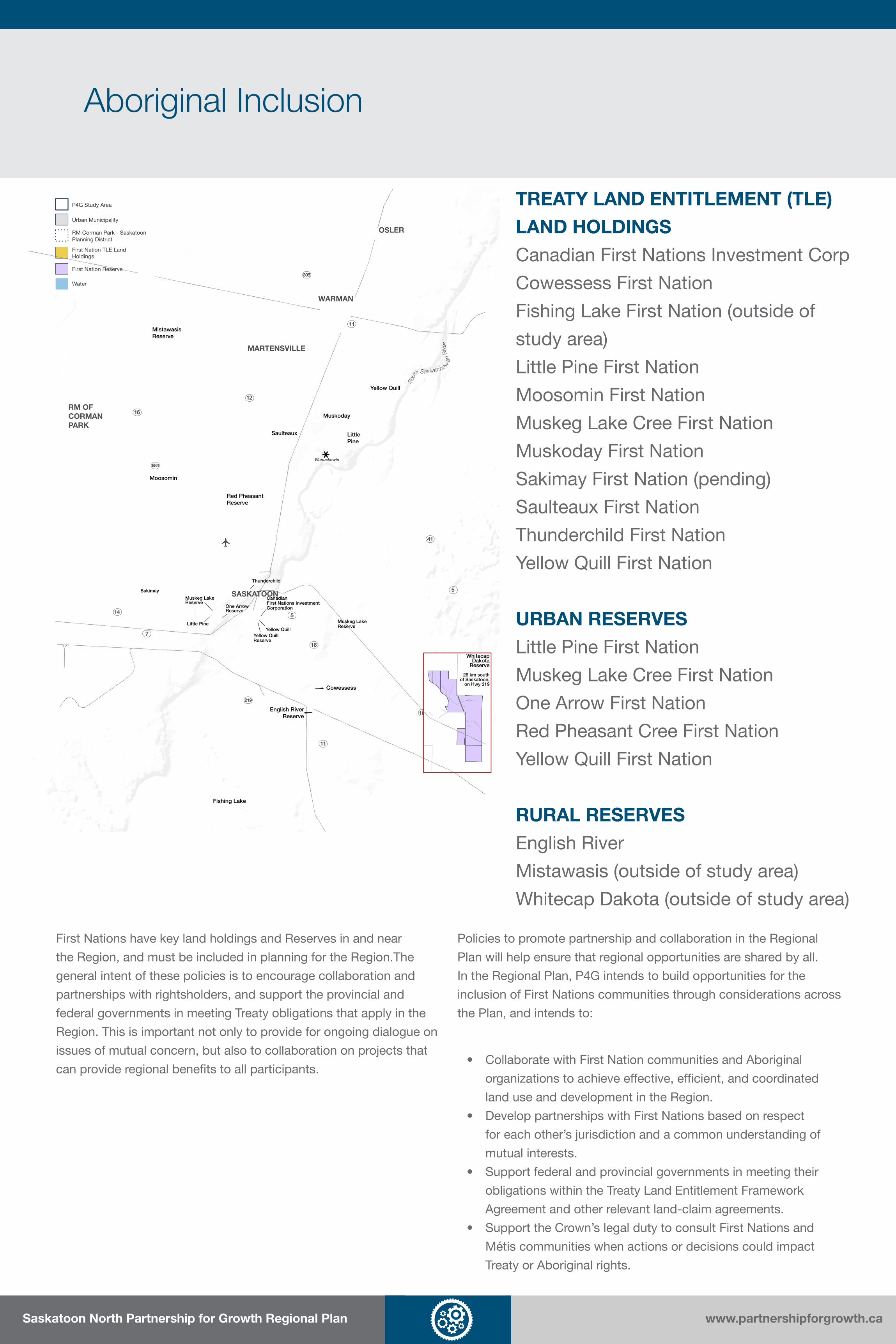
Aboriginal Inclusion
Wanuskewin
OSLER
MARTENSVILLE
SASKATOON
WARMAN
RM OFCORMANPARK
Yellow Quill
Little Pine
Mistawasis Reserve
Cowessess
English RiverReserve
Fishing Lake
SakimaySakimay
Saulteaux
Moosomin
Red Pheasant Reserve
Muskoday16
12
11
41
5
16
14
7
16
11
5
219
684
305
Sout
h Saskatchewa
n Ri
ver
WhitecapDakota
Reserve
26 km southof Saskatoon,
on Hwy 219
Yellow Quill
Muskeg LakeReserve
CanadianFirst Nations Investment Corporation
Yellow Quill Reserve
Muskeg Lake Reserve
Little Pine
One ArrowReserve
Thunderchild
P4G Study Area
Urban Municipality
RM Corman Park - SaskatoonPlanning District
First Nation TLE LandHoldings
First Nation Reserve
Water
TREATY LAND ENTITLEMENT (TLE)
LAND HOLDINGS
Canadian First Nations Investment Corp
Cowessess First Nation
Fishing Lake First Nation (outside of
study area)
Little Pine First Nation
Moosomin First Nation
Muskeg Lake Cree First Nation
Muskoday First Nation
Sakimay First Nation (pending)
Saulteaux First Nation
Thunderchild First Nation
Yellow Quill First Nation
URBAN RESERVES
Little Pine First Nation
Muskeg Lake Cree First Nation
One Arrow First Nation
Red Pheasant Cree First Nation
Yellow Quill First Nation
RURAL RESERVES
English River
Mistawasis (outside of study area)
Whitecap Dakota (outside of study area)
First Nations have key land holdings and Reserves in and near
the Region, and must be included in planning for the Region.The
general intent of these policies is to encourage collaboration and
partnerships with rightsholders, and support the provincial and
federal governments in meeting Treaty obligations that apply in the
Region. This is important not only to provide for ongoing dialogue on
issues of mutual concern, but also to collaboration on projects that
can provide regional benefits to all participants.
Policies to promote partnership and collaboration in the Regional
Plan will help ensure that regional opportunities are shared by all.
In the Regional Plan, P4G intends to build opportunities for the
inclusion of First Nations communities through considerations across
the Plan, and intends to:
• Collaborate with First Nation communities and Aboriginal
organizations to achieve effective, efficient, and coordinated
land use and development in the Region.
• Develop partnerships with First Nations based on respect
for each other’s jurisdiction and a common understanding of
mutual interests.
• Support federal and provincial governments in meeting their
obligations within the Treaty Land Entitlement Framework
Agreement and other relevant land-claim agreements.
• Support the Crown’s legal duty to consult First Nations and
Métis communities when actions or decisions could impact
Treaty or Aboriginal rights.

Saskatoon North Partnership for Growth Regional Plan www.partnershipforgrowth.ca
General Policies
Economic DevelopmentThe strong and vibrant economy of the P4G
Region has been a key driver of economic
prosperity in Saskatchewan. A regional approach
to economic development will ensure the region
supports current activities and can respond to
future economic opportunities and trends.
• Coordinate economic development planning
with P4G municipalities and SREDA
• Coordinate land use and development to
attract, retain and promote business and
employment growth for the region
• Support the agriculture and farming
industry, including opportunities for value-
added businesses in rural areas
• Support opportunities for regional tourism
and related development
• Encourage the identification/inventory of
significant natural and heritage resources
for conservation and management
• Coordinate a Regional Natural Areas
Strategy to help to maintain and enhance
natural features of the Region
• Ensure that development avoids or reduces
impacts of development to natural and
heritage resources
Natural and Heritage Resources
The P4G Region includes significant natural and
heritage resources that are valued and enjoyed
by both residents and visitors. These resources
create a sense of place and tell the story of
the Region’s history and its people. The P4G
recognizes that strategies are needed to identify,
protect, and enhance these resources so they
can be enjoyed today and by future generations.
Summary of Policies
• Ensure that development does not restrict
the use of groundwater or surface water,
or alter the flow of surface water in a way
that impacts other property or ecological
systems
• Develop a Regional Wetlands Inventory
and Policy to guide the protection and
restoration of wetlands
• Avoid or address impacts to wetlands from
development where reasonably possible,
and encourage approaches that ensure the
least possible disturbance and/or alteration
of wetlands
• Coordinate regional source water protection
and wetlands conservation with the
province
Water Resources and Wetlands
Water resources are one of the most valuable
features of the regional landscape, providing
services such as drinking water, recreation
opportunities, and wildlife habitat. These
resources include the South Saskatchewan
River and Opimihaw Creek that weave through
the region, as well as other surface waters and
groundwater.

Saskatoon North Partnership for Growth Regional Plan www.partnershipforgrowth.ca
General Policies
Natural HazardsNatural hazards include risks such as flooding,
slope instability, erosion, or subsidence.
Development should be appropriately designed
or limited where natural hazards exist in the
region to avoid risks to people, property,
infrastructure, and the environment. Preventing
risk is more effective than responding after an
event or damage has occurred.
For these policies, areas prone to flooding (which
are located within a floodplain) can be divided
between two areas:
• A “flood way” where the waters from a
1:500 flood (0.2% risk of occuring each
year, or another standard as set by the
province) are projected to meet or exceed
a depth of one metre or a velocity of one
metre per second
• A “flood fringe” where the waters from a
1:500 flood (0.2% risk of occuring each
year, or another standard as set by the
province) are projected to be less than a
depth of one metre and a velocity of one
metre per second
General
• Identify and map hazard lands within the
Region (e.g., floodplains, steep slopes)
• Ensure that hazards on lands are
properly managed before subdivision and
development
Unstable Areas
• Require development in areas with mining
leases to consult with mining companies
and provincial agencies about potential
subsidence risks
• Require development to implement risk
mitigation actions to ensure safety and the
protection of property
Flood Plains
• Coordinate updated flood plain mapping
with the province
• Restrict development in flood plains to
protect against loss of life and to minimize
property damage
• Prohibit the use of land within a flood way,
except for agricultural and passive open
space uses
• Require flood proofing for development
allowed in the flood fringe through a two-
stage building permit process
Summary of Policies

Saskatoon North Partnership for Growth Regional Plan www.partnershipforgrowth.ca
Regional Land Use Map
EXISTING BIOSOLIDS FACILITY
EXISTING BIOSOLIDS FACILITY
WARMANLAGOONWARMANLAGOON
LORAASLANDFILLLORAASLANDFILL
MARTENSVILLELAGOONMARTENSVILLELAGOON
POTENTIALFUTUREAIRPORT EXPANSION
POTENTIALFUTUREAIRPORT EXPANSION
WanuskewinHeritage Park
North CommuterParkway Bridge
REGIONAL COMMUNITY
SERVICES NODE
GRASSWOODMIXED-USE NODE
THIS AREA INCLUDES THE GRASSWOOD MIXED-USE NODE AND THE AREA SUBJECT TO ONGOING STUDY PENDING THE FINAL ALIGNMENT OF THE SASKATOON FREEWAY. ONCE THE ALIGNMENT IS KNOWN, THE LAND USE CATEGORIES FOR THE AREA INCLUDED WITHIN THE POTENTIAL ALIGNMENTS MAY BE AMENDED.
AGRI-FOOD NODE
MIXED-USE NODE
MIXED-USENODE
MIXED-USE NODE
MIXED-USE NODE
MIXED-USE NODE
MIXED-USENODE
MIXED-USE NODE
MIXED-USE NODE
OSLER
MARTENSVILLE
SASKATOON
WARMAN
RM OFCORMANPARK
Yellow Quill
Little Pine
Cowessess
English River
Reserve
MoosominMoosomin
Saulteaux
Muskoday16
12
11
41
5
16
14
7
16
11
5
219
684
305
Sout
h Saskatchewa
n Ri
ver
0 2 41 km
Land Use
Agricultural Research
Corman Park-OslerAgri-Food Node
Agriculture
Green Network Study Area (additional review required)
Country Residential
Rural Commercial/Industrial
Urban Residential Neighbourhood
Urban Commercial/Industrial
Urban Mixed Use Node
Existing Urban Municipality
Corman Park - SaskatoonPlanning District
First Nations Reserves
First Nations TLE Land Holdings
Areas subject to ongoing study
Potential Expansions(Airport, Wanuskewin, etc.)
Wanuskewin viewshed
Regional InstitutionalFacilities
Water
Parks and Open Space
Major Roadways
Saskatoon Freeway
Preferred Southeast Alignment
Approved Alignments
Potential Alignments
Potential Interchanges
Key Location
Future Urban Growth
Rural
Regional Infrastructure
Saskatoon North Partnership for Growth Regional Plan www.partnershipforgrowth.ca
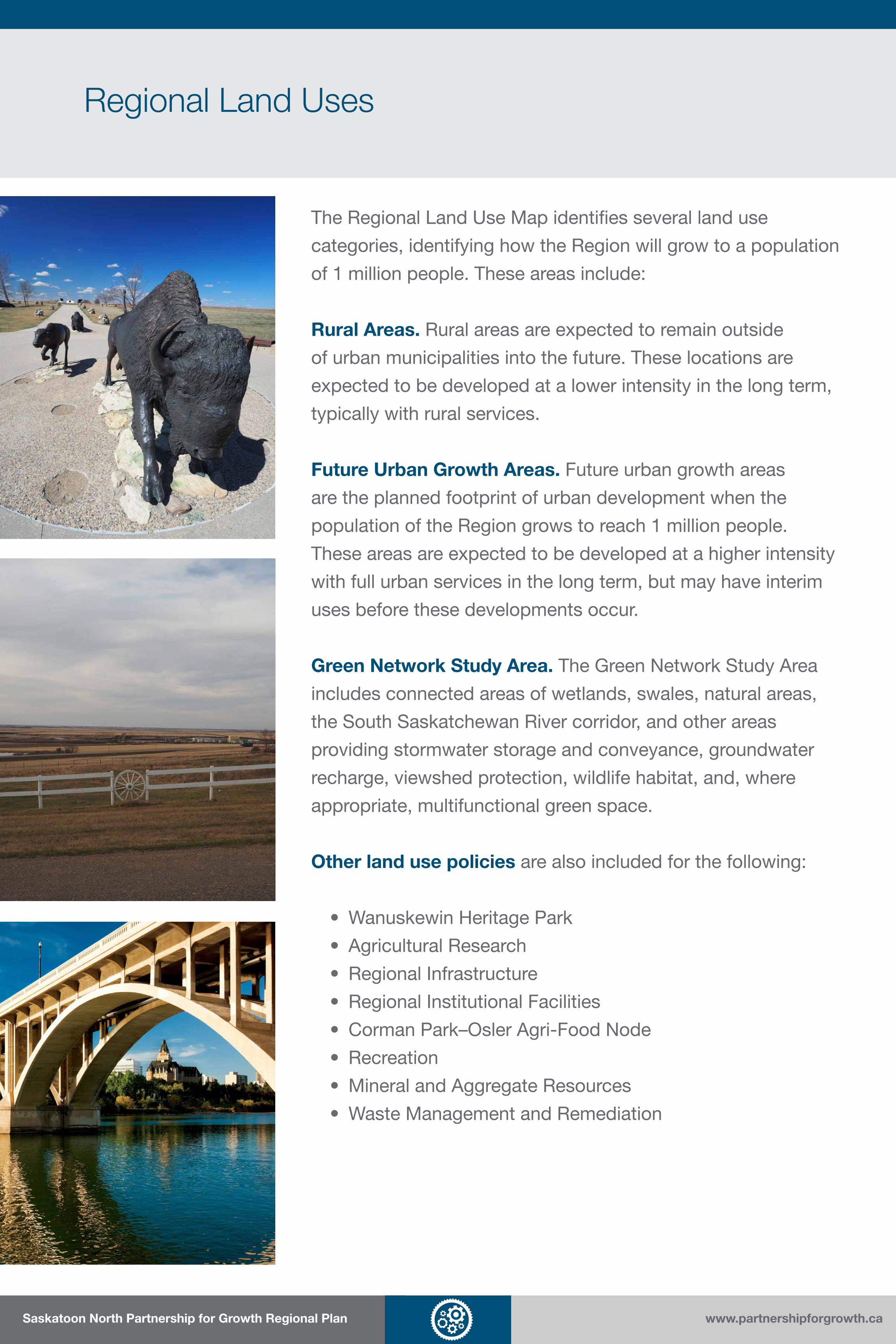
Regional Land Uses
The Regional Land Use Map identifies several land use
categories, identifying how the Region will grow to a population
of 1 million people. These areas include:
Rural Areas. Rural areas are expected to remain outside
of urban municipalities into the future. These locations are
expected to be developed at a lower intensity in the long term,
typically with rural services.
Future Urban Growth Areas. Future urban growth areas
are the planned footprint of urban development when the
population of the Region grows to reach 1 million people.
These areas are expected to be developed at a higher intensity
with full urban services in the long term, but may have interim
uses before these developments occur.
Green Network Study Area. The Green Network Study Area
includes connected areas of wetlands, swales, natural areas,
the South Saskatchewan River corridor, and other areas
providing stormwater storage and conveyance, groundwater
recharge, viewshed protection, wildlife habitat, and, where
appropriate, multifunctional green space.
Other land use policies are also included for the following:
• Wanuskewin Heritage Park
• Agricultural Research
• Regional Infrastructure
• Regional Institutional Facilities
• Corman Park–Osler Agri-Food Node
• Recreation
• Mineral and Aggregate Resources
• Waste Management and Remediation

Saskatoon North Partnership for Growth Regional Plan www.partnershipforgrowth.ca
Regional Land Uses: Rural Areas
Country ResidentialLand within the Country Residential category
will accommodate multi-parcel residential
subdivisions. These types of subdivisions have
relatively large lots, and may designed according
to cluster or conservation subdivision principles
to preserve open space and farmland.
The Country Residential category would allow
multi-parcel country residential development.
• Ensure that country residential development
is located in areas that will not be impacted,
such as hazard lands, sensitive ecological
areas, groundwater recharge areas
• Consider how local infrastructure
can support new country residential
development
• Promote sustainable country residential
subdivision designs and infrastructure
provision
Rural CommercialLands within the Rural Commercial category are
suitable for convenience commercial uses and
other commercial activities to meet the needs
of the RM and Region. These lands have rural
servicing, and are not expected to be required
for urban growth as the Region grows to 1 million
residents.
The Rural Commercial category would allow
for commercial uses with rural servicing,
with agriculture and agricultural residential
subdivisions allowed as interim uses.
• Differentiate between “Arterial Commercial
Districts” and “Rural Convenience
Commercial” through more detailed
planning
• Support rural commercial development as
nodal development where existing roads
and infrastructure can support development
• Allow for subdivision of two (2) building
sites per quarter section (or 1 site per 80-
acre parcel)
• Manage the integration of Rural
Convenience Commercial with country
residential development where appropriate
Rural IndustrialLands within the Rural Industrial category are
suitable for light and heavy industrial uses
and storage facilities. These lands have rural
servicing, and are not expected to be required
for urban growth as the Region grows to 1 million
residents.
The Rural Industrial category would allow for
industrial and storage uses with rural servicing,
with agriculture and agricultural residential
subdivisions allowed as interim uses.
• Differentiate between “Business Districts”,
“Light Industrial Districts”, and “Heavy
Industrial Districts” through more detailed
planning
• Allow subdivision of two (2) building sites
per quarter section (or 1 per 80-acre parcel)
• Provide long-term rural growth areas and
opportunities for site specific, locational
industrial sites
• Restrict incompatible industrial
development adjacent to urban areas
AgricultureThe Agriculture category enables agriculture and
pasture uses, as well as agricultural residential
uses, while preserving important ecosystem
services such as local food production, habitat
protection, and maintenance of the land’s natural
drainage characteristics.
The Agriculture category would allow:
agriculture (cultivation / pasture) and
agricultural residential subdivisions.
• Discourage fragmentation of agricultural
lands and disruption of agricultural activities
• Allow subdivision of five (5) building sites
per quarter section (3 per 80-acre parcel)
for agricultural residential building sites and
discretionary uses
• Maintain separation distances for Intensive
Livestock Operations
• Allow for agriculturally related rural
commercial, rural industrial, or country
residential development where appropriate
Summary of Policies
Saskatoon North Partnership for Growth Regional Plan www.partnershipforgrowth.ca
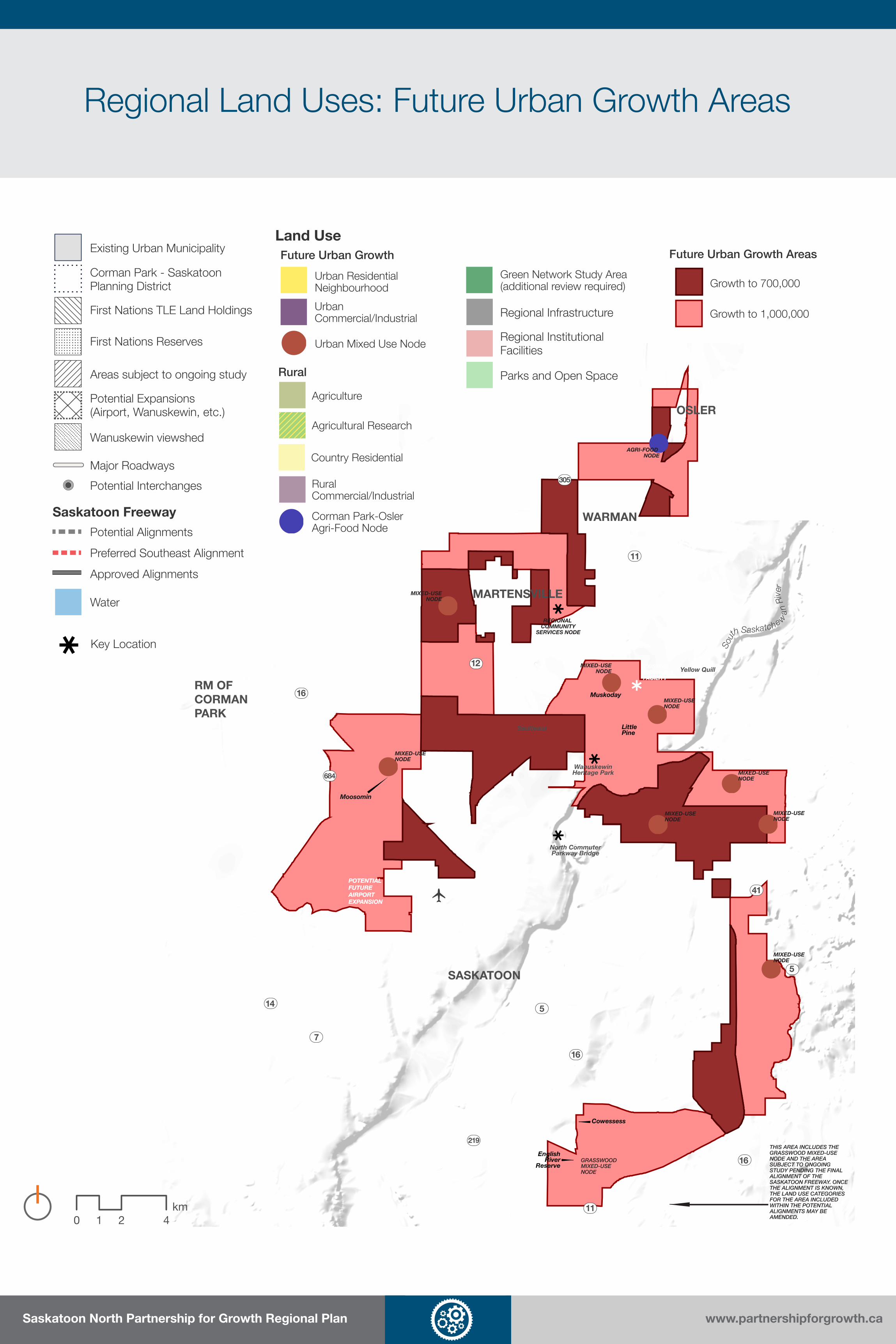
Regional Land Uses: Future Urban Growth Areas
EXISTING BIOSOLIDS FACILITY
EXISTING BIOSOLIDS FACILITY
WARMANLAGOONWARMANLAGOON
LORAASLANDFILLLORAASLANDFILL
MARTENSVILLELAGOONMARTENSVILLELAGOON
POTENTIALFUTUREAIRPORT EXPANSION
POTENTIALFUTUREAIRPORT EXPANSION
WanuskewinHeritage Park
North CommuterParkway Bridge
REGIONAL COMMUNITY
SERVICES NODE
GRASSWOODMIXED-USE NODE
THIS AREA INCLUDES THE GRASSWOOD MIXED-USE NODE AND THE AREA SUBJECT TO ONGOING STUDY PENDING THE FINAL ALIGNMENT OF THE SASKATOON FREEWAY. ONCE THE ALIGNMENT IS KNOWN, THE LAND USE CATEGORIES FOR THE AREA INCLUDED WITHIN THE POTENTIAL ALIGNMENTS MAY BE AMENDED.
AGRI-FOOD NODE
MIXED-USE NODE
MIXED-USENODE
MIXED-USE NODE
MIXED-USE NODE
MIXED-USE NODE
MIXED-USENODE
MIXED-USE NODE
MIXED-USE NODE
OSLER
MARTENSVILLE
SASKATOON
WARMAN
RM OFCORMANPARK
Yellow Quill
Little Pine
Cowessess
English River
Reserve
MoosominMoosomin
Saulteaux
Muskoday16
12
11
41
5
16
14
7
16
11
5
219
684
305
Sout
h Saskatchewa
n Ri
ver
Future Urban Growth Areas
Growth to 700,000
Growth to 1,000,000
0 2 41 km
Land Use
Agricultural Research
Corman Park-OslerAgri-Food Node
Agriculture
Green Network Study Area (additional review required)
Country Residential
Rural Commercial/Industrial
Urban Residential Neighbourhood
Urban Commercial/Industrial
Urban Mixed Use Node
Existing Urban Municipality
Corman Park - SaskatoonPlanning District
First Nations Reserves
First Nations TLE Land Holdings
Areas subject to ongoing study
Potential Expansions(Airport, Wanuskewin, etc.)
Wanuskewin viewshed
Regional InstitutionalFacilities
Parks and Open Space
Major Roadways
Saskatoon Freeway
Potential Interchanges
Future Urban Growth
Rural
Regional Infrastructure
Water
Preferred Southeast Alignment
Approved Alignments
Potential Alignments
Key Location

Saskatoon North Partnership for Growth Regional Plan www.partnershipforgrowth.ca
Regional Land Uses: Future Urban Growth Areas
Urban Residential NeighbourhoodThe Urban Residential Neighbourhood category
is intended to accommodate future urban
residential and supporting commercial and
institutional uses, all with urban servicing.
Interim uses in the Urban Residential
Neighbourhood category include agriculture,
agricultural residential subdivisions, and other
uses compatible with future urban residential
growth.
• Achieve a minimum of 17.3 housing units or
50 residents and jobs combined per gross
developable hectare (7 units or 20 residents
+ jobs per acre)
• Encourage low capital intensity, temporary
development for interim uses
• Prohibit urban commercial and industrial
development as interim uses
• Allow subdivision of four (4) building sites
per quarter section (2 per 80-acre parcel)
for interim uses outside future urban growth
areas required for a regional population of
700,000
Urban Commercial/IndustrialThe Urban Commercial/Industrial category
is intended to accommodate future general
commercial and industrial uses including office,
retail, and industrial areas that are connected to
urban servicing.
Interim uses in the Urban Commercial/
Industrial category include agriculture,
agricultural residential subdivisions, and rural
commercial/industrial uses.
• Allow Interim uses subject to Concept Plans
and Comprehensive Development Reviews
that support efficient and cost-effective
urban development
• Ensure that intermunicipal agreements for
interim development consider future urban
servicing
• Require a mitigation and remediation
plan for interim uses that could have an
environmental impact
Urban Mixed-Use NodeUrban Mixed-Use Nodes are locations that
are intended to accommodate a compatible
mix of future commercial (retail and office),
institutional, and residential uses, such as mixed-
use suburban centres. Current examples are
the areas around the major shopping malls in
Saskatoon.
• Ensure that the conceptual locations for
Urban Mixed-Use Nodes are planned in
more detail through Concept Plans
• Achieve a minimum intensity of 75 residents
and jobs combined per gross developable
hectare for the Urban Mixed-Use Node
General PoliciesThe future urban growth areas identified include
the expected urban footprint as the Region
grows to a population of 1 million.
The urban areas necessary for a regional
population of 700,000 are managed as follows:
• New Concept Plans are prioritized
• Temporary development is preferred
• Agricultural residential subdivisions in urban
residential neighbourhoods are restricted to
two (2) building sites per quarter section
• Allow interim uses in future urban growth
areas, subject to requirements that
support efficient and cost-effective urban
development
• Prohibit new ILOs within future urban
growth areas
• Allow subdivision of two (2) building sites
per quarter section (1 per 80-acre parcel) for
interim uses, except as specified below for
Urban Residential Neighbourhood areas
Summary of Policies

Saskatoon North Partnership for Growth Regional Plan www.partnershipforgrowth.ca
Regional Land Uses: Green Network Study Area
EXISTING BIOSOLIDS FACILITY
EXISTING BIOSOLIDS FACILITY
WARMANLAGOONWARMANLAGOON
LORAASLANDFILLLORAASLANDFILL
MARTENSVILLELAGOONMARTENSVILLELAGOON
POTENTIALFUTUREAIRPORT EXPANSION
POTENTIALFUTUREAIRPORT EXPANSION
WanuskewinHeritage Park
North CommuterParkway Bridge
REGIONAL COMMUNITY
SERVICES NODE
GRASSWOODMIXED-USE NODE
THIS AREA INCLUDES THE GRASSWOOD MIXED-USE NODE AND THE AREA SUBJECT TO ONGOING STUDY PENDING THE FINAL ALIGNMENT OF THE SASKATOON FREEWAY. ONCE THE ALIGNMENT IS KNOWN, THE LAND USE CATEGORIES FOR THE AREA INCLUDED WITHIN THE POTENTIAL ALIGNMENTS MAY BE AMENDED.
AGRI-FOOD NODE
MIXED-USE NODE
MIXED-USENODE
MIXED-USE NODE
MIXED-USE NODE
MIXED-USE NODE
MIXED-USENODE
MIXED-USE NODE
MIXED-USE NODE
OSLER
MARTENSVILLE
SASKATOON
WARMAN
RM OFCORMANPARK
Yellow Quill
Little Pine
Cowessess
English River
Reserve
MoosominMoosomin
Saulteaux
Muskoday16
12
11
41
5
16
14
7
16
11
5
219
684
305
Sout
h Saskatchewa
n Ri
ver
0 2 41 km
Land Use
Agricultural Research
Corman Park-OslerAgri-Food Node
Agriculture
Green Network Study Area (additional review required)
Country Residential
Rural Commercial/Industrial
Urban Residential Neighbourhood
Urban Commercial/Industrial
Urban Mixed Use Node
Existing Urban Municipality
Corman Park - SaskatoonPlanning District
First Nations Reserves
First Nations TLE Land Holdings
Areas subject to ongoing study
Potential Expansions(Airport, Wanuskewin, etc.)
Wanuskewin viewshed
Regional InstitutionalFacilities
Parks and Open Space
Major Roadways
Saskatoon Freeway
Potential Interchanges
Future Urban Growth
Rural
Regional Infrastructure
Water
Preferred Southeast Alignment
Approved Alignments
Potential Alignments
Key Location

Saskatoon North Partnership for Growth Regional Plan www.partnershipforgrowth.ca
Regional Land Uses: Green Network Study Area
Key policies include the following:
Boundary Refinement. Before the
boundaries of the Green Network Study
Area are finalized, more detailed studies that
incorporate the best available information
are needed. These studies would be based
on a set of refinement criteria and may be
conducted over a large area, or included
as part of a Concept Plan or other detailed
assessment.
Development Review. A review conducted
for development within the Green Network
Study Area must demonstrate that any
potential negative impacts to the Green
Network Study Area are avoided or mitigated.
Land Uses. The following uses may be
permitted in the Green Network Study Area:
• Agriculture (cultivation and pasture);
• Parks, open space, and protected areas;
• Outdoor recreation; and
• Public utilities (stormwater management
infrastructure only).
The Green Network Study Area includes
connected areas of wetlands, swales,
natural areas, conveyance and drainage
areas, network connections, views from
Wanuskewin, and important ecological
areas providing stormwater storage and
conveyance, and recharge of groundwater
supplies.
The Green Network Study Area is intended
to be managed to protect these natural
functions, but in rural areas is largely
expected to remain agricultural.
Benefits of the Green Network include:
• Protecting against flooding by allowing
the landscape to drain after large storm
events
• Minimizing impacts of development on
habitat to protect wildlife
• Maintaining and improving surface
water quality by reducing impacts of
pollutants
• Supporting regional open space and
passive recreation opportunities where
appropriate
• Maintaining important views from
Wanuskewin Heritage Park

Saskatoon North Partnership for Growth Regional Plan www.partnershipforgrowth.ca
Regional Land Uses: Green Network Study Area
Agricultural Residential Uses. Agricultural
residential building sites are allowed as
follows:
• two (2) building sites per quarter section
(one (1) per 80 acres) in Green Network
Study Area locations within growth areas
to a population of 700,000
• five (5) building sites per quarter section
(three (3) per 80 acres) in other Green
Network Study Area locations
Public Utilities. Public utilities other than
waste management and remediation
industries may be permitted, subject to a
development review.
Intensive Livestock Operations. Intensive
livestock operations may be permitted in
the Green Network Study Area, subject to
the policies of the Plan and a development
review.
Wetland and Riparian Buffers. Buffers of 30
metres around wetlands, rivers, streams, and
other surface water are required to maintain
and improve wetlands quality by reducing
pollutant loading and other disturbances. No
new development can occur in these areas,
and native vegetation should be maintained
within this buffer.
Wetlands Mitigation Plan. If a development
would cause impacts to significant wetlands
in the Green Network Study Area, a Wetlands
Mitigation Plan must be provided to
describe how impacts will be avoided and/or
addressed by the development.
Runoff from Site Development. Untreated
stormwater runoff from a multi-parcel
development in the Green Network Study
Area should be directed to a retention pond
or similar feature to reduce sediment and
pollutants inputs into surface water and
wetlands.
Integration with Stormwater Management.
Wetlands in the Green Network Study Area
should be integrated with the regional
stormwater management system where
feasible.
Natural Vegetation and Habitat. Impacts
to natural vegetation and native habitat from
development must be minimized, and habitat
corridors should be preserved to maintain
connections for wildlife movement.
Visual Impacts. Building sites in the Green
Network Study Area that can be seen from
Wanuskewin Heritage Park must be screened
or designed to minimize impacts to the view.
Passive Recreation Opportunities.
Passive recreation opportunities should be
encouraged for the Green Network Study
Area where appropriate.

Saskatoon North Partnership for Growth Regional Plan www.partnershipforgrowth.ca
Regional Land Uses: Other
Agricultural ResearchLand within the Agricultural Research category
includes some of the best soils in the region and
the area is the site of a number of agriculture
research plots and facilities. These lands are
important to the region’s economy and identity
as an agricultural centre.
• Prevent conflicts between long-term
agricultural research areas and surrounding
urban and rural land uses.
• Require more detailed planning for
applications to redesignate these areas
to other uses to indicate the rationale for
converting from long-term agricultural
research use.
• Review proposed development on adjacent
sites to ensure that impacts are sufficiently
mitigated through separation, buffers, or
site design.
Regional Infrastructure and Institutional FacilitiesRegional services and institutions often
require larger-scale facilities and other types of
infrastructure that can be land intensive. In many
cases, these land uses have specific location
requirements, may conflict with other land uses
within an area, or need to be sited close to the
populations they serve.
• Identify and coordinate areas for regional
infrastructure and institutional facilities in
cooperation with regional service providers.
• Protect these areas from incompatible
development.
Corman Park–Osler Agri-Food NodeThe Corman Park-Osler Agri-Food Node is
envisioned as a joint policy area between the RM
and Town of Osler. The initial vision is to support
small scale, basic food/artisan production,
sales and living, which would evolve into more
intensified facilities.
• Support small-scale artisanal production
and sales with compatible residential uses
that will intensify over time.
• Encourage value-added production
and delivery activities that support local
agricultural producers.
• Promote protection and awareness of the
cultural, historical, aesthetic and tourism
resources of the Node.
Wanuskewin Heritage ParkThe Wanuskewin Heritage Park, designated
a National Historic Site of Canada in 1986,
contains archaeological features that represent
most of the known elements that characterize
Northern Plains prehistory. The Park and
its facilities are intended to advance the
understanding and appreciation of the evolving
cultures of the Northern Plains Indigenous
peoples.
• Encourage dialogue with the Wanuskewin
Heritage Park Authority regarding
applications, plans, and policies that
may impact the Park, including viewshed
protection.
• Support ongoing efforts by the Wanuskewin
Heritage Park Authority in site management
and facility improvements, natural resource
management, and cultural and heritage
conservation.
Summary of Policies

Saskatoon North Partnership for Growth Regional Plan www.partnershipforgrowth.ca
Regional Land Uses: Other
RecreationRecreation opportunities are essential for a
high quality of life in the Region. The Region
includes many valued recreational resources,
including the South Saskatchewan River Valley
and important natural areas. Coordinating the
development of regional and local recreational
opportunities can help to build a connected
system that provides a range of high-quality
experiences for residents and visitors while
complementing communities and natural areas.
• Support regional recreational opportunities,
the development of integrated regional trail
systems, including connections to the Trans
Canada Trail, and continuous pedestrian
linkages.
• Consider partnership agreements to jointly
develop and support recreational amenities.
• Locate and design recreational
development in a manner that ensures
emergency services can be provided.
• Encourage the extraction of significant
commercial mineral and aggregate
resources prior to planned development.
• Consider nuisances and impacts to
aesthetic or environmental quality when
reviewing applications for mineral and
aggregate resource industries.
• Maintain separation distances between
aggregate resource industries and
residential and recreation uses.
• Consider intermunicipal coordination of
waste management industries and the
development of new regional facilities to
accommodate growth.
• Minimize the impacts and nuisances of
waste management and remediation
industries.
• Limit waste management and remediation
industries adjacent to the boundary of an
urban municipality or within a future urban
growth area.
Mineral and Aggregate Resources
Mineral and aggregate resource industries
provide significant economic benefits to the
Region. The sustainable management of these
industries must include long-term planning
that considers how mineral and aggregate
resource industries interact with other types of
development. The benefit provided by these
industries should be balanced with the need
to minimize impacts to communities and the
environment.
Waste Management and Remediation
Waste management and remediation are
important activities that will expand as the
Region grows to a population of 1 million.
Siting waste management and remediation
industries can be challenging, however, given the
potential nuisances and environmental impacts.
Regional coordination and planning for waste
management will ensure these industries are
sited to minimize impacts and land use conflicts,
while providing the services necessary to
support growth.
Summary of Policies

Saskatoon North Partnership for Growth Regional Plan www.partnershipforgrowth.ca
Regional Servicing
The Regional Plan and the Regional Servicing Strategy
provides recommendations to the P4G member municipalities
for strategic investments in regional infrastructure development
and service delivery.
The benefits of regional cooperation with infrastructure and
servicing include the following:
• Costs for planning, construction, operations, and
maintenance of infrastructure can be reduced through
economies of scale, especially for smaller municipalities
that would otherwise need to build and maintain facilities
independently.
• Smaller municipalities can achieve higher levels of
service through joint infrastructure projects and systems.
• Funding for new capital facilities can be pooled through
cost-sharing and joint efforts to petition senior
governments for support can help the P4G Region draw
on additional resources.
• Growth planning can be supported and promoted through
timely and efficient sequencing of infrastructure and
services to new development areas.
Considering these goals, the Regional Plan and Regional
Servicing Strategy provide a coordinated approach for the
following infrastructure systems in the P4G Region:
• Potable water
• Wastewater
• Stormwater management and drainage
• Transportation
Other policies and strategies are also included to manage the
sequencing of development, servicing agreements between
municipalities, infrastructure corridors, and other major issues.

Saskatoon North Partnership for Growth Regional Plan www.partnershipforgrowth.ca
Regional Servicing
Potable WaterAvailable supplies of potable water are an
important component in supporting regional
growth. Regional coordination can ensure
that potable water treatment capacity and the
potable water distribution system are developed
efficiently and support overall development
goals.
• Develop a Regional Potable Water Servicing
Plan to coordinate regional actions by P4G.
• Engage with regional potable water
providers to coordinate future infrastructure
planning and promote capital investments
that align with the goals of the Regional
Plan.
• Support efforts to promote innovative water
conservation strategies to reduce per capita
demands for water.
• Support regional water providers in securing
options for emergency supplies in the case
of contamination or severe shortages.
• Develop a Regional Wastewater Servicing
Plan to coordinate regional actions by P4G.
• Work to inspect urban sewer systems and
conduct repairs to mitigate infiltration and
inflow, and reduce wet-weather flows.
• Support municipal water conservation
initiatives to extend wastewater system
capacities.
• Encourage the use of innovative and safe
sewage treatment technologies that meet
regulatory requirements.
• Consider the role of the Green Network
Study Area for stormwater management
and drainage.
• Require drainage plans to ensure
development is designed and constructed
to avoid or mitigate on- and off-site
drainage impacts.
• Encourage new, innovative approaches
in stormwater management, such as low-
impact development (LID) techniques.
• Encourage on-site stormwater management
for development to meet a “no net impact”
standard with no incremental increase in
offsite flows.
Wastewater
Wastewater collection and treatment in the
P4G Region are managed either by centralized
systems or on-site treatment options. Safe and
effective wastewater infrastructure development
and service provision are essential not only to
support growth, but also to address potential
impacts to human and environmental health.
Stormwater + Drainage
Stormwater and drainage infrastructure in the
Region is typically managed at the scale of
a development or neighbourhood. However,
regional actions can provide common standards
for development and coordinate projects of
interest, including those in partnership with other
organizations.
Summary of Policies

Saskatoon North Partnership for Growth Regional Plan www.partnershipforgrowth.ca
Regional Servicing
TransportationCoordination of transportation infrastructure
in the Region is an essential component to
accessibility and mobility. Although the province
manages the development and maintenance of
highways and related infrastructure, including
the Saskatoon Freeway, municipalities have an
important role to play with coordinating local
transportation improvements, including potential
interjurisdictional projects. Additionally, other
transportation systems, such as rail, airports,
and transit should be considered as the Region
grows and develops.
• Develop a Regional Transportation
Plan to coordinate regional actions for
transportation systems.
• Encourage subdivisions and developments
to locate adjacent to existing roads that
have been designed and constructed to
accommodate them.
• Ensure that development near the
Saskatoon John G. Diefenbaker
International Airport is compatible with
operations.
• Maintain setbacks from railways and rail
facilities to align with best practices.
• Consider opportunities for regional corridors
and support the use of corridors for locating
infrastructure where feasible.
• Coordinate with the province and regional
service providers to identify and use
regional corridors for linear infrastructure,
including provincial highways.
• Require intermunicipal agreements where
urban servicing is being provided between
municipalities.
• Intermunicipal agreements for interim
development in Urban Commercial/
Industrial areas must include consideration
for future cost recovery for urban
infrastructure, as well as current and future
land uses, timing of urban development,
and planning for services.
• Establish regional development levies and
servicing agreement fees when required for
regional services and facilities.
Infrastructure Corridors
Co-locating multiple types of public and private
utilities within the same corridor, the costs of
land acquisition and the potential conflicts
with surrounding land uses can be minimized.
This effort requires coordination with multiple
stakeholders, including the province and regional
service providers, and involves long-term
planning at larger scales.
Servicing Agreements, Levies, and Fees
Development levies and servicing agreement
fees are mechanisms for funding capital projects
to service new development, to ensure growth
pays for growth. For the Region, there is a need
to coordinate how agreements, levies, and fees
are managed by municipalities to support future
growth identified in the Plan, and to provide
options for systems to coordinate regional
infrastructure projects.
Summary of Policies

Saskatoon North Partnership for Growth Regional Plan www.partnershipforgrowth.ca
Regional Governance
The current inter-municipal processes would
be changed as follows:
• The Corman Park–Saskatoon Planning
District would be expanded to become
the P4G Planning District.
• The P4G Regional Plan and a new
P4G Zoning Bylaw would replace the
Corman Park–Saskatoon Planning
District Official Community Plan and
Zoning Bylaw.
• Applications for discretionary uses
and Concept Plans within the District
would be referred to other municipalities
that could be impacted by the
development, and reviewed by the P4G
District Planning Commission. Changes
to current referral and review processes
are described on the next goverance
board.
• The Regional Land Use Map will offer
more certainty about development in
the Region, including areas for future
urban and rural growth.
The Regional Plan is intended to support
coordination between the P4G municipalities.
Under the Regional Plan, implementing the
Plan would be carried out as follows:
• Municipal Councils are in charge of
managing development within their own
jurisdiction, and have to consider the
Regional Plan in their decisions.
• The P4G District Planning Commission
is in charge of reviewing certain
development applications within the
Region. The 13-member Commission will
provide recommendations to municipal
Councils, but won’t approve or deny
applications. The existing Corman Park–
Saskatoon District Planning Commission
will be expanded to include members
from Warman, Martensville, and Osler.
• The Regional Oversight Committee,
consisting of representatives from all
P4G municipal Councils, will provide
advice to Councils for carrying out the
Regional Plan.
HOW WOULD THIS CHANGE THE CURRENT SYSTEM?
WHO WOULD BE RESPONSIBLE FOR IMPLEMENTING THE PLAN?

Saskatoon North Partnership for Growth Regional Plan www.partnershipforgrowth.ca
Regional Governance
Development applications would still be
managed by each municipality, but may
require neighbouring municipalities to
comment and recommend changes as
follows:
Permitted uses would not be required to
be referred, but still must comply with the
policies of the Regional Plan.
For discretionary uses, referrals of
applications to adjacent municipalities will
only be required if they may:
• pose a significant impact on adjacent
lands or growth areas;
HOW WOULD DEVELOPMENT BE REVIEWED UNDER THE PLAN?
• encourage discontinuous growth;
• place pressure on the adjacent
municipality to expand or upgrade
services and infrastructure; and/or
• have significant local service and
infrastructure demands.
Concept Plans and associated
amendments must be referred to adjacent
municipalities for comment.
Applications for development with
significant region-wide impacts on
services, infrastructure, or other concerns will
require referrals to all P4G municipalities.
Permitted Uses Referral to Adjacent P4G Municipality or Municipalities Only
Referral to All P4G Municipalities
Application made to municipal staff
Municipal staff refers application to adjacent P4G municipality and
other relevant stakeholders/rightsholders
Comments provided to municipal staff
Municipal staff works with applicant to resolve concerns from feedback received
Municipal staff prepare and present the report to the Commission
Commission provides a recommendation to Council
Council makes decision
Application made to municipal staff
Municipal staff refers application to allP4G municipalities and other relevant
stakeholders/rightsholders
Comments provided to municipal staff
Municipal staff works with applicant to resolve concerns from feedback received
Municipal staff prepare and present the report to the Commission
Commission provides a recommendation to Council
Council makes decision
Municipality manages application.No notification required.

Saskatoon North Partnership for Growth Regional Plan www.partnershipforgrowth.ca
Regional Governance
Amendments to the Regional Plan can occur
through either an expedited or a standard
process:
Expedited amendments can be used to
change an Agriculture area on the Regional
Land Use Map to Country Residential or
Rural Commercial/Industrial if:
• The area is not adjacent to or within
a future urban growth area, unless
confirmed to be compatible
• The development can be supported by
available infrastructure and services
• Changes to Rural Commercial/Industrial
are limited to one quarter section (160
acres), and must consider the impacts to
the regional real estate market
• The other P4G municipalities do not raise
objections
After referrals to other municipalities, and
a review by the P4G District Planning
Commission, the RM may amend the Plan.
Standard amendments are used for all text
amendments and other map changes to the
Plan. These amendments require:
• Referrals to the other municipalities
• A review and recommendation from the
P4G District Planning Commission
• Approvals from all five municipal
Councils
HOW WILL THE PLAN BE CHANGED IF NEEDED?
Application for expedited amendmentsubmitted to municipality (or drafted by municipality)
Originating municipality refers application to all municipalities and other
relevant rightsholders and stakeholders
Comments provided tooriginating municipality
Originating municipality works with applicant, rightsholders, municipalities, and
stakeholders to resolve any concerns
Originating municipality prepares andpresents the expedited amendment
report to the Commission
Commission provides a recommendation
Originating municipality considers theexpedited amendment
If approved, originating municipality sendsamendment to the minister for approval
StandardAmendment
Process
YES
NODo allmunicipalities agree to
expedited process?
DisputeResolution
Process
Application for amendmentsubmitted to municipality
(or drafted by municipality)*
Originating municipality refers application to all municipalities and other
relevant rightsholders and stakeholders
* This process may include more than one municipality, working jointly to coordinate a Regional Plan Amendment.
** A recommendation is contested if none of the representatives from a municipality are in favour of the recommendation
Comments provided tooriginating municipality
Originating municipality works with applicant, rightsholders, and stakeholders
to resolve any concerns
Originating municipality prepares andpresents the report to the Commission
Commission provides a recommendation
ROC provides recommendation tooriginating municipality
Originating municipality prepares andpresents the report to ROC
Recommendation providedto all Councils for approval
NO
YES
YES
NO
Originating municipality sends
amendment to the minister for approval
Originating municipality sends revisedamendment to the minister
(if approved in dispute resolution)
Is therecommendationuncontested?**
Do allCouncils approve the
amendment?
Expedited Amendment Process
Standard Amendment Process

Saskatoon North Partnership for Growth Regional Plan www.partnershipforgrowth.ca
Implementing the Plan
Regular reporting on the progress of
implementing the Regional Plan will be
provided through two main processes:
Regional Alignment Statements
demonstrate how the plans and policies
of individual municipalities align, link, and
complement the objectives and policies in the
P4G Regional Plan. These will be included as
a supplement to new and existing municipal
Official Community Plans to ensure that they
align with the P4G Regional Plan.
An Annual Report to Councils would be
provided to all municipalities. This Report
should include information about ongoing
projects and initiatives to implement the Plan.
If municipalities disagree on issues, the
Regional Plan provides a process to come to
a resolution:
• A joint committee between disputing
parties reviews the issue and works to
develop a solution
• If the dispute remains, the Regional
Oversight Committee reviews the issue
and works to develop a solution
• If the dispute remains, a mediator is
appointed to resolve the dispute
• If the dispute remains, the parties can
petition the Saskatoon Municipal Board
for a decision
Creating the framework for the P4G Region
will require certain plans and documents to
be completed and implemented.
Statutory plans and associated documents
will provide the structure for managing the
Region, including:
• The P4G District Planning Agreement,
which will officially create the P4G as a
Planning District and define its functions
• The P4G District Official Community
Plan (OCP), which provides high-level
policies and direction for the Region
• The P4G Zoning Bylaw, which provides
more detailed land use regulation within
the P4G Region and RM, and must be
approved by the RM
• Concept Plans developed for specific
areas to provide more detail about land
use and development
Other plans and supporting studies
will provide more detail on specific areas
or themes, including servicing plans and
supporting studies, the Green Network
Study Area Refinment Study, and a Regional
Commercial and Industrial Market Study.
HOW WILL PROGRESS ON THE PLAN BE REPORTED?
HOW WILL DISPUTES BE RESOLVED?
HOW WILL P4G BE IMPLEMENTED OVERALL?

Saskatoon North Partnership for Growth Regional Plan www.partnershipforgrowth.ca
Next Steps
Municipal Councils Endorsement of the Draft Regional Plan (summer/fall 2017)
The municipal Councils will consider endorsing the Regional Plan and Strategies,
which will guide the next steps in implementation.
Development of the P4G District Planning Agreement (early 2018)
A District Planning Agreement will be created, which will be the core governing
document of the P4G Planning District.
Creation of the P4G District Official Community Plan (early-mid 2018)
The municipalities will conduct a legal review of the Plan and redraft it in bylaw
language, where needed, to make it into the P4G District Official Community Plan.
Development of the P4G Zoning Bylaw (mid-late 2018)
A P4G Zoning Bylaw will be developed to manage land uses within the RM and P4G
Regional Plan Area, which will replace the current District Zoning Bylaw. This P4G
Zoning Bylaw must be approved by the RM of Corman Park.
Approval by the Municipalities (2018)
After municipal reviews have been completed and any necessary changes to the
Plan have been made, municipal Councils will have public hearings and vote on the
P4G District Planning Agreement, Regional Plan, and Zoning Bylaw. If approved by
all of the Councils, the Agreement and Bylaws will be submitted to the province for
approval.
Ongoing Engagement and Implementation (2018+)
P4G will coordinate ongoing projects and initiatives to support the implementation
of the Plan. This will include regional infrastructure and servicing studies and
planning, review of development by the new P4G Planning Commission, and ongoing
monitoring and review of the Plan.
The following steps are required to finalize the Plan and implement its
policies for the Region:
Ongoing information about progress through this schedule, as well as the continuing activities of P4G, will be available on the P4G website:
http://www.partnershipforgrowth.ca


