WebServices Integration on an RFID-Based Tracking System...
23
WebServices Integration on an RFID-Based Tracking System for Urban Transportation Monitoring * Jose I. San Jose † , Juan J. de Dios, Roberto Zangroniz, Jose M. Pastor Institute of Audiovisual Technologies (http://itav.uclm.es) University of Castilla-La Mancha Cuenca, Spain {JoseIvan.SanJose, JuanJose.deDios, Roberto.Zangroniz, JoseManuel.Pastor}@uclm.es Abstract Automatic Vehicle Location (AVL) Systems are being introduced increasingly in many cities around the world. These systems are aimed at cost reduction and optimization of time and resources. A Radio Frequency Identification (RFID) based system called RFID Urban Transportation Monitoring System (RUTMS), is proposed in this paper for urban transportation tracking. The monitoring of bus stops and lines on the route map has been integrated and an EPCGlobal-based WebServices interface to the proposed system has been developed. RFID readers are located in the bus stops for retrieving real-time data, as these data can be compared to the information of the transport routes stored in the database of the tracking system. A Web environment is proposed for this purpose, as these data can be accessed anytime through whichever device using a web browser. The architectural model is based on a Fosstrak EPCIS Repository, as it has been certified by EPCGlobal, and it can be used in any open source software platform implementing the EPC Network specifications. Two Web services are developed: the first one is used for monitoring the transport location and the second one is used for displaying the arrival time of any bus to a specific bus stop. A graphical interface has also been integrated on the tracking system. The system we propose is a simple and inexpensive tool to locate bus transport in a Geographic Information System (GIS), by using RFID readers in the bus stops and RFID tags in the buses. Keywords: EPCGlobal, Web Services, RFID, location, AVL. 1 Introduction Automatic Vehicle Location (AVL) [5] provides real-time location information for any mobile assets upon which it is installed. AVL is used for different traceability purposes, especially for those related to tracking one vehicle or a fleet of vehicles. Tracking system technology [2] was made possible by the integration of several navigational technologies, as Global Positioning System (GPS) [22], Geographic Information System (GIS) [7] and General Packet Radio Service (GPRS) [13]. Also, AVL can be used together with other technologies such as Radio Frequency Identification (RFID) [35] or Wireless Sensor Networks (WSN) [4]. IT CoNvergence PRActice (INPRA), volume: 1, number: 4, pp. 1-23 * This paper is an extended version of the work originally presented at the International Workshop on Pervasive Internet of Things and Smart Cities (PITSaC-2013) in conjunction with AINA-2013 International IEEE Conference, Barcelona, Spain, March 2013, titled “RFID Tracking for urban transportation using EPCGlobal-based WebServices”[27]. A more detailed description of our proyect is added. Besides, the Web interface is described in greater detail. Also made a comparison with other projects, that use GPS or RFID to locate public transport on a map. † Corresponding author: Institute of Audiovisual Technologies, University of Castilla-La Mancha, Cuenca (Spain). Tel: +34 969-179-100 ext. 4773, email: [email protected] 1
Transcript of WebServices Integration on an RFID-Based Tracking System...

WebServices Integration on an RFID-Based TrackingSystem for Urban Transportation Monitoring∗
Jose I. San Jose†, Juan J. de Dios, Roberto Zangroniz, Jose M. PastorInstitute of Audiovisual Technologies (http://itav.uclm.es)
University of Castilla-La ManchaCuenca, Spain
{JoseIvan.SanJose, JuanJose.deDios, Roberto.Zangroniz, JoseManuel.Pastor}@uclm.es
Abstract
Automatic Vehicle Location (AVL) Systems are being introduced increasingly in many cities aroundthe world. These systems are aimed at cost reduction and optimization of time and resources. ARadio Frequency Identification (RFID) based system called RFID Urban Transportation MonitoringSystem (RUTMS), is proposed in this paper for urban transportation tracking. The monitoring of busstops and lines on the route map has been integrated and an EPCGlobal-based WebServices interfaceto the proposed system has been developed. RFID readers are located in the bus stops for retrievingreal-time data, as these data can be compared to the information of the transport routes stored inthe database of the tracking system. A Web environment is proposed for this purpose, as these datacan be accessed anytime through whichever device using a web browser. The architectural model isbased on a Fosstrak EPCIS Repository, as it has been certified by EPCGlobal, and it can be used inany open source software platform implementing the EPC Network specifications. Two Web servicesare developed: the first one is used for monitoring the transport location and the second one is usedfor displaying the arrival time of any bus to a specific bus stop. A graphical interface has also beenintegrated on the tracking system. The system we propose is a simple and inexpensive tool to locatebus transport in a Geographic Information System (GIS), by using RFID readers in the bus stops andRFID tags in the buses.
Keywords: EPCGlobal, Web Services, RFID, location, AVL.
1 Introduction
Automatic Vehicle Location (AVL) [5] provides real-time location information for any mobile assetsupon which it is installed. AVL is used for different traceability purposes, especially for those relatedto tracking one vehicle or a fleet of vehicles. Tracking system technology [2] was made possible by theintegration of several navigational technologies, as Global Positioning System (GPS) [22], GeographicInformation System (GIS) [7] and General Packet Radio Service (GPRS) [13]. Also, AVL can be usedtogether with other technologies such as Radio Frequency Identification (RFID) [35] or Wireless SensorNetworks (WSN) [4].
IT CoNvergence PRActice (INPRA), volume: 1, number: 4, pp. 1-23∗This paper is an extended version of the work originally presented at the International Workshop on Pervasive Internet
of Things and Smart Cities (PITSaC-2013) in conjunction with AINA-2013 International IEEE Conference, Barcelona, Spain,March 2013, titled “RFID Tracking for urban transportation using EPCGlobal-based WebServices”[27]. A more detaileddescription of our proyect is added. Besides, the Web interface is described in greater detail. Also made a comparison withother projects, that use GPS or RFID to locate public transport on a map.†Corresponding author: Institute of Audiovisual Technologies, University of Castilla-La Mancha, Cuenca (Spain). Tel: +34
969-179-100 ext. 4773, email: [email protected]
1

WebServices Integration on an RFID-Based TrackingSystem for Urban Transportation Monitoring San Jose, de Dios, Zangroniz and Pastor
RFID technology [20] is one of the most innovative technologies in object location and identifica-tion, as it provides a good solution for the traceability and tracking of any kind of products in a simpleand economic way. On one hand, the application of RFID technology can benefit consumers throughimproved product availability, speed of service, and quality assurance. RFID tagging of products bymanufacturers, wholesalers, and retailers appears to be the most promising approach to reliable producttracking and tracing, instead of bar codes.
On the other hand, RFID helps companies to improve the supply chain efficiency, and provides ahigh added value by optimizing the distribution process and the available resources [19]. Besides, tagscan be used for identification, inventory, and product traceability.
The Electronic Product Code (EPC) [15] [17] is designed as a universal identifier that provides aunique identity for physical objects. EPC is generally thought of as the next generation of the standardbar code. It is used in information systems that need to track or otherwise refer to physical objects. Avery large subset of applications that use the Electronic Product Code also rely upon RFID Tags as a datacarrier, and enables the assignation of a unique global number to any product, so that it can be associatedwith specific product information, such as date of manufacturing, origin and destination of the shipment.
In this paper, we design a storage system for the events detected in the RFID readers located alongthe distribution chain of the products, from their manufacturing till they are delivered to customers. Dataare stored and retrieved using an RFID tag which transmits the ID of the product when prompted by theRFID reader.
Our main goal is to design and implement an EPCGlobal RFID-based system, to store tracking andtracing data events. These stored events may be accessed via a Web service specifically devised for thispurpose, with the capability to be accessible from any device, either a PC or any mobile device (smart-phones, tablets, etc.).
We propose a system, called RFID Urban Transportation Monitoring System (RUTMS), that will en-sure a set of minimum requirements of scalability, extendibility, and compatibility. In order to meet thesecriteria, EPCGlobal standard is fulfilled. In addition, the proposed system also provides the necessarytools to building our system. A simulation of the system will be implemented, as it is not possible toachieve all the resources required for this implementation at the moment.
Another goal of this paper is to locate any element through a GIS, Google Maps JavaScript API v3[33] [11] is used. Google Maps is commonly accepted, and globally referenced due to its usability.
The architecture of RUTMS is based on the Fosstrak EPCIS Repository, as it is a complete implemen-tation of the EPCIS standard specification, including what we need to deploy the application. Besides, itis also certified by EPCglobal. Futhermore, in this paper we also perform a comparative study with othersimilar systems using RFID or GPS to locate vehicles.
In this paper, we describe the general methodology that could be defined to develop any other typeof similar system. Finally, and as a particular case, we will implement an application for monitoring thetransport location and the arrival time of a bus route. This application is defined as a Web Service. Theuser queries the information of the current situation of a bus, the system will display it on the map andthe time left to reach to the selected bus stop will be also indicated on the route.
2
WebServices Integration on an RFID-Based TrackingSystem for Urban Transportation Monitoring San Jose, de Dios, Zangroniz and Pastor
2 Related Works
At present, beyond the simple management of vehicles [6], which comprise a fleet, different ways ofworking are essential, related not only to the management of the vehicle itself, but going a step further,related to the goods carried within them. Therefore a new set of technologies is necessary to meet theneeds that allow us to be able to offer services that enable monitoring, tracking and traceability of prod-ucts contained inside the cargo area of vehicles that come into play to implement this new solution.
AVL Systems are being introduced increasingly in many cities around the world [26]. The objectiveis to improve the efficiency of the road-based passenger transport systems. Satellite-based location andcommunication systems, particularly the GPS, have been the infraestructure needed for AVL systems,which are now supporting several types of applications as: Real-Time Passenger Information (RTPI),Fleet Management and Operations (FMOs) and Public Tansport Priorities (PTPs).
On one hand, most of the AVL Systems are using GPS as the main location technology. London’siBus [9], Sydney PTIPS [28], Auckland SR/RTPIS [34] or Glasgow BiAS [10] are examples of publictransport that use GPS as location technology.
On the other hand, we can find AVL Systems based on RFID. There are systems that use RFID andWSN [25] or automatic vehicle tracking [3].
In a more visual way, we compared the different systems in two tables. Table 1 shows a comparativebetween RUTMS, and the systems mentioned before. In this table, we compare the location technology,data transmission technology, data storage location, data processing location and bus priority at trafficsignals of each system.
Table 2 shows the different applications that have been developed in each system, as real time / esti-mation location, passenger information display, app for mobile devices, route calculation and number ofbuses arriving to a bus stop.
For the tracking tasks described above, GPS technology has already been well established, by whichit is possible to determine the absolute position of a particular vehicle, whose position can be associatedwith an existing map, obtaining additional information about the path that the vehicle on which the re-ceiver is installed.
Also, RFID technology allows to determine the position of a particular vehicle, when the vehiclepasses near an RFID Reader. The measurement distance depends on the kind of tag attached to thevehicle (active or passive), also depends on the position of the tag on the bus, and the RFID antennas.
3 Technologies
For developing our system, the following technologies are used: RFID, Electronic Product Code Infor-mation Services (EPCIS)[14], Fosstrak EPCIS Project [29] and Web Services [23].
3.1 RFID
Radio frequency identification (RFID) is a generic term that is used to describe a system that transmitsthe identity (unique serial number) of objects or people wirelessly, using radio waves. It’s grouped under
3

WebServices Integration on an RFID-Based TrackingSystem for Urban Transportation Monitoring San Jose, de Dios, Zangroniz and Pastor
LocationTechnology
Datatransmissiontechnology
Data storagelocation
Dataprocessing
location
Bus priorityat trafficsignals
London(iBus) GPS
GPRS /WLAN
AVL Centreand Bus
AVL Centre(lateness) and
BusYes
Sidney(PTIPS) GPS GPRS
AVL Centreand Bus
AVL Centre Yes
Auckland(RTPIS) GPS GPRS
AVL Centreand Bus
AVL Centre Yes
Glasgow(BiAS) GPS Radio / LAN
AVL Centreand Bus
Bus (lateness) Yes
BMS usingRFID and
WSNRFID WSN AVL Centre AVL Centre No
RUTMS RFIDLAN / WLAN
/ WSNAVL Centre AVL Centre No
Table 1: Comparative of technology
Real time /estimation
location
Passengerinformation
display
APP formobiledevices
Routecalculation
Number ofbuses will
arrive to busstop
London(iBus) Real time Yes No No 1
Sidney(PTIPS) Real time Yes No No 1
Auckland(RTPIS) Real time Yes No No 1
Glasgow(BiAS) Real time Yes No No 2
BMS usingRFID and
WSNEstimation Yes No No 1
RUTMS Estimation Yes Yes Yes 2
Table 2: Comparative of applications
the broad category of automatic identification (Auto-ID) technologies, which have been used to reducethe amount of time and labor needed to input data manually and to improve data accuracy.
Bar code systems often require a person to manually scan a label to capture the data. RFID is de-signed to enable readers to capture data on tags and transmit it to a computer system, without needing aperson to be involved.
A typical RFID tag consists of a microchip attached to a radio antenna mounted on a substrate, and
4

WebServices Integration on an RFID-Based TrackingSystem for Urban Transportation Monitoring San Jose, de Dios, Zangroniz and Pastor
contains the identification data of the object to which are attached. The RFID tags may generate a radiofrequency signal related to the data, so it can be received by an RFID reader, which retrieves the datastored on the tag and converts it to a digital format according to the specific application.
Currently, the organization of companies and universities around the world, called EPCGlobal (for-merly Auto-ID Labs), is responsible for developing standards and the necessary technology to be able toidentify any object effectively. In 2003, the RFID technology really began to spread through the industry,driven by technological advances, the reduction of costs and the efforts of the Department of Defense ofthe United States.
3.2 Electronic Product Code Information Services (EPCIS)
EPCIS is a standard designed by EPCglobal to allow sharing and pooling of data between differentcompanies. The aim is to allow the participants of the EPCGlobal Network get a common view of thedisposition of the various objects within the business environment.
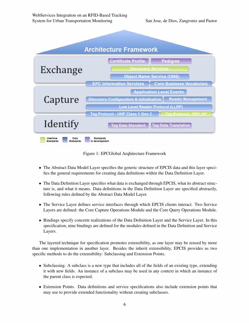
The Architecture Framework published by EPCglobal [16] provides a comprehensive overview ofthe EPCglobal standards. It shows how the different interface standards are related and outlines the prin-ciples that have guided the design of the standards.
EPCIS defines standard interfaces that allow the EPC data being captured and later be used by op-erations and an associated data model. Capture and query of these data, includes the use of persistentdatabases and the sharing of information application-to-application.
The EPCGlobal Architecture Framework1 (see Figure 1) is a collection of interrelated standards forhardware, software, and data interfaces, together with core services that are operated by EPCglobal andits delegates, all in service of a common goal of enhancing the supply chain through the use of ElectronicProduct Codes.
This framework does not dictate particular system architecture, but leaves this to implementers ormanufacturers who can choose the system architectures that are most appropriate for their deployments.EPCIS only specifies the interface between applications and data collection needed to access them.
It does not specify how to implement the operations or databases, but in no case the definition ofthe interfaces will be outside of the framework scope. In our development we use the RFID reader ofSkyeModuleM9 to capture data. This hardware meets the EPCGlobal standards and specifications, but ithas its own communication protocol and other special features.
Therefore, EPCIS is a standard that has a layered structure, extensible and modular. This featureoffers a number of advantages such as, for example, the reuse of code. The different layers describedwithin the EPCIS standard: Abstract Data Model Layer, Data Definition Layer, Service Layer and Bind-ings are presented in Figure 2).
These layers are described briefly below2:
1More information about data standards, interface standards and standards in development at: http://www.gs1.org/gsmp/kc/epcglobal2More information about the layers at: http://www.gs1.org/gsmp/kc/epcglobal/epcis/epcis_1_0_
1-standard-20070921.pdf
5
WebServices Integration on an RFID-Based TrackingSystem for Urban Transportation Monitoring San Jose, de Dios, Zangroniz and Pastor
Figure 1: EPCGlobal Arqhitecture Framework
• The Abstract Data Model Layer specifies the generic structure of EPCIS data and this layer speci-fies the general requirements for creating data definitions within the Data Definition Layer.
• The Data Definition Layer specifies what data is exchanged through EPCIS, what its abstract struc-ture is, and what it means. Data definitions in the Data Definition Layer are specified abstractly,following rules defined by the Abstract Data Model Layer.
• The Service Layer defines service interfaces through which EPCIS clients interact. Two ServiceLayers are defined: the Core Capture Operations Module and the Core Query Operations Module.
• Bindings specify concrete realizations of the Data Definition Layer and the Service Layer. In thisspecification, nine bindings are defined for the modules defined in the Data Definition and ServiceLayers.
The layered technique for specification promotes extensibility, as one layer may be reused by morethan one implementation in another layer. Besides the inherit extensibility, EPCIS provides us twospecific methods to do the extensibility: Subclassing and Extension Points.
• Subclassing. A subclass is a new type that includes all of the fields of an existing type, extendingit with new fields. An instance of a subclass may be used in any context in which an instance ofthe parent class is expected.
• Extension Points. Data definitions and service specifications also include extension points thatmay use to provide extended functionality without creating subclasses.
6

WebServices Integration on an RFID-Based TrackingSystem for Urban Transportation Monitoring San Jose, de Dios, Zangroniz and Pastor
Figure 2: EPCIS Layers
The modularity consists of several single associated specifications. This property allows to EPCISgrow and envolve in a distributed way. Together with the layered structure and extensibility, the modu-larity allows the definition of the structure in different documents as well as promote the consistency ofthe structure.
3.3 Fosstrak EPCIS Project
Fosstrak EPCIS Project is an open source software platform that implements the GS1 EPC Network spec-ifications. It provides an EPCglobal-certified EPCIS Repository as well as Query and Capture clients.
Fosstrak EPCIS Project features are, as follows:
• Deploying an EPCIS Repository.
• Run queries to an EPCIS Repository through a Graphic User Interface (GUI).
• Adding information to an existing EPCIS Repository through a GUI. This GUI is different thanthe before GUI.
7
WebServices Integration on an RFID-Based TrackingSystem for Urban Transportation Monitoring San Jose, de Dios, Zangroniz and Pastor
In addition to these standards-compliant modules, it also offers a ”Web adapter” for easy EPCIS ac-cess via web protocols (e.g., REST). Fosstrak has a regular client-server architecture consisting of threemodules: the Repository is the server, Query and Capture clients.
The repository is responsible for analyzing the requests of the clients, which are processed accordingto the rules defined in the specification of the standard. It implements five bindings as defined by theEPCIS specification: XML (eXtended Markup Language) for Data Definition Layer, HTTP for the Cap-ture Interface, SOAP/HTTP for the Query Control Interface, HTTP and HTTPS for the Query CallbackInterface.
The clients communicate with the repository via transport protocols. These protocols are: XML overHTTP to Capture client and SOAP (Simple Object Access Protocol) over HTTP to Query client, as wecan see in Figure 3.
To capture EPC data, it is necessary to wrap the data into XML conformin the EPCIS XML Schemafor event types. This EPCIS event must then be sent in an HTTP POST request to the repository’s captureinterface. An example of capture event, serialized into XML, is shown in Figure 4.
Queries for EPCIS Events must be inside a valid SOAP request to the repository. An examle of XMLis shown in Figure 5.
Both clients, Capture and Query, have a development client API and a client GUI. The API is usedby other applications to send queries to the repository. Manually, the interface is used to send eventswithin the repository. Fosstrak also provides a set of libraries and documentation to be able to integrateclients Capture and Query in an architecture type J2EE.
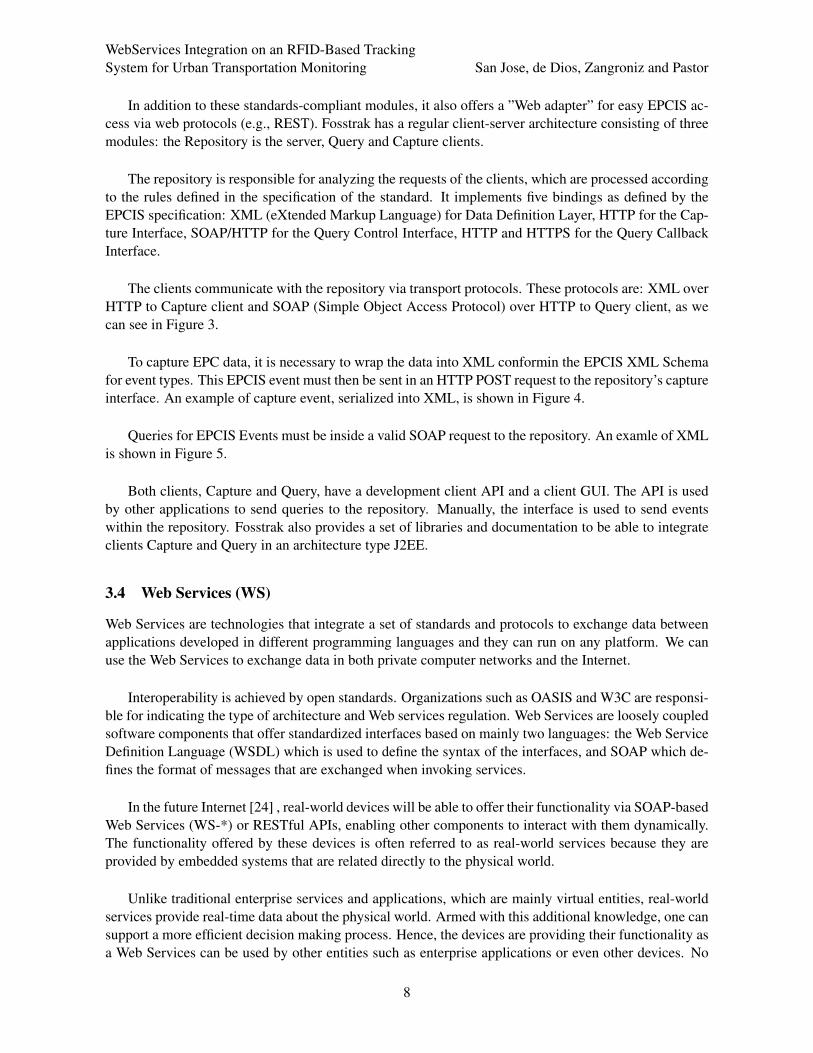
3.4 Web Services (WS)
Web Services are technologies that integrate a set of standards and protocols to exchange data betweenapplications developed in different programming languages and they can run on any platform. We canuse the Web Services to exchange data in both private computer networks and the Internet.
Interoperability is achieved by open standards. Organizations such as OASIS and W3C are responsi-ble for indicating the type of architecture and Web services regulation. Web Services are loosely coupledsoftware components that offer standardized interfaces based on mainly two languages: the Web ServiceDefinition Language (WSDL) which is used to define the syntax of the interfaces, and SOAP which de-fines the format of messages that are exchanged when invoking services.
In the future Internet [24] , real-world devices will be able to offer their functionality via SOAP-basedWeb Services (WS-*) or RESTful APIs, enabling other components to interact with them dynamically.The functionality offered by these devices is often referred to as real-world services because they areprovided by embedded systems that are related directly to the physical world.
Unlike traditional enterprise services and applications, which are mainly virtual entities, real-worldservices provide real-time data about the physical world. Armed with this additional knowledge, one cansupport a more efficient decision making process. Hence, the devices are providing their functionality asa Web Services can be used by other entities such as enterprise applications or even other devices. No
8

WebServices Integration on an RFID-Based TrackingSystem for Urban Transportation Monitoring San Jose, de Dios, Zangroniz and Pastor
Figure 3: Fosstrak EPCIS Project Implementation
device drivers are needed anymore and a new level of efficiency can be achieved as web service clientscan be generated dynamically at runtime.
4 Development Methodology
This section describes the methodology that has been proposed for the development of a generic ap-plication and that, subsequently, will serve us for the development of the application proposed in theintroduction section. Our methodology is divided into three parts: design, modeling, and implementa-tion.
9

WebServices Integration on an RFID-Based TrackingSystem for Urban Transportation Monitoring San Jose, de Dios, Zangroniz and Pastor
Figure 4: XML Capture EPCIS Events
4.1 Design
Before programming, we must consider a series of requirements previously, since it is necessary to beclear about the application you want to perform.
As indicated earlier, our application must be able to show us the information that it stores in adatabase. To do so, we must build a Web site on which we are able to access from any device (PC,Tablet, Smartphone, etc.), whichever browser, anywhere in the world to query of the information.
To do this, our application must meet a series of functional and non-functional requirements:
1. The functional requirements are the following: RFID readers must be able to access the centraldatabase through either a microprocessor or DSP. Each hardware element reading will connectthrough a port serial or USB to its processor, which will also have Internet connection. The infor-mation captured by the RFID readers in the bus stops, can be sent by different ways: via ethernetconnection, WIFI or through the new Wireless Sensor Networks infraestructures that are being in-
10

WebServices Integration on an RFID-Based TrackingSystem for Urban Transportation Monitoring San Jose, de Dios, Zangroniz and Pastor
Figure 5: XML Query for EPCIS Events
stalled in many cities. For a global interconnect, IPv6 addresses are used and IPv4 addresses willbe translated into IPv6 if needed to maintain compatibility. The Web Application can also accessthe same database in order to query, modify or update such data.
2. As non-functional requirements, our application must comply with the following: it seems inter-active for the user in order to request information from the server. The interface must be rathersimple so that any user can use it. The system should be robust against errors, and report eitherthe time in which they occur or whether not-allowed access to the data is tried out. It must providesecurity for the data stored in the database, so that they can only be modified by authorized users.
Once these requirements are met, we may enhance them according to the desired approach imple-mented for our application.
Within this section, it is also necessary to select the platform on which we are going to develop ourapplication. For its development, the following elements have been selected as the proposed architectureis based on Fosstrak EPCIS Repository and we need all the elements are fully compatible with Fosstrak.
Items selected for our development are as follows:
1. J2EE [1] development architecture.
2. Apache Tomcat [8] to be used as application server.
3. MySQL [12] to be used as database administrator.
4. Eclipse [18] and Visual Studio [21] to be used as development environments.
We have selected these elements because they are compatible with Fosstrak and EPCGlobal, they areprogrammed in Java, they are free, open source and secure. In the case of Visual C#, we use it becauseSkyeTek development APIs [32] are written in C and Microsoft NET. In this way we connect, configure
11

WebServices Integration on an RFID-Based TrackingSystem for Urban Transportation Monitoring San Jose, de Dios, Zangroniz and Pastor
and control our hardware SkyeModule M9 [31] and the captured information can be send to the centraldatabase for our application.
4.2 Modeling
Once the design is defined and the development platform has been also determined, the next step is toapply to particular cases such as urban transport routing and bus stops location on a map. It also estimatesthe arrival time of a bus stop.
In our case, our application consists of the design and implementation of an EPCGlobal system basedon RFID to store event data, more specifically location events. These data will be available to be accessedthrough any device and any Web browser.
RFID passive tags are used because they are a good solution for tracking products along the dis-tribution process and they are used in the first layer of our model. The RFID passive tags are cheap,can store up to 128 Kbytes of data and the RFID readers can read several tags simultaneously. Besides,RFID passive tags are used as they do not need maintenance an are more widespread than their activecounterparts, so wharehouses, generally, have the requiered handling equipment. However, it is possibleto use RFID active tags for specific applications, such as sensors, if required.
After deciding the application, the next step is to create the tables in the MySQL database and thevarious Java classes needed to work comfortably and easily, with the tables of the database that we create.
Within the database, the first task we carry out will be the filling a table named Read Point. The ideais to place a Read Point at each stop. In this way the name of the stop will be assigned and related to thelocated data (latitude, longitude and address) to identify it.
The next step will be to create and load the tables in the database that are for working with urbantransport lines and the different buses. As our application is rather simple, we only need to define threeJava classes to be able to properly write the tables that we have created within the database. The threeproper classes are: EPCIS, line and stop. As we can see in Figure 8, the properties of the line and stopclasses are specific for the database modeling.
Another important issue to consider when developing the data model, it is to analyze the relationshipsbetween the different tables and see how they relate to each other, to achieve a correct and consistent withour application data model. In Figure 9, we can see how they are related and how nodes are connectedto.
4.3 Integration
One of the main objectives of regular client-server architecture is the separation of the business logicsfrom the design logics. In other words, the goal is to separate the presentation data layer from the userlayer. Currently, when designing an application for big computer systems, it is often programmed vialayers or multilevel architectures.
The main advantage of this model of development is that the application is splitted up into severallevels or layers. Thus, each layer will play a simple role within the application, so we make a minor
12

WebServices Integration on an RFID-Based TrackingSystem for Urban Transportation Monitoring San Jose, de Dios, Zangroniz and Pastor
modification on the application, where it is not properly working.
To develop our application, a three-layer model is used (see Figure 6). It will consist of the followinglayers:
1. Presentation layer, for the user interface of the application. It introduces the system to the user,communicates information to him and returns the answer to the user applying a previous filterin order to check that there is no error. The interface consist of JSP components, because dy-namic content is created in an HTML document. the file is completed with JavaScript functions tocommunicate with Google Maps.
2. Business logic layer, for the business processes of the application. This layer is where the programsare running. It communicates with the presentation layer, to receive requests and present results,and with the data layer, to asking the system manager database for data storage or retrieval.
3. Data layer corresponds to the definition, storage and access to the application data. In an EPC-Global system, it translates into the definition of the tables necessary to store data of events, vo-cabularies, bus, bus lines, etc. This layer consists of one or more databases management and itreceives store request and retrieval information from the Business logic layer.
Figure 6: 3-layer model
Once the layer model to be used is decided, the next section will describe the process that we followfor the application development.
Another important task in our development is to connect, to configure and subsequent control ofRFID readers with Visual C#. This is a crucial task, because the location information captured is storedin a MySQL database, that is controlled by the developer, and these elements will be located on the map.
Finally, to conclude this section, the main libraries that we have used for deploying this applicationare:
• SkyeTek .NET API. It is a simple object-oriented interface that allows to use .NET framework ina computer. This interface allows to create commands for SkyeTek Protocol v3 (STPv3) [30] forSkyeModule readers. The requests and responses are written following the STPv3 standard.
• JDBC (Java Database Connectivity) API. This API is necessary to work with MySQL DB. It allowsto run different MySQL commands using Java in any DB.
• Fosstrak API. It is neccesary to define an EPCIS Repository to develop our application. For this,the Fosstrak API default libraries, the EPCIS Clients and the TDT Engine are used.
13
WebServices Integration on an RFID-Based TrackingSystem for Urban Transportation Monitoring San Jose, de Dios, Zangroniz and Pastor
EPCIS Capture Client and EPCIS Query Client. These clients allow capture and query for allthe EPC information.
EPCIS Repository. It is a file that is stored in the Web Server. Whenever that the systemneeds to capture or show information through EPCIS, the system queries to this context. EPCISRepository has several Java components that are necessary to develop our application.
TDT Engine. It traslates automatically the EPC information3 that it receives from the Skye-Module M9 into Pure Identity URIs.
• Google Maps JavaScript API v3. With this API, Google Maps can be added in a Web page. Also,we can find several utilities to work and services to add information to Google Maps. Google MapsAPI v3 is specially designed to work with mobile devices and traditional desktop applications.
5 Location transport and arrival time
Once the theoretical model of the system has been presented, in this section we describe the developmentof a particular WS for the location of urban transportation. In addition, the Web Application shows moreinformation about bus lines, bus routes, prices, etc.
The WS indicates the arrival time of the bus at a particular stop and it locates all the bus lines on theroute map, representing the specific position and displaying the time left for a bus to arrive at a particularstop. Besides, the application can calculate routes between two bus stops with the possibility of onetransfer between two different busses.
As indicated in the previous sections, we develop a Web Application based on regular client-serverarchitecture. The client requests through a Web browser the WS to the Web server. In our own localnetwork, there is a DB server that provides access, security and storage of all the data in the system. Oneof our development goal is that our application can be viewed from any compatible device, using anyweb browser, and which can be accessed from anywhere in the world.
On the other hand, we will have nodes related to the RFID reader that connects by USB to a micro-processor, so the Web server updates the system when an event occurs. This will happen when an RFIDtag goes nearby the antenna of a reader.
Subsequently, the location of the various elements that will form our system through Google Mapswill be displayed. As discussed in previous sections, there will be a simulation of the system, due to theunavailability of all the resources involved to achieve the actual implementation.
To begin our development, we create a Web Application information retrieval. To access proceduresto the database, it is using the default ones in Fosstrak EPCIS Repository. We will also use all defaultmethods leading to capture EPCIS events, thus following the standard marked by EPCglobal.
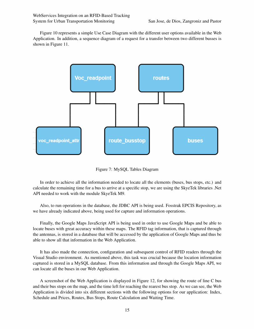
In the modeling process of our system, we are designing the necessary MySQL tables (Figure 7) forproper operation. Are also being designed Java classes (Figure 8) which form our model, taking specialcare in relationships and how to communicate between nodes our architecture consists of (Figure 9).
3EPCIS standard works in Pure Identity URI format. The EPC information is a hexadecimal code.
14
WebServices Integration on an RFID-Based TrackingSystem for Urban Transportation Monitoring San Jose, de Dios, Zangroniz and Pastor
Figure 10 represents a simple Use Case Diagram with the different user options available in the WebApplication. In addition, a sequence diagram of a request for a transfer between two different busses isshown in Figure 11.
Figure 7: MySQL Tables Diagram
In order to achieve all the information needed to locate all the elements (buses, bus stops, etc.) andcalculate the remaining time for a bus to arrive at a specific stop, we are using the SkyeTek libraries .NetAPI needed to work with the module SkyeTek M9.
Also, to run operations in the database, the JDBC API is being used. Fosstrak EPCIS Repository, aswe have already indicated above, being used for capture and information operations.
Finally, the Google Maps JavaScript API is being used in order to use Google Maps and be able tolocate buses with great accuracy within these maps. The RFID tag information, that is captured throughthe antennas, is stored in a database that will be accessed by the application of Google Maps and thus beable to show all that information in the Web Application.
It has also made the connection, configuration and subsequent control of RFID readers through theVisual Studio environment. As mentioned above, this task was crucial because the location informationcaptured is stored in a MySQL database. From this information and through the Google Maps API, wecan locate all the buses in our Web Application.
A screenshot of the Web Application is displayed in Figure 12, for showing the route of line C busand their bus stops on the map, and the time left for reaching the rearest bus stop. As we can see, the WebApplication is divided into six different sections with the following options for our application: Index,Schedule and Prices, Routes, Bus Stops, Route Calculation and Waiting Time.
15

WebServices Integration on an RFID-Based TrackingSystem for Urban Transportation Monitoring San Jose, de Dios, Zangroniz and Pastor
Figure 8: UML Class Diagram
Figure 9: Communication between nodes: UML Deployment Diagram
16

WebServices Integration on an RFID-Based TrackingSystem for Urban Transportation Monitoring San Jose, de Dios, Zangroniz and Pastor
Figure 10: UML Use Case Diagram
• Index. In this section, we briefly explain the Web Application.
• Schedule and Prices. This section includes several information about bus lines, bus stops, phonenumbers, points of interest and special bus lines.
• Routes. It show us the different routes of each bus lines.
• Bus Stops. The Web Application show us each bus stop on Google Maps. For that and followingthe three-layer model, when we select a bus stop, the application sends a query to the DB serverand receives the information that it shows us on Google Maps. The Web Application allows to theuser filter by bus line to get only the bus stops of one single bus line.
• Route Calculation. This section allows to the user to select an origin bus stop and a destinationbus stop, and it calculates the most efficient route with the possibility of one transfer between twodifferent buses. Once the Web Application receives the information, it shows this information(origin bus stop, destination bus stop, transfer between busses) on a Google Maps screen.
• Waiting Time. The last section show us the time left to arrive of a bus of a particular bus line to acertain bus stop. Also, we can get the location of this bus on Google Maps and the route to arriveto the actual bus stop.
6 Conclusions
The creation of a project based on a J2EE Web Application is proposed in this paper. The proceduresneeded for accessing the databases using the Fosstrak EPCIS Repository to capture events according to
17

WebServices Integration on an RFID-Based TrackingSystem for Urban Transportation Monitoring San Jose, de Dios, Zangroniz and Pastor
Figure 11: UML Sequence Diagram
the EPCglobal standard have been defined. Although, we have performed small scale tests and we are innegotiations with local authorities for actual testing on a real urban environment.
Combining two technologies, RFID and GIS, the tracking system referred in previous works can beimproved and more features can be added, with the design of Web Services. Besides, we have beenintegrated the tracking system in a Web environment as two Web Services, the monitoring of buses andreal-time information of the bus stops.
18

WebServices Integration on an RFID-Based TrackingSystem for Urban Transportation Monitoring San Jose, de Dios, Zangroniz and Pastor
Figure 12: Web Application
In addition, a three-layer model is proposed for the development of our application. Additional simi-lar applications can be developed by using the proposed model. Also we have used JavaScript functions,which may be reusable in future works.
Our original motivation was to complete the development initially achieved by our research group inthe lower layers of the EPCIS standard, in order to advance through to the upper layers. Our previousresearch was focused on developing hardware and networking middleware for RFID systems.
6.1 Discussion
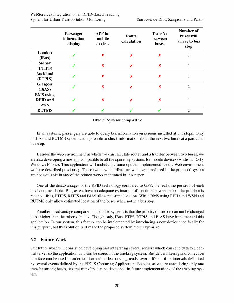
In this section, we will perform a comparison among all the systems mentioned in this paper and ours,indicating the advantages and disadvantages of the RUTMS system. Table 3 shows this comparison in amore graphical way, including the applications we consider important in evaluating RUTMS.
The advantage of our system RUTMS consists on the use of the communications infraestructure ofthe city itself. RUTMS can transmit data via LAN, WIFI or WSN. In this way, we have got no additionalexpenses, as in cases where the position must be transmitted from the vehicle, usually via GSM, GPRS,3G, 4G, etc.
In RUTMS, the installation of RFID readers in each bus stop can initially be more expensive thaninstalling GPS receivers and a mobile device to send the data in each bus. But in our case, we wouldhave an initial investment cost, but we would not have to pay for the communication lines of each busevery month during the usual operation of the system.
19
WebServices Integration on an RFID-Based TrackingSystem for Urban Transportation Monitoring San Jose, de Dios, Zangroniz and Pastor
Passengerinformation
display
APP formobiledevices
Routecalculation
Transferbetween
buses
Number ofbuses will
arrive to busstop
London(iBus) 3 7 7 7 1
Sidney(PTIPS) 3 7 7 7 1
Auckland(RTPIS) 3 7 7 7 1
Glasgow(BiAS) 3 7 7 7 2
BMS usingRFID and
WSN3 7 7 7 1
RUTMS 3 3 3 3 2
Table 3: Systems comparative
In all systems, passengers are able to query bus information on screens installed at bus stops. Onlyin BiAS and RUTMS systems, it is possible to check information about the next two buses at a particularbus stop.
Besides the web environment in which we can calculate routes and a transfer between two buses, weare also developing a new app compatible to all the operating systems for mobile devices (Android, iOS yWindows Phone). This application will include the same options implemented for the Web environmentwe have described previously. These two new contributions we have introduced in the proposed systemare not available in any of the related works mentioned in this paper.
One of the disadvantages of the RFID technology compared to GPS: the real-time position of eachbus is not available. But, as we have an adequate estimation of the time between stops, the problem isreduced. Ibus, PTIPS, RTPIS and BiAS allow real-time location. While BMS using RFID and WSN andRUTMS only allow estimated location of the buses when not in a bus stop.
Another disadvantage compared to the other systems is that the priority of the bus can not be changedto be higher than the other vehicles. Though only, iBus, PTPS, RTPIS and BiAS have implemented thisapplication. In our system, this feature can be implemented by introducing a new device specifically forthis purpose, but this solution will make the proposed system more expensive.
6.2 Future Work
Our future work will consist on developing and integrating several sensors which can send data to a cen-tral server so the application data can be stored in the tracking system. Besides, a filtering and collectioninterface can be used in order to filter and collect raw tag reads, over different time intervals delimitedby several events defined by the EPCIS Capturing Application. Besides, as we are considering only onetransfer among buses, several transfers can be developed in future implementations of the tracking sys-tem.
20

WebServices Integration on an RFID-Based TrackingSystem for Urban Transportation Monitoring San Jose, de Dios, Zangroniz and Pastor
On one hand, we have considered only one transfer among buses, so several transfers can be devel-oped in future implementations of the tracking system.
On the other hand, a WSN can be added to our system to know the number of passengers on thebus in real time. With this information and the hours of passenger transport peak, each route can bereinforced in their peak times of usage.
Additionally, the date provided by the sensors in the buses to get traffic information in real time canbe sent this to other buses or vehicles through WSN.
We are developing several sensors which can send data to a central server so the application infor-mation can be stored. Besides, a filtering and collection interface can be implemented in order to filterand collect raw tag reads, over different time intervals delimited by several events defined by the EPCISCapturing Application.
Our final intention is to develop an architecture and software tools in order to implement trackingand tracing applications in different fields: logistics, people tracking and Wireless Sensor Networks.
Acknowledgments
This work was partially supported by Ministerio de Ciencia e Innovacion (project BIA2009-10225) andby Viceconsejerıa de Ciencia y Tecnologıa - Junta de Comunidades de Castilla-La Mancha (ProjectPII1I09-0134-5683).
References
[1] O. Aloquili, A. Elbanna, and A. Al-Azizi. J2ee development frameworks. Computer, 38(1):107–110, January2005.
[2] O. Aloquili, A. Elbanna, and A. Al-Azizi. Automatic vehicle location tracking system based on gis environ-ment. IET Software, 3(4):255–263, December 2008.
[3] D. Bajaj and N. Gupta. Gps based automatic vehicle tracking using rfid. International Journal of Engineeringand Innovative Technology, 1(1):31–35, January 2012.
[4] P. Baronti, P. Pillaia, V. W. Chook, S. Chessa, , A. Gotta, and Y. F. Hua. Wireless sensor networks: a surveyon the state of the art. Computer Communications, 30(7):1655–1695, May 2007.
[5] A. Burlarley-Hyland, B. Toothill, and A. Das. Use of automatic vehicle location systems, geographic in-formation systems, and global positioning systems to increase efficiencies and decrease cost in maintenancemanagement. In Proc. of the Maintenance Management Conference (MMC’12), Seattle, USA, pages 46–54.Transportation Research Board of the National Academies, May 2012.
[6] M. Castro, A. J. Jara, and A. Skarmeta. Architecture for improving terrestrial logistics based on the web ofthings. Sensors, 12(5):6538–6575, May 2012.
[7] K.-T. Chang. Introduction to Geographic Information Systems. McGraw-Hill Education, 2010.[8] V. Chopra, S. Li, and J. Genender. La Biblia de MySQL. Wrox, 2008.[9] R. Clarke, T. Bowen, and J. Head. Mass deployment of bus priority using real-time passenger information
systems in london. In Proc. of the 35th European Transport Conference 2007 (ETC’07), Noordwijkerhout,Netherlands, pages 1–9. Association for ETC 2007, October 2007.
[10] G. C. Council. The Bus Information and Signalling System - BIAS. http://www.glasgow.gov.uk/
index.aspx?articleid=5203, 2004.
21

WebServices Integration on an RFID-Based TrackingSystem for Urban Transportation Monitoring San Jose, de Dios, Zangroniz and Pastor
[11] G. Developers. Google Maps JavaScript v3 API. https://developers.google.com/maps/
documentation/javascript/?hl=en, 2013.[12] P. Dubois. La Biblia de MySQL. Ed. Anaya Multimedia, 2007.[13] J. EberspAcher, H.-J. Vogel, and C. Bettstetter. GSM Switching, Services and Protocols, Second Edition.
John Wiley & Sons, 2001.[14] EPCGlobal. EPC Information Services (EPCIS) version 1.0.1 specification. http://www.gs1.org/gsmp/
kc/epcglobal/epcis/, 2007.[15] EPCGlobal. EPCGlobal Frequently Asked Questions. http://www.gs1.org/docs/epcglobal/
Frequently_Asked_Questions.pdf, 2007.[16] EPCGlobal. The EPCglobal Architecture Framework. http://www.gs1.org/gsmp/kc/epcglobal/
architecture/, 2010.[17] EPCGlobal. Gs1 epc tag data standard 1.7. Technical Report 1.7, GS1 EPCglobal, 2013.[18] T. E. Fundation. Announcements, Community News, etc. http://www.eclipse.org, 2013.[19] A. Garcıa, Y. S. Chang, and R. Valverde. Impact of new identification and tracking technologies on a distri-
bution center. Computers and Industrial Engineering, 51(3):542–552, November 2006.[20] R. Glidden, C. Bockorick, S. Cooper, C. Diorio, D. Dressler, vadim Gutnik, C. Hagen, D. Hara, T. Hass,
T. Humes, J. Hyde, R. Oliver, O. Onen, A. Pesavento, K. Sundstrom, and M. Thomas. Design of ultra lowcost uhf rfid tags for supply chain applications. IEEE Communications Magazine, 42(8):140–151, August2004.
[21] M. Gousset, B. Keller, A. Krishnamoorthy, and M. Woodward. Professional Application Lifecycle Manage-ment with Visual Studio 2010. Wrox, 2010.
[22] M. S. Grewal, L. R. Weill, and A. P. Andrews. Global Positioning Systems, Inertial Navigation, and Integra-tion. Wiley-Interscience, 2007.
[23] D. Guinard, V. Trifa, S. Karnouskos, P. Spiess, and D. Savio. Interacting with the soa-based internet of things:Discovery, query, selection, and on-demand provisioning of web services. IEEE Transactions on ServicesComputing, 3(3):223–235, July-September 2010.
[24] D. Guinard, V. Trifa, T. Pham, and O. Liechti. Towards physical mashups in the web of things. In Proc. of the6th International Conference on Networked Sensing Systems (INSS’09), Pittsburgh, USA, pages 1–4. IEEE,June 2009.
[25] B. A. Hatem and H. Habib. Bus management system using rfid in wsn. In Proc. of the 7th European andMediterranean Conference on Information Systems (EMCIS’10), Abu Dhabi, UAE, pages 1–8. EMCIS, April2010.
[26] N. Hounsell, B. Shrestha, and A. Wong. Data management and applications in a world-leading bus fleet.Transportation Research Part C: Emerging Technologies, 22:76–87, December 2012.
[27] J. I. S. Jose, J. M. Pastor, R. Zangroniz, and J. J. de Dios. Rfid tracking for urban transportation usingepcglobal-based webservices. In Proc. of the 27th International Conference on Advanced Information Net-working and Applications Workshops (WAINA’13), Barcelona, Spain, pages 1295–1300. IEEE, March 2013.
[28] A. Mehaffey and G. Jarjees. Preliminary trial results of the public transport information and priority system.In Proc. of the 8th World Congress on Intelligent Transport Systems (ITS’01), Sydney, Australia, pages 1–8.ITS America, September-October 2001.
[29] F. E. Project. EPCIS Architecture Guide. https://code.google.com/p/fosstrak/wiki/
EpcisArchitectureGuide, February 2012.[30] SkyeTek. Skyetek c and .net api reference guide. Technical Report 080409, SkyeTek, Inc., 2008.[31] SkyeTek. SkyeModule M9. http://www.skyetek.com/ProductsServices/EmbeddedRFIDReaders/
SkyeModuleM9/tabid/208/Default.aspx, 2013.[32] SkyeTek. SkyeTek Development APIs. http://www.skyetek.com/ProductsServices/
EmbeddedRFIDReaders/Firmware/SkyeAPI/tabid/419/Default.aspx, 2013.[33] G. Svennerberg. Beginning Google Maps API 3. Apress, 2010.[34] V. Vencatachellum. Auckland’s Signal Pre-emption and Real-time Passenger Information System. http:
//www.ipenz.org.nz/ipenztg/papers/2003/11_Vadi_Vencatachellum.pdf, 2012.
22

WebServices Integration on an RFID-Based TrackingSystem for Urban Transportation Monitoring San Jose, de Dios, Zangroniz and Pastor
[35] B. Violino. What is rfid? RFID Journal, pages 1–2, January 2005.
Author Biography
Jose Ivan San Jose received his Master degree in Advanced Computer Technologiesfrom the University of Castilla-la Mancha in 2011. Currently, he continues his studiesas a PhD student and participates in several research projects, and he is a researcherof Institute of Audiovisual Technologies in Cuenca (Spain) since 2010. His researchinterests are RFID, Web Services, Internet of Things, Smart Objects and WirelessSensor Networks.
Juan Jose de Dios received the Ingeniero de Telecomunicacion degree in 1991 andthe Doctor Ingeniero de Telecomunicacion degree (PhD in Communications) summacum laude in 2004 from the E.T.S. Ingenieros de Telecomunicacion of the Universi-dad Politecnica de Madrid (Spain). Since 1999 he has been with the E. U. Politecnicade Cuenca of the Universidad de Castilla–La Mancha (Spain). He is an associate pro-fessor of television systems in the Department of Signal Theory and Communications.Previously, he was working for Lucent Technologies (formerly AT&T) at the Trans-
mission Engineering Lab in Madrid (Spain) from 1991 to 1999. His professional interests include RFIDtechnology, image and video processing.
Roberto Zangroniz received the Science (Physics) degree in 1999, and the Electron-ics Engineering degree in 2001, from the University of Valladolid, Spain. Roberto hasample experience in the design and development of microcontroller driven devices.His research interests include RF data communications applied to RFID, WirelessSensor Networks and, Real-Time Location Systems through the design of electron-ics systems. In 2001, he joined the University of Castilla–La Mancha, where he is aLecturer of the Polytechnic school at Cuenca (Spain).
Jose Manuel Pastor was born in Leon, Spain. He received the Electronics and Auto-matic Control Engineering degree from the Polytechnic University of Madrid (UPM)in 1991. In 1992 he begins his doctoral research in Robotics in Construction Industry.In 1996 Dr. Pastor moves to the Engineering Department of the Carlos III Universityof Madrid. He received his Ph.D. in Robotics and Artificial Intelligence in 1997 fromthe UPM. His research interests include RFID, factory automation, intelligent manu-facturing and logistics systems. He is currently an Associate Professor at University
of Castilla-La Mancha, and director of Research Institute of Audiovisual Technologies.
23