Webinar: Designing Pedestrian Friendly Neighbourhoods in a Greenfield Context - A Case Study of Naya...
67
A product of WRI Ross Center for Sustainable Cities PRESENTED BY – ROHIT KHANDELWAL (NRDA), REJEET MATHEWS (WRI INDIA – EMBARQ) NEHA MUNGEKAR (WRI INDIA – EMBARQ) DESIGNING PEDESTRIAN FRIENDLY NEIGHBOURHOODS IN A GREENFIELD CITY FOCUS: NAYA RAIPUR SECTOR 31
-
Upload
wri-ross-center-for-sustainable-cities -
Category
Travel
-
view
1.831 -
download
1
Transcript of Webinar: Designing Pedestrian Friendly Neighbourhoods in a Greenfield Context - A Case Study of Naya...

A product of WRI Ross Center for Sustainable Cities
PRESENTED BY –
ROHIT KHANDELWAL (NRDA),
REJEET MATHEWS (WRI INDIA – EMBARQ)
NEHA MUNGEKAR (WRI INDIA – EMBARQ)
DESIGNING PEDESTRIAN FRIENDLY NEIGHBOURHOODS IN A GREENFIELD CITYFOCUS: NAYA RAIPUR SECTOR 31

PRESENTERS
• Rohit Khandelwal - Deputy General Manager (Planning) - Naya Raipur Development Authority (NRDA)
• Rejeet Mathews, Manager - Urban Development & Accessibility, WRI India | EMBARQ
• Neha Mungekar, Senior Associate - Urban Development & Accessibility, WRI India | EMBARQ

Designing Pedestrian Friendly Neighbourhoods in a Greenfield City
Focus: Naya Raipur Sector 31

Naya Raipur: Designing and building an entire city from scratch…

Collaboration: Naya Raipur Development Authority & WRI - EMBARQ India
|

Team work…

NAYA RAIPUR MASTER PLAN
Designing Pedestrian Friendly Neighbourhoods in a Greenfield CityFocus: Naya Raipur Sector 31

VISION
‘Naya Raipur’ to be developed as a modern but ‘Green and SMART city’.
For conservation of the environment and existing landscape, best practices for water harvesting, waste water recycling and use of non-conventional energy resources would be adopted.
Naya Raipur designed as a citizen friendly and visitor friendly city with Non Mortised Transport (NMT) facilities.
City design would promote sense of security and comfort among its citizens, especially women, children and the physically challenged.

CONNECTIVITY

NAYA RAIPUR PLANNING AREA• The Development Plan-2031 consists of
three layers-
Sr. No. LayerArea
IncludedVillages included
1 Layer-I 80.13 sq.km. 10 fully and 22 partly
2Layer- II(Naya Raipur Peripheral Region )
130.28 sq.km. 9 fully and 19 partly
3Layer- III(Airport Zone)
11.92 sq.km. 2 fully and 1 partly
13 Abadi areas have been included in layer -I

DEMOGRAPHIC DATANaya Raipur would act as an additional growth center taking functions from Raipur city and beyond.
Naya Raipur would attract population from Raipur, Durg – Bhilai Urban Agglomeration and various parts of Chhattisgarh.
Naya Raipur is to be developed in three phases within a period of 30 years for a population of 5.60 lakh
Phase – I 2015
Phase – II 2021
Phase –III2031
Projected Population 150,000 365,000 560,000
Natural Growth of the Existing Population 22,400 40,800
Additional Population 192,600 154,200

BALANCED LAND USE• Conservation of existing water bodies
• Conservation of existing plantation
• Recreation area 26 %
• Distributed employment centers across the city with centrally located CBD, to reduce the traffic.
• Green connectivity across the city to promote pedestrian and NMT movement.
• Grid pattern streets
1. To promote high speed roads on arterial roads
2. Alternative roads for every destinations
3. Ease in providing infrastructure.
4. Suitable for public transport system

WORK AREASActivity/Use Zone Number of employees
CBD 46819
Institutional areas 31213
Capitol Complex 26754
Light Industries /Composite use zone 22295
Planning Unit Centres 20065
Other Govt offices 17836
Construction Industry 17836
Residential Area 13379
Wholesale Trade 11147
Software technology park 8918
Transport Hub 6688
Total 222,950
Jobs in all sectors of Economy

NEIGHBORHOOD PLANNINGThe Housing strategy aims at providing
• Comfortable housing for all coupled with quality physical and social infrastructure
• Pedestrian movement based neighborhoods for convenient facilities.
• Gross residential density of each sector - 250 person per hectare
• Average population of typical sector - 16,000

TRANSPORTATION – NAYA RAIPUR
Bus rapid transit system (BRTS)
Railways – National connectivity
Light rail Transit system (LRTS)
NMT- Pedestrian walkways and cycle tracks
Corridor III
Source: Bus Service Plan Report by EMBARQ
Our Vision‘Mobility of all, affordable, equitable and safe’
Public Mass Transport System

NON MOTORIZED TRANSPORT PLANNING
Green corridors within the sectors
Green corridors at the city level
NMT along roads

TOD IMPLEMENTATION
• The revised TOD chapter 9 and Chapter 18 of NRDP 2031, sent to the Government for final notification.
• Planning of Sector 7, 15-16, 31 and 32 based on TOD.
• Land use change of green strip along transit route in Sectors 7, 15, 21, 25 and 28 is in the final stage.

TRANSIT ORIENTED DEVELOPMENT
Mixed Use
Flatted
Group housing
Compact Development
Well designed Transit station for high quality user experience
Bicycle Friendly Streets
Mixed use Development
Multimodal Transit Sectors 7, 15 and 16

ISSUES ADDRESSED IN REVISED DEVELOPMENT CODERegulations as per old DCR Regulations as per new DCR
Set Back Set BackFront 15m. Front 1m.Back 9m. Back 6m.
Side 1 9m. Side 1 6m.Side 2 9m. Side 2 6m.
Maximum Front Set Back
Commercial/Retail offices/Non Residential use 3m
Institutional/ industrial 3m Residential use 5m
Parking Standards (ECS per 100 sq.m.) Parking Standards (ECS per 100 sq.m.)
Residential - Group Housing 1.67 Residential - Group Housing 1
Commercial cum Business Complex 1.67 Commercial cum Business
Complex 1.25
Residential - Group Housing Residential - Group HousingGround Coverage 30% Ground Coverage N.R.
Min. FAR - Min. FAR 2Max. FAR 1.3 Max. FAR 4
Max. Height (Subject to AAI permissions) 26m. Max. Height
(Subject to AAI permissions) N.R.
Commercial Retail Commercial RetailGround Coverage 25% Ground Coverage N.R.
Min. FAR - Min. FAR 2Max. FAR 1 Max. FAR 4
Max. Height (Subject to AAI permissions) 26m. Max. Height
(Subject to AAI permissions) -

Designing Pedestrian Friendly Neighbourhoods in a Greenfield CityFocus: Naya Raipur Sector 31
Process | Challenges | Opportunities

The Process:
1. Workshops conducted with NRDA Staff and other stakeholders to discuss key concepts of sustainable cities…
2. Assessment of all applicable legal and regulatory frameworks…
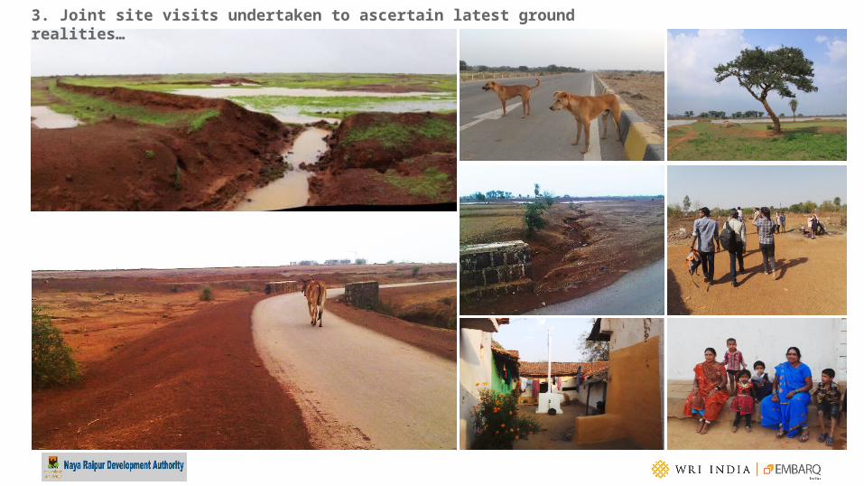
3. Joint site visits undertaken to ascertain latest ground realities…

3. Joint site visits undertaken to ascertain latest ground realities…

BRT Stop
4. Review and assessments done of existing sector designs…
Sector 27

BRTS Corridor in Curitiba, Brazil
5. Benchmarking with global and national best practices….

6. Understanding what not to do…
• Junction hierarchy system not well defined
• Thoroughfare traffic encouraged through design which is not desirable
Sector 27

Image Source: Jan Gehl Architects
Vibrant Streets
7. Understanding key principles of sector design…

7. Understanding key principles of sector design…
Vibrant Streets
Image Source: CTS Mexico / WRI - EMBARQ

Transit priority zones
7. Understanding key principles of sector design…

Typical Sector: 800m x 800m BRT alignment and station influence zone Natural features and a 100m x 100 m pedestrian access grid overlay
Gateway (50m) for intermodal access & Midway (250m) for high densities Alignment of the BRT also receiving higher densities and character Preservation of natural features
Integration of natural features and open spaces Main access corridors receiving medium density A Complete TOD
7. Understanding key principles of sector design…

Green and Open Space Hierarchy
7. Understanding key principles of sector design… Image adapted from: , ‘Shaping Neighbourhoods’ A Guide for Health, Sustainability and Vitality, By – Hugh Barton

7. Understanding key principles of sector design… Data Source: Transit-Oriented Development (TOD) Guidebook, City of Austin. Neighbourhood Planning and Zoning Department., April 2006
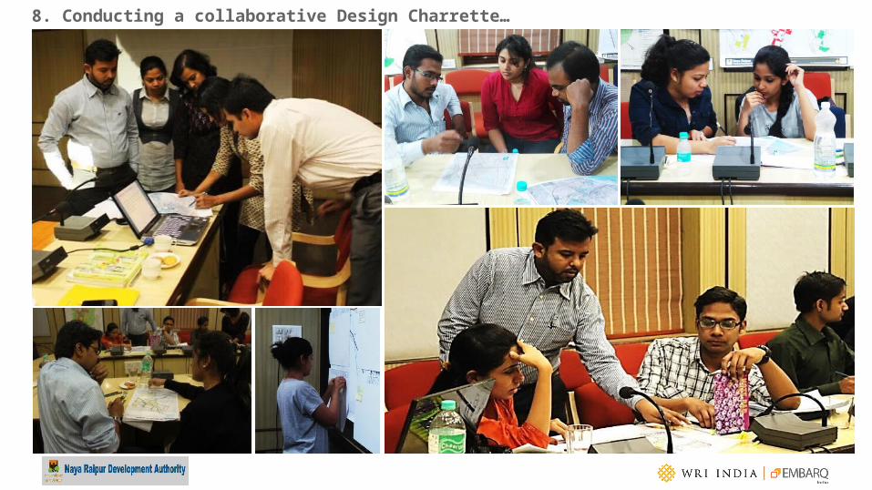
8. Conducting a collaborative Design Charrette…

8. Conducting a collaborative Design Charrette…

DESIGN 01 DESIGN 02 DESIGN 03 DESIGN 04
DESIGN 05 DESIGN 06 DESIGN 07 DESIGN 08
9. Preliminary ideas and sector design options…

9. Preliminary ideas and sector design options… Joint review of strengths and improvements

10. Taking ideas forward in consultation with various stakeholders, and bringing in technical soundness…
Talking with private developers – Infrastructure provision consultants – Other government departments
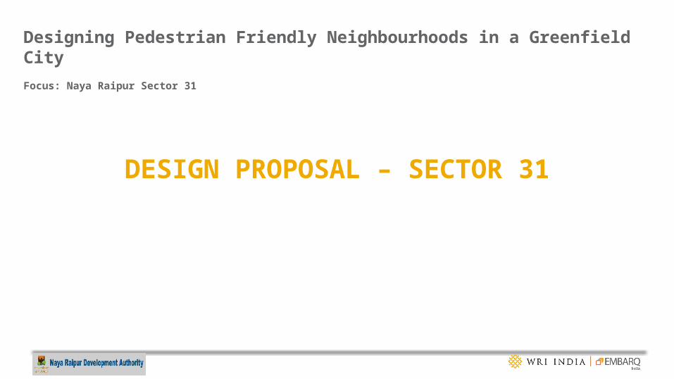
DESIGN PROPOSAL – SECTOR 31
Designing Pedestrian Friendly Neighbourhoods in a Greenfield CityFocus: Naya Raipur Sector 31

UNDERSTANDING CONTEXT
Sector 31

DESIGN CONCEPTS
Flattening of terrain
Dispersed mass and segregated landuse
Flooding
Increase in trip length
CON
VEN
TIO
NAL
Des
ign
Mixed Use Core
Development as per the contours. Water network
has been retained.
High Density Transit Corridor
Hierarchy of greens connecting to the amenities within walkable distance through permeable strips
TRAN
SIT
and
PEO
PLE
Orie
nted
Des
ign

SECTOR DESIGNExisting Markers
LakesTerrainVillage Route leading towards village Khapri to the west
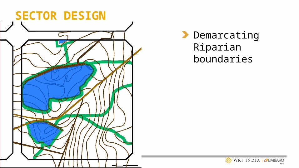
SECTOR DESIGNDemarcating Riparian boundaries
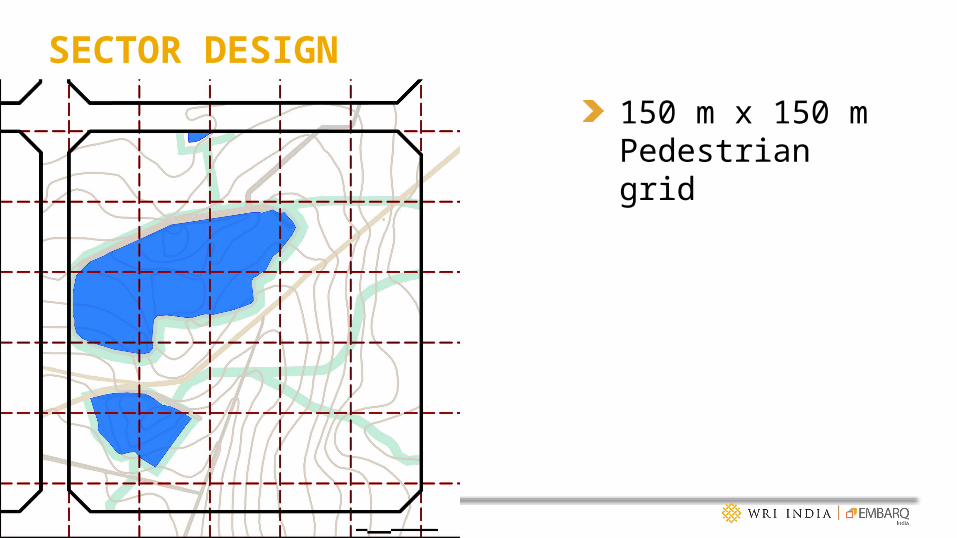
SECTOR DESIGN150 m x 150 m Pedestrian grid
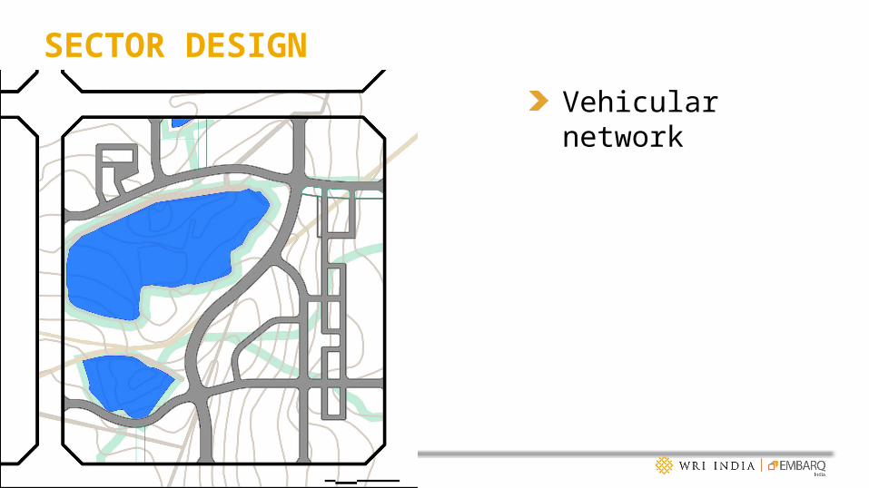
SECTOR DESIGNVehicular network

SECTOR DESIGNCycling track around public open spaces

SECTOR DESIGNAmenities and Open Spaces around Cycling track

SECTOR DESIGNBuildings around High Street
Bus Stop
Bus Stop

SECTOR DESIGNFinal Design

STREET DESIGN

ROAD HIERARCHY
Local Roads – 12.5 m & 10 mCollector roads – 18 mSub- Arterial Road – 25 m

SECTION 25 M – HIGH STREET
Median Carriage way Tree line Parking Footpath Cycling Track
Walkway in private property
1 7 1 2.5742.5
56%44%
Vehicular Vs NMT VehicularNMT

JUNCTION DETAILS1
3
2
1 23

OPEN SPACE DESIGN
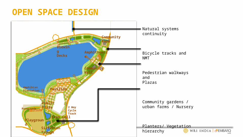
OPEN SPACE DESIGN
Natural systems continuity
Bicycle tracks and NMT
Pedestrian walkways and Plazas
Community gardens / urban farms / Nursery
Planters/ Vegetation hierarchy
Public Plaza
Viewing Decks
Siltation Trough
Farm CellPlayground
Community Hall
Community Room
Amphitheatre
PavilionAmphibian Plantation
Promenade 2 WayCycle Track

OPEN SPACE DESIGN – SILTATION PONDS

HOUSING

HOUSING - BUILDING HEIGHTS - APARTMENTS
G + 4
G + 6G + 8G + 12

HOUSING - PLOTTED TYPES
1 BHK
2 BHK3 BHK4 BHK

TYPOLOGY GUIDELINES – PLOTTED – 1 BHKBuilding Typology: 1 BHK Housing Row Housing
1Plot Area 60sq. m 60-200sq.m Corner Plots
2Permissible FSI 1.3
2Ground Coverage 65%Below 60 Incremental Hsg
60% 3Footprint 36-100sq.m
Allowed Footprint 39-130sq.m4
Setbacks
Front 1.5m Rear 2m Side 1 3m Side 2 0/2m Minimum Setbacks (DCR) Front 2 / 1(<60 sqm) Rear 2 Side 1 0 Side 2 0
5Building Height 7.5m (G+1) Interior plots
7.5/10.5 (G+1/2)Corner Plots
6No of dwelling units 1 Interior Plots 2Corner plots
7Total BUA 70-200Interior Plots Permissble BUA 78 -331sq.m
Compound Wall
1.5 m = 1.0 solid opaque + 0.5 m visible edge
around the entire plot line

FORM BASED GUIDELINES - APARTMENTSApartments abutting High Street
Apartments abutting Sector entrances
Apartments abutting 60 m eastern road
Plan with retail front
Plan without retail front
Sections

MASSING


PROJECT IMPACT

PROJECT IMPACTTOD PRINCIPLES PROPOSALS
Complete streets (Walking and Biking)
Walking Grid of 150m x 150 m, Connected Greens, Safe Junctions, Bicycle Paths
Transit Supportive Uses (Active Edges)
Shared uses along the transit corridors, Mixed/Commercial Uses on the ground floor, Permeable edges.
Integrated Transport (Public Transit)
Design responds to the feeder system which supports the BRT system.
Public Spaces (Open Spaces)
Varied hierarchy, Inclusive greens, Inter-connected
Cultural Landscapes (Historic and Environmental)
The design respects the natural terrain. The valleys are retained. The traditional routes connecting the existing villages are also retained thus helping to preserve the memory of the place.
Compact development (Mixed Use and Density)
Tiered Density along the transit routes. Mixed-uses proposed at the junctions

Permeable building edge activating the
street
Accessible inclusive public
spaces
Pedestrian and cycle friendly
streetsMixed use edge

ACCESSIBLE, INCLUSIVE AND SAFE
Inclusive public open spaces – urban farms
Safe AccessPedestrian connection
through blocksContinuity of water system

THANK YOU