
Waverley's PEOPLE, MOVEMENT AND PLACES_Movement_and_Pl… · Waverley's People, Movement and Places...
40
Waverley's PEOPLE, MOVEMENT AND PLACES Where we go and how we get there Final Summary
Transcript of Waverley's PEOPLE, MOVEMENT AND PLACES_Movement_and_Pl… · Waverley's People, Movement and Places...
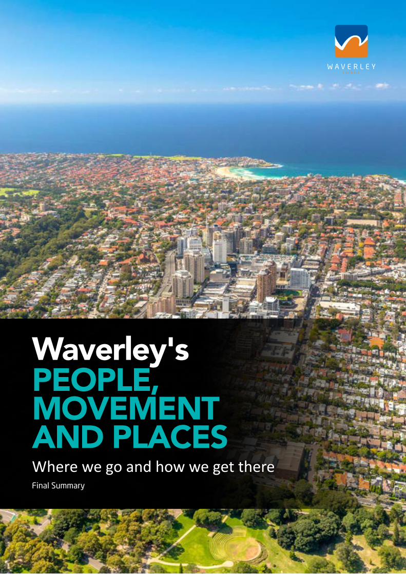
Waverley's PEOPLE, MOVEMENT AND PLACESWhere we go and how we get thereFinal Summary

Waverley's People, Movement and Places
2
EXECUTIVE SUMMARY 5
KEY TRANSPORT ISSUES FOR OUR LOCAL AREA 7
OUR TRANSPORT VISION 12
Transport Hierarchy 14
Outcomes for the Whole Community 15
TRANSPORT PLAN 16
Signature Projects 17
1. Better Streetscapes 18
2. Cycling Strategy 20
3. Bondi Junction Interchange 22
4. Bondi Road Corridor 24
5. Walking Strategy 26
6. Smart Cities Mobility 28
7. Schools Active Travel 30
8. Shared + Electric Vehicles 32
9. Charing Cross 34
10. Bondi Junction 35
11. Bondi Beach 36
12. Smart Parking Management 38
CONTENTS
Waverley Council (2017) Waverley's People, Movement and Places: where we go and how we get there: Final Summary
Waverley's People, Movement and Places
3


Waverley's People, Movement and Places
5EXECUTIVE SUMMARYBackgroundOur streets are vital to the success of our community. Streets provide links for transport movement, and are also places for people to meet, shop and linger.
Waverley's People, Movement and Places aims to make it easier for people to move around by improving the quality of our streetscapes and public places.
Our plan prioritises pedestrians first, followed by people riding bicycles, using public transport, service vehicles, shared mobility and private motor vehicles.
The Strategy Report provides recommendations for Council to improve the full range of transport options for the community. It includes twelve Signature Projects as well as 96 short, medium and long term actions that Council can undertake between now and 2030, in partnership with the community and state government agencies.
These actions include major improvements such as overhauling the Bondi Junction Interchange; priority bus routes along Bondi Road, Bronte Road and Old South Head Road; and cycling superhighways between key destinations.
Small actions will also make a difference, such as safe routes that enable walking and cycling to schools; more car share pods; and improved pedestrian crossings.
Combined, all of these actions will make it easier, safer and more enjoyable for everyone.
Why we need a transport planThe Community Plan and Environmental Action Plan set out the community’s aspirations, strategies and targets for achieving a better environment, community and economy. These include a commitment to making our streetscapes more liveable, sustainable and equitable for everybody in the community.
To progress these strategic directions further, Waverley Council commissioned a series of reports titled Waverley's People, Movement and Places: a study of where we go and how we get there.
Transport problems currently facing our local government area (LGA) include traffic congestion; lack of reliable and efficient public transport; problems with parking especially in village centres; safety; and difficulty walking and cycling due to difficult terrain, poor quality footpaths and lack of separated cycleways.
A draft report was exhibited in May/June 2017 and the feedback was used for this final transport plan.
The future of transport We anticipate that changes to transport over the next 20-30 years will be as dramatic as the transformation from horses to cars. Driverless vehicles (for goods delivery, drones, buses and cars), electric vehicles (including e-bikes) and shared mobility (share cars, share bikes, on-demand ride-sharing) will all be part of the transport mix.
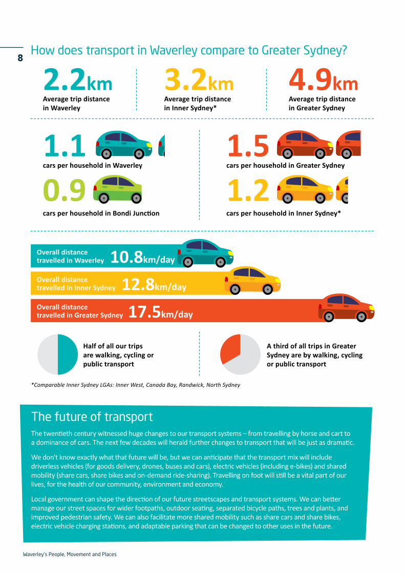
Our travel preferences and habits are also changing: young adults are choosing not to get driver’s licences, and an increasing number of seniors don't drive as often. As a result, car travel per person has decreased year-on-year since 2004, and this trend is set to continue. In most parts of the Waverley LGA the number of vehicles per household has remained steady at around 0.8 - 1.3 cars per household for the last two decades.
At the same time, Australia’s population has become more sedentary which is having a huge impact on the health of our communities and budgets. Australia wide the cost of obesity and associated illness, and loss of wellbeing, totals $130 billion per annum. We need to facilitate people to do more incidental exercise (walking and cycling) as part of their everyday lives – to the local shops, to the bus stop, to school and work.
The good news is that Waverley has some of the highest rates of walking, cycling and public transport usage in Australia and as a result our population is healthier than most. But we can do much more to make our streetscapes and places inviting whilst retaining the unique character that makes Waverley a great place to live in and visit.
This transport plan will help us to tackle our current transport problems, and best meet the changing demands of the future.
Waverley’s People, Movement and Places: where we go and how we get there

Waverley's People, Movement and Places
7
Changing demographics Waverley has the highest population density in Australia. This is, and should continue to be, supported by high frequency public transport, and quality walking and cycling infrastructure.
Although the population growth of Waverley is lower than the rest of Greater Sydney, the proportion of children (age 5-19) and people age over 45 is projected to grow significantly. These age cohorts require good access to schools, services and healthcare.
Waverley's economy is underpinned by tourism, retail and health services. These activities will continue to grow in the future, with transport being a major factor in supporting these industries.
Walking, cycling + public transportWaverley has a much higher mode share of walking, cycling and public transport than in Greater Sydney.
Only half of all trips in Waverley are made by car, compared to two-thirds in the rest of Sydney.
A third of all our trips are on foot. Waverley's streetscapes are fine-grained with a variety of local villages and neighbourhoods, making it appealing and convenient to walk.
Public transport is also well utilised with bus routes crossing throughout the Waverley area and beyond.
The Bondi Junction bus and rail interchange accommodates 86,500 passengers a day, totalling 3 million passengers a year.
Nine out of ten residents have said they would consider switching car travel to other transport if more options were available.
Traffic congestion + parkingTwice as many people use the Bondi Junction interchange as Syd Einfeld Drive. If they switched to driving instead, our streets would be gridlocked.
Whilst our passenger car ownership levels have remained stable, there has been an increase in the number of SUVs and scooters, leading to an overall increase in the number of vehicles on our roads.
We have good access to a range of transport options which, combined with mixed use land use patterns and local attractions, means we drive much less than the Sydney average.
Our average trip distance is only 2.2 kilometres, compared to 4.9 kilometres for Greater Sydney. Many local trips are even shorter. These short trips are easily done on foot or by bicycle, which reduces traffic congestion and demand for car parking.
KEY TRANSPORT ISSUESFOR OUR LOCAL AREA
Waverley's People, Movement and Places
8
cars per household in Greater Sydney
cars per household in Inner Sydney*
cars per household in Waverley
How does transport in Waverley compare to Greater Sydney?
The future of transportThe twentieth century witnessed huge changes to our transport systems – from travelling by horse and cart to a dominance of cars. The next few decades will herald further changes to transport that will be just as dramatic.
We don't know exactly what that future will be, but we can anticipate that the transport mix will include driverless vehicles (for goods delivery, drones, buses and cars), electric vehicles (including e-bikes) and shared mobility (share cars, share bikes and on-demand ride-sharing). Travelling on foot will still be a vital part of our lives, for the health of our community, environment and economy.
Local government can shape the direction of our future streetscapes and transport systems. We can better manage our street spaces for wider footpaths, outdoor seating, separated bicycle paths, trees and plants, and improved pedestrian safety. We can also facilitate more shared mobility such as share cars and share bikes, electric vehicle charging stations, and adaptable parking that can be changed to other uses in the future.
1.1
10.8km/day
12.8km/day
17.5km/day
2.2km 4.9km3.2km
1.51.20.9
Average trip distance in Waverley
Average trip distancein Greater Sydney
Average trip distancein Inner Sydney*
Overall distance travelled in Waverley
Overall distance travelled in Inner Sydney
Overall distance travelled in Greater Sydney
Half of all our trips are walking, cycling or public transport
A third of all trips in Greater Sydney are by walking, cycling or public transport
cars per household in Bondi Junction
*Comparable Inner Sydney LGAs: Inner West, Canada Bay, Randwick, North Sydney
Waverley's People, Movement and Places
9
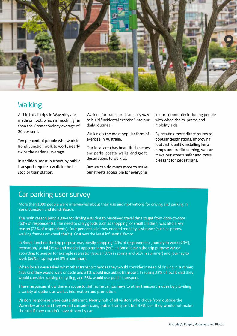
A third of all trips in Waverley are made on foot, which is much higher than the Greater Sydney average of 20 per cent.
Ten per cent of people who work in Bondi Junction walk to work, nearly twice the national average.
In addition, most journeys by public transport require a walk to the bus stop or train station.
Walking for transport is an easy way to build 'incidental exercise' into our daily routines.
Walking is the most popular form of exercise in Australia.
Our local area has beautiful beaches and parks, coastal walks, and great destinations to walk to.
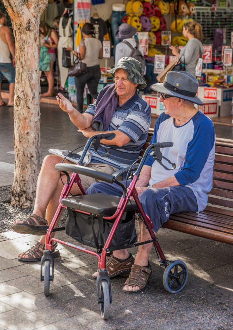
But we can do much more to make our streets accessible for everyone
in our community including people with wheelchairs, prams and mobility aids.
By creating more direct routes to popular destinations, improving footpath quality, installing kerb ramps and traffic calming, we can make our streets safer and more pleasant for pedestrians.
Walking
Car parking user surveyMore than 1000 people were interviewed about their use and motivations for driving and parking in Bondi Junction and Bondi Beach.
The main reason people gave for driving was due to perceived travel time to get from door-to-door (60% of respondents). The need to carry goods such as shopping, or small children, was also a key reason (23% of respondents). Four per cent said they needed mobility assistance (such as prams, walking frames or wheel chairs). Cost was the least influential factor.
In Bondi Junction the trip purpose was mostly shopping (40% of respondents), journey to work (20%), recreation/ social (15%) and medical appointments (9%). In Bondi Beach the trip purpose varied according to season for example recreation/social (37% in spring and 61% in summer) and journey to work (26% in spring and 9% in summer).
When locals were asked what other transport modes they would consider instead of driving in summer, 43% said they would walk or cycle and 31% would use public transport. In spring 22% of locals said they would consider walking or cycling, and 58% would use public transport.
These responses show there is scope to shift some car journeys to other transport modes by providing a variety of options as well as information and promotion.
Visitors responses were quite different. Nearly half of all visitors who drove from outside the Waverley area said they would consider using public transport, but 37% said they would not make the trip if they couldn't have driven by car.
9

Waverley's People, Movement and Places
10 CyclingThe average daily distance travelled in Waverley is 10.8 km/day, which is much less than the Greater Sydney average of 17.5 km/day. We also do more frequent trips, averaging 4.8 trips per weekday compared to 3.7 in Greater Sydney.
As a result, the average trip distance in Waverley is just 2.2 km per trip. Such short distances are relatively easy and convenient by bicycle.
About half of all trips in Waverley LGA could be ridden by bicycle within 10 minutes.
The growing popularity of dockless share bikes, e-bikes and cargo bikes illustrate the convenience, relative ease of parking, and time savings that cycling offers in our area.
Cycling in Waverley accounts for nearly 5 per cent of all trips, double the Sydney average.
3.1 per cent of journeys to work in the Waverley LGA are by bicycle, with some suburbs even higher, for example Tamarama 5.9%, Bronte 4.8% and Bondi 3.7%.
There is scope to further increase
bicycle mode share by providing safe cycling infrastructure, bike parking for shared and private bikes, and wayfinding signage.
For example, our estimates show there is demand for around 800 secure bicycle parking bays at Bondi Junction interchange, based on current cycling mode share.
Dockless share bikes debuted in late 2017 across the Sydney metro area. Council is working with the various operators to address issues such as bike parking, fleet management and data sharing.
Half of all trips in Waverley LGA could be made by bike within 10 minutes.
10<mins

Waverley's People, Movement and Places
11Nearly half of journeys to work in Bondi Junction are made by bus or train. This is one of the highest uses of public transport anywhere in Australia.
Bondi Junction is serviced by high frequency trains to the Sydney CBD and beyond. Three million bus and trains passengers a year use the Bondi Junction interchange. However the interchange is poorly designed and difficult to access.
The Waverley LGA has a wide variety of bus routes that connect to local destinations such as Bondi
Beach, Bondi Road, Charing Cross and Bronte. Buses also connect to key destinations across the region including Randwick hospital and university campuses, Coogee, Sydney Airport, and Burwood.
However, when considering all trips (not just to work), public transport is much less utilised. Only 15 per cent of all journeys within Waverley are by bus or train, which is similar to the Greater Sydney average.
Some disadvantages of the existing bus system include buses being caught in general traffic
congestion, and few direct north-south connections that bypass Bondi Junction.
Improvements to public transport services require working in partnership with state government including TfNSW, Sydney Buses, and RMS.
Changes are already underway such as the trial of on-demand buses which service Bondi Junction station, Edgecliff Station and Rose Bay ferry wharf.
Public transport
Waverley's People, Movement and Places
12 OUR TRANSPORT VISIONCommunity aspirationsOur community aspirations are to live in a great place with options to move around easily, to grow and prosper, and lead active and healthy lifestyles.
We are constrained by historic land use patterns and hilly terrain, traffic congestion, high land values making roads and parking expensive, competition for funding, and community expectations.
Our transport vision is to increase transport choices for residents and visitors, improve accessibility to centres and across the whole LGA, and reduce car travel overall.
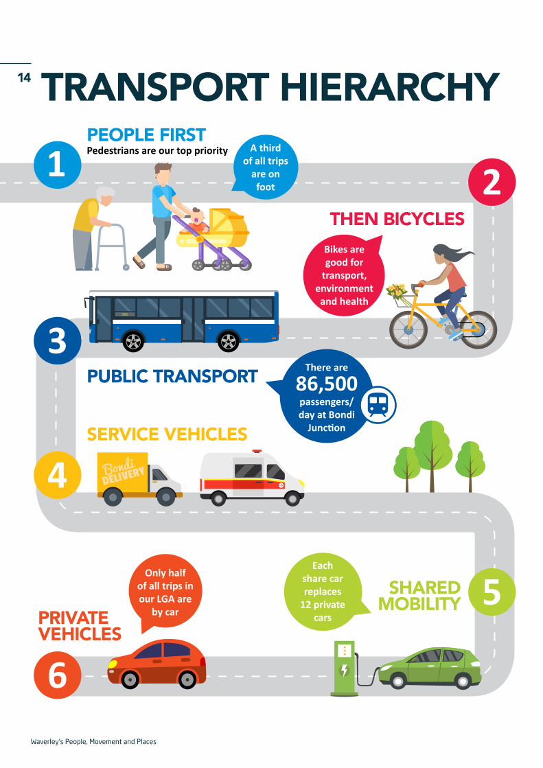
We will do this by prioritising pedestrians first, then bicycles, public transport, service vehicles and shared mobility. We will advocate for public transport to be more reliable. We will aim to utilise road, kerb and footpath space for the highest and best uses for the whole community; and move people and goods efficiently while maintaining streets as places that are welcoming and comfortable to people.
ImplementationWaverley's People, Movement and Places recommends twelve signature projects and 96 actions that we believe will help achieve our transport vision. We can't do this alone: we need to work in partnership with state government agencies, businesses, our local communities and neighbouring councils to achieve the best outcomes.
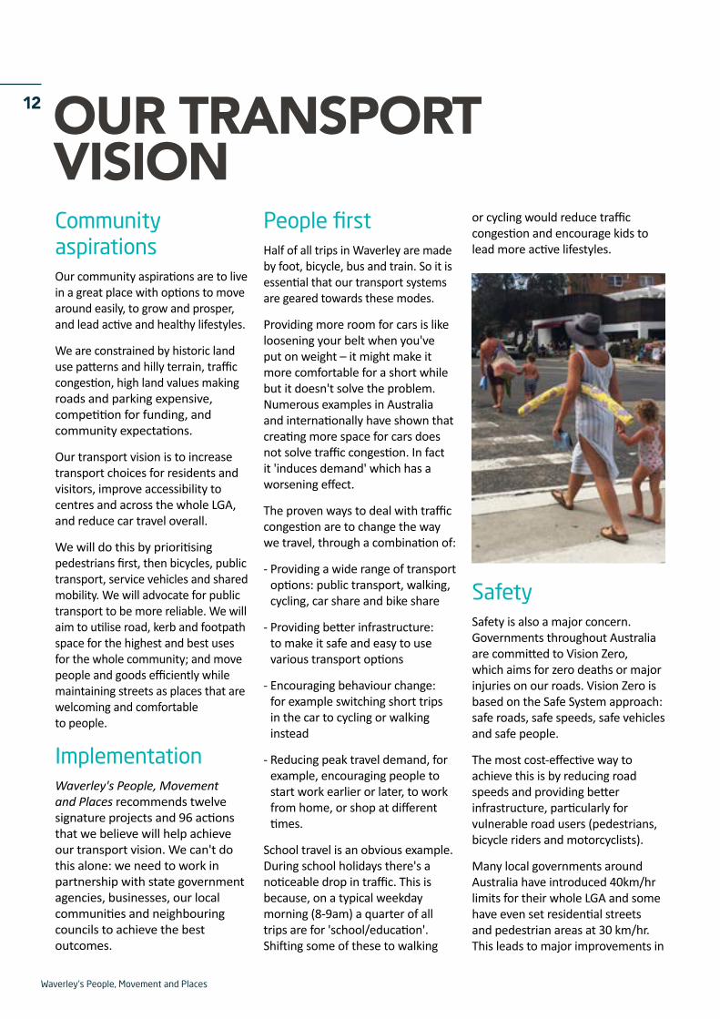
People firstHalf of all trips in Waverley are made by foot, bicycle, bus and train. So it is essential that our transport systems are geared towards these modes.
Providing more room for cars is like loosening your belt when you've put on weight – it might make it more comfortable for a short while but it doesn't solve the problem. Numerous examples in Australia and internationally have shown that creating more space for cars does not solve traffic congestion. In fact it 'induces demand' which has a worsening effect.
The proven ways to deal with traffic congestion are to change the way we travel, through a combination of:
- Providing a wide range of transport options: public transport, walking, cycling, car share and bike share
- Providing better infrastructure: to make it safe and easy to use various transport options
- Encouraging behaviour change: for example switching short trips in the car to cycling or walking instead
- Reducing peak travel demand, for example, encouraging people to start work earlier or later, to work from home, or shop at different times.
School travel is an obvious example. During school holidays there's a noticeable drop in traffic. This is because, on a typical weekday morning (8-9am) a quarter of all trips are for 'school/education'. Shifting some of these to walking
or cycling would reduce traffic congestion and encourage kids to lead more active lifestyles.
SafetySafety is also a major concern. Governments throughout Australia are committed to Vision Zero, which aims for zero deaths or major injuries on our roads. Vision Zero is based on the Safe System approach: safe roads, safe speeds, safe vehicles and safe people.
The most cost-effective way to achieve this is by reducing road speeds and providing better infrastructure, particularly for vulnerable road users (pedestrians, bicycle riders and motorcyclists).
Many local governments around Australia have introduced 40km/hr limits for their whole LGA and some have even set residential streets and pedestrian areas at 30 km/hr. This leads to major improvements in

Waverley's People, Movement and Places
13safety for all road users, at relatively low cost.
When Australia introduced a default urban speed limit of 50km/hr the number of casualty crashes dropped by 23 per cent. When school zones were introduced there was a further 24 per cent reduction in crashes. Setting these speed limits did
not increase overall travel time for drivers.
It is time for Waverley to further reduce road speeds throughout our LGA to improve safety for everyone.
Another pillar of the Safe System is safe roads. This means providing road designs that encourage drivers
to travel at a safe speed – such as narrowing roadways at intersections so that cars slow down before turning. It also means providing greater priority and profile to pedestrians – such as shorter crossing distances and raised pedestrian crossings.
Strategic Transport Framework
Aspirations
Constraints
Priorities
Projects
Goals
As a community, we want:• A great place to live• More options to move around easily• To grow and prosper• To lead active and healthy lifestyles
We are limited by:• Historic land use, street patterns and hilly terrain• Current traffic and parking congestion• High value land making roads and parking expensive• Competition for funding• Community expectations
We will prioritise travel modes in the following order:• Pedestrians• Bicycles• Public Transport• Service vehicles and shared mobility• Private vehicles
We will achieve this by implementing:• Twelve signature projects including: overhauling the Bondi
Junction Interchange; advocating for bus priority; installing cycling superhighways; and implementing a Walking Strategy
• 96 actions across the LGA
We will aim to:• Increase transport choices for residents and visitors• Improve accessibility to centres and across the LGA and region• Manage demands to use resources more efficiently• Reduce car travel overall and as a percentage of mode share
Waverley's People, Movement and Places
14 TRANSPORT HIERARCHY
SHARED MOBILITY
Each share car replaces
12 private cars
BondiDELIVERY
Pedestrians are our top priority
86,500passengers/day at Bondi
Junction
There arePUBLIC TRANSPORT
PRIVATE VEHICLES
SERVICE VEHICLES
THEN BICYCLES
1 2
3
4
6
5
PEOPLE FIRST
333
Bikes are good for
transport, environment and health
Only half of all trips in our LGA are
by car
A third of all trips
are on foot

Waverley's People, Movement and Places
15OUTCOMES FOR THE WHOLE COMMUNITYWaverley Council has undertaken significant community engagement on a wide range of transport-related policies and projects in the recent past. These include the community plan, which sets out the community's broad aspirations and directions, and the environmental action plan.
The Waverley Transport Plan (2011), Bondi Junction Complete Streets
(2013) and Waverley Bike Plan (2013) have also undergone major community consultation.
As part of the Waverley's People, Movement and Places research, more than 1000 people were interviewed at Bondi Beach and Bondi Junction to ask about their use and motivations for driving and parking (see information box page 9).
In May and June 2017, Council exhibited a draft version of Waverley's People, Movement and Places.
The draft exhibition reached more than 22,000 people and received 300 online and written survey responses. The feedback was used to inform this final transport plan.

Waverley's People, Movement and Places
16 TRANSPORT PLANWaverley Council has identified twelve signature projects that will make the biggest impact on improving transport across our area for the whole community.
The signature projects will be implemented through 96 short, medium and long term actions that Waverley Council will undertake in partnership with the community, state government agencies and the private sector. Each of these projects will help to make improvements across the transport spectrum of walking, cycling, public transport, service vehicles, shared mobility, private vehicles, and parking.
To deliver on its transport vision, Waverley Council needs to work with other agencies including
Transport for New South Wales and Roads + Maritime Services, particularly for public transport and state roads. Other key challenges for delivery include funding and planning of projects, and long-term maintenance of our assets.
Surveys show that 91 per cent of our residents would consider using the car even less if there were more transport options available. This is what our transport plan will help to deliver for the community over the next few years.
Waverley's People, Movement and Places
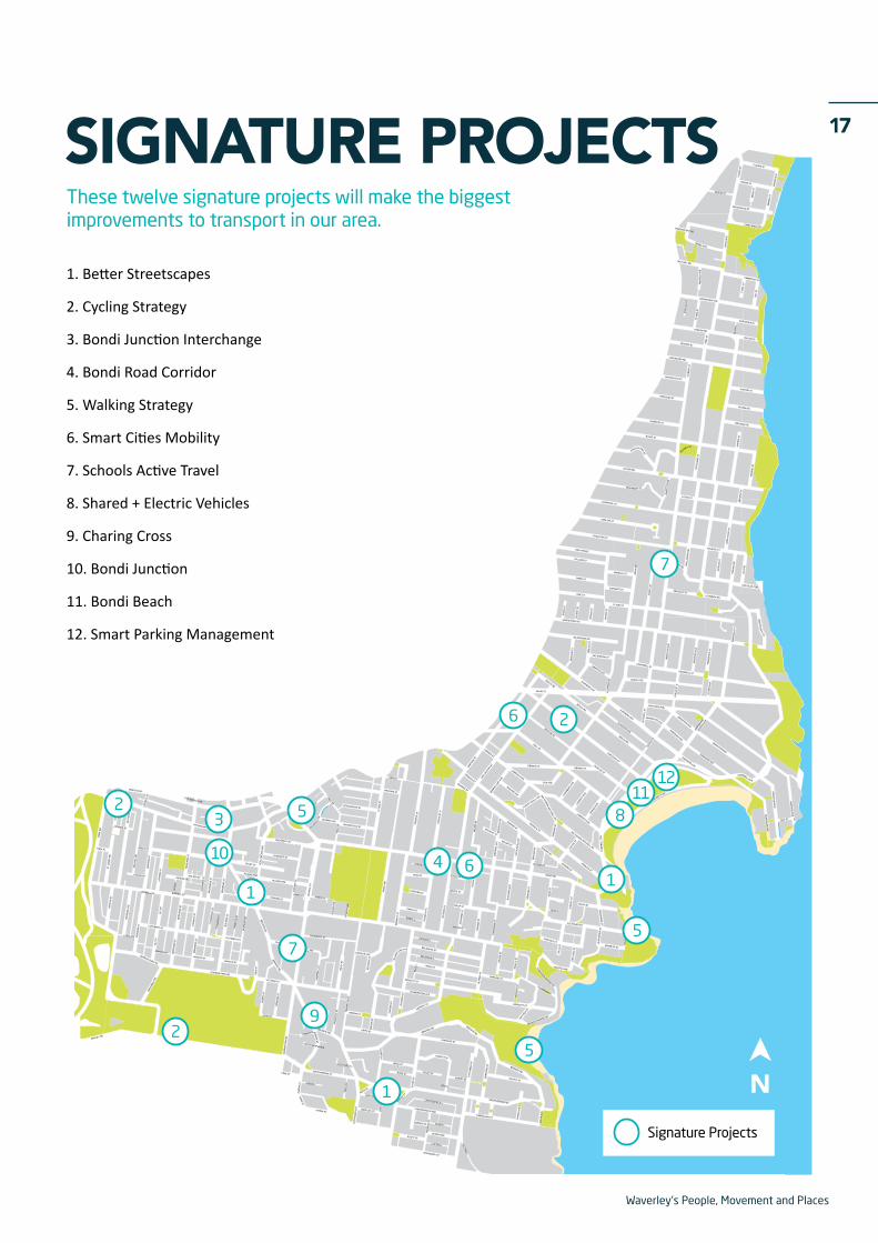
17SIGNATURE PROJECTSThese twelve signature projects will make the biggest improvements to transport in our area.
1. Better Streetscapes
2. Cycling Strategy
3. Bondi Junction Interchange
4. Bondi Road Corridor
5. Walking Strategy
6. Smart Cities Mobility
7. Schools Active Travel
8. Shared + Electric Vehicles
9. Charing Cross
10. Bondi Junction
11. Bondi Beach
12. Smart Parking Management
LESW
ELL
STDE
NIS
ON
ST
MAN
NIN
G S
T
ST M
ARYS
AVE
NEW
LAN
D ST
NEW
LAN
D ST
HO
LLYW
OO
D AV
E
HOLLYWOOD AVE
YORK
RD
BIRRELL ST BIRRELL STPORTER ST
ZARITA
BRONTE RD
BRONTE RD
BRONTE RD
ALBION ST
AVE
BRONTE RD
HEWLETT ST
PACIFIC AVE
FLETCHER ST
BRONTE RDBRONTE RD
GAR
DYNE
ST
MACPHERSON ST
EDWARD ST
EDWARD ST
BONDI RD
EDWARD ST
EDWARD ST
RICKARD AVE
SIR THOMAS MITCHELL RD
CAM
PBEL
L PD
E
RAMSGATE AVE
RAMSGATE AVE
HASTINGS PDE
FOREST KNOLL AVE
SIMPS
ON ST
SIMPS
ON ST
CAMPBELL PDE
NSignature Projects
8
16
1112
10 4
3
29
7
6
7
2
52
5
5
1
1
Waverley's People, Movement and Places
18 1. BETTER STREETSCAPESExpand the concept of 'complete streets' to the whole of Waverley LGA
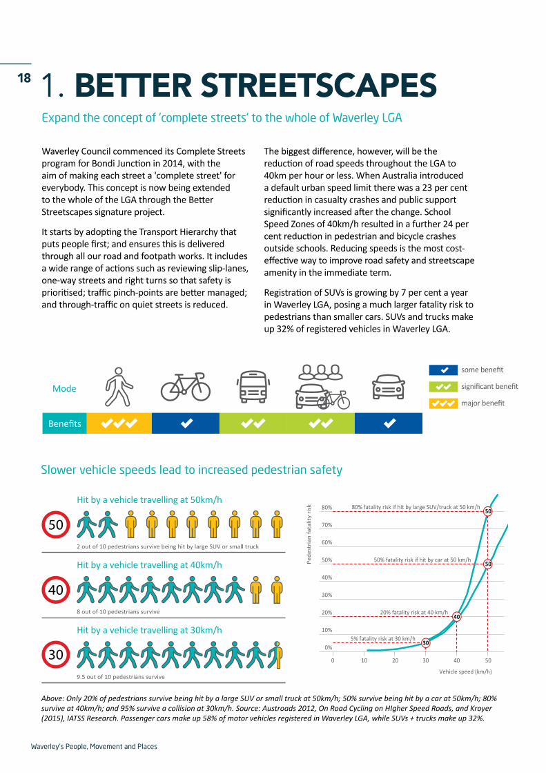
Above: Only 20% of pedestrians survive being hit by a large SUV or small truck at 50km/h; 50% survive being hit by a car at 50km/h; 80% survive at 40km/h; and 95% survive a collision at 30km/h. Source: Austroads 2012, On Road Cycling on HIgher Speed Roads, and Kroyer (2015), IATSS Research. Passenger cars make up 58% of motor vehicles registered in Waverley LGA, while SUVs + trucks make up 32%.
Waverley Council commenced its Complete Streets program for Bondi Junction in 2014, with the aim of making each street a 'complete street' for everybody. This concept is now being extended to the whole of the LGA through the Better Streetscapes signature project.
It starts by adopting the Transport Hierarchy that puts people first; and ensures this is delivered through all our road and footpath works. It includes a wide range of actions such as reviewing slip-lanes, one-way streets and right turns so that safety is prioritised; traffic pinch-points are better managed; and through-traffic on quiet streets is reduced.
The biggest difference, however, will be the reduction of road speeds throughout the LGA to 40km per hour or less. When Australia introduced a default urban speed limit there was a 23 per cent reduction in casualty crashes and public support significantly increased after the change. School Speed Zones of 40km/h resulted in a further 24 per cent reduction in pedestrian and bicycle crashes outside schools. Reducing speeds is the most cost-effective way to improve road safety and streetscape amenity in the immediate term.
Registration of SUVs is growing by 7 per cent a year in Waverley LGA, posing a much larger fatality risk to pedestrians than smaller cars. SUVs and trucks make up 32% of registered vehicles in Waverley LGA.
Mode
Benefits
major benefit
some benefit
significant benefit
Slower vehicle speeds lead to increased pedestrian safety
Hit by a vehicle travelling at 30km/h
309.5 out of 10 pedestrians survive
Hit by a vehicle travelling at 40km/h
8 out of 10 pedestrians survive
40
Hit by a vehicle travelling at 50km/h
2 out of 10 pedestrians survive being hit by large SUV or small truck
50 70%
60%
50%
40%
30%
20%
10%
0%
0 10 20
5% fatality risk at 30 km/h
20% fatality risk at 40 km/h
50% fatality risk if hit by car at 50 km/h
Vehicle speed (km/h)
Pede
stri
an fa
talit
y ri
sk
30
40
50
30 40 50
80% 80% fatality risk if hit by large SUV/truck at 50 km/h50
Waverley's People, Movement and Places
19
03 All road + footpath works improve accessibility for pedestrians, wheelchairs, prams, walking frames + bicycles
04 Reduce road speeds throughout the LGA
01 Commit to Transport Hierarchy
02 Crowdsource community issues
Feasibility Implementation
2018 2020 2025SHORT TERM MEDIUM TERM LONG TERM 2030
05 Audit kerbside allocation for service vehicles + rationalise
06 Review 1-ways, slip lanes + right turns; Instigate 'slip lane removal program'
07 Develop street hierarchy
08 Identify congestion pinch points + safety hazards
09 Re-align traffic intersections where >4 pedestrian approaches
10 Discourage through-traffic + speeding with landscape treatments; ensure street treatment appropriate to type
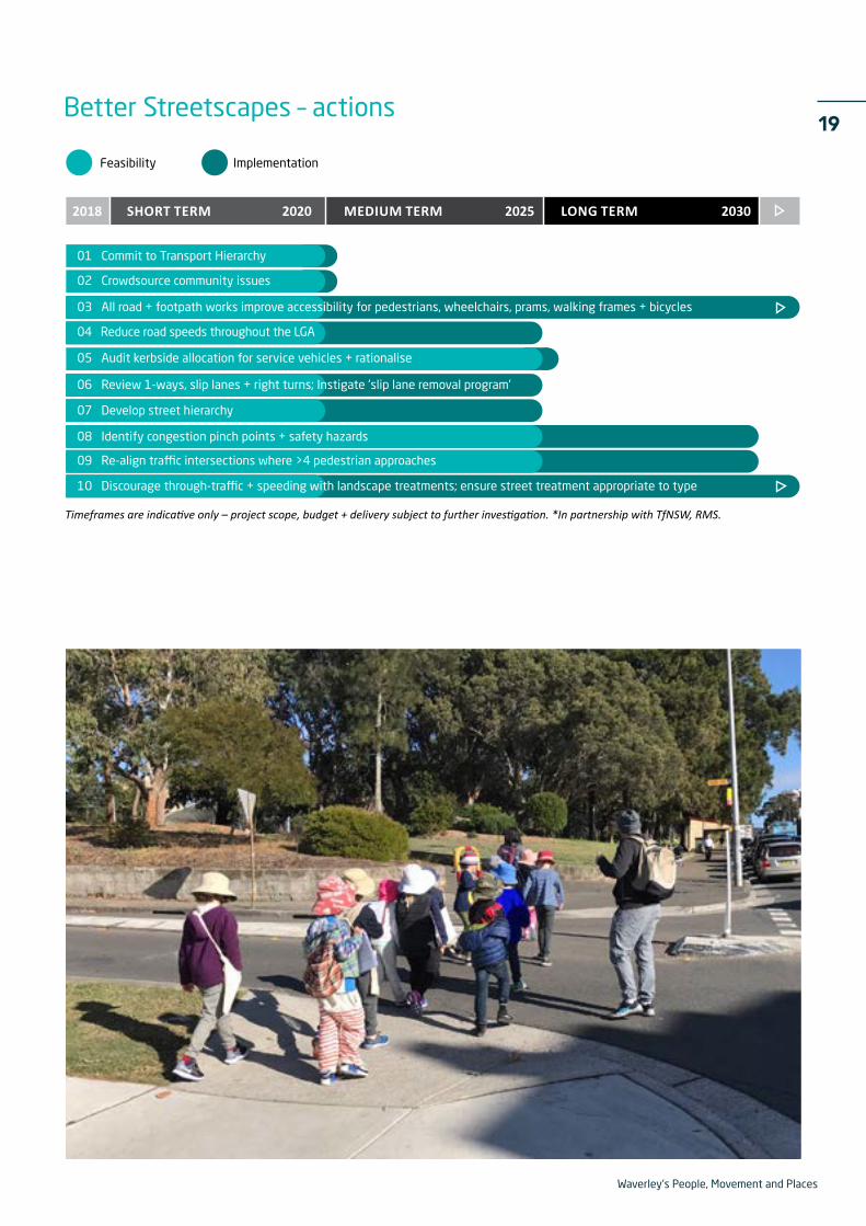
Timeframes are indicative only – project scope, budget + delivery subject to further investigation. *In partnership with TfNSW, RMS.
Better Streetscapes – actions
Waverley's People, Movement and Places
20 2. CYCLING STRATEGYProvide safe cycling infrastructure across Waverley and beyond
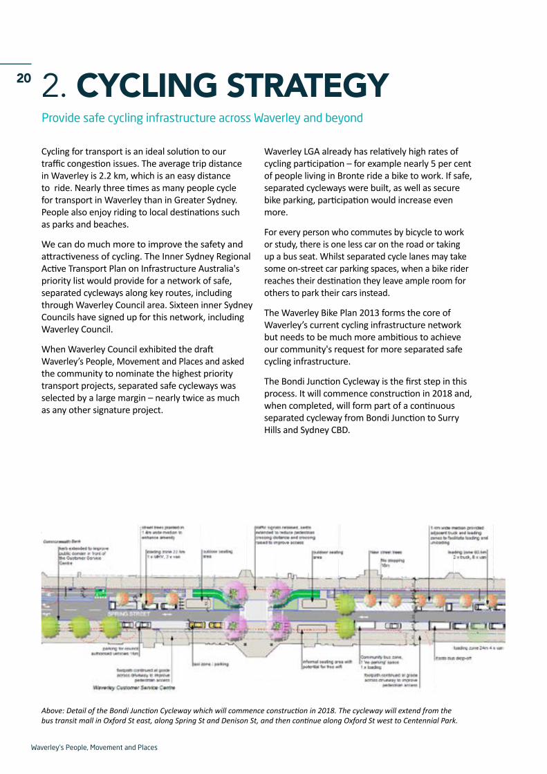
Above: Detail of the Bondi Junction Cycleway which will commence construction in 2018. The cycleway will extend from the bus transit mall in Oxford St east, along Spring St and Denison St, and then continue along Oxford St west to Centennial Park.
Cycling for transport is an ideal solution to our traffic congestion issues. The average trip distance in Waverley is 2.2 km, which is an easy distance to ride. Nearly three times as many people cycle for transport in Waverley than in Greater Sydney. People also enjoy riding to local destinations such as parks and beaches.
We can do much more to improve the safety and attractiveness of cycling. The Inner Sydney Regional Active Transport Plan on Infrastructure Australia's priority list would provide for a network of safe, separated cycleways along key routes, including through Waverley Council area. Sixteen inner Sydney Councils have signed up for this network, including Waverley Council.
When Waverley Council exhibited the draft Waverley’s People, Movement and Places and asked the community to nominate the highest priority transport projects, separated safe cycleways was selected by a large margin – nearly twice as much as any other signature project.
Waverley LGA already has relatively high rates of cycling participation – for example nearly 5 per cent of people living in Bronte ride a bike to work. If safe, separated cycleways were built, as well as secure bike parking, participation would increase even more.
For every person who commutes by bicycle to work or study, there is one less car on the road or taking up a bus seat. Whilst separated cycle lanes may take some on-street car parking spaces, when a bike rider reaches their destination they leave ample room for others to park their cars instead.
The Waverley Bike Plan 2013 forms the core of Waverley’s current cycling infrastructure network but needs to be much more ambitious to achieve our community's request for more separated safe cycling infrastructure.
The Bondi Junction Cycleway is the first step in this process. It will commence construction in 2018 and, when completed, will form part of a continuous separated cycleway from Bondi Junction to Surry Hills and Sydney CBD.
Waverley's People, Movement and Places
21
14 Crack seal program to repair longitudinal cracks where dangerous to riders
16 Work with adjoining councils for separated cycleways on regional routes including Inner Sydney Active Travel Network *
19 Provide cycle path opportunities as alternatives to Bondi Rd
17 Construct Oxford St/ Spring St Cycleway
18 Secure bicycle parking at Bondi Junction Interchange + improved bike access *
12 Continue to implement Waverley Bike Plan
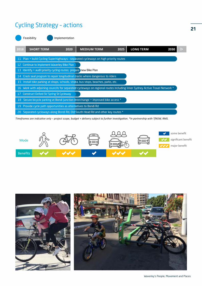
Timeframes are indicative only – project scope, budget + delivery subject to further investigation. *In partnership with TfNSW, RMS.
Feasibility Implementation
2018 2020 2025SHORT TERM MEDIUM TERM LONG TERM 2030
11 Plan + build Cycling Superhighways – separated cycleways on high priority routes
13 Identify + audit priority cycling routes; prepare new Bike Plan
15 Install bike parking at shops, schools, strata, bus stops, beaches, parks, etc.
20 Separated cycleways along Bondi Rd, Old South Head Rd and other key routes *
Cycling Strategy – actions
Mode
Benefits
major benefit
some benefit
significant benefit

Waverley's People, Movement and Places
22 3. BONDI JUNCTION INTERCHANGEOverhaul the Bondi Junction transport interchange to make it safe, easy + accessible
Three million bus and train passengers use the Bondi Junction transport interchange a year, averaging 86,500 every weekday. Twice as many people travel through the interchange as Syd Einfeld Drive.
Around 70,000 of these daily passengers enter and exit the interchange on foot. To get there they walk, ride a bicycle, drive or get a lift, catch a taxi, or catch a bus nearby. It is an extremely busy interchange, being at the terminating end of a major train line, and servicing 29 different bus routes that connect throughout the eastern suburbs region.
Council is keen to work with the NSW Government to improve bus operations and efficiency, and improve pedestrian accessibility, safety and amenity in and around the interchange. Bondi Junction contributes more than $1 million a year to State Parking Levy which is earmarked for improving transport interchanges – we'd like to see this spent directly on improving Bondi Junction interchange.
Waverley Council is working on the redevelopment of Rowe Street which will make a more direct connection between the Oxford St pedestrian mall and the train station. Again, this requires a close partnership with the state government to allow the reinstatement of the direct access tunnel which was closed a number of years ago.
Council estimates that there is demand for around 800 bicycle parking bays (based on current mode share of 3.1%) which would significanty increase the catchment area of the interchange. Provision for dockless bike share is also an important issue.
And there are future transport considerations. For example, on-demand buses have recently commenced trials which drop people from the station directly to their door. All of these services could be better integrated to ensure a more seamless experience for anyone using the interchange, or accessing Bondi Junction shops and services.
Mode
Benefits
major benefit
some benefit
significant benefit

Waverley's People, Movement and Places
23
Below, left: artist impressions of improved access to Bondi Junction bus/rail Interchange. Impressions are indicative only.
21 Overhaul Bondi Junction Interchange to improve pedestrian access + safety, bus operations*
22 Implement Rowe Street revitalisation*
Feasibility Implementation
2018 2020 2025SHORT TERM MEDIUM TERM LONG TERM 2030
23 Improve Kiss + Ride facilities around Bondi Junction station*
24 Provide bus priority on all approaches to Bondi Junction*
Timeframes are indicative only – project scope, budget + delivery subject to further investigation. *In partnership with TfNSW, RMS.
25 Install bike parking for 700+ bicycles around Bondi Junction interchange*
Bondi Junction Interchange – actions
Waverley's People, Movement and Places
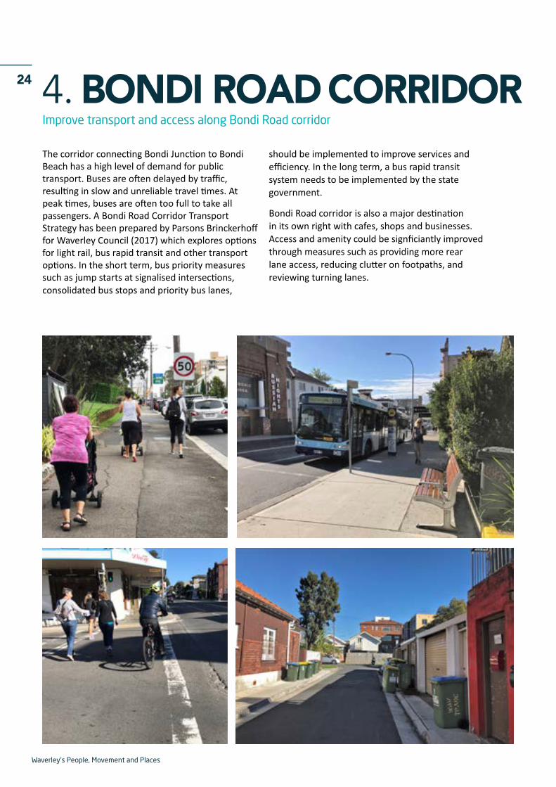
24 4. BONDI ROAD CORRIDORImprove transport and access along Bondi Road corridor
The corridor connecting Bondi Junction to Bondi Beach has a high level of demand for public transport. Buses are often delayed by traffic, resulting in slow and unreliable travel times. At peak times, buses are often too full to take all passengers. A Bondi Road Corridor Transport Strategy has been prepared by Parsons Brinckerhoff for Waverley Council (2017) which explores options for light rail, bus rapid transit and other transport options. In the short term, bus priority measures such as jump starts at signalised intersections, consolidated bus stops and priority bus lanes,
should be implemented to improve services and efficiency. In the long term, a bus rapid transit system needs to be implemented by the state government.
Bondi Road corridor is also a major destination in its own right with cafes, shops and businesses. Access and amenity could be signficiantly improved through measures such as providing more rear lane access, reducing clutter on footpaths, and reviewing turning lanes.
Waverley's People, Movement and Places
25
Timeframes are indicative only – project scope, budget + delivery subject to further investigation. *In partnership with TfNSW, RMS.
28 Widen footpaths + improve east-west + north-south access along Bondi Rd corridor
29 Remove slip-lane on Denham St/Bondi Rd for outdoor seating + bus stop*
26 Bondi Road Corridor – Bus priority or driverless electric shuttle bus system*
27 Investigate 'managed lanes' on Bondi Road + Old South Head Rd during peak times
31 Extend 'no stopping' times along Bondi Rd to reduce traffic congestion
32 Prepare rear laneway strategy to provide car park / walk / cycle alternatives on either side of Bondi Rd
30 Dedicated bus priority lane + consolidated bus stops along Bondi Rd*
Feasibility Implementation
2018 2020 2025SHORT TERM MEDIUM TERM LONG TERM 2030
33 Investigate potential north-south route re-alignments, intersections + flow of traffic on surrounding streets
Bondi Road Corridor – actions
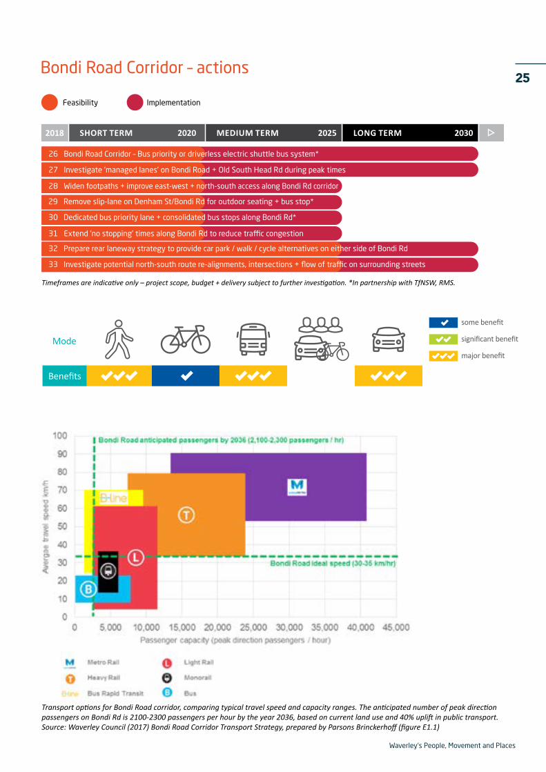
Transport options for Bondi Road corridor, comparing typical travel speed and capacity ranges. The anticipated number of peak direction passengers on Bondi Rd is 2100-2300 passengers per hour by the year 2036, based on current land use and 40% uplift in public transport.Source: Waverley Council (2017) Bondi Road Corridor Transport Strategy, prepared by Parsons Brinckerhoff (figure E1.1)
Mode
Benefits
major benefit
some benefit
significant benefit
Waverley's People, Movement and Places
26 5. WALKING STRATEGYImprove walking access, convenience and safety for everybody in the community
With a third of all trips in our LGA made on foot, we need to ensure that pedestrian access and safety is a high priority. This includes walking routes to key destinations such as village centres, schools, beaches and parks; but also in local residential streets to ensure people can get all the way to their front door unimpeded.
Pedestrians are at the top of the transport hierarchy for Waverley Council.
The Green Links program has already had some success in improving key walking routes but there is much more we can do to make walking safe, convenient and practical for everyone in the community. This includes improvements for every type of pedestrian, whether they are on their own, accompanying children, using a pram, wheelchair or mobility aid.
The Walking Strategy will audit existing conditions across the whole LGA and identify works that Council can undertake, as part of its maintenance and capital works programs, to improve every aspect of walking.
The Walking Strategy will identify key destinations and routes and highlight what additional works need to be done to make walking easier and more accessible. For example, footpaths that are
in disrepair or lack kerb ramps make it difficult for people with prams, wheelchairs, or bikes. Other actions include providing footpaths around and through parks; and ensuring that large redevelopments include through-site links.
The Safe System approach to road safety includes two pillars that Councils can act on directly: safe roads and safe speeds. In addition to reducing road speeds throughout our LGA, our road designs should encourage drivers to drive with care. Measures include narrowing roadways at intersections so that cars slow down before turning; providing greater priority and profile to pedestrians with shorter crossing distances and raised pedestrian crossings; ensuring that there are pedestrian crossings on all sides of intersections; and increasing the pedestrian crossing time allocation on traffic lights.
The Coastal Walk is also an important asset to our local communities and visitor economy. Signficant parts of the Coastal Walk are inaccessible to mobility impaired people and parents with prams. Council could do more to improve accessibility or provide convenient alternative routes nearby, improve access to nearby transport such as bus stops, and provide parking for bicycles to reduce the need for car parking.
Mode
Benefits
major benefit
some benefit
significant benefit

Waverley's People, Movement and Places
27
37 Ensure pedestrian crossing points on all sides of intersections *
39 Identify pedestrian links + opportunities to improve permeability e.g. around + through parks; through-site links
41 Reduce road speeds throughout Bondi Junction to 30km/hr + add shared space 10km/hr zones
40 Review pedestrian access to bus stops
42 Signage on key walk + cycle routes particularly Bondi Junction Interchange
35 Collate database of walking + bicycle counts
Timeframes are indicative only – project scope, budget + delivery subject to further investigation. * In partnership with TfNSW, RMS
Feasibility Implementation
2018 2020 2025SHORT TERM MEDIUM TERM LONG TERM 2030
34 Prepare walkability audit + Walking Strategy
36 Improve access to Coastal Walk + beaches for wheelchairs + prams, including Notts Ave + Bronte Cutting
38 Increase pedestrian crossing time at signalised intersections + scramble where feasible *
Walking Strategy – actions
Below: This new pedestrian crossing on Ebley St, Bondi Junction has a raised threshold which slows cars and puts pedestrians first.

Waverley's People, Movement and Places
28 6. SMART CITIES MOBILITYLeverage current and future technologies to provide better transport outcomes
Waverley Council is investigating how technology can provide faster, cheaper, and more convenient solutions for transport. It will prepare a ‘Smart Cities Mobility Strategy’ that will look at the range of technologies available now, and in the future, that could provide better transport outcomes in our area.
The key concept is Mobility-as-a-Service (MaaS) which describes a shift away from personally owned modes of transport (such as private cars) towards mobility that is consumed as a service (such as public transport, on-demand buses, share bikes, share cars and so on). This is enabled by combining the full range of options and services from public and private operators through a single point which helps people manage their transport needs.
In Waverley LGA this might look like a smartphone app that allows residents and visitors to:
- Compare the amount of time and cost of different transport modes using real-time information. For example, on a busy summer weekend to get to Bondi Beach, the app might show that driving (then parking and walking to the beachfront) will take 50 minutes in total and cost $15 in parking fees. Catching a bus will take 45 minutes and cost $4; riding a dockless share bike will take 20 minutes and cost $2; riding your own bike will take 15 minutes and is free; or walking will take 40 minutes and is free.
- Book an on-demand bus to take you directly from Bondi Junction and deliver you to your door with your shopping bags, after work, or at the end of a train trip
- Apply for and purchase e-permits for residential parking permits, beach parking permits, and associated visitor parking permits
- View real-time car parking availability across the whole LGA, so you know whether there is any parking available before you leave, and how much it will cost
- Pay for car parking using the same app – no need to use a parking meter.
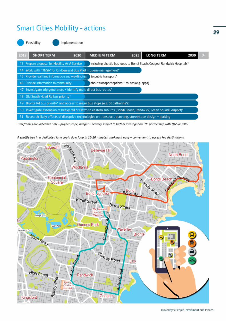
Another technology solution being considered is an electric shuttle bus that operates on a loop from Bondi Junction to Bondi Beach, along Bondi Road, Campbell Parade and Old South Head Road. The bus would act more like a tram, with all doors open for boarding. It would initially operate in general traffic, but over time the infrastructure could be improved to give buses greater priority and efficiency. For example, priority bus lanes (where space allows it), and built up stops to allow prams and wheelchairs to board directly without assistance. Eventually this could be operated by a driverless system.
To facilitate this, Waverley Council will apply for grant funding and work collaboratively with other partners such as state and federal government, and the private sector, to deliver these innovative smart city projects.
Mode
Benefits
major benefit
some benefit
significant benefit
Waverley's People, Movement and Places
29
44 Work with TfNSW for On-Demand Bus Pilot + queue management*
48 Old South Head Rd bus priority*
50 Investigate extension of heavy rail or Metro to eastern suburbs (Bondi Beach, Randwick, Green Square, Airport)*
46 Provide information to community about transport options + routes (e.g. apps)
43 Prepare proposal for Mobility As A Service including shuttle bus loops to Bondi Beach, Coogee, Randwick Hospitals*
Timeframes are indicative only – project scope, budget + delivery subject to further investigation. *In partnership with TfNSW, RMS
Feasibility Implementation
2018 2020 2025SHORT TERM MEDIUM TERM LONG TERM 2030
49 Bronte Rd bus priority* and access to major bus stops (e.g. St Catherine's)
45 Provide real time information and wayfinding to public transport*
47 Investigate trip generators + identify more direct bus routes*
51 Research likely effects of disruptive technologies on transport , planning, streetscape design + parking
Smart Cities Mobility – actions
A shuttle bus in a dedicated lane could do a loop in 15-20 minutes, making it easy + convenient to access key destinations
Streo
r
arade
S
a
to
M
'S
Kensington Pond
Busbys Pond
Duck Pond
Wylies Baths
lap pool
War MemorialHospital -Waverley
SydneyChildren'sHospital
Bondi Beach
Randwick
Kensington
Bondi Junction
Coogee
Clovelly
Waverley
Paddington
Kingsford
CentennialSquare
Moore ParkQueens Park
Bronte
North Bondi
Bondi
Woollahra
Bellevue HillEdgecliff
Birrell Street
Carri
ngto
n Ro
ad
Birrell Street
Edgecliff Rd
Arde
n St
reet
Bota
ny S
treet
Alison Road
High Street
Campb
ell Parade
Clovelly Road
Francis StreetBondi Road
Avoc
a Stre
et
Waverley's People, Movement and Places
30 7. SCHOOLS ACTIVE TRAVELImprove access to schools to make it easy to walk, ride and catch public transport
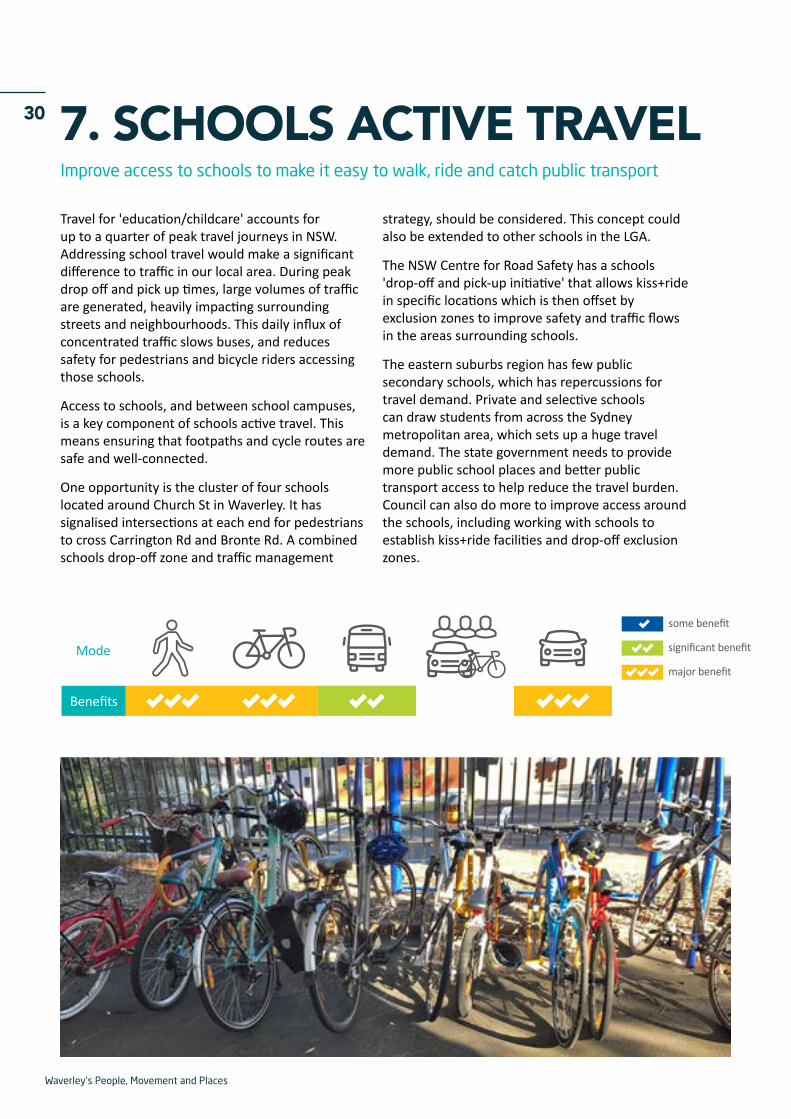
Travel for 'education/childcare' accounts for up to a quarter of peak travel journeys in NSW. Addressing school travel would make a significant difference to traffic in our local area. During peak drop off and pick up times, large volumes of traffic are generated, heavily impacting surrounding streets and neighbourhoods. This daily influx of concentrated traffic slows buses, and reduces safety for pedestrians and bicycle riders accessing those schools.
Access to schools, and between school campuses, is a key component of schools active travel. This means ensuring that footpaths and cycle routes are safe and well-connected.
One opportunity is the cluster of four schools located around Church St in Waverley. It has signalised intersections at each end for pedestrians to cross Carrington Rd and Bronte Rd. A combined schools drop-off zone and traffic management
strategy, should be considered. This concept could also be extended to other schools in the LGA.
The NSW Centre for Road Safety has a schools 'drop-off and pick-up initiative' that allows kiss+ride in specific locations which is then offset by exclusion zones to improve safety and traffic flows in the areas surrounding schools.
The eastern suburbs region has few public secondary schools, which has repercussions for travel demand. Private and selective schools can draw students from across the Sydney metropolitan area, which sets up a huge travel demand. The state government needs to provide more public school places and better public transport access to help reduce the travel burden. Council can also do more to improve access around the schools, including working with schools to establish kiss+ride facilities and drop-off exclusion zones.
Mode
Benefits
major benefit
some benefit
significant benefit

Waverley's People, Movement and Places
31
LESW
ELL
STDE
NIS
ON
ST
MAN
NIN
G S
T
ST M
ARYS
AVE
NEW
LAN
D ST
NEW
LAN
D ST
HO
LLYW
OO
D AV
E
HOLLYWOOD AVE
YORK
RD
BIRRELL ST BIRRELL STPORTER ST
ZARITA
BRONTE RD
BRONTE RD
BRONTE RD
ALBION ST
AVE
BRONTE RD
HEWLETT ST
PACIFIC AVE
FLETCHER ST
BRONTE RDBRONTE RD
GAR
DYNE
ST
MACPHERSON ST
EDWARD ST
EDWARD ST
BONDI RD
EDWARD ST
EDWARD ST
RICKARD AVE
SIR THOMAS MITCHELL RD
CAM
PBEL
L PD
E
RAMSGATE AVE
RAMSGATE AVE
HASTINGS PDE
FOREST KNOLL AVE
SIMPS
ON ST
SIMPS
ON ST
CAMPBELL PDE
5554
52 Improve walking and cycling access to schools
55 Managed kiss+ride for schools surrounding Church St Waverley
53 Promote walking + cycling to schools
Timeframes are indicative only – project scope, budget + delivery subject to further investigation.
Feasibility Implementation
2018 2020 2025SHORT TERM MEDIUM TERM LONG TERM 2030
54 Improve walking safety for school children along Henrietta St
56 Investigate ways to reduce travel demand + manage transport for schools particularly secondary schools
Schools Active Travel – actions
Government secondary school (limited catchment area)
Non-government secondary school (unlimited catchment area)
A quarter of all morning peak travel in NSW is for education/childcare
52
52
52 54
5352
52
52
Waverley's People, Movement and Places
32 8. SHARED + ELECTRIC VEHICLESEncourage more shared vehicles (cars, bicycles, scooters) and electric vehicle charging
Public feedback on draft Waverley's People, Movement and Places document
Electric vehicles (EVs) have been available in Australia for several years, and offer a clean alternative to petrol vehicles if they are powered by renewable energy sources such as solar or wind. Electric vehicles are also very quiet and don’t pollute the air, which is a major advantage in dense urban areas and on busy roads. Unfortunately the uptake of electric vehicles has been relatively slow in Australia, in part due to ‘range anxiety’: because there are few public electric charging stations, drivers of electric vehicles need to stay within a relatively short range of home to ensure they are able to keep charged.
Waverley Council, in partnership with Randwick and Woollahra Councils has developed an Electric Vehicles Charging Strategy. Charging stations will be installed on the beachfront at Bondi Beach, and in Council’s Eastgate Car Park in Bondi Junction.
In addition, the Development Control Plans (DCPs) require new developments to supply electric vehicle charging points to ensure they are future-proof for anyone who may own an electric vehicle in future.
Share vehicles have been around for some years – for example GoGet and Car Next Door. The growth in car share usage has been fairly rapid, with around 10,500 registered members and 198 cars in Waverley LGA in total. More share cars mean less cars competing for parking space. Research shows that share car users tend not to buy a car or second car and, as a result, the average share car takes about 12 cars off the street. This is a major advantage in Waverley LGA which has high demand for both on-street and off-street car parking.
Feedback on the draft transport vision showed very strong support for share cars, with eight out of ten people saying they've used car share or bike share, or would consider using a share system in future. Share bicycles and shared electric scooters are also a consideration. Council is continuing to work with dockless share bike operators, and will explore the potential of electric share bikes (e-bikes) which would make cycling easier on our hilly terrain.
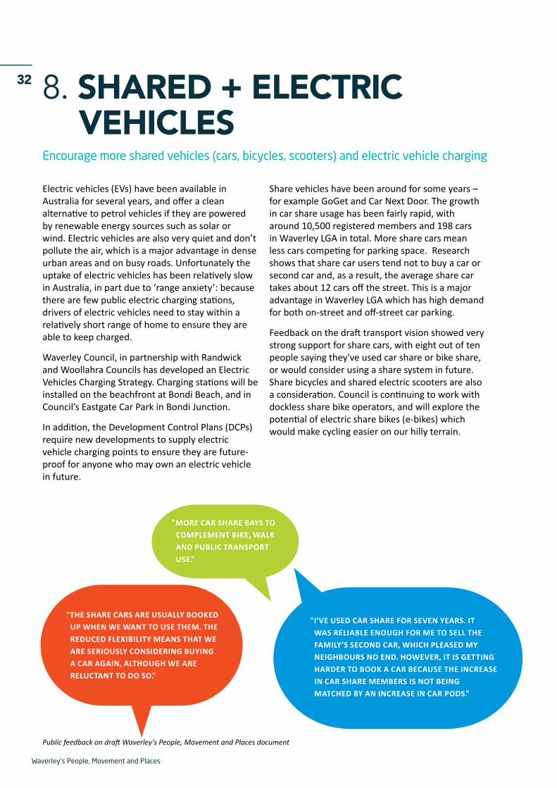
"MORE CAR SHARE BAYS TO COMPLEMENT BIKE, WALK AND PUBLIC TRANSPORT USE."
"I’VE USED CAR SHARE FOR SEVEN YEARS. IT WAS RELIABLE ENOUGH FOR ME TO SELL THE FAMILY’S SECOND CAR, WHICH PLEASED MY NEIGHBOURS NO END. HOWEVER, IT IS GETTING HARDER TO BOOK A CAR BECAUSE THE INCREASE IN CAR SHARE MEMBERS IS NOT BEING MATCHED BY AN INCREASE IN CAR PODS."
"THE SHARE CARS ARE USUALLY BOOKED UP WHEN WE WANT TO USE THEM. THE REDUCED FLEXIBILITY MEANS THAT WE ARE SERIOUSLY CONSIDERING BUYING A CAR AGAIN, ALTHOUGH WE ARE RELUCTANT TO DO SO."

Waverley's People, Movement and Places
33
60 Ensure electric car/ scooter/ bike charging installed on-street + off-street
59 Investigate 'next generation' share schemes for car/motorbike/e-bike etc
61 Install electric vehicle charging at Bondi
Timeframes are indicative only – project scope, budget + delivery subject to further investigation.
Feasibility Implementation
2018 2020 2025SHORT TERM MEDIUM TERM LONG TERM 2030
58 Prepare revised car share policy + install new car share pods throughout LGA
57 Work with dockless bike share operators + investigate potential for share e-bikes
Shared + Electric Transport – actions
Mode
Benefits
major benefit
some benefit
significant benefit
Waverley's People, Movement and Places
34 9. CHARING CROSSReview the movement of vehicles through Charing Cross
Charing Cross – actions
Timeframes are indicative only – project scope, budget + delivery subject to further investigation. *In partnership with TfNSW, RMS.
62 Prioritise public transport, walking + cycling on Bronte Rd*
63 Direct through-traffic away from Bronte Rd to Carrington Rd as arterial road*
64 Provide traffic calming, landscaping + tree coverage along Bronte Rd
65 Revise intersection of Carrington Rd/ Bronte Rd for preferred transport priorities + improved safety for all road users*
Feasibility Implementation
2018 2020 2025SHORT TERM MEDIUM TERM LONG TERM 2030
Mode
Benefits
major benefit
some benefit
significant benefit
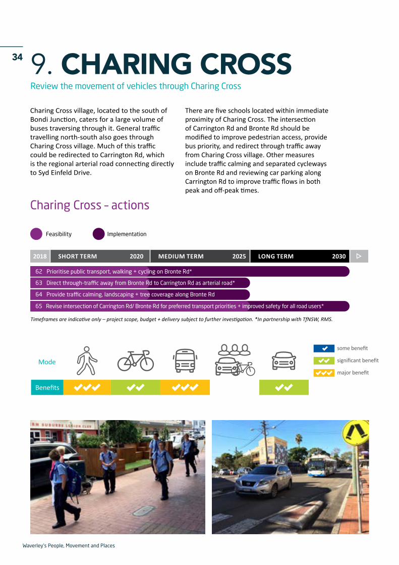
Charing Cross village, located to the south of Bondi Junction, caters for a large volume of buses traversing through it. General traffic travelling north-south also goes through Charing Cross village. Much of this traffic could be redirected to Carrington Rd, which is the regional arterial road connecting directly to Syd Einfeld Drive.
There are five schools located within immediate proximity of Charing Cross. The intersection of Carrington Rd and Bronte Rd should be modified to improve pedestrian access, provide bus priority, and redirect through traffic away from Charing Cross village. Other measures include traffic calming and separated cycleways on Bronte Rd and reviewing car parking along Carrington Rd to improve traffic flows in both peak and off-peak times.

Waverley's People, Movement and Places
3510. BONDI JUNCTIONContinue to implement Complete Streets and reduce traffic circulation in Bondi Junction
GRAFTON ST
GRAFTON ST
SYD EINFELD DR
SYD EINFELD DR
SPRING ST
SPRING ST
OXFORD ST MALL
EBLEY ST
ALLENS PDE
EBLEY ST
NEW
LAN
D ST
NEW
LAN
D ST
LAW
SON
ST
MAC
KEN
ZIE
ST
GARD
INER
ST
BRIS
BAN
E ST
BIRELL ST
BIRELL ST
DEN
ISO
N S
T
DEN
ISO
N S
T
MIL
L HI
LL R
D
LESW
ELL
ST JA
MES
RD
ST JA
MES
RD
OXFORD ST
OXFORD ST
OXFORD ST
BRO
NTE
RD
BRONTE RD
ROW
E ST
WAV
ERLE
Y ST
MAL
L
YORK
RD
RUTH
VEN
ST
HOLL
YWO
OD A
VE
OLD SOUTH HEAD RD
WAVERLEY ST
LLANDAFF ST
ALLENS PDE
BEN EDEN ST
WA
VERLEY CRES
BOTA
NY
ST
COUN
CIL
ST
BONDI RD
6867
66
67
70
68
68
69
Signature Projects
Actions – Bondi Junction
8
12
3
2
5
6
2
N
Bondi Junction – actions
67 Reconfigure intersections at each end of Syd Einfeld Drive + on/off ramps *
68 Discourage through-traffic + circulation in Bondi Junction
69 Review right-turn + u-turn exits from car parking
70 Develop parking hierarchy for street parking in Bondi Junction + audit existing
Feasibility Implementation
2018 2020 2025SHORT TERM MEDIUM TERM LONG TERM 2030
Timeframes are indicative only – project scope, budget + delivery subject to further investigation. *In partnership with TfNSW, RMS.
66 Continue to implement Bondi Junction Complete Streets
2
2
2
68
68
70
69
67
70
Council has been undertaking its Complete Streets program for Bondi Junction since 2014. In addition to these street improvement works, there is also an overall need to reduce through-traffic in Bondi Junction (particularly north-south) and reduce circulating traffic trying to access or exit car parking stations. Further projects that have been identified within Bondi Junction to help achieve this include:
- Installing ramps that exit directly off Syd Einfeld Drive (for bus only or general traffic) and reconfiguring the intersections at each end of Syd Einfeld Drive
- Altering entry and exit points to multi-storey car parks
- Reconfiguring intersections on Bronte Rd, Birrell St and York Rd to direct traffic away from the centre.
Waverley's People, Movement and Places
36 11. BONDI BEACH
Mode
Benefits
major benefit
some benefit
significant benefit
Implement major improvements to Campbell Parade and Bondi Beach
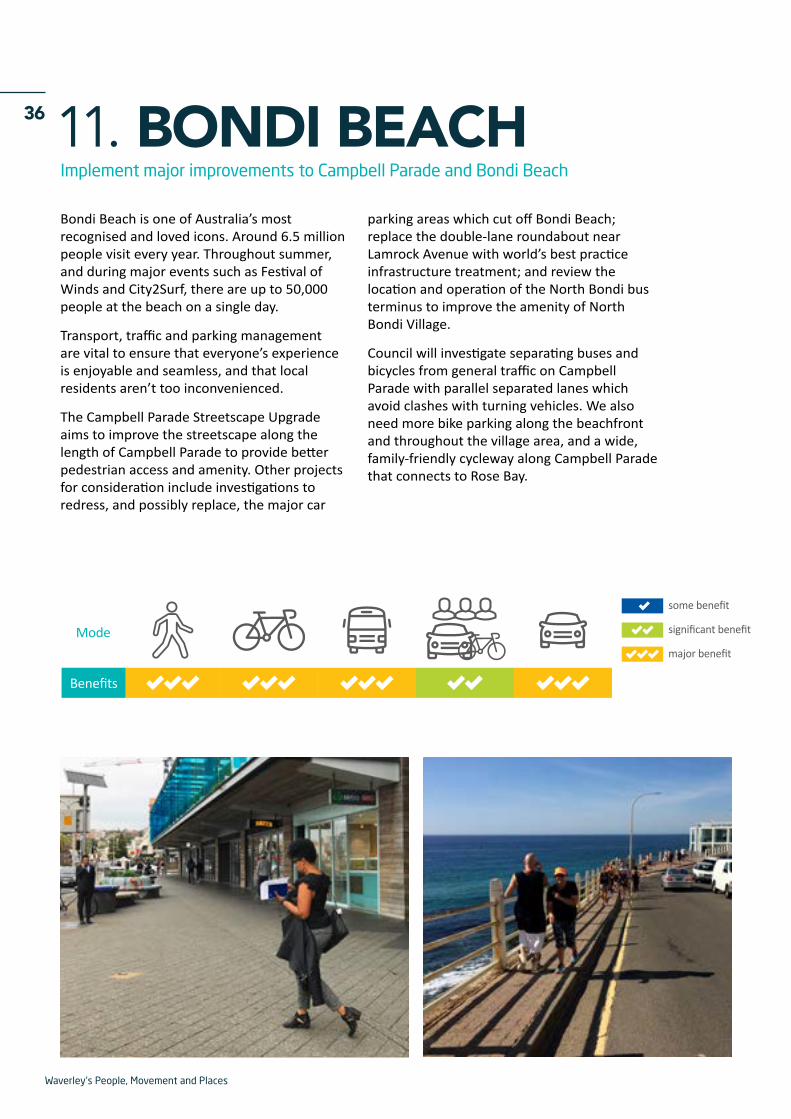
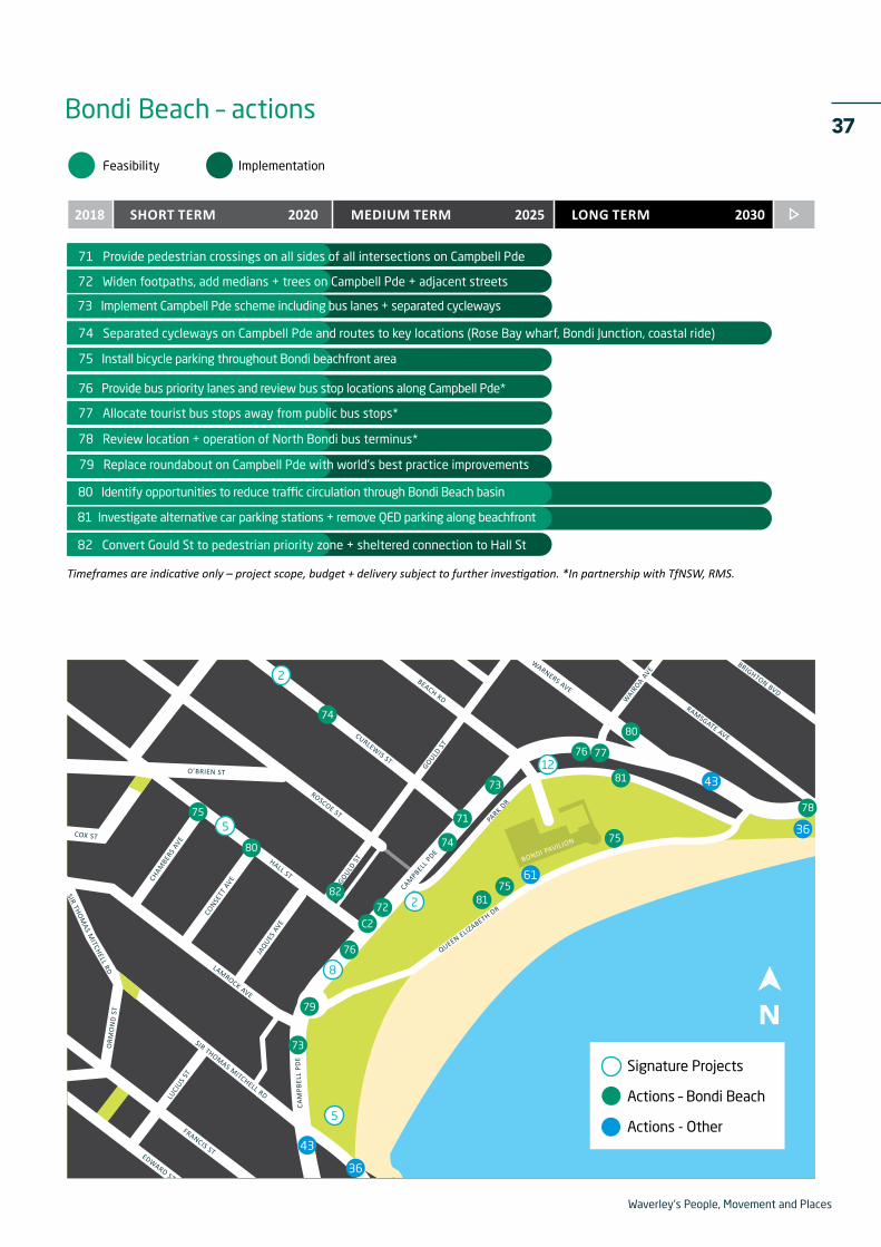
Bondi Beach is one of Australia’s most recognised and loved icons. Around 6.5 million people visit every year. Throughout summer, and during major events such as Festival of Winds and City2Surf, there are up to 50,000 people at the beach on a single day.
Transport, traffic and parking management are vital to ensure that everyone’s experience is enjoyable and seamless, and that local residents aren’t too inconvenienced.
The Campbell Parade Streetscape Upgrade aims to improve the streetscape along the length of Campbell Parade to provide better pedestrian access and amenity. Other projects for consideration include investigations to redress, and possibly replace, the major car
parking areas which cut off Bondi Beach; replace the double-lane roundabout near Lamrock Avenue with world’s best practice infrastructure treatment; and review the location and operation of the North Bondi bus terminus to improve the amenity of North Bondi Village.
Council will investigate separating buses and bicycles from general traffic on Campbell Parade with parallel separated lanes which avoid clashes with turning vehicles. We also need more bike parking along the beachfront and throughout the village area, and a wide, family-friendly cycleway along Campbell Parade that connects to Rose Bay.
Waverley's People, Movement and Places
37
LESW
ELL
STDE
NIS
ON
ST
MAN
NIN
G S
T
ST M
ARYS
AVE
NEW
LAN
D ST
NEW
LAN
D ST
HO
LLYW
OO
D AV
E
HOLLYWOOD AVE
YORK
RD
BIRRELL ST BIRRELL STPORTER ST
ZARITA
BRONTE RD
BRONTE RD
BRONTE RD
ALBION ST
AVE
BRONTE RD
HEWLETT ST
PACIFIC AVE
FLETCHER ST
BRONTE RDBRONTE RD
GAR
DYNE
ST
MACPHERSON ST
EDWARD ST
EDWARD ST
BONDI RD
EDWARD ST
EDWARD ST
RICKARD AVE
SIR THOMAS MITCHELL RD
CAM
PBEL
L PD
E
RAMSGATE AVE
RAMSGATE AVE
HASTINGS PDE
FOREST KNOLL AVE
SIMPS
ON ST
SIMPS
ON ST
CAMPBELL PDECAMPBELL
PARADE
QUEEN ELIZABETH DR
GOULD ST
GOULD ST
WAIR
OA AVE
RAMSGATE AVE
BRIGHTON BVD
WARNERS AVE
CURLEWIS ST
ROSCOE ST
HALL ST
BEACH RD
CAMPBELL
PDE
CAM
PBEL
L PD
E
PARK DR
LAMROCK AVE
SIR THOMAS MITCHELL RD
SIR THOM
AS MITCHELL RD
FRANCIS STEDWARD ST
ORM
ON
D S
T
LUCI
US ST
CONSE
TT A
VE
JAQUES
AVE
CHAM
BERS
AVE
GOULD S
T BONDI PAVILION
O’BRIEN ST
COX ST
MIT
CHEL
L ST
GLASGOW RDGLENAY
R AVE
75
82
72
C2
79
73
74
8175
80
80
78
76
75
73
71
NSignature Projects
Actions – Bondi Beach
Actions - Other
12
2
8
5
Feasibility Implementation
2018 2020 2025SHORT TERM MEDIUM TERM LONG TERM 2030
71 Provide pedestrian crossings on all sides of all intersections on Campbell Pde
82 Convert Gould St to pedestrian priority zone + sheltered connection to Hall St
74 Separated cycleways on Campbell Pde and routes to key locations (Rose Bay wharf, Bondi Junction, coastal ride)
77 Allocate tourist bus stops away from public bus stops*
73 Implement Campbell Pde scheme including bus lanes + separated cycleways
75 Install bicycle parking throughout Bondi beachfront area
76 Provide bus priority lanes and review bus stop locations along Campbell Pde*
72 Widen footpaths, add medians + trees on Campbell Pde + adjacent streets
79 Replace roundabout on Campbell Pde with world's best practice improvements
80 Identify opportunities to reduce traffic circulation through Bondi Beach basin
78 Review location + operation of North Bondi bus terminus*
81 Investigate alternative car parking stations + remove QED parking along beachfront
Timeframes are indicative only – project scope, budget + delivery subject to further investigation. *In partnership with TfNSW, RMS.
Bondi Beach – actions
2
5
74
76
77
81
61
43
43
36
36

Waverley's People, Movement and Places
38 12. SMART PARKING MANAGEMENTTake an integrated approach to parking, land use and travel demand
Mode
Benefits
major benefit
some benefit
significant benefit
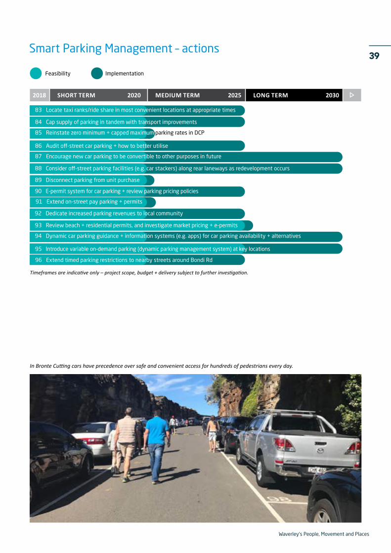
Parking is a limited resource that takes up valuable space both on-street and off-street. Cars that circulate while looking for parking also create a high volume of unnecessary traffic.
Better parking management would help to provide better utilisation of parking and greater equity of access to car parking spaces with highest demand, while reducing prices in other areas and times when demand is lower.
The community needs to be involved in the discussion about trade-offs between traffic congestion, car parking, priority bus routes,
cycleways, footpath space and amenities such as trees, shade and seating. Whilst we’d like to be able to provide for all of these, the reality is we can’t always provide everything in the same location.
Smart parking management actions include encouraging new parking spaces in buildings to be convertible to other uses in future; installing car stackers; and disconnecting the need to purchase a car space when buying a unit. Other measures include e-permits to replace the current beach and residential parking permits; and installing parking guidance systems that help drivers to find parking without needing to circulate for long periods.
Waverley's People, Movement and Places
39
Timeframes are indicative only – project scope, budget + delivery subject to further investigation.
93 Review beach + residential permits, and investigate market pricing + e-permits
88 Consider off-street parking facilities (e.g. car stackers) along rear laneways as redevelopment occurs
94 Dynamic car parking guidance + information systems (e.g. apps) for car parking availability + alternatives
89 Disconnect parking from unit purchase
90 E-permit system for car parking + review parking pricing policies
92 Dedicate increased parking revenues to local community
Feasibility Implementation
2018 2020 2025SHORT TERM MEDIUM TERM LONG TERM 2030
83 Locate taxi ranks/ride share in most convenient locations at appropriate times
95 Introduce variable on-demand parking (dynamic parking management system) at key locations
84 Cap supply of parking in tandem with transport improvements
87 Encourage new car parking to be convertible to other purposes in future
85 Reinstate zero minimum + capped maximum parking rates in DCP
86 Audit off-street car parking + how to better utilise
Smart Parking Management – actions
91 Extend on-street pay parking + permits
96 Extend timed parking restrictions to nearby streets around Bondi Rd
In Bronte Cutting cars have precedence over safe and convenient access for hundreds of pedestrians every day.

Waverley's People, Movement and Places
40


