Waterways: streambed erosion - Archive Local Land...
4
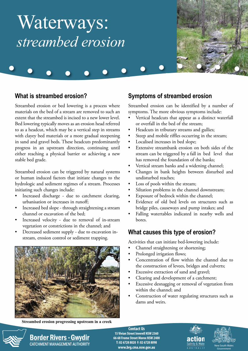
Waterways: streambed erosion What is streambed erosion? Streambed erosion or bed lowering is a process where materials on the bed of a stream are removed to such an extent that the streambed is incised to a new lower level. Bed lowering typically moves as an erosion head referred to as a headcut, which may be a vertical step in streams with clayey bed materials or a more gradual steepening in sand and gravel beds. These headcuts predominantly progress in an upstream direction, continuing until either reaching a physical barrier or achieving a new stable bed grade. Streambed erosion can be triggered by natural systems or human induced factors that initiate changes to the hydrologic and sediment regimes of a stream. Processes initiating such changes include: • Increased discharge - due to catchment clearing, urbanisation or increases in runoff; • Increased bed slope - through straightening a stream channel or excavation of the bed; • Increased velocity - due to removal of in-stream vegetation or constrictions in the channel; and • Decreased sediment supply - due to excavation in- stream, erosion control or sediment trapping. Streambed erosion progressing upstream in a creek Symptoms of streambed erosion Streambed erosion can be identified by a number of symptoms. The more obvious symptoms include: • Vertical headcuts that appear as a distinct waterfall or overfall in the bed of the stream; • Headcuts in tributary streams and gullies; • Steep and mobile riffles occurring in the stream; • Localised increases in bed slope; • Extensive streambank erosion on both sides of the stream can be triggered by a fall in bed level that has removed the foundation of the banks; • Vertical stream banks and a widening channel; • Changes in bank heights between disturbed and undisturbed reaches; • Loss of pools within the stream; • Siltation problems in the channel downstream; • Exposure of bedrock within the channel; • Evidence of old bed levels on structures such as bridge piles, causeways and pump intakes; and • Falling watertables indicated in nearby wells and bores. What causes this type of erosion? Activities that can initiate bed-lowering include: • Channel straightening or shortening; • Prolonged irrigation flows; • Concentration of flow within the channel due to the construction of levees, bridges and culverts; • Excessive extraction of sand and gravel; • Clearing and development of a catchment; • Excessive desnagging or removal of vegetation from within the channel; and • Construction of water regulating structures such as dams and weirs. Contact Us 15 Vivian Street Inverell NSW 2360 66-68 Frome Street Moree NSW 2400 T: 02 6728 8020 F: 02 6728 8098 www.brg.cma.nsw.gov.au
-
Upload
truongcong -
Category
Documents
-
view
220 -
download
0
Transcript of Waterways: streambed erosion - Archive Local Land...
Waterways: streambed erosion
What is streambed erosion?
Streambed erosion or bed lowering is a process where materials on the bed of a stream are removed to such an extent that the streambed is incised to a new lower level. Bed lowering typically moves as an erosion head referred to as a headcut, which may be a vertical step in streams with clayey bed materials or a more gradual steepening in sand and gravel beds. These headcuts predominantly progress in an upstream direction, continuing until either reaching a physical barrier or achieving a new stable bed grade.
Streambed erosion can be triggered by natural systems or human induced factors that initiate changes to the hydrologic and sediment regimes of a stream. Processes initiating such changes include: • Increased discharge - due to catchment clearing,
urbanisation or increases in runoff; • Increased bed slope - through straightening a stream
channel or excavation of the bed; • Increased velocity - due to removal of in-stream
vegetation or constrictions in the channel; and • Decreased sediment supply - due to excavation in-
stream, erosion control or sediment trapping.
Streambed erosion progressing upstream in a creek
Symptoms of streambed erosion
Streambed erosion can be identified by a number of symptoms. The more obvious symptoms include: • Vertical headcuts that appear as a distinct waterfall
or overfall in the bed of the stream; • Headcuts in tributary streams and gullies; • Steep and mobile riffles occurring in the stream; • Localised increases in bed slope; • Extensive streambank erosion on both sides of the
stream can be triggered by a fall in bed level that has removed the foundation of the banks;
• Vertical stream banks and a widening channel; • Changes in bank heights between disturbed and
undisturbed reaches; • Loss of pools within the stream; • Siltation problems in the channel downstream; • Exposure of bedrock within the channel; • Evidence of old bed levels on structures such as
bridge piles, causeways and pump intakes; and • Falling watertables indicated in nearby wells and
bores.
What causes this type of erosion?
Activities that can initiate bed-lowering include: • Channel straightening or shortening; • Prolonged irrigation flows; • Concentration of flow within the channel due to
the construction of levees, bridges and culverts; • Excessive extraction of sand and gravel; • Clearing and development of a catchment; • Excessive desnagging or removal of vegetation from
within the channel; and • Construction of water regulating structures such as
dams and weirs.
Contact Us 15 Vivian Street Inverell NSW 2360
66-68 Frome Street Moree NSW 2400
T: 02 6728 8020 F: 02 6728 8098
www.brg.cma.nsw.gov.au

Problems that can result If left unmanaged, the process of streambed lowering can result in the following problems: • Damage to infrastructure such as roads, bridges
causeways and communications cabling; • Declining stream water quality due to increased
sediment inputs and turbidity; • Removal of stream pools and waterholes that reduce
water availability or pump effectiveness; • Sedimentation of stream pools, lakes, wetlands and
reservoirs; • Changes to the dynamics and rates of water flow
and movement within the stream; • Loss of stream and wetland habitat for native fauna
species, particularly aquatic animals; • Reduction of stream productivity, which means less
food for aquatic animals; • Promotion of weed and algal outbreaks; and • Leads to deep watercourses where the banks are very
steep, the channel relatively narrow and overbank flow is restricted onto the floodplain.
Management Strategies
The majority of strategies for effectively controlling streambed erosion usually involve engineered structures that can be expensive to implement. Thus, prevention is the best form of management. In-stream strategies that reduce the risk of streambed erosion occurring include: • Preventing the straightening or shortening of stream
channels; • Not allowing levees to be constructed that may
confine stream flow to its channel; • Preventing unnecessary excavation of bed materials
in the creek; • Taking care not to excessively remove woody debris
from within the channel; • Increasing the roughness to channel flow within the
affected reach by establishing sedges, grasses and rushes near the water’s edge as well as native shrubs and trees on the lower and upper bank; and
• Fencing off streams to control and limit livestock access and where necessary providing livestock with alternative watering points.
However, where streambed erosion is causing problems in a stream, structural works should be designed to
An actively eroding headcut lowers the bed of this stream
dissipate the energy causing the erosion and put in place materials able to withstand expected flows. Suitable approaches are those that are able to: • Control the upstream movement of the headcut; • Reduce bed slope within the affected reach; • Increase the resistance to flow or roughness within
the affected reach of stream; and • Increase the stability of the bed material.
Headcut and grade control structures prevent bed lowering from progressing further upstream and establish a more stable channel slope within the reach where they have already passed through. These structures act to reduce the velocity of flows and trap material within the streambed, reducing the potential for bed lowering.
While there are many different types of structures capable of doing so, most should be carefully designed by a qualified professional in this field. Types and examples of these include: • Ramps - for instance Log Pin Ramps or the rock
constructed Schauberger Ramps; • Flumes - such as Concrete or Rock Flumes; • Sills or Weirs - numerous designs built in log, rock,
concrete or other versions; and • Girdles - such as Log or Rock Girdles.
These structural methods will usually require a permit. In NSW the primary contact for riparian zone management and approvals is the Department of Water and Energy. However, the Department of Primary Industries should also be consulted as these types of structures can impact upon fish passage.
Written and produced for the BR-G CMA by: May 2008
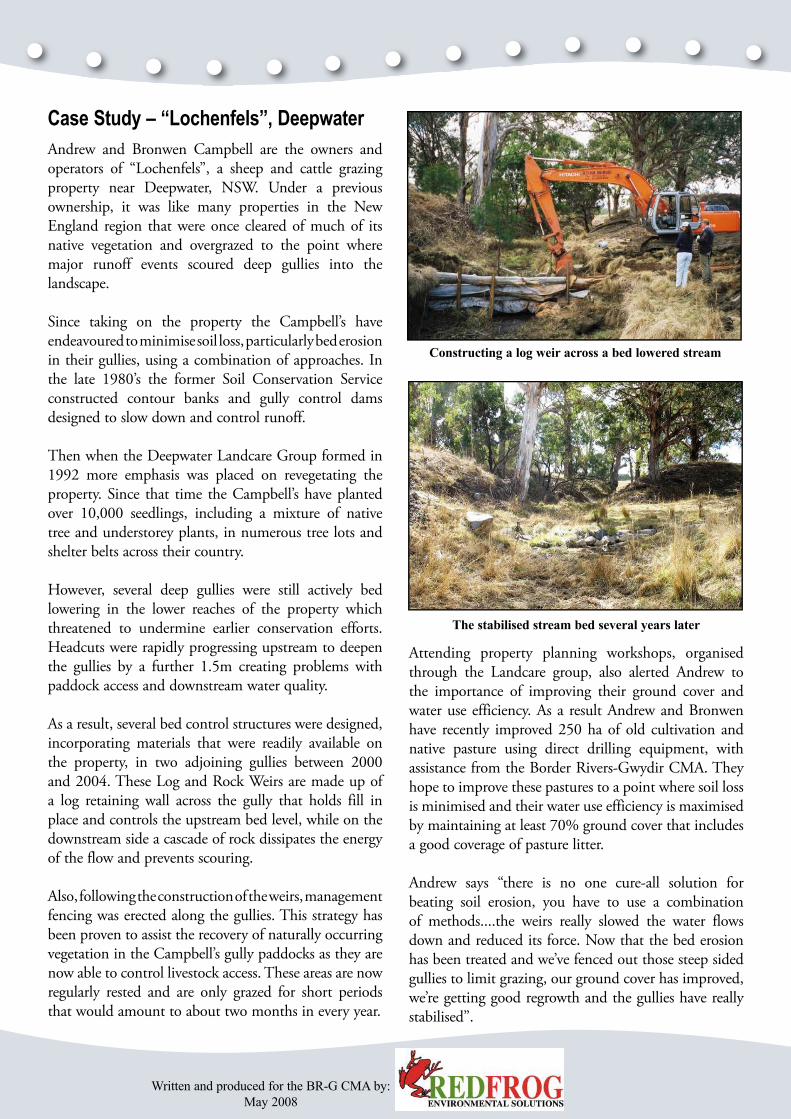
Case Study – “Lochenfels”, Deepwater
Andrew and Bronwen Campbell are the owners and operators of “Lochenfels”, a sheep and cattle grazing property near Deepwater, NSW. Under a previous ownership, it was like many properties in the New England region that were once cleared of much of its native vegetation and overgrazed to the point where major runoff events scoured deep gullies into the landscape.
Since taking on the property the Campbell’s have endeavoured to minimise soil loss, particularly bed erosion in their gullies, using a combination of approaches. In the late 1980’s the former Soil Conservation Service constructed contour banks and gully control dams designed to slow down and control runoff.
Then when the Deepwater Landcare Group formed in 1992 more emphasis was placed on revegetating the property. Since that time the Campbell’s have planted over 10,000 seedlings, including a mixture of native tree and understorey plants, in numerous tree lots and shelter belts across their country.
However, several deep gullies were still actively bed lowering in the lower reaches of the property which threatened to undermine earlier conservation efforts. Headcuts were rapidly progressing upstream to deepen the gullies by a further 1.5m creating problems with paddock access and downstream water quality.
As a result, several bed control structures were designed, incorporating materials that were readily available on the property, in two adjoining gullies between 2000 and 2004. These Log and Rock Weirs are made up of a log retaining wall across the gully that holds fill in place and controls the upstream bed level, while on the downstream side a cascade of rock dissipates the energy of the flow and prevents scouring.
Also, following the construction of the weirs, management fencing was erected along the gullies. This strategy has been proven to assist the recovery of naturally occurring vegetation in the Campbell’s gully paddocks as they are now able to control livestock access. These areas are now regularly rested and are only grazed for short periods that would amount to about two months in every year.
Constructing a log weir across a bed lowered stream
The stabilised stream bed several years later
Attending property planning workshops, organised through the Landcare group, also alerted Andrew to the importance of improving their ground cover and water use efficiency. As a result Andrew and Bronwen have recently improved 250 ha of old cultivation and native pasture using direct drilling equipment, with assistance from the Border Rivers-Gwydir CMA. They hope to improve these pastures to a point where soil loss is minimised and their water use efficiency is maximised by maintaining at least 70% ground cover that includes a good coverage of pasture litter.
Andrew says “there is no one cure-all solution for beating soil erosion, you have to use a combination of methods....the weirs really slowed the water flows down and reduced its force. Now that the bed erosion has been treated and we’ve fenced out those steep sided gullies to limit grazing, our ground cover has improved, we’re getting good regrowth and the gullies have really stabilised”.
Written and produced for the BR-G CMA by: May 2008
Case Study – Warialda Creek
In 2000 the Warialda Rivercare Committee (WRC)
and the Yallaroi (now Gwydir) Shire Council (YSC) approached the former Department of Land and Water Conservation for assistance to control the streambed erosion that was occurring in Warialda Creek, after it was identified as a high priority issue in the River Management Plan prepared for the creek.
Long profile surveys of the creek indicated that the bed had lowered by about 1m for a 1 km reach of the creek running through Warialda. This erosion was determined to have occurred during several moderate flooding events between 1999 and 2002. In lowering the creek bed, these floods removed all waterholes, swept away a lot of riparian vegetation and left behind unstable creek banks and a barren bed of sand.
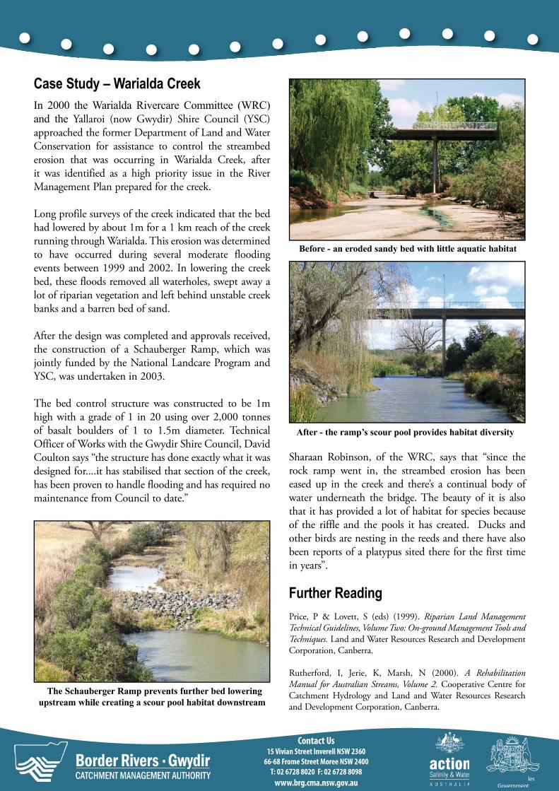
After the design was completed and approvals received, the construction of a Schauberger Ramp, which was jointly funded by the National Landcare Program and YSC, was undertaken in 2003.
The bed control structure was constructed to be 1m high with a grade of 1 in 20 using over 2,000 tonnes of basalt boulders of 1 to 1.5m diameter. Technical Officer of Works with the Gwydir Shire Council, David Coulton says “the structure has done exactly what it was designed for....it has stabilised that section of the creek, has been proven to handle flooding and has required no maintenance from Council to date.”
The Schauberger Ramp prevents further bed lowering upstream while creating a scour pool habitat downstream
Before - an eroded sandy bed with little aquatic habitat
After - the ramp’s scour pool provides habitat diversity
Sharaan Robinson, of the WRC, says that “since the rock ramp went in, the streambed erosion has been eased up in the creek and there’s a continual body of water underneath the bridge. The beauty of it is also that it has provided a lot of habitat for species because of the riffle and the pools it has created. Ducks and other birds are nesting in the reeds and there have also been reports of a platypus sited there for the first time in years”.
Further Reading
Price, P & Lovett, S (eds) (1999). Riparian Land Management Technical Guidelines, Volume Two: On-ground Management Tools and Techniques. Land and Water Resources Research and Development Corporation, Canberra.
Rutherford, I, Jerie, K, Marsh, N (2000). A Rehabilitation Manual for Australian Streams, Volume 2. Cooperative Centre for Catchment Hydrology and Land and Water Resources Research and Development Corporation, Canberra.
Contact Us 15 Vivian Street Inverell NSW 2360
66-68 Frome Street Moree NSW 2400
T: 02 6728 8020 F: 02 6728 8098
www.brg.cma.nsw.gov.au