Waterfowl Report, Volume IX, Annual Project Segment Report ...
42
ALAS KA DEPARTMENT OF FISH AND GAME JUNEAU. ALASKA STATE OF ALASKA Walter J. Hickel, Governor DEPARTMENT OF FISH AND GAME Augie F. Reetz, Commissioner DIVISION OF GAME Loren W. Croxton, Director Don H. Strode, Federal Aid Coordinator Robert B. Weeden, Project Leader WATERFOWL REPORT by Peter E. K. Shepherd Ben L. Hilliker John H. Crow Volume IX Annual Project Segment Report Federal Aid in Wildlife Restoration Project W-13-R-2 a nd 3, Work Plan C Scientists or other members of the public are £i:-ee, to use information in these report s . Because most reports tre at only part of continuing studi e s, pe rsons int e nding to use this material ext e nsively in other publications are urged to contact the Depart- ment of Fish and Game for more rec e nt data . Tentative conclusions s hould be identified as such in quotation. Credit would be appre- ciated. (Printed March 1968)
Transcript of Waterfowl Report, Volume IX, Annual Project Segment Report ...

ALAS KA DEPARTMENT OF FISH AND GAME
JUNEAU. ALASKA
STATE OF ALASKA Walter J. Hickel, Governor
DEPARTMENT OF FISH AND GAME Augie F. Reetz, Commissioner
DIVISION OF GAME Loren W. Croxton, Director
Don H. Strode, Federal Aid Coordinator Robert B. Weeden, Project Leader
WATERFOWL REPORT
by
Peter E. K. Shepherd Ben L. Hillike r
John H. Crow
Volume IX
Annual Project Segment Report Federal Aid in Wildlife Restoration Project W-13-R-2 and 3, Work Plan C
Scientists or other members of the public are £i:-ee, to use information in these reports . Because most reports treat only part of continuing studies, pe rsons intending to use this material extensively in othe r publications are urged to contac t the Department of Fish and Game for more recent data . Tentative conclusions should be identified as such in quotation. Credit would be appreciated.
(Printed March 1968)

CORRECTION NOTICE
Corrections in Annual Project Segment Reports, W-13-R, for 1967 (Vol. VII) and· 1966 (Vol. VIII) are necessary and should be noted as follows:
Vol. VII, page 7. Summer Population Gains should read:
1. Adults alive in late May 126
2. Est. loss of adults to August (10 percent) 13
3. Adults alive in August 113
4. Nests started 55
5. Nests hatching 44
6. Chicks per brood early in August 6.-2
7. Total chicks alive in August 275+
8. Adults plus chicks in August 385+
9. Factor of summer gain 3.0-3.l
Vol. VIII, page 13. Mortality, August 1965 to May 1966
Second paragraph should read:
"About 113 adult ptarmigan (59 males, 54 females) were on the area in August 1965. About 57 old birds (27 males, 30 females) were.present in the spring of 1966. The indicated mortality is SO percent (54 percent for cocks, 44 percent for hens) • The mortality rate was the same in 1964-65 as in 1965-66 for cocks, but was lower in 1965-66 among females ...
WORK PLAN SEGMENT REPORT
FEDERAL AID IN WILDLIFE RESTORATION
STATE:
PROJECT:
Alaska
W-13-R-2 and
TITLE: Small Game and Furbearer Investigations
3 TITLE: Waterfowl
WORK PLAN: c
JOBS: 1 3 2,3,4,5,6 (W-13-R-2); 1,2,3,4,5 3 6,B,9 (W-13-R-3)
PERIOD COVERED: January 1, 1967 to December 31, 1967
ABSTRACT
Land uplift stenming from the earthquake of 1964 has set in motion major soil changes on the Copper River Delta. These include desalinization and draining of formerly-flooded areas, tending to make habitats more favorable for mesophytic plant associations. Some plant communities of a type traditionally avoided by nesting geese seem to be developing. However, the dusky Canada geese may not be as rigidly associated with forb/grass associations as once thought. The geese now are beginning to nest in sedge cover types.
Counts of breeding drakes from the ground on three permanent plots on Minto Flats near Fairbanks suggested a 55-60 percent decrease in breeding waterfowl in comparison with 1966 data and the 1962-66 average. The air : ground visibility index in 1967 on those plots was 0.47 : 1.00; that is, 47 ducks were seen from the air for every 100 seen from the ground. Two plots were badly flooded during the counts, however, so . even the ground counts may have been low.
Excellent spring and early sWJ1T1er weather provided betterthan-average nesting and brood-rearing conditions throughout most of Alaska. Heavy rains in July and August caused extensive flooding at Minto Lakes and made production estimates impossible. The 1967 crop of dusky Canada geese on the Copper River Delta equaled the production of 52 young per hundred adults in 1966.
Migrant waterfowl were scarce in interior Alaska in late August and September due to extreme flooding of many marshes. Few sportsmen were able to hunt anyway. Hunting was the best in many years in the Cook Inlet area, but continued to be poor on the Copper River Delta-due mainly to earthquake-related shifts in feeding and loafing spots for ducks. State and federal personnel checked 376 hunters who spent 501 days in the field and shot 1609 ducks and geese in southcentral Alaska.
- i

Several cases of pollution were noted in Cook Inlet resulting from oil industry activities. One severe spill of oil led to the death of an estimated 2,000 waterfowl in November 1967. Oil from another spill in 1ate December disappeared from the surface; the latent effects of submerged oil in Cook Inlet are, as yet, unknown.
Federal personnel trapped and banded mal1ards in southeastern Alaska in midwinter 1967-68. A full report of this activity, partly funded under Work Plan C, will be made in a subsequent segment report.
- ii

WORK PLAN SEGMENT REPORT
FEDERAL AID IN WIIDLIFE RESTORATION
STATE:: Alaska
PROJECT: W-13-R-2 and 3 TITLE: Small Game and Furbearer Investigations
WORK PLAN: C TITLE: Waterfowl
JOBS: 1,2,3 2 4,5,6 (W-13-R-2); 1,2,3,4 25,6 28,9 (W-13-R-3)
PERIOD COVERED:: January 1, 1967 to December 31, 1967
OBJECTIVES
To determine the effect of land uplifting associated with the earthquake of March 27, 1964 on the production of waterfowl on the Copper River Delta.
To inventory, catalogue, map, and otherwise identify all types of waterfowl habitat in regard to the present or future use of these habitats as nesting, hunting or migrant areas.
To provide the Pacific Flyway Council and regulations committee with annual estimates of statewide waterfowl production.
To determine annual take, crippling loss, hunter success, species composition, and sex and age ratios of birds harvested.
To write publications suitable for technical journals, using data from completed Federal Aid investigations.
To make a general ecological survey of waterfowl habitats in the Juneau-Mendenhall area.
To observe and document the effects of pollution and industrial development on waterfowl and wetland habitat in Alaska.
To determine breeding areas, migration patterns, and exploitation rates of mallards wintering in southeast Alaska.

, TECHNIQUES
Techniques used in the field analysis of vegetation in 1967 were essentially the same as those described in the 1965 waterfowl report (Vol. VII, Annual Project Segment Report, June 1966).
Evaluation of the nesting success of dusky Canada geese, Branta canadensis occidentalis, was not attempted in 1967. How~ ever, 15, five-acre plots were selected at random to measure nesting density, cover preference; and nesting population shifts on the Copper River Delta. Each plot was located on the ground by permanently staking four corners with 2 x 2 x 24 inch cedar posts. Plots measured 330 by 660 feet. Narrow strips of cover• (approximately 30 feet wide) were searched until all habitat within the plot was checked for nestso
Work Plan personnel banded dusky Canada geese on the Copper River Delta at the request of the Bureau of Sport Fisheries and Wildlife. The method of driving geese, the construction of traps and materials used have been described previously (Progress Report W-6-R-2, 1960).
Aerial counts of adult and yotmg dusky Canada geese were made with a Piper Super Cub (PA 18). This was accomplished by first making a low, slow pass over the flock and counting the total number of geese. Another pass was made to count the young.
Aerial breeding pair censuses were conducted in cooperation with the Bureau of Sport Fisheries and Wildlife during May and Jtme Hilliker served as observer for most of the survey and Shepherd observed for the remainder of the count.
Breeding pair counts were made at Minto Lakes, using tech· niques as described in the 1965 waterfowl report (Vol. VII, Annual Project Segment Report, June 1966).
Waterfowl bag checks were made by State and Bureau of Sport Fisheries and Wildlife personnel in southcentral Alaska. A record of the number of hunters, days and hours hunted, method of hunting, birds lost, birds killed by sex, age, and species, was kept on standard forms supplied to all cooperators.
Reconnaissance, intensive plot study, and soil-sample gathering on the Jtmeau~Mendenhall tide lands followed the general methodology outlined in the 1967 waterfowl report for the Copper River Delta studies (Vol. VIII, Annual Project Segment Report, May 1967). These reconnaissance data were used for selection of perma• nent study sites. At each permanent study site a rectangular area
- 2

..
5 x 25 feet was staked. Each cedar stake was 1 x 1 x 18 inches with the above ground portion painted red. Precise notes were kept on the location of the study sites for future revisitationo
Within each rectangular area, or macroplot, ten microplots were placed at regular intervals, five on each of the long sides. The 20 x 50 cm microplots were delineated by ? metal plot frame placed on the inside of the macroplot with the longer side perpendicular to the long direction of the macroplot. (Notes on each study site are available so that the exact location of each microplot is known.) Soil samples were gathered at each macroplot and coverage data for the species or taxa present were recorded.
Aerial flights over Cook Inlet in a Cessna 180 and Grumman Goose were made at intervals on reports of oil spills or other pollutants. Photographs and documentary evidence were obtained to record each incident.
FINDINGS
Ecological Studies of the Copper River Delta
(C-1)
Vegetation
Plant ecological studies on the Copper River Delta are part of a continuing study which has been conducted by John H. Crow, a graduate student at Washington State University. This work will be used for a doctoral dissertation to be completed in 1968. A synopsis of findings to date was presented as a paper entitled »some Effects of the March 27, 1964 Earthquake on the Ecology of the Copper River Delta, Alaska", by John H. Crow. This paper, submitted to the National Academy of Science as part of an earthquake research compendium, is attached to this report (Appendix I).
Dusky Goose Nest Plots
Fifteen, five-acre nest and cover plots were surveyed and checked on the Copper River nesting grounds (see Fig. 1). Thirteen dusky Canada goose nests were found on these plots. A later check revealed that eleven clutches had hatched and that two nests were abandoned.
These plots were established to provide data concerning several changing conditions which are becoming increasingly apparent on the Delta. There is evidence that dusky Canada geese are selecting sedge habitat for nest cover. Eight out of 13 nests found on the Delta in 1967 were in sedge, whereas in 1959 a nesting
- 3

1 -.t: \,
·::-:;;
(}
0
~
+~ +
4 (
0"9 '5'· ~
~ '9

study on the Copper River Delta (Trainer, Charles, 1959. In BSFW Annual Waterfowl Report for Alaska, 1959.) revealed only 6--0ut of 224 nests situated in sedge cover. (Data on the relative proportions of sedge in the two areas involved are not available, but probably is not greatly different in the two count areas.) Floods no longer cast driftwood onto the for/grass type; the driftwood may have served as an important physiognomic factor involved in nesting cover recognitionn
Rigid selection of forb/grass areas for nesting would soon have an effect on goose populations assuming some upper limit of tolerable nest density,, because the forb/grass type is shrinking in extent. Sedge covers considerably more area than the forb/ grass type. One would then expect an accompanying increase in nesting pairs, if the geese come to accept sedge for nest sites, and if space had been limiting densities earlier. However, it is suspected that gunning mortality is holding this population in check. It would be interesting to tighten bag and possession limits for several years to observe the consequence of this action on subsequent breeding populations.
The five-acre plots offer a means of measuring changes in nesting densities in relation to vegetative change. Also they can provide data relative to shifts in the nesting range of the dusky Canada goose. In addition to the increase in nesting habitat on the present range of the dusky Canada goose, a trend towards a more mesophytic habitat on the Martin River Flats may have provided conditions more suitable for goose nesting than in the past. This area, large enough to support a sizeable breeding population of geese, has not been investigated recently.
HABITAT INVENTORY
(C-2)
This job was inactive during 1967. Future work on this job will involve coordination with the lands section for both office and field studies.
Statewide Waterfowl Production
(C-3)
Breeding Ground Conditions
Mild breakup weather and an early spring established excellent nesting conditions for returning migrants. Continuing
- 5
-·· - ·-··--·--·· ·-----------------------
Table l· Comparison of ground counts of breeding drakes on Minto Flats. Based on 1966-1967 surveys and the 1962-1966 average.
5-Year Percent Change
From
1966 1967 Average 1966 Average
Mallard 37 23 52 -38 -56
A. Widgeon 69 33 67 -52 -51
Green-winged teal 42 23 39 -45 -41
Shoveler 10 10 22 Sarne -55
Pintail 42 29 92 -31 -68
Sub Total 200 118 272
Canvasback 14 7 10 -50 -30
Sca up 215 62 166 -67 -63
Goldeneye 1 2 6
Bufflehead 17 8 21 -53 -61
Sub Total 247 79 203 -56 -59
- 6
-----------------------------~·.'~-#~.3.:::_________ ·-·-. --· --·----· ------···-···--- ··- ······-·······---·-

Table 2. Minto Flats Breeding Drake Surveys from the Ground, 1967.
Plots
No. 33 No. 106 No. 68
Total Total Total
Species Pairs Males Males Pairs Males Males Pairs Males Males
Mallard 3 4 7 1 3 4 3 9 12
'-I Pintail 1 7 8 2 7 9 4 8 12
Widgeon 3 5 9 4 4 8 9 7 16
Green-winged teal 3 1 4 3 4 7 5 7 12
Shoveler 0 1 1 0 0 0 3 6 9
Sc a up 14 4 18 20 2 22 19 3 22
Canvasback 2 1 3 0 1 1 1 2 3
Bufflehead 1 2 3 0 2 2 2 1 3
Go],deneye 0 1 1 0 0 0 1 0 1
28 26 54 30 23 53 47 43 90

good weather in May and June then provided better-than-average nesting and brooding conditions. However, above average rainfall in late July and August led to extensive flooding of the lower Tanana drainages and Minto Flats (an important Interior waterfowl production area). While this flooding was too late to affect the outcome of the nesting season it did cover most of the available food species with several feet of water. In fact water levels at Minto were four feet higher than had ever been recorded. Migrants soon left this area and broods were dispersed to the point where production estimates for this season were impossible to make.
Breeding Pair Counts
Breeding pair counts were conducted on the Minto Flats in the same manner as in 1966. Counts at Minto showed a 56 percent decrease over those plots of 1966 and much below the 5-year average for these plots. The combined species visibility index for this interior type habitat was 0.47 : 1.00 in comparison to 0.35 : 1.00 in 1966 and a.SO : 1.00 in 1965. High water and dispersed duck populations probably made even the ground counts rather low. A comparison of breeding drake counts on the Minto Flats plots is presented in Table J.
Conditions on the Minto Flats ground plots were poor with spring high water covering most of plots 33 and 106 (Table 1). Only plot 68 was in the same conditions as in 1966. The extensive flooding probably lowered the apparent, countable breeding populations on those plots.
Dusky Canada Goose Studies
Instead of the customary nesting study a series of nesting and cover plots were surveyed and checked on the Copper River Delta. Details of this study were presented in the section under the Copper River Delta Ecological Studies. Nesting densities on the 15, 5-acre plots ranged from 0 to 3 goose nests per plot and aver-·- aged nearly 1 nest per plot.
Thirty-five percent (419) of 1225 dusky Canada geese counted from the air in August were goslings. This survey was hampered by a lack of larger adult/brood flocks which may have biased the sampling. Therefore, we suggest that the adult-young ratios represent minimum productivity for 1967.
The scarcity of larger molter flocks presented another problem for the banding crew and they were unable to round up an appreciable number of juveniles for banding. A total of 526 geese was trapped, but eight died from injuries. Forty-one had been banded previously. Only 75 juvenile geese were in this banding sample.
- 8

Statewide Waterfowl Harvest
(C-4)
Weather and Habitat Conditions
Unusually high water levels in portions of interior Alaska this surruner resulted in poor feeding and loafing conditions on many of the local marshes. Migrants were present in good numbers early in August, but heavy rains and widespread flooding, especially in the lower Tanana Valley, led to a rapid movement out of the area. Later use of these marshes appeared restricted with only a few locally-raised waterfowl remaining through the fall. These conditions in addition to the general lack of interest on the part of the Fairbanks hunters (most were involved in flood repair work) led to the least productive waterfowl season in recent years.
Flood-displaced waterfowl may have bolstered Southcentral Alaska stocks, or at least I would assume this from reports of the goose and duck buildup in the Cook Inlet area. White-fronted geese, normally an uncommon fall migrant in this area, were seen commonly in August. Other waterfowl were exceedingly abundant and in large flocks. Hunters reported that the Susitna Flats provided the best hunting they had in years. Birds were available in Cook Inlet from August until October 20. Hunting along the greater Anchorage road systems was fair to good; on the Palmer Hay Flats, fair to good; and in Cordova, fair to good for dusky Canada Geese, but poor for ducks.,
Cordova waterfowl hunting seems to have become progressively poorer following the 1964 earthquake. Since this time there has been several major changes. Production of local ducks has been extremely poor over the past four surrrrners. Because most of the early harvest is from these stocks the September success has declined noticeably. Another major difference is that ducks use the newly exposed mudflats to the seaward of the grass flats. Only the very highest tides cause waterfowl to move inland where they can be reached by hunters. This physical change is apparently affecting both local and migrant waterfowl. Consequently, most experienced hunters in Cordova felt that the 1967 fall hunt was the worst in memory" Although there was a flurry of late shooting in October a sharp freeze on October 15 brought the season at Cordova to a close"
Bag Checks
Southcentral Alaska received nearly all the bag check effort this fall. Data from this work are divided into several sections within the southcentral region. While comparison of this season's bag checks with past years did not reflect improved hunting as indicated by hunter opinion, it did suggest that along with some excellent hunting on the Susitna Flats there was considerably more hunter interest than in past years.
- 9

··--·----------------------------------
A total of 376 hunters who spent 501 days in the field and bagged 1609 ducks and geese were checked by State and Federal personnel. Bag-check statistics as presented in Table l suggested hunting success in 1967 was similar and somewhat better than in 1966. The number of ducks per hunter was possibly influenced by the six-duck bag limit as was this statistic during the years of a two-scaup bonus (the 1967 ducks per hunter figure was the highest in the 1960-67 bag check period).
Relaxing of the bag limit and the abundant as well as available supplies of waterfowl certainly prompted more hunter interest as reflected in the average days spent on a hllllt in the Suisitna area* Surprisingly, hllllters seemed to have fared well along the Anchorage Road System. Success for this group was encouragingly good for the time spent hunting.
Table 3. Harvest information from southcentral Alaska, 1966 and 1967.
Days per Ducks per Ducks per Hunter Day Hunter
Cordova (1967) 1.0 2o7 2.7
Hay Flats (1967) 1.0 2.2 2.2
Anchorage Road System (1967) o.s 4.4 2.2
Susitna Flats (1967) 1.9 3.2 6.1
Southcentral Total (1967) 1.3 3.2 4.2 (376 hunters)
Total (1966) 1.3 3ol 4.1 (138 hunters)
SEecies ComEosition
As noted in past reports the relative species composition of the harvest often reflects production trends, availability, and hunting conditions in Alaska. Production of dabbling ducks in 1967 was good, especially for pintails, mallards, and widgeono Pintails appeared to be regaining the top position in the waterfowl harvest as in past years (Table 4)" Green-winged teal were also available in numbers, but did not-seem to reach the level of abundance attained in 1966, possibly because pintails were available~ White-fronted geese appeared more available on several southcentral Alaska marshes. Several uncommon species were found in hunter bags; these included one blue-winged teal and a hooded merganser"
- 10'

Waterfowl Publications
(C-5)
Two major publications were prepared in draft in 1967. These included the comprehensive waterfowl report and a paper on "Breeding Biology of Trumpeter Swans in Alaska,... Both publi cations have been edited and returned for further revisions and final writing.
Use of Juneau Tidelands l?y Waterfowl
Preliminary Reconnaissance of Plant Communities
The composition of the principal vegetational corrununities present on the Juneau Tidelands is presented in Table 1, Appendix. II. A more sophisticated presentation of these vegetative data will follow pending analysis of soil samples for salinity, pH, and texture. The tideland vegetation is listed according to the dominant species and from a hydric to mesic situation; however, the listing from left to right is not meant to imply any successional sequence. The initial community separation is as follows:
Puccinella/Spergularia Carex Carex/Algae Carex/Puccinella Plantago/Potentilla Hordium/Deschampsia Carex/Deschampsia Carex/Deschampsia/Eleocharis Elymus Elymus/Festuca
It is possible to draw meaningful distinctions between various kinds of plant communities present on the Juneau Tidelands. It also seems that a realistic interpretation may be made of the principal factors which influence the distribution of these communities. When the laboratory work is completed, factors which may be useful in interpreting the distribution will then be available for a more enlightened management program. Evidence should be available, for example, on the effects of different salinities and pH on the presence of various species or groups of associated species. This may indeed be useful so long as a program is initiated to demonstrate, quantitatively, grazing habits of the waterfowl.
- 11

Effects of Pollution and Industrial Development
(C-8)
Outstanding cooperation in reporting oil spills, in making surveys, and in coordinating field investigations to insure minimum pollution surveillance was maintained by the Alaska Department of Fish and Game, U.S. Fish and Wildlife Service, and the Federal Water Pollution Control Administration.
The number, origin and date of oil pollution incidences that were investigated, or observed on random flights over Cook Inlet, are listed in Table~- These spills can be logically segregated into four general classifications, depending on their respective origins: 1) Spills from temporary drill barges and rigs, or permanent platforms, 2) Pipeline breaks, 3) Spills from vessels including tankers, 4) Unknown origins.
Although there have been frequent instances of oil pollution either reported or observed in Cook Inlet, to date there has been only one significant waterfowl and sea bird mortality attributed to oil pollution. On November 24, 1967 reports of oil-soaked, dead and dying waterfowl were received from Ninilchik and Homer. As these two coastal communities are over 40 miles apart it was apparent that a considerable waterfowl loss had undoubtedly occured. Investigations subsequently revealed that in excess of 2,000 waterfowl, sea birds, and gulls were contaminated by oilo Beach cleanup crews picked up 344 birds in the area from just north of Ninilchik to the Homer Spit. Additional deaths of oil-soaked waterfowl were reported from Halibut Cove, Jackolof Bay, and Seldovia. Birds predominantly involved were: Pacific eider, Somateria mollissima ::!..· nigra, whitewinged seater, Melanitta deglandi; and guillimots, Cepphus .§E.E. Birds also picked up but in lesser numbers included old squaw, Clangula hyemalis, murres, and gulls.
Many birds in this area were obviously distressed, but were mobile enough to escape capture by the pick-up crew. Up to a dozen birds that were fairly active were collected with a shotgun, and they were all contaminated to various degrees by the oil. Other birds which were caught by the oil which were either not able to get: to shore by their own actions, or carried to shore by wind or tidal influences were likely carried to sea.
The oil which contaminated and, in some cases, completely covered the birds was about the consistency of nroofing tartt. Laboratory analysis of the substance covering the birds revealed that it was an "'unrefined hydrocarbon, a crude oil".
A second large spill was reported just over one month later. On December 30, 1967, the tanker Washington Trader was leaving the
- 12

---------
Drift River oil facility. The tanker was pierced-by an under-. water object causing 1500 to 1700 barrels of oil to escape into Cook Inlet. Six hours after the report was received, aerial surveys determined that the 60,000 gallons of oil had spread over 20 surface miles of the Inlet. By the next day over 60 surface miles were covered by the rapidly thinning oil slick. Five days after the accident, an extensive low level aerial survey failed to find any significant areas of surface contamination.
Of special concern at this time is the possibility that large quantities of oil have sunk to the bottom of Cook Inlet that might cause recontamination, or other future problems to diving ducks.
Other investigators have determined that oils and oily substances which are discharged into the ocean do not float around indefinitely. Many of those oily substances are readily absorbed by clay, silt, sand, skeletal remains of organisms, and other fine matter suspended in the water. The combination of oil with those particles causes weighting and subsequent sinking of the oil. This is especially prevelant in shallower waters.
Upper Cook Inlet, quite shallow, carries an extremely heavy silt load due to the many major rivers which are of glacial origin. This might lead to bottom deposition of considerable amounts of spilled oil spilled in Cook Inlet, with unknown effects on wildlife resources.
Mallard Populations Wintering in Southeastern Alaska
(C-9)
Personnel of the Bureau of Sport Fisheries and Wildlife trapped mallards (primarily with bait traps) in southeastern Alaska in the winter of 1967-68. As this activity was not completed by the end of the report period, a full report will be made in the segment report for Work Plan C for calendar year 1968.
- 13
-------------------------------------------------·

Table 4. Species Composition of the 1967 Southcentral Alaska Waterfowl Bag Checks.
Anchorage Cordova Total
No. % No. % No. %
Pintail 486 33.4 29 19.6 515 32.l
Mallard 267 18.3 29 19.6 296 18.5
Widgeon 332 22.8 11 7.4 343 21.4
Green-winged teal 156 10.7 23 15.5 179 11.2
Blue-winged teal 1 Trace a 0.0 l Trace
Shoveler 88 6.0 8 5.4 96 6.0
Gadwall 1 Trace 8 5.4 9 0.6
Sca up 51 3.5 3 2.0 54 3.4
Ring-necked duck 1 Trace 0 o.o 1 Tra-c-e-
Canvasback 3 Trace 0 o.o 3 Trace
Goldeneye 26 1.8 1 0. 7 27 1.7
Bufflehead 7 o .. 5 0 0.0 7 Trace
Old Squaw 1 Trace 0 o.o 1 Trace
Merganser 3 Trace 0 0.0 3 Trace
White-fronted goose 16 1.1 4 2.7 20 1.2
Canada goose 9 o.6 30 20.3 39 2.4
Crane 8 0.6 0 0.0 8 o •. 5
Unknown 0 o.o 2 1.4 2 Trace
Total 1456 99.3 148 100.0 1604 99.0
- 14

Table 5. Oil and Refuse Observations in Cook Inlet from Random Flights (Revised 10/5/67)*
Reporting Date Agency Type Location "' Source Deser ipti}.0::1
1966 6/? 1
9/6/ 2,3
9/7/ 1,2
9/23 3,4
10/10 2
10/24 3;8
10/25 2
12/21 2,3
12/21 2,3
1967 1/20 1,2,3,7
Oil
Oil
Oil
Oil
011
Oii
Oil
Oil
Mud Sacks
Mud Sacks & Garbage
Mid Inlet near Tyonek Shell Platform "A"
Unknown
Shell Platform "AH
North of Shell 11A11
sefweeii :t>an Airi and Nikiska Dock
East of Kalgin Island
Pan Am "Mna"
Pan Am "Anna 11
Pan Am "Anna 11
Unknown
Same
Platform
Platform
Platfcli'm
un::i<n.0wn.
Unknown
Platform
Same
Same
Oily su~etande on tide rips
Emitting stream of oil (probably diesel from mud)
Considerable oil surrounding platform
1 mile long, several hundred feet wide
!tidescertt sheen and ~opy ihtt!I ~es
iridescant she~rt afi~ tb~y masses 4 x 5 miles
Iridescent sheen and ropy masses 1/2 x 1/4 miles
Brown stream several miles long (drilling mud emission)??
Mud sacks on ice for several miles
Saw person throwing garbage of£ platform

Table 5. Oil and Refuse Observations, cont.
Reporting Date Agency Type Location Source Description
1967 4/20 2,3 Refuse West side of Drilling Vessel Several areas of refuse, mud
Inlet sacks, and pallet boards
4/20 2,3 Oil Sheen Not reported Drilling Vessel Several areas
5/8 1,2 Oil Below Kalgin Is. Unknown 5 miles long by 20 yards wide
5/19 1,3,6 Oil Pan Am "Bruce" Discharge from platform 200 yards long
5/19 1,3,6 Oil Tyonek Creek Unknown Along beach
8/11 2,5 Oil Nikiski Wharf Tanker Atlantic From oil dock to Colliers Eng.
8/11 2,5 Oil 1 mile west of Jack-up rig moored Small slick from rig Arness
8/25 1 Oil Mobile, Granite Barge alongside Iridescent sheen. No estimate Point rig of size made
9/19 5 Oil 4 miles north of Drilling Barge, Iridescent sheen from rig to McArthur River, Atlantic-Richfield beach. Waterfowl feeding in Trading Bay oil sheen
9/20 2,5 Oil Nikiski Docks to Unknown (noted 1/2 x 3 miles and around mouth of Kenai emission of white vessels. Oil observed near River fluid from vessel mouth of Kenai River
at Rig Tenders Dock.

Table 5. Oil and Refuse Observations, cont.
Reporting Date Agency Type Location Source Description
1967 9/20
9/27
9/27
9/27
9/27
9/27
10/2
5
5
5
2
5
5
3,5
Oil Arness Terminal
Oil
Oil
4 miles north of McArthur River, Trading Bay
l mile east of Pan Am "B"
Oil
Oil
Rig Tenders
Rig Tenders
Oil Arness Terminal
Oil Between "C" and "D"
Shell Pan Am
Unknown
Drilling Barge, Atlantic-Richfield on beach
Unknown
Unknown
Unknown
Unknown
Unknown
Large black globs and sheen in area of outermost sunken vessel used for dock
400 ft. long, 100 ft. wide at outermost end
3/4 mile long, 20 yards wide
Around south side of dock
From south side of dock 3 miles down beach
Sheen completely around facility
3 miles long with black ropy material
See page 19 for coding.
* No oil or refuse observed on 8 additional flights over Cook Inlet by BCF, BSFW, ADFG 12/1/6
12/22/66, 1/26/67, 4/15/67, 5/9/67, 5/24/67, 6/19/67, 6/20/67~

+able 5. Oil and Refuse Observations, cont. Coding used on Tables 5 and 6.
1 = Alaska Department of Fish and Game
2 = Bureau of Commercial Fisheries
3 = Bureau of Sport Fisheries and Wildlife
4 =Corps of Engineers
5 = Federal Water Pollution Control Administration
~ = Illinois Natural History Survey
~ 7 =United States Attorney's Office ~
8 = Division of Mines and Minerals
9 = U.S. Coast Guard

Table 6. Oil and Refuse Observations in Cook Inlet Following a Report (Revised 10/5/67)
Reporting Date Agency Type Location Source Extent
From 1/65 3 to 5/26/67 1966 3/5 5,1
3/? 5
5/? 5
6/9 1
~/15- 8 16
6fl9 1
6/19 1
6/19 1
6/23 1
Engine Oil
Oil
Stove
Oil
Oil
Oil
Oil
Oil
Oil
Oil
Pan Am MGS Crankcase Oil Disposed
Pipeline to Pipe Break MGS Shore Facility from Platform "A"
Oil Nikiski Dock, Tanker Overflow Standard Tanker
Pan Am Drill Stem Test
Salamatof Beach Unknown
Probably Nikiski Tanker with leak Dock in tank hole
North end Kalgin Unknown Island
Between Forelands Unknown
2 miles NW Shell Unknown 11 A11Platform
Glornar II and Unknown Western Offshore
70 gallons a week--160 bbls. so far. Corrected 7/67.
50-100 bbls. (200 reported by ADF&G from good source).
2,000 bbls.
More thart 50 bbls.
Oil on behch. Two lines visible. i0il on water in vicinity df Moose Point.
1,000 bbls.
3/4 mile long. Black gunky oil.
Light film.
Not reported~ sample taken.
Light slick-heavy black gunk in vicinity.

Table 6. Oil and Refuse Observations, cont.
Reporting Date Agency Type Location Source Extent
1966 6/24
7/1
7/8
l\J 7/10 0
7/11
9/23
10/31
12/13
1967 3/21
1
1
1
5,1
1
5,1
5,8
5,1
3,1
1
Oil
Refuse
Oil
Oil
Debris
Oil
Oil
Oil
Oil
Oil
From Kalifonski Beach halfway to Kalgin Island.
Kalgin Island
Between Pan Arn "BJI and Shell "A" Pan Am MGS
Trading Bay
Shell Pipeline from "A" to MGS Shore Facility
Glomar II near Nikiski
Shell "A1'
Pipeline
11 B11Pan Am
Seldovia Bayi
Unknown
Hunt Oil Co. Rig
Pipeline leak
Explosion
Pan Am Road Construction
Pipeline leak repair-. Pulled bolt on manifold with anchor
Pulled away from Drill Stem Test
Break
Pipe leak
Moored Drilling Rig
10 miles long, 200-300 yards wide.
Mud sacks, cement sacks, visqueen and garbage.
20 bbls.
75 bbls.
Roots, limbs, trunks, brush
50 bbls.
60 bbls.
700-1,400 bbls.
1 bbl. a day
Oil all over Bay,\ on boats and floats. bucks covered with oil.
3/22

Table 6. Oil and Refuse Observations, cont.
Reporting Date Agency Type Location Source Extent
1967 3/23
5/2
5/2
5/3
5/4
5/5
5/7
5/18
6/19
6/25
7/5
1,8
5,1,8
9
2,5,3
2,1,3
2,5
2,5
5,4
2,5,1
8
8
Oil
Oil
Jet Fuel (Kerosene)
II II
"
II II
None
Oil
Oil
Oil
Seldovia WODECO II Engine Oil and Wipings
1 mile east of "A 11 line pipe Shell Platform break "A"
Port of Anchorage Tanker EVJE (damaged)
II ti " "
II II II II
,,II II "
Following EVJE Damaged Tanker
Port of Anchorage,Broken gasket Standard Oil replacing blind Pipeline spectacle on
onshore oil line
Trading Bay
ARCO's Trading Unknown, possible Bay State #1 Union Mornopod
Trading Bay Hose on test State #1 barge loose Atlantic-Rich
10 gallons.
7 1/2 bbls. on two shots to locate break.
6,000-10,000 bbls.
"
Silver and iridescent sheen around dock and upper inlet.
II II II
" II II II
None observed.
Estimated 25 bbls.
Not located.
2 miles long.
1 bbl.

Table 6. Oil and Refuse Observations, cont.
Reporting Date Agency Type Location Source Extent
1967 7/7
7/31
8/9
8/11
l\J l\J
8/11
8/11
8/17
8/18
2
5
3,5,9,4
2,5
2,5
2,5
5
5
Stove
Oil
Oil
Oil
Oil
Oil
Oil
Oil
Oil Arness
Arness to Boulder Point
Port of Anchorage to Woranzof f
Forelands to Shell Pipeline nB"
Between Nikiski and Kalgin Is.
Arness
Nikiski Oil Dock
7 miles SW Kenai
Over pumping tank barge
Unknown
Brown & Root Derrick barge
Pipeline Break
Unknown
Unknown
Unknown, possible oil dock
Unknown
Sheen on water.
Arness to Boulder Point
2 miles slick
Less than 50 bbls. reported by Shell
2 slicks each 1 mile wide and 2 miles long.
Small sheen.
Lots of bl~ck heavy oil.
1/2 mile long by 2 miles wide: 3 miles offshore from Collier's Docks by time FWPCA observer arrived.

PREPARED BY:
Peter E.K. Shepherd Work Plan Leader
SUBMITTED BY:
Robert B. Weeden Project Leader
APPROVED BY:
-. I ,-·) / ,. .,;c;..... I', - . - .. -- '~- _. / ... ,-· --/.•<'"/f / ·' / .
Don H. Strode, Federal Aid Coordinator
...,
Clf2u/<-<-~~~ ren W. Croxton
Director, Division of Game
- 23

APPENDIX
Some Effects of the March 27, 1964 Earthquake on the Ecology of the Copper River Delta, Alaska
by John H. Crow
State of Alaska Department of Fish and Game
Fairbanks, Alaska
- 24

Introduction
On March 27, 1964, the Alaskan Good Friday earthquake produced some rather spectacular effects. Many of the effects were of immediate importance, such as the destruction of buildings and bridges, and received much attention; other effects were simply initiated at the moment the earthquake occurred. The ultimate effects of the latter category may not be realized for many years. A specific example of this would be the raising of the Copper River Delta an average of 6.3 feet (Reimnitz and Marshall, 1965).
This paper is an attempt to outline briefly some of the ecological work which has been accomplished on the Copper River Delta relating to the nesting habitat of the dusky Canada goose (Branta canadensis occidentalis) during the summers of 1965 and 1966. This bird breeds on the delta and winters in the Willamette Valley, Oregon, returning to the delta again in the spring of each year. Much additional data has been gathered and will be evaluated with the completion of work to take place during the summer of 1967. As the author is pursuing this investigation in partial fulfillment of the requirements for the degree of Ph.D. in the Department of Botany at Washington State University, it is intended that a more thorough treatment of all the data will followo
The Study Area
Location and Description
The Copper River Delta lies to the south and east of Cordova, Alaska, adjacent to Prince William Soundo The delta presents a rather flat area dominated by the alluvial deposits of the Copper River and numerous glacial streams flowing into the Gulf of Alaska immediately to the south. To the north gravels dominate but desist rather abruptly to the southo Finer textured materials characterize the remainder of the delta with sandy soil found near the Eyak and Copper Rivers to the west and east respectively. The interior portions of the delta are dominated by very fine textured materials.
Prior to the earthquake much of the Copper River Delta in the principal nesting area of the dusky Canada goose had been inundated to varying degrees by dilutr!d sea water during the highest tides of the year. Other tides brought sea water into the delta which would cover only part of the slough banks (Shepherd, 1965). The post-earthquake conditions are such that the land surface has been raised to the extent that the highest tides now come up only to the lowermost portions of the pre-earthquake vegetation along the slough banks, with the majority of the tides covering only part of the bare mudbanks now being invaded by plants.
- 25

Not only has the level of the water changed, but the water flowing in the sloughs is no longer salty, even at the high tides. This is apparently a result of the tremendous amount of fresh water flowing off the delta acting more or less as a "plug'' (Crow, 1965; Shepherd, 1965). A great deal of precipitation falls on the delta and it is therefore presumed that desalinization will proceed.
Goose Nesting
The uplift is of particular ecologica.l interest due to the general restriction of the dusky canada goose to the delta and principally to one kind of vegetation. The vegetation in question is dominated by forbs and grasses growing at the uppermost, rather leve~ portion of slough banks over a rather restricted area. The Bureau of Sport Fisheries and Wildlife 1959 Annual Waterfowl Report for Alaska by Trainer lists 97 percent of the nests (218 of 224) located within the forb-grass vegetation including small shrub fragments within the general forb-grass area. The high degree of fidelity may of course have been conditioned by the washing out of nests at sites of lower elevation. Higher, more mesophytic sites may have been vulnerable to increased predation. Regardless of the speculative reasons behind the restriction of goose nesting, the fact remains that nearly all of the nesting actually took place in one type of plant community. This plant community normally remained clear of the high tides, bt?ing inundated only hy a few exceptionally high tides. The more mesophytic types nearly always remained clear of all tides.
Because of the importance of the forb-grass vegetation to the goose population, the study was aimed at evaluating certain parameters of the various plant communities. This was done in order to assess the ecosystem changes that must surely follow the uplift of · the delta.
Methods
The first summer of field study was centered around reconnaissance work. This included the collection and tentative identification of voucher specimens. The principal objective was the visitation of a large number of sites over as much of the study area as possible in order to select thoroughly representative sites for more intensive study. At each site attention was paid to location, tidal influence, edaphic properties and other site characteristics. At each site stands were analyzed by means of a BraunBlanquet technique modified by Daubenmire (1959). According to this method the coverage of each species falling within an estimated 100 square meter plot is recorded. Coverage classes employed are listed below.
- 26

Class Range Midpoint of Range
1 0-5% 2.5%
2 5-25% 15 . 0';6
3 25-50% 37.5%
4 50-75% 62 o5%
5 75-95% 85 • 0';6
6 95-100% 97.5%
A polygon is imagined around the undisturbed foliage of each plant, or species, which is taken as its coverage. The coverage of each species is then estimated and its class recorded.
Upon completion of the reconnaissance work, quantitative details for specific stands were gathered by locating a macroplot of given area, including a number of 20 cm by 50 cm microplots delimited by a metal frame. Coverage techniques and classes used in the reconnaissance apply to the microplots. If a plant is not located within the microplots of a stand but is found within the macroplot, a plus is recorded in the data tables to indicate its presence. Calculations involved the summation and division of coverage class midpoints. For example, if 10 microplots of a stand analyzed yielded coverage estimates of 2, 1, O, 2, 2, 2, 3, 1, 2, and 2, the sum of the midpoints of 132.5. The average coverage value would be 13% and the frequency 90%.
Transect studies involved setting out 20 cm by 50 cm microplots at right angles to the transect line and evaluating each plot for coverage as outlined above. The number of flowers (or fruits) and the tallest specimens of each specil-~S were recorded within the microplots. This was done since changes in the vigor and vitality of species may precede changes in coverage or the introduction of new species in a succession"
Soil samples were also taken at each stand and at particular points along transects. These samples were taken to a depth of 1 cm with a common garden trowel and placed in paper bags to dryo Analysis took place at Washington State University.
It is important to note that each study site has been marked with either cedar stakes, metal posts, or both. Relocation and analysis of the sites studied at some time in the future should yield interesting detailB on plant succession and its relationship to goose nesting.
- 27
----------------------------------------··-·

Results and Discussion
The various types of plant communities were analyzed in detail in 1966. Those plants most often present in the macroplots of the stands analyzed have been listed in Table 1. In the region oa greatest goose nesting density, one typically finds a narrow zone of pure Carex lyngbyei at the lowermost vegetation line and slough banks. Progressing up the bank, a zone dominated by Carex lyngbyei and Eleocharis kamtschatica is next encountered. An analogous but more complex sedge community is located on the very gently sloping portion of the landscape internal to the slough bank. This basin may also contain zonal pond communities normally dominated by Potomogeton sp., Myriophyllum spicatum, Hippurus tetraphylla, or Carex lyngbyei. Hi.ppurus tetraphylla is replaced by _!!. vulgaris in ponds farther from the sea and apparently less saline. On the highest portion of the landscape within the region of maximum goose nesting one encounters a rather lush community of forbs and grasses. Before the earthquake, as mentioned earlier, certain high tides covered the forb-grass vegetation. Apparently due to the relatively level landsurface and the denseness of the vegetation the velocity of the very muddy water was slowed, enhancing the deposition of particles. These natural levees are very distinct in most places along slough banks over much of the delta.
This forb-grass community is of special interest because of its nesting utilization; however, during the summers which have followed the earthquake many successful nests have been located in other communities. Specifically, geese - as well as other waterfowl - are nesting in the various sedge communities, principally along the banks, which under pre-earthquake conditions would have been washed out.
It should be pointed out that small changes in relief in the general nesting area may be associated with rather striking changes in the vegetation as well as the fauna. For example, ecotones were nearly always very abrupt even where the apparent changes in elevation were quite gradual. This generalization appeared to be true for other areas on the delta as well.
A brief discuss.ion of more mesophytic sites shall be given because of the successional implications. The plant communities analyzed occupied positions along slough banks at least analogous to the position of the forb-grass vegetation.
Proceeding landward on similar textured soils, communities dominated by Sweet Gale (Myrica gale), willow (Salix sp.), alder (Alnus sinuata), and Sitka Spruce (Picea sitchensis) are encountered. It should be pointed out that some of the spruce communities do contain young Western Hemlock (Tsuga heterophylla) trees. The hemlock is generally assumed by most authors to be the climax dominant of most
- 28

.. well drained, topographically suitable sites along this region of the coast. Detailed analysis, as well as reconnaissance work, revealed sites at which succession had differed from the idealized scheme. The differences were primarily the amiss~ '01:° one or more of the defi.ni te seral stages. For example, sites were often observed with no trace of Sweet Gale beneath willow.
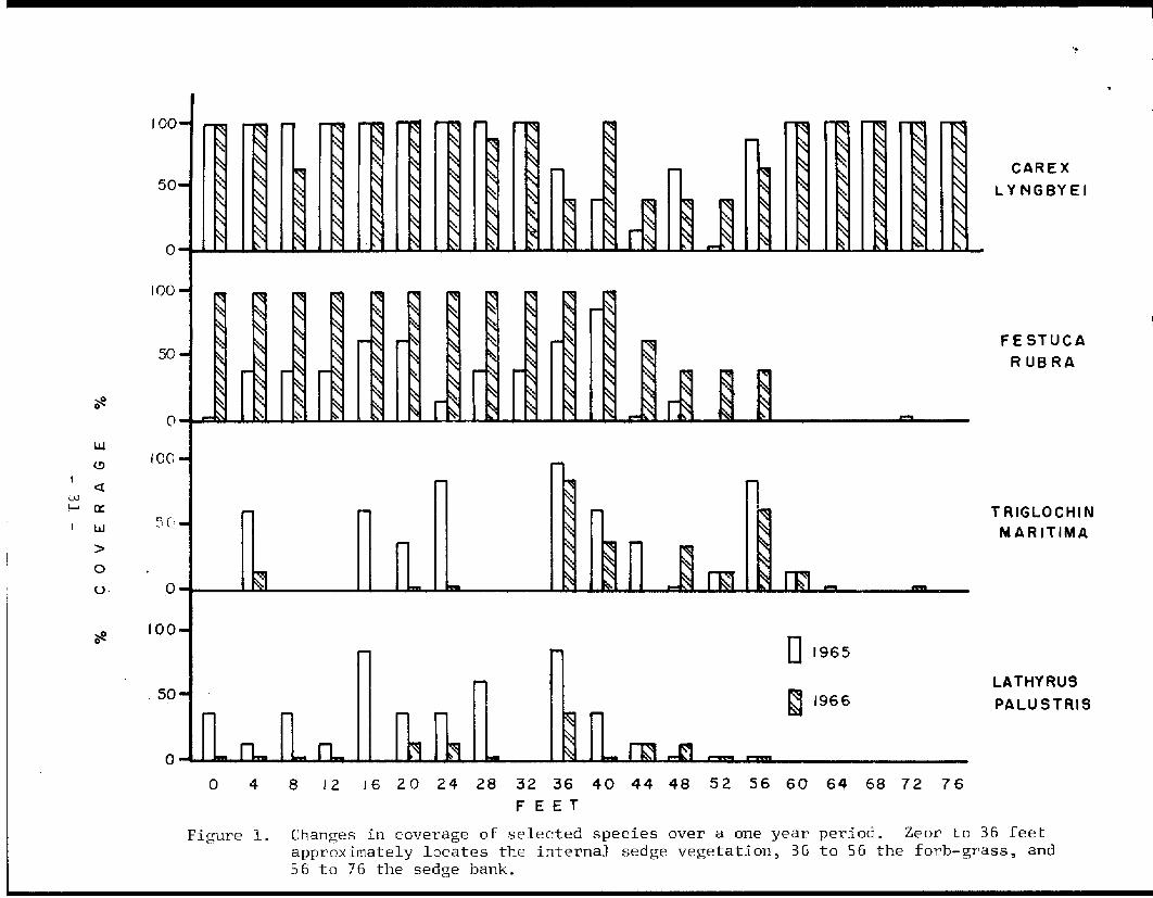
Vegetation transect work has revealed some rather interesting post-earthquake changes. Species characteristic of the forb-grass vegetation are migrating laterally - both down the banks and into the basins. This migration is not limited to the presently vegetated zones but is apparent on the previously bare mud banks. Plants of more mesophytic communities are also invading successfully along the slough banks. Specifically, willow and alder are found in the sedge along the banks as well as on bare mud. Changes in the coverage of species are exemplified by data presented in Figure 1. It is important to note the differences between 1965 and 1966 for the various zones, as this lends evidence useful in interpreting the direction of the putative successional changes. Although changes such as coverage are inconclusive for any one year, these data in conjunction with other observations seem to be useful in predicting present successional trends. Figure 1 depicts Carex J:yngbyei as not significantly changing in any of the zones, but the data in Figure 2 may presently give one a better means of evaluating the status of this species. Since the vigor and vitality of a species may vary between community types, data of this sort may also be useful for prediction if treated cautiously to avoid overemphasizing normal yearly differenceso In the more mesophytic communities where Carex lyngbyei is present the flowering is greatly reduced - it is also greatly reduced in very wet habitats. These data then suggest that the putative increased mesophytism is being realized.
Beekon, et al., (1953) have observed that desalinization may occur with a surplus of 150 mrn of rainfall and that leaching may occur rather rapidly under suitable conditions. Results of soil analyses from 1965 and 1966 show no high salt concentrations in the soils of the forb-grass vegetation. For that matter, the only soils which showed any signs of salt effects were those below pre-earthquake vegetation lines and a few samples from transects directly adjacent to the sea.
Regarding the nesting population of geese, it then seems that the increased area available for nesting is rather transient and an ultimate decrease in nesting vegetation is expected. Additional data not treated herein are aimed at defining as precisely as possible the ecologic potential of the various post-earthquake habitats.
- 29

Table 1. The distribution of plants in relation to types of vegetation. •. ThP communities are listed from left to right in order of increasing elevation of the landscape.
QJ bO
"Cl llJ llJ bO
Cf) "Cl llJ
llJ i::
·.-1 ,...., -2 C!l
i:i:i
Cf)
rl C!l
rn rn C!l H
llJ rl C!l
(.!) I H llJ .µ
llJ bO
"Cl
i:: H llJ .µ
(.!) I
,.Q H
.µ QJ llJ
~ ,...., ,....,
H QJ
"Cl
llJ CJ ;:l H
C!l s QJ Cf)
i:: H
0 J:.'-1
;3 Cf)
•.-1 3
rl ~
p.. rfJ
Carex lyngbyei + + + + + + Eleocharis kamtschatica + + Cicuta douglasii + C. Mackenzieana + Calamagrostis nutkaensis + + + Lathyrus palustris + + + Trigldchin maritima + + + Hedysarium alpinum americanum + Calamagrostis inexpansa + Salix arctica + Chrysanthemum arcticum + Parnassia palustris + Plantago macrocarpa + Polygonum v.iviparum + Rhinanthus minor groenlandicus + Dodecatheon macrocarpum + + Stellaria humifusa + + Carcx pluriflora + + Poa macrocalyx + + Deschampsia beringensis + + Festuca rubra + + Potentilla pacifica + + Iris setosa + + Ljgusticum hultenii + + + Myrica gale + + Caltha palustris + + Sanguisorba sitchensis + + + Eguisctwn pratense + + + Salix 2-E· + + Calamagrostis canadensis + + Alnus sinuata + + Viola ep.ipsila repens + Athyrium felix-femina + Rubus stellatus + R. arcticus + + Arctagrostis arundinacea + + Dryopteris austriaca + + D . .1 innaeana + Cirf'aea alpina + Hylocomium splendens + Cornus canadensis + Pyrola uniflora + Viburnum edule + Vaccinium alaskensis + Carex laeviculmis + Tricntalis europa Fuhus spectabilis
+ +
Potentilla pabistris + + - 30 -
·~
CAR EX
LYNGBYEI
~ 0
FESTUCA
RUB RA
LIJ
(.!) 100
<t 0J ;..... 0:
w
> 0
U· .0
TRIGLOCHIN MARITIMA
100 ~ 0
LATHYRUS
PALUSTRIS
Figure 1. Changes in coverage of selected species over a one year period. Zeor to 36 feet approximately locates the internal sedge vegetation~ 36 to 56 the forb-grass~ and 56 to 76 the sedge bank.
50
0 4
D1965
~ 1966
8 !2 J6 20 24 28 32 36 40 44 48 52 56 60 64 68 72 76
F EE T

16
JG
14
D1965 12
~ 1966 10
(/)
w ~ 8
jl.
en UJ N
4
2
0
0 4 8 12 16 2 0 2 4 2 8 32 36
F EE T
40 44 48 52 56 6 0 64 68 7 2 76
Figure 2. Changes in flowering of Carex lyngbyei over a one-year period. Zero to 36 feet approximately locates the internal sedge vegetation, 36 to 56 feet the forb-grass, and 56 to 76 the sedge bank.

r
Summary
The uplift of the Copper River Delta by the infamous March 27, 1964 earthquake has initiated major changes. Such changes include the desalinization and amelioration of inundated areas resulting in habitats becoming increasingly favorable to plant communities more mesophytic than per-earthquake communities. One such area affected has been employed by the dusky Canada goose as a nesting habitat. Transient expansion of nesting area should in a short time be followed by a decline in suitable nesting habitat due to the invasion and development of plant communities in which nesting fidelity is very low.
Acknowledgements
This study has been supported by the Alaska Department of Fish and Game, Division of Game. The writer is grateful to Mr. Peter E.K. Shepherd who recognized the importance of pursuing an ecological approach to study of a waterfowl area and initiated the study. The writer would also like to thank Mr. Robert Leedy who assisted in data gathering during the summer of 1966.
The author is presently in residence at Washington State University, Pullman, Washington, in the Department of Botany.
- 33

..
Literature Cited
Beekom, C.W.C. van, C. van den Berg, Th. A. de Boer, W.H. van der Molen, B. Verhoeven, J.J. Westerhof, and A.J. ·zuur. 1953. Reclaiming land flooded with salt water. Netherlands Journal of Agricultural Science 1: 153-163 and 225-244.
Crow, ,J. H. 1965. Progress report on the Coppt'.! C' R:Lrer Delta ecological study. Unpublished report for the Alaska Department of Fish and Game.
Daubenmire, R.F. 1959. A canopy coverage method of vegetation analysis. Northwest Science 33: 43-64.
Reimnitz, E. and N.F. Marshall. 1965. Effects of the Alaska earthquake and tsunami on recent deltaic sediments. Journal of Geophysical Research 70 (10): 2363-2376.
Shepherd, P.E.K. 1965. Personal communication.
Trainer, C.E. 1959. The 1959 Western Canada Goose (Branta canadensis occidentalis) study on the Copper River Delta, Alaska. Annual waterfowl report, Alaska Bureau of Sport Fisheries and Wildlife, H.A. Hansen, Supervisor.
- 34

•
Table 1.
Preliminary Vegetational Analysis Based on Frequency and Coverage, Juneau-Mendenhall Tidelands, 1967.
Puccinellia/ Carex/ Spergularia Carex Algae
Stand No. 9 10 11 17 19 30 29 18 21 22
Puccinellia nutkaensis? Spergularia canadensis Carex lyngbyei Potentilla pacifica Plantago maritima Hordeum caespitosum Deschampsia beringensis Eleocharis kamtschatica Elymus mollis Triglochia maritima Thaspi arcticium Ranunculus cymbalaria Festuca rubra Stellaria crassifolia Glaux maritima Brown algae Green algae Atriplex gmelini Chrysanthemium arcticurn Ligusticium hultenii Lathyrus maritimus Dodecatheon macrocarpum Junicus balticus Carex ssp. (scarious)
100/91 100/26 60/2 80/1
10/+ 10/2
100/18 60/2 10/+ 10/+ 30/1
100/89 40/1
60/4
10/2 10/+ 90/12 +/+
100/5430/1
+/+ 20/+
100/11 10/+
100/82 100/62 30/3 10/+ 100/2 80/10
IJ0/98 100'98 10(/!B lOQ/ c:.B
100/6 10/+
10/+ +/+ +/+ 100/94 100/11
90/37 100/10 20/5 20/+

31
Table 1. cont.
Carex/ Potentillia/ Plantago/ Puccinellia Plantago Potentillia
Stand No. 6 12
Puccinellia nutkaensis? Spergularia canadensis Carex lyngbyei Potentilla pacifica Plantag maritima Hordeum caespitosum Deschampsia beringensi Eleocharis kamtschatica Elymus mollis Triglochia maritima
w Thaspi arcticium-....J
Ranunculus cymbalaria Festuca rubra Stellaria crassifolia Glaux maritima Brown algae Green algae Atriplex gmelini Chrysanthemium arcticum Ligusticium hultenii Lathyrus maritimus Dodecatheon macrocarpum Junicus balticus Carex ssp. (scarious)
100/68
100/9820/2
10/+
70/4
90/52 100/53 100/96
30/9 10/+
100/24
13
100/71 100/77 100/63
20/4 +/+
100/68 70/2
100/4 100/11
80/2
20
100/76 100/7 100/95
20/+
100/5
100/23
1
100/20 100/18 100/22100/94 100/52
100/37
10/2
40/l
60/2 100/8
24
30/1 100/50 100/9 10/+? 30/8
10/+ 10/+
20/2 10/+
100/2
90/24 40/1 20/+ 30/1 +/+
60/12
25
100/18 100/90 50/2 30/3
20/2
30/1 70/7
100/8
+/+ 10/2 +/+
70/16 80/6
100/7110/+
llJ0/80
30/4
30/1
100/15
"

...
Table 1. cont.
Carex/ Deschampsia/
Eleocharis
Stand No.
Puccinellia nutkaensis? Spergularia canadensis Carex lyngbyei Potentillia pacifica Plantago maritima Hordeurn caespitosurn Descharnpsia beringensis Eleocharis karntschatica Elymus rnollis Triglochii rnaritima Thaspi arcticiurn
00 Ranunculus cymbalaria Festuca rubra Stellaria crassifolia Glaux maritima Brown algae Green algae Atriplex gmelini Chrysanthernium arcticum Ligusticiurn hultenii Lathyrus maritirnus Dodecatheon rnacrocarpum Juneus balticus Carex ssp. (scarrous) Lupinus nootkatensis Achillea borealis Carex macrochaeta Carex ssp. Parnassia palustris Calamagrotis deschampsoides
liJ
28
100/92 100/25
100/33 100/90
70/12
10/+ 20/8
100/75 20/+
33
100/38 80/4
100/95 20/+ 80/8 +/+
90/10 30/3
100/16
60/3
10/+
10/+
Elymus/ Festuca
15 4
20/+
10/+ 10/+
100/98 10/+ +/+
100/98
10/+ 10/+
40/9
20/2
8
10/+
100/98 20/+ 10/+
50/26
10/+
10/+
10/6
16
100/66 30/4
100/86
50/18
10/+
100/57
2
100/26 100/47 100/24
100/95 50/l
100/17
70/2 30/2
100/2
10/2
40/14
(10/+)?
3
100/40 100/26
70/4
100/83 80/6
100/16
20/+ 80/4
30/1
20/2 10/+
100/87
(10/2)? 10/+
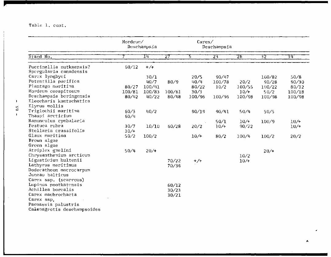
Table 1, cont.
Hordeum/ Carex/ Deschampsia Deschampsia
Stand No,
Puccinellia nutkaensis? Spergularia canadensis Carex lyngbyei Potentilla pacifica Plantago maritirna Hordeurn caespitosum Descharnpsia beringensis Eleocharis kamtschatica
w Elymus rnollis \.D Triglochii maritirna
Thaspi arcticiurn Ranunculus cyrnbalaria Festuca rubra Stellaria crassifolia Glaux rnaritima Brown algae Green algae Atriplex grnelini Chrysanthernium arcticum Ligusticiurn hultenii Lathyrus maritimus Dodecatheon macrocarpum Juneau balticus Carex ssp. (scarrous) Lupinus nootkatensis Achillea borealis Carex machrochaeta Carex ssp, Parnassia palustris Calamagrotis descharnpsoides
7
60/12
80/27 100/81
80/42
60/3 60/4
30/7 10/+ 50/2
50/4
14'
+/+
30/l 40/7
100/41 100/83
40/22
40/2
10/10
100/2
20/+
27
80/9
100/61 80/48
60/28
70/22 70/36
60/12 30/23 30/21
5
20/5 40/4 80/22 30/3
100/96
90/19
20/2
10/+
+/+
23
90/47 100/78
10/2
100/96
90/41
50/1 10/+
80/2
26
20/2 100/55
10/+ 100/98
50/4
10/+ 90/22
100/4
10/2 10/+
32
100/82 90/28
100/22 50/2
100/98
50/5
100/9
100/2
20/+
3 Q:
50/8 90/30 80/12
100/18 100/98
10/+ 10/+
20/2