Waterco - Flood Risk, Hydraulic Modelling and Hydrological Services
21
Waterco Consultants | Specialists in Water, Drainage and Flood www.waterco.co.uk Flood Risk, Hydraulic Modelling & Hydrological Services
-
Upload
waterco-consultants -
Category
Documents
-
view
221 -
download
1
description
Waterco Consultants Ltd Flood Risk, Hydraulic Modelling and Hydrological Services
Transcript of Waterco - Flood Risk, Hydraulic Modelling and Hydrological Services
Waterco Consultants | Specialists in Water, Drainage and Flood
www.waterco.co.uk
Flood Risk, Hydraulic Modelling& Hydrological Services
Waterco Consultants | Specialists in Water, Drainage and Flood
Waterco has a team of hydrologists and hydraulic modellers with a reputation fordelivering a cost effective and efficient service. We have successfully developedstrategic partnerships with a number of high profile key clients who require additionalspecialist support to their in-house resource. Using an integrated approach, andworking closely as part of the client team, we offer a ‘value for money’ service that isbased on quality output and timely delivery.
Waterco are committed to providing our clients with practical solutions whichare compatible with their objectives and add value to their projects.
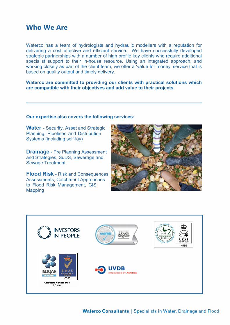
Who We Are
Our expertise also covers the following services:
Water - Security, Asset and StrategicPlanning, Pipelines and DistributionSystems (including self-lay)
Drainage - Pre Planning Assessmentand Strategies, SuDS, Sewerage andSewage Treatment
Flood Risk - Risk and ConsequencesAssessments, Catchment Approachesto Flood Risk Management, GISMapping
Waterco Consultants | Specialists in Water, Drainage and Flood
● Hydrology Studies (FEH Statistical, ReFH)
● 1D and 2D Hydraulic Modelling
● Flood Risk Assessments
● Fluvial and Coastal Breach Assessments
● Hazard and Vulnerability Mapping
● Water Quality Modelling
● Natural Flood Risk Management
● Flood Mitigation Design and Advice
● Hydro-geological Assessments
● Surface Water / rainfall modelling
● Network Modelling
● Coastal / Offshore Modelling
● Reservoir Inundation Modelling
● GIS mapping
What We Offer
Waterco Consultants | Specialists in Water, Drainage and Flood
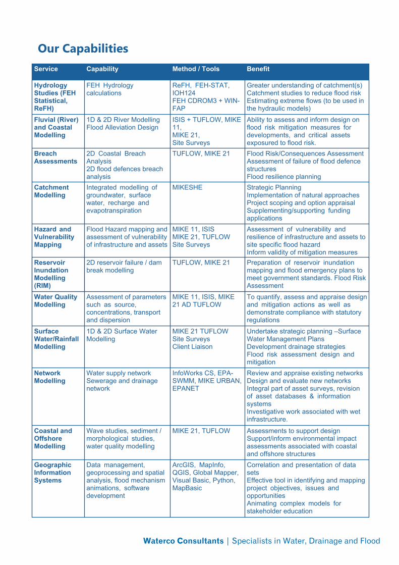
Our CapabilitiesService Capability Method / Tools Benefit
HydrologyStudies (FEHStatistical,ReFH)
FEH Hydrologycalculations
ReFH, FEH-STAT,IOH124FEH CDROM3 + WIN-FAP
Greater understanding of catchment(s)Catchment studies to reduce flood riskEstimating extreme flows (to be used inthe hydraulic models)
Fluvial (River)and CoastalModelling
1D & 2D River ModellingFlood Alleviation Design
ISIS + TUFLOW, MIKE11,MIKE 21,Site Surveys
Ability to assess and inform design onflood risk mitigation measures fordevelopments, and critical assetsexposured to flood risk.
BreachAssessments
2D Coastal BreachAnalysis2D flood defences breachanalysis
TUFLOW, MIKE 21 Flood Risk/Consequences AssessmentAssessment of failure of flood defencestructuresFlood resilience planning
CatchmentModelling
Integrated modelling ofgroundwater, surfacewater, recharge andevapotranspiration
MIKESHE Strategic PlanningImplementation of natural approachesProject scoping and option appraisalSupplementing/supporting fundingapplications
Hazard andVulnerabilityMapping
Flood Hazard mapping andassessment of vulnerabilityof infrastructure and assets
MIKE 11, ISISMIKE 21, TUFLOWSite Surveys
Assessment of vulnerability andresilience of infrastructure and assets tosite specific flood hazardInform validity of mitigation measures
ReservoirInundationModelling(RIM)
2D reservoir failure / dambreak modelling
TUFLOW, MIKE 21 Preparation of reservoir inundationmapping and flood emergency plans tomeet government standards. Flood RiskAssessment
Water QualityModelling
Assessment of parameterssuch as source,concentrations, transportand dispersion
MIKE 11, ISIS, MIKE21 AD TUFLOW
To quantify, assess and appraise designand mitigation actions as well asdemonstrate compliance with statutoryregulations
SurfaceWater/RainfallModelling
1D & 2D Surface WaterModelling
MIKE 21 TUFLOWSite SurveysClient Liaison
Undertake strategic planning –SurfaceWater Management PlansDevelopment drainage strategiesFlood risk assessment design andmitigation
NetworkModelling
Water supply networkSewerage and drainagenetwork
InfoWorks CS, EPA-SWMM, MIKE URBAN,EPANET
Review and appraise existing networksDesign and evaluate new networksIntegral part of asset surveys, revisionof asset databases & informationsystemsInvestigative work associated with wetinfrastructure.
Coastal andOffshoreModelling
Wave studies, sediment /morphological studies,water quality modelling
MIKE 21, TUFLOW Assessments to support designSupport/inform environmental impactassessments associated with coastaland offshore structures
GeographicInformationSystems
Data management,geoprocessing and spatialanalysis, flood mechanismanimations, softwaredevelopment
ArcGIS, MapInfo,QGIS, Global Mapper,Visual Basic, Python,MapBasic
Correlation and presentation of datasetsEffective tool in identifying and mappingproject objectives, issues andopportunitiesAnimating complex models forstakeholder education
Waterco Consultants | Specialists in Water, Drainage and Flood
Meet the Team
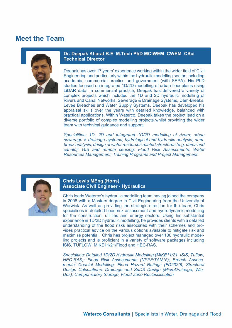
Dr. Deepak Kharat B.E. M.Tech PhD MCIWEM CWEM CSciTechnical Director
Deepak has over 17 years' experience working within the wider field of CivilEngineering and particularly within the hydraulic modelling sector, includingacademia, commercial practice and government (with SEPA). His PhDstudies focused on integrated 1D/2D modelling of urban floodplains usingLiDAR data. In commercial practice, Deepak has delivered a variety ofcomplex projects which included the 1D and 2D hydraulic modelling ofRivers and Canal Networks, Sewerage & Drainage Systems, Dam-Breaks,Levee Breaches and Water Supply Systems. Deepak has developed hisappraisal skills over the years with detailed knowledge, balanced withpractical applications. Within Waterco, Deepak takes the project lead on adiverse portfolio of complex modelling projects whilst providing the widerteam with technical guidance and support.
Specialities: 1D, 2D and integrated 1D/2D modelling of rivers; urbansewerage & drainage systems; hydrological and hydraulic analysis; dam-break analysis; design of water resources related structures (e.g. dams andcanals); GIS and remote sensing; Flood Risk Assessments; WaterResources Management; Training Programs and Project Management.
Chris Lewis MEng (Hons)Associate Civil Engineer - Hydraulics
Chris leads Waterco’s hydraulic modelling team having joined the companyin 2008 with a Masters degree in Civil Engineering from the University ofWarwick. As well as providing the strategic direction for the team, Chrisspecialises in detailed flood risk assessment and hydrodynamic modellingfor the construction, utilities and energy sectors. Using his substantialexperience in 1D/2D hydraulic modelling, he provides clients with a detailedunderstanding of the flood risks associated with their schemes and pro-vides practical advice on the various options available to mitigate risk andmaximise potential. Chris has project managed over 100 hydraulic model-ling projects and is proficient in a variety of software packages includingISIS, TUFLOW, MIKE11/21/Flood and HEC-RAS.
Specialties: Detailed 1D/2D Hydraulic Modelling (MIKE11/21, ISIS, Tuflow,HEC-RAS); Flood Risk Assessments (NPPF/TAN15); Breach Assess-ments; Coastal Modelling; Flood Hazard Ratings (FD2320); StructuralDesign Calculations; Drainage and SuDS Design (MicroDrainage, Win-Des); Compensatory Storage; Flood Zone Reclassification
Waterco Consultants | Specialists in Water, Drainage and Flood
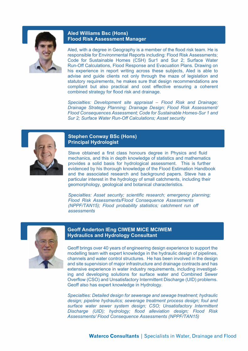
Aled Williams Bsc (Hons)Flood Risk Assessment Manager
Aled, with a degree in Geography is a member of the flood risk team. He isresponsible for Environmental Reports including: Flood Risk Assessments;Code for Sustainable Homes (CSH) Sur1 and Sur 2; Surface WaterRun-Off Calculations, Flood Response and Evacuation Plans. Drawing onhis experience in report writing across these subjects, Aled is able toadvise and guide clients not only through the maze of legislation andstatutory requirements, he makes sure that design recommendations arecompliant but also practical and cost effective ensuring a coherentcombined strategy for flood risk and drainage.
Specialties: Development site appraisal – Flood Risk and Drainage;Drainage Strategy Planning; Drainage Design; Flood Risk Assessment/Flood Consequences Assessment; Code for Sustainable Homes-Sur 1 andSur 2; Surface Water Run-Off Calculations; Asset security
Geoff Anderton IEng CIWEM MICE MCIWEMHydraulics and Hydrology Consultant
Geoff brings over 40 years of engineering design experience to support themodelling team with expert knowledge in the hydraulic design of pipelines,channels and water control structures. He has been involved in the designand site supervision of major infrastructure and drainage contracts and hasextensive experience in water industry requirements, including investigat-ing and developing solutions for surface water and Combined SewerOverflow (CSO) and Unsatisfactory Intermittent Discharge (UID) problems.Geoff also has expert knowledge in Hydrology.
Specialties: Detailed design for sewerage and sewage treatment; hydraulicdesign; pipeline hydraulics; sewerage treatment process design; foul andsurface water sewer system design; CSO; Unsatisfactory IntermittentDischarge (UID); hydrology; flood alleviation design; Flood RiskAssessments/ Flood Consequence Assessments (NPPF/TAN15)
Stephen Conway BSc (Hons)Principal Hydrologist
Steve obtained a first class honours degree in Physics and fluidmechanics, and this in depth knowledge of statistics and mathematicsprovides a solid basis for hydrological assessment. This is furtherevidenced by his thorough knowledge of the Flood Estimation Handbookand the associated research and background papers. Steve has aparticular interest in the hydrology of small catchments, including theirgeomorphology, geological and botanical characteristics.
Specialties: Asset security; scientific research; emergency planning;Flood Risk Assessments/Flood Consequence Assessments(NPPF/TAN15); Flood probability statistics; catchment run offassessments

Waterco Consultants | Specialists in Water, Drainage and Flood
Bethan Young BSc (Hons)Hydraulic Modeller
Bethan studied for her degree (BSc in Environmental Earth Science) atAberystwyth University and is a key member of the hydraulic modellingteam. She works on projects including 1D/2D hydraulic models (usingMIKEFLOOD) and Hydrology Assessments (using FEH and ReFH). Shehas had experience in both network modelling and coastalinundation/breach modelling. She is also experienced in flood risk assess-ments and has been involved in many schemes in Wales-making the mostof her Welsh speaking. Recently Bethan has become a graduate memberof CIWEM and has begun her journey to becoming chartered.
Specialties: Hydraulic Modelling, FEH, ReFH, GIS; Engineering Geology(rock, soil and water); hydrochemistry; Flood Risk Assessments/ FloodConsequence Assessments (NPPF/TAN15)
David Hughes MEng (Hons)Hydraulic Modeller
David graduated from the University of Southampton with a Masters in CivilEngineering in 2010. He has considerable experience of ISIS and ESTRY-TUFLOW modelling having completed over 30 modelling projects providingclients with a detailed understanding of flood risk and hazards. He hasrecently completed a Surface Water Management Plan model, strategicallyhighlighting the surface water flooding hotspots for further study. He hasalso worked on several large GIS-based projects being responsible forefficient data management. Outside of work, David enjoys kayaking andtaking part in white water rafting competitions.
Specialties: Detailed 1D/2D Hydraulic Modelling (ISIS, ESTRY, TUFLOW,MIKE11/21/FLOOD; HEC-RAS); SMS 11; Breach Analysis; Flood HazardMapping; Surface Water Management Plans; Direct Rainfall Modelling;AutoCAD; GIS (ArcGIS, MapInfo, Quantum GIS); Visual Basic program-ming; MapBasic
Sandeep Bomminayuni MscHydraulic/Coastal Modeller
Sandeep joined Waterco in April to lead on coastal, offshore, water qualityand geomorphological modelling. Sandeep is poised to complete his PhDdegree at Cardiff University and holds Master's degree in Civil Engineeringfrom Georgia Institute of Technology, USA and Bachelor's degree in CivilEngineering from Indian Institute of Technology. Sandeep has built up hishydraulic modelling expertise through diverse projects related to coastaland inland flooding, sediment and pollutant transport, marine renewableenergy and bathing water quality compliance. He also has publishedpapers in scientific journals and presented in seminars and conferences.
Specialities: Hydraulic modelling; Flood risk assessment; Hydro-informat-ics; Coastal modelling; Bathing water quality compliance; Renewable ener-gy; High-performance computing.

Waterco Consultants | Specialists in Water, Drainage and Flood
Karen Pinkerton Bsc (Hons)KTP Research Associate
Karen is an experienced GIS Analyst, who is currently the ResearchAssociate on the Natural Flood Management (NFM) Knowledge TransferPartnership with the University of Liverpool. Drawing on her skills in floodmanagement and GIS mapping, Karen is developing a number of pilotprojects with local authorities and numerous stakeholders, to identify floodmitigation projects which provide multiple benefits by utilising NFMapproaches. Working with our Geographers, Hydrologists, and HydraulicModellers together with a team of academics from the University ofLiverpool, Karen will lead the multi-disciplined team in the development ofthis approach.
Specialties: GIS Software (ArcGIS, QGIS, MapInfo); Hydrology;Emergency Planning; Flood Resilience; Stakeholder management
Manfredi Toraldo BA, MSc Env, MSc HydroinformaticsHydraulic Engineer and Hydrologist
Manfredi works in the Natural Flood Management team, an experiencedhydrologist, hydraulic modeller and engineer. He applies this experienceand understanding of the hydrology of catchments to model naturalinterventions both within the rural and urban setting to mitigate flood risk.Manfredi also works with the Hydraulic modelling team on a variety ofdevelopment and regeneration projects.
Specialties: Detailed 1D/2D Hydraulic Modelling; AutoCAD; GIS;Hydrological Assessments; Engineering design; Site engineering; Watersupply design
Laura AndertonHydrologist and Data Management
Laura is a key member of the Flood Risk Management team and hasdeveloped her technical skills and logical approach through work on datamanagement projects. These have involved liaison with multiple contactsto collect information from a variety of sources. Whilst at Waterco, she hasgained a detailed understanding of hydrological processes and has beentrained in the FEH statistical and ReFH methods. Laura is currentlyinvolved in a Knowledge Transfer Partnership project, working withAberystwyth University, using remote sensing and sourcing hydrologicaldata sets for use with hydraulic models. She also continues to providegeneral IT support throughout the business and maintains the companydatabase management systems.
Specialties: FEH statistical and ReFH methods; WINFAP-FEH, FEH-CDROM 3 and Global Mapper software; Hydrology Assessments; remotesensing; GIS; IT support; web programming; graphic design softwarepackages; data acquisition and management using Filemaker, Excel andAccess, SQL; project coordination

Waterco Consultants | Specialists in Water, Drainage and Flood
Waterco team CVs are available on request at [email protected].
Angharad Llewelyn MScFlood Risk Assessor
Angharad, with a masters degree in Environmental Dynamics and ClimateChange is a member of the flood risk team. She is responsible forEnvironmental Reports including: Flood Risk and ConsequencesAssessments; Code for Sustainable Homes (CSH) Sur1 and Sur 2; andSurface Water Runoff Calculations. Angharad is able to advise and guideclients not only through the maze of legislation and statutory requirements,she makes sure that design recommendations are compliant but alsopractical and cost effective ensuring a coherent combined strategy forflood risk and drainage
Specialties: Code for Sustainable Homes-Sur 1 and Sur 2; Surface WaterRun-Off Calculations; Flood Risk and Consequences Assessments
Jordan Jones BScFlood Risk Assessor
Jordan, with a degree in Environmental Science is a member of the floodrisk team. She is responsible for Environmental Reports including: FloodRisk and Consequences Assessments; Code for Sustainable Homes(CSH) Sur1 and Sur 2; and Surface Water Runoff Calculations. Jordan isable to advise and guide clients not only through the maze of legislationand statutory requirements, she makes sure that design recommendationsare compliant but also practical and cost effective ensuring a coherentcombined strategy for flood risk and drainage.
Specialties: Code for Sustainable Homes-Sur 1 and Sur 2; Surface WaterRun-Off Calculations; Flood Risk and Consequences Assessments
Ruari Benton Bsc (Hons)Flood Risk Assessor
Ruari graduated with an honours degree from Lancaster University in2012, where he gained experience in report writing and analysing data.After working abroad for a year, following university, he becameenthusiastic to work in the environmental sector. He joined the flood riskteam at Waterco in 2014. He is responsible for Environmental Reportsincluding: Flood Risk and Consequences Assessments; Code forSustainable Homes (CSH) Sur1 and Sur 2 and Surface Water RunoffCalculations.
Specialties: Code for Sustainable Homes-Sur 1 and Sur 2; Surface WaterRun-Off Calculations; Flood Risk and Consequences Assessments; clientliaison
Case Study
01824 702220 - www.waterco.co.uk - [email protected] Ltd. Eden Court, Lon Parcwr Business Park, Ruthin, Denbighshire, LL15 1NJ
Hydrology AssessmentAssessment of peak flows during a range ofextreme events using FEH methods
Ogwr Fach, Bridgend
The final flood estimation method chosen was the Adjusted Statisticalmethod. The ReFH hydrographs were scaled to the Adjusted Statisticalpeaks and the final hydrographs issued to C D Gray & Associates.
C D Gray & Associates inputted these hydrographs into a 1D hydraulicmodel (HEC-RAS) of the Ogwr Fach watercourse.
For more information on our hydrology assessment capabilities pleasevisit our web site or contact us using the details below.
� Detailed hydrology calculationsusing FEH (i.e. FEH Statistical &ReFH)
� WINFAP-FEH 3� FEH CD-ROM 3� ReFH Spreadsheet� EA Calculation Record� EA Checklist� Pooling group review� Climate Change
Outcomes and Solutions
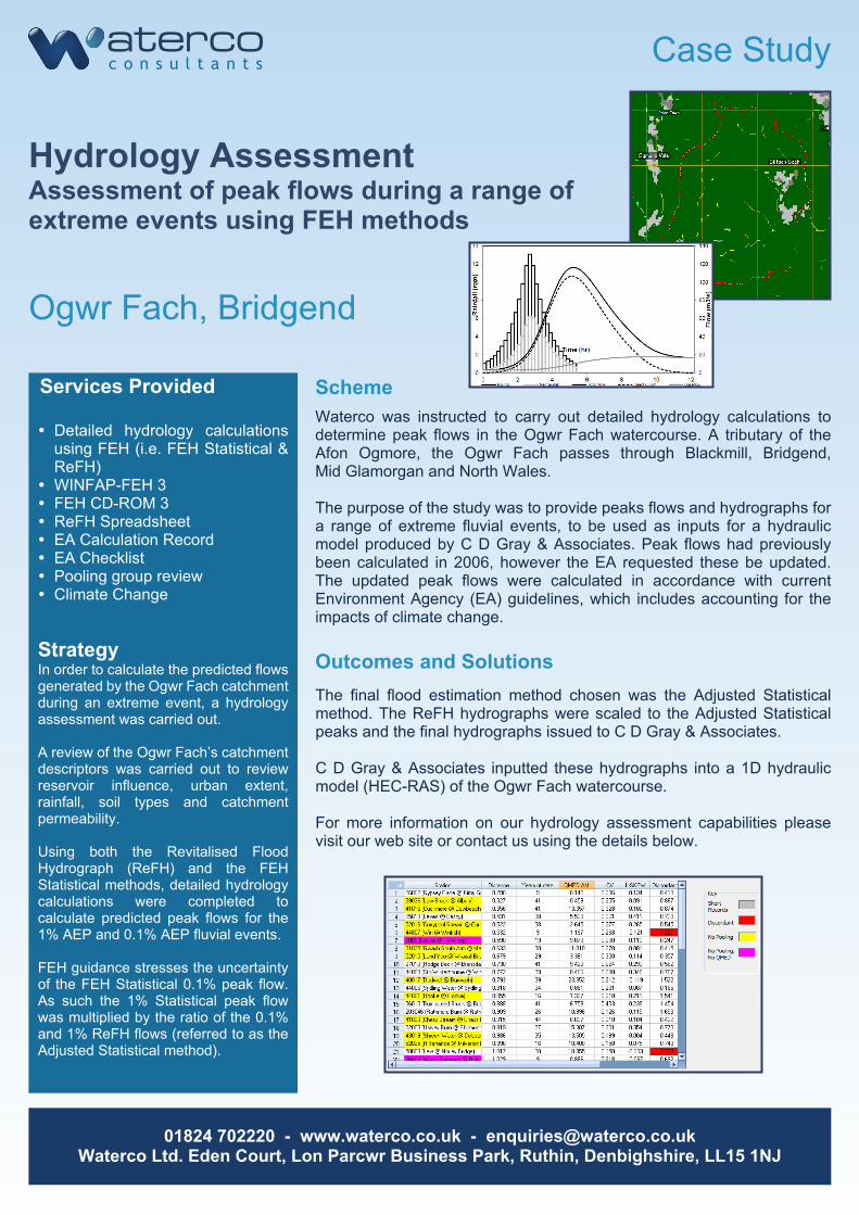
Waterco was instructed to carry out detailed hydrology calculations todetermine peak flows in the Ogwr Fach watercourse. A tributary of theAfon Ogmore, the Ogwr Fach passes through Blackmill, Bridgend,Mid Glamorgan and North Wales.
The purpose of the study was to provide peaks flows and hydrographs fora range of extreme fluvial events, to be used as inputs for a hydraulicmodel produced by C D Gray & Associates. Peak flows had previouslybeen calculated in 2006, however the EA requested these be updated.The updated peak flows were calculated in accordance with currentEnvironment Agency (EA) guidelines, which includes accounting for theimpacts of climate change.
Scheme
StrategyIn order to calculate the predicted flowsgenerated by the Ogwr Fach catchmentduring an extreme event, a hydrologyassessment was carried out.
A review of the Ogwr Fach’s catchmentdescriptors was carried out to reviewreservoir influence, urban extent,rainfall, soil types and catchmentpermeability.
Using both the Revitalised FloodHydrograph (ReFH) and the FEHStatistical methods, detailed hydrologycalculations were completed tocalculate predicted peak flows for the1% AEP and 0.1% AEP fluvial events.
FEH guidance stresses the uncertaintyof the FEH Statistical 0.1% peak flow.As such the 1% Statistical peak flowwas multiplied by the ratio of the 0.1%and 1% ReFH flows (referred to as theAdjusted Statistical method).
Services Provided
Case Study
01824 702220 - www.waterco.co.uk - [email protected] Ltd. Eden Court, Lon Parcwr Business Park, Ruthin, Denbighshire, LL15 1NJ
Hydraulic ModellingFlood Consequences and SolutionAssessment for extreme floods
Pontsticill Water Treatment Works
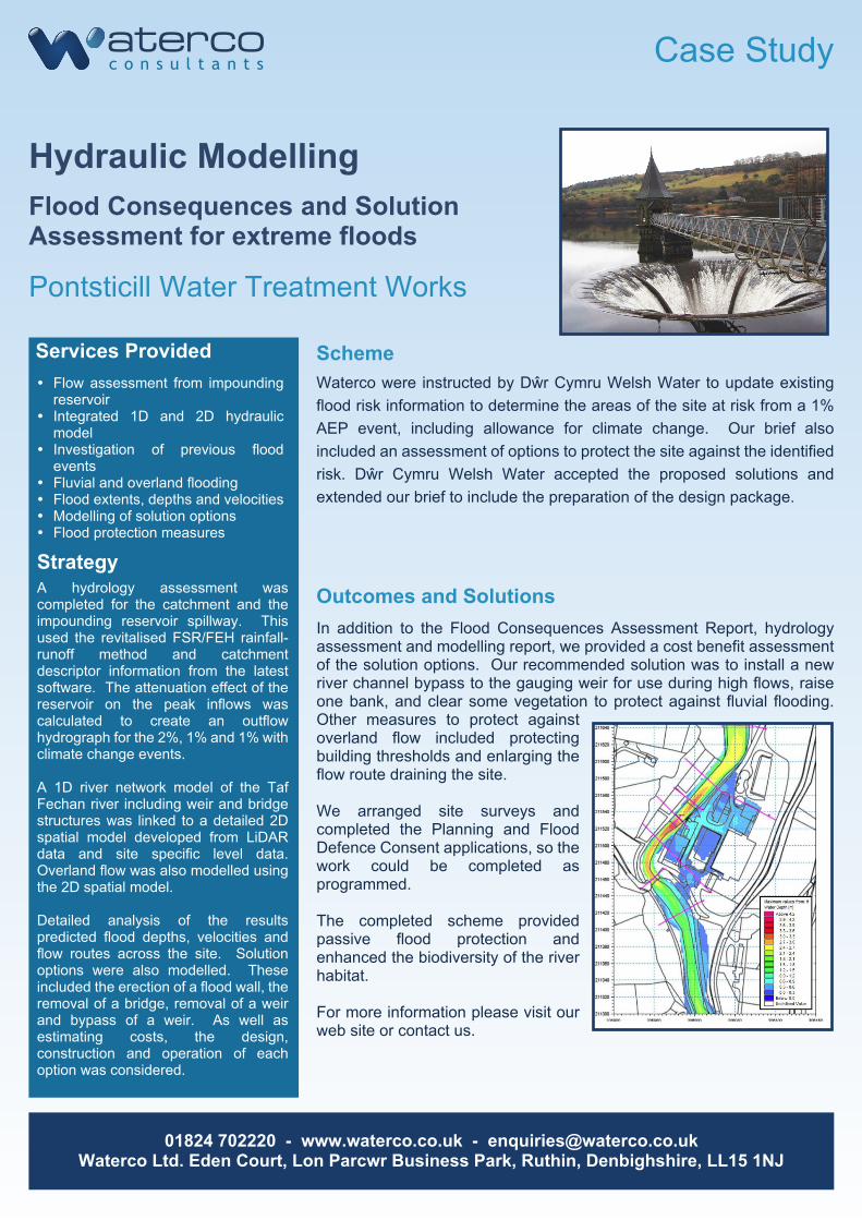
In addition to the Flood Consequences Assessment Report, hydrologyassessment and modelling report, we provided a cost benefit assessmentof the solution options. Our recommended solution was to install a newriver channel bypass to the gauging weir for use during high flows, raiseone bank, and clear some vegetation to protect against fluvial flooding.Other measures to protect againstoverland flow included protectingbuilding thresholds and enlarging theflow route draining the site.
We arranged site surveys andcompleted the Planning and FloodDefence Consent applications, so thework could be completed asprogrammed.
The completed scheme providedpassive flood protection andenhanced the biodiversity of the riverhabitat.
For more information please visit ourweb site or contact us.
� Flow assessment from impoundingreservoir
� Integrated 1D and 2D hydraulicmodel
� Investigation of previous floodevents
� Fluvial and overland flooding� Flood extents, depths and velocities� Modelling of solution options� Flood protection measures
Outcomes and Solutions
Waterco were instructed by Dŵr Cymru Welsh Water to update existingflood risk information to determine the areas of the site at risk from a 1%AEP event, including allowance for climate change. Our brief alsoincluded an assessment of options to protect the site against the identifiedrisk. Dŵr Cymru Welsh Water accepted the proposed solutions andextended our brief to include the preparation of the design package.
Scheme
StrategyA hydrology assessment wascompleted for the catchment and theimpounding reservoir spillway. Thisused the revitalised FSR/FEH rainfall-runoff method and catchmentdescriptor information from the latestsoftware. The attenuation effect of thereservoir on the peak inflows wascalculated to create an outflowhydrograph for the 2%, 1% and 1% withclimate change events.
A 1D river network model of the TafFechan river including weir and bridgestructures was linked to a detailed 2Dspatial model developed from LiDARdata and site specific level data.Overland flow was also modelled usingthe 2D spatial model.
Detailed analysis of the resultspredicted flood depths, velocities andflow routes across the site. Solutionoptions were also modelled. Theseincluded the erection of a flood wall, theremoval of a bridge, removal of a weirand bypass of a weir. As well asestimating costs, the design,construction and operation of eachoption was considered.
Services Provided
Case Study
01824 702220 - www.waterco.co.uk - [email protected] Ltd. Eden Court, Lon Parcwr Business Park, Ruthin, Denbighshire, LL15 1NJ
Hydraulic ModellingFlood Zone Reclassification
Cresswell, Staffordshire
The simulation results were subject to detailed analysis with predictedflood depth, velocities and flow routes being determined. This informationwas then used in conjunction with DEFRA guidance note ‘Flood Risks toPeople’ to produce a hazard map and further evaluate the impact offlooding on the proposed development and the surroundings.
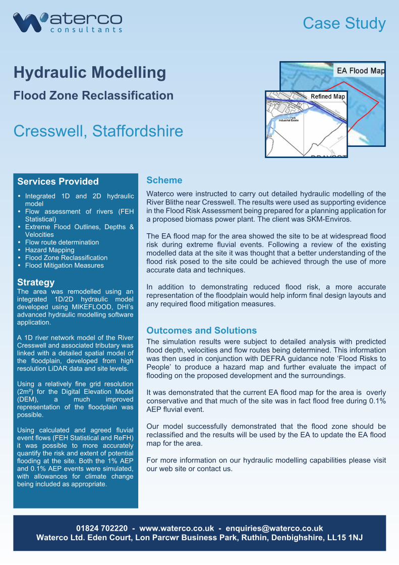
It was demonstrated that the current EA flood map for the area is overlyconservative and that much of the site was in fact flood free during 0.1%AEP fluvial event.
Our model successfully demonstrated that the flood zone should bereclassified and the results will be used by the EA to update the EA floodmap for the area.
For more information on our hydraulic modelling capabilities please visitour web site or contact us.
� Integrated 1D and 2D hydraulicmodel
� Flow assessment of rivers (FEHStatistical)
� Extreme Flood Outlines, Depths &Velocities
� Flow route determination� Hazard Mapping� Flood Zone Reclassification� Flood Mitigation Measures
Outcomes and Solutions
Waterco were instructed to carry out detailed hydraulic modelling of theRiver Blithe near Cresswell. The results were used as supporting evidencein the Flood Risk Assessment being prepared for a planning application fora proposed biomass power plant. The client was SKM-Enviros.
The EA flood map for the area showed the site to be at widespread floodrisk during extreme fluvial events. Following a review of the existingmodelled data at the site it was thought that a better understanding of theflood risk posed to the site could be achieved through the use of moreaccurate data and techniques.
In addition to demonstrating reduced flood risk, a more accuraterepresentation of the floodplain would help inform final design layouts andany required flood mitigation measures.
Scheme
StrategyThe area was remodelled using anintegrated 1D/2D hydraulic modeldeveloped using MIKEFLOOD, DHI’sadvanced hydraulic modelling softwareapplication.
A 1D river network model of the RiverCresswell and associated tributary waslinked with a detailed spatial model ofthe floodplain, developed from highresolution LiDAR data and site levels.
Using a relatively fine grid resolution(2m²) for the Digital Elevation Model(DEM), a much improvedrepresentation of the floodplain waspossible.
Using calculated and agreed fluvialevent flows (FEH Statistical and ReFH)it was possible to more accuratelyquantify the risk and extent of potentialflooding at the site. Both the 1% AEPand 0.1% AEP events were simulated,with allowances for climate changebeing included as appropriate.
Services Provided
Case Study
01824 702220 - www.waterco.co.uk - [email protected] Ltd. Eden Court, Lon Parcwr Business Park, Ruthin, Denbighshire, LL15 1NJ
Breach AssessmentAssessment of flood risk posed to sitefrom possible breach of coastal defences
Immingham, South Humberside
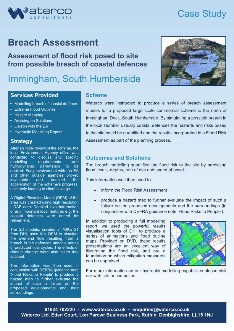
The breach modelling quantified the flood risk to the site by predictingflood levels, depths, rate of rise and speed of onset.
This information was then used to:
· inform the Flood Risk Assessment
· produce a hazard map to further evaluate the impact of such afailure on the proposed developments and the surroundings (inconjunction with DEFRA guidance note ‘Flood Risks to People’).
In addition to producing a full modellingreport, we used the powerful resultsvisualisation tools of DHI to produce aseries of animations and flood outlinemaps. Provided on DVD, these resultspresentations are an excellent way ofillustrating the flood risk, and are afoundation on which mitigation measurescan be appraised.
For more information on our hydraulic modelling capabilities please visitour web site or contact us.
� Modelling breach of coastal defence� Extreme Flood Outlines� Hazard Mapping� Advising on Solutions� Liaison with the EA� Hydraulic Modelling Report
Outcomes and Solutions
Waterco were instructed to produce a series of breach assessment
models for a proposed large scale commercial scheme to the north of
Immingham Dock, South Humberside. By simulating a possible breach in
the local Humber Estuary coastal defences the hazards and risks posed
to the site could be quantified and the results incorporated in a Flood Risk
Assessment as part of the planning process.
Scheme
StrategyAfter an initial review of the scheme, thelocal Environment Agency office wascontacted to discuss any specificmodelling requirements andhydrodynamic parameters to beapplied. Early involvement with the EAand other outside agencies provedinvaluable and enabled theacceleration of the scheme’s progress,ultimately leading to client savings.
A Digital Elevation Model (DEM) of thearea was created using high resolutionLiDAR data. Detailed level informationof any important local features e.g. thecoastal defences were added forrefinement.
The 2D models, created in MIKE 21from DHI, used this DEM to simulatethe overland flow resulting from abreach in the defences under a seriesof predicted tidal cycles. The effects ofclimate change were also taken intoaccount.
This information was then used inconjunction with DEFRA guidance note‘Flood Risks to People’ to produce ahazard map to further evaluate theimpact of such a failure on theproposed developments and theirsurroundings.
Services Provided
Case Study
01824 702220 - www.waterco.co.uk - [email protected] Ltd. Eden Court, Lon Parcwr Business Park, Ruthin, Denbighshire, LL15 1NJ
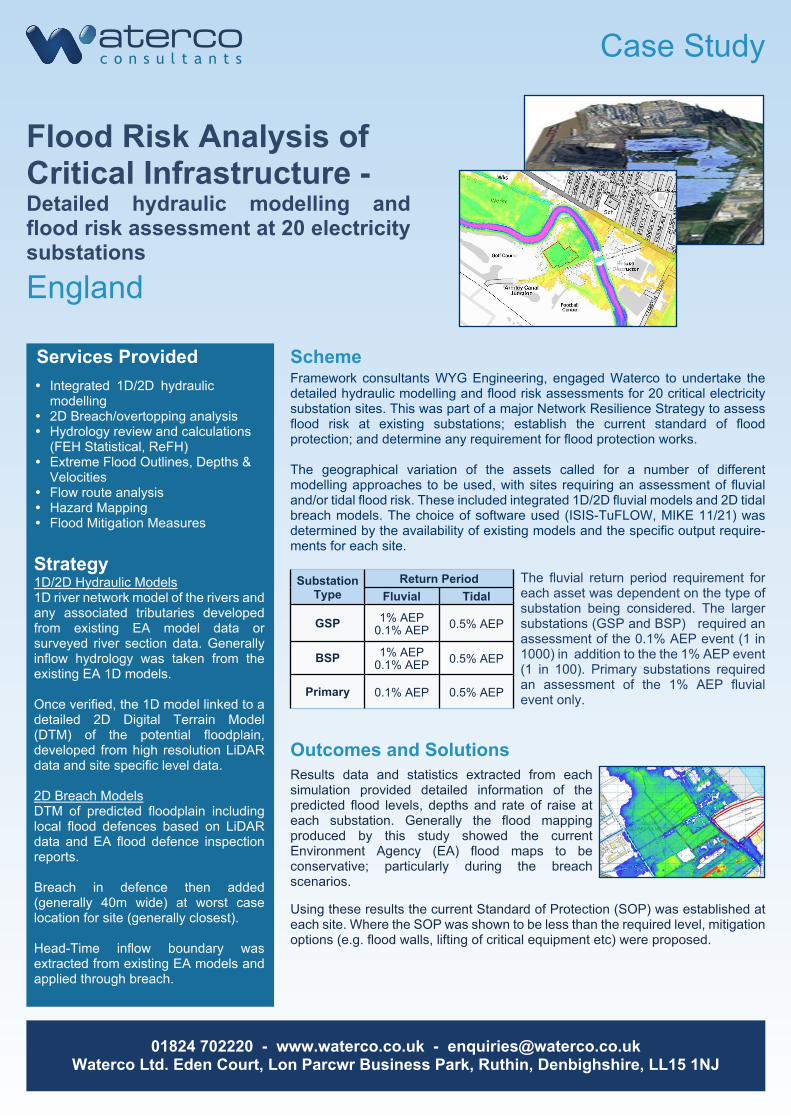
Flood Risk Analysis ofCritical Infrastructure -Detailed hydraulic modelling andflood risk assessment at 20 electricitysubstations
England
� Integrated 1D/2D hydraulicmodelling
� 2D Breach/overtopping analysis� Hydrology review and calculations
(FEH Statistical, ReFH)� Extreme Flood Outlines, Depths &
Velocities� Flow route analysis� Hazard Mapping� Flood Mitigation Measures
Framework consultants WYG Engineering, engaged Waterco to undertake thedetailed hydraulic modelling and flood risk assessments for 20 critical electricitysubstation sites. This was part of a major Network Resilience Strategy to assessflood risk at existing substations; establish the current standard of floodprotection; and determine any requirement for flood protection works.
The geographical variation of the assets called for a number of differentmodelling approaches to be used, with sites requiring an assessment of fluvialand/or tidal flood risk. These included integrated 1D/2D fluvial models and 2D tidalbreach models. The choice of software used (ISIS-TuFLOW, MIKE 11/21) wasdetermined by the availability of existing models and the specific output require-ments for each site.
Scheme
Strategy1D/2D Hydraulic Models1D river network model of the rivers andany associated tributaries developedfrom existing EA model data orsurveyed river section data. Generallyinflow hydrology was taken from theexisting EA 1D models.
Once verified, the 1D model linked to adetailed 2D Digital Terrain Model(DTM) of the potential floodplain,developed from high resolution LiDARdata and site specific level data.
2D Breach ModelsDTM of predicted floodplain includinglocal flood defences based on LiDARdata and EA flood defence inspectionreports.
Breach in defence then added(generally 40m wide) at worst caselocation for site (generally closest).
Head-Time inflow boundary wasextracted from existing EA models andapplied through breach.
The fluvial return period requirement foreach asset was dependent on the type ofsubstation being considered. The largersubstations (GSP and BSP) required anassessment of the 0.1% AEP event (1 in1000) in addition to the the 1% AEP event(1 in 100). Primary substations requiredan assessment of the 1% AEP fluvialevent only.
Outcomes and SolutionsResults data and statistics extracted from eachsimulation provided detailed information of thepredicted flood levels, depths and rate of raise ateach substation. Generally the flood mappingproduced by this study showed the currentEnvironment Agency (EA) flood maps to beconservative; particularly during the breachscenarios.
Using these results the current Standard of Protection (SOP) was established ateach site. Where the SOP was shown to be less than the required level, mitigationoptions (e.g. flood walls, lifting of critical equipment etc) were proposed.
Services Provided
SubstationType
Return PeriodFluvial Tidal
GSP 1% AEP0.1% AEP 0.5% AEP
BSP 1% AEP0.1% AEP 0.5% AEP
Primary 0.1% AEP 0.5% AEP
Case Study
01824 702220 - www.waterco.co.uk - [email protected] Ltd. Eden Court, Lon Parcwr Business Park, Ruthin, Denbighshire, LL15 1NJ
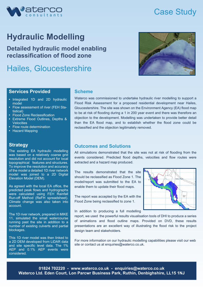
Hydraulic ModellingDetailed hydraulic model enablingreclassification of flood zone
Hailes, Gloucestershire
All simulations demonstrated that the site was not at risk of flooding from theevents considered. Predicted flood depths, velocities and flow routes wereextracted and a hazard map produced.
The results demonstrated that the siteshould be reclassified as Flood Zone 1. Themodel/report was submitted to the EA toenable them to update their flood maps.
The report was accepted by the EA with theFlood Zone being reclassified to zone 1.
In addition to producing a full modellingreport, we used the powerful results visualisation tools of DHI to produce a seriesof animations and flood outline maps. Provided on DVD, these resultspresentations are an excellent way of illustrating the flood risk to the projectdesign team and stakeholders.
For more information on our hydraulic modelling capabilities please visit our website or contact us at [email protected].
� Integrated 1D and 2D hydraulicmodel
� Flow assessment of river (FEH Sta-tistical)
� Flood Zone Reclassification� Extreme Flood Outlines, Depths &
Velocities� Flow route determination� Hazard Mapping
Outcomes and Solutions
Waterco was commissioned to undertake hydraulic river modelling to support aFlood Risk Assessment for a proposed residential development near Hailes,Gloucestershire. The site was shown on the Environment Agency (EA) flood mapto be at risk of flooding during a 1 in 200 year event and there was therefore anobjection to the development. Modelling was undertaken to provide better detailthan the EA flood map, and to establish whether the flood zone could bereclassified and the objection legitimately removed.
Scheme
StrategyThe existing EA hydraulic modellingwas based on a relatively coarse gridresolution and did not account for localtopographical features and structures.To improve the resolution and accuracyof the model a detailed 1D river networkmodel was joined to a 2D DigitalElevation Model (DEM).
As agreed with the local EA office, thepredicted peak flows and hydrographswere calculated using FEH RainfallRun-off Method (ReFH spreadsheet).Climate change was also taken intoaccount.
The 1D river network, prepared in MIKE11, simulated the small watercourserunning past the site in addition to anumber of existing culverts and partialblockages.
This 1D river model was then linked toa 2D DEM developed from LiDAR dataand site specific level data. The 1%AEP and 0.1% AEP events wereconsidered.
Services Provided

Capability Statement
01824 702220 - www.waterco.co.uk - [email protected] Ltd. Eden Court, Lon Parcwr Business Park, Ruthin, Denbighshire, LL15 1NJ
Coastal Water QualityAssessment
● Point sources – rivers,
streams, drainage outlets,
effluent outfalls
● Diffuse sources – overland
flow, agricultural runoff
Pollution sources:
● Coastal water quality modelling
● Environmental impact assessment
● Regulatory compliance
● Integrated catchment to coast modelling
● Asset management solutions
Our services include:
● EU Bathing Waters Directive
(2006/7/EC)
● EU Shellfish Waters Directive
(2006/113/EC)
● EU Water Framework
Directive (2000/60/EC)
Guidelines:
Waterco have the Modelling expertise and experience to carry outWater Quality Assessments for coastal areas to ensure compliancewith European Union Directives. We identify and characterisepollution sources entering coastal waters and model their impact onthe surrounding areas.
Bathing water compliance study for Swansea Bay, UK[Bomminayuni, S., PhD thesis (unpublished), Cardiff University]
Impacts of pollution:
● Endangers aquatic life
● Disrupts ecosystem
● Poses risk to public health
Capability Statement
01824 702220 - www.waterco.co.uk - [email protected] Ltd. Eden Court, Lon Parcwr Business Park, Ruthin, Denbighshire, LL15 1NJ
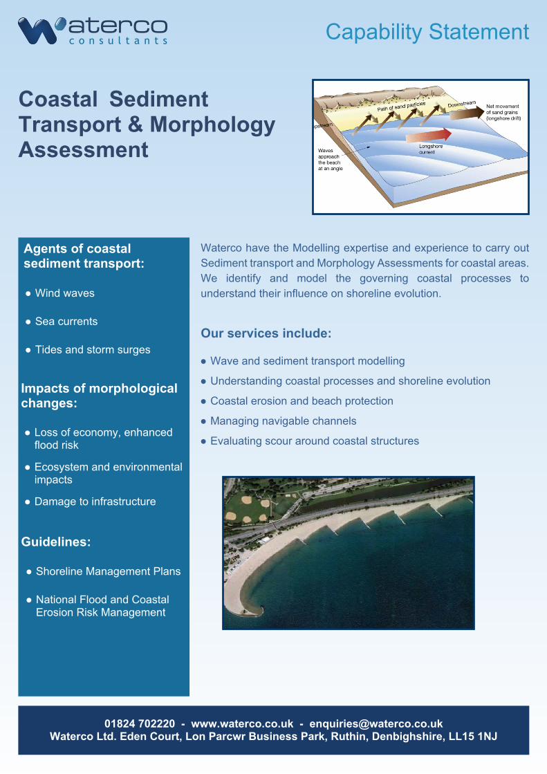
Coastal SedimentTransport & MorphologyAssessment
● Wind waves
● Sea currents
● Tides and storm surges
Agents of coastalsediment transport:
● Wave and sediment transport modelling
● Understanding coastal processes and shoreline evolution
● Coastal erosion and beach protection
● Managing navigable channels
● Evaluating scour around coastal structures
Our services include:
● Shoreline Management Plans
● National Flood and CoastalErosion Risk Management
Guidelines:
Waterco have the Modelling expertise and experience to carry outSediment transport and Morphology Assessments for coastal areas.We identify and model the governing coastal processes tounderstand their influence on shoreline evolution.
Impacts of morphologicalchanges:
● Loss of economy, enhancedflood risk
● Ecosystem and environmentalimpacts
● Damage to infrastructure
Capability Statement
01824 702220 - www.waterco.co.uk - [email protected] Ltd. Eden Court, Lon Parcwr Business Park, Ruthin, Denbighshire, LL15 1NJ
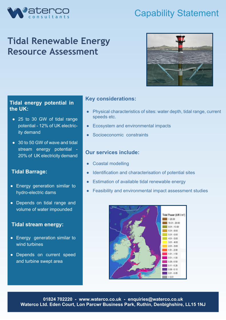
Tidal Renewable EnergyResource Assessment
● 25 to 30 GW of tidal rangepotential - 12% of UK electric-ity demand
● 30 to 50 GW of wave and tidalstream energy potential -20% of UK electricity demand
Tidal energy potential inthe UK:
Key considerations:
Our services include:
● Coastal modelling
● Identification and characterisation of potential sites
● Estimation of available tidal renewable energy
● Feasibility and environmental impact assessment studies
● Physical characteristics of sites: water depth, tidal range, currentspeeds etc.
● Ecosystem and environmental impacts
● Socioeconomic constraints
Tidal Barrage:
Tidal stream energy:
● Energy generation similar tohydro-electric dams
● Depends on tidal range andvolume of water impounded
● Energy generation similar towind turbines
● Depends on current speedand turbine swept area
Capability Statement
01824 702220 - www.waterco.co.uk - [email protected] Ltd. Eden Court, Lon Parcwr Business Park, Ruthin, Denbighshire, LL15 1NJ
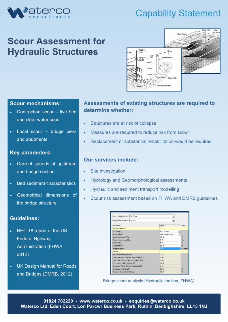
Scour Assessment forHydraulic Structures
· Contraction scour – live bed
and clear water scour
· Local scour – bridge piers
and abutments
Scour mechanisms: Assessments of existing structures are required todetermine whether:
Our services include:
· Site investigation
· Hydrology and Geomorphological assessments
· Hydraulic and sediment transport modelling
· Scour risk assessment based on FHWA and DMRB guidelines
· Structures are at risk of collapse
· Measures are required to reduce risk from scour
· Replacement or substantial rehabilitation would be required
Bridge scour analysis (Hydraulic toolbox, FHWA)
· HEC-18 report of the US
Federal Hghway
Administration (FHWA,
2012)
· UK Design Manual for Roads
and Bridges (DMRB, 2012)
Guidelines:
Key parameters:
· Current speeds at upstream
and bridge section
· Bed sediment characteristics
· Geometrical dimensions of
the bridge structure
Capability Statement
01824 702220 - www.waterco.co.uk - [email protected] Ltd. Eden Court, Lon Parcwr Business Park, Ruthin, Denbighshire, LL15 1NJ
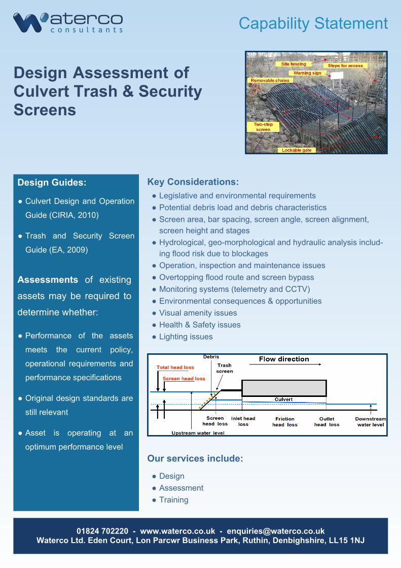
Design Assessment ofCulvert Trash & SecurityScreens
● Culvert Design and Operation
Guide (CIRIA, 2010)
● Trash and Security Screen
Guide (EA, 2009)
Design Guides: Key Considerations:
● Design● Assessment● Training
● Legislative and environmental requirements● Potential debris load and debris characteristics● Screen area, bar spacing, screen angle, screen alignment,
screen height and stages● Hydrological, geo-morphological and hydraulic analysis includ-
ing flood risk due to blockages● Operation, inspection and maintenance issues● Overtopping flood route and screen bypass● Monitoring systems (telemetry and CCTV)● Environmental consequences & opportunities● Visual amenity issues● Health & Safety issues● Lighting issues● Performance of the assets
meets the current policy,
operational requirements and
performance specifications
● Original design standards are
still relevant
● Asset is operating at an
optimum performance level
Assessments of existing
assets may be required to
determine whether:
Our services include:

Waterco Consultants | Specialists in Water, Drainage and Flood
(+44) 1824 702220
www.waterco.co.uk
Waterco Ltd.Lon Parcwr Business Park
RuthinDenbighshire
LL15 1NJ