
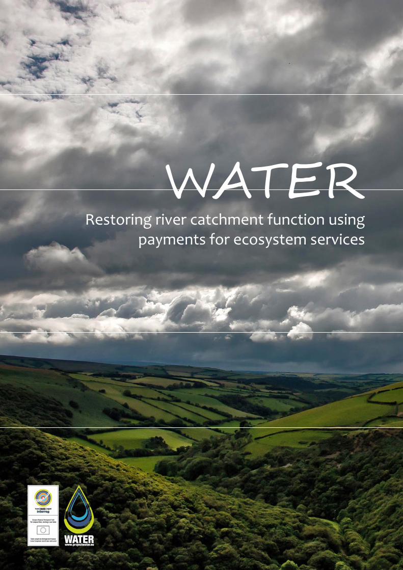
WATER: Restoring River Catchment Function through Payments for Ecosystems Services
24
WATER Restoring river catchment function using payments for ecosystem services
-
Upload
westcountry-rivers-trust -
Category
Documents
-
view
215 -
download
1
description
This handbook explores the history of why our river catchments are in their current condition, the nature of the threats and challenges they face and sets out in practical terms some of the solutions we have to restore them. It also sets out the governance structure that has evolved to address these problems and where the various funding comes from to deliver change. The WATER (Wetted land: The Assessment, Techniques & Economics of Restoration) project is a €3.9 million programme funded by the France (Channel) England Interreg IVA Programme and led by the Westcountry Rivers Trust, which aims to revolutionise the way we restore and manage our environment by developing innovative funding mechanisms.
Transcript of WATER: Restoring River Catchment Function through Payments for Ecosystems Services
WATER Restoring river catchment function using
payments for ecosystem services
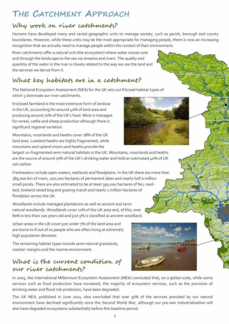
THE CATCHMENT APPROACH Why work on river catchments? Humans have developed many and varied geographic units to manage society, such as parish, borough and county
boundaries. However, while these units may be the most appropriate for managing people, there is now an increasing
recognition that we actually need to manage people within the context of their environment.
River catchments offer a natural unit (the ecosystem) where water moves over
and through the landscape to the sea via streams and rivers. The quality and
quantity of the water in the river is closely related to the way we use the land and
the services we derive from it.
What key habitats are in a catchment? The National Ecosystem Assessment (NEA) for the UK sets out 8 broad habitat types of
which 5 dominate our river catchments.
Enclosed farmland is the most extensive form of landuse
in the UK, accounting for around 40% of land area and
producing around 70% of the UK’s food. Most is managed
for cereal, cattle and sheep production although there is
significant regional variation. Mountains, moorlands and heaths cover 18% of the UK
land area. Lowland heaths are highly fragmented, while
mountains and upland moors and heaths provide the
largest un‐fragmented semi‐natural habitats in the UK. Mountains, moorlands and heaths
are the source of around 70% of the UK’s drinking water and hold an estimated 40% of UK
soil carbon. Freshwaters include open‐waters, wetlands and floodplains. In the UK there are more than
389,000 km of rivers, 200,000 hectares of permanent lakes and nearly half a million
small ponds. There are also estimated to be at least 390,000 hectares of fen, reed‐
bed, lowland raised bog and grazing marsh and nearly 1 million hectares of
floodplain across the UK.
Woodlands include managed plantations as well as ancient and semi‐
natural woodlands. Woodlands cover 12% of the UK area and, of this, over
80% is less than 100 years old and just 5% is classified as ancient woodland.
Urban areas in the UK cover just under 7% of the land area and
are home to 8 out of 10 people who are often living at extremely
high population densities.
The remaining habitat types include semi‐natural grasslands,
coastal margins and the marine environment.
What is the current condition of our river catchments? In 2005, the international Millennium Ecosystem Assessment (MEA) concluded that, on a global scale, while some
services such as food production have increased, the majority of ecosystem services, such as the provision of
drinking water and flood risk protection, have been degraded.
The UK NEA, published in June 2011, also concluded that over 30% of the services provided by our natural
environment have declined significantly since the Second World War, although our pre‐war industrialisation will
also have degraded ecosystems substantially before this baseline period. 2
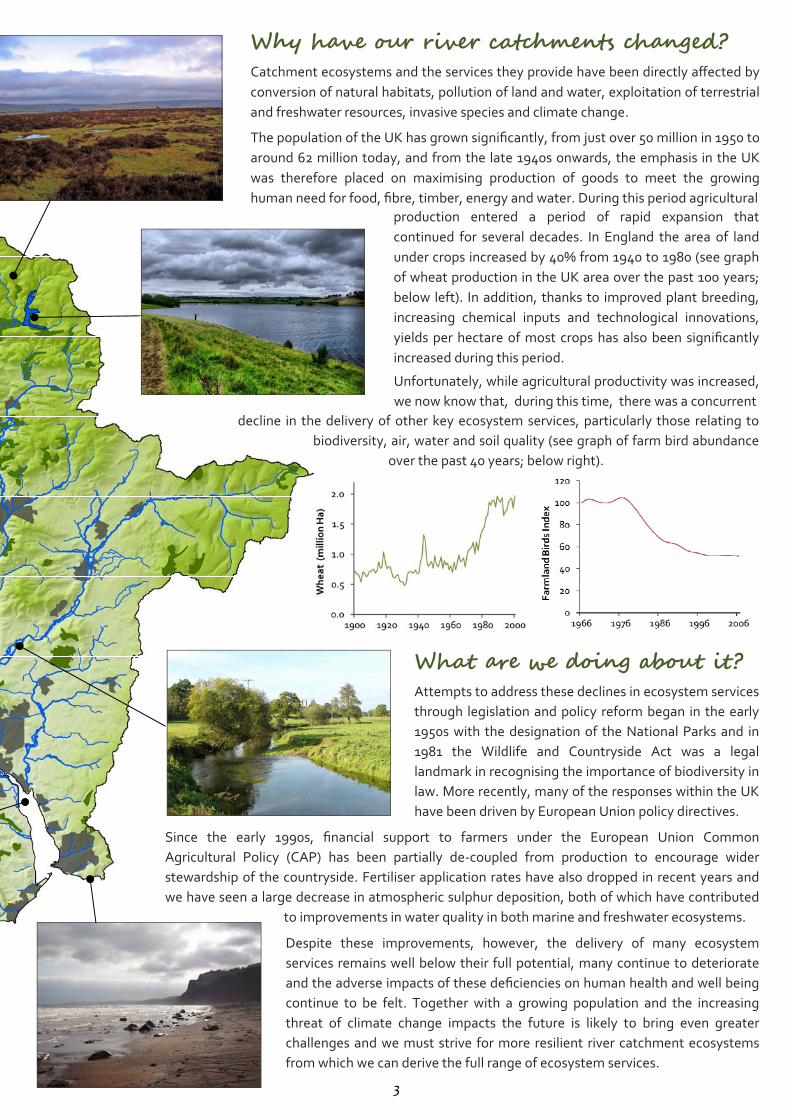
Why have our river catchments changed? Catchment ecosystems and the services they provide have been directly affected by
conversion of natural habitats, pollution of land and water, exploitation of terrestrial
and freshwater resources, invasive species and climate change.
The population of the UK has grown significantly, from just over 50 million in 1950 to
around 62 million today, and from the late 1940s onwards, the emphasis in the UK
was therefore placed on maximising production of goods to meet the growing
human need for food, fibre, timber, energy and water. During this period agricultural production entered a period of rapid expansion that
continued for several decades. In England the area of land
under crops increased by 40% from 1940 to 1980 (see graph
of wheat production in the UK area over the past 100 years;
below left). In addition, thanks to improved plant breeding,
increasing chemical inputs and technological innovations,
yields per hectare of most crops has also been significantly
increased during this period. Unfortunately, while agricultural productivity was increased,
we now know that, during this time, there was a concurrent decline in the delivery of other key ecosystem services, particularly those relating to
biodiversity, air, water and soil quality (see graph of farm bird abundance
over the past 40 years; below right).
What are we doing about it? Attempts to address these declines in ecosystem services
through legislation and policy reform began in the early
1950s with the designation of the National Parks and in
1981 the Wildlife and Countryside Act was a legal
landmark in recognising the importance of biodiversity in
law. More recently, many of the responses within the UK
have been driven by European Union policy directives. Since the early 1990s, financial support to farmers under the European Union Common
Agricultural Policy (CAP) has been partially de‐coupled from production to encourage wider
stewardship of the countryside. Fertiliser application rates have also dropped in recent years and
we have seen a large decrease in atmospheric sulphur deposition, both of which have contributed
to improvements in water quality in both marine and freshwater ecosystems. Despite these improvements, however, the delivery of many ecosystem
services remains well below their full potential, many continue to deteriorate
and the adverse impacts of these deficiencies on human health and well being
continue to be felt. Together with a growing population and the increasing
threat of climate change impacts the future is likely to bring even greater
challenges and we must strive for more resilient river catchment ecosystems
from which we can derive the full range of ecosystem services. 3
THREATS TO RIVER CATCHMENTS RIVER CATCHMENTS COME UNDER PRESSURE FROM A WIDE ARRAY OF THREATS. MANY THAT ARE DERIVED FROM THE
URBAN ENVIRONMENT OR HUMAN INDUSTRIAL ACTIVITY CAN BE CONTROLLED BY REGULATION AND LOCAL
PLANNING GUIDELINES, BUT MORE DIFFUSE PRESSURES THAT ARISE IN THE WIDER LANDSCAPE ARE FAR MORE
DIFFICULT TO IDENTIFY AND REMEDY.
4
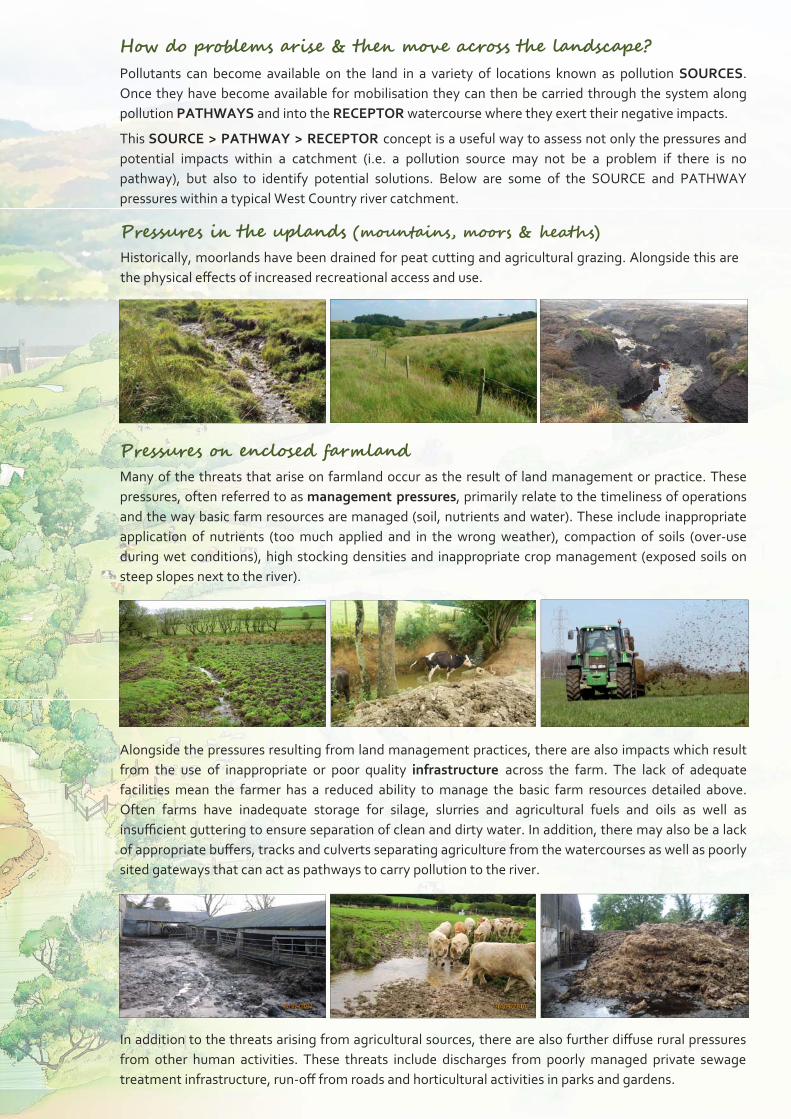
How do problems arise & then move across the landscape? Pollutants can become available on the land in a variety of locations known as pollution SOURCES.
Once they have become available for mobilisation they can then be carried through the system along
pollution PATHWAYS and into the RECEPTOR watercourse where they exert their negative impacts.
This SOURCE > PATHWAY > RECEPTOR concept is a useful way to assess not only the pressures and
potential impacts within a catchment (i.e. a pollution source may not be a problem if there is no
pathway), but also to identify potential solutions. Below are some of the SOURCE and PATHWAY
pressures within a typical West Country river catchment. Pressures in the uplands (mountains, moors & heaths) Historically, moorlands have been drained for peat cutting and agricultural grazing. Alongside this are
the physical effects of increased recreational access and use.
Pressures on enclosed farmland Many of the threats that arise on farmland occur as the result of land management or practice. These
pressures, often referred to as management pressures, primarily relate to the timeliness of operations
and the way basic farm resources are managed (soil, nutrients and water). These include inappropriate
application of nutrients (too much applied and in the wrong weather), compaction of soils (over‐use
during wet conditions), high stocking densities and inappropriate crop management (exposed soils on
steep slopes next to the river).
Alongside the pressures resulting from land management practices, there are also impacts which result
from the use of inappropriate or poor quality infrastructure across the farm. The lack of adequate
facilities mean the farmer has a reduced ability to manage the basic farm resources detailed above.
Often farms have inadequate storage for silage, slurries and agricultural fuels and oils as well as
insufficient guttering to ensure separation of clean and dirty water. In addition, there may also be a lack
of appropriate buffers, tracks and culverts separating agriculture from the watercourses as well as poorly
sited gateways that can act as pathways to carry pollution to the river.
In addition to the threats arising from agricultural sources, there are also further diffuse rural pressures
from other human activities. These threats include discharges from poorly managed private sewage
treatment infrastructure, run‐off from roads and horticultural activities in parks and gardens.
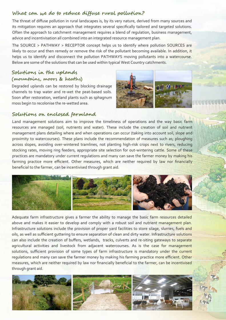
What can we do to reduce diffuse rural pollution? The threat of diffuse pollution in rural landscapes is, by its very nature, derived from many sources and
its mitigation requires an approach that integrates several specifically tailored and targeted solutions.
Often the approach to catchment management requires a blend of regulation, business management,
advice and incentivisation all combined into an integrated resource management plan.
The SOURCE > PATHWAY > RECEPTOR concept helps us to identify where pollution SOURCES are
likely to occur and then remedy or remove the risk of the pollutant becoming available. In addition, it
helps us to identify and disconnect the pollution PATHWAYS moving pollutants into a watercourse.
Below are some of the solutions that can be used within typical West Country catchments.
Solutions on enclosed farmland Land management solutions aim to improve the timeliness of operations and the way basic farm
resources are managed (soil, nutrients and water). These include the creation of soil and nutrient
management plans detailing where and when operations can occur (taking into account soil, slope and
proximity to watercourses). These plans include the recommendation of measures such as; ploughing
across slopes, avoiding over‐wintered tramlines, not planting high‐risk crops next to rivers, reducing
stocking rates, moving ring feeders, appropriate site selection for out‐wintering cattle. Some of these
practices are mandatory under current regulations and many can save the farmer money by making his
farming practice more efficient. Other measures, which are neither required by law nor financially
beneficial to the farmer, can be incentivised through grant aid.
Solutions in the uplands (mountains, moors & heaths) Degraded uplands can be restored by blocking drainage
channels to trap water and re‐wet the peat‐based soils.
Soon after restoration, wetland plants such as sphagnum
moss begin to recolonise the re‐wetted area.
Adequate farm infrastructure gives a farmer the ability to manage the basic farm resources detailed
above and makes it easier to develop and comply with a robust soil and nutrient management plan.
Infrastructure solutions include the provision of proper yard facilities to store silage, slurries, fuels and
oils, as well as sufficient guttering to ensure separation of clean and dirty water. Infrastructure solutions
can also include the creation of buffers, wetlands, tracks, culverts and re‐siting gateways to separate
agricultural activities and livestock from adjacent watercourses. As is the case for management
solutions, sufficient provision of some types of farm infrastructure is mandatory under the current
regulations and many can save the farmer money by making his farming practice more efficient. Other
measures, which are neither required by law nor financially beneficial to the farmer, can be incentivised
through grant aid.
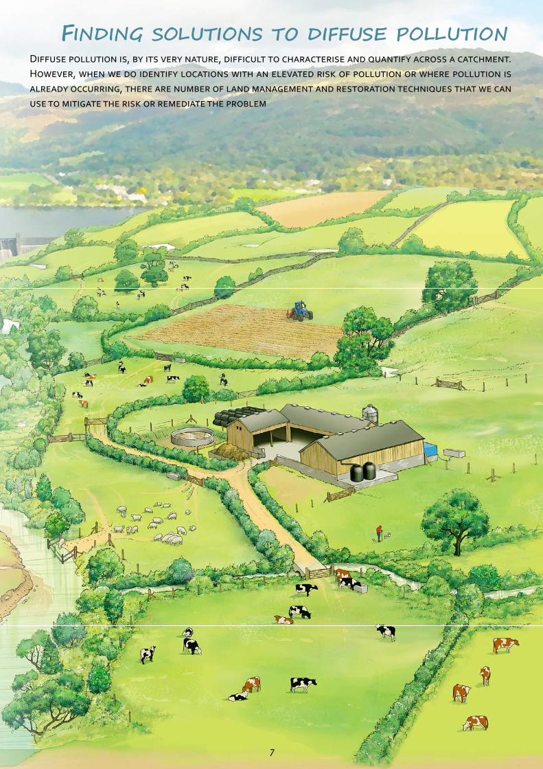
FINDING SOLUTIONS TO DIFFUSE POLLUTION DIFFUSE POLLUTION IS, BY ITS VERY NATURE, DIFFICULT TO CHARACTERISE AND QUANTIFY ACROSS A CATCHMENT.
HOWEVER, WHEN WE DO IDENTIFY LOCATIONS WITH AN ELEVATED RISK OF POLLUTION OR WHERE POLLUTION IS
ALREADY OCCURRING, THERE ARE NUMBER OF LAND MANAGEMENT AND RESTORATION TECHNIQUES THAT WE CAN
USE TO MITIGATE THE RISK OR REMEDIATE THE PROBLEM
7
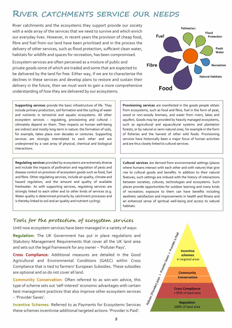
RIVER CATCHMENTS SERVICE OUR NEEDS River catchments and the ecosystems they support provide our society
with a wide array of the services that we need to survive and which enrich
our everyday lives. However, in recent years the provision of cheap food,
fibre and fuel from our land have been prioritised and in the process the
delivery of other services, such as flood protection, sufficient clean water,
habitats for wildlife and spaces for recreation, has been compromised.
Ecosystem services are often perceived as a mixture of public and
private goods some of which are traded and some that are expected to
be delivered by the land for free. Either way, if we are to characterise the
declines in these services and develop plans to restore and sustain their
delivery in the future, then we must work to gain a more comprehensive
understanding of how they are delivered by our ecosystems.
Supporting services provide the basic infrastructure of life. They
include primary production, soil formation and the cycling of water
and nutrients in terrestrial and aquatic ecosystems. All other
ecosystem services – regulating, provisioning and cultural –
ultimately depend on them. Their impacts on human well‐being
are indirect and mostly long‐term in nature: the formation of soils,
for example, takes place over decades or centuries. Supporting
services are strongly interrelated to each other and are
underpinned by a vast array of physical, chemical and biological
interactions.
Provisioning services are manifested in the goods people obtain
from ecosystems, such as food and fibre, fuel in the form of peat,
wood or non‐woody biomass, and water from rivers, lakes and
aquifers. Goods may be provided by heavily managed ecosystems,
such as agricultural and aquacultural systems and plantation
forests, or by natural or semi‐natural ones, for example in the form
of fisheries and the harvest of other wild foods. Provisioning
services have historically been a major focus of human activities
and are thus closely linked to cultural services.
Regulating services provided by ecosystems are extremely diverse
and include the impacts of pollination and regulation of pests and
disease control on provision of ecosystem goods such as food, fuel
and fibre. Other regulating services, include air quality, climate and
hazard regulation, and the amount and quality of available
freshwater. As with supporting services, regulating services are
strongly linked to each other and to other kinds of services (e.g.
Water quality is determined primarily by catchment processes and
is thereby linked to soil and air quality and nutrient cycling).
Cultural services are derived from environmental settings (places
where humans interact with each other and with nature) that give
rise to cultural goods and benefits. In addition to their natural
features, such settings are imbued with the history of interactions
between societies, cultures, technologies and ecosystems. Such
places provide opportunities for outdoor learning and many kinds
of recreation; exposure to them can have benefits including
aesthetic satisfaction and improvements in health and fitness and
an enhanced sense of spiritual well‐being and access to natural
habitats.
Tools for the protection of ecosystem services Until now ecosystem services have been managed in a variety of ways:
Regulation: The UK Government has put in place regulations and
Statutory Management Requirements that cover all the UK land area
and sets out the legal framework for any owner – ‘Polluter Pays’.
Cross Compliance: Additional measures are detailed in the Good
Agricultural and Environmental Conditions (GAEC) within Cross
Compliance that is tied to farmers’ European Subsidies. These subsidies
are optional and so do not cover all land.
Community Conservation: Often referred to as win‐win advice, this
type of scheme sets out ‘self‐interest’ economic advantages with certain
best management practices that also improve other ecosystem services
– ‘Provider Saves’.
Incentive Schemes: Referred to as Payments for Ecosystems Services
these schemes incentivise additional targeted actions: ‘Provider is Paid’. 8
A NEW APPROACH TO CATCHMENT MANAGEMENT We know there are significant pressures exerted on our ecosystem services from both the urban and the rural
environment. We need to address these pressures, and their drivers, through a mixture of regulation, self‐interest
and incentivisation, but this needs to be integrated to take into account the role of the private, public and third
sector. Setting out an approach for catchment management requires consideration of three initial steps:
1. The aims and scope of catchment management: Sustainable delivery of the services we derive from a
catchment based on the needs and aspirations of society. These services need to be publicly formulated, such as
‘healthy rivers and waterways’, ‘viable communities’ and ‘better livelihoods’.
2. The geographic scale at which to plan and implement catchment management: The term ‘catchment’ can
refer to the sub‐basins of tributaries or to a whole river basin as defined by the watersheds that divide drainage
areas. The need to manage water from its source to its sink, and the inter‐dependence of water uses, natural
processes and ecosystem services justify assessment and management at a catchment scale.
3. Levels of governance for decision making and for implementation: Catchment management involves local
responsibilities and requires inclusive deliberation at a local level under the framework of existing multi‐level
government. There is a need to look to the existing scales and responsibilities of local government as a basis for
catchment management, but with provision for cooperation and coordination for catchment areas that span
administrative boundaries.
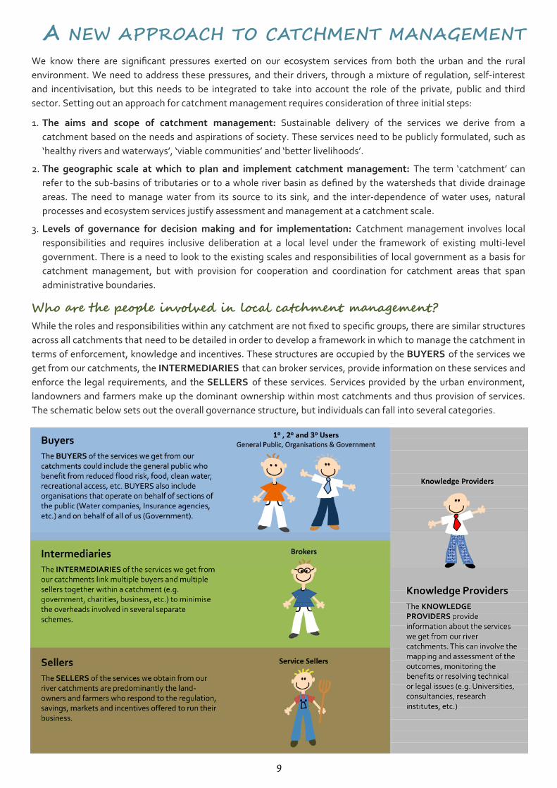
Who are the people involved in local catchment management? While the roles and responsibilities within any catchment are not fixed to specific groups, there are similar structures
across all catchments that need to be detailed in order to develop a framework in which to manage the catchment in
terms of enforcement, knowledge and incentives. These structures are occupied by the BUYERS of the services we
get from our catchments, the INTERMEDIARIES that can broker services, provide information on these services and
enforce the legal requirements, and the SELLERS of these services. Services provided by the urban environment,
landowners and farmers make up the dominant ownership within most catchments and thus provision of services.
The schematic below sets out the overall governance structure, but individuals can fall into several categories.
9
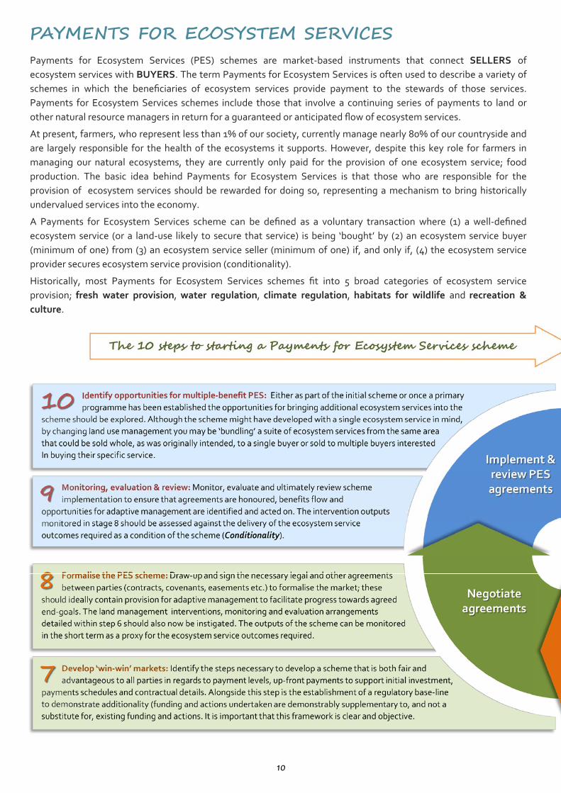
PAYMENTS FOR ECOSYSTEM SERVICES Payments for Ecosystem Services (PES) schemes are market‐based instruments that connect SELLERS of
ecosystem services with BUYERS. The term Payments for Ecosystem Services is often used to describe a variety of
schemes in which the beneficiaries of ecosystem services provide payment to the stewards of those services.
Payments for Ecosystem Services schemes include those that involve a continuing series of payments to land or
other natural resource managers in return for a guaranteed or anticipated flow of ecosystem services.
At present, farmers, who represent less than 1% of our society, currently manage nearly 80% of our countryside and
are largely responsible for the health of the ecosystems it supports. However, despite this key role for farmers in
managing our natural ecosystems, they are currently only paid for the provision of one ecosystem service; food
production. The basic idea behind Payments for Ecosystem Services is that those who are responsible for the
provision of ecosystem services should be rewarded for doing so, representing a mechanism to bring historically
undervalued services into the economy.
A Payments for Ecosystem Services scheme can be defined as a voluntary transaction where (1) a well‐defined
ecosystem service (or a land‐use likely to secure that service) is being ‘bought’ by (2) an ecosystem service buyer
(minimum of one) from (3) an ecosystem service seller (minimum of one) if, and only if, (4) the ecosystem service
provider secures ecosystem service provision (conditionality).
Historically, most Payments for Ecosystem Services schemes fit into 5 broad categories of ecosystem service
provision; fresh water provision, water regulation, climate regulation, habitats for wildlife and recreation &
culture.
10
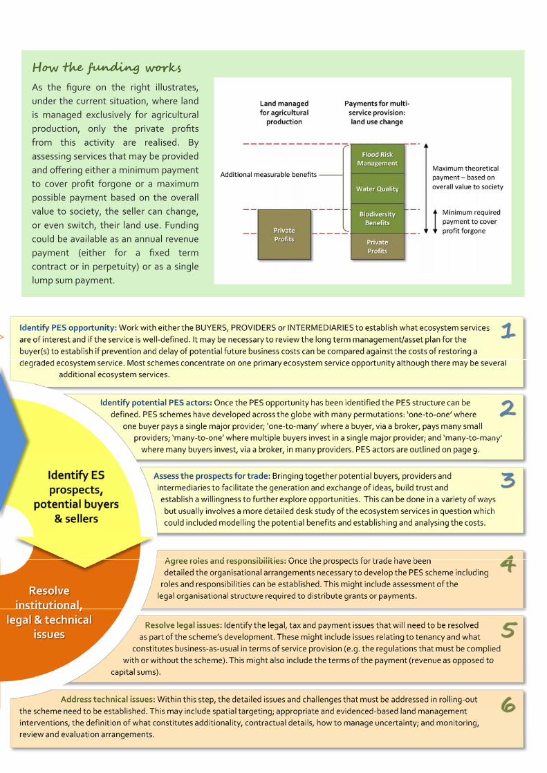
How the funding works As the figure on the right illustrates,
under the current situation, where land
is managed exclusively for agricultural
production, only the private profits
from this activity are realised. By
assessing services that may be provided
and offering either a minimum payment
to cover profit forgone or a maximum
possible payment based on the overall
value to society, the seller can change,
or even switch, their land use. Funding
could be available as an annual revenue
payment (either for a fixed term
contract or in perpetuity) or as a single
lump sum payment.
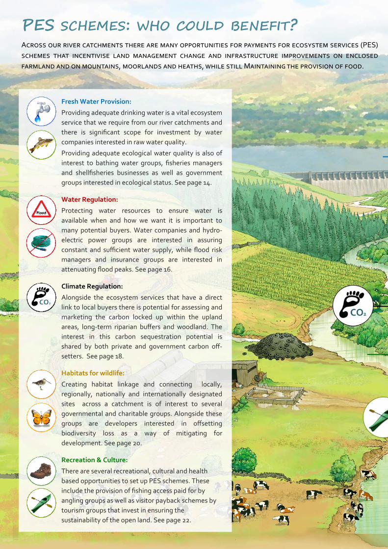
PES SCHEMES: WHO COULD BENEFIT? ACROSS OUR RIVER CATCHMENTS THERE ARE MANY OPPORTUNITIES FOR PAYMENTS FOR ECOSYSTEM SERVICES (PES)
SCHEMES THAT INCENTIVISE LAND MANAGEMENT CHANGE AND INFRASTRUCTURE IMPROVEMENTS ON ENCLOSED
FARMLAND AND ON MOUNTAINS, MOORLANDS AND HEATHS, WHILE STILL MAINTAINING THE PROVISION OF FOOD.
Fresh Water Provision:
Providing adequate drinking water is a vital ecosystem
service that we require from our river catchments and
there is significant scope for investment by water
companies interested in raw water quality.
Providing adequate ecological water quality is also of
interest to bathing water groups, fisheries managers
and shellfisheries businesses as well as government
groups interested in ecological status. See page 14.
Water Regulation:
Protecting water resources to ensure water is
available when and how we want it is important to
many potential buyers. Water companies and hydro‐
electric power groups are interested in assuring
constant and sufficient water supply, while flood risk
managers and insurance groups are interested in
attenuating flood peaks. See page 16.
Climate Regulation:
Alongside the ecosystem services that have a direct
link to local buyers there is potential for assessing and
marketing the carbon locked up within the upland
areas, long‐term riparian buffers and woodland. The
interest in this carbon sequestration potential is
shared by both private and government carbon off‐
setters. See page 18.
Habitats for wildlife:
Creating habitat linkage and connecting locally,
regionally, nationally and internationally designated
sites across a catchment is of interest to several
governmental and charitable groups. Alongside these
groups are developers interested in offsetting
biodiversity loss as a way of mitigating for
development. See page 20.
Recreation & Culture:
There are several recreational, cultural and health
based opportunities to set up PES schemes. These
include the provision of fishing access paid for by
angling groups as well as visitor payback schemes by
tourism groups that invest in ensuring the
sustainability of the open land. See page 22.
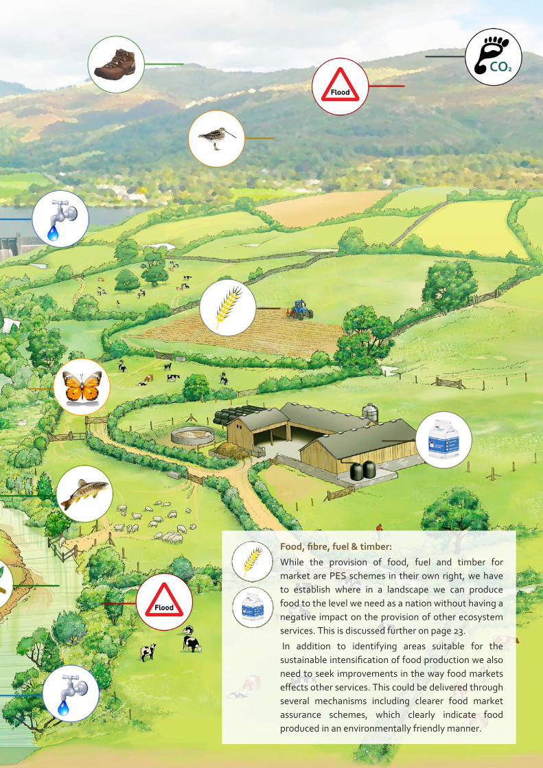
Food, fibre, fuel & timber:
While the provision of food, fuel and timber for
market are PES schemes in their own right, we have
to establish where in a landscape we can produce
food to the level we need as a nation without having a
negative impact on the provision of other ecosystem
services. This is discussed further on page 23.
In addition to identifying areas suitable for the
sustainable intensification of food production we also
need to seek improvements in the way food markets
effects other services. This could be delivered through
several mechanisms including clearer food market
assurance schemes, which clearly indicate food
produced in an environmentally friendly manner.
FRESH WATER PROVISION THE PROVISION OF CLEAN WATER IS OF INTEREST TO VARIOUS GROUPS. WHILE SOME OF THESE HAVE A LIMITED
ABILITY TO SET UP SIGNIFICANT PES SCHEMES (E.G. FISHERY/SHELLFISHERY BUSINESSES), THERE IS POTENTIAL
DEPENDING ON THE CATCHMENT FOR CONSIDERABLE PES SCHEMES TO DEVELOP AROUND THE DELIVERY OF CLEAN
BATHING WATER (LOCAL GOVERNMENT), WATER FRAMEWORK DIRECTIVE GOOD ECOLOGICAL STATUS (NATIONAL
GOVERNMENT) AND DRINKING WATER (WATER COMPANIES).
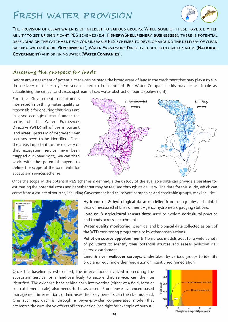
Assessing the prospect for trade Before any assessment of potential trade can be made the broad areas of land in the catchment that may play a role in
the delivery of the ecosystem service need to be identified. For Water Companies this may be as simple as
establishing the critical land areas upstream of raw water abstraction points (below right). For the Government departments
interested in bathing water quality or
responsible for ensuring that rivers are
in ‘good ecological status’ under the
terms of the Water Framework
Directive (WFD) all of the important
land areas upstream of degraded river
sections need to be identified. Once
the areas important for the delivery of
that ecosystem service have been
mapped out (near right), we can then
work with the potential buyers to
define the scope of the payments for
ecosystem services scheme. Once the scope of the potential PES scheme is defined, a desk study of the available data can provide a baseline for
estimating the potential costs and benefits that may be realised through its delivery. The data for this study, which can
come from a variety of sources; including Government bodies, private companies and charitable groups, may include:
Hydrometric & hydrological data: modelled from topography and rainfall
data or measured at Environment Agency hydrometric gauging stations.
Landuse & agricultural census data: used to explore agricultural practice
and trends across a catchment.
Water quality monitoring: chemical and biological data collected as part of
the WFD monitoring programme or by other organisations.
Pollution source apportionment: Numerous models exist for a wide variety
of pollutants to identify their potential sources and assess pollution risk
across a catchment.
Land & river walkover surveys: Undertaken by various groups to identify
problems requiring either regulation or incentivised remediation.
Once the baseline is established, the interventions involved in securing the
ecosystem service, or a land‐use likely to secure that service, can then be
identified. The evidence‐base behind each intervention (either at a field, farm or
sub‐catchment scale) also needs to be assessed. From these evidenced‐based
management interventions or land‐uses the likely benefits can then be modeled.
One such approach is through a buyer‐provider co‐generated model that
estimates the cumulative effects of intervention (see right for example of output).
Environmental
water
Drinking
water
14
Overcoming technical challenges When setting up a PES scheme to deliver water quality through on‐farm interventions there are several technical
issues that must be addressed if the scheme is to succeed. Perhaps the two most significant of these challenges are;
(1) the spatial targeting of appropriate land management interventions and (2) how to monitor the level of the service
that is being delivered before and after the interventions are undertaken. Establishing spatially specific interventions that deliver the service: Schemes need to
assess the evidence and certainty over the success of spatially specific interventions. This
may vary considerably with the type of intervention, the location of intervention and the
spatial scale of interventions.
There is a large amount of literature detailing the effectiveness of on farm interventions
for reducing diffuse water pollution from agriculture on a field scale (Cuttle et al., 2006),
but this research is only now being scaled up to examine the effects across farm and sub‐
catchment areas. Spatial targeting of interventions can be achieved via the desk study.
Establish indicative deliverables for measurement: Once a series of interventions are
established that you wish to incentivise you then need to establish how to assess if
these are being delivered. You can do this by direct outputs (e.g. area of adequate
buffer strip) or indirect outcomes (e.g. improved water quality).
Establishing an adequate assessment output is vital as this will be used to assess
performance and often drives work on the ground. If the indicative output is not closely
linked to the ecosystem service perverse actions could occur that do not lead to
provision of the service (e.g. buffer strips at the top of fields for the protection of
water). Alternatively, if the indicative output is closely linked to the service, but hard to
accurately measure, you could spend all your time trying to measure the ecosystem and
not have the budget to instigate change.
CASE STUDY 1: Upstream Thinking Catchment: River Tamar & tributaries
Buyer: South West Water (Private)
Seller: Multiple farmers in catchment
Intermediary: Westcountry Rivers Trust (Ethical
broker), University of East Anglia
(Knowledge Provider), Environment
Agency (Regulator)
This scheme was co‐developed between the buyer,
who recognised the economic, ecological and
regulatory benefit of improved raw water quality, and
an intermediary, who had a knowledge of the
catchment‐wide actions that could be sold to farmers
and which could lead to improved raw water quality
in the river. Payments are based on action through
the provision of improved farm infrastructure and
agricultural practice. Longevity is ensured through a
10 or 25 year contract and covenant. The scheme will
distribute over £1.2 million of investment (at 50%
grant rate) and is monitored through implementation
of interventions. The delivery of the ecosystem
service is assessed though a ‘proof of concept’
monitoring programme in the Caudworthy Water
sub‐catchment (being undertaken by DEFRA DTC).
CASE STUDY 2: New York City Catchment: Rivers Catskills & Delaware
Buyer: New York City (Government)
Seller: Multiple farmers in catchment
Intermediary: Watershed Agricultural Council and the
Catskill Watershed Corporation
The New York City Department for Environmental
Protection (NYC DEP) funds and implements a
comprehensive Long‐Term Watershed Protection
Program, which maintains and protects the high
quality source of drinking water for nine million water
consumers (nearly half the state’s total population).
New York City’s partners include the Watershed
Agricultural Council (land conservation) and the
Catskill Watershed Corporation (community infra‐
structure and economic development). Both of these
organisations are local not‐for‐profit corporations
that were specifically created to assist DEP with the
administration and implementation of watershed
programs. The program cost US$1.5 billion,
compared to the estimated US$8‐10 billion for a
water filtration plant, and was administered through
a formal urban‐rural partnership that is considered as
a true market.
WATER REGULATION THE REGULATION OF ADEQUATE WATER IS OF INTEREST TO VARIOUS GROUPS. POTENTIAL PES SCHEMES HAVE BEEN
DEVELOPED AROUND ENSURING ADEQUATE WATER SUPPLY FOR BOTH DRINKING (WATER COMPANIES) AND HYDRO‐
ELECTRIC POWER (ENERGY GROUPS). OTHER POTENTIAL PES SCHEMES HAVE DEVELOPED AROUND ATTENUATING
FLOOD PEAKS IN AREAS WHERE LOCALISED FLOODING IS OF CONCERN (NATIONAL GOVERNMENT, WATER
COMPANIES AND INSURANCE COMPANIES).
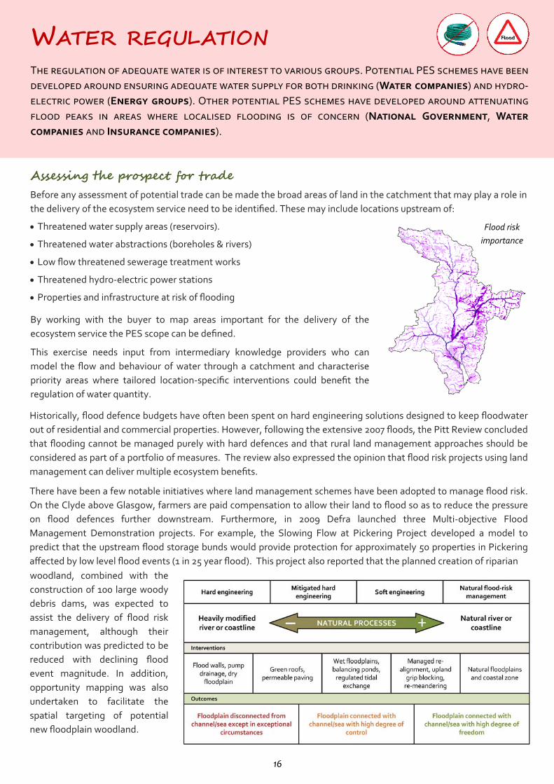
Assessing the prospect for trade Before any assessment of potential trade can be made the broad areas of land in the catchment that may play a role in
the delivery of the ecosystem service need to be identified. These may include locations upstream of:
Threatened water supply areas (reservoirs).
Threatened water abstractions (boreholes & rivers)
Low flow threatened sewerage treatment works
Threatened hydro‐electric power stations
Properties and infrastructure at risk of flooding
Flood risk
importance
By working with the buyer to map areas important for the delivery of the
ecosystem service the PES scope can be defined.
This exercise needs input from intermediary knowledge providers who can
model the flow and behaviour of water through a catchment and characterise
priority areas where tailored location‐specific interventions could benefit the
regulation of water quantity. Historically, flood defence budgets have often been spent on hard engineering solutions designed to keep floodwater
out of residential and commercial properties. However, following the extensive 2007 floods, the Pitt Review concluded
that flooding cannot be managed purely with hard defences and that rural land management approaches should be
considered as part of a portfolio of measures. The review also expressed the opinion that flood risk projects using land
management can deliver multiple ecosystem benefits.
There have been a few notable initiatives where land management schemes have been adopted to manage flood risk.
On the Clyde above Glasgow, farmers are paid compensation to allow their land to flood so as to reduce the pressure
on flood defences further downstream. Furthermore, in 2009 Defra launched three Multi‐objective Flood
Management Demonstration projects. For example, the Slowing Flow at Pickering Project developed a model to
predict that the upstream flood storage bunds would provide protection for approximately 50 properties in Pickering
affected by low level flood events (1 in 25 year flood). This project also reported that the planned creation of riparian woodland, combined with the
construction of 100 large woody
debris dams, was expected to
assist the delivery of flood risk
management, although their
contribution was predicted to be
reduced with declining flood
event magnitude. In addition,
opportunity mapping was also
undertaken to facilitate the
spatial targeting of potential
new floodplain woodland.
16
Potential buyers for flood risk management PES schemes The following funding streams could be developed into flood risk management PES schemes:
Flood Defence Grant‐In‐Aid: Funding raised through general taxation for flooding risk management work.
Regional Flood and Coastal Committee (RFCC) Local Levy: Money raised from Lead Local Flood Authorities for
additional flood risk and coastal erosion management priorities not funded by FDGiA.
Water company investment: Funds raised through the price review process. Water companies are able to invest in
some types of surface water management and invest to increase the resilience of their assets.
Community Infrastructure Levy: A locally set, general charge which local authorities can choose to implement.
Levied on developers (charged per square metre) on most new developments across a local authority area.
Section 106 (Town and Country Planning Act 1990): Contributions from developers that are linked to specific
developments and the infrastructure required to make them acceptable in planning terms.
Landfill Community Fund: The Landfill Tax Credit Scheme (LTCS) was introduced with the landfill tax and enables
Landfill Operators to donate up to 6.5% of their landfill tax liability to implement social and environmental projects.
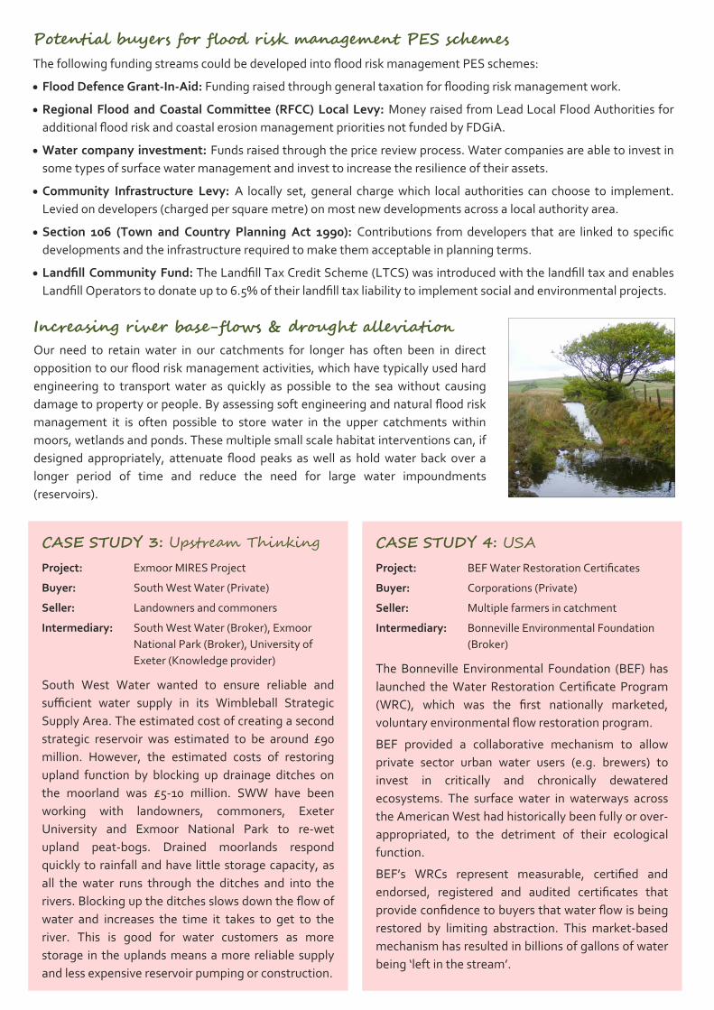
Increasing river base-flows & drought alleviation Our need to retain water in our catchments for longer has often been in direct
opposition to our flood risk management activities, which have typically used hard
engineering to transport water as quickly as possible to the sea without causing
damage to property or people. By assessing soft engineering and natural flood risk
management it is often possible to store water in the upper catchments within
moors, wetlands and ponds. These multiple small scale habitat interventions can, if
designed appropriately, attenuate flood peaks as well as hold water back over a
longer period of time and reduce the need for large water impoundments
(reservoirs).
CASE STUDY 3: Upstream Thinking Project: Exmoor MIRES Project
Buyer: South West Water (Private)
Seller: Landowners and commoners
Intermediary: South West Water (Broker), Exmoor
National Park (Broker), University of
Exeter (Knowledge provider)
South West Water wanted to ensure reliable and
sufficient water supply in its Wimbleball Strategic
Supply Area. The estimated cost of creating a second
strategic reservoir was estimated to be around £90
million. However, the estimated costs of restoring
upland function by blocking up drainage ditches on
the moorland was £5‐10 million. SWW have been
working with landowners, commoners, Exeter
University and Exmoor National Park to re‐wet
upland peat‐bogs. Drained moorlands respond
quickly to rainfall and have little storage capacity, as
all the water runs through the ditches and into the
rivers. Blocking up the ditches slows down the flow of
water and increases the time it takes to get to the
river. This is good for water customers as more
storage in the uplands means a more reliable supply
and less expensive reservoir pumping or construction.
CASE STUDY 4: USA Project: BEF Water Restoration Certificates
Buyer: Corporations (Private)
Seller: Multiple farmers in catchment
Intermediary: Bonneville Environmental Foundation
(Broker)
The Bonneville Environmental Foundation (BEF) has
launched the Water Restoration Certificate Program
(WRC), which was the first nationally marketed,
voluntary environmental flow restoration program.
BEF provided a collaborative mechanism to allow
private sector urban water users (e.g. brewers) to
invest in critically and chronically dewatered
ecosystems. The surface water in waterways across
the American West had historically been fully or over‐
appropriated, to the detriment of their ecological
function.
BEF’s WRCs represent measurable, certified and
endorsed, registered and audited certificates that
provide confidence to buyers that water flow is being
restored by limiting abstraction. This market‐based
mechanism has resulted in billions of gallons of water
being ‘left in the stream’.
CLIMATE REGULATATION THE REGULATION OF THE CLIMATE THROUGH THE EMISSION AND CAPTURE OF GREENHOUSE GASES (GROUPED HERE
AS CARBON EQUIVALENT GASES) IS OF INTEREST TO VARIOUS GROUPS. THERE ARE CURRENT AND POTENTIAL PES
SCHEMES THAT OFFER TO OFFSET CARBON EMISSIONS THROUGH CARBON CAPTURE PROJECTS UNDER VOLUNTARY
CARBON OFFSETTING SCHEMES (PRIVATE COMPANIES AND GENERAL PUBLIC) AND THROUGH GOVERNMENT LAND
USE CHANGE SCHEMES (WOODLAND GRANT SCHEME)
Assessing the prospect for trade Before any assessment of potential trade can be made the broad areas of land in the catchment that may play a role in
the delivery of the ecosystem service need to be identified. These may include locations of:
Existing high carbon soil (peat soils, moorland, woodland) Potential high carbon areas with minimal impact on food Carbon sequestering land management practices Carbon Storage (sequestration) schemes involving landuse/management
interventions have, thus far, been slow to develop worldwide. The majority of
the carbon offsetting market has been dominated by energy efficiency or
renewable energy projects. The reason for this stems from the fact that
sequestration schemes can take many years for the environmental benefits to
be realised and measuring carbon sequestration is not an easy task.
Accordingly, very few sequestration schemes have been approved by the United
Nations’ accreditation scheme under the Kyoto Protocol.
Carbon
sequestration
potential
In the UK, there are a small number of unaccredited carbon offsetting projects in
existence based on woodland planting schemes. These appear attractive to corporate
sponsors on Corporate Social Responsibility (CSR) grounds rather than the acquisition of
carbon credits per se. Defra provide a Code of Best Practice for Carbon Offset Providers
(accreditation requirements and procedures), which together with the Woodland Carbon
Code has helped to formalise some of these schemes.
To meet the requirements of the Code, projects need to: (1) register with the FC, stating
the exact location and long‐term objectives; (2) meet UK standards for sustainable forest
management; (3) have a long‐term management plan; (4) use approved methods for
estimating the carbon that will be captured; and (5) demonstrate that the project
delivers additional carbon benefits than would otherwise have been the case.
There are currently no carbon offsetting projects in the UK based on soil carbon sequestration. This is because the
ability of soils to sequester carbon under different management practices is subject to significant variability and
measurement of soil carbon is not a straightforward process. Below is an example of how this could be delivered
through a scheme to permanently change land use.
18
CASE STUDY 5: USA Project: Chicago Climate Exchange
Buyer: U.S. carbon markets (Private)
Seller: Multiple farmers
Intermediary: Climate Exchange PLC
The CCE Trading System closed in 2010 but had the
three main elements. (1) A trading platform acted as
a marketplace for executing trades among registered
account holders. For example, the US National
Farmers Union’s Carbon Credit Program was a multi‐
state program that allowed farmers and landowners
to earn income by storing carbon in their soil through
no‐till crop production and long‐term grass seeding
practices. The Farmers Union earned approval from
the Chicago Climate Exchange to aggregate carbon
credits. The Farmers Union was enrolling producer
areas of carbon into blocks of credits that were traded
on the Exchange, much like other agricultural
commodities are traded. (2) The clearing and
settlement platform processed all transaction
information. (3) The registry was the official database
for Carbon Financial Instruments owned by registered
account holders.
CASE STUDY 6: Woodland Trust Project: Warcop Training Area
Buyer: North Pennines AONB & a private
company
Seller: Ministry of Defence (Government)
Intermediary: The Woodland Trust (Broker)
The Woodland Carbon Code (WCC) provides
standards for the creation of woodland with the aim
of removing atmospheric carbon dioxide. The WCC
operates in the UK voluntary carbon market, where it
seeks to bolster market confidence in forest carbon
projects, thereby increasing private investment in
forest creation. The Warcop Training Area (WTA)
pilot scheme was co‐developed between the Ministry
of Defence (MOD), who wished to develop new
woodlands on its training areas; the Woodland Trust,
who had knowledge of woodland creation and
management; and retail companies wishing to
mitigate for unavoidable greenhouse gas emissions.
The sale of sequestered carbon and a significant
funding contribution from North Pennines AONB
allowed the project to be 100% financed from sources
not traditionally associated with woodland creation.
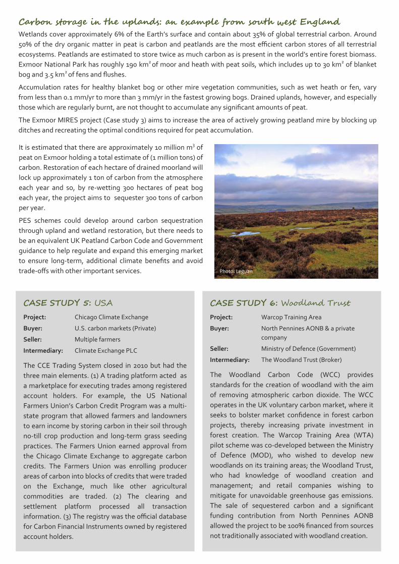
It is estimated that there are approximately 10 million m3 of
peat on Exmoor holding a total estimate of (1 million tons) of
carbon. Restoration of each hectare of drained moorland will
lock up approximately 1 ton of carbon from the atmosphere
each year and so, by re‐wetting 300 hectares of peat bog
each year, the project aims to sequester 300 tons of carbon
per year.
PES schemes could develop around carbon sequestration
through upland and wetland restoration, but there needs to
be an equivalent UK Peatland Carbon Code and Government
guidance to help regulate and expand this emerging market
to ensure long‐term, additional climate benefits and avoid
trade‐offs with other important services.
Carbon storage in the uplands: an example from south west England Wetlands cover approximately 6% of the Earth’s surface and contain about 35% of global terrestrial carbon. Around
50% of the dry organic matter in peat is carbon and peatlands are the most efficient carbon stores of all terrestrial
ecosystems. Peatlands are estimated to store twice as much carbon as is present in the world’s entire forest biomass.
Exmoor National Park has roughly 190 km2 of moor and heath with peat soils, which includes up to 30 km2 of blanket
bog and 3.5 km2 of fens and flushes.
Accumulation rates for healthy blanket bog or other mire vegetation communities, such as wet heath or fen, vary
from less than 0.1 mm/yr to more than 3 mm/yr in the fastest growing bogs. Drained uplands, however, and especially
those which are regularly burnt, are not thought to accumulate any significant amounts of peat.
The Exmoor MIRES project (Case study 3) aims to increase the area of actively growing peatland mire by blocking up
ditches and recreating the optimal conditions required for peat accumulation.
Photo: Leguan
HABITATS FOR WILDLIFE THE PROVISION OF NATURAL HABITATS IS OF INTEREST TO A LARGE VARIETY OF GROUPS. THERE IS CONSIDERABLE
POTENTIAL FOR CATCHMENT‐SCALE PES SCHEMES TO DEVELOP AROUND THE DELIVERY OF PROTECTED AND WELL
LINKED HABITATS. CURRENT SCHEMES INCLUDE THE PROTECTION AND MANAGEMENT OF DESIGNATED SITES
(GOVERNMENT AND PRIVATE NGO GROUPS) AS WELL AS THE CREATION OF ECOLOGICAL NETWORKS THROUGH
THE DEVELOPMENT OF BIODIVERSITY OFFSETTING SCHEMES (DEVELOPERS).
Assessing the prospect for trade The Lawton Review (Making Space for Water, 2010) proposed that the overarching aim for England’s ecological
network should be to deliver a natural environment where biodiversity is enhanced and the diversity, functioning and
resilience of ecosystems re‐established in a network of spaces for nature that can sustain these levels into the future,
even given continuing environmental change and human pressures.
This is underpinned by three objectives: 1. To restore species and habitats appropriate to England’s physical and
geographical context to levels that are sustainable in a changing climate, and
enhanced in comparison with those in 2000.
2. To restore and secure the long‐term sustainability of the ecological and
physical processes that underpin the way ecosystems work, thereby
enhancing the capacity of our natural environment to provide ecosystem
services such as clean water, climate regulation and crop pollination, as well
as providing habitats for wildlife.
3. To provide accessible natural environments rich in wildlife for people to enjoy
and experience.
Habitat
opportunities
Biodiversity off-setting Biodiversity offsetting involves a developer taking account of any biodiversity loss (species/
habitats) associated with a development and buying credits from a provider of equivalent
biodiversity established elsewhere. The approach is an example of a ‘cap‐and‐trade’ mechanism,
which has been applied widely in the creation of wetland mitigation banks in the USA, and is
developing in the UK through the Environment Bank, which has established a biodiversity credits
market for offsetting the impacts of development (see case study 8).
DEFRA have set out some guiding principles for the development of biodiversity offsetting
schemes suggesting that they should:
Not change existing levels of protection for biodiversity
Deliver real benefits for biodiversity by: improving the compensation for biodiversity loss;
expanding and restoring habitats; using offsets to contribute to enhancing England’s ecological
network; providing additionality; creating habitat which lasts in perpetuity; and requiring
avoidance and mitigation of impacts to take place first.
Be managed at the local level as far as possible: within national priorities for managing
biodiversity; within a standard framework; through partnerships at an appropriate geographic
level; with the right level of national support and guidance to build capacity where it is needed;
and involving local communities
Be as simple as possible, for developers, local authorities and others
Be transparent, giving clarity on how the offset calculations are derived and allowing people to
see how offset resources are being used
Be good value for money 20
CASE STUDY 7: USA Project: Conservation Reserve Program
Buyer: U.S. Department of Agriculture
Seller: Multiple farmers
Intermediary: US Farm Service Agency
The Conservation Reserve Program (CRP) offers
farmers 10‐15 year contracts to take land out of crop
production in return for financial assistance to
establish cover (usually grass or trees) and an on‐
going annual payment. Land is eligible either if it has
a history of crop production and is regarded as highly
erodible, is located in a Conservation Priority Area or
will be devoted to wetland restoration, streamside or
conservation buffers. The scheme is competitive and
farmers offer bids for the funds. Offers are then
evaluated using an Environmental Benefits Index
(EBI) to select farmer bids which comprises a benefit‐
cost index that accounts for a broad range of
environmental concerns and the administration cost
involved in managing the contract. Farmers can
improve their EBI scores by offering to take lower
annual payments or foregoing cost‐sharing on cover
establishment.
CASE STUDY 8: Environment Bank Project: Biodiversity Offsetting Scheme
Buyer: Developers (Private)
Seller: Multiple landowners
Intermediary: Environment Bank (Broker)
The Environment Bank Ltd undertakes a review of
schemes and, in consultation, on behalf of the client
(developers), with statutory nature conservation
advisers, planning authorities and other stake‐
holders, an appropriate mitigation strategy is
developed and ‘signed‐up’.
A costing programme is calculated and the developer
purchases credits from the Environment Bank which
are used to fund the creation and/or management of
an ecological or environmental resource.
The delivery of the resource is made at either the
local or wider environment level. Situations also arise
where credits from a range of development schemes
are pooled and large sites created, providing
substantial added value through landscapes that
people can visit and enjoy, thereby improving their
health and well being. This benefit is linked to the
recreational PES.
Enhancing habitat provision through Environmental Stewardship Environmental Stewardship is an agri‐environment scheme which offers payments to farmers and land managers in
England for effective land management to protect and enhance the environment and wildlife. The scheme’s primary
objectives are to:
Conserve wildlife (biodiversity)
Maintain and enhance landscape quality and character
Protect the historic environment
Protect natural resources (water and soil)
Promote public access and understanding of the countryside Nearly 6.5 million hectares (nearly 70% of England’s farmland) are in agri‐
environment schemes (43,000 Environmental Stewardship agreements
covering 5.5 million hectares).
While there is some debate as to whether the individual strands, namely
Entry Level Stewardship (ELS, Organic ELS & Upland ELS) and Higher Level
Stewardship (HLS), are genuine PES or ‘PES‐like’ schemes, HLS payments
have been used by many groups to protect designated habitats and deliver
the Government’s Public Service Agreement to secure 95% of Sites of Special
Scientific Interest (SSSIs) in England in favourable or recovering condition by
2010. This target has not been reached, but it did lead to the establishment
of the three broad objectives set out in the Lawton Review.
Alongside Biodiversity Offsetting and Environmental Stewardship
programmes other funding routes that could be loosely developed into ‘PES‐
like’ schemes include the Community Infrastructure Levy, Section 106
payments and Landfill Community Fund (see page 17 for further details).
RECREATION & CULTURE THE PROVISION OF AN ADEQUATE QUANTITY AND QUALITY OF RECREATION AREAS IS OF INTEREST TO VARIOUS
USER GROUPS AND FOR A VARIETY OF REASONS (TOURISM, CULTURE, WELL BEING, ETC…). SOME OF THESE MAY BE
ON A SMALL SCALE (E.G. ANGLING GROUPS), BUT THERE IS POTENTIAL, DEPENDING ON THE CATCHMENT, FOR
CONSIDERABLE PES SCHEMES TO DEVELOP AROUND POPULAR HIGH ‘FOOT‐FALL’ AREAS THAT HAVE THE POTENTIAL
TO SET UP VISITOR PAYBACK SCHEMES RUN BY NATIONAL PARKS AND LOCAL COMMUNITIES GROUPS.
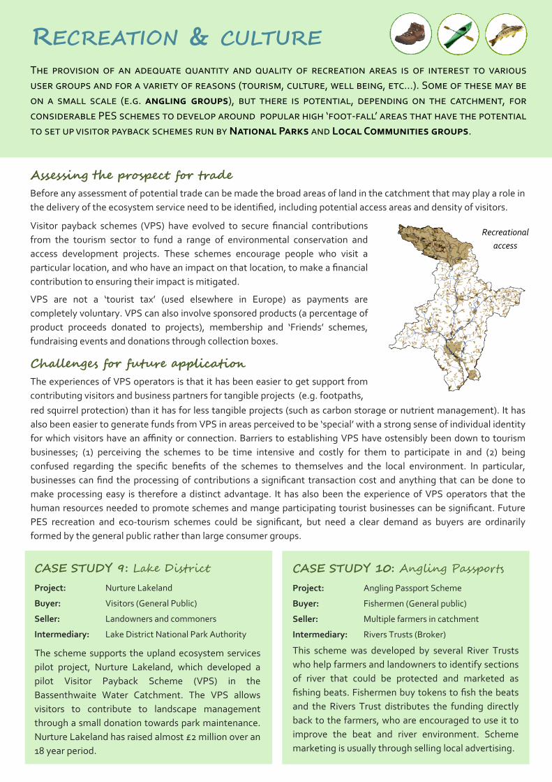
Assessing the prospect for trade Before any assessment of potential trade can be made the broad areas of land in the catchment that may play a role in
the delivery of the ecosystem service need to be identified, including potential access areas and density of visitors. Recreational
access
Visitor payback schemes (VPS) have evolved to secure financial contributions
from the tourism sector to fund a range of environmental conservation and
access development projects. These schemes encourage people who visit a
particular location, and who have an impact on that location, to make a financial
contribution to ensuring their impact is mitigated.
VPS are not a ‘tourist tax’ (used elsewhere in Europe) as payments are
completely voluntary. VPS can also involve sponsored products (a percentage of
product proceeds donated to projects), membership and ‘Friends’ schemes,
fundraising events and donations through collection boxes. Challenges for future application The experiences of VPS operators is that it has been easier to get support from
contributing visitors and business partners for tangible projects (e.g. footpaths, red squirrel protection) than it has for less tangible projects (such as carbon storage or nutrient management). It has
also been easier to generate funds from VPS in areas perceived to be ‘special’ with a strong sense of individual identity
for which visitors have an affinity or connection. Barriers to establishing VPS have ostensibly been down to tourism
businesses; (1) perceiving the schemes to be time intensive and costly for them to participate in and (2) being
confused regarding the specific benefits of the schemes to themselves and the local environment. In particular,
businesses can find the processing of contributions a significant transaction cost and anything that can be done to
make processing easy is therefore a distinct advantage. It has also been the experience of VPS operators that the
human resources needed to promote schemes and mange participating tourist businesses can be significant. Future
PES recreation and eco‐tourism schemes could be significant, but need a clear demand as buyers are ordinarily
formed by the general public rather than large consumer groups.
CASE STUDY 9: Lake District Project: Nurture Lakeland
Buyer: Visitors (General Public)
Seller: Landowners and commoners
Intermediary: Lake District National Park Authority
The scheme supports the upland ecosystem services
pilot project, Nurture Lakeland, which developed a
pilot Visitor Payback Scheme (VPS) in the
Bassenthwaite Water Catchment. The VPS allows
visitors to contribute to landscape management
through a small donation towards park maintenance.
Nurture Lakeland has raised almost £2 million over an
18 year period.
CASE STUDY 10: Angling Passports Project: Angling Passport Scheme
Buyer: Fishermen (General public)
Seller: Multiple farmers in catchment
Intermediary: Rivers Trusts (Broker)
This scheme was developed by several River Trusts
who help farmers and landowners to identify sections
of river that could be protected and marketed as
fishing beats. Fishermen buy tokens to fish the beats
and the Rivers Trust distributes the funding directly
back to the farmers, who are encouraged to use it to
improve the beat and river environment. Scheme
marketing is usually through selling local advertising.
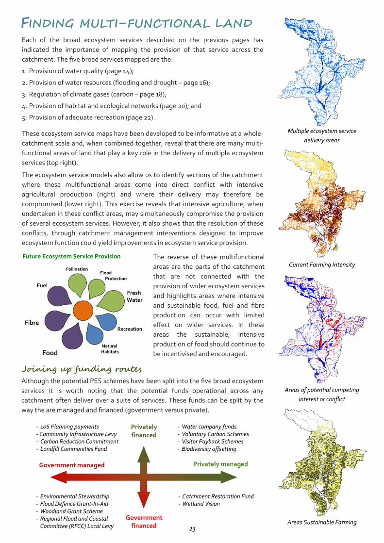
FINDING MULTI-FUNCTIONAL LAND Each of the broad ecosystem services described on the previous pages has
indicated the importance of mapping the provision of that service across the
catchment. The five broad services mapped are the:
1. Provision of water quality (page 14);
2. Provision of water resources (flooding and drought – page 16);
3. Regulation of climate gases (carbon – page 18);
4. Provision of habitat and ecological networks (page 20); and
5. Provision of adequate recreation (page 22).
These ecosystem service maps have been developed to be informative at a whole‐
catchment scale and, when combined together, reveal that there are many multi‐
functional areas of land that play a key role in the delivery of multiple ecosystem
services (top right).
The ecosystem service models also allow us to identify sections of the catchment
where these multifunctional areas come into direct conflict with intensive
agricultural production (right) and where their delivery may therefore be
compromised (lower right). This exercise reveals that intensive agriculture, when
undertaken in these conflict areas, may simultaneously compromise the provision
of several ecosystem services. However, it also shows that the resolution of these
conflicts, through catchment management interventions designed to improve
ecosystem function could yield improvements in ecosystem service provision.
Multiple ecosystem service
delivery areas
Current Farming Intensity The reverse of these multifunctional
areas are the parts of the catchment
that are not connected with the
provision of wider ecosystem services
and highlights areas where intensive
and sustainable food, fuel and fibre
production can occur with limited
effect on wider services. In these
areas the sustainable, intensive
production of food should continue to
be incentivised and encouraged. Joining up funding routes Although the potential PES schemes have been split into the five broad ecosystem
services it is worth noting that the potential funds operational across any
catchment often deliver over a suite of services. These funds can be split by the
way the are managed and financed (government versus private).
Areas of potential competing
interest or conflict
Areas Sustainable Farming
Future Ecosystem Service Provision
23
WATER Restoring river catchment function through
Payments for Ecosystems Services
This handbook explores the history of why our river catchments are in their
current condition, the nature of the threats and challenges they face and sets out
in practical terms some of the solutions we have to restore them. It also sets out
the governance structure that has evolved to address these problems and where
the various funding comes from to deliver change.
This guide is designed to be read in conjunction with the ecosystems service
evidence case studies that document some of the work being done estimating
and monitoring ecosystem service delivery.
Cover photo: Exmoor landscape by Mark Robinson
Westcountry Rivers Trust
Rain Charm House, Kyl Cober Parc, Stoke Climsland, Cornwall, PL17 8PH
www.wrt.org.uk; [email protected]
The WATER (Wetted land: The Assessment, Techniques & Economics of
Restoration) project is a €3.9 million programme funded by the France (Channel)
England Interreg IVA Programme and led by the Westcountry Rivers Trust, which
aims to revolutionise the way we restore and manage our environment by
developing innovative funding mechanisms.


