Water Resources - ww2.ocglobal.jpww2.ocglobal.jp/company/pdf/PS07.pdf · ha with flood depths of...
14
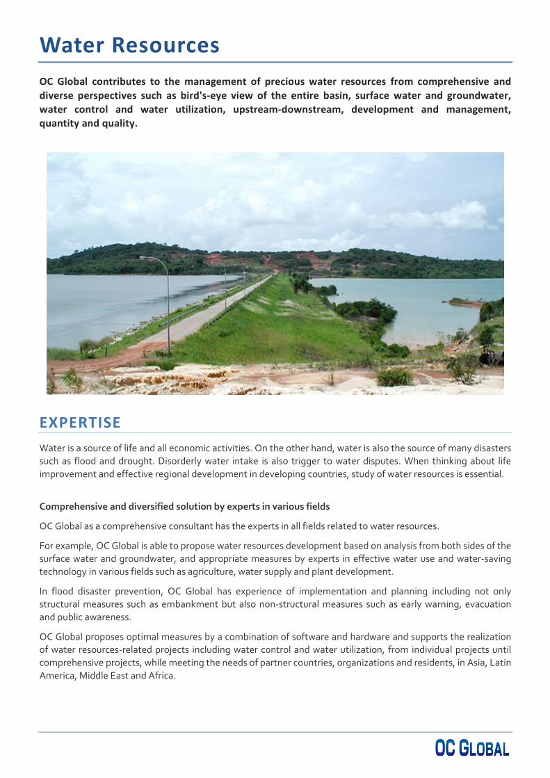
Water Resources OC Global contributes to the management of precious water resources from comprehensive and diverse perspectives such as bird's-eye view of the entire basin, surface water and groundwater, water control and water utilization, upstream-downstream, development and management, quantity and quality. EXPERTISE Water is a source of life and all economic activities. On the other hand, water is also the source of many disasters such as flood and drought. Disorderly water intake is also trigger to water disputes. When thinking about life improvement and effective regional development in developing countries, study of water resources is essential. Comprehensive and diversified solution by experts in various fields OC Global as a comprehensive consultant has the experts in all fields related to water resources. For example, OC Global is able to propose water resources development based on analysis from both sides of the surface water and groundwater, and appropriate measures by experts in effective water use and water-saving technology in various fields such as agriculture, water supply and plant development. In flood disaster prevention, OC Global has experience of implementation and planning including not only structural measures such as embankment but also non-structural measures such as early warning, evacuation and public awareness. OC Global proposes optimal measures by a combination of software and hardware and supports the realization of water resources-related projects including water control and water utilization, from individual projects until comprehensive projects, while meeting the needs of partner countries, organizations and residents, in Asia, Latin America, Middle East and Africa.
Transcript of Water Resources - ww2.ocglobal.jpww2.ocglobal.jp/company/pdf/PS07.pdf · ha with flood depths of...
Water Resources OC Global contributes to the management of precious water resources from comprehensive and diverse perspectives such as bird's-eye view of the entire basin, surface water and groundwater, water control and water utilization, upstream-downstream, development and management, quantity and quality.
EXPERTISE Water is a source of life and all economic activities. On the other hand, water is also the source of many disasters such as flood and drought. Disorderly water intake is also trigger to water disputes. When thinking about life improvement and effective regional development in developing countries, study of water resources is essential.
Comprehensive and diversified solution by experts in various fields
OC Global as a comprehensive consultant has the experts in all fields related to water resources.
For example, OC Global is able to propose water resources development based on analysis from both sides of the surface water and groundwater, and appropriate measures by experts in effective water use and water-saving technology in various fields such as agriculture, water supply and plant development.
In flood disaster prevention, OC Global has experience of implementation and planning including not only structural measures such as embankment but also non-structural measures such as early warning, evacuation and public awareness.
OC Global proposes optimal measures by a combination of software and hardware and supports the realization of water resources-related projects including water control and water utilization, from individual projects until comprehensive projects, while meeting the needs of partner countries, organizations and residents, in Asia, Latin America, Middle East and Africa.

Water Resources
CONSULTING SERVICES S e r v i c e T y p e
Project formation, study, planning (master plan formulation, feasibility studies), design (basic design, detailed design), construction management, technology transfer, capacity development
S e r v i c e S e c t o r
Water resources management
Water resources development
Groundwater development
Watershed management
Flood management
Sediment management
Water supply
Irrigation
Sewage
Water quality management
Erosion control
Coastal protection
Forest conservation
Observation and monitoring
E l e m e n t a l t e c h n o l o g y Surface water endowment amount evaluation
Groundwater endowment amount evaluation
Water demand assessment and prediction
Climate change impact assessment
Water balance analysis
Development possible amount evaluation
Hydraulic analysis
Hydrological analysis
Hydrological observation
Flow rate observation
Water quality analysis
Hydrogeological analysis
Ground survey
River structures design
Water supply facility design
Well drilling management
Remote Sensing
GIS
Public consultation
Institutional operation and management for Watershed/water management

Sector Water Resources Project Type Flood Control – River Improvement Project Title Upper Citarum Basin Urgent Flood Control Project Location Bandung, West Java, Indonesia Client Director General of Water Resources / JBIC Project Period July 1994 – March 2008
Dredging works for low water channel at Parunghalang
Reconstructed road bridge at Dayeuhkolot
Problems addressed by the Project The Citarum River (the largest river in West Java which flows through the Upper Citarum Basin and then north¬wards to the North Java coast, East of Jakarta) has a catchment area of 6,000 km2. The Upper Citarum Basin (1,800 km2) suffers from recurrent flooding problems. The March 1986 flood covered a flood area of 7,450 ha with flood depths of 0.8 to 1.5 m in the Dayeuhkolot area, and caused exten¬sive damage to 27,310 houses and 480 industrial and commercial buildings as well as 6,360 ha of rice fields. Future flood damage is expected to worsen and increase with severity in the future, owing to the following: low discharge capacity of the Citarum River channel, increasing flood peak discharge due to rapid basin development, increasing population in flood-prone urban sprawl ar¬eas, etc. Since river improvement has a high priority among various infrastructural development programs in the basin, in order to relieve socio-economic growth problems by mitigating flood damage, the Government of Indonesia requested technical and financial assistance from Japan.
Service Period Under the technical cooperation program that JICA extended to the Directorate General of Water Resources in 1987-1988, OC Global established an overall flood control plan consisting of structural and non-structural measures, and conducted a feasibility study to identify an urgent project corresponding to the components of the flood control plan. Thereafter, OC Global executed the detailed de¬sign for the urgent project in 1991-1992 and provided construction supervision services for it under JBIC financial assistance from 1994 up to 2008.
Actual Project Recommendations The urgent project works covered river improvement totalling 67 km along the main stream of the Citarum River and its tributaries, and the establishment of a telemetering system for flood forecasting and warning activities. The major work component of the river improvement consisted of dredging/excavation of channels and construction of riparian structures as well as re-construction of bridges, since river improvement in a 5-year frequency scale adopts the dredging and widening method for composite channel section. Telemeter system, involving collecting real-time hydrological data from 7-water level and 8-rainfall observation stations, was established by strengthening and utilizing the existing system of the Saguling Hydropower Station.
LEGEND
: Project Area
: City
: River
: Reservoir: Dam
N
JAKARTAJAVA SEA
BANDUNG
Project AreaA = 1.771 km2
KARAWANG
PURWAKARTA
CIRATA
CIANJURSAGULING
JATILUHURRESERVOIR
RESERVOIR
CITARUM RIVER
L = 67 Km
Project Area
RESERVOIR
River Improvement
JAVA SEA
: Improved River Reaches
BANDUNG
KOLOTDAYEUH

Significant Problem Addressed by Project The Sula Valley is the most important agricultural and industrial area in Honduras producing 40-50% GNP. The northwestern part of Sula Valley, the Choloma river basin covering approximately 105 km2, has high susceptibility to sedimentation and flooding and it is hit every 2 or 3 years by a hurricane or tropical depression. The most severe damages in recorded history were caused by the hurricane in 1974. It caused 10,000 deaths and $400 million damage to the economy. Within the center of Choloma city, sedimentation reached more than one meter deep and regional transportation
was paralyzed, causing disastrous social and economic impact. Since this area suffers from a heavy sedimentation problem, the Government of Honduras requested technical assistance from Japan to control the sediments of Choloma River and prevent future disasters from flooding.
OCG’s Project Services After detailed topographic and geological surveys, soil and hydrological investigations, OCG made the structural designs and formulated the construction plan. In addition, OCG performed construction supervision throughout the whole period of the project.
Actual Project Works Improvement of river channel including construction of river bank protection works: 1,468 m Sabo dam: H = 14 m, 2 sites Consolidation dams: H = 3.7 m and H = 3.2 m Reconstruction of railway bridge: L = 183 m
Sector Water Resources Project Type Flood and Sediment Control Project Title Flood and Sediment Control for Rio Choloma Location Choloma, Honduras Client Secretaria de Obras Públicas, Transporte y Vivienda / JICA Project Period July 1997 to August 2001
Sabo Dam Railway Bridge
Consolidation Dam River Improvement

`
Sector Groundwater Management Project Type Groundwater Management Planning Project Title Groundwater Management Plan of Stampriet Artesian Basin Location Stampriet, Namibia Client Department of Water Affaires (DWA), Ministry of Agriculture, Water and Rural Development / JICA Project Period 1999 – 2002
Significant Problem Addressed by Project The southeast Kalahari (Stampriet) Artesian Basin is the largest groundwater basin in Namibia. According to monitoring wells, groundwater levels in the basin have declined continuously since 1980. Although extensive groundwater extraction by commercial and communal farmers occurs in this basin, groundwater management plan for sustainable groundwater development has not been regulated. Hence the Government of Namibia requested the Japanese Government to develop a Groundwater Development Plan for Stampriet Artesian Basin.
OCG’s Project Services OCG carried out the following investigations to clarify Hydrogeological Structure, Groundwater Potential, Groundwater Flow and Recharge Mechanism: Hydrogeological investigations, topographical and geological surveys, and geophysical explorations Test well drilling and groundwater monitoring Water quality and isotope analysis Hydrocensus Groundwater modeling and simulation.
Actual Project Recommendations OCG provided groundwater management plan confirmed by simulation for sustainable usage which included the following: Supply targets for reducing groundwater use in the short- and long-term
30% cutoff in short-term, 50% cutoff in long-term Main recommendations in order to control water use
Education of sustainable groundwater use Control of Irrigation area Crop conversion for effective water use Improvement of Irrigation method
700
800
900
1000
1100
1200
1300
1400
(m ASL)
NW SE
50 100 150 200 250 3000 (Km)
K Kalahari BedsB Kalkland BasaltDo Karoo DoleriteR Rietmond MemberA Auob MemberM Mukorob MemberN Nossob Member
P.E. Pre-Ecca Group
2641823769
396
514
105658
6646
J-9(Swart Modder)
J-5(Martzivilla)
110
1288
392
528
GR-1555 ACP-29
ACP-30
293112756
JO5-N(7995)Goachas452
DWA-2
J-8(Tweeriver)
32272
3281310
N
N
P.E.
P.E.
N
P.E.
Do
P.E.
B
B
M
M
M
A
A
A
A
A
R
R
R
R
R
R
K
K
K
K
Hoachanas
StamprietGochas�
Auob R. TweeriverAuob R.
Section-3 Section-4
Section-2Section-1
Geological Cross Section of Stampriet Artesian Basin
Actual Water Head Drawdown: 10 m
Drawdown of Auob Aquifer after 100 Years by Groundwater Simulation
17 17.5 18 18.5 19 19.5 20
-26.5
-26
-25.5
-25
-24.5
-24
-23.5
-23
-22.5
0 25 50 75 100
Gochas
Stampriet
Mariental
Koes
Aranos
Leonardville
Aminuis
Kalkrand
1 10 20 30 40 48j=1
10
20
30
40
50
60
i=
km
m
-11357911131525
Worse
Better
Artesian Groundwater

Sector Water Resources Project Type Basic Research & Training for the Flood Control and Sabo Works
Project Title The Project for the Construction of a Hydraulic Laboratory, & The Project for Enhancement of Capabilities in Flood Control and Sabo Engineering of the Department of Public Works and Highways
Location Metropolitan Manila / The Republic of the Philippines Client Department of Public Works and Highways / JICA Project Period Basic Design: 2000, Implementation: 2001 – 2003, Training: 2003 – 2004
Problems addressed by the Project Every year, the Philippines experiences flood damage due to an average of 20 typhoons per year, which form in the region and cause torrential rains which in some areas exceed 3,500 mm per year. In the Medium-term Development Plan 1999-2004, 14 items were listed as priorities in the field of flood control and drainage, one of which was to establish the Flood Control and Sabo Engineering Center (FCSEC) to conduct applied research and develop human resources. Hence, the Government of the Philippines requested Project Type Cooperation assistance from JICA to construct a Hydraulic Experiment Laboratory and to procure the necessary instruments and equipment. The main objectives of the experiments conducted at the Laboratory were training staff and basic research for the flood control and Sabo works in the Philippines.
Service Period OC Global performed basic design and supervision of procurement for the equipment portion of the project as well as offered training to the staff of FCSEC.
Actual Project Recommendations 1. Procurement of Hydraulic Experiment Flumes
Wide flume (W = 3 m, L = 40 m, maximum slope: 1/50, maximum discharge: 400 l/s)
Two-dimensional flume (W = 0.5 m, L = 25 m, maximum slope: 1/50, maximum discharge: 250 l/s)
Debris flow flume (W = 0.5 m, L = 20 m, maximum slope:20 o, maximum discharge: 150 l/s)
Mud flow flume (W = 1 m, L = 10 m, maximum slope: 30 o) and model of fan (W = 4 m, L = 10 m, maximum slope: 1/50) with maximum discharge: 150 l/s
Artificial rainfall apparatus (area: 5x10 m, maximum rainfall intensity: 200 mm/hr)
2. Procurement of Display Models
River model Landslide model Sabo dam model
3. Procurement of Experiment Instruments and Equipment
Electromagnetic Current meter, Water and Sand Surface Detector, Laser type Sand Surface Detector, Point Gauge, Data acquiring System, etc.
4. Training in Basic and Specific Hydraulic Experiments Know-how and Techniques
Simulated meandering channel in wide flume
Training course for FCSEC personnel
Sabo dam model catching debris flow in the debris flow flume

Sector Water Resources Project Type Flood Forecasting and Warning System
Project Title The Basic Design Study on the Project for Improvement of Equipment for the Flood Control System of the Hanjiang River
Location Mid and Downstream Basin of the Hanjiang River of Hubei and Henan provinces, China Client Changjiang Water Resources Commission, China / JICA Project Period April 2001 – March 2002
Problems addressed by the Project The flood-susceptible catchment of the mid and downstream basin of the Hanjiang River is 11,300 km2 with a population of about 7.4 million. Although flood control projects have been conducted for about 40 years, artificial flood controls, using flood control basins in the midstream area, were still necessary for preventing damage downstream, such as to Wuhan city. There were about 1 million people living near the flood control basins who needed to be evacuated promptly after receiving precise flood forecasts. However, it took more than 6 hours to collect, proceed and distribute flood information using the present manual system. The Government of China requested the Government of Japan for grant aid to improve the flood control system of the Hanjiang River.
Service Period Study of existing situation
and data Formulation of a total
system plan Design and plan of systems
covering, observation equipment, information collection line, information processing, information distribution, etc.
Plan of project implementation
Evaluation of the project
Actual Project Recommendations Data collection system (49 rain gages and 22 water level
gages, etc.) Data proceeding system for system control center and
monitoring stations (12 stations) Software related to data collection and proceeding Due to this project, at least 16 million people benefited
from flood damage reduction.
Project Area
Flooding of Hanjiang River
Floodway control gate
Image of flood forecasting and warning system
Hanjiang River Basin

Sector Water Resources Project Type Stormwater Drainage Project Title The Study on Drainage Improvement in the Core Area of Metropolitan Manila Location Core Area of Metropolitan Manila, Philippines Client Japan International Cooperation Agency (JICA) Project Period August 2003 to March 2005
Actual Project Recommendations Rehabilitation of existing major drainage facilities: drainage channels and drainage pumping stations Relocation of informal settlers living inside the target drainage channels. Improvement of O & M organizations and establishment of barangay-involved O & M system Extension of barangay environmental management to promote community participation Periodical update of the database established in the Study for the O & M of drainage facilities.
Drainage Survey Solid Waste Survey
Project Area
Problem Addressed by the Project The Study area covered the core area of Metropolitan Manila, consisting of the City of Manila and parts of Makati and Pasay, and adjoining areas. The total study area was 73 km2 with a population of 2.58 million, which included 1,200 barangays. The core area had severe drainage problems, affecting traffic and inhabitants, and required early improvement for its drainage system in order to promote sustainable development. In addition, the core area required improving solid waste management and relocating informal settlers along drainage channels, which were dramatically affecting the existing drainage system. Under these circumstances, the GOP requested the GOJ to conduct a comprehensive study on drainage improvement for the area.
Services Provided
Formulating a master plan for comprehensive drainage improvement of the core area Conducting a feasibility study on the priority projects/areas identified in the master plan Preparing guidelines for comprehensive drainage improvement Transferring technology and knowledge of the methods and management of comprehensive drainage
improvement to the Philippines’ counterpart personnel.
Informal Settlers along Drainage

Sector Water Resources Project Type Dam, Water Supply Project Title The Zletovica Basin Water Utilization Improvement Project Location The Zletovica basin, Macedonia Client Ministry of Agriculture, Forestry and Water Economy, Macedonia / Public Enterprise
Hydrosystem Zletovica (PEHZ) /JICA Project Period November 2004 – January 2013
Knezevo Dam Asphalt Core Intake and Access Road SCADA System
Problems addressed by the Project The north-eastern part of Macedonia faces a severe deficiency of water resources and experiences seasonal shortage of drinking water in urban and rural areas. There are problems of poor hygiene in rural areas; The rather high occurrence of waterborne diseases indicates that water resources have been contaminated by untreated municipal waste water. These situations apply particularly to the north-eastern part of the county where municipalities such as Kratovo, Probishtip, Zletovo, Sveti Nikole, Lozovo, Karbinci and Stip are located. This area also encounters a shortage of irrigation water in the dry season that limits the productivity of wheat and other crops keeping the area underdeveloped and subject to poverty. Based on a request by the Government, the project received a JICA ODA loan to assist in solving seasonal shortage of municipal water in the envisaged areas.
Project background The Zletovica Basin Water Utilization Improvement Project, the first Japanese ODA Loan project in Macedonia, began in 2003 to supply raw water to municipalities in the Zletovica river basin. It is comprised of four packages: 1) construction of an access road, 2) construction of the multi-purpose Knezevo Dam, 3) construction of two intakes downstream of the Knezevo Dam and transmission pipelines from the intakes to municipalities, and 4) installation of SCADA (Supervisory Control and Data Acquisition) system.
Services Provided The objective of the consulting services was for construction of a multipurpose dam (total reservoir capacity: 23.5 mil m3) on the upper stream of the Zletovica River, 80 km east of the Macedonian capital Skopje, as well as related intake and raw water transmission facilities in the neighboring area. Main services were: a) review of detailed design for the intake facilities, main water supply pipelines, Knezevo Dam and its related structures ("the Hydro system"), and b) supervision of construction of the Hydro system, particularly for quantity, quality and progress control of the construction works.s
Actual Project Works - Knezevo Dam: reservoir vol. 23.5 mil m3
Dam type: zone type rock fill with asphalt core (t= 600 mm) Dam height: 75 m, Crest length: 270 m, Crest width: 10 m Flowing tunnel: length of 320 m, dia 3.4 m
- Delivery pipelines for water supply - Joint delivery pipeline: length of 22.9 km, dia 864 mm - Delivery pipeline for Stip: length of 10.9 km, dia 660 mm - Delivery pipeline for Sveti Nikole: length of 23.30 km, dia 457 mm - Delivery pipeline for Karbinci: length of 4.5km, dia 300 mm - Delivery pipeline for Lozobo: length of 11.2km, dia 200 mm
- SCADA & telecom system for monitoring water flow, controlling valves and monitoring CCTV of intake with fiber optic cables

Sector Water Resources Project Type Water Resources Management
Project Title The Development Study on Water Resources Development and Management for Lake Kyoga Basin
Location Lake Kyoga Basin Client Directorate Water Resources Management / JICA Project Period March 2009 – March 2011
Kyoga Lake (upper), River gauge station (upper right) and Monthly River Flow by catchment (lower right)
Problems addressed by the Project Uganda is an agricultural country with 40% of GDP or 80% of total export covered by agricultural products. Approximately 70% of rural people who constitute 86% of total population are engaged in agricultural activities. The rural area people face the water issues such as poor drinking water supply, low quality of drinking water, shortage of agricultural water. These water problems are connected to chronic poverty and must be addressed. Improvement of access to safe water should contribute to poverty reduction through upgrading sanitary conditions, increasing agricultural yields and so on. Lake Kyoga Basin (57,669 km2) is considerably blessed with water resources, consisting of rivers, lakes and groundwater with an annual precipitation of more than 1,200 mm. However, safe water supply coverage in the rural areas is approximately 57% on an average in comparison with a national coverage of 63% and besides Kaabong, Kotido, Abim and Bugiri districts in the Lake Kyoga Basin have less than 40%. The national development plan (NDP April 2010), which incorporates "PEAP" (Poverty Eradication Action Plan 1997 to 2008) aims to reduce absolute poverty to less than 24.5% of total population by the year of 2015. NDP sets target for water sector as below. Increased access to safe water supply in rural areas from 63% to 77%, in urban areas from 60% in 2008 to
100% by 2015. Increased access to improved sanitation from 69% to 80% from rural areas and 77% to 100% for urban areas. Improved efficiency and effectiveness in water and sanitation service delivery. Ensure that Uganda fully utilizes its water resources for development and guarantee her water security.
Service Period The project consists of three phases, (1) data collection and analysis, (2) formulate basic plan of water resources development and management and (3) master plan of rural water supply. The project was carried out from March 2009 to March 2011.
Actual Project Recommendations Hydraulic condition survey : Whole Lake Kyoga Basin (57,669 km2) Water utilization survey : Urban water supply, water point (spring, shallow well, deep well) Socioeconomic survey : 125 villages.

Water quality survey : Existing Monitoring wells (1,524 boreholes) and 200 sampled water. Water balance analysis : Whole Lake Kyoga Basin (divided into eleven (11) sub-basin) Water management plan : Water Management Plan consists of the following items:
Comprehensive water resources management Effective, stable and equitable water supply Prevention of flood and sediments disaster to protect lives and
properties Conservation plan of water environment
Master plan of rural water supply : 57 RGC (Rural Growth Centre) were selected in 3 priority districts (Iganga, Pallisa and Soroti) for construction of rural water supply system. 57 RGC were divided into three stages (short term 2015, mid-term 2020 and long term 2035).
Test borehole drilled : 20 sites in the Districts of Iganga (8), Pallisa (8) and Soroti (4).

Sector Water Resources Project Type Rural Water Supply Project Title The Project for Rural Water Supply in Southern Djibouti Location Southern Part of Republic of Djibouti Client Ministry of Agriculture, Livestock, Fishery and Aquatic Resources / JICA Project Period March 2010 – March 2014
Location Map (Boxed names show drilled sites)
Traditional water point in wadi
Traditional house for nomad
Well construction
flood picture,
Establishment of Water Management Committee Constructed water supply facility (solar power system,
elevated panel tank and water tap faucet)
Problems addressed by the Project It rarely rains in Djibouti and the average annual rainfall is about 150 mm. Since there are no rivers, many people rely on underground water flow below the wadi. However, many shallow wells dry up during the dry season. Even in areas that have water, it is often not drinkable because of high salinity due to the geological and geographical features of Djibouti. In urban areas, the water supply ratio is 92%, but in rural areas, the ratio is only 54%. Due to recent droughts, people in rural areas are suffering from not only an insufficient amount of drinking water but also a lack of water for daily use, agriculture and livestock. Djibouti government requested the Japanese Government to (1) construct water supply facilities (deep well, pump with solar system, water tank) at 18 settlements in 21 villages, (2) provide material/equipment for well construction/water resource exploration, and (3) provide technical guidance on handling geophysical exploration equipment. Water supply facilities for the 18 target settlements were chosen from the plan of PNSA (National Program for Food Security).
Service Period The Preparatory Survey to select adequate project sites for the construction of water facility is carried out from January 2010 to March 2011. In this survey, 9 sites were selected based on the social survey, hydro-geological survey and 15 test wells drilling. Test wells drilling was extremely difficult in very bad working conditions with temperature of over 40ºC, terrible access road and several interruption by flood. For the procurement of equipment and material, electric survey equipment and drilling materials were selected for the Project. Before start construction stage, one well was utilized for city water supply by the Djibouti government. Project components were formulated by end of 2011. Construction stage started on April 2012 and 8 water supply facilities were completed on May 2014. On the other hand, for the operation and maintenance of the water supply facilities, water committees by the water users were established under the soft component activity. In the activity, training material was made with collaboration from UNICEF and professional illustrator for Djibouti News Paper. In addition, demystify songs to appeal importance of the water and keep well water facility were composed by
Djibouti professional musician, and given it to the water committees. Water users consciousness to keep clean and well function of the facility was improved by the song.
Actual Project Recommendations Hydrogeological survey : Existing well data analysis(ground water level, water quality) Geophysical survey : 2 dimension electric survey in 26 sites Social condition survey : 28 sites Test well drilling : 15 sites (70 ~ 150 m/well) Water quality test : Existing well (38 samples) and test well (13 samples) Water intake facility : 8 sites (solar pump system with elevated tank) Procurement of equipment : Survey equipment for groundwater development
2 dimension electric survey equipment Electrical logging equipment (for borehole)
: Drilling materials and support vehicles Drilling bit, Casing, Screen etc. Pic-up, Mobile workshop and Crain truck
Soft Component : Training of groundwater survey equipment (30 days for 10 people) : Establishment of water committee for 4 constructed sites and training for
water committee operation