Water Quality in the Trinity River Basin, Texas, 1992 9542'0976414—dc21 98–4639 CIP 1998 U.S....
44
Water Quality in the Trinity River Basin Texas, 1992–95 U.S. Department of the Interior U.S. Geological Survey Circular 1171 science for a changing world
Transcript of Water Quality in the Trinity River Basin, Texas, 1992 9542'0976414—dc21 98–4639 CIP 1998 U.S....

Water Quality in theTrinity River Basin
Texas, 1992–95
U.S. Department of the InteriorU.S. Geological Survey Circular 1171
science for a changing world
k on
A COORDINATED EFFORT
Coordination among agencies and organizations is an integral part of the NAWQA Program. We thanthe following agencies and organizations who contributed through their participation in the Study Unit LiaisCommittee.
Federal Agencies:• U.S. Army Corps of Engineers• U.S. Department of Agriculture, Natural Resources
Conservation Service• U.S. Department of the Interior, Bureau of
Reclamation• U.S. Environmental Protection Agency• U.S. Fish and Wildlife Service
State Agencies:• Railroad Commission of Texas• Texas Department of Agriculture• Texas Natural Resource Conservation Commission• Texas Parks and Wildlife Department• Texas State Soil and Water Conservation Board• Texas Water Development Board
Local Organizations:• City of Arlington• City of Fort Worth• City of Irving• Dallas Water Utilities Department• Tarrant County Water Control and Improvement
District No. 1• Trinity River Authority
Universities and other organizations:• Galveston Bay National Estuary Program• North Central Texas Council of Governments• Texas Water Resources Institute• University of North Texas• University of Texas at Austin
Jonathon
eter W.
Summary of compound detections and concentrations tables (p. 30–35) were provided by Sarah J. Ryker, C. Scott, and Alan L. Haggland.
Editing, graphics, and report-processing support were provided by Gloria J. Smith, Stanley H. Crenwelge, PBush, Gail J. Sladek, and Judy A. Voigt.
Chief, NAWQA ProgramU.S. Geological Survey
Water Resources Division12201 Sunrise Valley Drive, M.S. 413
Reston, VA 20192
FOR ADDITIONAL INFORMATION ON THE NATIONAL WATER-QUALITY ASSESSMENT (NAWQA) PROGRAM:
Trinity River Basin Study Unit, contact:
District ChiefU.S. Geological Survey
Water Resources Division8011 Cameron Rd.Austin, TX 78754
Information on the NAWQA Program is also available on the Internet via the World Wide Web. You may connect to the NAWQA Home Page using the Universal Resources Locator (URL):
http://wwwrvares.er.usgs.gov/nawqa/nawqa_home.html
The Trinity River Basin Study Unit’s Home Page is at URL:http://txwww.cr.usgs.gov/trin/index.html
Front cover: Dallas skyline at dusk. The channelized Trinity River is in foreground. (Photograph courtesy of TEXAS HIGHWAYS Magazine. © by Richard Stockton. Used with permission.)
Back cover: Longhorns grazing north of Denton. (Photograph by Larry F. Land, U.S. Geological Survey.)

U.S. GEOLOGICAL SURVEY CIRCULAR
Water Quality in the Trinity River Basin, Texas, 1992–95
1171
By Larry F. Land, J. Bruce Moring, Peter C. Van Metre, David C. Reutter, Barbara J. Mahler, Allison A. Shipp, and Randy L. Ulery
CONTENTS
National Water-Quality Assessment Program ................................................................................................................... 1
Summary of Major Issues and Findings in the Trinity River Basin .................................................................................. 2
Environmental Setting and Hydrologic Conditions in the Trinity River Basin ................................................................ 4
Major Issues and Findings ................................................................................................................................................. 6
Nutrients in Streams ..................................................................................................................................................... 6
Pesticides in Streams .................................................................................................................................................... 8
Determining Water-Quality Trends Using Sediment Cores, White Rock Lake, Dallas ............................................... 10
Organochlorines in Streambed Sediments and Aquatic Biota ..................................................................................... 12
Stream-Habitat Characteristics and Fish-Community Degradation ............................................................................. 14
Stream-Habitat Characteristics ................................................................................................................................ 15
Fish-Community Degradation ................................................................................................................................. 16
Use of a New Method, Semipermeable Membrane Device (SPMD), to Assess the Occurrence of Water-Borne Polycyclic Aromatic Hydrocarbons (PAHs) in Streams ....................................................................... 17
Fish-Community Changes Reflect Water-Quality Improvements in the Trinity River Downstream From Dallas ................................................................................................................................................................ 19
How Has the Water Quality Improved? .................................................................................................................. 19
How Has the Fish Community Changed as a Result? ............................................................................................. 20
Quality of Ground Water in Aquifer Outcrops ............................................................................................................. 22
Trinity Aquifer ......................................................................................................................................................... 22
Woodbine Aquifer ................................................................................................................................................... 22
Carrizo-Wilcox Aquifer ........................................................................................................................................... 23
Gulf Coast Aquifer .................................................................................................................................................. 23
Water-Quality Conditions in a National Context .............................................................................................................. 24
Comparison of Trinity River Basin Study Unit Surface-Water Results with Nationwide NAWQA Findings ...................................................................................................................................................................... 24
Comparison of Trinity River Basin Study Unit Ground-Water Results With Nationwide NAWQA Findings ...................................................................................................................................................................... 26
Study Design and Data Collection in the Trinity River Basin .......................................................................................... 28
Summary of Compound Detections and Concentrations .................................................................................................. 30
References ......................................................................................................................................................................... 36
Glossary ............................................................................................................................................................................. 37

Library of Congress Cataloging in Publications Data
The use of firm, trade, and brand names in this report is for identification purposes only anddoes not constitute endorsement by the U.S. Government.
Free on application to theU.S. Geological Survey
Information ServicesBox 25286 Federal Center
Denver, CO 80225
U.S. DEPARTMENT OF THE INTERIOR
BRUCE BABBITT, Secretary
U.S. GEOLOGICAL SURVEY
Thomas J. Casadevall, Acting Director
Water quality in the Trinity River Basin, Texas, 1992–95 / by Larry F. Land ... [et al.].
p. cm.— (U.S. Geological Survey circular ; 1171)
ISBN 0–607–89233–1 (pbk.)
1. Water quality—Texas—Trinity River watershed. I. Land, Larry F.
II. Series.
TD224.T4W378 1998
363.739'42'0976414—dc21 98–4639
CIP
1998

NATIONAL WATER-QUALITY ASSESSMENT PROGRAM
Began in 1991
Began in 1994
Began in 1997
Not scheduled yet
EXPLANATION
“The USGS Trinity NAWQA Program has been an invaluable resource for the Texas Natural Resource Conservation Commission and the Texas Clean Rivers Program. Since 1993, NAWQA hydrologists and biologists have provided the TNRCC staff and Texas Clean Rivers Program partners with their technical expertise on data analysis procedures and monitoring and assessment protocols. As the challenges in data assessment and monitoring continue for the Texas Clean Rivers Program, the TNRCC will look to the USGS and the lessons learned from the Trinity NAWQA Program.”
Sally C. Gutierrez, Director, Water Quality DivisionTexas Natural Resource Conservation Commission
ause costs, andgicalramxtentd anality
0 ofvely,es ofsive Eachater-
by studyly pro-rticu-isonsater-
1992it cern.rce
ulators, ut ton-ality
t
Knowledge of the quality of the Nation's streams and aquifers is important becof the implications to human and aquatic health and because of the significantassociated with decisions involving land and water management, conservationregulation. In 1991, the U.S. Congress appropriated funds for the U.S. GeoloSurvey (USGS) to begin the National Water-Quality Assessment (NAWQA) Progto help meet the continuing need for sound, scientific information on the areal eof the water-quality problems, how these problems are changing with time, anunderstanding of the effects of human actions and natural factors on water-quconditions.
The NAWQA Program is assessing the water-quality conditions of more than 5the Nation's largest river basins and aquifers, known as Study Units. Collectithese Study Units cover about one-half of the United States and include sourcdrinking water used by about 70 percent of the U.S. population. Comprehenassessments of about one-third of the Study Units are ongoing at a given time.Study Unit is scheduled to be revisited every decade to evaluate changes in wquality conditions. NAWQA studies rely heavily on existing information collected the USGS and many other agencies as well as the use of nationally consistentdesigns and methods of sampling and analysis. Such consistency simultaneousvides information about the status and trends in water-quality conditions in a palar stream or aquifer and, more importantly, provides the basis to make comparamong watersheds and improve our understanding of the factors that affect wquality conditions regionally and nationally.
This report is intended to summarize major findings that emerged between and 1995 from the water-quality assessment of the Trinity River Basin Study Unand to relate these findings to water-quality issues of regional and national conThe information is primarily intended for those who are involved in water-resoumanagement. Indeed, this report addresses many of the concerns raised by regwater-utility managers, industry representatives, and other scientists, engineers,public officials, and members of stakeholder groups who provided advice and inpthe USGS during this NAWQA Study Unit investigation. Yet, the information cotained here might also interest those who simply wish to know more about the quof water in the rivers and aquifers in the area where they live.
Robert M. Hirsch, Chief Hydrologis
U.S. Geological Survey Circular 1171 1
al
ing-ted by
n during
tected in ften ff are
e urban rcent of
Rock troduction
s banned
70s and
rom
s Natural
al areas.
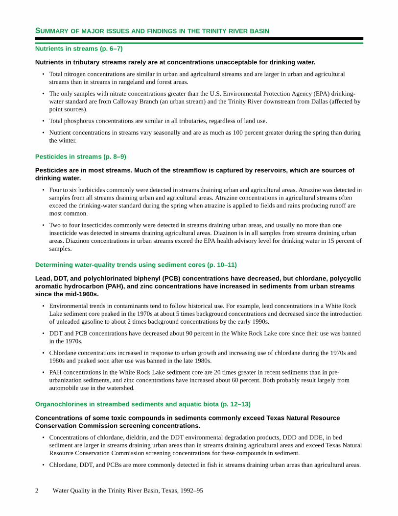
SUMMARY OF MAJOR ISSUES AND FINDINGS IN THE TRINITY RIVER BASIN
Nutrients in streams (p. 6–7)
Nutrients in tributary streams rarely are at concentrations unacceptable for drinking water.
• Total nitrogen concentrations are similar in urban and agricultural streams and are larger in urban and agriculturstreams than in streams in rangeland and forest areas.
• The only samples with nitrate concentrations greater than the U.S. Environmental Protection Agency (EPA) drinkwater standard are from Calloway Branch (an urban stream) and the Trinity River downstream from Dallas (affecpoint sources).
• Total phosphorus concentrations are similar in all tributaries, regardless of land use.
• Nutrient concentrations in streams vary seasonally and are as much as 100 percent greater during the spring thathe winter.
Pesticides in streams (p. 8–9)
Pesticides are in most streams. Much of the streamflow is captured by reservoirs, which are sources of drinking water.
• Four to six herbicides commonly were detected in streams draining urban and agricultural areas. Atrazine was desamples from all streams draining urban and agricultural areas. Atrazine concentrations in agricultural streams oexceed the drinking-water standard during the spring when atrazine is applied to fields and rains producing runomost common.
• Two to four insecticides commonly were detected in streams draining urban areas, and usually no more than oninsecticide was detected in streams draining agricultural areas. Diazinon is in all samples from streams drainingareas. Diazinon concentrations in urban streams exceed the EPA health advisory level for drinking water in 15 pesamples.
Determining water-quality trends using sediment cores (p. 10–11)
Lead, DDT, and polychlorinated biphenyl (PCB) concentrations have decreased, but chlordane, polycyclic aromatic hydrocarbon (PAH), and zinc concentrations have increased in sediments from urban streams since the mid-1960s.
• Environmental trends in contaminants tend to follow historical use. For example, lead concentrations in a White Lake sediment core peaked in the 1970s at about 5 times background concentrations and decreased since the inof unleaded gasoline to about 2 times background concentrations by the early 1990s.
• DDT and PCB concentrations have decreased about 90 percent in the White Rock Lake core since their use wain the 1970s.
• Chlordane concentrations increased in response to urban growth and increasing use of chlordane during the 191980s and peaked soon after use was banned in the late 1980s.
• PAH concentrations in the White Rock Lake sediment core are 20 times greater in recent sediments than in pre-urbanization sediments, and zinc concentrations have increased about 60 percent. Both probably result largely fautomobile use in the watershed.
Organochlorines in streambed sediments and aquatic biota (p. 12–13)
Concentrations of some toxic compounds in sediments commonly exceed Texas Natural Resource Conservation Commission screening concentrations.
• Concentrations of chlordane, dieldrin, and the DDT environmental degradation products, DDD and DDE, in bed sediment are larger in streams draining urban areas than in streams draining agricultural areas and exceed TexaResource Conservation Commission screening concentrations for these compounds in sediment.
• Chlordane, DDT, and PCBs are more commonly detected in fish in streams draining urban areas than agricultur
2 Water Quality in the Trinity River Basin, Texas, 1992–95

nd less ings.
r no result, al
the ambers
a.
sease
t 95
hen ever less
any
, and water allow
ted VOC
ever,
SUMMARY OF MAJOR ISSUES AND FINDINGS IN THE TRINITY RIVER BASIN
Stream-habitat characteristics and fish-community degradation (p. 14–16)
Fish communities are affected by characteristics of streamflow and the structure of physical habitats in the stream channel, in addition to water chemistry. In streams where historical patterns of streamflow have been altered by channelization, degradation in the fish community has occurred.
• Streams in developed urban and agricultural settings generally have more variable streamflow, more degraded adiverse physical habitats, and more degraded fish communities than comparable streams in less-developed sett
• The urban stream West Fork Trinity River in Fort Worth has highly variable streamflow, is channelized with little omeandering, has few woody snags in the stream, and has low woody-species diversity in the riparian zone. As amore nonnative and generally more pollutant-tolerant species of fish are in this stream than in comparable naturstreams.
• The Blackland Prairie stream Chambers Creek is channelized and leveed in its lower reach, which has reduced structural complexity of physical habitat. A high percentage of tolerant fish species are present in this reach of ChCreek.
Use of a new method, semipermeable membrane device (SPMD), to assess the occurrence of water-borne PAHs in streams (p. 17–18)
The SPMD is an effective tool to detect trace organic compounds in water. The small concentrations of many compounds in streams might not be detected by more traditional water-sampling techniques.
• Twenty-five PAHs were detected in SPMDs deployed in urban streams in the Dallas-Fort Worth metropolitan are
• Nine of the PAHs detected by the SPMDs are on the Public Health Service Agency for Toxic Substances and DiRegistry priority list of 275 hazardous substances, and two, benzo(a)pyrene and benzo(b)fluoranthene, are ranked in thetop 10.
Fish-community changes reflect water-quality improvements (p. 19–21)
Improvements in the treatment of wastewater in the Dallas-Fort Worth area from the early 1970s through the mid-1990s have been beneficial to the water quality of the Trinity River.
• Ammonia plus organic nitrogen concentrations in the Trinity River downstream from Dallas have decreased aboupercent from more than 10 milligrams per liter in the 1970s to near trace concentrations in the mid-1990s.
• Dissolved oxygen conditions in the Trinity River downstream from Dallas have improved vastly from the 1970s, woccurrences of nearly no dissolved oxygen were common, to the mid-1990s, when concentrations were almost nthan 5 milligrams per liter.
• The fish community has improved markedly since the mid-1980s when several fishkills occurred. Now (1998), mnative species of fish that were absent in the 1970s have returned to the Trinity River downstream from Dallas.
Quality of ground water in aquifer outcrops (p. 22–23)
Pesticide, volatile organic compound (VOC), and elevated nutrient concentrations were present in some shallow (outcrop) water wells in urban and agricultural areas; however, most samples did not exceed drinking-water standards.
• About 10 to 30 percent of samples from the shallow zone (outcrop) of each of four aquifers contained herbicidesabout 5 to 50 percent contained insecticides. None of the pesticide concentrations in samples of shallow groundexceeded drinking-water standards or health advisory levels. Thirteen percent of nitrate concentrations in the shzone of the Woodbine aquifer exceeded the EPA standard for drinking water.
• VOCs were detected in one or more samples from each of the four aquifers sampled. The most commonly detecwas MTBE, a gasoline additive, in the urban part of the Woodbine aquifer.
• None of the samples from the Trinity aquifer exceeded EPA maximum contaminant levels for drinking water; howthe insecticide diazinon was detected in nearly one-half the samples.
U.S. Geological Survey Circular 1171 3

l and nd aqui- others, and ga
ENVIRONMENTAL SETTING AND HYDROLOGIC CONDITIONS IN THE TRINITY RIVER BASIN
The environmental setting is an integration of many physical and hydrologic features and human activities. Physicahydrologic features include location, topography, physiography, geology, soils, climate, natural vegetation, streams, afers. A classification of Integrated Land Resource Units characterizes the physical and hydrologic features (Ulery and1993). Past and current human activities, including construction of reservoirs, urbanization, farming, ranching, and oil s production, have greatly altered the natural environment in the Trinity River Basin.
33
96
98
o
o
o
.
Dallas-Fort Worthmetropolitan area
North Central Prairie: The terrain is nearly level to hilly and covered with natural vegetation, which mostly is prairie grass. However, brush has encroached into much of the area. Substantial amounts of oil and gas are produced in the area. The principal agricultural product is cattle.
4
32o
h
Western and Eastern Cross Timbers: The terrain is hilly and oak trees are a prominent feature, especially when contrasted with prairies immediately to theeast and west of each of these areas. Thearea is suitable for raising cattle. The Eastern Cross Timbers between Fort Wortand Dallas has been urbanized.
Water Quality in the Trinity R
97o
Grand Prairie: The terrain is characterized by nearly level plains and rolling hills and is naturally devoid of trees except along streamsMuch of Fort Worth is located on the Grand Prairie.
iver Basin, Texas, 1992–95
31o
0 20 40
Blackland Prairie: The terrain varies from nearly level to rolling hills, has very fertile soils, and, in its natural state, is largely a grassy plain except along the streams. Much of the area has been cultivated in the past; however, a large part of the cultivated acreage has been converted back to pasture for cattle grazing. Much of the Dallas metropolitanarea is on the Blackland Prairie.
95o
Texas Claypan: The terrain is mostly rolling hills. The natural vegetation is mostly prairie grasses and oaks. Agriculture is dominated by cattle ranching. Lignite coal is mined locally andis used to fuel nearby electric power plants.
o30
60 MILES
Eastern Timberlands: The terrain varies from a rolling plain to gently rolling hills. The area is noted for piney woods and produces nearly all the commercial timber in Texas. The area also is a major producer of oil and gas. Perennial streams are prevalent.
d
g.
0 20 40 60 KILOMETERS
Coastal Prairie and Marsh: The area is very flat. Natural vegetation is prairie grasses with stands of hardwoods and pines. The area is extensively cultivatefor growing rice. However, much of the cultivated acreage is being converted to pasture for cattle grazinOil and gas also are produced in the area.
Bottomlands: The Bottomlands lie along the Trinity River and the lower reaches of major tributaries. Many reservoirs in the Trinity River Basin have greatly reduced the historical magnitude and frequency of floods in the Bottomlands.
he large built for hater is
Surface water, almost entirely from reservoirs, supplies more than 90 percent of the water used in the basin. With tpopulation and concentration of businesses and industries in the Dallas-Fort Worth area, many reservoirs have been water supply and flood protection. Relatively little water is used for irrigating crops. Aquifers outcrop in all or parts of te Western and Eastern Cross Timbers, Eastern Timberlands, Texas Claypan, and Coastal Prairie and Marsh. Ground wused for municipal and domestic supply in some of the smaller towns and in rural areas.

varies rt to rshed, logic con-
ion and
s reatest d more er 1994
ain y. Water e levels lled by
tative of
ENVIRONMENTAL SETTING AND HYDROLOGIC CONDITIONS IN THE TRINITY RIVER BASIN
Hydrologic conditions in the Trinity River Basin are best characterized by precipitation and streamflow. Precipitationconsiderably across the Study Unit, with average annual rainfall ranging from about 27 inches in the northwestern paabout 52 inches in the southeastern part. Streamflow generally is proportional to precipitation and the size of the wateexcept downstream from reservoirs and point sources such as wastewater-treatment plants. To characterize the hydroditions in the Trinity River Basin during the March 1993–September 1995 intensive sampling phase, monthly precipitatdaily streamflow from October 1992 to September 1995 at selected stations are graphed and interpreted.
Precipitation: Essentially all the precipitation in the Trinity River Basin is rain. At the three selected precipitation siteacross the basin, rainfall was about normal in 1993 and 1994 and about one-third greater than normal in 1995. The gflooding occurred in October 1994 in the southern part of the study area where 18.5 inches was recorded in 1 day anthan 26 inches in 3 days. The rainfall data suggest that water-quality data collected during and shortly after the Octob flood would reflect unusual hydrologic conditions.
Streamflow: Two stream configurations are in the Trinity River Basin; one is tributary streams and the other is the mstem of the Trinity River. Much of the water in tributary streams is captured by reservoirs and becomes a water supplin the main stem provides water to Lake Livingston, also used for water supply, and to coastal bays and estuaries. Thhydrographs for two tributaries, Big Sandy Creek and Chambers Creek, show streamflow decreases to relatively low each year during the summer. Flow in the Trinity River at Romayor, about 70 miles upstream from the mouth, is controreleases from Lake Livingston. The hydrographs indicate that data collected during the sampling period are represennormal conditions, except during 1995 in the lower reach of the Trinity River when flows were well above average.
96
98
97
o
o
o30
31o
95
32o
o
o
o
33
0 20 40 60 MILES
0 20 40 60 KILOMETERS
0
and water tored ers.
and
1993 1994 19951
100,000
10
100
1,000
10,000
EXPLANATION
Daily mean streamflow
Average streamflow for period of record
Average discharge for October–September
1993 1994 19951
100,000
10
100
1,000
10,000
1993 1994 19951
100,000
10
100
1,000
10,000
08064100
08044000
08066500
ST
RE
AM
FLO
W, I
N C
UB
IC F
EE
T P
ER
SE
CO
ND
PE
R D
AY
1993 1994 19950
15
5
10
EXPLANATION
Monthly precipitation
Average precipitation for 1961–90
Average precipitation for October–September
1993 1994 19950
15
5
10
1993 1994 1995
15
5
10
Jacksboro
Corsicana
Liberty 29.59
PR
EC
IPIT
AT
ION
, IN
INC
HE
S
Trinity River at Romayor
Big Sandy Creek near Bridgeport
Chambers Creek near Rice
Jacksboro Fort Worth
Corsicana
Dallas
Liberty
08066500
08064100
08044000
LAKE LIVINGSTON
Streamflow-gaging station
Reservoirs: There are 22 reservoirs in the Trinity River Basin with more than10,000 acre-feet of storage and hundreds of smaller reservoirs, mostly flood-control structures built by the Natural Resources Conservation Service (Ulery others, 1993). These reservoirs have an appreciable effect on streamflow and quality in the basin. They tend to increase base flow in streams by releasing swater during dry periods. They tend to reduce flood peaks by storing floodwatThey affect water quality by trapping sediment and associated nutrients and contaminants and by altering the stream habitat both in the flooded lake area downstream.
U.S. Geological Survey Circular 1171 5
6 Water Quality in the Trinity River Basin, Texas, 1992–95
o
31
95
33
96
98
97
32
o
o
o
o
o
o
o
30
0 20 40 60 MILES
0 20 40 60 KILOMETERS
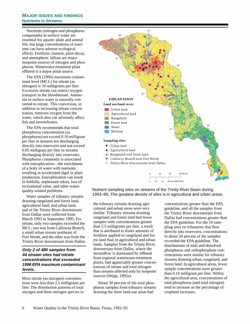
Nutrients (nitrogen and phosphoruscompounds) in surface water areessential for aquatic plant and animallife; but large concentrations of nutri-ents can have adverse ecologicaleffects. Fertilizer, manure, plant decay,and atmospheric fallout are majornonpoint sources of nitrogen and phos-phorus. Wastewater-treatment planteffluent is a major point source.
The EPA (1996) maximum contam-inant level (MCL) for nitrate (asnitrogen) is 10 milligrams per liter.Excessive nitrate can restrict oxygentransport in the bloodstream. Ammo-nia in surface water is naturally con-verted to nitrate. This conversion, inaddition to increasing nitrate concen-tration, removes oxygen from thewater, which also can adversely affectfish and invertebrates.
The EPA recommends that totalphosphorus concentration (asphosphorus) not exceed 0.10 milligramper liter in streams not dischargingdirectly into reservoirs and not exceed0.05 milligram per liter in streamsdischarging directly into reservoirs.Phosphorus commonly is associatedwith eutrophication—the enrichmentof a body of water with nutrientsresulting in accelerated algal or plantproduction. Eutrophication can resultin fishkills, unpleasant odors, loss ofrecreational value, and other water-quality-related problems.
Water samples of tributary streamsdraining rangeland and forest land,agricultural land, and urban land,and of the Trinity River downstreamfrom Dallas were collected fromMarch 1993 to September 1995. Fornitrate, only two samples exceeded theMCL; one was from Calloway Branch,a small urban stream northeast ofFort Worth, and the other was from theTrinity River downstream from Dallas.
Only 2 of 480 samples from44 stream sites had nitrateconcentrations that exceeded1996 EPA maximum contaminantlevels.
Most nitrate (as nitrogen) concentra-tions were less than 2.5 milligrams perliter. The distribution patterns of totalnitrogen and three nitrogen species in
the tributary streams draining agri-cultural and urban areas were verysimilar. Tributary streams drainingrangeland and forest land had fewersamples with concentrations greaterthan 2.5 milligrams per liter, a resultthat is attributed to lesser amounts offertilizer applied in rangeland and for-est land than in agricultural and urbanlands. Samples from the Trinity Riverdownstream from Dallas, where thestreamflow is dominated by effluentfrom regional wastewater-treatmentplants, had appreciably greater concen-trations of nitrate and total nitrogenthan streams affected only by nonpointsources (Shipp, 1995a).
About 30 percent of the total phos-phorus samples from tributary streamsdraining the three land-use areas had
concentrations greater than the EPAguideline, and all the samples fromthe Trinity River downstream fromDallas had concentrations greater thanthe EPA guideline. For the 10 sam-pling sites on tributaries that flowdirectly into reservoirs, concentrationsin about 50 percent of the samplesexceeded the EPA guideline. Thedistributions of total and dissolvedphosphorus and orthophosphate con-centrations were similar for tributarystreams draining urban, rangeland, andforest land. In agricultural areas, fewersample concentrations were greaterthan 0.10 milligram per liter. Withinthe agricultural area, concentrations oftotal phosphorus (and total nitrogen)tend to increase as the percentage ofcropland increases.
Nutrient sampling sites on streams of the Trinity River Basin during1993–95. The greatest density of sites is in agricultural and urban areas.
MAJOR ISSUES AND FINDINGSNutrients in Streams
Urban landAgricultural landRangelandForest landWaterWetland
Urban landAgricultural landRangeland and forest land
Trinity River downstream from Dallas
Sampling sites
Land use/land cover
EXPLANATION
Calloway Branch near Fort Worth

U.S. Geological Survey Circular 1171 7
MAJOR ISSUES AND FINDINGSNutrients In Streams
The largest nutrient concentra-tions were downstream fromwastewater point sources, andthe smallest nutrient concentra-tions were immediately down-stream from reservoirs.
Total nitrogen and total phosphorusconcentrations show noticeable sea-sonal patterns (Land and Shipp, 1996).Median total nitrogen concentrationsincrease from midwinter to midspring,decline in the summer, and increaseagain in the fall; median total phospho-rus concentrations follow a generallysimilar pattern. Because much greateramounts of fertilizer are applied in thespring than in other seasons, the timing
Dissolved Ammonia
Total Ammonia Organic Nitrogen
Nitrate
Total Nitrogen
Dissolved Ammonia
Total Ammonia Organic Nitrogen
Nitrate
Total Nitrogen
Dissolved Ammonia
Total Ammonia Organic Nitrogen
Nitrate
Total Nitrogen
Dissolved
Total ammonia +
Nitrate nitrogen
Total nitrogen
NIT
RO
GE
N
Rangeland Urban land Trinity River down-Agricultural land
ammonia nitrogen
organic nitrogen
1000 50
Dissolved Orthophosphate
Dissolved Phosphorus
Total Phosphorus
Dissolved Orthophosphate
Dissolved Phosphorus
Total Phosphorus
Dissolved Orthophosphate
Dissolved Phosphorus
Total Phosphorus
1000 50
Dissolved
Dissolved
Total
PH
OS
PH
OR
US
PERCENTAGE OF SAMPLES1000 50 1000 50
orthophosphate
phosphorus
phosphorus
Concentration, in
Less than 0.25
0.25 to 2.5
Greater than 2.5
EXPLANATION
milligrams per liter
Less than 0.01
0.01 to 0.1
Greater than 0.1
Distributions of nitrogen and phosphorus concentrations in streams of the Trinity River Basin during 1993–95reflect agricultural and urban land-use practices.
and forest land stream from Dallas
An algal bloom in Richland Creekis indicative of excess nutrients.
Seasonality of nitrogen and phosphorus concentrations in streams of theTrinity River Basin during 1993–95. Each bar shows the range between the10th and 90th percentiles. The black line in each bar shows the monthlymedian concentration as a percentage of the annual median.
Total phosphorusTotal nitrogen
J F M A M J J A S O N DMONTH
10
10,000
20
50
100
200
500
1,000
2,000
5,000
PE
RC
EN
TA
GE
OF
AN
NU
AL
J F M A M J J A S O N DMONTH
Total nitrogen Total phosphorus
ME
DIA
N C
ON
CE
NT
RA
TIO
N
of the applications would seem to bethe major reason for increases in con-centrations in the spring. However,total nitrogen and (especially) totalphosphorus concentrations werefound to relate more closely to stream-flow than to fertilizer applications.Monthly mean streamflow usuallypeaks in the spring, declines in thesummer, and rises to a lesser peak inthe fall.
Nutrient concentrations at mostsampling sites did not changeappreciably from 1974 to 1991.
Nutrient concentrations at mostsampling sites did not change appre-ciably from 1974 to 1991 (Van Metre
and Reutter, 1995). The exceptionsare five sites downstream from majorwastewater-treatment plants in theDallas area. As a result of upgradesto the treatment plants, ammonia plusorganic nitrogen at the samplingsites decreased about 95 percent;concurrently, nitrate increased by asimilar magnitude. The decrease inammonia has led to an increase in dis-solved oxygen, which reduces thethreat of fishkills downstream from thewastewater-treatment plants.

8 Water Quality in the Trinity River Basin, Texas, 1992–95
o
31
95
33
96
98
97
32
o
o
o
o
o
o
o
30
0 20 40 60 MILES
0 20 40 60 KILOMETERS
Pesticides (herbicides, insecticides,and fungicides) are present in streamsthroughout the basin (Shipp, 1995b;Ulery and Brown, 1995). Herbicidesare used to control nuisance plants. Inagricultural areas, they commonly areapplied to the soil in late winter orearly spring and during the growingseason to improve crop yields andquality. In urban areas, they are used tocontrol weeds in lawns and unwantedvegetation along streets and highwaysto improve safety and reduce mainte-nance. Insecticides are used to controlinsects that might damage crops, land-scaping, and buildings or cause diseasein humans and animals. Modern insec-ticides are designed to decompose intoless harmful products faster than manyolder insecticides. Fungicides are usedto control plants such as molds andmildews. Even though pesticides arevery useful, they can be harmful tohumans, domestic animals and wild-life, desirable plants and insects, andwhole ecosystems.
In most streams of the Trinity Basin,herbicides are more prevalent thaninsecticides—the number of herbicidedetections was greater than the numberof insecticide detections. The mostcommonly detected herbicide in 284samples collected from March 1993 toSeptember 1995 is atrazine. Atrazinetypically is used on fields of corn, hay,and sorghum and on lawns. Atrazinewas detected in about one-half the 38samples from 17 rangeland and foreststream sites, in more than 95 percent ofthe 148 samples from 15 agriculturalstream sites, in all 75 samples from
About 6 percent of 277 samplesfrom 44 stream sites had concen-trations of atrazine, the mostcommonly detected herbicide,that exceeded the 1996 EPA MCL.
11 urban stream sites, and in all 16samples from a site on the TrinityRiver downstream from Dallas. TheEPA 1996 MCL for atrazine is 3.0micrograms per liter. Generally, theagricultural stream samples had largeratrazine concentrations than samplesfrom rangeland and forest streams,urban streams, or the Trinity Riverdownstream from Dallas. About 12percent of the agricultural stream sam-
ples had atrazine concentrationsgreater than the MCL; none of thesamples from rangeland and foreststreams, urban streams, and the TrinityRiver downstream from Dallas hadatrazine concentrations greater thanthe MCL.
Atrazine concentrations show a sea-sonal pattern. Concentrations tend torise to seasonal highs in the spring andthen decline to seasonal lows that lastfrom late summer through midwinter(Land and Brown, 1996). The medianatrazine concentration among all sam-ples was 0.26 microgram per liter. Thehighest monthly median concentration,in April, was about 70 percent of theMCL for atrazine; monthly medianconcentrations from late summer tomidwinter were less than one-tenth ofthe April median concentration.
The most commonly detected insec-ticide in the 277 samples was diazinon.Diazinon generally is applied to lawns,gardens, and landscaped areas. Diazi-non was detected in about one-half ofthe rangeland and forest samples andagricultural samples, in all the urbansamples, and in about 90 percent of theTrinity River downstream from Dallassamples. The EPA 1996 lifetime healthadvisory (HA) (the concentration indrinking water that is not expected tocause any adverse noncarcinogeniceffects over a lifetime of exposure) fordiazinon is 0.6 microgram per liter.
About 4 percent of 277 samplesfrom 44 stream sites had concen-trations of diazinon, the mostcommonly detected insecticide,that exceeded the 1996 EPA HA.
Urban landAgricultural landRangelandForest landWaterWetland
Urban landAgricultural landRangeland and forest landTrinity River downstream from Dallas
Sampling sites
Land use/land cover
EXPLANATION
Pesticide sampling sites on streams of the Trinity River Basin during1993–95. The greatest density of sites is in agricultural and urban areas.
MAJOR ISSUES AND FINDINGSPesticides in Streams
Richland-Chambers Reservoir

U.S. Geological Survey Circular 1171 9
Seasonality of atrazine and diazinon concentrations in streams of theTrinity River Basin during 1993–95 reflects the timing of applications andrunoff. Each bar shows the range between the 10th and 90th percentiles.The black line in each bar shows the monthly median concentration as apercentage of the annual median.
Generally, diazinon concentrations arelarger in urban stream samples than instream samples from other settings.About 15 percent of the diazinon con-centrations in the urban streamsexceeded the HA.
Diazinon concentrations do notshow a distinct seasonal pattern. Themedian diazinon concentration amongall samples was 0.008 microgram perliter. None of the monthly medianconcentrations exceeded the HA fordiazinon.
Pesticides other than atrazine anddiazinon also are commonly detectedin basin streams. Twenty-threedifferent herbicides were detected inrangeland and forest streams, 19 inagricultural streams, and 24 in urbanstreams. Among herbicides other thanatrazine, prometon was detected inalmost 40 percent of the agriculturalstream samples and in more than 90percent of the urban stream samplesat concentrations well below its1996 EPA HA of 100 microgramsper liter. Metolachlor and simazinewere detected in more than one-halfthe samples from agricultural andurban streams and from the TrinityRiver downstream from Dallas, eachat concentrations below its respective1996 EPA HA (for metolachlor) andMCL (for simazine).
Five different insecticides weredetected in rangeland and foreststreams, 10 in agricultural streams, and
10 in urban streams. Among insecti-cides other than diazinon, carbaryl andchlorpyrifos were detected in slightlymore than 60 percent of the urban trib-utary stream samples, each of thosecompounds at concentrations below itsrespective 1996 EPA HA.
Although the concentrations of indi-vidual pesticides in most samples wereless than EPA MCLs and HAs, someconcerns remain. One involves pesti-cide concentrations in reservoirs: Inthe Trinity River Basin, nearly allstreamflow is captured by reservoirs,many of which provide drinking waterto urban areas. Pesticide concentra-tions in reservoirs could be greater
than average concentrations in inflow-ing streams because much of theannual inflow to reservoirs occurs inthe spring when runoff and pesticideuse are greatest. For example, fivesamples from Richland-ChambersReservoir collected in 1995 containedfrom six to eight pesticides each, andthe three samples collected in June,after spring runoff, had atrazine con-centrations of about 3 micrograms perliter (Land, 1997). Another concerninvolving pesticides in drinking wateris that there is a lack of understandingof the toxicity of combinations of pes-ticides. Current EPA MCLs and HAsare only for individual compounds.
Distributions of selected herbicides and pesticides in streams of the Trinity River Basin during 1993–95 are relatedto land-use practices.
2,4-DAlachlorAtrazine
FluometuronMetolachlor
MetribuzinMolinate
PendimethalinPrometon
PropanilSimazine
TebuthiuronThiobencarb
Trifluralin
Rangeland Agricultural land Urban land Trinity River down-H
ER
BIC
IDE
S
0 10050 0 10050 0 10050 0 10050
CarbarylCarbofuran
Chlorpyrifosp,p'-DDEDiazinonDieldrin
MalathionINS
EC
TIC
IDE
S
PERCENTAGE OF SAMPLES
EXPLANATION
Detected and less than 0.1
0.1 to 1.0
Greater than 1.0
Detected and less than 0.1
0.1 to 1.0
Greater than 1.0
Concentration, in micrograms per liter
More than 10 percent ofsamples exceed 1996EPA MCL or HA
J F M A M J J A S O N SMONTH
1
10,000
2
51020
50100200
5001,0002,000
5,000
PE
RC
EN
TA
GE
OF
AN
NU
AL Atrazine
Insu
ffici
ent d
ata
J F M A M J J A S O N DMONTH
10
10,000
20
50
100
200
500
1,000
2,000
5,000Diazinon
Insu
ffici
ent d
ataMCL
HA
MAJOR ISSUES AND FINDINGSPesticides in Streams
ME
DIA
N C
ON
CE
NT
RA
TIO
N
and forest land stream from Dallas

WH
ITE
RO
CK
LA
KE
Coring location
0 0.5 1 MILE
0 0.5 1 KILOMETERW
hiteR
ock
Cr. Urban land, 1990
a
Undeveloped land
MAJOR ISSUES AND FINDINGSDeterminin g Water-Qualit y Trends Usin g Sediment Cores, White Rock Lake, Dallas
White Rock Lake was built in 1912 at a time when agriculture dominated land use. Since that time, the water-shed has been incorporated into the growing Dallas metropolitan area. In 1935, urban land use in the watershedwas 6 percent; by 1990, urban land use was 72 percent. The watershed is100 square miles, and the surface areof the reservoir is 1.7 square miles. Sedimentation in the reservoir since itsconstruction has reduced its storage capacity by one-half.
0 4 8 MILES
0 4 8 KILOMETERS
White Rock Creek Basin
to
-of h
-
e
0 20 1
CESIUM-137, INPICOCURIES PER GRAM
0
140
0
20
40
60
80
100
120DE
PT
H IN
CO
RE
, IN
CE
NT
IME
TE
RS
Nondetections
1912Reservoir built
1952Cesium first detected
1963Cesium peaks
1994Core collected
Cores are collected by lowering the coring tool from the 15-foot aluminum A-frame on a custom-built pontoon boat.
Removal of a 5-centimeter subsample of the sediment core for laboratory analysis.
Cesium-137, a by-product of nuclear testing, was used to date sections of reservoir sediment from the core.
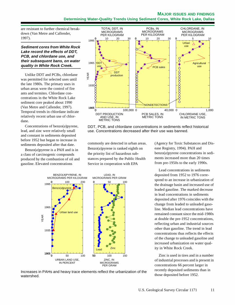
Sediment cores were collected neathe dam from a pontoon boat. The reservoir sediment has a large water content relative to the pre-reservoir sediment, which was dry and crumbly.The cores, measured in centimeters (2.54 centimeters = 1 inch), were sliced into 2- to 5-centimeter sections that were analyzed for a number of constituents, including trace elementsorganochlorine compounds, and poly-cyclic aromatic hydrocarbons (PAHs).
Age-dating of core sediments was done by analysis of their cesium-137 content. Cesium-137 is a by-product
10 Water Quality in the Trinity Rive
r
,
of nuclear weapons testing. It first occurred in the atmosphere in about 1952 and peaked during 1963–64. It adsorbs strongly to fine-grained sediments and therefore can be used determine the time of deposition of sediments that have been exposed toatmospheric fallout. Cesium-137 first was detected in White Rock Lake coresediments at a depth of 60 to 63 centimeters (1952) and peaked at a depth 48 to 51 centimeters (1963). The deptof the interface between pre-reservoirand reservoir sediment, 136 centime-ters, corresponds to the reservoir construction date (1912), and the top of the core corresponds to the sampling date (July 1994).
r Basin, Texas, 1992–95
Trends in DDT and PCBs in the White Rock Lake core coincide with historical use of these compounds. Usof the insecticide DDT peaked in the early 1960s before being banned by the EPA in 1972. Annual sales of PCBs, which have a variety of indus-trial uses, peaked in 1970. The EPA placed a voluntary ban on their use in1973 and a complete ban in 1979. PCBs, DDT, and the DDT environ-mental degradation products DDE andDDD adsorb strongly to sediments and
-
-
-
TOTAL DDT, INMICROGRAMS
PCBs, IN
MAJOR ISSUES AND FINDINGSDeterminin g Water-Qualit y Trends Usin g Sediment Cores, White Rock Lake, Dallas
DDT, PCB, and chlordane concentrations in sediments reflect historical use. Concentrations decreased after their use was banned.
DDT PRODUCTIONAND USE, IN
METRIC TONS
PCB SALES, INMETRIC TONS
0 100 5
CHLORDANE, IN MICROGRAMS
0 1,000CHLORDANE USE,IN METRIC TONS
0 300 10 20
1905
1995
1905
1935
1965
0 100,0000
0 300 10 20
0 40,000
Agriculturaluse
Urbanuse
DDTuse
DDTproduction
PCB sales
NONDETECTIONS
YE
AR
PER KILOGRAM PER KILOGRAMMICROGRAMS
PER KILOGRAM
are resistant to further chemical breakdown (Van Metre and Callender, 1997).
Sediment cores from White Rock Lake record the effects of DDT, PCB, and chlordane use, and their subsequent bans, on water quality in White Rock Creek.
Unlike DDT and PCBs, chlordane was permitted for selected uses until the late 1980s. The primary uses in urban areas were the control of fire ants and termites. Chlordane con-centrations in the White Rock Lake sediment core peaked about 1990 (Van Metre and Callender, 1997). Temporal trends in chlordane indicaterelatively recent urban use of chlor-dane.
Concentrations of benzo(a)pyrene, lead, and zinc were relatively small and constant in sediments deposited before 1952 but began to increase in sediments deposited after that date.
Benzo(a)pyrene is a PAH and is in a class of carcinogenic compounds produced by the combustion of oil andgasoline. Elevated concentrations
Increases in PAHs and heavy trace elewatershed.
0 2000 100
BENZO(A)PYRENE, INMICROGRAMS PER KILOGRA
1905
1995
1905
1935
1965
YE
AR
0 1000 50
URBAN LAND USE,IN PERCENT
Urban land use
Benzo(a)pyrene
commonly are detected in urban areasBenzo(a)pyrene is ranked eighth on the priority list of hazardous sub-stances prepared by the Public HealthService in cooperation with EPA
U.S. Ge
f of e
- s ,
s d
r n
ments reflect the urbanization of the
M
0 1000 50
LEAD, INMICROGRAMS PER GRAM
50 15050 100
ZINC, IN MICROGRAMS
Lead Zinc
PER GRAM
(Agency for Toxic Substances and Disease Registry, 1994). PAH and benzo(a)pyrene concentrations in sediments increased more than 20 times from pre-1950s to the early 1990s.
Lead concentrations in sediments deposited from 1952 to 1976 corre-spond to an increase in urbanization othe drainage basin and increased use leaded gasoline. The marked decreasin lead concentrations in sediments deposited after 1976 coincides with thechange from leaded to unleaded gasoline. Median lead concentrations haveremained constant since the mid-1980at double the pre-1952 concentrationsreflecting urban and industrial sourcesother than gasoline. The trend in leadconcentrations thus reflects the effectof the change to unleaded gasoline anincreased urbanization on water qual-ity in White Rock Creek.
Zinc is used in tires and in a numbeof industrial processes and is present iconcentrations 66 percent larger in recently deposited sediments than in those deposited before 1952.
.
ological Survey Circular 1171 11

12 Water Quality in the Trinity River Basin, Texas, 1992–95
30o
31o
95o
32 o
33 o
96
98
o
o
97 o
Dallas
Fort Worth
Corsicana
Denton
McKinney
Waxahachie
LAKE LIVINGSTON
TRINITY BAY0 20 40 60 MILES
0 20 40 60 KILOMETERS
Urban land
Agricultural land
Rangeland
Forest land
Water
Wetland
EXPLANATIONLand use/land cover
Data-collection sites
Use of organochlorine pesticidesand PCBs was widespread beginningin the 1940s until bans and use restric-tions were placed on these compoundsin the 1970s and 1980s. Organochlo-rine compounds tend to be persistent inthe environment. Compounds such aschlordane, DDT and its environmentaldegradation products (DDD andDDE), and PCBs are water insoluble,are strongly associated with organiccarbon and fine sediment, and havelong half-lives. Organochlorine com-pounds were selected by NAWQA forassessment because these compoundsare not metabolized rapidly andbecause they have high bioaccumula-tion and bioconcentration factors(Crawford and Luoma, 1993).
The distribution of organochlorinecompounds in streambed sedimentsand biota is, in part, a reflection of thehistorical applications of pesticides.In the Trinity River Basin, pesticideuses were concentrated in agriculturalareas, particularly the BlacklandPrairie (Ulery and Brown, 1995), andin urban settings such as the Dallas-Fort Worth metropolitan area.
Surficial streambed-sediment andaquatic-biota samples were collectedat 16 sites in the Trinity River Basinduring late winter 1992 and earlyspring 1993 (Moring, 1997). Sites onTrinity River tributaries were chosento reflect general urban, agricultural,rangeland, and forest land-use areas.Aquatic-biota samples from tributarysites werecorbicula (asiatic clams).Four Trinity River main-stem sites alsowere selected. Becausecorbicula werescarce at the main-stem sites, aquatic-biota samples at these sites were com-mon carp and blue catfish.
Overall, more organochlorinecompounds were detected insediment than in biologicaltissues; however, certainorganochlorines like chlordaneand PCBs were detected morefrequently in aquatic biota thansediment.
Organic compounds containedin chlordane (the sum of all chlordaneand nonachlor compounds and oxy-chlordane), an insecticide typicallyused for the extermination of termitesand fire ants, were more commonlydetected in urban streams both intissues and in sediment. The DDT deg-radation products, DDD and DDE,were more commonly detected in tis-sues at agricultural sites and morecommonly detected in sediment aturban sites.
At least one concentration of eachof nine organochlorine pesticidesexceeded the TNRCC screening levelsfor these pesticides in streambed
sediments (Texas Natural ResourceConservation Commission, 1996).These screening levels are based onthe 85th-percentile concentration fromstatewide historical data and are nothealth or toxicity based. Each exceed-ance represents 1 of the 16 sitessampled. Concentrations of the insecti-cide dieldrin more frequently exceededthe TNRCC screening level than didconcentrations of any other organo-chlorines. Urban sites, more than agri-cultural or Trinity River main-stemsites, had concentrations that exceededthe screening levels for chlordane,dieldrin, DDD, DDE, and DDT. Sincetheir use in agriculture was restricted
Land-use and streambed-sediment and aquatic-biota collection sites in theTrinity River Basin, Texas.
MAJOR ISSUES AND FINDINGSOrganochlorines in Streambed Sediments and Aquatic Biota

U.S. Geological Survey Circular 1171 13
Aldrin Chlordane Dieldrin DDD DDE DDT Endrin Hepta- Heptachlor
ORGANOCHLORINE PESTICIDE
0
40
0
10
20
30
PE
RC
EN
TA
GE
OF
SIT
ES Main-stem sites
Urban sites
Agricultural sites
chlor epoxide
Percentage of sites with organochlorine concentrations in sediments thatexceed TNRCC screening levels reflects major land uses and location onthe main-stem Trinity River.
0 20 40 60 80 100
PERCENTAGE OF SITES WITH DETECTIONS
cis-Chlordane
trans-Chlordane
DCPA (Dacthal)
o,p'-DDD
p,p'-DDD
o,p'-DDE
p,p'-DDE
o,p'-DDT
p,p'-DDT
Dieldrin
Endrin
alpha-HCH
beta-HCH
delta-HCH
gamma-HCH (lindane)
Heptachlor
Heptachlor epoxide
Hexachlorobenzene
o,p'-Methoxychlor
p,p'-Methoxychlor
Mirex
cis-Nonachlor
trans-Nonachlor
Oxychlordane
PCBs, total
Pentachloroanisole
Toxaphene
OR
GA
NO
CH
LOR
INE
CO
MP
OU
ND
PP
P
P
P
P
P
P
PP
P
O
O
O
P
P
P
P
P
P
PP
P
P
PCB
PP
0 20 40 60 80 100
PERCENTAGE OF SITES WITH DETECTIONS
Toxaphenetrans-Permethrin
cis-PermethrinPentachloroanisole
PCBs, totalOxychlordane
trans-Nonachlorcis-Nonachlor
Mirexp,p'-Methoxychloro,p'-Methoxychlor
IsodrinHexachlorobenzeneHeptachlor epoxide
Heptachlorgamma-HCH (lindane)
delta-HCHbeta-HCH
alpha-HCHEndrin ketone
Endrin aldehydeEndrin
Endosulfan sulfateEndosulfan IIEndosulfan I
Dieldrinp,p'-DDTo,p'-DDTp,p'-DDEo,p'-DDEp,p'-DDDo,p'-DDD
DCPA (Dacthal)trans-Chlordane
cis-ChlordaneAldrin
OR
GA
NO
CH
LOR
INE
CO
MP
OU
ND
PPP
PP
P
P
P
P
P
P
P
P
P
OO
PPP
PP
P
O
OO
O
P
PP
PP
PPP
P
PCB
IN BIOLOGICAL TISSUE IN STREAMBED SEDIMENT
AGRICULTURAL SITESURBAN SITES
P
PCB
O
ORGANOCHLORINE
POLYCHLORINATED
OTHER ORGANO-CHLORINE COMPOUND
PESTICIDE
BIPHENYL
AGRICULTURAL SITESURBAN SITES
P
PCB
O
ORGANOCHLORINE
POLYCHLORINATED
OTHER ORGANO-CHLORINE COMPOUND
PESTICIDE
BIPHENYL
in the 1970s, chlordane and dieldrinwere more extensively used in urbansettings. However, DDT commonlywas used for pest control in agricul-tural crops before its ban in 1972.The larger concentrations of DDD,DDE, and DDT in urban stream sedi-ments of the Trinity River Basin couldbe a result of extensive applicationsof DDT in the 1950s and 1960s formosquito control. Aldrin, endrin,heptachlor, and its environmental deg-radation product, heptachlor epoxide,exceeded their respective TNRCCscreening levels only at agriculturalsites in the Trinity River Basin. Aldrin,endrin, and heptachlor were used prin-cipally on crops such as corn, wheat,and cotton.
Percentage of sites with detections of organochlorine compounds during 1992–93 differs according to land-usepractices.
MAJOR ISSUES AND FINDINGSOrganochlorines in Streambed Sediments and Aquatic Biota

14 Water Quality in the Trinity River Basin, Texas, 1992–95
o
o
30
31
95
33
96
98
97
o
o
32
o
o
o
o
0 20 40 60 MILES
0 20 40 60 KILOMETERS
Urban landAgricultural landRangelandForest landWaterWetland
Land use/land cover
EXPLANATION
The USGS NAWQA Program includes an assessment of fish commu-nities as one of the measures of water quality. Because fish communities are strongly influenced by their habitat, instream habitat conditions also are assessed. Combining the habitat data, the biological-community data, and the water-chemistry data provides oppor-tunities for developing a comprehen-sive understanding of the aquatic life
in a stream. Additionally, habitat anal-yses can assist in the identification of limiting physical or chemical factors critical to establishing or maintaining healthy biological communities in the streams.
Stream-habitat characteristics were related to fish-community degradation at three very different stream reaches in the Trinity River Basin. The reaches were chosen to
reflect major differences in environ-mental settings, flow conditions, land uses, and stream biota. West Fork Trinity River is a relatively large stream in an urban area; Chambers Creek is a relatively large stream draining an intensively farmed area; and Menard Creek is considered a reference site (minimally affected by human activities) in the forested lands of southeast Texas.
West Fork Trinity River: The West Fork Trinity River reach is a few miles east of downtown Fort Worth and in the Central Oklahoma/Texas Plains Ecoregion (Omernik, 1987). This reach of the West Fork Trinity River has been channelized and leveed for flood control. The channel substrate is coarse, dominated by cobble and gravel from outcrops of limestone. Flows in the reach respond quickly to precipitation. However, upstream reservoirs tend to moderate low and high flows.
Chambers Creek: The Chambers Creek reach is in the Blackland Prairie Ecoregion, which is the most intensively cultivated ecoregion in the basin. The major crops are cotton, sorghum, corn, and wheat. This region is characterized by heavy clay soils, little relief, and stream chan-nels in the lower part of the basin that have been straightened and leveed for flood control. Streams in this ecoregion respond to heavy pre-cipitation with rapid rises and falls in stage and large sediment loads.
Menard Creek: The Menard Creek reach is in the Western Gulf Coastal Plain Ecoregion and in the National Park Service’s Big Thicket Preserve. Adjacent land use is dominated by silviculture; however, the riparian zone and, to some extent, the flood plain contain secondary vegetative growth that has not been disturbed for many years. The watershed is characterized by acidic sandy soils, little relief, and meandering channels. Floods are atten-uated by flood-plain and riparian vege-tation, and stream stages change gradually.
Land use and land cover and location of selected survey reaches.
MAJOR ISSUES AND FINDINGSStream-Habitat Characteristics and Fish-Community Degradation

U.S. Geological Survey Circular 1171 15
West Fork Trinity River.
Chambers Creek.
Menard Creek.
Stream-habitat characteristics
Stream
Sinuosity
(meandering)
(dimensionless)
Channel
gradient
(feet/mile)
Bank height/
channel
width ratio
(dimensionless)
Density of
woody
vegetation
(dimensionless)
Variation
of monthly
flow index
(dimensionless)
West Fork Trinity River 2.2 6.7 0.75 3.4 39
Chambers Creek 1.1 1.1 .60 7.1 82
Menard Creek 1.9 10.6 .24 20.4 26
Stream-Habitat Characteristics
The physical and chemical charac-teristics of water combined with thephysical features of the stream channelinfluence the presence or absence ofparticular aquatic organisms in astream. Habitat affects species distri-butions at different spatial scales. Forexample, fish-species distribution in astream reach is affected by climate ona regional scale, channel gradient on alocal scale, and particle size of sub-strate at a very detailed scale. Otherimportant factors such as stream mean-dering, steepness of banks, riparianvegetation, and variability of stream-flow affect the habitat for fish in thestream. Not only does stream habitathave to be suitable for a particular spe-cies, it also has to support other biotathat are prey for the species.
The measured habitat characteristicsat the three stream reaches strongly
reflect the differences in habitatamong the reaches. The low bankheight/channel width ratio and highdensity of woody vegetation in theMenard Creek reach create a settingwhere woody snags and logjams pro-vide habitat for fish and an excellentenvironment for biota that supply foodfor fish. The low bank height/channelwidth ratio indicates bank stability anda lack of channel incision or cutting.The high density of woody vegetationmoderates temperature, correspondsto stable banks with little erosion, andprovides a source of organic materialto the stream.
In contrast, the low sinuosity(meandering) and low channel gradi-ent in the Chambers Creek reach couldlimit the number and size of pools andripples that create a variety of habitats.Variety of habitat provides moreopportunity for large numbers andvarieties of species to thrive. The high
MAJOR ISSUES AND FINDINGSStream-Habitat Characteristics and Fish-Community Degradation
variation in flow at Chambers Creek isassociated with more frequent floods,in which organisms can be physicallyharmed or swept away, and more fre-quent very low flows, in which the vol-ume of water is limited and species aresubject to large and rapid changes inthe pH, dissolved oxygen, and temper-ature of the water.
The high bank height/channel widthratio and low density of woody vegeta-tion at the West Fork Trinity River sitecan be attributed to stream channeliza-tion associated with urban flood con-trol. Channelization has resulted in astream reach with little or no woodyriparian vegetation to contribute struc-ture and habitat to the channel. Chan-nelization also causes deeper channelincision, which reduces the amount ofstream-margin habitat for aquaticorganisms.

16 Water Quality in the Trinity River Basin, Texas, 1992–95
Fish-Community Degradation
The evaluation of fish-communitydegradation involved measures ofthe percentage of fish species in areach that (1) are known to be tolerantof severe environmental stresses,(2) are known to be omnivorous,(3) are not native to the stream, and(4) have physical anomalies thatcan be visually detected. The fish-community degradation index is com-puted from the frequency of nonnative,tolerant, and omnivorous individualsat a site and from the frequency ofexternal anomalies observed for eachspecies of fish.
The table shows that MenardCreek, with an index of 6, is theleast degraded of the three reachesdiscussed here. Menard Creek percent-ages are lowest in all the measured cat-
egories. The Menard Creek habitat andquality of water support a robust fishcommunity. The two other reaches,West Fork Trinity River and ChambersCreek, each have an index of 12. Thesetwo reaches are examples of highlyaltered streams characterized byincised and leveed channels, low den-sity of vegetation in the riparian zones,and unstable streamflow characteris-tics. These and other factors, possiblyincluding water-chemistry conditions,have contributed to degraded fishcommunities.
Robust fish communities withmany native species are mostlikely to be present in streamswith a complex habitat andnatural, unaltered flow regimes.
In the West Fork reach, the percent-age of fish with external anomalies isthe greatest among the three reaches.The relatively large incidence of exter-nal anomalies could be related to thequality of water and sediment originat-ing in the urban area. In a separatestudy of organic contamination in bedsediment and tissue of aquatic biota,Moring (1997) reports the occurrenceand degree of contamination in stream-bed sediments and tissues of aquaticbiota in the Trinity River Basin to bemuch greater in urban streams than innon-urban streams.
MAJOR ISSUES AND FINDINGSStream-Habitat Characteristics and Fish-Community Degradation
Fish-community degradation
Stream
Tolerant
species
(percent)
Omnivorous
species
(percent)
Nonnative
species
(percent)
External
anomalies
(percent)
Fish-
community
degradation
index
West Fork Trinity River 50 30 3 2.8 12
Chambers Creek 53 26 0 2.2 12
Menard Creek 37 8 0 .9 6

Fossil Little BearCa l loway
Creek
Br.
CreekC
reek
Cr.
John
son
Com
bs
Rush
Cr.
Cre
ek
Cre
ek
Bear
CreekSycam
ore
BigO
nion
T RINITY
ChambersRIVERCreek
CreekMill C
reek
White
Rock
97 96oo
33o
32 30’o
0 10 20 30 40 MILES
0 10 20 30 40 KILOMETERS
Trinity River
FORT WORTH
DALLAS
downstreamfrom Dallas
West Fork
White Rock Creek
Trinity River
-
e
e
Location of SPMD deployment sites in the Dallas-Fort Worth metropolitan area.
MAJOR ISSUES AND FINDINGSUse of a New Method, Semipermeable Membrane Device (SPMD), to Assess the Occurrence of
Water-Borne Polycyclic Aromatic Hydrocarbons (PAHs) in Streams
PAHs are a group of organic com-pounds that are abundant in the environment and are toxic and often carcinogenic to organisms. Major sources of PAHs are oil spills and the incomplete combustion of fossil fuels.
PAHs are metabolized and excreted by most higher ver-tebrates, particularly fishes, which can make assessment of concentrations in tissues impossible.
SPMD technology (Huckins and others, 1990) is new. An SPMD simu-lates the exposure to and passive uptake of highly lipid-soluble organic compounds by biological membranes.An SPMD typically consists of a long strip of low-density, polyethylene tub-ing filled with a thin film of a purified lipid such as triolein. The long strip of tubing and lipid film provide a large surface area/volume ratio that simu-lates a biological membrane such as afish gill. The SPMDs used in this studyconcentrate PAHs above ambient concentrations in water and simulate bio-logical exposure over a controlled period of deployment.
One site on each of three streams was selected for monitoring the occurrence of PAHs. The sites were chosento reflect varied urban land uses and the influences of point and nonpoint sources of contaminants or PAHs. Themonitoring was done using SPMDs during a 30-day period in late May andJune 1994.
Twenty-five different PAHs were detected in the SPMDs. Twenty-threewere detected at the Trinity River downstream from Dallas and White Rock Creek sites, and 21 were detecteat the West Fork Trinity River site. Seventy-three percent of the PAHs from the White Rock Creek and Trin-ity River downstream from Dallas sitesand 67 percent from the West Fork Trinity River site were substituted
-
d
PAHs—that is, PAHs with one or more substituted alkyl groups attached. The largest concentrations were of unsubstituted (parent) PAHs, such as fluoranthene, chrysene, pyrene, and phenanthrene; concentrations of these PAHs consistently were largest at the White Rock Creek site and smallest at the West Fork Trinity River site.
The Public Health Service Agency for Toxic Substances and Disease Registry (ATSDR), in cooperation with the EPA, has developed a com-prehensive ranking of 275 hazardous substances on the basis of their frequency of occurrence at hazardous waste sites, toxicity, and potential for human exposure (Agency for Toxic Substances and Disease Registry, 1994).
Nine of the PAHs detected by the SPMDs have been ranked as hazardous substances by the Public Health Service. Benzo( a)pyrene and benzo( b)fluoran-thene are ranked in the top 10.
The results of application of SPMDsindicate that aquatic organisms at thresites near Dallas are exposed to toxicPAH compounds. The SPMD is an effective tool to detect hydrophobic organics in water. The small concen-trations of the compounds in the streams might not be detected by mortraditional water-sampling techniques.
U.S. Geological Survey Circular 1171 17

18 Water Quality in the Trinity River Basin, Texas, 1992–95
MAJOR ISSUES AND FINDINGSUse of a New Method, Semipermeable Membrane Device (SPMD), to Assess the Occurrence of Water-Borne Pol ycyclic Aromatic H ydrocarbons (PAHs) in Streams
10 10,000100 1,000
2-Ethylnaphthalene
2,6-Dimethylnaphthalene
1,6-Dimethylnaphthalene
Acenaphthylene
1,2-Dimethylnaphthalene
Acenaphthene
2,3,6-Trimethylnaphthalene
9H-Fluorene
1-Methyl-9H-Fluorene
Dibenzothiophene
Phenanthrene
Anthracene
Acridine
9H-Carbazol
2-Methylanthracene
4,5-Methylenephenanthrene
1-Methylphenanthrene
Anthraquinone
Pyrene
1-Methylpyrene
Benz(a)anthracene
Chrysene
Benzo(b)fluoranthene
Benzo(a)pyrene
Fluoranthene
EXPLANATION
Trinity River downstream from Dallas
West Fork Trinity River
White Rock Creek
CONCENTRATION, IN MICROGRAMS PER KILOGRAM
PAHs were frequently detected in SPMDs deployed in urban streams.
Hazardous PAHs detected in SPMDs
[ASTDR, Agency for Toxic Substances and Disease Registry]
PAHASTDRranking
Benzo(a)pyrene 8
Benzo(b)fluoranthene 10
Benz(a)anthracene 35
Fluoranthene 100
Chrysene 110
Acenaphthene 140
Phenanthrene 188
Pyrene 201
Anthracene 235

MAJOR ISSUES AND FINDINGSFish-Communit y Changes Reflect Water-Qualit y Improvements in the
Trinit y River Downstream from Dallas
Fossil Little BearCa l loway
Creek
Br.
Cr eekC
reek
Cr.
John
son
Com
bs
Rush
Cr.
Cre
ek
Cre
ek
Bear
CreekSycam
ore
BigO
nion
T RINITY
Chambers
RIVERCreek
CreekMill C
reek
White
Rock
97 96oo
33o
32 30’o
0 10 20 30 40 MILES
0 10 20 30 40 KILOMETERS
Trinity River downstream from Dallas
DALLAS
A timeline of change for the Trinity River downstream from Dallas.
1920 1940 1960 1980 20001900
“Mythological river of death”
Primary wastewater-treatment processes begin
Secondary wastewater-treatment processes begin
Federal Clean Water Act, 1972
Upper Trinity River Basin Comprehensive
13 fishkills during 1970–85
Trinity River NAWQA started
Sewage Plan, 1971
.
e
s
The Trinity River downstream from Dallas data-collection site.
In 1925, the Trinity River in the Dallas-Fort Worth area was character-ized by the Texas Department of Health as a “mythological river of death.” With a rapid expansion of industry and population and only pri-mary wastewater treatment beginningin the late 1920s and secondary treat-ment in the mid-1930s, water-quality conditions in the area were poor. Theydid not substantially improve until State and Federal pollution control laws, like the Federal Clean Water Actof 1972, stimulated efforts to address degraded water-quality conditions. The Upper Trinity River Basin Com-prehensive Sewage Plan of 1971 resulted in the construction of large, regional wastewater-treatment plants,elimination of many small, industrial and municipal wastewater-treatment plants, and the upgrading of existing wastewater-treatment plants.
During 1970–85, 13 fishkills were documented in the Trinity River from areach just downstream from Dallas to Lake Livingston in the lower part of the Trinity River Basin. The magni-tude and frequency of the fishkills resulted in a depleted fish community,particularly in the reach of the Trinity River immediately downstream from Dallas. An estimated 1.04 million fish died in these 13 kills. Twelve of the
During 1970–85, more than 1 million fish were killed by water pollution in the Trinity River downstream from Dallas.
13 fishkills were associated with minorflooding on the Trinity River from rainfall in the Dallas-Fort Worth met-ropolitan area. According to the TexasParks and Wildlife Department (TPWD), the probable cause of the kills was the resuspension of bottom sediments and associated organic material during floods that caused an increase in biochemical oxygen demand and a corresponding rapid drop in dissolved oxygen (Davis, 1987). Ironically, improvements in
water quality during the 1970s set the stage for the fishkills by allowing appreciable fish populations to live in this reach of the Trinity River.
How Has the Water Qualit y Improved?
Dissolved oxygen, measured as milligrams of oxygen per liter of water, has increased from lows of near zero in the early 1970s to highs of more than 10 milligrams per liter in 1996. Notable improvement in dis-solved oxygen concentrations in the Trinity River downstream from Dallas
began in the late 1970s and continuedthrough the 1980s and into the 1990sDissolved oxygen was consistently recorded above the TNRCC (Texas Natural Resource Conservation Commission, 1996) dissolved oxygencriterion for the support of aquatic life (5.0 milligrams per liter) beginning in the late 1980s. The improvement in dissolved oxygen concentrations is attributable to improvements in wastewater-treatment practices and thcorresponding reduction in the dis-charge of oxygen-demanding material
U.S. Geological Survey Circular 1171 19

Families identified, Families identified,Families identified,
Shad25%Temperate bass
25%
Minnows25%
Suckers25%
Sunfishes27%
Shad9.1%
Drums9.1%
Minnows18% Suckers
18%
Livebearers9.1%
Sunfishes28%
Silversides4.0%
Temperate bass4.0%
Drums4.0%
Livebearers4.0%
Gars12%
Catfishes12%
i-
-
In slightly more than two decades, the fish community in a reach of the Trinity River downstream from Dallas has markedly improved. Improvement is most evident in the number of fish caught and the number of species, including those that are not tolerant of polluted water.
MAJOR ISSUES AND FINDINGSFish-Community Changes Reflect Water-Quality Improvements in the Trinity River Downstream from Dallas
Silversides9.1%
Minnows8.0%
Suckers8.0%
Shad8.0%
Darters8.0%
1972–74 surveys 1987 survey 1993–95 surveys
from wastewater-treatment plants and industry.
Advanced wastewater-treatment processes that include nitrification (conversion of ammonia nitrogen to nitrate) have been implemented at the large wastewater-treatment plants that discharge into the Trinity River in the Dallas-Fort Worth area. Ammonia consumes oxygen when it is converted to nitrate, and large concentrations of ammonia are toxic to fish and other aquatic organisms. Ammonia levels in the Trinity River downstream from Dallas exceeded the TNRCC criterion for dissolved ammonia in freshwater streams and reservoirs (1.0 milligram
per liter) consistently until the late 1980s. Since then, the nitrification pro-cess used in wastewater-treatment plants has reduced the amount of ammonia nitrogen that is discharged to the river.
How Has the Fish Community Changed as a Result?
The fish community in the Trinity River immediately downstream from Dallas was almost nonexistent in the early 1970s (Texas Parks and Wildlife Department, 1974). Only four species of fish were collected by the TPWD during 1972–74—smallmouth buf-falo, gizzard shad, common carp, and
yellow bass. Four of the six surveys yielded no fish from this reach of the river. Two of the species, gizzard shadand common carp, generally are classfied as tolerant taxa and could be expected to tolerate the water-quality conditions in this reach in the 1970s.
The TPWD collected 11 species of fish from this reach in 1987. Although the 1987 survey yielded more speciesthan the 1972–74 surveys, the TPWDstill considered the species richness low and attributed the condition to the fishes’ exposure to ammonia nitrogen and heavy trace elements intro-duced from the upstream wastewater-treatment plants (Davis, 1991).
20 Water Quality in the Trinity River Basin, Texas, 1992–95
Ammonia nitrogen
00 01970
1970 20001970 1975 1980 1985 1990 1995SAMPLING YEAR
14
2
4
6
8
10
12
DIS
SO
LVE
D O
XY
GE
N, I
N M
ILLI
GR
AM
S P
ER
LIT
ER
30
5
10
15
20
25
FIS
H S
PE
CIE
S
FishDissolved oxygen
DISSOLVED OXYGEN AND FISH SPECIES
TNRCC
20001975 1980 1985 1990 1995SAMPLING YEAR
18
2
4
6
8
10
12
14
16
AM
MO
NIA
, IN
MIL
LIG
RA
MS
PE
R L
ITE
R A
S N
ITR
OG
EN
FIS
H S
PE
CIE
S
Fish
AMMONIA NITROGEN AND FISH SPECIES
TNRCCstandard for
Fish species have increased as water quality improved in the Trinity River downstream from Dallas.
ammonia
30
5
10
15
20
25
nitrogen
standard fordissolvedoxygen
0

e
-
of
,
s
MAJOR ISSUES AND FINDINGSFish-Communit y Changes Reflect Water-Qualit y Improvements in the
Trinit y River Downstream from Dallas
Catching fish with a backpack electrofishing device.
The USGS conducted fish-community surveys on the reach at Trinity River downstream from Dallas during 1993–95. The methods used by the USGS—seining, boat electrofishing, and gill netting—are identical to the methods used by the TPWD in 1987. A cumulative total of 25 species of fish were collected inthis reach during the 3-year period.
Fish surveys during 1993–95 indicate that the Trinity River downstream from Dallas is typical of a large stream in the region.
Several game species were collected including largemouth bass, white crappie, and white bass. None of thesgame species were collected in the reach during the 1972–74 or 1987 surveys. Two darter species, bigscale logperch and slough darter, also werecollected. The presence of these indigenous species suggests a return this reach to a more natural condition.Other species characteristic of warm-water southeastern streams—alligatorspotted, and longnose gars and
White bass being measured
flathead, blue, and channel catfish—frequently were collected during the USGS surveys of 1993–95. None of these gar or catfish species were reported in the reach downstream from Dallas in the 1972–74 or 1987 TPWD
surveys. The change since 1972–74 ia likely consequence of improvementsin water quality, particularly improve-ments in the quality of discharges fromwastewater-treatment plants in the Dallas-Fort Worth area.
U.S. Geological Survey Circular 1171 21
and examined.

22 Water Quality in the Trinity River Basin, Texas, 1992–95
o
31
95
33
96
98
97
32
o
o
o
o
o
o
o
30
Trinity
Woodbine
Gulf Coast
DallasFort Worth
Carrizo− Wilcox
0 20 40 60 MILES
0 20 40 60 KILOMETERS
The Trinity, Woodbine, Carrizo-Wilcox, and Gulf Coast aquifers (andintervening confining units and minoraquifers) in the Trinity River Basinoccur as a series of sloping layers thatbegin at land surface and become moredeeply buried toward the gulf coast.The aquifer outcrops delineated on amap of the basin appear as generallycoast-parallel bands. The Trinity,Carrizo-Wilcox, and Gulf Coast aremajor aquifers, on the basis of thequantity of water that can be suppliedto wells. The Woodbine is a minoraquifer, but it is important to the studyof water-quality conditions in the basinbecause it underlies the urban Dallas-Fort Worth metropolitan area.
Ground-water samples were col-lected from wells in the outcrops of thefour aquifers from August 1993 toAugust 1994 and analyzed for nutri-ents, major inorganic compounds,trace elements, pesticides, organic car-bon, and VOCs.
Trinity AquiferOn the basis of samples from 24
wells less than 200 feet deep in theTrinity aquifer outcrop, ground waterin the uppermost zone of the aquiferdid not exceed 1996 EPA primarydrinking-water standards (MCLs) forthe analyzed constituents but hashigher than acceptable dissolved solidsconcentration (salinity) in water fromone-half of the wells. (Salinity has an
EPA secondary MCL [SMCL]. AnSMCL is based on factors such as tasteand odor that affect the potability ofwater but do not pose a health con-cern.) The salinity could occur natu-rally or it could be from brinesassociated with oil and gas production.
Pesticides were detected in Trinityaquifer wells. The insecticide diazinonwas detected in nearly one-half thesamples, and the DDT derivativep,p'-DDE was detected in samplesfrom four wells. None of the concen-trations exceeded the 1996 EPA life-time HA for diazinon. The herbicideatrazine or its metabolite deethylatra-zine was detected in two wells. Ben-zene, a component of gasoline, wasdetected in one well at a concentration
Trace concentrations of organiccompounds, such as pesticidesand solvents, show the vul-nerability of these aquifers tocontamination.
less than the 1996 MCL. The pesticideand VOC detections show the vulnera-bility of shallow ground water in theTrinity aquifer to contamination. Thepathway of such compounds into shal-low ground water could be throughnatural recharge or recharge along theoutside of well casings that are notcompletely sealed at the land surface.
Woodbine AquiferAnalyses of samples from the
outcrop of the Woodbine aquifercould indicate shallow ground-watercontamination associated with urbanland use. Twenty-eight specially con-structed monitoring wells less than50 feet deep were used to sample waterin the uppermost aquifer zone. Ten
Diagrammatic section showing aquifer configuration in theTrinity River Basin.
Ground-water sampling sites in outcrops of aquifers in the Trinity RiverBasin.
Gulf CoastCarrizo-Wilcox
Trinity
Gulf ofLand surfaceConfining units
Confining units
Confining units and
Confining units
Woodbine
Northwest Southeast
Mexicominor aquifers
MAJOR ISSUES AND FINDINGSQuality of Ground Water in Aquifer Outcrops
aquifer aquiferaquifer
aquifer

U.S. Geological Survey Circular 1171 23
domestic wells were used to samplewater in the deeper aquifer zone (50to 150 feet deep). The water in theWoodbine aquifer (Reutter, 1996) canbe naturally saline and high in ironand sulfate—71 percent of the 38Woodbine water samples exceeded theEPA SMCL for dissolved solids, and61 percent of the samples exceeded theSMCLs for both iron and sulfate. Fiveof the 38 samples exceeded the EPAMCL for nitrate.
Herbicides were detected in 11 ofthe 38 wells;p,p'-DDE was detected insamples from two wells. None of thesample concentrations of pesticides forwhich EPA has established MCLs orHAs exceeded those standards.
Samples from seven wells havedetectable concentrations of VOCs.The most commonly detected VOCwas MTBE (methyltert-butyl ether), agasoline additive, in the urban part ofthe Woodbine aquifer. The samplefrom one shallow monitoring well hasconcentrations of several VOCsgreater than 10 micrograms per liter.Tetrachloroethylene and trichloro-ethylene, solvents for which the 1996MCL is 5 micrograms per liter, weredetected at concentrations of 6,000 and230 micrograms per liter, respectively.Chloroethylene (vinyl chloride), acompound used as a solvent and asa refrigerant, for which the 1996 MCLis 2 micrograms per liter, was detectedat a concentration of 32 microgramsper liter; andcis-1,2-dichloroethylene,a solvent for which the 1996 MCL is70 micrograms per liter, was detectedat a concentration of 82 microgramsper liter.
Carrizo-Wilcox AquiferIn the outcrop of the Carrizo-
Wilcox aquifer, 23 wells less than300 feet deep were sampled. Samplesfrom seven wells had dissolved solidsor iron concentrations that exceededEPA SMCLs. As in the Trinity aquifer,higher than acceptable salinity couldoccur naturally or be related to histori-cal brine disposal from oil and gas pro-duction; the higher than acceptableiron concentrations occur naturally.
Herbicides were detected in samplesfrom two wells and insecticides insamples from five wells. Trichloro-fluoromethane, a VOC used as solvent,was detected in the sample from onewell. None of the pesticides or VOCsfor which EPA has established MCLsor HAs had concentrations thatexceeded those standards.
Gulf Coast Aquifer
In the outcrop of the Gulf Coastaquifer, 24 wells less than 250 feetdeep were sampled. Samples fromsix wells had dissolved solids concen-trations that exceeded the EPA SMCL.The excess salinity probably is relatedto historical brine disposal from oiland gas production. Herbicides weredetected in samples from three wellsand insecticides in samples from twowells. Trichloromethane, a VOC usedas a refrigerant or a solvent, wasdetected in the sample from one well.As in the Carrizo-Wilcox aquifer, noneof the pesticides or VOCs for which
the EPA has established MCLs or HAshad concentrations that exceeded thosestandards.
Water samples from wells in theoutcrops of major aquifers didnot exceed EPA drinking-waterMCLs or SMCLs for trace ele-ments, except for iron at somelocations.
A comparison of pesticides detectedin shallow ground water in the out-crops with those detected in streams inthe outcrops (excluding the main-stemTrinity River sites) indicates thatstream water generally contains agreater number of pesticides at higherconcentrations than shallow groundwater. A larger pesticide presence instreams than in ground water impliesthat pesticides applied to the land aremore readily transported into thestreams by runoff than into the shallowground water by natural recharge orrecharge associated with well con-struction (Brown, 1995).
Summary of ground-water-quality data
Trinityaquifer
(24 samples)
Woodbineaquifer
(38 samples)
Carrizo-Wilcoxaquifer
(23 samples)
GulfCoastaquifer
(24 samples)
Percentage of samples in which concentrations exceeded1996 EPA drinking-water standards
Major constituents (1996 EPA SMCL in milligrams per liter)Chloride (250) 12 18 0 4Fluoride (2.0) 0 5 0 0Sulfate (250) 4 61 0 0Dissolved solids (500) 50 71 17 25
Nutrients (1996 EPA MCL in milligrams per liter)Nitrate nitrogen (10) 0 13 0 0
Trace elements (1996 EPA MCL or SMCL [iron, zinc] in milligrams per liter)Arsenic (0.05) 0 0 0 0Chromium (0.1) 0 0 0 0Iron (0.3) 12 61 17 17Lead (0.015) 0 0 0 0Nickel (0.1) 0 10 0 0Selenium (0.05) 0 0 0 0Zinc (5) 0 0 0 0
Percentage of samples in which pesticides andvolatile organic compounds were detected
PesticidesHerbicides 8 29 9 12Insecticides 54 5 22 8
Volatile organic compounds 4 18 4 4
MAJOR ISSUES AND FINDINGSQuality of Ground Water in Aquifer Outcrops

24 Water Quality in the Trinity River Basin, Texas, 1992–95
DALLASFORT WORTH
DALLASFORT WORTH
DALLASFORT WORTH
WATER-QUALITY CONDITIONS IN A NATIONAL CONTEXTComparison of Trinit y River Basin Stud y Unit Surface-Water Resultswith Nationwide NAWQA Findin gs
The median nutrient concentration at a Trinity River site downstream from large wastewater discharges is in the highest category of all NAWQA stream sites, and one sample from the site exceeded the EPA MCL. Otherwise, all the sites except one in a rural area are less than the national median. As expected, the median concentra-tions at reference sites are in the lowest quartile of all NAWQA Study Units across the Nation.
Concentrations of organochlorine pesticides and PCBs in bed sediments and biota (clam and fish tissue) at two sites on the Trinity River in the Dallas-Fort Worth area are in the highest category of all NAWQA Study Units. Sites in watersheds with little development are in the lowest category.
Seven major water-quality characteristics were evaluated for stream sites in each NAWQA Study Unit. Summary scores for each characteristic were computed for all sites that have adequate data. Scores for each site in the Trinity River Basin were compared with scores for all sites sampled in the 20 NAWQA Study Units during 1992–95. Results are summarized by percentiles; higher percentiles generally indicate poorer quality compared with other NAWQA sites. Water-quality conditions at each site also are compared to established criteria for protection of aquatic life. Applicable criteria are limited to nutrients and pesticides in water and semivolatile organic compounds (SVOCs), organochlorine pesticides, and PCBs in sediment. (Methods used to compute rankings and evaluate aquatic-life criteria are described in Gilliom and others, in press.)
Median pesticide concentrations are greater than the national NAWQA median at all three sites for which there were adequate data to make the com-parison. Sites with urban watersheds are in the highest category. A site with croplands in the watershed is in the sec-ond highest category. Exceedances of drinking-water standards are most often attributed to diazinon in urban streams and atrazine in agricultural streams.
EXPLANATION
Ranking relative to national conditions—Darker colored circles generally indicate poorer quality. Bold outline of circle indicates one or more drinking-water standards or aquatic-life criteria are exceeded
Greater than the 75th percentile(among the highest 25 percent nationally)
Between the median and the 75th percentile
Between the 25th percentile and the median
Less than the 25th percentile(among the lowest 25 percent nationally)
NUTRIENTS in water
PESTICIDES in water
ORGANOCHLORINESin streambed sediments and biota

U.S. Geological Survey Circular 1171 25
DALLASFORT WORTH
DALLASFORT WORTH
DALLASFORT WORTH
DALLASFORT WORTH
WATER-QUALITY CONDITIONS IN A NATIONAL CONTEXTComparison of Trinit y River Basin Stud y Unit Surface-Water Results
with Nationwide NAWQA Findin gs
SEMIVOLATILE ORGANIC COMPOUNDS in streambed sediments
Concentrations of trace elements in sediments at a site on the West Fork Trinity River near downtown Fort Worth are in the highest category of all NAWQA sites. The next-highest concentrations are in the Trinity River downstream from Dallas. All other sites have concentrations less than the national median.
STREAM HABITAT
Habitat degradation is greater than the national median at one site on the Trinity River. Leveeing of the streams and bank erosion are the most influential factors for this degraded habitat. All the sites on relatively small rural streams are in the least-degraded category.
A fish-community index based on the number of diseased, pollution-tolerant, omnivorous, and nonnative fish is greater than the national NAWQA median at 4 of the 10 sites eval-uated. The two most degraded sites are on the Trinity River; one is downstream from Dallas-Fort Worth, and the other is near the mouth of the Trinity River.
TRACE ELEMENTS in streambed sediments
Concentrations of SVOCs (primarily PAHs) in sediments at two sites on the Trinity River in the Dallas-Fort Worth area are in the highest category of all NAWQA sites. However, no compounds exceeded an aquatic-life criterion. Surpris-ingly, SVOCs at the reference site on Menard Creek are above the national median.
FISH COMMUNITIES
CONCLUSIONS
Nutrient concentrations in most streams in the Trinity River Basin were below national median concentrations for NAWQA Study Units. Two exceptions are the Trinity River downstream from Dallas and a rural site. Pesticide concentrations at two urban sites were in the highest category, and concen-trations at an agricultural site were in the second highest category, all above the national NAWQA median.
In general, concentrations of trace ele-ments, PCBs, organochlorine pesticides, and PAHs in streambed sediments and aquatic biota exceeded national medians (highest two categories) or 75th percentiles (highest category) at urban sites and were below national medians at more rural sites.
One urban site, one agricultural site, and two sites on the Trinity River downstream from Dallas had fish-community indices greater than the national median. One of those sites also had habitat degradation greater than the national median.

26 Water Quality in the Trinity River Basin, Texas, 1992–95
EXPLANATION
Drinking-water aquifers
Trinity
Carrizo-Wilcox
Gulf Coast
Shallow ground-water area
Woodbine aquifer (urban area)
FORT WORTH
DALLAS
WATER-QUALITY CONDITIONS IN A NATIONAL CONTEXTComparison of Trinit y River Basin Stud y Unit Ground-Water Resultswith Nationwide NAWQA Findin gs
Four major water-quality characteristics were evaluated for ground-water studies in each NAWQA Study Unit. Ground-water resources were divided into two categories: (1) drinking-water aquifers, and (2) shallow ground water underlying agricultural or urban areas. Summary scores were computed for each characteristic for all aquifers and shallow ground-water areas that have adequate data. Scores for each aquifer and shallow ground-water area in the Trinity River Basin were compared with scores for all aquifers and shallow ground-water areas sampled in the 20 NAWQA Study Units during 1992–95. Results are summarized by percentiles; higher percentiles generally indicate poorer quality compared with other NAWQA ground-water studies. Water-quality conditions for each drinking-water aquifer also are compared to established drinking-water standards and criteria for protection of human health. (Methods used to compute rankings and evaluate standards and criteria are described in Gilliom and others, in press.)
The median nitrate nitrogen concentrations are less than the median of comparable aquifers in NAWQA Study Units nationwide except for the Trinity aquifer, which has a median only slightly greater than the national median. The only sample that exceeded the drinking-water standard was from a shallow monitoring well in the Woodbine aquifer in an urban area. This part of the aquifer is not used for drinking-water supply.
Ranking relative to national conditions—Darker colored circles generally indicate poorer quality. Bold outline of circle indicates one or more drinking-water standards or criteria are exceeded
Greater than the 75th percentile(among the highest 25 percent nationally)
Between the median and the 75th percentile
Between the 25th percentile and the median
Less than the 25th percentile(among the lowest 25 percent nationally)
NITRATE

U.S. Geological Survey Circular 1171 27
FORT WORTH
DALLAS
FORT WORTH
DALLAS
FORT WORTH
DALLAS
CONCLUSIONS
No samples of ground water in aquifers used for drinking water exceeded EPA MCLs and HAs for nutrients, pesticides, and VOCs; how-ever, dissolved solids concentrations com-monly exceed the SMCL. Dissolved solids in all four aquifers, nitrate in the Trinity aquifer, and VOCs in the Woodbine aquifer were at greater concentrations or were detected more frequently than national medians for compara-ble aquifers. The avenues of contamination could be natural recharge or recharge along the outside of well casings that are not com-pletely sealed at the surface.
The percentages of pesticide detections in the Trinity, Carrizo-Wilcox, and Gulf Coast aquifers are less than the median of all NAWQA ground-water surveys nationwide. Although pesticides were detected in 29 percent of the wells sampled in the Woodbine aquifer, that percentage is in the lowest category relative to nationwide results for shallow ground water underlying urban and agricultural areas.
One or more VOCs were detected in less than 5 percent of the wells in the Trinity, Carrizo-Wilcox, and Gulf Coast aquifers. The percentage of detections in all three aquifers is less than the median percentage of detections for all comparable aquifers in NAWQA Study Units nation-wide. These results are in contrast to a detection rate of 18 percent for the network of shallow wells in the Woodbine aquifer in an urban area. This detection rate is in the worst category for all comparable aquifers. Only one well in the urban area had a VOC concentration that exceeded the drinking-water standards.
The median dissolved solids concentration of the Carrizo-Wilcox aquifer was slightly less than the median concentration of comparable aquifers in NAWQA Study Units nationwide. However, the medians of the Gulf Coast, Trinity, and Woodbine aquifers were greater than the national median. The percentage of wells with samples that exceeded the SMCL ranges from 17 percent in the Carrizo-Wilcox aquifer to 71 percent in the Woodbine aquifer.
DISSOLVED SOLIDS
VOLATILE ORGANIC COMPOUNDS
WATER-QUALITY CONDITIONS IN A NATIONAL CONTEXTComparison of Trinity River Basin Study Unit Ground-Water Results
with Nationwide NAWQA Findings
PESTICIDES

STUDY DESIGN AND DATA COLLECTIONIN THE TRINITY RIVER BASIN
95
96
9897
31
33
o
o30
o
o
32
o
o
o
o
95
96
9897
31
33
o
o30
o
o
32
o
o
o
o
95
96
9897
31
33
o
o30
o
o
32
o
o
o
o
95
96
9897
31
33
o
o30
o
o
32
o
o
o
o
0 40 80 120 MILES
0 40 80 120 KILOMETERS
Location of data-collection sites.
Chemistry of Surface Waterand Bed Sediment
Aquatic Biology
Chemistry of Ground Water Special Studies
Bed-sediment site
Basic Fixed siteIntensive Fixed site
Basinwide synoptic site
Aquatic-biota site
Basic Fixed site
Aquifer outcrop
Urban land
Basinwide survey site
Land-use study site
Semipermeable membrane device site
Urban point- and nonpoint-source siteRichland-Chambers watershed siteCoastal Prairie site
Reservoir sediment core site
EXPLANATION EXPLANATION
EXPLANATION EXPLANATION
Intensive Fixed site
28 Water Quality in the Trinity River Basin, Texas, 1992–95

STUDY DESIGN AND DATA COLLECTIONIN THE TRINITY RIVER BASIN
Summary of data collection in the Trinity River Basin Study Unit, 1992–95
Study component ObjectivesBrief description and
water-quality measuresNumberof sites
Frequencyduring 1993–95
Chemistry of surface water and bed sedimentWater chemistry—
Basic and Intensive Fixed sites
Describe concentrations and loads of water-quality constituents at selected stream sites.
Sample at or near streamflow-gaging stations. Basic sites are sampled for major ions, organic carbon, suspended sediment, and nutrients. Intensive sites are a subset of the Basic sites and include sampling for pesticides.
8 Basic;2 Intensive
~14 per year at Basic; ~25 per year at Intensive
Water chemistry—Basinwide synoptic studies
Describe short-term presence and distribution of contamination over the entire basin and how well the Basic and Intensive sites represent the Trinity River Basin.
Sample streams during winter base-flow and spring runoff conditions for major ions, organic carbon, suspended sediment, nutrients, and pesticides.
43 2
Bed-sediment contamination—Presence and distri-bution survey
Determine presence of potentially toxic compounds attached to sedi-ment deposited on streambeds.
Sample depositional zones of streams for trace elements and hydrophobic organic compounds.
16 1
Aquatic biologyEcological assess-
ments—Basic and Intensive Fixed sites
Assess in detail biological communi-ties and habitat in streams repre-senting primary ecological and land-use regions.
Sample and quantify fish, macroinvertebrates, and algae in streams at stream-chemistry sites and describe stream habitat. Intensive sites are a subset of the Basic sites where there is repli-cate sampling over three stream reaches.
7 Basic;5 Intensive
1 at Basic; 1 per year and multiple reaches at Intensive
Aquatic-biota contam-ination—Presence and distribution sur-vey
Determine presence of contaminants that can accumulate in tissues of aquatic biota.
Collect clam and fish species that are present in most streams of the Trinity River Basin. Sam-ple composites of clams or fish for organic compounds and trace elements.
16 1
Chemistry of ground waterWater chemistry—
Basinwide surveyDescribe the overall water quality
and natural chemical patterns of water in aquifers.
Sample existing supply wells in the outcrop of three major aquifers for major ions, nutrients, pesticides, trace elements, and VOCs.
71 1
Water chemistry—Land-use study
Determine the effects of urban land use on the quality of shallow ground water.
Sample shallow monitoring and supply wells where there is residential and commercial development for major ions, nutrients, pesti-cides, trace elements, and VOCs.
38 1
Water chemistry—Flow-path study
Describe changes in water quality in an urban area along flow paths from a shallow aquifer to small streams.
Sample clusters of wells in land-use effects survey and a nearby small stream for major ions, nutrients, pesticides, and age-dating constituents.
3 1
Special studiesWater chemistry—
Use of SPMDsDetermine presence of organic con-
taminants in water and sediment by deploying caged clams and SPMDs and comparing the results of the two approaches.
Deploy caged native clams and SPMDs side by side for 1 month and determine the presence and concentration of PCBs and PAHs in each medium.
3 1
Water chemistry—Comparison of urban point- and nonpoint-source contaminants
Compare the presence and distribu-tion of nutrients and pesticides in small urban streams and in efflu-ent from regional wastewater-treatment plants in the same ser-vice area.
Sample streams and effluent from regional wastewater-treatment plants during late winter to summer for major ions, nutrients, and pesticides.
6 streams: 3 waste-water-treat-ment plants
6
Water chemistry—Richland-Chamberswatershed
Describe presence and distribution of agricultural chemicals in streams and reservoirs in a major crop-producing area.
Sample streams from late winter to late summer for major ions, nutrients, pesticides, and sus-pended sediment. Reservoirs sampled at begin-ning or end of study, or both.
5 streams; 11 reser-voirs
7 at streams; 1 or 2 at reservoirs
Water chemistry— Coastal Prairie agricultural area
Describe presence and distribution of agricultural chemicals in streams in a major crop-producing area with irrigation.
Sample streams for 1 year for major inorganic ions, nutrients, pesticides, and suspended sedi-ment. Sampling much more frequent during late spring and summer than fall and winter.
3 ~25
Water-quality trends—Reservoir sediment cores
Determine temporal trends of trace elements, organochlorine com-pounds, and PAHs in streams.
Collect sediment cores at Lake Livingston and White Rock Lake. Horizontal slices analyzed for age-dating elements, trace elements, organochlorine compounds, and PAHs.
2 reservoirs 1
U.S. Geological Survey Circular 1171 29

30 Water Quality in the Trinity River Basin, Texas, 1992–95
Herbicide(Trade or commonname)
Rateofdetec-
tion b
Concentration, inµg/L
0.001 0.01 0.1 1 10 100 1,000
The following tables summarize data collected for NAWQA studies from 1992–95 by showing results for the Trinity River BasinStudy Unit compared to the NAWQA national range for each compound detected. The data were collected at a wide variety of places andtimes. In order to represent the wide concentration ranges observed among Study Units, logarithmic scales are used to emphasize thegeneral magnitude of concentrations (such as 10, 100, or 1,000), rather than the precise number. The complete dataset used to constructthese tables is available upon request.
Concentrations of herbicides, insecticides, volatile organic compounds, and nutrients detected in ground and surface waters of the TrinityRiver Basin Study Unit
[µg/L, micrograms per liter; %, percent; <, less than; --, not measured; mg/L, milligrams per liter; trade names might vary]
EXPLANATION
Range of surface-water detections in all 20 Study Units
Detection in the Trinity River Basin Study Unit
Range of ground-water detections in all 20 Study Units
Drinking-water standard or guidelinea
Freshwater-chronic criterion for the protection of aquatic lifea
Herbicide(Trade or commonname)
Rateofdetec-
tion b
Concentration, inµg/L
0.001 0.01 0.1 1 10 100 1,000
Dicamba (Banvel,Mediben, dianat)
1%0%
Dichlorprop (2,4-DP,Seritox 50, Kildip)
3%0%
Dinoseb (DNBP, DN289, Premerge, Aretit)
1%0%
Diuron (Karmex,Direx, DCMU)
7%0%
EPTC (Eptam) 1%0%
Fluometuron (Flo-Met, Cotoran)
17%0%
Linuron (Lorox,Linex, Sarclex)
1%0%
MCPA (Agritox,Agroxone)
3%0%
MCPB (Can-Trol,Thistrol, Tropotox)
<1%0%
Metolachlor (Dual,Pennant)
69%0%
Metribuzin (Lexone,Sencor)
10%2%
Molinate (Ordram) 18%0%
Napropamide(Devrinol)
<1%0%
Neburon (Neburex,Noruben, Kloben)
<1%0%
Oryzalin (Surflan,Dirimal, Ryzelan)
3%0%
Pendimethalin(Prowl, Stomp)
10%0%
SUMMARY OF COMPOUND DETECTIONS AND CONCENTRATIONS
Acetochlor 7%0%
Acifluorfen (Blazer,Tackle 2S)
1%0%
Alachlor (Lasso) 15%0%
2,6-Diethylaniline(Alachlor metabolite)
<1%0%
Atrazine (AAtrex,Gesaprim)
88%3%
Deethylatrazinec
(Atrazine metabolite)
71%4%
Bentazon (Basagran,bentazone)
4%1%
Bromacil (Hyvar X,Urox B, Bromax)
<1%1%
Bromoxynil (Buctril,Brominal, Torch)
<1%0%
Butylate (Sutan,Genate Plus, butilate)
<1%0%
Chloramben(Amiben, Vegiben)
<1%0%
Clopyralid (Stinger,Lontrel, Dowco 290)
1%0%
Cyanazine (Bladex,Fortrol)
5%0%
2,4-D (2,4-PA) 17%2%
DCPA (Dacthal,chlorthal-dimethyl)
<1%<1%
Dacthal, mono-acid(Dacthal metabolite)
<1%0%

U.S. Geological Survey Circular 1171 31
Picloram (Tordon,Amdon)
1%0%
Prometon (Gesa-gram, prometone)
50%4%
Pronamide (Kerb,propyzamid)
2%0%
Propachlor (Ramrod,propachlore)
1%0%
Propanil (Stampede,Surcopur)
5%0%
Propham (Chem-Hoe,IPC, prophame)
1%0%
Simazine (Aquazine,Princep, Gesatop)
63%<1%
Tebuthiuron (Spike,Perflan)
42%2%
Thiobencarb (Bolero,Saturn, benthiocarb)
8%0%
Triclopyr (Garlon,Grazon, Crossbow)
1%0%
Trifluralin (Treflan,Trinin, Elancolan)
3%0%
Insecticide(Trade or commonname)
Rateofdetec-
tion b
Concentration, inµg/L
Aldicarbc (Temik) <1%0%
Aldicarb sulfonec
(Standak)
<1%0%
Aldicarb sulfoxidec
(Aldicarb metabolite)
<1%0%
Azinphos-methylc
(Guthion)
1%0%
Carbarylc (Sevin,Savit)
24%0%
Carbofuranc
(Furadan, Curaterr)
7%0%
Chlorpyrifos (Durs-ban, Lorsban)
21%<1%
p,p’-DDE (p,p’-DDTmetabolite)
<1%<1%
Diazinon 47%10%
Dieldrin (PanoramD-31, Octalox)
2%1%
0.001 0.01 0.1 1 10 100 1,000
Disulfotonc (Disys-ton, Dithiosystox)
<1%0%
Fonofos (Dyfonate) 1%0%
alpha-HCH (alpha-BHC, alpha-lindane)
<1%0%
gamma-HCH 5%0%
3-Hydroxycarbofuran <1%0%
Malathion (maldison,malathon, Cythion)
10%0%
Methiocarb (Grand-slam, Mesurol,Draza)
<1%0%
Methomyl (Lannate,Nudrin)
2%0%
Methyl parathion(Penncap-M)
1%0%
cis-Permethrinc
(Ambush, Pounce)
<1%0%
Volatile organiccompound(Trade or commonname)
Rateofdetec-
tion b
Concentration, inµg/L
1,1-Dichloroethene(Vinylidene chloride)
--1%
1,2,4-Trimethylben-zene (Pseudocumene)
--1%
Benzene --1%
Chlorobenzene(Monochlorobenzene)
--1%
Chloroethene (VinylChloride)
--1%
Dimethylbenzenes(Xylenes (total))
--1%
total Trihalomethanes --3%
Trichloroethene(TCE)
--3%
Trichlorofluo-romethane (CFC 11)
--1%
cis-1,2-Dichloro-ethene)
--1%
trans-1,2-Dichloro-ethene)
--1%
0.01 0.1 1 10 100 1,000
Insecticide(Trade or commonname)
Rateofdetec-
tion b
Concentration, inµg/L
0.001 0.01 0.1 1 10 100 1,000
Herbicide(Trade or commonname)
Rateofdetec-
tion b
Concentration, inµg/L
0.001 0.01 0.1 1 10 100 1,000
SUMMARY OF COMPOUND DETECTIONS AND CONCENTRATIONS

32 Water Quality in the Trinity River Basin, Texas, 1992–95
Herbicides
2,4,5-T
2,4,5-TP (Silvex, Feno-prop)
2,4-DB (Butyrac, Butox-one, Embutox Plus, Embu-tone)
Benfluralin (Balan, Bene-fin, Bonalan, Benefex)
Ethalfluralin (Sonalan, Cur-bit)
Fenuron (Fenulon, Feni-dim)
Norflurazon (Evital, Pre-dict, Solicam, Zorial)
Pebulate (Tillam, PEBC)
Terbacil (Sinbar)
Triallate (Far-Go, AvadexBW, Tri-allate)
Insecticides
Ethoprop (Mocap, Ethopro-phos)
Oxamyl (Vydate L, Pratt)
Parathion (Roethyl-P, Alk-ron, Panthion, Phoskil)
Phorate (Thimet, Granu-tox, Geomet, Rampart)
Propargite (Comite, Omite,Ornamite)
Propoxur (Baygon, Blat-tanex, Unden, Proprotox)
Terbufos (Contraven,Counter, Pilarfox)
Volatile organiccompounds
1,1,1,2-Tetrachloroethane(1,1,1,2-TeCA)
1,1,1-Trichloroethane(Methylchloroform)
1,1,2,2-Tetrachloroethane
1,1,2-Trichloro-1,2,2-triflu-oroethane (Freon 113, CFC113)
1,1,2-Trichloroethane(Vinyl trichloride)
1,1-Dichloroethane (Eth-ylidene dichloride)
1,1-Dichloropropene
1,2,3-Trichlorobenzene(1,2,3-TCB)
1,2,3-Trichloropropane(Allyl trichloride)
1,2,4-Trichlorobenzene
1,2-Dibromo-3-chloropro-pane (DBCP, Nemagon)
1,2-Dibromoethane (EDB,Ethylene dibromide)
1,2-Dichlorobenzene (o-Dichlorobenzene, 1,2-DCB)
1,2-Dichloroethane (Ethyl-ene dichloride)
1,2-Dichloropropane (Pro-pylene dichloride)
1,3,5-Trimethylbenzene(Mesitylene)
1,3-Dichlorobenzene (m-Dichlorobenzene)
1,3-Dichloropropane (Tri-methylene dichloride)
1,4-Dichlorobenzene (p-Dichlorobenzene, 1,4-DCB)
1-Chloro-2-methylbenzene(o-Chlorotoluene)
1-Chloro-4-methylbenzene(p-Chlorotoluene)
2,2-Dichloropropane
Bromobenzene (Phenylbromide)
Bromochloromethane(Methylene chlorobromide)
Bromomethane (Methylbromide)
Chloroethane (Ethylchloride)
Chloromethane (Methylchloride)
Dibromomethane (Methyl-ene dibromide)
Dichlorodifluoromethane(Freon 12, CFC 12)
Dichloromethane (Methyl-ene chloride)
Ethenylbenzene (Styrene)
Ethylbenzene (Phenyl-ethane)
Hexachlorobutadiene
Isopropylbenzene(Cumene)
Methylbenzene (Toluene)
Naphthalene
Tetrachloromethane (Car-bon tetrachloride)
cis-1,3-Dichloropropene((Z)-1,3-Dichloropropene)
n-Butylbenzene (1-Phe-nylbutane)
n-Propylbenzene (Iso-cumene)
p-Isopropyltoluene (p-Cymene)
sec-Butylbenzene
tert-Butylbenzene
trans-1,3-Dichloropropene((E)-1,3-Dichloropropene)
Nutrients
No nondetects
Methyl tert-butyl
etherd (MTBE)
--4%
Tetrachloroethene(Perchloroethene)
--1%
Dissolved ammonia 90%92%
Dissolved ammoniaplus organic nitrogenas nitrogen
91%41%
Dissolved phospho-rus as phosphorus
77%66%
Dissolved nitrite plusnitrate
87%50%
Nutrient Rateofdetec-
tion b
Concentration, in mg/L
0.01 1 10 100 1,000 10,000100,0000.1
Volatile organiccompound(Trade or commonname)
Rateofdetec-
tion b
Concentration, inµg/L
0.01 1 10 100 1,000 10,000100,0000.1
Herbicides, insecticides, volatile organic compounds, and nutrients not detected in ground and surface waters of the Trinity River BasinStudy Unit.
SUMMARY OF COMPOUND DETECTIONS AND CONCENTRATIONS

U.S. Geological Survey Circular 1171 33
1,2-Dimethylnaphtha-lene
--4%
1,6-Dimethylnaphtha-lene
--15%
1-Methylphenan-threne
--27%
1-Methylpyrene --35%
2,2-Biquinoline --4%
2,3,6-Trimethylnaph-thalene
--4%
2,6-Dimethylnaphtha-lene
--58%
2,6-Dinitrotoluene --2%
2-Ethylnaphthalene --8%
2-Methylanthracene --35%
4,5-Methylene-phenanthrene
--35%
9H-Carbazole --46%
9H-Fluorene --39%
Acenaphthene --15%
Acenaphthylene --22%
Acridine --35%
Anthracene --46%
Concentrations of semivolatile organic compounds, organochlorine compounds, and trace elements detected in fish and clam tissue andbed sediment of the Trinity River Basin Study Unit
[µg/kg, micrograms per kilogram; --, not measured; %, percent; µg/g, micrograms per gram; trade names may vary]
EXPLANATION
Range of detections in fish and clam tissue in all 20 Study Units
Detection in fish tissue or bed sediment in the Trinity River Basin Study Unit
Range of detections in bed sediment in all 20 Study Units
Guideline for the protection of aquatic lifee
Detection in clam tissue in the Trinity River Basin Study Unit
Semivolatile organiccompound
Rate ofdetec-
tion b
Concentration, inµg/kg
0.1 1 10 100 1,000 10,000 100,000
Semivolatile organiccompound
Rate ofdetec-
tion b
Concentration, inµg/kg
0.1 1 10 100 1,000 10,000 100,000
Anthraquinone --50%
Benz(a)anthracene --51%
Benzo(a)pyrene --49%
Benzo(b)fluoranthene --51%
Benzo(g,h,i)perylene --37%
Benzo(k)fluoranthene --51%
Butylbenzylphthalate --88%
Chrysene --51%
Di-n-butylphthalate --95%
Di-n-octylphthalate --15%
Dibenz(a,h)anthracene
--27%
Dibenzothiophene --12%
Diethylphthalate --61%
Dimethylphthalate --32%
Fluoranthene --85%
Indeno(1,2,3-cd)pyrene
--46%
Isoquinoline --19%
SUMMARY OF COMPOUND DETECTIONS AND CONCENTRATIONS

34 Water Quality in the Trinity River Basin, Texas, 1992–95
Naphthalene --8%
Phenanthrene --69%
Phenanthridine --12%
Phenol --50%
Pyrene --81%
bis(2-Ethyl-hexyl)phthalate
--100%
p-Cresol --50%
Organochlorinecompound(Trade name)
Rateofdetec-
tion b
Concentration, inµg/kg
Aldrin (HHDN,Octalene)
3%0%
total Chlordane 60%20%
DCPA (dacthal,chlorthal-dimethyl)
3%0%
p,p’-DDE 61%49%
total DDT 67%49%
Dieldrin (Panoram D-31, Octalox)
42%18%
gamma-HCH (lin-dane,gamma-BHC)
11%0%
Heptachlor epoxide 14%2%
Heptachlor (hepta-chlore, Velsicol 104)
3%0%
Mirex (Dechlorane) 0%2%
PCB, total 28%4%
Pentachloroanisole 8%0%
Toxaphene (cam-phechlor, Hercules)
3%0%
0.01 1 10 100 1,000 10,000100,0000.1
Arsenic 73%100%
Cadmium 73%98%
Chromium 93%100%
Copper 100%100%
Lead 67%100%
Mercury 67%67%
Nickel 73%100%
Selenium 100%100%
Zinc 100%96%
Semivolatile organiccompound
Rate ofdetec-
tion b
Concentration, inµg/kg
0.1 1 10 100 1,000 10,000 100,000
Trace element Rateofdetec-
tion b
Concentration, inµg/g
0.01 0.1 1 10 100 1,000 10,000
SUMMARY OF COMPOUND DETECTIONS AND CONCENTRATIONS

U.S. Geological Survey Circular 1171 35
Semivolatile organic compounds, organochlorine compounds, and trace elements not detected in fish and clam tissue and bed sediment ofthe Trinity River Basin Study Unit.
a Selected water-quality standards and guidelines (Gilliom and others, in press).b Rates of detection are based on the number of analyses and detections in the Study Unit, not on national data. Rates of detection for herbicides
and insecticides were computed by counting only detections equal to or greater than 0.01µg/L to facilitate equal comparisons among compounds, whichhad widely varying detection limits. For herbicides and insecticides, a detection rate of “<1%” means that all detections are less than 0.01µg/L, or thedetection rate rounds to less than 1%. For other compound groups, all detections were counted and minimum detection limits for most compounds weresimilar to the lower end of the national ranges shown. Method detection limits for all compounds in these tables are summarized in(Gilliom and others, in press).
c Detections of these compounds are reliable, but concentrations are determined with greater uncertainty than for the other compounds and arereported as estimated values (Zaugg and others, 1995).
d The guideline for methyltert-butyl ether is between 20 and 40µg/L; if the tentative cancer classification C is accepted, the lifetime health advisorywill be 20µg/L (Gilliom and others, in press).
e Selected sediment-quality guidelines (Gilliom and others, in press).
SUMMARY OF COMPOUND DETECTIONS AND CONCENTRATIONS
Semivolatile organiccompounds
1,2,4-Trichlorobenzene
1,2-Dichlorobenzene(o-Dichlorobenzene,1,2-DCB)
1,3-Dichlorobenzene(m-Dichlorobenzene)
1,4-Dichlorobenzene(p-Dichlorobenzene,1,4-DCB)
1-Methyl-9H-fluorene
2,4-Dinitrotoluene
2-Chloronaphthalene
2-Chlorophenol
3,5-Dimethylphenol
4-Bromophenyl-phenyl-ether
4-Chloro-3-methylphenol
4-Chlorophenyl-phenyl-ether
Azobenzene
Benzo(c)cinnoline
C8-Alkylphenol
Isophorone
N-Nitrosodi-n-propylamine
N-Nitrosodiphenylamine
Nitrobenzene
Pentachloronitrobenzene
Quinoline
bis(2-Chloroethoxy)methane
Organochlorinecompounds
Chloroneb (chloronebe,Demosan, Soil Fungicide1823)
Endosulfan I (alpha-Endosulfan, Thiodan,Cyclodan, Beosit, Malix,Thimul, Thifor)
Endrin (Endrine)
Hexachlorobenzene (HCB)
Isodrin (Isodrine, Com-pound 711)
alpha-HCH (alpha-BHC,alpha-lindane,alpha-hexachlorocyclohexane,alpha-benzene hexachlo-ride)
beta-HCH (beta-BHC,beta-hexachlorocyclohex-ane,alpha-benzenehexachloride)
cis-Permethrin (Ambush,Astro, Pounce, Pramex,Pertox, Ambushfog, Kafil,Perthrine, Picket, Picket G,Dragnet, Talcord, Outflank,Stockade, Eksmin, Coopex,Peregin, Stomoxin, Sto-moxin P, Qamlin, Corsair,Tornade)
delta-HCH (delta-BHC,delta-hexachlorocyclohex-ane,delta-benzenehexachloride)
o,p’-Methoxychlor
p,p’-Methoxychlor(Marlate, methoxychlore)
trans-Permethrin (Ambush,Astro, Pounce, Pramex,Pertox, Ambushfog, Kafil,Perthrine, Picket, Picket G,Dragnet, Talcord, Outflank,Stockade, Eksmin, Coopex,Peregin, Stomoxin, Sto-moxin P, Qamlin, Corsair,Tornade)
Trace elements
No nondetects

36 Water Quality in the Trinity River Basin, Texas, 1992–95
Agency for Toxic Substances and Disease Registry, 1994, 1993 CERCLA priority list of hazard-ous substances that will be the subject of toxicological profiles and support document: U.S. Public Health Service, 34 p.
Brown, M.F., 1995, Water-quality assessment of the Trinity River Basin, Texas—Pesticides in a suburban watershed, Arlington, 1993–94: U.S. Geological Sur-vey Fact Sheet FS–159–95, 4 p.
Crawford, K.S., and Luoma, S.N., 1993, Guidelines for studies of contaminants in biological tis-sues for the National Water Qual-ity Assessment Program: U.S. Geological Survey Open-File Report 92–494, 69 p.
Davis, J.R., 1987, Analysis of fish kills and associated water quality conditions in the Trinity River, Texas, I: Review of historical data, 1970–1985: Texas Water Commission LP 87–02, 107 p.
______1991, Analysis of fish kills and associated water quality condi-tions in the Trinity River, Texas, IV: Assessment of biotic integ-rity: Texas Water Commission LP 91–03, 169 p.
Gilliom, R.J., Mueller, D.K., and Nowell, L.H., in press, Methods for comparing water-quality conditions among National Water-Quality Assessment Study Units, 1992–95: U.S. Geological Survey Open-File Report 97–589.
Huckins, J.N., Tubergen, M.W., and Manuweera, G.K., 1990, Semi-permeable membrane devices containing model lipid—A new approach to monitoring the bioavailability of lipophilic con-taminants and estimating their bioconcentration potential: Chemosphere, v. 20, no. 5, p. 533–552.
Land, L.F., 1997, Water-quality assessment of the Trinity River Basin, Texas—Nutrients and pesticides in the watersheds of Richland and Chambers Creeks, 1993–95: U.S. Geological Sur-vey Water-Resources Investiga-tions Report 97–4132, 22 p.
Land, L.F., and Brown, M.F., 1996, Water-quality assessment of the Trinity River Basin, Texas—Pesticides in streams draining an urban and an agricultural area, 1993–95: U.S. Geological Sur-vey Water-Resources Investiga-tions Report 96–4114, 22 p.
Land, L.F., and Shipp, A.A., 1996, Water-quality assessment of the Trinity River Basin, Texas—Nutrients in streams draining an agricultural and an urban area, 1993–95: U.S. Geological Sur-vey Open-File Report 96–322, 6 p.
Moring, J.B., 1997, Occurrence and distribution of organochlorine compounds in biological tissue and bed sediment from streams in the Trinity River Basin, Texas, 1992–93: U.S. Geological Sur-vey Water-Resources Investiga-tions Report 97–4057, 19 p.
Omernik, J.N., 1987, Ecoregions of the conterminous United States: Annals of the Association of American Geographers, v. 77, p. 118–125.
Reutter, D.C., 1996, Water-quality assessment of the Trinity River Basin, Texas—Well and water-quality data from the outcrop of the Woodbine aquifer in urban Tarrant County, 1993: U.S. Geological Survey Open-File Report 96–413, 32 p.
Shipp, A.A., 1995a, Water-quality assessment in the Trinity River Basin, Texas—Nutrient concen-trations in streams, winter and spring 1994: U.S. Geological Sur-vey Fact Sheet FS–231–95, 2 p.
______1995b, Water-quality assess-ment in the Trinity River Basin, Texas—Pesticide occurrence in streams, winter and spring 1994: U.S. Geological Survey Fact Sheet FS–160–95, 2 p.
Texas Natural Resource Conservation Commission, 1996, Surface water monitoring program—Supple-mentary information manual: Texas Natural Resource Conser-vation Commission [variously paged].
Texas Parks and Wildlife Department, 1974, Trinity River study—A comparison of fish collections and water quality in the Trinity River between Dallas County and Lake Livingston, July, 1972 through April, 1974: Austin, Inland Fisheries and Environmen-tal Branches, 47 p.
Ulery, R.L., and Brown, M.F., 1995, Water-quality assessment of the Trinity River Basin, Texas—Review and analysis of available pesticide information, 1968–91: U.S. Geological Survey Water-Resources Investigations Report 94–4218, 88 p.
Ulery, R.L., Van Metre, P.C., and Crossfield, A.S., 1993, Trinity River Basin, Texas: American Water Resources Association, Water Resources Bulletin, v. 29, no. 4, p. 685–711.
U.S. Environmental Protection Agency, 1996, Drinking water regulations and health advisories: EPA 822–R–96–001, 14 p.
Van Metre, P.C., and Callender, Edward, 1997, Water-quality trends in White Rock Creek Basin from 1912–1994 identified using sediment cores from White Rock Lake reservoir, Dallas, Texas: Journal of Paleolimnology 17, p. 239–249.
Van Metre, P.C., and Reutter, D.C., 1995, Water-quality assessment of the Trinity River Basin, Texas—Analysis of available information on nutrients and suspended sediment, 1974–91: U.S. Geological Survey Water-Resources Investigations Report 94–4086, 71 p.
Zaugg, S.D., Sandstrom, M.W., Smith, S.G., and Fehlberg, K.M., 1995, Methods of analysis by the U.S. Geological Survey National Water Quality Laboratory—Determination of pesticides in water by C–18 solid-phase extrac-tion and capillary-column gas chromatography/mass spectrometry with selected-ion monitoring: U.S. Geological Sur-vey Open-File Report 95–181, 49 p.
REFERENCES

be
ae are
ions,
r flow, is
ity, sus-l and tem-
the sur-ithelial
atic
isms
one
he
ed as
ods.
1 sec- second. s. f cer-
of the
vant
tory or
as row-
zone, taminant
GLOSSARY
The terms in this glossary were compiled from numerous sources. Some definitions have been modified and may not the only valid ones for these terms.
Algae - Chlorophyll-bearing, nonvascular, primarily aquatic species that have no true roots, stems, or leaves; most algmicroscopic, but some species can be as large as vascular plants.
Ammonia - A compound of nitrogen and hydrogen (NH3) that is a common by-product of animal waste. Ammonia readilyconverts to nitrate in soils and streams.
Anomalies - As related to fish, externally visible skin or subcutaneous disorders, including deformities, eroded fins, lesand tumors.
Aquifer - A water-bearing layer of soil, sand, gravel, or rock that will yield usable quantities of water to wells. Bank - The sloping ground that borders a stream and confines the water in the natural channel when the water level, o
normal. Basic Fixed sites - Sites on streams at which streamflow is measured and samples are collected for temperature, salin
pended sediment, major ions and trace elements, nutrients, and organic carbon to assess the broad-scale spatiaporal character and transport of inorganic constituents of stream water in relation to hydrologic conditions and environmental settings.
Bed sediment - The material that temporarily is stationary in the bottom of a stream or other watercourse. Bioaccumulation - The biological sequestering of a substance at a higher concentration than that at which it occurs in
rounding environment or medium. Also, the process whereby a substance enters organisms through the gills, eptissues, dietary, or other sources.
Biochemical oxygen demand (BOD) - The amount of oxygen, measured in milligrams per liter, that is removed from aquenvironments by the life processes of microorganisms.
Bioconcentration - A process by which there is a net accumulation of a chemical directly from water into aquatic organresulting from simultaneous uptake (for example, by gill or epithelial tissue) and elimination.
Biota - Living organisms. Channelization - Modification of a stream, typically by straightening the channel, to provide more uniform flow; often d
for flood control or for improved agricultural drainage or irrigation. Chlordane - Octachloro-4,7-methanotetrahydroindane. An organochlorine insecticide no longer registered for use in t
United States. Technical chlordane is a mixture in which the primary components are cis- and trans-chlordane, cis- and trans-nonachlor, and heptachlor.
Concentration - The amount or weight of a substance present in a given volume or weight of sample. Usually expressmicrograms per liter (water sample) or micrograms per kilogram (sediment or tissue sample).
Constituent - A chemical or biological substance in water, sediment, or biota that can be measured by analytical methContamination - Degradation of water quality compared to original or natural conditions due to human activity. Cubic foot per second - The rate of water discharge representing a volume of 1 cubic foot passing a given point during
ond, approximately equivalent to 7.48 gallons per second or 448.8 gallons per minute or 0.02832 cubic meter perDDT - Dichlorodiphenyltrichloroethane. An organochlorine insecticide no longer registered for use in the United StateDetection limit - The concentration below which a particular analytical method cannot determine, with a high degree o
tainty, a concentration. Dieldrin - An organochlorine insecticide no longer registered for use in the United States. Also a degradation product
insecticide aldrin. Discharge - Rate of fluid flow passing a given point at a given moment in time, expressed as volume per unit of time. Dissolved constituent - Operationally defined as a constituent that passes through a 0.45-micrometer filter. Ecoregion - An area of similar climate, landform, soil, potential natural vegetation, hydrology, or other ecologically rele
variables. Effluent - Outflow from a particular source, such as a stream that flows from a lake or liquid waste that flows from a fac
sewage-treatment plant. Environmental setting - Land area characterized by a unique combination of natural and human-related factors, such
crop cultivation or glacial-till soils. Eutrophication - The process by which water becomes enriched with plant nutrients, most commonly nitrogen and
phosphorus. Fish community - A group of populations of fish that interact in a common area. Fixed sites - NAWQA’s most comprehensive monitoring sites. See Basic Fixed sites and Intensive Fixed sites. Flow-path study - Network of clustered wells located along a flow path extending from a recharge zone to a discharge
preferably a shallow stream. The studies examine the relations of land-use practices, ground-water flow, and conoccurrence and transport. The studies are located in the area of one of the land-use studies.
U.S. Geological Survey Circular 1171 37

s, bacte-
ta are
ence of effects
to
physio-
ron-
lysis 4
part of
lly are ributing
r of y.
ly, or
th
per micro-
f sol-ousand
. Areas re types
, phos-
ounds oly-
odi-lindane). xicity to
s,
GLOSSARY
Fumigant - A substance or mixture of substances that produce gas, vapor, fume, or smoke intended to destroy insectria, or rodents.
Gaging station - A particular site on a stream, canal, lake, or reservoir where systematic observations of hydrologic daobtained.
Habitat - The part of the physical environment where plants and animals live. Health advisory (HA) - Nonregulatory levels of contaminants in drinking water that can be used as guidance in the abs
regulatory limits. They consist of estimates of concentrations that would result in no known or anticipated health (for carcinogens, a specified cancer risk) determined for a child or for an adult for various exposure periods.
Herbicide - A chemical or other agent applied for the purpose of killing undesirable plants. See also Pesticide. Hydrograph - Graph showing variation of water elevation, velocity, streamflow, or other property of water with respect
time. Indicator sites - Stream sampling sites located at outlets of drainage basins with relatively homogeneous land-use and
graphic conditions; most indicator-site basins have drainage areas ranging from 20 to 200 square miles. Insecticide - A substance or mixture of substances intended to destroy or repel insects. Integrator or mixed-use site - Stream sampling site located at an outlet of a drainage basin that contains multiple envi
mental settings. Most integrator sites are on major streams with relatively large drainage areas. Intensive Fixed sites - Basic Fixed sites with increased sampling frequency during selected seasonal periods and ana
of dissolved pesticides for 1 year. Most NAWQA Study Units have 1 to 2 integrator Intensive Fixed sites and 1 to indicator Intensive Fixed sites.
Invertebrate - An animal with no backbone or spinal column.Land-use study - A network of existing shallow wells in an area with a relatively uniform land use. These studies are a
the Study Unit Survey and have the goal of relating the quality of shallow ground water to land use. See also Study Unit Survey.
Main stem - The principal course of a river or stream. Major ions - Constituents commonly present in concentrations exceeding 1.0 milligram per liter. Major cations genera
calcium, magnesium, sodium, and potassium; major anions are sulfate, chloride, fluoride, nitrate, and those contto alkalinity, generally assumed to be bicarbonate and carbonate.
Maximum contaminant level (MCL) - Maximum permissible level of a contaminant in water that is delivered to any usea public water system. MCLs are enforceable standards established by the U.S. Environmental Protection Agenc
Mean - The average of a set of observations, unless otherwise specified. Mean discharge - The arithmetic mean of individual daily mean discharges during a specific period, usually daily, month
annually. Median - The middle or central value in a distribution of data ranked in order of magnitude. The median is also the 50
percentile. Micrograms per liter - A unit expressing the concentration of constituents in solution as weight (micrograms) of solute
unit volume (liter) of water; equivalent to 1 part per billion in most stream water and ground water. One thousandgrams per liter equals 1 milligram per liter.
Milligrams per liter - A unit expressing the concentration of chemical constituents in solution as weight (milligrams) oute per unit volume (liter) of water; equivalent to 1 part per million in most stream water and ground water. One thmicrograms per liter equals 1 milligram per liter.
Nitrate - An ion consisting of nitrogen and oxygen (NO3-). Nitrate is a plant nutrient and is very mobile in soils.
Nonpoint source - A pollution source that cannot be defined as originating from discrete points such as pipe dischargeof fertilizer and pesticide applications, atmospheric deposition, manure, and natural inputs from plants and trees aof nonpoint-source pollution.
Nutrient - Element or compound essential for animal and plant growth. Common nutrients in fertilizer include nitrogenphorus, and potassium.
Organochlorine compound - Synthetic organic compounds containing chlorine. As generally used, term refers to compcontaining mostly or exclusively carbon, hydrogen, and chlorine. Examples include organochlorine insecticides, pchlorinated biphenyls, and some solvents containing chlorine.
Organochlorine insecticide - A class of organic insecticides containing a large percentage of chlorine. Includes dichlorphenylethanes (such as DDT), chlorinated cyclodienes (such as chlordane), and chlorinated benzenes (such as Most organochlorine insecticides are banned because of their carcinogenicity, tendency to bioaccumulate, and towildlife.
Pesticide - A chemical applied to crops, rights of way, lawns, or residences to control weeds, insects, fungi, nematoderodents or other “pests.”
38 Water Quality in the Trinity River Basin, Texas, 1992–95

(pH
ivity
stock
clor acitors
ult s from and
w.
e re sec-
affect
rocess,
lvent-tes, and
ersion
o- 4,000
t. The y other
sonal
le.
edi-
Cs dients in
GLOSSARY
pH - The logarithm of the reciprocal of the hydrogen ion concentration (activity) of a solution; a measure of the acidityless than 7) or alkalinity (pH greater than 7) of a solution; a pH of 7 is neutral.
Phosphorus - A nutrient essential for growth that can be important in stimulating aquatic growth in lakes and streams.
Picocurie - One trillionth (10-12) of the amount of radioactivity represented by a curie. A curie is the amount of radioactthat yields 3.7 X 10¹⁰ radioactive disintegrations per second. A picocurie yields 2.22 disintegrations per minute.
Point source - A source at a discrete location such as a discharge pipe, drainage ditch, tunnel, well, concentrated liveoperation, or floating craft.
Polychlorinated biphenyl (PCB) - A mixture of chlorinated derivatives of biphenyl, marketed under the trade name Arowith a number designating the chlorine content (such as Aroclor 1260). PCBs were used in transformers and capfor insulation and in gas pipeline systems as a lubricant. Further sale for new use was banned by law in 1979.
Polycyclic aromatic hydrocarbon (PAH) - A class of organic compounds with a fused-ring aromatic structure. PAHs resfrom incomplete combustion of organic carbon (including wood), municipal solid waste, and fossil fuels, as well anatural or anthropogenic introduction of uncombusted coal and oil. PAHs include benzo(a)pyrene, fluoranthene, pyrene.
Precipitation - Any or all forms of water particles that fall from the atmosphere, such as rain, snow, hail, and sleet.
Recharge - Water that infiltrates the ground and reaches the saturated zone.
Reference site - A NAWQA sampling site selected for its relatively undisturbed conditions.
Riparian zone - Pertaining to or located on the bank of a body of water, especially a stream.
Runoff - Excess rainwater or snowmelt that is transported to streams by overland flow, tile drains, or ground-water flo
Salinity - In this report, refers to the concentration of dissolved solids in water.
Secondary maximum contaminant level (SMCL) - The maximum contamination level in public water systems that, in thjudgment of the U.S. Environmental Protection Agency (EPA), are required to protect the public welfare. SMCLs aondary (nonenforceable) drinking-water regulations established by the EPA for contaminants that may adverselythe odor or appearance of such water.
Sediment - Particles, derived from rocks or biological materials, that have been transported by a fluid or other natural psuspended or settled in water.
Semivolatile organic compound (SVOC) - Operationally defined as a group of synthetic organic compounds that are soextractable and can be determined by gas chromatography/mass spectrometry. SVOCs include phenols, phthalaPAHs.
Streamflow - A type of channel flow, applied to that part of surface runoff in a stream whether or not it is affected by divor regulation.
Study Unit - A major hydrologic system of the United States in which NAWQA studies are focused. Study Units are gegraphically defined by a combination of ground- and surface-water features and generally encompass more thansquare miles of land area.
Study Unit Survey - Broad assessment of the water-quality conditions of the major aquifer systems of each Study UniStudy Unit Survey relies primarily on sampling existing wells and, wherever possible, on existing data collected bagencies and programs. Typically, 20 to 30 wells are sampled in each of 3 to 5 aquifer subunits.
Survey - Sampling of any number of sites during a given hydrologic condition.
Synoptic sites - Sites sampled during a short-term investigation of specific water-quality conditions during selected seaor hydrologic conditions to provide improved spatial resolution for critical water-quality conditions.
Tolerant species - Those species that are adaptable to (tolerant of) human effects on the environment.
Total concentration - Refers to the concentration of a constituent regardless of its form (dissolved or bound) in a samp
Trace element - An element found in only minor amounts (concentrations less than 1.0 milligram per liter) in water or sment; includes arsenic, cadmium, chromium, copper, lead, mercury, nickel, and zinc.
Volatile organic compound (VOC) - Organic chemical that has a high vapor pressure relative to its water solubility. VOinclude components of gasoline, fuel oils, and lubricants, as well as organic solvents, fumigants, some inert ingrepesticides, and some by-products of chlorine disinfection.
U.S. Geological Survey Circular 1171 39
Land and others • W
ater Quality in the Trinity R
iver Basin
USG
S Circular 1171 •
1998
National Water-Quality Assessment (NAWQA) ProgramTrinity River Basin
NAWQA
Tri nityRiv er
DallasFort Worth