Water Protection Toolkit - Sturm College of La · 2009-02-02 · Alternative Turnarounds Reduce...
50
Water Protection Toolkit for Local Officials Connecting Land Use With Water Quality AWARE Colorado http://www.awarecolorado.org 303-861-5195 Revised February 2007
Transcript of Water Protection Toolkit - Sturm College of La · 2009-02-02 · Alternative Turnarounds Reduce...

Water Protection Toolkit for Local Officials
Connecting Land Use WithWater Quality
AWARE Colorado http://www.awarecolorado.org 303-861-5195
Revised February 2007
About AWARE ColoradoAWARE Colorado is a statewide program to help communities protect water quality through land use choices. Its purpose is to educate local decision makers about the impacts of land use on water quality.
AWARE Colorado is an initiative of the League of Women Voters of Colorado Education Fund, the 501(c)(3), non-advocacy component of the organization. AWARE Colorado is funded by the Colorado Department of Public Health and Environment through a grant from the U.S. Environmental Protection Agency. The project is guided by an advisory committee of water quality and land use experts. Colorado State University Cooperative Extension provides research assistance and technical support to the program.
AWARE Colorado is a charter member of the National Nonpoint Education for Municipal Officials (NEMO) Network. The network includes over 30 state and local programs that address the water quality impacts of land use choices. The network is a source of informa-tion, materials, research and support for AWARE Colorado.
This booklet is designed for use in conjunction with community presentations throughout Colorado. For information about scheduling a presentation call 303-861-5195.
Contact UsAWARE Colorado League of Women Voters of Colorado Education Fund 1410 Grant Street, B204, Denver, CO 80203 Phone Denver: 303-861-5195 Phone Colorado: 888-861-9969 Fax: 303-837-9917 [email protected]
Program Director, Cynthia Peterson [email protected]
Special Thanks ToJill BaronTerry BausEric BergmanTom BoyceJoe ChaplinJane ClaryRuss ClayshulteJill Cooper Michelle DeLariaLaurie DiBattista John DoerferKathy DolanGary FinstadLaurie FisherKaril Frohboese Jeannette HilleryBarb HornJulio Iturreria
Susan LefeverLoretta LohmanCarol MaclennanDave MerrittDarren MollendorPeter MonahanCarl NorbeckMike NortonBrenda O’BrienGini PingenotDixie SchmatzPatty SchoedlerCharlie UnseldReagan WaskomBill WenkDavid WingerRobert Zebroski
Copyright © 2005, 2006, 2007 League of Women Voters of Colorado Education Fund Revised February 2007

Table of Contents
Introduction ....................................................................................... 1
The Water and Land Connection ................................................... 3
Reducing Impervious Surfaces ....................................................... 5
Collaboration ........................................................................................ 7
Planning ToolsNatural Resources Inventory: An Essential First Step .............................9
Cluster Development Has Many Benefits ............................................. 11
Buffers and Setbacks Safeguard Sensitive Areas .................................. 13
Zoning ToolsConservation Easements and Land Trusts ........................................... 15
Overlay Zoning and Planned Unit Development ................................... 17
Reducing Transportation-Related ImpactsDesigning Streets and Roads With Less Impact ................................... 19
Alternative Turnarounds Reduce Impervious Area ................................ 21
Alternative Sidewalk Design ............................................................... 23
Swales Promote Infiltration ................................................................ 25
Alternative Driveway Design .............................................................. 27
Innovative Parking Lot Design ............................................................ 29
Parking Lot Size and Location Matter .................................................. 31
Porous Pavement Reduces Surface Runoff .......................................... 33
Improved LandscapingNatural Landscaping Reduces Runoff .................................................. 35
Saving and Amending Topsoil ............................................................ 37
Tree Cover Provides Multiple Benefits .................................................. 39
Regulatory Programs ........................................................................41
Resources ........................................................................................... 43
Glossary .............................................................................................. 45

1
Introduction
Land Use Officials and Water QualityLocal land use decision makers play a critical role in preventing pollution and protecting water quality in Colorado. In fact, effective water quality man-agement starts with strategic community planning at the local level. Even before any dirt is moved, thoughtful planning and land use decisions are criti-cal to water quality protection.
Until recently, most communities dealt with stormwater runoff by collecting it in storm sewer systems and conveying it to the nearest stream or river as quickly as possible. But this “collect and convey” strategy only serves to create an “express route” for polluted runoff to impair local and state water resources.
Now, to protect water quality, different strategies must be employed. And that’s where local land use decision makers come in.
Preventing pollution at the source through wise planning is the best, most effective approach to protect water resources. Healthy aquatic ecosystems and clean water are vital to the quality of life in Colorado’s communities both now and for future generations. Local officials are in a unique position to proactively incorporate water quality protection in land use decisions.
Many strategies related to transportation infrastructure, community design criteria, land-scaping and tree cover, among others, can help communities protect water quality while accommodating growth and development. Although many communities already imple-ment such strategies for a variety of reasons, they may not recognize that water quality also benefits from these approaches. Often, communities need only remove regulatory barriers in order to allow innovative, water-protective practices.
This approach has been used effectively in communities throughout the country. Beginning in 1991 with NEMO (Nonpoint Education for Municipal Officials) in Connecticut, programs in over 30 states have been developed to educate local officials about the link between land use and water quality. As part of the National NEMO Network, AWARE Colorado incorporates successful strategies and approaches from these initiatives that are applicable to our state. As Colorado communities find success with some of these ideas, AWARE will share them with other communities around the state.
At a Glance• Land use is directly linked to
water quality.
• Land use decision makers play a key role in protecting water quality and preventing pollution.
• Healthy aquatic ecosystems and clean water are vital to the quality of life Colorado-ans expect now and in the future.
• There are many effective strategies to help communi-ties protect water quality while accommodating growth and development.
• Strategic community plan-ning can enhance water quality and potentially reduce expenses related to stormwater management.

2
About the ToolkitAWARE Colorado developed this toolkit of research-based, non-advocacy information to give decision makers a resource to better understand approaches to protecting water quality in their communities and watersheds. The toolkit is not intended to provide technical or legal recommendations. Rather, its purpose is to give communities ideas about ways to protect water quality, and suggested resources for learning more. The toolkit includes proven management strategies and practices appropriate for Colorado.
The toolkit provides background information about:
• the water quality impacts of land use, polluted runoff and impervious surfaces
• the importance of internal and external collaboration for communities
• water-protective planning and zoning tools
• strategies to prevent, or reduce, polluted runoff from transportation infrastructure such as streets and parking lots
• ways to improve landscaping practices and enhance community tree cover
• state and federal regulatory programs that impact local governments
• resources for additional guidance
Specials NotesWeb addresses cited in this toolkit are current and “live” at the time of publication. Since Web addresses may change, visit <http://www.awarecolorado.org> for an updated list of Web resources and the latest version of the “Water Protection Toolkit for Local Officials.”
Compliance with state water rights laws and adminis-trative practices of state water officials is outside the scope of this toolkit or the AWARE Colorado program. Questions regarding water law should be referred to professionals having experience and knowledge in the area of water rights and their administration.
Our research is ongoing, so be sure to check for updates at <http://www.awarecolorado.org>.
This toolkit is available online in PDF format at <http://www.awarecolorado.org/tool-kit.html>.
For additional information about the strategies discussed in this toolkit, see “National Management Measures to Control Nonpoint Source Pollution from Urban Areas.” This document from the U.S. Environmental Protection Agency can be viewed or downloaded at <http://www.epa.gov/nps/urbanmm>.

3
The Water and Land Connection
Polluted RunoffPolluted runoff, also known as nonpoint source pollution, occurs when contaminants are picked up by rainwater, snowmelt or landscape irrigation, then carried off to be deposited in lakes, rivers and streams. Some examples are: oil and sand from roads, sediment from disturbed soil, lawn and garden products, and toxic materials from urban and suburban areas.
Sometimes these pollutants flow directly off the land to nearby bodies of water; other times they first travel through the storm drainage system.
Polluted runoff can be generated by all uses of land such as residential and commercial development, transportation infrastructure, mining and agriculture.
Human activities, such as the improper use of yard and garden chemicals, improper disposal of automo-tive products and failure to pick up after pets, also contribute to the problem.
Polluted runoff can have a number of negative impacts on water quality. For example, increasing the sediment and nutrient loads upsets nature’s balance in streams and lakes. Excess nutrients, such as nitrogen and phosphorus, lead to algae blooms and a condition known as eutrophication, which damages aquatic ecosystems. Metals and other toxic
chemicals in polluted runoff negatively impact aquatic life and human health. Finally, polluted runoff can introduce bacteria, viruses and other pathogens into local water bodies.
At a Glance• Polluted runoff is generated
when contaminants on the land are picked up by rainwa-ter, snowmelt or landscape irrigation and transported to nearby water bodies.
• Polluted runoff is related to various land uses and human activities.
• Polluted runoff can have a number of impacts on water quality, with negative conse-quences for the environment and human health.
Non
poin
t So
urce
Edu
catio
n fo
r M
unic
ipal
Offi
cial
s
Rain and snowmelt wash contaminants into storm drain.

4
WatershedsWe all live in a watershed.
Watersheds often cross municipal, county and state boundaries. Pollution in one part of a watershed can affect water quality elsewhere in the watershed.
A watershed is the area of land, which catches rain and snow that drains or seeps into a marsh, stream, river, lake or groundwater. The highest ground, such as mountains or ridges, forms boundaries between watersheds.
The U.S. Environmental Protection Agency considers watersheds the basic organizing system when addressing the impacts of water pollution.
In Colorado, there are a number of initiatives involving citizen-based watershed groups that are good sources of information or may be potential partners in collaborative water protec-tion efforts. For more information visit the Colorado Watershed Assembly <http://www.coloradowater.org>.
For More InformationColorado Water Protection Project <http://www.ourwater.org>
Colorado Watershed Network <http://www.coloradowatershed.org>
U.S. Environmental Protection Agency – Watersheds <http://www.epa.gov/owow/watershed>
At a Glance• A watershed is the area of
land that catches rain or snow that then drains or seeps into a common marsh, stream, river, lake or groundwater.
• Watersheds often cross municipal, county and state borders.
U.S
. En
viro
nmen
tal P
rote
ctio
n Ag
ency
A typical watershed

5
Reducing Impervious Surfaces
Background InformationThere are many ways that land use can lead to an increase in polluted runoff. One of the most crucial factors: impervious surfaces. In fact, a recent study conducted by the National Oceanic and Atmospheric Administration estimates that the area of impervious surfaces – roads, rooftops, parking lots, etc. – in the contiguous United States is approximately 112,610 square kilometers or almost the size of Ohio.
Impervious surfaces include materials like cement, asphalt, roofing, and even compacted soil. In short, anything that prevents percolation of water into the ground is an impervious surface and can be a source of additional polluted runoff to nearby water bodies.
In an undisturbed environment, water falls to the ground, and runs off or percolates and filters through the soil into the groundwater. Either way, water makes its way to our streams, ponds, wet-lands, rivers and lakes.
As we develop and increase the impervious surfaces in an area, this natural cycle is disturbed, impacting both water quantity and quality: • Impervious surfaces increase the volume of
stormwater runoff because the runoff can’t soak into the soil. This can lead to more frequent and severe runoff events, which may increase flooding and erosion. Because of impervious surfaces, a typical city block generates over five times more runoff than a woodland area of the same size.
• Decreased infiltration means less groundwater recharge. This can lead to lower stream flows in dry weather.
• Impervious surfaces deliver more pollution – generated from our use of the land – to nearby waterways.
At a Glance• Impervious surfaces are any
materials that prevent infiltra-tion of rain and snowmelt into the ground.
• Increased impervious cover is a large factor in water quality impacts related to land use.
• Minimizing impervious areas is a key strategy to reduce the flow of polluted runoff to nearby water resources.
Before Development
After Development Prov
ided
by
Mic
helle
DeL
aria

6
• And, finally, as impervious cover increases, so does the temperature of water entering nearby lakes, rivers and streams, which can negatively impact the aquatic environment.
Minimizing impervious areas is a key strategy to reduce the flow of polluted runoff to nearby water resources. Disconnecting impervious surfaces from one another with porous areas, such as swales (see Swales Promote Infiltration) or filter strips (see Buffers and Setbacks Safeguard Sensitive Areas) also reduces negative water quality impacts.
Reducing impervious surfaces is as important for areas undergoing redevelopment as is it for new development. In fact, by removing existing impervious surfaces and including water protective strategies in site designs, considerable water quality improvements can be gained through redevelopment.
Besides reducing impervious surface area, communities may also want to explore other effective approaches to reduce polluted runoff such as: • public education and demonstration programs that address ways to reduce polluted runoff • street sweeping/cleaning • reduced use of sand and anti-icing compounds • sediment control at construction sites • household hazardous waste disposal programs
Geographic information system (GIS) analysis of existing and potential impervious cover in a community can be a useful tool in evaluating the impacts of development on water resources.
For More InformationImpacts of Development on Waterways <http://nemo.uconn.edu/tools/impervious_surfaces/pdfs/NEMO_fact_3.pdf>
Paving Our Way to Water Shortages: How Sprawl Aggravates the Effects of Drought <http://www.smartgrowthamerica.com/waterandsprawl.html>
Addressing Imperviousness in Plans, Site Design and Land Use Regulations <http://nemo.uconn.edu/tools/impervious_surfaces/pdfs/NEMO_tech_1.pdf>
Methods for Measuring and Estimating Impervious Surface Coverage <http://nemo.uconn.edu/tools/impervious_surfaces/pdfs/NEMO_tech_3.pdf>
Do it Yourself! Impervious Surface Buildout Analysis <http://nemo.uconn.edu/tools/impervious_surfaces/pdfs/NEMO_tech_4.pdf>
2005 Fountain Creek Watershed Impervious Surface Area and Watershed Health Analysis Report <http://www.ppacg.org/Envir/Fountain%20Creek/envir_fountaincreek.htm>
National Management Measures to Control Nonpoint Source Pollution from Urban Areas <http://www.epa.gov/nps/urbanmm>
Learning from Nature: Reducing Urban Stormwater Impacts <http://www.udfcd.org/downloads/pdf/Wulliman-LakeLine%20Article.pdf>

7
Collaboration
Background InformationWater resources are not bound by jurisdictional boundaries. Instead, they exist within a watershed – the area of land, which catches rain and snow that drains or seeps into a common marsh, stream, river, lake or groundwater. (See The Water and Land Connection.)
Within a watershed, water quality issues can range from region to region, from community to commu-nity, and between urban and rural areas. They can impact and involve multiple governmental entities, such as federal, tribal, state, county and municipal governments.
Within a local government, a variety of departments, such as parks and recreation, transportation, planning and zoning, environmental health, open space and public safety, can play a role in land use and water quality protection. A key partner can be the local stormwater program, which in larger communities is charged with preventing degradation of local water resources due to stormwater runoff.
Even private businesses and organizations, such as land trusts and watershed groups, can be engaged in planning to protect water resources.
Community Strategies• Collaborate with other governmental entities within your community’s watershed(s) to
cooperatively address water quality concerns.
• Engage all affected governmental departments in a collective effort to reduce polluted runoff and achieve community water quality goals.
• Work with other groups, businesses and organizations to protect water resources within the watershed.
Some Examples• The city of Loveland collaborates with the Big Thompson Watershed Forum on a number of
projects including an annual survey of residents to gauge their knowledge about stormwater. The city and the forum also sponsor events such as the annual Big Thompson River Revival, where volunteers help clean the river. Other collaboration plans call for a new adopt-a-waterway program, and a citizen’s panel that will have a voice in local water issues.
At a Glance• Because water resources are
not bound by jurisdictional borders, collaboration is important when addressing water quality issues.
• Collaboration can occur between governmental enti-ties, within a governmental entity, or with other organiza-tions or businesses.

8
• Cherry Creek Stewardship Partners is an alliance of individual citizens and representatives from land use jurisdictions, state and federal resource management agencies, conservation, recreation and historic preservation groups, and the business community. Numerous politi-cal subdivisions exist in the Cherry Creek basin including cities, counties and special districts. As an example of cooperative efforts, the partners, with assistance from The Trust for Public Land and funding from Great Outdoors Colorado, have developed the Cherry Creek Basin Open Space Conservation & Stewardship Plan. It includes existing documents as well as new inventory and mapping efforts. The plan serves as a guide for cooperation and future initiatives.
• Many communities have collaborative processes to coordinate various agencies when review-ing development plans, For example, the City of Loveland holds a meeting of the Develop-ment Review Team for each development project that will require planning commission or city council approval. This meeting includes the applicant, the applicant’s representative and a person from each of the city departments that will be involved in the project. This means, depending on the project, that a staff member from current planning, stormwater, parks and recreation, the airport, transportation, water and wastewater, fire, power, land records (for plat information), or others may attend the meeting. With everyone in the same room, conflicting requirements between departments can be resolved and potential improvements can be explored at one meeting. This can speed the process for the developer and result in a better, more coordinated, project that meets or exceeds the city’s requirements.
For More InformationWatershed Solutions: Collaborative Problem Solving for States and Communities, by the National Policy Consensus Center <http://www.policyconsensus.org/publications/reports/docs/Watershed.pdf>
Cherry Creek Stewardship Partners <http://www.cherry-creek.org>
Cherry Creek Group Builds on Success, Colorado NPS Connection, winter 2004. <http://www.ourwater.org/connection/con.12.1.pdf>

9
Natural Resource Inventory: An Essential First Step
Background InformationWhen planning to protect water quality, a natural resource inventory is an essential first step. By identifying important natural resources and envi-ronmentally sensitive areas, communities develop a framework for evaluating impacts of future develop-ment. The inventory is helpful in developing poli-cies, reviewing land use decisions and identifying natural resources to be conserved or protected. Existing programs that protect natural resources can be assessed through the inventory.
Resources that are often identified in an inventory include steep slopes, historic and scenic vistas, wetlands, soils, aquifer recharge areas, endangered and threatened species’ habi-tat, watersheds and wellhead protection areas. Updating floodplain information can be done in conjunction with a natural resource inventory.
Some communities supplement a natural resource inventory with an impervious cover analysis. Such geographic information system-based tools allow communities to evaluate potential water related impacts from planned growth patterns.
Community Strategies• Undertake a natural resource inventory to identify critical natural resources and environ-
mentally sensitive areas that may require protection, at the same time accommodating community growth and development.
• Conduct an impervious cover analysis of planned community development to assess water quality impacts.
Some Examples• The city of Loveland, Colo., updated its natural areas inventory in 1996. It identifies and
evaluates natural areas in Loveland and its area of community influence. The inventory considered and ranked such things as overall habitat; wetlands; presence of mammals; presence of reptiles/amphibians; presence of songbirds, water birds and/or raptors; animal and plant diversity; and enhancement potential. Loveland’s open lands plan was then based, in large part, on information from the natural areas inventory.
• The Cherry Creek Basin Open Space Conservation & Stewardship Plan (Cherry Creek Greenprint), a project led by the Trust for Public Land, inventoried existing conditions in the Cherry Creek Basin, such as vegetation, riparian areas, water resources, existing and future land uses, and wildlife habitat. The document’s goal is to help guide the creation of an interconnected open space system that protects key natural resources.
At a Glance A natural resource inventory
is a useful tool that helps communities plan for growth while protecting important natural resources and envi-ronmentally sensitive areas.

10
• A watershed inventory was prepared by the Roaring Fork Conservancy to provide vital statistics and information on the Roaring Fork Watershed, such as climate, geol-ogy/topography, water resources, soils, vegetation, fish, wildlife, land and water uses, and water quality/quantity concerns. Originally published in 2003, the document seeks to help people within the watershed’s six municipalities and four counties to view the watershed as a whole.
For More InformationCherry Creek Basin Open Space Conservation & Stewardship Plan (Cherry Creek Greenprint) <http://www.tpl.org/content_documents/co_cherrycreek_greenprint_plan.pdf>
Colorado Natural Heritage Program <http://www.cnhp.colostate.edu>
Natural Resource Guidance Checklist, Minnesota Department of Natural Resources <http://files.dnr.state.mn.us/assistance/nrplanning/community/nrchecklists/inventory.pdf>
Roaring Fork Watershed Inventory <http://www.roaringfork.org/images/other/rfwatershedinventoryapr2005.pdf>
Methods for Measuring and Estimating Impervious Surface Coverage <http://nemo.uconn.edu/tools/impervious_surfaces/pdfs/NEMO_tech_3.pdf>
Do It Yourself! Impervious Surface Buildout Analysis <http://nemo.uconn.edu/tools/impervious_surfaces/pdfs/NEMO_tech_4.pdf>

11
Cluster Development Has Many Benefits
Background InformationCluster development occurs when lot sizes, set-backs and frontage distances are minimized so that one portion of the site is more densely developed while the remaining portion is left undeveloped. Generally, 30 percent to 80 percent of the entire site is left as open space.
In traditional development, 35 percent to 60 per-cent of the site is usually cleared and graded. But this is reduced where cluster development occurs, so the potential for erosion is greatly reduced.
By clustering development, the road network and sidewalks are shortened because buildings are closer together. Studies show that imperviousness can be reduced 10 percent to 50 percent compared to conventional subdivision layouts. Also, the rate and volume of runoff – and the quantity of pollut-ants – can be reduced by a similar amount.
There are numerous other advantages to cluster development including 1) increased property values because of proximity to open space, 2) creation of urban wildlife habitat areas, 3) a wider range of possible sites for stormwater collection and 4) concentration of stormwater runoff in one part of the site, which means it can be more effectively treated.
Cluster development is intended to be less costly to construct than traditional develop-ment. Through design, it can reduce the amount of infrastructure needed, such as streets, sanitary and storm sewers, sidewalks, streetlights, street trees and water lines. Studies suggest cost savings of 25 percent or more for some larger developments.
Community StrategiesDepending on the site, consider using cluster development as a tool that can improve water quality by reducing impervious surfaces and increasing open space. It also cuts down on erosion during construction, and offers more options for natural and planned stormwater runoff treatment.
At a Glance• Cluster developments con-
centrate buildings in specific areas on a site, leaving remaining land for recreation, common open space and preservation of environmen-tally sensitive areas.
• Less impervious surface due to road networks occur in a cluster development.
• Pollutant loads to streams and other water resources are reduced.
• Cluster development pro-vides more opportunities for stormwater infiltration.
• Community costs may be reduced.

12
Some ExamplesEighty-four acres of ranchland are protected in Garfield County using a new cluster zoning provision aimed at preserving agricultural land. The Rural Lands Development Option was created by the county in 2000. It exempts proposals, which concentrate development on a small portion of the property while keeping the remainder for agricultural use, from the county’s subdivision process. Although the county requires agricultural land to be held as open space for 40 years, the developer agreed to place the property in a perpetual conserva-tion easement managed by the Aspen Valley Land Trust. <http://www.avlt.org>
Douglas County has a Rural Site Plan land use classification. This is an administrative site plan process for alternative 35-acre development that provides a density bonus for preserv-ing open space, riparian and wetland areas and habitat through clustering. <http://www.douglas.co.us/community/planning/documents/RuralSitePlaninfo.pdf>
The Rural Cluster Process in Jefferson County encourages the clustering of residential dwell-ings on tracts of land to maintain rural character, preserve common open areas, reduce the extension of roads and utilities, and provide landowners with the opportunity to implement smart growth techniques in the rural areas of the county. This process allows a landowner to create parcels without going through a platting process. <http://www.co.jefferson.co.us/jeffco/planning_uploads/regulations/ldr/9.pdf>
For a model open space development ordinance visit <http://www.epa.gov/owow/nps/ordinance/openspace.htm>.
For More InformationSite Planning for Urban Stream Protection: Chapter 4 - Stream Protection Clusters <http://www.cwp.org/SPSP/TOC.htm>
Colorado Open Space Alliance <http://www.coloradoopenspace.org>
U.S. Environmental Protection Agency, Model Ordinances to Protect Local Resources <http://www.epa.gov/owow/nps/ordinance/openspace.htm>
Protecting Water Resources with Higher-Density Development <http://www.epa.gov/smartgrowth/water_density.htm>
Unlike traditional development, cluster development (right) preserves open space and minimizes im-pervious area, which reduces the volume and velocity of runoff and the amount of pollutants entering nearby water bodies, while maintaining the same number of build-ing sites.
NEM
O, U
nive
rsity
of
Conn
ectic
ut

13
Buffers and SetbacksSafeguard Sensitive Areas
Background InformationA landscape buffer is an area designed to pro-vide a transition between two different land uses. Usually a buffer is a vegetated area and can be left in a natural state, or it can be designed to accom-plish a specific goal such as reduction in polluted runoff, increased wildlife habitat or improved visual aesthetics. (Areas that are designed and land-scaped expressly for the purpose of filtering runoff are sometimes called filter strips.)
A riparian buffer is a vegetated area next to a water feature such as a stream, lake, or reservoir that restricts or prohibits development or other land uses that would negatively affect the water body. The vegetation can include plant material such as trees, shrubs and grasses. The purpose of riparian buffers is to reduce the potential for flooding, allow for runoff infiltration, protect the natural state of the water feature and, in many cases, provide habitat for animals. In addition, the vegetation may shade the water, which can moderate the tem-perature and improve conditions for fish and other aquatic plants and animals.
Setback requirements around water features stipulate that land use near the water must be “set back” from the water a defined distance based on site-specific criteria. Typical setbacks from sensitive water bodies range from 100 feet to 600 feet. How the land in the setback will be used may or may not be defined.
Community Strategies• Consider the use of buffers and setbacks to
protect sensitive water resources.
• When feasible, incorporate filter strips between impervious surfaces, such as between parking lots and sidewalks, to interrupt direct runoff to storm sewer systems.
At a Glance• Landscape buffers help filter
runoff, reduce flooding, and protect against bank erosion, temperature fluctuations and other conditions.
• Riparian buffers are located near water features. To protect the water body, potentially harmful land uses are prohibited or restricted in the buffer.
• Buffers can be naturally occurring or designed to accomplish a specific goal.
• Setbacks can be used to create buffers of defined distances from sensitive ripar-ian areas.
Prov
ided
by
Lore
tta
Lohm
an
Riparian buffer

14
Some ExamplesBased on size and habitat considerations, the city of Fort Collins requires a riparian buffer of 50 feet to 300 feet to protect wetland areas. Riparian buffers of 100 feet to 300 feet are required for various stream corridors within the city.
For More InformationCenter for Watershed Protection - Aquatic Buffers <http://www.cwp.org/aquatic_buffers.htm>
Urban Storm Drainage Criteria Manual Volume 3 - Best Management Practices, Urban Drainage and Flood Control District <http://www.udfcd.org/downloads/down_critmanual.htm>
Fort Collins Land Use Code <http://www.colocode.com/ftcollins/landuse/article3.htm>
Water Efficient Landscape Design Model Ordinance <http://dola.colorado.gov/dlg/osg/docs/Water%20Efficient%20Landscaping%20Design.pdf>
WaterWise Landscaping Best Practices Manual: A Companion to the Landscape Design Ordinance <http://dola.colorado.gov/dlg/osg/docs/WaterWise%20Landscaping%20Best%20Practices%20Manual.pdf>
U.S. Environmental Protection Agency, Model Ordinances to Protect Local Resources <http://www.epa.gov/owow/nps/ordinance>
Stormwater Center Buffer Model Ordinance <http://www.stormwatercenter.net/Model%20Ordinances/buffer_model_ordinance.htm>
Architecture of Stream Buffers - From “Site Planning for Urban Stream Protection” <http://www.cwp.org/SPSP/CHAPTER_FIVE.PDF>
National Management Measures to ControlNonpoint Source Pollution from Urban Areas <http://www.epa.gov/nps/urbanmm>
Riparian Setbacks: Technical Information for Decision Makers <http://www.crwp.org/pdf_files/riparian_setback_paper_jan_2006.pdf>

15
Conservation Easements and Land Trusts
Background InformationAn effective way to protect water quality is to own or control land located in upstream watershed or groundwater recharge areas where development activities could impair the quality of the drinking water source. This land use strategy protects water quality in the near future and for generations to come.
A conservation easement is a legal agreement between a landowner and a land trust or govern-ment agency that permanently limits uses of the land. It allows the owner to own and use the land, and to sell it or pass it on to heirs.
Colorado provides a tax credit up to $260,000 to preserve agricultural lands.
Although they work closely with the government, land trusts are not governmental agencies. They can acquire land, manage land, research needs, help develop open space plans, etc. As nonprofit organizations, they generally can accept donations of land, conservation easements, and more.
Community Strategies• Work with private landowners and land trusts to identify and preserve wetlands and other sensitive, disappearing landscapes.
• Cooperate with land trusts to protect areas critical to water resource protection.
Some Examples• Farmers and ranchers in Morgan and Weld Counties established the Centennial Land
Trust to preserve open space, including but not limited to farmland.
• In Boulder County, four contiguous private easements, totaling 1,180 acres, protect the South St. Vrain drainage.
• Colorado Open Lands designed a protective development in Douglas County, which allows 10 three-acre homesites on 830 acres of land. Ninety-five percent of the Allis Ranch Preserve is protected from further development through a conservation easement, including 1.5 miles of riparian corridor along West Plum Creek.
At a Glance• Land acquisition and ease-
ment efforts can protect a water supply by preventing pollution-generating activities in critical areas.
• A conservation easement is a legal agreement between a landowner and a land trust or government agency that permanently limits uses of the land. It allows the owner to own and use the land, and to sell it or pass it on to heirs.
• Colorado has a tax credit of up to $260,000 for the dona-tion of a conservation ease-ment to preserve agricultural lands.

16
For More InformationNew Federal Funding for Land Acquisition and Conservation Easements <http://www.epa.gov/safewater/dwsrf/ffland.html>
Land Trust Alliance <http://www.lta.org>
The Nature Conservancy, Conservation Easements <http://www.nature.org/aboutus/howwework/conservationmethods/privatelands/ conservationeasements>
U.S. Fish & Wildlife Service, Conservation Easement Examples <http://www.r6.fws.gov/pfw/r6pfw8b.htm>
Colorado Coalition of Land Trusts <http://www.cclt.org>

17
Overlay Zoning and Planned Unit Development
Background Information
Overlay zoning, in which additional regulatory standards are superimposed on existing zoning, provides a method for developing special restric-tions to protect sensitive riparian areas and water resources.
Traditional zoning is usually quite rigid; overlay zones are a way to add flexibility without creating any additional zoning categories. An overlay zone can establish additional regulations, or reduce or extend existing ones. They are generally used to address issues that are unique to a particular area such as riparian corridors.
A planned unit development (PUD) is a form of overlay zone. It incorporates a combination of diverse land uses, such as residential (possibly with a variety of densities), commercial, industrial and other uses. PUD provisions allow land to be devel-oped in a manner that does not conform to existing requirements of any of the standard zoning districts. The PUD allows greater flexibility and innovation than conventional standards because it is regulated as one unit instead of each lot being regulated separately. PUDs provide a vehicle to incorporate water protective strategies on a site-specific basis.
Community StrategiesOverlay zoning and PUDs can be a good approach to encourage strategies that protect water quality in areas where they are not currently allowed.
Some ExamplesAdams County, Colo., adopted a Natural Resources Conservation Overlay District into its Zone District Regulations in 2002. The purpose is to provide for the protection of natural, wildlife, agricultural, and cultural resources, which are an essential component of the community’s economic base and establish the character of the community; and to pre-serve and enhance the quality of life for county residents to enjoy. <http://www.co.adams.co.us/documents/page/planning/dev_plan/Chapter04.pdf>
At a Glance• Overlay zones, in which addi-
tional regulatory standards are superimposed on existing zoning, are good ways to implement water protection strategies, such as riparian corridors, without having to revise the entire zoning code.
• Planned Unit Developments (PUDs) – a form of overlay zoning – allow greater flex-ibility and innovation than conventional standards, and can also be used to encour-age water protective mea-sures in communities.

18
For More InformationOverlay Zones, in the Tompkins County Planning Vital Communities Toolbox <http://www.co.tompkins.ny.us/planning/vct/tool/overlayzones.html>
“Smart Growth for Clean Water” <http://www.nalgep.org/publications/PublicationsDetail.cfm?LinkAdvID=42157>
Overlay Zoning to Protect Surface Waters <http://www.plannersweb.com/wfiles/w192.html>
National Management Measures to Control Nonpoint Source Pollution from Urban Areas <http://www.epa.gov/nps/urbanmm>

19
Designing Streets and RoadsWith Less Impact
Background InformationStreets and roads contribute a significant amount to the impervious cover of a community, by some accounts, 40 percent to 50 percent in residential areas. By modifying street and road design to accommodate actual traffic needs while reducing impervious cover, the amount of polluted runoff can be decreased substantially.
The cost of constructing and maintaining narrower roads and streets is less than wider ones. With a reduction in stormwater runoff, additional savings may accrue due to a reduction in the size of down-stream stormwater management structures needed.
An added benefit of narrow streets and roads is that they tend to slow traffic and increase pedestrian, bicyclist and driver safety.
Community Strategies• Require streets and roads to be designed with the
minimum required pavement width to support travel lanes, on-street parking and emergency vehicle access. Base street width on projected traffic volumes and desired vehicle speeds.
• Reduce the length of residential streets by reviewing minimum lot widths and exploring alternative street layouts.
• Minimize the number and size of cul-de-sacs. Consider alternative turnarounds. (See Alternative Turn-arounds Reduce Impervious Area.)
• Where feasible, build uncurbed roads using vegetated swales as an alternative. (See Swales Promote Infiltration.)
At a Glance• Streets account for an
estimated 40 percent to 50 percent of the impervious cover in residential areas.
• Shifting to narrower streets can result in a 5 percent to 20 percent reduction in impervi-ous cover.
• In many instances, streets can be designed with nar-rower widths and still balance speed, traffic volume, emer-gency access, parking and safety.
• Additional design modifica-tions to streets and roads can further reduce polluted runoff.
Residential street with parking on one side only

20
Some ExamplesThe City of Boulder has implemented narrow road widths in residential subdivisions:
Street Pavement Width (feet)20’20’ (no parking)22’ (parking one side)26’ (parking both sides)26’ (parking one side)
Average Daily Trips150350-1,000350350500-1000
For More InformationNarrower Residential Streets, Center for Watershed Protection <http://www.stormwatercenter.net/Assorted%20Fact%20Sheets/Tool4_Site_Design/nar-row_streets.htm>
Roads, Nonpoint Source Education for Municipal Officials <http://nemo.uconn.edu/tools/impervious_surfaces/pdfs/NEMO_tech_9.pdf>
Protecting Our Waters: Streets and Roads <http://clean-water.uwex.edu/plan/streetsroads.htm>
National Management Measures to Control Nonpoint Source Pollution from Urban Areas <http://www.epa.gov/nps/urbanmm>

21
Background InformationTraditional cul-de-sacs can be replaced with alterna-tive turnarounds to reduce the amount of impervi-ous cover in residential, commercial and mixed-use neighborhoods.
There are alternatives to traditional cul-de-sacs, including: a 40-foot radius cul-de-sac that slopes toward a landscaped island, a 30-foot radius cul-de-sac, a T-shaped hammerhead, and a loop road. Alternatives can be applied in any type of develop-ment.
Sufficient turnaround area is an important factor in designing cul-de-sacs, particularly for fire trucks, service vehicles and school buses. However, these vehicles can often navigate turnarounds with smaller turning radii.
Community Strategies• Remove regulatory barriers (particularly local
codes) that prevent the use of alternative turn-arounds when appropriate.
• Encourage, or require, the use of alternative turnarounds in your community.
Some Examples• The City of Grand Junction has specified alternative turnarounds that meet fire depart-
ment access requirements. <http://www.ci.grandjct.co.us/CityDeptWebPages/PublicWorksAndUtilities/ TransportationEngineering/TEFilesThatLINKintoDWStoreHere/TEDS/FireReq.pdf>
• Impervious cover created by each turnaround option. (U.S. EPA from Schueler, 1995)
Turnaround Option Impervious Area (square feet)40-foot radius 5,02440-foot radius with island 4,39730-foot radius 2,82630-foot radius with island 2,512Hammerhead 1,250
Alternative TurnaroundsReduce Impervious Areas
At a Glance• Cul-de-sacs, many with a
radius of over 40 feet, create large areas of impervious cover in neighborhoods.
• Alternative turnarounds can reduce impervious areas from over 5,000 square feet to less than 2,000 square feet.
• There are numerous alterna-tives to traditional cul-de-sacs, including: - 40-foot radius cul-de-sac sloping toward a landscaped island - 30-foot radius cul-de-sac - T-shaped hammerhead - Loop road

22
For More InformationBetter Site Design Fact Sheet: Alternative Turnarounds <http://www.stormwatercenter.net> Click “Fact Sheets,” then chose Alternative Turnarounds from “Better Site Design” pull down menu.
Post-Construction Stormwater Management in New Development and Redevelopment <http://cfpub.epa.gov/npdes/stormwater/menuofbmps/index.cfm?action=min_measure&min_measure_id=5>
National Management Measures to Control Nonpoint Source Pollution from Urban Areas <http://www.epa.gov/nps/urbanmm>
40-foot radius cul-de-sac with landscaped island
30-foot radius cul-de-sac
T-shapedhammerhead
Loop road
Four alternative turnarounds for residential streets (Modified from Better Site Design Fact Sheet: Alternative Turnarounds)

23
Alternative Sidewalk Design
Background InformationThough sidewalks and trails don’t often generate as much polluted runoff as streets, they can adversely affect water quality. When planning for sidewalks, some considerations are material, size and place-ment while keeping in mind other community goals such as active living and disabled accessibility.
Sidewalks and trails are often constructed of imper-vious materials like concrete and asphalt, which can generate stormwater runoff into nearby streets and parking lots.
Community Strategies• It may be helpful to have a comprehensive side-
walk plan showing areas served by existing side-walks and areas where sidewalks will be needed. Carefully consider the amount of foot traffic expected, and plan accordingly.
• Where sidewalks are required, call for alternative materials, such as brick or paver stone, which can be laid with spaces in between to permit stormwater infiltration. Gravel, with or without reinforcing plastic grids, can be consid-ered for low traffic areas.
• Construct sidewalks only along one side of the street, where feasible.
• Grade sidewalks to drain to border strips and adjacent lawns to infiltrate runoff.
Some ExamplesA sidewalk (next page) is designed to provide access for emergency vehicles. Grass adjacent to the sidewalk is reinforced with a plastic grid to support vehicles. (See Porous Pavement Reduces Surface Runoff.)
For More InformationNonpoint Source Education for Municipal Officials-Technical Paper Number 7 <http://nemo.uconn.edu/tools/impervious_surfaces/pdfs/NEMO_tech_7.pdf>
At a Glance There are a number of ways
to avoid negative impacts to water quality when plan-ning for sidewalks and trails, including: • Separate sidewalks from streets using vegetated filter strips. • Use permeable materials that allow water infiltration. • Grade sidewalks to drain to border strips and adjacent lawns. • Design sidewalks to be only large enough to accommo- date anticipated use, includ- ing those with special needs.

24
The sidewalk, adjacent to rein-forced turf, doubles as an emer-gency vehicle access.
A vegetated buffer sepa-rates the sidewalk from the street.
A gravel trail replaces a concrete sidewalk and promotes infiltration.

25
Swales Promote Infiltration
Background InformationSwales are densely vegetated drainageways with low-pitched slopes that collect and slowly convey runoff. They promote infiltration and reduce stormwater runoff volumes. Grass swales can replace curbs, gut-ters and storm sewer systems.
Grass swales typically cost less to construct than curbs, gutter or storm sewer systems. Using grass swales can also reduce the size and expense of constructing and maintaining downstream stormwater management facilities. However, swales require some maintenance, which may incur some additional cost.
Community Strategies• Consider revising street standards, where appropriate, to encourage uncurbed roads, installing grass swales instead.
• Consider requiring swales in and around parking lots.
Some ExamplesMajestic Retreat subdivision in Longmont (left) and White Hawk Farm subdivision in Lafayette used swales instead of traditional curbs and gutters.
At a Glance• Vegetated swales can often
replace curbs, gutters and storm sewer systems.
• They promote infiltration and reduce stormwater runoff volumes.
• Swales can be a less expen-sive alternative to traditional curbs, gutters and stormwater management systems.

26
For More InformationUrban Storm Drainage Criteria Manual Volume 3 - Best Management Practices, Urban Drainage and Flood Control District <http://www.udfcd.org/downloads/down_critmanual.htm>
Fact Sheet - Dry and Wet Vegetated Swales, Federal Highway Administration <http://www.fhwa.dot.gov/environment/ultraurb/3fs10.htm>
U.S. Environmental Protection Agency, Vegetated Swales: Storm Water Technology Fact Sheet <http://www.epa.gov/owm/mtb/vegswale.pdf>
City and County of Denver Water Quality Management Plan <http://www.denvergov.org/WMDWaterQuality/77516706template3jump.asp>
National Management Measures to Control Nonpoint Source Pollution from Urban Areas <http://www.epa.gov/nps/urbanmm>

27
Alternative Driveway Design
Background InformationDriveways add a significant amount of impervious cover in a community. Driveways often slope to the street and are direct conduits of pollutants from automobiles – emissions, leaks and deteriorating metal parts – as well as from household activities, such as washing and repairing vehicles, maintaining lawn equipment and applying salt for ice removal.
By reducing driveway length and width, less pol-luted runoff occurs, and construction and mainte-nance costs are lower.
Community Strategies• Encourage the use of shared driveways to reduce
impervious areas.
• Consider ribbon driveways, which are two strips of pavement with grass in between. They are cheaper to build and reduce impervious coverage.
• Do not allow roof gutters and downspouts to drain onto driveways.
• Allow and promote the use of porous driveway surfaces, such as porous pavers and reinforced grass grids.
• Consider maximum limits on driveway lengths, widths and curb cut widths.
• Consider relaxed front yard setback requirements to reduce driveway length.
Some Examples• The Built Green Colorado™ Checklist recommends that permeable materials comprise 40
percent of all walkways, patios and driveway areas.
• The Built Green Communities™ Checklist suggests that driveways be narrowed or “necked down” to a maximum 10-foot width at the street connection.
At a Glance• Driveways are a significant
component of a community’s impervious surface coverage.
• To reduce impervious cover, driveways should be designed to be as narrow, short and few as possible.
Typical DrivewayMore impervious area than necessary
Narrowed Driveway Entrance
Ribbon Driveway Prov
ided
by
Mic
helle
DeL
aria

28
For More InformationNEMO Technical Paper Number 6 – Driveways <http://nemo.uconn.edu/tools/impervious_surfaces/pdfs/NEMO_tech_6.pdf>
Built Green Communities™ Checklist – Homebuilders Association of Metro Denver <http://www.builtgreen.org/community/community_checklist.pdf>
Built Green Colorado™ Checklist <http://www.builtgreen.org/checklist/default.aspx>
Mountain Driveway Best Management Practices Manual <http://www.wrightwater.com/wwe/wwepubs/pdfs/Mountain%20Driveways%20Part%201.pdf>
City and County of Denver Water Quality Management Plan <http://www.denvergov.org/WMDWaterQuality/77516706template3jump.asp>
A driveway in Loveland serves three homes, reducing total impervious area.

29
Innovative Parking Lot Design
Background InformationPaved parking lots are impervious surfaces that prevent rain and snowmelt from infiltrating the soil. In effect, they seal the earth and prevent groundwater recharge. Poorly designed parking lots may become part of a large network of con-nected impervious surfaces that collect and convey polluted runoff directly to nearby waterways. But effective parking lot design can help reduce water pollution by decreasing the volume, velocity and quantity of pollutants in runoff.
Community Strategies• Revise regulations to encourage or require porous
surfaces for all, or part of, parking areas, using such materials as crushed stone, porous modular pavers, and turf with reinforcing grids.
• Rather than requiring raised curbs around parking lot islands, encourage installation of depressed “sumps” with slotted curbs or wheel stops so runoff flows into the island’s landscaped detention area rather than around it.
• Drain or slope parking areas to on-site vegetative filter strips.
• If possible, provide snow-piling sites in locations other than parking lots or provide a porous section within the parking lots to stockpile snow.
• Require that landscaped buffers and islands be designed to act as infiltration areas.
Some ExamplesNonpoint Education for Municipal Officials (NEMO) suggests that landscaping comprise at least 5 percent to 25 percent of the total paved area of parking lots.
At a Glance• Poorly designed parking lots
may become part of a large network of interconnected impervious surfaces that collect and convey polluted runoff.
• Some water-protective park-ing lot design strategies use: - Porous parking surfaces, such as modular porous pavers - “Sumps” (sunken land- scaped areas in, or near, parking lots), not “humps” - Landscaped strips between adjoining parking lots - Landscaped swales, a kind of natural gutter

30
The parking lot runoff from the
Parking lot runoff at Western Resource Advocates building in Boulder is directed to porous landscaped areas.
For More InformationUrban Storm Drainage Criteria Manual Volume 3 - Best Management Practices, Urban Drainage and Flood Control District <http://www.udfcd.org/downloads/down_critmanual.htm>
Nonpoint Source Education for Municipal Officials-Parking Lots <http://nemo.uconn.edu/tools/impervious_surfaces/pdfs/NEMO_tech_5.pdf>
“To Make It Truly Green, Just Add Water: Saving Water by Design,” On Common Ground, winter 2004 <http://www.realtor.org/SG3.nsf/Pages/winter04water>
“An Ounce of Prevention,” American Water Resources Association newsletter, winter 2004 <http://www.awra.org/state/colorado/AWRAWinter2004.pdf>
Better Site Design Fact Sheet: Green Parking <http://www.stormwatercenter.net/Assorted%20Fact%20Sheets/Tool4_Site_Design/GreenParking.htm>
Parking Spaces/Community Places: Finding the Balance Through Smart Growth Solutions <http://www.epa.gov/dced/parking.htm>
Mic
helle
DeL
aria
Mic
helle
DeL
aria
Traditional parking lot median doesn’t promote infiltration.
Parking lot “sumps,” appropriately called porous landscape detention or rain gardens, are part of the parking lot design at the Aurora Super Target store, near Buckingham Plaza.

31
Parking Lot Size and Location Matter
Background InformationPaved parking lots are impervious surfaces that prevent rainfall and snowmelt infiltration and groundwater recharge. Unless parking lot size and location are considered, the lots may flow together onto the street forming massive asphalt sheets, collectively storing pollutants such as sediments, oils and metals and conveying them to waterways during rain or snowmelt events.
Parking lot size is often based on peak demand rather than average usage, which leaves many parking spaces empty for most of the year.
Efforts should be made to reduce the impacts of parking lot runoff on nearby bodies of water. Parking lots should not be near, or drain into water-ways or wetlands. Consideration should be given to design options such as shared parking, under-ground parking or multistoried garages.
Community Strategies• Consider requiring shared parking, parking under or in the building served, or in multi-
storied parking garages.
• Consider the use of permeable material, such as porous pavers, in overflow parking areas in order to accommodate the busiest days of the year.
• The common planning goal of “providing ample off-street parking” might be substituted with “adopting parking standards that meet actual demand.”
• Review regulations regarding parking space size. Do they provide variations for compact versus full-size cars?
• Consider establishing a limit for the maximum number of parking spaces in commercial developments rather than, or in addition to, minimum number requirements.
At a Glance• Research shows that typical
zoning regulations require more parking spaces than are actually used.
• Parking lot size can be based on actual need and/or use.
• There are a number of con-siderations regarding parking lot location, including: - They should not be near, or drain into, watercourses and wetlands. - Some options include shared parking, parking in or under buildings, or in multi-storied garages.

32
Some ExamplesThe city of Fort Collins limits parking to a maximum number of spaces rather than a mini-mum number, which potentially reduces the total impervious surface required for parking. For example, a shopping center is allowed a maximum of five spaces per 1,000 square feet of building space.
Denver Seminary and Hudson Gardens share an entrance and parking lot in Littleton. The seminary needs parking during the day when students are present, and Hudson Gardens needs it at night during its popular summer concert series.
For More InformationNonpoint Source Education for Municipal Officials-Parking Lots <http://nemo.uconn.edu/tools/impervious_surfaces/pdfs/NEMO_tech_5.pdf>
“To Make It Truly Green, Just Add Water: Saving Water by Design,” On Common Ground, winter 2004 <http://www.realtor.org/SG3.nsf/Pages/winter04water>
American Water Resources Association, “An Ounce of Prevention,” Michelle DeLaria, Stormwater Quality Control Officer for Jefferson County <http://www.awra.org/state/colorado/AWRAWinter2004.pdf>
Federal Highway Administration, Stormwater Best Management Practices in an Ultra-Urban Setting: Selection and Monitoring <http://www.fhwa.dot.gov/environment/ultraurb/index.htm>
Paving Our Way to Water Shortages: How Sprawl Aggravates the Effects of Drought <http://www.smartgrowthamerica.com/waterandsprawl.html>
Parking Spaces/Community Places: Finding the Balance Through Smart Growth Solutions <http://www.epa.gov/dced/parking.htm>

33
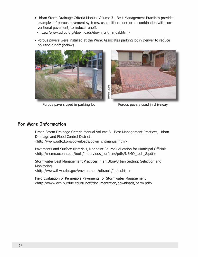
Porous Pavement ReducesSurface Runoff
Background InformationPorous paving systems have been shown to reduce surface runoff volume and attenuate peak dis-charges. Permeable pavements can reduce total impervious surface, as well as minimize directly connected impervious areas.
Porous paving systems include modular concrete pavers, which interlock and allow water to drain through; and flexible plastic grid networks, which when used with grass, protect root systems and stabilize soil. In some applications, gravel can be used as an alternative to pavement.
Porous paving systems are particularly useful for sidewalks, overflow parking, driveways, fire lanes, road shoulders and other areas of low-traffic vol-umes and loads.
Permeable paving systems vary widely in cost and are generally more expensive than typical asphalt pavement. However, the use of perme-able paving can reduce the need for construction and maintenance of stormwater man-agement facilities, resulting in cost savings over the long term.
Community StrategiesTo reduce runoff, encourage the use of porous pavement systems for sidewalks and low-vol-ume traffic and parking areas. The Urban Drainage and Flood Control District Volume 3 - Drainage Criteria Manual provides guidelines. <http://www.udfcd.org/downloads/down_critmanual.htm>
Some Examples• A field study conducted by the Urban Drainage and Flood Control District and the City of
Lakewood showed a significant reduction of runoff volume using porous modular pavers compared to conventional asphalt. The test plot also showed reductions in some pollut-ant concentrations such as total suspended solids and total phosphorous.
At a Glance• Porous paving systems can
reduce runoff volume while encouraging infiltration.
• Porous paving systems are best suited for low-traffic applications such as side-walks, overflow parking, driveways and fire lanes.
• They may reduce the need for construction and mainte-nance of stormwater manage-ment infrastructure, resulting in cost savings.
34
• Urban Storm Drainage Criteria Manual Volume 3 - Best Management Practices provides examples of porous pavement systems, used either alone or in combination with con-ventional pavement, to reduce runoff. <http://www.udfcd.org/downloads/down_critmanual.htm>
• Porous pavers were installed at the Wenk Associates parking lot in Denver to reduce polluted runoff (below).
For More InformationUrban Storm Drainage Criteria Manual Volume 3 - Best Management Practices, Urban Drainage and Flood Control District <http://www.udfcd.org/downloads/down_critmanual.htm>
Pavements and Surface Materials, Nonpoint Source Education for Municipal Officials <http://nemo.uconn.edu/tools/impervious_surfaces/pdfs/NEMO_tech_8.pdf>
Stormwater Best Management Practices in an Ultra-Urban Setting: Selection and Monitoring <http://www.fhwa.dot.gov/environment/ultraurb/index.htm>
Field Evaluation of Permeable Pavements for Stormwater Management <http://www.ecn.purdue.edu/runoff/documentation/downloads/perm.pdf>
Mic
helle
DeL
aria
Porous pavers used in parking lot Porous pavers used in driveway

35
Natural LandscapingReduces Runoff
Background InformationNatural landscaping involves both site design and plant selection.
Native plants are adapted to local climate, soil and environmental conditions. Properly placed, they require very little maintenance and water – and that means better water quality because there is less runoff, and less need for pesticides and fertilizers.
Non-native Xeriscape plants also require less water and chemical support, and may be good landscape choices as long as they are not on the state’s noxious weeds list.
Community Strategies• As a key part of site planning, preserve and
enhance existing natural areas such as prairies, wetlands and floodplains.
• Encourage the use of native species and/or Xeri-scaping in your community’s landscape design criteria.
At a Glance• Low maintenance plants that
require little water result in better water quality because there is less runoff, and less need for pesticides and fertil-izers.
• Native plants, which are adapted to local climate, soil and environmental conditions, are often used in natural landscaping design.
• Non-native Xeriscape plants may also be good choices as long as they are not on the state’s noxious weeds list.
Dav
id W
inge
r
Xeriscape demonstration garden at Denver Water Prairie garden at Denver Botanic Gardens
Dav
id W
inge
r

36
Some Examples• The City and County of Broomfield includes the following language in its master plan:
Protect Broomfield’s unique natural settings by conserving valuable creek corridors, wildlife habitats, steep slopes, and other significant natural features.
Landscaping in open space areas should emphasize the use of drought-tolerant, non-invasive plant species. The design and maintenance of landscaping must recognize the ultimate conditions of a specific location and provide appropriate plantings which can survive and regenerate naturally.
• The city of Aurora encourages Xeriscape landscape designs in its Landscaping Requirements Manual. The manual contains a preferred list of plants, shrubs and street trees for various water-use categories. The list includes many Xeriscape species.
For More InformationEPA – A Source Book on Natural Landscaping for Public Officials <http://www.epa.gov/glnpo/greenacres/toolkit/chap1.html#WHAT%20IS>
Water Efficient Landscape Design Model Ordinance <http://www.dola.state.co.us/dlg/osg/docs/Water%20Efficient%20Landscaping%20Design.pdf>
WaterWise Landscaping Best Practices Manual: A Companion to the Landscape Design Ordinance <http://dola.colorado.gov/dlg/osg/docs/WaterWise%20Landscaping%20Best%20Practices%20Manual.pdf>
City of Broomfield 1995 Master Plan <http://www.ci.broomfield.co.us/planning/masterplan/99MP1_97.html>
City of Aurora Landscape Manual <http://www.auroragov.org/stellent/groups/public/documents/article-publication/025219.pdf>
Colorado State University Gardening Online Fact Sheets <http://www.ext.colostate.edu/PUBS/GARDEN/pubgard.html>
Water-Efficient Landscaping: Preventing Pollution & Using Resources Wisely <http://www.epa.gov/OW-OWM.html/water-efficiency/docs/water-efficient_landscap-ing_508.pdf>
Green Industries of Colorado <http://www.greenco.org>

37
Saving and Amending Topsoil
Background InformationTopsoil, which contains organic matter, is often removed when sites are graded during construction. The removal of topsoil, and compaction of soil by heavy equipment during construction, reduces the land’s ability to absorb water, leading to increased imperviousness, especially in clay soils.
By saving and replacing the topsoil removed during construction, or amending soil with organic materi-als such as compost, the perviousness of the land can be re-established.
In addition, phased construction, in which smaller areas are cleared and graded, can help reduce imperviousness. Phased construction requires smaller grading equipment, which lessens the extent of areas affected by compaction and other disturbances. It also reduces exposed soils, on-site erosion and off-site sediment transport.
Community StrategiesRequire the saving and reuse of topsoil on site, or the amendment of soil with organic materials after construction.
Some ExamplesThe Built Green Colorado™ Checklist recommends that builders: • Remove, store, and then replace topsoil to a depth of 4 inches in all disturbed areas. (House pad and street are excluded.) • Add at least 3 cubic yards of soil amendment per 1,000 square feet of installed landscape area, based on soil analysis.
For More InformationBuilt Green Colorado™ Checklist <http://www.builtgreen.org/checklist/default.aspx>
GreenCO Best Management Practices <http://www.greenco.org/downloadables/Soil%20Amendment.pdf>
At a Glance• Removal of topsoil during
construction increases imper-viousness on site.
• Saving and replacing topsoil, or amending soil with organic matter, can help retain the site’s ability to absorb water and prevent runoff.
• Phased construction can help reduce imperviousness since the smaller equipment used lessens soil compaction.

38
Urban Storm Drainage Criteria Manual Volume 3 - Best Management Practices, Urban Drainage and Flood Control District <http://www.udfcd.org/downloads/down_critmanual.htm>
Douglas County Grading, Erosion and Sediment Control Manual <http://www.douglas.co.us/publicworks/engineering/GESC.html>
RecycleWorks, San Mateo County <http://www.recycleworks.org/greenbuilding/sus_sitework.html>

39
Tree Cover ProvidesMultiple Benefits
Background InformationIn addition to protecting water quality, trees reduce air and noise pollution, provide energy-saving shade, are a habitat for wildlife, can increase property value, and are aesthetically pleasing.
Trees increase real estate values by as much as 15 percent, according to the National Association of Home Builders.
A 2005 report shows tree cover in Boulder, Colo. reduces stormwater runoff by an estimated at six million cubic feet annually, saving the city approxi-mately $532,311. The average tree intercepts 1,271 gallons of stormwater annually, with a value to the community of $15 per tree.
Tree ordinances that specifically relate to plant-ing and managing trees can be a useful tool in maintaining a community’s healthy tree canopy and protecting aquatic resources. These ordinances can be grouped into three categories: 1. Street trees: Deals with the planting and removal of trees in rights-of-ways, parking lots, etc. 2. Tree protection: Intended to protect native or historical trees. These laws can relate to removal, building near, pruning, etc. 3. View: Relates to trees blocking views or sunlight.
Community Strategies• Consider adopting a tree ordinance that will maintain the existing tree canopy. However,
not all trees are worth saving, and your community should be specific about which trees it wants to protect.
• Require that trees destroyed during development be replaced with desirable species.
Some ExamplesThe city of Aurora, Colo., has included a Policy on Preservation of Existing Trees within its Landscape Manual. The city’s policy is that existing, mature trees within the city, which are alive and in good health condition, shall remain in their present location and shall be
At a Glance• Urban forests are an essential
part of cities, rural areas, streets, backyards, parks and open spaces. They reduce the volume and intensity of runoff, as well as minimize the heat effect on receiving waters.
• A study of stormwater prevention provided by tree canopy in Boulder, Colo., showed a significant reduc-tion in polluted runoff.
• Tree ordinances that are well written and are part of a well planned strategy can promote community tree cover and protect aquatic resources.

40
safeguarded from damage due to site development. The policy outlines a set of require-ments for site development to protect the community’s tree canopy. <http://www.auroragov.org/stellent/idcplg?IdcService=SS_GET_PAGE&nodeId=1174&ssSourceNodeId=831>
Built Green Colorado™ provides guidelines for replacing trees during development. <http://www.builtgreen.org/community/community_checklist.pdf>
Tree Preservation Ordinances - National Association of Homebuilders <http://www.nahb.org/generic.aspx?genericContentID=19086>
CITYgreen, a GIS application for land-use planning and policy-making, calculates economic benefits of a community’s tree cover based on specific site conditions. <http://www.americanforests.org/productsandpubs/citygreen>
For More InformationBuilt Green Communities™ Checklist <http://www.builtgreen.org/community/community_checklist.pdf>
Calculating the Value of Boulder’s Urban Forest <http://www.bouldercolorado.gov/index.php?option=com_content&task=view&id=3851&Itemid=1467>
City of Boulder, Colorado Municipal Tree Resource Analysis <http://www.bouldercolorado.gov/files/Parks%20and%20Recreation/Forestry/Municipal_Tree_Resource_Analysis/Boulder_MTRA-ExecSummary.pdf>
Guidelines for Developing and Evaluating Tree Ordinances <http://www.phytosphere.com/treeord/ordprt1a.htm>
Protecting Our Waters - Street Trees <http://clean-water.uwex.edu/plan/streetrees.htm>
Regional Ecosytem Analysis for Metropolitan Denver and Cities of The Northern Front Range, Colorado <http://www.americanforests.org/downloads/rea/AF_FrontRange.pdf>
Tree Preservation Ordinances - National Association of Homebuilders <http://www.nahb.org/generic.aspx?genericContentID=19086>
http://www.bouldercolorado.gov/files/Parks%20and%20Recreation/Forestry/Municipal_Tree_Resource_Analy

41
Regulatory Programs
The following federal programs are administered by the state of Colorado. They address stormwater runoff and drinking water sources at the community level.
Phase II Stormwater ProgramIn 1972, the National Pollutant Discharge Elimination System (NPDES) program was established through the federal Clean Water Act.
In response to the 1987 amendments to that act, the U.S. Environmental Protection Agency developed Phase I of the NPDES Stormwater Program three years later. It required NPDES permit coverage for municipalities with populations of 100,000 or more. In Colorado, the cities of Denver, Aurora, Lakewood and Colorado Springs were covered by this permit requirement.
In 1999, Phase II of the NPDES Stormwater Program was implemented. It expanded cov-erage of the Phase I program by requiring smaller communities with municipal separate storm sewer systems (MS4s) to obtain permits.
Permitted communities are required to develop and implement a comprehensive stormwater management program that includes these six measures: 1) public educa-tion and outreach on stormwater impacts, 2) public involvement/participation, 3) illicit discharge detection and elimination, 4) construction site stormwater runoff control, 5) post-construction stormwater management for new development and redevelopment, and 6) pollution prevention/good housekeeping for municipal operations.
Source Water Assessment ProgramThe federal Safe Drinking Water Act Amendments of 1996 require states to develop Source Water Assessment Programs to analyze existing and potential threats to public drinking water supplies. This initiative is directed at both surface and groundwater sources.
In Colorado, the community-based program uses a two-phased approach: 1) an initial assessment phase, and 2) a protection phase in which communities develop plans to prevent potential drinking water contamination.
These plans provide communities with valuable information so that land use choices can better protect drinking water sources.
A grants program is available through the Colorado Department of Public Health and Environment to support planning activities. <http://www.cdphe.state.co.us/wq/sw/ swaphom.html>

42
For More InformationStormwater Program, U.S. Environmental Protection Agency <http://cfpub1.epa.gov/npdes/home.cfm?program_id=6>
Colorado Phase II Permit Guidance Document <http://www.cdphe.state.co.us/wq/PermitsUnit/ms4guide.pdf>
Colorado Drinking Water Program, Colorado Department of Public Health and Environment <http://www.cdphe.state.co.us/wq/drinkingwater/index.html>
Source Water Assessment and Protection Program, Colorado Department of Public Health and Environment <http://www.cdphe.state.co.us/wq/sw/swaphom.html>
Source Water Protection Program, U.S. Environmental Protection Agency <http://www.epa.gov/safewater/protect.html>
Colorado Nonpoint Source Program <http://www.npscolorado.com>

43
Resources
AWARE Colorado1410 Grant Street, B204Denver, CO 80203Denver 303-861-5195Colorado 888-861-9969<http://www.awarecolorado.org>
AWARE Colodrado Model Ordinance List <http://awarecolorado.org/resources/model_ordi-nances.pdf>
Center For Watershed Protection8390 Main Street, 2nd FloorEllicott City, MD 21043410-461-8323 <http://www.cwp.org>
Colorado Department of Local AffairsOffice of Smart Growth1313 Sherman St., Rm. 521Denver, CO 80203303-866-2156<http://www.dola.state.co.us/SmartGrowth/index.htm>
Colorado Department of Public Health & EnvironmentNonpoint Source Program4300 Cherry Creek Drive SouthDenver, CO 80246-1530303-692-3570<http://www.npscolorado.com>
Colorado Department of Transportation4201 E. Arkansas Ave.Denver, CO 80222303-757-9448<http://www.dot.state.co.us>
Colorado State University Cooperative Extension• Plant Select Program <http://plantselect.org>• Water Resources <http://www.ext.colostate.edu/menuwater.html>
Colorado Water Resources Research Institute 970-491-6308 <http://www.cwrri.colostate.edu>
Colorado Watershed Assembly970-484-3678<http://www.coloradowater.org>
Colorado Watershed Network<http://www.coloradowatershed.org>
GreenCO<http://www.greenco.org>
International City/County Management Association777 North Capitol Street, NE, Suite 500Washington, DC 20002 202-289-4262<http://www.icma.org>
Land Trust Alliance1331 H Street NW, Suite 400Washington DC 20005-4734202-638-4725<http://www.lta.org>
Local Government Environmental Assistance Network877-865-4326<http://www.lgean.org>
Low Impact Development Center5010 Sunnyside Avenue, Suite 200 Beltsville, Maryland 20705 301-982-5559<http://www.lowimpactdevelopment.org>• Low Impact Development for Big Box Retailers <http://www.lowimpactdevelopment.org/bigbox/ lid%20articles/bigbox_final_doc.pdf>
National Association of Counties202-393-6226<http://www.naco.org>

44
National Association of Local Government Environmental Professionals1333 New Hampshire Ave, NWWashington, DC 20036202-638-6254<http://www.nalgep.org>
Nonpoint Source Education for Municipal Officials (NEMO)Middlesex County Extension Center1066 Saybrook Rd. Box 70Haddam, CT 06438860-345-4511<http://web.uconn.edu/nemo>
Trust for the Public Land, National Office116 New Montgomery St., 4th FloorSan Francisco, CA 94105415-495-4014<http://www.tpl.org>
Urban Drainage and Flood Control District2480 West 26th Avenue, Suite 156-BDenver, CO 80211303-455-6277 <http://www.udfcd.org>
Urban Land Institute<http://www.uli.org>
U.S. Environmental Protection Agency• Low-Impact Development <http://www.epa.gov/owow/nps/lid>• Polluted Runoff (Nonpoint Source Pollution) <http://www.epa.gov/owow/nps>
• National Management Measures to ControlNonpoint Source Pollution from Urban Areas<http://www.epa.gov/nps/urbanmm>
• Smart Growth <http://www.epa.gov/smartgrowth>• Source Water Protection <http://cfpub.epa.gov/safewater/sourcewater>• Surf Your Watershed <http://www.epa.gov/surf>• Wetlands, Oceans, & Watersheds <http://www.epa.gov/owow>
Checklists and Scorecards
Several checklists and scorecards have been devel-oped to assist communities so they can accommodate growth while protecting natural resources. All the tools address water quality in varying ways, as well as other community values such as energy efficiency, balancing density and open space, preserving agricul-tural lands, creating diverse housing, and public health.
AWARE Colorado Community Awareness Review Sheet <http://www.awarecolorado.org/resources/Commu-nity_Awareness_Review_Sheet.pdf>
Built Green Colorado™ Checklist <http://www.builtgreen.org/checklist/default.aspx>
Built Green Communities™ (Colorado) Checklist <http://www.builtgreen.org/community/commu-nity_checklist.pdf>
Center for Watershed Protection Code and Ordinance Worksheet <http://www.cwp.org/Cow.pdf>
National Association of County and City Health Officials Public Health in Land Use Planning & Community Design Checklist <http://archive.naccho.org/Documents/LandUseCheck-list-03-10-03.pdf>
Smart Scorecard for Development Projects <http://www.epa.gov/dced/scorecards/Scorecard_exp-fleissigjacobsen.pdf>
Vermont Smart Growth Scorecard – A Community Self-Assessment Tool <http://www.vtsprawl.org/Resources/publications/ publicationsmain.htm>

45
Glossary
BMP (Best Management Practice): Regulatory or voluntary measures that can reduce the threat to water supplies posed by normal activities in homes, businesses or farms.
Cluster Development: Buildings concen-trated in specific areas to minimize infrastruc-ture and development costs while achieving the allowable density. This approach allows the preservation of natural open space for recre-ation, common open space, and preservation of environmentally sensitive features.
Filter Strips: Bands of closely growing veg-etation, usually grass, planted between pollu-tion sources and downstream receiving water bodies.
Geographic Information System (GIS): A database of digital information and data on land-use, land cover, ecology, and other geo-graphic attributes that can be overlaid, statisti-cally analyzed, mathematically manipulated, and graphically displayed using maps, charts, and graphs.
Greenway: A linear open space; a corridor composed of natural vegetation. Greenways can be used to create connected networks of open space that include traditional parks and natural areas.
Groundwater: Water stored underground in the pore spaces between soil particles or rock fractures.
Impervious Area: A hard surface area (e.g., parking lot or rooftop) that prevents or retards the entry of water into the soil, causing water to run off the surface in greater quantities and at an increased rate of flow.
Low-Impact Development (LID): An inno-vative stormwater management approach with a goal of mimicking a site’s predevelopment hydrology using design techniques that infil-trate, filter, store, evaporate, and detain runoff close to its source.
National Pollutant Discharge Elimination System (NPDES): A permit program autho-rized by the Clean Water Act that controls water pollution by regulating point sources that discharge pollutants into waters of the United States.
Nonpoint Source Pollution: Water from irrigation, rainfall or snowmelt that picks up contaminants as it moves across or into the ground, carrying pollutants into streams, lakes, wetlands or groundwater. Also known as pol-luted runoff.
Overlay Zoning: Zoning in which additional regulatory standards are superimposed on existing zoning. Overlay zoning provides a method of placing special restrictions in addi-tion to those required by basic zoning ordi-nances.
Pathogen: Microorganisms (e.g., bacteria, viruses, or parasites) that can cause disease in humans, animals and plants.

46
Permeable: A property of soil or other material that allows gases, water or other liquids to filter into, or pass through, it. Planned Unit Development (PUD): Planned unit development provisions allow land to be developed in a manner that does not conform to existing requirements of any of the standard zoning districts. The PUD allows greater flexibility and innovation than conventional standards because it is regu-lated as one unit instead of each lot being regulated separately.
Point Source: A stationary location or fixed facility from which pollutants are discharged.
Polluted Runoff: Water from irrigation, rainfall or snowmelt that picks up contami-nants as it moves across or into the ground, carrying pollutants into streams, lakes, wetlands or groundwater. Also known as nonpoint source pollution.
Riparian Buffer: A vegetated zone adjacent to a stream, wetland, or shoreline where development is restricted or controlled to minimize the effects of development.
Runoff: Water from rain, melted snow, or irrigation that flows over the land surface.
Setback: Requirements around water fea-tures, which stipulate that land use near the water must be “set back” from the water a defined distance based on site-specific crite-ria.
Swale: An open drainage channel designed to detain or infiltrate stormwater runoff.
Watershed: The area of land, which catches rain and snow that drains or seeps into a marsh, stream, river, lake or ground-water. The highest ground forms boundaries between watersheds.
Xeriscape: An alternative landscaping technique that conserves water through site design and the use of plants with low-water demand.

Revisions:
February, 2006
Pages, 2, 6, 14, 18, 20, 22, and 44 – Added information about “National Management Measures to Control Nonpoint Source Pollution from Urban Areas.”
Page 4 – Added information about the U.S. Environmental Protection Agency Watersheds Web site.
Page 8 and 34 – Deleted obsolete Web addresses.
Page 12 – Added information about “Protecting Water Resources with Higher-Density Development.” Corrected Web address for Jefferson County Rural Cluster regulation.
Pages 14, 26, 30, 33, 34 and 38 – Corrected Web address for “Urban Storm Drainage Criteria Manual Volume 3, Best Management Practices.”
Page 32 – Added information about “Parking Spaces/Community Places: Finding the Balance Through Smart Growth Solutions.”
Pages 33 and 34 – Added new resources.
December, 2006
Pages 6, 10, 17, 20, 22, 23, 28, 30, 32, 33, 36, 37, 40, 42 and 44 – Updated Web links.
Page 18 – Deleted obsolete Web addresses.
February, 2007
Pages 14, 22, 28, 36, 37, 40, 41 and 44 – Updated Web links.
Page 16 – Deleted obsolete Web address.
Pages 6, 14, 40, 43 and 44 – Added new resources.