Water and Environment Management Framework Lot 3 · PDF fileWater and Environment Management...
71
Water and Environment Management Framework Lot 3 – Engineering and Related Services West Wight Coastal Flood and Erosion Risk Management Strategy Appendix H – Habitats Regulations Assessment (Screening Report) March 2016
Transcript of Water and Environment Management Framework Lot 3 · PDF fileWater and Environment Management...

Water and Environment Management Framework Lot 3 – Engineering and Related Services
West Wight Coastal Flood and Erosion Risk Management Strategy
Appendix H – Habitats Regulations Assessment (Screening Report) March 2016

i
Document history
Version Status Issue date Prepared by Reviewed by Approved by
1 First Draft September 2015
Graeme Down
Consultant
Ecologist
Dr James Riley,
Associate
Director
(Ecology)
Tessa Harding,
Associate
Director
(Ecology)
2 First revision December 2015
Graeme Down
Consultant
Ecologist
Dr James Riley,
Associate
Director
(Ecology)
Tessa Harding,
Associate
Director
(Ecology)
3 Revision for
consultation March 2016
Ben Taylor
Assistant
Consultant
Jonathan Short
Principal
Consultant
Jonathan Short
Principal
Consultant
AECOM Infrastructure & Environment UK Limited Scott House Alencon Link Basingstoke RG21 7PP
ii
Limitations
AECOM Infrastructure & Environment UK Limited (“AECOM”)/ Capita Property and Infrastructure Ltd
(“Capita”) has prepared this Report for the sole use of the Environment Agency/Isle of Wight Council in
accordance with the Agreement under which our services were performed. No other warranty, expressed
or implied, is made as to the professional advice included in this Report or any other services provided by
AECOM / Capita. This Report is confidential and may not be disclosed by the Client nor relied upon by
any other party without the prior and express written agreement of AECOM / Capita.
The conclusions and recommendations contained in this Report are based upon information provided by
others and upon the assumption that all relevant information has been provided by those parties from
whom it has been requested and that such information is accurate. Information obtained by AECOM /
Capita has not been independently verified by AECOM / Capita, unless otherwise stated in the Report.
The methodology adopted and the sources of information used by AECOM / Capita in providing its
services are outlined in this Report. The work described in this Report was undertaken between August
and December 2015 and is based on the conditions encountered and the information available during the
said period of time. The scope of this Report and the services are accordingly factually limited by these
circumstances.
Where assessments of works or costs identified in this Report are made, such assessments are based
upon the information available at the time and where appropriate are subject to further investigations or
information which may become available.
AECOM / Capita disclaim any undertaking or obligation to advise any person of any change in any matter
affecting the Report, which may come or be brought to AECOM’ / Capita’s attention after the date of the
Report.
Certain statements made in the Report that are not historical facts may constitute estimates, projections
or other forward-looking statements and even though they are based on reasonable assumptions as of
the date of the Report, such forward-looking statements by their nature involve risks and uncertainties
that could cause actual results to differ materially from the results predicted. AECOM / Capita specifically
does not guarantee or warrant any estimate or projections contained in this Report.

iii
Contents 1. Introduction 1 1.1 Introduction 1 1.2 The West Wight Coastal Flood and Erosion Risk Management
Strategy 3 1.3 HRA of the Strategy 3 1.4 This Report 7
2. Habitats Regulations Assessment –Methodology 9 2.1 Key Principles 9 2.2 The Process of HRA 9 2.3 HRA Task One: Likely Significant Effects (Screening) 10 2.4 HRA of Isle of Wight SMP 2 10 2.5 HRA Screening of the Strategy 12 2.6 Assessment ‘in combination’ 13
3. Potential Impact Pathways 14 3.1 Introduction 14 3.2 Direct Landtake 14 3.3 Coastal squeeze 14 3.4 Loss of high tide roosts 15 3.5 Disturbance 15 3.6 Changes in sediment transport (coastal processes) 15 3.7 Contamination 15
4. Background Information Regarding Relevant European Sites 16
4.1 Solent Maritime SAC 16 4.2 South Wight Maritime SAC 16 4.3 Isle of Wight Downs SAC 17 4.4 Solent & Southampton Water SPA/Ramsar site 17 4.5 Solent and Dorset Coast pSPA 19 4.6 European designated sites associated with the Individual Strategy
Management Zones (SMZs) 19
5. HRA Screening 21
6. In Combination Assessment 64 6.1 Introduction 64 6.2 Short term (2015 – 2025) 64 6.3 Medium and long term (2025 – 2115) 65
7. Conclusions 66
Appendix 1 – Option Development Units 67

1
1. Introduction
1.1 Introduction
Isle of Wight Council is developing a Coastal Flood and Erosion Risk Management Strategy for
‘West Wight’, an area that extends from Freshwater Bay to East Cowes. This project frontage
comprises the Policy Development Zones (PDZs) 1, 6 & 7 as outlined in the 2010 Shoreline
Management Plan (SMP) for the Isle of Wight1 (Figure 1):
PDZ 1: Cowes and the Medina Estuary (from Gurnard Luck to Old Castle Point (East Cowes);
PDZ 6: West Wight (from the eastern margin of Freshwater around the West Wight headland to include Yarmouth (to the eastern margin of Port la Salle); and,
PDZ 7: North-west Coastline (from the eastern margin of Bouldnor to the western margin of Gurnard Luck).
The Coastal Flood and Erosion Risk Management Strategy (herein the ‘Strategy’) is the next
stage on from the SMP. Its purpose is to outline the preferred options (measures and actions)
which shall be undertaken to manage effectively and sustainably the risks posed by coastal
flooding and erosion in the short (10 year), medium (10-40 years) and long term (40 – 100
years). The Strategy considers the effects of climate change and associated impacts such as
sea-level rise and coastal erosion.
In order to comply with the requirements of Article 6 of the EC Habitats Directive 1992
(interpreted into English law by the Conservation of Habitats & Species Regulations 2010) land
use plans must be subject to a Habitats Regulations Assessment (HRA) screening exercise to
determine if they are likely to have a significant effect on a Natura 2000 site (Europe wide
network of sites: Special Areas of Conservation (SAC) and Special Protection Areas (SPA). It is
also Government policy (as described in the National Planning Policy Framework) for candidate
Special Areas of Conservation (cSAC), proposed Special Protection Areas (pSPA) and sites
designated under the Convention on Wetlands of International Importance 1971 (Ramsar sites)
to be treated as having equivalent status to designated Natura 2000 sites. Collectively, we refer
to these sites throughout this report as ‘European sites’. There are also nationally and locally
designated sites in the Strategy area, such as Sites of Special Scientific Interest (SSSI), Local
Nature Reserves (LNR) and Sites Important for Nature Conservation (SINC) but these do not fall
within the remit of HRA.
If the HRA screening exercise determines that a likely significant effect may occur then further
investigation (Appropriate Assessment or AA stage of the HRA process) is necessary in order to
determine potential for avoidance or mitigation. Box 1 below sets out the legislative basis for
such an assessment.
The Habitats Directive applies the precautionary principle to protected areas so that plans and
projects can only be permitted having ascertained that there will be no adverse effect on the
integrity of the site(s) in question. Plans and projects may still be permitted if there are no
alternatives to them and there are Imperative Reasons of Overriding Public Interest (IROPI) as to
why they should go ahead. In such cases, compensation would be necessary to ensure the
overall integrity of the site network.
1 Isle of Wight Shoreline Management Plan (2010) http://www.coastalwight.gov.uk/smp/

2
Figure 1: Isle of Wight SMP (2010) Policy Development Zone Locations

3
Box 1. The legislative basis for Habitats Regulations Assessment
1.2 The West Wight Coastal Flood and Erosion Risk Management Strategy
Capita-AECOM has been commissioned by the Isle of Wight Council to develop a long-
term Coastal Flood and Erosion Risk Management Strategy.
The Strategy provides an assessment of the risks and opportunities associated with
coastal processes and presents the preferred management options to reduce the risks in a
sustainable manner in the short (10 year), medium (10 -40 years) and longer term (40 –
100 years). In doing so, the Strategy forms an important element of the coastal
management hierarchy and also provides guidance for spatial planning within the coastal
zone.
Key stages of the Strategy development included:
An assessment of the conditions and performance of existing coastal defences for the study frontage for the next 100 years;
The development and evaluation of options for the maintenance and improvement of defences, based on careful consideration of all technical issues, economics, stakeholder interests, future developments and environmental impacts; and,
Recommendation of a preferred long-term strategy to be adopted.
The HRA process has informed and confirmed the preferred strategy options through its
identification of the likely significant effects of the implementation of the Strategy on
relevant environmental receptors.
1.3 HRA of the Strategy
It is important to note that The Strategy sets the location, scale and general method of
coastal management but does not define the specific details. The details will be defined
during subsequent scheme appraisals and design stages. Since Coastal Flood & Erosion
Habitats Directive 1992
Article 6 (3) states that:
“Any plan or project not directly connected with or necessary to the management of the
site but likely to have a significant effect thereon, either individually or in combination with
other plans or projects, shall be subject to appropriate assessment of its implications for
the site in view of the site's conservation objectives.”
Conservation of Habitats & Species Regulations 2010
The Regulations state that:
“A competent authority, before deciding to … give any consent for a plan or project which
is likely to have a significant effect on an internationally important wildlife site … shall
make an appropriate assessment of the implications for the site in view of that sites
conservation objectives … the authority shall agree to the plan or project only after having
ascertained that it will not adversely affect the integrity of the Internationally important
wildlife site”.

4
Risk Management Strategies form the middle tier in a three-tiered system (with Shoreline
Management Plans above and individual schemes below) the HRA work to accompany
these documents also needs to be pitched at the appropriate level, culminating with the
most detailed HRA being undertaken at the individual scheme level. This is in line with
Communities & Local Government (CLG) guidance on the AA of Plans which makes it
clear that:
“The comprehensiveness of the [Appropriate] assessment work undertaken should be
proportionate to the geographical scope of the option and the nature and extent of any
effects identified. An AA need not be done in any more detail, or using more resources,
than is useful for its purpose. It would be inappropriate and impracticable to assess the
effects [of a land use plan] in the degree of detail that would normally be required for the
Environmental Impact Assessment (EIA) of a project.”
The Strategy management options considered are those defined in the Defra guidance
(Defra, 2006), including: Do Nothing, Do Minimum, Sustain, Maintain, Improve, Managed
Realignment, Adaption etc. These fall under the SMP polices such as Hold the [defence]
Line, Advance the line, Managed Realignment, and No Active Intervention. The options are
set over three time frames (often termed epochs), which are:
0-20 years (short term) 2005 - 2025;
20-50 years (medium term) 2025 - 2055; and
50-100 years (long term) 2055 - 2105.
It should be noted that under the Strategy the first time period runs from 2015 to 2025,
while the longer term period extends 10 years beyond that of the SMP to 2115 to provide a
100 year appraisal period.
The study area consists of Shoreline Management Zones (SMZs) that overlap the SMP
PDZs (Figure 2). Each SMZ is divided into Option Development Units (W1-32), also shown
on Figure 2 and listed in Appendix 1. The European sites considered within this HRA
report are shown in Figure 3.

5
Figure 2: Strategy Management Zones (SMZs) and Option Development Units (W1-32)

6
Figure 3: European Designated Sites AROUND West Wight included in Habitats Regulations Assessment.

7
The shoreline extends approximately 84km from Freshwater Bay to East Cowes, as
detailed below:
SMZ 5 and 6 (SMP PDZ 1): Cowes and the Medina Estuary (from Gurnard Luck to Old
Castle Point (East Cowes)
This area comprises the communities of Gurnard, Cowes, East Cowes and surrounding
the Medina Estuary. This frontage is approximately 26km in length, inclusive of the
Estuary. The current approach to shoreline management is a mix of ‘hold the existing
defence line’ and ‘no active intervention’ depending on the assets at risk. The majority of
the coastline is designated as a Special Area of Conservation (SAC) with Ramsar sites
present within the estuary. South of the built up areas of Cowes and East Cowes, the
Medina Estuary is designated as part of the Solent and Southampton SPA and Ramsar
site. The entire stretch of coastline is also included within the current boundary of the
proposed Solent and Dorset Coast SPA.
SMZ 1, 2 and 3 (SMP PDZ 6): West Wight (from the eastern margin of Freshwater around the West Wight headland to include Yarmouth (to the eastern margin of Port la Salle)
This zone extends approximately 27km in length and includes the communities of
Freshwater, Alum Bay, Totland, Colwell, Yarmouth and Port la Salle. The current approach
to shoreline management in this area is mixed with areas of defences, but many
undefended areas and there are extensive areas protected by European Environmental
designations.
The entire stretch of coastline is also included within the current boundary of the proposed
Solent and Dorset Coast SPA.
SMZ 4 (SMP PDZ 7): North-west Coastline (from the eastern margin of Bouldnor to the
western margin of Gurnard Luck)
This frontage extends approximately 39km in length, inclusive of Newtown Estuary. This
area includes the areas of Hamstead, Newtown Estuary and Thorness Bay and the current
approach to shoreline management in this area is no active intervention. SAC and
Ramsar sites cover the entirety of the coast.
The entire stretch of coastline is also included within the current boundary of the proposed
Solent and Dorset Coast SPA which is currently at the consultation period. Should the
designation be confirmed, the environmental studies of the Strategy will be updated to
consider in more detail the potential impacts on the new designation.
1.4 This Report
This report comprises the HRA Screening Report. The aim of the Screening Report is to:
Undertake a high level risk assessment to decide whether the full subsequent
stage known as Appropriate Assessment is required. The essential question is: “Is
the Plan, either alone or in combination with other relevant projects and plans,
likely to result in a significant effect upon European sites?”
This report will be subject to consultation with the Isle of Wight Council and statutory
consultees including the Natural England (NE), Historic England (HE) and the Environment
Agency.

8
The report will also be made available to non-statutory consultees and stakeholders should
they wish to participate in the consultation process.

9
2. Habitats Regulations Assessment –Methodology
2.1 Key Principles
The HRA will be guided by a series of key principles – see Table 1.
Table 1 - Key principles underpinning the proposed methodology
Principle Rationale
Maximise value of existing
information
We have made the best use of existing information
where possible. This includes information gathered as
part of the SMP HRA and Strategic Environmental
Assessment, data collated by those involved in
developing the Regional Habitat Creation Programme
and information held by the Council ecologists, Natural
England, the Environment Agency (EA) and others as
appropriate.
Consult with Natural
England, the Environment
Agency and other
stakeholders
We have ensured continued consultation with
stakeholders for the duration of the assessment. We
have ensured that we utilised information held by them
and others and have taken on board their comments on
the assessment process and findings. The scoping report
confirmed impact pathways and European sites requiring
consideration.
Ensure a proportionate
assessment
We have ensured that the level of detail addressed in the
assessment reflects the level of detail in the development
planning for the frontage (i.e. that the assessment is
proportionate).
Keep the process as simple
as possible
We have endeavoured to keep the process as simple as
possible while ensuring an objective and rigorous
assessment in compliance with the Habitats Directive
and emerging best practice.
Ensure a clear audit trail
We have ensured that the HRA process and findings are
clearly documented in order to ensure a clearly
discernible audit trail.
2.2 The Process of HRA
The HRA has been carried out in the continuing absence of formal Government guidance
on the HRA of plans, but within the context of precedent set by other Coastal Strategies.
Communities & Local Government (CLG) released a consultation paper on AA of Plans in
20062. As yet, no further formal guidance has emerged although informal guidance
documents exist, produced by RSPB and for internal use by Natural England. Figure 1
below outlines the stages of HRA according to current draft CLG guidance. The stages
2 CLG (2006) Planning for the Protection of European Sites, Consultation Paper

10
are essentially iterative, being revisited as necessary in response to more detailed
information, recommendations and any relevant changes to the plan until no significant
adverse effects remain.
Figure 1: Four-Stage Approach to Habitats Regulations Assessment
2.3 HRA Task One: Likely Significant Effects (Screening)
The first step in HRA is a simple screening exercise to determine Likely Significant Effects
(LSE) - essentially a high level risk assessment to decide whether the full subsequent
stage known as AA is required. The essential question is:
”Is the Plan, either alone or in combination with other relevant projects and plans, likely to
result in a significant effect upon internationally important wildlife sites?”
The objective is to ‘screen out’ those plans and projects that can, without any detailed
appraisal, be said to be unlikely to result in significant effects upon internationally important
wildlife sites, usually because there is no mechanism or pathway connecting the
plan/project with internationally important wildlife sites.
In particular, reference is made to ensuring that each policy option is appraised not in
isolation but within the context of (‘in combination’ with) other relevant plans and projects.
The Likely Significant Effects (Screening) stage is the purpose of this report.
2.4 HRA of Isle of Wight SMP 2
The Appropriate Assessment of the Isle of Wight Shoreline Management Plan (2) has
already undertaken a detailed precautionary assessment of likely significant effects on
Natura 2000 sites as a result of SMP policy.
HRA Task One: Likely significant effects
(‘screening’) –identifying whether a plan is ‘likely to have
a significant effect’ on a European site
HRA Task Two: Appropriate Assessment – assessing
the effects of the plan on the conservation objectives of
any European sites ‘screened in’ during HRA Task 1
HRA Task Three: Alternative solutions – where
adverse effects are identified at HRA Task 2, the plan
should be altered until adverse effects are cancelled out
fully
Evidence Gathering/Scoping – collecting information
on relevant European sites, their conservation objectives
and characteristics and other plans or projects.

11
The HRA of the Shoreline Management Plan3 identified that the policies for PDZ1 (SMZ 5
and 6) and PDZ 7 (SMZ 4) would not lead to likely significant effects on European
designated sites.
However, for PDZ6 (specifically SMZ 3b – Western Yar Valley) it was concluded that:
“The opening up of defences at Thorley Brook (PU6C.5) in the second epoch will result in
the flooding of Thorley and Barnfields Stream, which will have an adverse effect on the
integrity of the designated coastal grazing marshes and (and undesignated) freshwater
habitats that are features of the Solent and Southampton [sic] Ramsar site, as well as bird
species that use the coastal grazing marshes for feeding that are features of the Solent
and Southampton SPA. The freshwater reed beds and grazing marshes landward of the
Thorley Brook defences offer important wetland areas for high water roosting and feeding
activities of water [birds] and wildfowl (SPA interest feature and Ramsar Criterion 1), as
well as supporting rare and important species (Ramsar Criterion 2). Saline intrusion would
cause the loss of ca. 4.0 ha of undesignated freshwater habitat around the line of the two
rivers and 30.9 ha of designated grazing marsh habitats (plus 5.3 ha of undesignated
grazing marsh). If saline intrusion is prevented from extending beyond Thorley Bridge
(under the Thorley Road) then 13.1 ha of grazing marsh will be remain unaffected. The
change in habitat from coastal grazing marsh that offer feeding grounds and high water
roost sites for wildfowl would be gradually replaced by saltmarsh and mudflat. It is likely
that though the area would still provide an important feeding ground for many bird species,
in that some birds would adapt and find new roost sites over time, whilst others would not
since the function of mudflats and saltmarsh are different to that of coastal grazing marsh.
Therefore, the community of birds may change over time with the MR policy as the feeding
function of the area changes. It has been concluded that the change in 30.9 ha of habitat
will cause an adverse effect on the Solent and Southampton Water SPA and Ramsar site.
It has been predicted that 30.9 ha of coastal grazing marsh that support the SPA bird
species that currently use this site will need to be sought for compensation through the
Southern RHCP.”
Further appraisal of the SMP4 identified that specific mitigation approaches should include
a programme of action for monitoring, consultation and studies to improve the predictions
of intertidal developments and understanding of the impact of gain in intertidal mudflat and
saltmarsh and loss of coastal grazing marsh. It was also established that loss of habitat
function, as a consequence of the recommended SMP2 policy within the Western Yar
Estuary (PU6C.5) can potentially be mitigated through habitat management.
A statement of Imperative reasons of Overriding Public Interest (IROPI) noted that:
“The preferred policy of HTL/MR/NAI results in creating a significant amount of mudflat and
saltmarsh, the latter of which is an important declining Biodiversity Action Plan habitat that
is difficult to recreate, as there is not often opportunity to do so, as well as enabling new
coastal grazing habitat with the function of providing feeding and high tide roost sites for
wintering bird species to be planned and created in advance of loss. If the SMP2 were not
to be implemented, and the defences and sluices in this policy unit were to be left
unmaintained it would result in more detrimental consequences to the Solent and
Southampton Water SPA and Ramsar site and its interest features than if the active policy
3
http://www.coastalwight.gov.uk/smp/FINAL_SMP_for_web/pdf_Appendices/Appendix_I_HRA_Dec10_Final.pdf?bc
si_scan_E956BCBE8ADBC89F=0&bcsi_scan_filename=Appendix_I_HRA_Dec10_Final.pdf 4
http://www.coastalwight.gov.uk/smp/FINAL_SMP_for_web/pdf_Appendices/Appendix%20L_IROPI_Dec10_Final.p
df?bcsi_scan_E956BCBE8ADBC89F=0&bcsi_scan_filename=Appendix%20L_IROPI_Dec10_Final.pdf

12
suite was implemented. The policy provides time in the first epoch to investigate and plan
the controlled management of the saline intrusion through the existing defence line (by a
policy of MR in the second epoch) of the sluices at Thorley Brook and Barnfields Stream,
followed by NAI in the long term. Whilst this is a damaging plan in one way, it is the most
sustainable and least damaging option in the long term (see Box F). Re-opening the
sluices through a MR policy will allow the Western Yar estuary to open up more naturally
and increase the amount of designated mudflat and saltmarsh habitats (which is
particularly important with the decline of internationally and nationally important saltmarsh
species) and allow estuary function to improve, adapt and evolve with sea level rise.”
Compensatory habitat must be identified, either to cater for the loss of 31ha of coastal
grazing marsh as a result of the Isle of Wight SMP or in combination with a loss of 39ha of
similar habitat as a result of the North Solent SMP. There is expectation that this will occur
through the Environment Agency’s Southern Regional Habitat Creation Programme
(RHCP).
The HRA Stage 4 of the SMP indicates that “the Environment Agency’s Southern Regional
Habitat Creation Programme (RHCP) is a dedicated, resourced plan for delivering
compensatory habitat. To date the RHCP has firm delivery plans for the first epoch (first 20
years), where the necessary compensation will be created and ecologically functional by
the time it is required. It is reasonable to expect that this method of providing
compensation habitat will continue for Epochs 2 and 3. Natural England themselves have
agreed nationally that the Regional Habitat Creation Schemes are an appropriate
mechanism for securing and delivering compensatory habitat.”
Since the adverse effect has already been identified as resulting from the SMP, and the
RHCP has been identified as the delivery mechanism for securing compensatory habitat
provision, it is considered that it is not necessary for this issue to be reinvestigated, or
habitat losses recalculated, for this Strategy (or for the Strategy itself to identify specific
parcels of compensatory habitat), provided that it can be confirmed that the Strategy would
not result in adverse effects of a different or greater nature than was determined for the
SMP, and that the RHCP will incorporate the identification of compensatory habitat as part
of its remit for Epoch 2 (2025 – 2055).
If the Strategy resulted in any deviations from SMP policy for PDZ6 (particularly the
aforementioned SMZ3b – Western Yar Valley) that would increase habitat loss above the
level assumed in the SMP HRA, the assumptions stated in the previous paragraph would
need to be revisited.
2.5 HRA Screening of the Strategy
The HRA Screening builds upon the work undertaken for the Isle of Wight SMP. It focuses
upon:
Confirming whether changes in policy at The Strategy level (if any) would alter the conclusions reached at SMP level, either negatively (e.g. additional coastal squeeze through the change from an NAI to HTL policy) or positively (such as a change from an HTL to NAI policy which could result in reduced intertidal habitat losses compared to those determined for the SMP);
Discussing whether in areas of Hold The Line (HTL) there is the potential for an increase in defence footprint as a result of the preferred Strategy option and whether this would alter the habitat loss/gain conclusions reached at SMP level. Any increases in habitat loss can be very broadly estimated at the Strategy level using an assumed typical extent of footprint increase for the relevant sections of

13
frontage, but cannot be calculated precisely until the scheme level, since it is only at that level that the precise method for achieving HTL is confirmed;
Identifying whether, based on the probable broad construction methods/processes that would be employed, there would be any potential for disturbance to SPA waterfowl (e.g. use of piling), and if so what should be done to mitigate such disturbance to a level that is not significant;
Confirming whether any assumptions made about this frontage at the SMP level are now out-of-date. For example, the proposed Solent and Dorset Coast SPA was not designated at the time of adoption of the SMP, and therefore will be a new material consideration when undertaking HRA of the Strategy.
2.6 Assessment ‘in combination’
The key plans and projects requiring consideration ‘in combination’ with the Strategy are
the other Coastal Strategies along the Isle of Wight SMP frontage and the adjacent SMP
for the North Solent. It is also considered appropriate to include the additional housing,
transportation and commercial/industrial allocations proposed for the Strategy coastline in
the short term (2015 – 2025) . This development will be delivered as set out in the Isle of
Wight (Island Plan) Core Strategy. Studies have been undertaken into recreational
disturbance of the Solent by the Solent Forum (the Solent Disturbance and Mitigation
Project5) and these will be referred to with regard to the ‘in combination’ assessment. It is
reasonable to conclude on a precautionary basis that the increased population associated
with this new residential development may result in increased recreational pressure within
the Solent in particular. Therefore a Supplementary Planning Document (SPD) has been
adopted on this matter by the Isle of Wight Council.
It is not for this Strategy HRA to undertake a detailed assessment of the impacts of any of
these plans but rather to make a high-level qualitative appraisal in order to place The
Strategy within an appropriate context.
The medium to long term (2025 – 2115) are sufficiently far in the future that no other plans
or projects that will commence within those epochs are currently identifiable.
5 http://www.solentforum.org/forum/sub_groups/Natural_Environment_Group/Disturbance_and_Mitigation_Project/

14
3. Potential Impact Pathways
3.1 Introduction
There are various ways in which a Coastal Flood & Erosion Risk Management Strategy can result in adverse effects on internationally designated wildlife sites. Those pathways are discussed in this chapter.
3.2 Direct Landtake
Managed Realignment policies (i.e. policies that require flood defences to be moved) can have a beneficial impact on internationally important wildlife sites through allowing intertidal habitats to retreat inland in response to rising sea levels, thereby alleviating coastal squeeze. Managed Realignment Policy can (depending on the site and habitats) also have an adverse effect if the flood defences actually serve to protect habitat that would suffer from heavy tidal inundation. For example, in the Portchester to Emsworth Strategy and Hamble to Portchester Strategy in the North Solent area, it was concluded that Managed Realignment policies (like that proposed for the Thorley Brook area) would have a beneficial effect on the intertidal habitat but an adverse effect on the grazing marsh that currently lies behind the defences.
Coastal defences can also result in direct landtake by advancing works into areas of internationally designated habitat through an increase in defence footprint (or through the footprint of construction access routes) if the defences are being maintained to an improved standard. This could be both a temporary effect (e.g. if landtake is used for construction compounds but removed when defence improvement works are complete) or a permanent effect.
3.3 Coastal squeeze
Rising sea levels can be expected to cause intertidal habitats (principally saltmarsh and mudflats) to migrate landwards, dependant on the topography. However, in built-up areas, such landward retreat is often rendered impossible due the presence of sea walls and other flood defences.
In addition, development frequently takes place immediately behind the flood defences, so that the flood defences cannot be moved landwards to accommodate managed retreat of threatened habitats. The net result of this is that the quantity of saltmarsh and mudflat adjacent to built-up areas will progressively decrease as sea levels rise. This process is known as ‘coastal squeeze’. In areas where sediment availability is reduced, the 'squeeze' also includes an increasingly steep beach profile and foreshortening of the seaward zones. This would be a permanent effect.
Defra's current national assessment is that the creation of an annual average of at least 100 ha of intertidal habitat associated with Internationally important wildlife sites in England that are subject to coastal squeeze, together with any more specifically identified measures to replace losses of terrestrial and supra-tidal habitats, is likely to be required to protect the overall coherence of the Natura 2000 network. This assessment takes account of intertidal habitat loss from internationally important wildlife sites in England that is caused by a combination of all flood risk management structures and sea level rise. The assessment will be kept under review taking account of the certainty of any adverse effects and monitoring of the actual impacts of plans and projects.
6
6 Defra. 2005. Coastal Squeeze – Implications for Flood Management.
http://www.defra.gov.uk/environ/fcd/policy/csqueeze.pdf

15
3.4 Loss of high tide roosts
The boundaries of European sites are defined to encompass as much as possible of the key land areas essential to the maintenance of populations of species of European importance. However, for migratory or otherwise highly mobile species it is not possible to encompass all the areas of land necessary for the maintenance of the population within the site boundary. In these instances, areas outside the European site boundary require preservation.
The Solent European sites are noted for a suite of highly mobile waterfowl and other birds. Of particular note, it is known that the populations of Brent goose for which the SPA/Ramsar sites are designated are highly dependent upon areas of open short-mown grassland around the SPAs and other types of habitat as high tide roosts and feeding areas.
3.5 Disturbance
Depending on the timing of construction works Coastal Flood & Erosion Risk Management Strategies can also indirectly result in disturbance of the species for which the internationally important wildlife site was designated, particularly for those sites designated for bird interest. On such sites, flood defence maintenance can cause short-term localised disturbance of breeding birds or wintering birds depending on the time of year but careful programming of works can help reduce this disturbance. This would be a temporary effect.
3.6 Changes in sediment transport (coastal processes)
Many internationally important coastal wildlife sites are partially dependent on receiving sediment inputs via long-shore transport from other parts of the coastline. The presence of coastal defences (or their ongoing maintenance) can reduce this sediment input which, when considered within the context of rising sea levels, can lead to a long-term incremental reduction in the habitat available as erosion and inundation outpace accretion. This would potentially be a permanent effect. Coastal defences can also serve a useful purpose in collecting and storing sediment which can then become colonised by internationally important species and habitats.
3.7 Contamination
There is the potential for Strategy options to introduce or increase contamination risk for internationally important sites by resulting in the release of contamination that is currently locked into soils on the shore, and thereby introducing new pathways linking sources to receptors. ‘Doing Nothing’ could also potentially result in this risk by a process of gradual erosion. This would be a temporary effect but may be of considerable duration. The consideration of this impact would require information not only on the contamination risk associated with the frontage but also how vulnerable the interest features of the internationally important sites are to increased contamination of the water column. There is also the potential for The Strategy to provide beneficial impacts by preventing or blocking potential pathways which could link contaminated sites to receptors.

16
4. Background Information Regarding Relevant European Sites
4.1 Solent Maritime SAC
The Solent Maritime SAC extends along the north and north-west coastline of the Isle of Wight and covers the majority of the intertidal area along the western Solent, west side of Southampton Water and the Hamble.
The site is designated under the EU Habitats Directive for its Annex I habitats which include:
Salicornia and other annuals colonising mud and sand
Atlantic salt meadows (Glauco-Puccinellietalia maritimae)
Spartina swards (Spartinion maritimae)
Mudflats and sandflats - not submerged at low tide
Annual vegetation drift lines
Perennial vegetation of stony banks
Coastal lagoons
Shifting white dunes with Ammophila arenaria
Estuaries
Sandbanks - slightly covered by sea water all the time
The conservation objectives of the Solent Maritime SAC are to maintain in favourable condition, subject to natural change the Annex 1 habitats for which the site has been designated as listed above. The site covers a complex of estuarine systems with a wide range of estuary types and diversity of habitats. The estuary habitats support a wide variety of communities which depend on the ecological functioning of other communities, therefore loss of habitats/communities would be detrimental to the favourable condition of the estuaries feature. The key sensitivity is the loss or reduction in the Annex I habitats. Annual vegetated drift lines are sensitive to physical loss as a result of coastal squeeze and changes in coastal processes may affect the sediment budget of estuaries and reduce the supply of sediment to areas of drift line vegetation. Saltmarsh (Salicornia, Atlantic salt meadows and Spartina swards), mudflats and sandflats are sensitive to physical loss through coastal squeeze due to sea level rise.
The site is also designated for the Annex II species Desmoulin’s whorl snail (Vertigo moulinsiana). Desmoulin’s whorl snail is the largest Vertigo species, with a shell height up to about 2.6 mm. It normally lives on reed-grasses and sedges, such as reed sweet-grass.
4.2 South Wight Maritime SAC
The South Wight Maritime SAC extends along the southern shore of the Isle of Wight, off the coast of southern England, and includes a number of subtidal reefs that extend into the intertidal zone. This site is selected on account of its variety of reef types and associated communities, including chalk, limestone and sandstone reefs.
South Wight Maritime SAC on the south coast of England also represents contrasting Cretaceous hard cliffs, semi-stable soft cliffs and mobile soft cliffs.

17
The southern shore of the Isle of Wight includes a number of either submerged or partially submerged sea caves. Examples of this habitat can be found from the Needles along the south-west coast of the Island to Watcombe Bay (near Freshwater Bay).
The site is designated under the EU Habitats Directive for its Annex I habitats which include:
Reefs
Vegetated sea cliffs
Submerged or partially submerged sea caves
The conservation objectives of the South Wight SAC are to maintain in favourable condition, subject to natural change the Annex 1 habitats for which the site has been designated as listed above.
Key sensitivities include coastal squeeze of cliff habitats due to erosion, development or intensive agriculture in the hinterland and development in the intertidal/subtidal habitat zones.
4.3 Isle of Wight Downs SAC
The Isle of Wight Downs SAC represents one of the best examples of chalk grassland in the south of England under maritime influence. The SAC meets the coast between The Needles and Compton Bay along the south-west coast of the Isle of Wight. The exposed and weathered cliff tops provide a range of sheltered and exposed conditions. The most exposed chalk cliff tops support important assemblages of nationally rare lichens.
The site is designated under the EU Habitats Directive for its Annex I habitats which include:
Dry heaths
Vegetated sea cliffs
Dry grasslands and scrublands on chalk or limestone, including important orchid sites.
It is also designated for its population of early gentian, Gentianella anglica.
The conservation objectives of the Isle of Wight Downs SAC are to maintain in favourable condition, subject to natural change the Annex 1 habitats and species for which the site has been designated as listed above.
A key sensitivity of the SAC is that the vegetated sea cliffs are vulnerable to cliff stabilisation schemes.
4.4 Solent & Southampton Water SPA/Ramsar site
The Solent and Southampton Water SPA extends from Hurst Spit to Hill Head along the south coast of Hampshire, within the SMP area and from Yarmouth to Whitecliff Bay along the north coast of the Isle of Wight.
The site is comprised of a series of estuaries and harbours with extensive mudflats and saltmarshes together with adjacent coastal habitats including saline lagoons, shingle beaches, reedbeds, damp woodland and grazing marsh. These coastal habitats are important for breeding gulls and terns, and wintering wildfowl.
This site qualifies under Article 4.1 of the EU Birds Directive by regularly supporting 1% or more of the Great Britain breeding population of Annex I species. The Annex 1 species the
18
site supports includes Mediterranean gull (Larus melcanocephalus), little tern (Sterna albifrons), roseate tern (Sterna dougallii) common tern (Sterna hirundo) and Sandwich tern (Sterna sandvicensis). The site also qualifies under Article 4.2 of the EU Birds Directive by regularly supporting 1% or more of the biogeographic population of migratory species and 51,381 waterfowl. The migratory species the site supports include Eurasian teal (Anas crecca), dark bellied Brent goose (Branta bernicla bernicla), ringed plover (Charadrius hiaticula) and black-tailed godwit (Limosa limosa islandica).
The conservation objectives of the Solent and Southampton Water SPA are to maintain in favourable condition, subject to natural change, the habitats which support internationally important Annex I species, internationally important migratory species and internationally important assemblages of waterfowl. These habitats include sand, shingle, saltmarsh, intertidal mudflats, intertidal sandflats, boulder and cobble shore, mixed sediment shores, shallow coastal waters, saline lagoons, coastal grazing marsh, open water and terrestrial grasslands.
Key site sensitivities include activities or development resulting in the physical loss of the important nesting, roosting and feeding habitats for species such as little tern (Sterna albifrons), roseate tern (Sterna dougallii), common tern, Sandwich tern (Sterna sandvicensis) and Mediterranean gulls (Larus melcanocephalus). Loss of habitat could result from maintaining coastal defences, thereby causing coastal squeeze of intertidal habitats or allowing defences protecting landward habitats to fail, thereby causing permanent inundation of these landward habitats. Disturbance is also a key sensitivity including physical disturbance through human activities and non-physical disturbance such as noise, which can have an effect by displacing birds from their feeding grounds and affect their survival.
The Ramsar site extends from Hurst Spit to Gilkicker Point along the south coast of Hampshire and along the north coast of the Isle of Wight. The site comprises estuaries and adjacent habitats including intertidal flats, saline lagoons, shingle beaches, saltmarsh, reedbeds, damp woodland and grazing marsh. The diversity of the habitats supports internationally important numbers of wintering waterfowl, important breeding gull and tern populations and an important assemblage of rare invertebrates and plants.
This site is designated under the Ramsar criteria 1, 2, 5 & 6:
Ramsar criterion 1 - The site is one of the few major sheltered channels between a substantial island and mainland in European waters, exhibiting an unusual string double tide flow and has long periods of slack water at high and low tide. It includes many wetland habitats characteristic of the biogeographic region including saline lagoons, saltmarshes, estuaries, intertidal flats, shallow coastal waters, grazing marshes, reedbeds, coastal woodland and rocky boulder reefs.
Ramsar criterion 2 - The site supports an important assemblage of rare plants and invertebrates; at least 39 British Red Data Book invertebrates and at least eight British red Data Book plants represented on site.
Ramsar criterion 5 – A wintering bird assemblage of international importance, an average of 51343 waterfowl per winter (5 year peak mean 1998/99-2002/2003)
Ramsar criterion 6 – species populations occurring at levels of international importance:
– Ringed plover, Charadrius hiaticula (1.2% of the UK population)
– Dark bellied Brent goose, Branta bernicla bernicla (3% of the UK population)
– Eurasian teal, Anas crecca (1.3% of the UK population)
– Black-tailed godwit, Limosa limosa islandica (3.5% of the UK population).
The key wetland types present are listed below.

19
Rocky marine shores
Sand/ shingle shores (including sand dunes)
Intertidal mud, sand or salt flats
Saltmarshes
Coastal brackish/saline lagoons
Permanent saline/brackish/alkaline marshes/pools
Permanent freshwater marshes/pools
Freshwater, tree dominated wetlands
4.5 Solent and Dorset Coast pSPA
On January 12th, 2015, Natural England issued Technical Information Note 166 (TIN166), which proposes the designation of a new marine SPA provisional called the Solent and Dorset Coast SPA.
This pSPA would be designated for its breeding colonies of sandwich tern (Sterna sandvicensis), common tern (Sterna hirundo) and little tern (Sterna albifrons). The pSPA would cover an area from Worbarrow Bay in the west to Middleton-on-Sea in the east, with a landward boundary at Mean Low Water where it abuts existing SPAs where terns are a feature and Mean High Water elsewhere. The seaward extent of the pSPA would cover foraging ranges from existing tern colonies known in the area.
4.6 European designated sites associated with the Individual Strategy Management Zones (SMZs)
West Wight - Strategy Management Zones 1, 2 and 3 (SMP PDZ6)
This area covers zones SMZ1, SMZ2, SMZ3a and SMZ3b in the Strategy. Additionally a
section to the south of the Causeway Road at Freshwater, extending to Freshwater Bay,
will be included as SMZ3c.
On the south side of the peninsular there are two international designations. The South
Wight Maritime SAC extends from the south-eastern extent of Freshwater Bay to
Hatherwood Point (Headon Warren), whilst the Isle of Wight Downs SAC that is designated
for the grasslands, vegetated sea cliffs and Heathland, includes the eastern headland at
Freshwater Bay and the cliffs along Tennyson Down to the Needles. The latter SAC has a
SSSI ‘Headon Warren & West High Down’ that protects the cliffs of Tennyson Down and
Headon Warren under the Habitats Regulations. There are no international designations
from Hatherwood Point along Totland Bay and Colwell Bay to Sconce Point.
On the northern coastline of the area there are components of three international sites, the
Solent Maritime SAC and the Solent and Southampton Water SPA and Ramsar sites. The
area of all three designations includes the mudflats and saltmarsh of the Western Yar
estuary, including Norton Spit that extends across the mouth, to the road at Freshwater
near Afton Manor. The Solent Maritime SAC also includes the intertidal and subtidal areas
from Sconce Point to Bouldnor. The SPA and Ramsar sites include the flood zone areas
of two streams feeding into the Western Yar estuary, at Thorley Brook immediately south
of the Yarmouth town (and the main access road) and at Barnfield Stream further south.
There is one component SSSI for these international designations, the Yar Estuary SSSI,

20
which protects the estuary, including the intertidal and related brackish wetland habitats,
which extends to the tidal limit at Causeway Road.
The entire stretch of coastline is also included within the current boundary of the proposed
Solent and Dorset Coast SPA.
North-west Coastline – Strategy Management Zone 4 (SMP PDZ 7)
The coastline between the eastern margin of Port la Salle through to the western margin of
Gurnard Luck is almost completely undefended at present and sits within three
international designations, the Solent Maritime SAC, the Solent and Southampton Water
SPA and Ramsar sites. The entire coastline for this section is part of the SAC, and
includes estuaries, saltmarsh and Spartina swards for which it is designated. The Solent
and Southampton Water SPA and Ramsar sites protect the entirety of Newtown Estuary,
the coastline around the entrance and the coastline to the east until Gurnard Ledges. The
extent of the SPA goes beyond that of the SAC and Ramsar sites, protecting the entire
flood zone, and includes areas of coastal grazing, in particular to the east of the estuary.
The entire stretch of coastline is also included within the current boundary of the proposed
Solent and Dorset Coast SPA.
Cowes and Medina Estuary - Strategy Management Zones 5 and 6 (SMP PDZ1)
There are two internationally designated areas along the Old Castle Point (East Cowes) to Gurnard Luck stretch of coastline. The Solent Maritime SAC covers the entirety of this coastline, running from Sconce Point west of Yarmouth to the eastern end of Osborne Bay (covering 11,325ha). South of the built up areas of Cowes and East Cowes, the Medina Estuary is designated as part of the Solent and Southampton SPA and Ramsar site. The SPA protects a number of internationally important wildfowl, wading and overwintering birds that use the estuarine mudflat areas for feeding.
The entire stretch of coastline is also included within the current boundary of the proposed
Solent and Dorset Coast SPA.

21
5. HRA Screening
The HRA screening exercise takes into consideration the conservation requirements of the European designated sites listed in
Chapter 4 of this report7, and examines the potential for the Strategy to lead to likely significant effects in line with the Pathways of
Impact outlined in Chapter 3, both alone and in combination with other relevant plans and projects.
The following tables consider the Pathways of Impact presented in Chapter 3 and present the screening assessments for each
recommended option that has been put forward for consideration.
Table 2: Assessment of preferred options - Direct Landtake
SMZ
code
Option
Development
Units in SMZ*
Option
number
Preferred Option SMP Policy HRA screening outcome
1 W1 1 Do nothing NAI The ‘do nothing’ approach is in line with the SMP policy for this
area which is for No Active Intervention.
The only designated site along this SMZ is South Wight Maritime
SAC. Natural coastal erosion is considered to be beneficial to the
SAC.
Therefore the HRA screening conclusion is for no likely
significant effects.
7 http://publications.naturalengland.org.uk/category/6528471664689152
Green shading in the final column indicates an Option that has been screened out of further consideration due to the absence of
any mechanism for an adverse effect on European sites via the pathway of Impact being assessed in that table.
Orange shading indicates that further Appropriate Assessment (or at least further screening in the presence of further information)
is required since a pathway of impact exists that cannot be screened out at this stage.

22
SMZ
code
Option
Development
Units in SMZ*
Option
number
Preferred Option SMP Policy HRA screening outcome
2 W2-W7 2 Do minimum: H&S and
access and develop
coastal change
management area plan
for clifftop areas (W2-
6)
NAI and HTL The SMP policies along this frontage are a mixture of HTL and
NAI. A ‘do minimum’ approach may deviate from HTL policies
under the SMP, however there are no European sites designated
along this SMZ that would be likely to be affected by reduced
maintenance of existing defences as proposed by the Strategy.
The proposed Solent and Dorset Coast SPA may include this
section of coastline but will be designated for offshore feeding
grounds for tern species. There would be no LSE from landtake
due to coastal defence works.

23
SMZ
code
Option
Development
Units in SMZ*
Option
number
Preferred Option SMP Policy HRA screening outcome
3a W8-9
W15-17
3 Maintain and sustain
1.33% AEP SoP with
Temporary Flood
Barriers. Improve from
2055.
Manage and reduce
flooding to areas at
significant risk with
temporary flood
barriers. Prevent
erosion to critical
infrastructure serving
the town. Raise /
implement new
defences (bunds and
floodwalls) to manage
longer term increasing
flood and erosion risk
posed by sea level rise
(with the exception of
W8 which is only to
maintain H&S and
access requirements).
HTL in all
Epochs east of
the Yar estuary,
or HTL in Epoch
1 then NAI west
of the Yar
estuary, on the
coast.
The strategy of maintaining existing defences along the majority
of this SMZ means that there will not be likely significant effects
on Solent Maritime SAC or Solent and Southampton Water SPA
and Ramsar through direct landtake as defences will be retained
in, or landwards of, their current alignment. It is possible that in
order to provide defences of a sufficient standard in the future
under a HTL policy, there could be a requirement to encroach
further into the intertidal zone (for example if the crest of the
defences needs to be raised to allow for rising sea levels, the
base of the structure may require widening). However, it is
anticipated that given that the shoreline through W8-9 and W15-
17 is less than 4km in length and allowing for an incremental
forward or backward movement of defence toes (taken to be less
than 2m), the loss of intertidal habitat would be minimal. SMP
calculations predict a loss of 0.4ha of saltmarsh and mudflat from
the SAC as a result of existing SMP approaches8. Overall the
SAC will experience a much greater increase in mudflat habitat
(142ha through the implementation of the North Solent SMP).
The HRA of the SMP notes that “the defences along Norton Spit
are to be held for the duration of the SMP, which will ensure that
the mudflat and saltmarsh on the landward side of the spit are
maintained, resulting in a beneficial effect of the HTL policy.
Furthermore, allowing the adjacent coastline between Sconce
Point and Norton to naturally erode in the medium to long term
will ensure an increase of sediment downdrift, resulting in
accretion of Norton Spit which would further protect the mudflat
and saltmarsh on the landward side of the defence structures.”
The precise nature of any defences and their alignments would
be determined at a scheme-specific level and these would need
to be subject to project-level HRA screening.
At this stage therefore it is concluded that there is no likely
significant effect on the European sites from the Strategy.

24
SMZ
code
Option
Development
Units in SMZ*
Option
number
Preferred Option SMP Policy HRA screening outcome
3b W10
W13-14
5 Do Minimum with
Thorley Brook
Managed Realignment
(from 2025)
Managed realignment
at Thorley Brook to
provide environmental
mitigation and create
intertidal habitat.
Recommend PLP for
isolated residential
properties at very
significant flood risk
(and maintain cycle
and foot path access).
NAI with the
exception of
Thorley
Brookand
Barnfields
Stream where
the approach is
HTL in Epoch 1,
MR in Epoch 2
and NAI in
Epoch 3.
The HRA of the SMP concluded that MR at Thorley Brook would
lead to an adverse effect on Solent to Southampton Water SPA
and Ramsar through saline intrusion and loss of coastal grazing
marsh habitat. A total of 31ha of coastal grazing marsh would be
lost. It was determined by IROPI that compensation for this loss
of habitat would be achieved through delivery via the Southern
Region RHCP (Regional Habitat Creation Plan). Without such
compensatory habitat provision the West Wight Coastal Flood
and Erosion Risk Management Strategy would lead to a likely
significant adverse effect on the SPA/ Ramsar in line with the
conclusion of the HRA of the SMP.
A LSE may therefore be considered to arise from Epoch 2 but
IROPI/No Alternatives for the SMP has already been undertaken
and it has been agreed that compensatory habitat provision will
need to be delivered (which should be taken to mean
created/secured AND functional) by RHCP before the Strategy
MR policy can be implemented. It will be the responsibility of the
MR scheme developers to confirm that this has occurred.
Compensatory habitat will comprise grazing marsh including
provision of suitable habitat that would provide compensatory
high tide roosts sites.
Although a conclusion of LSE on Solent and Southampton Water
SPA/ Ramsar has been reached, further Appropriate
Assessment is not required since the Strategy is in line with
agreed IROPI of the SMP and specific measures should be
addressed within project-level HRAs.
As a result of a managed realignment scheme at the Thorley
Brook site, the SMP has identified that mudflat and saltmarsh
habitat would be created at the site. There is potential for up to
34.9 ha of saltmarsh/mudflat habitat creation in this area.
8 Isle of Wight SMP2: Appendix I HRA Stage 3: Final AA Report. Royal Haskoning.

25
SMZ
code
Option
Development
Units in SMZ*
Option
number
Preferred Option SMP Policy HRA screening outcome
3c W11-12 4 Maintain (and PLP) then Improve (2055) – Maintenance of existing structures and recommend PLP to the residential properties at significant flood risk Refurbishment of existing defences at Freshwater Bay at end of design life to prevent erosion risk and implement new defences at Freshwater Village in the long term to mitigate flood risk and improve the standard of protection.
HTL The preferred option for SMZ3c does not lead to a conclusion of
LSE on European sites. A HTL approach at the mouth of
Freshwater Bay is in line with SMP policy and will not lead to
landtake from the South Wight Maritime SAC.
Any potential new defence measures inland at Freshwater
village would occur outside of any European sites. There is
potential for creation of new habitat to the south of the Causeway
as part of the Strategy which could contribute to RHCP
objectives to contribute new areas of coastal grazing marsh.
However, this is a high level concept at the moment and further
studies would be needed to determine if the habitat would be of
a suitable type, in a suitable location, of suitable extent and of
sufficient quality to fit relevant criteria.
4 W18-20 1 Do nothing NAI The entire coastline along this section is fronted by the South
Wight Maritime SAC, and sections of the Solent and
Southampton Water SPA/ Ramsar are located along this section.
There would be no direct landtake under a policy of NAI and
therefore no LSE.

26
SMZ
code
Option
Development
Units in SMZ*
Option
number
Preferred Option SMP Policy HRA screening outcome
5a W21-22 3 Do Minimum &
community & property
level resilience then
adaption
Privately funded
community and
property level flood
resistance and
resilience. Accept flood
risk will increase over
time due to sea level
rise. Provide coastal
change management
area plan and do
nothing. Do minimum
(maintain H&S) at
Gurnard Cliff.
HTL in part in
Epoch 1,
otherwise NAI.
The strategy along this frontage will not lead to any
advancement of defences and therefore no LSE on the Solent
Maritime SAC through direct landtake.

27
SMZ
code
Option
Development
Units in SMZ*
Option
number
Preferred Option SMP Policy HRA screening outcome
5b W23 3 Maintain:
Maintenance of
existing structures and
refurbishment or
replacement at end of
their residual life
HTL The strategy approach is in conformity with the SMP in that it
promotes maintenance of the existing defences and it seeks to
achieve this through refurbishment or replacement of existing
defences rather than increasing defence footprints.
Although at a scheme-specific level this could in reality include
strengthening of existing structures with potential incremental
changes in the footprint of the base of existing defences, the
HRA of the SMP notes that “there is the potential for loss of
some of the silt, gravel, and boulder littered foreshore along the
Gurnard frontage… however, the interest features for the Solent
Maritime SAC are the subtidal mudflats and sandflats, and
maintaining the defences will not affect the integrity of the three
International sites.”
The length of shoreline to be defended in this SMZ is
approximately 3km, and therefore, based any incremental
forward movement of defences (taken to be less than 2m) could
reasonably be estimated to lead to a loss of less than 0.5ha of
subtidal SAC habitat. This would represent less than 0.001% of
the 11,325ha SAC, albeit that the designation covers a range of
habitat types. Any defences encroaching into the SAC would be
subject to HRA, and if necessary, IROPI and any need for
compensation would be confirmed at the scheme level.
Given the Strategy is in line with the SMP there is considered to
be no LSE on the SAC.

28
SMZ
code
Option
Development
Units in SMZ*
Option
number
Preferred Option SMP Policy HRA screening outcome
6a W24-25
W31
4 Sustain 1.33% AEP
SoP with Temporary
Flood Barriers and
PLP (to 2055) then
Improve by replacing
and raising defences in
the longer term.
Redevelopment to
provide new defences
through the planning
process.
HTL This section of the Medina Estuary forms part of the Solent
Maritime SAC. At present it is not certain as to how and where
proposed defence improvements would occur. Beyond 2055,
there is potential for improved defences to occupy a footprint
seaward of existing defences in order to maintain sufficient
standards of protection. However the landward limits of the SAC
at this location are at Mean Low Water and since it is assumed
no defences would be placed below this mark, no LSE on the
SAC through direct landtake would occur. The length of
shoreline to be defended in this SMZ is approximately 6.5km,
and therefore any incremental forward movement of defences
already AT MLW (taken as less than 2m movement) could
reasonably be estimated to lead to a loss of 0.5-1ha of subtidal
SAC habitat. This would represent less than 0.001% of the
11325ha SAC, albeit that the designation covers a range of
habitat types. Any defences encroaching into the SAC would be
subject to HRA screening and if necessary, IROPI and any need
for compensation would be confirmed at the scheme level.
Given the Strategy is in line with the SMP there is considered to
be no LSE on the SAC.
6b W26-28
W30
W32
1 Do nothing Mainly NAI with
isolated HTL
The preferred option of ‘do nothing’ will not lead to landtake from
European sites as no active works are proposed.
At W32, during the first epoch, the approach is to do minimum,
with minor maintenance of the existing coastal structures. These
minor works will keep within the footprint of the existing defences
and therefore will not lead to landtake from European sites.
Private maintenance of defences in W27 will also be kept within
existing defence footprints.

29
SMZ
code
Option
Development
Units in SMZ*
Option
number
Preferred Option SMP Policy HRA screening outcome
6c W29 3 Maintain and PLP /
resilience (improve
through
redevelopment)
Maintain and refurbish
defences to 2055.
Manage. Reduce
flooding to areas at
very significant risk
with recommended
Property Level
Protection. Then new
frontline defences to
improve the SoP;
redevelopment /
change of use
opportunities will raise
land levels / provide
defences to contribute
to flood risk reduction
through the planning
process.
HTL SMZ 6c has a limited connectivity with Solent Maritime SAC and
Solent and Southampton Water SPA/ Ramsar at its northern
end. However the Strategy does not require advancement of
existing defences and therefore no direct landtake will occur on
European sites.

30
Table 3: Assessment of preferred options - Coastal squeeze
SMZ
code
Option
Development
Units in SMZ*
Option
number
Preferred Option SMP Policy HRA screening outcome
1 W1 1 Do nothing NAI The ‘do nothing’ approach is in line with the SMP
policy for this area which is for No Active Intervention.
The only designated site along this SMZ is South
Wight Maritime SAC. Natural coastal erosion is
considered to be beneficial to the SAC and the
process of erosion is not constrained by built
development.
Therefore the HRA screening conclusion is for no
likely significant effects.
2 W2-W7 2 Do minimum: H&S and
access and develop
coastal change
management area plan
for clifftop areas (W2-
6)
NAI and HTL The SMP policies along this frontage are a mixture of
HTL and NAI. A ‘do minimum’ approach will lead to
advancement of the seaward area due to cliff erosion.
The proposed Solent and Dorset Coast SPA may
include this section of coastline but will be designated
for offshore feeding grounds for tern species. There
would be no LSE from coastal squeeze due to coastal
defence works.

31
SMZ
code
Option
Development
Units in SMZ*
Option
number
Preferred Option SMP Policy HRA screening outcome
3a W8-9
W15-17
3 Maintain and sustain
1.33% AEP SoP with
Temporary Flood
Barriers. Improve from
2055.
Manage and reduce
flooding to areas at
significant risk with
temporary flood
barriers. Prevent
erosion to critical
infrastructure serving
the town. Raise /
implement new
defences (bunds and
floodwalls) to manage
longer term increasing
flood and erosion risk
posed by sea level
rise.
HTL in all
Epochs east of
the Yar estuary,
or HTL in Epoch
1 then NAI west
of the Yar
estuary, on the
coast.
The strategy of maintaining existing defences along
the majority of this SMZ means that there is potential
for likely significant effects on Solent Maritime SAC or
Solent and Southampton Water SPA and Ramsar
through coastal squeeze as defences will be retained
in their current alignment.
The HRA of the SMP notes that “the defences along
Norton Spit are to be held for the duration of the SMP,
which will ensure that the mudflat and saltmarsh on
the landward side of the spit are maintained, resulting
in a beneficial effect of the HTL policy. Furthermore,
allowing the adjacent coastline between Sconce Point
and Norton to naturally erode in the medium to long
term will ensure an increase of sediment downdrift,
resulting in accretion of Norton Spit which would
further protect the mudflat and saltmarsh on the
landward side of the defence structures.”
It is also noted that the SMP calculations predict a
loss of 0.4ha of saltmarsh and mudflat from the SAC
and 0.25ha of such habitats from the SPA/ Ramsar as
a result of coastal squeeze within the frontage that
include W9 and W15-17 (Management Unit 6C)9. The
HRA of the SMP confirms that this is not considered
to be a significant amount of habitat loss within the
SMP HRA since the level of loss is within the natural
fluctuations of the ecosystem and indiscernible from
natural losses.
Defences already in existence to the east of the
mouth of the Yar Estuary will continue to protect
coastal grazing marsh from saline intrusion. Therefore
based on an insignificant reduction in intertidal
habitat, and a protection of terrestrial habitat (which
will therefore not be subject to coastal squeeze) there
is no likely significant effect on the European sites.

32
SMZ
code
Option
Development
Units in SMZ*
Option
number
Preferred Option SMP Policy HRA screening outcome
3b W10
W13-14
5 Do Minimum with
Thorley Brook
Managed Realignment
(from 2025)
Managed realignment
at Thorley Brook to
provide environmental
mitigation and create
intertidal habitat.
Recommend PLP for
isolated residential
properties at very
significant flood risk
(and maintain cycle
and foot path access).
NAI with the
exception of
Thorley Brook 4
and Barnfields
Stream where
the approach is
HTL in Epoch 1,
MR in Epoch 2
and NAI in
Epoch 3.
The approach being undertaken in this SMZ will not
result in coastal squeeze as there is opportunity for
seaward habitats to migrate landward under a ‘do
minimum’ strategy. The MR approach at Thorley
Brook is designed to compensate for the effects of
loss of intertidal habitat elsewhere through coastal
squeeze.
Therefore through the provision of the MR strategy,
the ability of habitat to retreat elsewhere along this
SMZ as a result of a ‘do minimum’ approach, and the
creation of coastal grazing marsh habitat through the
RCHP, it is concluded that there will be no LSE on
European sites.
9 Isle of Wight SMP2: Appendix I HRA Stage 3: Final AA Report. Royal Haskoning.

33
SMZ
code
Option
Development
Units in SMZ*
Option
number
Preferred Option SMP Policy HRA screening outcome
3c W11-12 4 Maintain (and PLP) then Improve (2055) – Maintenance of existing structures and recommend PLP to the residential properties at significant flood risk Refurbishment of existing defences at Freshwater Bay at end of design life to prevent erosion risk and implement new defences at Freshwater Village in the long term to mitigate flood risk and improve the standard of protection.
HTL The preferred option for SMZ3c does not lead to a
conclusion of LSE on European sites. A HTL
approach at the mouth of Freshwater Bay is in line
with SMP policy and will not lead to coastal squeeze
on the South Wight Maritime SAC, since as the HRA
of the SMP states:
“there are no vegetated sea cliffs within the bay of
Freshwater and therefore the HTL policy will have no
adverse effect on the vegetated cliffs of the South
Wight Maritime SAC.”
The existing defences at the Causeway would be
retained and while this may result in loss of intertidal
habitat this is included in the SMP calculations
predicting a loss of 0.4ha of saltmarsh and mudflat
from the SAC and 0.25ha of such habitats from the
SPA/ Ramsar within the frontage that includes W11
(Management Unit 6C)10
. This is not considered to be
a significant amount of habitat loss within the SMP
HRA and therefore is screened out as being a LSE as
a result of the Strategy.
As a result of a managed realignment scheme at the
Thorley Brook site, the SMP has identified that
mudflat and saltmarsh habitat would be created at the
site. There is potential for up to 34.9 ha of
saltmarsh/mudflat habitat creation in this area.
10
Isle of Wight SMP2: Appendix I HRA Stage 3: Final AA Report. Royal Haskoning.

34
SMZ
code
Option
Development
Units in SMZ*
Option
number
Preferred Option SMP Policy HRA screening outcome
4 W18-20 1 Do nothing NAI The entire coastline along this section is fronted by
the South Wight Maritime SAC, and includes sections
of the Solent and Southampton Water SPA/ Ramsar.
The HRA of the SMP was able to conclude that
despite sea level rise, there would be opportunities for
the designated features of the SAC and SPA/ Ramsar
to migrate landward. Therefore there would be no
LSE as the Strategy is in conformity with the SMP.
5a W21-22 3 Do Minimum &
community & property
level resilience then
adaption.
Privately funded
community and
property level flood
resistance and
resilience. Accept
flood risk will increase
over time due to sea
level rise. Provide
coastal change
management area plan
and do nothing. Do
minimum (maintain
H&S) at Gurnard Cliff.
HTL in part in
Epoch 1,
otherwise NAI.
The strategy along this frontage would have potential
to lead to coastal squeeze, since it presents an
approach of minimal intervention, and the retreat of
habitats landward through natural processes may be
restricted by built development.
However, the HRA of the SMP notes that “there is the
potential for loss of some of the silt, gravel, and
boulder littered foreshore along the Gurnard
frontage… however, the interest features for the
Solent Maritime SAC are the subtidal mudflats and
sandflats, and maintaining the defences will not affect
the integrity of the three International sites.”
The implication is that other SAC designated habitats
(e.g. Spartina swards and Atlantic salt meadows) are
absent from this SMZ. Any landward advancement of
the sea at this location will restrict intertidal and
terrestrial habitats only and not subtidal features,
leading to a conclusion of no LSE.

35
SMZ
code
Option
Development
Units in SMZ*
Option
number
Preferred Option SMP Policy HRA screening outcome
5b W23 3 Maintain:
Maintenance of
existing structures and
refurbishment or
replacement at end of
their residual life.
HTL The conclusion for this SMZ is as above for SMZ5a.
The HRA of the SMP notes that “there is the potential
for loss of some of the silt, gravel, and boulder littered
foreshore along the Gurnard frontage… however, the
interest features for the Solent Maritime SAC are the
subtidal mudflats and sandflats, and maintaining the
defences will not affect the integrity of the three
International sites.”
The implication is that other SAC designated habitats
(e.g. Spartina swards and Atlantic salt meadows) are
absent from this SMZ. Any landward advancement of
the sea at this location will restrict intertidal and
terrestrial habitats only and not subtidal features,
leading to a conclusion of no LSE.
Although the potential for coastal squeeze exists, in
reality the SAC features that could be affected are
absent from this section of coastline.
6a W24-25
W31
4 Sustain 1.33% AEP
SoP with Temporary
Flood Barriers and
PLP (to 2055) then
Improve by replacing
and raising defences in
the longer term.
Redevelopment to
provide new defences
through the planning
process.
HTL Along this frontage the Medina River is constrained
by built defences, and sea level rise will lead to
potential loss of intertidal habitat at this location.
Beyond 2055, there is potential for improved
defences to occupy a footprint seaward of existing
defences in order to maintain sufficient standards of
protection. However, as the Solent Maritime SAC
extends only to MLW here, the extent of subtidal
features would not be reduced as a result of sea level
rise, since sea level rise will only lead to a loss of
habitat above MLW, outside of the SAC, and there is
therefore considered to be no LSE on the SAC.

36
SMZ
code
Option
Development
Units in SMZ*
Option
number
Preferred Option SMP Policy HRA screening outcome
6b W26-28
W30
W32
1 Do nothing Mainly NAI (with
isolated HTL)
The preferred option of ‘do nothing’ has potential to
lead to coastal squeeze through inability of
designated habitats to retreat as sea levels rise,
although the majority of this frontage is undefended,
estuarine and able to evolve naturally. The HRA of
the SMP noted that although up to 1.7ha of mudflat
may be lost from the Solent Maritime SAC along the
Medina Valley, overall the SAC will experience a
much greater increase in mudflat habitat (142ha
through the implementation of the North Solent SMP)
and therefore no LSE would occur. Bird species for
which Solent and Southampton Water SPA is
designated would not be adversely affected since
habitat changes would be extremely incremental
compared to short term fluctuations in habitat
availability (tidal effects), and additionally alternative
habitat is being created elsewhere outside of the
SPA.

37
SMZ
code
Option
Development
Units in SMZ*
Option
number
Preferred Option SMP Policy HRA screening outcome
6c W29 3 Maintain and PLP /
resilience (improve
through
redevelopment).
Maintain and refurbish
defences to 2055.
Reduce flooding to
areas at very
significant risk with
recommended
Property Level
Protection. Then new
frontline defences to
improve the SoP;
Redevelopment /
change of use
opportunities will raise
land levels / provide
defences to contribute
to flood risk reduction
through the planning
process.
HTL Although there is potential for coastal squeeze to
occur due to inability of habitats to retreat landward at
this location, the area of European sites affected
would be extremely small as SMZ6c has only limited
connectivity with Solent Maritime SAC and Solent and
Southampton Water SPA/ Ramsar at its northern end.
The underlying justifications for conclusion of no LSE
applying to SMZ 6b apply to SMZ 6c also.
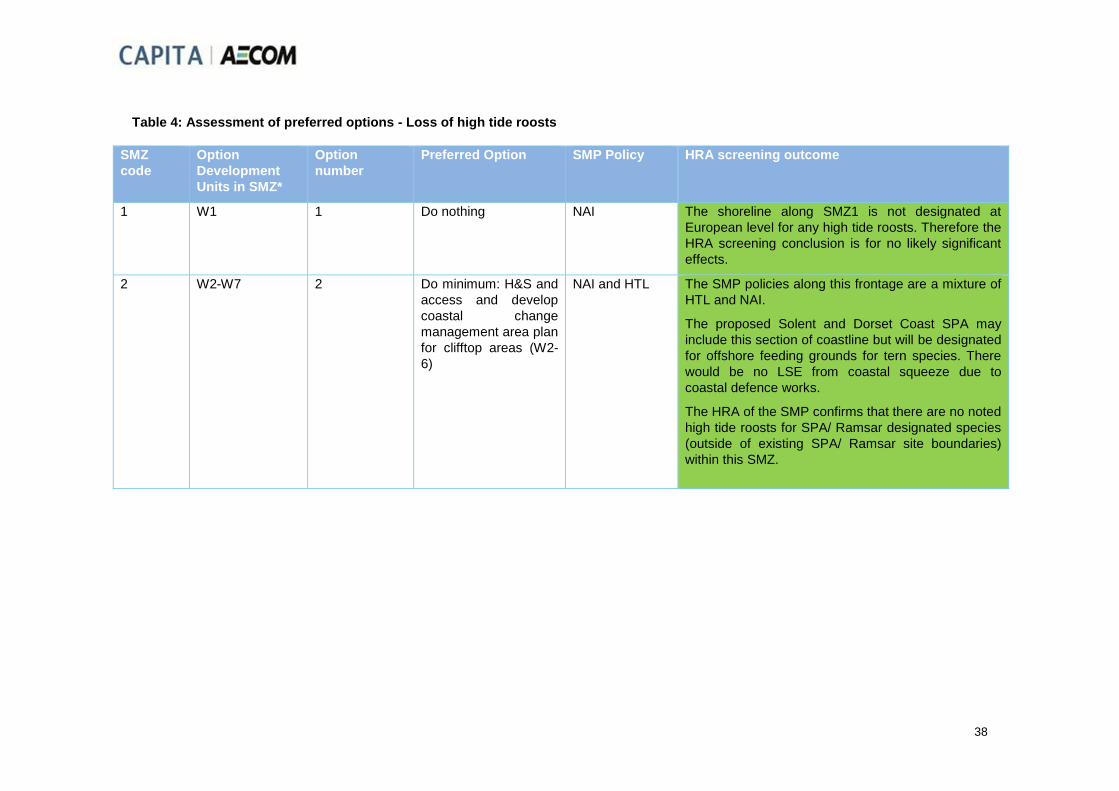
38
Table 4: Assessment of preferred options - Loss of high tide roosts
SMZ
code
Option
Development
Units in SMZ*
Option
number
Preferred Option SMP Policy HRA screening outcome
1 W1 1 Do nothing NAI The shoreline along SMZ1 is not designated at
European level for any high tide roosts. Therefore the
HRA screening conclusion is for no likely significant
effects.
2 W2-W7 2 Do minimum: H&S and
access and develop
coastal change
management area plan
for clifftop areas (W2-
6)
NAI and HTL The SMP policies along this frontage are a mixture of
HTL and NAI.
The proposed Solent and Dorset Coast SPA may
include this section of coastline but will be designated
for offshore feeding grounds for tern species. There
would be no LSE from coastal squeeze due to
coastal defence works.
The HRA of the SMP confirms that there are no noted
high tide roosts for SPA/ Ramsar designated species
(outside of existing SPA/ Ramsar site boundaries)
within this SMZ.

39
SMZ
code
Option
Development
Units in SMZ*
Option
number
Preferred Option SMP Policy HRA screening outcome
3a W8-9
W15-17
3 Maintain and sustain
1.33% AEP SoP with
Temporary Flood
Barriers. Improve from
2055.
Manage and reduce
flooding to areas at
significant risk with
temporary flood
barriers. Prevent
erosion to critical
infrastructure serving
the town. Raise /
implement new
defences (bunds and
floodwalls) to manage
longer term increasing
flood and erosion risk
posed by sea level
rise.
HTL in all
Epochs east of
the Yar estuary,
or HTL in Epoch
1 then NAI west
of the Yar
estuary, on the
coast.
Drawing on the most recent available evidence from
the Solent Brent Goose and Wader Roost Strategies,
the HRA of the SMP was able to confirm that no high
tide roosts are present along this SMZ and therefore
no LSE will occur.

40
SMZ
code
Option
Development
Units in SMZ*
Option
number
Preferred Option SMP Policy HRA screening outcome
3b W10
W13-14
5 Do Minimum with
Thorley Brook
Managed Realignment
(from 2025)
Managed realignment
at Thorley Brook to
provide environmental
mitigation and create
intertidal habitat.
Recommend PLP for
isolated residential
properties at very
significant flood risk
(and maintain cycle
and foot path access).
NAI with the
exception of
Thorley Brook
and Barnfields
Stream where
the approach is
HTL in Epoch 1,
MR in Epoch 2
and NAI in
Epoch 3.
The HRA of the SMP concluded that MR at Thorley
Brook (to create mudflat / saltmarsh habitat) would
lead to an adverse effect on Solent to Southampton
Water SPA and Ramsar through saline intrusion and
loss of coastal grazing marsh habitat. 31ha of coastal
grazing marsh would be lost, including areas used by
roosting birds for which the SPA/ Ramsar are
designated. It was determined by IROPI that
compensation for this loss of habitat would be
achieved through delivery via the Southern Region
RHCP (Regional Habitat Compensation Plan).
Without such compensatory habitat provision the
West Wight Coastal Flood and Erosion Risk
Management Strategy would lead to a likely
significant adverse effect on the SPA/ Ramsar in line
with the conclusion of the HRA of the SMP.
A LSE may therefore be considered to arise from
Epoch 2 but IROPI/No Alternatives for the SMP has
already been undertaken and it has been agreed that
compensatory habitat provision will need to be
delivered by RHCP before the Strategy MR policy
can be implemented. It will be the responsibility of the
MR scheme developers to confirm that this has
occurred.
Compensatory habitat will comprise grazing marsh,
including provision of suitable habitat that would
provide compensatory high tide roosts
Although a conclusion of LSE on Solent and
Southampton Water SPA/ Ramsar has been reached,
further Appropriate Assessment is not required since
the Strategy is in line with agreed IROPI of the SMP
and specific measures should be addressed within
project-level HRAs.

41
SMZ
code
Option
Development
Units in SMZ*
Option
number
Preferred Option SMP Policy HRA screening outcome
3c W11-12 4 Maintain (and PLP) then Improve (2055) – Maintenance of existing structures and recommend PLP to the residential properties at significant flood risk Refurbishment of existing defences at Freshwater Bay at end of design life to prevent erosion risk and implement new defences at Freshwater Village in the long term to mitigate flood risk and improve the standard of protection.
HTL The preferred option for SMZ3a does not lead to a
conclusion of LSE on European sites as no high tide
roosts for which the SPA/ Ramsar are designated
exist along this SMZ. A HTL approach at the mouth of
Freshwater Bay is in line with SMP policy and will not
lead to landtake from the South Wight Maritime SAC.
Proposed new defences or measures at the
Causeway/Freshwater village would occur outside of
any European sites. Creation of new habitat to the
south of the Causeway could potentially contribute to
RHCP objectives to contribute new areas of coastal
grazing marsh, if the habitat would be in a suitable
location, of suitable extent and of sufficient quality to
fit relevant criteria.
4 W18-20 1 Do nothing NAI The coastline includes sections of the Solent and
Southampton Water SPA/ Ramsar. The HRA of the
SMP was able to conclude that despite sea level rise,
there would be opportunities for the designated
features of the SPA/ Ramsar, including known high-
tide roosts, to migrate landward. There would be no
LSE.

42
SMZ
code
Option
Development
Units in SMZ*
Option
number
Preferred Option SMP Policy HRA screening outcome
5a W21-22 3 Do Minimum &
community & property
level resilience then
adaption
Privately funded
community and
property level flood
resistance and
resilience. Accept
flood risk will increase
over time due to sea
level rise. Provide
coastal change
management area plan
and do nothing. Do
minimum (maintain
H&S) at Gurnard Cliff.
HTL in part in
Epoch 1,
otherwise NAI.
There are no European sites designated for high tide
roosts along this SMZ and according to the HRA of
the SMP there are no significant roosts outside the
boundaries of the existing SPA/ Ramsar sites along
this SMZ and therefore no LSE will occur.
5b W23 3 Maintain:
Maintenance of
existing structures and
refurbishment or
replacement at end of
their residual life
HTL There are no European sites designated for high tide
roosts along this SMZ and according to the HRA of
the SMP there are no significant roosts outside the
boundaries of the existing SPA/ Ramsar sites along
this SMZ and therefore no LSE will occur.

43
SMZ
code
Option
Development
Units in SMZ*
Option
number
Preferred Option SMP Policy HRA screening outcome
6a W24-25
W31
4 Sustain 1.33% AEP
SoP with Temporary
Flood Barriers and
PLP (to 2055) then
Improve by replacing
and raising defences in
the longer term.
Redevelopment to
provide new defences
through the planning
process.
HTL There are no European sites designated for high tide
roosts along this SMZ and according to the HRA of
the SMP there are no significant roosts outside the
boundaries of the existing SPA/ Ramsar sites along
this SMZ and therefore no LSE will occur.
6b W26-28
W30
W32
1 Do nothing Mainly NAI (with
isolated HTL)
This SMZ includes sections of the Solent and
Southampton Water SPA/ Ramsar. The HRA of the
SMP was able to conclude that despite sea level rise,
there would be opportunities for the species for which
the SPA/ Ramsar are designated, including at known
high-tide roosts, to migrate landward. Therefore for a
‘do nothing’ option, there is no conflict with the
conclusions of the HRA of the SMP and there would
be no LSE.

44
SMZ
code
Option
Development
Units in SMZ*
Option
number
Preferred Option SMP Policy HRA screening outcome
6c W29 3 Maintain and PLP /
resilience (improve
through
redevelopment)
Maintain and refurbish
defences to 2055.
Reduce flooding to
areas at very
significant risk with
recommended
Property Level
Protection. Then new
frontline defences to
improve the SoP;
Redevelopment /
change of use
opportunities will raise
land levels / provide
defences to contribute
to flood risk reduction
through the planning
process.
HTL SMZ 6c has a small connectivity with Solent and
Southampton Water SPA/ Ramsar at its northern
end, and there are no known high tide roosts along
this section. Therefore there will be no LSE arising
from the strategy preferred option.

45
Table 5: Assessment of preferred options - Disturbance
SMZ
code
Option
Development
Units in SMZ*
Option
number
Preferred Option SMP Policy HRA screening outcome
1 W1 1 Do nothing NAI A ‘do nothing’ strategy will not lead to LSE through
disturbance and the coastline is not designated for
breeding or roosting birds.
2 W2-W7 2 Do minimum: H&S and
access and develop
coastal change
management area plan
for clifftop areas (W2-
6)
NAI and HTL The proposed Solent and Dorset Coast SPA may
include this section of coastline but will be designated
for offshore feeding grounds for tern species. There
would be no LSE due to disturbance from coastal
defence works.
3a W8-9
W15-17
3 Maintain and sustain
1.33% AEP SoP with
Temporary Flood
Barriers. Improve from
2055.
Manage and reduce
flooding to areas at
significant risk with
temporary flood
barriers. Prevent
erosion to critical
infrastructure serving
the town. Raise /
implement new
defences (bunds and
floodwalls) to manage
longer term increasing
flood and erosion risk
posed by sea level
rise.
HTL in all
Epochs east of
the Yar estuary,
or HTL in Epoch
1 then NAI west
of the Yar
estuary, on the
coast.
According to the HRA of the SMP, there are no
known high tide roosts for species for which Solent
and Southampton Water SPA/ Ramsar have been
designated within SMZ 3a.
The SPA is designated for breeding bird species, but
breeding colonies of these species are not noted
along this stretch of coastline.
The proposed Solent and Dorset Coast SPA may
include this section of coastline but will be designated
for offshore feeding grounds for tern species. There
would be no LSE from disturbance due to coastal
defence works.
Therefore a conclusion of no LSE can be reached.

46
SMZ
code
Option
Development
Units in SMZ*
Option
number
Preferred Option SMP Policy HRA screening outcome
3b W10
W13-14
5 Do Minimum with
Thorley Brook
Managed Realignment
(from 2025)
Managed realignment
at Thorley Brook to
provide environmental
mitigation and create
intertidal habitat.
Recommend PLP for
isolated residential
properties at very
significant flood risk
(and maintain cycle
and foot path access).
NAI with the
exception of
Thorley Brook
and Barnfields
Stream where
the approach is
HTL in Epoch 1,
MR in Epoch 2
and NAI in
Epoch 3.
This section of the coast includes high tide roost sites
and feeding sites for species for which the Solent and
Southampton Water SPA/ Ramsar site is designated.
Therefore there is potential for disturbance to birds
should the preferred option be implemented between
October and March when designated species are
most likely to be present. However, at this stage the
details of methodologies are not determined and
therefore the effects of these on bird disturbance
would be most appropriately addressed at a scheme
specific level.
The SPA is designated for breeding bird species, but
breeding colonies of these species are not noted for
this stretch of coastline.
The proposed Solent and Dorset Coast SPA may
include this section of coastline but will be designated
for offshore feeding grounds for tern species. There
would be no LSE from disturbance due to coastal
defence works.
Therefore a conclusion of no LSE can be reached.

47
SMZ
code
Option
Development
Units in SMZ*
Option
number
Preferred Option SMP Policy HRA screening outcome
3c W11-12 4 Maintain (and PLP) then Improve (2055) – Maintenance of existing structures and recommend PLP to the residential properties at significant flood risk Refurbishment of existing defences at Freshwater Bay at end of design life to prevent erosion risk and implement new defences at Freshwater Village in the long term to mitigate flood risk and improve the standard of protection.
HTL The preferred option for SMZ3c does not lead to a
conclusion of LSE on European sites. A HTL
approach at the mouth of Freshwater Bay is in line
with SMP policy.
Proposed new defences or measures at the
Causeway/Freshwater village would occur outside of
any European sites.
The proposed Solent and Dorset Coast SPA may
include this section of coastline but will be designated
for offshore feeding grounds for tern species. There
would be no LSE from disturbance due to coastal
defence works.
Therefore there is no LSE from the preferred option
through disturbance of bird species for which
European sites are designated.
4 W18-20 1 Do nothing NAI This section of the coast includes high tide roost sites
and feeding sites for species for which the Solent and
Southampton Water SPA/ Ramsar site is designated.
However, a preferred option of ‘do nothing’ in line with
SMP policy of NAI means that there is no potential for
LSE through disturbance.

48
SMZ
code
Option
Development
Units in SMZ*
Option
number
Preferred Option SMP Policy HRA screening outcome
5a W21-22 3 Do Minimum &
community & property
level resilience then
adaption
Privately funded
community and
property level flood
resistance and
resilience. Accept
flood risk will increase
over time due to sea
level rise. Provide
coastal change
management area plan
and do nothing. Do
minimum (maintain
H&S) at Gurnard Cliff.
HTL in part in
Epoch 1,
otherwise NAI.
This frontage is not currently designated as a SPA or
Ramsar. The proposed Solent and Dorset Coast SPA
may include this section of coastline but will be
designated for offshore feeding grounds for tern
species. There would be no LSE from disturbance
due to coastal defence works.
5b W23 3 Maintain:
Maintenance of
existing structures and
refurbishment or
replacement at end of
their residual life
HTL This frontage is not currently designated as a SPA or
Ramsar. The proposed Solent and Dorset Coast SPA
may include this section of coastline but will be
designated for offshore feeding grounds for tern
species. There would be no LSE from disturbance
due to coastal defence works.
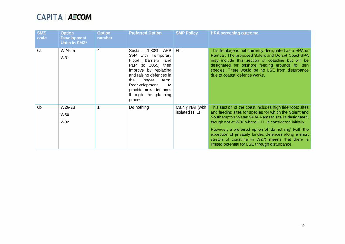
49
SMZ
code
Option
Development
Units in SMZ*
Option
number
Preferred Option SMP Policy HRA screening outcome
6a W24-25
W31
4 Sustain 1.33% AEP
SoP with Temporary
Flood Barriers and
PLP (to 2055) then
Improve by replacing
and raising defences in
the longer term.
Redevelopment to
provide new defences
through the planning
process.
HTL This frontage is not currently designated as a SPA or
Ramsar. The proposed Solent and Dorset Coast SPA
may include this section of coastline but will be
designated for offshore feeding grounds for tern
species. There would be no LSE from disturbance
due to coastal defence works.
6b W26-28
W30
W32
1 Do nothing Mainly NAI (with
isolated HTL)
This section of the coast includes high tide roost sites
and feeding sites for species for which the Solent and
Southampton Water SPA/ Ramsar site is designated,
though not at W32 where HTL is considered initially.
However, a preferred option of ‘do nothing’ (with the
exception of privately funded defences along a short
stretch of coastline in W27) means that there is
limited potential for LSE through disturbance.

50
SMZ
code
Option
Development
Units in SMZ*
Option
number
Preferred Option SMP Policy HRA screening outcome
6c W29 3 Maintain and PLP /
resilience (improve
through
redevelopment)
Maintain and refurbish
defences to 2055.
Manage and reduce
flooding to areas at
very significant risk
with recommended
Property Level
Protection.
Then new frontline
defences to improve
the SoP;
Redevelopment /
change of use
opportunities will raise
land levels / provide
defences to contribute
to flood risk reduction
through the planning
process.
HTL SMZ 6c has a small connectivity with Solent and
Southampton Water SPA/ Ramsar at its northern end.
However this developed frontage is not considered to
support significant concentrations of bird species for
which the SPA/ Ramsar sites are designated and
therefore there is no LSE through disturbance.

51
Table 6: Assessment of preferred options - Changes in sediment transport
SMZ
code
Option
Development
Units in SMZ*
Option
number
Preferred Option SMP Policy HRA screening outcome
1 W1 1 Do nothing NAI No significant changes in sedimentation patterns are
expected along this coastline affecting European
sites as a result of the preferred option.
2 W2-W7 2 Do minimum: H&S and
access and develop
coastal change
management area plan
for clifftop areas (W2-
6)
NAI and HTL No significant changes in sedimentation patterns are
expected along this coastline affecting European
sites as a result of the preferred option. Sediment
supply is expected to increase in the long term under
the preferred option, as additional lengths of cliff start
to erode. As there are no existing European sites
along this coastline no likely significant effects would
arise due to mobilisation of sediment locally.
Although the stretch of coastline may form part of a
future Solent and Dorset Coast SPA, it is considered
unlikely that the scale of sediment mobilisation would
have a significant effect on offshore feeding
opportunities for tern species. It is also considered
unlikely that the scale of sediment mobilisation would
have likely significant effects on European site
designations away from SMZ2 through sediment
deposition further along the shoreline.

52
SMZ
code
Option
Development
Units in SMZ*
Option
number
Preferred Option SMP Policy HRA screening outcome
3a W8-9
W15-17
3 Maintain and sustain
1.33% AEP SoP with
Temporary Flood
Barriers. Improve from
2055.
Manage and reduce
flooding to areas at
significant risk with
temporary flood
barriers. Prevent
erosion to critical
infrastructure serving
the town. Raise /
implement new
defences (bunds and
floodwalls) to manage
longer term increasing
flood and erosion risk
posed by sea level
rise.
HTL in all
Epochs east of
the Yar estuary,
or HTL in Epoch
1 then NAI west
of the Yar
estuary, on the
coast.
The strategy of maintaining existing defences along
the majority of this SMZ means that there will not be
likely significant adverse effects on Solent Maritime
SAC or Solent and Southampton Water SPA and
Ramsar through changes in sedimentation patterns.
The HRA of the SMP notes that “the defences along
Norton Spit are to be held for the duration of the
SMP, which will ensure that the mudflat and
saltmarsh on the landward side of the spit are
maintained, resulting in a beneficial effect of the HTL
policy. Furthermore, allowing the adjacent coastline
between Sconce Point and Norton to naturally erode
in the medium to long term will ensure an increase of
sediment downdrift, resulting in accretion of Norton
Spit which would further protect the mudflat and
saltmarsh on the landward side of the defence
structures.”
Therefore there is considered to be a likely positive
effect on European sites.

53
SMZ
code
Option
Development
Units in SMZ*
Option
number
Preferred Option SMP Policy HRA screening outcome
3b W10
W13-14
5 Do Minimum with
Thorley Brook
Managed Realignment
(from 2025)
Managed realignment
at Thorley Brook to
provide environmental
mitigation and create
intertidal habitat.
Recommend PLP for
isolated residential
properties at very
significant flood risk
(and maintain cycle
and foot path access).
NAI with the
exception of
Thorley Brook
and Barnfields
Stream where
the approach is
HTL in Epoch 1,
MR in Epoch 2
and NAI in
Epoch 3.
No significant changes in sedimentation patterns are
expected along this coastline affecting European
sites as a result of the preferred option.

54
SMZ
code
Option
Development
Units in SMZ*
Option
number
Preferred Option SMP Policy HRA screening outcome
3c W11-12 4 Maintain (and PLP) then Improve (2055) – Maintenance of existing structures and recommend PLP to the residential properties at significant flood risk Refurbishment of existing defences at Freshwater Bay at end of design life to prevent erosion risk and implement new defences at Freshwater Village in the long term to mitigate flood risk and improve the standard of protection.
HTL No significant changes in sedimentation patterns are
expected along this coastline affecting European
sites as a result of the preferred option.
4 W18-20 1 Do nothing NAI No significant changes in sedimentation patterns are
expected along this coastline affecting European
sites as a result of the preferred option.

55
SMZ
code
Option
Development
Units in SMZ*
Option
number
Preferred Option SMP Policy HRA screening outcome
5a W21-22 3 Do Minimum &
community & property
level resilience then
adaption
Privately funded
community and
property level flood
resistance and
resilience. Accept
flood risk will increase
over time due to sea
level rise. Provide
coastal change
management area plan
and do nothing. Do
minimum (maintain
H&S) at Gurnard Cliff.
HTL in part in
Epoch 1,
otherwise NAI.
No significant changes in sedimentation patterns are
expected along this coastline affecting European
sites as a result of the preferred option.
5b W23 3 Maintain:
Maintenance of
existing structures and
refurbishment or
replacement at end of
their residual life
HTL No significant changes in sedimentation patterns are
expected along this coastline affecting European
sites as a result of the preferred option.

56
SMZ
code
Option
Development
Units in SMZ*
Option
number
Preferred Option SMP Policy HRA screening outcome
6a W24-25
W31
4 Sustain 1.33% AEP
SoP with Temporary
Flood Barriers and
PLP (to 2055) then
Improve by replacing
and raising defences in
the longer term.
Redevelopment to
provide new defences
through the planning
process.
HTL No significant changes in sedimentation patterns are
expected along this coastline affecting European
sites as a result of the preferred option.
6b W26-28
W30
W32
1 Do nothing Mainly NAI (with
isolated HTL)
No significant changes in sedimentation patterns are
expected along this estuary shoreline affecting
European sites as a result of the preferred option. In
the long term, some additional sediment supply could
commence near Old Castle Point if the coastal land
starts to erode. This could result in changes in SAC
designated habitats, but in the context of an SAC
covering 11325ha, the area of change (which may
itself be immaterial) would be very limited.

57
SMZ
code
Option
Development
Units in SMZ*
Option
number
Preferred Option SMP Policy HRA screening outcome
6c W29 3 Maintain and PLP /
resilience (improve
through
redevelopment)
Maintain and refurbish
defences to 2055.
Reduce flooding to
areas at very
significant risk with
recommended
Property Level
Protection. Then new
frontline defences to
improve the SoP;
Redevelopment /
change of use
opportunities will raise
land levels / provide
defences to contribute
to flood risk reduction
through the planning
process.
HTL No significant changes in sedimentation patterns are
expected along this shoreline affecting European
sites as a result of the preferred option.
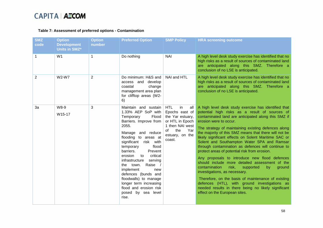
58
Table 7: Assessment of preferred options - Contamination
SMZ
code
Option
Development
Units in SMZ*
Option
number
Preferred Option SMP Policy HRA screening outcome
1 W1 1 Do nothing NAI A high level desk study exercise has identified that no
high risks as a result of sources of contaminated land
are anticipated along this SMZ. Therefore a
conclusion of no LSE is anticipated.
2 W2-W7 2 Do minimum: H&S and
access and develop
coastal change
management area plan
for clifftop areas (W2-
6)
NAI and HTL A high level desk study exercise has identified that no
high risks as a result of sources of contaminated land
are anticipated along this SMZ. Therefore a
conclusion of no LSE is anticipated.
3a W8-9
W15-17
3 Maintain and sustain
1.33% AEP SoP with
Temporary Flood
Barriers. Improve from
2055.
Manage and reduce
flooding to areas at
significant risk with
temporary flood
barriers. Prevent
erosion to critical
infrastructure serving
the town. Raise /
implement new
defences (bunds and
floodwalls) to manage
longer term increasing
flood and erosion risk
posed by sea level
rise.
HTL in all
Epochs east of
the Yar estuary,
or HTL in Epoch
1 then NAI west
of the Yar
estuary, on the
coast.
A high level desk study exercise has identified that
potential high risks as a result of sources of
contaminated land are anticipated along this SMZ if
erosion were to occur.
The strategy of maintaining existing defences along
the majority of this SMZ means that there will not be
likely significant effects on Solent Maritime SAC or
Solent and Southampton Water SPA and Ramsar
through contamination as defences will continue to
protect areas of potential risk from erosion.
Any proposals to introduce new flood defences
should include more detailed assessment of the
contamination risk, supported by ground
investigations, as necessary.
Therefore, on the basis of maintenance of existing
defences (HTL), with ground investigations as
needed results in there being no likely significant
effect on the European sites.

59
SMZ
code
Option
Development
Units in SMZ*
Option
number
Preferred Option SMP Policy HRA screening outcome
3b W10
W13-14
5 Do Minimum with
Thorley Brook
Managed Realignment
(from 2025)
Managed realignment
at Thorley Brook to
provide environmental
mitigation and create
intertidal habitat.
Recommend PLP for
isolated residential
properties at very
significant flood risk
(and maintain cycle
and foot path access).
NAI with the
exception of
Thorley Brook
and Barnfields
Stream where
the approach is
HTL in Epoch 1,
MR in Epoch 2
and NAI in
Epoch 3.
A high level desk study exercise has identified that
high risks as a result of sources of contaminated land
are anticipated along this SMZ.
A landfill site has been identified as being present
along this frontage. It is known that part of the site is
capped and the rest is currently flooded in a 1:1yr
present day event – there have been no negative
consequences reported, which suggest no remedial
works are required at this time. The preferred option
for this frontage (W10) is NAI.
Therefore at this stage it has been concluded that
there would be no LSE on any European sites,
however the potential for increased frequency of
flooding in W10 and the potential for release of
contaminants may merit further investigation.

60
SMZ
code
Option
Development
Units in SMZ*
Option
number
Preferred Option SMP Policy HRA screening outcome
3c W11-12 4 Maintain (and PLP) then Improve (2055) – Maintenance of existing structures and recommend PLP to the residential properties at significant flood risk Refurbishment of existing defences at Freshwater Bay at end of design life to prevent erosion risk and implement new defences at Freshwater Village in the long term to mitigate flood risk and improve the standard of protection.
HTL A high level desk study exercise has identified that no
high risks as a result of sources of contaminated land
are anticipated along this SMZ. Therefore a
conclusion of no LSE is anticipated.
4 W18-20 1 Do nothing NAI A high level desk study exercise has identified that no
high risks as a result of sources of contaminated land
are anticipated along this SMZ. Therefore a
conclusion of no LSE is anticipated.

61
SMZ
code
Option
Development
Units in SMZ*
Option
number
Preferred Option SMP Policy HRA screening outcome
5a W21-22 3 Do Minimum &
community & property
level resilience then
adaption
Privately funded
community and
property level flood
resistance and
resilience. Accept
flood risk will increase
over time due to sea
level rise. Provide
coastal change
management area plan
and do nothing. Do
minimum (maintain
H&S) at Gurnard Cliff.
HTL in part in
Epoch 1,
otherwise NAI.
A high level desk study exercise has identified that no
high risks as a result of sources of contaminated land
are anticipated along this SMZ. Therefore a
conclusion of no LSE is anticipated.
5b W23 3 Maintain:
Maintenance of
existing structures and
refurbishment or
replacement at end of
their residual life
HTL A high level desk study exercise has identified that no
high risks as a result of sources of contaminated land
are anticipated along this SMZ. Therefore a
conclusion of no LSE is anticipated.

62
SMZ
code
Option
Development
Units in SMZ*
Option
number
Preferred Option SMP Policy HRA screening outcome
6a W24-25
W31
4 Sustain 1.33% AEP
SoP with Temporary
Flood Barriers and
PLP (to 2055) then
Improve by replacing
and raising defences in
the longer term.
Redevelopment to
provide new defences
through the planning
process.
HTL A high level desk study exercise has identified that
high risks as a result of sources of contaminated land
are anticipated along this SMZ.
The strategy of maintaining existing defences along
the majority of this SMZ means that there will not be
likely significant effects on Solent Maritime SAC
through contamination due to erosion as defences
will continue to protect areas of potential risk from
erosion.
Any future proposals to introduce new structures,
replace or remove structures should undertake a
more detailed assessment of the contamination risk,
supported by ground investigations, as necessary.
Therefore on the basis of maintenance of existing
defences (HTL), with ground investigations as
needed results in there being no likely significant
effect on the European sites.
6b W26-28
W30
W32
1 Do nothing Mainly NAI (with
isolated HTL)
A high level desk study exercise has identified that
high risks as a result of sources of contaminated land
are anticipated along this SMZ.
The desk study has concluded that at this time there
is nothing that suggests contamination risks, which
may arise through tidal inundation in areas of NAI
(W30) are large enough to require remediation or
new flood defences.
Therefore a conclusion of no LSE may be concluded.

63
SMZ
code
Option
Development
Units in SMZ*
Option
number
Preferred Option SMP Policy HRA screening outcome
6c W29 3 Maintain and PLP /
resilience (improve
through
redevelopment).
Maintain and refurbish
defences to 2055.
Reduce flooding to
areas at very
significant risk with
recommended
Property Level
Protection. Then new
frontline defences to
improve the SoP;
Redevelopment /
change of use
opportunities will raise
land levels / provide
defences to contribute
to flood risk reduction
through the planning
process.
HTL A high level desk study exercise has identified that no
high risks as a result of sources of contaminated land
are anticipated along this SMZ. Therefore a
conclusion of no LSE is anticipated.

64
6. In Combination Assessment
6.1 Introduction
It is a requirement to consider the West Wight Coastal Flood and Erosion Risk Management Strategy in combination with other projects and plans. That is the purpose of this Chapter.
6.2 Short term (2015 – 2025)
No likely significant effects requiring Appropriate Assessment have been identified from the West Wight Coastal Flood and Erosion Risk Management Strategy alone. The HRA has concluded a need for development of scheme-specific methodologies that would be required to avoid disturbance of bird species for which the Solent and Southampton Water SPA and Ramsar are designated. These should be subject to project level HRA screening.
Effects in combination with the North Solent SMP have been discussed in section 2.4 of this report. It was identified that loss of 31ha of coastal grazing marsh as a result of the Isle of Wight SMP or in combination with a loss of 39ha of similar habitat as a result of the North Solent SMP would require compensation that will occur through the Environment Agency’s Southern Regional Habitat Creation Programme (RHCP). It has also been identified that SMP calculations predict a loss of 0.4ha of saltmarsh and mudflat from the SAC as a result of existing SMP approaches. Overall the SAC will experience a much greater increase in mudflat habitat - 142ha through the implementation of the North Solent SMP and as a result of a managed realignment scheme at the Thorley Brook site there is potential for up to 34.9 ha of saltmarsh/mudflat habitat creation in West Wight.
The main potential for an in combination effect with other plans and projects relates to the additional population associated with new housing to be delivered on the Isle of Wight and throughout the Solent area over the Strategy period. However, due to the nature of the analysis in the Solent Disturbance and Mitigation Project and its Solent-wide geographic scope, recreational effects of housing across the Solent area have effectively already been considered cumulatively in undertaking the original analysis that led to the identification of the 5.6km zone around the coast and the need for mitigation to be delivered for housing within that zone. This has been enshrined within the Island Plan Solent Special Protection Areas Supplementary Planning Document11. Other projects will be securing bespoke solutions or making the required financial contribution to the delivery of the strategic mitigation being delivered by the local authorities.
If Strategy works to achieve HTL or MR took place at an inappropriate time (i.e. during the core wintering period when bird populations are greatest) then there could be an ‘in combination’ disturbance effect alongside the substantial increase in recreational activity within the Solent European sites that is expected over the Strategy period due to housing proposals for surrounding districts. However, no additional mitigation needs to be delivered by the Strategy since the timing of works to avoid the sensitive periods will effectively address the Strategy’s contribution to the ‘in combination’ effect.
11
https://www.iwight.com/azservices/documents/2779-SSPA-SPD.pdf

65
6.3 Medium and long term (2025 – 2115)
No ‘in combination’ assessment is possible for this time period since no projects and plans that will come on line during those Epochs are sufficiently developed at this stage.

66
7. Conclusions
It is concluded that the West Wight Coastal Flood and Erosion Risk Management Strategy will
not result in a likely significant effect on European sites, either alone or in combination with
other projects and plans. In reaching that conclusion, the HRA has considered the following;
For SMZ 3b: The HRA of the SMP concluded that MR at Thorley Brook would lead to an adverse effect on Solent to Southampton Water SPA and Ramsar through saline intrusion and loss of coastal grazing marsh habitat. 31ha of coastal grazing marsh would be lost, including areas used by roosting birds for which the SPA/ Ramsar are designated. It was determined by IROPI that compensation for this loss of habitat would be achieved through delivery via the Southern Region RHCP (Regional Habitat Compensation Plan). Without such compensatory habitat provision the West Wight Coastal Flood and Erosion Risk Management Strategy would lead to a likely significant adverse effect on the SPA/ Ramsar in line with the conclusion of the HRA of the SMP. A LSE may therefore be considered to arise from Epoch 2 but IROPI/No Alternatives for the SMP has already been undertaken and it has been agreed that compensatory habitat provision will need to be delivered by RHCP before the Strategy MR policy can be implemented. It will be the responsibility of the MR scheme developers to confirm that this has occurred. Compensatory habitat will comprise grazing marsh, including provision of suitable habitat that would provide compensatory high tide roosts. Although a conclusion of LSE on Solent and Southampton Water SPA/ Ramsar has been reached, further Appropriate Assessment is not required since the Strategy is in line with agreed IROPI of the SMP and specific measures should be addressed within project-level HRAs.
For SMZ3a, SMZ5b and SMZ6a: Maintenance and improvement of existing defences could potentially lead to a need to reinforce the toe of any existing alignments, which could lead to small amounts of landtake from designated sites. However, consideration of the low value (SMZ5b) and areas of habitat concerned, coupled with levels of creation of habitat elsewhere within the designated sites as a result of coastal Strategies leads to the conclusion that no LSE would occur through landtake as a result of the West Wight Coastal Flood and Erosion Risk Management Strategy. However it is concluded that at the level of specific schemes, project-level HRA screening should be undertaken to confirm no LSE would arise once more details are available.
For SMZ3b: If works to achieve HTL or MR took place at an inappropriate time (i.e. during the core wintering period when SPA/ Ramsar designated bird populations are greatest) then there could be LSE through disturbance. However at this stage the details of methodologies are not determined and therefore the effects on disturbance would be most appropriately addressed at a scheme specific level.
No LSE has been identified through changes to sedimentation patterns (subject to further detailed modelling), or through contaminant release (Subject to ground investigations at project-specific level).

67
Appendix 1 – Option Development Units
Unit Area
W1 Freshwater Bay
W2 Tennyson Down, Alum Bay and
Headon Warren
W3 Southern Totland Bay
W4 Northern Totland Bay
W5 Southern Colwell Bay
W6 Central Colwell Bay
W7 Fort Albert
W8 Fort Victoria Country Park
W9 Fort Victoria and Norton
W10 Norton Spit
W11 Western Yar Estuary – Western
Shore
W12 The Causeway
W13 Western Yar Estuary – Eastern
Shore
W14 Thorley Brook and Barnfield
Stream
W15 Thorley Brook to Yar Bridge
W16 Yar Bridge to Yarmouth Common
W17 Yarmouth Common to Port la
Salle
W18 Bouldnor Copse and Hamstead
W19 Newtown Estuary
W20 Thorness Bay and southern
Gurnard Bay
W21 Gurnard Luck
W22 Gurnard Cliff
W23 Gurnard to Cowes Parade
W24 Cowes Town Centre to Fountain
Yard
W25 Fountain Yard to Medina Wharf
W26 Kingston Road Power Station to
Shrape Breakwater
W27 Shrape Breakwater to Old Castle
Point
W28 Central Medina - north west
W29 West Medina Mills
W30 Central Medina – south west
W31 Newport Harbour
W32 Central Medina - east